R-350 A - Climate Science: Roger Pielke Sr
9
Satellite-based modeling of transpiration from the grasslands in the Southern Great Plains, USA Joseph G. Alfieri a , Xiangming Xiao b , Dev Niyogi a,c, ⁎, Roger A. Pielke Sr. d , Fei Chen e , Margaret A. LeMone e a Department of Agronomy, Crop, Soil, and Environmental Sciences, Purdue University, West Lafayette, Indiana 47907, USA b Institute for the Study of Earth, Oceans, and Space, University of New Hampshire, Durham, New Hampshire 03824, USA c Department of Earth and Atmospheric Sciences, Purdue University, West Lafayette, Indiana 47907, USA d Colorado State University, Department of Atmospheric Science, Fort Collins, Colorado 80523, USA e National Center for Atmospheric Research, Boulder, Colorado 80307, USA abstract article info Article history: Accepted 8 February 2009 Available online 3 January 2009 Keywords: Moderate Resolution Imaging Spectroradiometer (MODIS) 2002 International H2O Project IHOP_2002 Southern Great Plains Vegetation Transpiration Model Vegetation Photosynthesis Model evaporation transpiration Data from the 2002 International H 2 O Project (IHOP_2002), which was conducted during May and June 2002 in the Southern Great Plains of the United States, was used to validate a remote sensing-based Vegetation Transpiration Model (VTM). The VTM is based on the linkage between transpiration and photosynthesis, and has been successfully tested over forest landscapes. This study is the first evaluation of the VTM model over grasslands. Since grasslands represent a significant proportion of the Earth's terrestrial surface, this research marks an important step toward applying a satellite-based transpiration model over a landscape that plays a critical role in numerous biogeochemical cycles on both regional and global scales. Comparison of the model output with observer transpiration showed the VTM tended to overestimate transpiration under sparely- vegetated conditions and overestimate transpiration when the vegetation was full. These results indicate that explicitly incorporating the effects of LAI into the VTM could improve model estimates of transpiration; they also underscore the importance of soil evaporation in grassland environments and consequently the need for a companion soil evaporation model that works with the VTM. © 2008 Elsevier B.V. All rights reserved. 1. Introduction Evapotranspiration (ET), the combined transport of moisture from the land surface to the atmosphere by soil evaporation and vegetation transpiration (TR), is a fundamental process linking numerous hydrologic, atmospheric, and ecological processes. Globally, nearly two-thirds of the precipitations that falls over land is returned to the atmosphere via ET (Baumgartner and Reichel,1975); thus, ET is clearly an important component of the water cycle and hydrologic processes. Furthermore, as an integral component of the surface energy budget, ET is also linked to a variety of atmospheric processes (Pielke et al., 1998, 2007) ranging from the development of mesoscale circulation patterns (Hanesaik et al., 2004; Raddatz, 2007) to the evolution of the atmospheric boundary layer (LeMone et al., 2002, 2007a) and the development of convective storms (Pielke, 2001). The TR component of ET is closely connected to many ecological and biogeochemical processes ranging from nitrogen cycling (Schulze et al., 1994) to carbon uptake through photosynthesis (Farquhar and Sharkey, 1982). Many researchers have sought to use remotely sensed data to understand and model the role of the land surface in environmental processes (e.g. Potter et al., 1993; Ruimy et al., 1994; Prince and Goward, 1995; Jiang and Islam, 2001; Norman et al., 2003; Anderson et al., 2004; Tian et al., 2004; Batra et al., 2006; Jin and Liang, 2006). This study applies a remote sensing-based photosynthesis model, the Vegetation Photosynthesis Model (VPM), and specifically the tran- spiration or Vegetation Transpiration Model (VTM) component of that model, over grasslands using data collected as a part of the 2002 International H 2 O Project (IHOP_2002; Weckworth et al., 2004; LeMone et al., 2007b). The VTM is built on the close relationship between photosynthesis and transpiration and utilizes water use efficiency (WUE) and gross primary production (GPP) to estimate transpiration. GPP data are estimated by the VPM using satellite imagery, air temperature, and photosynthetically active radiation (PAR; Xiao et al., 2004a,b, 2005). While the VPM and the VTM previously have been validated over forested regions (Xiao et al., 2004a,b, 2005, 2006), they have not yet been tested against observations collected over grasslands. Such a model evaluation is important because these ecosystems are a major component of terrestrial land use and land cover. Grasslands constitute approximately 52.5 × 10 6 km 2 or 41% of the earth's terrestrial, ice-free surface (White et al., 2000). This includes 41% of the land cover of North America (Suyker and Verma, 2001) and 22% of Europe (Soussana et al., 2007). Due to the ubiquitous nature of grasslands, they play an important role in land–atmosphere exchange Global and Planetary Change 67 (2009) 78–86 ⁎ Corresponding author. Department of Agronomy, Purdue University, 915 W. State Street, West Lafayette, Indiana 47907, USA. Tel.: +1765 494 6574; fax: +1765 496 2626. E-mail address: [email protected] (D. Niyogi). 0921-8181/$ – see front matter © 2008 Elsevier B.V. All rights reserved. doi:10.1016/j.gloplacha.2008.12.003 Contents lists available at ScienceDirect Global and Planetary Change journal homepage: www.elsevier.com/locate/gloplacha
Transcript of R-350 A - Climate Science: Roger Pielke Sr

Global and Planetary Change 67 (2009) 78–86
Contents lists available at ScienceDirect
Global and Planetary Change
j ourna l homepage: www.e lsev ie r.com/ locate /g lop lacha
Satellite-based modeling of transpiration from the grasslands in the Southern GreatPlains, USA
Joseph G. Alfieri a, Xiangming Xiao b, Dev Niyogi a,c,⁎, Roger A. Pielke Sr. d, Fei Chen e, Margaret A. LeMone e
a Department of Agronomy, Crop, Soil, and Environmental Sciences, Purdue University, West Lafayette, Indiana 47907, USAb Institute for the Study of Earth, Oceans, and Space, University of New Hampshire, Durham, New Hampshire 03824, USAc Department of Earth and Atmospheric Sciences, Purdue University, West Lafayette, Indiana 47907, USAd Colorado State University, Department of Atmospheric Science, Fort Collins, Colorado 80523, USAe National Center for Atmospheric Research, Boulder, Colorado 80307, USA
⁎ Corresponding author. Department of Agronomy, PStreet,West Lafayette, Indiana 47907, USA. Tel.: +1765 4
E-mail address: [email protected] (D. Niyogi).
0921-8181/$ – see front matter © 2008 Elsevier B.V. Adoi:10.1016/j.gloplacha.2008.12.003
a b s t r a c t
a r t i c l e i n f oArticle history:
Data from the 2002 Internat Accepted 8 February 2009Available online 3 January 2009Keywords:Moderate Resolution ImagingSpectroradiometer (MODIS)2002 International H2O ProjectIHOP_2002Southern Great PlainsVegetation Transpiration ModelVegetation Photosynthesis Modelevaporationtranspiration
ional H2O Project (IHOP_2002), which was conducted during May and June 2002in the Southern Great Plains of the United States, was used to validate a remote sensing-based VegetationTranspiration Model (VTM). The VTM is based on the linkage between transpiration and photosynthesis, andhas been successfully tested over forest landscapes. This study is the first evaluation of the VTM model overgrasslands. Since grasslands represent a significant proportion of the Earth's terrestrial surface, this researchmarks an important step toward applying a satellite-based transpiration model over a landscape that plays acritical role in numerous biogeochemical cycles on both regional and global scales. Comparison of the modeloutput with observer transpiration showed the VTM tended to overestimate transpiration under sparely-vegetated conditions and overestimate transpiration when the vegetation was full. These results indicate thatexplicitly incorporating the effects of LAI into the VTM could improve model estimates of transpiration; theyalso underscore the importance of soil evaporation in grassland environments and consequently the need fora companion soil evaporation model that works with the VTM.
© 2008 Elsevier B.V. All rights reserved.
1. Introduction
Evapotranspiration (ET), the combined transport of moisture fromthe land surface to the atmosphere by soil evaporation and vegetationtranspiration (TR), is a fundamental process linking numeroushydrologic, atmospheric, and ecological processes. Globally, nearlytwo-thirds of the precipitations that falls over land is returned to theatmosphere via ET (Baumgartner and Reichel,1975); thus, ET is clearlyan important component of the water cycle and hydrologic processes.Furthermore, as an integral component of the surface energy budget,ET is also linked to a variety of atmospheric processes (Pielke et al.,1998, 2007) ranging from the development of mesoscale circulationpatterns (Hanesaik et al., 2004; Raddatz, 2007) to the evolution of theatmospheric boundary layer (LeMone et al., 2002, 2007a) and thedevelopment of convective storms (Pielke, 2001). The TR componentof ET is closely connected to many ecological and biogeochemicalprocesses ranging from nitrogen cycling (Schulze et al., 1994) tocarbon uptake through photosynthesis (Farquhar and Sharkey, 1982).
Many researchers have sought to use remotely sensed data tounderstand and model the role of the land surface in environmental
urdue University, 915 W. State94 6574; fax:+1765 496 2626.
ll rights reserved.
processes (e.g. Potter et al., 1993; Ruimy et al., 1994; Prince andGoward, 1995; Jiang and Islam, 2001; Norman et al., 2003; Andersonet al., 2004; Tian et al., 2004; Batra et al., 2006; Jin and Liang, 2006).This study applies a remote sensing-based photosynthesis model, theVegetation Photosynthesis Model (VPM), and specifically the tran-spiration or Vegetation TranspirationModel (VTM) component of thatmodel, over grasslands using data collected as a part of the 2002International H2O Project (IHOP_2002; Weckworth et al., 2004;LeMone et al., 2007b). The VTM is built on the close relationshipbetween photosynthesis and transpiration and utilizes water useefficiency (WUE) and gross primary production (GPP) to estimatetranspiration. GPP data are estimated by the VPM using satelliteimagery, air temperature, and photosynthetically active radiation(PAR; Xiao et al., 2004a,b, 2005).
While the VPM and the VTM previously have been validated overforested regions (Xiao et al., 2004a,b, 2005, 2006), they have not yetbeen tested against observations collected over grasslands. Such amodel evaluation is important because these ecosystems are a majorcomponent of terrestrial land use and land cover. Grasslandsconstitute approximately 52.5×10⁶ km2 or 41% of the earth'sterrestrial, ice-free surface (White et al., 2000). This includes 41% ofthe land cover of North America (Suyker and Verma, 2001) and 22% ofEurope (Soussana et al., 2007). Due to the ubiquitous nature ofgrasslands, they play an important role in land–atmosphere exchange

Fig. 1. The locations of the ten IHOP_2002 surface sites and their associated flight tracks are shown. The 10 surface sites can be divided into three subsets with each groupingassociated with one of three flight tracks that were followed when aircraft were used to carry out atmospheric and surface observations.
Table 1The location and a summary of the environmental conditions for the 10 IHOP_2002surface sites are shown.
Site Location Latitude(°N)
Longitude(°W)
Elevation(m)
Environmental Conditions
1 Booker, TX 36.4728 100.6179 872 Fallow; persistent drought2 Elmwood, Ok 36.6221 100.6270 859 CRP grassland; persistent
drought3 Beaver, OK 36.8610 100.5945 780 Sand-sagebrush; persistent
drought4 Zenda, KS 37.3579 98.2447 509 Pasture; intermediate
precipitation5 Spivey, KS 37.3781 98.1636 506 Winter wheat; intermediate
precipitation6 Conway
Springs, KS37.3545 97.6533 417 Winter wheat; intermediate
precipitation7 New Salem,
KS37.3132 96.9387 382 Pasture; water surplus
8 Atlanta, KS 37.4070 96.7656 430 Grassland; water surplus9 Grenola, KS 37.4103 96.5671 447 Pasture; water surplus10 Beaver, OK 36.8701 100.6180 785 Heavily grazed pasture;
persistent drought
79J.G. Alfieri et al. / Global and Planetary Change 67 (2009) 78–86
processes and subsequent atmospheric phenomena (Burba andVerma, 2005).
Compared to the grasslands presented here, the forested regionsused to develop the VPM and VTM models — for example, the mixedconiferous and hardwood forest at the Howland Forest Ameriflux site(Hollinger et al., 1999; Xiao et al., 2005)— have very different physicaland canopy characteristics. As a result, grasslands and forested regionshave very different moisture exchange characteristics; for example,grasslands tend to have a higher evaporative fraction and canopyresistance than forests (Kelliher et al., 1993). Thus, model validation isneeded both to assess the skill of the VPM/VTM and to isolate thoseaspects of the model that would benefit from further development.
The following section briefly describes the IHOP_2002 fieldcampaign including the surface observation sites and data collectionmethods. Section 3 explains the scaling scheme used to estimatetranspiration fromthe totalmoisturefluxobservedduring IHOP_2002. Italso contains an overview of the VTM. Section 4 describes the results ofthe comparison of the modeled and observed moisture flux. Section 5presents the conclusions drawn from the analysis.
2. Site description and data collection methods
2.1. 2002 International H2O Project
This study used estimates of evapotranspiration derived from theobserved latent heat flux measured during May and June 2002 as apart of IHOP_2002, a multi-agency field campaign conducted in theSouthern Great Plains (SGP) of the United States. While a completedescription of the field program is given by Weckworth et al. (2004)and LeMone et al. (2007b), a brief summary of IHOP_2002 is providedhere. The research domain, which includes portions of Kansas, Oklahoma,and Texas (Fig. 1), incorporated a broad range of environmentalconditions. For example, a strongwest–east precipitation gradient existedacross the domain. The western third of the IHOP_2002 domainexperiencedaprotractedperiodof severedroughtprior to and throughoutthe duration of the field campaign (Oklahoma Water Resource Board,2002; LeMone et al., 2007b). The eastern third of the domain experienceda water surplus; from data available for Cowley County, Kansas, thelocation of the easternmost three IHOP_2002 sites, precipitation duringMay and June 2002 exceeded 356 mm, nearly 46% above normal (KansasState University Weather Data Library, available at www.oznet.ksu.edu/wdl /KSPCP.htm, 2004). The research domain also represented a broadrange of land cover types from bare ground and croplands(primarily winter wheat) to grasslands and sagebrush rangelands.
The field campaign included ten surface sites distributed across theIHOP_2002 domain (Fig. 1; Table 1). Each of these sites represented acombination of land use and environmental conditions that weretypical of the surrounding region. As such, the sites included fallow,cropped, and grassland surfaces and dry, intermediate, and wetmoisture conditions. While the analyses were conducted using allvegetated surface sites, three representative grassland sites are thefocus of this paper. These three sites are Site 2, Site 4, and Site 9 (Fig. 2).Site 2 (Fig. 2a) was a sparsely-vegetated grassland site located in thepanhandle of Oklahoma. A mixture of native C3 and C4 plant speciesthat formed a mosaic of clumped vegetation and bare soil dominatedSite 2. The leaf area index (LAI) — the one-sided leaf area per unitarea of land surface — changed little during the field campaign; theLAI ranged from 0.15 m2 leaf m−2 ground (m2 m−2 hereafter) to0.34 m2 m−2 and had an average value of 0.20 m2 m−2. Similarly, thissite had a greenness fraction (Fg) — the fraction of the land surfacecovered with green vegetation — that ranged from 0.32 at thebeginning of the field campaign to a peak value of 0.44 on 16-Juneand 0.35 at the end of IHOP_2002. This site, which was located in thewestern portion of the IHOP_2002 domain, received approximately34 mm of rain during the field campaign. Site 4 (Fig. 2b) was agrassland site located in central Kansas. The LAI and Fg at this siteinitiallywere 0.21m2m−2 and 0.43m2m−2, respectively, but gradually

Fig. 2. Views of the three IHOP_2002 field sites that are the focus of this work presented here are shown. These sites are (a) Site 2, (b) Site 4, and (c) Site 9. Additional information andphotographs of the field sites can be found at www.ral.ucar.edu/projects/land/IHOP/index.htm.
80 J.G. Alfieri et al. / Global and Planetary Change 67 (2009) 78–86
increased to plateau values 1.07m2m−2 and 0.90m2m−2, respectively,by mid-June. Site 4 received nearly 60 mm of rain during IHOP_2002.Site 9 (Fig. 2c) was a grassland site located within the Walnut RiverWatershed in southeastern Kansas. This site, which again contained amixture of C3 and C4 species, had a LAI ranging from 0.43 m2 m−2 to2.0m2m−2. At this site, Fg had a constant valueof 1.0 during IHOP_2002.Themeasured rainfall at this Site 9 exceeded117mmfor thewhole of thefield campaign.
2.2. Flux data collection
While a complete description of the surface data collected duringIHOP_2002may be found in LeMone et al. (2007b), a brief overview ofthe data used in this study is given here. The data collected included afull suite of micrometeorological, surface energy flux, and soilproperties measurements (Table 2) collected on a continuous basis.The sensible (H) and latent (λE) heat fluxes were measured using theeddy covariance method. The soil moisture and temperature datawere collected at a depth of 5 cm. The datawere stored as 5-min blockaverages which were post-processed using a standard suite ofcorrections and aggregated to 30-min data. Also, the latent heat flux
Table 2The continuous and period observations conducted at each of the IHOP_2002 surfacesites are enumerated.
Continuous Micrometeorologicalmeasures
Air temperature; atmospheric pressure; mixingratio; rain amount and intensity; wind speed anddirection
Radiative measures Incident shortwave radiation; incident longwaveradiation; net radiation; photosynthetic activeradiation; surface temperature
Surface energy flux Latent heat flux; sensible heat flux; soil heat fluxSoil properties Soil moisture; soil temperature
Periodic Surfacecharacteristics
Surface soil moisture; soil type; multispectralreflectance; leaf area index; vegetation height;vegetation type
These observations include micrometeorological, radiative, surface energy flux, soilproperty, and surface characteristic data.
was converted to a daily total ET to facilitate comparisonwith the VTMoutput.
In order to characterize the surface conditions, periodic biophysicalmeasurements were also made at each of the surface sites at five toten-day intervals (Table 2). The characterization of the surfaceincluded measures of vegetation properties, such as LAI and Fg, andsoil properties such as soil texture and soil moisture content (θ).
3. Evapotranspiration models
3.1. Estimation of transpiration from the IHOP_2002 data
In order to estimate the fraction of the total moisture fluxmeasured at each of the IHOP_2002 sites that could be attributed totranspiration, the surface resistance (rs) was first calculated using aninverted form of the Penman–Monteith (P–M) equation as follows:
rs =ra Δ Rn − Gð Þ− λE Δ − γð Þ½ � + ρcpD
γλEð1Þ
where ra is the aerodynamic resistance, Δ is the slope of the saturationvapor pressure–air temperature curve, Rn is the net radiation, G is thesoil heat flux, λE is the latent heat flux, γ is the psychrometricconstant, ρ is the air density, cp is the specific heat, and D is the vaporpressure deficit. The canopy resistance (rc) was then derived from rsby scaling rs as a function LAI following the method developed byHatfield and Allen (1996). Using this method rc is estimated asfollows:
rc =0:3LAI + 1:2
LAIrs ð2Þ
Finally, the component of λE associated with transpiration wascalculated by inserting this estimate of rc back into the P–M equation.
λETR =Rn − Gð Þ + ρcpD
ra
Δ + γ rcra
− 1� � ð3Þ

Fig. 3. The observed and modeled moisture flux (a), difference between the observed and modeled transpiration (b), rainfall amount and soil moisture content (c), and greennessfraction and leaf area index (d) are shown for Site 2.
81J.G. Alfieri et al. / Global and Planetary Change 67 (2009) 78–86
Since this technique cannot account for the evaporation of waterintercepted by the canopy or ponded at the surface, only days withoutrainfall were considered for further analysis.
3.2. The VTM model
The VTM combines WUE and GPP to estimate TR. In brief, TR isestimated by scaling GPP by δg as follows:
TR = δg × GPP ð4Þ
where δg is WUE (μmol H2O/μmol CO2). At leaf level, δg=500 (μmolH2O/μmol CO2) for C3 plants and δg=250 (μmol H2O/μmol CO2) forC4 plants (Taiz and Zeiger, 2002).
GPP is estimated from the Vegetation PhotosynthesisModel (VPM)as
GPP = eg × FPARchl × PAR ð5Þ
where εg is the light use efficiency (μmol CO2/μmol PAR), FPARchl isthe fraction of PAR absorbed by leaf chlorophyll, and PAR is thephotosynthetically active radiation. The detailed description of theVPMmodel is given in other papers (Xiao et al., 2004a,b, 2005, 2006);a brief review is presented here.
The VPM model uses two vegetation indices: the enhancedvegetation index (EVI; Huete et al., 1997) and the land surface waterindex (LSWI; Xiao et al., 2004a). EVI is defined as
EVI = 2:5 ×ρnir − ρred
ρnir + 6ρred − 7:5ρblueð Þ + 1
� �ð6Þ
where ρnir is the near infrared reflectance, ρred is the red reflectance,and ρblue is the blue reflectance at the surface. LSWI is defined as
LSWI =ρnir − ρswir
ρnir + ρswirð7Þ
where ρswir is the shortwave infrared reflectance. EVI is used as aproxy for FPARchl and LSWI is used to calculate the light use efficiency(εg).
The light use efficiency is defined as
eg = e0 × Tscalar × Wscalar × Pscalar ð8Þ
where ε0 is the maximum light use efficiency, and Tscalar, Wscalar, andPscalar are down-regulation scaling factors for the effects of tempera-ture, water, and leaf phenology on light use efficiency.
Each of the scaling factors can be determined utilizing eithersurface observational data or remotely-sensed data. The scaling factorfor temperature effects, which was developed for the TerrestrialEcosystem Model (Raich et al., 1991), is calculated as
Tscalar =T − Tminð Þ T − Tmaxð Þ
T − Tminð Þ T − Tmaxð Þ½ �− T−Topi� �2 ð9Þ
where T is the air temperature, and Tmin, Tmax, and Topt are theminimum, maximum, and optimum temperatures for photosyntheticactivity, respectively. The scaling factor for water is derived from theLSWI as:
Wscalar =1 + LSWI
1 + LSWImaxð10Þ

82 J.G. Alfieri et al. / Global and Planetary Change 67 (2009) 78–86
where LSWImax is the maximum LSWI value within the plant growingseason. Finally, the scaling factor for leaf phenology is:
Pscalar =1 + LSWI
2ð11Þ
prior to full expansion of the leaf and
Pscalar = 1 ð12Þ
after full expansion of the leaf. For the purposes of this study, whichuses data collected during the summer months, Pscalar is held constantas 1.
4. Results
4.1. IHOP_2002 Site 2
Over the rain-free days during the whole of the IHOP_2002 fieldcampaign, the total observed ET and TR were 80.6 mm and 17.2 mm,respectively. The sum of the modeled TR from the VTM for the sameperiod, which was more than three times the TR derived from theobservations, was 54.5 mm. On a daily basis, the difference betweenthe observed and modeled TR (Δ) was approximately 1.25 mm,however, the magnitude of this difference varied over time (Fig. 3). Byplotting Δ as a function of θ (Fig. 4), it can be seen that the data is wellcorrelated (r=0.82). While θ is not considered directly by the VTM, θmay impact the VTM through its influence on the LSWI. Theshortwave infrared reflectance used to calculate LSWI is sensitive toboth the moisture content of the vegetation and the soil (Xiao et al.,2002). Given the sparse vegetation cover at Site 2, the signal from thebare surface most likely corrupts the shortwave infrared reflectancemeasurement, thus the estimate of LSWI. Since LSWI is used in the
Fig. 4. The relationship between the difference in modeled and obse
calculation of both Wscalar and Pscalar, any error in determining LSWIwould propagate through to the modeled TR.
4.2. IHOP_2002 Site 4
The observed and modeled TR for Site 4 were 34.3 mm and25.1 mm, respectively. Although the 9.1 mm difference between thesevalues is substantially lower than the 37.3 mm difference between themodeled and observed TR at Site 2, the VTM still fails to capture theobserved TR (Fig. 5). While the difference in TR values can again belinked to θ, LAI is also influential at this site. For values of LAI less than0.5, the VTM tends to overestimate TR, on average by 1.2 mm d−1.Furthermore, under these more sparsely-vegetated conditions, asimilar, albeit less well-defined, relationship exists between Δ and θ(Fig. 6). When LAI exceeded 0.9, the VTM underestimated TR by anaverage of 2.1 mm d−1. The magnitude of the underestimate isproportional to θ.
4.3. IHOP_2002 Site 9
At Site 9, the total TR derived from the observational data was85 mm or 87% of the total ET (99 mm) measured at the site. Incontrast, the VTM, which calculated a total TR of only 24 mm,underestimated TR by as much as 4.3 mm d−1. As was the case at Site4, the error in VTM can be linked to θ and LAI at Site 9 (Fig. 7). WhenLAI was low, i.e. less than 0.5 m2 m−2, Δ is weakly correlated with θ(Fig. 8); however, the range in θ was too small to demonstrate a clearpattern such as was found at the other IHOP_2002 sites. At the highervalues of LAI, which ranged from 0.67 m2 m−2 to 2.0 m2 m−2, Δ waspoorly correlated with θ. However, the range in θ was again limited tonear-saturation conditions (Fig. 8). As can be seen in Fig. 9, thedifference is strongly correlated to LAI (r=0.92). This result points out
rved transpiration and soil moisture content is shown for Site 2.

Fig. 6. The relationship between the difference in modeled and observed transpiration and soil moisture content is shown for Site 4.
Fig. 5. The observed and modeled moisture flux (a), difference between the observed and modeled transpiration (b), rainfall amount and soil moisture content (c), and greennessfraction and leaf area index (d) are shown for Site 4.
83J.G. Alfieri et al. / Global and Planetary Change 67 (2009) 78–86

Fig. 8. The relationship between the difference in modeled and observed transpiration and soil moisture content is shown for Site 9.
Fig. 7. The observed and modeled moisture flux (a), difference between the observed and modeled transpiration (b), rainfall amount and soil moisture content (c), and greennessfraction and leaf area index (d) are shown for Site 9.
84 J.G. Alfieri et al. / Global and Planetary Change 67 (2009) 78–86
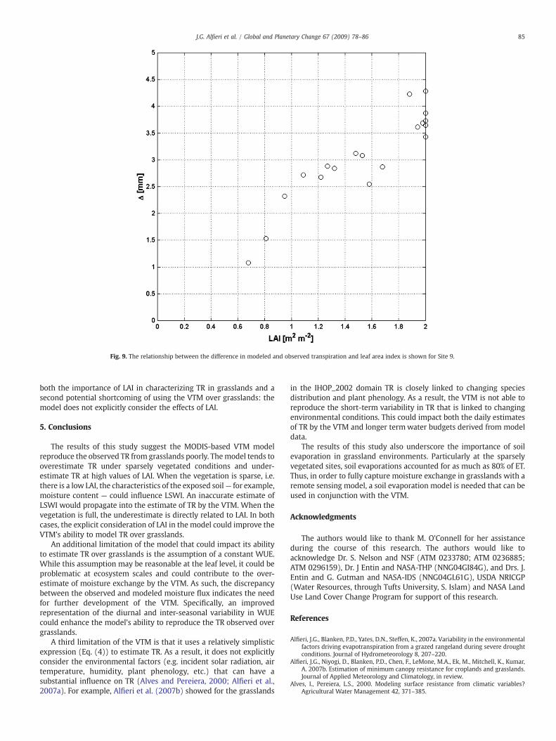
Fig. 9. The relationship between the difference in modeled and observed transpiration and leaf area index is shown for Site 9.
85J.G. Alfieri et al. / Global and Planetary Change 67 (2009) 78–86
both the importance of LAI in characterizing TR in grasslands and asecond potential shortcoming of using the VTM over grasslands: themodel does not explicitly consider the effects of LAI.
5. Conclusions
The results of this study suggest the MODIS-based VTM modelreproduce the observed TR from grasslands poorly. Themodel tends tooverestimate TR under sparsely vegetated conditions and under-estimate TR at high values of LAI. When the vegetation is sparse, i.e.there is a low LAI, the characteristics of the exposed soil— for example,moisture content — could influence LSWI. An inaccurate estimate ofLSWI would propagate into the estimate of TR by the VTM. When thevegetation is full, the underestimate is directly related to LAI. In bothcases, the explicit consideration of LAI in the model could improve theVTM's ability to model TR over grasslands.
An additional limitation of the model that could impact its abilityto estimate TR over grasslands is the assumption of a constant WUE.While this assumption may be reasonable at the leaf level, it could beproblematic at ecosystem scales and could contribute to the over-estimate of moisture exchange by the VTM. As such, the discrepancybetween the observed and modeled moisture flux indicates the needfor further development of the VTM. Specifically, an improvedrepresentation of the diurnal and inter-seasonal variability in WUEcould enhance the model's ability to reproduce the TR observed overgrasslands.
A third limitation of the VTM is that it uses a relatively simplisticexpression (Eq. (4)) to estimate TR. As a result, it does not explicitlyconsider the environmental factors (e.g. incident solar radiation, airtemperature, humidity, plant phenology, etc.) that can have asubstantial influence on TR (Alves and Pereiera, 2000; Alfieri et al.,2007a). For example, Alfieri et al. (2007b) showed for the grasslands
in the IHOP_2002 domain TR is closely linked to changing speciesdistribution and plant phenology. As a result, the VTM is not able toreproduce the short-term variability in TR that is linked to changingenvironmental conditions. This could impact both the daily estimatesof TR by the VTM and longer termwater budgets derived from modeldata.
The results of this study also underscore the importance of soilevaporation in grassland environments. Particularly at the sparselyvegetated sites, soil evaporations accounted for as much as 80% of ET.Thus, in order to fully capture moisture exchange in grasslands with aremote sensing model, a soil evaporation model is needed that can beused in conjunction with the VTM.
Acknowledgments
The authors would like to thank M. O'Connell for her assistanceduring the course of this research. The authors would like toacknowledge Dr. S. Nelson and NSF (ATM 0233780; ATM 0236885;ATM 0296159), Dr. J Entin and NASA-THP (NNG04GI84G), and Drs. J.Entin and G. Gutman and NASA-IDS (NNG04GL61G), USDA NRICGP(Water Resources, through Tufts University, S. Islam) and NASA LandUse Land Cover Change Program for support of this research.
References
Alfieri, J.G., Blanken, P.D., Yates, D.N., Steffen, K., 2007a. Variability in the environmentalfactors driving evapotranspiration from a grazed rangeland during severe droughtconditions. Journal of Hydrometeorology 8, 207–220.
Alfieri, J.G., Niyogi, D., Blanken, P.D., Chen, F., LeMone, M.A., Ek, M., Mitchell, K., Kumar,A. 2007b. Estimation of minimum canopy resistance for croplands and grasslands.Journal of Applied Meteorology and Climatology, in review.
Alves, I., Pereiera, L.S., 2000. Modeling surface resistance from climatic variables?Agricultural Water Management 42, 371–385.

86 J.G. Alfieri et al. / Global and Planetary Change 67 (2009) 78–86
Anderson, M.C., Norman, J.M., Mecikalski, J.R., Torn, R.D., Kustas, W.P., Basara, J.B., 2004.A multiscale remote sensing model for disaggregating regional fluxes to micro-meteorological scales. Journal of Hydrometeorology 5, 343–363.
Batra, N., Islam, S., Venturini, V., Bisht, G., Jiang, L., 2006. Estimation and comparison ofevapotranspiration from MODIS and AVHRR sensors for clear sky days over theSouthern Great Plains. Remote Sensing of Environment 103, 1–15.
Baumgartner, A., Reichel, E., 1975. The World Water Balance. Elsevier. 179 pp.Burba, G.G., Verma, S.B., 2005. Seasonal and interannual variability in evapotranspira-
tion of native tallgrass prairie and cultivated wheat ecosystems. Agricultural andForest Meteorology 135, 190–201.
Farquhar, G.D., Sharkey, T.D., 1982. Stomatal conductance and photosynthesis. AnnualReviews of Plant Physiology 33, 317–345.
Hanesaik, J.M., Raddatz, R.L., Lobban, S., 2004. Local initiation of deep convection on theCanadian prairie provinces. Boundary-Layer Meteorology 110, 455–470.
Hatfield, J.L., Allen, R.G., 1996. Evapotranspiration estimates under deficient watersupplies. Journal of Irrigation and Drainage Engineering 122, 301–308.
Hollinger, D.Y., Goltz, S.M., Davidson, E.A., Lee, J.T., Tu, K., Valentine, H.T., 1999. Seasonalpatterns and environmental control of carbon dioxide and water vapour exchangein an ecotonal boreal forest. Global Change Biology 5, 891–902.
Huete, A.R., Liu, H.Q., Batchily, K., van Leeuwen, W., 1997. A comparison of vegetationindices global set of TM images for EOS MODIS. Remote Sensing of Environment 59,440–451.
Jiang, L., Islam, S., 2001. Estimation of surface evaporation map over Southern GreatPlains using remote sensing data. Water Resources Research 37, 329–340.
Jin, M.L., Liang, S., 2006. An improved land surface emissivity parameter for land surfacemodels using global remote sensing observations. Journal of Climate 19,2867–2881.
Kelliher, F.M., Leuning, R., Schulze, E.D., 1993. Evaporation and canopy characteristics ofconiferous forests and grasslands. Oecologia 95, 153–163.
LeMone, M.A., Grossman, R.L., McMillen, R.T., Liou, K.-N., Ou, S.C., McKeen, S.,Angevine, W., Ikeda, K., Chen, F., 2002. CASES-97: late-morning warming andmoistening of the convective boundary layer over the Walnut River Watershed.Boundary-Layer Meteorology 104, 1–52.
LeMone, M.A., Chen, F., Alfieri, J.G., Tewari, M., Geerts, B., Miao, Q., Grossman, R.L.,Coulter, R.L., 2007a. Influence of land cover, soil moisture, and terrain on thehorizontal distribution of sensible and latent heat fluxes and boundary layerstructure in southeast Kansas during IHOP_2002 and CASES-97. Journal ofHydrometeorology 8, 68–87.
LeMone, M.A., Chen, F., Alfieri, J.A., Cuenca, R., Niyogi, D., Kang, S., Davis, K., Blanken, P.D.,2007b. Surface, soil, and vegetation network during the international H2O project2002 field campaign. Bulletin of the American Meteorological Society 88, 65–81.
Norman, J.M., Anderson,M.C., Kustas,W.P., French, A.N.,Mecikalski, J., Torn, R., Diak, G.R.,Schmugge, T.J., 2003. Remote sensing of surface energy fluxes at 10(1)-m pixelresolutions. Water Resources Research 38. doi:10.1029/2002WR001775.
Oklahoma Water Resource Board, 2002. July 3 Oklahoma Water Resources Bulletin andSummary of Current Conditions. Oklahoma Water Resource Board. [Available fromOklahoma Water Resources Board, 3800 N. Classen Blvd., Oklahoma City, OK73118.].
Pielke, R.A., 2001. Influence of the spatial distribution of vegetation and soils on theprediction of cumulus convective rainfall. Reviews of Geophysics 39, 151–177.
Pielke, R.A., Avissar, R., Raupach, M., Dolman, A.J., Zeng, X.B., Denning, A.S., 1998.Interactions between the atmosphere and terrestrial ecosystems: influence onwater and climate. Global Change Biology 4, 461–475.
Pielke, R.A. Sr., Adegoke, J., Beltran-Przekurat, A., Hiemstra, C.A., Lin, J., Nair, U.S., Niyogi, D.,Nobis, T.E., 2007. An overview of regional land use and land cover impacts on rainfall.Tellus B 59, 587–601.
Potter, C.S., Randerson, J.T., Field, C.B., Matson, P.A., Vitousek, P.M., Mooney, H.A.,Klooster, S., 1993. Terrestrial ecosystem production: a process model based onglobal satellite and surface data. Global Biogeochemical Cycles 7, 811–841.
Prince, S.D., Goward, S.N., 1995. Global primary production: a remote sensing approach.Journal of Biogeography 22, 815–825.
Raddatz, R.L., 2007. Evidence for the influence of agriculture on weather and climatethrough the transformation and management of vegetation: illustrated byexamples from the Canadian Prairies. Agricultural and Forest Meteorology 142,186–202.
Raich, J.W., Rastetter, E.B., Melillo, J.M., Kicklighter, D.W., Steudler, P.A., Peterson, B.J.,1991. Potential net primary productivity in South-America-application of a global-model. Ecological Applications 1, 399–429.
Ruimy, A., Saugier, B., Dedieu, G., 1994. Methodology for the estimation of terrestrial netprimary production from remotely sensed data. Journal of Geophysical Research 99,5263–5283.
Schulze, E.D., Kelliher, F.M., Körner, C., Lloyd, J., Leuning, R., 1994. Relationships amongmaximum stomatal conductance, ecosystem conductance, carbon assimilation rate,and plant nitrogen nutrition: a global ecology scaling exercise. Annual Review ofEcology and Systematics 25, 629–660.
Soussana, J.F., et al., 2007. Full accounting of the greenhouse gas (CO2, N2O, CH4) budgetof nine European grassland sites. Agricultural Ecosystems and Environment 121,121–134.
Suyker, A.E., Verma, S.B., 2001. Year-round observations of the net ecosystem exchangeof carbon dioxide for a native tallgrass prairie. Global Change Biology 7, 279–289.
Tian, Y., Dickinson, R.E., Zhou, L., Shaikh, M., 2004. Impact of a new land boundaryconditions for Moderate Resolution Imaging Spectroradiometer (MODIS) data onthe climatology of land surface variables. Journal of Geophysical Research 109.doi:10.1029/2004JD005443.
Taiz, L., Zeiger, E., 2002. Plant Physiology, 3rd Edition. Sinauer Associates. 690 pp.White, R., Murray, S., Rohweder, M., 2000. Pilot Analysis of Global Ecosystems:
Grassland Ecosystems. World Resources Institute, Washington D.C.Weckworth, T.M., Parsons, D.B., Koch, S.E., Moore, J.A., LeMone, M.A., Demoz, B.,
Flamant, C., Geerts, B., Wang, J., Feltz, W.F., 2004. An overview of the InternationalH2O Project (IHOP 2002) and some preliminary highlights. Bulletin of the AmericanMeteorological Society 85, 253–277.
Xiao, X., Boles, S., Liu, J.Y., Zhuang, D.F., Liu, M.L., 2002. Characterization of forest types inNortheastern China, using multitemporal SPOT-4 VEGETATION sensor data. RemoteSensing of Environment 82, 335–348.
Xiao, X., Hollinger, D., Aber, J.D., Goltz, M., Davidson, E.A., Zhang, Q.Y., 2004a. Satellite-based modeling of gross primary production in an evergreen needleleaf forest.Remote Sensing of Environment 89, 519–534.
Xiao, X., Zhang, Q., Braswell, B., Urbanski, S., Boles, S., Wofsy, S.C., Moore, B.I., Ojima, D.,2004b. Modeling gross primary production of a deciduous broadleaf forest usingsatellite images and climate data. Remote Sensing of Environment 91, 256–270.
Xiao, X., Zhang, Q., Hollinger, D., Aber, J., Moore, B., 2005. Modeling gross primaryproduction of an evergreen needleleaf forest using MODIS and climate data.Ecological Applications 15, 954–969.
Xiao, X., Hagen, S., Zhang, Q., Keller, M., Moore, B., 2006. Detecting leaf phenology ofseasonally moist tropical forests in South America with multi-temporal MODISimages. Remote Sensing of Environment 103, 465–473.


![EX-PROTECTION - Wandfluh AG · 2017. 4. 3. · 25 40 80 150 15 40 25 100 6 6 60 25 25 25 Pmax [bar] 350 350 350 315 350 350 350 350 350 350 350 350 40 100 350 350 350 350 VALVES EX](https://static.fdocuments.net/doc/165x107/610826360cc123139028f4a3/ex-protection-wandfluh-ag-2017-4-3-25-40-80-150-15-40-25-100-6-6-60-25-25.jpg)