Qalandiya Village Profile - أريجvprofile.arij.org/jerusalem/pdfs/vprofile/Qalandiya_EN.pdf ·...
24
Qalandiya Village Profile Prepared by The Applied Research Institute – Jerusalem Funded by Spanish Cooperation 2012
-
Upload
vuongthien -
Category
Documents
-
view
243 -
download
1
Transcript of Qalandiya Village Profile - أريجvprofile.arij.org/jerusalem/pdfs/vprofile/Qalandiya_EN.pdf ·...

Qalandiya Village Profile
Prepared by
The Applied Research Institute – Jerusalem
Funded by
Spanish Cooperation
2012
Palestinian Localities Study Jerusalem Governorate
1
Acknowledgments ARIJ hereby expresses its deep gratitude to the Spanish agency for International Cooperation for Development (AECID) for their funding of this project. ARIJ is grateful to the Palestinian officials in the ministries, municipalities, joint services councils, village committees and councils, and the Palestinian Central Bureau of Statistics (PCBS) for their assistance and cooperation with the project team members during the data collection process. ARIJ also thanks all the staff who worked throughout the past couple of years towards the accomplishment of this work.

Palestinian Localities Study Jerusalem Governorate
2
Background This report is part of a series of booklets, which contain compiled information about each city, village, and town in the Jerusalem Governorate. These booklets came as a result of a comprehensive study of all villages in Jerusalem Governorate, which aims at depicting the overall living conditions in the governorate and presenting developmental plans to assist in developing the livelihood of the population in the area. It was accomplished through the "Village Profiles and Needs Assessment;" the project funded by the Spanish Agency for International Cooperation for Development (AECID). The "Village Profiles and Needs Assessment" was designed to study, investigate, analyze and document the socio-economic conditions and the needed programs and activities to mitigate the impact of the current unsecure political, economic and social conditions in the Jerusalem Governorate.
The project's objectives are to survey, analyze, and document the available natural, human, socioeconomic and environmental resources, and the existing limitations and needs assessment for the development of the rural and marginalized areas in the Jerusalem Governorate. In addition, the project aims at preparing strategic developmental programs and activities to mitigate the impact of the current political, social, and economic instability with the focus on the agricultural sector. All village profiles in Arabic and English are available online at http://vprofile.arij.org.

Palestinian Localities Study Jerusalem Governorate
3
Table of Content
Location and Physical Characteristics .............................................................................. 4
History ......................................................................................................................................... 5
Religious and Archaeological Sites .................................................................................... 5
Population .................................................................................................................................. 6
Education .................................................................................................................................... 7
Health Status ............................................................................................................................. 8
Economic Activities ................................................................................................................. 8
Agricultural Sector ................................................................................................................ 10
Institutions and Services ..................................................................................................... 12
Infrastructure and Natural Resources ............................................................................ 12
Impact of the Israeli Occupation ....................................................................................... 16
Development Plans and Projects ...................................................................................... 21
Village Development Priorities and Needs ................................................................... 22
References ................................................................................................................................ 23

Palestinian Localities Study Jerusalem Governorate
4
Qalandiya Village Profile
Location and Physical Characteristics Qalandiya is a Palestinian village in Jerusalem Governorate located (horizontally) 9.6km north of Jerusalem City. It is bordered by Kafr 'Aqab to the east, Rafat lands to the north, Al Judeira to the west, and Bir Nabala to the south (ARIJ-GIS Unit, 2012) (See map 1).
Map 1: Qalandiya location and borders
Source: ARIJ - GIS Unit, 2012
Qalandiya is located at an altitude of 758m above sea level with a mean annual rainfall of 530mm. The average annual temperature is 16 oC and the average annual humidity is approximately 60.4% (ARIJ-GIS Unit, 2012). Since 1994 Qalandiya has been governed by a village council, which is currently administrated by 9 members appointed by the Palestinian National Authority in addition to 1 permanent employee. The

Palestinian Localities Study Jerusalem Governorate
5
village council owns a permanent headquarters but does not possess a vehicle for the collection of solid waste (Qalandiya Village Council, 2010). It is the responsibility of the Village Council to provide a number of services to the residents of Qalandiya, including (Qalandiya Village Council, 2010): Collecting solid waste, rehabilitating, constructing, and paving roads, and providing social
development services. Implementing projects and case studies for the village. Organizing the processes of construction and license issuing. Providing a sewage network. Establishing and managing kindergartens.
History Some believe that Qalandiya village’s name was taken from a Kurdish tribe that inhabited the village (Qalandiya Village Council, 2010). The establishment of the village dates back to the Crusades era and the liberation of Jerusalem (Qalandiya Village Council, 2010).
Religious and Archaeological Sites There are two mosques in the village, Qalandiya al Kabir and Qalandiya Old Mosques. The village has few sites of archaeological interest: Byzantine remains, which include a water spring, and grape and olive presses (Qalandiya Village Council, 2010). Also, there are basins, graves curved in stones and a pool (Al Dabbagh, 1991) (See Map 2).

Palestinian Localities Study Jerusalem Governorate
6
Map 2: Main locations in Qalandiya Village
Source: ARIJ - GIS Unit, 2012.
Population According to the Palestinian Central Bureau of Statistics (PCBS), the total population of Qalandiya in 2007 was 1,063, of whom 517 were male and 546 female. There were 214 households living in 220 housing units.
Age Groups and Gender The General Census of Population and Housing carried out by PCBS in 2007 showed the distribution of age groups in Qalandiya was as follows: 33.4% were less than 15 years old, 47% between 15 - 64 years of age, and 3.9% 65 years old or older. Data additionally showed that the sex ratio of males to females in the village is 94.7:100, meaning that males and females constituted 48.6% and 51.4% of the population respectively.

Palestinian Localities Study Jerusalem Governorate
7
Families Qalandiya residents are from several families, mainly the 'Awad Allah, Hussein, Hamad, Hamdiyah and Suboh families (Qalandiya Village Council, 2010).
Immigration According to the field survey conducted by ARIJ, approximately 200 persons have left the village since the Second Intifada in 2000 (Qalandiya Village Council, 2010).
Education According to the results of the PCBS Population, Housing and Establishment Census (2007), the illiteracy rate among Qalandiya population was approximately 6.4%, of whom 78.6% were females. Of the literate population, 8% could only read and write with no formal education, 22.2% had elementary education, 31.7% had preparatory education, 16.7% had secondary education, and 14% completed higher education. Table 1 shows the educational level in the village of Qalandiya by sex and educational attainment in 2007.
Table 1: Qalandiya population (10 years of age and above) by sex and educational attainment, 2007
S E x
Illite-rate
Can read
& write
Elem-entary
Prepa-ratory
Second-ary
Associate Diploma
Bach-elor
Higher Diploma
Master PhD Un-
known Total
M 9 22 77 104 55 19 17 1 2 - 4 310
F 33 27 68 103 54 33 17 - 2 - 5 342
T 42 49 145 207 109 52 34 1 4 - 9 652
Source: PCBS, 2009.
There is one public school in the village, Qalandiya Co-educated Elementary School which is run by the Palestinian Ministry of Education and Higher Education (MoEHE) (Directorate of Education in Jerusalem, 2011). In the village there are 138 students, 15 teachers, and 9 classes (Directorate of Education in Jerusalem, 2011). The average number of students per teacher in the school is nearly 9 and the average number of students per class is approximately 15 (Directorate of Education in Jerusalem, 2011). There is one local kindergarten, Zuhoor Qalandiya kindergarten, which is run by a private body and was attended by 23 children in 2011 (Directorate of Education in Jerusalem, 2011). Due to the lack of some levels of education in the village, students also attend neighboring villages' schools, including Al Jib High School in Al Jib village (3km from the village), Bir Nabala Girls High

Palestinian Localities Study Jerusalem Governorate
8
School, and Kafr 'Aqab School (each of which is located in Bir Nabala around 3km from Qalandiya) (Qalandiya Village Council, 2010). The students face difficulties due to the Israeli occupation, primarily the existence of permanent and partial checkpoints which can hinder physical access to schools (Qalandiya Village Council, 2010). The educational sector in Qalandiya village faces some obstacles, primarily:
1. The difficulty faced by students in transportations. 2. The high costs of education. 3. The high drop-out rates amongst students.
Health Status There are very few health centers available in Qalandiya village: a governmental physician clinic and a governmental motherhood and childcare center. In the absence of required health services and in emergencies, residents of Qalandiya go to Al Bayan Health Center, Ash Sheikh Jarrah Center or Beit al 'Atiba' Center in Jerusalem, each of which is about 20km from the village (Qalandiya Village Council, 2010). The health sector in the village faces many obstacles and problems, including (Qalandiya Village Council, 2010):
1. The lack of an ambulance in the village. 2. The lack of a health center.
Economic Activities The economy in Qalandiya is dependent on several economic sectors, mainly the industrial sector, which absorbs 33% of the workforce (Qalandiya Village Council, 2010) (See Figure1). A field survey conducted by ARIJ in 2010 to realize this study showed that the distribution of labor by economic activity in Qalandiya is as follows:
Industry (33%) Israeli labor market (22%) Agriculture sector (22%) Government or private employees sector (11%) Trade sector (6%) Services sector (6%)

Palestinian Localities Study Jerusalem Governorate
9
Figure 1: Economic activity in Qalandiya village
Source: Qalandiya Village Council, 2010
In terms of commercial and industrial productions in Qalandiya village, there are 3 grocery stores, 3 different professional workshops (blacksmith, carpentry) and a stone cutter (Qalandiya Village Council, 2010). The unemployment rate in Qalandiya has reached around 10%, and it was found that the social groups most affected in the village as a result of Israeli restrictions and procedures are (Qalandiya Village Council, 2010):
1. Workers in the agriculture sector. 2. Workers in the trade sector. 3. Workers in industry.
Labor Force According to the PCBS Population, Housing and Establishment Census (2007), 31.7% of Qalandiya’s labor force was economically active, of whom 88.4% were employed, and 66.4% were not economically active, of whom 50% were students and 36.3% were housekeepers (See table 2).

Palestinian Localities Study Jerusalem Governorate
10
Table 2: Qalandiya population (10 years of age and above) by sex and employment status-2007
S E X
Economically Active Not Economically Active
Un-known
Total Emp-loyed
Currently Un-
employed
Un-employed
(Never worked)
Total Stud-ents
House- keeping
Unable to work
Not working & Not looking
for work
Other Total
M 163 10 8 181 91 1 19 8 5 124 5 310
F 20 - 6 26 125 156 21 7 - 309 7 342
T 183 10 14 207 216 157 40 15 5 433 12 652
Source: PCBS, 2009.
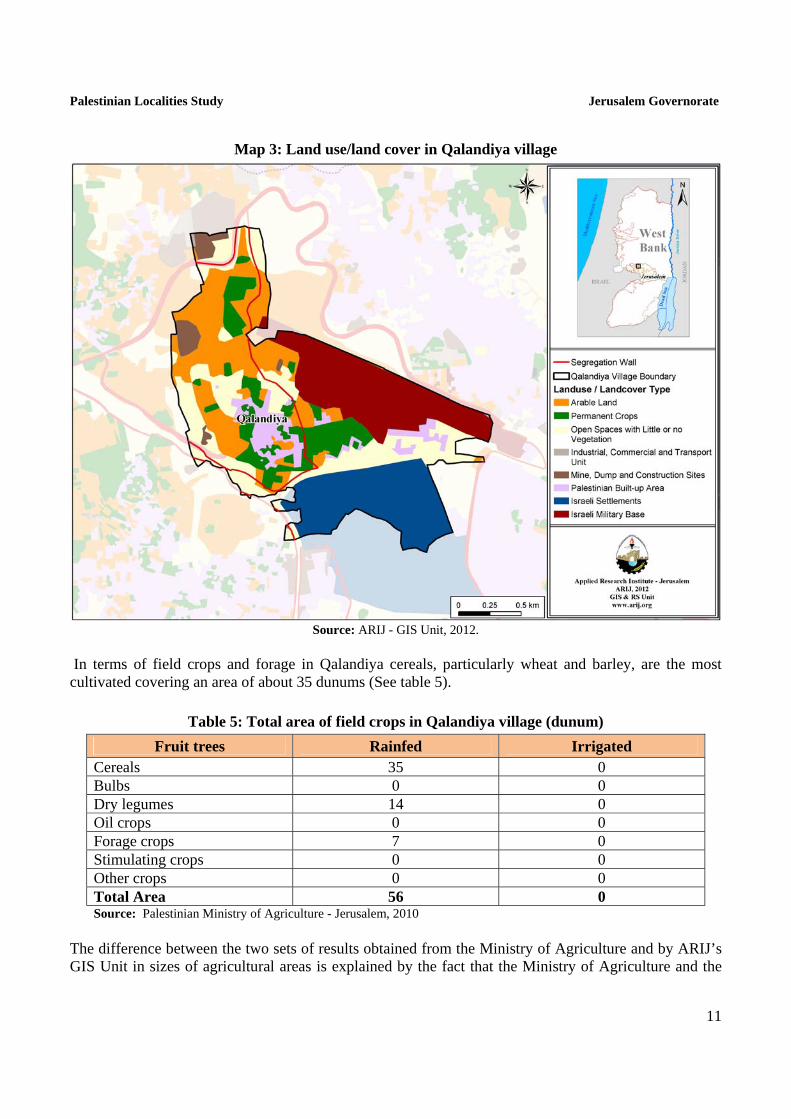
Agricultural Sector Qalandiya has a total area of around 3,273 dunums of which 1,070 are considered ‘arable’ land and 206 dunums are registered as ‘residential’ (See table 3 and map 3).
Table 3: Land use and land cover in Qalandiya village in 2010 (area in dunum)
Total Area
Built up
Area
Agricultural area (1,070)
Inland water
Forests Open
Spaces
Area of Industrial,
Commercial & Transport Unit
Area of Settlements,
Military Bases &
Wall Zone Permanent
Crops Green-houses
Range-lands
Arable lands
3,273 206 365 0 0 705 0 0 649 89 1,259
Source: ARIJ – GIS Unit, 2012. Table 4 shows the different types of fruit trees planted in the area. The village is known for the cultivation of olives; there are 187 dunums in the village cultivated with olive trees.
Table 4: Total area of fruit and olive trees in Qalandiya (dunum)
Fruit trees Rainfed Irrigated Olives 187 0 Citrus 0 0 Stone-fruits 37 0 Pome fruits 0 0 Nuts 13 0 Other fruits 23 0 Total Area 268 0 Source: Palestinian Ministry of Agriculture - Jerusalem, 2010
Palestinian Localities Study Jerusalem Governorate
11
Map 3: Land use/land cover in Qalandiya village
Source: ARIJ - GIS Unit, 2012.
In terms of field crops and forage in Qalandiya cereals, particularly wheat and barley, are the most cultivated covering an area of about 35 dunums (See table 5).
Table 5: Total area of field crops in Qalandiya village (dunum)
Fruit trees Rainfed Irrigated Cereals 35 0 Bulbs 0 0 Dry legumes 14 0 Oil crops 0 0 Forage crops 7 0 Stimulating crops 0 0 Other crops 0 0 Total Area 56 0 Source: Palestinian Ministry of Agriculture - Jerusalem, 2010
The difference between the two sets of results obtained from the Ministry of Agriculture and by ARIJ’s GIS Unit in sizes of agricultural areas is explained by the fact that the Ministry of Agriculture and the

Palestinian Localities Study Jerusalem Governorate
12
Palestinian Central Bureau of Statistics (2010) conducted a survey which used a definition of agricultural areas based on land ownership. Therefore, the areas included in the survey were those of actual holdings of agricultural areas instead of seasonal ones. The survey did not consider fragmented and small seasonal cultivated areas in residential and agricultural areas. ARIJ’s survey, however, indicated the existence of a high proportion of small and fragmented holdings (home gardens) throughout the occupied Palestinian territories, thus accounting for the larger area of agricultural holdings calculated by ARIJ. The field survey conducted by ARIJ shows that 7% of the residents in Qalandiya rear and keep domestic animals such as cows, goats, and sheep (Qalandiya Village Council, 2010) (See Table 6).
Table 6: Livestock in Qalandiya village
Cows* Sheep Goats Camels Horses Donkeys Mules Broilers Layers Bee
Hives
3 670 185 0 0 0 0 0 0 0 *Including cows, bull calves, heifer calves and bulls Source: Palestinian Ministry of Agriculture - Jerusalem, 2010 There are no agricultural roads in the village (Qalandiya Village Council, 2010). The village faces some obstacles concerning the agricultural sector, principally:
The high costs of feed. The lack of interest in agriculture on the part of Qalandiya residents. The confiscation of lands by the Israeli state.
Institutions and Services Qalandiya village has no governmental institutions, but a few local institutions and associations that provide services to various sectors of society. These include (Qalandiya Village Council, 2010):
Qalandiya Village Council: Founded in 1994 by the Ministry of Local Government with the goal of solving issues in the village and providing various services to its population.
Qalandiya Women Society: Founded in 2008 by a group of women from the village. The Society provides different services to the village.
Infrastructure and Natural Resources
Electricity and Telecommunication Services Qalandiya has been connected to a public electricity network since 1978. It is served by Jerusalem Electricity Company, which is the main source of electricity in the village. Approximately 100% of the

Palestinian Localities Study Jerusalem Governorate
13
housing units in the village are connected to this network. However, the village residents face some problems concerning electricity, mainly the frequent power cut-offs (Qalandiya Village Council, 2010). Qalandiya is connected to a telecommunication network and approximately 95% of the housing units within the village boundaries are connected to phone lines (Qalandiya Village Council, 2010).
Transportation Services There are no main means of transportation in Qalandiya village; the village residents use transportation from other villages in the area (Qalandiya Village Council, 2010). There are 3km of designated ‘main’ roads and 2km of ‘secondary’ roads (See table 7) (Qalandiya Village Council, 2010).
Table 7: Roads in Qalandiya Village
Status of Internal Roads Road Length (km) Main Sub
Paved & in good condition 1 - Paved but in poor condition 2 2 Unpaved - - Source: Qalandiya Village Council, 2010
Water Resources Qalandiya is provided with water by Jerusalem Water Authority through the public water network. Approximately 98% of the housing units are connected to this network (Qalandiya Village Council, 2010). The quantity of water supplied to Qalandiya in 2010 was approximately 10,687 cubic meters/ month; therefore, the average rate of water supply per capita in Qalandiya is 25 liters per day (Qalandiya Village Council, 2010). However no Qalandiya citizen consumes this amount of water due to water losses, which are recorded at around 26.5%. These losses happen at the main source, major transport lines, in the distribution network, and at the household level. Therefore, the rate of water consumption per capita in Qalandiya is 18 liters per day. The rate experienced by Qalandiya residents is low compared with the minimum quantity of 100 liters per capita per day proposed by the World Health Organization (Qalandiya Village Council, 2010). Some residents depend on rainwater harvesting cisterns, of which there are 30 in the village, during winter (Qalandiya Village Council, 2010). To determine water costs, the water authority has adopted an upward rate whereby the price of water increases simultaneously with increases in water consumption. Table 8 shows the price of water by category of consumption.

Palestinian Localities Study Jerusalem Governorate
14
Table 8: Water tariffs of Jerusalem Water Authority adopted in 01.01.2012 (one month bill cycle)
Consumption Category
(m³)
Domestic (NIS/m³)
Industrial (NIS/m³)
Tourist (NIS/m³)
Commercial (NIS/m³)
Public Institutions
(NIS/m³) 0 – 5 4.5 5.6 5.6 5.6 5.4
5.1 – 10 4.5 5.6 5.6 5.6 4.5 10.1 – 20 5.6 6.8 6.8 6.8 5.6 20.1 – 30 6.8 8.1 8.1 8.1 6.8
30.1+ 9 9.9 10.8 9 9 Source: Jerusalem Water Authority, 2012
Sanitation Qalandiya has a public sewage network established since 1986 (Qalandiya Village Council, 2010). The majority of Qalandiya housing units (60%) use the sewage network as a major means for wastewater disposal, while the rest of housing units (40%) use cesspits and endocrines (Qalandiya Village Council, 2010). Based on the estimated daily per capita water consumption, the estimated amount of wastewater generated per day is approximately 17 cubic meters, or 6,284 cubic meters annually. At the individual level in the village, it is estimated that the per capita wastewater generation is 15 liters per day, depending on the consumption rate. The wastewater collected through the sewerage network and by cesspits is discharged by wastewater tankers directly to open areas or nearby valleys with no concern for the environment. There is no wastewater treatment either at the source or at the disposal sites and this poses a serious threat to both environmental and public health (ARIJ-WERU, 2012).
Solid Waste Management Qalandiya Local Council is considered the official body responsible for managing the collection and disposal of solid waste generated by the citizens and establishments in the town. As the process of solid waste management is costly, a monthly fee (around 15 NIS/month) has been charged to the population served by domestic solid waste collection and transportation services (Qalandiya Village Council, 2010). Most of the population in Qalandiya benefit from the solid waste services, whereby waste is collected from households, institutions, shops, and public squares in plastic bags and then transferred to 44 small-sized containers distributed throughout the village. Qalandiya Local Council collects the solid waste once a week, and then transports it using a waste vehicle to Ramallah Municipality dumping site, 7km outside of the village, where it is buried (Qalandiya Village Council, 2010). The daily per capita rate of solid waste production in Qalandiya is 0.7kg. Thus the estimated amount of solid waste produced per day from Qalandiya residents is nearly 0.8 ton, or 301 tons per year (ARIJ-WERU, 2012).

Palestinian Localities Study Jerusalem Governorate
15
Environmental Conditions Like other villages and camps in the Governorate, Qalandiya experiences several environmental problems which must be addressed and solved. These problems can be identified as follows: Water Crisis
Water is cut off by the West Bank Water Department for long periods of time in summer in several
neighborhoods of the village. There is no public water reservoir in the village to cover the residents’ water needs during water cut-
offs. Wastewater Management
The absence of a public sewage network in some neighborhoods (40%) forces the residents to use unhygienic cesspits for the disposal of wastewater, and/or to discharge wastewater in the streets. This is particularly common in winter, as citizens cannot afford the high cost of sewage tankers during this period. This causes environmental damage and health problems, and facilitates the spread of epidemics and diseases in the town. The use of cesspits pollutes the groundwater and water collected in domestic cisterns (rainwater harvesting cisterns) as the wastewater mixes with water and contaminates it, making it inappropriate for human consumption. This is due to the fact that most cesspits are built without lining, allowing wastewater to enter into the ground and avoiding, on a sporadic basis, the need to use sewage tankers. The untreated wastewater collected from cesspits by sewage tankers is disposed of in open areas without taking into account the damage it causes to both the environment and to residents' health.
The untreated wastewater collected by the public sewage network is disposed of in open areas without taking into account the damage it causes to both the environment and residents' health.
Solid Waste Management
The lack of a central sanitary landfill to serve Qalandiya and the other communities in the governorate is due mainly to the obstacles created by the Israeli authorities for local and national institutions in granting licenses to establish such a landfill, because the appropriate land is within Area C and under Israeli control. Nevertheless, Ramallah Municipality in cooperation with Al Bireh and Beituniya Municipalities, is seeking to establish a regional landfill in accordance with approved international standards. However, the project faces many obstacles (Ramallah Municipality, 2011):
1. Problems related to purchasing and acquisition of land because of ownership technicalities. 2. Lack of availability of funding to purchase land, despite a formal commitment from the
Prime Minister and the Ministry of Finance to cover the price of lands. 3. Difficulties in the acquisition of approved lands due to their location in area C according to
the Oslo agreement.

Palestinian Localities Study Jerusalem Governorate
16
4. There is no system in the town and the governorate to separate hazardous waste from non-hazardous waste, so hazardous and industrial solid waste are collected with non-hazardous waste and transported to Ramallah Municipality Landfill for disposal by burial.
Impact of the Israeli Occupation Geopolitical Status of Qalandiya Village According to the Oslo II Interim Agreement signed on 28th September 1995 between the Palestinian Liberation Organization (PLO) and Israel, Qalandiya village was divided into areas ‘B’ and ‘C’. Approximately 66 dunums (2% of the total village area) were assigned as area ‘B’, where the Palestinian National Authority (PNA) has complete control over civil matters but Israel continues to have overriding responsibility for security. Area ‘B’ constitutes most of the inhabited Palestinian areas, including municipalities, villages, and some camps. Most of the village’s population resides in area ‘B’ which constitutes a very small area in comparison to the total area of the village. Approximately 3,207 dunums (98% of the total village area) is classified as area ‘C’, where Israel retains full control over security and administration. In area ‘C’ Palestinian building and land management is prohibited unless through a permit given by the Israeli Civil Administration. Most of the lands lying within the area ‘C’ are agricultural and open spaces (Table 9).
Table 9: The geopolitical divisions of Qalandiya according to Oslo II interim agreement in 1995
Percent of Total village area
Area in dunums Area
0 0 Area A 2 66 Area B
98 3,207 Area C 0 0 Nature Reserve
100 3,273 Total Source: ARIJ-GIS Unit, 2012
Qalandiya Village and the Israeli Occupation Practices Qalandiya village has experienced its share of land confiscations for various Israeli purposes, primarily the construction of Israeli settlements, the Segregation Wall and bypass roads, and the establishment of Israeli military bases and checkpoints. Below is a breakdown of the Israeli confiscations of Qalandiya village territories: During the Israeli occupation of the Palestinian territory, the Israeli government has confiscated 574 dunums of land from Qalandiya village (17.5% of its total area) to establish Atarot, an Israeli industrial settlement to the southeast of the village which was built in 1970. Israel has also confiscated 639 dunums (19.5%) of Qalandiya village lands to establish an Israeli military base (Qalandiya Airport Military Camp) to the northeast of the village.

Palestinian Localities Study Jerusalem Governorate
17
Israel has confiscated additional lands from Qalandiya to construct bypass roads 45 and 443 to connect Israeli settlements (principally Atarot industrial settlement and Qalandiya airport military camp) with Israeli cities inside the 1948 boundaries. The real threat of such bypass roads lies in the area of the buffer zone drawn by the IOF along the road, which extends to 75m on each side. Qalandiya Village and the Israeli Segregation Wall Plan The Israeli Segregation Wall plan has had a negative and destructive impact on Qalandiya Village. According to the last amendment of the plan, published on the webpage of the Israeli Defense Ministry (30th April 2007), the Wall extends 4km over Qalandiya’s lands, covers part of the surrounding territories on both sides of Israeli bypass road 443, and isolates 1,940 dunums of the village, 59.3% of the village’s total area. The isolated lands include open and agricultural areas, in addition to Israeli settlements, military camps, and checkpoints established on the village territory (Table 10). Table 10: The land classification of lands isolated by the Segregation Wall in Qalandiya Village -
Jerusalem Governorate
No. Land classification Area (dunums)
1 Israeli military base 639 2 Israeli settlement 574 3 Agricultural areas 305 4 Open spaces 345 5 Palestinian residential areas 69 6 Wall zone 8
Total 1,940 Source: ARIJ-GIS Unit, 2011
Suffering of Palestinians in Qalandiya Caused by the Construction of the Segregation Wall According to the Segregation Wall plan published on the webpage of the Israeli Defense Ministry on 30th April, 2007, the urbanized areas of Qalandiya will be isolated by the Wall from neighboring Palestinian communities and from Jerusalem city in particular, as it will be surrounded by the Wall from all four sides. The village will therefore be completely isolated; Ramallah will become Qalandiya village’s only accessible destination through a road on the northern side of the village. Qalandiya has been linked to surrounding Palestinian communities in the southern area through a tunnel passing under Israeli bypass road 443. Through the construction of the Wall, Qalandiya village has been isolated from Jerusalem city and separated from Qalandiya camp, Qalandiya military checkpoint and Qalandiya Israeli airport military camp. Qalandiya village (known locally as Qalandiya al Balad) is about 1.5km from Qalandiya camp; however, residents must walk 7km to access the camp, looping around the Segregation Wall route through Ramallah. The Wall has also prevented urbanization on all sides of the village as Israeli occupation authorities constructed the Wall close to the urbanized area of the village, increasing the total area confiscated from the village and minimizing the area available for future urban expansion. This
Palestinian Localities Study Jerusalem Governorate
18
policy will create a new socio-geographic reality that will be difficult to reverse, as such polices have led to a high population and urbanization density in the village due to the lack of land for construction and expansion. This is exacerbated by the fact that construction is permitted only within Area B which constitutes only 2% of the village territory, leading the population to internal and vertical urban expansion.
Qalandiya Israeli Military Checkpoint Qalandiya Military Checkpoint, located on Qalandiya and Ar Ram village territories, is considered one of the most significant military checkpoints in the West Bank and one of the most difficult crossings leading to the occupied city of Jerusalem. Qalandiya Crossing causes routine suffering and humiliation for Palestinians traveling to and from the city of Ramallah, especially those holding Jerusalem identity cards (the blue ID) who were excluded outside the Jerusalem city limits by the Segregation Wall such as residents of Kafr 'Aqab and Ar Ram. Palestinian citizens must wait, often for several hours, at the checkpoint to undergo inspection when entering or exiting Jerusalem, causing serious traffic jams. Traffic problems are increased when Palestinian citizens holding West Bank identity cards and driving to Ramallah city via the southern entrance meet the traffic entering Jerusalem. Additionally, Israeli practices at Qalandiya crossing directly cause serious psychological strain for citizens, increase their economic burden, and contribute to environmental pollution in the surrounding area where thousands of cars accumulate. Qalandiya crossing impedes Palestinian access to health and educational services on a daily basis; many arrests and shootings have occurred at the checkpoint as it is a focal point for tension between Palestinians and Israelis. Finally, this checkpoint also separates Qalandiya village from Qalandiya camp, Ar Ram and the surrounding towns to the east, causing further suffering for Palestinian citizens.
Jerusalem International Airport (Qalandiya Airport): The Jerusalem International Airport, also known as Qalandiya Airport, is the oldest airport in Palestine; it was established on 650 dunums of Qalandiya’s lands in 1920 during the British Mandate period. During the 1950s the airport was under Jordanian control and was used for tourism, trade and aerial navigation to and from Jerusalem. After Israel's occupation of the West Bank and Gaza Strip in 1967, the airport fell under Israeli control; the Israeli government established Atarot Israeli industrial settlement nearby and renamed it ‘Atarot Airport’. Since the outbreak of the Second Intifada in 2000 Israel has turned the airport into a military base, currently used as the army headquarters. For some time Israel has been planning to convert Qalandiya Airport to an industrial area and annex it to Atarot industrial settlement. On 18th April 2009, a weekly Israeli newspaper (Iroshalim) stated that discussions are taking place between the Israeli Jerusalem Development Authority, Jerusalem Municipality and the Airport Authority in order to transform Qalandiya Airport into an industrial area. The Israeli Ministry of Construction and Housing has prepared a plan to construct thousands of housing units in the airport area, but this plan has been disregarded due to concerns that it will face strong opposition from the international community due to the historical and geopolitical status of this airport in the city of Jerusalem.
Palestinian Localities Study Jerusalem Governorate
19
Recently, the occupation authorities have confirmed their adherence to the settlement scheme; on 23rd February 2012, an Israeli newspaper (Maariv) mentioned that the Israeli Planning and Construction Commission which is run by Jerusalem municipality has registered the land on which the airport is established as land belonging to the municipality and the State of Israel. Previously the airport was not registered under Israeli records and was captured by the Israeli Civilian Airports Authority in preparation for its conversion into an industrial area belonging to the Municipality of Jerusalem.
Ramallah City as a Substitute for Jerusalem City Since the outbreak of the Second Intifada in September 2000, residents of Qalandiya and the surrounding villages have lost their link with Jerusalem City, previously the primary source of employment, education, and health services. Residents of Qalandiya have therefore started to use Ramallah City to fulfill these needs. Until 2002, residents were able to use Israeli bypass road no. 443 to access Ramallah; they have now been prohibited from using the road by Israeli authorities and must travel using indirect roads with poor infrastructure to Ramallah and to other villages, doubling the time taken to travel to Ramallah. This has caused many residents of Qalandiya to move to Ramallah to avoid delays and disruptions caused by Israeli obstacles to travel and routine mistreatment at Israeli checkpoints.
Long tunnel to connect the north with the north-west of Jerusalem After the construction of the Segregation Wall around the city of Jerusalem, many of the surrounding Palestinian communities were separated from the city. The Wall also separated Palestinian villages north of Jerusalem from those in the north-west through the annexation of the Giv'at Ze'ev settlement bloc, which prompted Israeli occupation authorities to establish a 1.5 km underground tunnel to link the north of Jerusalem city with the north-west, connecting the villages north of Jerusalem (about six villages) through Al Jib village with the north-west villages (about nine) through Biddu town. Palestinians must travel through this tunnel on a daily basis to reach north Jerusalem and Ramallah city (map 4).
Israeli Military Orders Issued in Qalandiya Village The Israeli occupation authorities have issued a set of military orders to confiscate lands in Qalandiya village for various military purposes. These include: Israeli military order 52/05/T: issued on 22nd March 2005 to confiscate 108 dunums in Qalandiya, Rafat, Bir Nabala and Al Judeira for the construction of the Segregation Wall.

Map 4: The tunnel to connect the north with the north-west of Jerusalem
Source: ARIJ - GIS Unit, 2012

Development Plans and Projects
Implemented Projects Qalandiya Village Council has implemented several development projects in Qalandiya during the past five years (See Table 11).
Table 11: Implemented development plans and projects in Qalandiya during the last five years
Name of the Project Type Year Donor
Changing the water internal network Infrastructure 2008 German Agency Constructing a wall and a gate for the school Educational 2008 PECDAR Constructing the Village Council headquarters Public Services 2009 German Agency Constructing retaining walls Infrastructure 2010 CHF Furnishing the Village Council headquarters Public Services 2010 Creative Institution
Establishing a sewage network line Infrastructure 2010 Ministry of Local Government
& Ministry of Finance Source: Qalandiya Village Council, 2010
Proposed Projects Qalandiya Village Council, in cooperation with the civil society organizations in the village and the village residents, hopes to implement several projects in the coming years. The project ideas were developed during the PRA workshop conducted by ARIJ staff in the village. The projects are as follows, in order of priority from the perspectives of the participants in the workshop:
1. Completing the sewage network and connect it with Jerusalem Municipality line. 2. Rehabilitating roads. 3. Providing street lighting in the village and at the main entrance. 4. Establishing a playground, a multi- purpose hall, and a public park. 5. Reclaiming agricultural lands and supporting farmers in their agricultural projects. 6. Constructing retaining walls and agricultural roads.

Palestinian Localities Study Jerusalem Governorate
22
Village Development Priorities and Needs
Qalandiya suffers from a significant shortage of infrastructure and services. Table 12 shows the development priorities and needs in the village according to the village council’s feedback (Qalandiya Village Council, 2010).
Table 12: Development priorities and needs in Qalandiya
No. Sector Strongly Needed
Needed Not a
Priority Notes
Infrastructural Needs 1 Opening and Pavement of Roads * 8km 2 Rehabilitation of Old Water Networks * 2km 3 Extending the Water Network to Cover New Built up
Areas *
2km
4 Construction of New Water Networks * 5 Rehabilitation/ Construction of New Wells or Springs * 6 Construction of Water Reservoirs * 7 Construction of a Sewage Disposal Network * 2.5km 8 Construction of a New Electricity Network * 9 Providing Containers for Solid Waste Collection * 10 Providing Vehicles for Collecting Solid Waste * 1 vehicle 11 Providing a Sanitary Landfill *
Health Needs 1 Building of New Clinics or Health Care Centres * 2 Rehabilitation of Old Clinics or Health Care Centres * 3 Purchasing of Medical Equipment and Tools *
Educational Needs 1 Building of New Schools
* preparatory &
secondary levels 2 Rehabilitation of Old Schools * 3 Purchasing of New Equipment for Schools *
Agriculture Needs 1 Rehabilitation of Agricultural Lands * 1000 dunums 2 Building Rainwater Harvesting Cisterns * 10 cisterns 3 Construction of Barracks for Livestock * 4 Veterinary Services * 5 Seeds and Hay for Animals * 20 tons per year 6 Construction of New Greenhouses * 6 greenhouses 7 Rehabilitation of Greenhouses * 8 Field Crops Seeds * 9 Plants and Agricultural Supplies * 2km are main roads, 2km are sub roads and 4km are agricultural.
Source: Qalandiya Village Council, 2010
Palestinian Localities Study Jerusalem Governorate
23
References Al Dabbagh, M. Our Country, Palestine; Chapter 8, Part Two. Kafr Qari' – Palestine. Dar al Huda
Press, 1991. Applied Research Institute - Jerusalem (ARIJ), 2012. Geographic Information Systems and
Remote Sensing Unit Database. Bethlehem - Palestine. Applied Research Institute - Jerusalem (ARIJ), 2012. Geographic Information Systems and Remote
Sensing Unit; Land Use Analysis (2010) – Half Meter High Accuracy. Bethlehem - Palestine. Applied Research Institute - Jerusalem (ARIJ). 2012. Water & Environment Research Unit
Database (WERU). Bethlehem - Palestine. Qalandiya Village Council, 2010. Ministry of Education & Higher Education (MOHE) - Jerusalem, 2011. Directorate of Education;
A database of schools (2010/2011). Jerusalem – Palestine. Palestinian Central Bureau of Statistics. 2009. Jerusalem, Palestine: General Census of Population
and Housing Censuses, 2007. Palestinian Ministry of Agriculture (MOA), 2010. Directorate of Agriculture data (2009/2010).
Jerusalem - Palestine. Jerusalem Water Authority (for Ramallah & Al Bireh areas) (2011). Detection showing the amount
of water sold from 1/1/2010 till 31/12/2010. Ramallah – Palestine. Jerusalem Water Authority (2012). Jerusalem Water Authority's Website; Data Retrieved on the
first of March. http://www.jwu.org/newweb/atemplate.php?id=87. Ramallah Municipality (2011). Ramallah Municipality Website; Data Retrieved on the first of
March, 2012. http://www.ramallah.ps/atemplate.aspx?id=1207.