Kifl Haris Town Profile - أريجvprofile.arij.org/salfit/pdfs/vprofile/Kifl Haris_tp_en.pdf ·...
24
Kifl Haris Town Profile Prepared by The Applied Research Institute – Jerusalem Funded by Spanish Cooperation 2013
Transcript of Kifl Haris Town Profile - أريجvprofile.arij.org/salfit/pdfs/vprofile/Kifl Haris_tp_en.pdf ·...

Kifl Haris Town Profile
Prepared by
The Applied Research Institute – Jerusalem
Funded by
Spanish Cooperation
2013
Palestinian Localities Study Salfit Governorate
1
Acknowledgments
ARIJ hereby expresses its deep gratitude to the Spanish Agency for International Cooperation for
Development (AECID) for their funding of this project.
ARIJ is grateful to the Palestinian officials in the ministries, municipalities, joint services councils,
village committees and councils, and the Palestinian Central Bureau of Statistics (PCBS) for their
assistance and cooperation with the project team members during the data collection process.
ARIJ also thanks all the staff who worked throughout the past couple of years towards the
accomplishment of this work.

Palestinian Localities Study Salfit Governorate
2
Background
This report is part of a series of booklets, which contain compiled information about each city, town, and
village in the Salfit Governorate. These booklets came as a result of a comprehensive study of all
localities in Salfit Governorate, which aims at depicting the overall living conditions in the governorate
and presenting developmental plans to assist in developing the livelihood of the population in the area. It
was accomplished through the "Village Profiles and Needs Assessment;" the project funded by the
Spanish Agency for International Cooperation for Development (AECID).
The "Village Profiles and Needs Assessment" was designed to study, investigate, analyze and document
the socio-economic conditions and the needed programs and activities to mitigate the impact of the
current unsecure political, economic and social conditions in Salfit Governorate.
The project's objectives are to survey, analyze, and document the available natural, human,
socioeconomic and environmental resources, and the existing limitations and needs assessment for the
development of the rural and marginalized areas in Salfit Governorate. In addition, the project aims at
preparing strategic developmental programs and activities to mitigate the impact of the current political,
social, and economic instability with the focus on the agricultural sector.
All locality profiles in Arabic and English are available online at http://vprofile.arij.org.

Palestinian Localities Study Salfit Governorate
3
Table of Contents
Location and Physical Characteristics __________________________________________ 4
History ____________________________________________________________________ 5
Religious and Archaeological Sites _____________________________________________ 6
Population _________________________________________________________________ 6
Education _________________________________________________________________ 7
Health Status ______________________________________________________________ 8
Economic Activities _________________________________________________________ 8
Agricultural Sector _________________________________________________________ 10
Institutions and Services ____________________________________________________ 13
Infrastructure and Natural Resources _________________________________________ 13
Environmental Conditions ___________________________________________________ 15
Impact of the Israeli Occupation ______________________________________________ 16
Development Plans and Projects ______________________________________________ 20
Implemented Projects _______________________________________________________ 20
Proposed Projects __________________________________________________________ 21
Locality Development Priorities and Needs ______________________________________ 22
References: _______________________________________________________________ 23

Palestinian Localities Study Salfit Governorate
4
Kifl Haris Town Profile
Location and Physical Characteristics
Kifl Haris is a Palestinian town in Salfit Governorate located 4.57 km north of Salfit City. It is bordered
by Qira and Marda villages to the east, Salfit city to the south, Haris and Deir Istiya villages to the west,
and Zeita Jamma‟in village in Nablus Governorate to the north (ARIJ-GIS, 2013) (See Map 1).
Map 1: Kifl Haris location and borders
Source: ARIJ - GIS Unit, 2013.
Kifl Haris is located at an altitude of 512 m above sea level with a mean annual rainfall of 636.6 mm.
The average annual temperature is 18 Co and the average annual humidity is approximately 61% (ARIJ-
GIS, 2013).
Since 1999, Kifl Haris has been governed by a Municipal Council which is currently administrated by 9
members appointed by the Palestinian National Authority (PNA). There are 8 employees working in the
Palestinian Localities Study Salfit Governorate
5
council, which owns a permanent headquarters that is included within the „Joint Services Council of
East Salfit.‟ The Council also owns maintenance devices for the water network and an electric dentition
machine, but not a vehicle for the collection of solid waste (Kifl Haris Municipality, 2012).
It is the responsibility of the Municipal Council to provide a number of services to the residents of Kifl
Haris, including (Kifl Haris Municipality, 2012):
The establishment and maintenance of the drinking water and electricity networks.
Road construction and restoration, street cleaning and social development services.
Implementation of projects and studies for the town.
Provision of offices for governmental services.
Protection of historical and archeological sites in the town.
Provision of an educational kindergarten.
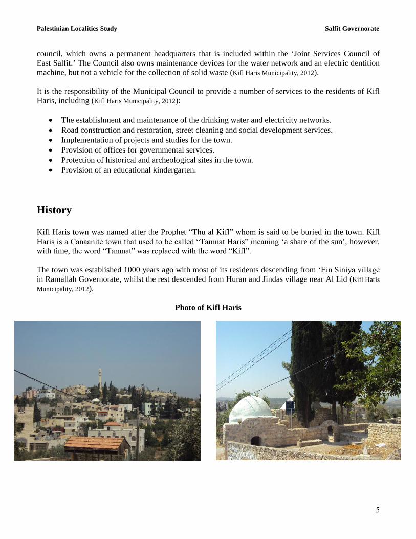
History
Kifl Haris town was named after the Prophet “Thu al Kifl” whom is said to be buried in the town. Kifl
Haris is a Canaanite town that used to be called “Tamnat Haris” meaning „a share of the sun‟, however,
with time, the word “Tamnat” was replaced with the word “Kifl”.
The town was established 1000 years ago with most of its residents descending from „Ein Siniya village
in Ramallah Governorate, whilst the rest descended from Huran and Jindas village near Al Lid (Kifl Haris
Municipality, 2012).
Photo of Kifl Haris

Palestinian Localities Study Salfit Governorate
6
Religious and Archaeological Sites There are five mosques in the town; An Noor, Al Haqq, Abu Bakr as Siddiq, Hajja Hamida Abd Naffa‟
and Kifl Haris Old Mosques. The town has several sites of archaeological interest including: Prophet
Thu al Kifl Shrine, Prophet Thu an Noon Shrine and Prophet Yosha‟ Shrine. One should note that none
of these sites are qualified for tourism (Kifl Haris Municipality, 2012) (See Map 2).
Map 2: Main locations in Kifl Haris Town
Population Source: ARIJ - GIS Unit, 2013.
Population
According to the Palestinian Central Bureau of Statistics (PCBS), the total population of Kifl Haris in
2007 was 3,206, of whom 1,592 were male and 1,614 female. There were additionally 599 households
recorded as living in 704 housing units.
Age Groups and Gender
The „General Census of Population and Housing‟ carried out by PCBS in 2007 showed the distribution
of age groups in Kifl Haris is as follows: 42.5% were less than 15 years of age, 52.3% were between 15

Palestinian Localities Study Salfit Governorate
7
and 64 years of age, and 4.8% were 65 years of age or older. Data also showed that the sex ratio of
males to females in the town is 98.6:100, meaning that males and females constitute 49.7% and 50.3%
of the population, respectively.
Families
Kifl Haris residents are from several families, including Salih, Abu Ya‟coub, Buziyah, Qaqq, Hammad,
Obeid and Qishawi (Kifl Haris Municipality, 2012).
Education
According to the results of the PCBS Population, Housing and Establishment Census-2007, the illiteracy
rate among Kifl Haris population is approximately 6.5%, of whom 80.1% are females. Of the literate
population, 10.6% could only read and write, with no formal education, 19% had elementary education,
23.9% had preparatory education, 24.1% had secondary education, and 15.7% completed higher
education. Table 1 shows the educational level in the town of Kifl Haris by sex and educational
attainment in 2007.
Table 1: Kifl Haris population (10 years and above) by sex and educational attainment
S
E
x
Illite-
rate
Can
read &
write
Element-
ary
Preparat-
ory
Second-
ary
Associate
Diploma Bachelor
Higher
Diploma Master
PhD Un-
known Total
M 29 134 207 287 287 37 117 1 12 2 1 1,114 F 117 104 218 248 253 65 113 0 5 0 4 1,127 T 146 238 425 535 540 102 230 1 17 2 5 2,241 Source: PCBS, 2009.
There are four public schools in the town, all are run by the Palestinian Ministry of Higher Education
(Directorate of Education in Salfit, 2012) (see Table 2).
Table 2: Schools in Kifl Haris by name, stage, sex, and supervising authority (2011/2012)
School Name Supervising Authority Sex
Kifl Haris Girls‟ Secondary School Government Female
Kifl Haris Girls‟ Elementary School Government Female
Kifl Haris Boys‟ Elementary Higher School Government Male
Kifl Haris Co-educated Secondary School Government Mixed Source: Directorate of Education in Salfit, 2012
In the town there are 1,104 students, 77 teachers, and 47 classes. The average number of students per
teacher in the school is nearly 14, whilst the average number of students per class is approximately 23
(Directorate of Education in Salfit, 2012).
There are two kindergartens in Kifl Haris town, both of which are run by a private organization
(Directorate of Education in Salfit, 2012) (See table 3 below).

Palestinian Localities Study Salfit Governorate
8
Table 3: Kindergartens in Kifl Haris town by name and supervising authority
Name of Kindergarten No. of Classes No. of Teachers Supervising Authority
Sundus for the Future Kindergarten 2 2 Private
Az Zuhoor Kindergarten 2 3 Private Source: Directorate of Education in Salfit, 2012
Due to the lack of an industrial school in the town, students head to Salfit Industrial School in Salfit city
which is approx. 18 km from Kifl Haris (Kifl Haris Municipality, 2012).
The educational sector in Kifl Haris town faces a number of obstacles, including (Kifl Haris Municipality,
2012):
The poor infrastructure of part of Kifl Haris Boys‟ Elementary School buildings and the leakage
of water into the classrooms (4 classrooms are in need of rehabilitation).
The crowded classrooms in Kifl Haris Girls‟ Secondary School and the need to construct
additional classrooms to accommodate pupils (2 classrooms).
The existence of permanent and partial checkpoints on the roads leading to Kifl Haris Co-
educated Secondary and Kifl Haris Boys Elementary Schools, which delays staff and students
from reaching school on time.
Health Status
Kifl Haris has a governmental mother and child care center, a health clinic and a medical laboratory
joined between the governmental sector and the Palestinian Red Crescent Society, 4 private general
physicians clinics, a private ophthalmologist clinic, a private Urologist clinic and 3 private pharmacies.
In the absence of required health services or in emergencies, patients are transferred to Yasir Arafat
Governmental Hospital in Salfit city (18 km away) or to Rafidiya Governmental Hospital in Nablus city
(23 km away) (Kifl Haris Municipality, 2012).
The health sector in the town faces some obstacles and problems, principally (Kifl Haris Municipality, 2012):
The lack of medicines in the health clinic.
The lack of financial and material capacities in the medical laboratory of the health clinic.
The lack of an ambulance for the health clinic.
Economic Activities
The economy in Kifl Haris is mainly dependent on the employees (private and government) sector
which absorbs approximately 30% of the town‟s workforce (Kifl Haris Municipality, 2012) (See Figure 1).
The results of a field survey conducted by ARIJ in 2012 for the distribution of labor by economic
activity in Kifl Haris are as follows:

Palestinian Localities Study Salfit Governorate
9
Government or other employees sector (30%)
Trade sector (22%)
Agriculture sector (15%)
Israeli labor market (15%)
Industry (10%)
Services sector (8%)
Figure 1: The distribution of labor force among main economic activities in Kifl Haris
Source: Kifl Haris Municipality, 2012
Kifl Haris has 5 groceries, 13 fruits and vegetables stores, a bakery, a butchery, 11 service stores, 6
different professional workshops, a stone cutter, 2 olive oil-presses and an agricultural nursery (Kifl Haris
Municipality, 2012).
In 2012, the unemployment rate in Kifl Haris reached 12% and the groups most affected economically
by the Israeli restrictions have been (Kifl Haris Municipality, 2012):
Agricultural workers.
Workers in the trade sector.
Workers in the services sector.
Labor Force
According to the PCBS Population, Housing and Establishment Census-2007, 32.1% of Kifl Haris labor
force was economically active, of whom 84.7% were employed, 67.7% were not economically active,
56.1% were students, and 28.9% were housekeepers (See Table 4).

Palestinian Localities Study Salfit Governorate
11
Table 4: Kifl Haris population (10 years of age and above) by sex and employment status
S
e
x
Economically active Non-economically active
Not
stated Total Employ-
ed
Currently
Unem-
ployed
Un-
employed
(never
worked)
Total Stud-
ent
House-
keeping
Unable
to work
Not
working
& not
looking
for work
Others Total
M 482 76 15 573 432 2 81 15 10 540 1 1,114
F 128 12 7 147 420 436 104 4 14 978 2 1,127
T 610 88 22 720 852 438 185 19 24 1,518 3 2,241 M: Male; F: Female; T: Total.
Source: PCBS, 2009.
Agricultural Sector
Kifl Haris has a total area of approximately 9,302 dunums of which 6,500 are „arable‟ land and 438
dunums are registered as „residential,‟ making it a predominantly agriculturally dependent region (See
Table 5 and Map 3).
Table 5: Land use and land cover in Kifl Haris town (area in dunum)
Total
Area
Built
up
Area
Agricultural area
(6,500)
Inland
water
Forests Open
Spaces
Area of
Industrial,
Commercial &
Transport Unit
Area of
Settlements,
Military
Bases &
Wall Zone
Permanent
Crops
Green-
houses
Range-
lands
Arable
lands
9,302 438 6,116 1 63 320 0 0 1,833 165 366
Source: ARIJ – GIS Unit, 2012.

Palestinian Localities Study Salfit Governorate
11
Map 3: Land use/land cover and Segregation Wall in Kifl Haris Town
Source: ARIJ - GIS Unit, 2013.
Table 6 shows the different types of rain-fed and irrigated open-cultivated vegetables in Kifl Haris. The
most commonly cultivated crops within this area are green beans, tomatoes, squash, Jew‟s melon,
cabbages and cauliflowers.
Table 6: Total area of rain-fed and irrigated open cultivated vegetables in Kifl Haris (area in dunums)
Fruity
vegetables
Leafy
vegetables Green legumes Bulbs
Other
vegetables Total Area
Rf. Irr. Rf. Irr. Rf. Irr. Rf. Irr. Rf. Irr. Rf. Irr.
10 28 0 14 0 11 0 4 0 0 10 57 Rf.: Rain-fed; Irr.: Irrigated.
Source: Ministry of agriculture-Salfit, 2010
Table 7 shows the different types of fruit trees planted in the area. Kifl Haris is famous for olive
cultivation and there are approximately 4,895 dunums of town lands planted with olive trees.
Table 7: Total area of horticulture and olive trees in Kifl Haris (area in dunums)
Olives Citrus Stone-fruits Pome fruits Nuts Other fruits Total Area
Rf. Irr. Rf. Irr. Rf. Irr. Rf. Irr. Rf. Irr. Rf. Irr. Rf. Irr.
4,895 0 0 0 16 0 0 0 0 0 26 0 4,937 0 Rf.: Rain-fed; Irr.: Irrigated.
Palestinian Localities Study Salfit Governorate
12
Source: Ministry of agriculture-Salfit, 2010
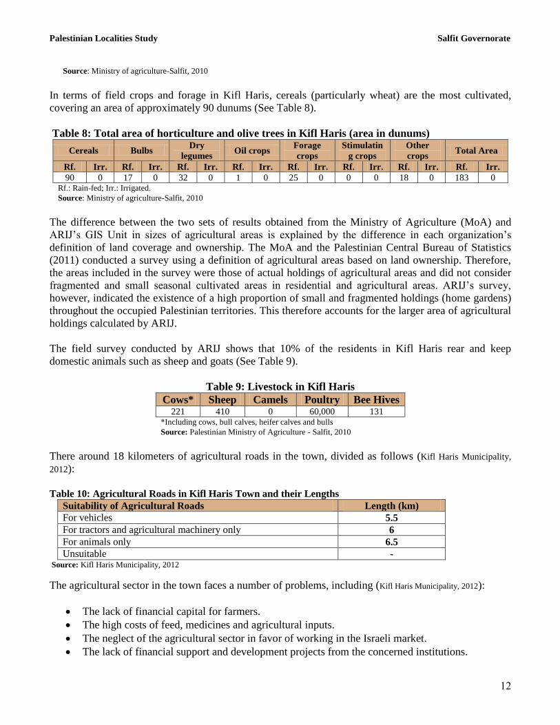
In terms of field crops and forage in Kifl Haris, cereals (particularly wheat) are the most cultivated,
covering an area of approximately 90 dunums (See Table 8).
Table 8: Total area of horticulture and olive trees in Kifl Haris (area in dunums)
Cereals Bulbs Dry
legumes Oil crops
Forage
crops
Stimulatin
g crops
Other
crops Total Area
Rf. Irr. Rf. Irr. Rf. Irr. Rf. Irr. Rf. Irr. Rf. Irr. Rf. Irr. Rf. Irr.
90 0 17 0 32 0 1 0 25 0 0 0 18 0 183 0 Rf.: Rain-fed; Irr.: Irrigated.
Source: Ministry of agriculture-Salfit, 2010
The difference between the two sets of results obtained from the Ministry of Agriculture (MoA) and
ARIJ‟s GIS Unit in sizes of agricultural areas is explained by the difference in each organization‟s
definition of land coverage and ownership. The MoA and the Palestinian Central Bureau of Statistics
(2011) conducted a survey using a definition of agricultural areas based on land ownership. Therefore,
the areas included in the survey were those of actual holdings of agricultural areas and did not consider
fragmented and small seasonal cultivated areas in residential and agricultural areas. ARIJ‟s survey,
however, indicated the existence of a high proportion of small and fragmented holdings (home gardens)
throughout the occupied Palestinian territories. This therefore accounts for the larger area of agricultural
holdings calculated by ARIJ.
The field survey conducted by ARIJ shows that 10% of the residents in Kifl Haris rear and keep
domestic animals such as sheep and goats (See Table 9).
Table 9: Livestock in Kifl Haris
Cows* Sheep Camels Poultry Bee Hives 221 410 0 60,000 131
*Including cows, bull calves, heifer calves and bulls
Source: Palestinian Ministry of Agriculture - Salfit, 2010
There around 18 kilometers of agricultural roads in the town, divided as follows (Kifl Haris Municipality,
2012):
Table 10: Agricultural Roads in Kifl Haris Town and their Lengths
Suitability of Agricultural Roads Length (km)
For vehicles 5.5
For tractors and agricultural machinery only 6
For animals only 6.5
Unsuitable - Source: Kifl Haris Municipality, 2012
The agricultural sector in the town faces a number of problems, including (Kifl Haris Municipality, 2012):
The lack of financial capital for farmers.
The high costs of feed, medicines and agricultural inputs.
The neglect of the agricultural sector in favor of working in the Israeli market.
The lack of financial support and development projects from the concerned institutions.

Palestinian Localities Study Salfit Governorate
13
The lack of access to agricultural lands as a result of Israeli restrictions (i.e. the Segregation
Wall).
The lack of water sources for agricultural production.
The confiscation of agricultural lands by Israeli occupation forces.
Institutions and Services
Kifl Haris town has a post office in addition to a number of local institutions and associations that
provide services to various sectors of society. These include (Kifl Haris Municipality, 2012):
Kifl Haris Municipal Council: Founded in 1999 by the Ministry of Local Government, with the
aim of taking care of the town‟s issues and providing various services to its population, such as
infrastructure services.
Kifl Haris Sports Club: Founded in 1996 and was later registered by the Ministry of Youth and
Sports. The Club is interested in the younger generation as it organizes sports teams, summer
camps and educational courses, in addition to supplying needy families with in-kind assistance,
such as food baskets and stationery.
The Rural Women Development Society: Founded in 2007 by the Ministry of Interior, it is
interested in woman's affairs and defending gender rights. It also organizes handcrafts, food
processing and health educational courses, in addition to various summer camps.
Safe Mother & Life Cultural Center: Founded in 2001 by the Palestinian Red Crescent
Society, it is interested in women, through organizing courses on giving birth and early marriage,
in addition to following up on married ladies through regular home visits. It also organizes
multiple summer camps and various activities.
Youth development Society: Founded in 2004 by the Agricultural Relief Organization and was
later registered by the Ministry of Interior. The Society organizes sports teams, summer camps,
medical days and health educational courses, in addition to providing loans for young people to
implement small development projects.
Infrastructure and Natural Resources
Electricity and Telecommunication Services:
Kifl Haris has been connected to a public electricity network since 1984. It is served by the Israeli
„Qatariya Electricity Company,‟ which represents the main source of electricity in the town. All of the
housing units in the town are connected to the network. The town residents face a number of problems
concerning electricity, primarily the weak electrical current and frequent power outages, in addition to
the geographical extension of the town which does not commensurate with the power voltage (Kifl Haris
Municipality, 2012).

Palestinian Localities Study Salfit Governorate
14
Kifl Haris is also connected to a telecommunication network. Approximately 70% of the housing units
within the town boundaries are connected to phone lines (Kifl Haris Municipality, 2012).
Transportation Services:
There are 5 taxis and 8 public buses in Kifl Haris. However, residents suffer from the existence of earth
mounds and/or military checkpoints on roads in addition to the lack of vehicles to serve all residents
with transport (Kifl Haris Municipality, 2012). There are 6.5 km of main roads and 20 km of secondary roads
in Kifl Haris (Kifl Haris Municipality, 2012) (See Table 11).
Table 11: Roads in Kifl Haris town
Status of Internal Roads Road Length (km)
Main Sub
1. Paved & in good condition 3.5 5
2. Paved &in poor condition 3 7
3. Unpaved - 8 Source: Kifl Haris Municipality, 2012
Water Resources:
Kifl Haris is provided with water by the „West Bank Water Department‟ through the public water
network established in 1982 and all housing units are connected to the water network (Kifl Haris Municipality,
2012)
The quantity of water supplied to Kifl Haris town in 2010 was approximately 81,000 cubic meters/year
which makes the estimated rate of water supply per capita 63 liters/day (Kifl Haris Municipality, 2012).
However, no Kifl Haris citizen consumes this amount of water due to water losses, which are estimated
at 22% (PWA, 2010). These losses happen at the main source, major transport lines, in the distribution
network, and at the household level. Therefore, the rate of water consumption per capita in Kifl Haris is
49 liters per day (Kifl Haris Municipality, 2012). The average water consumption of Kifl Haris residents is low
compared with the minimum quantity of 100 liters per capita per day proposed by the World Health
Organization. Each cubic meter of water from the public network costs 5 NIS (Kifl Haris Municipality,
2012).
The town has a public water reservoir with a capacity of 300 cubic meters used by its residents (Kifl Haris
Municipality, 2012).
Sanitation:
Kifl Haris lacks a public sewerage network and most of the population use cesspits and septic tanks as a
main means for wastewater disposal (Kifl Haris Municipality, 2012).
Based on the estimated daily per capita water consumption, the approximate quantity of wastewater
generated per day, is 138 cubic meters, or 50,544 cubic meters annually. At the individual level, it is
estimated that the per capita wastewater generation is approximately 39 liters per day. The wastewater
collected by cesspits and septic tanks is discharged by wastewater tankers directly to open areas or
nearby valleys with little regard for the environment. Here it is noted that there is no wastewater
Palestinian Localities Study Salfit Governorate
15
treatment either at the source or at the disposal sites and this poses a serious threat to the environment
and the public health (ARIJ - WERU, 2012).
Solid Waste Management:
The Joint Services Council of East Salfit is responsible for the collection and disposal of solid waste
generated by citizens and establishments in the town. As the process of solid waste management is
costly, a monthly fee amounting to 7 NIS/ month is charged to the population served by domestic solid
waste collection and transportation services. However, the collected fees are not considered sufficient
for a good management of solid waste, which is exacerbated by the fact that only approximately 80% of
these fees are collected from the citizens (Kifl Haris Municipality, 2012)
Most of the population in Kifl Haris benefits from solid waste services, whereby waste is collected from
households, institutions, shops, and public squares in plastic bags, and placed in 80 containers (of 1 m3
capacity) located around the municipality. The Joint Council in cooperation with the Municipality
collects the solid waste twice weekly and transports it using a waste vehicle to the town‟s dumping site,
1.5 km from the town, where it is subsequently burnt (Kifl Haris Municipality, 2012)
The daily per capita rate of solid waste production in Kifl Haris is 1.05kg. Thus the estimated quantity of
solid waste produced per day from the Kifl Haris residents is nearly 3.7 tons, or 1,350 tons per year
(ARIJ-WERU, 2012).
Environmental Conditions
Like other towns and villages in the Governorate, Kifl Haris experiences several environmental
problems which must be addressed and solved. These problems can be identified as follows:
Water Crisis
Water is cut off by the West Bank Water Department for long periods of time during summer in
numerous neighborhoods of the town for several reasons:
1. Israeli control over Palestinian water resources causes problems in the organization of water
pumping and its distribution among populations. The West Bank Water Department
distributes water to various areas on an interval basis because the amount of water available
is not sufficient to simultaneously supply everyone‟s needs. In addition, the West Bank
Water Department purchase water from Israeli Companies in order to meet the citizens
needs of water.
2. High rate of water losses, due to the water network‟s aged condition in need of rehabilitation
and renovation.
Wastewater Management
The absence of a public sewage network in the town means that Kifl Haris residents are forced to
use unhygienic cesspits for the disposal of wastewater, and/or to discharge wastewater in the

Palestinian Localities Study Salfit Governorate
16
streets. This is particularly common in winter, as citizens cannot afford the high cost of sewage
tankers during this period. These methods facilitate environmental damage, health problems, and
the spread of epidemics and diseases in the town. This wastewater also contaminates the
groundwater because most cesspits are built without lining, to avoid the need to use sewage
tankers and allow wastewater to enter into the ground. Moreover, the untreated wastewater
collected from cesspits by sewage tankers is disposed of in open areas without concern for the
damage it causes to the environment and to residents' health.
Solid Waste Management:
Zahrat al Finjan landfill in Jenin Governorate (approximately 32 km in distance from the center
of Salfit Governorate) is considered the central sanitary landfill which is supposed to serve Salfit
Governorate. However, the Municipalities and Village Councils in Salfit Governorate do not
transfer the solid waste to Zahrat al Finjan landfill, but rather get rid of waste in random dumps
scattered throughout the Governorate. This is due to the high costs of transporting and disposing
waste in the landfill. As a result, wastes are being disposed randomly in these landfills causing an
abomination to health, and leading to the proliferation of harmful flies, insects, and mice, as well
as the bad odors, toxic gases and black smoke which emits when burned. All of these have
harmful effects on human health as well as the environment.
The lack of a central sanitary landfill to serve Kifl Haris and the other neighboring communities
in the Governorate is due mainly to obstacles created by the Israeli authorities for local and
national institutions in granting licenses to establish such a landfill. The reason of cited against
the creation of a landfill is that the appropriate land is within Area C (Oslo Accords II) and under
Israeli administrative and security control. Additionally, the implementation of such projects
depends on funding from donor countries. The lack of a sanitary landfill is a source of pollution
to the groundwater and soil through the leachate produced from the solid waste, which produces
bad odors and a distortion of the landscape.
Impact of the Israeli Occupation
Geopolitical status in Kifl Haris
According to the Oslo II Interim Agreement signed between the Palestinian Liberation Organization
(PLO) and Israel on 28th
September 1995, Kifl Haris was divided into areas “B” and “C”.
Approximately 3,919 dunums (42% of the town‟s total area) were assigned as area B, where the
Palestinian National Authority (PNA) has a complete control over civil matters but Israel continues to
have overriding responsibility for security. Area B constitutes most of the inhabited Palestinian areas,
including municipalities, villages and some refugee camps. It is worth mentioning that most of the
town‟s population resides in area B. The rest of the town‟s area, constituting 5,383 dunums (58% of the
total area), is classified as area C, where Israel retains full control over security and administration
related to the territory (table 12). In Area C Palestinian building and land management is prohibited

Palestinian Localities Study Salfit Governorate
17
unless through consent or authorization by the Israeli Civil Administration. Most of the lands lying
within area C are agricultural areas, open spaces and lands confiscated for Israeli settlements.
Table 12: The Geopolitical Divisions of Kifl Haris – Salfit Governorate
Percent of Total town area Area in dunums Area
0 0 Area A
42 3,919 Area B
58 5,383 Area C
0 0 Nature Reserve
100 9,302 Total Source: ARIJ-GIS, 2013
The Israeli Occupation Practices in Kifl Haris Town
Kifl Haris town has been subjected to numerous Israeli confiscations for the benefit of the various Israeli
objectives, represented in the construction of Israeli settlements, checkpoints, outposts and bypass roads
on the town‟s territories. This is in addition to the Segregation Plan represented by the Segregation Wall.
That which follows is a breakdown of the Israeli confiscations to have negatively affected Kifl Haris
town territories
During their occupation of the Palestinian territories, Israeli Occupation Forces (IOF) confiscated 361
dunums (4% of the town‟s total area) in Kifl Haris to establish “Ariel” settlement south of the town and
north of Salfit city, which is considered the second largest Israeli settlements in the West Bank in terms
of area, and which is separated from Kifl Haris town by the Segregation Wall.
The settlement was established in 1978 on a total area of 5,184 dunums of lands of Kifl Haris, as well as
Salfit city, Iskaka and Marda villages. Today, this settlement is inhabited by 17,559 Israeli settlers. In
addition the occupation authorities provided this settlement, built on confiscated Palestinian lands,
multiple types of services and infrastructure to become an integrated city, including health, education
and entertainment services. Israeli authorities have supported the establishment of "Ariel College - Judea
and Samaria." On 17 July 2012, the Council for Higher Education in Judea and Samaria passed a
resolution to grant the institution full university status. According to Arutz Sheva (2012), „this move was
praised by the Prime Minister Benjamin Netanyahu, Minister of Education Gideon Saar, Foreign
Minister Avigdor Lieberman and a number of Knesset members.‟
This move demonstrated how the
occupation authorities consider this settlement an integral part of the "State of Israel."
Kifl Haris town has been subjected to many attacks from settlers living in settlements surrounding the
town, including assaults on agricultural land and trees, in addition to preventing farmers from accessing
their lands. Additionally, settlers organize periodic visits guarded by the Israeli army to religious shrines
in the town (Prophet Thu al Kifl, Prophet Thu an Noon and Prophet Yosha‟ Shrine). Here they have
attacked areas of historical and religious significance in addition to attacking the property of citizens
through writing wrote slogans hostile to Arabs and Muslims on people‟s property.
Moreover, the occupation authorities‟ have confiscated approximately 35 dunums of land in Kifl Haris
in order to establish a power station for the Israeli Electricity Company south of the town, on Israeli
bypass road number 5.

Palestinian Localities Study Salfit Governorate
18
Following the outbreak of the second Palestinian Intifada in September 2000, the Israeli occupation
authorities established two Israeli military checkpoints on the southern entrance of the town, which are
represented as an iron gate that is currently open1 and a military observation tower. It is worth noting
that this gate established on the main entrance of the town is being closed and open intermittently
according to the security situation, which increases the suffering of this town people in times of closures.
The military tower was established by the occupation forces on the 16th
November 2008 on land
confiscated from the town's population upon the Israeli Military Order No. 08/08/SH2. This order was
was issued on November 8 2008 by the Israeli civil administration and confiscates a piece of land in “Al
Marj” site south of Kifl Haris town which is owned by citizen Mahmoud Abdul Hadi Shqeir.
Furthermore, following the outbreak of the second Palestinian Intifada in September 2000, the
Israeli occupation authorities established another Israeli military checkpoint on the northern entrance of
Salfit city, which is represented as an iron gate established near the western entrance of Ariel Israeli
settlement. Closing the northern entrance of Salfit city has had a negative impact on Palestinians lives
during the last decade, as it is has restricted their freedom of movement and connection with villages
north of Salfit and other villages in the northern West Bank. This has caused numerous material losses
for Palestinians and increased economic burden, as they are forced to use longer distances in order to
reach villages in the north. The closure of this checkpoint, was carried out under the pretext of
protecting settlers in Ariel settlement as well as other nearby settlements. This checkpoint
represents a part of the Segregation Plan adopted by the occupation forces through the establishment of
settlements, annexing them through the Segregation Wall and changing Palestinians‟ movement. The
checkpoint north of Salfit was closed to Palestinians for more than 10 years and was recently partially
opened (during 2011) for public vehicles only (taxis and buses), while private cars are still forbidden to
cross it.
Due to the closure of this main entrance to Salfit city and its neighboring villages, citizens started using
the eastern entrance of the city which passes through Yasuf and Iskaka villages, then to Salfit city.
However, the citizens are forced to cross through another military checkpoint that is considered
representative of many Palestinian‟s daily suffering. The checkpoint is called “Za‟tara” (Kfar Taffuh)
military checkpoint which separates the center from north of the West Bank.
Moreover, the Israeli Government has confiscated thousands of dunums of agricultural and non-
agricultural lands to open several bypass roads stretching thousands of kilometers from the north to
south in the West Bank. This has been carried out to link Israeli settlements, dismember Palestinian
lands and enhance Israeli security control over them. Israel has also confiscated more land from Kifl
Haris to its south, for the construction of the Israeli bypass road no. 5 known as “Samria Crossing” and
Israeli bypass road no. 505. Both roads extend for 4.6km on the town‟s land with a 40 m width. The real
threat of these bypass roads however lies in the buffer zone formed by the IOF, extending approximately
75 m on each side. These buffer zones dramatically increase the total area of land affected by the
construction of the bypass roads.
1 Although note that this is likely to change in times of political tension or as a result of other Israeli restrictions.
2 Confiscating Palestinian lands in Kifl Haris village.
http://www.poica.org/editor/case_studies/view.php?recordID=1695

Palestinian Localities Study Salfit Governorate
19
The Israeli Segregation Wall Plan in Kifl Haris Town
The Israeli Segregation Wall plan has had a negative and destructive impact on Kifl Haris residents. The
latest route of the Israeli Segregation Wall Plan, published on the Israeli Ministry of Defense's website
(April 30 2007), shows that upon the implementation of the wall on Kifl Haris town‟s land to the south,
4,095 dunums, equivalent to 44% of the town‟s total area will be isolated, and even more lands for
Israeli settlement activities will be isolated. The majority of lands planned to be isolated by the Wall
includes agricultural areas, open spaces and “Ariel” Israeli settlement (See Table 13).
Table 13: Land Classification of the Isolated lands in Kifl Haris Town – Salfit Governorate
No. Land Classification Area (in dunums)
1 Agricultural Areas 1,919
2 Open Spaces 1,608
3 Israeli Settlements 361
4 Construction Sites 140
5 Shrubs and Herbaceous Vegetation 63
6 Wall Zone 4
Total 4,095 Source: The Geo-informatics Department – ARIJ 2013
Upon the completion of the Segregation Wall plan, the planned Wall will isolate approx. half of Kifl
Haris town lands and will include many Israeli settlements within the Wall area known as the "Ariel
Finger"3 scheme; of which the largest and most important is Ariel settlement. This will lead to the
isolation of Kifl Haris town from Salfit city and villages south and west of Salfit.
One should also note that Salfit Governorate villages are known for their fertile soil, their beautiful
nature and the abundance of water and large trees, especially olive trees. This makes the region an
important target for Israeli settlement activities, and is the second Governorate after Jerusalem in terms
of land confiscations, wall and settlement construction (ARIJ-UMD, 2012).
Military Orders Issued in Kifl Haris Town
The Israeli occupation Army has issued many military orders to confiscate lands in Kifl Haris town.
Among the issued orders was Israeli Military Order No. 32/05/T (extension of validity No. 2), which
was issued during February 2010, to confiscate a total area of 86.3 dunums of land in Kifl Haris and
Marda villages in order to construct the Israeli Segregation Wall.
Also, on December 29 2011, the Israeli Civil Office of Coordination and Liaison handed Palestinians a
military notification No. 32/05/T (extension and amendment No. 2) which extends the confiscation
validity of the aforementioned order (No. 32/05/T) until the year 2014 to complete the construction of
3 The 'Ariel finger' penetrates deep inside the northern part of the West Bank, on lands of Salfit Governorate, about 22 km
east of the 1949 Armistice Line (Green Line), (ARIJ GIS, 2012). The Israeli updated Wall map of April, 2007 which was
published on the Israeli Ministry of Defense website showed that the Wall around Ariel bloc will annex 21 Israeli
settlements to Israel proper, at the same time, it will isolate more than 10 Palestinian communities from the center of life in
Salfit city and the nearby Palestinian villages.
Palestinian Localities Study Salfit Governorate
21
the fence (a form of the Racial Segregation Wall) on 86.2 dunums of land of Kifl Haris and Marda
villages. The order was first issued back in the year 2005 and states the confiscation of 197 dunums of
Marda and Kifl Haris lands for the construction of the fence around the settlement of Ariel. The military
notification, which was signed by the commander of the Israeli army in the West Bank; Moshe Lobinski,
is a renewal for a second time for lands that have already been confiscated by the Israeli occupation
authorities in 2005 for the construction of the wall. The military notification was first amended on
February 11 2010.
It should be noted that the notifications of seizure of land that had been previously confiscated by the
occupation, came because the occupation authorities did not complete the construction of a section of
the wall (fence) at the planned site as stated in the Military Order. This was due to petitions submitted by
Palestinians to the Israeli Supreme Court against the construction of the wall (fence) in the area,
questioning the legitimacy of its location, which upon its implementation will deprive Palestinians from
their agricultural lands. This in turn prompted the Israeli government to issue an extension of validity to
the Israeli military order; The first was issued in the year 2010 while the second was issued in 2011, so
that Israel can complete the construction of the wall (the fence) around the “Ariel Finger”.
Development Plans and Projects
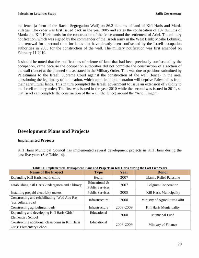
Implemented Projects
Kifl Haris Municipal Council has implemented several development projects in Kifl Haris during the
past five years (See Table 14).
Table 14: Implemented Development Plans and Projects in Kifl Haris during the Last Five Years
Name of the Project Type Year Donor
Expanding Kifl Haris health clinic Health 2117 Islamic Relief-Palestine
Establishing Kifl Haris kindergarten and a library Educational &
Public Services 2117 Belgium Cooperation
Installing prepaid electricity meters Public Services 2118 Kifl Haris Municipality
Constructing and rehabilitating „Wad Abu Ras
„agricultural road Infrastructure 2118 Ministry of Agriculture-Salfit
Constructing agricultural roads Infrastructure 2008-2009 Kifl Haris Municipality
Expanding and developing Kifl Haris Girls‟
Elementary School
Educational 2118 Municipal Fund
Constructing additional classrooms in Kifl Haris
Girls‟ Elementary School
Educational 2008-2009 Ministry of Finance

Palestinian Localities Study Salfit Governorate
21
Expanding and developing Kifl Haris Girls‟
Secondary School
Educational 2010-2009 UNDP
Rehabilitating and paving secondary roads Infrastructure 2010-2009 Ministry of Local Government
Maintaining religious and historical sites Public Services 2111 Salfit Governorate
Rehabilitating and paving secondary roads Infrastructure 2111 Municipal Fund
Rehabilitating Kifl Haris town entrance Infrastructure 2111 CHF
Source: Kifl Haris Municipality, 2012
Proposed Projects
Kifl Haris Municipal Council, in cooperation with the town‟s civil society organizations and town
residents, hopes to implement several projects in the coming years. The project ideas were developed
during the Participatory Rapid Appraisal (PRA) workshop conducted by ARIJ staff in the town. The
projects are as follows, in order of priority from the viewpoints of the workshop participants:
1. Developing the electricity network by increasing the electric power voltage, and extending it by
approx. 2km to reach new buildings in the town outskirts.
2. Developing the public water network through the provision of household water connections and
expanding it by approximately 2 km.
3. Constructing a school and a public library to reduce the students density in the currently
available schools.
4. Supplying the town with at least 50 waste collection containers and re-activating the waste
recycling landfill.
5. Constructing and paving secondary roads (5 km) and agricultural roads (10 km).
6. Establishing a sewerage network in the town.
7. Constructing a gym and providing it with a stadium to serve the town‟s youth.
8. Constructing a women center to activate the role of women in the town.
9. Supplying the town with a private car for transportations and a pumping car to regulate the
process of collecting and disposal of sewage water in specific areas.
10. Ratifying the structural plan of the town by the Ministry of Local Government.
11. Restoring the old city buildings, and publicizing the town for tourism through the media.
12. Establishing an emergency center that operates 24 hours a day.

Palestinian Localities Study Salfit Governorate
22
Locality Development Priorities and Needs Kifl Haris suffers from a significant shortage of infrastructure and services. Table 15 shows the
development priorities and needs in the town, according to the Municipal Council‟s view point.
Table 15: Development Priorities and Needs in Kifl Haris
No. Sector Strongly
Needed
Needed Not a
Priority
Notes
Infrastructural Needs
1 Opening and paving roads * 44.5 km^
2 Rehabilitation of old water networks * 4 km
3 Extending the water network to cover new built up
areas *
5 km
4 Constructing new water networks *
5 Rehabilitation/ construction of new wells and/ or
springs *
6 Construction of water reservoirs * 500 m3
7 Construction of a sewage disposal network * 10 km
8 Construction of a new electricity network * 3 km
9 Providing containers for solid waste collection * 40 containers
10 Providing vehicles for collecting solid waste *
11 Providing a sanitary landfill *
Health Needs
1 Building new clinics or health care centres *
2 Rehabilitation of old clinics or health care centres *
3 Purchasing medical equipment and tools * 1
Educational Needs
1 Building new schools *
2 Rehabilitating old schools *
Kifl Haris Boys
Elementary School
3 Purchasing new equipment for schools * all schools
Agriculture Needs
1 Rehabilitating agricultural lands *
2 Building rainwater harvesting cisterns * 20 cisterns
3 Constructing livestock barracks *
4 Provision of veterinary services *
5 Provision of seeds and hay for animals * 240 tons per year
6 Construction of new greenhouses * 5 greenhouses
7 Rehabilitation of greenhouses * 2 greenhouses
8 Provision of field crops seeds *
9 Provision of plants and agricultural supplies *
^ 6.5 km main roads, 20 km secondary roads and 18 km are agricultural roads Source: Kifl Haris Municipality, 2012

Palestinian Localities Study Salfit Governorate
23
References:
Applied Research Institute - Jerusalem (ARIJ), 2013. Geographic Information Systems and
Remote Sensing Unit Database. Bethlehem - Palestine.
Applied Research Institute - Jerusalem (ARIJ), 2013. Geographic Information Systems and Remote
Sensing Unit; Land Use Analysis (2012) – Half Meter High Accuracy. Bethlehem - Palestine.
Applied Research Institute - Jerusalem (ARIJ). 2012. Urbanization Monitoring Department
Violations Database (UMD). Bethlehem - Palestine.
Applied Research Institute - Jerusalem (ARIJ). 2012. Water & Environment Research Unit
Database (WERU). Bethlehem - Palestine.
Kifl Haris Municipality, 2012.
Ministry of Education & Higher Education (MOHE) - Salfit, 2012. Directorate of Education; A
database of schools (2011/2012). Salfit – Palestine.
Palestinian Central Bureau of Statistics. 2009. Ramallah, Palestine: General Census of Population
and Housing Censuses, 2007.
Palestinian Ministry of Agriculture (MOA), 2010. Directorate of Agriculture data (2009/2010).
Salfit - Palestine.
Palestinian Water Authority. 2012. Ramallah, Palestine: Water Supply Report, 2010.