Public Access to County GIS Basemap Data July,...
33
Public Access to County GIS Basemap Data Public Access to County GIS Basemap Data July, 2013 July, 2013 GIS Consultants, Piedmont, CA Page 1 GIS Consultants GIS Consultants GIS Consultants Open Data Consortium project Open Data Consortium project Open Data Consortium project Defending Public Access to Defending Public Access to our Governments' GeoData our Governments' GeoData The Supreme Decision Bruce Joffe, GISP, AICP Organizer, Open Data Consortium Principal, GIS Consultants Piedmont, CA [email protected] 510-508-0213 GIS Consultants GIS Consultants GIS Consultants Open Data Consortium project Open Data Consortium project Open Data Consortium project Agenda • Assuring Access to the Data used by our government Assuring Access to the Data used by our government o Santa Clara County Lawsuit summary o Orange County Lawsuit: current status • Copyright • Homeland Security • Software, Data, and the meaning of "System" • Public Agency Responsibility in a Democracy • Citizen Responsibility in a Democracy
Transcript of Public Access to County GIS Basemap Data July,...

Public Access to County GIS Basemap DataPublic Access to County GIS Basemap Data July, 2013July, 2013
GIS Consultants, Piedmont, CA Page 1
GIS Consultants GIS Consultants GIS Consultants Open Data Consortium projectOpen Data Consortium projectOpen Data Consortium project
Defending Public Access to Defending Public Access to
our Governments' GeoDataour Governments' GeoData
The Supreme Decision
Bruce Joffe, GISP, AICP
Organizer, Open Data Consortium Principal, GIS Consultants
Piedmont, CA
GIS Consultants GIS Consultants GIS Consultants Open Data Consortium projectOpen Data Consortium projectOpen Data Consortium project
Agenda
•• Assuring Access to the Data used by our governmentAssuring Access to the Data used by our government
o Santa Clara County Lawsuit summary
o Orange County Lawsuit: current status
• Copyright
• Homeland Security
• Software, Data, and the meaning of "System"
• Public Agency Responsibility in a Democracy
• Citizen Responsibility in a Democracy

Public Access to County GIS Basemap DataPublic Access to County GIS Basemap Data July, 2013July, 2013
GIS Consultants, Piedmont, CA Page 2
GIS Consultants GIS Consultants GIS Consultants Open Data Consortium projectOpen Data Consortium projectOpen Data Consortium project
What Basic Resource Is Needed To Start A Geoanalysis Project?
GIS Consultants GIS Consultants GIS Consultants Open Data Consortium projectOpen Data Consortium projectOpen Data Consortium project
Notification of Parcels Within 300 Ft.

Public Access to County GIS Basemap DataPublic Access to County GIS Basemap Data July, 2013July, 2013
GIS Consultants, Piedmont, CA Page 3
GIS Consultants GIS Consultants GIS Consultants Open Data Consortium projectOpen Data Consortium projectOpen Data Consortium project
GIS Consultants GIS Consultants GIS Consultants Open Data Consortium projectOpen Data Consortium projectOpen Data Consortium project
Geographic Parcel Data in California's 58 Counties
• 49 Provide Parcel Data at No Cost or Cost of Reproduction ($5 to $300)
o 20 Revised their distribution policy since 2004
• 8 Sell Parcel Data for More Than the Cost of Reproduction (over $500)
o 5 Use private data provider for their basemap
• 1 Is Not Releasing Parcel Data (says it is not available in digital form)

Public Access to County GIS Basemap DataPublic Access to County GIS Basemap Data July, 2013July, 2013
GIS Consultants, Piedmont, CA Page 4
GIS Consultants GIS Consultants GIS Consultants Open Data Consortium projectOpen Data Consortium projectOpen Data Consortium project
County Parcel Data Distribution Policy – 2006, 2012
GIS Consultants GIS Consultants GIS Consultants Open Data Consortium projectOpen Data Consortium projectOpen Data Consortium project
Which Counties Impeded Access to Parcel Data? (2009)
More Than Cost of Reproductiono Orange $ 375,000
o Santa Clara $ 158,000
o Merced $ 1,000
o Sierra $ 1,000
o Alpine $ 650
More Than Cost of Reproduction - Privateo Solano $ 13,400
o San Luis Obispo $ 12,000
o Madera $ 3,123
o Lassen $ 2,500
o Del Norte $ 1,500
Data Not Availableo Colusa
Public Access to County GIS Basemap DataPublic Access to County GIS Basemap Data July, 2013July, 2013
GIS Consultants, Piedmont, CA Page 5
GIS Consultants GIS Consultants GIS Consultants Open Data Consortium projectOpen Data Consortium projectOpen Data Consortium project
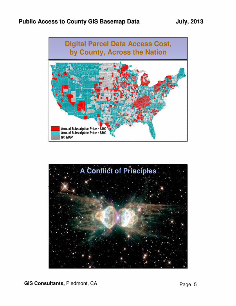
Digital Parcel Data Access Cost,by County, Across the Nation
GIS Consultants GIS Consultants GIS Consultants Open Data Consortium projectOpen Data Consortium projectOpen Data Consortium project
A Conflict of PrinciplesA Conflict of Principles

Public Access to County GIS Basemap DataPublic Access to County GIS Basemap Data July, 2013July, 2013
GIS Consultants, Piedmont, CA Page 6
GIS Consultants GIS Consultants GIS Consultants Open Data Consortium projectOpen Data Consortium projectOpen Data Consortium project
Public's Right to Public Dataaccess to public informationinsures government accountability
" ... the Legislature, mindful of the right of individuals to privacy, finds and declares that access to information concerning the conduct of the people's business is a fundamental and necessary rightfundamental and necessary right of every person in this state.. " CPRA CPRA §§ 62506250
Public Agency's Need to Fund Geodata OperationsIts ability to create, maintain, and disseminate data depends on funding through Taxes, Fees, Capture Taxes, Fees, Capture of Added Value, State Subsidy, or Data Sale.of Added Value, State Subsidy, or Data Sale.
" ... Yipes! Our department budget was cut "
Data Distribution PolicyGovernments' Accountability v. Cost
GIS Consultants GIS Consultants GIS Consultants Open Data Consortium projectOpen Data Consortium projectOpen Data Consortium project
Improving Access to Public Geodata:
Strategies for Solution
•• Enforcement of Public Records LawEnforcement of Public Records Law
• Use of Standard Data Distribution Policies & License Agreements to Harness the Private Sector for Distributing Data
• Capturing the Value of Using Geodata and Allocating a Portion to Geodata Maintenance
• Data Sharing for Emergency Response: Building Geodata Repositories
• State Government Incentive Payments

Public Access to County GIS Basemap DataPublic Access to County GIS Basemap Data July, 2013July, 2013
GIS Consultants, Piedmont, CA Page 7
GIS Consultants GIS Consultants GIS Consultants Open Data Consortium projectOpen Data Consortium projectOpen Data Consortium project
CA Attorney General's OpinionOctober 3, 2005October 3, 2005
1. Parcel boundary map dataParcel boundary map data maintained by a county Assessor in an electronic format is subject to public inspection and is subject to public inspection and
copyingcopying under provisions of the California Public Record Act.
2.2. A copy of parcel boundary map data maintained in an A copy of parcel boundary map data maintained in an
electronic formatelectronic format by a county assessor must be furnished must be furnished
promptlypromptly upon request of a member of the public.
3. The fee that may be chargedThe fee that may be charged by a county for furnishing a copy of parcel boundary map data maintained in an electronic format by a county assessor is generally limited to the amount is generally limited to the amount
that covers the direct cost of producing the copythat covers the direct cost of producing the copy, but may include certain other costs depending upon the particular circumstances as specified in the California Public Records Act.
20 Counties Have Changed Policy to Low or No Cost20 Counties Have Changed Policy to Low or No Cost
GIS Consultants GIS Consultants GIS Consultants Open Data Consortium projectOpen Data Consortium projectOpen Data Consortium project
What about the 8 counties that are What about the 8 counties that are notnot
in compliance with the in compliance with the
California Public Records Act?California Public Records Act?
The A.G's opinion is not a legal interpretation of the law.
A judicial determinationjudicial determination must be made in context of a lawsuit.

Public Access to County GIS Basemap DataPublic Access to County GIS Basemap Data July, 2013July, 2013
GIS Consultants, Piedmont, CA Page 8
GIS Consultants GIS Consultants GIS Consultants Open Data Consortium projectOpen Data Consortium projectOpen Data Consortium project
Enforcement of Public Records Law
June 12, 2006June 12, 2006California First Amendment CoalitionCalifornia First Amendment Coalition sent a Letter of DemandLetter of Demandfor Data under CPRA 6250 to Santa Clara CountySanta Clara Countyo Most current version of the GIS parcel basemap
closed polygons, each tagged with APN
o Each parcel to include these attributes:APN, Situs Address, Air Parcel Status & Address, Adr. Annotation
o Metadata: projection, datum, date of data capture, accuracy
o Database Dictionary, description of contents
o In BOTH .shp and ESRI geodatabase (native) Format
June 26, 2006 Timely Response received: Request REFUSEDo AG Opinion does notnot apply to a "sophisticated GIS basemapsophisticated GIS basemap"
o Basemap is copyrightedcopyrighted
o Records Exempted by State Law (unspecified)
oo Computer Mapping System is softwareComputer Mapping System is software (6254.9)claim that .shp files and geodatabase files are software
GIS Consultants GIS Consultants GIS Consultants Open Data Consortium projectOpen Data Consortium projectOpen Data Consortium project
Enforcement of Public Records Law
October 11, 2006October 11, 2006
CFACCFAC filed a petition with Superior Court of Santa Clara County (a state court) to enforce the CPRA
o As a citizen, CFAC has the right to viewview and copycopy the County's data, for no more than the cost of duplicationcost of duplication
o Citizen's right includes not having to state how the data will be used (therefore, not bound to sign a not bound to sign a
nonnon--disclosure agreementdisclosure agreement).
oo GIS basemap data is necessaryGIS basemap data is necessary, when used with other public information, to monitor and inspect the decisions of public agencies; for example, Property Property
Tax Assessment, Zoning Variance Approval, PermitsTax Assessment, Zoning Variance Approval, Permits

Public Access to County GIS Basemap DataPublic Access to County GIS Basemap Data July, 2013July, 2013
GIS Consultants, Piedmont, CA Page 9
GIS Consultants GIS Consultants GIS Consultants Open Data Consortium projectOpen Data Consortium projectOpen Data Consortium project
Find parcels with similar locational characteristics: Buffer distance to park
GIS Consultants GIS Consultants GIS Consultants Open Data Consortium projectOpen Data Consortium projectOpen Data Consortium project
Find parcels with similar attributes: Building size sq. ft.

Public Access to County GIS Basemap DataPublic Access to County GIS Basemap Data July, 2013July, 2013
GIS Consultants, Piedmont, CA Page 10
GIS Consultants GIS Consultants GIS Consultants Open Data Consortium projectOpen Data Consortium projectOpen Data Consortium project
Show Taxable Valuation
2
GIS Consultants GIS Consultants GIS Consultants Open Data Consortium projectOpen Data Consortium projectOpen Data Consortium project
Taxable Valuation less than half of mine < $ 30,000

Public Access to County GIS Basemap DataPublic Access to County GIS Basemap Data July, 2013July, 2013
GIS Consultants, Piedmont, CA Page 11
GIS Consultants GIS Consultants GIS Consultants Open Data Consortium projectOpen Data Consortium projectOpen Data Consortium project
GIS Consultants GIS Consultants GIS Consultants Open Data Consortium projectOpen Data Consortium projectOpen Data Consortium project
Superior Court Decision:VICTORY !
May 18, 2007 May 18, 2007 (7 months after petition filed)
Superior Court Superior Court directed Santa Clara County to:
1. Provide CFAC with an electronic copy of the GIS basemap, and
2. Charge CFAC the direct cost for the copy provided.
• Citing the state constitution "a statue shall be broadly construed if it furthers the people's right of access, and narrowly construed if it limits the right of access," the Court concluded that the County failed to show a the County failed to show a "clear overbalance" on the side of non"clear overbalance" on the side of non--disclosuredisclosure.If there's any doubt, data must be given to the requester

Public Access to County GIS Basemap DataPublic Access to County GIS Basemap Data July, 2013July, 2013
GIS Consultants, Piedmont, CA Page 12
GIS Consultants GIS Consultants GIS Consultants Open Data Consortium projectOpen Data Consortium projectOpen Data Consortium project
Superior Court Decision AppealedVICTORY (?)
June 12, 2007June 12, 2007
County Filed an Appeal:County Filed an Appeal:
• "County GIS Basemap is exempt from application of the CPRA because it has been Protected Critical Infrastructure Information (PCII) by the United States Department of Homeland Security"
o "Release of this sensitive information into the public domain Release of this sensitive information into the public domain
poses a threat to the public at largeposes a threat to the public at large, ... potentially allowing terrorists to identify the precise location of the location of the HetchHetch HetchyHetchy
water supply systemwater supply system and plan attacks that can disrupt the main water supply to millions of Bay Area residents
o "The County's request to protect the GIS Basemap from disclosure is ... to protect sensitive infrastructure information not not
customarily in the public domaincustomarily in the public domain."
GIS Consultants GIS Consultants GIS Consultants Open Data Consortium projectOpen Data Consortium projectOpen Data Consortium project
Appeals Court DecisionFebruary 5, 2009
•• Federal homeland security provisions do not applyFederal homeland security provisions do not apply.Both the Critical Infrastructure Information Act and the
accompanying DHS regulations make a distinction between submitterssubmitters of critical infrastructure information (to DHS) and recipientsrecipients of PCII (from DHS). The federal prohibition on disclosure of PCII applies only to recipientsrecipients of PCII fromfrom DHS.
• There is nono statutory basisstatutory basis either for copyrightingcopyrighting the GIS basemap or for conditioning its release on a licensing conditioning its release on a licensing agreementagreement.
"End user restrictions are incompatible with the purposes and operation of the CPRA."
•• The public interest in disclosure outweighs the public interest The public interest in disclosure outweighs the public interest in nondisclosure. in nondisclosure.
• County "remanded" to Superior Court to determine the fee for duplication.

Public Access to County GIS Basemap DataPublic Access to County GIS Basemap Data July, 2013July, 2013
GIS Consultants, Piedmont, CA Page 13
GIS Consultants GIS Consultants GIS Consultants Open Data Consortium projectOpen Data Consortium projectOpen Data Consortium project
Legal Timeline CFAC vs Santa Clara County
June 2006 - CFAC makes CPRA request for data;
months - County refuses the request
0 Oct 2006 - CFAC files suit in Superior Court
4 Feb 2007 - Superior Court Hearing
7 May 2007 - Superior Court Decision (in favor of CFAC)
8 June 2007 - County appeals the decision
17 Mar 2008 - Court of Appeal decides to review case
18 Apr 2008 - Arguments filed
20 June 2008 - Amicus Briefs filed
27 Jan 2009 - Court of Appeal hearing
28 Feb 2009Feb 2009 -- Court of Appeal decision (in favor of CFAC)Court of Appeal decision (in favor of CFAC)
29 Mar 2009 - County requests depublicationdepublication; declines to appeal to California Supreme Court
30 Apr 2009 - Court of Appeal issues "remittur" returning case to Superior Court to determine fee for duplication
31 May 2009 - CA Supreme Court denies request for depublication!
35 Sept 2009Sept 2009 -- CFAC receives County's dataCFAC receives County's data, verifies content
GIS Consultants GIS Consultants GIS Consultants Open Data Consortium projectOpen Data Consortium projectOpen Data Consortium project
Which Counties Impede Access to Parcel Data? (2013)
More Than Cost of Reproduction
o Orange $ 375,000 �during lawsuit, temporarily, $5,000
o Alpine $ 1,300
o Sierra $ 1,000
o Del Norte $ 750
More Than Cost of Reproduction - Private
o San Luis Obispo $ 4,500
o Madera $ 2,500
o Solano $ 1,500
o Lassen $ 1,200

Public Access to County GIS Basemap DataPublic Access to County GIS Basemap Data July, 2013July, 2013
GIS Consultants, Piedmont, CA Page 14
GIS Consultants GIS Consultants GIS Consultants Open Data Consortium projectOpen Data Consortium projectOpen Data Consortium project
Orange County's Compliance with the Public Records Act
June 21, 2007Sierra Club Sierra Club (Los Angeles chapter) sent a Letter of Request for Data under CPRA 6250 to Orange County Orange County (Assessor)
July 2, 2007Request REFUSED, County says:
o AG Opinion in not binding
oo GIS data is exempt as computer mapping software GIS data is exempt as computer mapping software ---- ""Software ExemptionSoftware Exemption""
February 9, 2009Sierra Club cites Santa Clara County decision requiring PRA compliance
March 5, 2009County refuses again
April 21, 2009Sierra Club sues Orange CountySierra Club sues Orange County with "Petition for Writ of Mandate to Enforce Public Records Act"
o Unless Sierra Club obtains the requested public records, the public will be denied information prepared at public expense pertaining to the prepared at public expense pertaining to the conduct of the public's business essential to monitor its governconduct of the public's business essential to monitor its governmentment
GIS Consultants GIS Consultants GIS Consultants Open Data Consortium projectOpen Data Consortium projectOpen Data Consortium project
What is the Software Exemption?
§6254.9 (a) Computer software developed by a state or local agency is Computer software developed by a state or local agency is not itself a public recordnot itself a public record under this chapter. The agency may sell, lease, or license the software for commercial or noncommercial use.
(b) As used in this section, "computer software" "computer software" includesincludes computer computer mapping systems, computer programs, and computer graphics mapping systems, computer programs, and computer graphics systemssystems.
(c) This section shall not be construed to create an implied warranty on the part of the State of California or any local agency for errors, omissions, or other defects in any computer software as providedpursuant to this section.
(d) Nothing in this section is intended to affect the public record Nothing in this section is intended to affect the public record status of information merely because it is stored in a computer.status of information merely because it is stored in a computer.Public records stored in a computer shall be disclosed as required by this chapter.
(e) Nothing in this section is intended to limit any copyright protections.

Public Access to County GIS Basemap DataPublic Access to County GIS Basemap Data July, 2013July, 2013
GIS Consultants, Piedmont, CA Page 15
GIS Consultants GIS Consultants GIS Consultants Open Data Consortium projectOpen Data Consortium projectOpen Data Consortium project
Definition of Terms
What is a Computer Mapping System?
What is a GIS?
What does "includes" mean?
GIS Consultants GIS Consultants GIS Consultants Open Data Consortium projectOpen Data Consortium projectOpen Data Consortium project
What is a CMS?
• County says Computer Mapping System is an earlier version of GIS
• Sierra Club says CMS is an earlier type of mapping software; it is not GIS
o Computer Graphics
o CAD
o Automated Mapping System - AMS (Computer Mapping System - CMS)
o AM/FM
o GIS

Public Access to County GIS Basemap DataPublic Access to County GIS Basemap Data July, 2013July, 2013
GIS Consultants, Piedmont, CA Page 16
GIS Consultants GIS Consultants GIS Consultants Open Data Consortium projectOpen Data Consortium projectOpen Data Consortium project
What is GIS?
• County cites ESRI definition, and others:"An integrated collection of computer software and datacollection of computer software and data used to view and manage information about geographic places, analyze spatial relationships, and model spatial processes.A GIS provides a framework for gathering and organizing spatial data and related information so that it can be displayed and analyzed." -- GIS From A to Z
• County's Argument:o GIS includes software and datao County's O.C. Landbase is a GIS
oo GIS is a type of CMSGIS is a type of CMSo CMS is excluded by §6254.9oo Therefore, Therefore, O.C.'sO.C.'s GIS GIS LandbaseLandbase data is excludeddata is excluded
• ESRI definition should have said:"A collection of computer software used to integrate dataused to integrate data to view ..."
GIS Consultants GIS Consultants GIS Consultants Open Data Consortium projectOpen Data Consortium projectOpen Data Consortium project
What is a Geographic Information System?What is "System"
"A GIS provides a framework for gathering and organizing spatial data and related information so that it can be displayed and analyzed."
• Sierra Club's Argumento GIS "System" refers to all the elements necessary to make use of GIS
technology, including:• Hardware• Software• Data• Application Programming and Data Models• Staffing and Training• Administration / Management• Maintenance Procedures and Standards• Financing
o CMS "system" refers to software modules; "CMS" does not mean "GIS"o A "framework for data" can not also be data; GIS (software) is distinct
from GIS datao § 6254.9 (d) makes it clear:
Nothing in this section is intended to affect the public record Nothing in this section is intended to affect the public record status of status of informationinformation merely because it is stored in a computermerely because it is stored in a computer. Public records stored in a computer shall be disclosed as required by this chapter.
•• County says applies to "information" not the format of the inforCounty says applies to "information" not the format of the informationmation

Public Access to County GIS Basemap DataPublic Access to County GIS Basemap Data July, 2013July, 2013
GIS Consultants, Piedmont, CA Page 17
GIS Consultants GIS Consultants GIS Consultants Open Data Consortium projectOpen Data Consortium projectOpen Data Consortium project
What Does "Includes" Mean?
§6254.9 (b) As used in this section, "computer software"
includesincludes computer mapping systems, computer programs, and computer graphics systems.
Sierra Club says "computer mapping systems, computer programs, and computer graphics systems" are examplesexamples of software.
County says "computer mapping systems, computer programs, and computer graphics systems" is an
enlargementenlargement of the definition of software.
GIS Consultants GIS Consultants GIS Consultants Open Data Consortium projectOpen Data Consortium projectOpen Data Consortium project
What Does "Includes" Mean?
• Sierra Club said:
o The plain-meaning interpretation: "Computer software" has the same meaning when used in its common and its technical senses.
““Includes ClauseIncludes Clause”” provides illustrative examplesprovides illustrative examples of types of computer software, but does not enlargedoes not enlarge the definition.
o The County’s expandedexpanded--meaning interpretation:meaning interpretation: Three enumerated items "computer mapping systems, computer programs, and computer mapping systems, computer programs, and
computer graphics systemscomputer graphics systems" would entail all computer-resident data.
Public Access to County GIS Basemap DataPublic Access to County GIS Basemap Data July, 2013July, 2013
GIS Consultants, Piedmont, CA Page 18
GIS Consultants GIS Consultants GIS Consultants Open Data Consortium projectOpen Data Consortium projectOpen Data Consortium project
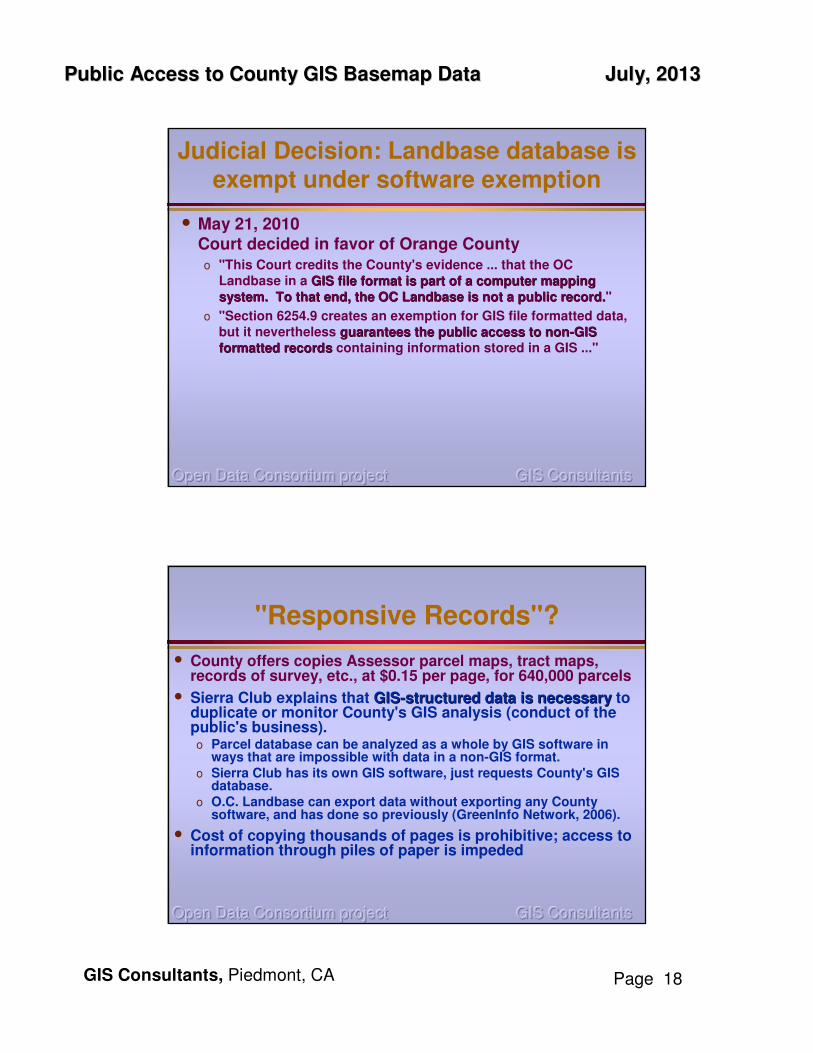
Judicial Decision: Landbase database is exempt under software exemption
• May 21, 2010Court decided in favor of Orange Countyo "This Court credits the County's evidence ... that the OC
Landbase in a GIS file format is part of a computer mapping GIS file format is part of a computer mapping
system. To that end, the OC system. To that end, the OC LandbaseLandbase is not a public record.is not a public record."
o "Section 6254.9 creates an exemption for GIS file formatted data, but it nevertheless guarantees the public access to nonguarantees the public access to non--GIS GIS
formatted recordsformatted records containing information stored in a GIS ..."
GIS Consultants GIS Consultants GIS Consultants Open Data Consortium projectOpen Data Consortium projectOpen Data Consortium project
"Responsive Records"?
• County offers copies Assessor parcel maps, tract maps, records of survey, etc., at $0.15 per page, for 640,000 parcels
• Sierra Club explains that GISGIS--structured data is necessarystructured data is necessary to duplicate or monitor County's GIS analysis (conduct of the public's business).o Parcel database can be analyzed as a whole by GIS software in
ways that are impossible with data in a non-GIS format.o Sierra Club has its own GIS software, just requests County's GIS
database.o O.C. Landbase can export data without exporting any County
software, and has done so previously (GreenInfo Network, 2006).
• Cost of copying thousands of pages is prohibitive; access to information through piles of paper is impeded

Public Access to County GIS Basemap DataPublic Access to County GIS Basemap Data July, 2013July, 2013
GIS Consultants, Piedmont, CA Page 19
Taxable Valuation less than half of mine < $ 30,000
Who Owns These Properties?
GIS Consultants GIS Consultants GIS Consultants Open Data Consortium projectOpen Data Consortium projectOpen Data Consortium project
Who Owns These Properties?

Public Access to County GIS Basemap DataPublic Access to County GIS Basemap Data July, 2013July, 2013
GIS Consultants, Piedmont, CA Page 20
GIS Consultants GIS Consultants GIS Consultants Open Data Consortium projectOpen Data Consortium projectOpen Data Consortium project
"Responsive Records"?
• County offers copies Assessor parcel maps, tract maps, records of survey, etc., at $0.15 per page, for 640,000 parcels
• Sierra Club explains that GISGIS--structured data is necessarystructured data is necessary to duplicate or monitor County's GIS analysis (conduct of the public's business).o Parcel database can be analyzed as a whole by GIS software in
ways that are impossible with data in a non-GIS format.o Sierra Club has its own GIS software, just requests County's GIS
database.o O.C. Landbase can export data without exporting any County
software, and has done so previously (GreenInfo Network, 2006).
• Cost of copying thousands of pages is prohibitive; access to information through piles of paper is impeded
• Aug 9, 2010Court issued final Statement of Decision for Orange County
GIS Consultants GIS Consultants GIS Consultants Open Data Consortium projectOpen Data Consortium projectOpen Data Consortium project
The Fight Continues:Sierra Club Appeals the Decision
August 27, 2010
Sierra Club files petition to the Court of AppealSierra Club files petition to the Court of Appeal
• The OC Landbase contains data only. It does not contain software.
• The trial court’s interpretation goes against Legislaturegoes against Legislature’’s intents intent.Upon introduction, the bill (AB3265) was immediately amended:
o Assembly Bill No. 3265: "Nothing in this chapter prohibits an agency from selling proprietary informationproprietary information or requiring a licensing agreement for payment of royalties to the agency prior to any subsequent sale, distribution, or commercial use of the proprietary information by any person receiving the information. "Proprietary information" includes computer readable data computer readable data
basesbases, computer programs, and computer graphics systems.”
o Assembly amendment changed the term "proprietary information" to "computer software."
o Senate amendment replaced the term "computer readable data bases" with "computer mapping systems."

Public Access to County GIS Basemap DataPublic Access to County GIS Basemap Data July, 2013July, 2013
GIS Consultants, Piedmont, CA Page 21
GIS Consultants GIS Consultants GIS Consultants Open Data Consortium projectOpen Data Consortium projectOpen Data Consortium project
The Fight Continues:Orange County Argues Sierra Club Appeal
September 13, 2010, Orange County says:
• Case is not about a denial of access to information, but whether this information must be produced in a particular format. Is GISIs GIS--compatible format public record?compatible format public record?
• "Definition" of GIS says that data is part of GIS and County's expert says CMS is actually a GIS. Therefore GIS data is exempt from public records disclosure under §6254.9 (b)
•• County spent millions County spent millions of dollars to develop and maintain its Landbase ... needs to recoup its costsneeds to recoup its costs.
• The Attorney General misinterpreted Section 6254.9 by adopting a construction that essentially redacts the term “computer mapping system” from the statute.
GIS Consultants GIS Consultants GIS Consultants Open Data Consortium projectOpen Data Consortium projectOpen Data Consortium project
Orange County Wins Appeal
May 31, 2011 – Court of Appeal concludes: "§6254.9 excludes from the Act's disclosure requirements for a geographic information system database like the one at issue here.“
•• "Whether the increasing use of GIS data in our society "Whether the increasing use of GIS data in our society requires reconsideration of section 6254.9's exclusion requires reconsideration of section 6254.9's exclusion from disclosure is a matter of public policy for the from disclosure is a matter of public policy for the Legislature to consider." Legislature to consider."

Public Access to County GIS Basemap DataPublic Access to County GIS Basemap Data July, 2013July, 2013
GIS Consultants, Piedmont, CA Page 22
GIS Consultants GIS Consultants GIS Consultants Open Data Consortium projectOpen Data Consortium projectOpen Data Consortium project
Sierra Club Appeals toCalifornia Supreme Court
• July 11, 2011 – Sierra Club files CSC appeal.
• Sept 10, 2011 – GIS Amicus letter asking to hear the caseo 11 GIS Organizations
o 72 Individual GIS Professionals
• Sept 14, 2011 – CA Supreme Court agrees to hear the caseCA Supreme Court agrees to hear the case
• Nov 14, 2011 – Sierra Club's brief filed
• Dec 15, 2011 – Orange County's answer brief filed
• Feb 6, 2012 – Sierra Club's rebuttal brief filed
• March 5, 2012 – 9 Amicus Briefs filedo 7 in support of Sierra Club, including GIS Community Brief:
•• 23 GIS Organizations23 GIS Organizations
•• 212 Individual GIS Professionals212 Individual GIS Professionals
o 2 in support of Orange County
• May 7, 2013 – Hearing before the CA Supreme Court
GIS Consultants GIS Consultants GIS Consultants Open Data Consortium projectOpen Data Consortium projectOpen Data Consortium project
GIS Community Amicus Brief
A. ““Computer Mapping SystemComputer Mapping System”” refers to software and only softwarerefers to software and only software; it does not include data. GIS data should not be considered different from any other public record data that government agencies use in conducting the people's business.
B. GIS-compatible database structure is an intrinsic and necessary database structure is an intrinsic and necessary part of Orange County’s OC Landbase. .PDF files do not substitute.PDF files do not substitute.
C. The consequences of removing GIS-readable parcel data from the public domain threatens citizens, other counties and citiesother counties and cities in many ways.
D. Removing GIS-readable parcel data from the public domain counters explicit national and Federal data policiesnational and Federal data policies.
E. Some counties’ policy of excluding GIS data from the public domain is currently causing expensive, negative impacts on CA state governmentexpensive, negative impacts on CA state government.
F. The 4th District Court, and Orange County, may have misunderstood the concept of concept of ““systemsystem”” in the context of section 6254.9(b).
G. Excel analogyExcel analogy to better understand the relationship between software and data.

Public Access to County GIS Basemap DataPublic Access to County GIS Basemap Data July, 2013July, 2013
GIS Consultants, Piedmont, CA Page 23
GIS Consultants GIS Consultants GIS Consultants Open Data Consortium projectOpen Data Consortium projectOpen Data Consortium project
GIS Community Amicus Brief
• 212 Individual GIS Professionals
• 23 GIS Professionals' OrganizationsGreenInfoGreenInfo NetworkNetwork
Latitude Geographics Group Ltd.
NACISNACIS - North American Cartographic Information Society
NSGICNSGIC - National States Geographic Information Council
Oregon Natural Desert Association
OSGeoOSGeo - Open Source Geospatial Foundation
Pacific Institute
Pacific Institute for Research & Evaluation
Southern CaliforniaSouthern California Chapter of URISAURISA
Urban Strategies Council
Vector1MediaVector1Media
WIGICCWIGICC - Wisconsin Geographic Information Coordination Council
AAGAAG - Association of American Geographers
Advancement Project, Healthy City
BAAMABAAMA Chapter of URISA URISA -- Bay Area Automated Mapping Association, Board of Directors
CaGISCaGIS - Cartography and Geographic Information Society
CALI - California Association of Licensed Investigators
Californians AwareCalifornians Aware
CUGOS - Cascadia Users of Geospatial Open Source
Davis Demographics & Planning, Inc.
DMTI Spatial
GeoTecGeoTec MediaMedia
GITAGITA - Geospatial Information Technology Association
GIS Consultants GIS Consultants GIS Consultants Open Data Consortium projectOpen Data Consortium projectOpen Data Consortium project
It's About TEAMWORKIt's About TEAMWORK

Public Access to County GIS Basemap DataPublic Access to County GIS Basemap Data July, 2013July, 2013
GIS Consultants, Piedmont, CA Page 24
CA Supreme Court HearingMay 7, 2013
A few excerpts:
• A Court Justice (CJ) asked Sierra Club (SCa) - When the Legislature has defined a term, that term replaces the word's "ordinary meaning," but here, the PRA does not define "software" nor "computer mapping system," so those terms' ordinary meaning remain, "is that the crux of your argument?"SCa - apparently wary that she was being invited to step into a trap answered vaguely, to which theCJ replied, "I'm trying to help you out here!"
• CJ - Do you agree that 49 [out of California's 58] counties are able to provide their GIS database according to the CPRA?OCa - Yes.CJ - Why can't Orange County afford to provide the data at the cost of duplication if 49 other counties can do so?
• CJ asked Orange County (OCa) - Are you saying that there are two kinds of public record, one being exempt?OCa - Yes, but we are not withholding "the data," however "the system" costs us a lot of money ... 26% of the annual operating cost of $781,000, which we receive from data sales, shouldn't burden our taxpayers.CJ - What does the $781,000 pay for?OCa - Computers, software, and ...CJ - Aren't computers simply a fixed cost of doing business?OCa - ... it pays for personnel to input the data.CJ - Isn't this the same for any county department? Wouldn't the exemption that pertains to "computer programs" as well as "computer mapping systems" therefore exempt all county data where there is a cost to inputting new data, say into a Word program?
GIS Consultants GIS Consultants GIS Consultants Open Data Consortium projectOpen Data Consortium projectOpen Data Consortium project
July 8, 2013
Supreme Court Decision: VICTORY!
• Openness in government is essential to the functioning of a democracy. Implicit in the democratic process is the notion that government should be accountable for its actions. In order to verify accountability, individuals must have access to government files.
• We believe the public records exemption for “computer software," a term that “includes computer mapping systems," does not cover GIS-formatted databases like the OC Landbase at issue here.
• The County must produce the OC Landbase in response to Sierra Club’s request “in any electronic format in which it in any electronic format in which it holds the informationholds the information” (§ 6253.9(a)(1)) "at a cost not to at a cost not to exceed the direct cost of duplicationexceed the direct cost of duplication (§ 6253.9(a)(2)."

Public Access to County GIS Basemap DataPublic Access to County GIS Basemap Data July, 2013July, 2013
GIS Consultants, Piedmont, CA Page 25
GIS Consultants GIS Consultants GIS Consultants Open Data Consortium projectOpen Data Consortium projectOpen Data Consortium project
Supreme Court Decision: further discussion
• What the parties dispute is whether the OC Landbase in a GIS file formatis a public record that must be disclosed in that format pursuant to the PRA.
• The analysis leads us to conclude that although the term “computer mapping systems” by itself is ambiguous, the ordinary meaning of “computer software” supports Sierra Club’s contention that the the public records exemption for computer mapping systems covers public records exemption for computer mapping systems covers GIS mapping software but not GISGIS mapping software but not GIS--formatted dataformatted data.
• Any remaining doubt about the proper interpretation of 6254.9 isdispelled by the interpretive rule in Article I, Section 3, Subdivision (b)(2), of the California Constitution: ““A statute, court rule, or other A statute, court rule, or other authority ... shall be broadly construed if it furthers the peopauthority ... shall be broadly construed if it furthers the peoplele’’s s right of access, and narrowly construed if it limits the right oright of access, and narrowly construed if it limits the right of f access.access.””
• To the extent that the term “computer mapping system” is ambiguous, the constitutional canon requires us to interpret it in a way that maximizes the publicmaximizes the public’’s access to information, unless the s access to information, unless the Legislature has expressly provided to the contraryLegislature has expressly provided to the contrary.
GIS Consultants GIS Consultants GIS Consultants Open Data Consortium projectOpen Data Consortium projectOpen Data Consortium project
Supreme Court Decision: further discussion
And a final endorsement of the Attorney General's opinion:
We note that this interpretation is consistent with a 2005 opinion letter issued by the Attorney General ... “the term the term
‘‘computer mapping systemscomputer mapping systems’’ in section 6254.9 does not refer to or include basic maps and boundary information per se (i.e., the basic data compiled, updated, and maintained by county assessors), but rather denotes denotes
unique computer unique computer programs programs to process such datato process such data using mapping functions ..."

Public Access to County GIS Basemap DataPublic Access to County GIS Basemap Data July, 2013July, 2013
GIS Consultants, Piedmont, CA Page 26
GIS Consultants GIS Consultants GIS Consultants Open Data Consortium projectOpen Data Consortium projectOpen Data Consortium project
Legal Timeline Sierra Club vs Orange County
June 2007 - Sierra Club makes CPRA request for dataSierra Club makes CPRA request for data
July 2007 - Orange County refuses
April 2008 - Sierra Club makes CPRA request for data
June 2008 - Orange County refuses
Feb 2009 - Sierra Club makes CPRA request for data
March 2009 - Orange County refuses
March 2009 - Sierra Club makes CPRA request for data
April 2009 - Orange County refuses
Months 0 April 2009 -- Sierra Club files suit in Superior CourtSierra Club files suit in Superior Court
7 Nov 2009 - Superior Court Tentative Ruling (in favor of Orange County)
12 April 2010 - Evidentiary Hearing
12 April 2010 -- Trial Court ruled in favor of Orange CountyTrial Court ruled in favor of Orange County
16 Aug 2010 - Court issues final Statement of Decision
16 Aug 2010 - Sierra Club petition to Court of Appeal
17 Sept 2010 - Orange County responds (final response Nov 2010)
21 Jan 2011 - Amicus Briefs filed
23 March 2011 - Oral Arguments in Court of Appeal
26 June 2011 -- Court of Appeal decides in favor of Orange CountyCourt of Appeal decides in favor of Orange County
27 July 2011 - Sierra Club appeals to California Supreme Court
29 Sept 2011 - CA Supreme Court agrees to hear the caseCA Supreme Court agrees to hear the case
31 Nov 2011 - Sierra Club's brief filed
32 Dec 2011 - OC's brief filed
34 Feb 2012 - Sierra Club's rebuttal brief
35 Mar 2012 - Amicus Briefs filed
49 May 2013 - Hearing before the CA Supreme CourtHearing before the CA Supreme Court
51 July 2013 - CA Supreme Court decides in favor of Sierra ClubCA Supreme Court decides in favor of Sierra Club
GIS Consultants GIS Consultants GIS Consultants Open Data Consortium projectOpen Data Consortium projectOpen Data Consortium project
Meanwhile, back in Santa Clara County
• No new basemap data have been released since the April, 2009 version
• County claims it isn't maintaining nor distributing more current data
But, They offer on-line subscription to current database for $14,000+ per year.
• While the 2009 version contained situs address and APNs, they now sell the situs-APN table for an extra $2,000!

Public Access to County GIS Basemap DataPublic Access to County GIS Basemap Data July, 2013July, 2013
GIS Consultants, Piedmont, CA Page 27
GIS Consultants GIS Consultants GIS Consultants Open Data Consortium projectOpen Data Consortium projectOpen Data Consortium project
Are We Surfing the Public's GeoData ?
GIS Consultants GIS Consultants GIS Consultants Open Data Consortium projectOpen Data Consortium projectOpen Data Consortium project
Or ...Or ...

Public Access to County GIS Basemap DataPublic Access to County GIS Basemap Data July, 2013July, 2013
GIS Consultants, Piedmont, CA Page 28
GIS Consultants GIS Consultants GIS Consultants Open Data Consortium projectOpen Data Consortium projectOpen Data Consortium project
1 – Geospatial data returns more value to the agency than its cost.
2 – The more users = the more value accrued.
3 – Counties with data sharing policies have more economic development than counties with data selling policies.
4 – To support its GIS operations, an agency needs to:
o Track the costs savedo Track the added revenueo Allocate a portion of the ROI to
GIS maintenance and operations
National States Geographic Information Council
www.NSGIC.org
Understanding the Understanding the
Return on Investment Return on Investment
of GIS & Geodataof GIS & Geodata
GIS Consultants GIS Consultants GIS Consultants Open Data Consortium projectOpen Data Consortium projectOpen Data Consortium project
Calculating Return On Investmentof GIS Applications & Geospatial Data
Cost 2006 2007 2008 2009 2010
Basis Qty. Cost Qty. Cost Qty. Cost Qty. Cost Qty. Cost
GIS Application Benefits Benefit
subtotal Application Raw Benefits $42,900 $79,500 $127,200 $168,900
Number of new analyst users 2 1 1 1 1
Cumulative number of analyst users less 1 dvt. 1 2 3 4 5
Potential Application Benefit $85,800 $238,500 $508,800 $844,500
Discounted Benefit 60% $51,480 $143,100 $305,280 $506,700
TOTAL COST $153,586 $160,402 $170,142 $179,270 $189,057
NET BENEFITS (Benefit-Cost) -$153,586 -$108,922 -$27,042 $126,010 $317,643
Cumulative Benefit (Cost) -$153,586 -$262,508 -$289,550 -$163,540 $154,103
Net ROI after 3 yearsNet ROI after 3 years
Cumulative ROI Cumulative ROI
within 5 yearswithin 5 years
Emeryville GIS Benefits - Cost
-$400,000
-$300,000
-$200,000
-$100,000
$0
$100,000
$200,000
$300,000
$400,000
$500,000
$600,000
2006 2007 2008 2009 2010
Year
Costs
Benefits
NET BENEFITS (-Cost)
Cumulative Benefit

Public Access to County GIS Basemap DataPublic Access to County GIS Basemap Data July, 2013July, 2013
GIS Consultants, Piedmont, CA Page 29
GIS Consultants GIS Consultants GIS Consultants Open Data Consortium projectOpen Data Consortium projectOpen Data Consortium project
My Opinion
• 49 California counties have developed and are maintaining similarly expensive GIS databases without selling their data. "Poor fiscal management should not be an exemption for "Poor fiscal management should not be an exemption for access to public records." access to public records."
• Government agencies decided to expend the cost of building a GIS database because of the benefits that GIS would provide them in fulfilling their mandated tasks. "These benefits are return enough on their investment and "These benefits are return enough on their investment and do not justify additional revenue from data sales." do not justify additional revenue from data sales."
•• GIS Professionals must be aware of and involved with public GIS Professionals must be aware of and involved with public policy issues that they can affect and that affect our societypolicy issues that they can affect and that affect our society
Liberty Requires Vigilance
GIS Consultants GIS Consultants GIS Consultants Open Data Consortium projectOpen Data Consortium projectOpen Data Consortium project
Vigilance = Participation + Teamwork
•• GIS Professionals must be aware of and involved GIS Professionals must be aware of and involved
with public policy issues that they can affect and with public policy issues that they can affect and
that affect our society.that affect our society.
o We have special knowledge that can assist public policy.
o Public Policy issues arise that affect our profession.
oo Our participation in the public forum is necessary!Our participation in the public forum is necessary!Both for us, and for our national, state, and local communities.
Public Access to County GIS Basemap DataPublic Access to County GIS Basemap Data July, 2013July, 2013
GIS Consultants, Piedmont, CA Page 30
GIS Consultants GIS Consultants GIS Consultants Open Data Consortium projectOpen Data Consortium projectOpen Data Consortium project
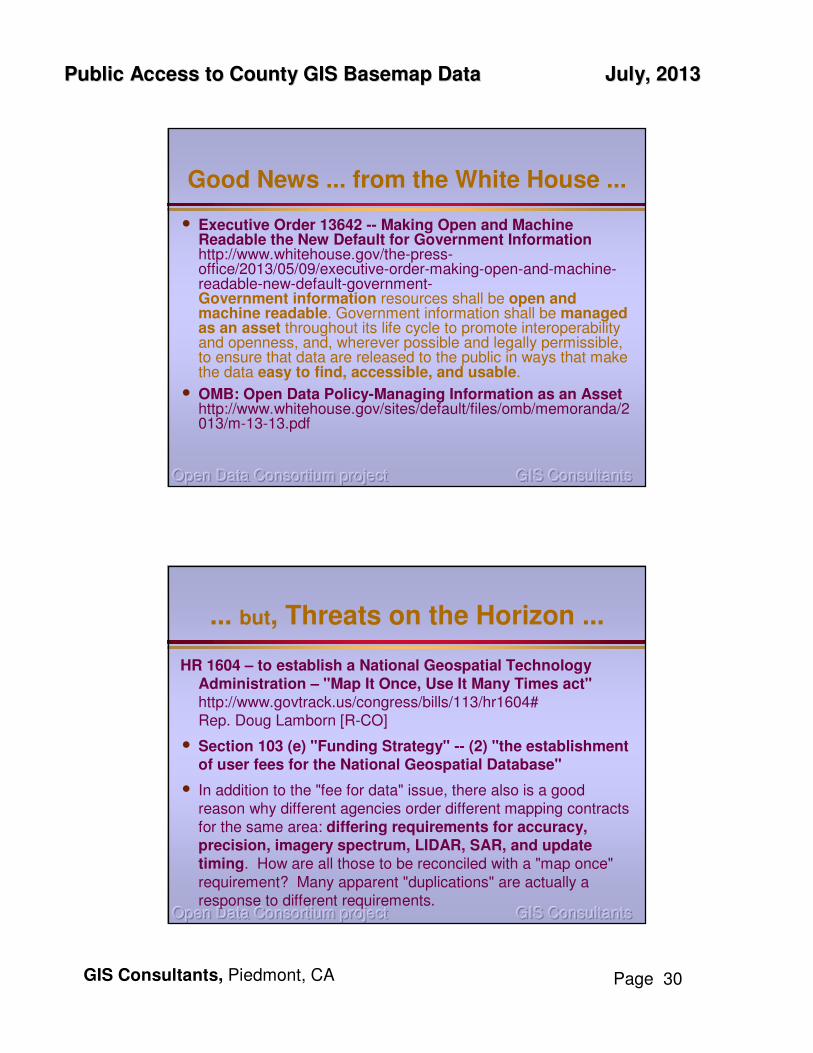
Good News ... from the White House ...
• Executive Order 13642 -- Making Open and Machine Readable the New Default for Government Informationhttp://www.whitehouse.gov/the-press-office/2013/05/09/executive-order-making-open-and-machine-readable-new-default-government-Government information resources shall be open and machine readable. Government information shall be managed as an asset throughout its life cycle to promote interoperability and openness, and, wherever possible and legally permissible, to ensure that data are released to the public in ways that makethe data easy to find, accessible, and usable.
• OMB: Open Data Policy-Managing Information as an Asset http://www.whitehouse.gov/sites/default/files/omb/memoranda/2013/m-13-13.pdf
GIS Consultants GIS Consultants GIS Consultants Open Data Consortium projectOpen Data Consortium projectOpen Data Consortium project
... but, Threats on the Horizon ...
HR 1604 – to establish a National Geospatial Technology Administration – "Map It Once, Use It Many Times act"http://www.govtrack.us/congress/bills/113/hr1604#Rep. Doug Lamborn [R-CO]
• Section 103 (e) "Funding Strategy" -- (2) "the establishment of user fees for the National Geospatial Database"
• In addition to the "fee for data" issue, there also is a good reason why different agencies order different mapping contracts for the same area: differing requirements for accuracy, precision, imagery spectrum, LIDAR, SAR, and update timing. How are all those to be reconciled with a "map once" requirement? Many apparent "duplications" are actually a response to different requirements.

Public Access to County GIS Basemap DataPublic Access to County GIS Basemap Data July, 2013July, 2013
GIS Consultants, Piedmont, CA Page 31
GIS Consultants GIS Consultants GIS Consultants Open Data Consortium projectOpen Data Consortium projectOpen Data Consortium project
In California's 2013 Budget: a close callSB 71
Friday, June 14Friday, June 14 – CA Legislature passes budget On Time (first time in over a decade).
• Also passed – several "trailer" bills with budgetary "adjustments" ... ... Including (buried within) ...
• Section 4 – would make CPRA optionaloptional. "Eliminates the requirement of existing law that agencies must make available 'electronic records' or 'information in any format in which the agency already holds them'."
Sunday, June 16Sunday, June 16 – First Amendment Coalition sends warning to its supporters
Monday, June 17Monday, June 17 – GIS supporters of PRA receive call to action: email the Governor to VETO SB 71
Wednesday, June 19Wednesday, June 19 – Governor refuses to veto, but at same time, newspapers all over California print VETO editorials and articles. Letters to Governor pouring in.
Thursday, June 20Thursday, June 20 – confusion – conflicting stories. Late in the day, Senate re-writes SB 71 without Section 4; Governor reverses policy and agrees to leave PRA legal requirements in tact.
TAKE AWAY: Be AlertBe Alert, Stay ConnectedStay Connected with reliable sources of information; Act QuicklyAct Quickly when the need arises
GIS Consultants GIS Consultants GIS Consultants Open Data Consortium projectOpen Data Consortium projectOpen Data Consortium project
TEAMWORK = ParticipationTEAMWORK = Participation

Public Access to County GIS Basemap DataPublic Access to County GIS Basemap Data July, 2013July, 2013
GIS Consultants, Piedmont, CA Page 32
GIS Consultants GIS Consultants GIS Consultants Open Data Consortium projectOpen Data Consortium projectOpen Data Consortium project
What Can You Do To Preserve Access To GIS Data?What Can You Do To Preserve Access To GIS Data?
GIS Consultants GIS Consultants GIS Consultants Open Data Consortium projectOpen Data Consortium projectOpen Data Consortium project
Your Opinion?

Public Access to County GIS Basemap DataPublic Access to County GIS Basemap Data July, 2013July, 2013
GIS Consultants, Piedmont, CA Page 33
GIS Consultants GIS Consultants GIS Consultants Open Data Consortium projectOpen Data Consortium projectOpen Data Consortium project
Reference Links
• Supreme Court decision at http://appellatecases.courtinfo.ca.gov/search/case/mainCaseScreen.cfm?dist=0&doc_id=1985061&doc_no=S194708
• Court timeline athttp://appellatecases.courtinfo.ca.gov/search/dockets.cfm?dist=0&doc_id=1985061&q=110968&h=964387314
• Court documents at http://www.calpubrec.org/oclawsuit/appeal/index.html
• General Information athttp://www.OpenDataConsortium.netnet
• NSGIC Data Sharing Guidelineshttp://www.nsgic.org/data-sharing-work-group
GIS Consultants GIS Consultants GIS Consultants Open Data Consortium projectOpen Data Consortium projectOpen Data Consortium project
Defending Public Access to Defending Public Access to
our Governments' GeoDataour Governments' GeoData
The Supreme Decision
Bruce Joffe, GISP, AICP
Organizer, Open Data Consortium Principal, GIS Consultants
Piedmont, CA