Proposed Updates to the Rocky River Watershed Action Plan...
6
Rocky River Watershed Council 2010 Proposed Updates to the Rocky River Watershed Action Plan The Rocky River Watershed Action Plan (RRWAP) was endorsed by the Ohio Environmental Protection Agency and the Ohio Department of Natural Resources in 2006. Since its endorsement, efforts by watershed partners have lead to more specific recommendations in the Mainstem, Abram Creek, Baldwin Creek, Healey Creek and Upper West Branch subwatersheds. Rocky River Watershed Council 6100 West Canal Road Valley View, OH 44125 www.MyRockyRiver.org [email protected]
Transcript of Proposed Updates to the Rocky River Watershed Action Plan...

R
ock
y R
ive
r W
ate
rsh
ed
Co
un
cil
20
10
Pr
op
os
ed
Up
da
tes
to
th
e R
oc
ky
Riv
er
Wa
ter
sh
ed
Ac
tio
n P
lan
The Rocky River Watershed Action Plan (RRWAP) was endorsed by the
Ohio Environmental Protection Agency and the Ohio Department of
Natural Resources in 2006. Since its endorsement, efforts by
watershed partners have lead to more specific recommendations in the
Mainstem, Abram Creek, Baldwin Creek, Healey Creek and Upper West
Branch subwatersheds.
Rocky River Watershed Council
6100 West Canal Road
Valley View, OH 44125
www.MyRockyRiver.org
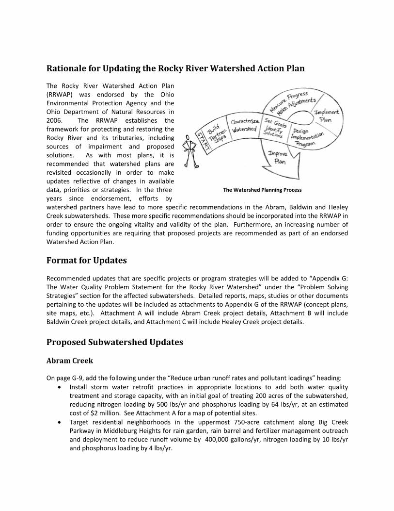
Rationale for Updating the Rocky River Watershed Action Plan
The Rocky River Watershed Action Plan
(RRWAP) was endorsed by the Ohio
Environmental Protection Agency and the
Ohio Department of Natural Resources in
2006. The RRWAP establishes the
framework for protecting and restoring the
Rocky River and its tributaries, including
sources of impairment and proposed
solutions. As with most plans, it is
recommended that watershed plans are
revisited occasionally in order to make
updates reflective of changes in available
data, priorities or strategies. In the three
years since endorsement, efforts by
watershed partners have lead to more specific recommendations in the Abram, Baldwin and Healey
Creek subwatersheds. These more specific recommendations should be incorporated into the RRWAP in
order to ensure the ongoing vitality and validity of the plan. Furthermore, an increasing number of
funding opportunities are requiring that proposed projects are recommended as part of an endorsed
Watershed Action Plan.
Format for Updates
Recommended updates that are specific projects or program strategies will be added to “Appendix G:
The Water Quality Problem Statement for the Rocky River Watershed” under the “Problem Solving
Strategies” section for the affected subwatersheds. Detailed reports, maps, studies or other documents
pertaining to the updates will be included as attachments to Appendix G of the RRWAP (concept plans,
site maps, etc.). Attachment A will include Abram Creek project details, Attachment B will include
Baldwin Creek project details, and Attachment C will include Healey Creek project details.
Proposed Subwatershed Updates
Abram Creek
On page G-9, add the following under the “Reduce urban runoff rates and pollutant loadings” heading:
• Install storm water retrofit practices in appropriate locations to add both water quality
treatment and storage capacity, with an initial goal of treating 200 acres of the subwatershed,
reducing nitrogen loading by 500 lbs/yr and phosphorus loading by 64 lbs/yr, at an estimated
cost of $2 million. See Attachment A for a map of potential sites.
• Target residential neighborhoods in the uppermost 750-acre catchment along Big Creek
Parkway in Middleburg Heights for rain garden, rain barrel and fertilizer management outreach
and deployment to reduce runoff volume by 400,000 gallons/yr, nitrogen loading by 10 lbs/yr
and phosphorus loading by 4 lbs/yr.
The Watershed Planning Process

Also on Page G-9, add the following under the “Minimize the storm water impacts associated with new
development” heading:
• Prioritize parcels for permanent protection via fee simple acquisition or the acquisition of
conservation easements.
Additionally, on Page H-5, prior to the first paragraph under the “Abram Creek” heading, add:
Current estimated Total Nitrogen Load from nonpoint sources: 31,507 lbs/yr
Target nonpoint source Total Nitrogen Load: 25,853 lbs/yr
Recommended Total Nitrogen Load Reduction from nonpoint sources: 5654 lbs/yr
Current estimated Total Phosphorus Load from nonpoint sources: 5248 lbs/yr
Target nonpoint source Total Phosphorus Load: 3778 lbs/yr
Recommended Total Phosphorus Load Reduction from nonpoint sources: 1470 lbs/yr
Baldwin Creek
On page G-17, add the following under the “Begin the process of recovering urban impacted streams
and their aquatic habitat” heading:
• Restore fish passage to 0.9 miles of Baldwin Creek by removing four low-head dams and
enhance fish habitat sufficient to raise the average QHEI of the reach from 51.5 to 60 along the
creek’s lower one-mile reach in Berea, at an estimated cost of $507,000. See Attachment B for
mapped locations.
• Reduce siltation and embedded substrate and enhance habitat by an average of 5 QHEI points
through the installation of 2500 feet of streambank stabilization practices and 7500 feet of
stream restoration practices, reducing sediment loading by 900 lbs/yr, nitrogen loading by 1450
lbs/yr and phosphorus loading by 550lbs/yr, at an estimated cost of $2,125,000. See
attachment B for a map of identified erosion areas.
Also on page G-17, add the following under the “Reduce urban runoff rates and pollutant loadings”
heading:
• Install storm water retrofit practices in appropriate locations to add both water quality
treatment and storage capacity, with an initial goal of treating 100 acres of the subwatershed,
reducing nitrogen loading by 250 lbs/yr and phosphorus loading by 32 lbs/yr, at an estimated
cost of $1 million. See Attachment B for a map of potential sites.
Also on Page G-17, add the following under the “Minimize the storm water impacts associated with new
development” heading:
• Prioritize parcels for permanent protection via fee simple acquisition or the acquisition of
conservation easements.
Additionally, on page H-6, immediately under the “Baldwin Creek” heading, add:
Current estimated Total Nitrogen Load: 114,197 lbs/yr
Target Total Nitrogen Load: 25,596 lbs/yr
Recommended Total Nitrogen Load Reduction: 88,601 lbs/yr
Current estimated Total Phosphorus Load: 4922 lbs/yr
Target Total Phosphorus Load: 3741 lbs/yr
Recommended Total Phosphorus Load Reduction: 1181 lbs/yr
Healey Creek
On page G-21, add the following under the “Storm Water Management” heading:
Begin the process of recovering urban impacted streams and their aquatic habitat (see summary map in
Attachment C):
• Restore habitat in the Upper Healey Creek subwatershed by restoring 1500 linear feet of incised
channel in Venus Park in Brunswick using natural stream channel design, two-stage or self
forming channel techniques, restoring QHEI to a minimum of 60, and reducing nitrogen loading
by 400 lbs/yr and phosphorus loading by 150 lbs/yr, at an estimated cost of $300,000.
• Install storm water wetland on vacant 3-acre property upstream of Venus Park, where three
outlet pipes meet to form Healey Creek, to reduce nitrogen loading by 400 lbs/yr, phosphorus
loading by 150 lbs/yr, and sediment loading by 200 tons/yr, at an estimated cost of $200,000.
• Reconnect 1500 linear feet of floodplain along Healey Creek as it flows through North Park in
Brunswick by removing levees and adding or expanding riparian wetlands and/or vernal pools to
increase QHEI to a minimum of 60 and reduce sediment by 126 tons/yr, nitrogen loading by 200
lbs/yr, and phosphorus loading by 75 lbs/yr, at an estimated cost of $300,000.
• Target residential neighborhoods upstream of Venus Park and upstream of North Park Lake for
rain garden, rain barrel and fertilizer management outreach and deployment.
• Retrofit approximately 3500 feet of roadside ditch to improve storage, infiltration and water
quality treatment along West Drive and East Drive in Brunswick, reducing nitrogen loading by 10
lbs/yr and phosphorus loading by 4 lbs/yr at an estimated cost of $100,000.
Also on page G-21, add the following under the “Minimize the storm water impacts associated with new
development” heading (included in summary map in Attachment C):
• Permanently protect 9000 linear feet of Healey Creek and its tributaries by acquiring interest in
real property or conservation easements on the 25-acre Hudak property and 20-acre Custer
property immediately upstream of North Park in Brunswick and the 10-acre Metro Church
property, 85-acre Knight Development property, and 107-acre and 23-acre Fifth-Third Bank
properties downstream of North Park in Brunswick, at an estimated cost of $2.7 million.
Also on page G-21, add the following under the “Land Use Issues” heading:
Implement the Rocky River Upper West Branch Balanced Growth Plan.
Additionally, on page H-7, under the “East Branch” heading and the ”Nutrients” subheading, add the
following:

Healey Creek:
Current estimated Total Nitrogen Load from nonpoint sources: 16,678 lbs/yr
Target nonpoint source Total Nitrogen Load: 12,593 lbs/yr
Recommended Total Nitrogen Load Reduction from nonpoint sources: 4085 lbs/yr
Current estimated Total Phosphorus Load from nonpoint sources: 2872 lbs/yr
Target nonpoint source Total Phosphorus Load: 1841 lbs/yr
Recommended Total Phosphorus Load Reduction from nonpoint sources: 1031 lbs/yr
Upper West Branch
On page G-38, add the following under the “Begin the process of recovering urban impacted streams
and their aquatic habitat” heading:
• Restore habitat and reduce streambank erosion through the restoration of 3000 linear feet of
Champion Creek in the City of Medina, using soft engineering and natural stream channel design
techniques to reduce nitrogen loading by 100 lbs/yr.
Also on page G-38, add the following under the “Land Use Issues” heading:
Implement the Rocky River Upper West Branch Balanced Growth Plan.
Additionally, on page H-7, under the “West Branch” heading and below the “Nutrients” subheading,
insert:
Current estimated Total Nitrogen Load: 25,931 lbs/yr
Target nonpoint source Total Nitrogen Load: 20,681lbs/yr
Recommended Total Nitrogen Load Reduction: 5250 lbs/yr
Mainstem of the Rocky River
On page G-5, add the following under the “Reduce modified habitat attributes associated with heavy
sediment loads and scouring stream flows from urban runoff wherever possible” subheading:
o Reduce sediment loading from bank erosion by stabilizing 500 linear feet of streambank and
adding riffles/grade control and/or bankfull benches along 2500 feet of an unnamed
tributary to the Mainstem adjacent to Windsor Drive in North Olmsted to reduce nitrogen
loading by 100 lbs/yr, phosphorus loading by 45 lbs/yr and sediment loading by 75 tons/yr,
at a cost of $300,000.
o Target residential neighborhoods upstream of the erosion sites along Windsor Drive in
North Olmsted for rain garden, rain barrel, downspout disconnection, and roadside ditch
retrofit outreach and deployment, with an initial goal of treating 25% of the channel
protection volume (25% = 1 acre-ft or 163 cubic ft/acre).
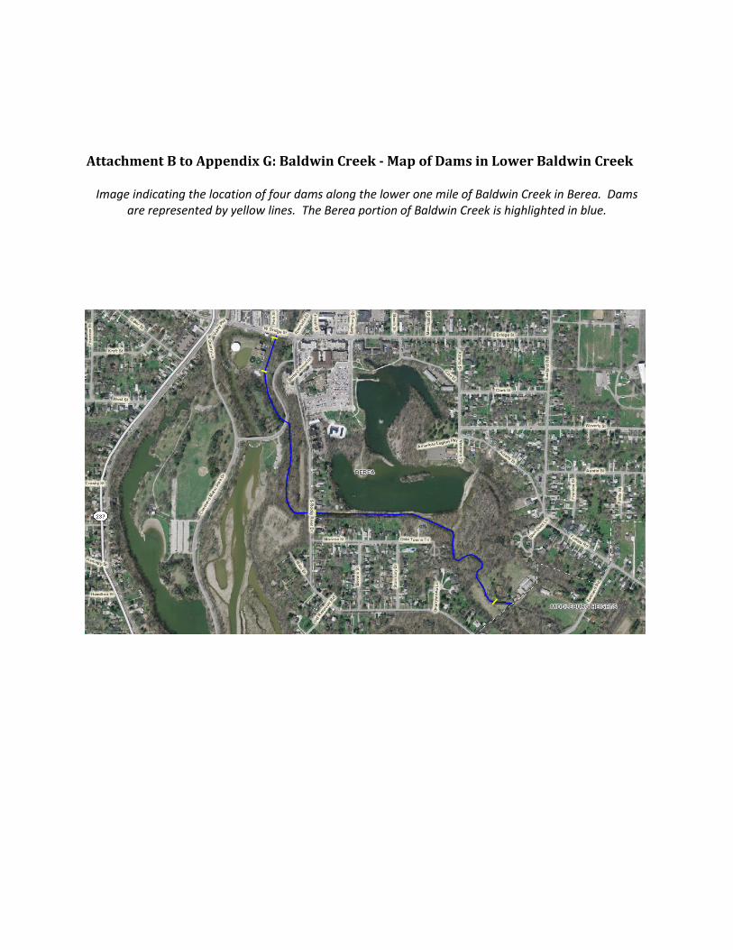
Attachment B to Appendix G: Baldwin Creek - Map of Dams in Lower Baldwin Creek
Image indicating the location of four dams along the lower one mile of Baldwin Creek in Berea. Dams
are represented by yellow lines. The Berea portion of Baldwin Creek is highlighted in blue.