
Project Name: Native Vegetation Precinct Plan - Armstrong ... · Draft 1 21/07/09 Christine Spits...
42
Project Name: Native Vegetation Precinct Plan - Armstrong Creek East Precinct Project Number: 3005009 Report for: Armstrong Creek Development Corporation PREPARATION, REVIEW AND AUTHORISATION Revision # Date Prepared by Reviewed by Approved for Issue by Draft 1 21/07/09 Christine Spits Cameron Miller Cameron Miller Draft 2 25/08/09 Christine Spits Cameron Miller Cameron Miller Final A 18/10/09 Christine Spits Cameron Miller Cameron Miller Final B 07/01/10 Christine Spits/ David Fairbridge Bram Mason Bram Mason ISSUE REGISTER Distribution List Date Issued Number of Copies Armstrong Creek Development Corporation Pty. Ltd. (ACDC) 07/01/2010 Electronic City of Greater Geelong 07/01/2010 1 Electronic Department of Sustainability and Environment 07/01/2010 1 Electronic SMEC staff: 07/01/2010 Electronic Associates: 07/01/2010 Electronic Melbourne Office Library (SMEC office location): 07/01/2010 Electronic SMEC COMPANY DETAILS SMEC Australia Pty Ltd Level 4, 71 Queens Road, Melbourne VIC 3004 PO Box 6208, 600 St Kilda Road, Melbourne, Vic, 8008 Tel: 03 9514 1500 Fax: 03 9514 1502 Email: [email protected] www.smec.com The information within this document is and shall remain the property of SMEC Australia Pty Ltd
Transcript of Project Name: Native Vegetation Precinct Plan - Armstrong ... · Draft 1 21/07/09 Christine Spits...

Project Name: Native Vegetation Precinct Plan - Armstrong Creek East Precinct
Project Number: 3005009
Report for: Armstrong Creek Development Corporation
PREPARATION, REVIEW AND AUTHORISATION
Revision # Date Prepared by Reviewed by Approved for Issue by
Draft 1 21/07/09 Christine Spits Cameron Miller Cameron Miller
Draft 2 25/08/09 Christine Spits Cameron Miller Cameron Miller
Final A 18/10/09 Christine Spits Cameron Miller Cameron Miller
Final B 07/01/10 Christine Spits/ David Fairbridge
Bram Mason Bram Mason
ISSUE REGISTER
Distribution List Date Issued Number of Copies
Armstrong Creek Development Corporation Pty. Ltd. (ACDC) 07/01/2010 Electronic
City of Greater Geelong 07/01/2010 1 Electronic
Department of Sustainability and Environment 07/01/2010 1 Electronic
SMEC staff: 07/01/2010 Electronic
Associates: 07/01/2010 Electronic
Melbourne Office Library (SMEC office location): 07/01/2010 Electronic
SMEC COMPANY DETAILS
SMEC Australia Pty Ltd
Level 4, 71 Queens Road, Melbourne VIC 3004
PO Box 6208, 600 St Kilda Road, Melbourne, Vic, 8008
Tel: 03 9514 1500
Fax: 03 9514 1502
Email: [email protected]
www.smec.com The information within this document is and shall remain the property of SMEC Australia Pty Ltd

Native Vegetation Precinct Plan – Armstrong Creek East Precinct.
For: Armstrong Creek Development Corporation
JANUARY 7, 2010

Native Vegetation Precinct Plan - Armstrong Creek East Precinct Final Page | 1
1. ARMSTRONG CREEK EAST PRECINCT NATIVE VEGETATION PRECINCT PLAN – JANUARY 2010
This is the Armstrong Creek East Precinct Native Vegetation Precinct Plan (NVPP) listed under Schedule to Clause 52.16 of the Greater Geelong Planning Scheme.
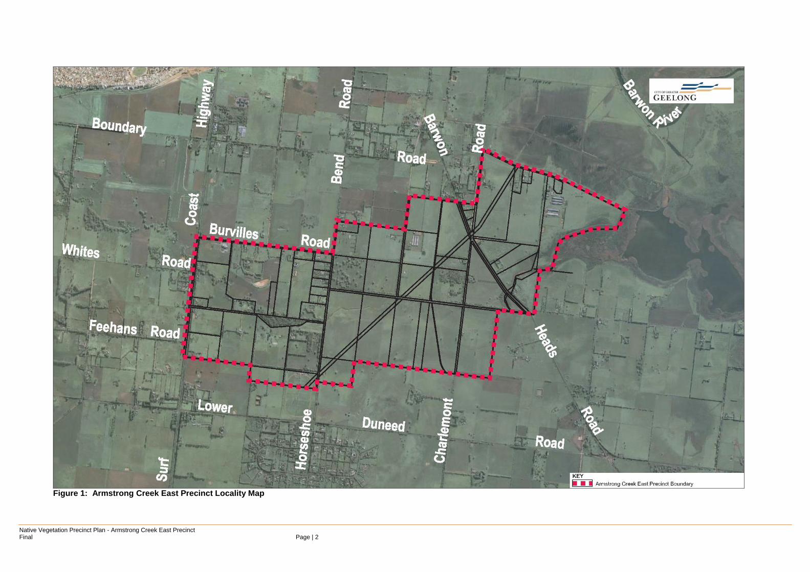
The Armstrong Creek East Precinct Native Vegetation Precinct Plan applies to all land shown in Figure 1.
Native Vegetation Precinct Plan - Armstrong Creek East Precinct Final Page | 2
Figure 1: Armstrong Creek East Precinct Locality Map

Native Vegetation Precinct Plan - Armstrong Creek East Precinct Final Page | 3
Purpose
In accordance with clause 52.16 of the City of Greater Geelong Planning Scheme, the purpose of this plan is to:
Specify the native vegetation to be protected and the native vegetation that can be removed, destroyed or lopped;
Ensure that areas set aside to protect native vegetation are managed to conserve ecological values in accordance with the Armstrong Creek East Precinct Structure Plan;
Ensure that the removal, destruction or lopping of native vegetation specified to be protected is consistent with conserving the ecological values of these areas and is in accordance with the three-step approach to net gain as set out in (Victoria’s Native Vegetation Management – a Framework for Action, DSE 2002);
Set out the works or other necessary actions to offset the removal, destruction or lopping of native vegetation; and
Streamline the planning approvals process through a landscape approach to native vegetation protection and management.
Vegetation Protection Objectives to be Achieved
The objectives of the Armstrong Creek East Precinct NVPP are to:
1. Provide for the protection of native vegetation within the landscape that recognises the conservation significance of native vegetation in accordance with Victoria’s Native Vegetation Management – A Framework for Action (the Framework) (DNRE 2002);
2. Be consistent with, and complement the desired outcomes of the Armstrong Creek East Precinct, Precinct Structure Plan (PSP);
3. Ensure that appropriate biodiversity outcomes are achieved through the retention of specified native vegetation, habitat enhancement and waterway protection; and
4. Support the provision of Public Open Space (POS) and dedicated conservation areas that avoid vegetation loss, minimise impacts and enhance native vegetation protection through the precinct vegetation offsetting.

Native Vegetation Precinct Plan - Armstrong Creek East Precinct Final Page | 4
2. THE NATIVE VEGETATION TO BE PROTECTED
The native vegetation to be protected is:
- Summarised in Table 1 and Table 2 to this Plan;
- Presented in Figures 2 and 3 in Appendix A to this Plan; and
- Set aside and available as offsets for vegetation removed within the area to which this Plan applies.

Native Vegetation Precinct Plan - Armstrong Creek East Precinct Final Page | 5
Table 1: Habitat Zones to be protected
Lot no. Property Address Habitat Zone
EVC Area (ha)
Conservation Status
Conservation Significance
N5 Crown Land 40-110 Burvilles Rd Mount Duneed
HZ1A GW 5.90 Endangered Very High
N5 Crown Land 87 Stewarts Rd Mount Duneed
Lot 1 SP503311 87 Stewarts Rd Mount Duneed
Lot 2 SP503312 112-120 Burvilles Rd Mount Duneed
Lot 1 TP8285 470 Horseshoe Bend Rd Mount Duneed
HZ1C GW 1.44 Endangered High
Lot 1 TP131497 61-83 Stewarts Rd Mount Duneed
HZ1D GW 5.35 Endangered High
Lot 2 PS544260 568-612 Torquay Rd Mount Duneed
N5 Crown Land 40-110 Burvilles Rd Mount Duneed
N5 Crown Land 87 Stewarts Rd Mount Duneed
Lot 1 TP23492 76-88 Groves Rd Connewarre
HZ2 CS 3.47 Endangered Very High
Allot. 2A Sec. 4A Crown Land, Baenschs Rd Connewarre
Lot 1 TP23492 76-88 Groves Rd Connewarre
HZ3 CS 4.34 Endangered Very High
Allot. D Sec. 8 TP60083
112-140 Stewarts Rd Mount Duneed
HZ4 GW 1.56 Endangered High
Allot. D Sec. 8 TP60083
112-140 Stewarts Rd Mount Duneed
HZ5 GW 1 28 Endangered High
Allot. D Sec. 8 TP60083
112-140 Stewarts Rd Mount Duneed
HZ6 GW 0.22 Endangered High
Allot. D Sec. 8 TP60083
112-140 Stewarts Rd Mount Duneed
HZ7 GW 0.49 Endangered Very High
Allot. D Sec. 8 TP60083
112-140 Stewarts Rd Mount Duneed
HZ8A GW 0.29 Endangered High
Allot. D Sec. 8 TP60083
112-140 Stewarts Rd Mount Duneed
HZ8B GW 0.29 Endangered High
Allot. D Sec. 8 TP60083
112-140 Stewarts Rd Mount Duneed
HZ9 GW 0.61 Endangered High
Allot. M Sec. 6 TP835812
262-290 Charlemont Rd Connewarre
HZ10 GW 3.46 Endangered High
Lot 1 TP132274 772-890 Barwon Heads Rd Connewarre
HZ11B GW 1.27 Endangered High
Allot. O Sec. 6 TP5685
381-431 Horseshoe Bend Rd Connewarre
HZ14 GW 12.90 Endangered Very High
Allot. O Sec. 6 TP5685
381-431 Horseshoe Bend Rd Connewarre
HZ15 GW 0.69 Endangered High
Allot. O Sec. 6 TP5685
381-431 Horseshoe Bend Rd Connewarre
HZ16 GW 1.40 Endangered High
NA Stewarts Rd Mount Duneed (roadside)
HZ17 GW 0.31 Endangered High
NA Stewarts Rd Mount Duneed
HZ18 GW 0.07 Endangered High
NA Stewarts Rd Mount Duneed
HZ19 GW 0.05 Endangered High

Native Vegetation Precinct Plan - Armstrong Creek East Precinct Final Page | 6
Lot no. Property Address Habitat Zone
EVC Area (ha)
Conservation Status
Conservation Significance
NA Stewarts Rd Mount Duneed
HZ20 GW 1.20 Endangered High
NA Horseshoe Bend Rd Mount Duneed (roadside)
HZ21 GW 0.18 Endangered High
NA Horseshoe Bend Rd Mount Duneed (roadside)
HZ22 GW 0.48 Endangered High
NA Horseshoe Bend Rd Mount Duneed (roadside)
HZ23 GW 0.07 Endangered High
NA Horseshoe Bend Rd Mount Duneed (roadside)
HZ24 GW 0.03 Endangered High
NA Horseshoe Bend Rd Mount Duneed (roadside)
HZ25 GW 0.18 Endangered High
NA Horseshoe Bend Rd Mount Duneed (roadside)
HZ26 GW 0.09 Endangered High
NA Horseshoe Bend Rd Mount Duneed (roadside)
HZ27 GW 0.07 Endangered High
NA Horseshoe Bend Rd Mount Duneed (roadside)
HZ28 GW 0.27 Endangered High
Portion M. Sec. 5 122-140 Burvilles Rd Mount Duneed
HZ30 GW 0.57 Endangered Very High
NA Burvilles Rd Mount Duneed (roadside)
HZ31 GW 0.09 Endangered High
NA Lake Rd Connewarre (roadside)
HZ32 GW 2.10 Endangered High
NA Batten Rd Connewarre (roadside)
HZ33 GW 1.82 Endangered High
NA Lake Rd Connewarre (roadside)
NA Lake Rd Connewarre (roadside)
HZ34 GW 0.10 Endangered High
NA Lake Rd Connewarre (roadside)
HZ35 GW 1.40 Endangered High
NA Charlemont Rd Connewarre (roadside)
HZ37 GW 0.34 Endangered High
NA Charlemont Rd Connewarre (roadside)
HZ38 GW 0.15 Endangered High
NA Charlemont Rd Connewarre (roadside)
HZ39 GW 0.07 Endangered High
NA Charlemont Rd Connewarre (roadside)
HZ40 GW 0.67 Endangered High
Lot 4 LP92692 831-889 Barwon Heads Rd Connewarre
HZ41 PSW 0.79 Endangered High
Allot. E1 Sec. 7 Crown Land, Barwon Heads Rd Connewarre
Lot 4 LP92691 831-889 Barwon Heads Rd Connewarre
HZ42 CS 0.59 Endangered Very High
Allot. E1 Sec. 7 Crown Land, Barwon Heads Rd Connewarre
Legend
EVC Types GW – EVC 175 : Grassy Woodland
CS – EVC 9: Coastal Saltmarsh
PSW – EVC 647: Plains Sedgy Wetland

Native Vegetation Precinct Plan - Armstrong Creek East Precinct Final Page | 7
Table 2: Scattered trees to be protected
Lot no. / Property Address
Tree ID Species EVC Conservation Significance
Conservation Status
Coordinates
Longitude Latitude
Allot. B Sec. 9 TP817685 /
372-450 Charlemont Rd
Connewarre
2 Eucalyptus
camaldulensis GW 175
High Endangered 144.36 -
38.2442
Allot. B Sec. 9 TP817685 /
372-450 Charlemont Rd
Connewarre
3 Eucalyptus
camaldulensis GW 175
High Endangered 144.36 -
38.2443
Allot. B Sec. 9 TP817685 /
372-450 Charlemont Rd
Connewarre
4 Eucalyptus
camaldulensis GW 175
High Endangered 144.36 -
38.2443
Lot 1 TP133379 / 372-450
Charlemont Rd Connewarre
5 Eucalyptus
camaldulensis GW 175
High Endangered 144.362 -
38.2441
Lot 1 TP133379 / 372-450
Charlemont Rd Connewarre
6 Eucalyptus
camaldulensis GW 175
High Endangered 144.362 -
38.2438
Lot 1 TP133379 / 372-450
Charlemont Rd Connewarre
7 Eucalyptus
camaldulensis GW 175
High Endangered 144.363 -
38.2433
Allot. D Sec. 9 TP817714 /
292-370 Charlemont Rd
Connewarre
13 Eucalyptus
camaldulensis GW 175
High Endangered 144.371 -38.239
Lot 1 TP133379 / 372-450
Charlemont Rd Connewarre
14 Eucalyptus
camaldulensis GW 175
High Endangered 144.365 -
38.2375
Lot 1 TP133379 / 372-450
Charlemont Rd Connewarre
15 Eucalyptus
camaldulensis GW 175
Low Endangered 144.365 -
38.2378
Lot 1 TP133379 / 372-450
Charlemont Rd Connewarre
16 Eucalyptus
camaldulensis GW 175
High Endangered 144.365 -
38.2377
Lot 1 TP133379 / 372-450
Charlemont Rd Connewarre
20 Eucalyptus
camaldulensis GW 175
High Endangered 144.364 -
38.2377
Lot 1 TP133379 / 372-450
Charlemont Rd Connewarre
21 Eucalyptus
camaldulensis GW 175
High Endangered 144.364 -
38.2377
Lot 1 PS424103 / 372-450
Charlemont Rd Connewarre
25 Eucalyptus
camaldulensis GW 175
High Endangered 144.352 -
38.2452
Lot 1 TP8285 / 470 Horseshoe Bend Rd Mount
Duneed
27 Eucalyptus
camaldulensis GW 175
Low Endangered 144.351 -
38.2381
Allot. D Sec. 8 TP60083 / 112-140 Stewarts
Rd Mount Duneed
32 Eucalyptus
camaldulensis GW 175
High Endangered 144.35 -
38.2442

Native Vegetation Precinct Plan - Armstrong Creek East Precinct Final Page | 8
Lot no. / Property Address
Tree ID Species EVC Conservation Significance
Conservation Status
Coordinates
Longitude Latitude
Allot. D Sec. 8 TP60083 / 112-140 Stewarts
Rd Mount Duneed
33 Allocasuarina
verticillata GW 175
High Endangered 144.35 -
38.2444
Allot. D Sec. 8 TP60083 / 112-140 Stewarts
Rd Mount Duneed
39 Eucalyptus
camaldulensis GW 175
Low Endangered 144.351 -
38.2434
Allot. D Sec. 8 TP60083 / 112-140 Stewarts
Rd Mount Duneed
40 Allocasuarina
verticillata GW 175
Low Endangered 144.352 -
38.2434
Allot. D Sec. 8 TP60083 / 112-140 Stewarts
Rd Mount Duneed
49 Eucalyptus
camaldulensis GW 175
High Endangered 144.351 -
38.2429
Allot. D Sec. 8 TP60083 / 112-140 Stewarts
Rd Mount Duneed
50 Eucalyptus
camaldulensis GW 175
Low Endangered 144.351 -
38.2425
Allot. D Sec. 8 TP60083 / 112-140 Stewarts
Rd Mount Duneed
51 Eucalyptus viminalis
subsp. viminalis GW 175
Low Endangered 144.351 -38.242
Allot. D Sec. 8 TP60083 / 112-140 Stewarts
Rd Mount Duneed
52 Eucalyptus
camaldulensis GW 175
Low Endangered 144.351 -
38.2408
Allot. D Sec. 8 TP60083 / 112-140 Stewarts
Rd Mount Duneed
53 Eucalyptus
camaldulensis GW 175
High Endangered 144.351 -
38.2408
Allot. D Sec. 8 TP60083 / 112-140 Stewarts
Rd Mount Duneed
54 Eucalyptus
camaldulensis GW 175
High Endangered 144.352 -
38.2408
Allot. D Sec. 8 TP60083 / 112-140 Stewarts
Rd Mount Duneed
55 Eucalyptus
camaldulensis GW 175
Low Endangered 144.352 -
38.2408
Allot. D Sec. 8 TP60083 / 112-140 Stewarts
Rd Mount Duneed
56 Eucalyptus
camaldulensis GW 175
High Endangered 144.352 -
38.2408
Allot. D Sec. 8 TP60083 / 112-140 Stewarts
Rd Mount Duneed
57 Eucalyptus
camaldulensis GW 175
High Endangered 144.352 -
38.2408
Allot. D Sec. 8 TP60083 / 112-140 Stewarts
Rd Mount Duneed
58 Eucalyptus
camaldulensis GW 175
High Endangered 144.352 -
38.2414
Allot. D Sec. 8 TP60083 / 112-140 Stewarts
Rd Mount Duneed
59 Eucalyptus viminalis
subsp. viminalis GW 175
Low Endangered 144.351 -
38.2417

Native Vegetation Precinct Plan - Armstrong Creek East Precinct Final Page | 9
Lot no. / Property Address
Tree ID Species EVC Conservation Significance
Conservation Status
Coordinates
Longitude Latitude
Allot. D Sec. 8 TP60083 / 112-140 Stewarts
Rd Mount Duneed
60 Eucalyptus
camaldulensis GW 175
High Endangered 144.352 -
38.2418
Allot. D Sec. 8 TP60083 / 112-140 Stewarts
Rd Mount Duneed
64 Eucalyptus
camaldulensis GW 175
Low Endangered 144.348 -
38.2404
Allot. D Sec. 8 TP60083 / 112-140 Stewarts
Rd Mount Duneed
65 Eucalyptus
camaldulensis GW 175
High Endangered 144.348 -
38.2404
Allot. D Sec. 8 TP60083 / 112-140 Stewarts
Rd Mount Duneed
66 Eucalyptus
camaldulensis GW 175
High Endangered 144.348 -
38.2404
Allot. D Sec. 8 TP60083 / 112-140 Stewarts
Rd Mount Duneed
67 Eucalyptus
camaldulensis GW 175
High Endangered 144.349 -
38.2405
Allot. D Sec. 8 TP60083 / 112-140 Stewarts
Rd Mount Duneed
68 Eucalyptus
camaldulensis GW 175
Low Endangered 144.349 -
38.2405
Allot. D Sec. 8 TP60083 / 112-140 Stewarts
Rd Mount Duneed
69 Eucalyptus
camaldulensis GW 175
High Endangered 144.349 -
38.2405
Allot. D Sec. 8 TP60083 / 112-140 Stewarts
Rd Mount Duneed
70 Eucalyptus
camaldulensis GW 175
High Endangered 144.349 -
38.2405
Allot. D Sec. 8 TP60083 / 112-140 Stewarts
Rd Mount Duneed
71 Eucalyptus
camaldulensis GW 175
High Endangered 144.35 -
38.2405
Allot. D Sec. 8 TP60083 / 112-140 Stewarts
Rd Mount Duneed
73 Eucalyptus
camaldulensis GW 175
High Endangered 144.35 -
38.2405
Allot. D Sec. 8 TP60083 / 112-140 Stewarts
Rd Mount Duneed
74 Eucalyptus
camaldulensis GW 175
Low Endangered 144.35 -
38.2406
Allot. D Sec. 8 TP60083 / 112-140 Stewarts
Rd Mount Duneed
75 Eucalyptus
camaldulensis GW 175
Low Endangered 144.35 -
38.2405
Allot. D Sec. 8 TP60083 / 112-140 Stewarts
Rd Mount Duneed
76 Eucalyptus
camaldulensis GW 175
Low Endangered 144.35 -
38.2405
Allot. D Sec. 8 TP60083 / 112-140 Stewarts
Rd Mount Duneed
77 Eucalyptus
camaldulensis GW 175
Low Endangered 144.35 -
38.2406

Native Vegetation Precinct Plan - Armstrong Creek East Precinct Final Page | 10
Lot no. / Property Address
Tree ID Species EVC Conservation Significance
Conservation Status
Coordinates
Longitude Latitude
Allot. D Sec. 8 TP60083 / 112-140 Stewarts
Rd Mount Duneed
78 Eucalyptus
camaldulensis GW 175
Low Endangered 144.35 -
38.2406
Allot. D Sec. 8 TP60083 / 112-140 Stewarts
Rd Mount Duneed
79 Eucalyptus
camaldulensis GW 175
Low Endangered 144.35 -
38.2406
Allot. D Sec. 8 TP60083 / 112-140 Stewarts
Rd Mount Duneed
80 Eucalyptus
camaldulensis GW 175
High Endangered 144.35 -
38.2406
Allot. D Sec. 8 TP60083 / 112-140 Stewarts
Rd Mount Duneed
81 Eucalyptus
camaldulensis GW 175
High Endangered 144.35 -
38.2406
Allot. D Sec. 8 TP60083 / 112-140 Stewarts
Rd Mount Duneed
82 Eucalyptus
camaldulensis GW 175
Low Endangered 144.35 -
38.2406
Allot. D Sec. 8 TP60083 / 112-140 Stewarts
Rd Mount Duneed
83 Eucalyptus
camaldulensis GW 175
Low Endangered 144.35 -
38.2406
Allot. D Sec. 8 TP60083 / 112-140 Stewarts
Rd Mount Duneed
84 Eucalyptus
camaldulensis GW 175
High Endangered 144.35 -
38.2406
Allot. D Sec. 8 TP60083 / 112-140 Stewarts
Rd Mount Duneed
85 Eucalyptus
camaldulensis GW 175
Low Endangered 144.35 -
38.2406
Allot. D Sec. 8 TP60083 / 112-140 Stewarts
Rd Mount Duneed
86 Eucalyptus
camaldulensis GW 175
High Endangered 144.35 -
38.2407
Allot. D Sec. 8 TP60083 / 112-140 Stewarts
Rd Mount Duneed
87 Eucalyptus
camaldulensis GW 175
Low Endangered 144.35 -
38.2407
Allot. D Sec. 8 TP60083 / 112-140 Stewarts
Rd Mount Duneed
88 Eucalyptus
camaldulensis GW 175
Low Endangered 144.35 -
38.2407
Allot. D Sec. 8 TP60083 / 112-140 Stewarts
Rd Mount Duneed
89 Eucalyptus
camaldulensis GW 175
High Endangered 144.351 -
38.2407
Allot. D Sec. 8 TP60083 / 112-140 Stewarts
Rd Mount Duneed
90 Eucalyptus
camaldulensis GW 175
Low Endangered 144.35 -
38.2407
Allot. D Sec. 8 TP60083 / 112-140 Stewarts
Rd Mount Duneed
91 Eucalyptus
camaldulensis GW 175
Low Endangered 144.35 -
38.2407

Native Vegetation Precinct Plan - Armstrong Creek East Precinct Final Page | 11
Lot no. / Property Address
Tree ID Species EVC Conservation Significance
Conservation Status
Coordinates
Longitude Latitude
Stewarts Rd Mount Duneed
(roadside) 92
Eucalyptus camaldulensis
GW 175
Low Endangered 144.352 -
38.2397
Stewarts Rd Mount Duneed
(roadside) 93
Eucalyptus camaldulensis
GW 175
Low Endangered 144.352 -
38.2396
Stewarts Rd Mount Duneed
(roadside) 94
Eucalyptus camaldulensis
GW 175
Low Endangered 144.352 -
38.2396
Stewarts Rd Mount Duneed
(roadside) 100
Eucalyptus camaldulensis
GW 175
Low Endangered 144.347 -
38.2399
Allot. C Sec. 8 TP370272 / 82-110 Stewarts
Rd Mount Duneed
102 Eucalyptus
camaldulensis GW 175
Low Endangered 144.346 -
38.2399
Lot 1 TP84964 / 2-4 Stewarts Rd Mount Duneed
114 Eucalyptus
camaldulensis GW 175
High Endangered 144.335 -
38.2375
Lot 1 TP84964 / 2-4 Stewarts Rd Mount Duneed
115 Eucalyptus
camaldulensis GW 175
High Endangered 144.335 -
38.2379
Lot 1 TP131497 / 61-83 Stewarts
Rd Mount Duneed
116 Eucalyptus
camaldulensis GW 175
High Endangered 144.34 -
38.2375
J6 TP811600 / 152-160 Batten Rd Connewarre
122 Eucalyptus
camaldulensis GW 175
High Endangered 144.364 -
38.2312
J6 TP811600 / 152-160 Batten Rd Connewarre
123 Eucalyptus
camaldulensis GW 175
High Endangered 144.364 -38.231
Allot K. Sec. 6 TP811813 /
155-175 Batten Rd Connewarre
124 Eucalyptus
camaldulensis GW 175
High Endangered 144.366 -38.233
Allot. J Sec. 6 TP811600 /
152-160 Batten Rd Connewarre
125 Allocasuarina
verticillata GW 175
High Endangered 144.363 -
38.2333
Lot 1 TP132274 / 772-890
Barwon Heads Rd Connewarre
129 Eucalyptus
camaldulensis GW 175
High Endangered 144.375 -
38.2382
Lake Rd Connewarre (roadside)
140 Eucalyptus
camaldulensis GW 175
High Endangered 144.37 -
38.2379
Lake Rd Connewarre (roadside)
141 Eucalyptus
camaldulensis GW 175
Low Endangered 144.369 -
38.2378
Stewarts Rd Mount Duneed
(roadside) 142
Eucalyptus camaldulensis
GW 175
High Endangered 144.344 -
38.2386
Allot. D Sec. 8 TP60083 / 112-140 Stewarts
Rd Mount Duneed
145 Eucalyptus
camaldulensis GW 175
High Endangered 144.351 -
38.2428

Native Vegetation Precinct Plan - Armstrong Creek East Precinct Final Page | 12
Lot no. / Property Address
Tree ID Species EVC Conservation Significance
Conservation Status
Coordinates
Longitude Latitude
Allot. M Sec. 6 TP835812 /
262-290 Charlemont Rd
Connewarre
148 Eucalyptus
camaldulensis GW 175
High Endangered 144.371 -
38.2363
Allot. M Sec. 6 TP835812 /
262-290 Charlemont Rd
Connewarre
149 Eucalyptus
camaldulensis GW 175
Low Endangered 144.372 -
38.2362
Allot. M Sec. 6 TP835812 /
262-290 Charlemont Rd
Connewarre
150 Eucalyptus
camaldulensis GW 175
Low Endangered 144.372 -
38.2363
Allot. M Sec. 6 TP835812 /
262-290 Charlemont Rd
Connewarre
151 Eucalyptus
camaldulensis GW 175
Low Endangered 144.372 -
38.2364
Allot. M Sec. 6 TP835812 /
262-290 Charlemont Rd
Connewarre
152 Eucalyptus
camaldulensis GW 175
Low Endangered 144.372 -
38.2364
Allot. M Sec. 6 TP835812 /
262-290 Charlemont Rd
Connewarre
153 Eucalyptus
camaldulensis GW 175
Low Endangered 144.372 -
38.2364
Allot. M Sec. 6 TP835812 /
262-290 Charlemont Rd
Connewarre
154 Eucalyptus
camaldulensis GW 175
Low Endangered 144.372 -
38.2367
Allot. M Sec. 6 TP835812 /
262-290 Charlemont Rd
Connewarre
155 Eucalyptus
camaldulensis GW 175
Low Endangered 144.372 -
38.2368
Allot. O Sec. 6 TP5685 / 381-431 Horseshoe
Bend Rd Connewarre
158 Eucalyptus ovata GW 175
High Endangered 144.36 -
38.2337
Allot. O Sec. 6 TP5685 / 381-431 Horseshoe
Bend Rd Connewarre
159 Eucalyptus ovata GW 175
High Endangered 144.36 -
38.2338
Allot. O Sec. 6 TP5685 / 381-431 Horseshoe
Bend Rd Connewarre
160 Eucalyptus
camaldulensis GW 175
High Endangered 144.362 -38.235
Allot. O Sec. 6 TP5685 / 381-431 Horseshoe
Bend Rd Connewarre
161 Eucalyptus
camaldulensis GW 175
High Endangered 144.362 -
38.2354
Allot. O Sec. 6 TP5685 / 381-431 Horseshoe
Bend Rd Connewarre
162 Eucalyptus
camaldulensis GW 175
High Endangered 144.361 -
38.2361
Allot. O Sec. 6 TP5685 / 381-431 Horseshoe
Bend Rd Connewarre
163 Eucalyptus
camaldulensis GW 175
High Endangered 144.361 -
38.2362

Native Vegetation Precinct Plan - Armstrong Creek East Precinct Final Page | 13
Lot no. / Property Address
Tree ID Species EVC Conservation Significance
Conservation Status
Coordinates
Longitude Latitude
Allot. O Sec. 6 TP5685 / 381-431 Horseshoe
Bend Rd Connewarre
164 Eucalyptus
camaldulensis GW 175
High Endangered 144.361 -
38.2365
Allot. O Sec. 6 TP5685 / 381-431 Horseshoe
Bend Rd Connewarre
165 Eucalyptus
camaldulensis GW 175
High Endangered 144.36 -
38.2356
Allot. O Sec. 6 TP5685 / 381-431 Horseshoe
Bend Rd Connewarre
166 Eucalyptus
camaldulensis GW 175
High Endangered 144.36 -38.236
Allot. O Sec. 6 TP5685 / 381-431 Horseshoe
Bend Rd Connewarre
167 Eucalyptus
camaldulensis GW 175
Low Endangered 144.36 -
38.2364
Allot. O Sec. 6 TP5685 / 381-431 Horseshoe
Bend Rd Connewarre
168 Eucalyptus
camaldulensis GW 175
High Endangered 144.36 -
38.2365
Lot 1 TP84964 / 2-4 Stewarts Rd Mount Duneed
169 Eucalyptus
camaldulensis GW 175
Low Endangered 144.335 -
38.2374
Lot 1 LP219515 / 614-620
Torquay Rd Mount Duneed
170 Eucalyptus
camaldulensis GW 175
High Endangered 144.335 -
38.2374
Lot 1 LP219515 / 614-620
Torquay Rd Mount Duneed
171 Eucalyptus
camaldulensis GW 175
High Endangered 144.335 -
38.2373
Lot 1 TP84964 / 2-4 Stewarts Rd Mount Duneed
172 Eucalyptus
camaldulensis GW 175
High Endangered 144.335 -
38.2375
Lot 1 LP219515 / 614-620
Torquay Rd Mount Duneed
173 Eucalyptus
camaldulensis GW 175
High Endangered 144.335 -
38.2374
Lot 1 LP219515 / 614-620
Torquay Rd Mount Duneed
174 Eucalyptus
camaldulensis GW 175
Low Endangered 144.335 -
38.2374
Lot 1 LP219515 / 614-620
Torquay Rd Mount Duneed
175 Eucalyptus
camaldulensis GW 175
Low Endangered 144.335 -
38.2374
Lot 1 LP219515 / 614-620
Torquay Rd Mount Duneed
176 Eucalyptus
camaldulensis GW 175
Low Endangered 144.336 -
38.2374
Lot 1 LP219515 / 614-620
Torquay Rd Mount Duneed
177 Eucalyptus
camaldulensis GW 175
Low Endangered 144.336 -
38.2374
Lot 1 TP84964 / 2-4 Stewarts Rd Mount Duneed
178 Eucalyptus
camaldulensis GW 175
Low Endangered 144.335 -
38.2375
Stewarts Rd Mount Duneed
(roadside) 179
Eucalyptus camaldulensis
GW 175
Low Endangered 144.336 -
38.2376

Native Vegetation Precinct Plan - Armstrong Creek East Precinct Final Page | 14
Lot no. / Property Address
Tree ID Species EVC Conservation Significance
Conservation Status
Coordinates
Longitude Latitude
Stewarts Rd Mount Duneed
(roadside) 180
Eucalyptus camaldulensis
GW 175
Low Endangered 144.336 -
38.2376
Stewarts Rd Mount Duneed
(roadside) 181
Eucalyptus camaldulensis
GW 175
High Endangered 144.336 -
38.2376
Stewarts Rd Mount Duneed
(roadside) 182
Eucalyptus camaldulensis
GW 175
Low Endangered 144.337 -
38.2377
Stewarts Rd Mount Duneed
(roadside) 183
Eucalyptus camaldulensis
GW 175
Low Endangered 144.337 -
38.2377
Stewarts Rd Mount Duneed
(roadside) 184
Eucalyptus camaldulensis
GW 175
Low Endangered 144.337 -
38.2377
Stewarts Rd Mount Duneed
(roadside) 185
Eucalyptus camaldulensis
GW 175
Low Endangered 144.337 -
38.2378
Lot 1 TP131497 / 61-83 Stewarts Rd Mount Duneed
186 Eucalyptus
camaldulensis GW 175
Low Endangered 144.341 -
38.2381
Lot 1 TP131497 / 61-83 Stewarts Rd Mount Duneed
187 Eucalyptus
camaldulensis GW 175
Low Endangered 144.341 -
38.2381
Lot 1 TP131497 / 61-83 Stewarts Rd Mount Duneed
188 Eucalyptus
camaldulensis GW 175
Low Endangered 144.341 -
38.2381
Lot 1 TP131497 / 61-83 Stewarts Rd Mount Duneed
189 Eucalyptus
camaldulensis GW 175
High Endangered 144.341 -
38.2381
Lot 1 TP131497 / 61-83 Stewarts Rd Mount Duneed
190 Eucalyptus
camaldulensis GW 175
Low Endangered 144.341 -
38.2382
Lot 1 TP131497 / 61-83 Stewarts Rd Mount Duneed
191 Eucalyptus
camaldulensis GW 175
Low Endangered 144.341 -
38.2382
Lot 1 TP131497 / 61-83 Stewarts Rd Mount Duneed
192 Eucalyptus
camaldulensis GW 175
Low Endangered 144.342 -
38.2382
Lot 1 TP131497 / 61-83 Stewarts Rd Mount Duneed
193 Eucalyptus
camaldulensis GW 175
Low Endangered 144.342 -
38.2383
Stewarts Rd Mount Duneed
(roadside) 194
Eucalyptus camaldulensis
GW 175
Low Endangered 144.351 -
38.2394
Stewarts Rd Mount Duneed
(roadside) 195
Eucalyptus camaldulensis
GW 175
Low Endangered 144.351 -
38.2394
Stewarts Rd Mount Duneed
(roadside) 196
Eucalyptus camaldulensis
GW 175
Low Endangered 144.352 -
38.2395
Stewarts Rd Mount Duneed
(roadside) 197
Eucalyptus camaldulensis
GW 175
Low Endangered 144.352 -
38.2396

Native Vegetation Precinct Plan - Armstrong Creek East Precinct Final Page | 15
Lot no. / Property Address
Tree ID Species EVC Conservation Significance
Conservation Status
Coordinates
Longitude Latitude
Stewarts Rd Mount Duneed
(roadside) 198
Eucalyptus camaldulensis
GW 175
High Endangered 144.353 -
38.2396
Stewarts Rd Mount Duneed
(roadside) 199
Eucalyptus camaldulensis
GW 175
Low Endangered 144.353 -
38.2396
Stewarts Rd Mount Duneed
(roadside) 200
Eucalyptus camaldulensis
GW 175
High Endangered 144.353 -
38.2397
Allot. A Sec. 9 TP817685 /
372-450 Charlemont Rd
Connewarre
201 Eucalyptus
camaldulensis GW 175
High Endangered 144.353 -
38.2398
Lot 1 PS424103 / 372-450
Charlemont Rd Connewarre
202 Eucalyptus
camaldulensis GW 175
High Endangered 144.352 -
38.2445
Lot 1 PS424103 / 372-450
Charlemont Rd Connewarre
203 Allocasuarina
verticillata GW 175
Low Endangered 144.352 -
38.2447
Lot 1 PS424103 / 372-450
Charlemont Rd Connewarre
204 Allocasuarina
verticillata GW 175
Low Endangered 144.352 -
38.2446
Lot 1 PS424103 / 372-450
Charlemont Rd Connewarre
205 Allocasuarina
verticillata GW 175
Low Endangered 144.352 -
38.2444
Lot 1 PS424103 / 372-450
Charlemont Rd Connewarre
206 Allocasuarina
verticillata GW 175
Low Endangered 144.352 -
38.2444
Lot 1 PS424103 / 372-450
Charlemont Rd Connewarre
207 Allocasuarina
verticillata GW 175
Low Endangered 144.352 -
38.2442
Lot 1 PS424103 / 372-450
Charlemont Rd Connewarre
208 Allocasuarina
verticillata GW 175
Low Endangered 144.352 -
38.2441
Lot 1 PS424103 / 372-450
Charlemont Rd Connewarre
209 Allocasuarina
verticillata GW 175
Low Endangered 144.352 -38.244
Lot 1 PS424103 / 372-450
Charlemont Rd Connewarre
210 Eucalyptus
camaldulensis GW 175
Low Endangered 144.352 -
38.2439
Lot 1 PS424103 / 372-450
Charlemont Rd Connewarre
211 Eucalyptus
camaldulensis GW 175
Low Endangered 144.352 -
38.2437
Lot 1 PS424103 / 372-450
Charlemont Rd Connewarre
212 Eucalyptus
camaldulensis GW 175
Low Endangered 144.352 -
38.2435
Horseshoe Bend Rd Mount
Duneed (roadside)
213 Eucalyptus
camaldulensis GW 175
Low Endangered 144.353 -
38.2395
Horseshoe Bend Rd Mount
Duneed (roadside)
214 Eucalyptus
camaldulensis GW 175
High Endangered 144.353 -
38.2395
Native Vegetation Precinct Plan - Armstrong Creek East Precinct Final Page | 16
Lot no. / Property Address
Tree ID Species EVC Conservation Significance
Conservation Status
Coordinates
Longitude Latitude
Horseshoe Bend Rd Mount
Duneed (roadside)
215 Eucalyptus
camaldulensis GW 175
High Endangered 144.353 -
38.2395
Allot. A Sec. 9 TP817685 /
372-450 Charlemont Rd
Connewarre
216 Eucalyptus
camaldulensis GW 175
Low Endangered 144.353 -
38.2393
Allot. A Sec. 9 TP817685 /
372-450 Charlemont Rd
Connewarre
217 Eucalyptus
camaldulensis GW 175
Low Endangered 144.353 -
38.2393
Allot. A Sec. 9 TP817685 /
372-450 Charlemont Rd
Connewarre
218 Eucalyptus
camaldulensis GW 175
Low Endangered 144.353 -
38.2393
Allot. A Sec. 9 TP817685 /
372-450 Charlemont Rd
Connewarre
219 Eucalyptus
camaldulensis GW 175
Low Endangered 144.353 -
38.2392
Allot. A Sec. 9 TP817685 /
372-450 Charlemont Rd
Connewarre
220 Eucalyptus
camaldulensis GW 175
Low Endangered 144.353 -
38.2392
Allot. A Sec. 9 TP817685 /
372-450 Charlemont Rd
Connewarre
221 Eucalyptus
camaldulensis GW 175
High Endangered 144.353 -
38.2386
Lake Rd Connewarre (roadside)
222 Allocasuarina
verticillata GW 175
Low Endangered 144.354 -38.236
Lake Rd Connewarre (roadside)
223 Allocasuarina
verticillata GW 175
Low Endangered 144.354 -
38.2359
Lake Rd Connewarre (roadside)
224 Allocasuarina
verticillata GW 175
Low Endangered 144.354 -
38.2359
Lake Rd Connewarre (roadside)
225 Allocasuarina
verticillata GW 175
High Endangered 144.354 -
38.2359
Lake Rd Connewarre (roadside)
226 Allocasuarina
verticillata GW 175
Low Endangered 144.354 -38.236
Lake Rd Connewarre (roadside)
227 Allocasuarina
verticillata GW 175
Low Endangered 144.354 -
38.2359
Lake Rd Connewarre (roadside)
228 Allocasuarina
verticillata GW 175
High Endangered 144.354 -
38.2361
Lake Rd Connewarre (roadside)
229 Allocasuarina
verticillata GW 175
High Endangered 144.354 -
38.2361
Horseshoe Bend Rd Mount
Duneed (roadside)
230 Allocasuarina
verticillata GW 175
High Endangered 144.354 -
38.2357

Native Vegetation Precinct Plan - Armstrong Creek East Precinct Final Page | 17
Lot no. / Property Address
Tree ID Species EVC Conservation Significance
Conservation Status
Coordinates
Longitude Latitude
Horseshoe Bend Rd Mount
Duneed (roadside)
231 Allocasuarina
verticillata GW 175
Low Endangered 144.354 -
38.2331
Horseshoe Bend Rd Mount
Duneed (roadside)
232 Allocasuarina
verticillata GW 175
High Endangered 144.354 -
38.2328
Horseshoe Bend Rd Mount
Duneed (roadside)
233 Allocasuarina
verticillata GW 175
Low Endangered 144.354 -
38.2325
Horseshoe Bend Rd Mount
Duneed (roadside)
234 Allocasuarina
verticillata GW 175
High Endangered 144.354 -38.232
Horseshoe Bend Rd Mount
Duneed (roadside)
235 Allocasuarina
verticillata GW 175
Low Endangered 144.354 -
38.2319
Horseshoe Bend Rd Mount
Duneed (roadside)
236 Allocasuarina
verticillata GW 175
High Endangered 144.354 -
38.2318
Burvilles Rd Mount Duneed
(roadside) 252 Eucalyptus ovata
GW 175
High Endangered 144.354 -
38.2321
Burvilles Rd Mount Duneed
(roadside) 253 Eucalyptus ovata
GW 175
Low Endangered 144.354 -
38.2321
Burvilles Rd Mount Duneed
(roadside) 254 Eucalyptus ovata
GW 175
Low Endangered 144.354 -
38.2321
Burvilles Rd Mount Duneed
(roadside) 255 Acacia mearnsii
GW 175
High Endangered 144.354 -
38.2322
Burvilles Rd Mount Duneed
(roadside) 256 Acacia mearnsii
GW 175
High Endangered 144.353 -
38.2322
Burvilles Rd Mount Duneed
(roadside) 257
Allocasuarina verticillata
GW 175
High Endangered 144.353 -
38.2321
Burvilles Rd Mount Duneed
(roadside) 258 Acacia mearnsii
GW 175
Low Endangered 144.353 -
38.2321
Lot 1 TP884950 / 410
Horseshoe Bend Rd Mount
Duneed
259 Acacia mearnsii GW 175
Low Endangered 144.353 -
38.2322
Burvilles Rd Mount Duneed
(roadside) 260 Acacia mearnsii
GW 175
Low Endangered 144.353 -
38.2321
Burvilles Rd Mount Duneed
(roadside) 261 Acacia mearnsii
GW 175
Low Endangered 144.353 -
38.2321
Burvilles Rd Mount Duneed
(roadside) 262 Acacia mearnsii
GW 175
Low Endangered 144.353 -
38.2321
Native Vegetation Precinct Plan - Armstrong Creek East Precinct Final Page | 18
Lot no. / Property Address
Tree ID Species EVC Conservation Significance
Conservation Status
Coordinates
Longitude Latitude
Burvilles Rd Mount Duneed
(roadside) 263
Allocasuarina verticillata
GW 175
High Endangered 144.353 -
38.2321
Lot 1 TP884950 / 410
Horseshoe Bend Rd Mount
Duneed
264 Allocasuarina
verticillata GW 175
Low Endangered 144.353 -
38.2321
Burvilles Rd Mount Duneed
(roadside) 265
Allocasuarina verticillata
GW 175
High Endangered 144.353 -
38.2321
Burvilles Rd Mount Duneed
(roadside) 266
Allocasuarina verticillata
GW 175
Low Endangered 144.348 -
38.2316
Burvilles Rd Mount Duneed
(roadside) 267
Allocasuarina verticillata
GW 175
High Endangered 144.348 -
38.2316
Burvilles Rd Mount Duneed
(roadside) 268 Eucalyptus ovata
GW 175
High Endangered 144.336 -38.23
Burvilles Rd Mount Duneed
(roadside) 269 Eucalyptus ovata
GW 175
High Endangered 144.336 -38.23
Lake Rd Connewarre (roadside)
270 Allocasuarina
verticillata GW 175
Low Endangered 144.354 -38.236
Lake Rd Connewarre (roadside)
271 Allocasuarina
verticillata GW 175
Low Endangered 144.354 -38.236
Lake Rd Connewarre (roadside)
272 Allocasuarina
verticillata GW 175
Low Endangered 144.355 -38.236
Lake Rd Connewarre (roadside)
273 Allocasuarina
verticillata GW 175
Low Endangered 144.355 -38.236
Lake Rd Connewarre (roadside)
274 Eucalyptus
camaldulensis GW 175
High Endangered 144.365 -
38.2375
Lake Rd Connewarre (roadside)
275 Eucalyptus
camaldulensis GW 175
High Endangered 144.365 -
38.2372
Lake Rd Connewarre (roadside)
276 Eucalyptus
camaldulensis GW 175
Low Endangered 144.365 -
38.2372
Lake Rd Connewarre (roadside)
277 Eucalyptus
camaldulensis GW 175
Low Endangered 144.368 -
38.2377
Allot. D Sec. 9 TP817714 /
292-370 Charlemont Rd
Connewarre
283 Eucalyptus
camaldulensis GW 175
Low Endangered 144.371 -
38.2422
Allot. D Sec. 9 TP817714 /
292-370 Charlemont Rd
Connewarre
284 Eucalyptus
camaldulensis GW 175
Low Endangered 144.371 -
38.2423

Native Vegetation Precinct Plan - Armstrong Creek East Precinct Final Page | 19
Lot no. / Property Address
Tree ID Species EVC Conservation Significance
Conservation Status
Coordinates
Longitude Latitude
Allot. D Sec. 9 TP817714 /
292-370 Charlemont Rd
Connewarre
285 Eucalyptus
camaldulensis GW 175
Low Endangered 144.371 -
38.2425
Allot. D Sec. 9 TP817714 /
292-370 Charlemont Rd
Connewarre
286 Eucalyptus
camaldulensis GW 175
High Endangered 144.371 -
38.2439
Charlemont Rd Connewarre (roadside)
290 Eucalyptus
camaldulensis GW 175
High Endangered 144.373 -
38.2331
Charlemont Rd Connewarre (roadside)
291 Eucalyptus ovata GW 175
High Endangered 144.373 -
38.2326
Charlemont Rd Connewarre (roadside)
292 Eucalyptus ovata GW 175
Low Endangered 144.373 -
38.2326
Charlemont Rd Connewarre (roadside)
293 Eucalyptus
camaldulensis GW 175
High Endangered 144.373 -
38.2321
Charlemont Rd Connewarre (roadside)
294 Eucalyptus
camaldulensis GW 175
High Endangered 144.377 -
38.2388
Charlemont Rd Connewarre (roadside)
296 Eucalyptus
camaldulensis GW 175
Low Endangered 144.379 -
38.2391
Charlemont Rd Connewarre (roadside)
297 Eucalyptus
camaldulensis GW 175
High Endangered 144.378 -38.239
Charlemont Rd Connewarre (roadside)
298 Eucalyptus
camaldulensis GW 175
Low Endangered 144.378 -38.239
Burvilles Rd Mount Duneed
(roadside) 299
Eucalyptus camaldulensis
GW 175
Low Endangered 144.336 -38.23
Burvilles Rd Mount Duneed
(roadside) 300
Eucalyptus camaldulensis
GW 175
Low Endangered 144.337 -38.23
Burvilles Rd Mount Duneed
(roadside) 301
Eucalyptus camaldulensis
GW 175
Low Endangered 144.337 -
38.2301
Burvilles Rd Mount Duneed
(roadside) 302
Eucalyptus camaldulensis
GW 175
Low Endangered 144.337 -
38.2301
Burvilles Rd Mount Duneed
(roadside) 303
Eucalyptus camaldulensis
GW 175
Low Endangered 144.337 -
38.2301
Burvilles Rd Mount Duneed
(roadside) 304
Eucalyptus camaldulensis
GW 175
Low Endangered 144.337 -
38.2302
Burvilles Rd Mount Duneed
(roadside) 305
Eucalyptus camaldulensis
GW 175
Low Endangered 144.337 -
38.2302

Native Vegetation Precinct Plan - Armstrong Creek East Precinct Final Page | 20
Lot no. / Property Address
Tree ID Species EVC Conservation Significance
Conservation Status
Coordinates
Longitude Latitude
Burvilles Rd Mount Duneed
(roadside) 306
Eucalyptus camaldulensis
GW 175
Low Endangered 144.337 -
38.2302
Burvilles Rd Mount Duneed
(roadside) 307
Eucalyptus camaldulensis
GW 175
High Endangered 144.337 -
38.2303
Burvilles Rd Mount Duneed
(roadside) 308
Eucalyptus camaldulensis
GW 175
Low Endangered 144.337 -
38.2303
Burvilles Rd Mount Duneed
(roadside) 309
Eucalyptus camaldulensis
GW 175
Low Endangered 144.338 -
38.2303
Burvilles Rd Mount Duneed
(roadside) 310
Eucalyptus camaldulensis
GW 175
Low Endangered 144.338 -
38.2303
Burvilles Rd Mount Duneed
(roadside) 311
Eucalyptus camaldulensis
GW 175
Low Endangered 144.338 -
38.2303
Burvilles Rd Mount Duneed
(roadside) 312
Eucalyptus camaldulensis
GW 175
Low Endangered 144.338 -
38.2303
Burvilles Rd Mount Duneed
(roadside) 313
Eucalyptus camaldulensis
GW 175
Low Endangered 144.338 -
38.2303
Burvilles Rd Mount Duneed
(roadside) 314
Eucalyptus camaldulensis
GW 175
Low Endangered 144.337 -
38.2301
Burvilles Rd Mount Duneed
(roadside) 315
Eucalyptus camaldulensis
GW 175
Low Endangered 144.337 -
38.2301
Burvilles Rd Mount Duneed
(roadside) 316
Eucalyptus camaldulensis
GW 175
Low Endangered 144.338 -
38.2304
Burvilles Rd Mount Duneed
(roadside) 317
Eucalyptus camaldulensis
GW 175
High Endangered 144.339 -
38.2305
Barwon Heads Rd Connewarre
318 Eucalyptus
camaldulensis GW 175
Low Endangered 144.378 -
38.2373
Lot 3 LP92692 / 811-829
Barwon Heads Rd Connewarre
322 Eucalyptus
camaldulensis GW 175
High Endangered 144.377 -
38.2352
Lot 2 LP92692 / 791-809
Barwon Heads Rd Connewarre
323 Eucalyptus
camaldulensis GW 175
High Endangered 144.376 -
38.2346
Lot 2 LP92692 / 791-809
Barwon Heads Rd Connewarre
324 Eucalyptus
camaldulensis GW 175
High Endangered 144.376 -
38.2346
Barwon Heads Rd Connewarre
325 Eucalyptus
camaldulensis GW 175
High Endangered 144.376 -
38.2346
Barwon Heads Rd Connewarre
326 Eucalyptus
camaldulensis GW 175
High Endangered 144.373 -
38.2306

Native Vegetation Precinct Plan - Armstrong Creek East Precinct Final Page | 21
Lot no. / Property Address
Tree ID Species EVC Conservation Significance
Conservation Status
Coordinates
Longitude Latitude
Lot 1 LP52874 / 741-769
Barwon Heads Rd Connewarre
335 Eucalyptus
camaldulensis GW 175
Low Endangered 144.373 -
38.2302
Lot 1 LP52874 / 741-769
Barwon Heads Rd Connewarre
336 Eucalyptus
camaldulensis GW 175
Low Endangered 144.373 -
38.2302
Lot 1 LP52874 / 741-769
Barwon Heads Rd Connewarre
337 Eucalyptus
camaldulensis GW 175
Low Endangered 144.373 -
38.2301
Lot 1 LP52874 / 741-769
Barwon Heads Rd Connewarre
338 Eucalyptus
camaldulensis GW 175
Low Endangered 144.374 -
38.2295
Lot 1 LP52874 / 741-769
Barwon Heads Rd Connewarre
339 Eucalyptus
camaldulensis GW 175
Low Endangered 144.374 -
38.2292
Lot 1 LP52874 / 741-769
Barwon Heads Rd Connewarre
340 Eucalyptus
camaldulensis GW 175
Low Endangered 144.374 -
38.2291
Lot 1 LP52874 / 741-769
Barwon Heads Rd Connewarre
341 Eucalyptus
camaldulensis GW 175
Low Endangered 144.374 -
38.2294
Charlemont Rd Connewarre (roadside)
342 Eucalyptus
camaldulensis GW 175
Low Endangered 144.374 -
38.2301
Charlemont Rd Connewarre (roadside)
343 Eucalyptus
camaldulensis GW 175
Low Endangered 144.374 -
38.2295
Lake Rd Connewarre (roadside)
344 Eucalyptus
camaldulensis GW 175
High Endangered 144.378 -
38.2389

Native Vegetation Precinct Plan - Armstrong Creek East Precinct Final Page | 22
3. NATIVE VEGETATION WHICH CAN BE REMOVED, DESTROYED OR LOPPED
The native vegetation described in Tables 3 and 4 and shown as native vegetation that can be removed in Map 2 can be removed, destroyed or lopped, subject to the requirements and conditions set out in this template under "5. Works, payment or other actions necessary to offset the removal, destruction or lopping of native vegetation." The native vegetation that can be removed, destroyed or lopped is:
- Summarised in Table 3 and (Note: in the case where part of the habitat zone is to be retained and part is to be removed, the habitat zone will be split into two separate areas in the NVPP to allow retention of required part).
- Table 4 to this Plan;
- Presented in Figures 2 and 3, Appendix A to this Plan; and
- Required to meet the conditions and requirements for the removal of native vegetation.

Native Vegetation Precinct Plan - Armstrong Creek East Precinct Final Page | 23
Table 3: Habitat Zones that can be removed
Lot no. Property Address Habitat Zone
EVC Total Removal Area (ha)
Conservation Status
Conservation Significance
Allot. B Sec. 9 TP817685
372-450 Charlemont Rd Connewarre
HZ1B GW 2.00 Endangered High
Lot 1 TP133379 372-450 Charlemont Rd Connewarre
Allot. M Sec. 6 TP835812
262-290 Charlemont Rd Connewarre
HZ10 GW 1.5 Endangered High
Lot 1 TP132274 772-890 Barwon Heads Rd Connewarre
HZ11A GW 0.07 Endangered High
Allot. M Sec. 6 TP835812
262-290 Charlemont Rd Connewarre
HZ12 GW 0.02 Endangered High
Allot. M Sec. 6 TP835812
262-290 Charlemont Rd Connewarre
HZ13 GW 1.34 Endangered High
Legend
EVC Types GW – EVC 175 : Grassy Woodland
(Note: in the case where part of the habitat zone is to be retained and part is to be removed, the habitat zone will be split into two separate areas in the NVPP to allow retention of required part).
Table 4: Scattered trees that can be removed
Property Address Tree ID
Species EVC Coordinates
Longitude Latitude
Allot. B Sec. 9 TP817685 / 372-450
Charlemont Rd Connewarre
1 Eucalyptus camaldulensis GW 175 144.353 -38.2434
Lot 1 TP133379 / 372-450 Charlemont Rd
Connewarre 8 Eucalyptus camaldulensis GW 175 144.362 -38.2428
Lot 1 TP133379 / 372-450 Charlemont Rd
Connewarre 9 Eucalyptus camaldulensis GW 175 144.363 -38.2418
Lot 1 TP133379 / 372-450 Charlemont Rd
Connewarre 10 Eucalyptus camaldulensis GW 175 144.364 -38.2433
Lot 1 TP817690 / 372-450 Charlemont Rd
Coneewarre 11 Eucalyptus camaldulensis GW 175 144.365 -38.2438
Lot 1 TP817690 / 372-450 Charlemont Rd
Coneewarre 12 Eucalyptus camaldulensis GW 175 144.365 -38.2438
Lot 1 TP133379 / 372-450 Charlemont Rd
Connewarre 17 Eucalyptus camaldulensis GW 175 144.365 -38.2394
Lot 1 TP133379 / 372-450 Charlemont Rd
Connewarre 18 Eucalyptus camaldulensis GW 175 144.365 -38.2397

Native Vegetation Precinct Plan - Armstrong Creek East Precinct Final Page | 24
Property Address Tree ID
Species EVC Coordinates
Longitude Latitude
Lot 1 TP133379 / 372-450 Charlemont Rd
Connewarre 19 Eucalyptus camaldulensis GW 175 144.366 -38.2405
Allot. B Sec. 9 TP817685 / 372-450
Charlemont Rd Connewarre
22 Eucalyptus camaldulensis GW 175 144.362 -38.238
Allot. B Sec. 9 TP817685 / 372-450
Charlemont Rd Connewarre
23 Eucalyptus camaldulensis GW 175 144.361 -38.238
Allot. B Sec. 9 TP817685 / 372-450
Charlemont Rd Connewarre
24 Eucalyptus camaldulensis GW 175 144.36 -38.2385
Lot 1 PS424103 / 372-450 Charlemont Rd
Connewarre 26 Eucalyptus camaldulensis GW 175 144.354 -38.2452
Lot 5 LP93986 / 460 Horseshoe Bend Rd
Mount Duneed 28 Eucalyptus camaldulensis GW 175 144.353 -38.2375
Allot. D Sec. 8 TP60083 / 112-140 Stewarts Rd
Mount Duneed 30 Eucalyptus camaldulensis GW 175 144.349 -38.242
Allot. D Sec. 8 TP60083 / 112-140 Stewarts Rd
Mount Duneed 31 Eucalyptus camaldulensis GW 175 144.349 -38.2423
Allot. D Sec. 8 TP60083 / 112-140 Stewarts Rd
Mount Duneed 34 Eucalyptus camaldulensis GW 175 144.351 -38.2446
Allot. D Sec. 8 TP60083 / 112-140 Stewarts Rd
Mount Duneed 35 Eucalyptus camaldulensis GW 175 144.351 -38.2446
Allot. D Sec. 8 TP60083 / 112-140 Stewarts Rd
Mount Duneed 36 Eucalyptus camaldulensis GW 175 144.351 -38.2446
Allot. D Sec. 8 TP60083 / 112-140 Stewarts Rd
Mount Duneed 37 Eucalyptus camaldulensis GW 175 144.351 -38.2446
Allot. D Sec. 8 TP60083 / 112-140 Stewarts Rd
Mount Duneed 38 Eucalyptus camaldulensis GW 175 144.351 -38.2446
Allot. D Sec. 8 TP60083 / 112-140 Stewarts Rd
Mount Duneed 61 Eucalyptus camaldulensis GW 175 144.348 -38.2411
Allot. D Sec. 8 TP60083 / 112-140 Stewarts Rd
Mount Duneed 62 Eucalyptus camaldulensis GW 175 144.349 -38.2408
Allot. D Sec. 8 TP60083 / 112-140 Stewarts Rd
Mount Duneed 72 Eucalyptus camaldulensis GW 175 144.349 -38.2403
Allot. D Sec. 8 TP60083 / 112-140 Stewarts Rd
Mount Duneed 95 Acacia mearnsii GW 175 144.351 -38.2394
Allot. C Sec. 8 TP370272 / 82-110 Stewarts Rd Mount
Duneed
96 Eucalyptus camaldulensis GW 175 144.347 -38.241

Native Vegetation Precinct Plan - Armstrong Creek East Precinct Final Page | 25
Property Address Tree ID
Species EVC Coordinates
Longitude Latitude
Allot. C Sec. 8 TP370272 / 82-110 Stewarts Rd Mount
Duneed
97 Eucalyptus camaldulensis GW 175 144.346 -38.2406
Allot. C Sec. 8 TP370272 / 82-110 Stewarts Rd Mount
Duneed
98 Eucalyptus camaldulensis GW 175 144.346 -38.241
Allot. C Sec. 8 TP370272 / 82-110 Stewarts Rd Mount
Duneed
99 Eucalyptus camaldulensis GW 175 144.346 -38.2401
Allot. C Sec. 8 TP370272 / 82-110 Stewarts Rd Mount
Duneed
101 Eucalyptus camaldulensis GW 175 144.347 -38.24
Allot. C Sec. 8 TP370272 / 82-110 Stewarts Rd Mount
Duneed
103 Eucalyptus camaldulensis GW 175 144.345 -38.2408
Allot. C Sec. 8 TP370272 / 82-110 Stewarts Rd Mount
Duneed
104 Eucalyptus camaldulensis GW 175 144.345 -38.2411
Allot. C Sec. 8 TP370272 / 82-110 Stewarts Rd Mount
Duneed
105 Eucalyptus camaldulensis GW 175 144.347 -38.2425
Allot. C Sec. 8 TP370272 / 82-110 Stewarts Rd Mount
Duneed
106 Eucalyptus camaldulensis GW 175 144.347 -38.2434
Allot. C Sec. 8 TP370272 / 82-110 Stewarts Rd Mount
Duneed
107 Eucalyptus camaldulensis GW 175 144.347 -38.2421
Allot. C Sec. 8 TP370272 / 82-110 Stewarts Rd Mount
Duneed
108 Eucalyptus camaldulensis GW 175 144.348 -38.242
Allot. C Sec. 8 TP370272 / 82-110 Stewarts Rd Mount
Duneed
109 Allocasuarina verticillata GW 175 144.343 -38.2422
Allot. C Sec. 8 TP370272 / 82-110 Stewarts Rd Mount
Duneed
110 Allocasuarina verticillata GW 175 144.343 -38.242
Allot. C Sec. 8 TP370272 / 82-110 Stewarts Rd Mount
Duneed
111 Allocasuarina verticillata GW 175 144.343 -38.2419
Allot. B Sec. 8 TP763813 / 42-80 Stewarts Rd Mount
Duneed
112 Eucalyptus camaldulensis GW 175 144.343 -38.2399
Allot. C Sec. 8 TP370272 / 82-110 Stewarts Rd Mount
Duneed
113 Eucalyptus camaldulensis GW 175 144.343 -38.2412
Allot. C Sec. 8 TP370272 / 82-110 Stewarts Rd Mount
Duneed
117 Eucalyptus camaldulensis GW 175 144.344 -38.241
Allot. C Sec. 8 TP370272 / 82-110 Stewarts Rd Mount
Duneed
118 Eucalyptus camaldulensis GW 175 144.344 -38.2407

Native Vegetation Precinct Plan - Armstrong Creek East Precinct Final Page | 26
Property Address Tree ID
Species EVC Coordinates
Longitude Latitude
Allot. C Sec. 8 TP370272 / 82-110 Stewarts Rd Mount
Duneed
119 Eucalyptus camaldulensis GW 175 144.345 -38.2404
Allot. C Sec. 8 TP370272 / 82-110 Stewarts Rd Mount
Duneed
120 Eucalyptus camaldulensis GW 175 144.344 -38.24
Allot. C Sec. 8 TP370272 / 82-110 Stewarts Rd Mount
Duneed
121 Eucalyptus camaldulensis GW 175 144.345 -38.24
TP3994 / 2-50 Groves Rd Connewarre
126 Eucalyptus camaldulensis GW 175 144.38 -38.2255
Lot 1 TP132274 / 772-890 Barwon Heads Rd
Connewarre 127 Eucalyptus camaldulensis GW 175 144.373 -38.2359
Lot 1 TP132274 / 772-890 Barwon Heads Rd
Connewarre 128 Eucalyptus camaldulensis GW 175 144.373 -38.2367
Lot 1 TP132274 / 772-890 Barwon Heads Rd
Connewarre 130 Eucalyptus camaldulensis GW 175 144.376 -38.2378
Allot A. Sec. 7 NUA / 105-205 Charlemont Rd
Connewarre 131 Eucalyptus camaldulensis GW 175 144.376 -38.2253
Allot A. Sec. 7 NUA / 105-205 Charlemont Rd
Connewarre 132 Eucalyptus camaldulensis GW 175 144.376 -38.2253
Allot A. Sec. 7 NUA / 105-205 Charlemont Rd
Connewarre 133 Eucalyptus camaldulensis GW 175 144.376 -38.2254
Allot A. Sec. 7 NUA / 105-205 Charlemont Rd
Connewarre 134 Eucalyptus camaldulensis GW 175 144.376 -38.2253
Allot A. Sec. 7 NUA / 105-205 Charlemont Rd
Connewarre 136 Eucalyptus camaldulensis GW 175 144.376 -38.2302
Allot A. Sec. 7 NUA / 105-205 Charlemont Rd
Connewarre 137 Eucalyptus camaldulensis GW 175 144.377 -38.2302
Allot A. Sec. 7 NUA / 105-205 Charlemont Rd
Connewarre 138 Allocasuarina verticillata GW 175 144.377 -38.2305
Allot A. Sec. 7 NUA / 105-205 Charlemont Rd
Connewarre 139 Eucalyptus camaldulensis GW 175 144.377 -38.231
Allot. D Sec. 8 TP60083 / 112-140 Stewarts Rd
Mount Duneed 143 Eucalyptus camaldulensis GW 175 144.35 -38.2437
Allot. D Sec. 8 TP60083 / 112-140 Stewarts Rd
Mount Duneed 144 Eucalyptus camaldulensis GW 175 144.351 -38.2437
Allot. M Sec. 6 TP835812 / 262-290
Charlemont Rd Connewarre
146 Eucalyptus camaldulensis GW 175 144.372 -38.2366

Native Vegetation Precinct Plan - Armstrong Creek East Precinct Final Page | 27
Property Address Tree ID
Species EVC Coordinates
Longitude Latitude
Allot. M Sec. 6 TP835812 / 262-290
Charlemont Rd Connewarre
147 Eucalyptus camaldulensis GW 175 144.372 -38.2366
Allot. M Sec. 6 TP835812 / 262-290
Charlemont Rd Connewarre
156 Eucalyptus camaldulensis GW 175 144.369 -38.2342
Allot. M Sec. 6 TP835812 / 262-290
Charlemont Rd Connewarre
157 Eucalyptus camaldulensis GW 175 144.369 -38.2342
Charlemont Rd Connewarre (roadside)
279 Eucalyptus camaldulensis GW 175 144.372 -38.2384
Charlemont Rd Connewarre (roadside)
280 Eucalyptus camaldulensis GW 175 144.372 -38.2385
Charlemont Rd Connewarre (roadside)
281 Eucalyptus camaldulensis GW 175 144.372 -38.2388
Charlemont Rd Connewarre (roadside)
282 Eucalyptus camaldulensis GW 175 144.372 -38.2391
Charlemont Rd Connewarre (roadside)
287 Eucalyptus camaldulensis GW 175 144.372 -38.2381
Charlemont Rd Connewarre (roadside)
288 Eucalyptus camaldulensis GW 175 144.372 -38.238
Charlemont Rd Connewarre (roadside)
289 Eucalyptus camaldulensis GW 175 144.372 -38.2377
Barwon Heads Rd Connewarre
319 Eucalyptus camaldulensis GW 175 144.378 -38.2364
Barwon Heads Rd Connewarre
320 Eucalyptus camaldulensis GW 175 144.377 -38.2364
Barwon Heads Rd Connewarre
321 Eucalyptus camaldulensis GW 175 144.378 -38.2365

Native Vegetation Precinct Plan - Armstrong Creek East Precinct Final Page | 28
4. MAP 2 AND 3: NATIVE VEGETATION TO BE PROTECTED AND REMOVED
Map 2 and 3 located within Appendix A contain the following information:
1. Native vegetation to be protected.
2. Native vegetation which can be removed. This is the vegetation that may be removed by the developer without permit subject to the offsets requirements specified in the NVPP.
3. Any areas of land required to protect native vegetation that is specified to be protected (including areas around protected trees of at least twice the canopy radius and areas to ensure manageable boundaries and access or fire buffers as needed around retained and protected Habitat Zones in accordance with cl. 52.16–2 dot point four).
4. Areas containing no native vegetation: Areas mapped as currently not having any native vegetation. Unless offset areas are located in this map unit, no permits to remove native vegetation under Cl. 52.17 of the Planning Scheme will be required for the removal or destruction of native vegetation in these areas at anytime in the future. This provides the required certainty to developers.
It is important that the PSPs and associated biodiversity values are discoverable. Therefore, an appropriate planning tool should be used.

Native Vegetation Precinct Plan - Armstrong Creek East Precinct Final Page | 29
5. THE WORKS, PAYMENTS OR OTHER ACTIONS NECESSARY TO OFFSET THE REMOVAL, DESTRUCTION OR LOPPING OF NATIVE VEGETATION
The following requirements must be met:
A planning permit must not be granted to use or subdivide the land or to construct a building or carry out works until the Offset Plan in accordance with Table 5 and 6 (the NVPP) has been prepared to the satisfaction of the Department of Sustainability and Environment and has the approval of the responsible authority;
The landowner must enter into a legal, on title agreement prior to subdivision or building and works that provides for the management and ongoing protection of the offset in accordance with the approved Offset Plan and must include, as appropriate:
- The Offset Plan;
- the on-going land use commitments to manage the offset primarily for protection of the native vegetation values in perpetuity;
- specification of the identity of the responsible monitoring authority and the reporting responsibilities of the land owner; and
- specification of the terms in which the responsible authority can visit and monitor the site.
If the Offset Plan varies from the offset strategy, proposed changes will need to be to the satisfaction of DSE;
Offsets must commence within one year of the approval of the Offset Plan, except for Very High Conservation Significance vegetation where initiation of the Offset Plan must commence prior to vegetation removal. Implementation must be completed according to the schedule of works in the Offset Plan, to the satisfaction of the Responsible Authority.
Offset management prescriptions shall be detailed in a specific Offset Management Plan that must be approved by the DSE.
The offset requirements for habitat zones losses in the Armstrong Creek East Precinct are identified in Table 5. The offset requirements for scattered tree losses (including large old trees in habitat zones) are identified in Table 6.

Native Vegetation Precinct Plan - Armstrong Creek East Precinct Final Page | 30
Table 5: Offset Requirements for Habitat Zones for native vegetation that can be removed
Lot no. Property Address Habitat Zone
EVC Name & No.
Conservation Significance Loss
(habitat hectares)
Net Gain Multiplier
Gain Target (habitat hectares) Offset to be acheived
Allot. B Sec. 9 TP817685
372-450 Charlemont Rd Connewarre
HZ1B GW 175
High 0.3 1.5 0.45
Lot 1 TP133379 372-450 Charlemont Rd Connewarre
Allot. M Sec. 6 TP835812
262-290 Charlemont Rd Connewarre
HZ10 GW 175
High 0.47 1.5 0.70
Lot 1 TP132274 772-890 Barwon Heads Rd Connewarre
HZ11A GW 175
High 0.01 1.5 0.02
Allot. M Sec. 6 TP835812
262-290 Charlemont Rd Connewarre
HZ12 GW 175
High 0.02 1.5 0.03
Allot. M Sec. 6 TP835812
262-290 Charlemont Rd Connewarre
HZ13 GW 175
High 0.29 1.5 0.44
Total
1.64

Native Vegetation Precinct Plan - Armstrong Creek East Precinct Final Page | 31
Table 6: Offset required for scattered trees that can be removed
Property Address EVC No. &
name Conservation Significance
Tree ID Loss: No. of
VLOTs Loss: No. of
LOTs Loss: No. of
MOTs Loss: No. of Small Trees
Offset to be acheived Recruitment/Revegetation
Target
Offset to be acheived Protection of Trees
Target
Allot. B Sec. 9 TP817685 / 372-450
Charlemont Rd Connewarre
175 - Grassy
Woodland High 1, 22, 23, 24 2 2
60 12
Lot 1 PS424103 / 372-450 Charlemont Rd
Connewarre
175 - Grassy
Woodland High 26 1
20 4
Lot 1 TP133379 / 372-450 Charlemont Rd
Connewarre
175 - Grassy
Woodland High 8, 9, 10, 17, 18, 19 2 4
80 16
Lot 1 TP817690 / 372-450 Charlemont Rd
Coneewarre
175 - Grassy
Woodland High 11, 12 2
40 8
Lot 5 LP93986 / 460 Horseshoe Bend Rd
Mount Duneed
175 - Grassy
Woodland High 28
1
2 10
Allot. D Sec. 8 TP60083 / 112-140 Stewarts Rd Mount
Duneed
175 - Grassy
Woodland High
30, 31, 34, 35, 36, 37, 38, 61, 62, 72,
95, 143, 144 1 4 3 5 165 15
Allot. C Sec. 8 TP370272 / 82-110 Stewarts Rd Mount
Duneed
175 - Grassy
Woodland High
96, 97, 98, 99, 101, 103, 104, 105, 106, 107, 108, 109, 110, 111, 113, 117, 118,
119, 120, 121
3 11 5 1 213 31

Native Vegetation Precinct Plan - Armstrong Creek East Precinct Final Page | 32
Property Address EVC No. &
name Conservation Significance
Tree ID Loss: No. of
VLOTs Loss: No. of
LOTs Loss: No. of
MOTs Loss: No. of Small Trees
Offset to be acheived Recruitment/Revegetation
Target
Offset to be acheived Protection of Trees
Target
Allot. B Sec. 8 TP763813 / 42-80 Stewarts Rd Mount
Duneed
175 - Grassy
Woodland High 112 1
20 4
TP3994 / 2-50 Groves Rd Connewarre
175 - Grassy
Woodland High 126
1
10 2
Lot 1 TP132274 / 772-890 Barwon Heads Rd
Connewarre
175 - Grassy
Woodland High 127, 128, 130 1 2
40 8
Allot A. Sec. 7 NUA / 105-205 Charlemont
Rd Connewarre
175 - Grassy
Woodland High
131, 132, 133, 134, 136, 137, 138, 139
4 1 3 99 9
Allot. M Sec. 6 TP835812 / 262-290
Charlemont Rd Connewarre
175 - Grassy
Woodland High 146, 147, 156, 157
2 1 1 43 5
Charlemont Rd Connewarre (roadside)
175 - Grassy
Woodland High
279, 280, 281, 282, 287, 288, 289
6 1 38 6
Barwon Heads Rd Connewarre (roadside)
175 - Grassy
Woodland Low 319, 320, 321
3 54
Allot. B Sec. 9 TP817685 & Lot 1
TP133379 / 372-450 Charlemont Rd
Connewarre
175 - Grassy
Woodland High HZ10
5
100 20
Allot. M Sec. 6 TP835812 / 262-290
Charlemont Rd Connewarre
175 - Grassy
Woodland High HZ12
2
40 8
Total
13 38 16 14 1024 158

Native Vegetation Precinct Plan - Armstrong Creek East Precinct Final Page | 33
Table 7: Summary of net gains available from nominated offset sites within the Armstrong Creek East Precinct (source, SMEC Australia, 2009)
Offset Sites
Offset HZ1C
Offset HZ1D
Offset HZ5
Offset HZ6
Offset HZ7
Offset HZ8A
Offset HZ10
Offset HZ32 Totals
EVC Number 175 175 175 175 175 175 175 175 -
EVC name
Gra
ssy
Woodla
nd
Gra
ssy
Woodla
nd
Gra
ssy
Woodla
nd
Gra
ssy
Woodla
nd
Gra
ssy
Woodla
nd
Gra
ssy
Woodla
nd
Gra
ssy
Woodla
nd
Gra
ssy
Woodla
nd
-
-
Conservation Significance High High High High
Very High
Very High High High -
Habitat Score 24 23 39 23 40 24 31 38 -
Area of proposed offset 1.44 5.35 1.28 0.22 0.49 0.29 3.46 2.10
Total contribution to Net Gain (Hha) 0.08 0.28 0.13 0.01 0.05 0.02 0.66 0.19 1.42
Note: This gain is based on a combination of ‘prior management’, ‘security’ and ‘maintenance’ gains available to individual offset sites as identified in the Detailed Ecological Assessment (SMEC Australia, 2009). ‘Improvement’ gains have only been calculated for HZ10. Prior management and security gains are not calculated for HZ32 as this site is a public roadside.
Table 8: Summary of revegetation Gains available from nominated offset sites within the Armstrong Creek East Precinct (source, SMEC Australia, 2009)
Score Component Revegetation area connecting HZ 4,5, 6 & 8A
Site Condition (Hha / ha) 0.12
Landscape Context (Hha / ha) 0.03
Revegetation Gain (point / ha) 0.15
Area of revegetation (ha) 1.43
Total Revegetation Gains (Hha) 0.22
*Note: To receive a site condition gain score of 12 points (0.12 Hha), logs within the re-vegetated area must be meet the benchmark log length, including large logs. For Grassy Woodland, large logs are 35cm in diameter for Eucalypt spp., 20cm for Allocasuarina spp. and 15cm for Acacia spp.. The benchmark log length is 15m / 0.1 ha or 150m per hectare.
Complete details of Net Gain calculations and offset management prescriptions can be found in the Armstrong Creek East Precinct Detailed Ecological Assessment Report (SMEC Australia 2009).

Native Vegetation Precinct Plan - Armstrong Creek East Precinct Final Page | 34
6. CONDITIONS AND REQUIREMENTS FOR PERMITS
The following conditions must be included in the schedule to the UGZ:
The works, payments and other actions necessary to offset the removal, destruction or lopping of native vegetation as set out in the Armstrong Creek East Precinct Detailed Ecological Assessment Report (SMEC Australia, 2009) must be provided to the satisfaction of the Responsible Authority;
All offsets are to be located within the area to which this Plan applies and be consistent with the principles set out in Victoria’s Native Vegetation Framework – A Framework for Action (DSE 2002);
If native vegetation identified as being capable to be removed is instead to be retained, offset requirements will be reduced accordingly;
Where offsets are required, an offset management plan must be prepared to the satisfaction of the Secretary to the Department of Sustainability and Environment and those offsets shall be protected through measures such as conservation covenants, Section 173 agreements or gifts to the Crown (where such gifts are accepted) to the satisfaction of the Responsible Authority;
All earthworks must be undertaken in a manner that will minimise soil erosion and adhere to Construction Techniques for Sediment Pollution Control, EPA 1991.
No grazing may occur on native vegetation to be protected (unless it is permitted by a Management Plan approved by the responsible authority).
Soil must not be stockpiled on native vegetation that is to be protected.
Only indigenous plants of local provenance may be used in revegetation works.
Any native vegetation to be removed (in accordance with this NVPP) must be clearly marked on site.
Prior to commencement of any works during the construction phase, a highly visible vegetation protection fence must be erected around twice the canopy distance of each scattered tree and more than 2 metres from areas of native vegetation which have been identified to be protected.
The placement of fill must be designed to ensure that it does not compromise native vegetation to be protected.
Water run-off must be designed to ensure that native vegetation to be protected is not compromised.
Prior to felling any tree which may be removed, the tree must be examined by a suitably qualified zoologist for the presence of fauna in hollows or external nests. If native fauna species are located, they must be salvaged and relocated to the closest suitable vegetation in consultation with the Department of Sustainability and Environment
The removal of native vegetation which is identified within this NVPP does not require a further permit; and
Offsets must commence within one year of the approval of the Offset Plan (except for Very High Conservation Significance vegetation where initiation of the Offset Plan must commence prior to vegetation removal). Implementation must be completed according to the schedule of works in the Offset Plan, to the satisfaction of the Responsible Authority and DSE.

Native Vegetation Precinct Plan - Armstrong Creek East Precinct Final Page | 35
7. PROCEDURES FOR THE COLLECTION OF ANY PAYMENTS
No payments are necessary or specified.

Native Vegetation Precinct Plan - Armstrong Creek East Precinct Final Page | 36
8. OTHER INFORMATION
The specific controls contained within this incorporated document do not expire.
Native Vegetation Precinct Plan - Armstrong Creek East Precinct Final Page | 37
9. REFERENCES
SMEC Australia (2009). Detailed Ecological Assessment: Armstrong Creek East Precinct for the Armstrong Creek Development Corporation. SMEC Australia Pty Ltd, Melbourne.
Corangamite CMA (2005). Corangamite Native Vegetation Plan, Corangamite Catchment Management Authority, Colac, Victoria.
Department of Natural Resources and Environment (2002) Victoria’s Native Vegetation Management – A Framework for Action. State of Victoria.
Department of Sustainability and Environment (2006). VPP Practice Note – Preparing a Native Vegetation Precinct Plan. State of Victoria.
Environment Protection Authority (1991). Construction Techniques for Sediment Pollution Control. State of Victoria.

Native Vegetation Precinct Plan - Armstrong Creek East Precinct Final Page | 38
APPENDIX A: ANNOTATED MAPS OF NATIVE VEGETATION TO BE RETAINED AND REMOVED

9 876
5
43
21 0
9998
9796
94929190
8382807574
6765
64
5653
524948
4140
383736
3534
27
2625
24 232221
19
181615
430429
428427
426425
424423
422
421420
419
418
417
416
415414
412411
410408407
391
372
371370369
368
367
366365
361360
349
341
337336
335
330
327326325
324 321
312311
307
306303
302300299
292291
285
284283282
278 275
273272271
270
269
268267
266265
264263 262
258254
249247246242
240
234233
231
134133
132
131 130
123122
118
103
HZ1B
HZ1D
HZ21
HZ40
HZ38
HZ22
HZ39
HZ18
HZ35HZ32
HZ37HZ34
HZ19
HZ17
HZ42
HZ41
HZ29
HZ28
HZ33
HZ27
HZ25
HZ26HZ31
HZ20
HZ30
HZ24
HZ8A
HZ4
HZ3
HZ12
HZ2
HZ11B
HZ8B
HZ10
HZ15
HZ13
HZ1C
HZ16HZ14
HZ11A
HZ1A
SMEC AUSTRALIA PTY LTD
PROJECT:
¹
LEGEND
LOTs within Habitat Zones
Status
Remove
Retain
Offset Sites
Revegetation Area
Retention Basins
Habitat Zones
Status
Remove
Retain
Assessment Boundary
Land Not Assessed
Non-Indigenous Vegetation
CONSULTANT:
TITLE:
DRAWN BY:
CHECKED BY: Bram Mason
APPROVED BY: Bram Mason
DATE: 07/01/2010
DATE: 07/01/2010
DATE: 07/01/2010
FINAL
Drawing No. NA
Revision. 4 Sheet Size. A3
Level 5/71 Queens Road, Melbourne VIC 3004T + 61 3 9514 1500 F + 61 3 9514 1502
Website: www.smec.com.au
Armstrong Creek East Precinct Structure Plan
Figure 2 - Status of Habitat Zones and Large Old Trees (remove or retain) within the Armstrong Creek (East) Precinct Structure Plan Area
DATA SOURCE:
Data Source: ‘VICMAP_IMAGERY’© Supplied by City of Greater Geelong
GCS_GDA_1994GEOGRAPHIC COORDINATE SYSTEM:
DATUM: D_GDA_1994
0 220 440 660 880110Meters
C. White & C. Spits

!
!!!!!
!
!
!
!
!!
!
!!!
!
!
!
!!
!!
!
! !
!
!
!
!!
!!!!!
!!
!
!
!
!!!!!!
!
!!
!
!
!!! !!!!!!!!!!!!!!!!!!!!!!!!
!!!!
!
!
!
!!!!
!
!
!
!
! !
!!!
!
!
!
!
!
!!
!
! !
!!
!
!
!
!
!
!
!!!!
! !!
!
!!!
!
!
!
!!
!
!!!
!!!!!!!
! !!!
!
!
!!!
!
!
!!
!!!!!!!!! !!! !! !!!
!!!!!! ! !
!!!! !!!
!
!!
!!!!!
!
!!!
!!!!!!!!
!
!!!!!!!!!
!!
!
!!!
!!!!!!!!!!!!!!
!!
!!!!!!!!! !!!!!!!!!!
! !
!!
!
!
!!!
!
!
!
!
!!
!!!
!
!!!
!
! !
!!!
!
!
!
!
!!!
!
!
!
!!
!!!!
!!!
!
9
8
7
65
432
1
86
28
99
98 96
95 9493
92
91
9089
8180
7570
6867
6665
61
6059
575655
54
5150
49
4039
383736
35
3332
3130
27
2625
24
23222120
19
1817
1615
14
13
1211
10
277276275
273272271
270
292291
293
290
286
285284
283
282
279281
289288
287344294
322
324323325
326
341340
339337335
338
321320
319
296
318
298297
317316315314
313312311
304
305269
267266
265264263
261
256255
252
233232
231
230222
226
221
220219218215
212211210
204
206
201198
197
196195
194
193192191
190
189
188187
185184
183
181
182
180
179177
178
174
170
168167
165166
164163
162
161160
159158157156
155154153
151149148
146
145
144143
130
142
141 140
139
138136
134133132
131
129
128
127
126
125124
123122
121120119
118117
116
115
113
112
111110109
108107
106
105
104
102
101
SMEC AUSTRALIA PTY LTD
PROJECT:
¹
LEGEND
Scattered Tree Status
! Remove
! Retain
Assessment Boundary
Land Not Assessed
Non-Indigenous Vegetation
CONSULTANT:
TITLE:
DRAWN BY:
CHECKED BY: Bram Mason
APPROVED BY: Bram Mason
DATE: 06/01/2010
DATE: 07/01/2010
DATE: 07/01/2010
FINAL
Drawing No. NA
Revision. 4 Sheet Size. A3
Level 5/71 Queens Road, Melbourne VIC 3004T + 61 3 9514 1500 F + 61 3 9514 1502
Website: www.smec.com.au
Armstrong Creek East Precinct Structure Plan
Figure 3 - Status of Scattered IndigenousTrees (remove or retain) within the Armstrong Creek (East) Precinct Structure Plan Area
DATA SOURCE:Data Source: ‘VICMAP_IMAGERY’© Supplied by City of Greater Geelong
GCS_GDA_1994GEOGRAPHIC COORDINATE SYSTEM:
DATUM: D_GDA_1994
0 220 440 660 880110Meters
C. White & C. Spits