Project Inception Folder
20
Project Inception Folder: 1. MEETINGS SCHEDULE AND AGENDA 2. MEETING MINUTES 3. METHODOLOGY AND INFORMATION DOCUMENTS This folder covers deliverables for Task 1 concerning “Kick-off meeting agenda,” “Methodology and information folder,” “Meeting schedule form” and “Kick-off meeting minutes.”
Transcript of Project Inception Folder

Project Inception Folder: 1. MEETINGS SCHEDULE AND AGENDA 2. MEETING MINUTES 3. METHODOLOGY AND INFORMATION
DOCUMENTS
This folder covers deliverables for Task 1 concerning “Kick-off meeting agenda,” “Methodology and information folder,” “Meeting schedule form” and “Kick-off meeting minutes.”

1. MEETINGS SCHEDULE AND AGENDA
PROJECT MANAGEMENT MEETINGS WITH ALL PARTNERS:
General discussion subjects: • Goals, tasks, deliverables and timetables • Discussion on data sources and availability • Specifications for data collection, processing and presentation • Reporting procedures and submission details • Current work on indicators in Cyprus
DAY 1, 29 March 2004: 09:00-10:00 Introductions, partner presentations 10:00-13:00 Discussion of contract details 14:00-18:00 Elaboration of task allocation
DAY 2, 30 March 2004: 15:00-18:00 Discussion of technical aspects of the
project
DAY 3, 31 March 2004: 14:00-18:00 Drafting of work and deliverables schedule
until next project meeting MEETINGS WITH STAKEHOLDER ORGANISATIONS
General discussion subjects: • The need to develop an up-to-date monitoring system • The concept, goals and main characteristics of the proposal • Governance issues related to the implementation of the project • Initial contacts with data providing organisations and local
authorities • Initial contacts with civil society (environmental, cultural heritage
and professional organisations)
DAY 2, 30 March 2004: 09:00-14:00 Plenary session with planning system and
sustainable development stakeholders; presentation and discussion of project goals and tasks
DAY 3, 31 March 2004: 09:00-13:00 Establishment of contacts with data
providers through meetings at the offices of the Statistical and Environment Services, the Public Works Department, the Union of Municipalities and the Municipality of Strovolos
2

2. MEETING MINUTES
29 MARCH 2004
Project management meeting with all partners. Participating partners: • DTPH • Atlantis • ALA • EAPAX • ADD
09:00-10:00 Introduction of partners’ organisations
10:00-11:00 Discussion and finalisation of contracts Various practical issues were raised and cleared regarding tasks assigned to each partner and estimated budget allocated to each task.
11:00-13:30 Elaboration of responsibilities and timetable Discussion of and agreement on technical requirements, agreement on deliverable submission deadlines. The basic methodology to be used is outlined below, in part 3 of this Appendix. It was also agreed that individual meetings will be set with the various government organisations responsible for the project’s data input to further clarify and assess data availability and data gaps, as well as to discuss a standardised format and specifications for data collection, processing and presentation.
14:30-18:30 Elaboration of responsibilities and timetable (continued) Discussion on possible pilot test areas - it was decided to explore the practicalities of using parts of Strovolos Municipality, where a wide range of land uses and development densities exist. It was also decided to explore the feasibility of using ArcView GIS software because of their applicability for the needs of the project, their wide use by stakeholder organisations and the planned adoption of compatible systems by the beneficiary organisation DTPH in the coming years. Finally, quality control and monitoring of the project was discussed and decided upon. 30 MARCH 2004
Presentation meeting with all stakeholders. Participating partners: • DTPH • Atlantis • ALA • EAPAX • ADD
09:00-14:30 Presentation of project to stakeholder organisations
3

List of participants:
Participant Institution Represented 1 Yiannos Papadopoulos DTPH (MOI) 2 Christos Ktorides DTPH (MOI) 3 Ermis Klokkaris DTPH (MOI) 4 George HadjiMichael DTPH (MOI) 5 Phaedon Enotiades DTPH (MOI) 6 Michael Kyriakides DTPH (MOI) 7 Christina Antoniadou DTPH (MOI) 8 Maro Anastasiou MCIT 9 Niki Paschalidou MCIT
10 Thasos Christofides Public Works Department (MCW) 11 Evi Fiouri Department of Antiquities (MCW) 12 Lia Georgiou Water Development Department
(MANRE) 13 Efstathios Kyriakou Geological Survey Department
(MANRE) 14 Antonis Koutalianos Department of Forests (MANRE) 15 Tasoula Leontidou-Kyprianidou Department of Labour Inspection
(MLSI) 16 Eleni Stylianopoulou Environment Service (MANRE) 17 Georgia Ioannou Statistical Service (MOF) 18 Athena Metaxa Cyprus Tourism Organisation 19 Christos HadjiYiangou Union of Cyprus Municipalities 20 Panagiotis Damianou Union of Cyprus Communities 21 Jacovos Phedonos Cyprus Town Planners’ Association 22 Christos Theodorou Federation of Ecological and
Environmental Organisations
MCIT Ministry of Commerce, Industry and Tourism MCW Ministry of Communications and Works MANRE Ministry of Agriculture, Natural Resources and the Environment MOF Ministry of Finance MOI Ministry of the Interior MLSI Ministry of Labour and Social Insurance
Stakeholders unable to participate apologised for absence: Department of Lands and Surveys (MOI), Cyprus Scientific Technical Chamber, Cyprus Cultural Heritage Organisation
The presentation covered descriptions of project partners, goals, tasks, deliverables and timetable as well as discussion of the involvement and support required from government organisations and local authorities. In the discussion that followed, various questions concerning the project were answered by the project partners, while some of its more complex aspects were clarified. The Union of Cyprus Municipalities expressed interest in getting involved with the project and with the pilot study. It was also agreed that individual meetings will be set with several of the stakeholder organisations represented in order to further clarify project parameters. Project management meeting with all partners. Participating partners: • DTPH • Atlantis • ALA
4

• EAPAX • ADD
15:30-18:00 Evaluation of stakeholders’ initial reactions and AOB Discussion and evaluation of views of the presentation participants. Special attention was given to the views of the representative of the Union of Cyprus Communities (UCC), who expressed disappointment that the project will concentrate on urban areas and asked that the UCC is involved in the project to the maximum possible extent. It was decided that DTPH will prepare and forward a translated summary of the project in Greek to all stakeholders. It was also agreed that Town Planning will initiate procedures for the design and hosting of the project web page in the next six months. The meeting closed with further elaboration of project details. 31 MARCH 2004
Contacts and interviews of key stakeholder organisations. Participating partners: • Atlantis • ALA • EAPAX • ADD
09:00-14:00 The following contact meetings were held: • Municipality of Strovolos, interview of Mayor Savvas Eliofotou • Department of Town Planning and Housing, interview of Chief
Planner Christodoulos Ktorides • Statistical Service (CYSTAT), meetings with Georgia Ioannou and
Kika Sarri for demographic data; Pantelis Protopapas and Andreas Antoniou for data on housing development and registration of establishments.
15:00-17:00 Discussion and evaluation of contacts Discussion on results of the contact meetings, final adjustments of project scheduling. The next project meeting was set for early June 2004.
5

3. METHODOLOGY AND INFORMATION DOCUMENTS
This section comprises a list of proposed introductory reading material below, as well as the compilation of material presented at inception meetings that follows, titled “Action for Sustainable Urban Development.”
Selected Reading and Links
Diakoulaki, D. et al., Environmental Signals: A report on sustainability indicators, National Centre for the Environment and Sustainable Development, Athens, 2003; related link: http://www.ekpaa.gr/
Expert Group on the Urban Environment, Towards a Local Sustainability Profile: European common indicators, Technical Report, European Commission (DG-Environment), Luxembourg, 2000; http://ec.europa.eu/environment/urban/common_indicators.htm
Smeets, E. and R. Waterings, Environmental Indicators Typology and Overview, Technical Report, European Environment Agency, Copenhagen, 1999; http://reports.eea.europa.eu/TEC25/en/tech_25_text.pdf
UNCHS, Monitoring Human Settlements with Urban Indicators, Draft Guide, Global Urban Observatory, United Nations Centre for Human Settlements (Habitat), Nairobi, 1997; related link: http://ww2.unhabitat.org/programmes/guo/urban_indicators.asp
World Bank, Expanding the Measure of Wealth: Indicators of environmentally sustainable development, World Bank, Washington D.C., 1997; http://www-wds.worldbank.org/external/default/main?pagePK=64193027&piPK=64187937&theSitePK=523679&menuPK=64187510&searchMenuPK=64187283&theSitePK=523679&entityID=000009265_3971113150949&searchMenuPK=64187283&theSitePK=523679
Cyprus Development Plans for urban areas (in Greek):
Τμήμα Πολεοδομίας και Οικήσεως, Τοπικό Σχέδιο Λευκωσίας, 2003. http://www.moi.gov.cy/moi/tph/tph.nsf/All/7758FCF2D1C9555AC2257034002B5633/$file/text.pdf
Τμήμα Πολεοδομίας και Οικήσεως, Τοπικό Σχέδιο Λεμεσού, 2003. http://www.moi.gov.cy/moi/tph/tph.nsf/All/9D39DEA7AA1455DBC2257034002B7F6F/$file/text.pdf
Τμήμα Πολεοδομίας και Οικήσεως, Τοπικό Σχέδιο Λάρνακας, 2003. http://www.moi.gov.cy/moi/tph/tph.nsf/All/D52785E3559F72D6C2257034002B692C/$file/text.pdf
Τμήμα Πολεοδομίας και Οικήσεως, Τοπικό Σχέδιο Πάφου, 2003. http://www.moi.gov.cy/moi/tph/tph.nsf/All/769B0B44B5E40B3EC2257034002B8AE8/$file/text.pdf
6

Action for Sustainable Urban Development Excerpts from the presentations of Didier Deroy, Anna Caramondani, Charalambos Panayiotou and Ioulia Moraitou 1. Project Description 1.1 URBANGUARD objectives
• Improve urban development planning • Assist decision makers managing the «city» • Develop better quality of life for Cyprus citizens • Improve attractiveness of urban space • Protect the environmental and cultural heritage • Secure sustainable economic development • Build together a Cyprus tailor made tool 1.2 URBANGUARD actions
• Create a first set of indicators • Establish a monitoring tool • Training and capacity building • Pilot testing of the system • Produce a state of sustainability report • Produced recommendations for further
development
A Project Task summary is provided in Table 1. 1.3 Definitions
Indicator: An indicator is a measurement or value, which gives you an idea of what something is like… (Collins) Urban planning: Way of thinking and organising the city by deciding and following criteria Sustainable development: An on-going process allowing humanity to improve quality of live without altering the natural, economical, social and cultural environment for the current and forthcoming generations
7

Example of an indicator A traffic light is an indicator – it informs you: • if you have to stop (Red), • if you can go (Green), • if you have to be careful (Orange)
• Decision – decisions are made based on indicator information • Evaluation and amendment – this process needs to be assessed
and amended if necessary
• Communication integration – information needs to be communicated and also integrated in the decision process
1.4 Why use indicators? • Indicators play a key role in decision making • They assist this process allowing us to take a decision based on
the analysis of facts or circumstances • Indicators can inform us about the level of compliance to limits • They are the medium between the information and the decision How does it work? • Everything starts by two simple questions:
o What do you want to know? o What do you want to control?
• From the question, you are determining the type of information needed o (the indicator)
• You are collecting information about questions corresponding to: o your indicator (the data)
• Identify the applicable standards • Verify that data corresponding to your indicator follows these
standards
8

Table 1: TASK SUMMARY
Task Title Dates Actions Deliverables 1 Kick-off meeting 2-3/2004 Preparation of Agenda and elaboration of
project methodology • Methodology information and schedule forms • Minutes • Quality Plan
2 Review of existing policies
3-7/2004 • Consultations • Review of work on indicators in Cyprus
• Reports on existing policies and indicators
3 Review of EU indicators 3-7/2004 Collection and evaluation of existing EU indicators
• List of general indicators • Shortlist of indicators • Evaluation results
4 Drafting of final set of urban indicators for Cyprus
8-9/2004 • Select experts • Evaluate and prepare final set of
indicators
• EU and local perspectives assessment reports • Final set of indicators
5 Preparation of guidance on use, evaluation and reporting
10/2004-1/2005
• Review of existing reporting guides • Prepare guides, training and pilot
evaluations
• Methodology sheets • Training agenda • Training evaluations • Training manual
6 Selection of monitoring and reporting system
2-4/2005 Drafting of software system and specs for tendering
• Training • System specs • Tenders
7 Design of the integrated indicator system
5-9/2005 • System based on geo-reference scales • Guides for data • Training
• Established system • Training agenda • Database
8 Pilot Implementation 10/2005-9/2006
• Select area in Nicosia • Application and evaluation of system
• System modifications • Recommendations/guidelines • Final system
9 Dissemination 5/2004-1/2007
• Organise web page, work shops • Dissemination of brochures/ publications
• Web site • Information day • Conference • Publications
10 Project management 2/2004-1/2007
• Coordination of activities • Meetings • Reports • Liaison with EU • Quality control
• Interim report • Final report • Meeting minutes • Inter-team communications, problem reports
9

2. Monitoring system setup – database geospatial structure
The following steps need to be undertaken.
Selection of smallest grid section: • City block • Survey area • Road link
Build-up steps to city scale: • Environmental area • Quarter • Municipality • Road artery A combination of some of the above scales may be necessary.
Basic data: • Population/ population density • Number/ density of commercial establishments • Building density • Road network Variations in the geographical resolution and distribution of each parameter should be accounted for in the grid structure.
Selection of indicator structure: • Identification of policies • Selection of indicators to evaluate policies • Selection of core indicator parameters • Selection of sub-indicators to adequately describe existing state Example: Transport policy sustainability
Sub indicator: miles travelled by passenger vehicles
Directly relevant indicators • Miles travelled to schools • Miles travelled to schools by bus/ passenger vehicles
Trip generation indicator • Average distance to schools • Number of students in schools outside their designated district
Policy indicators • Number of public school buses • Expenditure on public transport
10
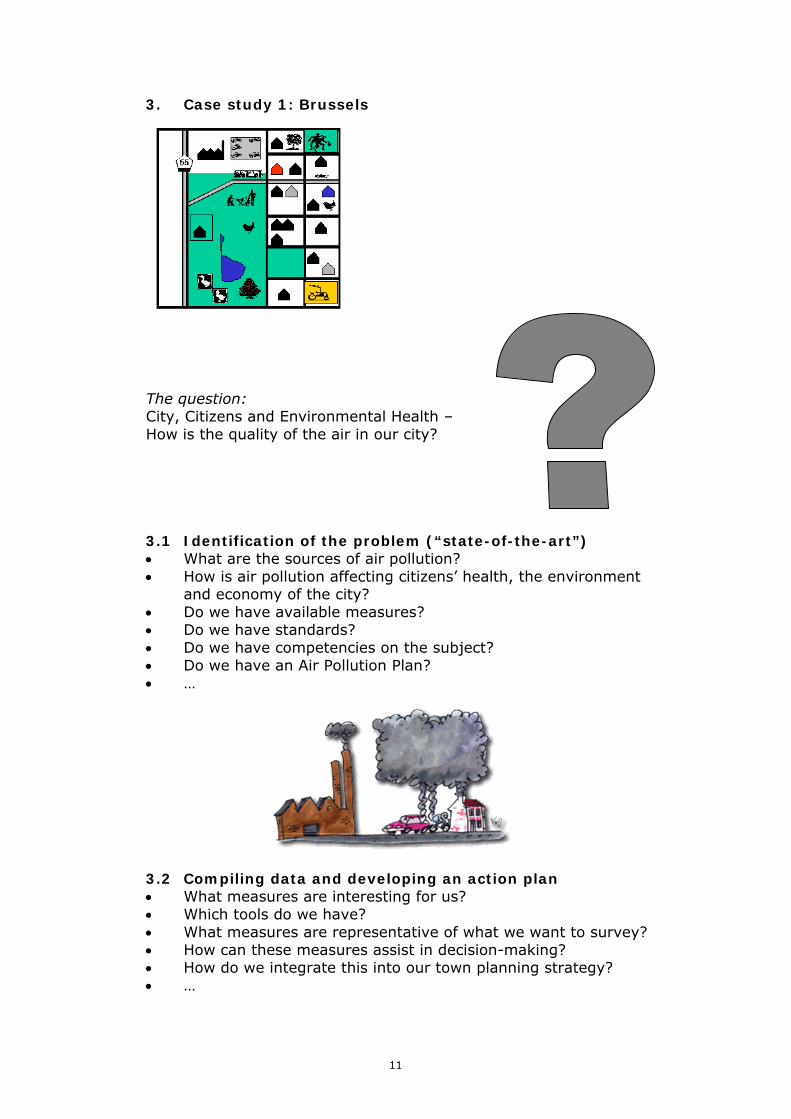
3. Case study 1: Brussels
The question: City, Citizens and Environmental Health – How is the quality of the air in our city? 3.1 Identification of the problem (“state-of-the-art”) • What are the sources of air pollution? • How is air pollution affecting citizens’ health, the environment
and economy of the city? • Do we have available measures? • Do we have standards? • Do we have competencies on the subject? • Do we have an Air Pollution Plan? • … 3.2 Compiling data and developing an action plan • What measures are interesting for us? • Which tools do we have? • What measures are representative of what we want to survey? • How can these measures assist in decision-making? • How do we integrate this into our town planning strategy? • …
11

3.3 Comparing with standards • Do we have standards? • Do we have legal obligations? • Do we have comparable measures? • Do we have alert procedures? • … Example: Norms for SO2 (Sulphur dioxide) Source: Brussels Institute
for the Management of the Environment (IBGE)
Sources: IRCEL-CELINE, website, March 2004
daily average•400 µg/m³
BENELUX GUIDELINE
yearly average50 µg/m³
daily average•125 µg/m³
WHO GUIDELINES
yearly average•40 to 60 µg/m³
daily average•100 to 150 µg/m³
GUIDE VALUES - EU
98th Percentile of all the daily averages measured during the meteorological year•350 µg/m³ with P98 of suspended particles < 150 µg/m³•250 µg/m³ with P98 of suspended particles > 150 µg/m³
50th Percentile(*) of the daily averages measured during themeteorological year(**) •year120 µg/m³ with P50 of suspended particles < 40 µg/m³80 µg/m³ with P50 of suspended particles > 40 µg/m³•winter180 µg/m³ with P50 of suspended particles < 60 µg/m³130 µg/m³ with P50 of suspended particles > 60 µg/m³
LIMIT VALUES - EU
3.4 Integration of data All collected information is analysed, combined and integrated. The data can be associated with different media for analysis and communication assistance. The results have to be easy to read and understandable by the stakeholders.
12

These results can be multiple and need to be presented in a summarised format document
T ue sd a y 2 3 /0 3 /20 0 4 : 1 3 h 0 0 u p d a te (lo ca l tim e ) fo r de ta iled in fo rm a tion c lick on sta tion codes
An Indicator can be a “simple indicator” or several simple indicators can be combined in a “complex indicator.” An indicator can also be: • Quantitative • Qualitative • Geographic Source: IRCEL-CELINE website,
23 March 2004 3.5 Information Dissemination is a key element in the process of developing a platform for Sustainable Urban Planning. In the Brussels Region, the IBGE is providing different kinds of information: • The indicators: they are presented under the Brussels Pilot
Board which includes the most politically significant data (general audience)
• The state of the environment: a snapshot of the environmental state of Brussels Region (general audience)
cod e co m m u n ity O 3 N O 2 C O S O 2 PM 10 PM 2.5 C 6 H 6
1 h o ur a v era g e
1 h o u r a v era ge
1 /2 h ou r av era g e
run n ing 2 4 h o ur a v era g e
ru n n in g 2 4 h ou r a v era g e
ru n n in g 2 4 h ou r a v era ge
ru nn in g 2 4 ho u ra v erag e
µ g /m 3 µ g /m 3 m g /m 3 µg /m 3 µ g /m 3 µ g /m 3 µ g /m 3B ru ss els C ap ita l R eg io n
41B 00 6 B rus s el (E U p ar lem ent) / B ru xe lles (P arlem en t U E ) 40 53 N A 1 ,2
41B 00 5 B rus s el (E as tm an-B e llia rd ) / B ru xe lles (E as tm an-B e lliard ) 55 N A 8
41B 00 3 B rus s el (K u ns t-W et) / B ru xe lles (A rts -L oi) 13 4 1,4 6
41B 00 4 B rus s el (S in t-K a te li jn e ) / B ru xe lles (S ain te -C a th erin e) 55 36 0,3
41R 00 2 E ls en e / Ixe lles 81 0,8 4 41N 04 3 H aren 56 25 0,4 4 45 12 41 M E U 1 N ed er-O ver-H eem b e ek 23 6 19 9
41B 01 1 S in t-A g a th a-B erc h em / B erc h em -S ain te -A g ath e 63 N A 4 16
41R 00 1 S in t-J ans -M o lenb eek / M o lenb eek -S ain t-J ean 42 57 0,3 9 36
41W O L1 S in t-L am brec h ts -W olu w e / W olu w e-S ain t-L am b ert 35 62 0,3 4 23
41R 01 2 U kk e l / U c c le 52 36 6 26
Sources: IRCEL-CELINE, website, 23 March 2004, Meteorological Station « Brussels -Eu Parliament »
Le Pollumètre Qualité de l'air le 23/03/2004
Indices
Exécrable Très mauvaise Mauvaise Très médiocre
Médiocre Moyenne
Assez bonne
Bonne Très bonne Excellente
13

• The fact sheets: more detailed information presented by key subjects (trained audience)
• The measure tables: more detailed information presenting values by key subjects (specialist audience)
• The technical reports: all analytical reports made by the specialised laboratories (specialist audience)
• General publications and newsletters: awareness campaigns materials (general audience)
3.6 Decision Making
• Do we have procedures? • Do we have a specific plan? • Etc.
Source: IRCEL-CELINE website, 23 March 2004
Le Pollumètre Qualité de l'air le 23/03/2004
Indices
Exécrable Très mauvaise Mauvaise Très médiocre
Médiocre Moyenne
Assez bonne
Bonne Très bonne Excellente
Developing sustainable urban planning is developing a network of actors and stakeholders to improve citizens’ quality of life and quality of working conditions. Its is building a cooperative system
Laboratories
Measure stations and
Observatories
Information unit
Analitaical unit
Central Institute
BRUSSELS 161.4 km² 964,405 inhabitants + 30 indicators
14

4. Setup of the monitoring system and selection of indicators
The URBANGUARD system aspires to comprise a set of interdependent indicators selected to assess sustainability implications of development policy and practice. Steps to be followed: • Identification of any indicators required by EU directives • Analysis of major development policies and identification of suitable
assessment parameters • Analysis of development goals (Department of Town Planning and
Housing, Public Works Department, local authorities etc) and identification of suitable assessment parameters
• Selection of indicators for assessing these parameters*
*A mechanism based on the DPSIR methodology will be applied 5. Geospatial structure of the database
Selection of tools• Databases, GIS, other Grid design• Spatial scales to be incorporated in the system Base data • Population, land use Data specific to selected indicators • Population • Land use (commercial establishments, housing development, road
network etc) • Zoning • Land Registry Maps
Variations in the geographical resolution and distribution of each parameter should be accounted for in the grid structure. Main stakeholders • Statistical Service • Environment Service • Public Works Department • Water Development Department • Department of Labour Inspection • Ministry of Commerce, Industry and Tourism • Municipalities • NGOs
15

6. Case study 2: Xanthi, Greece The Xanthi Strategic Master Plan of Sustainable Development • Distinction in the European Sustainable Cities and Towns Campaign • 1998 UNCHS 100 Best Practices List • CEMR, 18 Good Examples of Local Sustainable Development in Europe 6.1 The strategy’s steps regarding urban renewal and environmental qualitative presentation
Urban Environment Upgrading Infrastructures Development • Development of communications infrastructure • Access to waste management and treatment • Land use management and regulations • Energy efficiency mechanisms, promotion of renewable energy • Urban renewal and environmental improvement of central areas • Human settlement upgrading, neighbourhoods development • Urban greening: creation of public green areas together with sport and
recreational facilities • Clean water initiatives, river-front development, natural disasters
prevention plan and interventions (fire/ inundation prevention)
16

Environmental Improvement Strategy • Healthy environment not incompatible with economic growth • Environmental protection • Enhancing sustainable environment/ pollution reduction • Ongoing planning and management of environmental improvements • Eco-development (scientific understanding and management of land-
resources system, despite the constraints raised due to lack of a land inventory at a national and regional level)
• Interconnection of green areas and areas designated for social and cultural activities
• Rational use and energy saving initiatives; renewable energy systems application
• Rehabilitation of older districts, preservation of cultural heritage 6.2 The strategy’s steps enhancing the value of internal organisation, transnational cooperation and exchange of know-how
New Dynamic Administration • Initiatives towards an institutional and policy development
reinforcement • Parallel changes in the methods of administration, establishment of
monitoring and evaluation mechanisms • Innovation in the provision of services, technology transfer • Adoption and modernization of their administrative structures and
decision-making machinery • Long-term savings rather than short-term crisis management • Make the city’s presence felt on the National-European scene and
markets • Improve productivity of the public sector
Transforming Experience to Action • Alternative development standards • Sustained public/private partnerships • Cultural vitality / expression and animation • Sustainable investments to the local social capital: qualitative
improvement, historic memory preservation instruments, strengthening knowledge of the local identity
• Homelessness prevention • Economic revival and development, investment development • Creation of new supporting organizations • Development assistance • Targeting fundamental changes in civic culture 6.3 The “Multi-Poles Approach,” the concept of the urban complexity as a starting point for the Xanthi model
We need to accept the spatial, temporal, structural and cultural complexity in the spaces we inhabit in our way to analyze man-environment systems • We attempted to replace the static equilibrium by a dynamic one
17

• We are enhancing a process of a sustainable development, leading to a replacement of exhausted systems by others in evolution
• We try to provide an easy access to new options and the solution of problems
Problem: Chaotic diversity of opinions Response: An intensive participatory approach – every citizen has the
responsibility of acting and treating existing problems responsibly Necessity: Informed, proactive, responsible and transparent decision
making Questions: Strategic thinking? Planning? Scientific reporting? Local Agenda 21? Set up indicators? Communication? More communication? Technology in the service of decision- making? Technology as facilitator-accelerator of decisions? Which way? For whom? 6.4 Monitoring is crucial – to measure is to know
The performance of the city must be assessed! • How can the performance of the city (as well as local actors) be
improved? • It is of course not physically possible to monitor and measure
everything. Further, it would be too expensive. • Indicators are selected: representative and relevant elements that help
us visualize sustainability. The objective of the Xanthi Model is to manage change strategically, meaning that the degree in which decision-makers are acting, trying or have already become change-makers too, is a direct way to check a policy’s success and integrated character in dealing with emerging problems in an urban-wide context. The Xanthi Model first introduced the principle that the change of a city’s image is a two-level indicator, qualitative and quantitative. The Xanthi Model also provided the platform to a “capital notions” evolution at the theoretical level, to the introduction of a thematic system of sustainability indicators and to transform statistic measures instruments in favour of culture, heritage enhancement and general social qualitative upgrading.
18

6.5 The “capital notions” and their evolution
To consider cultural heritage as an ecosystem was the first step. The questions that followed included: • Which is the role that the cultural infrastructure will play in the future
city and why? • What will be the future image of the European cultural ecosystem in the
following decade? • Can the quantity of the qualitative preservation of a cultural ecosystem
become the satisfying answer in a city’s aspiration to become a regional capital?
These questions provided answers that helped achieve results such that: • A first approach of a concrete system of indicators was introduced
according to the concept of cultural ecosystems • An integrated and multilevel research process was born out of it and
remains an on going process 6.6 The system of thematic indicators
Two levels of classification were initially proposed. The first one was to separate the simple indicators from the complex ones. Simple indicators can become valuable support instruments as they can be found readily in existing bibliography and chosen because they are compatible with a proposed concept; at the same time, they function to orient the policy adoption process within the urban sustainability framework. Complex indicators on the other hand, are useful in procuring a better response to preoccupations and local objectives, enhancing the role of existing simple indicators, as well as providing added value to simple indicators with a new enlarged dimension imposed by the innovative concept of “cultural ecosystems.”
The second classification level is the thematic division of both simple and complex indicators. Four themes were chosen to equally reflect the principal socio-cultural, economic, political and environmental processes. This was done because a dynamic heritage conception and evolution has a role within the development process and a place within the urban environment.
Twelve complex indicators were therefore introduced in an attempt to reinforce research focus. Their aim was to depict any existing link between urban sustainability and heritage protection or enhancement. This is about a dynamic heritage conception and evolution that can have a role within the development process Examples:
Simple Indicators • Environmental: Number of protected areas in the city • Social: Number of citizen groups supporting heritage preservation • Political: Participation in the “European Heritage Days” events • Economic: Unemployment rate
19

Complex Indicators • Environmental: Green space and heritage in need of rehabilitation (sum
of the percentage of heritage sites in need of rehabilitation per total surface of heritage sites and the percentage of urban green space requiring rehabilitation per total urban surface)
6.7 Conclusions
his research and action is an ongoing process. It is the output of an
oreover, the city of Xanthi has been applying the national sustainability
he thematic indicator system of Xanthi is a further and deeper approach to
Tintensive and long- term municipal policy, supported by an extensive exchange of know-how at European and international level (48 countries studied) through participation in a significant number of international thematic meetings. It involves ongoing literature collection and analysis, participation in relevant European projects and close collaboration with organisations across the EU.
Mindicators as proposed by the Greek Ministry of the Environment since 1998. Monitoring and the feedback is therefore assured in two ways; the municipality conducts the reporting and the updating of data relevant to the national indicators and the Ministry receives and overviews this local monitoring, providing necessary feedback. This is very necessary to promote efficient budget allocation for large projects and achieve a hierarchy of priorities at national, regional and local level.
Tlocal sustainability and a more localised approach to sustainability engagement as an output of a long-term European cooperation commitment and active presence. It provides an additional and more sophisticated instrument oriented to monitoring the local development processes.
20