Project history of Dublin’s River Liffey bridges · The River Liffey, which is about 135 km long,...
19
Project history of Dublin’s River Liffey bridges M. Phillips and A. Hamilton A significant geographical feature of Dublin, the capital of the Republic of Ireland, is that the River Liffey divides the city into the north side and south side. As there has always been significant traffic needing to cross the river, ancient fords and ferries gave way to a series of bridges. It is assumed that the first stone bridge across the River Liffey was built in the thirteenth century. Most of the surviving bridge infrastructure was built in the nineteenth century. Four road bridges were built in the twentieth century. The first bridge crossing in the twenty-first cen- tury was a footbridge commissioned in 2000. A further road crossing was completed in June 2003 and a sixteenth crossing is under consideration. A significant departure for Dublin was engaging an international designer for these latter bridges. The historical progression of river crossings is described and linked to a comprehensive set of 16 photographs. Historical reviews are provided of the approach used in bridge design and construction, the time and cost outcomes, the principals contracted to deliver the bridges, and certain aspects of the construction where such information was recorded. All original imperial measurements are also given in metric, and for ease of comparison all monetary values are given in Irish pounds (G1 = IR»0˝78). 1. DUBLIN CITY AND ITS PRINCIPAL RIVER The River Liffey, which is about 135 km long, has its source near Kippure in Co. Wicklow and its confluence with the Irish Sea at Dublin Bay, which forms the eastern boundary of Dublin City. 1 The source of the Liffey is at approximately 540 m elevation and only about 20 km south of Dublin in the Wicklow mountains. In its flow the river drains just over 1380 km 2 of catchment area and forms a huge arc as it flows first to the west, then in a general northerly direction and finally east through Dublin City. It flows over a range of different geological formations; from granite, to sandstone, to sand- stone–limestone and finally pure limestone. Two reservoirs and three small hydroelectric power stations act as controls on the river flow. Prior to the beginning of the seventeenth century, and within what would at that time be considered as the city limits, the Liffey was spanned at the city’s westerly limit by a single bridge. This bridge, which was built during the eleventh century, was constructed from timber and was known as Dubhghall’s Bridge. 2–4 The bridge replaced a ford that had been called the Ford of the Hurdles. A masonry bridge, which was known as the Bridge of Dublin (also referred to as the Old Bridge), replaced the original timber structure during the first quarter of the thirteenth century. This bridge was quite wide and was a ‘living bridge’; it was lined with houses and shops and had towers at either end. The river was navigable by seagoing vessels as far as this bridge. 5 The river’s width within the city has over time been considerably modified and narrowed by land reclamation. Probably from the beginning of the thirteenth century and for the next five centuries the banks of the river underwent development through reclamation and earthen or timber riverbank construction. During the period from the first quarter of the eighteenth century to the second quarter of the twentieth century significant development work took place on training the river to accommodate shipping. In particular the second and third quarters of the nineteenth century were witness to significant development as quay walls on both the north side and south side were constructed to create deepwater berthing. 6,7 Within the present Dublin City area the river has a width, between quay walls, generally widening in the downstream direction from about 30 m to over 300 m at its mouth. The earliest recorded settlement on the banks of the navigable stretch of the River Liffey is given as the sixth or seventh century. The first landing by the Vikings was in AD AD 795, and by AD AD 841 they had created a permanent settlement, which was named Dubh Linn, ‘the black pool’. Other settlements consisted of small clusters of habitation at different locations on both the north bank and south bank of the river. Initially movement from either side of the river would have been by fording it or by obtaining passage on whatever small craft was travelling from one bank to the other. The Norse built a fortification on the south side of the river. In 1170 the Normans arrived at a time when the population within the settled area was probably only a few thousand people. A building programme throughout the thirteenth century created two cathedrals and other secular buildings including a castle (Dublin Castle), many other stone buildings, and the building and conversion of the city walls to stone. The developing city walls contained six free-standing towers incorporating arches (or gates) located at junctions with streets, and the castle formed the south-east corner of, and was included within, the ramparts. However, adjacent to the Liffey the walls were incomplete, giving access to the quays. Proceedings of the Institution of Civil Engineers Bridge Engineering 156 December 2003 Issue BE4 Pages 161^179 Paper 13329 Received 01/04/2003 Accepted 22/08/2003 Keywords: bridges/river engineering Michael Phillips City Engineer, Dublin City Council, Ireland Albert Hamilton Consultant; former Director, Centre for Project Management, and Kent Professor of Project Management, University of Limerick, Ireland Bridge Engineering 156 Issue BE4 Dublin’s River Liffey bridges Phillips Ř Hamilton 161
Transcript of Project history of Dublin’s River Liffey bridges · The River Liffey, which is about 135 km long,...
Project history of Dublin’s River Liffey bridges
M. Phillips and A. Hamilton
A significant geographical feature of Dublin, the capital ofthe Republic of Ireland, is that the River Liffey divides thecity into the north side and south side. As there hasalways been significant traffic needing to cross the river,ancient fords and ferries gave way to a series of bridges. Itis assumed that the first stone bridge across the RiverLiffey was built in the thirteenth century. Most of thesurviving bridge infrastructure was built in the nineteenthcentury. Four road bridges were built in the twentiethcentury. The first bridge crossing in the twenty-first cen-tury was a footbridge commissioned in 2000. A furtherroad crossing was completed in June 2003 and a sixteenthcrossing is under consideration. A significant departurefor Dublin was engaging an international designer forthese latter bridges. The historical progression of rivercrossings is described and linked to a comprehensive setof 16 photographs. Historical reviews are provided of theapproach used in bridge design and construction, the timeand cost outcomes, the principals contracted to deliverthe bridges, and certain aspects of the construction wheresuch information was recorded. All original imperialmeasurements are also given in metric, and for ease ofcomparison all monetary values are given in Irish pounds(G1 = IR»0˝78).
1. DUBLINCITYAND ITS PRINCIPAL RIVERThe River Liffey, which is about 135 km long, has its sourcenear Kippure in Co. Wicklow and its confluence with the IrishSea at Dublin Bay, which forms the eastern boundary of DublinCity.1 The source of the Liffey is at approximately 540 melevation and only about 20 km south of Dublin in the Wicklowmountains. In its flow the river drains just over 1380 km2 ofcatchment area and forms a huge arc as it flows first to thewest, then in a general northerly direction and finally eastthrough Dublin City. It flows over a range of differentgeological formations; from granite, to sandstone, to sand-stone–limestone and finally pure limestone. Two reservoirs andthree small hydroelectric power stations act as controls on theriver flow.
Prior to the beginning of the seventeenth century, and withinwhat would at that time be considered as the city limits, theLiffey was spanned at the city’s westerly limit by a singlebridge. This bridge, which was built during the eleventhcentury, was constructed from timber and was known asDubhghall’s Bridge.2–4 The bridge replaced a ford that had been
called the Ford of the Hurdles. A masonry bridge, which wasknown as the Bridge of Dublin (also referred to as the OldBridge), replaced the original timber structure during the firstquarter of the thirteenth century. This bridge was quite wideand was a ‘living bridge’; it was lined with houses and shopsand had towers at either end. The river was navigable byseagoing vessels as far as this bridge.5
The river’s width within the city has over time beenconsiderably modified and narrowed by land reclamation.Probably from the beginning of the thirteenth century and forthe next five centuries the banks of the river underwentdevelopment through reclamation and earthen or timberriverbank construction. During the period from the first quarterof the eighteenth century to the second quarter of the twentiethcentury significant development work took place on trainingthe river to accommodate shipping. In particular the secondand third quarters of the nineteenth century were witness tosignificant development as quay walls on both the north sideand south side were constructed to create deepwater berthing.6,7
Within the present Dublin City area the river has a width,between quay walls, generally widening in the downstreamdirection from about 30 m to over 300 m at its mouth.
The earliest recorded settlement on the banks of the navigablestretch of the River Liffey is given as the sixth or seventhcentury. The first landing by the Vikings was in ADAD 795, and byADAD 841 they had created a permanent settlement, which wasnamed Dubh Linn, ‘the black pool’. Other settlements consistedof small clusters of habitation at different locations on both thenorth bank and south bank of the river. Initially movementfrom either side of the river would have been by fording it orby obtaining passage on whatever small craft was travellingfrom one bank to the other. The Norse built a fortification onthe south side of the river. In 1170 the Normans arrived at atime when the population within the settled area was probablyonly a few thousand people. A building programme throughoutthe thirteenth century created two cathedrals and other secularbuildings including a castle (Dublin Castle), many other stonebuildings, and the building and conversion of the city walls tostone. The developing city walls contained six free-standingtowers incorporating arches (or gates) located at junctionswith streets, and the castle formed the south-east corner of,and was included within, the ramparts. However, adjacent tothe Liffey the walls were incomplete, giving access to thequays.
Proceedings of the Institution ofCivil EngineersBridge Engineering 156December 2003 Issue BE4Pages 161^179
Paper 13329Received 01/04/2003Accepted 22/08/2003
Keywords:bridges/river engineering
Michael PhillipsCity Engineer, Dublin CityCouncil, Ireland
Albert HamiltonConsultant; former Director, Centrefor Project Management, and KentProfessor of Project Management,University of Limerick, Ireland
Bridge Engineering 156 Issue BE4 Dublin’s River Liffey bridges Phillips � Hamilton 161
The first census in Ireland in 1659 showed that the totalpopulation of Dublin was 8780. However, some 15 years earlierthe population was believed to be between 20000 and 30000,but it had been stricken by plague on at least two occasions.Dublin’s future population would increase and decrease withtime for numerous reasons such as war, disease and immigra-tion. By 1776 it had reached 150000. This undulation of thecity’s population has continued to recent times: censuses haveshown populations of 567802 (1966), 481854 (1996) and495101 (2002). Where in ancient times the population focuswas on the south side of the river, the density of population isnow higher on the north side. Throughout its history Dublin’spopulation and those wishing to travel overland on a north–south axis adjacent to Ireland’s eastern coast have needed tocross Dublin’s geographical divide—the River Liffey.3
2. THE DEVELOPMENTOF BRIDGES OVER DUBLIN’SLIFFEY
There can be little doubt that in many ways the story of bridge
building is the story of civilisation. By it, we can readily measure an
important part of people’s progress—Franklin D Roosevelt8
It would be difficult not to agree with this statement whenexamining the development of bridges across the River Liffeyin Dublin.
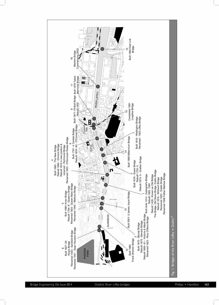
Figure 1 shows the geographical locations of the 16 current andplanned bridges across the Liffey within the city. Thenomenclature used in this figure relates to the time order inwhich the bridges were initially built, number 1 being theearliest and number 16 being the latest. The diagram is achronology showing significant dates and name changes.9
Name change appears to be a popular aspect of the Republic’smeans of demonstrating change ‘from the old order’, and therealso seems to be an apparent need for commemoration.Thirteen of these bridges are road and pedestrian bridges, twoare solely for pedestrians, and one is a rail bridge.
2.1. Father Mathew BridgeThis bridge is located at, or close to, the first millennium’s siteof the Ford of the Hurdles. It has been suggested10 that theoriginal ford was in use up to and including the tenth centuryand was replaced by Dublin’s first bridge, which was of timberconstruction. Little is known of this bridge, but circumstantialevidence of other timber bridges constructed in Ireland duringthe first half of the second millennium would indicate a simpleframed structure without any form of cross or longitudinalbracing. Tree trunks were used firstly for creating sole platesthat lay at the river bottom in line with the direction of waterflow. Sole plates were laid at regular intervals across the widthof the river, and from these bases vertical members wereconnected in or passed through into the underlying riverbottom. The upper end of the vertical trunks within each soleplate would have been tied into a timber cross-member(transom) that would be in line with the sole plate. Thesetransoms supported the deck and all other imposed loading.Rocks and stones placed on top would have protected the soleplates, and this would have helped to provide some lateralresistance to movement. It is somewhat surprising that thisbridge lasted until at least 1315. It was rebuilt in 1320 butswept away in a flood in 1380. In the last quarter of thefourteenth century and the first quarter of the fifteenth century
a ferry plying between the north side and the south side hadreplaced, albeit temporarily, the timber bridge.
In 1428 the Dominicans, a religious order, constructed amasonry bridge, which was called the Bridge of Dublin (whichbecame known as the Old Bridge) and provided a newpermanent crossing at this location. The preachers in Ostman-town (north side) Friary funded the construction cost of thebridge. The concept of religious orders building and maintain-ing bridges was not, however, unique to Dublin.11,12 Thisstronger and wider bridge had four arches, and towers at eitherend. It was lined with shops and housing, and accommodatedsuch buildings as a chapel, a bake-house and an inn. It carriedall pedestrian, livestock and horse-drawn traffic across the riverat that time. The tolls and chapel were recorded as still existingin 1762.
Between 1816 and 1818, indicating a lifespan for the bridge of390 years, the Bridge of Dublin was replaced by a new 145 ft(44 m) long masonry bridge because of the collapse of thenorthern end of the Bridge of Dublin; it was called theWhitworth Bridge. This three-span, elliptical arch bridge wasdesigned and constructed by George Knowles for the client, thePort of Dublin, at a price reputed to be about IR£26000; thebridge is shown in Fig. 2. It was renamed in 1938.
2.2. Rory O’More BridgeThe Rory O’More Bridge had been built as the Victoria & AlbertBridge in 1863; it was renamed in 1939. It had twopredecessors. In 1670 a timber bridge, the second across theLiffey, was constructed at this site and became known asBloody Bridge. The timber bridge was replaced by a stonebridge in 1704, which in turn was replaced by the present day,95 ft (29 m) single-span, 33 ft (10·05 m) wide, cast iron bridgesupported off granite abutments. There are seven I-sectionbeams that form the main span, and between each beam thereis cast iron cross-bracing. The bridge is unusual in that itsdecking is of wrought iron. It was fabricated in St Helens,Lancashire, England. Today it carries two lanes of traffic.
George Halpin designed the bridge for the client, the Port ofDublin, and the contractor was John Killen of Malahide.13 Thecost was reputed to be IR£13710. The bridge is shown in Fig. 3.
2.3. Grattan BridgeIn 1676 the first bridge to be built on this site was a seven-archstone bridge with piers from 9 ft (2·74 m) to 13 ft (3·96 m)thick, providing a total waterway width of 170 ft (51·82 m). Thebridge was constructed from the ruined masonry of a nearbyabbey; at completion it was named the Essex Bridge. In 1687 itwas repaired after being damaged in a flood. In 1751 thesecond most northerly pier collapsed and damaged the adjacentarches; in May of the same year temporary repairs wereundertaken, but it was decided to rebuild the bridge. Thecontractor who built the replacement bridge discovered that thepiers of the old bridge had been built upon timber grillages,which were believed to have been constructed onshore and thensunk to the river bed at the required pier positions. Thegrillages were not founded on piles, and as they sat on the riverbed without any apparent protection it was not surprising thatthe bridge suffered catastrophic damage on more than oneoccasion.
162 Bridge Engineering 156 Issue BE4 Dublin’s River Liffey bridges Phillips � Hamilton
PH
OE
NIX
PA
RK
G.P
.O.
Cus
tom
Hse
.
RIV
ER
LIF
FE
Y
8B
uilt
1827
_ 29K
ing'
s B
ridge
Ren
amed
192
3 -
Sar
sfie
ld B
ridge
Ren
amed
194
1 -
Sea
n H
eust
on B
ridge
5B
uilt
1684
-Arr
an B
ridge
Reb
uilt
1764
_8
- Q
ueen
's B
ridge
Ren
amed
192
3 -
Que
en M
aev
Brid
geR
enam
ed 1
942
- M
ello
ws
Brid
ge
4B
uilt
1682
- T
he N
ew B
ridge
Reb
uilt
1684
- O
rmon
d B
ridge
Reb
uilt
1816
in n
ew p
ositi
on &
rena
med
- R
ichm
ond
Brid
geR
enam
ed 1
923
- O
'Don
ovan
Ros
sa B
ridge
6B
uilt
1791
_4
Car
lisle
Brid
geR
ebui
lt 18
76_
80
- O
'Con
nel B
ridge
9B
uilt
1877
_ 79 B
utt B
ridge
Reb
uilt
1932
11B
uilt
1978
Tal
bot
Mem
oria
l Brid
ge
16M
acke
n B
ridge
Com
men
cing
200
3
12B
uilt
1982
Fra
nk S
herw
in B
ridge
GU
INN
ES
S
2B
uilt
1670
- B
lood
y B
ridge
Reb
uilt
1675
- B
arra
ck B
ridge
Reb
uilt
1859
_6
1 -
Vic
toria
& A
lber
t Brid
geR
enam
ed 1
923
- R
ory
O'M
ore
Brid
ge
15B
uilt
2001
_ 3 Ja
mes
Joy
ce B
ridge 1
Bui
lt A
nte
1014
- D
ubhg
hall'
s B
ridge
Reb
uilt
1385
, 139
4R
ebui
lt 14
28 -
Kno
wn
as O
ld B
ridge
The
Brid
ge, O
ld S
tone
Brid
ge, D
ublin
Brid
geR
ebui
lt 18
16 -
Whi
twor
t Brid
geR
enam
ed 1
923
- D
ublin
Brid
geR
enam
ed 1
938
Fat
her
Mat
hew
Brid
ge3B
uilt
1676
- E
ssex
Brid
geR
ebui
lt 17
53_
5R
ebui
lt 18
73_
5 -
Gra
ttan
Brid
ge
14B
uilt
1999
Mill
enni
um B
ridge
7B
uilt
1816
- W
ellin
gton
Brid
geR
enam
ed -
192
3 Li
ffey
Brid
ge
10C
ompl
eted
189
1Lo
oplin
e B
ridge
13B
uilt
1984
Eas
t Lin
kB
ridge
Fig.
1.Bridg
esof
theRiver
Liffe
yin
Dub
lin13
Bridge Engineering 156 Issue BE4 Dublin’s River Liffey bridges Phillips � Hamilton 163
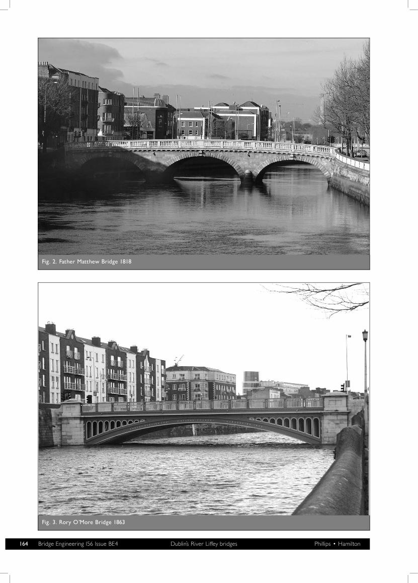
Fig. 2. Father Matthew Bridge 1818
Fig. 3. Rory O’More Bridge 1863
164 Bridge Engineering 156 Issue BE4 Dublin’s River Liffey bridges Phillips � Hamilton
The replacement Essex Bridge was constructed in 1753 to 1755,and its development is well recorded.14,15 The new bridge was afive-span semicircular stone arch design with two 8 ft (2·44 m)piers and two 9 ft (2·74 m) piers; this left a waterway width of200 ft (60·96 m). The width of the bridge was 47 ft (14·3 m). Itwas designed and constructed by George Semple, who hadundertaken the repairs on the previous bridge in 1751, for theCity of Dublin. Semple was particularly interested to exploreusing the latest technology of ‘enclosures’ when constructing inwater, to enable the removal of old foundations and replace-ment with new. Because 28 borings had shown depths of sand,mud, gravel and stones of less than 20 ft (6·1 m), but moreoften less than 10 ft (3·05 m), above bedrock, his plan was tocofferdam and remove the offending material. A cofferdamwould have to be designed to keep out water at depths of 27 ft(8·23 m)—high spring tide. The timber-plank cofferdamextended beyond the midway point of the bridge’s length andwas connected to the bank at a considerable distance upstreamand downstream of the bridge’s centreline. The temporaryworks were undertaken by building first the northern cofferdamfollowed by the southern cofferdam. In plan the cofferdamformed a truncated V, and in elevation it consisted of fivevertical compartments, a large middle section flanked by twonarrower vertical spaces. All five compartments were filled withpuddle clay when the cofferdam was driven to its requireddepth. The two piers at the north end were founded on oakbearing piles that were driven to rock, but because of the higherlevel of rock on the south end the two piers there were foundeddirectly on rock and not piled.
Semple appears to have been a very competent projectmanager. He took responsibility for the bridge’s design and
construction without any form of written contract. His publicdeclaration of estimates stated that the bridge would costIR£20500 and take two years to complete. He delivered thebridge to the City of Dublin with a 1·1% overrun on thescheduled period (eight days over the two years) and with lessthan a 1% overspend (in fact 0·79%) on the cost budget(actually IR£20661).16 Much later bridges have not been able tomatch this excellent result.
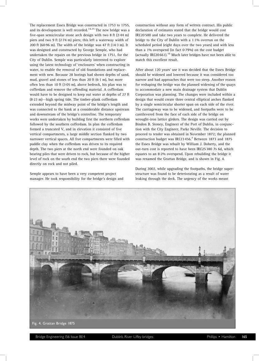
After about 120 years’ use it was decided that the Essex Bridgeshould be widened and lowered because it was considered toonarrow and had approaches that were too steep. Another reasonfor reshaping the bridge was the planned widening of the quaysto accommodate a new main drainage system that DublinCorporation was planning. The changes were included within adesign that would create three central elliptical arches flankedby a single semicircular shorter span on each side of the river.The carriageway was to be widened, and footpaths were to becantilevered from the face of each side of the bridge onwrought-iron lattice girders. The design was carried out byBindon B. Stoney, Engineer of the Port of Dublin, in conjunc-tion with the City Engineer, Parke Neville. The decision toproceed to tender was obtained in November 1872; the plannedconstruction budget was IR£23456.7 Between 1873 and 1875the Essex Bridge was rebuilt by William J. Doherty, and theout-turn cost is reported to have been IR£25380 7s 6d, whichequates to an 8·2% overspend. Upon rebuilding the bridge itwas renamed the Grattan Bridge, and is shown in Fig. 4.
During 2002, while upgrading the footpaths, the bridge super-structure was found to be deteriorating as a result of waterleaking through the deck. The urgency of the works meant
Fig. 4. Grattan Bridge 1875
Bridge Engineering 156 Issue BE4 Dublin’s River Liffey bridges Phillips � Hamilton 165
there was not sufficient time to proceed with the normaltendering process. Messrs Pierse Construction Ltd, who werecontracted to provide the adjacent cantilevered boardwalk overthe river, carried out the work at a cost of S2·3m (IR£1·794m).
2.4. O’Donovan Rossa BridgeWhat would have been Dublin’s third timber bridge in a periodof 14 years was built in 1682 and was called the OrmondeBridge. It was paid for by the incumbent Lord Mayor of Dublin,Sir Humphrey Jervis,17 and cost IR£502 19s 7d. Withoutrailings of any type it is not surprising that it was condemnedand replaced in 1684 by a masonry bridge. The masonry bridgewas designed as a five-span simple arch bridge, which isunderstood to have had an opening drawbridge or centre spanthat was arched over a few years after it was commissioned.13
In December 1802 the bridge was swept away during a severestorm.
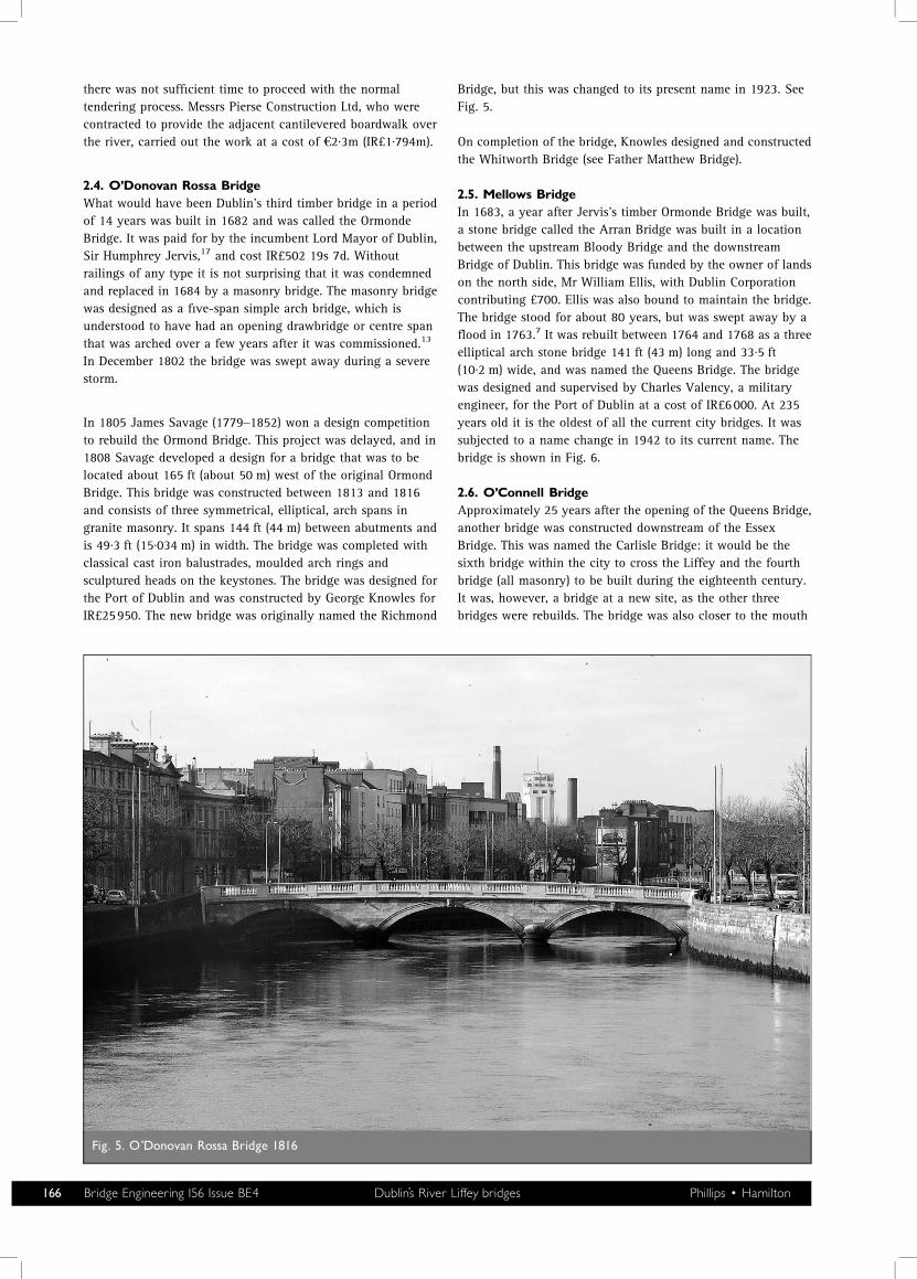
In 1805 James Savage (1779–1852) won a design competitionto rebuild the Ormond Bridge. This project was delayed, and in1808 Savage developed a design for a bridge that was to belocated about 165 ft (about 50 m) west of the original OrmondBridge. This bridge was constructed between 1813 and 1816and consists of three symmetrical, elliptical, arch spans ingranite masonry. It spans 144 ft (44 m) between abutments andis 49·3 ft (15·034 m) in width. The bridge was completed withclassical cast iron balustrades, moulded arch rings andsculptured heads on the keystones. The bridge was designed forthe Port of Dublin and was constructed by George Knowles forIR£25950. The new bridge was originally named the Richmond
Bridge, but this was changed to its present name in 1923. SeeFig. 5.
On completion of the bridge, Knowles designed and constructedthe Whitworth Bridge (see Father Matthew Bridge).
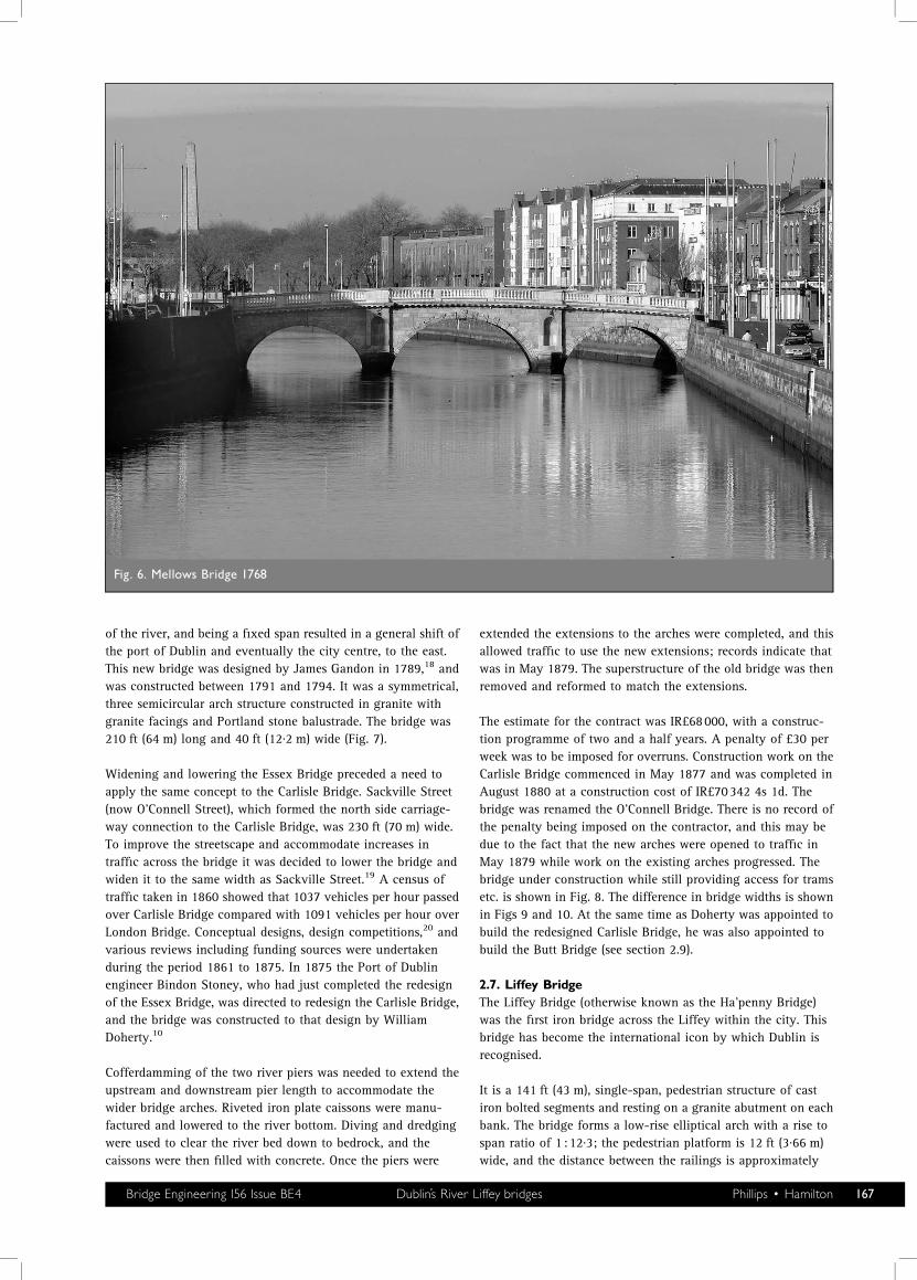
2.5. Mellows BridgeIn 1683, a year after Jervis’s timber Ormonde Bridge was built,a stone bridge called the Arran Bridge was built in a locationbetween the upstream Bloody Bridge and the downstreamBridge of Dublin. This bridge was funded by the owner of landson the north side, Mr William Ellis, with Dublin Corporationcontributing £700. Ellis was also bound to maintain the bridge.The bridge stood for about 80 years, but was swept away by aflood in 1763.7 It was rebuilt between 1764 and 1768 as a threeelliptical arch stone bridge 141 ft (43 m) long and 33·5 ft(10·2 m) wide, and was named the Queens Bridge. The bridgewas designed and supervised by Charles Valency, a militaryengineer, for the Port of Dublin at a cost of IR£6000. At 235years old it is the oldest of all the current city bridges. It wassubjected to a name change in 1942 to its current name. Thebridge is shown in Fig. 6.
2.6. O’Connell BridgeApproximately 25 years after the opening of the Queens Bridge,another bridge was constructed downstream of the EssexBridge. This was named the Carlisle Bridge: it would be thesixth bridge within the city to cross the Liffey and the fourthbridge (all masonry) to be built during the eighteenth century.It was, however, a bridge at a new site, as the other threebridges were rebuilds. The bridge was also closer to the mouth
Fig. 5. O’Donovan Rossa Bridge 1816
166 Bridge Engineering 156 Issue BE4 Dublin’s River Liffey bridges Phillips � Hamilton
of the river, and being a fixed span resulted in a general shift ofthe port of Dublin and eventually the city centre, to the east.This new bridge was designed by James Gandon in 1789,18 andwas constructed between 1791 and 1794. It was a symmetrical,three semicircular arch structure constructed in granite withgranite facings and Portland stone balustrade. The bridge was210 ft (64 m) long and 40 ft (12·2 m) wide (Fig. 7).
Widening and lowering the Essex Bridge preceded a need toapply the same concept to the Carlisle Bridge. Sackville Street(now O’Connell Street), which formed the north side carriage-way connection to the Carlisle Bridge, was 230 ft (70 m) wide.To improve the streetscape and accommodate increases intraffic across the bridge it was decided to lower the bridge andwiden it to the same width as Sackville Street.19 A census oftraffic taken in 1860 showed that 1037 vehicles per hour passedover Carlisle Bridge compared with 1091 vehicles per hour overLondon Bridge. Conceptual designs, design competitions,20 andvarious reviews including funding sources were undertakenduring the period 1861 to 1875. In 1875 the Port of Dublinengineer Bindon Stoney, who had just completed the redesignof the Essex Bridge, was directed to redesign the Carlisle Bridge,and the bridge was constructed to that design by WilliamDoherty.10
Cofferdamming of the two river piers was needed to extend theupstream and downstream pier length to accommodate thewider bridge arches. Riveted iron plate caissons were manu-factured and lowered to the river bottom. Diving and dredgingwere used to clear the river bed down to bedrock, and thecaissons were then filled with concrete. Once the piers were
extended the extensions to the arches were completed, and thisallowed traffic to use the new extensions; records indicate thatwas in May 1879. The superstructure of the old bridge was thenremoved and reformed to match the extensions.
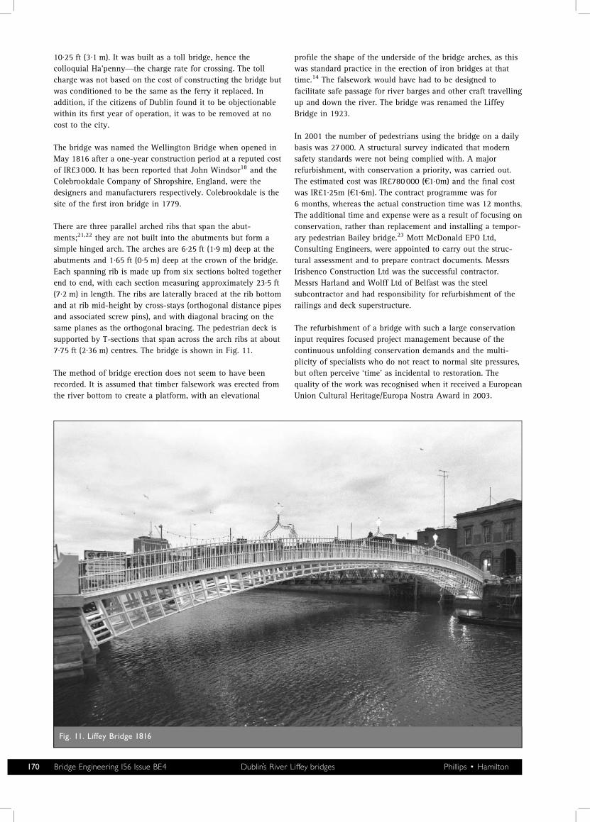
The estimate for the contract was IR£68000, with a construc-tion programme of two and a half years. A penalty of £30 perweek was to be imposed for overruns. Construction work on theCarlisle Bridge commenced in May 1877 and was completed inAugust 1880 at a construction cost of IR£70342 4s 1d. Thebridge was renamed the O’Connell Bridge. There is no record ofthe penalty being imposed on the contractor, and this may bedue to the fact that the new arches were opened to traffic inMay 1879 while work on the existing arches progressed. Thebridge under construction while still providing access for tramsetc. is shown in Fig. 8. The difference in bridge widths is shownin Figs 9 and 10. At the same time as Doherty was appointed tobuild the redesigned Carlisle Bridge, he was also appointed tobuild the Butt Bridge (see section 2.9).
2.7. Liffey BridgeThe Liffey Bridge (otherwise known as the Ha’penny Bridge)was the first iron bridge across the Liffey within the city. Thisbridge has become the international icon by which Dublin isrecognised.
It is a 141 ft (43 m), single-span, pedestrian structure of castiron bolted segments and resting on a granite abutment on eachbank. The bridge forms a low-rise elliptical arch with a rise tospan ratio of 1 :12·3; the pedestrian platform is 12 ft (3·66 m)wide, and the distance between the railings is approximately
Fig. 6. Mellows Bridge 1768
Bridge Engineering 156 Issue BE4 Dublin’s River Liffey bridges Phillips � Hamilton 167
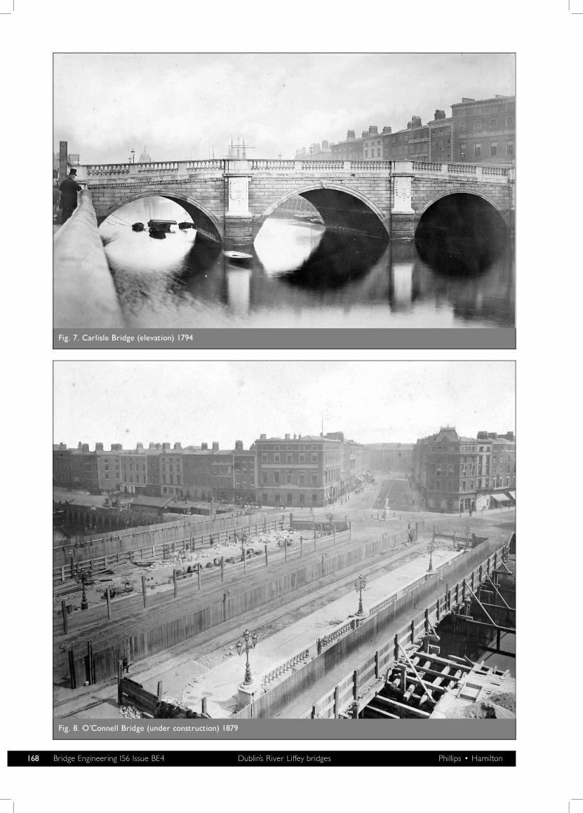
Fig. 7. Carlisle Bridge (elevation) 1794
Fig. 8. O’Connell Bridge (under construction) 1879
168 Bridge Engineering 156 Issue BE4 Dublin’s River Liffey bridges Phillips � Hamilton
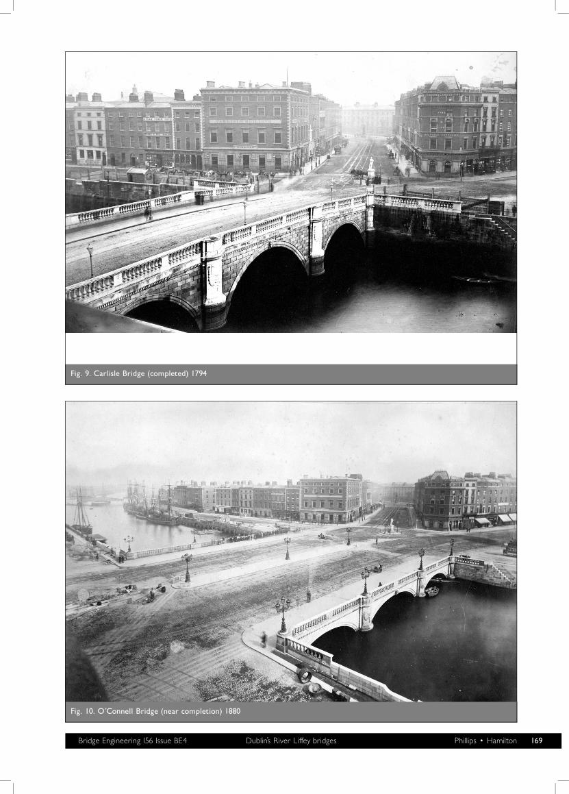
Fig. 9. Carlisle Bridge (completed) 1794
Fig. 10. O’Connell Bridge (near completion) 1880
Bridge Engineering 156 Issue BE4 Dublin’s River Liffey bridges Phillips � Hamilton 169
10·25 ft (3·1 m). It was built as a toll bridge, hence thecolloquial Ha’penny—the charge rate for crossing. The tollcharge was not based on the cost of constructing the bridge butwas conditioned to be the same as the ferry it replaced. Inaddition, if the citizens of Dublin found it to be objectionablewithin its first year of operation, it was to be removed at nocost to the city.
The bridge was named the Wellington Bridge when opened inMay 1816 after a one-year construction period at a reputed costof IR£3000. It has been reported that John Windsor18 and theColebrookdale Company of Shropshire, England, were thedesigners and manufacturers respectively. Colebrookdale is thesite of the first iron bridge in 1779.
There are three parallel arched ribs that span the abut-ments;21,22 they are not built into the abutments but form asimple hinged arch. The arches are 6·25 ft (1·9 m) deep at theabutments and 1·65 ft (0·5 m) deep at the crown of the bridge.Each spanning rib is made up from six sections bolted togetherend to end, with each section measuring approximately 23·5 ft(7·2 m) in length. The ribs are laterally braced at the rib bottomand at rib mid-height by cross-stays (orthogonal distance pipesand associated screw pins), and with diagonal bracing on thesame planes as the orthogonal bracing. The pedestrian deck issupported by T-sections that span across the arch ribs at about7·75 ft (2·36 m) centres. The bridge is shown in Fig. 11.
The method of bridge erection does not seem to have beenrecorded. It is assumed that timber falsework was erected fromthe river bottom to create a platform, with an elevational
profile the shape of the underside of the bridge arches, as thiswas standard practice in the erection of iron bridges at thattime.14 The falsework would have had to be designed tofacilitate safe passage for river barges and other craft travellingup and down the river. The bridge was renamed the LiffeyBridge in 1923.
In 2001 the number of pedestrians using the bridge on a dailybasis was 27000. A structural survey indicated that modernsafety standards were not being complied with. A majorrefurbishment, with conservation a priority, was carried out.The estimated cost was IR£780000 (S1·0m) and the final costwas IR£1·25m (S1·6m). The contract programme was for6 months, whereas the actual construction time was 12 months.The additional time and expense were as a result of focusing onconservation, rather than replacement and installing a tempor-ary pedestrian Bailey bridge.23 Mott McDonald EPO Ltd,Consulting Engineers, were appointed to carry out the struc-tural assessment and to prepare contract documents. MessrsIrishenco Construction Ltd was the successful contractor.Messrs Harland and Wolff Ltd of Belfast was the steelsubcontractor and had responsibility for refurbishment of therailings and deck superstructure.
The refurbishment of a bridge with such a large conservationinput requires focused project management because of thecontinuous unfolding conservation demands and the multi-plicity of specialists who do not react to normal site pressures,but often perceive ‘time’ as incidental to restoration. Thequality of the work was recognised when it received a EuropeanUnion Cultural Heritage/Europa Nostra Award in 2003.
Fig. 11. Liffey Bridge 1816
170 Bridge Engineering 156 Issue BE4 Dublin’s River Liffey bridges Phillips � Hamilton
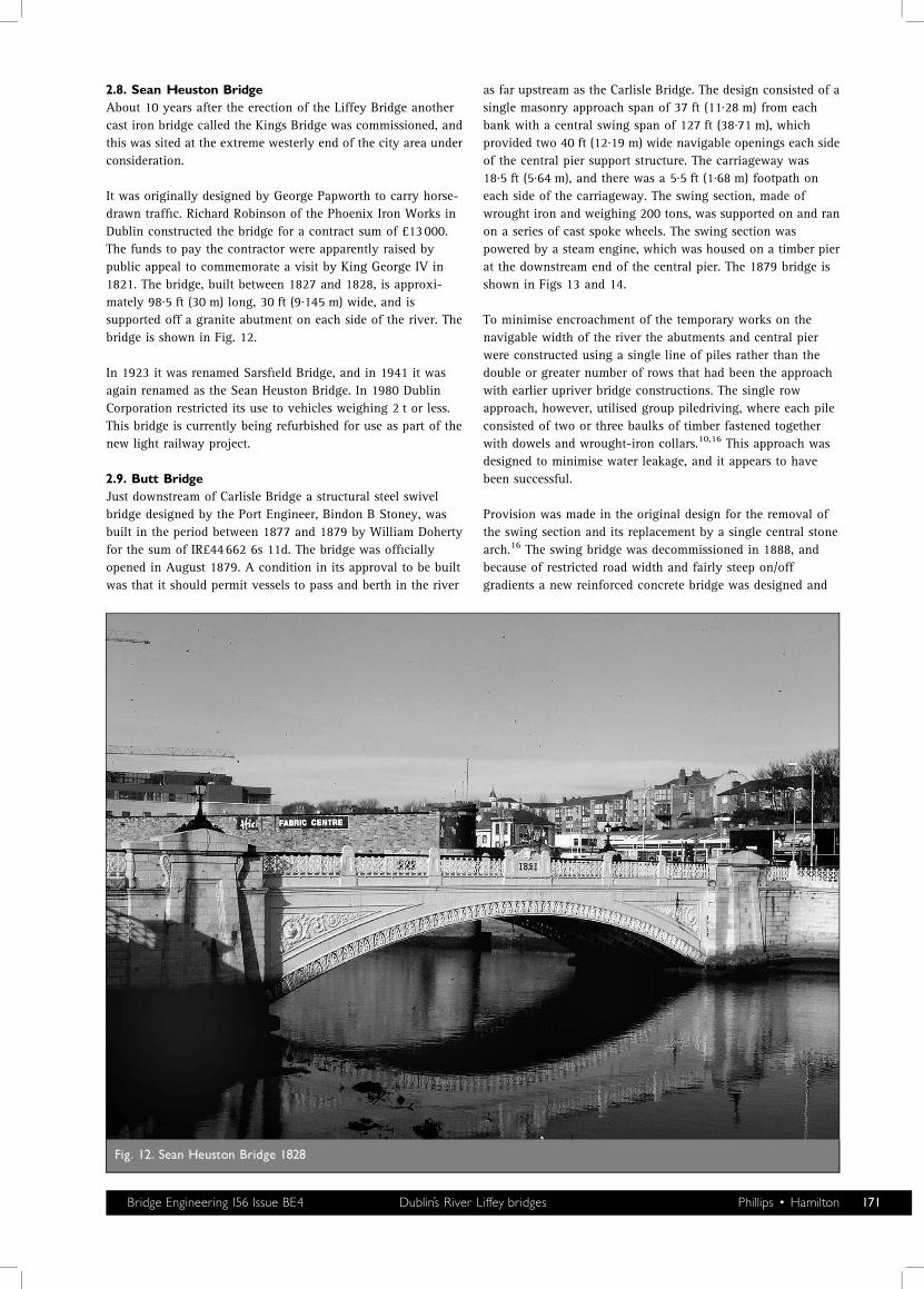
2.8. Sean Heuston BridgeAbout 10 years after the erection of the Liffey Bridge anothercast iron bridge called the Kings Bridge was commissioned, andthis was sited at the extreme westerly end of the city area underconsideration.
It was originally designed by George Papworth to carry horse-drawn traffic. Richard Robinson of the Phoenix Iron Works inDublin constructed the bridge for a contract sum of £13000.The funds to pay the contractor were apparently raised bypublic appeal to commemorate a visit by King George IV in1821. The bridge, built between 1827 and 1828, is approxi-mately 98·5 ft (30 m) long, 30 ft (9·145 m) wide, and issupported off a granite abutment on each side of the river. Thebridge is shown in Fig. 12.
In 1923 it was renamed Sarsfield Bridge, and in 1941 it wasagain renamed as the Sean Heuston Bridge. In 1980 DublinCorporation restricted its use to vehicles weighing 2 t or less.This bridge is currently being refurbished for use as part of thenew light railway project.
2.9. Butt BridgeJust downstream of Carlisle Bridge a structural steel swivelbridge designed by the Port Engineer, Bindon B Stoney, wasbuilt in the period between 1877 and 1879 by William Dohertyfor the sum of IR£44662 6s 11d. The bridge was officiallyopened in August 1879. A condition in its approval to be builtwas that it should permit vessels to pass and berth in the river
as far upstream as the Carlisle Bridge. The design consisted of asingle masonry approach span of 37 ft (11·28 m) from eachbank with a central swing span of 127 ft (38·71 m), whichprovided two 40 ft (12·19 m) wide navigable openings each sideof the central pier support structure. The carriageway was18·5 ft (5·64 m), and there was a 5·5 ft (1·68 m) footpath oneach side of the carriageway. The swing section, made ofwrought iron and weighing 200 tons, was supported on and ranon a series of cast spoke wheels. The swing section waspowered by a steam engine, which was housed on a timber pierat the downstream end of the central pier. The 1879 bridge isshown in Figs 13 and 14.
To minimise encroachment of the temporary works on thenavigable width of the river the abutments and central pierwere constructed using a single line of piles rather than thedouble or greater number of rows that had been the approachwith earlier upriver bridge constructions. The single rowapproach, however, utilised group piledriving, where each pileconsisted of two or three baulks of timber fastened togetherwith dowels and wrought-iron collars.10,16 This approach wasdesigned to minimise water leakage, and it appears to havebeen successful.
Provision was made in the original design for the removal ofthe swing section and its replacement by a single central stonearch.16 The swing bridge was decommissioned in 1888, andbecause of restricted road width and fairly steep on/offgradients a new reinforced concrete bridge was designed and
Fig. 12. Sean Heuston Bridge 1828
Bridge Engineering 156 Issue BE4 Dublin’s River Liffey bridges Phillips � Hamilton 171
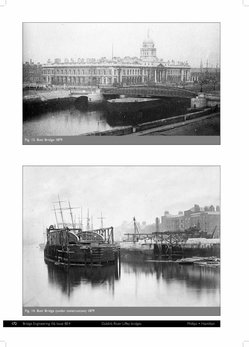
Fig. 13. Butt Bridge 1879
Fig. 14. Butt Bridge (under construction) 1879
172 Bridge Engineering 156 Issue BE4 Dublin’s River Liffey bridges Phillips � Hamilton
constructed between 1930 and 1932; it opened to traffic inJune 1932.
The new bridge, built in the same location as the original ButtBridge, has a central span of 112 ft (34·13 m) and a singleapproach 40 ft (12·2 m) span each side of the central span. Thecentral span was influenced by the span of the Liffey Viaductriver piers immediately downstream, as to repeat this spanwould provide a fixed channel for river traffic. The bridge is66 ft (20·12 m) wide across the spandrels on the central spanand carries a 40 ft (12·20 m) roadway and two 11·75 ft (3·58 m)footpaths.
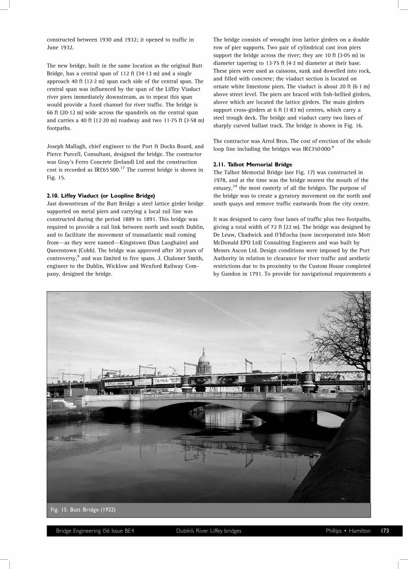
Joseph Mallagh, chief engineer to the Port & Docks Board, andPierce Purcell, Consultant, designed the bridge. The contractorwas Gray’s Ferro Concrete (Ireland) Ltd and the constructioncost is recorded as IR£65500.17 The current bridge is shown inFig. 15.
2.10. Liffey Viaduct (or Loopline Bridge)Just downstream of the Butt Bridge a steel lattice girder bridgesupported on metal piers and carrying a local rail line wasconstructed during the period 1889 to 1891. This bridge wasrequired to provide a rail link between north and south Dublin,and to facilitate the movement of transatlantic mail comingfrom—as they were named—Kingstown (Dun Laoghaire) andQueenstown (Cobh). The bridge was approved after 30 years ofcontroversy,9 and was limited to five spans. J. Chaloner Smith,engineer to the Dublin, Wicklow and Wexford Railway Com-pany, designed the bridge.
The bridge consists of wrought iron lattice girders on a doublerow of pier supports. Two pair of cylindrical cast iron pierssupport the bridge across the river; they are 10 ft (3·05 m) indiameter tapering to 13·75 ft (4·2 m) diameter at their base.These piers were used as caissons, sunk and dowelled into rock,and filled with concrete; the viaduct section is located onornate white limestone piers. The viaduct is about 20 ft (6·1 m)above street level. The piers are braced with fish-bellied girders,above which are located the lattice girders. The main girderssupport cross-girders at 6 ft (1·83 m) centres, which carry asteel trough deck. The bridge and viaduct carry two lines ofsharply curved ballast track. The bridge is shown in Fig. 16.
The contractor was Arrol Bros. The cost of erection of the wholeloop line including the bridges was IR£350000·9
2.11. Talbot Memorial BridgeThe Talbot Memorial Bridge (see Fig. 17) was constructed in1978, and at the time was the bridge nearest the mouth of theestuary,24 the most easterly of all the bridges. The purpose ofthe bridge was to create a gyratory movement on the north andsouth quays and remove traffic eastwards from the city centre.
It was designed to carry four lanes of traffic plus two footpaths,giving a total width of 72 ft (22 m). The bridge was designed byDe Leuw, Chadwick and O’hEocha (now incorporated into MottMcDonald EPO Ltd) Consulting Engineers and was built byMessrs Ascon Ltd. Design conditions were imposed by the PortAuthority in relation to clearance for river traffic and aestheticrestrictions due to its proximity to the Custom House completedby Gandon in 1791. To provide for navigational requirements a
Fig. 15. Butt Bridge (1932)
Bridge Engineering 156 Issue BE4 Dublin’s River Liffey bridges Phillips � Hamilton 173
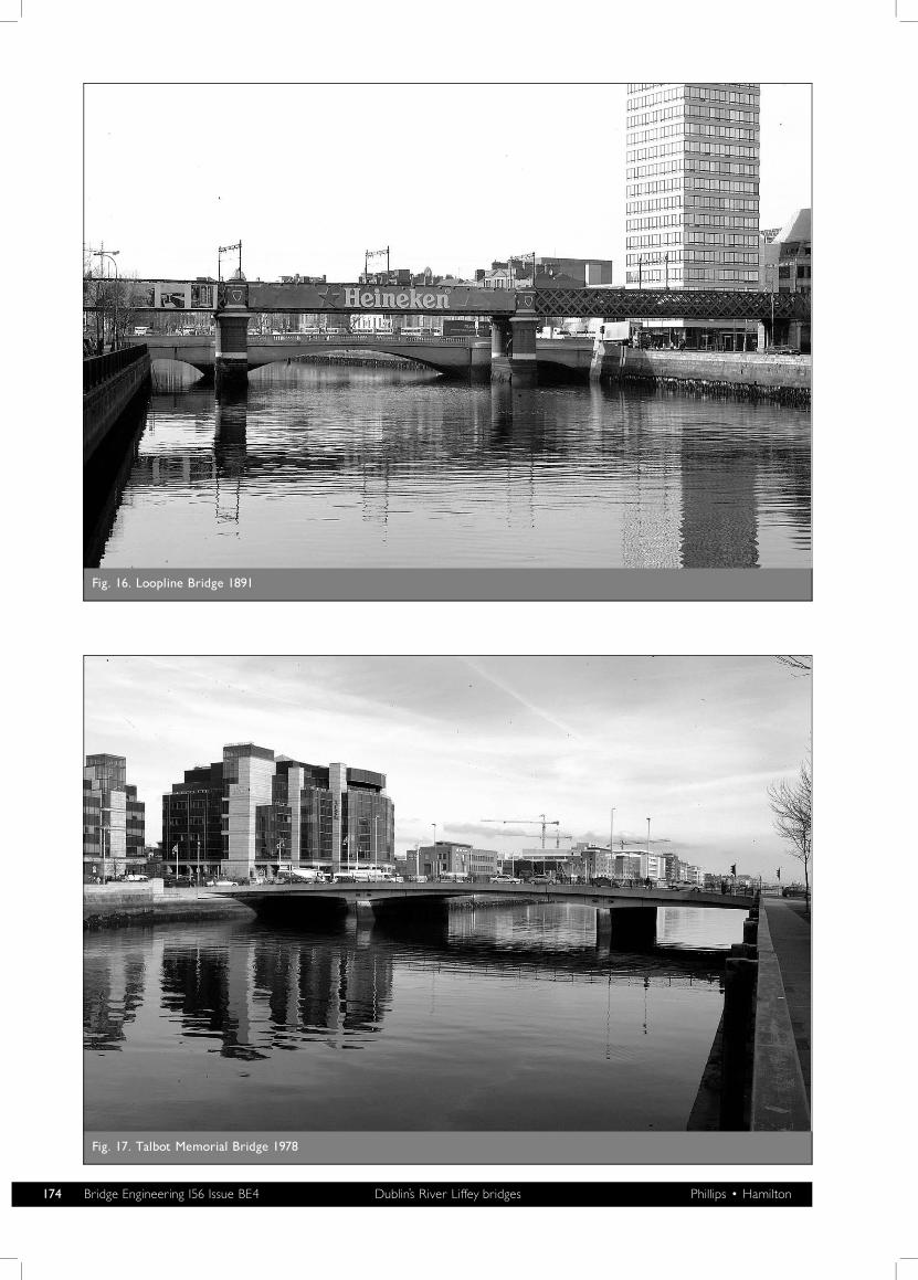
Fig. 16. Loopline Bridge 1891
Fig. 17. Talbot Memorial Bridge 1978
174 Bridge Engineering 156 Issue BE4 Dublin’s River Liffey bridges Phillips � Hamilton
single-span solution and a three-span solution were examined.A three-span solution was adopted for the 246 ft (75 m) wideriver with a centre span of 111·5 ft (34 m). It was constructedby founding the bridge piers on rock using interlocking steelsheet piling to form cofferdams and precast, prestressed beamswith an in situ deck for the superstructure. The contractprogramme was for 18 months and the actual construction timewas 20 months (construction period was April 1976 to February1978). The main delay was incurred as a result of difficulties insealing and drying out the cofferdams. The tender price in 1975was IR£725380 and the final cost was IR£1·05m. The con-ditions of contract used for bridges constructed in the latterpart of the twentieth century were the Institution of Engineersof Ireland standard conditions of contract (adopted from ICEconditions of contract). These included the standard pricevariation clause (PVC) and Clause 12 for unforeseen groundconditions. In the mid-1970s inflation was high, at 15%, andhad a sizeable impact on the final cost of projects.
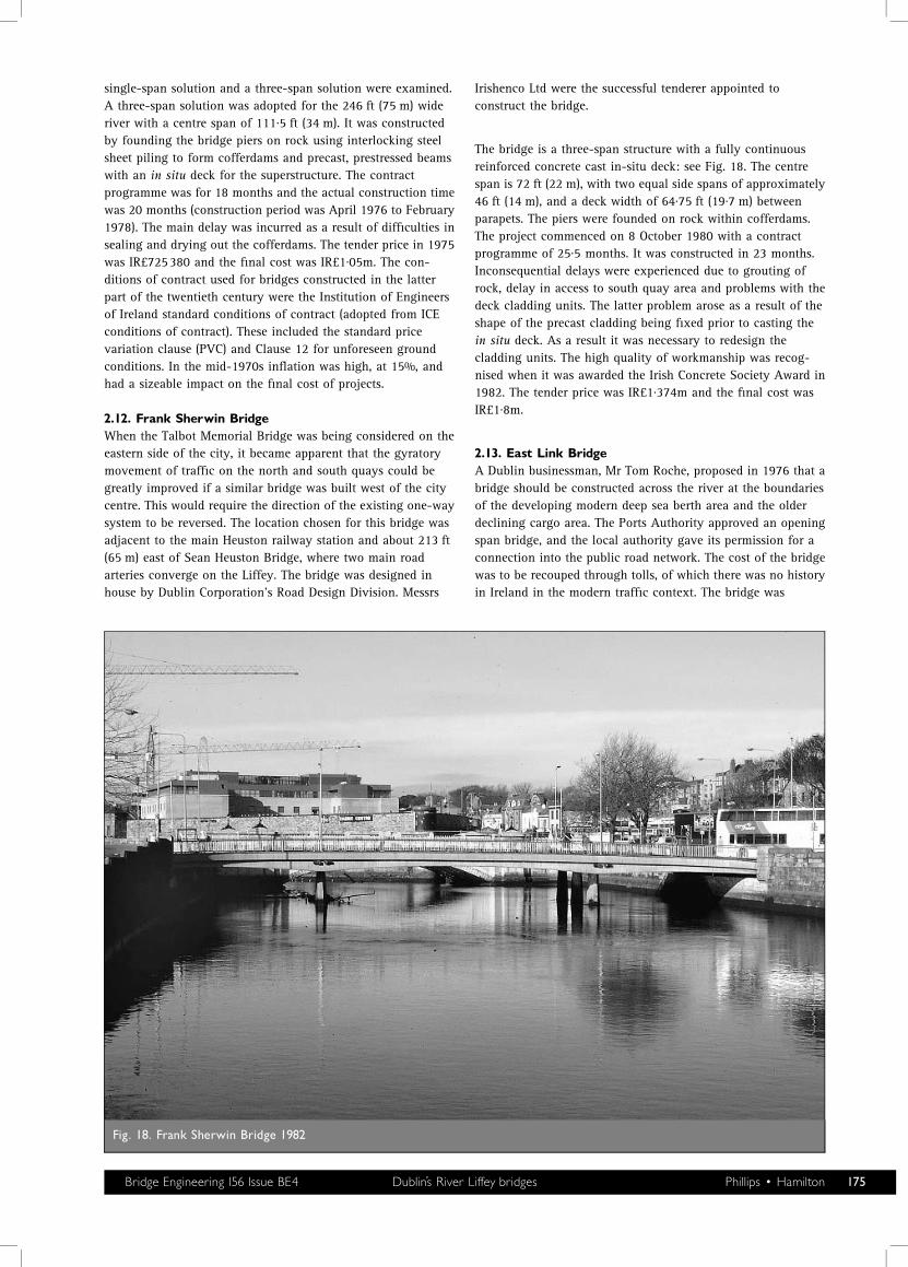
2.12. Frank Sherwin BridgeWhen the Talbot Memorial Bridge was being considered on theeastern side of the city, it became apparent that the gyratorymovement of traffic on the north and south quays could begreatly improved if a similar bridge was built west of the citycentre. This would require the direction of the existing one-waysystem to be reversed. The location chosen for this bridge wasadjacent to the main Heuston railway station and about 213 ft(65 m) east of Sean Heuston Bridge, where two main roadarteries converge on the Liffey. The bridge was designed inhouse by Dublin Corporation’s Road Design Division. Messrs
Irishenco Ltd were the successful tenderer appointed toconstruct the bridge.
The bridge is a three-span structure with a fully continuousreinforced concrete cast in-situ deck: see Fig. 18. The centrespan is 72 ft (22 m), with two equal side spans of approximately46 ft (14 m), and a deck width of 64·75 ft (19·7 m) betweenparapets. The piers were founded on rock within cofferdams.The project commenced on 8 October 1980 with a contractprogramme of 25·5 months. It was constructed in 23 months.Inconsequential delays were experienced due to grouting ofrock, delay in access to south quay area and problems with thedeck cladding units. The latter problem arose as a result of theshape of the precast cladding being fixed prior to casting thein situ deck. As a result it was necessary to redesign thecladding units. The high quality of workmanship was recog-nised when it was awarded the Irish Concrete Society Award in1982. The tender price was IR£1·374m and the final cost wasIR£1·8m.
2.13. East Link BridgeA Dublin businessman, Mr Tom Roche, proposed in 1976 that abridge should be constructed across the river at the boundariesof the developing modern deep sea berth area and the olderdeclining cargo area. The Ports Authority approved an openingspan bridge, and the local authority gave its permission for aconnection into the public road network. The cost of the bridgewas to be recouped through tolls, of which there was no historyin Ireland in the modern traffic context. The bridge was
Fig. 18. Frank Sherwin Bridge 1982
Bridge Engineering 156 Issue BE4 Dublin’s River Liffey bridges Phillips � Hamilton 175
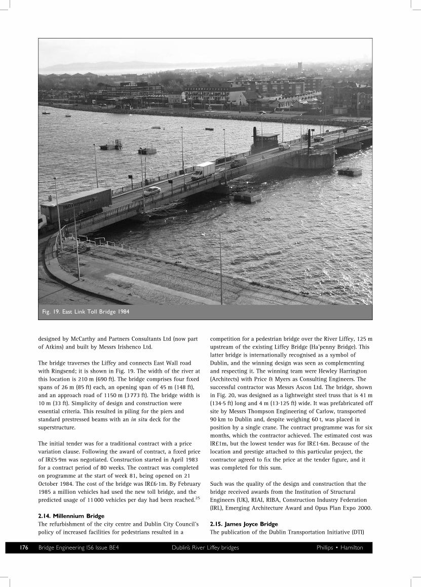
designed by McCarthy and Partners Consultants Ltd (now partof Atkins) and built by Messrs Irishenco Ltd.
The bridge traverses the Liffey and connects East Wall roadwith Ringsend; it is shown in Fig. 19. The width of the river atthis location is 210 m (690 ft). The bridge comprises four fixedspans of 26 m (85 ft) each, an opening span of 45 m (148 ft),and an approach road of 1150 m (3773 ft). The bridge width is10 m (33 ft). Simplicity of design and construction wereessential criteria. This resulted in piling for the piers andstandard prestressed beams with an in situ deck for thesuperstructure.
The initial tender was for a traditional contract with a pricevariation clause. Following the award of contract, a fixed priceof IR£5·9m was negotiated. Construction started in April 1983for a contract period of 80 weeks. The contract was completedon programme at the start of week 81, being opened on 21October 1984. The cost of the bridge was IR£6·1m. By February1985 a million vehicles had used the new toll bridge, and thepredicted usage of 11000 vehicles per day had been reached.25
2.14. Millennium BridgeThe refurbishment of the city centre and Dublin City Council’spolicy of increased facilities for pedestrians resulted in a
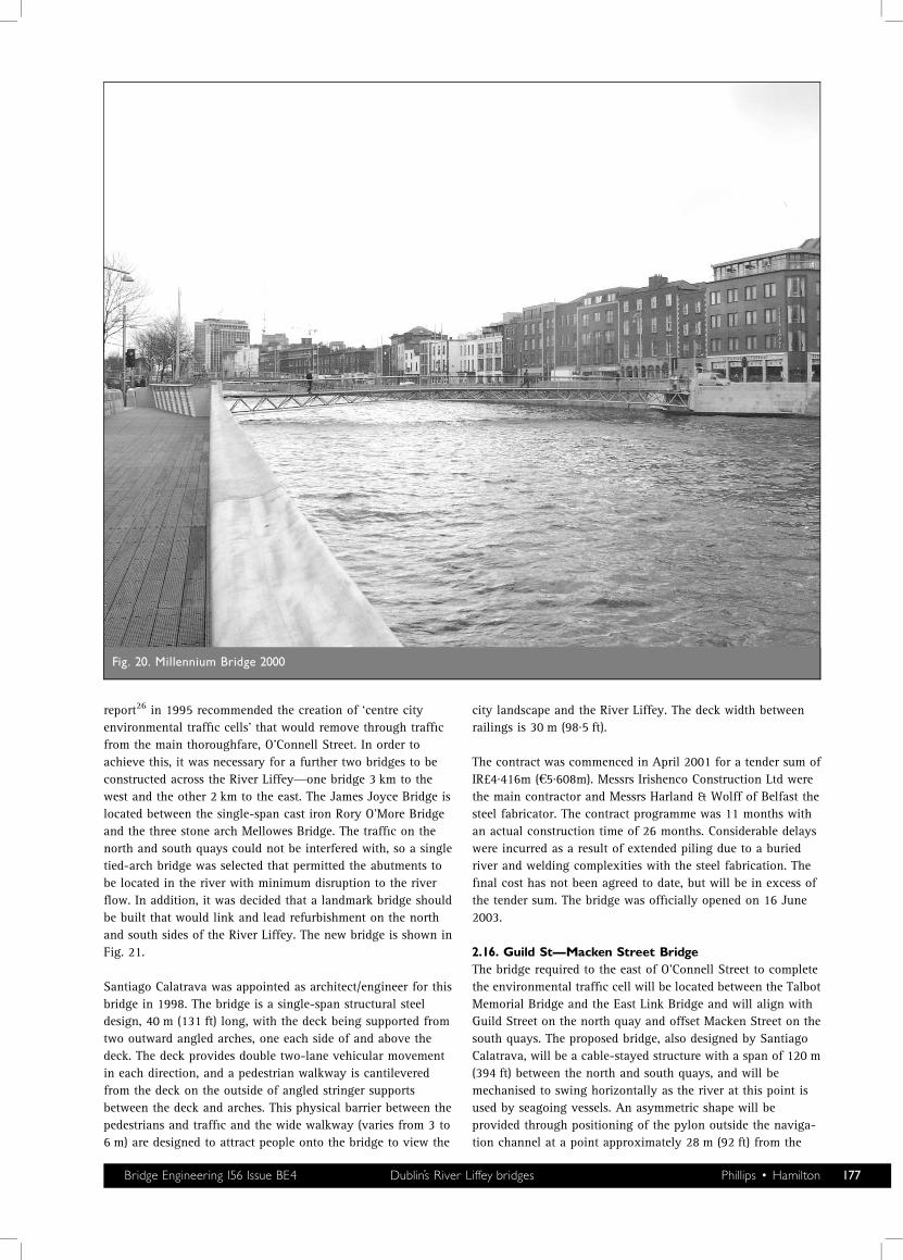
competition for a pedestrian bridge over the River Liffey, 125 mupstream of the existing Liffey Bridge (Ha’penny Bridge). Thislatter bridge is internationally recognised as a symbol ofDublin, and the winning design was seen as complementingand respecting it. The winning team were Hewley Harrington(Architects) with Price & Myers as Consulting Engineers. Thesuccessful contractor was Messrs Ascon Ltd. The bridge, shownin Fig. 20, was designed as a lightweight steel truss that is 41 m(134·5 ft) long and 4 m (13·125 ft) wide. It was prefabricated offsite by Messrs Thompson Engineering of Carlow, transported90 km to Dublin and, despite weighing 60 t, was placed inposition by a single crane. The contract programme was for sixmonths, which the contractor achieved. The estimated cost wasIR£1m, but the lowest tender was for IR£1·6m. Because of thelocation and prestige attached to this particular project, thecontractor agreed to fix the price at the tender figure, and itwas completed for this sum.
Such was the quality of the design and construction that thebridge received awards from the Institution of StructuralEngineers (UK), RIAI, RIBA, Construction Industry Federation(IRL), Emerging Architecture Award and Opus Plan Expo 2000.
2.15. James Joyce BridgeThe publication of the Dublin Transportation Initiative (DTI)
Fig. 19. East Link Toll Bridge 1984
176 Bridge Engineering 156 Issue BE4 Dublin’s River Liffey bridges Phillips � Hamilton
report26 in 1995 recommended the creation of ‘centre cityenvironmental traffic cells’ that would remove through trafficfrom the main thoroughfare, O’Connell Street. In order toachieve this, it was necessary for a further two bridges to beconstructed across the River Liffey—one bridge 3 km to thewest and the other 2 km to the east. The James Joyce Bridge islocated between the single-span cast iron Rory O’More Bridgeand the three stone arch Mellowes Bridge. The traffic on thenorth and south quays could not be interfered with, so a singletied-arch bridge was selected that permitted the abutments tobe located in the river with minimum disruption to the riverflow. In addition, it was decided that a landmark bridge shouldbe built that would link and lead refurbishment on the northand south sides of the River Liffey. The new bridge is shown inFig. 21.
Santiago Calatrava was appointed as architect/engineer for thisbridge in 1998. The bridge is a single-span structural steeldesign, 40 m (131 ft) long, with the deck being supported fromtwo outward angled arches, one each side of and above thedeck. The deck provides double two-lane vehicular movementin each direction, and a pedestrian walkway is cantileveredfrom the deck on the outside of angled stringer supportsbetween the deck and arches. This physical barrier between thepedestrians and traffic and the wide walkway (varies from 3 to6 m) are designed to attract people onto the bridge to view the
city landscape and the River Liffey. The deck width betweenrailings is 30 m (98·5 ft).
The contract was commenced in April 2001 for a tender sum ofIR£4·416m (S5·608m). Messrs Irishenco Construction Ltd werethe main contractor and Messrs Harland & Wolff of Belfast thesteel fabricator. The contract programme was 11 months withan actual construction time of 26 months. Considerable delayswere incurred as a result of extended piling due to a buriedriver and welding complexities with the steel fabrication. Thefinal cost has not been agreed to date, but will be in excess ofthe tender sum. The bridge was officially opened on 16 June2003.
2.16. Guild St�Macken Street BridgeThe bridge required to the east of O’Connell Street to completethe environmental traffic cell will be located between the TalbotMemorial Bridge and the East Link Bridge and will align withGuild Street on the north quay and offset Macken Street on thesouth quays. The proposed bridge, also designed by SantiagoCalatrava, will be a cable-stayed structure with a span of 120 m(394 ft) between the north and south quays, and will bemechanised to swing horizontally as the river at this point isused by seagoing vessels. An asymmetric shape will beprovided through positioning of the pylon outside the naviga-tion channel at a point approximately 28 m (92 ft) from the
Fig. 20. Millennium Bridge 2000
Bridge Engineering 156 Issue BE4 Dublin’s River Liffey bridges Phillips � Hamilton 177
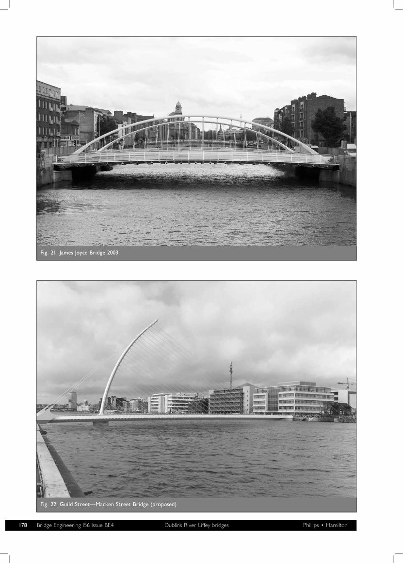
Fig. 21. James Joyce Bridge 2003
Fig. 22. Guild Street�Macken Street Bridge (proposed)
178 Bridge Engineering 156 Issue BE4 Dublin’s River Liffey bridges Phillips � Hamilton
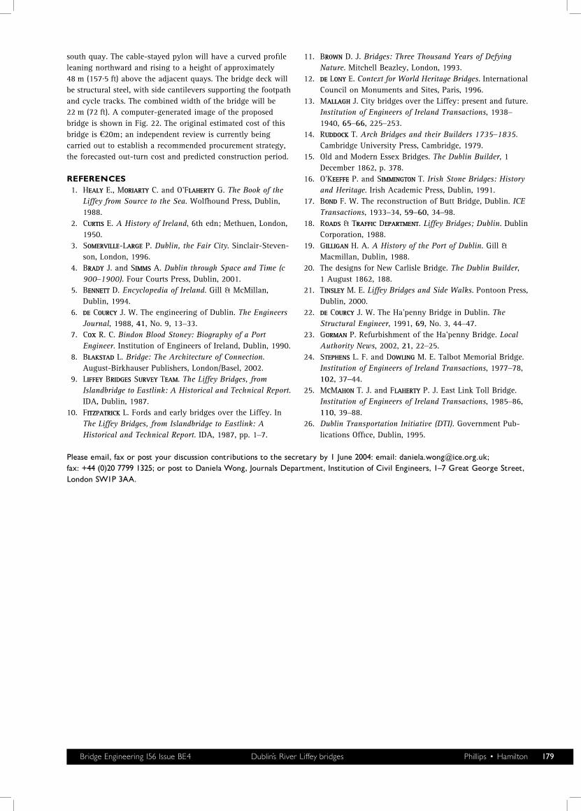
south quay. The cable-stayed pylon will have a curved profileleaning northward and rising to a height of approximately48 m (157·5 ft) above the adjacent quays. The bridge deck willbe structural steel, with side cantilevers supporting the footpathand cycle tracks. The combined width of the bridge will be22 m (72 ft). A computer-generated image of the proposedbridge is shown in Fig. 22. The original estimated cost of thisbridge is S20m; an independent review is currently beingcarried out to establish a recommended procurement strategy,the forecasted out-turn cost and predicted construction period.
REFERENCES1. HEALYEALY E., MORIARTYORIARTY C. and O’FLAHERTYLAHERTY G. The Book of the
Liffey from Source to the Sea. Wolfhound Press, Dublin,1988.
2. CURTISURTIS E. A History of Ireland, 6th edn; Methuen, London,1950.
3. SOMERVILLEOMERVILLE-LARGEARGE P. Dublin, the Fair City. Sinclair-Steven-son, London, 1996.
4. BRADYRADY J. and SIMMSIMMS A. Dublin through Space and Time (c900–1900). Four Courts Press, Dublin, 2001.
5. BENNETTENNETT D. Encyclopedia of Ireland. Gill & McMillan,Dublin, 1994.
6. DEDE COURCYOURCY J. W. The engineering of Dublin. The EngineersJournal, 1988, 41, No. 9, 13–33.
7. COXOX R. C. Bindon Blood Stoney: Biography of a PortEngineer. Institution of Engineers of Ireland, Dublin, 1990.
8. BLAKSTADLAKSTAD L. Bridge: The Architecture of Connection.August-Birkhauser Publishers, London/Basel, 2002.
9. LIFFEYIFFEY BRIDGESRIDGES SURVEYURVEY TEAMEAM. The Liffey Bridges, fromIslandbridge to Eastlink: A Historical and Technical Report.IDA, Dublin, 1987.
10. FITZPATRICKITZPATRICK L. Fords and early bridges over the Liffey. InThe Liffey Bridges, from Islandbridge to Eastlink: AHistorical and Technical Report. IDA, 1987, pp. 1–7.
11. BROWNROWN D. J. Bridges: Three Thousand Years of DefyingNature. Mitchell Beazley, London, 1993.
12. DEDE LONYONY E. Context for World Heritage Bridges. InternationalCouncil on Monuments and Sites, Paris, 1996.
13. MALLAGHALLAGH J. City bridges over the Liffey: present and future.Institution of Engineers of Ireland Transactions, 1938–1940, 65–66, 225–253.
14. RUDDOCKUDDOCK T. Arch Bridges and their Builders 1735–1835.Cambridge University Press, Cambridge, 1979.
15. Old and Modern Essex Bridges. The Dublin Builder, 1December 1862, p. 378.
16. O’KEEFFEEEFFE P. and SIMMINGTONIMMINGTON T. Irish Stone Bridges: Historyand Heritage. Irish Academic Press, Dublin, 1991.
17. BONDOND F. W. The reconstruction of Butt Bridge, Dublin. ICETransactions, 1933–34, 59–60, 34–98.
18. ROADSOADS & TRAFFICRAFFIC DEPARTMENTEPARTMENT. Liffey Bridges; Dublin. DublinCorporation, 1988.
19. GILLIGANILLIGAN H. A. A History of the Port of Dublin. Gill &Macmillan, Dublin, 1988.
20. The designs for New Carlisle Bridge. The Dublin Builder,1 August 1862, 188.
21. TINSLEYINSLEY M. E. Liffey Bridges and Side Walks. Pontoon Press,Dublin, 2000.
22. DEDE COURCYOURCY J. W. The Ha’penny Bridge in Dublin. TheStructural Engineer, 1991, 69, No. 3, 44–47.
23. GORMANORMAN P. Refurbishment of the Ha’penny Bridge. LocalAuthority News, 2002, 21, 22–25.
24. STEPHENSTEPHENS L. F. and DOWLINGOWLING M. E. Talbot Memorial Bridge.Institution of Engineers of Ireland Transactions, 1977–78,102, 37–44.
25. MCCMAHONAHON T. J. and FLAHERTYLAHERTY P. J. East Link Toll Bridge.Institution of Engineers of Ireland Transactions, 1985–86,110, 39–88.
26. Dublin Transportation Initiative (DTI). Government Pub-lications Office, Dublin, 1995.
Please email, fax or post your discussion contributions to the secretary by 1 June 2004: email: [email protected];fax: +44 (0)20 7799 1325; or post to Daniela Wong, Journals Department, Institution of Civil Engineers, 1^7 Great George Street,London SW1P 3AA.
Bridge Engineering 156 Issue BE4 Dublin’s River Liffey bridges Phillips � Hamilton 179