
Student Housing in Tower Hamlets Manmohan Dayal L.B.Tower Hamlets 30 th June 2008.

Preparation of Detailed Project Report for Up-gradation of Ausa – Waranga & Wardha – Butibori Section of NH361 in the state the state of Maharastra.
FINAL FEASIBILITY REPORTFINAL FEASIBILITY REPORTProject DescriptionProject Description
PROJECT DESCRIPTIONINTRODUCTION
National Highways Authority of India (NHAI) is engaged in the development of National
Highways. As a part of this endeavor, NHAI has decided to upgrade and strengthen the
existing two lane State Highway MSH-3 between sections Ausa – Waranga Phata and
Wardha – Butibori into four lane configuration. In this regard, NHAI retained the services
of M/s. Aarvee Associates Architects Engineers & Consultants Pvt. Ltd. for preparation of
the Detailed Project Report for upgradation and strengthening of the existing two lane
State Highway MSH-3 between sections Ausa – Waranga Phata and Wardha – Butibori
into four lane configuration. The different stretches of the project road that are proposed
for the above said development are:
PROJECT STRETCH
S. No Section Chainage NH No State
1Ausa – Waranga
Phata
Overlap section of MSH2 from Km 503.000 to Km 534.000 and From Km 548.000 to Km 554.000 of MSH6/NH222 and 8.75 km of Nanded Bypass
361 (Old MSH3)
Maharashtra
2 Wardha – Butibori Km 85.374 to 28.800
LOCATION OF THE PROJECT AREA
MSH-3 originates from Ratnagiri and passes through several districts of Maharashtra like
Kolhapur, Sangli, Solapur, Tuljapur, Ausa, Nanded, Hingoli, Yeotmal, Wardha and
terminates at Nagpur, having overlaps with several NH and other State Highways.
The National Highway No. 361 starts at Tuljapur and passes important towns Ausa,
Latur, Chakur, Sirur Tajband, Ahmedpur, Loha, Nanded, Hadgaon, Umerkhaed, Mahagaon,
Arni, Yavatmal, Kalamb, Deoli, Wardha and ends at Butibori on NH-44.
The section-I of the the project highway starts at Ausa (Km 470.000 on MSH3) run across
3 - 1

Preparation of Detailed Project Report for Up-gradation of Ausa – Waranga & Wardha – Butibori Section of NH361 in the state the state of Maharastra.
FINAL FEASIBILITY REPORTFINAL FEASIBILITY REPORTProject DescriptionProject Description
the districts of Latur, Nanded and Hingoli and ends at Waranga Phata (Km 611.200 on
MSH3).
The Section – II Starts at Butibori (Km 28.800 on MSH3) in Nagpur district and ends at
Wardha (Km 80.000 ) in Wardha District. The entire project stretch passes through 5
districts
S. No
Section Chainage LengthGeo Co.ordinates
From To
1Ausa –
WarangaKm.470.000 to Km.611.200
186 18°14'4.16"N 76°30'29.48"E
19°25'55.13"N 77°24'57.64"E
2Wardha – Butibori
Km 85.374 to 28.800
6020°41'23.00"N 78°32'24.35"E
20°54'38.67"N 78°59'21.21"E
WARDHA – BUTIBORI
The Section starts at Km 28.800 at Butibori which is a major junction with NH-44 and
ends at Km 85.374 near Salod village. The total length of the section is about 56.574 Km.
The section passes through MIDC, Seldoh, Kelzar, Selu, Pavanar and Wardha. The existing
pavement is entirely of flexible type. The project road is characterised by two lane
carriage way with a varying width from 6.7m to 7.1m and earthen shoulder width varies
from 1.5m to 2.5m and approximately 2.1 Km of the project road is having 4 lane of 7m
each carriageway width with 1.2m earthen shoulders. The project corridor passes through
plain terrain and the predominant land observed is agriculture followed by barren/waste
land and Built up sections. Part of the adjacent land along the project stretch from Km.
47.500 to Km. 48.900 is observed to be forest land on Wardha – Butibori section. About
5.4 hectares (App.) of forest land is required to be diverted (Acquired) for improving the
alignment in Wardha – Butibori section. The project crossing the Dham river at Pavnar
and Selu and also it crosses many streams, and canals. Approximately 15.6 Km length of
the project road is comes under the jurisdiction of Nagpur and remaining length of the
section comes under the jurisdiction of Wardha district. Most of the land use pattern falls
under agricultural, built-up, barren and forest area. The height of the embankment varies
between 0.5m to 2m. There are 3 major junctions along the project stretch. The Index
map of project stretch is shown in Fig – 1.
3 - 2

Preparation of Detailed Project Report for Up-gradation of Ausa – Waranga & Wardha – Butibori Section of NH361 in the state the state of Maharastra.
FINAL FEASIBILITY REPORTFINAL FEASIBILITY REPORTProject DescriptionProject Description
FIG:1 INDEX MAP OF THE WARDHA - BUTIBORI
3 - 3
Start point of Wardha - Butibori End point of Wardha - Butibori

Preparation of Detailed Project Report for Up-gradation of Ausa – Waranga & Wardha – Butibori Section of NH361 in the state the state of Maharastra.
FINAL FEASIBILITY REPORTFINAL FEASIBILITY REPORTProject DescriptionProject Description
CLIMATE
The climate of the region is characterized as tropical. The climate, wind and wave pattern
are governed by the annually changing monsoons and transition periods between them
dividing the year into four seasons as given below
Seasons of the region
Season Months Characteristics
Summer March–MayHottest part of the year, occurrence of dust
storms
South-West monsoon June–SeptCharacterised by predominantly SW winds.
Generally strong and persistent winds prevail.
North-East monsoon Oct-NovCharacterised by predominantly NE winds. Fair
weather with the variable winds.
Winter Dec-Feb Cool season of the year
Cyclonic storms/depressions do occur Maharashtra state mainly due to disturbances
occurred in Bay of Bengal and partly due to disturbances occurred in Arabian Sea.
However, the impact from these is minimal.
The mean temperature of the area is 15°C minimum & 41°Cmaximum.
The relative humidity of the area varies between 22% to 81%
The wind speed normally ranges between 6.7Kmph to 19kmph and the wind
direction is predominant in NE, W & NW directions.
Maximum annual rainfall is received during the south-west monsoon season. July
& August are being the peak rainy months. The average annual rainfall is 751.5
mm and 1087.7 mm in the south-east and north-east regions respectively.
In order to analyze the past meteorological and climatological data from India
Meteorological Department (IMD), Yavatmal station was collected.
Comparison of Mean Monthly Meteorological Parameters for IMD, Yavatmal
3 - 4

Preparation of Detailed Project Report for Up-gradation of Ausa – Waranga & Wardha – Butibori Section of NH361 in the state the state of Maharastra.
FINAL FEASIBILITY REPORTFINAL FEASIBILITY REPORTProject DescriptionProject Description
Station (1931– 1960)
Month
Temperature
( 0C)
Relative
Humidity
(%)
Wind
Speed
(Km/hr)
Wind Direction
(Degrees) Rainfall
(mm)
Max Min Max Min Mean PredominantCalm
(%)
January 28.7 15.4 50 31 8.2 NE, E 7.5 9.2
February 32.2 17.8 39 24 9.0 NE, E 5.0 6
March 36.4 21.6 33 20 9.8 NE, SW 4..5 17.7April 39.9 25.3 32 19 11.4 NW, SW 3.5 15.8
May 41.8 27.8 37 20 15.6 NW, SW 1.5 21.0
June 36.7 25.1 67 48 19.0 NW, SW 1.5 174.2
July 30.7 23.0 84 71 17.6 W, NW 1.0 293.5
August 29.3 22.3 85 75 16.0 NW, SW 1.5 293.8
September 30.6 21.9 81 68 11.0 NW, SW 4.5 178.2
October 31.7 20.4 63 48 6.7 NE, N 9.5 48.9
November 29.7 17.2 51 40 6.8 NE, E 11.5 18.3December 28.0 15.0 50 37 7.1 NE, E 12.0 11.1
TERRAIN
Terrain is classified by the general slope of the country across the highway alignment. The
general topography of the area along the project corridor is a combination of plain and
rolling terrain.
Type of Terrain
Ausa – Waranga Phata Wardha-Butibori
Percentage Percentage
Plain 84 89
Rolling 15 11
Hilly 1 -
LAND USE ALONG THE PROJECT ROAD
The project stretch passes through important settlements like Ausa, Latur, Ahmadpur,
Loha, Nanded, Ardhapur, Pavnar, Seloo, Kelzar, and Seldoh. The majority of adjoining land
is agricultural area and built up sections. The important crop grown along the project
3 - 5

Preparation of Detailed Project Report for Up-gradation of Ausa – Waranga & Wardha – Butibori Section of NH361 in the state the state of Maharastra.
FINAL FEASIBILITY REPORTFINAL FEASIBILITY REPORTProject DescriptionProject Description
stretch are mostly cotton, Sugar cane, Soya bean in the Ausa to Waranga corridor and
Cotton in the Wardha to Butibori corridor. The type of land use pattern that exists along
the project stretch is presented in Table
Land Use Pattern
Type of Land Use
Wardha-Butibori
Percentage of Road length
LHS RHS
Agricultural 37 41
Built-Up 19 24
Barren 28 26
Forest 16 9
VILLAGES AND TOWNS
Wardha - Butibori: This Section passes through Pavnar, Seloo, Kelzar, and Butibori
Further there are more number of villages and hamlets with less density along the project
stretch and the list of villages and their locations in each section are given below
List of Villages
Wardha-Butibori
1 Dattapur
2 Pavnar
3 Khanapur
4 Seloo
5 Mahabala
6 Kelzar
7 Aamgar
Wardha-Butibori
8 Khadiki
9 Saildho
10 Wadgoan
11 Savanga
12 Asola
13 Butibori
3 - 6

Preparation of Detailed Project Report for Up-gradation of Ausa – Waranga & Wardha – Butibori Section of NH361 in the state the state of Maharastra.
FINAL FEASIBILITY REPORTFINAL FEASIBILITY REPORTProject DescriptionProject Description
INTERSECTIONS
The project highway crosses National Highway, State Highways, Major District roads and
village roads etc. The section wise details of intersections are given below:
Sl. No Location (Km.) Type of Juntion
Type of Road Leads to
Wardha-Butibori
1 72.750 + Arvi Wardha city
2 60.000 T Ghorad -
3 46.000 T - Sindi
4 28.800 T Nagpur Hyderabad
The complete analysis of the turning movement surveys with the impact of each junctions
is duly presented in the traffic report. It can be inferred that the traffic pattern at most of
the major junctions changes significantly, delays at these junctions are longer than usual
and hence need to be improved geometrically and should be developed in a way to
accommodate all types of movements in an organised manner.
EXISTING ALIGNMENT OF PROJECT ROAD
The project stretch has number of horizontal and vertical curves as the existing ground
profile is uneven in nature. The geometric alignment of the prevailing project stretch may
have been designed as per State Highway standards and may not meet the present NH
standards. The design is deficient in terms of sight distance, curve radii and super
elevation at many of the locations. Further, there are various curves near to the village
limits which might require improvement
EXISTING ROW
The Right of Way pillars were observed at few locations along the project stretch. The
Right of Way details shall be ascertained from the revenue records to clarify on the exact
land availability for construction. Based on the field verification the existing ROW is 25m-
45m for the entire project road except in built-up area.
CROSS DRAINAGE STRUCTURES
As a part of upgrading of the project, it is required to make an assessment of existing
structures with regard to their adequacies to ensure that they meet the objectives of the
3 - 7

Preparation of Detailed Project Report for Up-gradation of Ausa – Waranga & Wardha – Butibori Section of NH361 in the state the state of Maharastra.
FINAL FEASIBILITY REPORTFINAL FEASIBILITY REPORTProject DescriptionProject Description
project. The existing structures in the project corridor comprise as follows:
Major bridges
Minor bridges
Slab Culverts
Hume Pipe Culverts
StructurePipe
Culverts
Box & Slab
culverts
Minor Bridges
Major Bridges
Wardha – Butibori 62 18 13 2
CONDITION SURVEY OF EXISTING STRUCTURES
The aim of carrying out the condition survey is to ascertain the condition of the existing
bridges and their ability to ensure the safe and smooth movement of the traffic especially
on the structural portion with or without widening. As a component of the condition
survey, visual observations were made keeping in view the requirements of IRC: SP-35
and IRC: SP-40. Visual observations carried out during the condition survey were mainly
made to find out the shortcomings / distresses in the structures listed above. In addition
to the superstructures, RCC / masonry substructures were inspected to locate cracks and
loose mortar in joints, especially for piers and abutments. Condition survey of the
existing bridges has been carried out by the Consultants’ senior rehabilitation expert by
visual inspection of various visible parts of the structures to observe the snags and to find
out whether any sign of structural distress is exhibited in any of the bridges.The most
commonly observed snag in RCC bridges/ structures are as follows:
Cracking, cracks of different types
Scaling
Spalling of concrete
Leaching
Rust stain
Delamination
3 - 8

Preparation of Detailed Project Report for Up-gradation of Ausa – Waranga & Wardha – Butibori Section of NH361 in the state the state of Maharastra.
FINAL FEASIBILITY REPORTFINAL FEASIBILITY REPORTProject DescriptionProject Description
Based on the inspection it is concluded that the most of the existing bridges are in good
condition. With regular maintenance these bridges will perform well for a long time to
come. However, due to any eventuality because of lack of maintenance or otherwise,
affected portions of the structure can be repaired, strengthened or maintained. Some of
the bridges needs to widened or repaired or rehabilitated due to structural or other
consideration. The detailed description of every structure with its condition and
recommendation is incorporated in the Bridge Inventoty and condition survey report.
There are 1 ROB, 1 RUB and 1 VUP in Wardha-Butibori Section. Also, for each pipe
culvert an inventory cum condition survey sheet has been filled up after visual
observation and measurement with tapes. The locations of the cross drainage structure
as noted in the inventory sheet depended on the actual existant kilometer stones.Most of
the existing pipe culverts are in good to fair condition and must be widened in order to
meet the the project requirement. Most of the Slab culverts are RCC slab type with RCC/
PCC abutment and wing walls. The detailed condition of Pipe and Slab culverts are
described in Bridge inventory and Condition survey report.
EXISTING BYPASSES
There are existing bypasses in project stretch which are summarized below.
S.no Section
Chainage Length
in KmName of Village
Lane
Configuration From To
1 Wardha - Butibori 80.0 68.8 11.2 Wardha2 lane
Carriageway
ALTERNATIVE ALINGMENTS/BYPASSES
Project road passes through some congested locations and built-up areas which may
require further study of alternative alignment/Bypasses. Tentatively identified villages
from where project passes are Pavanar, Seloo, Kelzar in Wardha-Butibori sections.
3 - 9

Preparation of Detailed Project Report for Up-gradation of Ausa – Waranga & Wardha – Butibori Section of NH361 in the state the state of Maharastra.
FINAL FEASIBILITY REPORTFINAL FEASIBILITY REPORTProject DescriptionProject Description
PROPOSED BYPASSES ON WARDHA – BUTIBORI SECTTION
KELZAR: Kelzar is famous for its historical place, Sidhi Vinayaka Temple and the Bor
National Tiger Reserve & Bird sanctuary. The highway from Km.49.000 to Km.53.200
passes through the Kelzar Village. There is traffic congestion in city due to densely built-up
areas, local movement to traffic along/across the Highway. It is difficult to acquire enough
land, to accommodate four lane highway. The geometrics of the existing alignment is poor
and improvement to existing alignment leads to demolition of structures Considering the
above two alternates are proposed for Kelzar village. In case geometric corrections and
widening is done through the Kelzar village , around 138 Pakka, 31 Semipakka and 49
Others are to be dismantled for land acquisition.
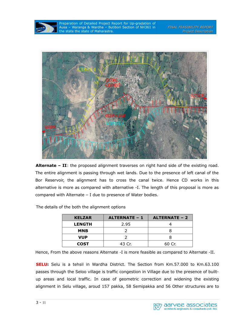
Alternate – I: The Proposed alignment passing on left side of existing alignment, traverses
through cultivated lands and barren lands. The length of bypass will be around 2.95 km.
The village is extending towards right side of the existing alignment. The length of the
propsed alignment is less than the existing alignment.
3 - 10
Preparation of Detailed Project Report for Up-gradation of Ausa – Waranga & Wardha – Butibori Section of NH361 in the state the state of Maharastra.
FINAL FEASIBILITY REPORTFINAL FEASIBILITY REPORTProject DescriptionProject Description
Alternate – II: the proposed alignment traverses on right hand side of the existing road.
The entire alignment is passing through wet lands. Due to the presence of left canal of the
Bor Reservoir, the alignment has to cross the canal twice. Hence CD works in this
alternative is more as compared with alternative -I. The length of this proposal is more as
compared with Alternate – I due to presence of Water bodies.
The details of the both the alignment options
KELZAR ALTERNATE – 1 ALTERNATE – 2
LENGTH 2.95 4
MNB 2 8
VUP 2 8
COST 43 Cr. 60 Cr.
Hence, From the above reasons Alternate -I is more feasible as compared to Alternate -II.
SELU: Selu is a tehsil in Wardha District. The Section from Km.57.000 to Km.63.100
passes through the Seloo village is traffic congestion in Village due to the presence of built-
up areas and local traffic. In case of geometric correction and widening the existing
alignment in Selu village, aroud 157 pakka, 58 Semipakka and 56 Other structures are to
3 - 11

Preparation of Detailed Project Report for Up-gradation of Ausa – Waranga & Wardha – Butibori Section of NH361 in the state the state of Maharastra.
FINAL FEASIBILITY REPORTFINAL FEASIBILITY REPORTProject DescriptionProject Description
be dismantled for acquisition of 60m RoW. The village is extending on right hand side of the
existing road.
Proposed Bypass: Two alternative bypass are proposed on left hand side of the existing
alignment. Two alternatives are almost equivalent in length to the existing alignment. As it
is observed from the field investigations and from the google images the bypass on right
hand side is not feasible due to extended built-up of the village and a number of water
bodies resulting in increase in the length of he bypass. Hence, alternate to the bypass on
right hand side is not consider for the comparison and studying the feasibility.
3 - 12

Preparation of Detailed Project Report for Up-gradation of Ausa – Waranga & Wardha – Butibori Section of NH361 in the state the state of Maharastra.
FINAL FEASIBILITY REPORTFINAL FEASIBILITY REPORTProject DescriptionProject Description
The details of Proposed alignment are given below.
SELOO Alternate - I Alternate - II
LENGTH 3.7 4.170
MNB 2 4
MJB 1 1
VUP 2 2
COST 50 Cr. 60 Cr.
Hence, From the above reasons Alternate -I is more feasible as compare with Alternate -II.
3 - 13

Preparation of Detailed Project Report for Up-gradation of Ausa – Waranga & Wardha – Butibori Section of NH361 in the state the state of Maharastra.
FINAL FEASIBILITY REPORTFINAL FEASIBILITY REPORTProject DescriptionProject Description
SALOD: Salod is village in outskirts of the wardha city with a huge settlements and
dense builtip areas. Salod village is bounded by Shampur Sawangi and Selsura with
meagre built up areas. In order to avoid the junction between wardha bypass and city
road which is poor in geometrics and creating accident prone area.
Besides this around 312 pakka, 145 semi pakka and around 92 kiosks are to be
dismantled for land acquisition and geometric correction. In addition to this there is a
State Highway – 243 is joining with NH361 near Shampur Village which adds traffic to
NH361 making the built up areas congested with traffic. Keeping the point in view a
bypass is proposed for salod in previous package of Yavatmal – Wardha. Considering the
above constraints and proposals, the proposed salod bypass is extended upto wardha
bypass.
3 - 14

Preparation of Detailed Project Report for Up-gradation of Ausa – Waranga & Wardha – Butibori Section of NH361 in the state the state of Maharastra.
FINAL FEASIBILITY REPORTFINAL FEASIBILITY REPORTProject DescriptionProject Description
The proposed alignment will take off at Km 85.340 and lands at Km 79.200 on Wardha
bypass and measures around 7.3 km
REALIGNMENTS
Realignment is proposed due to the presence of a sub standard curves and insufficient
geometric standards, and inorder to avoid demolition of private and religious structures.
Realignments are proposed at locations listed below.
Design Chainage Length (m) Remarks
From To
Wardha-Butibori
1 476.200 476.500 300 Geometric Correction
2 477.700 481.700 4000 Geometric Correction
3 483.000 483.500 500 Realignment due to Mosque
4 505.600 506.600 1000 Realignment due to Temple
3 - 15
Proposed bypass
Existing Alignment


