Productivity - kmcgeo.com · measurement, stakeout, quality control and progress monitoring on the...
12
TRIMBLE SITE POSITIONING SYSTEMS Trimble Productivity: Mobilize your Construction Workforce
Transcript of Productivity - kmcgeo.com · measurement, stakeout, quality control and progress monitoring on the...

TriMBLE SiTE PoSiTioNiNG SySTEMS
Trimble Productivity: Mobilize your Construction Workforce
NORTH AMERICATrimble 5475 Kellenburger RoadDayton, Ohio 45424 U.S.A. 800-538-7800 (Toll Free)+1-937-245-5154 Phone+1-937-233-9441 Faxwww.trimble.com
EUROPETrimble GmbH Am Prime Parc 1165479 RaunheimGERMANY+49-6142-2100-0 Phone+49-6142-2100-550 Fax
LATIN AMERICATrimble Navigation Limited6505 Blue Lagoon DriveSuite 120Miami, FL 33126U.S.A. +1-305-263-9033 Phone +1-305-263-8975 Fax
AFRICA & MIDDLE EASTTrimble Export Middle-East P.O. Box 17760Jebel Ali Free ZoneDubai, U.A.E. +971-4-881-3005 Phone+971-4-881-3007 Fax
ASIA-PACIFICTrimble Singapore80 Marine Parade Road 22-06, Parkway ParadeSingapore 449269+65-6-325-5668 Phone+65-6-348-2232 Fax
CHINATrimble BeijingRoom 2602-05Tengda PlazaNo. 168 Xiwai StreetHaidian District, BeijingCHINA 100044+86-10-8857-7575 Phone+86-10-8857-7161 Faxwww.trimble.com.cn
© 2005-2007, Trimble Navigation Limited. All rights reserved. Trimble and the Globe & Triangle logo are trademarks of Trimble Navigation Limited, registered in the
United States Patent and Trademark Office and in other countries. John Deere is a trademark of Deere & Company. Microsoft Windows, Microsoft Outlook, Microsoft
Word, and Microsoft Excel are registered trademarks of Microsoft Corporation in the United States and/or other countries. All other trademarks are the property of
their respective owners. Reorder PN 022482-989 07/07
YOUR LOCAL TRIMBLE OFFICE OR REPRESENTATIVE
Productivity is...
Planningsoftware that optimizes transportation routes to minimize project time and costs.
Designdata preparation and management for the construction jobsite life cycle.
Gradecontrol that is faster, more accurate and minimizes rework.
Checkmeasurement, stakeout, quality control and progress monitoring on the job site.
Constructwith precise positioning for faster completion with less re-work.
Only one company can optimize your productivity with the broadest, deepest and most advanced set of tools for integrating measurement, data management, machine operations and asset management throughout the construction life cycle. Productivity is... Trimble.
Go to www.trimble-productivity.com to learn how contractors are using these Trimble Systems for significant time and money savings.
ProductivityTrimble

The new Trimble® Site Positioning Systems give the contractor in site preparation,
heavy highway, mining, landfill, and waste disposal the ability to quickly
resolve problems onsite... and the flexibility to complete any task with the
right equipment. From initial site measurement to final as-built checks, when you
need site positioning equipment that is productive, easy to use, and gets the job
done right every time, Trimble Site Positioning Systems are your best choice.
THE MODERN TRIMBLE CONSTRUCTION SITE
SiTE CoNTroL oPEraTioNS
Calibrate the jobsite for GPS operations. Record
existing and new control points in convenient
locations for total station operation or daily GPS
check shots.
GENEraL SiTE MEaSurEMENTS
Position and record the location of features
onsite, such as power lines, utilities, manholes,
pipe inverts and existing structures.
GradE CHECkiNG
Check both the finished grade and laid material
thickness to get an instant report showing
areas for rework. Monitor overall accuracy and
consistency of grading operations.
The Connected Construction SiteAn interesting thing happens when you connect your office, people and machines. Productivity jumps. Rework disappears. Cash flow improves. Profits soar. Only one company has the technology and experience to connect your site. The leader ... Trimble.

Central to the Trimble Site Positioning System is the powerful Trimble construction software for field and office.
Developed specifically for the needs of heavy and highway contractors, the Trimble SCS900
Site Controller Software simplifies site operations, increases efficiency in the field, and
minimizes downtime at every stage of the project. Combined with Trimble Construction
office software options, you have the broadest, deepest and most advanced set of tools for
integrating measurement, data management, workflow and site operations management
throughout the construction life cycle. Trimble Site Positioning Systems offer you the choice of
GPS or total station-based positioning.
THE MODERN TRIMBLE CONSTRUCTION SITE
ProGrESS VoLuMES
Measure surfaces and use those for computation
of surface to surface volumes e.g. original or
current ground compared to finished design.
Quickly and accurately assess material stockpiles.
STakEouT
Stake out site features such as embankments,
grading limits, utilities, pads, structures, hydrants
and manholes. Navigate using the real time map,
select the stakeout feature from the live map and
display cut / fill data to get to grade.
aS-BuiLT SiTE MEaSurEMENT
Carry out as-built site measurements for client
submission and approval at the end of the project.
Produce high-quality reports and impress the client
with thorough QA/QC processes.

TRIMBLE CONSTRUCTION SOFTwARE SOLUTIONS
Before the first machine can start earthmoving
operations, there is considerable planning
and design work to be done. Digital data
seamlessly connects the design engineer,
data manager, supervisor, machine operator,
and grade checker into an integrated
workflow. The same digital information
created for the site design and project
planning can be used for machine control
to ensure accurate grading - and for site
positioning during and after project
completion.
Trimble offers a suite of office software
products that provide a wide range of
capabilities facilitating job functions from
planning and bidding to complete project
productivity analysis. The data flow between
suite components is enhanced by the fact that
all the components of the solution come from
a single source and single manufacturer.
CrEaTE aCCuraTE iNForMaTioN For THE Bid STaGE
Rapid takeoff tools provide accurate models
for the generation of quantity data for
materials and earthworks operations on the
project. Give your company the competitive
edge, win more bids and increase your profits.
At bid stage you can:
• Take off material and earthwork
quantities quickly and accurately
• Bid more projects, contract those that are most
profitable and improve your bottom line
• Provide value engineering to the client
through better process, improved
material usage and balanced earthworks
PrEParE diGiTaL ModELS For SiTE aNd HiGHway ProjECTS
• Import data provided by the engineer
and validate it
• Prepare accurate surface models for
grade control and CAD data for stakeout
operations
• Evaluate areas of cut and fill, determine
mass haul information for the project to
determine equipment requirements and
schedules
• Evaluate the models in 3D for mistakes prior
to starting work. Good data preparation
can help identify and resolve site problems
before breaking ground - saving time,
money and potential conflicts.
MaNaGE GradE CoNTroL oPEraTioNS
• Transfer site models to the on-machine
grade control systems over the site
wireless network or via data cards
prepared in the office
• Create site maps to provide graphical
information required by the operator
• Track data in use by each machine on
the project. Send updated designs out
quickly in response to design changes
• Monitor compaction operations
• Run diagnostic checks on machines
to resolve problems and recommend
remedial actions where required

SuPErViSE, rEPorT aNd aNaLyzE ProGrESS
• Conduct grade and material
thickness checks and generate
high quality reports
• Monitor progress volumes for the
site to keep the project on schedule
• Track all site measurement and
stakeout activities
• Make on the spot informed decisions
based on factual data
TriMBLE iNTELLiGENT daTa TraCkiNG
Trimble field and office software solutions
are designed to work together. Data
changes made in the office or by a field
crew are automatically recognized and
used to populate the project database
and are routed to all other crews that
need the data.
Trimble Intelligent Data Tracking means
that everyone has the latest and most up
to date information at all times, reducing
the possibility of making mistakes caused
by having out of date models.
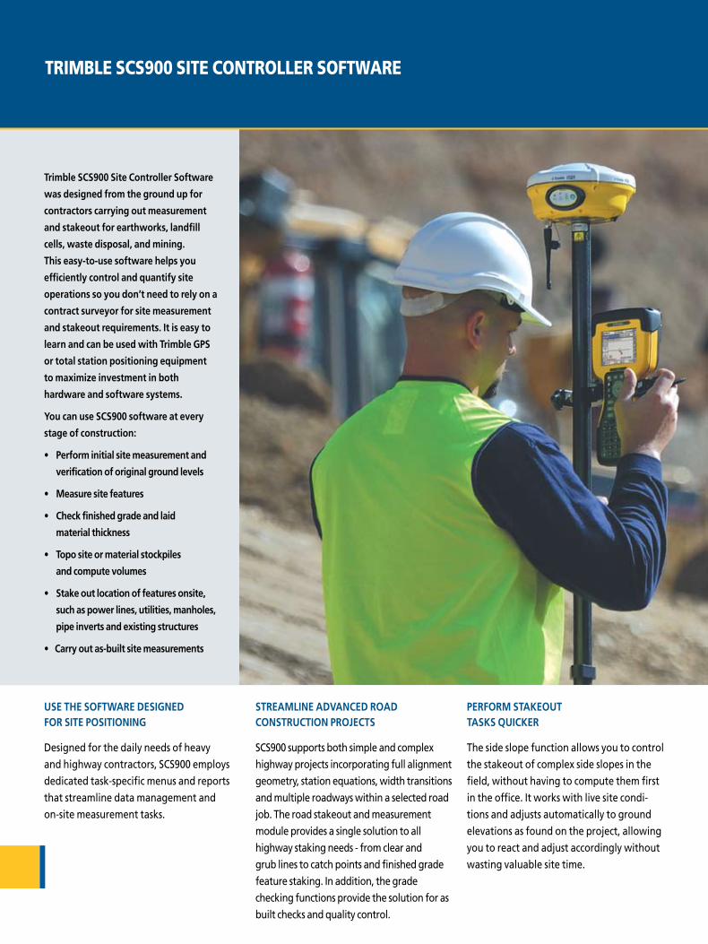
uSE THE SoFTwarE dESiGNEd For SiTE PoSiTioNiNG
Designed for the daily needs of heavy
and highway contractors, SCS900 employs
dedicated task-specific menus and reports
that streamline data management and
on-site measurement tasks.
STrEaMLiNE adVaNCEd road CoNSTruCTioN ProjECTS
SCS900 supports both simple and complex
highway projects incorporating full alignment
geometry, station equations, width transitions
and multiple roadways within a selected road
job. The road stakeout and measurement
module provides a single solution to all
highway staking needs - from clear and
grub lines to catch points and finished grade
feature staking. In addition, the grade
checking functions provide the solution for as
built checks and quality control.
PErForM STakEouT TaSkS QuiCkEr
The side slope function allows you to control
the stakeout of complex side slopes in the
field, without having to compute them first
in the office. It works with live site condi-
tions and adjusts automatically to ground
elevations as found on the project, allowing
you to react and adjust accordingly without
wasting valuable site time.
TRIMBLE SCS900 SITE CONTROLLER SOFTwARE
Trimble SCS900 Site Controller Software
was designed from the ground up for
contractors carrying out measurement
and stakeout for earthworks, landfill
cells, waste disposal, and mining.
This easy-to-use software helps you
efficiently control and quantify site
operations so you don’t need to rely on a
contract surveyor for site measurement
and stakeout requirements. it is easy to
learn and can be used with Trimble GPS
or total station positioning equipment
to maximize investment in both
hardware and software systems.
you can use SCS900 software at every
stage of construction:
• Perform initial site measurement and
verification of original ground levels
• Measure site features
• Check finished grade and laid
material thickness
• Topo site or material stockpiles
and compute volumes
• Stake out location of features onsite,
such as power lines, utilities, manholes,
pipe inverts and existing structures
• Carry out as-built site measurements

CLoSE THE GaP BETwEEN SiTE aNd oFFiCE oPEraTioNS
The SCS Data Manager allows you to
automatically transfer and manage
data between the office and field. You
can organize, manage and track all site
measurement and stakeout operations for
multiple crews on multiple jobsites. Plus,
preview work in from the field or review
work order and design information before
delivery to a field crew.
SuPErViSE oPEraTioNS FroM THE FiELd
The Trimble SCS900 Tablet Edition combines
the easy-to-use data management system of
Trimble SCS900 software with the graphics
capabilities and processing power of a
tablet PC. In doing so, it extends the use
of the software to construction jobsite
supervisors, foremen and project managers
who coordinate job activities from a vehicle
addiTioNaL FEaTurES oF SCS900 iNCLudE:
• Real-time cut and fill maps
• Digital plans in the field – eliminate rolls
of paper plans
• GPS position on the plan – immediately
locate yourself on the map to interrogate
the digital information from the plans
• Query the data in the model, elevations,
cuts / fills, distances, areas, current
volumes and more

TRIMBLE SITE POSITIONING SYSTEM TOTAL STATIONS.
THE ULTIMATE IN PRECISION AND PRODUCTIVITY.
iNNoVaTioN FroM THE LEadEr - dESiGNEd For your CoNSTruCTioN SiTE oPEraTioNS
Trimble total stations build on over 50 years of
total station technology innovation to deliver
unmatched performance for construction jobsite
applications. From initial site measurements to
finished grading, Trimble total stations let you
take control of your site measurement, stakeout ,
and machine control requirements and eliminate
the daily need for contract surveyors.
ToTaL STaTioNS For SiTE PoSiTioNiNG aNd GradE CoNTroL oPEraTioNS
Now with Servo, Autolock, Robotic, DR
Reflectorless and ATS modes of operation,
the powerful Trimble SPS730 and SPS930
Universal Total Stations satisfy all site
measurement, stakeout, reflectorless
measurement, and grade control needs -
all from one highly accurate instrument.
idEaL For FiNE GradE CoNTroL
Trimble Universal Total Stations allow the
user to reliably track a machine target and
know the data is being passed from the
instrument to the machine as quickly and
accurately as possible. The motor grader or
dozer operator can conduct real-time fine
grading operations to millimeter accuracy while
minimizing rework and increasing profits.

Easy-to-learn and use SCS900 interface eliminates the complexities associated with traditional surveying systems. The system is designed for use by supervisors, foremen, grade checkers and site engineers.
FaCTorS
Accuracy/Precision needs
Safety and accessibility
Single or multi-user operation
Coverage area from a single setup location
Ease of use and operator skill
Operating conditions
Sensor calibration
ToTaL STaTioN
Accuracy – <3mm (.12 in)
With DR reflectorless capability, measure to dangerous and inaccessible surfaces from remote locations easily and safely.
One instrument supports a single rover asset.
Line of sight dependent, <700m robotic range for typical topo measurement and stakeout operations.
Ideal where line of sight to the sky is obscured or partially blocked by trees, buildings, structures, bridges or tunnels.
Mechanical design needs routine periodic calibration and checks to deliver specified accuracies.
GPS
Accuracy– <10mm (.39 in)H; 20mm (.78 in)V
Base station located safely away from heavy machinery zone. No line of sight base to rover restrictions.
A single GPS base station supports multiple GPS rovers or GPS grade control systems on the same jobsite.
>3 mile (5km) range from base station for typical topo measurement and stakeout operations. With repeater radios or via use of cell phone communications over longer ranges are possible.
Ideal for large, open site operation.
Needs no routine calibration to deliver specified accuracies.
adVaNTaGES oF ToTaL STaTioNS
The simple solution to all your site positioning
needs, Trimble total stations provide superior
tracking during measurement and stakeout
phases, for machine guidance, and final as-built
checks. Their single-person operation increases
cost savings and productivity.
applications
• Layout of structures, foundations, caissons and piles
• Tunnel measurement
• Earthworks, fine grading and finishing stakeout operations
• Reflectorless measurement of stockpiles, rock faces, cuttings and structures
• Initial site measurements to verify design levels
• As-built records and grade checks on laid material
Here are some key factors to consider when
deciding whether to use GPS or total station
for your application requirements:

TRIMBLE SITE POSITIONING SYSTEMS GPS SOLUTIONS.
SMARTER PRODUCTIVITY ON ANY SCALE.
BETTEr GPS uPTiME
Trimble GPS systems are guided by the
powerful Trimble RTK engine. Stronger signal
acquisition from more satellites – including
GLONASS and modernized GPS – means you can
run faster, longer, and without interruptions.
FuTurE rEady, Now
Trimble site positioning systems support all
currently available positioning constellations
including OmniSTAR, SBAS, GPS and and
GLONASS signals and will track the modernized
GPS L5 signal when it becomes available.
You won’t have to invest in new systems to
take advantage of the latest signal capabilities.
oPTioNS THaT Grow wiTH you
Trimble GPS systems are designed to meet
the specialized needs of the construction
industry. You can choose among a range of
options to suit your individual applications,
flexibility, and performance requirements.
iNTErNET-ENaBLEd BaSE STaTioNS
A built-in powerful web server component
enables increased operational efficiency
and flexibility. Using an Internet-enabled
base station allows for remote configuration
and monitoring of a base station, eliminating
the need for time-consuming and costly
visits to the base station to set up each day or
diagnose issues that may arise. Internet base
stations can provide corrections to multiple
jobsites in the same vicinity, or provide
corrections to cell phone enabled rovers in
areas of radio blackout.
iNNoVaTioN FroM THE LEadEr - dESiGNEd For your CoNSTruCTioN SiTE oPEraTioNS

adVaNTaGES oF SaTELLiTE PoSiTioNiNG
Using satellite positioning signals from the
currently available GPS and GLONASS satellites
and all available correction systems, the Trimble
Site Positioning System GPS receivers are well
suited to work anywhere that has a clear line of
sight to the sky. Real-Time Kinematic (RTK) GPS
delivers centimeter level (0.03 ft) accuracy—
even when you’re on the move— making it
well suited to on vehicle or machine opera-
tions. RTK GPS technology can provide accurate
positions at long distances from the base
station, so most construction sites are covered
from a single setup location.
SMarT GPS VErSuS ModuLar GPS
The Smart GPS Antenna concept gives you
everything you need in one single unit, while
the modular GPS Receiver features a separate
antenna and receiver. The Smart GPS Antenna
is your ideal configuration for rover systems
mounted on a rod or supervisor vehicle and
allows for fast daily setups as a base station.
The Modular GPS Receiver can be used as
either a base station or a rover and provides
the flexibility to be configured for your specific
jobsite needs. It also allows you to leave the
receiver and radio in the site trailer secured,
while only the antennas are on the roof of the
trailer exposed to the environment.
applications
• Permanent and semi-permanent base station installations
• Site supervisor vehicle-mounted systems
• Pole or ATV-mounted stakeout and measurement applications
• Vessel-mounted marine RTK systems
• Marine survey and construction vessel opera-tions on dredges, cranes and piling rigs.

NORTH AMERICATrimble 5475 Kellenburger RoadDayton, Ohio 45424 U.S.A. 800-538-7800 (Toll Free)+1-937-245-5154 Phone+1-937-233-9441 Faxwww.trimble.com
EUROPETrimble GmbH Am Prime Parc 1165479 RaunheimGERMANY+49-6142-2100-0 Phone+49-6142-2100-550 Fax
LATIN AMERICATrimble Navigation Limited6505 Blue Lagoon DriveSuite 120Miami, FL 33126U.S.A. +1-305-263-9033 Phone +1-305-263-8975 Fax
AFRICA & MIDDLE EASTTrimble Export Middle-East P.O. Box 17760Jebel Ali Free ZoneDubai, U.A.E. +971-4-881-3005 Phone+971-4-881-3007 Fax
ASIA-PACIFICTrimble Singapore80 Marine Parade Road 22-06, Parkway ParadeSingapore 449269+65-6-325-5668 Phone+65-6-348-2232 Fax
CHINATrimble BeijingRoom 2602-05Tengda PlazaNo. 168 Xiwai StreetHaidian District, BeijingCHINA 100044+86-10-8857-7575 Phone+86-10-8857-7161 Faxwww.trimble.com.cn
© 2005-2007, Trimble Navigation Limited. All rights reserved. Trimble and the Globe & Triangle logo are trademarks of Trimble Navigation Limited, registered in the
United States Patent and Trademark Office and in other countries. John Deere is a trademark of Deere & Company. Microsoft Windows, Microsoft Outlook, Microsoft
Word, and Microsoft Excel are registered trademarks of Microsoft Corporation in the United States and/or other countries. All other trademarks are the property of
their respective owners. Reorder PN 022482-989 07/07
YOUR LOCAL TRIMBLE OFFICE OR REPRESENTATIVE
Productivity is...
Planningsoftware that optimizes transportation routes to minimize project time and costs.
Designdata preparation and management for the construction jobsite life cycle.
Gradecontrol that is faster, more accurate and minimizes rework.
Checkmeasurement, stakeout, quality control and progress monitoring on the job site.
Constructwith precise positioning for faster completion with less re-work.
Only one company can optimize your productivity with the broadest, deepest and most advanced set of tools for integrating measurement, data management, machine operations and asset management throughout the construction life cycle. Productivity is... Trimble.
Go to www.trimble-productivity.com to learn how contractors are using these Trimble Systems for significant time and money savings.
ProductivityTrimble