PRE FEASIBILITY REPORT OF KATTALANKULAM...
32
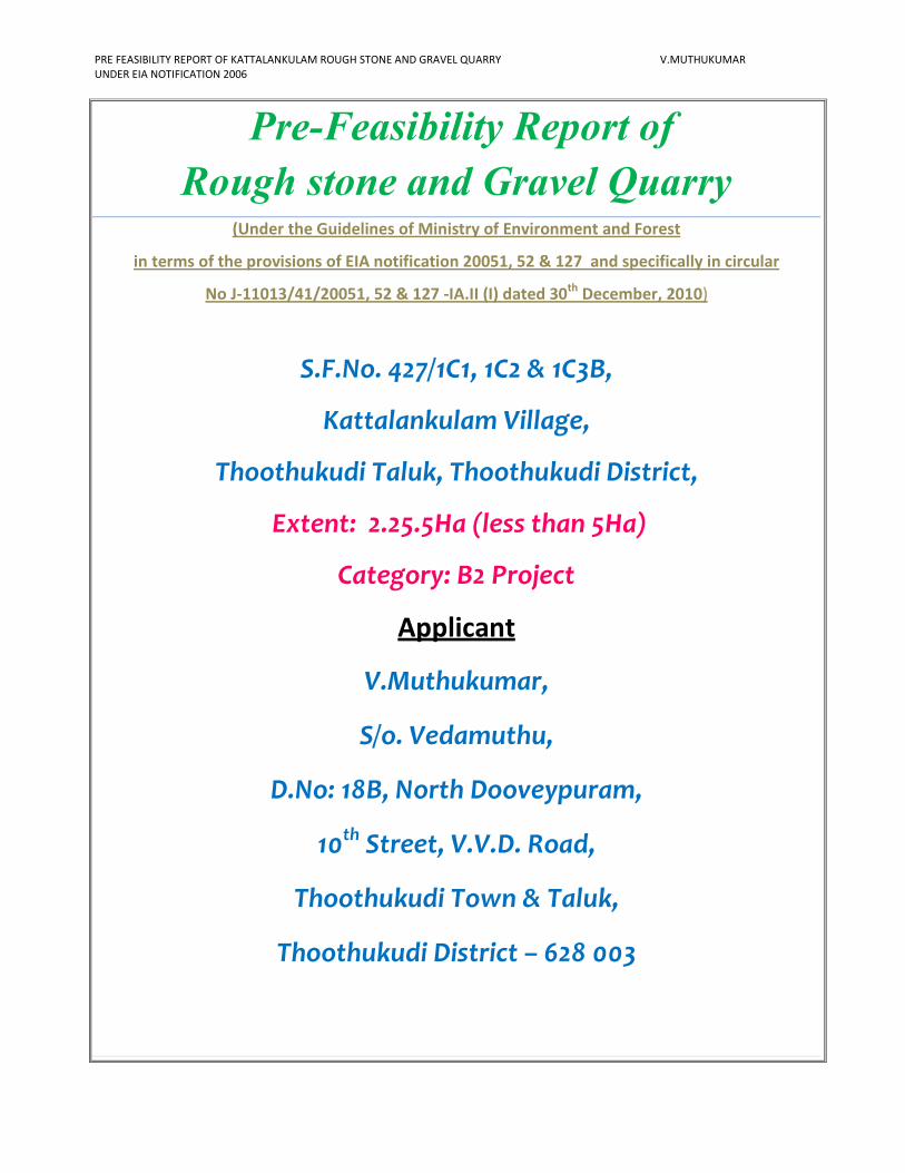
PRE FEASIBILITY REPORT OF KATTALANKULAM ROUGH STONE AND GRAVEL QUARRY V.MUTHUKUMAR UNDER EIA NOTIFICATION 2006 Pre-Feasibility Report of Rough stone and Gravel Quarry (Under the Guidelines of Ministry of Environment and Forest in terms of the provisions of EIA notification 20051, 52 & 127 and specifically in circular No J-11013/41/20051, 52 & 127 -IA.II (I) dated 30 th December, 2010) S.F.No. 427/1C1, 1C2 & 1C3B, Kattalankulam Village, Thoothukudi Taluk, Thoothukudi District, Extent: 2.25.5Ha (less than 5Ha) Category: B2 Project Applicant V.Muthukumar, S/o. Vedamuthu, D.No: 18B, North Dooveypuram, 10 th Street, V.V.D. Road, Thoothukudi Town & Taluk, Thoothukudi District – 628 003
Transcript of PRE FEASIBILITY REPORT OF KATTALANKULAM...
PRE FEASIBILITY REPORT OF KATTALANKULAM ROUGH STONE AND GRAVEL QUARRY V.MUTHUKUMAR
UNDER EIA NOTIFICATION 2006
Pre-Feasibility Report of
Rough stone and Gravel Quarry (Under the Guidelines of Ministry of Environment and Forest
in terms of the provisions of EIA notification 20051, 52 & 127 and specifically in circular
No J-11013/41/20051, 52 & 127 -IA.II (I) dated 30th
December, 2010)
S.F.No. 427/1C1, 1C2 & 1C3B,
Kattalankulam Village,
Thoothukudi Taluk, Thoothukudi District,
Extent: 2.25.5Ha (less than 5Ha)
Category: B2 Project
Applicant
V.Muthukumar,
S/o. Vedamuthu,
D.No: 18B, North Dooveypuram,
10th Street, V.V.D. Road,
Thoothukudi Town & Taluk,
Thoothukudi District – 628 003
PRE FEASIBILITY REPORT OF KATTALANKULAM ROUGH STONE AND GRAVEL QUARRY V.MUTHUKUMAR
UNDER EIA NOTIFICATION 2006
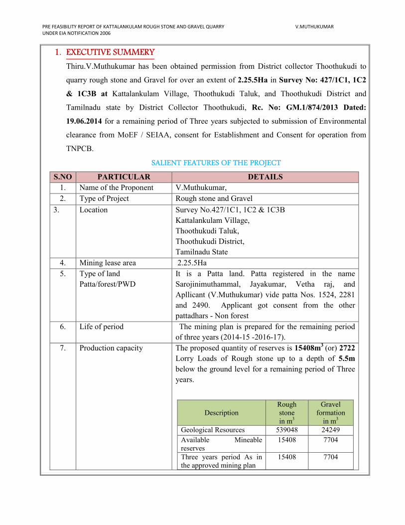
1. EXECUTIVE SUMMERY
Thiru.V.Muthukumar has been obtained permission from District collector Thoothukudi to
quarry rough stone and Gravel for over an extent of 2.25.5Ha in Survey No: 427/1C1, 1C2
& 1C3B at Kattalankulam Village, Thoothukudi Taluk, and Thoothukudi District and
Tamilnadu state by District Collector Thoothukudi, Rc. No: GM.1/874/2013 Dated:
19.06.2014 for a remaining period of Three years subjected to submission of Environmental
clearance from MoEF / SEIAA, consent for Establishment and Consent for operation from
TNPCB.
SALIENT FEATURES OF THE PROJECT
S.NO PARTICULAR DETAILS
1. Name of the Proponent V.Muthukumar,
2. Type of Project Rough stone and Gravel
3. Location Survey No.427/1C1, 1C2 & 1C3B
Kattalankulam Village,
Thoothukudi Taluk,
Thoothukudi District,
Tamilnadu State
4. Mining lease area 2.25.5Ha
5. Type of land
Patta/forest/PWD
It is a Patta land. Patta registered in the name
Sarojinimuthammal, Jayakumar, Vetha raj, and
Apllicant (V.Muthukumar) vide patta Nos. 1524, 2281
and 2490. Applicant got consent from the other
pattadhars - Non forest
6. Life of period The mining plan is prepared for the remaining period
of three years (2014-15 -2016-17).
7. Production capacity The proposed quantity of reserves is 15408m3
(or) 2722
Lorry Loads of Rough stone up to a depth of 5.5m
below the ground level for a remaining period of Three
years.
Description
Rough
stone
in m3
Gravel
formation
in m3
Geological Resources 539048 24249
Available Mineable
reserves
15408 7704
Three years period As in
the approved mining plan
15408 7704
PRE FEASIBILITY REPORT OF KATTALANKULAM ROUGH STONE AND GRAVEL QUARRY V.MUTHUKUMAR
UNDER EIA NOTIFICATION 2006
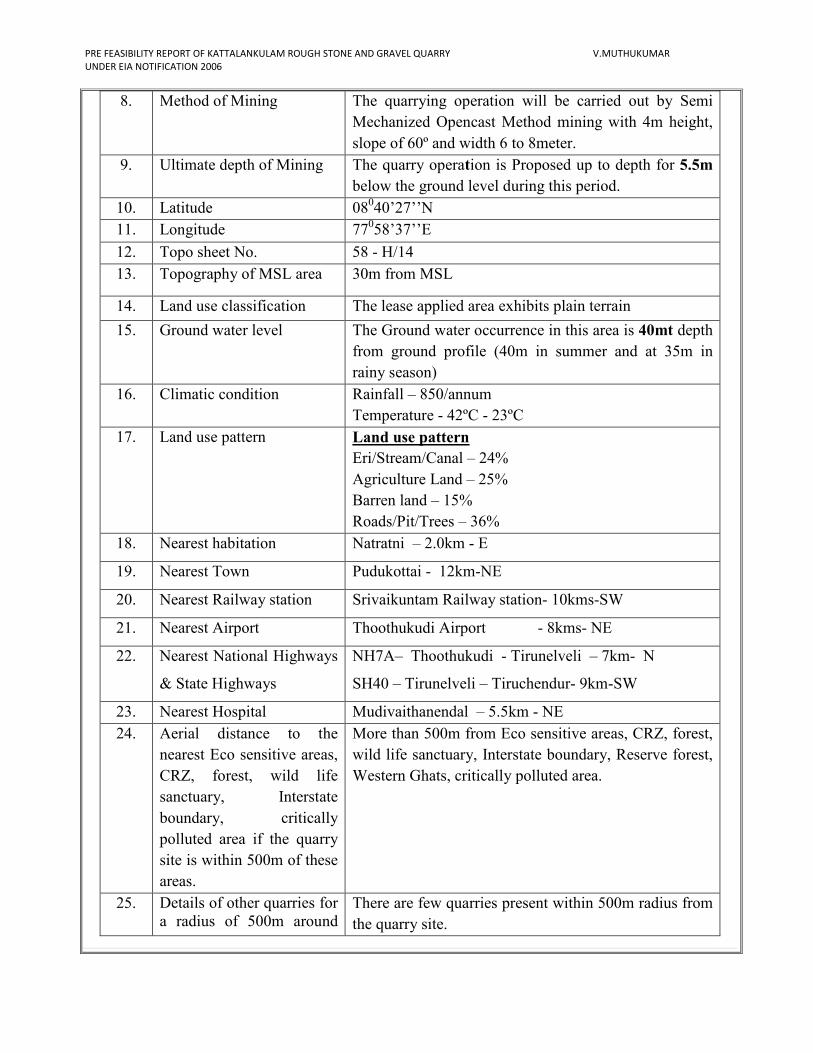
8. Method of Mining The quarrying operation will be carried out by Semi
Mechanized Opencast Method mining with 4m height,
slope of 60º and width 6 to 8meter.
9. Ultimate depth of Mining The quarry operation is Proposed up to depth for 5.5m
below the ground level during this period.
10. Latitude 08040’27’’N
11. Longitude 77058’37’’E
12. Topo sheet No. 58 - H/14
13. Topography of MSL area 30m from MSL
14. Land use classification The lease applied area exhibits plain terrain
15. Ground water level The Ground water occurrence in this area is 40mt depth
from ground profile (40m in summer and at 35m in
rainy season)
16. Climatic condition Rainfall – 850/annum
Temperature - 42ºC - 23ºC
17. Land use pattern Land use pattern
Eri/Stream/Canal – 24%
Agriculture Land – 25%
Barren land – 15%
Roads/Pit/Trees – 36%
18. Nearest habitation Natratni – 2.0km - E
19. Nearest Town Pudukottai - 12km-NE
20. Nearest Railway station Srivaikuntam Railway station- 10kms-SW
21. Nearest Airport Thoothukudi Airport - 8kms- NE
22. Nearest National Highways
& State Highways
NH7A– Thoothukudi - Tirunelveli – 7km- N
SH40 – Tirunelveli – Tiruchendur- 9km-SW
23. Nearest Hospital Mudivaithanendal – 5.5km - NE
24. Aerial distance to the
nearest Eco sensitive areas,
CRZ, forest, wild life
sanctuary, Interstate
boundary, critically
polluted area if the quarry
site is within 500m of these
areas.
More than 500m from Eco sensitive areas, CRZ, forest,
wild life sanctuary, Interstate boundary, Reserve forest,
Western Ghats, critically polluted area.
25. Details of other quarries for
a radius of 500m around
There are few quarries present within 500m radius from
the quarry site.
PRE FEASIBILITY REPORT OF KATTALANKULAM ROUGH STONE AND GRAVEL QUARRY V.MUTHUKUMAR
UNDER EIA NOTIFICATION 2006
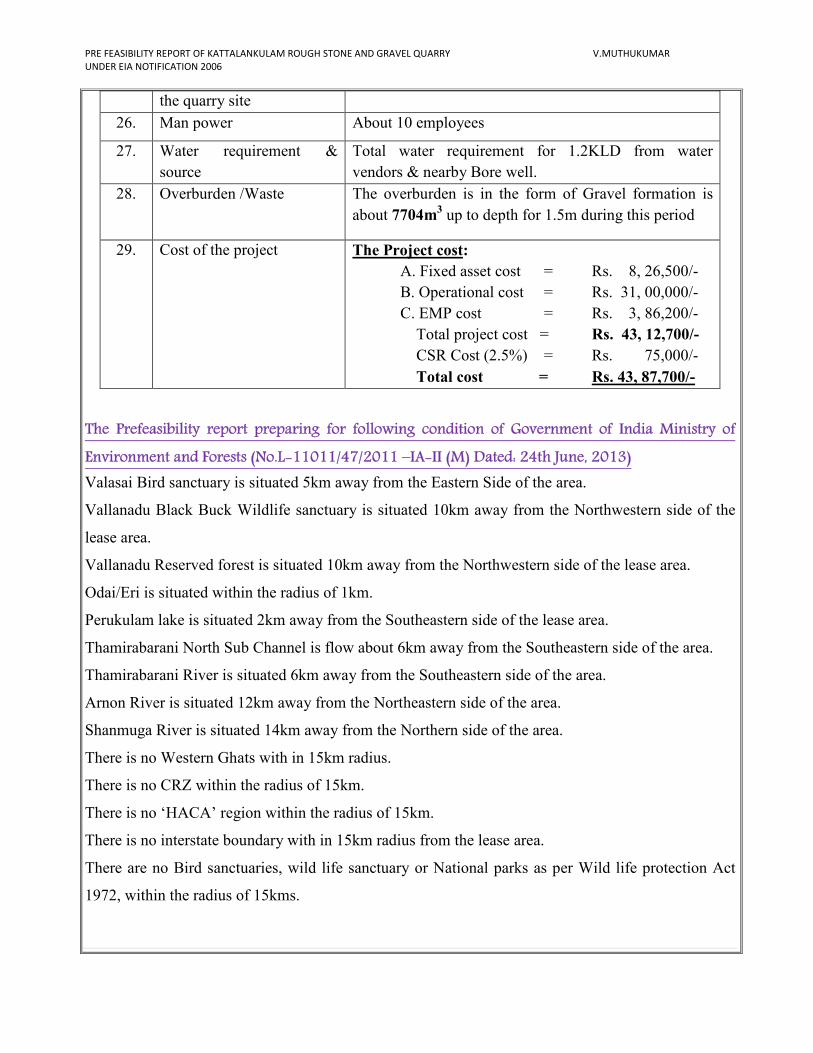
The Prefeasibility report preparing for following condition of Government of India Ministry of
Environment and Forests (No.L-11011/47/2011 –IA-II (M) Dated: 24th June, 2013)
Valasai Bird sanctuary is situated 5km away from the Eastern Side of the area.
Vallanadu Black Buck Wildlife sanctuary is situated 10km away from the Northwestern side of the
lease area.
Vallanadu Reserved forest is situated 10km away from the Northwestern side of the lease area.
Odai/Eri is situated within the radius of 1km.
Perukulam lake is situated 2km away from the Southeastern side of the lease area.
Thamirabarani North Sub Channel is flow about 6km away from the Southeastern side of the area.
Thamirabarani River is situated 6km away from the Southeastern side of the area.
Arnon River is situated 12km away from the Northeastern side of the area.
Shanmuga River is situated 14km away from the Northern side of the area.
There is no Western Ghats with in 15km radius.
There is no CRZ within the radius of 15km.
There is no ‘HACA’ region within the radius of 15km.
There is no interstate boundary with in 15km radius from the lease area.
There are no Bird sanctuaries, wild life sanctuary or National parks as per Wild life protection Act
1972, within the radius of 15kms.
the quarry site
26. Man power About 10 employees
27. Water requirement &
source
Total water requirement for 1.2KLD from water
vendors & nearby Bore well.
28. Overburden /Waste The overburden is in the form of Gravel formation is
about 7704m3 up to depth for 1.5m during this period
29. Cost of the project The Project cost:
A. Fixed asset cost = Rs. 8, 26,500/-
B. Operational cost = Rs. 31, 00,000/-
C. EMP cost = Rs. 3, 86,200/-
Total project cost = Rs. 43, 12,700/-
CSR Cost (2.5%) = Rs. 75,000/-
Total cost = Rs. 43, 87,700/-
PRE FEASIBILITY REPORT OF KATTALANKULAM ROUGH STONE AND GRAVEL QUARRY V.MUTHUKUMAR
UNDER EIA NOTIFICATION 2006
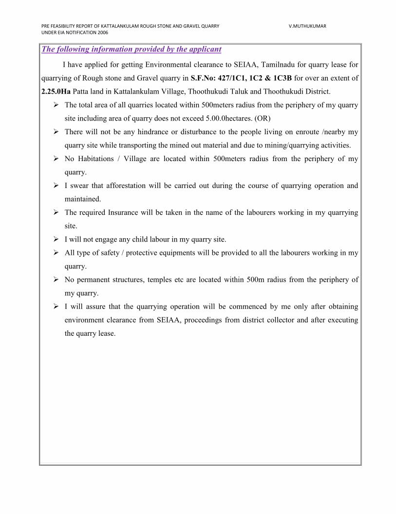
The following information provided by the applicant
I have applied for getting Environmental clearance to SEIAA, Tamilnadu for quarry lease for
quarrying of Rough stone and Gravel quarry in S.F.No: 427/1C1, 1C2 & 1C3B for over an extent of
2.25.0Ha Patta land in Kattalankulam Village, Thoothukudi Taluk and Thoothukudi District.
� The total area of all quarries located within 500meters radius from the periphery of my quarry
site including area of quarry does not exceed 5.00.0hectares. (OR)
� There will not be any hindrance or disturbance to the people living on enroute /nearby my
quarry site while transporting the mined out material and due to mining/quarrying activities.
� No Habitations / Village are located within 500meters radius from the periphery of my
quarry.
� I swear that afforestation will be carried out during the course of quarrying operation and
maintained.
� The required Insurance will be taken in the name of the labourers working in my quarrying
site.
� I will not engage any child labour in my quarry site.
� All type of safety / protective equipments will be provided to all the labourers working in my
quarry.
� No permanent structures, temples etc are located within 500m radius from the periphery of
my quarry.
� I will assure that the quarrying operation will be commenced by me only after obtaining
environment clearance from SEIAA, proceedings from district collector and after executing
the quarry lease.
PRE FEASIBILITY REPORT OF KATTALANKULAM ROUGH STONE AND GRAVEL QUARRY V.MUTHUKUMAR
UNDER EIA NOTIFICATION 2006
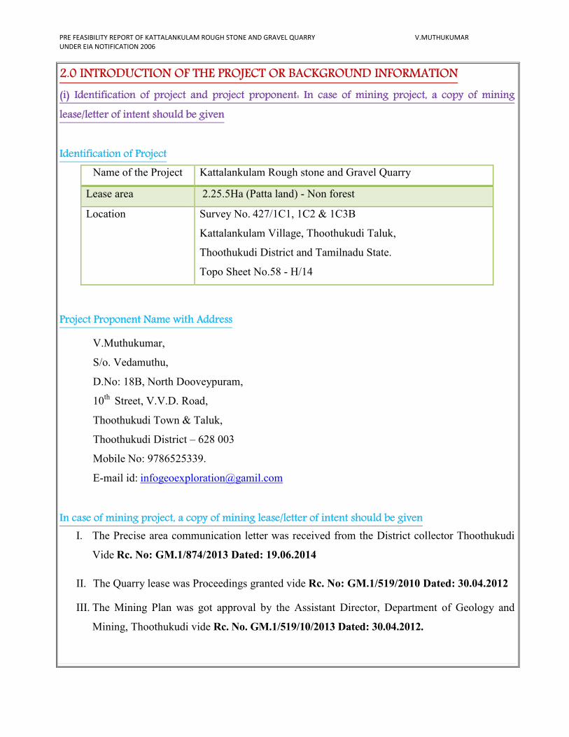
2.0 INTRODUCTION OF THE PROJECT OR BACKGROUND INFORMATION
(i) Identification of project and project proponent: In case of mining project, a copy of mining
lease/letter of intent should be given
Identification of Project
Name of the Project Kattalankulam Rough stone and Gravel Quarry
Lease area 2.25.5Ha (Patta land) - Non forest
Location Survey No. 427/1C1, 1C2 & 1C3B
Kattalankulam Village, Thoothukudi Taluk,
Thoothukudi District and Tamilnadu State.
Topo Sheet No.58 - H/14
Project Proponent Name with Address
V.Muthukumar,
S/o. Vedamuthu,
D.No: 18B, North Dooveypuram,
10th
Street, V.V.D. Road,
Thoothukudi Town & Taluk,
Thoothukudi District – 628 003
Mobile No: 9786525339.
E-mail id: [email protected]
In case of mining project, a copy of mining lease/letter of intent should be given
I. The Precise area communication letter was received from the District collector Thoothukudi
Vide Rc. No: GM.1/874/2013 Dated: 19.06.2014
II. The Quarry lease was Proceedings granted vide Rc. No: GM.1/519/2010 Dated: 30.04.2012
III. The Mining Plan was got approval by the Assistant Director, Department of Geology and
Mining, Thoothukudi vide Rc. No. GM.1/519/10/2013 Dated: 30.04.2012.
PRE FEASIBILITY REPORT OF KATTALANKULAM ROUGH STONE AND GRAVEL QUARRY V.MUTHUKUMAR
UNDER EIA NOTIFICATION 2006
(ii) Brief description of nature of the project
The lease area is almost plain terrain. The Rough stone and Gravel quarrying operation is
proposed to carry out by conventional opencast Semi mechanized method by formation of benches.
One bench is proposed with a height of 4mts on Rough stone. The width 6 to 8meter. The quarry
operation involves jackhammer drilling; Slurry blasting and excavators are used for loading the
Rough stone from pithead to the needy crushers.
The proposed quantity of reserves is about 15408m3 of Rough stone. The overburden is in the
form of Gravel formation is about 7704m3 up to depth for 1.5m for during this period. The quarry
operation is proposed up to depth for 5.5m below the ground level for a remaining period of Three
years only.
(iii) Need for the project and its importance to the country and or region
The Rough stone is important building material to our country and region; it’s a vital material
for Infrastructure development and Road widening project. Hence a lot of Rough stone is required for
Granular sub base (GSB).
In this proposed Rough stone quarry operations employee will about 10 persons and on
indirect opportunities through allied opportunities in logistics, trading; repairing works etc., good
employment potential will arise in this internal rural backward area, which will provide a great fillip
for raising income levels and standards of living in the area.
Mineral Industries of the state of Tamil Nadu provides employment opportunities for the
people of the state as well as in the specific project area. The Quarrying is one among the major core
sector for industries, which plays a vital process of country’s economic development.
(iv) Demand and supply gap
There is a huge demand of Rough stone for State and National Road projects is under massive
development for its widening and strengthening operation, apart from this many bridges and fly overs
are also being under construction. And also huge requirements of Rough stone for Public and Private
sector projects to infrastructure development of the state; hence the project is significant to the state.
Railway lines in the country also under progress where huge Rough stone is required as Ballast.
Other internal panchayat Roads are also under progress, besides all these public works projects the
Rough stone is widely used for domestic construction project like Hospital, School, Government
Building and Housing construction. It is worth mentioning that the Rough stone of Thoothukudi
District.
PRE FEASIBILITY REPORT OF KATTALANKULAM ROUGH STONE AND GRAVEL QUARRY V.MUTHUKUMAR
UNDER EIA NOTIFICATION 2006
(v) Imports vs indigenous production
There is no import of Rough stone at present in India.
(vi) Export Possibility
There are no possibilities for export.
(vii) Domestic/Export Markets
The applicant after obtaining the lease will fetch a domestic market as mentioned earlier.
It is propose to sell Rough stone domestic needy crushers for roads project and other infrastructure
development projects for public and private sector companies.
(viii) Employment Generation (Direct and Indirect) due to the project
It is proposed to deploy about 10 employees directly and 6 persons will be indirectly
Benefited .The tentative man power required for the proposed Rough stone and Gravel quarry shall
be as follows.
The above man power is adequate to meet out the production schedule and the machinery
strength envisaged in the mining plan and also to comply with the stationary provisions of quarry
safety regulation.
It is been ensured that the labours will not be deployed less than 18 years, No Child labours
will engaged or entertained for any kind of quarrying operations. All the labours engaged for
quarrying operations will be insured till the end of life of quarry.
PRE FEASIBILITY REPORT OF KATTALANKULAM ROUGH STONE AND GRAVEL QUARRY V.MUTHUKUMAR
UNDER EIA NOTIFICATION 2006
3.0 PROJECT DESCRIPTION
(i) Type of project including interlinked and interdependent projects, if any
The Kattalankulam Rough stone and Gravel quarry; it is an opencast semi mechanized quarry.
There is no interlinked & interdependent project.
(ii) Location (map showing general location, specific location, and project boundary & project site
layout) with coordinates
� The area is located in S.F.No. 427/1C1, 1C2 & 1C3B, Kattalankulam Village,
Thoothukudi Taluk, and Thoothukudi District.
� The entire quarry lease area falls in the Patta land, the area is almost plain terrain.
� The Altitude of the area is above 30m (Maximum) from MSL.
� The area is mentioned in GSI Topo sheet No. 58 - H/14
� The Latitude between of 08040’27’’N
� The Longitude between of 77058’37’’E on WGS 1984 datum.
PRE FEASIBILITY REPORT OF KATTALANKULAM ROUGH STONE AND GRAVEL QUARRY V.MUTHUKUMAR
UNDER EIA NOTIFICATION 2006
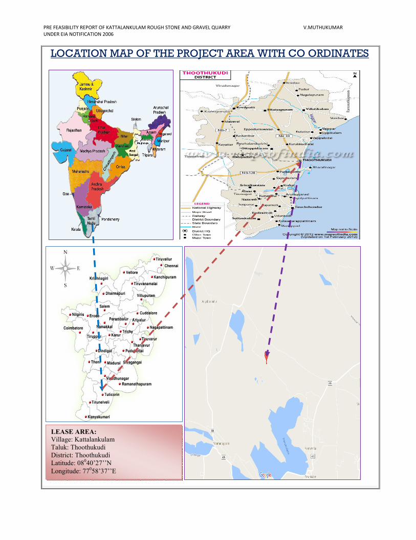
LOCATION MAP OF THE PROJECT AREA WITH CO ORDINATES
LEASE AREA:
Village: Kattalankulam
Taluk: Thoothukudi
District: Thoothukudi
Latitude: 08040’27’’N
Longitude: 77058’37’’E
PRE FEASIBILITY REPORT OF KATTALANKULAM ROUGH STONE AND GRAVEL QUARRY V.MUTHUKUMAR
UNDER EIA NOTIFICATION 2006
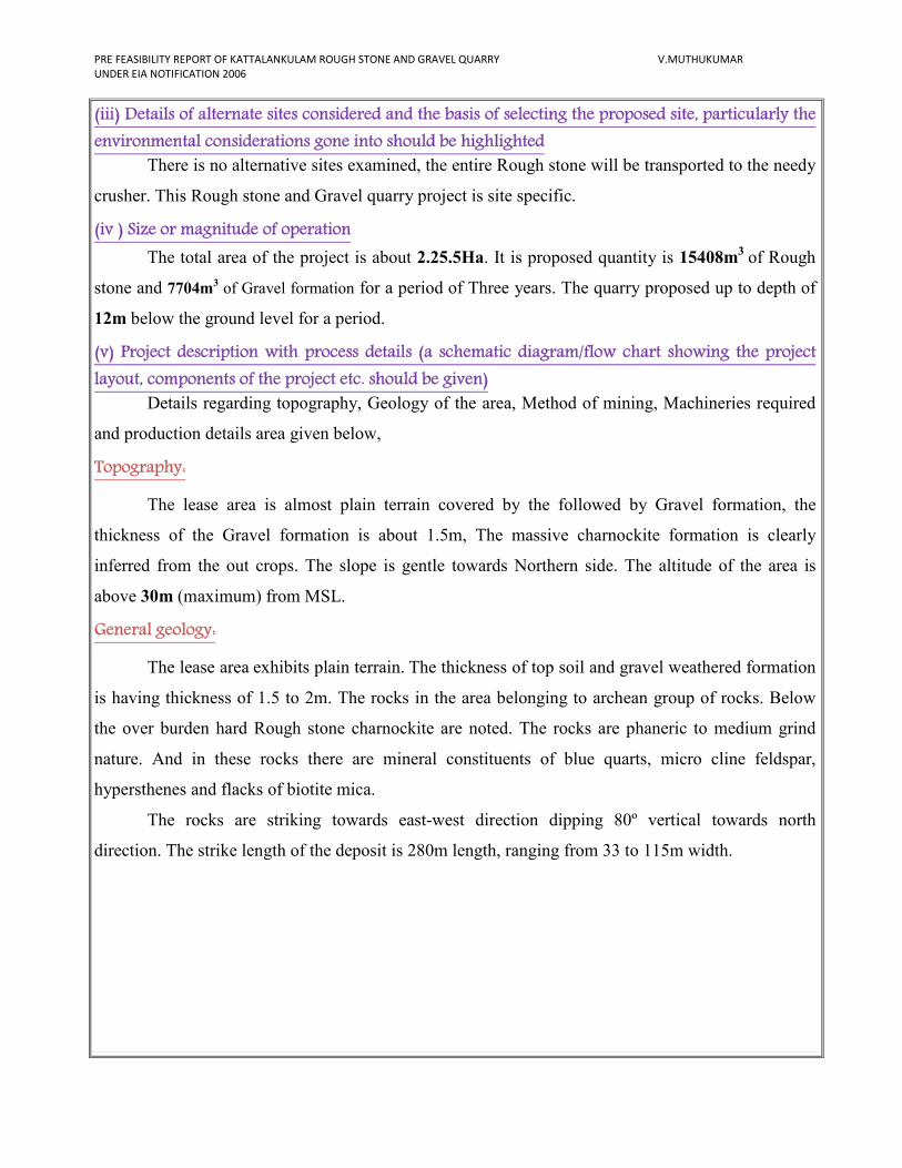
(iii) Details of alternate sites considered and the basis of selecting the proposed site, particularly the
environmental considerations gone into should be highlighted
There is no alternative sites examined, the entire Rough stone will be transported to the needy
crusher. This Rough stone and Gravel quarry project is site specific.
(iv ) Size or magnitude of operation
The total area of the project is about 2.25.5Ha. It is proposed quantity is 15408m3
of Rough
stone and 7704m3 of Gravel formation for a period of Three years. The quarry proposed up to depth of
12m below the ground level for a period.
(v) Project description with process details (a schematic diagram/flow chart showing the project
layout, components of the project etc. should be given)
Details regarding topography, Geology of the area, Method of mining, Machineries required
and production details area given below,
Topography:
The lease area is almost plain terrain covered by the followed by Gravel formation, the
thickness of the Gravel formation is about 1.5m, The massive charnockite formation is clearly
inferred from the out crops. The slope is gentle towards Northern side. The altitude of the area is
above 30m (maximum) from MSL.
General geology:
The lease area exhibits plain terrain. The thickness of top soil and gravel weathered formation
is having thickness of 1.5 to 2m. The rocks in the area belonging to archean group of rocks. Below
the over burden hard Rough stone charnockite are noted. The rocks are phaneric to medium grind
nature. And in these rocks there are mineral constituents of blue quarts, micro cline feldspar,
hypersthenes and flacks of biotite mica.
The rocks are striking towards east-west direction dipping 80º vertical towards north
direction. The strike length of the deposit is 280m length, ranging from 33 to 115m width.
PRE FEASIBILITY REPORT OF KATTALANKULAM ROUGH STONE AND GRAVEL QUARRY V.MUTHUKUMAR
UNDER EIA NOTIFICATION 2006
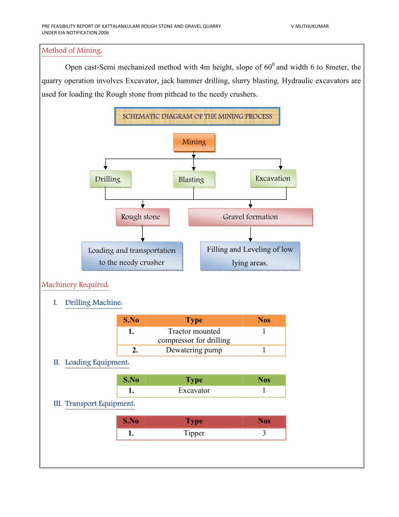
Method of Mining:
Open cast-Semi mechanized method with 4m height, slope of 600
and width 6 to 8meter, the
quarry operation involves Excavator, jack hammer drilling, slurry blasting. Hydraulic excavators are
used for loading the Rough stone from pithead to the needy crushers.
Machinery Required:
I. Drilling Machine:
S.No Type Nos
1. Tractor mounted
compressor for drilling
1
2. Dewatering pump 1
II. Loading Equipment:
S.No Type Nos
1. Excavator 1
III. Transport Equipment:
S.No Type Nos
1. Tipper 3
SCHEMATIC DIAGRAM OF THE MINING PROCESS
Mining
Excavation Blasting Drilling
Rough stone
Loading and transportation
to the needy crusher
Gravel formation
Filling and Leveling of low
lying areas.
PRE FEASIBILITY REPORT OF KATTALANKULAM ROUGH STONE AND GRAVEL QUARRY V.MUTHUKUMAR
UNDER EIA NOTIFICATION 2006
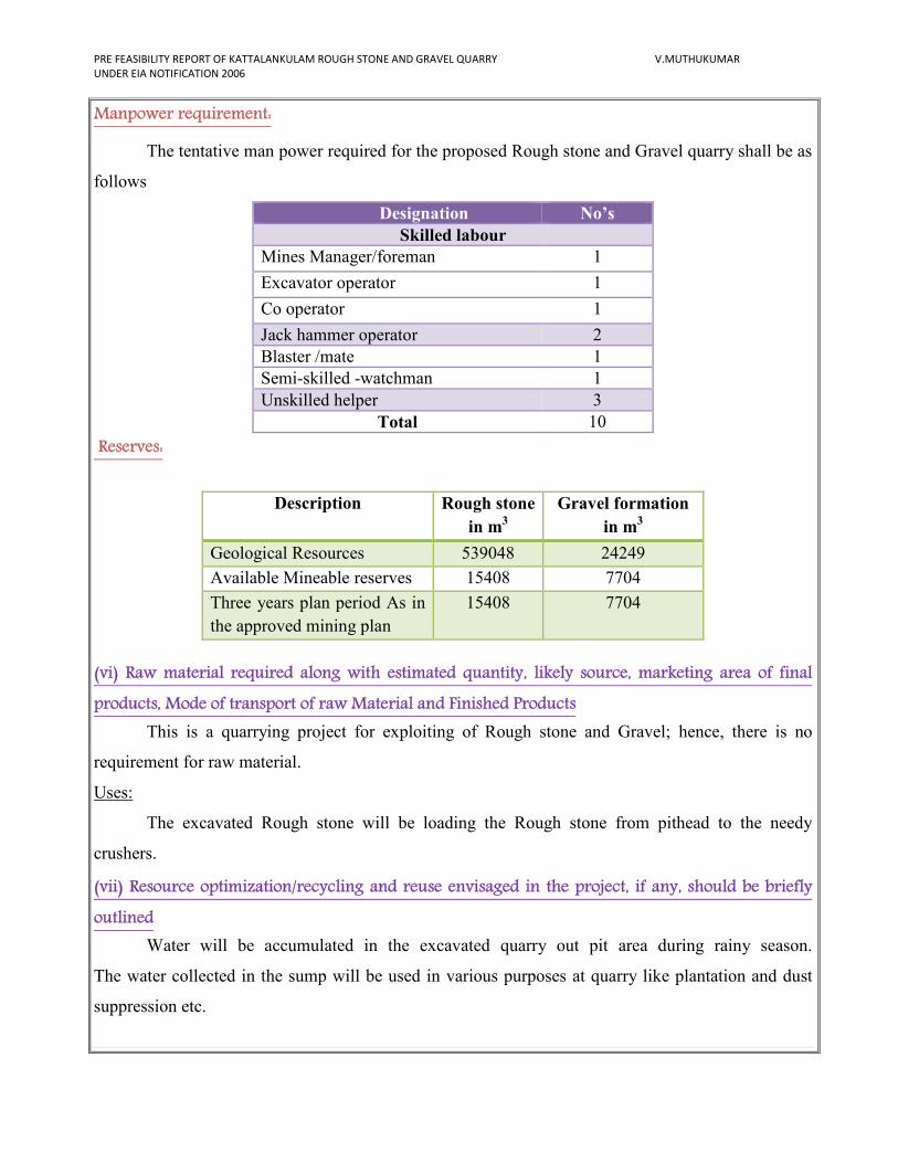
Manpower requirement:
The tentative man power required for the proposed Rough stone and Gravel quarry shall be as
follows
Designation No’s
Skilled labour
Mines Manager/foreman 1
Excavator operator 1
Co operator 1
Jack hammer operator 2
Blaster /mate 1
Semi-skilled -watchman 1
Unskilled helper 3
Total 10
Reserves:
(vi) Raw material required along with estimated quantity, likely source, marketing area of final
products, Mode of transport of raw Material and Finished Products
This is a quarrying project for exploiting of Rough stone and Gravel; hence, there is no
requirement for raw material.
Uses:
The excavated Rough stone will be loading the Rough stone from pithead to the needy
crushers.
(vii) Resource optimization/recycling and reuse envisaged in the project, if any, should be briefly
outlined
Water will be accumulated in the excavated quarry out pit area during rainy season.
The water collected in the sump will be used in various purposes at quarry like plantation and dust
suppression etc.
Description Rough stone
in m3
Gravel formation
in m3
Geological Resources 539048 24249
Available Mineable reserves 15408 7704
Three years plan period As in
the approved mining plan
15408 7704
PRE FEASIBILITY REPORT OF KATTALANKULAM ROUGH STONE AND GRAVEL QUARRY V.MUTHUKUMAR
UNDER EIA NOTIFICATION 2006
(viii) Availability of water its source, Energy/power requirement and source should be given
This Rough stone and Gravel quarry project does not require huge water and Electricity for
the project.
Purpose Quantity Sources
Drinking &
Domestic Purpose
0.4KLD Water purchase from Approved water vendors
available in Kattalankulam (3 km –N side).
Dust suppression 0.6 KLD From Existing Borehole on nearby the quarry.
Green belt 0.2 KLD From Existing Borehole on nearby the quarry.
Total 1.2KLD
Energy Electricity for Mines office and Lights only at nights (working is restricted on day time only
between 9Am to 5Pm). Diesel (HSD) will be used for quarrying machineries around 13600 Liters of
HSD will be used for the entire project life. Diesel will be brought from nearby diesel pumps. No
power is required for the project. Lightings on the Night will be taken from nearby electric poles after
obtaining permission from concerned authorities.
1.For Gravel:
Per hour Excavator will consume = 10 liters / hour
Per hour Excavator will excavate = 60m3of Gravel
For 7704m3
= 7704 /60
= 128 hours
Diesel consume 128 working hours = 770hours x 10 liters
Total diesel consumption = 1280 Liters of HSD will be utilized for Gravel
2.For Rough stone:
Per hour Excavator will consume = 16 liters / hour
Per hour Excavator will excavate = 20m3of Rough stone
For 15408m3
= 15408 /20
= 770 hours
Diesel consume 770 working hours= 770 hours x 16 liters
Total diesel consumption = 12320 Liters of HSD will be utilized for Rough Stone
Total diesel consumption is around = 13600 Liters of HSD for the entire period of life.
PRE FEASIBILITY REPORT OF KATTALANKULAM ROUGH STONE AND GRAVEL QUARRY V.MUTHUKUMAR
UNDER EIA NOTIFICATION 2006
(ix) Quantity of wastes to be generated (liquid and solid) and scheme for their
management/disposal
Top soil: There is no top soil in the lease period.
Overburden/Waste: The overburden is in the form of Gravel formation. The thickness of 1.5m Gravel
formation. The Gravel will be directly loaded into tippers for the filling and leveling of low lying
areas.
Waste water: There will not be any process effluent generation from the quarry lease area. Domestic
effluent from the mine office is discharged in septic tank and soak pit.
There is no toxic effluent expected to generate in the form of solid liquid and gases and the no
requirement of treatment of waste.
(x) Schematic representations of the feasibility drawing which give information of EIA purpose
4.0 SITE ANALYSIS
(i) Connectivity
Mode Description
Road
connectivity
1. There is a metal road on the Northern side of the area the road
connecting on the Adaikalapuram - Pandaaravilai village at a
distance of 10m.
2. The Nearest National Highway (NH-7A) Thoothukudi -
Tirunelveli –7km- Northern side.
3. The Nearest State Highway (SH-40) Tirunelveli – Tiruchendur-
9km- Southwestern side.
Railway station
& Railway line
1. The Nearest Railway station is Srivaikuntam – 10km –
southwestern side.
2. The Nearest Railway line is Tirunelveli - Tiruchendur– 10km-
Southwestern side.
Air port 1. The Nearest Airport is Thoothukudi - 8kms –Northeastern side.
Form – 1
Along with pre-feasibility report
&
Approved Mining plan with Annexure
To Submit SEIAA
Final Presentation

PRE FEASIBILITY REPORT OF KATTALANKULAM ROUGH STONE AND GRAVEL QUARRY V.MUTHUKUMAR
UNDER EIA NOTIFICATION 2006
(ii) Land Form, Land use and Land ownership
The quarry lease applied area is 2.25.5Ha. The area falls in GSI Topo sheet No. 58 - H/14.
No forest land involved in this lease area. The lease area is almost plain terrain. It is a Patta land.
Patta registered in the name Sarojinimuthammal, Jayakumar, Vetha raj, and Apllicant
(V.Muthukumar) vide patta Nos. 1524, 2281 and 2490. Applicant got consent from the other
pattadhars.
(iii) Topography (along with map)
The lease area is almost plain terrain covered by the followed by Gravel formation, the
thickness of the Gravel formation is about 1.5m, the massive charnockite formation is clearly inferred
from the out crops. The slope is gentle towards Northern side. The altitude of the area is above 30m
(maximum) from MSL. The water table is found at a depth of 40m in the summer and at 35m in rainy
seasons. Average annual rainfall is about 850mm during NE monsoon.
Google Map View of the Quarry lease applied area
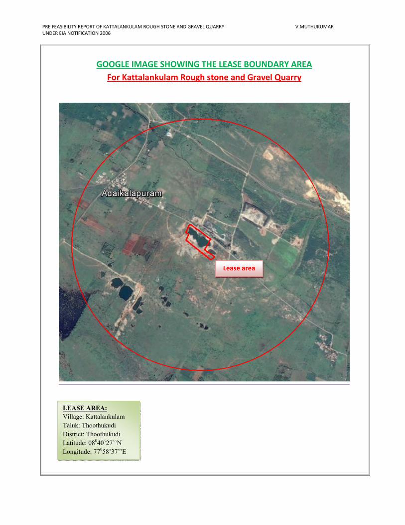
PRE FEASIBILITY REPORT OF KATTALANKULAM ROUGH STONE AND GRAVEL QUARRY V.MUTHUKUMAR
UNDER EIA NOTIFICATION 2006
GOOGLE IMAGE SHOWING THE LEASE BOUNDARY AREA
For Kattalankulam Rough stone and Gravel Quarry
LEASE AREA:
Village: Kattalankulam
Taluk: Thoothukudi
District: Thoothukudi
Latitude: 08040’27’’N
Longitude: 77058’37’’E
Lease area
PRE FEASIBILITY REPORT OF KATTALANKULAM ROUGH STONE AND GRAVEL QUARRY V.MUTHUKUMAR
UNDER EIA NOTIFICATION 2006
(iv) Existing land use pattern (agriculture, non-agriculture, forest, water bodies (including area
under CRZ), shortest distances from the periphery of the project to periphery of the forests, national
park, wild life sanctuary, eco sensitive areas, water bodies (distance from the HFL of the river), CRZ.
In case of notified industrial area, a copy of the Gazette notification should be given.
The lease area is almost plain terrain. The area is a dry barren land devoid of Agriculture and
Habitations. The land is not used for any specific vegetation. The region experiences semi – humid
climate and there is scanty growth of vegetation in and around the lease applied area (seasonal
vegetation is mostly practiced).
� Valasai Bird sanctuary is situated 5km away from the Eastern Side of the area.
� Vallanadu Black Buck Wildlife sanctuary is situated 10km away from the Northwestern side
of the lease area.
� Vallanadu Reserved forest is situated 10km away from the Northwestern side of the lease
area.
� Odai/Eri is situated within the radius of 1km.
� Perukulam Lake is situated 2km away from the Southeastern side of the lease area.
� Thamirabarani North Sub Channel is flow about 6km away from the Southeastern side of the
area.
� Thamirabarani River is situated 6km away from the Southeastern side of the area.
� Arnon River is situated 12km away from the Northeastern side of the area.
� Shanmuga River is situated 14km away from the Northern side of the area.
� There is no Western Ghats with in 15km radius.
� There is no CRZ within the radius of 15km.
� There is no ‘HACA’ region within the radius of 15km.
� There is no interstate boundary with in 15km radius from the lease area.
� There are no Bird sanctuaries, wild life sanctuary or National parks as per Wild life protection
Act 1972, within the radius of 15kms.
� There are few quarries is situated within the radius of 500m.
(v) Existing Infrastructure
There is no existing infrastructure present in the applied area. A permanent mine office has
been proposed in the lease area. A well-equipped first aid facility will be made available. Permanent
rest shelter is proposed. At the quarry site, urinal and latrine are proposed.
Water for drinking purpose be supplied form the approved water vendors. A small water tank
is also proposed which will be used for water sprinkling, plantation etc.
PRE FEASIBILITY REPORT OF KATTALANKULAM ROUGH STONE AND GRAVEL QUARRY V.MUTHUKUMAR
UNDER EIA NOTIFICATION 2006
(vi) Soil Classification
The massive Charnockite formation Charnockite formation is noticed followed by the Gravel
formation. This land does not sustain any type of vegetation or Agriculture.
(vii) Climatic data form secondary sources
The area receives rainfall of about 850mm/ annum and the rainy season is mainly from Oct -
Jan during North East, monsoon. The summer is hot with maximum temperature of 42°C and winter
encounters a minimum temperature of 23°C.
(viii) Social infrastructure available
There is no social infrastructure within the radius of 1Km like schools, universities, hospitals,
prisons and community housing etc.
5. PLANNING BRIEF
(i) Planning Concept (type of industries, facilities, transportation etc) Town and Country
Planning/Development authority Classification
The quarry operation involves jackhammer drilling, slurry explosives blasting, excavator are
used for loading of Rough stone through tippers to the needy crusher.
There are no habitations or villages en-route between the quarry sites the loaded vehicles are
allowed to move only below 40Kms per hour on the roads. The haul roads are sprinkled periodically
to prevent dust. Other facilities such as power, transportation and communication, social
infrastructure facilities are locally available near project site. Nearest town is pudukottai, facilities
like Dispensary, post office are available in 12km on Northeastern side.
(ii) Population projection
There are few villages located in this area within 5km radius; the approximate distance and
population are given below.
S.No Name of the Village
Approximate distance &
Direction from lease
applied area
Approximate
population
1. Kattalankulam 3km – N 250
2. Sivalur 3km – S 100
3. Natratni 2km – E 100
4. Meenakshipatti 2.5km – W 200
Basic human welfare Amenities such as Health Center, Schools, Communication Facilities,
and Commercial Centers etc are available at Pudukottai located at a distance of 12kms on the
Northeastern side of the area.
PRE FEASIBILITY REPORT OF KATTALANKULAM ROUGH STONE AND GRAVEL QUARRY V.MUTHUKUMAR
UNDER EIA NOTIFICATION 2006
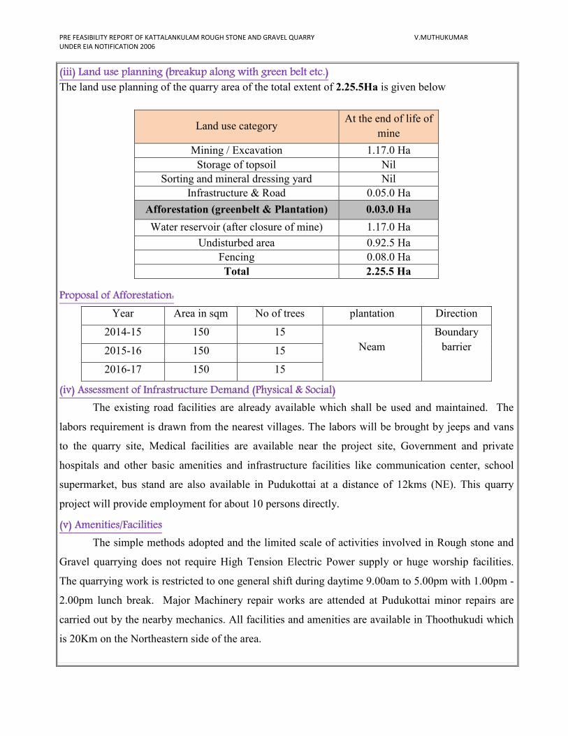
(iii) Land use planning (breakup along with green belt etc.)
The land use planning of the quarry area of the total extent of 2.25.5Ha is given below
Proposal of Afforestation:
Year Area in sqm No of trees plantation Direction
2014-15 150 15
Neam
Boundary
barrier
2015-16 150 15
2016-17 150 15
(iv) Assessment of Infrastructure Demand (Physical & Social)
The existing road facilities are already available which shall be used and maintained. The
labors requirement is drawn from the nearest villages. The labors will be brought by jeeps and vans
to the quarry site, Medical facilities are available near the project site, Government and private
hospitals and other basic amenities and infrastructure facilities like communication center, school
supermarket, bus stand are also available in Pudukottai at a distance of 12kms (NE). This quarry
project will provide employment for about 10 persons directly.
(v) Amenities/Facilities
The simple methods adopted and the limited scale of activities involved in Rough stone and
Gravel quarrying does not require High Tension Electric Power supply or huge worship facilities.
The quarrying work is restricted to one general shift during daytime 9.00am to 5.00pm with 1.00pm -
2.00pm lunch break. Major Machinery repair works are attended at Pudukottai minor repairs are
carried out by the nearby mechanics. All facilities and amenities are available in Thoothukudi which
is 20Km on the Northeastern side of the area.
Land use category At the end of life of
mine
Mining / Excavation 1.17.0 Ha
Storage of topsoil Nil
Sorting and mineral dressing yard Nil
Infrastructure & Road 0.05.0 Ha
Afforestation (greenbelt & Plantation) 0.03.0 Ha
Water reservoir (after closure of mine) 1.17.0 Ha
Undisturbed area 0.92.5 Ha
Fencing 0.08.0 Ha
Total 2.25.5 Ha
PRE FEASIBILITY REPORT OF KATTALANKULAM ROUGH STONE AND GRAVEL QUARRY V.MUTHUKUMAR
UNDER EIA NOTIFICATION 2006
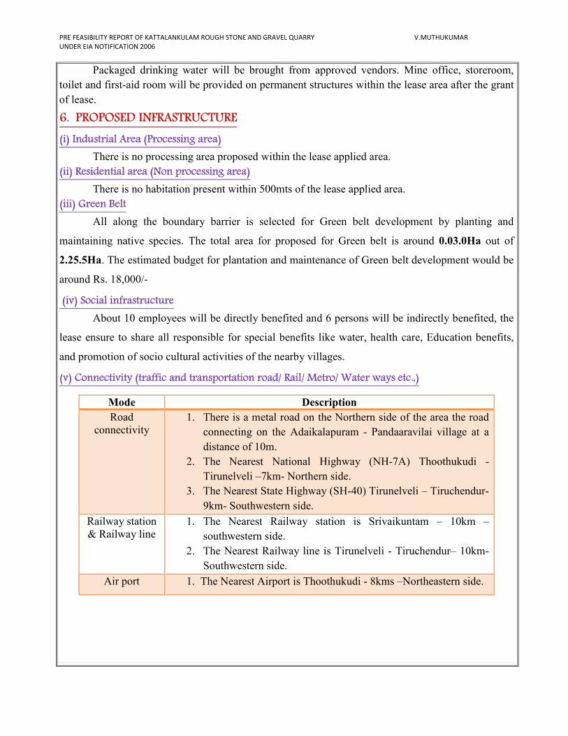
Packaged drinking water will be brought from approved vendors. Mine office, storeroom,
toilet and first-aid room will be provided on permanent structures within the lease area after the grant
of lease.
6. PROPOSED INFRASTRUCTURE
(i) Industrial Area (Processing area)
There is no processing area proposed within the lease applied area.
(ii) Residential area (Non processing area)
There is no habitation present within 500mts of the lease applied area.
(iii) Green Belt
All along the boundary barrier is selected for Green belt development by planting and
maintaining native species. The total area for proposed for Green belt is around 0.03.0Ha out of
2.25.5Ha. The estimated budget for plantation and maintenance of Green belt development would be
around Rs. 18,000/-
(iv) Social infrastructure
About 10 employees will be directly benefited and 6 persons will be indirectly benefited, the
lease ensure to share all responsible for special benefits like water, health care, Education benefits,
and promotion of socio cultural activities of the nearby villages.
(v) Connectivity (traffic and transportation road/ Rail/ Metro/ Water ways etc.,)
Mode Description
Road
connectivity
1. There is a metal road on the Northern side of the area the road
connecting on the Adaikalapuram - Pandaaravilai village at a
distance of 10m.
2. The Nearest National Highway (NH-7A) Thoothukudi -
Tirunelveli –7km- Northern side.
3. The Nearest State Highway (SH-40) Tirunelveli – Tiruchendur-
9km- Southwestern side.
Railway station
& Railway line
1. The Nearest Railway station is Srivaikuntam – 10km –
southwestern side.
2. The Nearest Railway line is Tirunelveli - Tiruchendur– 10km-
Southwestern side.
Air port 1. The Nearest Airport is Thoothukudi - 8kms –Northeastern side.
PRE FEASIBILITY REPORT OF KATTALANKULAM ROUGH STONE AND GRAVEL QUARRY V.MUTHUKUMAR
UNDER EIA NOTIFICATION 2006
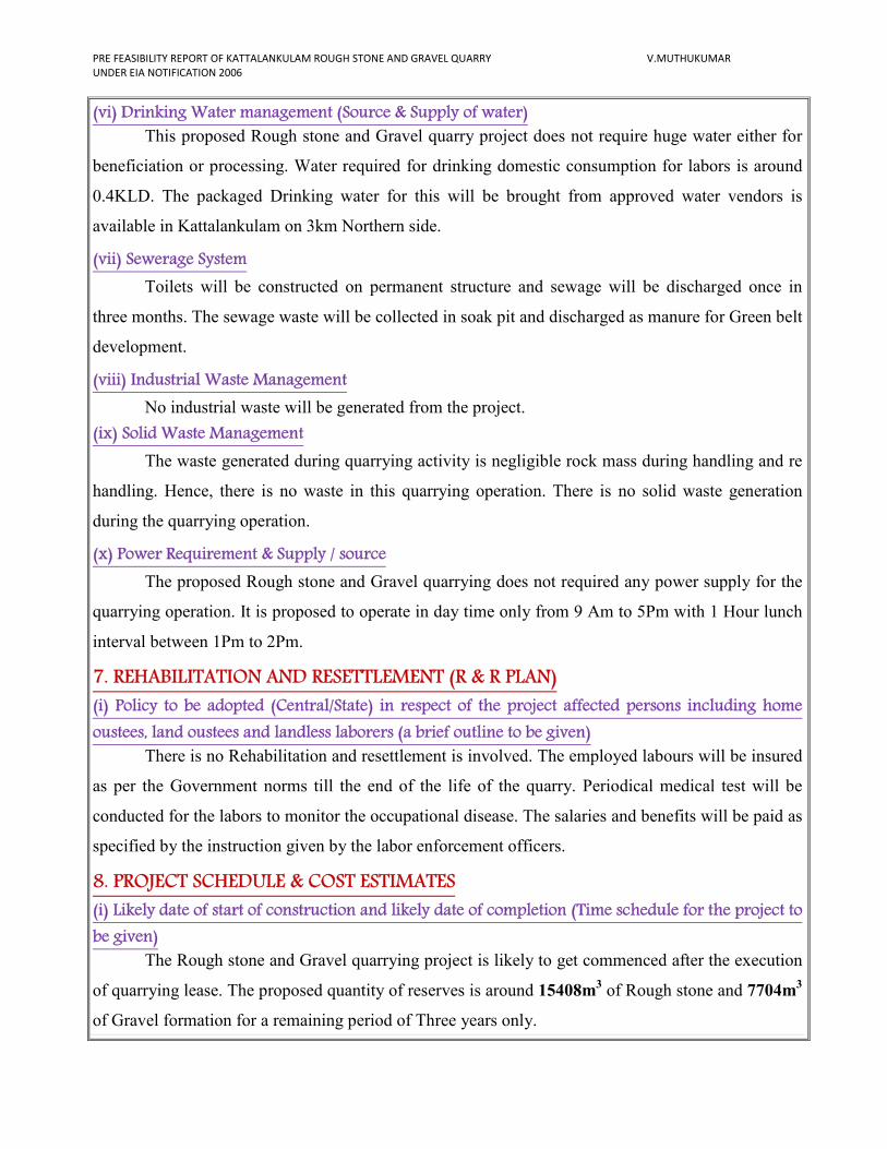
(vi) Drinking Water management (Source & Supply of water)
This proposed Rough stone and Gravel quarry project does not require huge water either for
beneficiation or processing. Water required for drinking domestic consumption for labors is around
0.4KLD. The packaged Drinking water for this will be brought from approved water vendors is
available in Kattalankulam on 3km Northern side.
(vii) Sewerage System
Toilets will be constructed on permanent structure and sewage will be discharged once in
three months. The sewage waste will be collected in soak pit and discharged as manure for Green belt
development.
(viii) Industrial Waste Management
No industrial waste will be generated from the project.
(ix) Solid Waste Management
The waste generated during quarrying activity is negligible rock mass during handling and re
handling. Hence, there is no waste in this quarrying operation. There is no solid waste generation
during the quarrying operation.
(x) Power Requirement & Supply / source
The proposed Rough stone and Gravel quarrying does not required any power supply for the
quarrying operation. It is proposed to operate in day time only from 9 Am to 5Pm with 1 Hour lunch
interval between 1Pm to 2Pm.
7. REHABILITATION AND RESETTLEMENT (R & R PLAN)
(i) Policy to be adopted (Central/State) in respect of the project affected persons including home
oustees, land oustees and landless laborers (a brief outline to be given)
There is no Rehabilitation and resettlement is involved. The employed labours will be insured
as per the Government norms till the end of the life of the quarry. Periodical medical test will be
conducted for the labors to monitor the occupational disease. The salaries and benefits will be paid as
specified by the instruction given by the labor enforcement officers.
8. PROJECT SCHEDULE & COST ESTIMATES
(i) Likely date of start of construction and likely date of completion (Time schedule for the project to
be given)
The Rough stone and Gravel quarrying project is likely to get commenced after the execution
of quarrying lease. The proposed quantity of reserves is around 15408m3 of Rough stone and 7704m
3
of Gravel formation for a remaining period of Three years only.
PRE FEASIBILITY REPORT OF KATTALANKULAM ROUGH STONE AND GRAVEL QUARRY V.MUTHUKUMAR
UNDER EIA NOTIFICATION 2006
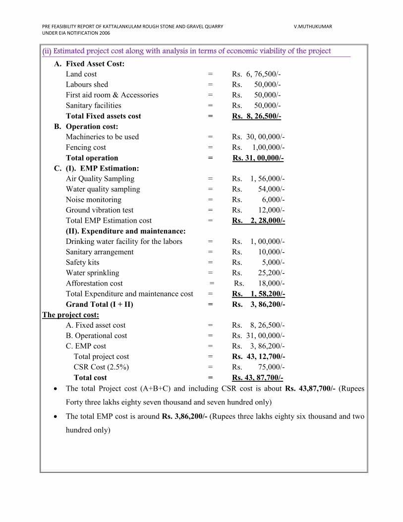
(ii) Estimated project cost along with analysis in terms of economic viability of the project
A. Fixed Asset Cost: Land cost = Rs. 6, 76,500/-
Labours shed = Rs. 50,000/-
First aid room & Accessories = Rs. 50,000/-
Sanitary facilities = Rs. 50,000/-
Total Fixed assets cost = Rs. 8, 26,500/-
B. Operation cost:
Machineries to be used = Rs. 30, 00,000/-
Fencing cost = Rs. 1,00,000/-
Total operation = Rs. 31, 00,000/-
C. (I). EMP Estimation:
Air Quality Sampling = Rs. 1, 56,000/-
Water quality sampling = Rs. 54,000/-
Noise monitoring = Rs. 6,000/-
Ground vibration test = Rs. 12,000/-
Total EMP Estimation cost = Rs. 2, 28,000/-
(II). Expenditure and maintenance:
Drinking water facility for the labors = Rs. 1, 00,000/-
Sanitary arrangement = Rs. 10,000/-
Safety kits = Rs. 5,000/-
Water sprinkling = Rs. 25,200/-
Afforestation cost = Rs. 18,000/-
Total Expenditure and maintenance cost = Rs. 1, 58,200/-
Grand Total (I + II) = Rs. 3, 86,200/-
The project cost:
A. Fixed asset cost = Rs. 8, 26,500/-
B. Operational cost = Rs. 31, 00,000/-
C. EMP cost = Rs. 3, 86,200/-
Total project cost = Rs. 43, 12,700/-
CSR Cost (2.5%) = Rs. 75,000/-
Total cost = Rs. 43, 87,700/-
• The total Project cost (A+B+C) and including CSR cost is about Rs. 43,87,700/- (Rupees
Forty three lakhs eighty seven thousand and seven hundred only)
• The total EMP cost is around Rs. 3,86,200/- (Rupees three lakhs eighty six thousand and two
hundred only)
PRE FEASIBILITY REPORT OF KATTALANKULAM ROUGH STONE AND GRAVEL QUARRY V.MUTHUKUMAR
UNDER EIA NOTIFICATION 2006
Population Benefit
The applicant ensures to take social responsibilities like providing School Note books,
Uniforms to the Students below poverty level beside if the villages require any borehole for public
use the applicant ensure to do so.
The applicant will also take part and contribute the native cultural activities in the nearby
villages. During summer seasons packaged drinking water will be kept will be kept in the village for
public and for tress passers. The applicant will involve and contribute all the socio cultural allocation
in and around the area. The budget provisions and allocation for all the above activities will be
around Rs. 75,000/-for the period of Three years.
MINE CLOSURE PLAN:
Steps proposed for phased restoration, reclamation of already mined out areas:
� After the exploitation the Rough stone fencing will be constructed around the pit to prevent
inherent entry of public.
� The pit will be allowed to collect water which will act as a temporary Reservoir which will
enhance the Ground water level of the nearby areas.
� There is no proposal for back filling, reclamation and re habitation. The quarry pit will be
fenced to prevent inherent entry of public.
Measures to be under taken on mine closure as per Act & Rules:
Measure will be taken as per Act & Rules.
Mitigation measure to be undertaken for safety and restoration / reclamation of the already mined out
area:
� Drilling will be carrying out by wet drilling to control the dust into the air.
� Blasting will be carrying out on limited scale.
� Mist spray on haul road will be proposed to prevent the dust propagation into the air.
� The plantation will be carried out on the safety barriers to prevent Noise, besides wet drilling
will be practiced to prevent dust.
� All the machineries will be maintained in good conditions as per RTO and TNPCB Norms to
prevent Noise, Smoke and vibration.
� Machineries will be periodically maintained by experienced mechanic to minimize noise,
Smoke and ground vibration.
PRE FEASIBILITY REPORT OF KATTALANKULAM ROUGH STONE AND GRAVEL QUARRY V.MUTHUKUMAR
UNDER EIA NOTIFICATION 2006
9. ANALYSIS OF PROPOSAL (FINAL RECOMMENDATIONS)
(i) Financial and social benefits with special emphasis on the benefit to the local people including
tribal population, if any, in the area
The lease applied area is patta land in Kattalankulam Village, Thoothukudi Taluk, and
Thoothukudi District. There are no tribal populations in and around the area about 10 personals
directly will be benefited by these projects, besides the government. The proposed quarry will bring
economic benefits to the state by the way of royalty for mineral, surface rent, sale tax/VAT, income
tax etc.
The socio- Economic conditions of the village and distance will enhance due to the project,
hence, the project should be allowed after considering all the parameters. The detail furnished in this
mining plan is based on information provided by the State Government and the lessee. By
considering the merit of the project the permission may be granted.
Date : 07.02.2017
Place : Thoothukudi
1. Signature of the Applicant
V.Muthukumar
2. Signature of the Recognized qualified person
M. Ifthikhar Ahmed, M.Sc., F.G.S., M.B.A., M.M.E.A.,
RQP/MAS/183/2004/A
Base Line Studies is Prepared for
Kattalankulam
Rough stone and Gravel Quarry
BASE LINE STUDIES
The base line study is prepared for Kattalankulam Rough stone and Gravel quarry
project. Base line studies provide a base data for regular Environmental Monitoring and
Environmental Impact Assessment (EIA).
The baseline study is provides bench mark for carrying out environmental Impact
assessment due to the course of quarrying and mining activities. The purpose of these studies is
to evaluate the benefited and adverse effect of developing activities on the neighborhood
environment and the area where the quarrying is proposed to carry out.
Thiru.V.Muthukumar has applied for Rough stone and Gravel quarry project lease for
over an extent of 2.25.5Ha in S.F.No. 427/1C1, 1C2 & 1C3B at Kattalankulam Village,
Thoothukudi Taluk, Thoothukudi District.
The comprehensive base line studies and standards constitute of collecting data on
Ambient Air quality, Water quality, Ground water table and Flora and Fauna statistics.
Ground water table
The rocks in this area belonging to archean group of rocks. Below the over burden hard
rough stone charnockite are noted. The rocks are phaneric to medium grid nature. And in these
rocks there are mineral constituents of blue quartz, micro cline feldspar, hypersthenes and flacks
of biotite mica. The rocks are strike towards East – West direction dipping 800 vertical towards
North direction. The strike length of the deposit is 280 meter length, ranging from 33 to
115meter width. The water table is found at a depth of 40m in summer and at 35m in rainy
seasons.
The average annual normal rainfall is about 850mm during NE monsoon. The
Government of Tamilnadu under the roof of TWAD formed an Authority to monitoring ground
water table. The quarrying operation does not require any water for a regular quarry activity and
the quarrying is restricted to only up to 12m depth below the ground level, hence there is no
intersection of Ground water table during the life of quarrying operation.
General approach to Environment
The Environmental besides data comprise of the features present of the site area its
includes environmental features such as forest area, conservation area, water bodies, industries,
wild life and fauna place of historic and importance etc.,
The data collected to cover the following.
1. Air environment
2. Noise Environment
3. Water environment
Air Environment
Air environment is responsible for the health of human beings, animals, wild life and
vegetation. Air pollutants emitted by project and non-point source are transported dispersed or
concentrated by meteorological and topographical conditions.
The atmosphere is dynamic system which absolute range of solid, Liquid or gases from
both Natural and Manmade source. There substances travel through the air disappear and reveal
among themselves and also with other substances both physically and chemically which result in
air pollution.
The Rough stone and Gravel proposed to quarry is nontoxic which does not emit any
undesirable pollutants in the form of solid liquid or gas. The dust emitted during the
transportation of vehicles the drilling will be carried out in wet condition to prevent dust into air
and the haul roads will be periodically sprinkled with mist water spray to prevent dust into the
atmosphere. The area in and around is quit fresh and the impact an air environment will always
be under controlled and will be monitored. No processing or beneficiation is proposed except
quarrying hence the impact an air will be controlled monitored and mitigated.
The ambient air quality within the study area on both core and buffer zone forms the
baseline information. The air quality monitoring points selected based on the Meteorological
conditions, topography of the study area and likely impact boundary location of the ambient air
quality monitoring stations was selected on the basis of wind pattern.
The ambient Air quality monitoring stations are shown in the map. Four major pollutions
were consideration significantly.
I. Particle matter - PM
II. Suspended Particle Matter - SPM
III. Sulphur dioxide - SO2
IV. Nitrogen dioxide - NO2
Respectively the overall of emission we identified the direction of the wind in the
majority observed time was predominantly south west to North East direction.
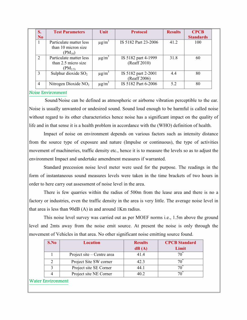
S.
No
Test Parameters Unit Protocol Results CPCB
Standards
1 Particulate matter less
than 10 micron size
(PM10)
µg/m3
IS 5182 Part 23-2006 41.2 100
2 Particulate matter less
than 2.5 micro size
(PM2.5)
µg/m3 IS 5182 part 4-1999
(Reaff 2010)
31.8 60
3 Sulphur dioxide SO2 µg/m3
IS 5182 part 2-2001
(Reaff 2006)
4.4 80
4 Nitrogen Dioxide NO2 µg/m3 IS 5182 Part 6-2006 5.2 80
Noise Environment
Sound/Noise can be defined as atmospheric or airborne vibration perceptible to the ear.
Noise is usually unwanted or undesired sound. Sound loud enough to be harmful is called noise
without regard to its other characteristics hence noise has a significant impact on the quality of
life and in that sense it is a health problem in accordance with the (WHO) definition of health.
Impact of noise on environment depends on various factors such as intensity distance
from the source type of exposure and nature (Impulse or continuous), the type of activities
movement of machineries, traffic density etc., hence it is to measure the levels so as to adjust the
environment Impact and undertake amendment measures if warranted.
Standard precession noise level meter were used for the purpose. The readings in the
form of instantaneous sound measures levels were taken in the time brackets of two hours in
order to here carry out assessment of noise level in the area.
There is few quarries within the radius of 500m from the lease area and there is no a
factory or industries, even the traffic density in the area is very little. The average noise level in
that area is less than 90dB (A) in and around 1Km radius.
This noise level survey was carried out as per MOEF norms i.e., 1.5m above the ground
level and 2mts away from the noise emit source. At present the noise is only through the
movement of Vehicles in that area. No other significant noise emitting source found.
S.No Location Results
dB (A)
CPCB Standard
Limit
1 Project site – Centre area 41.4 70*
2 Project Site SW corner 42.3 70*
3 Project site SE Corner 44.1 70*
4 Project site NE Corner 40.2 70*
Water Environment
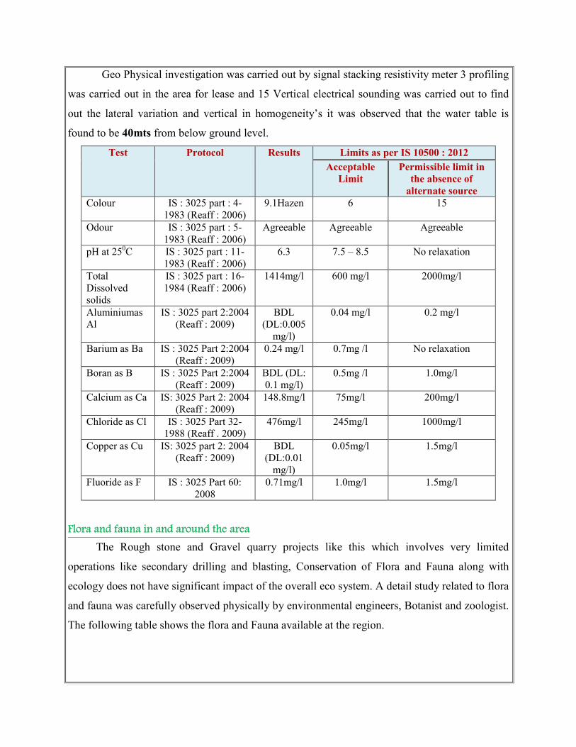
Geo Physical investigation was carried out by signal stacking resistivity meter 3 profiling
was carried out in the area for lease and 15 Vertical electrical sounding was carried out to find
out the lateral variation and vertical in homogeneity’s it was observed that the water table is
found to be 40mts from below ground level.
Test Protocol Results Limits as per IS 10500 : 2012
Acceptable
Limit
Permissible limit in
the absence of
alternate source
Colour IS : 3025 part : 4-
1983 (Reaff : 2006)
9.1Hazen 6 15
Odour IS : 3025 part : 5-
1983 (Reaff : 2006)
Agreeable Agreeable Agreeable
pH at 250C IS : 3025 part : 11-
1983 (Reaff : 2006)
6.3 7.5 – 8.5 No relaxation
Total
Dissolved
solids
IS : 3025 part : 16-
1984 (Reaff : 2006)
1414mg/l 600 mg/l 2000mg/l
Aluminiumas
Al
IS : 3025 part 2:2004
(Reaff : 2009)
BDL
(DL:0.005
mg/l)
0.04 mg/l
0.2 mg/l
Barium as Ba IS : 3025 Part 2:2004
(Reaff : 2009)
0.24 mg/l 0.7mg /l No relaxation
Boran as B IS : 3025 Part 2:2004
(Reaff : 2009)
BDL (DL:
0.1 mg/l)
0.5mg /l 1.0mg/l
Calcium as Ca IS: 3025 Part 2: 2004
(Reaff : 2009)
148.8mg/l 75mg/l 200mg/l
Chloride as Cl IS : 3025 Part 32-
1988 (Reaff . 2009)
476mg/l 245mg/l 1000mg/l
Copper as Cu IS: 3025 part 2: 2004
(Reaff : 2009)
BDL
(DL:0.01
mg/l)
0.05mg/l 1.5mg/l
Fluoride as F IS : 3025 Part 60:
2008
0.71mg/l 1.0mg/l 1.5mg/l
Flora and fauna in and around the area
The Rough stone and Gravel quarry projects like this which involves very limited
operations like secondary drilling and blasting, Conservation of Flora and Fauna along with
ecology does not have significant impact of the overall eco system. A detail study related to flora
and fauna was carefully observed physically by environmental engineers, Botanist and zoologist.
The following table shows the flora and Fauna available at the region.
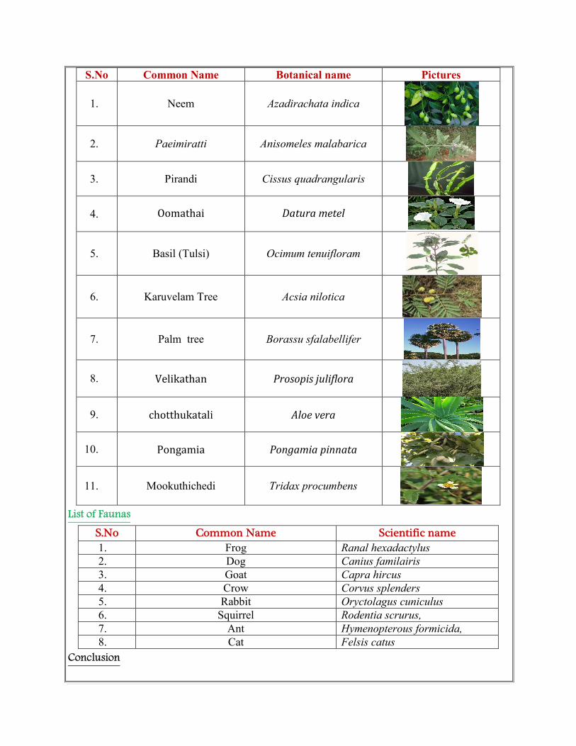
S.No Common Name Botanical name Pictures
1. Neem Azadirachata indica
2. Paeimiratti Anisomeles malabarica
3. Pirandi Cissus quadrangularis
4. Oomathai Datura metel
5. Basil (Tulsi) Ocimum tenuifloram
6. Karuvelam Tree Acsia nilotica
7. Palm tree Borassu sfalabellifer
8. Velikathan Prosopis juliflora
9. chotthukatali Aloe vera
10. Pongamia Pongamia pinnata
11. Mookuthichedi Tridax procumbens
List of Faunas
S.No Common Name Scientific name 1. Frog Ranal hexadactylus
2. Dog Canius familairis
3. Goat Capra hircus
4. Crow Corvus splenders
5. Rabbit Oryctolagus cuniculus
6. Squirrel Rodentia scrurus,
7. Ant Hymenopterous formicida,
8. Cat Felsis catus
Conclusion
The base line studies relents no hazardous levels of dust and noise and prevailing at the
project area. A well implemented environmental Management plan as discussed in the mining
plan will help in mitigation the adverse effects due to quarrying activities.
The movement of vehicles is very minimal. The entire vehicle used will be periodically
maintained by well experienced mechanic and kept under TNPCB standards, emission testing
will be carried out periodically and water will be sprinkled periodically to prevent dust into air.
The small quantity of non-humus rich surface soil will be removed and preserved in the
boundary barrier to facilitate the Afforestation.
Blasting will be used for heaving effect and not shattering effect hence the fly rock
problem will not arise. This is because the Rough stone industry requires only huge blocks which
are free from induced cracks and fissures.
Environmental care and attitude of preventing environment is inducted to the proponent
and advice to carry out and mitigate the minor impacts due to quarrying. Appropriate persons are
advice to get employed to protect the Environment and Ecology of the area.
Date : 07.02.2017
Place : Thoothukudi
1. Signature of the Applicant
V.Muthukumar
2. Signature of the Recognized qualified person
M. Ifthikhar Ahmed, M.Sc., F.G.S., M.B.A., M.M.E.A.,
RQP/MAS/183/2004/A