Potter Valley Hydroelectric Project Relicensing of...
21
Bahramian 1 WRPI: Water Resources Institute Final Report Potter Valley Hydroelectric Project Relicensing of Pacific Gas and Electric (PG&E) Mendocino and Lake Counties, California Jennifer Bahramian California State University East Bay June 8, 2017 – September 28, 2017 Advisor: Dawn Alvarez, US Forest Service, Pacific Southwest Region, Vallejo: Regional Hydropower Assistant Team Final Report: November 14, 2017
Transcript of Potter Valley Hydroelectric Project Relicensing of...
Bahramian 1
WRPI: Water Resources Institute Final Report
Potter Valley Hydroelectric Project Relicensing of Pacific Gas and Electric (PG&E)
Mendocino and Lake Counties, California
Jennifer Bahramian
California State University East Bay
June 8, 2017 – September 28, 2017
Advisor: Dawn Alvarez, US Forest Service, Pacific Southwest Region, Vallejo: Regional Hydropower Assistant Team
Final Report: November 14, 2017
Bahramian 2
Table of Contents
Acknowledgements -----------------------------------------------------------------------2
Executive Summary -----------------------------------------------------------------------3
Project Objectives ------------------------------------------------------------------------3-6
Project Approach --------------------------------------------------------------------------6-7
Project Outcomes --------------------------------------------------------------------------8-14
Conclusions -------------------------------------------------------------------------------- 14
References ----------------------------------------------------------------------------------15
Acronyms, and Abbreviations ------------------------------------------------------------ 16
Figures ---------------------------------------------------------------------------------------17-21
Acknowledgements
This project was supported by Hispanic-Serving Institution’s Education Program Grant no. 2015-38422-24058 from the USDA National Institute of Food and Agriculture.
I like to thank the guidance of my internship supervisor, Dawn Alvarez, the Pacific Southwest Region Fish Biologist, Hydropower Assistance Team. I would also like to acknowledge the genuine support of Forest Service Regional Program Specialist, Lily Nieves and WRPI Internship Manager, Christina Rodriguez.
Bahramian 3
Executive Summary
The Potter Valley is comprised of two dams, a powerhouse, and a diversion tunnel that
artificially connects the Eel River to the East Branch Russian River. The project is located in the
Eel River headwaters and diverts water out of the watershed through a tunnel in a mountain into
the Russian River. Since the location of this plant is between two, Eel River watershed and
Russian River watershed, considering the effect of climate change and overall condition of Eel
River with its salmonid and steelhead, it puts demands and imposes tougher environmental laws
and regulation for PG&E PAD. Yoshiyama and Moyle (2010) estimated that from 500,000 up to
1 million salmonids historically spawned in the Eel River watershed annually; Flow regime
alteration by dams and water diversions is one of the most serious and continuous threats to river
ecosystem sustainability (Poff et al. 1997; Bunn 2002). Project relicensing started on April 15,
2017, 5 years prior to expiration on April 14, 2022. In 2004, FERC issued an Order Amending
License for the Project which included a complex set of conditions to govern streamflow in both
the Eel River and East Branch Russian River, as well as storage levels in Lake Pillsbury. This
PAD is a requirement of the ILP. PG&E is filing the PAD with FERC simultaneously with the
notice of intent and distributing the PAD to federal and state resource agencies, local
governments, Native American tribes, members of the public, and others interested in the
relicensing proceeding. FERC staff prepares a scoping document that includes a preliminary list
of issues, and solicits comments on the scope of analysis of issues, which staff holds scoping
meetings, conducts a site visit, and issues a revised scoping document based on public and
agency input. Stakeholders (tribes, resource agencies, non-governmental organizations,
interested public, and FERC) submit study requests.
Project Objectives
Potter Valley is in Mendocino County, north-northeast of the town of Ukiah and at the
headwaters of the East Fork on the Russian River. The Ukiah Valley has major wine production
industry. Potter Valley also is a producer of wines; its rich agricultural soils planted mostly in
irrigated pasture, wine grapes, and pears and supports a wide verity of farms and ranches. Most
Bahramian 4
of the Project is located on lands owned by Pacific Gas and Electric (PG&E and National Forest
System Lands (NFSL)) administered by the United States Forest Service (USFS), Mendocino
National Forest (MNF). The Potter Valley Project began in the year 1905 when the town of
Ukiah and nearby areas around it needed more water, for the small coal-burning plant and natural
flow of the Russian River was no longer providing enough water for the fast-growing
agricultural and urban demands. Mr. W.W. Van Arsdale of San Francisco envisioned an
electrical power plant, powered by water, that could replace a small coal-burning plant at the
north end of Potter Valley on the Eel River and the East Branch Russian River. Mr. Van Arsdale
inspired by the Eel River being in 475 feet higher elevation than the valley so he builds the Cape
Horn Dam, which backed up the Eel River and formed a reservoir called Van Arsdale as well as
a one-mile (1.6 km) and 8-foot (2.4 m)-diameter tunnel under the drainage divide to Potter
Valley and over 450 feet vertical into the Potter Valley powerhouse, at the headwaters of the
East Branch of the Russian River. However, this project could only operate during the wet winter
months, when there was enough water in the Eel River to divert without drying up the riverbed
downstream. The Scott Dam, cyclopean concrete ogee gravity structure 12 miles (19 km)
upstream from Cape Horn Dam formed Lake Pillsbury, was built in 1922 with much greater
storage capacity that provides water for the diversion during the summer months.
On April 15, 1922, the Federal Power Commission (precursor to the Federal Energy Regulatory
Commission (FERC) which now licenses the Project) granted a 50-year license, which expired in
1972, for the project owned by the Snow Mountain Water and Power Company. In 1930 PG&E
bought the Project from Snow Mountain Water and Power and assumed the license. In 1983, the
Hydropower Project was relicensed for 50 years (from the original expiration date of 1972) and
was signed by PG&E, California Department of Fish and Game (CDFG) and three counties of
Mendocino, Sonoma, and Humboldt. Based on Article 39 10-year study undertaken to determine
the project water flows impact on the Eel River’s salmon and steelhead and establish the new
modified flow recommended by FERC. After a year or two other organizations like the Round
Valley Indian Tribes (RVIT) and Sonoma County Water Agency (SCWA) or Upper Russian
River Water Agency submitted proposals for minimum flow releases to FERC. A public scoping
meeting was held by FERC in February of 1998 for many organizations and water districts,
governmental agencies and environmental groups joined as interveners in the process resulting in
the completion of EIS Draft. In November of 2002 after a long Section 7 Consultation between
Bahramian 5
PF&E, FERC and National Marine Fisheries Service (NMFS), according to Endangered Species
Act, NMFS formed a Biological View and Reasonable and Prudent Alternative (RPA) for the
Project water flows that was submitted to FERC. As a result, FERC issued the License for the
Project on January 28, 2004, that expires on April 14, 2022.
To renew project license PG&E is filing with the (FERC or Commission) a Notice of Intent
(NOI) to begin official relicensing for the current 9.2-megawatt (MW) Potter Valley Project,
FERC Project No. 77. To initiate relicensing of the project PG&E uses FERC’s Integrated
Licensing Process (ILP). The ILP is a step by step process made up of pre-application activity
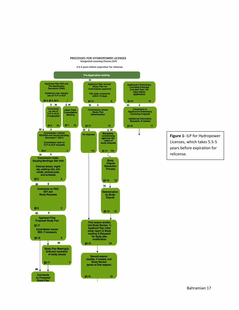
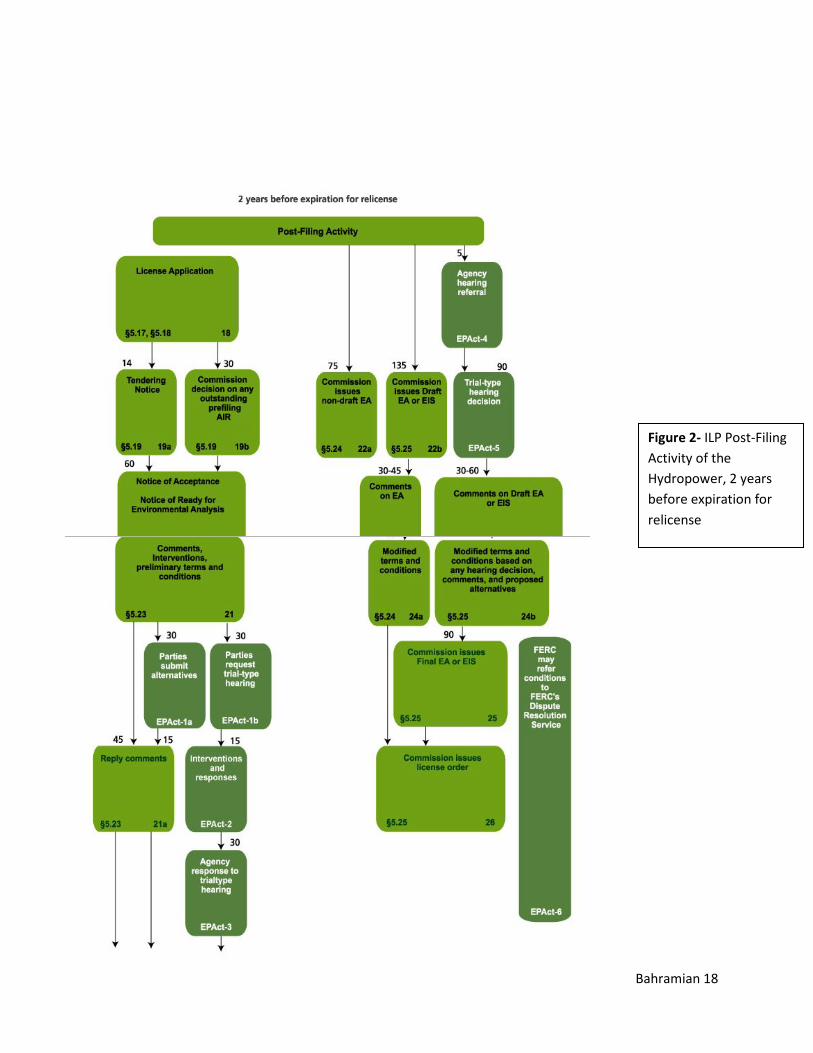
and post-filling activity. Figure 1&2 demonstrate the flow path process of pre-filing activity and
post-filing activity. In the preparation of this PAD, PG&E exercised due diligence by
communicating to governmental agencies, Native American tribes, and other organizations with
potentially having relevant information. The PAD provides participants the information
necessary to recognize issues and develop study requests and to familiarize those who plan to
participate in the relicensing. Information from the PAD will be used to support the
development of FERC’s Scoping Documents, the License Application (to be filed by April 14,
2020), and FERC’s Environmental Impact Statement or Environmental Assessment under the
National Environmental Policy Act (NEPA). PAD is organized into 7 sections:
Section 1.0. Introduction to the Project and relicensing process.
Section 2.0. Process Plan and Schedule for all relicensing activities through the
filing of the License Application; Proposed Communication Protocols; and ILP
Flow Chart.
Section 3.0. General Description of the Eel and Russian River Watersheds.
Section 4.0. Description of Project Location, Facilities, and Operation.
Section 5.0. Description of the Existing Environment by Resource Area.
Section 6.0. Potential Resource Issues; Potential Studies and Analyses; existing
and Proposed Measures; and Relevant Comprehensive Plans.
Section 7.0. Literature Cited.
My goal with WRI was aimed at first to use GIS to delineate watershed in Lassen National
Forest. I have been asked by my previous supervisor, at Hat Creek ranger district, to create pour
points which particularly uses TopModel modeling. However, this task was way out of my
Bahramian 6
background training and out of the time range of this internship. My revised goal is within the
scope of my education and has helped me to understand and grasp what I have studied in my
undergraduate years as an Environmental Science and geology major. My task in this project
was to survey PAD created by PG&E particularly focusing on section 6.0. potential resource
issues, studies, and analysis, read the FERC’s scoping documents(SDs) particularly SD2, and
briefly look at each stakeholder’s comments on the PAD documents including US Forest
Service, and finally compare all these organizations responses from both sides of the Eel and
Russian River watershed, to provide my input opinion based on what I have learned from this
project survey.
Project Approach
To achieve task and goal of this experiential learning project several procedures have been
followed to search, read, analyze and evaluate the documents at hands. Prior to any search or
creating any strategical procedures, a section of an interest has been suggested by the project
supervisor, which was focusing briefly on potential resource issues, potential studies and
analyses, and by focusing on scoping documents 2 comments as well as study request by other
stakeholders and organizations. A primary step started with the reading of PG&E’s PAD
document followed by reading the USFS study request, which comments on the “Potter Valley
Hydroelectric Project” PAD reflects on section 6.2 Potential Studies and Analyses. Forest
Service is requesting 26 new studies addressing areas of Aquatic Resources, Terrestrial
Resources, Cultural Resources, Land Resources, Recreation Resources, Potential Study Plan
Development, with each addressing seven study criteria:
Criteria 1- Goals and objectives of the study
Criteria 2- Explain the relevant resource management goals
Criteria 3- Explain any relevant public interest considerations
Criteria 4- Describe existing information concerning the subject of the study proposal
Bahramian 7
Criteria 5- Explain the nexus between project operations and effects on the resources to be
studied.
Criteria 6- Explain how any proposed study methodology is consistent with generally accepted
practice.
Criteria 7- Describe considerations of level of effort and cost.
Also, additional study requests are included in addition to earlier PG&E potential studies and
analyses to address information needs that have not been previously identified in the PAD.
The second approach was to survey Scoping Document 2 general comments on issues raised by
participants. Some of these entities were: Water Board, National Marine Fisheries Service,
Round Valley Indian Tribes, Wildlands Conservancy, Willits Environmental Center, Humboldt
County 3rd District Supervisor, Pacific Rivers, Native Fish Society, Center for Biological
Diversity, Save California’s Salmon, Pacific Coast Federation of Fishermen’s Associations, and
San Francisco Crab Boat Owners Association, American Whitewater, California Sportfishing
Protection Alliance, California Trout, Friends of the Eel River, Friends of the River, Trout
Unlimited, the Redwood Chapter of Trout Unlimited, and North Coast Rivers Alliance. These
organizations suggested alternatives ranged from full decommissioning with the removal of
project facilities, to removal or lowering of Scott Dam. Other comments were given on the
behalf of Dam Safety and New Study request, which have been mentioned above.
The third approach was to look at each entities study request and focus on critical issues that all
these organizations responded upon the pre-application document of PG&E and find strong
common ground. My focus was to briefly look at these responses by stakeholders: Center for
Biological Diversity, United States Department of the Interior national park service, North Coast
Regional Water Quality Control Board, Pacific Coast Federation of Fishermen’s Association
(PCFFA), Wiyot Tribe, Round Valley Indian Tribe and by briefly looking at National Oceanic
and Atmospheric Administration (NOAA).
Bahramian 8
Project Outcomes
Since the duration of this relicensing project surpasses my experiential learning at USFS and the
time for me to look at the further outcomes of these studies, and any updates are limited, I
finalize this project outcome according to my comprehension of these entities comments and
study request regarding PAD:
Center for Biological Diversity
The center for biological diversity urges FERC to consider, where applicable and where
information is available, the beneficial or adverse effects of the projects on a variety of resources
or interests, including but not limited to:
(1) listed threatened or endangered species; (2) economic viability of a project, including
costs of resource protection measures; (3) river targeted for fish recovery; (4) feasibility
of fish passage; (5) consistency with comprehensive plan(s); (6) protected river status
(e.g., scenic river, wilderness area); (7) effectiveness of past mitigation measures and
availability of future measures; (8) support by applicant or other party for
decommissioning; (9) Tribal lands, resources, or interests; (10) water quality issues,
including presence of toxic sediments; (11) potential opportunities for recreation; (12)
physical condition of project; (13) presence of existing project-dependent development
(e.g., houses abutting reservoir); (14) other non-power project-related benefits (e.g.,
municipal water supply, flood control, irrigation); (15) project-dependent resource values
(e.g., recreation, wetlands, wildlife, habitat); (16) need for power and ancillary services;
and (17) historic properties.
National Park Services (NPS) (Comments on Study Request)
The NPS pays specific attention to discussions of designated Wild and Scenic Rivers (WSRs)
within and downstream of the Potter Valley Project Area. The NPS focuses on discussions of
recreation use and opportunities in the Project Area, especially those related to whitewater
boating. The NPS mentions that the applicant proposes to conduct a Whitewater Boating
Flow Assessment, but claims that no further studies are needed as the available information
is sufficient to conduct the assessment and that there are no information gaps. The NPS
Bahramian 9
believes that the Applicant is unable to come to this conclusion without conducting a
formalized whitewater boating study that would provide more reliable and comprehensive
data that can be used in making recommendations on enhancing whitewater boating
opportunities and experiences.
North Coast Regional Water Quality Control Board (Regional Water Board)
The Regional Water Board requests a comprehensive study of water quality conditions, their
drivers, and the degree to which project operations affect those water quality conditions. The
water quality study should address temperature, dissolved oxygen, pH, mercury, nutrient
cycling, cyanobacteria harmful algal blooms (CyanoHABs), and aluminum. The goal of
these water quality Study is to: (1) characterize existing water quality conditions in Lake
Pillsbury; (2) determine consistency with state and federal water quality standards; and, (3)
identify potential Project operation and maintenance-related causes of water quality objective
exceedances and/or impairment of beneficial uses.
Pacific Coast Federation of Fishermen’s Association (PCFFA)
The PCFFA request that the following studies be part of the process:
1. A study of economic impacts to the Eel River and North Coast from the loss of
the commercial fisheries and recreational opportunities
2. Full cost/benefit analysis of the Potter Valley Project
3. An economic analysis of the benefits of a restored Eel River
4. Water rights and public trust investigation into the Potter Valley Project, which
includes options to replacement water to Russian River water rights holders in the
event dams are removed
5. A full analysis of habitat available above the dams that include the mapping of in
reservoirs springs and possible refugia for salmon, inundated habitat, and numbers
of salmon and trout that could be produced in the area based on new habitat
assessments
6. An analysis of water quality impacts of the reservoirs which explores reservoir
actions that could address these impacts. This analysis should look at temperature
Bahramian 10
impacts, Dissolved Oxygen impacts, toxic algae, along with mercury and
methylmercury production
7. An analysis of sediment fill and effectiveness for storing water, including water
to be used for chilly water releases
8. An analysis of Dam safety and needed to be changed to operations to address the
dam safety issues
9. A study that explores species genetics, and suggests a reintroduction plan for
Spring Chinook Salmon
10. A study that discusses sediment needs (coarse gravel) and scouring needs below
both dams
Wiyot Tribe
Wiyot Tribe state that because Scott Dam prevents upstream migrating anadromous fishes from
spawning habitat that exists above Lake Pillsbury, the geographic scope for fisheries analyses
should be modified to include those tributaries. The requested studies by this tribe are in 4
elements focusing on; 1) passage constraints for Impacted Species; 2) considering Pacific
lamprey passage issues at cape horn dam; 3) Pacific lamprey passage issues at Scott Dam; 4)
assessment of all migration barriers above Scott Dam with an assessment of available spawning
habitat below identified barriers to lake Pillsbury;
Round Valley Indian Tribe
The Round Valley Tribes propose five alternatives for evaluation in the EIS: 1) retention of all
existing project facilities, refinement of river flow management to provide improved conditions
for Eel River fisheries, construction of volitional or other fish passage around the project
facilities on the Eel River (adult migration, juvenile outmigration) for both salmonids and
lamprey, and investigation and implementation of water management and fisheries
improvements to minimize impacts on the Russian River, including Potter Valley Irrigation
District (PVID);
2) removal of all project facilities, restoration of full fish access for all native species, restoration
of the Eel River within the footprint of project facilities, and investigation and implementation of
Bahramian 11
water management and fisheries improvements to minimize impacts on the Russian River,
including PVID;
3) removal of Scott Dam to restore fish access for all native species, retention of Van Arsdale
Dam and diversion, maintenance of the Van Arsdale fish ladder, retention of diversion and
powerplant structures but with seasonal operation (December-April/May), and investigation and
implementation of water management and fisheries improvements to minimize impacts on the
Russian River, including PVID;
4) retention of all existing facilities for cold water pool and climate change opportunities,
shifting primary flow management focus to provide improved conditions for Eel River fisheries,
providing volitional or other fish passage around the project facilities on the Eel River (adult
migration, juvenile outmigration) for both salmonids and lamprey, and investigation and
implementation of water management and fisheries improvements to minimize impacts on the
Russian River, including PVID;
5) phased implementation of the Second Alternative, based on the resolution of water supply and
fisheries impacts on the Russian River, project ownership changes, funding, and/or improved
scientific understanding of future fisheries responses.
NOAA
Any information or study request (NMFS_Potter Valley PAD response p-77) must contain:
1. Effects of the Project on Fish Passage at Scott Dam and Lake Pillsbury
2. Effects of the Project on Fish Passage at Cape Horn Dam and Van Arsdale Reservoir
3. Anadromous Salmonid Reintroduction Plan
4. Evaluating Upper Eel River Habitat for Anadromous Salmonids
5. Evaluating Eel River Habitat Downstream of Scott Dam for Anadromous Fish
6. Chinook Salmon, Coho Salmon, and Steelhead Quantitative Life-Cycle Models to Assess
the Effects of the Potter Valley Hydroelectric Project.
Bahramian 12
7. Effects of the Project and Related Activities on Water Temperatures for Anadromous Fish
Migration, Holding, Spawning, and Rearing Needs.
8. Effects of the Project and Related Facilities Evaluated Through a Water Quality Model
9. Effect of the Project on Hydrology for Anadromous Fish and their Habitat
10. Effects of the Project and Related Facilities Evaluated Through an Operations Model
11. Effects of the Project on Fluvial Processes for Anadromous Fish Habitat
12. Effects of the Project on the Distribution and Abundance of Sacramento Pikeminnow in the
Eel River and Lake Pillsbury with Implications to Anadromous Fish Populations.
The Facilities and Operations to be Investigated:
• Scott Dam
“Scott Dam is a concrete, gravity-type, ogee-shaped structure with a maximum height of 130feet
and a total length of 805 feet.” (NMFS p. 2) Scott Dam physically obstructs flow and physically
blocks upstream and downstream migrating fish from passage. Fish swimming upstream or
downstream encounter the physical structure that blocks the natural river channel watercourse.
Prior to reaching Scott Dam, upstream migrating fish will encounter Cape Horn Dam, and
subsequently its forebay, Van Arsdale Reservoir. Cape Horn Dam is equipped with a fish
passage facility that is operational in most river conditions; however, may impede passage during
and following high flow events. Once fish ascend the fish way at Cape Horn Dam and navigate
through Van Arsdale Reservoir, their destination either ends at the base of Scott Dam, within the
approximate 13-mile reach of the Eel River between Scott and Cape Horn Dams, or within one
of the few spawning and rearing tributaries between the two dams.
• Lake Pillsbury
“Lake Pillsbury, shaped by the building of Scott Dam situated on the upper Eel River, has a
surface area of approximately 2,275 acres at the normal maximum water surface elevation of
1,828.3 feet and a current storage capacity of 76,876 acre-feet (ac-ft.). The reservoir is operated
Bahramian 13
to preserve a minimum reservoir storage of at least 10,000 ac-ft., resulting in a normal usable
storage of 66,876 ac-ft.” (PG&E 2017, pg. 4-31).” (NMFS p-2). The lacustrine environment
created by Lake Pillsbury includes water depths, velocities, and potentially water quality
conditions that do not resemble the pre-dam historic condition, or the riverine environment
typically encountered by adult salmonids migrating upstream or juvenile and adult salmonids
migrating downstream. it is unclear if anadromous fishes passed over Scott Dam and entering
Lake Pillsbury would successfully migrate to the upper Eel River watershed. It is also unclear
whether downstream migrating anadromous kelts or juveniles originating in the upper Eel could
successfully, in a volitional way, migrate through Lake Pillsbury and locate downstream passage
facilities near Scott Dam. In most years big volumes of water spillover Scott Dam during the
winter and early spring months. Anadromous fish going down through Lake Pillsbury during
these spillover events may pass over Scott Dam moving downstream, but most likely get injured
or parish on the concrete surface at the base of Scott Dam. Therefore, the possibility of effective
downstream passage over or through Lake Pillsbury’s current infrastructure is low, and the
likelihood of injury and mortality is high – due to the height of the dam, the hydraulic and
mechanical circumstances in route through the needle valve and predation interactions below.
Investigations of these impacts are valuable information requirements for this licensing process,
to allow suitable preventive measures to be prescribed or contemplated for prescription. (NMFS
p-3).
State Water Resources Control Board
State Water Board staff was disappointed that PG&E deviated from standard practices
demonstrated in other Commission relicensing processes (such as the Yuba River Development)
of proactively developing and proposing draft study plans in its PAD. The following is the list of
seven studies requested by State Water Board staff:
1. Water Quality Monitoring Study
2. Water Temperature Model Study
3. Water Balance/ Operations Model Study
4. Instream Flow Study
Bahramian 14
5. Fluvial Processes Study
6. Fish Population Study in the East Branch Russian River
7. Special Status Amphibians and Reptiles Study
Conclusions
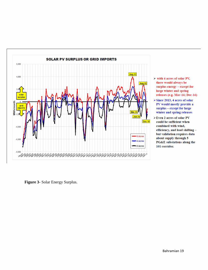
After all, looking at other alternatives to replace the Hydropower one comes to the conclusion
that solar energy is the best option available. According to John Rosenblum (2017), it is feasible
to replace hydropower with Solar batteries within Ukiah’s City limit because:
I. 3 acres of solar photovoltaics (13 MW rated) on parking lots.
II. 27 MWh battery storage
III. $40 million installed cost
Looking at Figure 3 one can see the high amount of energy releases by solar PV or solar grid
replacing the hydropower.
Internship Assessment
Involving shortly In Hydropower relicensing of PG&E with the help of my supervisor Dawn
Alvarez, I have been able to see beyond what I have studied as theory and experience the reality
of what is environmental law, which sits at the corner of the Politics, science, economics, ethics,
health and much more
Bahramian 15
References
Asarian, J.E. 2015. Long-Term Streamflow and Precipitation Trends in the Eel River Basin.
Prepared by Riverbend Sciences for Friends of the Eel River, Arcata, CA.
Poff, N. L., Allan, J. D., Bain, M. B., Karr, J. R., Prestegaard, K. L., Richter, B. D., Sparks, R. E.,
and Stromberg, J. C. 1997. The Natural Flow Regime. BioScience, 47(11), 769–784.
http://doi.org/10.2307/1313099
Rosenblum, J. 2017. Initial Feasibility Evaluation for Replacing Potter-Valley Hydropower with
Solar Energy. Prepared for Friends of Eel River
• http://www.pottervalleywater.org/history.html • https://en.wikipedia.org/wiki/Potter_Valley_Project
Bahramian 16
Acronyms, and Abbreviations
FERC or Commission Federal Energy Regulatory Commission
GIS Geographic Information System
ILP Integrated Licensing Process
kg kilogram: 1,000 grams
km2 square kilometer
km/day kilometer(s) per day
kV kilovolt: 1,000 volts
kVA kilovolt ampere
kW kilowatt
NEPA National Environmental Policy Act
NFSL National Forest System Land(s)
NMFS National Marine Fisheries Service
NOAA National Oceanic and Atmospheric Administration
NOI Notice of Intent
NRCS Natural Resources Conservation Service
PG&E or Licensee Pacific Gas and Electric Company
ppm parts per million
ppt parts per thousands
Project Vicinity The area extending to about 5 miles from the Project
Boundary.
PVID Potter Valley Irrigation District
SWRCB State Water Resources Control Board
USFWS U.S. Fish and Wildlife Service
USGS U.S. Geological Survey
Bahramian 17
Figure 1- ILP for Hydropower Licenses, which takes 5.5-5 years before expiration for relicense.
Bahramian 18
Figure 2- ILP Post-Filing Activity of the Hydropower, 2 years before expiration for relicense
Bahramian 19
Figure 3- Solar Energy Surplus.
Bahramian 20
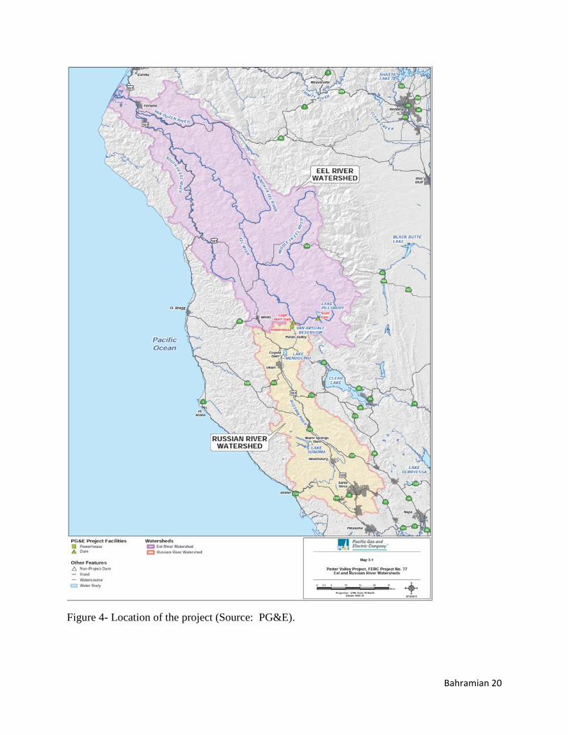
Figure 4- Location of the project (Source: PG&E).
Bahramian 21
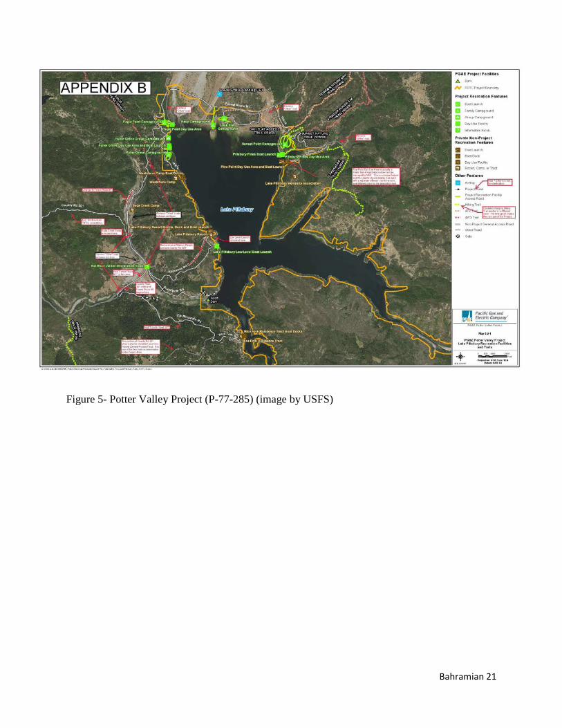
Figure 5- Potter Valley Project (P-77-285) (image by USFS)