Planning Policy Statement 15 (PPS 15): Planning and Flood Risk

Planning shapes the places where people live and
work and the country we live in It plays a key role
in supporting the Governmentrsquos wider economic
social and environmental objectives and for
sustainable communities
P L A N N I N GPlanning Policy Statement 25Development and Flood RiskPractice Guide
Updated December 2009
PL
AN
NIN
GP
OL
ICY
STA
TE
ME
NT
25
PR
AC
TIC
EG
UID
E|
Taking
floo
drisk
into
accou
nt
inth
ep
lann
ing
pro
cess
Planning Policy Statement 25 Development and Flood Risk Practice Guide
December 2009Department for Communities and Local Government
Department for Communities and Local GovernmentEland HouseBressenden PlaceLondon SW1E 5DUTelephone 030 3444 0000Website wwwcommunitiesgovuk
copy Crown Copyright 2009
Copyright in the typographical arrangement rests with the Crown
This publication excluding logos may be reproduced free of charge in any format or medium for research private study or for internal circulation within an organisation This is subject to it being reproduced accurately and not used in a misleading context The material must be acknowledged as Crown copyright and the title of the publication specified
This document is value added Please apply for a Click-Use Licence for value added material at wwwopsigovukclick-usesystemonlinepLoginasp or by writing to the Office of Public Sector Information Information Policy Team Kew Richmond Surrey TW9 4DU
e-mail licensingopsigovuk
If you require this publication in an alternative format please email alternativeformatscommunitiesgsigovuk
Communities and Local Government PublicationsTel 0300 123 1124Fax 0300 123 1125Email productcommunitiesgsigovukOnline via the Communities and Local Government website wwwcommunitiesgovuk
First published June 2008 2nd edition published December 2009
Product Code 09 PD 06171
ISBN 978 1 4098 2055 0
1 Introduction 1How will this guide help you 2Who should use the guide 3How this update of the guide was prepared 4Status of the guide 4Further information and references 5
2 Taking flood risk into account in the planning process 6Introduction 6Managing flood risk strategically 6The key stages in taking flood risk into account in the planning process 14Regional Spatial Strategies 14Local Development Documents 17Individual Planning Applications 20Key consultees to the planning process 25Monitoring and review of PPS25 28Illustrative case studies 28Further information and references 35
3 The assessment of flood risk 37Introduction 37Aims of flood risk assessments 37The source-pathway-receptor approach 38Assessing flood risk 42Types of flood risk assessment 43Regional Flood Risk Appraisal (RFRA) 44Strategic Flood Risk Assessment (SFRA) 49Site-specific flood risk assessment (FRA) 68Climate change 75Lifetime of development 77A hypothetical example of how the flood risk assessment process should work 78Further information and references 80
4 The Sequential and Exception Tests 81Introduction 81The sequential approach 82The sequential test 85The exception test 95Flood risk vulnerability classifications 101Functional floodplain 104Further information and references 106
Contents
5 Managing surface water 107Introduction 107The role of the planning system in surface water management 108Managing surface water at source sustainable drainage systems 109Role and responsibilities of planning bodiesauthorities 111Role and responsibilities of developers 114Environmental improvements amp issues for planning 120Role of the strategic flood risk assessment (SFRA) 124Surface water management plans and how they integrate into the planning system 124Site-specific surface water management 129Householder permitted development rights 131Further information and references 132
6 Risk management by design 134Introduction 134Risk management options for new development sites 135Building design 145Taking climate change into account in the design of flood risk management measures 151Design of flood protection infrastructure taking account of uncertainty and 152 freeboard allowancesInsurance issues 152Further information and references 153
7 Residual risk 154Introduction 154Residual risk in SFRAs 155Residual risk in FRAs 155Residual flood risk behind flood defences 156Other infrastructure acting as a flood defence 160Assessingmanaging residual risk from reservoirs and other artificial water retaining 160 structuresAssessing other residual flood risks 162Flood warning and evacuation plans 162Further information and references 165
Appendix A PPS25 in context with other national planning policy 166
Appendix B FRA checklist 168
Appendix C Relevant policies plans and sources of information 174
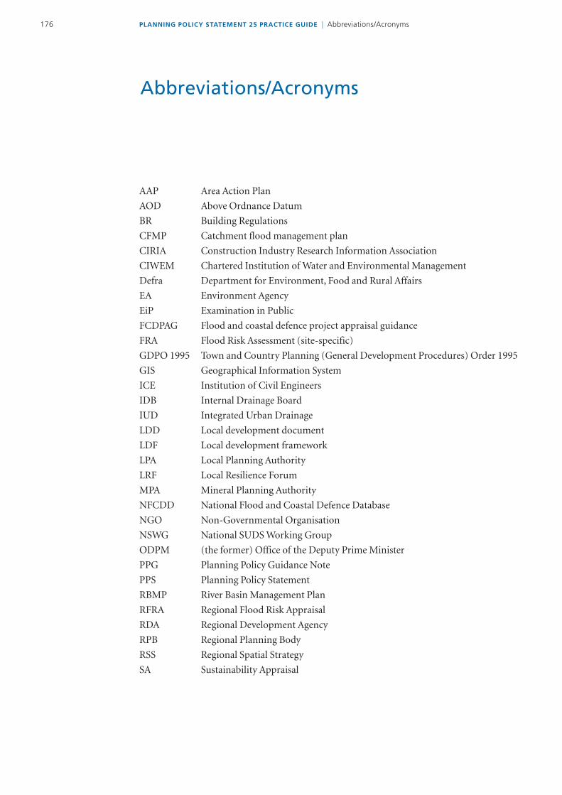
AbbreviationsAcronyms 176
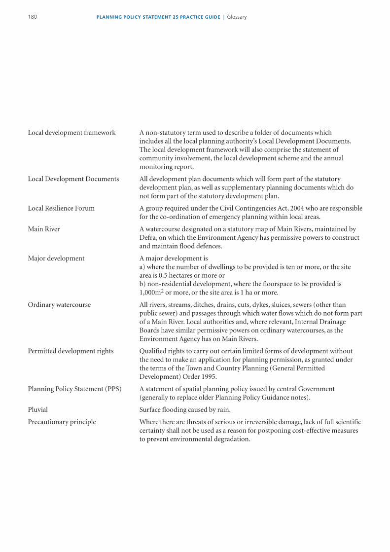
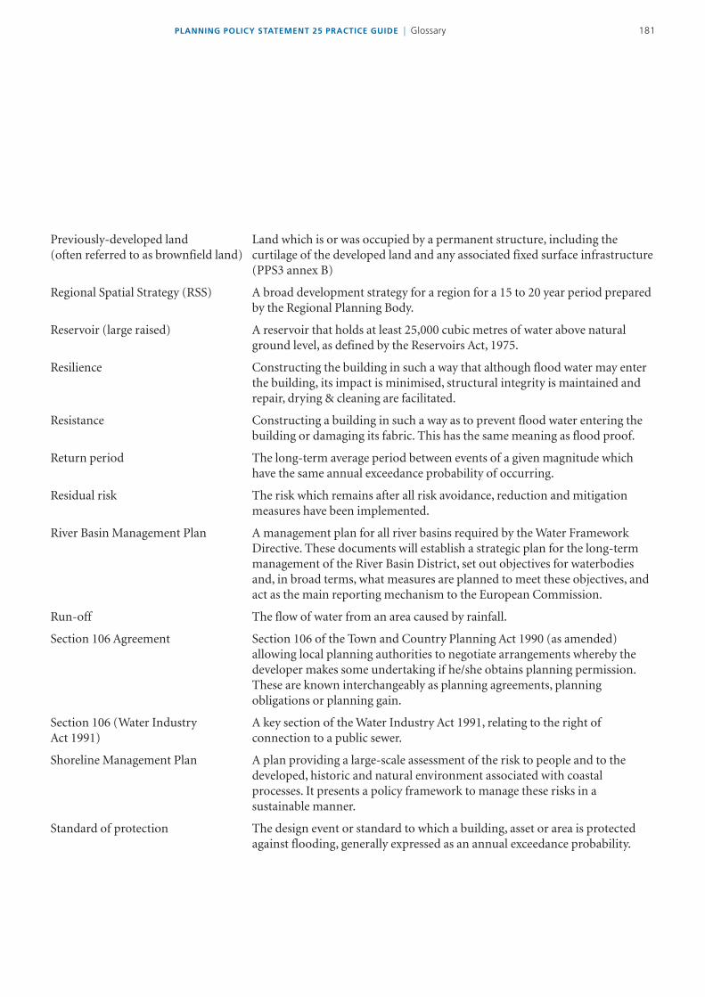
Glossary 178
Updating the PPS25 Practice GuideSummary of main changes
This update of the practice guide replaces the version of the guide that was published on the Communities and Local Government website in June 2008 It reflects the intention announced at the time of publication to keep the guide fresh and relevant through periodic updates
Our approach to this update is explained in paragraphs 111-14 below Many of the amendments made are relatively minor and it would not be appropriate or helpful to list every change here However your attention is drawn to the following more substantial changes from the June 2008 version of the guide
Chapter 2 Taking flood risk into account in the planning process
Additional advice on applying the sequential approach at the regional level over a longer time frame ndash see paragraph 214
Reference to the role of waste and mineral planning authorities as lsquolead local flood authorityrsquo paragraph 230
Clarification on the provision of a site-specific flood risk assessment (FRA) with a planning application ndash see paragraphs 235-36 also paragraph 382
Emphasis on the need to consult British Waterways when appropriate ndash see paragraph 259
New case studies illustrating planning appeals where a sequential approach has not been properly followed and new and updated case studies illustrating strategic approaches to managing flood risk
vPLANNING POLICY STATEMENT 25 PRACTICE GUIDE | Summary of main changes
Chapter 3 The assessment of flood risk
Reference to Environment Agency mapping of areas susceptible to surface water flooding and advice on the use of this map in spatial planning particularly in flood risk assessment ndash paragraphs 38 amp 39 amp 327
Guidance on the chance of flooding occurring during the lifetime of a development ndash see paragraph 314 and associated footnote
Clarification that flood risk appraisalassessments do not have to be supervised by someone with chartered status ndash see paragraph 320
Further advice on undertaking strategic flood risk assessments (SFRA) ndash see paragraphs 340-344 and 364
Further advice on the issues relating to guidance provided within SFRAs including on the role of surface water management plans ndash see paragraphs 370-79
Further guidance on the need for a proportionate approach to FRAs ndash see paragraph 386
Updated guidance on climate change impacts ndash see paragraphs 396-398 Also paragraph 641 in relation to the design of flood risk management measures
New and updated case studies on regional flood risk appraisal SFRAs and site-specific FRAs
Chapter 4 The Sequential and Exception Tests
Updated guidance on applying the sequential approach to other sources of flooding including use of Environment Agency mapping of areas susceptible to surface water flooding ndash see paragraphs 411-412
Further advice on the application of the Sequential Test including on the availability of alternative sites ndash paragraph 419 amp 425 and in relation to regeneration areas ndash paragraph 438 and wind farms ndash paragraph 439
Updated advice on sequential testing of site allocations informed by a SFRA when local development documents are reviewed or being finalised ndash paragraph 422
Clarification on the approach to a proposed change of use of land to a caravan or camping (or similar) site ndash paragraphs 443-444
Additional guidance on the lsquowhat is safersquo element of the exception test ndash paragraphs 454-468
PLANNING POLICY STATEMENT 25 PRACTICE GUIDE | Summary of main changesvi
Clarification of the approach to developments containing different elements of vulnerability to flood risk ndash paragraph 473
Expansion of advice on the application of the policy to critical infrastructure ndash paragraph 482
Further clarification on defining functional floodplains ndash paragraph 494
New case studies on applying the sequential approachtest including the role of SFRAs
Chapter 5 Managing surface water
Further guidance on sustainable drainage systems (SUDS) ndash paragraphs 514 517-524 and on the adoption and maintenance of SUDS ndash paragraphs 528-530
Updated guidance on surface water management plans integrated urban drainage and water cycle studies ndash paragraphs 537-546
Updated advice on the right to connect foul drainage to public sewers ndash paragraph 552
Updated guidance on permitted development rights and permeable surfaces ndash paragraphs 555-557
New and updated case studies illustrating surface water management and the use of SUDS
Chapter 6 Risk management by design
Update on changes to UK Climate Change Projections in relation to flood risk management measures ndash paragraph 641
Updated guidance on insurance issues ndash paragraph 649
New case studies with examples of upstream flood storage developer contributions to flood alleviation schemes and innovative design
Chapter 7 Residual risk
Advice on the need to consult British Waterways where appropriate ndash see paragraph 76
Additional factors to be taken into account in assessing residual flood risk associated with overtopping or breaching of a flood defence ndash paragraph 713
Further and updated guidance on emergency planning and inundation maps for flooding from reservoirs ndash paragraphs 718-720
Updated case study on SFRA and residual flood risk
viiPLANNING POLICY STATEMENT 25 PRACTICE GUIDE | Summary of main changes
Appendix A PPS25 in context with other national planning policy
Updated in relation to other national planning policy
Appendix B Flood Risk Assessment (FRA) checklist
Formerly appendix C providing a FRA pro-forma now amended to make clear that this form should be used as a checklist (or aide-memoire)
PLANNING POLICY STATEMENT 25 PRACTICE GUIDE | Summary of main changesviiii
1PLANNING POLICY STATEMENT 25 PRACTICE GUIDE | Introduction
1 Introduction
11 Planning Policy Statement 25 (PPS25) Development and Flood Risk (Communities and Local Government 2006) is about positive planning at all levels to deliver appropriate sustainable development in the right places taking full account of flood risk PPS25 sets out the policy approach This practice guide explains further how to implement this approach
12 PPS25 is part of the holistic approach to managing risk set out in the Governmentrsquos strategy for flood and coastal erosion management Making Space for Water (Defra 2005) Planning has a key role to play in avoiding and reducing the risk from floods
13 Flooding from rivers and coastal waters is a natural process that plays an important role in shaping the natural environment But flooding can cause substantial damage to property and threaten human life as the floods of summer 2007 showed Such damage is a consequence of previous decisions about the location and nature of settlement and land use It cannot be prevented entirely but its effects can be reduced We can manage new development in a way that ensures risks do not increase and can even be reduced
14 The aim of our policies for managing flood risk through the planning system is to avoid such inappropriate development in flood risk areas The key message of PPS25 is to avoid such inappropriate development and to locate development away from flood risk whenever possible The approach it adopts to do this is to assess risk so it can be avoided and managed This can be summarised in the following
assess ndash avoid ndash substitute ndash control ndash mitigate
The hierarchy used in this practice guide further develops the appraise manage and reduce flood risk approach in PPS25 This guide shows how this can be done in practice
15 Flood risk is likely to increase because of climate change Firm application of planning policy should mean risks can be managed allowing sustainable development to continue to benefit communities the economy and the environment The Stern Review on the Economics of Climate Change (HM Treasury 2006) pointed out that spatial planning is important in managing long-term flood risk by encouraging private and public investment towards locations that are less vulnerable to climate risks including flooding
16 Sir Michael Pittrsquos review of the summer 2007 floods (Cabinet Office 2008) supported PPS25 planning policy and urged that it should be rigorously applied by local planning authorities His final report recommended that the operation and effectiveness of PPS25 should be kept under review and strengthened if and when necessary
PLANNING POLICY STATEMENT 25 PRACTICE GUIDE | Introduction2
HOW WILL THIS GUIDE HELP YOU
17 The guide complements PPS25 by offering guidance on how to implement its policies in practice It draws on existing good practice through case studies and examples to show how regional planning bodies and local planning authorities can deliver the national policies in PPS25 in the light of their own varying circumstances
18 Each chapter is set within the context of the overall flood risk management hierarchy which is explained further in chapter 2
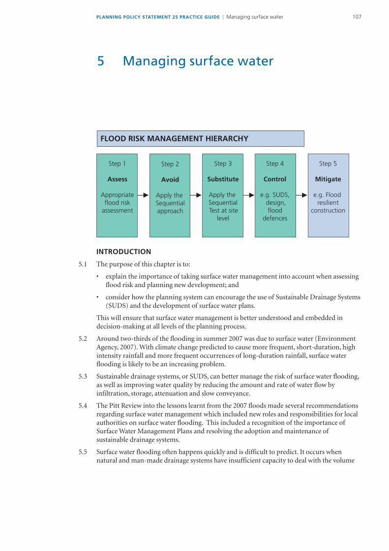
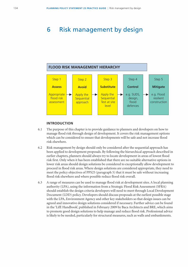
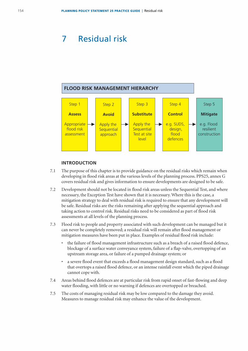
FLOOD RISK MANAGEMENT HIERARCHY
Step 2
Avoid
Apply the Sequentialapproach
Step 3
Substitute
Apply the Sequential Test at site
level
Step 4
Control
eg SUDS design flood
defences
Step 5
Mitigate
eg Flood resilient
construction
Step 1
Assess
Appropriateflood risk
assessment
19 At the beginning of each chapter this summary flow chart shows which part of the process the chapter relates to It acts as a reminder that these steps are sequential So for example you can only conclude that mitigation (step 5) is a possible solution to developing in areas at risk of flooding if all the previous steps have been considered first The hierarchy is colour coded as follows
Green step(s) relevant to chapter
Yellow step(s) covered in previous chapters
Blue step(s) covered in following chapters
Chapter 2 ndash Taking flood risk into account in the planning process explains how Regional and Sub-Regional Spatial Strategies Local Development Documents (LDDs) and Sustainability Appraisals should take flood risk into account in a strategic way It also explains what PPS25 means for those responsible for deciding individual planning applications An overview of the role of the various parties in the planning process is also provided
3PLANNING POLICY STATEMENT 25 PRACTICE GUIDE | Introduction
Chapter 3 ndash The assessment of flood risk provides guidance on how to do Regional Flood Risk Appraisals Strategic Flood Risk Assessments and site-specific Flood Risk Assessments
Chapter 4 ndash The Sequential and Exception Tests explains how to apply the sequential approach generally and how to apply the Sequential Test at a local level It also describes how to apply the Exception Test where this is relevant
Chapter 5 ndash Managing surface water provides guidance on the spatial planning considerations of a range of measures for mitigating the adverse impacts of conventional drainage systems An overview of the principles of sustainable drainage systems (SUDS) is provided together with signposts to relevant technical guidance on the design implementation maintenance and adoption of sustainable drainage measures The role of Surface Water Management Plans in the planning system is also covered
Chapter 6 ndash Risk management by design outlines a range of measures that can be implemented to reduce flood risk at development sites to an acceptable level
Chapter 7 ndash Residual risk describes some of the key residual risk issues and outlines a range of possible management measures The chapter discusses the limitations of measures designed to protect developments in flood risk areas
WHO SHOULD USE THE GUIDE
110 The guide is aimed at regional and local planning officers as well as development control officers An important principle of PPS25 is that flood risk should be considered at all levels of the planning process But it will also be relevant to anyone involved in the planning process such as
bull developersandtheiragentswhoneedtounderstandhowtheplanningprocessassessesflood risk and what is required to ensure that development is being located in appropriate places and designed to achieve the aims of PPS25
bull individualswithplanningapplicationswherefloodriskisanissuetohelpthemminimiseand where possible reduce flood risk overall
bull otherstakeholderswhoareinvolvedindevelopmentandfloodriskand
bull communitygroupswhowanttounderstandhowtheplanningsystemdealswithdevelopment in flood risk areas
PLANNING POLICY STATEMENT 25 PRACTICE GUIDE | Introduction4
HOW THIS UPDATE OF THE GUIDE WAS PREPARED
111 This update (December 2009) of the practice guide replaces the version of the guide that was published by Communities and Local Government in June 2008 It reflects the intention to update the guide at periodic intervals to keep it fresh and relevant
112 Communities and Local Government have recently undertaken an initial review of the implementation of PPS25 The findings were broadly positive and were followed up by a letter to local planning authorities in May 2009 drawing their attention to the reviewrsquos findings The letter emphasised the importance of reducing flood risk to and from new development through the application of PPS25 as recommended by Sir Michael Pitt in his final report published in 2008 Sir Michaelrsquos final report recommended that the operation and effectiveness of the policy in PPS25 should be kept under review and strengthened if and when necessary The review and update of this practice guide (which supports the policy) is in keeping with Sir Michaelrsquos recommendation and carries forward what the Government said about its intention to update the guide in its response to Sir Michaelrsquos review published in December 2008
113 This update of the practice guide reflects current and as far as it is possible to do so emerging Government policy It also takes into account any relevant legislation enacted since the guide was published in June 2008 Any further legislative measures which have a bearing on the matters covered by this guide will be reflected in future updates
114 As well as reflecting these developments this update of the guide draws on
bull feedbackfrompractitionersbothinthelightofimplementingPPS25policyinpracticeand in identifying certain circumstances where further clarification of the wording in the guidewouldbeofbenefitand
bull inputfromstaffattheEnvironmentAgencyDepartmentforEnvironmentFoodandRural Affairs (Defra) and members of the Practice Guide Advisory Group
115 Our thanks are due to all of those who have helped contribute to this update of the guide
STATUS OF THE GUIDE
116 This guide is intended to support and facilitate the implementation of the Governmentrsquos national planning policies on development and flood risk as set out in PPS25 As such it should be taken into account by regional planning bodies and local planning authorities in the preparation of regional spatial strategies and LDDs and when deciding planning applications
5PLANNING POLICY STATEMENT 25 PRACTICE GUIDE | Introduction
117 The use of examples taken from any development plan prior to its adoption is without prejudice to the Secretary of Statersquos rights of objection or direction in respect of plan policies or to call in plans for his own determination The use of any example whether from an adopted plan or otherwise is also without prejudice to any decision the Secretary of State may wish to take in respect of any planning application coming before him as a consequence of a policy included in an example in this guide
118 Where other published or electronically available material is cited apart from Government documents this is intended to provide pointers to good practice and does not necessarily confer full endorsement or adoption of the content by Communities and Local Government
119 The case studies used are intended to suggest good practice in ways of working rather than full endorsement of a particular proposal or decision
120 Also included with this update of the guide are a number of recent decisions made on planning appeals to the Secretary of State where the Planning Inspector has taken the view that the development proposal has not been in accordance with the policy approach in PPS25
FURTHER INFORMATION AND REFERENCES
Making Space for Water DEFRA 2005
Planning Policy Statement 25 Development and Flood Risk Communities and Local Government 2006
Stern Review on the Economics of Climate Change Cabinet Office ndash HM Treasury 2006
The Pitt Review Lessons Learned from the 2007 Floods Cabinet Office 2008
The Governmentrsquos Response to Sir Michael Pittrsquos Review of the Summer 2007 Floods DEFRA 2008and Progress Report Defra 2009
Initial review of the implementation of Planning Policy Statement 25 Development and Flood Risk Communities and Local Government 2009
PLANNING POLICY STATEMENT 25 PRACTICE GUIDE | Taking flood risk into account in the planning process6
FLOOD RISK MANAGEMENT HIERARCHY
Step 2
Avoid
Apply the Sequential approach
Step 3
Substitute
Apply the Sequential Test at site
level
Step 4
Control
eg SUDS design flood
defences
Step 5
Mitigate
eg Flood resilient
construction
Step 1
Assess
Appropriateflood risk
assessment
INTRODUCTION
21 This chapter explains how flood risk should be taken into account at all levels of the planning system By doing so inappropriate development can be avoided in flood risk areas which will help deliver sustainable development into the future
22 Planners have a key role in managing flood risk through the hierarchy above The planning system is the main way to avoid and reduce flood risk to and from new development It also offers opportunities to reduce flood risk to existing communities and developments through better management of surface water provision for conveyance and of storage for flood water
23 PPS25 is part of the plan led approach to spatial planning The aim is to set broad policies and allocations for an area taking full account of flood risk Once spatial plans are adopted there should be greater certainty that development can proceed in those allocated areas Individual planning applications which conform to plan policies should be straightforward in granting planning permission subject to other material considerations as the principles for development will already have been appraised in the formulation of the plans
MANAGING FLOOD RISK STRATEGICALLY
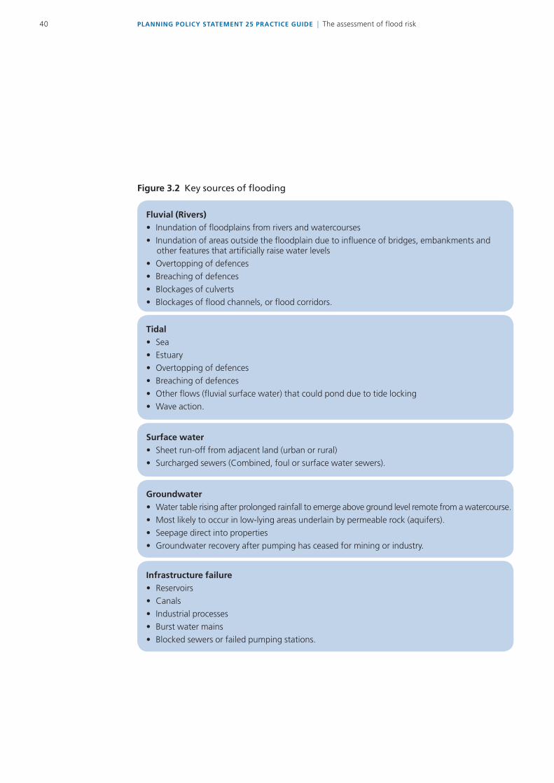
24 All forms of flooding (see figure 32) and their impact on the natural and built environment are material planning considerations PPS25 requires flood risk to be taken into account at all stages of the planning process to avoid inappropriate development This means using the hierarchy above at the same time as taking account of
bull thenatureoffloodrisk
bull thespatialdistributionoffloodrisk
bull climatechangeimpactsand
bull thedegreeofvulnerabilityofdifferenttypesofdevelopment
2 Taking flood risk into account in the planning process
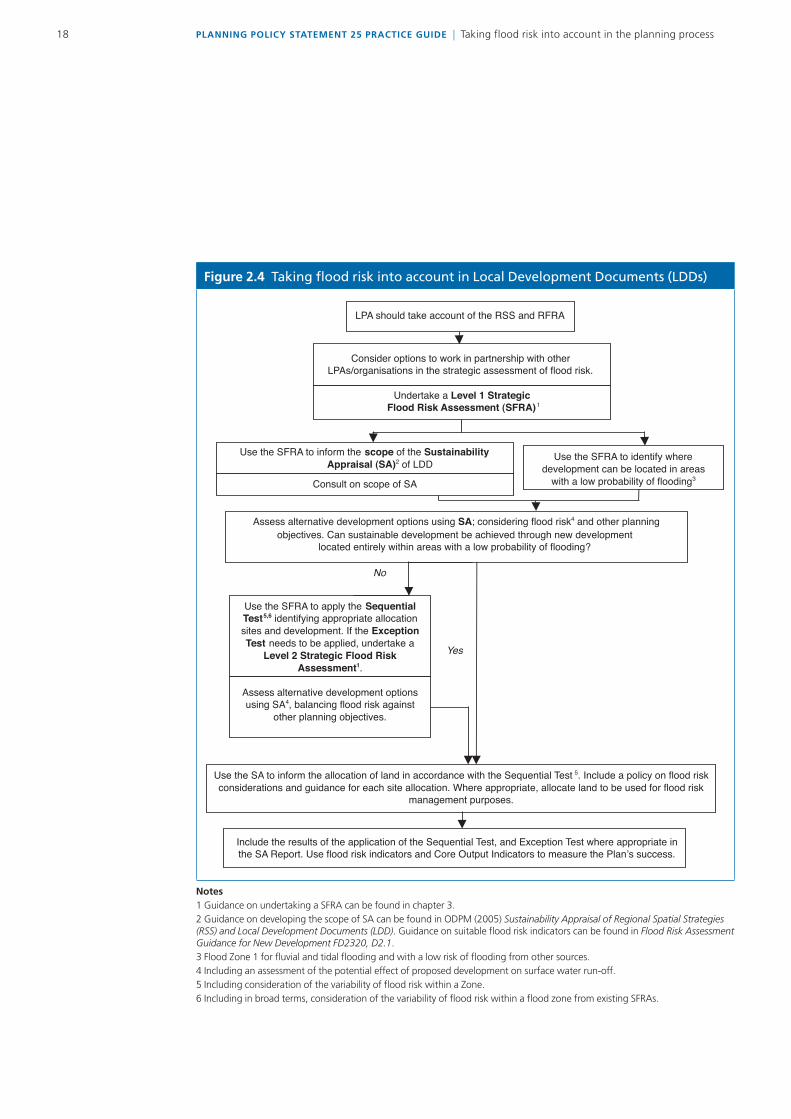
7PLANNING POLICY STATEMENT 25 PRACTICE GUIDE | Taking flood risk into account in the planning process
25 The spatial planning approaches advocated in PPS25 (including the emphasis on close partnership working) can assist with the strategic management of flood risk whilst realising the opportunities to improve the quality of the built and natural environment Illustrative case studies of these approaches being put into practice can be found at the end of this chapter
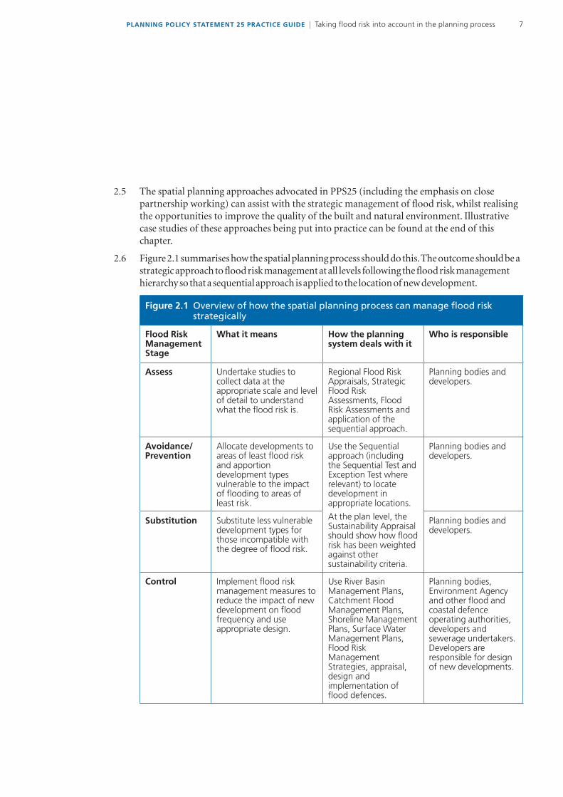
26 Figure 21 summarises how the spatial planning process should do this The outcome should be a strategic approach to flood risk management at all levels following the flood risk management hierarchy so that a sequential approach is applied to the location of new development
Figure 21 Overview of how the spatial planning process can manage flood risk strategically
Flood Risk Management Stage
What it means How the planning system deals with it
Who is responsible
Assess Undertake studies to collect data at the appropriate scale and level of detail to understand what the flood risk is
Regional Flood Risk Appraisals Strategic Flood Risk Assessments Flood Risk Assessments and application of the sequential approach
Planning bodies and developers
AvoidancePrevention
Allocate developments to areas of least flood risk and apportion development types vulnerable to the impact of flooding to areas of least risk
Use the Sequential approach (including the Sequential Test and Exception Test where relevant) to locate development in appropriate locations
At the plan level the Sustainability Appraisal should show how flood risk has been weighted against other sustainability criteria
Planning bodies and developers
Substitution Substitute less vulnerable development types for those incompatible with the degree of flood risk
Planning bodies and developers
Control Implement flood risk management measures to reduce the impact of new development on flood frequency and use appropriate design
Use River Basin Management Plans Catchment Flood Management Plans Shoreline Management Plans Surface Water Management Plans Flood Risk Management Strategies appraisal design and implementation of flood defences
Planning bodies Environment Agency and other flood and coastal defence operating authorities developers and sewerage undertakersDevelopers are responsible for design of new developments
Figure 21 Overview of how the spatial planning process can manage flood risk strategically (continued)
Flood Risk Management Stage
What it means How the planning system deals with it
Who is responsible
Mitigation Implement measures to mitigate residual risks
Flood risk assessments Incorporating flood resistance and resilience measures Emergency Planning Documents Implementation of flood warning and evacuation procedures
Planning bodies emergency planners developers the Environment Agency other flood and coastal defence operating authorities and sewerage undertakers
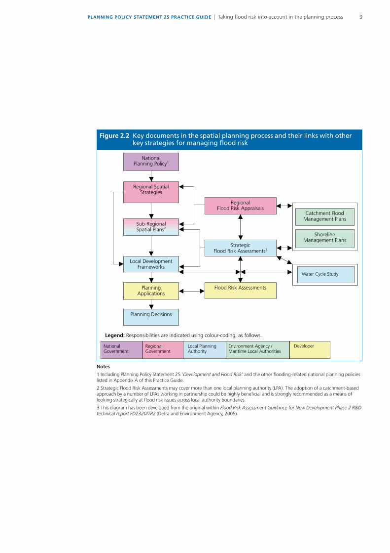
27 Figure 22 shows who is responsible for producing the key documents required to manage flood risk through each stage of the spatial planning process It also shows the link with other strategic documents prepared by flood and coastal defence operating authorities
PLANNING POLICY STATEMENT 25 PRACTICE GUIDE | Taking flood risk into account in the planning process8
9PLANNING POLICY STATEMENT 25 PRACTICE GUIDE | Taking flood risk into account in the planning process
Figure 22 Key documents in the spatial planning process and their links with other key strategies for managing flood risk
NationalPlanning Policy1
Regional SpatialStrategies
Sub-RegionalSpatial Plans2
Local DevelopmentFrameworks
PlanningApplications
Planning Decisions
RegionalFlood Risk Appraisals
StrategicFlood Risk Assessments2
Flood Risk Assessments
Catchment FloodManagement Plans
ShorelineManagement Plans
NationalGovernment
RegionalGovernment
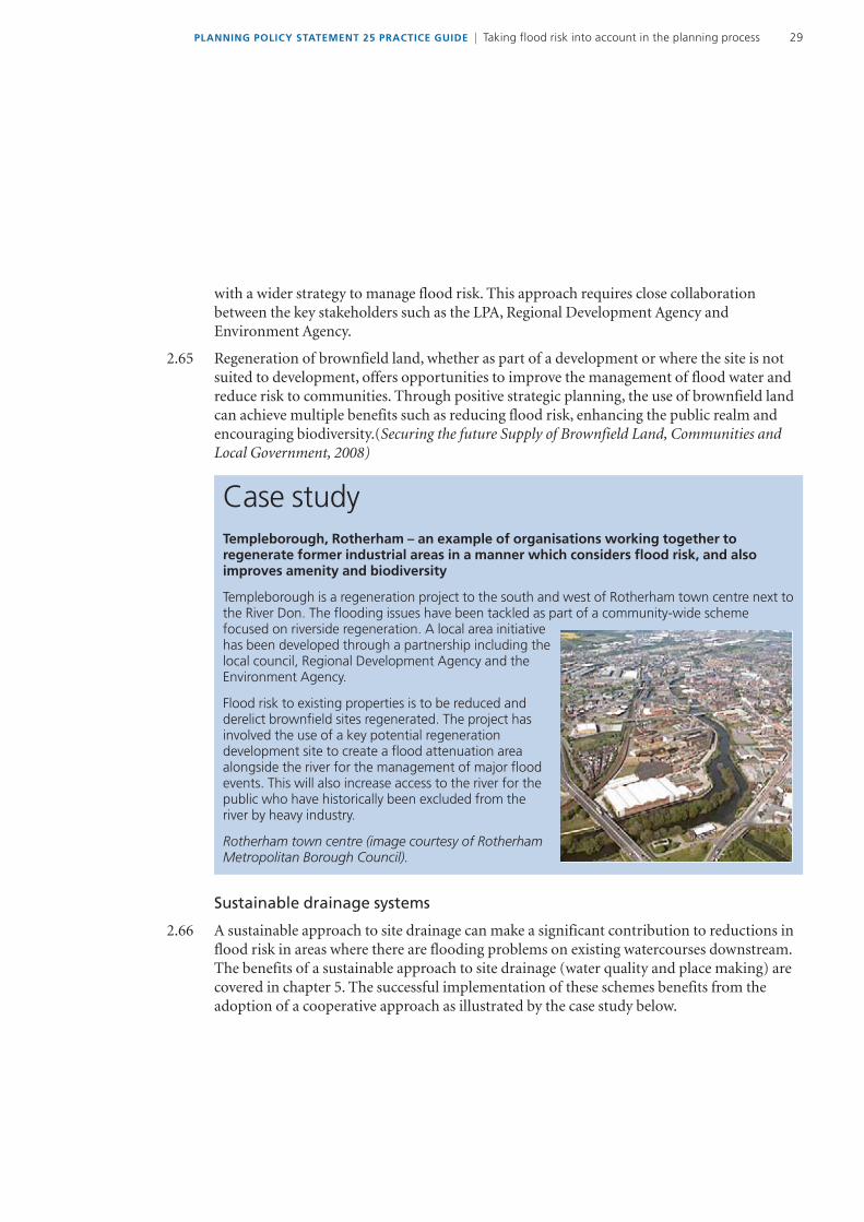
DeveloperEnvironment Agency Maritime Local Authorities
Local PlanningAuthority
Legend Responsibilities are indicated using colour-coding as follows
Water Cycle Study
Notes
1 Including Planning Policy Statement 25 lsquoDevelopment and Flood Riskrsquo and the other flooding-related national planning policies listed in Appendix A of this Practice Guide
2 Strategic Flood Risk Assessments may cover more than one local planning authority (LPA) The adoption of a catchment-based approach by a number of LPAs working in partnership could be highly beneficial and is strongly recommended as a means of looking strategically at flood risk issues across local authority boundaries
3 This diagram has been developed from the original within Flood Risk Assessment Guidance for New Development Phase 2 RampD technical report FD2320TR2 (Defra and Environment Agency 2005)
PLANNING POLICY STATEMENT 25 PRACTICE GUIDE | Taking flood risk into account in the planning process10
28 This strategic sequential approach (see chapter 4) is quite different from one which simply tries to match land uses to areas or zones with an lsquoacceptablersquo level of flood risk Under PPS25 (annex D table D1 defines flood zones) planners should steer development to Flood Zone 1 the zone of lowest flood risk wherever possible Where there are no reasonably available sites in Flood Zone 1 planners should consider reasonably available sites in Flood Zone 2 applying the Exception Test if necessary Only where there are no reasonably available sites in Flood Zones 1 or 2 should sites in Flood Zone 3 be considered The examples below are illustrations of planning applications that have been considered on appeal where a sequential approach has not been properly followed and as a consequence has had a bearing on the appeal decision reached
Examples of planning appeal decisions
Debenham Stowmarket ndash a planning appeal dismissed on Sequential Test grounds
The planning application (to build a detached two-storey dwelling and detached cart lodge adjacent to the River Deben) was refused by Mid-Suffolk District Council
There was disagreement between the parties over the level of flood risk The latest Environment Agency Flood Map showed the site falling within Flood Zone 3 and recent modelling suggested that part of it fell within Zone 3b the functional floodplain On the basis of this assessment the Agency maintained an objection in principle to the scheme
The Councilrsquos Strategic Flood Risk Assessment (SFRA) pointed to the site being within Zone 3 when climate change was taken into account as recommended in PPS25 and that a small section along the river frontage may be within the functional floodplain The appellant pointed to site specific modelling and assessment demonstrating that the site almost entirely lay outside the 1100 year flood event and that even allowing for climate change flooding would only encroach onto part of the site This put the site into Zones 2 and 3 on the basis of the appellantrsquos assessment
Continued
The ford at Water Lane Debenham near the proposed development site when dry and in flood Images courtesy of the Environment Agency and Mr P Carter
11PLANNING POLICY STATEMENT 25 PRACTICE GUIDE | Taking flood risk into account in the planning process
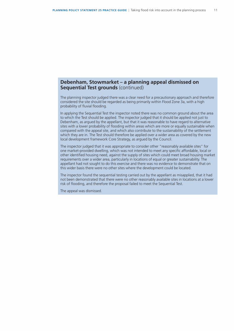
Debenham Stowmarket ndash a planning appeal dismissed on Sequential Test grounds (continued)
The planning inspector judged there was a clear need for a precautionary approach and therefore considered the site should be regarded as being primarily within Flood Zone 3a with a high probability of fluvial flooding
In applying the Sequential Test the inspector noted there was no common ground about the area to which the Test should be applied The inspector judged that it should be applied not just to Debenham as argued by the appellant but that it was reasonable to have regard to alternative sites with a lower probability of flooding within areas which are more or equally sustainable when compared with the appeal site and which also contribute to the sustainability of the settlement which they are in The Test should therefore be applied over a wider area as covered by the new local development framework Core Strategy as argued by the Council
The inspector judged that it was appropriate to consider other ldquoreasonably available sitesrdquo for one market-provided dwelling which was not intended to meet any specific affordable local or other identified housing need against the supply of sites which could meet broad housing market requirements over a wider area particularly in locations of equal or greater sustainability The appellant had not sought to do this exercise and there was no evidence to demonstrate that on this wider basis there were no other sites where the development could be located
The inspector found the sequential testing carried out by the appellant as misapplied that it had not been demonstrated that there were no other reasonably available sites in locations at a lower risk of flooding and therefore the proposal failed to meet the Sequential Test
The appeal was dismissed
PLANNING POLICY STATEMENT 25 PRACTICE GUIDE | Taking flood risk into account in the planning process12
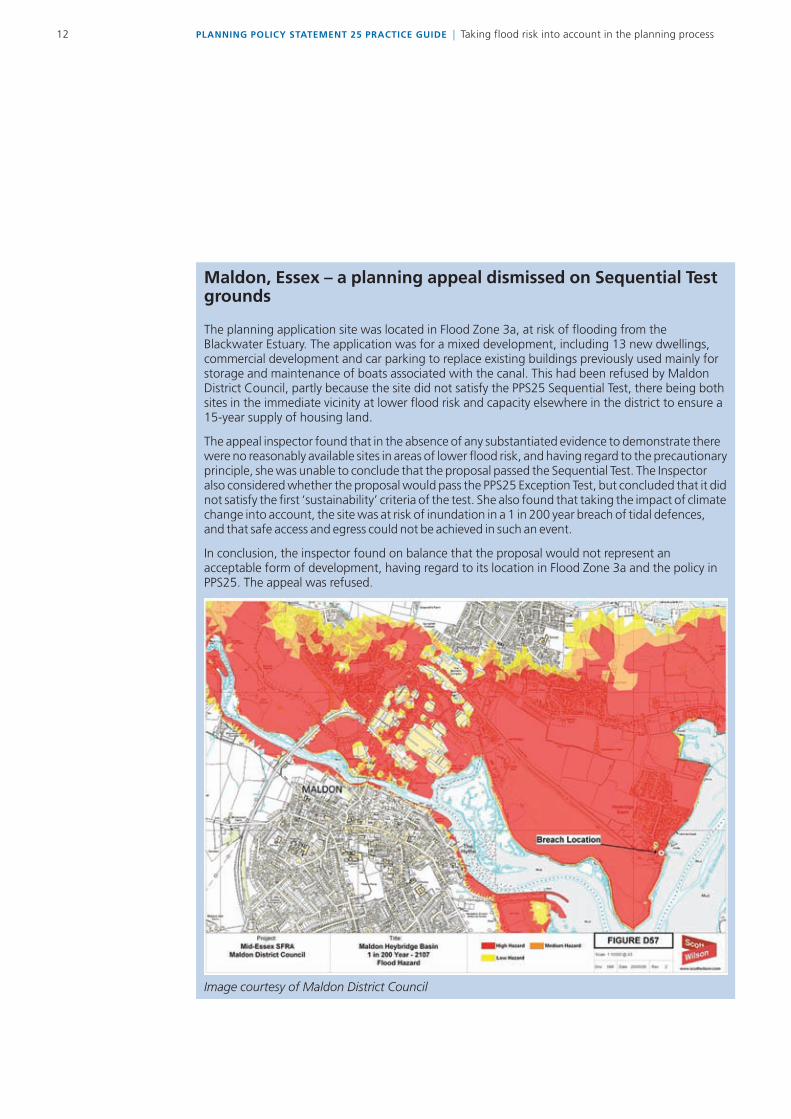
Maldon Essex ndash a planning appeal dismissed on Sequential Test grounds
The planning application site was located in Flood Zone 3a at risk of flooding from the Blackwater Estuary The application was for a mixed development including 13 new dwellings commercial development and car parking to replace existing buildings previously used mainly for storage and maintenance of boats associated with the canal This had been refused by Maldon District Council partly because the site did not satisfy the PPS25 Sequential Test there being both sites in the immediate vicinity at lower flood risk and capacity elsewhere in the district to ensure a 15-year supply of housing land
The appeal inspector found that in the absence of any substantiated evidence to demonstrate there were no reasonably available sites in areas of lower flood risk and having regard to the precautionary principle she was unable to conclude that the proposal passed the Sequential Test The Inspector also considered whether the proposal would pass the PPS25 Exception Test but concluded that it did not satisfy the first lsquosustainabilityrsquo criteria of the test She also found that taking the impact of climate change into account the site was at risk of inundation in a 1 in 200 year breach of tidal defences and that safe access and egress could not be achieved in such an event
In conclusion the inspector found on balance that the proposal would not represent an acceptable form of development having regard to its location in Flood Zone 3a and the policy in PPS25 The appeal was refused
Image courtesy of Maldon District Council
13PLANNING POLICY STATEMENT 25 PRACTICE GUIDE | Taking flood risk into account in the planning process
Brentmead Place Barnet London ndash a planning appeal dismissed on the lack of a Sequential Test
The planning application site was located partly within Flood Zone 3a and partly within Zone 3b the functional flood plain The application (to replace derelict houses with new build residential student accommodation) was refused by the Council of the London Borough of Barnet
The applicant failed to provide documents that met the minimum requirements for a Flood Risk Assessment Evidence for the PPS25 Sequential and Exception Tests was provided subsequently The Sequential Test was based on certain wards in the Borough of Barnet based on the incorrect assumption that the development was associated with the Hendon campus of Middlesex University
The appeal inspector considered the lack of association with any particular university She took into account the definition of lsquostudentrsquo in both the signed and draft unilateral undertakings and guidance in the PPS25 Practice Guide stating that the area to apply the Sequential Test will be defined by local circumstances relating to the catchment area of the development She judged the minimum area of search should have been the whole of the Borough of Barnet
It was considered that the appellant had failed to demonstrate that there were no reasonably available sites in Flood Zones 1 or 2 In addition the information submitted for the Exception Test did not demonstrate that the proposal would provide wider sustainability benefits that would outweigh the risk of flooding The access route to the site would be flooded in a flood event therefore safe access and egress to the site may not be possible The increase in the development footprint would reduce the flood storage capacity of the site and may lead to an increase in flooding elsewhere Accordingly it was found that the development proposal did not pass the Exception Test and the Sequential Test had not been appropriately applied
In conclusion the inspector found that the proposed development failed to comply with policy as set out in PPS25 Taking this into account with other concerns she dismissed the appeal
Decision-making and the role of sustainability appraisal
29 Those preparing Regional Spatial Strategies (RSSs) and Local Development Documents (LDDs) have to maintain a balance between considerations of flood risk and the various other sustainable development drivers as well as regional targets for housing economic growth and brownfield targets One way in which flood risk can be considered within the wider context of sustainability is through the Sustainability Appraisal (SA) process In order for flood risk to be properly evaluated at the SA stage an appropriate Regional Flood Risk Appraisal andor Strategic Flood Risk Assessment (see chapter 3) needs to be undertaken The approach in figure 21 provides the evidence-base required to ensure that the decision-making process takes adequate account of flood risk issues
210 The purpose of a SA is to promote sustainable development through the integration of social environmental and economic considerations into RSSs and LDDs SA for RSS
PLANNING POLICY STATEMENT 25 PRACTICE GUIDE | Taking flood risk into account in the planning process14
revisions new or revised LDDs and supplementary planning documents is a requirement of The Planning and Compulsory Purchase Act 2004 and must also incorporate the requirements of the Strategic Environmental Assessment Directive Government guidance and a methodology that seeks to meet both the SA requirements and comply with the Directive is set out in Sustainability Appraisal of Regional Spatial Strategies and Local Development Documents Guidance for Regional Planning Bodies and Local Planning Authorities (ODPM 2005)
211 The first stage of the SA process is to set the context and objectives establish the baseline and define a scope which is set out in a Sustainability Appraisal Scoping Report This report should identify the key sustainability issues or problems for the RSS or LDDs that it applies to Avoiding and reducing the risk of flooding should be identified as a sustainability objective if it is a pertinent issue regionally or locally and in some circumstances it may be highlighted as a key sustainability issue
THE KEY STAGES IN TAKING FLOOD RISK INTO ACCOUNT IN THE PLANNING PROCESS
REGIONAL SPATIAL STRATEGIES (RSSs)
212 A RSS should provide strategic policies for a region that are compatible with the requirements of PPS25 The policies for each RSS should recognise the flood risk issues unique to that region Revisions to RSS should be consistent with Strategic Flood Risk Assessments (SFRAs) emerging Catchment Flood Management Plans Shoreline Management Plans Surface Water Management Plans and (when they are in place ndash the first phase of which will be in December 2009) River Basin Management Plans which are being prepared in accordance with the Water Framework Directive
213 PPS25 requires that regional planning bodies (RPBs) carry out Regional Flood Risk Appraisals (RFRAs) to provide the evidence to support these policies Guidance on how to produce a RFRA is given in chapter 3 and in figure 23 below
214 In meeting its responsibilities under PPS25 the RPB should adopt a sequential approach in order to direct strategically significant growth areas towards locations with the lowest probability of flooding taking account of the lifetime of the resulting development and the forecast impacts of climate change wherever possible In England just under 90 per cent of land is within Flood Zone 1 so at a regional scale there will be many opportunities to direct development in this zone Chapter 4 provides further guidance on application of the sequential approach
215 RPBs should demonstrate in broad terms with evidence that they have applied the sequential approach to managing flood risk as part of the test of soundness of the RSS at the Examination in Public The RPB should consider climate change (PPS25 Annex B) and the
15PLANNING POLICY STATEMENT 25 PRACTICE GUIDE | Taking flood risk into account in the planning process
impact that could have on whether existing and planned flood defences will be adequate in the future The Environment Agency should be consulted to provide up-to-date information about their flood risk management strategies
216 The RPB should indicate at the Examination in Public those instances where other sustainability criteria outweigh flood risk for reasons of regional or national importance and provide evidence of the decision making process In these instances the flood risk lsquoavoidancersquo and lsquosubstitutionrsquo measures (see figure 21) are unlikely to be applied in full at the regional level and the onus to apply the Sequential Test falls with the local planning authority (LPA) An example of this would be the regeneration of an existing area which is a key priority to ensure its continued sustainability
217 RPBs should consider the impacts of proposed development on the remainder of the catchment RPBs should consider at a strategic scale whether there are opportunities to be gained to reduce flood risk to existing settlements through large-scale flood water storage schemes
218 The RSS should include policies to limit the vulnerability of development in flood risk areas by establishing locational criteria to guide development allocation at the local authority level Effective locational criteria will aid LPAs in applying the Sequential Test and help avoid the type of development that requires application of the Exception Test at the Local Development Document stage This is an example of locational criteria
lsquoWhere it is necessary following application of the Sequential Approach to locate new development in Flood Zones 2 and 3 such development should be focused within areas where
bull the preferred policy option in the relevant Catchment Flood Management Plan or Shoreline Management Plan is to lsquohold the line1rsquo over the lifetime of the development
bull the standard of protection afforded by the existing defences is compatible with the land use type proposed
bull application of the sequential approach using completed SFRAs has been used to identify the areas within the zone that are at least risk and
bull flood forecasting and warning systems as well as flooding emergency response procedures are well-developedrsquo
219 Such criteria will help LPAs when they apply the Sequential Test They will also help to keep to a minimum the number of cases where the Exception Test has to be applied
1 lsquohold the linersquo refers to a policy of maintaining the existing flood defences and control structures in their present positions and increasing the standard of protection against flooding in some areas
PLANNING POLICY STATEMENT 25 PRACTICE GUIDE | Taking flood risk into account in the planning process16
Figure 23 Taking flood risk into account in Regional Spatial Strategies (RSSs)
Undertake RegionalFlood Risk Appraisal (RFRA)1
Use the RFRA to inform the Scope of the Sustainability Appraisal 2
Consult on scope of Sustainability Appraisal
Assess development options using Sustainability Appraisal considering flood risk4 and otherplanning objectives Can sustainable development be achieved through a focus on
areas located entirely within areas with a low probability of flooding3
Use the RFRA to assess flood risk at other potential areas of growth using a
Sequential Approach 56
Direct development and draft policy in accordance with the Sequential Approach56 taking into account strategic flood risk management issues7
Use the RFRA to identify where development can be focused in areas
with a low probability of flooding 3
Assess alternative development options using Sustainability Appraisal
balancing flood risk against other planning objectives
Include guidance on the preparation of SFRAs
Include the results of the application of the Sequential Approach 5 in the Sustainability Appraisal Report Use flood risk indicators and Core Output Indicators to measure the success of the Plan
Yes
No
Notes1 Guidance on undertaking a RFRA can be found in chapter 32 Guidance on developing the scope of SA can be found in ODPM (2005) Sustainability Appraisal of Regional Spatial Strategies (RSS) and Local Development Documents (LDD) Guidance on suitable flood risk indicators can be found in Flood Risk Assessment Guidance for New Development FD2320 D213 Flood Zone 1 for fluvial and tidal flooding and with a low risk of flooding from other sources4 Including an assessment of the potential effect of proposed development on surface water run-off5 Including the likelihood of the Exception Test being passed where appropriate6 Including in broad terms consideration of the variability of flood risk within a Flood Zone from existing SFRAs7 As identified through consultation with the Environment Agency and other operating authorities
17PLANNING POLICY STATEMENT 25 PRACTICE GUIDE | Taking flood risk into account in the planning process
LOCAL DEvELOPMENT DOCUMENTS (LDDs)2
220 LDDs should deliver national and regional policy while also taking account of specific local issues and concerns The Core Strategy LDD should reflect the local planning authoritys (LPAs) strategic planning policies and approach to flood risk Site allocations should reflect the application of the Sequential Test as well as guidance on how flood risk issues should be addressed at sites allocated within flood risk areas Flood risk should be factored into LDDs in the detailed allocation of land use types across their area Figure 24 illustrates this process
221 PPS25 requires that LPAs prepare Strategic Flood Risk Assessments (SFRAs) (see chapter 3) to an appropriate level of detail to allow the Sequential Test to be applied in the site allocation process This is an essential part of the pre-productionevidence gathering stage of the plan preparation process It is strongly recommended that LPAs consider whether it would be more effective to work jointly with other local authorities and stakeholders to prepare a sub-regionalcounty SFRA The SFRA should take into consideration any regional guidance prepared by the RPB
222 The SFRA will provide the baseline information for the Sustainability Appraisal (SA) of LDDs for the scoping and evaluation stages It will also provide the evidence base for the application of the Sequential Test and the Exception Test in the land use allocation process The LPA should demonstrate through evidence that it has considered a range of options in conjunction with the flood risk information from the SFRA and applied the Sequential Test and where necessary the Exception Test in the site allocation process This can be undertaken directly or ideally as part of the SA Where other sustainability criteria outweigh flood risk issues the decision making process should be transparent with reasoned justifications for any decision to allocate land in areas at high risk in the SA report The process should take account of any locational criteria included in guidance prepared by the RPB
223 Site-specific allocations can be made in one or more LDDs LDDs should identify the specific flood risk related issues which will need to be addressed for certain site allocations when a planning application is submitted for their development
224 Area Action Plans provide the planning framework for key areas of change or conservation They should identify the distribution of uses and their inter-relationships and include specific site allocations Again the allocation of sites in Area Action Plans must reflect application of the Sequential Test and where necessary the Exception Test with transparent reasoned justifications provided for any decision to allocate land in areas at high risk Area Action Plans should also highlight the specific flood risk related issues which will need to be addressed for certain site allocations when a planning application is submitted for their development eg through criteria based policies on design and location of development
2 LDDs comprise Development Plan Documents and Supplementary Planning Documents Development Plan Documents are part of the lsquodevelopment planrsquo may allocate land for development and are tested at independent examination Supplementary Planning Documents may expand policies set out in a Development Plan Document or provide additional detail They must not be used to allocate land because they are not subject to independent examination Although only the term LDD is used in this document and in most cases it will be referring to a Development Plan Document the distinction above must be borne in mind
PLANNING POLICY STATEMENT 25 PRACTICE GUIDE | Taking flood risk into account in the planning process18
Figure 24 Taking flood risk into account in Local Development Documents (LDDs)
Use the SFRA to inform the scope of the SustainabilityAppraisal (SA)2 of LDD
Consult on scope of SA
Assess alternative development options using SA considering flood risk4 and other planningobjectives Can sustainable development be achieved through new development
located entirely within areas with a low probability of flooding
Use the SFRA to apply the SequentialTest56 identifying appropriate allocationsites and development If the ExceptionTest needs to be applied undertake a
Level 2 Strategic Flood RiskAssessment1
Use the SA to inform the allocation of land in accordance with the Sequential Test 5 Include a policy on flood riskconsiderations and guidance for each site allocation Where appropriate allocate land to be used for flood risk
management purposes
Consider options to work in partnership with otherLPAsorganisations in the strategic assessment of flood risk
Undertake a Level 1 StrategicFlood Risk Assessment (SFRA) 1
Assess alternative development optionsusing SA4 balancing flood risk against
other planning objectives
Include the results of the application of the Sequential Test and Exception Test where appropriate in
the SA Report Use flood risk indicators and Core Output Indicators to measure the Planrsquos success
LPA should take account of the RSS and RFRA
Use the SFRA to identify wheredevelopment can be located in areas
with a low probability of flooding3
No
Yes
Notes1 Guidance on undertaking a SFRA can be found in chapter 32 Guidance on developing the scope of SA can be found in ODPM (2005) Sustainability Appraisal of Regional Spatial Strategies (RSS) and Local Development Documents (LDD) Guidance on suitable flood risk indicators can be found in Flood Risk Assessment Guidance for New Development FD2320 D213 Flood Zone 1 for fluvial and tidal flooding and with a low risk of flooding from other sources4 Including an assessment of the potential effect of proposed development on surface water run-off5 Including consideration of the variability of flood risk within a Zone6 Including in broad terms consideration of the variability of flood risk within a flood zone from existing SFRAs
19PLANNING POLICY STATEMENT 25 PRACTICE GUIDE | Taking flood risk into account in the planning process
Taking flood risk into account in waste and mineral planning
225 Waste and mineral planning authorities (including county councils) need to take account of flood risk when allocating land for development Waste and mineral planning authorities (WMPAs) should develop their policies and plans with due regard to Regional Spatial Strategies (RSSs) Regional Flood Risk Appraisals (RFRAs) and any available SFRAs WMPAs should liaise with relevant LPAs to ensure that all issues are covered when scoping out the necessary elements a SFRA should cover The location of Mineral Safeguarding Areas and site allocations in particular in relation to sand and gravel workings which are often located in functional floodplains need to be identified By taking this holistic approach it is possible to explore benefits such as restoring mineral working located in flood risk areas to increase flood water storage which can reduce flood risk enhance biodiversity and the natural environment Partnership working on joint SFRAs offers the best opportunity to identify and realise these opportunities
226 There is no reason why the WMPA could not coordinate a SFRA working with other LPAs if this is a preferred approach For example Gloucestershire County Council are coordinating a SFRA covering six borough councils to produce one SFRA covering the whole county
227 Duplication of SFRAs should be avoided but where there is incomplete coverage of SFRAs of the area covered by a WMPA WMPAs should use the best information available and may need to carry out more detailed work in specific areas of concern Sources of readily available information include the Environment Agency Flood Map and historical information The aim is for each county to have SFRAs which cover the whole area either from one SFRA or from aggregated ones carried out by LPAs
228 WMPAs should apply the sequential approach to allocation of sites for waste management and where possible mineral extraction and processing Sand and gravel extraction is defined as lsquowater-compatible developmentrsquo in PPS25 (table D 2 PPS25) This acknowledges that sand and gravel deposits have to be worked where they are (often in flood risk areas) However mineral working should not increase flood risk elsewhere and need to be designed worked and restored accordingly Mineral workings can be large and may afford opportunities for applying the sequential approach at the site level It may be possible to locate ancillary facilities such as processing plant and offices in areas at lowest flood risk Sequential working and restoration can be designed to reduce flood risk by providing flood storage and attenuation This is likely to be most effective at a strategic (county) scale
229 Waste operations such as landfill sites can pose a pollution threat Risks will need to be fully taken into account in applying the sequential approach Waste treatment facilities are classified as lsquoless vulnerablersquo except where handling landfill or hazardous waste when they are classified as lsquomore vulnerablersquo (see table D2 PPS25)
PLANNING POLICY STATEMENT 25 PRACTICE GUIDE | Taking flood risk into account in the planning process20
230 WMPAs will in many cases also have the lsquolead local flood authorityrsquo role as set out in the letters of 17 December 2008 sent jointly by the Secretary of State for Environment Food and Rural Affairs and the Minister for Local Government to Chief Executives and subsequent Departmental letters of 29 April 2009 It is important that their roles as WMPA and lead local flood authority are complementary here
INDIvIDUAL PLANNING APPLICATIONS
The role of the developer
231 Paragraphs 22-23 of PPS25 make it clear that it is the responsibility of the developer to consider the flood risk issues at a site It is in their own interests to do this as early as possible Flood risk is one of many constraints that need to be investigated before taking forward a development and it can have significant implications for the value of and potential for a development site Whilst the Environment Agency Flood Map provides a useful indication of the likely flood risk issues at a site and the SFRA should provide further more detailed information including on surface water and local flood risk developers are advised to make independent checks prior to purchasing sites Guidance on assessing flood risk at development sites is provided in chapter 3 of this guide
232 If a proposed development is identified in a sequentially tested LDD that is supported by an SFRA the site will already have been through the Sequential Test As long as the development types making up the proposal are in accord with the LDD a developer can rely on the outcome of that testing However there may still be opportunities for the sequential approach to be considered within the site (flood risk substitution)
233 However where either
(a) the site allocation has been sequentially tested as part of the LDD but the proposed development is not consistent in scale development type and location with that allocation or
(b) the Sequential and Exception Tests have not been applied to the LDD and the site is withinanareaatriskofflooding
the developer will need to provide reasoned evidence in the Flood Risk Assessment (FRA) for the location of the proposed development This justification must explain how the development would meet the requirements of the Sequential and where necessary the Exception Tests It is the role of the local planning authority to carry out the actual test however (see chapter 4 below) based on this and its other sources of information
234 In any event the developer must apply the sequential approach to any flood risk within the site itself when determining the location of appropriate land uses For example where a site contains Flood Zone 1 and 2 land the most vulnerable uses should be located in areas where
21PLANNING POLICY STATEMENT 25 PRACTICE GUIDE | Taking flood risk into account in the planning process
the detailed FRA shows the lowest flood risk Guidance on use of the sequential approach within a development site is provided in chapter 4
235 The scope of any site-specific FRA should be agreed with the LPA if necessary in consultation with the Environment Agency and other relevant stakeholders One of the major reasons why the Environment Agency objects to planning applications is that a FRA is either absent or inadequate Ensuring that the FRA is appropriate will avoid delay and difficulty later The FRA must show that the applicant has considered flood risk from all sources and demonstrated how flood risk will be managed for the lifetime of the development taking climate change into account
236 Communities and Local Governmentrsquos standard application form (One App) sets out when a FRA is required It should be provided along with the application form when submitting the application to the LPA It will also mean that design issues such as the inclusion of sustainable drainage can be considered at an early stage What should be in an FRA is covered in more detail in chapter 3 A checklist which can serve as an aide memoir to developers on the matters their FRA should be taking into account is provided in appendix B
237 Once a planning application together with an appropriate FRA is submitted by the developer it will need to be validated in order for it to be considered and determined by the LPA In considering the application the LPA will consult and seek advice from the Environment Agency and other relevant authorities
238 The process from pre-purchase of land to submission of a completed planning application form with accompanying FRA is illustrated in figure 25
PLANNING POLICY STATEMENT 25 PRACTICE GUIDE | Taking flood risk into account in the planning process22
Figure 25 Taking flood risk into account in preparation of individual planning applications
Ask LPA if there is a current SFRA available 1
Has the site beenallocated for the
proposed land usetype in the Local
Development Document(LDD) using
the SequentialException tests2
Confirm with the LPA whether a Flood Risk Assessment (FRA) isrequired and if consultation is necessary with flood risk consultees4
Where applicable undertake pre-application consultation with theflood risk consultees Are there any known flooding-related siteconstraints which make the development proposed unviable
Does the proposed developmenthave the potential to pass the
Sequential Test andorException Test 3
Agree the scope of an appropriate FRA with the LPA based on thepre-application discussions Undertake FRA5 Is it possible todesign a new development which is safe and which does not
increase flood risk elsewhere6
Do the proposals fulfil the requirements of the Sequential TestHas reasoned justification been provided to the LPA wherever
they need to apply the Exception Test Have all contentious issuesbeen discussed and agreed with the LPA and flood risk
consultees
Identify vulnerability of proposed developmentland use type (Table D2 PPS25)
No
Yes
NoYes
No
Yes
Consult Local Planning Authority (LPA)Does the LPA confirm that theproposed development may be
acceptable
Consider alternativedevelopment site
No
Yes
Yes
No
Yes
No
Submit application to LPA using standard Planning ApplicationForm and accompanying FRA
Yes
No
Notes1 A SFRA can be defined as current if it has been prepared in accordance with PPS252 If the site has been allocated in this way then subsequent steps in the process are likely to be significantly more straightforward3 If a site has not been allocated in the LDD because it was considered that the flood risk is unacceptable it is unlikely that a proposed development at the site will be accepted by the LPA4 See paragraphs 249-260 of this Practice Guide for key consultees to the planning process with regard to flood risk5 Guidance on undertaking a FRA can be found in chapter 36 Including surface water management
23PLANNING POLICY STATEMENT 25 PRACTICE GUIDE | Taking flood risk into account in the planning process
The development control role of the local planning authority (LPA)
239 The LPA is the principal decision-maker on applications for new development LPAs should respond actively to requests for pre-application discussions with any developer expressing an interest in submitting a planning application for a site that is in an area at risk of flooding or which has potential to increase flood risk elsewhere Specifically the LPA should
bull statewhereadevelopmentproposalwouldbeunacceptableonfloodriskgrounds
bull referthedevelopertoanypolicieswithintheLDDwhichhavebeensequentiallytestedand are of relevance to the site including policies or guidance on acceptable land uses and theapplicationofsustainabledrainagemeasures
bull referthedevelopertotheStrategicFloodRiskAssessment(SFRA)asthisshouldformthebasisoftheapplicantssite-specificfloodriskassessment(FRA)
bull wherethesitehasnotbeenallocatedinaccordancewiththerequirementsoftheSequential and Exception Tests clarify the specific supporting information required to allow the LPA to apply the Sequential or Exception Test as part of the individual planning applicationprocess
bull advisethedeveloperontheneedforasite-specificFRA(seeparagraph380onwards)andconsultationwithEnvironmentAgencyandorotherfloodriskconsultees
bull setoutandagreethescopefortheFRAusingtheEnvironmentAgencyStandingAdvice(see paragraph 251 of this guide) or in direct consultation with the Environment Agency andanyrelevantfloodriskconsulteesasappropriateand
bull encouragepre-applicationdiscussionswiththeidentifiedfloodriskconsulteestoensureflood risk issues are resolved prior to submission of the planning application
240 On receipt of the application the LPA will consult the Environment Agency in accordance with Article 10 of the Town and Country Planning (General Development Procedure) Order 1995 (the GDPO) The GDPO was amended on 1 October 2006 to make the Environment Agency a statutory consultee for specified categories of development where flood risk is an issue The LPA must consult the Environment Agency as follows
bull developmentotherthanminordevelopmentinFloodZones2amp3
bull developmentinFloodZone1wheretherearecriticaldrainageproblems
bull anydevelopmentexceedingonehectareinextent
bull developmentwithin20mofthebanktopofaMainRiverand
bull anyculvertingoperationordevelopmentwhichcontrolstheflowofanyriverorstream
PLANNING POLICY STATEMENT 25 PRACTICE GUIDE | Taking flood risk into account in the planning process24
241 The Environment Agency is required to respond to consultations on pre-planning enquiries within 21 days unless otherwise formally agreed in writing The Environment Agency will object if a FRA is required and has not been submitted with the planning application
242 The Environment Agency advice and the evidence supplied by the developer will be used by the LPA as the basis for taking flood risk issues into account in their planning decision In coming to its decision the LPA should demonstrate how the requirements of the Sequential Test and where necessary the Exception Test have been met (see chapter 4) With the increased role of local authorities in local flood risk management as concluded by the Pitt Review and accepted by the Government the LPA should also consider the views of its other departments (eg for highways)
243 The Town and Country Planning (Consultation) (England) Direction 2009 subsumed within it the provisions of the previous (Flooding) (England) Direction 2007 which was then cancelled The Direction requires an LPA to notify the Secretary of State of any application for major development in a flood risk area where it is minded to grant permission despite a sustained objection from the Environment Agency on flood risk grounds This should only happen in a very small number of cases
244 Normally the developer will become aware of objections from the Environment Agency through its statutory consultee role described in paragraphs 240-242 The LPA the Environment Agency and the applicant should discuss and try to agree what changes could be made to the application that would enable the Environment Agency to withdraw its objection Experience so far under the Direction suggests that this will usually be possible
245 If even after discussions the Environment Agency concludes that it is unable to withdraw its objection it will advise the LPA within the set timeframe The LPA should then consider whether it is minded to grant permission or not If it is the Direction requires the LPA to notify the Secretary of State This should be done through the appropriate regional Government Office The Secretary of State will consider whether to call the application in for determination
246 For the purposes of the Direction development is defined as major if
bull forresidentialdevelopmentthenumberofdwellingstobeprovidedis10ormoreorthesite area is 05 hectares or more or
bull fornon-residentialdevelopmentthenewfloorspacetobeprovidedis1000squaremetres or more or the site area is 1 hectare or more
247 A flood risk area is defined as
bull landinanareawithinFloodZones2or3or
bull landinanareawithinFloodZone1whichhascriticaldrainageproblemsandwhichhasbeen notified to the local planning authority by the Environment Agency
25PLANNING POLICY STATEMENT 25 PRACTICE GUIDE | Taking flood risk into account in the planning process
248 All LPAs should notify the Environment Agency of the decision on a planning application where they have objected (paragraph 29 PPS25)
KEY CONSULTEES TO THE PLANNING PROCESS
The partnership approach
249 PPS25 (paragraph 6) advocates a partnership approach It is important to share expertise and information to be able to deliver effective and timely planning policy and decisions Partnership working should occur at all levels in the planning process through engagement with key stakeholders to ensure that flood risk is factored into the earliest stages of decisions and all key stakeholders are fully involved Partnership working provides opportunities for
bull bettercooperation
bull amorecoordinatedapproach
bull locallyagreedsustainablesolutionsand
bull facilitatingreductioninfloodriskthroughdevelopmentopportunities
The role of the Environment Agency
250 The Environment Agency is a statutory consultee for RSSs LDDs Sustainability Appraisals and Strategic Environmental Assessments They are also a statutory consultee for planning applications as detailed in the individual planning applications section (paragraphs 240-242 above) The Environment Agencyrsquos role at the pre-application stage will generally involve provision of relevant flood risk information and advice as well as comments on the scope of site-specific Flood Risk Assessments (FRA)
251 The Environment Agency has Standing Advice available on its website which gives guidance to LPAs on
bull whentheEnvironmentAgencyshouldbeconsulted
bull makingdecisionsonlowriskplanningapplicationswhereitisnotnecessarytoconsulttheEnvironmentAgencydirectly
bull thetypesofapplicationthattheEnvironmentAgencyneedtobeconsultedonand
bull howtodemonstratethattheSequentialTesthasbeenappliedtransparently
The Standing Advice also includes advice to developers and their agents on the types of application which will need to be accompanied by a FRA and guidance on householder and other minor extensions
PLANNING POLICY STATEMENT 25 PRACTICE GUIDE | Taking flood risk into account in the planning process26
Other key flood risk consultees
252 The following organisations are key flood risk consultees who may also need to be consulted within the planning process This is in addition to annex H of PPS25 which details the basic roles and responsibilities of key stakeholders
Sewerage undertakers
253 Sewerage undertakers are generally responsible for surface water drainage from developments where this is via adopted sewers Sewerage undertakers are statutory consultees for RSSs and LDDs LPAs should consult sewerage undertakers in developing their spatial plans so that their Strategic Flood Risk Assessment (SFRA) takes account of any specific capacity problems and of the undertakerrsquos Drainage Area Plans Where Surface Water Management Plans are identified in the SFRA as a requirement LPAs and sewerage undertakers should work closely together Developers should consult the Surface Water Management Plan if one has been produced or their local sewerage undertaker on surface water disposal issues
Local Authorities acting in Flood and Coastal Operating AuthorityMaritime District Councils and emergency planning roles
254 Where local authorities are the drainage authority under the Land Drainage Act 1991 (everywhere there is no Internal Drainage Board and on the coast) or are a Maritime District Council under the Coastal Protection Act 1949 LPAs should engage their engineering and emergency response staff when preparing the SFRA and in connection with specific planning applications that will impact on local drainage or flood risk or which rely extensively on emergency evacuation or rescue plans They also have emergency planning duties under the Civil Contingencies Act 2004
Internal Drainage Boards
255 In locations where they exist LPAs should confer with Internal Drainage Boards to identify the scope of any consultation required This may include
bull preparationofaSFRA
bull consultationonmajordevelopmentsinFloodZone1thatarewithinorwilldrainintotheirInternalDrainageDistrict
bull allnon-householderdevelopmentsinFloodZones2and3and
bull anyapplicationsthataffectanInternalDrainageBoard-controlledwatercourse
27PLANNING POLICY STATEMENT 25 PRACTICE GUIDE | Taking flood risk into account in the planning process
256 LPAs should then advise developers accordingly Internal Drainage Boards have a high level of expertise in their local area and can be a very valuable source of information Internal Drainage Boards will need to ensure that they meet targets of timescale and quality of response appropriate to the consultation
The highway authorities
257 The LPA should ensure that the relevant highway authorities are consulted when preparing the SFRA and that the implications of individual applications for highway drainage are addressed by developers
Reservoir undertakers (see chapter 7)
258 Under the Reservoirs Act 1975 reservoirs impounding over 25000 cubic metres of water
above natural ground level are categorised on a risk basis according to the consequences (in terms of potential for loss of life andor damage to property) of a structural failure occurring LPAs should discuss their proposed site allocations with reservoir undertakers to
bull avoidanintensificationofdevelopmentwithinareasatriskfromreservoirfailureand
bull ensurethatreservoirundertakerscanassessthecostimplicationsofanyreservoirsafetyimprovements required due to changes in land use downstream of their assets
Navigation authorities
259 Navigation authorities (British Waterways and others3) should be consulted by the LPA and developers in relation to sites adjacent to or which discharge into canals especially where these are impounded above natural ground level It is important that British Waterways are consulted in such circumstances so that they can ensure that LPAs and developers have properly mapped potential breach inundation from canals correctly and can check for consistency
Emergency services and multi-agency emergency planning
260 LPAs are advised to consult with their emergency planning officers as early as possible during the preparation of LDDs and liaise with them regarding any planning applications which have implications for emergency planning Where issues affecting emergency services are identified it may be relevant to contact the Local Resilience Forum or in some cases it may be appropriate for the LPA to consult the emergency services themselves on specific emergency planning issues related to new developments
3 Reference in this Practice guide to lsquoBritish Waterwaysrsquo is to be taken to mean British Waterways andor other navigation authorities as appropriate
PLANNING POLICY STATEMENT 25 PRACTICE GUIDE | Taking flood risk into account in the planning process28
MONITORING AND REvIEW OF PPS25
261 PPS25 paragraphs 35-37 sets out Communities and Local Governmentrsquos monitoring and review strategy for development and flood risk policy In addition to the indicators in the Environment Agencyrsquos annual lsquoDevelopment and Flood Riskrsquo report (previously known as the High Level Target 5 report) produced for Defra and Communities and Local Government as detailed in paragraph 36 of PPS25 Communities and Local Government are also monitoring
bull theAnnualMonitoringReportCoreIndicatoratregionalandLDDlevelwhichseekstomeasure flood protection and water quality The indicator is identical at both regional and local level and seeks data on the lsquoNumber of planning permissions by local authority area granted contrary to the advice of the Environment Agency on grounds of flood defence or water qualityrsquo
bull theeffectivenessoftheformerFloodingDirectionand(fromApril2009)theConsultationDirectionwhichreplacedit
bull landusestatisticstoseethetrendsofdevelopmentinfloodriskareasand
bull theeffectivenessofSFRAsthroughDefrarsquosresearchproject(Land use planning Assessing the quality and influence of Strategic Flood Risk Assessments 2009)
262 An initial review of the implementation of PPS25 (see paragraph 112) has been carried out by Communities and Local Government drawing amongst other things on the findings from the Environment Agencyrsquos 200708 Development and Flood Risk (HLT5) Report and the initial findings earlier this year from Defrarsquos research project on SFRAs Communities and Local Government will continue to draw from these and other sources to monitor the implementation and effectiveness of the PPS25 policy approach
ILLUSTRATIvE CASE STUDIES
263 The following case studies illustrate a few of the ways in which the spatial planning approaches advocated in PPS25 including the emphasis on close partnership working can assist with the strategic management of flood risk whilst realising the opportunities to improve the quality of the built and natural environment
Regeneration Strategies
264 In some regions there is a significant legacy of past industrial activity along river corridors resulting in ribbons of brownfield sites and derelict industrial premises within floodplain areas There is significant potential for strategies aimed at regeneration of such areas to result in an increase in flood risk to people and property unless the policies in PPS25 are carefully adhered to However where the sequential approach is followed and application of the Exception Test demonstrates that regeneration of such areas is a sustainable proposition then opportunities can be taken to combine regeneration and environmental improvements
29PLANNING POLICY STATEMENT 25 PRACTICE GUIDE | Taking flood risk into account in the planning process
with a wider strategy to manage flood risk This approach requires close collaboration between the key stakeholders such as the LPA Regional Development Agency and Environment Agency
265 Regeneration of brownfield land whether as part of a development or where the site is not suited to development offers opportunities to improve the management of flood water and reduce risk to communities Through positive strategic planning the use of brownfield land can achieve multiple benefits such as reducing flood risk enhancing the public realm and encouraging biodiversity(Securing the future Supply of Brownfield Land Communities and Local Government 2008)
Case studyTempleborough Rotherham ndash an example of organisations working together to regenerate former industrial areas in a manner which considers flood risk and also improves amenity and biodiversity
Templeborough is a regeneration project to the south and west of Rotherham town centre next to the River Don The flooding issues have been tackled as part of a community-wide scheme focused on riverside regeneration A local area initiative has been developed through a partnership including the local council Regional Development Agency and the Environment Agency
Flood risk to existing properties is to be reduced and derelict brownfield sites regenerated The project has involved the use of a key potential regeneration development site to create a flood attenuation area alongside the river for the management of major flood events This will also increase access to the river for the public who have historically been excluded from the river by heavy industry
Rotherham town centre (image courtesy of Rotherham Metropolitan Borough Council)
Sustainable drainage systems
266 A sustainable approach to site drainage can make a significant contribution to reductions in flood risk in areas where there are flooding problems on existing watercourses downstream The benefits of a sustainable approach to site drainage (water quality and place making) are covered in chapter 5 The successful implementation of these schemes benefits from the adoption of a cooperative approach as illustrated by the case study below
PLANNING POLICY STATEMENT 25 PRACTICE GUIDE | Taking flood risk into account in the planning process30
Case studyAngmering ndash an example of cooperation of multiple developers the use of sustainable drainage and clarity of maintenance responsibilities
The Bramley Green development is located in Angmering West Sussex and consists of a mixed residential development of some 600 units The development was built by a number of developers who formed a consortium to deliver the infrastructure for the development as a whole This included the provision of a new pond a flood storage area and an under-drained infiltration area within a public open space The picture shows the flood storage area with water in it
The sewerage undertaker has adopted the surface water drains that discharge to the pond while the pond the flood storage area and an under-drained infiltration area are being maintained by the parish council
Angmering development (image courtesy of Peter Brett Associates)
River and floodplain restoration schemes
267 Perhaps most in the spirit of the Governmentrsquos Making Space for Water strategy are proposals that seek to combine new development with measures to restore heavily-modified watercourses and their floodplains to a more natural state Such measures can include removing culverts restoring meanders and re-connecting river channels with areas of floodplain obstructed by artificial features All of these measures can result in reductions in flood risk as well as significant improvements in amenity biodiversity and water quality Floodplains have developed naturally since the last ice age adjusting to subsequent changes in climate land use and management Re-connecting a floodplain with its adjoining river channel restores its original function as an area of flood storage and sediment deposition This shows the benefits of a spatial planning approach which enables other flood risk and water management strategies to be delivered
31PLANNING POLICY STATEMENT 25 PRACTICE GUIDE | Taking flood risk into account in the planning process
Case studySutcliffe Park and Chinbrook Meadows Lewisham
During development of Lewisham Lee Kidbrooke and Eltham in the 1930rsquos the River Quaggy was diverted underground using tunnels and culverts This worked well except during heavy rainfall when Lewisham town centre would flood
The solution to this was to reduce the amount of culverting and allow the river to run above ground The aim was to re-establish it as a meandering more lsquonaturalrsquo watercourse This Quaggy Flood Alleviation Plan had three main benefits better control over water flows enhanced public open space and increased biodiversity
A lsquoholding arearsquo where floodwaters could be contained in times of high rainfall was developed in Sutcliffe Park in 2002 The new Sutcliffe Park was opened in 2004 to alleviate flooding in Lewisham Town Centre and creating a wetland site rich in bio-diversity and of significant ecological and amenity benefit
In addition breaking the river Quaggy out of its concrete corridor in Chinbrook Meadows Park and allowing it to flow more naturally through the park reduced flood risk as well as reintroducing river bank areas to encourage wildlife The scheme completed in 2002 includes the creation of boardwalks and bridges to enable visitors to interact better with the river
The public footpath running through the meadows forms part of the South East London Green Chain Walk and the regional Capital Ring The park has been awarded over several years the prestigious Green Flag award which is designed to recognise and reward standards of excellence in parks and green spaces
http wwwqwagorgukquaggyrestorationphp
httpwwwgreenwichgovukGreenwichYourEnvironmentGreenSpaceParksGardensElthamSutcliffeParkFloodAlleviationPlanhtm
httpwwwlewishamgovukLeisureAndCultureParksAndRecreationLocalParksChinbrookMeadowshtm
Aerial view of Sutcliffe Park with the restored Natural meandering watercourse Chinbrook Quaggy River running through it Meadows
Images courtesy of Lewisham Council
PLANNING POLICY STATEMENT 25 PRACTICE GUIDE | Taking flood risk into account in the planning process32
Case studyFormer Waterworks Site (now Gheluvelt Park) Worcester
For over 200 years the public water supply for Worcester came from a waterworks on a four hectare site on the banks of the River Severn in the urban area The site was within the recognised floodplain but a flood defence was in place with a high concrete wall
When de-commissioning of the Waterworks took place the owners Severn Trent Water in partnership with the City Council and the Environment Agency agreed a scheme to restore the land to public park Major improvements to flood management were achieved by removing the
flood wall removing the 17 brick and concrete tanks recontouring the site and restoring the active floodplain The spoil was used to fill deeper tanks and develop housing on an adjoining site not at flood risk A local brook (Barbourne Brook) with main river status was also broken out of culvert and released to flow freely through the park and into the river In the recent floods the park provided valuable flood storage to reduce the impact of the floods on Worcester (and the new housing on the periphery did not flood) The park was back in use hosting a folk festival and craft fair shortly after the 2007 floods
Image courtesy of Worcester City Council
33PLANNING POLICY STATEMENT 25 PRACTICE GUIDE | Taking flood risk into account in the planning process
Case studyFairford Leys ndash an example of river restoration as part of a new development
The 217 hectare Fairford Leys site was developed to provide a golf course sports field public open space and approximately 70 hectares of mainly residential development on the edge of the River Thame floodplain The site incorporates a large flood storage compensation area excavated and landscaped on the edge of the floodplain The scheme led to a major river restoration project funded by the development
A number of watercourses cross the residential development area all of which have associated floodplain Work was carried out to restore the heavily engineered rivers to a more natural state This involved reforming the watercourses as multi-staged channels varying in width between 35 and 90 meters The low flow channels were aligned with a restored sinuosity and provided with pools and riffles The watercourse corridors were enhanced by planting of native vegetation including meadow grasslands trees and marginal aquatic vegetation and provided routes for pedestrians
Fairford Leys Aylesbury (image courtesy of the Environment Agency)
PLANNING POLICY STATEMENT 25 PRACTICE GUIDE | Taking flood risk into account in the planning process34
Case studyBrent Cross and Cricklewood Regeneration London Borough of Barnet North London ndash an example of strong partnership working ensuring that flood risk was reduced across the board not just concentrating on river flooding
The Masterplan Area of Brent Cross and Cricklewood is located within a highly urbanised part of North London which is predominantly brownfield and includes a mixture of uses from industrial and commercial through to residential The North Circular main road cuts through the Masterplan Area and running parallel with this road is the River Brent Main River which is contained within a lsquoUrsquo shaped concrete channel At present the River is an undervalued asset within the community as the concrete channel is unappealing and pathways alongside and over the river are seen as unsafe
Masterplan Area
As part of an outline planning application for the regeneration of this area the existing Brent Cross Shopping Centre is to be redeveloped and integrated within a new town centre with a mix of uses At an early stage the Environment Agency identified flood risk as one of the main constraints to redeveloping this site and has worked closely with the developer since then to ensure that the redevelopment maximises the opportunity to reduce flood risk The development has sought to reduce flood risk in the following ways
bull TheRiverBrentistoberealignedandrestoredthroughouttheMasterplanAreasettingnewdevelopment back from the river and using bioengineering techniques to restore the river channel and banks In some places access to the river will be restricted to create a wetland style habitat and in other places the river will be enhanced as a community asset providing access for shoppers and local residents River restoration will make space for water and reduce flood risk The Clitterhouse Ditch and an ordinary watercourse which drains into the Brent is also to be restored
Continued
35PLANNING POLICY STATEMENT 25 PRACTICE GUIDE | Taking flood risk into account in the planning process
Brent Cross and Cricklewood Regeneration London Borough of Barnet North London ndash an example of strong partnership working ensuring that flood risk was reduced across the board not just concentrating on river flooding (continued)
bull Theexistingandproposeddevelopments have been fully modelled to ensure that the redevelopment proposals do not increase flood risk Modelled flood extents have been used to help ensure that residential uses are located outside the floodplain Modelled flood levels have helped to ensure that development will be safe and bridges are designed to be clear-span and above the modelled flood level By making space for water through river restoration the development has reduced the flood extent post-development
bull AcrosstheMasterplanAreaareduction in surface water flood risk of approximately 75 has been achieved through use of a range of SUDS solutions including areas of wetland
Top Flood Risk Before ndash baselineBottom Flood Risk After ndash river diversion includedImages courtesy of Scott Wilson and the Brent Cross Cricklewood Development Partners
FURTHER INFORMATION AND REFERENCES
Circular 0209 The Town and Country Planning (Consultation) (England) Direction 2009 CommunitiesandLocalGovernment2009(replacesandcancelsCircular0406The Town and Country Planning (Flooding) (England) Direction 2007)
Enquiries to the Environment Agency should be through their National Call Centre on 08708 506506 Enquiries regarding flood risk will be forwarded to the Planning Liaison Team at the relevant local office
Environment Agency website ndash wwwenvironment-agencygovuk
Environment Agency Standing Advice can be found within the planning section of this website
Flood Risk Assessment Guidance for New Development FD2320 Phase 2 DEFRA and Environment Agency 2005
Land use planning ndash Assessing the Quality and influence of Strategic Flood Risk Assessments (SFRAs) RampD Technical Report FD2610TR Defra 2009
PLANNING POLICY STATEMENT 25 PRACTICE GUIDE | Taking flood risk into account in the planning process36
Making Space for Water Developing a New Government Strategy for Flood amp Coastal Erosion Risk Management Environment AgencyDEFRA 2006
Planning Policy Statement 25 Development and Flood Risk Communities and Local Government 2006
Planning Policy Statement 1 Delivering Sustainable Development ODPM 2005
Planning Policy Statement 1 Planning and Climate Change ndash Supplement to PPS1 Communities and Local Government 2007
Planning Policy Statement 11 Regional Spatial Strategies ODPM 2004
Regional Spatial Strategy Monitoring A Good Practice Guide ODPM 2005
Planning Policy Statement 12 Local Spatial Planning Communities and Local Government 2008andtechnicalamendments2009
Planning for Biodiversity and Geological Conservation A Guide to Good Practice Communities and Local Government 2006
Policy regarding culverts Policy statement Environment Agency 1999
Policy regarding culverts Explanation of policy Environment Agency 1999
Policy regarding culverts Technical guidance on culverting proposals Environment Agency 1999
Securing the Future Supply of Brownfield Land Government response to English Partnershipsrsquo Recommendations Communities and Local Government 2008
Shoreline management plan guidance Volume 1 Aims and requirements Defra 2006
Standard Application Form and Validation of Planning Applications Communities and Local Government 2008 main webpage httpwwwcommunitiesgovukplanningandbuildingplanningplanningpolicyimplementationstandardapplicationform
Strategic Environmental Directive (SEA Directive) European Directive 200142EC
Sustainability Appraisal of Regional Spatial Strategies and Local Development Documents ODPM 2005
The Planning and Compulsory Purchase Act 2004
The Town and Country Planning (Local Development) (England) Regulations 2004 ndash amended May 2008 and February 2009
The Water Framework Directive European Directive 200060EC
Town and Country Planning (General Development Procedure) Order 1995 (the GDPO) amended October 2006 and February 2008
37PLANNING POLICY STATEMENT 25 PRACTICE GUIDE | The assessment of flood risk
INTRODUCTION
31 The purpose of this chapter is to provide guidance on how flood risk assessments at all levels of the planning system should be carried out to inform the planning process This is the first important step in the flood risk management hierarchy and will provide the information for understanding flood risk at the regional local and site level This will allow for full consideration of flood risk issues when preparing plan polices and making planning decisions This guidance builds on PPS25 paragraphs 10-13 and annex E
32 Flood risk needs to be assessed in order to inform decisions at all stages of the planning process This is the first step in applying the sequential approach in the flood risk management hierarchy by providing information on which to base decisions
FLOOD RISK MANAGEMENT HIERARCHY
Step 2
Avoid
Apply the Sequentialapproach
Step 3
Substitute
Apply the Sequential Test at site
level
Step 4
Control
eg SUDS design flood
defences
Step 5
Mitigate
eg Flood resilient
construction
Step 1
Assess
Appropriateflood risk
assessment
33 A flood risk assessment should cover the probability consequences and characteristics of flooding Assessments should be based on all available information relevant to the scale (regional local and site) at which the assessment is being done
AIMS OF FLOOD RISK ASSESSMENTS
34 The main aims of flood risk assessment are to
bull appraisefloodriskattheearlieststagesofspatialplanning
bull informdecisionssothatdevelopmentisavoidedinfloodriskareaswhereverpossible
bull ensurethatallfuturelandallocationsaremadeonthebasisofanappropriatelydetailedassessment which results in a full understanding of flood risk assessed at the regional or locallevel
3 The assessment of flood risk
PLANNING POLICY STATEMENT 25 PRACTICE GUIDE | The assessment of flood risk38
bull ensurethatpoliciesaswellasthelocationalcriteriaforspecificallocateddevelopmentsites in Local Development Documents (LDDs) are appropriate to the actual local flood risksand
bull ensurethatfloodrisksofallkindsareassessedandfactoredintothedesignofanynewdevelopments over their lifetimes to minimise the risk of loss of life injury and distress (social costs) as well as the economic and environmental costs of flooding
THE SOURCE-PATHWAY-RECEPTOR APPROACH
35 Paragraph 9 of PPS25 suggests how the lsquosource-pathway-receptorrsquo model should be applied to planning for development in areas of flood risk This approach (see Figure 31) is already used in the planning system to address issues of land contamination and environmental pollution Further information on the sources of flooding and the source-pathway-receptor approach can be found in the Construction Industry Research and Information Associationrsquos Report C624 Development and flood risk ndash guidance for the construction industry (2004) and R amp D report FD2320 Flood Risk Assessment Guidance for New Development Phase 2 (Defra amp Environment Agency 2005)
39PLANNING POLICY STATEMENT 25 PRACTICE GUIDE | The assessment of flood risk
Figure 31 An Example of the Source-Pathway-Receptor Approach for PPS25
Source Construction Industry Research and Information Association (CIRIA) (2004) Development and flood risk ndash Guidance for the construction industry (C624)
Sources of flooding
36 Flooding can occur from a range of sources (see annex C PPS25) Rivers and the sea have historically been the principal causes of flood damage in England However the floods from surface water in the summer of 2007 caused significant damage The Summer 2007 Flood Report produced by the Environment Agency reported that approximately two-thirds of the properties flooded were as a result of drains and sewers being overwhelmed by rainfall and run-off Key sources of flooding are summarised in figure 32
PLANNING POLICY STATEMENT 25 PRACTICE GUIDE | The assessment of flood risk40
Figure 32 Key sources of flooding
Fluvial (Rivers)bull Inundationoffloodplainsfromriversandwatercourses
bull Inundationofareasoutsidethefloodplainduetoinfluenceofbridgesembankmentsand other features that artificially raise water levels
bull Overtoppingofdefences
bull Breachingofdefences
bull Blockagesofculverts
bull Blockagesoffloodchannelsorfloodcorridors
Tidalbull Sea
bull Estuary
bull Overtoppingofdefences
bull Breachingofdefences
bull Otherflows(fluvialsurfacewater)thatcouldpondduetotidelocking
bull Waveaction
Surface waterbull Sheetrun-offfromadjacentland(urbanorrural)
bull Surchargedsewers(Combinedfoulorsurfacewatersewers)
Groundwaterbull Watertablerisingafterprolongedrainfalltoemergeabovegroundlevelremotefromawatercourse
bull Mostlikelytooccurinlow-lyingareasunderlainbypermeablerock(aquifers)
bull Seepagedirectintoproperties
bull Groundwaterrecoveryafterpumpinghasceasedforminingorindustry
Infrastructure failure bull Reservoirs
bull Canals
bull Industrialprocesses
bull Burstwatermains
bull Blockedsewersorfailedpumpingstations
41PLANNING POLICY STATEMENT 25 PRACTICE GUIDE | The assessment of flood risk
37 River and tidal flooding information is widely available and forms the basis of the Environment Agencyrsquos Flood Map
38 The Environment Agency provided a first national map of areas susceptible to surface water flooding to Local Resilience Fora in August 2008 and to local planning authorities (LPAs) in July 2009 The map and guidance is available to LPAs at wwwgeostorecomenvironment-agency The Environment Agency is currently examining how to improve this map by addressing some of the simplifications which were made in developing the current areas susceptible to surface water flooding maps It is hoped that improved mapping will be available by summer 2010 Surface water flooding is covered in more detail in chapter 5
39 For spatial planning purposes the main use of the map will be as a starting point to highlight areas where the potential for flooding from surface water needs particular assessment and scrutiny within Strategic Flood Risk Assessments (SFRAs) and Regional Flood Risk Appraisals (RFRAs) The output from these assessments should in turn inform development allocations within LDDs and outline the requirements for site-specific Flood Risk Assessments (FRAs) to be carried out by developers LPAs should assess the suitability of the map in conjunction with other evidence (for example historical data other models and other organisationsrsquo data) The map should not be used as the sole evidence for any specific planning decision at any scale without further supporting studies or evidence
Groundwater flooding
310 The final report for the Groundwater Flooding project under the Making Space for Water programme has been published The recommendations from this report state that a national database collating records from all sources of groundwater flooding is both desirable and feasible
311 The Environment Agency is progressing the recommendations from this report in line with the recommendations from the Pitt Review (2007) It is currently progressing the options for mapping other sources of flooding including that from groundwater flooding Various short medium and long-term options for surface water and groundwater mapping are being considered
312 The Environment Agency is leading a project to collect historical records from LPAs water and sewerage companies to populate a GIS database for use by all contributing bodies The aim is for the project to produce maps of these historic records in Spring 2010
PLANNING POLICY STATEMENT 25 PRACTICE GUIDE | The assessment of flood risk42
ASSESSING FLOOD RISK
313 There are two components of assessing flood risk ndash the probability of flooding and the consequences of flooding
The probability of flooding
314 The likelihood of a particular flood happening is best expressed as a chance or probability over a period of one year For example if there is a one in 100 chance of flooding in any given year this can also be described as having a 1 per cent chance of flood each year However if a flood occurs it does not mean that another flood will not occur for 99 years4
315 Figure 33 summarises the flood zones as defined by PPS25 table D1
Figure 33 Annual probabilities of flooding associated with PPS25 Flood Zones
Flood Zone Annual probability of flooding
1 lt 1 in 1000 (lt01 ) from river or sea flooding
2 Between 1 in 1000 (01) and 1 in 100 (1) for river flooding or between 1 in 1000 (01) and 1 in 200 (05) for flooding from the sea
3a gt 1 in 100 (gt1) for river flooding and gt 1 in 200 (gt05) for flooding from the sea
3b Functional floodplain (see paragraphs 487-495 below)
Note These Flood Zones refer to the probability of river and sea flooding ignoring the presence of defences
The consequences of flooding
316 Flooding in the worst instances can result in fatalities as well as damaging property and disrupting lives and businesses It can have severe consequences for people such as financial loss emotional distress and health problems There are a number of key factors which affect the scale and severity of the consequences as follows
bull thesourceandtypeofflooding
bull thedepthandvelocityoffloodwater
bull thedurationofflooding
bull therateofonsetofflooding
bull therateofriseoffloodwater
bull thepresenceorabsenceofdebrisinthefloodwater
bull thedegreetowhichpeopleandorassetsareexposedtothefloodwater
4 The chance of flooding occurring during the lifetime of a development can be calculated by the equation R=1- (1-1T)m
R = risk of exceedencechance of flooding occurring
T = return period of flood in years
M = number of years (lifetime of development)
Using the above equation it is possible to calculate that a 1-in-200 year flood has a 395 chance of occurring within a development lifetime of 100 years
43PLANNING POLICY STATEMENT 25 PRACTICE GUIDE | The assessment of flood risk
bull thelevelandamountofwarningpeoplereceive
bull behaviourofpeopleduringafloodeventand
bull theextentandvulnerabilityofthepeopleandpropertiesaffected
317 The Middlesex Universityrsquos Flood Hazard Research Centre report The Benefits of Flood and Coastal Defence otherwise known as the Multicoloured Manual provides guidance on quantifying the consequences of flooding at a strategic and detailed site-specific level The main factors that contribute to risks to people during floods are explored in the DEFRAEA (2004) RampD Technical Report FD 2321IR1 Flood Risks to People Phase 2 Interim Report 2)
318 Defining what is safe in different flood situations is considered in chapter 4 paragraphs 453-458
TYPES OF FLOOD RISK ASSESSMENT
319 Flood risk assessments will fall into one of three categories
Figure 34 Scope and responsibilities for flood risk assessments
RegionalFlood Risk
Appraisals (RFRAs)
StrategicFlood Risk Assessments
(SFRAs)
Site-specific Flood RiskAssessments
(FRAs)
SFRAs provide anassessment of all typesof flood risk to informland use planningdecisions The SFRA willenable the LPA to applythe Sequential Testallocate appropriate sitesfor development andidentify opportunities forreducing flood riskSFRAs should carefullyconsider the implicationsof climate change
FRAs are site or projectspecific Initially alltypes of flood riskassociated with adevelopment should beconsidered with anysignificant sources of risksubsequently assessedin detail A FRA shouldoutline the managementof the risk to anacceptable levelconsidering climatechange and addressingany residual risk issues
RFRAs provide a broadoverview of flood riskissues across a regionThey should influencespatial allocations forgrowth in housing andemployment as well as toidentify where flood riskmanagement measuresmay be required at aregional level to supportthe proposed growth Itwill highlight key areaswhere a more detailedstudy may be required atsub-regional level
Responsibility RPBs either alone or withLPAs and otherstakeholders
ResponsibilityLPAs either alone or inpartnership with other LPAsand stakeholders
ResponsibilityAll those proposing newdevelopments for which anFRA is required
PLANNING POLICY STATEMENT 25 PRACTICE GUIDE | The assessment of flood risk44
320 Flood Risk AppraisalsAssessments at the regional and local levels should be undertaken under the supervision of an experienced and competent flood risk management specialist Regional Planning Bodies (RPBs) and LPAs have a key role as clients in ensuring that work is properly scoped and carried out to address the specified issues of local concern
REGIONAL FLOOD RISK APPRAISAL (RFRA)
Responsibilities
321 The need for RPBs to prepare Regional Flood Risk Appraisals (RFRAs) and consider flood risk when preparing Regional Spatial Strategies is highlighted in paragraphs 11 and 24 of PPS25 RPBs should approach this task with reference to paragraph E4 of PPS25
Objectives
322 The primary objective of a RFRA is to provide an appraisal of strategically significant flood risk issues in a region in order to guide strategic planning decisions The aim is to provide information to guide new development to the safest location possible The RFRA should inform the policies for managing flood risk and the broad strategy for development within the regional spatial strategy Where there are significant strategic flood risk issues the RFRA should provide the necessary information to allow the RPB to develop clear policies in the regional spatial strategy on how these issues are to be addressed at local authority level The regional spatial strategy should aim to avoid flood risk by directing development towards broad areas within Flood Zone 1 (the sequential approach) Where development is necessary in a flood risk area for other sustainability reasons such as regeneration then the RFRA should indicate what flood risk issues need to be addressed in order for development to continue
323 A staged approach should be adopted
bull reviewSFRAs
bull takeawiderlooktoassessimplicationsofCatchmentFloodManagementPlansShorelineManagementPlansRiverBasinManagementPlansetcand
bull usealongsideotherregionalspatialstrategyworkstreamstoidentifyandevaluategrowthoptions
Scope
324 The key requirements of a RFRA are summarised in annex E of PPS25 The detailed scope of a RFRA will depend on the nature of the flood risk issues in each region It is recommended that initially a scoping exercise is undertaken in order to
bull identifyissuesfortheregionalspatialstrategyinrelationtofloodrisk
bull definetheobjectivesoftheRFRAinrelationtofloodrisk
45PLANNING POLICY STATEMENT 25 PRACTICE GUIDE | The assessment of flood risk
bull identifyboundariestotheRFRA(includingconsiderationofneighbouringregions)
bull identifystakeholders(wideconsultationwillbeexpectedfortheregionalspatialstrategythosewithastakeinfloodriskneedtobeidentified)
bull identifypotentialfloodriskcomponents(iepossiblesourcespathwaysandreceptors)
bull identifyinitialfloodriskindicatorstobeusedandlikelyacceptabilitycriteria(seeparagraph331below)and
bull decidebaselineconditionsfortheassessment
325 It is important to involve key stakeholders when drawing up the scope of the RFRA so that strategic issues are clear from the outset It gives the RPB the opportunity to discuss with partners the flood risk issues facing the region This exercise should aim to provide a clear scope and specification for the RFRA
326 The RPB needs to ensure that the scope and level of information collated is appropriate to the scale of the flood risk issues and development pressures across and within the region All the types of flooding listed in Figure 32 should be considered as part of a regional or sub-regional scale assessment
Sources of information
327 Whenever possible existing assessments of flood risk should be used This can reduce costs and time implications associated with new assessments but also provides continuity of approach and hence continuity of decision-making The starting point to gain an overview of broad flood risk issues within a region should be the Environment Agencyrsquos Flood Map bearing in mind that these maps only cover river and tidal flooding Reference should be made to the Environment Agencyrsquos Catchment Flood Management Plans and Shoreline Management Plans and any existing SFRAs which have been produced by LPAs In addition the Environment Agency has provided a map to LPAs (July 2009) showing areas susceptible to surface water flooding This map is not as sophisticated as the Agencyrsquos main Flood Map but indicates areas of land susceptible to surface water flooding after extreme rainfall
328 However it should be borne in mind that climate change predictions continue to develop and that these may have significant impacts on previous flood risk assessments ndash the Flood Map does not include the predicted effects of climate change Also flood events that have occurred since the production of previous assessments will provide more up-to-date information on the reality of flood risk These factors need to be taken into account when reviewing the adequacy of existing assessments
329 Sewerage undertakers may be able to provide an overview of broad locations with significant sewer flooding problems and a strategic view on where the capacity of drainage networks is most likely to be exceeded Navigation Authorities including British Waterways may be able
PLANNING POLICY STATEMENT 25 PRACTICE GUIDE | The assessment of flood risk46
to give advice on any potential issues associated with the canal network Internal Drainage Boards will be a key source of information for areas within the drainage districts
330 The RFRA should also consider in broad terms the potential impact of climate change on future flood risk for the region This should include consideration of the timescales over which it would be appropriate to assess and design for climate change when undertaking SFRAs within the region
331 A possible way of measuring the significance of flooding issues across the region is through the use of flood risk indicators These are measurable attributes of the existing flood risk or the impact of a development on flood risk (see FD2320 DefraEnvironment Agency 2005) Indicators would include
bull theareaandproportionoftheregionthatlieswithinFloodZone3
bull thenumberofexistingpropertiesatriskfromrivercoastalsurfacewaterandothersourcesoffloodingforwhichinformationisavailable
bull thenumberofpropertiescurrentlybenefitingfromflooddefencesofadefinedstandardand
bull theannualaveragevalueofthedamagescausedbyfloodingacrosstheregion
332 By using existing sources of information to quantify indicators of this kind it should be possible to identify whether existing flood risk is a significant issue in different parts of the region and
bull whereintheregiontheproblemoffloodriskislikelytobethegreatest
bull howmuchoftheregionisprotectedbyflooddefences
bull wherelimitationsontheamountofdevelopmentmightapply
bull whethernewdevelopmentintheregionislikelytoaddtothatriskandtherefore
bull whetherfloodriskneedstobeconsideredinmoredetailforexampleatsub-regionallevel or whether the RFRA can provide the necessary evidence base for the Sustainability Appraisal and preparation of the regional spatial strategy
More detailed appraisal
333 If flood risk is a significant issue within the region and the more readily available information sources do not provide the necessary information to characterise the risk a more detailed appraisal may be required For example if significant development is proposed in a particular area then it is recommended to look at the implications of this at the sub-regional scale This would provide an opportunity to find broad alternative locations for development or would highlight the issues that would need consideration by the affected LPAs should the development go ahead If development is necessary in areas with a
47PLANNING POLICY STATEMENT 25 PRACTICE GUIDE | The assessment of flood risk
significant risk of flooding more detailed information should be provided by a sub-regional scale SFRA rather than carrying out individual SFRAs for each LPA
Role of RFRA in planning for housing
334 Planning Policy Statement 3 Housing (Communities and Local Government 2006) sets out the approach to identifying a sufficient quantity of housing to improve affordability across the housing market Both PPS1 and PPS3 recognise the importance of considering flood risk when identifying suitable land for housing consistent with sustainable development objectives
335 RFRAs should feed into the evidence base supporting planning for housing policies In particular they should be considered when determining potential sources of land for housing The Strategic Housing Land Availability Assessment Practice Guidance (Communities and Local Government 2007) explains how regions and local planning authorities can identify potential land for housing As part of considering the potential suitability of broad locations and sites for housing the risk of flooding should be recorded as part of the assessment It will be the subsequent plan-making stages that determine whether a site is suitable to be allocated for housing having regard to the findings of the assessment and the application of the Sequential Test required in PPS25
Outputs
336 A RFRA should summarise the key strategic issues relevant to flood risk and the spatial planning process across the region As a minimum a RFRA should include the following
bull summaryplansfigures(ideallywithaccompanyingdigitalspatialdatasets)showingthebroad spatial distribution of flood risk for use in the appraisal of options considered withintheregionalspatialstrategycoveringallsourcesofflooding
bull suggestedpolicies for sustainable flood risk management for incorporation into the regionalspatialstrategyand
bull suitablelocational criteria for flood risk management measures for use in areas of high flood risk that are likely to be considered for development including guidance on the preparation of SFRAs and the management of surface water run-off from new developments
337 Examples of locational criteria of this kind are provided in paragraph 218
338 The RFRA outputs should enable the RPB to
bull informtheSustainabilityAppraisalwhenconsideringdevelopmentoptionsforaregionsub-region
bull consideropportunitiestolocatedevelopmentawayfromfloodriskareas
PLANNING POLICY STATEMENT 25 PRACTICE GUIDE | The assessment of flood risk48
bull takefullaccountoffloodriskwhenconsideringdevelopmentoptions
bull showtransparencythatthesequentialapproachhasbeenappliedattheregionalscaleand
bull enablefloodriskpoliciestobedevelopedtoprovidesoundguidanceonhowLPAsshouldmanage flood risk
Case studyRegional Flood Risk Appraisal for the South East of England
The then South East England Regional Assembly (now the South East England Partnership Board) undertook a Regional Flood Risk Appraisal (RFRA) in autumn 2006 complementing the flood risk policy in the draft South East Plan This was prior to the publication of PPS25 and the Practice Guide At the time there was only limited information available on flood risk The Assembly therefore commissioned an update of the RFRA
The update of the RFRA published in late 2008 (see httpwwwsoutheast-ragovuksustainability_floodinghtml) shows that areas in the South East of England where high growth and high flood risk coincide include South Hampshire the Kent Thames Gateway Ashford Milton Keynes Aylesbury Oxford Didcot Reading Crawley and Shoreham For these identified areas flood risk indicators reflecting the full range of flood risk aspectssources have been developed However the level of confidence concerning some indicators such as flooding from surface or groundwater is not high
49PLANNING POLICY STATEMENT 25 PRACTICE GUIDE | The assessment of flood risk
Regional Flood Risk Appraisal for the South East of England (continued)
In areas such as South Hampshire and Kent Thames Gateway the capacity to develop outside high flood risk areas considering all sources of flooding and the scope of mitigation measures has to be investigated broadly at local level before allocating future growth The Government encourages a sequential approach which steers development to areas without (or with mitigated) environmental constraints
Images courtesy of the Environment Agency and the South East England Partnership Board
STRATEGIC FLOOD RISK ASSESSMENT (SFRA)
339 The Strategic Flood Risk Assessment is at the core of the PPS25 approach It provides the essential information on flood risk taking climate change into account that allows the LPA to understand the risk across its area so that the Sequential Test can be properly applied
340 SFRAs should be a key part of the evidence base to help inform the allocation of development in a local plan area through the preparation of LDDs It is unlikely that a LDD that was not supported by an adequate evidence base on flood risk would be found to be lsquosoundrsquo Unsound plans must be withdrawn under regulation
PLANNING POLICY STATEMENT 25 PRACTICE GUIDE | The assessment of flood risk50
341 In carrying out its initial review of the implementation of PPS25 published in June 2009 Communities and Local Government recognised how getting good SFRAs in place across England is critical in meeting Sir Michael Pittrsquos recommendation for the implementation of the planning policy for managing flood risk It is important to ensure SFRAs are robust particularly in the light of the review findings that in some cases there had been differences in approach in covering matters such as surface water groundwater andor climate change There is also the possibility that SFRAs could provide evidence to contribute towards meeting the requirements for providing Preliminary Flood Risk Assessments (PFRAs) under the EU Floods Directive
342 The initial review of the implementation of PPS25 drawing on Defrarsquos research study on the preparation of SFRAs reported that over 85 of LPAs had completed a lsquobasicrsquo level 1 SFRA (see paragraphs 343 onwards) with a further 13 in the process of being developed Only 2 of LPAs had not produced a SFRA at all largely due to awaiting finalising of boundary changes andor reorganisation to unitary authorities
343 Although nearly all LPAs have undertaken a level 1 SFRA it is still felt it would be helpful and relevant to LPAs and other practitioners to provide guidance on the scope approach and outputs expected for both level 1 and level 2 SFRAs as set out in the earlier June 2008 version of this Practice Guide LPAs should review their SFRAs if necessary to make sure they are ldquoPPS25 compliantrdquo and that they provide the necessary evidence to properly inform their development plan and development control decision making The SFRA case studies following paragraph 364 below show where this has been done in practice
Responsibilities
344 The need for LPAs to consider flood risk when preparing LDDs and to produce SFRAs is highlighted in paragraphs 12 and 25 of PPS25 PPS25 paragraphs E5-E7 gives some preliminary guidance and this is developed below Local authority areas do not follow river catchment boundaries As a catchment-based approach to flood management is desirable LPAs should always consider the possibility of working in partnership with other LPAs to develop SFRAs at a catchment or sub-regional level County level SFRAs may also be appropriate where minerals and waste issues can be considered at the same time
51PLANNING POLICY STATEMENT 25 PRACTICE GUIDE | The assessment of flood risk
Case studyDacorum St Albans Three Rivers and Watford Strategic Flood Risk Assessment (SFRA) ndash an example of a sub-regional SFRA
Four councils in Hertfordshire grouped together to undertake a sub-regional Level 1 SFRA The purpose of grouping together was to save time and resources by commissioning consultants to undertake this study over four boroughs These boroughs also grouped together on this project as they wanted to ensure that future development would not have a flood risk impact on the neighbouring borough
The end product of this piece of work is a robust SFRA that can be used in the local planning authoritiesrsquo (LPArsquos) local development frameworks including some useful maps on all sources of flooding
The sub-regional SFRA enabled detailed analysis of flood risk to be carried out The SFRA provides useful borough-specific flood risk assessment guidance which can be used by the LPA when advising developers on site-specific flood risk assessment This guidance proposes a range of mitigation options and measures that can be put in place to reduce flood risk
The LPAs also ensured that the key policy messages of the Thames Catchment Flood Management Plan were taken on board as recommendations in this document This will help inform the compilation of borough-specific flood risk policies
PLANNING POLICY STATEMENT 25 PRACTICE GUIDE | The assessment of flood risk52
Case studyStrategic Flood Risk Assessment (SFRA) Task Group for the Thames Region ndash an example of the setting up a Task Group to manage multiple SFRAs
In the Thames Region of the Environment Agency a SFRA task force was set up between August 2007 and March 2009 to project manage the delivery of eighty five local authorityrsquos SFRAs across the region This group provided a dedicated resource giving advice and guidance to all of these local authorities
The role of this group was to take a proactive approach to delivering SFRAs in Thames Region including influencing local authorities to undertake a SFRA guiding them through the process making recommendations for methodology and policy and technically evaluating the outputs That within two years three- quarters of all SFRAs in this Region have now been completed to a high standard demonstrates the success of the group
The approach adopted in this case study has been successful because it has fostered a partnership approach to delivering the goals of PPS25 and has given local authorities and their consultants one point of contact and a source of consistent advice simplifying the process of SFRA production This example could be used as a model elsewhere across the country
Objectives
345 The key requirements of a SFRA are summarised in annex D paragraph D4 and annex E of PPS25 The SFRA should provide sufficient data and information on all types of flood risk to enable the LPA to apply the Sequential Test when determining land use allocations and where necessary the Exception Test In addition they will allow LPAs to
bull fullyunderstandfloodriskfromallsourceswithinitsareaandalsotheriskstoandfromsurroundingareasinthesamecatchment
bull informtheSustainabilityAppraisalsothatfloodriskisfullytakenaccountofwhenconsideringoptionsandinthepreparationofLPAlandusepolicies
bull prepareappropriatepoliciesforthemanagementoffloodriskwithinLDDs
bull identifythelevelofdetailrequiredforsite-specificfloodriskassessmentsinparticularlocationsand
bull determinetheacceptabilityoffloodriskinrelationtoemergencyplanningcapability
346 It is important that the LPA takes ownership of the SFRA and that it is developed in partnership with other key stakeholders in particular the Environment Agency internal drainage boards and sewerage undertakers Scoping a SFRA is essential to understand the strategic flood risk issues that need to be assessed Consequently the LPA should discuss the scope of the SFRA at an early stage with the Environment Agency and the other key
53PLANNING POLICY STATEMENT 25 PRACTICE GUIDE | The assessment of flood risk
stakeholders The Environment Agency as a statutory consultee for the preparation of LDDs needs to be satisfied that all flood risk issues are adequately covered and should be satisfied with the completed SFRA
347 The LPA should project-manage the production of the SFRA buying in any additional expertise and information needed from external consultants The LPA needs to understand what the issues are for its area and the SFRA outputs it needs The SFRA must be robust enough to use through the Sustainability Appraisal process
General scope
348 A staged approach is recommended in PPS25 (annex E paragraph E6) designed to allow flexibility in the level of assessment required from one local authority area to another In local authority areas where flooding is not a major issue and where development pressures are low a less detailed approach will be required (referred to below as a Level 1 SFRA) relative to that necessary in areas where there is high development pressure and flooding is a significant issue
349 Where a Level 1 SFRA shows that land outside flood risk areas cannot accommodate the necessary development and the Exception Test needs to be applied the scope of the SFRA should be widened This increased scope SFRA is referred to as a Level 2 SFRA in this Practice Guide The recommended approach for Level 1 and Level 2 SFRAs are outlined below
350 The SFRA should be completed in time to inform the development of options for the allocation of land for development For housing this should be done through the Strategic Housing Land Availability Assessment The timing of PPS25 and changes to the planning system have meant that some SFRAs were carried out later than ideal
Role of SFRA in planning for housing
351 Linked to the role of RFRAs in planning for housing (paragraph 335) SFRAs can help to assess the potential suitability of broad and site-specific locations for housing as required by the Strategic Housing Land Availability Assessments As such SFRAs can inform the evidence base by helping to identify the level of flood risk
352 However the key role of the SFRA is to help determine whether potential sites identified in the evidence base are suitable to be allocated for housing as part of the subsequent plan-making stages This will include applying the Sequential Test (and where appropriate the Exception Test) to potential sites to determine which are suitable to be allocated for housing This means that flood risk mitigation measures should not be considered as part of how to overcome flood risk constraints as part of the Strategic Housing Land Availability Assessment
PLANNING POLICY STATEMENT 25 PRACTICE GUIDE | The assessment of flood risk54
Level 1 SFRA Scope and Approach
353 A Level 1 SFRA should be sufficiently detailed to allow application of the Sequential Test (annex D table D1 of PPS25) and to identify whether development can be allocated outside high and medium flood risk areas based on all sources of flooding not just river and coastal or whether application of the Exception Test is necessary The information may also be used to assess how any environmental objectives relating to flooding as defined in the Sustainability Appraisal may be affected by additional development A Level 1 SFRA may principally be a desk-based study making use of existing information
354 Information sources for Level 1 SFRAs may include
bull EnvironmentAgencyFloodMap(coveringriverandtidalflooding)
bull EnvironmentAgencylsquoAreassusceptibletosurfacewaterfloodingrsquomap
bull RFRA(includingallsourcesreferredtointheguidanceprovidedontheirpreparation)
bull NationalFloodandCoastalDefenceDatabaseandNationalFloodRiskAssessmentavailablefromtheEnvironmentAgency
bull expertadvicefromtheEnvironmentAgencywhomaybeabletoprovidereportscontaining the results of detailed modelling and flood mapping studies including critical drainageareasandhistoricfloodevents
bull informationfromotherfloodriskconsulteesincludinginternaldrainageboardssewerage undertakers highways authorities local authorities (in their role as statutory drainage (operating) authority) navigation authorities reservoir operators and informed localsources
bull geologicalandsoilmaps(sothepotentialfortheimplementationofsourcecontrolandinfiltration sustainable drainage techniques groundwater and overland flood risk can be assessed)and
bull historicalrecordsoffloodeventsfromlocalnewspaperslocalresidentsandcommunitygroups
Level 1 SFRA Outputs
355 The key outputs from a Level 1 SFRA are
bull plansshowingtheLPAareaMainRiversordinarywatercoursesandfloodzonesincluding the functional floodplain if appropriate (as defined in annex D table D1 of PPS25) across the local authority area as well as all previously allocated development sites(orsitestobeconsideredinthefuture)
55PLANNING POLICY STATEMENT 25 PRACTICE GUIDE | The assessment of flood risk
5 Guidance on appropriate timescales over which to assess climate change impacts may be provided within the RFRA For a Level 1 assessment it is suggested that the minimum requirement would be a qualitative appraisal by a flood risk management professional of whether site allocations could potentially be affected by climate change impacts as defined within Annex B of PPS25
bull anassessmentoftheimplicationsofclimatechangeforfloodriskatallocateddevelopment sites over an appropriate time period if this has not been factored into the plans above5
bull areasatriskfromothersourcesoffloodingsuchassurfacewaterandgroundwaterflooding (NB the Environment Agency Flood Map only shows rivers and tidal flood risk)
bull floodriskmanagementmeasuresincludinglocationandstandardofinfrastructureandthecoverageoffloodwarningsystems
bull locationswhereadditionaldevelopmentmaysignificantlyincreasefloodriskelsewherethrough the impact on existing sources of flooding or by the generation of increased surfacewaterrun-off(aSurfaceWaterManagementPlanmaybeneeded)
bull guidanceonthepreparationoffloodriskassessmentsforallocateddevelopmentsitesand
bull guidanceonthelikelyapplicabilityofsustainabledrainagesystemstechniquesformanaging surface water run-off at key development sites
356 This information should be sufficient to allow application of the Sequential Test and inform the Sustainability Appraisal and subsequent plan policies
357 Where the Level 1 SFRA demonstrates that land in Flood Zone 1 (taking climate change into account) cannot accommodate the necessary development then the Exception Test needs to be applied A more detailed Level 2 SFRA will need to be carried out including further data collection andor analysis as detailed in the following section
PLANNING POLICY STATEMENT 25 PRACTICE GUIDE | The assessment of flood risk56
Level 2 SFRA Scope
358 The Level 2 SFRA corresponds to the lsquoincreased scopersquo SFRA referred to in paragraph E6 of PPS25 The principal purpose of a Level 2 SFRA is to facilitate application of the Sequential and Exception Tests More detailed information is required where there is deemed to be development pressure in areas that are at medium or high flood risk and there are no other suitable alternative areas for development after applying the Sequential Test This more detailed study should consider the detailed nature of the flood hazard taking account of the presence of flood risk management measures such as flood defences This will allow a sequential approach to site allocation to be adopted within a flood zone (paragraphs 17 and D4 of PPS25) It will also allow the policies and practices required to ensure that development in such areas satisfies the requirements of the Exception Test to be identified for insertion into the LDD
359 The scope should consider the detailed nature of the flood hazard within a flood zone including
bull floodprobability
bull flooddepth
bull floodvelocityand
bull rateofonsetofflooding
360 These factors can be significantly affected by the presence of flood defences or any other infrastructure which acts as a flood defence (see chapter 7 and below) Flooding behind such infrastructure can occur either as a result of
bull constructionaloroperationalfailureofthedefenceeitherinwholeorinpart(breach)or
bull waterlevelsrisingtoexceedthelevelofthedefence(overtopping)or
bull overloadingofthesurfacewaterdrainagesystemeitherduetoitsownlimitedcapacityorbeing unable to discharge due to high water levels outside the defended area
361 These mechanisms can lead to rapid inundation of areas by flood water and the consequences can be potentially catastrophic (chapter 7)
Information on flood defences
362 As part of a Level 2 SFRA information on the location standard and condition of existing flood defences should be obtained from those who operate and maintain these assets Future policy for these flood defence systems and assets as set down in Catchment Flood Management Plans and Shoreline Management Plans should be reviewed
57PLANNING POLICY STATEMENT 25 PRACTICE GUIDE | The assessment of flood risk
Assessment of flood defence breaching and overtopping
363 Section S32 of FD2320 Flood Risk Assessment Guidance for New Development Phase 2 DefraEnvironment Agency R amp D Project 2004 provides guidance on the assessment of the risk to people behind flood defences This document suggests three approaches to the assessment of flood risk of increasing complexity (Simple-Intermediate-Complex) FD2320 (Section D34) suggests that the Simple or Intermediate methods may be appropriate for SFRAs although the approach taken will depend upon the flood risk pathways and receptor vulnerability in the area behind the flood defences The analysis needs to be sufficiently detailed to allow the application of the sequential approach within the flood zone Assessment of flood defence breaching should generally be undertaken on the basis of a design event of the appropriate design standard (1 per cent for river flooding 05 per cent for flooding from the sea) including an allowance for climate change
364 Assessment of overtopping of flood defences should generally be undertaken on the basis of events exceeding their design standard up to a 01 per cent flood event including an allowance for climate change In coastal areas factors such as wave height and direction will also need to be included in the assessment
Case studyCalder valley Level 1 SFRA and Central Wakefield Area Action Plan (CWAAP) Level 2 SFRA ndash examples of good practice
The Calder Valley Level 1 SFRA for Calderdale and Kirklees Metropolitan Borough Councils and the City of Wakefield Metropolitan District Council formed a key component of each Councilrsquos Strategic Environmental Assessment and the Sustainability Appraisal and it influenced the development of the Core Strategy This joint study recognised the need for consideration of inter-district flood risk hazards and linkages particularly in respect of the risks from surface water flooding
The SFRA undertook detailed surface water screening modelling in six key areas Drawing upon a suite of SFRA flood risk maps showing fluvial flood extents and depths for different levels of protection areas naturally vulnerable to surface water flooding and areas subject to climate change sensitivity a rich picture of the spatial scale and nature of actual and residual flood risks was provided
The Level 1 SFRA enabled the Councils to implement the Sequential Test and provided an early screening on the likely outcome of the Exception Test allowing them to seek alternative lower risk sites and determine the need to undertake a Level 2 SFRA In addition the Level 1 SFRA identifies Critical Drainage Areas and then suggests locations where Surface Water Management Plans are required
Continued
PLANNING POLICY STATEMENT 25 PRACTICE GUIDE | 58
Calder valley Level 1 SFRA and Central Wakefield Area Action Plan (CWAAP) Level 2 SFRA ndash examples of good practice (continued)
Central Wakefield is proposed as the economic heart of the district and based on information provided in the Level 1 SFRA the Level 2 SFRA was completed providing a better understanding of the flood risk mechanisms in central Wakefield The Level 2 SFRA provided the evidence base for carrying out the Exception Test on five Special Policy Areas across the city and to support the Central Wakefield Area Action Plan Integrated flood risk management and development solutions were needed and detailed modelling of the River Calder and central Wakefield was developed to help assess both actual and residual flood risks A suite of key indicators was adopted and a flood risk balance sheet used to test the policy areas and to propose land use policies that reflected the scale of residual risks
Residual risk map for extreme event overtopping current defences Image courtesy of JBA Consulting
The Examination in Public for the Wakefield Core Strategy and the Central Wakefield Area Action Plan accepted that this approach to land use policy was appropriate and should override individual landowner expectations for higher vulnerability development Benefiting from the updated lsquoPPS25 compliantrsquo SFRA work and in line with the Inspectorrsquos findings Wakefield Council amended its Core Strategy and Development Policies and is using the Level 1 SFRA to prepare the Site Specific Proposals development plan document
59PLANNING POLICY STATEMENT 25 PRACTICE GUIDE | The assessment of flood risk
Case studyIsle of Wight (IoW) SFRA ndash example of good practice
This island wide SFRA provides a robust and credible evidence base to apply the flood risk Sequential amp Exception Tests in PPS25 It informs development proposals and allocations through the local development framework process including individual site specific flood risk assessments (particularly in assessing and avoiding flood risk) Site specific allocations have been turned down using SFRA information to sequentially test their appropriateness
Newport Harbour [Supplementary Planning Guidance] will be revised through the Site Allocation Development Plan Document and Newport Waterfront [Supplementary Planning Guidance] and the SFRA will be used to assess suitable uses for potential development sites Image courtesy of Isle of Wight Council
Continued
PLANNING POLICY STATEMENT 25 PRACTICE GUIDE | The assessment of flood risk60
Isle of Wight (IoW) SFRA ndash example of good practice (continued)
In response to the need for growth the Council identified 14 potential broad development areas comprising over 1400 potential development sites and the SFRA has considered the flood risk to each one of these locations Two digital GIS datasets with ldquotraffic lightrdquo development site flood risk classifications and flood zone maps have been produced and these comprise
bull AttributionDatabaseSitesareattributedwiththehighestriskfloodzonethatposesarisktothem and each site is assessed on the basis of whether it will be impacted by climate change and tidal and fluvial flooding events Information on the requirements of a flood risk assessment historic flooding proximity to a Main River and any defences are also presented The dataset also categorises the infiltration potential and surface water run off potential for each site
bull SiteSpecificDatabaseThisdatasetcontainsgreaterdetailforthosesitesidentifiedasbeinginFlood Zones 2 3a or 3b and provides the variation of flood risk across each site historic flooding climate change implications and a drainage assessment thereby identifying parts of each site where certain uses are restricted
A three-tiered assessment of flood risk has been undertaken Level 1 identified all potential sites suitable for development Level 2 identified all potential sites impacted by a flood risk zone and Level 3 identified the flood risk present at each site A focus has been given to fluvial and tidal flood risks due to their prominence and surface water and groundwater have been assessed proportionate to the risks involved
The SFRA has played a significant role in influencing the submission Core Strategy so that the most appropriate types of development are at the most suitable locations to contribute towards sustainable growth within the Island Four Core Policies on General Criteria for Housing Development Sustainable Development Flood Risk and Water Resources require flood risk management actions to be carried out This includes minimising flood risk meeting the Sequential and Exception Tests and all development to include sustainable drainage systems
For specific locations around the Island which include regeneration areas and vulnerable communities Supplementary Planning Documents (SPD) will be developed which will address the specific flood risk related issues that need to be taken into account by development proposals within areas covered by the SPD The SPD will outline what measures need to be demonstrated so that new developments would not be at risk of flooding as a result of climate change or would not worsen flood risk elsewhere It would also ensure that the identified risks are appropriately managed in specific settlements
61PLANNING POLICY STATEMENT 25 PRACTICE GUIDE | The assessment of flood risk
Case studyHull City Council SFRA ndash an example of where surface water flooding was identified as a particular issue resulting in the production of a city-wide Surface Water Management Plan
In June 2007 over 8000 properties within Hull City were flooded from surface water This was the first time the city had experienced flooding of this magnitude None of the properties were flooded from the Humber Estuary or from the rivers yet 95 of Hull is classified as at a high risk from fluvial and tidal flooding
Having already carried out a level 1 SFRA a level 2 SFRA was completed in November 2007 The steering group tasked with producing the SFRA consisted of Hull City Council East Riding of Yorkshire Council (neighbouring authority) the Environment Agency and Yorkshire Water The methodology and outputs of the SFRA were agreed by the steering group The SFRA considered the detailed nature of the flood hazard taking account of the presence of flood risk management measures such as flood defences Simplified surface water modelling to identify flood risk areas associated with pluvial flooding was undertaken A key output was the map below which designates the city into 6 different degrees of flood risk from all sources of flooding
Image courtesy of Hull City Council
Continued
PLANNING POLICY STATEMENT 25 PRACTICE GUIDE | The assessment of flood risk62
Hull City Council SFRA ndash an example of where surface water flooding was identified as a particular issue resulting in the production of a city-wide Surface Water Management Plan (continued)
Some Local Standing Advice was produced to accompany the map
httpwwwhullccgovukplsportaldocsPAGEHOMEPLANNINGPLANNING20POLICYFLOOD20RISK20ASSESSMENTFRSAPROPOSALSPDF
This outlines the level of detail required within flood risk assessments and when to consult the Environment Agency The Local Standing Advice enables the Council to make fully informed planning decisions and apply the Sequential and Exception Tests In addition the advice provides detailed flood design solutions to mitigate the flood risk (eg raised floor levels height of flood proofing and the level of a place of safety)
Building on the SFRA Hull City Council was successful in attaining DEFRA support for the production of a city-wide Surface Water Management Plan (SWMP) The SWMP will
ndash provide a detailed understanding of surface water risk and the same members of the SFRA steering group are leading this work
ndash inform options to reduce the risk of surface water flooding and possible locations for aqua greens (multi-use areas used for recreation or amenity use when dry and to store water in extreme flood events)
ndash influence long term capital investment decisions of the local authorities Environment Agency and water company
The SWMP is due to be completed before the end of 2009 and will be crucial in influencing how other SWMPrsquos are produced in the future
Crucial elements to manage flood risk effectively include
bull Strongpartnershipsabletotakedifficultdecisions
bull Considerationofallsourcesofflooding
bull Clearlydefinedoutput(mapandrecommendations)
bull Simpletoolswhichplanersanddeveloperscanapply(eglocalstandingadvice)
bull Seniorofficerandpoliticalsupporttoapplytherecommendations
bull Needstobepubliclyavailableandwidelyunderstood
bull Alongtermstrategy
63PLANNING POLICY STATEMENT 25 PRACTICE GUIDE | The assessment of flood risk
Case studySheffield City SFRA ndash an innovative approach to flood risk mapping in urban areas
As part of the Core Strategy process Sheffield City Council undertook a Strategic Flood Risk Assessment The SFRA included work to map functional floodplain (Flood Zone 3b) to aid the implementation of PPS25 However given the predominantly urban nature of the LPA area and the prevailing convention to remove built-up areas from functional floodplain a special designation was given to those areas of functional floodplain lying in the urban area ndash Flood Zone 3a(i)
This meant that there was an acknowledgement of the high flood risk in these areas without applying the strict policy restrictions associated with functional floodplain (Flood Zone 3b) Sheffield City Councilrsquos resultant Core Strategy ensures that the footprint of built development in these areas would not be increased and would where possible be reduced In addition the policy prevents the locating or subdividing of properties that would be used for more vulnerable uses This innovative approach is now being promoted for SFRAs throughout the Region
Image courtesy of Jacobs and the Environment Agency
PLANNING POLICY STATEMENT 25 PRACTICE GUIDE | The assessment of flood risk64
Level 2 SFRA Outputs
365 A Level 2 SFRA should build on the source information that would be comprised within a Level 1 SFRA and contain
bull anappraisalofthecurrentconditionofflooddefenceinfrastructureandoflikelyfuturefloodmanagementpolicywithregardtoitsmaintenanceandupgrade
bull anappraisaloftheprobabilityandconsequencesofovertoppingorfailureoffloodriskmanagementinfrastructureincludinganappropriateallowanceforclimatechange
bull definitionandmappingofthefunctionalfloodplaininlocationswherethisisrequired
bull mapsshowingthedistributionoffloodriskacrossallfloodzonesfromallsourcesoffloodingtakingclimatechangeintoaccount
bull guidanceonappropriatepoliciesforsiteswhichcouldsatisfypartsa)andb)oftheException Test and on the requirements that would be necessary for a flood risk assessment supporting a planning application for a particular application to pass part c) oftheExceptionTest
bull guidanceonthepreparationoffloodriskassessmentsforsitesofvaryingriskacrossthefloodzonesincludinginformationabouttheuseofsustainabledrainagetechniques
bull identificationofthelocationofcriticaldrainageareasandidentificationoftheneedforSurfaceWaterManagementPlansand
bull meaningfulrecommendationstoinformpolicydevelopmentcontrolandtechnicalissues
366 In general the SFRA should aim to provide clear guidance on appropriate risk management measures for adoption on potential sites within Flood Zones 2 and 3 which are protected from flooding by existing defences to minimise the extent to which individual developers need to undertake separate studies of the same problem eg breach and overtopping studies In some instances improvements to existing flood defences may be required to manage residual flood risks (see annex G of PPS25) Where such flood defence works are considered the SFRA should include an appraisal of the extent of any works required to provide or raise the flood defence to an appropriate standard
367 The SFRA should provide information on the variation of risk within flood zones which are protected by flood defence infrastructure draw appropriate conclusions and make recommendations for each potential development site
65PLANNING POLICY STATEMENT 25 PRACTICE GUIDE | The assessment of flood risk
Sub-regional SFRA
368 Where sub-regional assessments are undertaken these will provide more detailed information on the broad spatial distribution of flood risk within extensive areas of Flood Zone 2 and 3 where development is to be considered but where it will be necessary to apply the Exception Test An example of a sub-regional SFRA is provided on page 51 Such studies can be led by RPBs or by groups of LPAs as described above A sub-regional SFRA provides the opportunity to locate necessary development safely on a wider strategic basis avoiding the constraints of local administrative boundaries
Issues related to guidance provided within SFRAs
Defended areas
369 Policy and practice for managing these particular risks in these areas as part of the spatial planning process should be included in the SFRA This will need to be made in full knowledge of the future plans for management or maintenance of the flood defences and drainage infrastructure together with knowledge of how climate change will affect the protection offered over the lifetime of the development
370 When new development is an option behind raised flood defences the impact on residual flood risk to the development itself and to other properties should be considered New development behind flood defences can depending on the circumstances increase or reduce the residual flood risk should these defences breach or overtop by interrupting conveyance routes (flow paths) andor by displacing flood water If conveyance routes that allow flood water to pass back into a river or the sea following failure of a flood defence are blocked this will potentially increase flood risk to existing properties If there is a finite volume of water able to pass into a defended area following a failure of the defences then a new development by displacing some of the flood water will increase the risk to existing properties Raised land on which new development is located may prevent flood water from reaching other areas which would have otherwise flooded
371 It is recommended that should any land allocation be proposed in a defended flood area consideration be given to the potential cumulative impact of loss of storage at the allocation sites on flood risk elsewhere within the flood cell Such assessment should be appropriate to the scale and nature of the proposed development and flood risk If the potential impact is unacceptable mitigation should be provided or allocations rejected Since the impact of proposed new development in defended areas on the flood risk to existing development could be negative or positive depending on the circumstances it is essential that hydraulic modelling is thorough and robust
PLANNING POLICY STATEMENT 25 PRACTICE GUIDE | The assessment of flood risk66
Example 1 Limited land allocation
The total area of land allocation within a flood cell that is defended against fluvial flooding to a standard of 1 per cent (including an allowance for climate change and freeboard) is 02 ha The flood cell within which the proposed allocation site is located has a total area of 50 ha If a breach in the flood defences occurred the depth of flooding at the allocation site would be 03 m Simple calculation indicates that the impact of loss of floodplain storage on this site on water levels in the flood cell could be expected to be in the order of
03 x (0250) = 00012 m higher
As the increase is negligible compensatory floodplain storage would not be necessary although it should be demonstrated in site-specific flood risk assessments that the amount of residual floodplain volume lost due to the development had been minimised by careful development design
Undefended areas excluding the functional floodplain
372 Where development is proposed in undefended areas of floodplain which lie outside of the functional floodplain it should comply with policy in PPS25 paragraph 5 ie remain safe without increasing flood risk and ideally reducing the risk Because of this the implications of development for flood risk including issues such as safe access need to be carefully considered and appropriate guidance provided to developers within the SFRA
373 Application of the flood risk management hierarchy should be used before solutions such as ground raising or the construction of new defences are considered Defence may be provided in a number of ways and the SFRA should look at options such as flood storage in these circumstances as well as embanked defences at the site in question
374 In undefended coastal areas raising the ground is less likely to impact on maximum water levels from tidal sea flooding and provision of compensatory storage may not always be necessary whereas in undefended estuarine areas raising the ground could impact on maximum tidal levels and provision of compensatory storage may be necessary There are few circumstances where provision of compensatory flood storage or conveyance will not be required for undefended fluvial floodplain areas This is because whilst single developments may have a minimal impact the cumulative impact of many such developments can be significant Compensation should aim to be provided for on a ldquolevel for levelrdquo basis to mimic floodplain characteristics prior to the proposed development
Compensatory Flood StorageConveyance
375 Where development may be proposed in flood risk areas there may be a need to establish whether there is land available for compensatory flood storage in order to ensure that overall flood risk does not increase A Level 2 SFRA should look at the feasibility of the compensatory flood storage being provided in the near vicinity of new development Similarly with conveyance routes these need to be considered as part of the SFRA The LPA needs to bear in mind that if compensatory flood storage cannot be found or conveyance
67PLANNING POLICY STATEMENT 25 PRACTICE GUIDE | The assessment of flood risk
routes cause significant impacts then proposed allocations may in the future not be able to pass part c) of the Exception Test
376 Further consideration of compensatory storage is given in chapter 6
Example 2 Substantial allocation
A number of allocation sites are proposed within an area that is defended against fluvial flooding to a standard of 1 per cent (including an allowance for climate change and freeboard) The total area of the allocation sites is 20 ha The flood cell within which the proposed development is located has a total area of 50 ha If a breach in the flood defences occurred the average depth of flooding at the allocation sites would be 03 m based on the volume of water passing through the breach over the duration of the flood Simple calculation indicates that the impact of loss of floodplain storage on this site on water levels in the flood cell could be expected to be in the order of
03 x (2050) = 012 m higher
Such an increase would be unacceptable and therefore the development should be designed to avoid such a significant loss of storage A more detailed analysis would be required to assess the impact of the proposed allocation sites on residual flood risk and measures identified to avoid an unacceptable impact
Run-off rates and volumes from new development
377 SFRAs should provide baseline information on where flooding from surface water and run-off is a problem now and possibly in the future due to climate change SFRA outputs should be used to identify areas with critical drainage issues where measures will be required to ensure that these risks are managed safely either through development or investment from operating authorities in particular sewerage undertakers This should be done by consultation between the LPA the local authoritiesrsquo own drainage function Environment Agency internal drainage boards and sewerage undertakers The identification of areas of critical drainage issues should result in Surface Water Management Plans being commissioned which will seek ways to manage surface water flooding in the future
378 Local authority led Surface Water Management Plans should become a co-ordinating mechanism at regional sub-regional and local levels Surface Water Management Plans should allow LPAs to
bull Undertakeacomprehensiveassessmentofsurfacewaterfloodingaspartoftheirstrategicfloodriskassessmentandpredictwhereitcouldhappen
bull Makeinformedlanduseplanningdecisionsonthebasisofsuchanassessment
bull Clarifyresponsibilitiesandco-ordinateinvestmentindrainagesystemstomanagetheriskmoreeffectivelyandwithgreateruseofsustainabledrainagesystems
bull Improveemergencyplansforsurfacewaterfloodingthisapproachispro-activeandrisk-based and therefore delivers resources where they are needed most
PLANNING POLICY STATEMENT 25 PRACTICE GUIDE | The assessment of flood risk68
379 SFRAs should be used as an initial stage to producing guidance to developers on how surface water should be managed and on the potential for using sustainable drainage measures This topic is covered in chapter 5 of this practice guide The starting point for this guidance should be the policies stated in annex F paragraph F10 of PPS25 These policies state that both the rates and volumes of run-off from new developments should be lsquono greater than the rates prior to the proposed development unless specific off-site arrangements are made which result in the same net effectrsquo This may have significant implications for new developments which developers will need to factor into the earliest stages of their site assessments
SITE-SPECIFIC FLOOD RISK ASSESSMENT (FRA)
Responsibilities
380 Landowners have the primary responsibility for assessing the flood risk to and from their property Site-specific Flood Risk Assessments (FRAs) are generally prepared by prospective developers for specific development sites The general principles and key requirements of a FRA are summarised in annex E of PPS25 The responsibilities of the developer LPAs and other key stakeholders in the development control process relevant to new development sites are discussed in chapter 2 of this practice guide FRAs may be stand-alone documents submitted by the developer to accompany a planning application or where an Environmental Statement is required for a development the developer should ensure that the FRA is incorporated into this
Objectives
381 The objectives of an FRA is to establish the following
bull whetheraproposeddevelopmentislikelytobeaffectedbycurrentorfuturefloodingfromanysource
bull whetheritwillincreasefloodriskelsewhere
bull whetherthemeasuresproposedtodealwiththeseeffectsandrisksareappropriate
bull ifnecessaryprovidetheevidencetotheLPAsothattheSequentialTestcanbeappliedand
bull whetherthedevelopmentwillbesafeandpasspartc)oftheExceptionTestifthisisappropriate (paragraph D9c of PPS25)
When is a site-specific Flood Risk Assessment required
382 Paragraph E9 annex E of PPS25 defines when a flood risk assessment should be produced as part of a planning application It is important to recognise that the Environment Agency is likely to object to a planning application if a FRA is required but not produced or is deemed to be inadequate The Standard Application Form (One App) clearly sets out when a FRA is needed It should be provided along with the application form when submitting the application to the LPA A checklist which can serve as an aide memoir to developers on the matters which their FRA should be taking into account is set out in appendix B
69PLANNING POLICY STATEMENT 25 PRACTICE GUIDE | The assessment of flood risk
6 A FRA toolkit is available to download from the CIRIA website (httpwwwciriaorgdownloadshtm) This includes a flowchart that guides the user through the tiered FRA process Further details about the methodologies and approaches to FRA may be found in CIRIA publication C624 and FD2320 (Section D35)
383 The Environment Agency website wwwenvironment-agencygovuk enables developers to examine whether their proposed site is within Flood Zone 2 or 3 using the Flood Map This website also provides developers with standing advice which covers broad FRA requirements
Scope
384 PPS25 annex E paragraph E3 sets out the minimum requirements for FRAs
385 Where SFRAs have been completed these form the starting point for the sitendashspecific FRA The scope of a FRA can be very variable depending on factors such as the type and characteristics of flood risk and whether the development is in accordance with a sequentially tested LDD policy
386 FRAs should always be proportionate to the degree of flood risk and should make optimum use of information already available It is also important that as well as being proportionate to the degree of risk an FRA should be appropriate to the scale nature and location of the development For example where the development is an extension to an established existing house for which planning permission is required and the house is in an area of high flood risk it is quite proper that a FRA is prepared to assess that risk However a pragmatic approach should also be taken having regard to the scale and nature of the development on the level and detail of the information required to enable the LPA with advice as necessary from the Environment Agency to be able to reach an informed decision on the planning application In such a case it would be expected that the LPA would need a lower level of coverage and detail in the FRA than for a new detached property in a similar location
387 Where a SFRA has been produced this should provide more detailed information on flood risk as it will cover all sources of flooding Where no SFRA has been prepared interim procedures should be agreed with the LPA in consultation with the Environment Agency and any other key consultees
388 The scope of FRAs should be agreed with the LPA in consultation with the Environment Agency and any other relevant bodies as set out in chapter 2 of this practice guide and annex H of PPS25 Pre-application meetings are highly recommended for large developments to ensure that all flood risk issues including surface water management options are adequately scoped The key components of a FRA are summarised in Figure 35
Levels of FRA
389 Development and flood risk ndash guidance for the construction industry C624 (Construction Industry Research and Information Association (CIRIA) 2004) defines three levels of FRA which can be undertaken6 This process is useful to determine the level of detail required in the FRA to ensure that it is fit for purpose The three levels are summarised in Figure 35 and covered in more detail in the following sections
PLANNING POLICY STATEMENT 25 PRACTICE GUIDE | The assessment of flood risk70
Figure 35 Levels of FRA
FRA Level
Description
Level 1 Screening study to identify whether there are any flooding or surface water management issues related to a development site that may warrant further consideration This should be based on readily available existing information including the SFRA where there is one in place Environment Agency Flood Map and their Standing Advice The screening study will ascertain whether a FRA Level 2 or 3 is required
Level 2 Scoping study to be undertaken if the Level 1 FRA indicates that the site may lie within an area that is at risk of flooding or that the site may increase flood risk due to increased run-off This study should confirm the sources of flooding which may affect the site The study should include the following
bull anappraisaloftheavailabilityandadequacyofexistinginformation
bull aqualitativeappraisalofthefloodriskposedtothesiteandpotentialimpactofthedevelopment on flood risk elsewhere and
bull anappraisalofthescopeofpossiblemeasurestoreducethefloodrisktoacceptablelevels
The scoping study may identify that sufficient quantitative information is already available to complete a FRA appropriate to the scale and nature of the development
Level 3 Detailed study to be undertaken if the Level 2 FRA concludes that further quantitative analysis is required to assess flood risk issues related to the development site
The study should include
bull quantitativeappraisalofthepotentialfloodrisktothedevelopment
bull quantitativeappraisalofthepotentialimpactofthedevelopmentsiteonfloodriskelsewhere and
bull quantitativedemonstrationoftheeffectivenessofanyproposedmitigationmeasures
71PLANNING POLICY STATEMENT 25 PRACTICE GUIDE | The assessment of flood risk
Figure 36 Typical sources of information
FRA Level Typical Sources of Information
1 Screening
study
bull StrategicFloodRiskAssessment
bull EnvironmentAgencyFloodMap
bull EnvironmentAgencyStandingAdvice
bull PPS25tableD1
bull SurfaceWaterManagementPlanandWaterCycleStudy
2 Scoping Study
All the above plus
bull Regionalorlocalpolicystatementsorguidance(egRegionalSpatialStrategiesLocal Development Documents)
bull RegionalFloodRiskAppraisals
bull CatchmentFloodManagementPlansShorelineManagementPlansRiverBasinManagement Plans
bull SurfaceWaterManagementPlans
bull ConsultationwiththeLPAEnvironmentAgencysewerageundertakersandotherflood risk consultees to gain information and to identify in broad terms what issues related to flood risk need to be considered including other sources of flooding
bull Historicmaps
bull Locallibrariesandnewspaperreports
bull Interviewswithlocalpeopleandcommunitygroups
bull Walkoversurveytoassess
ndash Potential sources of flooding
ndash Likely routes for flood waters
ndash The sitersquos key features including flood defences and their condition
bull Sitesurveytodetermine
ndash General ground levels across the site
ndash Levels of any formal or informal flood defences relevant to the site
bull OtherdocumentslistedinAppendixCofthisGuide
3 Detailed
study
As above plus
bull Detailedtopographicalsurvey
bull Detailedhydrographicsurvey
bull Site-specifichydrologicalandhydraulicmodellingstudieswhichshouldincludethe effects of the proposed development
bull Monitoringtoassistwithmodelcalibrationverification
bull ContinuedconsultationwiththeLPAEnvironmentAgencyandotherfloodriskconsultees
PLANNING POLICY STATEMENT 25 PRACTICE GUIDE | The assessment of flood risk72
Outputs of a FRA
390 As highlighted above the content of a FRA should always be appropriate to the scale and nature of the development The outputs of a FRA will be site-specific and dependant on the site characteristics A typical Level 2 or Level 3 FRA could cover the following
Development description and location
bull thetypeofdevelopmentproposedandwhereitwillbelocated
bull thevulnerabilityclassification(tableD2annexDPPS25)
bull whethertheproposeddevelopmentisconsistentwiththeLocalDevelopmentDocuments
bull evidencethattheSequentialTestandExceptionTest(ifnecessary)hasbeenappliedinthe selection of this site for the development type proposed or reference to this if presented in other planning documents
Definition of the flood hazard
bull allsourcesoffloodingthatcouldaffectthesite
bull identifysourcesdescribehowfloodingwouldoccurwithreferencetoanyhistoricrecords wherever these are available
bull theexistingsurfacewaterdrainagearrangementsforthesite
Probability
bull thefloodzonethesiteiswithin
bull informationfromtheSFRAcoveringthesite
bull theprobabilityofthesitefloodingtakingaccountofthecontentsoftheSFRAandofany further site-specific assessment
bull theexistingratesandvolumesofrun-offgeneratedbythesiteincludinginformationon flow and rate of onset
Climate change
bull theeffectsofclimatechangeonfloodriskforthelifetimeofthedevelopmentndashuseannex B of PPS25
Detailed development proposals
bull detailsofthedevelopmentlayoutreferringtotherelevantdrawings(crossreferringtothe main application)
73PLANNING POLICY STATEMENT 25 PRACTICE GUIDE | The assessment of flood risk
bull whereappropriatedemonstratehowlandusesmostsensitivetoflooddamagehavebeen placed in areas within the site that are at least risk of flooding (applying the Sequential Test at site level)
Flood risk management measures
bull howwillthesitebeprotectedfromfloodingincludingthepotentialimpactsofclimate change over the developmentrsquos lifetime
Off site impacts
bull demonstratehowthemeasurestoprotectthedevelopmentfromfloodingwillensurethat there will be no increased flood risk elsewhere
bull measurestopreventrun-offfromthecompleteddevelopmentcausinganincreasedimpact elsewhere
bull theincorporationofsustainabledrainagesystemsintheoveralldesignofthedevelopment or justification of why they are not suitable
Residual risks
bull anassessmentoftheflood-relatedrisksthatremainaftermeasurestoprotectthesitefrom flooding have been implemented
bull whowillmanagetherisksandenforcecomplianceoverthelifetimeofthedevelopment
A FRA checklist is provided in appendix B
PLANNING POLICY STATEMENT 25 PRACTICE GUIDE | The assessment of flood risk74
Case studyNewhaven Regeneration and North Street Lewes projects - examples of partnership working between developer and the Environment Agency in producing robust FRAs
The Environment Agency is working in partnership with Lewes District Council Newhaven Town Council and various other bodies on the Newhaven Regeneration Project and the North Street Vision Project in Lewes
These projects are considering the regeneration potential of two large areas of previously developed land within Lewes District
The Newhaven Regeneration Project is mainly looking at the regeneration of the east bank of the River Ouse which currently mostly has port related uses The project is looking at the potential to regenerate the site with mixed use development and the relocation of port related uses As part of the regeneration of this area new tidal river defences will be required to protect the flood cell to the 1 in 200 year tidal event for the year 2115 Numerous meetings involving a number of key stakeholders have been held
The North Street Vision is looking at the regeneration potential of the west bank of the River Ouse north of the Phoenix Causeway in Lewes The site currently contains commercial uses and the project is looking at the potential to replace this with mixed use development As part of the regeneration of this site new fluvial defences are proposed to protect the whole of this particular flood cell up to the 1 in 100 year event including allowances for climate change There have been numerous meetings involving a number of key stakeholders and public consultation and workshops have taken place to gain a wider view of the proposals
The majority of both sites are situated within the indicative floodplain and a significant area of the North Street site was flooded in 2000 Both projects are currently awaiting the outcomes of the Lewes District Councilrsquos Strategic Flood Risk Assessment to inform the planning process
75PLANNING POLICY STATEMENT 25 PRACTICE GUIDE | The assessment of flood risk
Allowing for uncertainty
391 Where flood risk is an important issue and evidence is required to show that the planning application passes the Exception Test FRAs may require complex analyses and the use of specialist techniques and software particularly in the design of measures to protect vulnerable properties from flooding Hydrologists and hydraulic modellers seldom have all the data they require in order to accurately determine the flows and flood levels associated with events with annual probabilities as low as one per cent It is important that developers discuss with LPAs and the Environment Agency to ensure that where such studies are proposed they are appropriate and the approach takes adequate account of the need to
bull calibrateandverifynumericalmodelsusingallrelevantinformationreasonablyavailable
bull allowforuncertaintiesintheinputparametersand
bull considerthesensitivityofmodellingresultstouncertaintyintheinputparametersandadopt a precautionary approach particularly where uncertainty could have serious consequences
Use of modelling software
392 The modelling software chosen for detailed Level 3 FRAs should be capable of producing the relevant outputs identified in the scope for the FRA It will generally be appropriate to choose commercial hydraulicriver modelling software that is in widespread use for work in relation to river and coastal flooding Surface water flooding and design of drainage elements may require different software In certain circumstances for example where the applicability of a model to a specific situation has not been previously demonstrated it will be necessary for those conducting the FRA to have independent benchmarking tests carried out to demonstrate model performance using standard data
393 In reporting on any hydraulic modelling carried out as part of the FRA a technical description of the model should be provided This should include the name and version of the software used Where non-standard software has been used evidence should be provided to demonstrate the applicability of the model(s) to the situation in question
394 A non-technical summary of modelling outputs should be produced for non-specialists to be able to understand the conclusions and implications for flood risk on and off the site
CLIMATE CHANGE
395 The Environment Agency Flood Map and Flood Zones do not currently take account of climatechangeimpactsPPS1PlanningandClimateChangendashSupplementtoPlanningPolicy Statement 1 and PPS25 requires that the spatial planning process should When completing RFRAs and SFRAs planning bodies will need to agree how to factor climate change into these studies and over what timeframe Policy in this area may best be defined at
PLANNING POLICY STATEMENT 25 PRACTICE GUIDE | The assessment of flood risk76
a regional level based on the nature of the development pressures and flooding problems across the region It should be borne in mind that the costs and benefits of all publicly-funded flood alleviation schemes are considered over a 100 year time horizon to help ensure that the preferred options take account of long-term sustainability issues
396 New UK Climate Projections (UKCP09) updating those that were published in 2002 by the UK Climate Change Impacts Programme (UKCIP02) were published in June 2009 They are available via the climate change lsquoadaptationrsquo pages of Defrarsquos website The Chief Planner of Communities and Local Government wrote at that time to Chief Planning Officers of LPAs and regional planning bodies advising on the publication of UKCP09 and to set out the implications for the planning process (see httpwwwcommunitiesgovukpublicationsplanningandbuildingclimateprojections)
397 Pending further work being carried out by Defra and the Environment Agency on the differences between the UKCP09 and UKCIP02 projections the Chief Plannerrsquos letter advised that whilst there is a range of projections in UKCP09 of future climate for any given variable based on different emissions scenarios and probability levels around the 50 probability point on the central emissions scenario the data are broadly similar to the UKCIP02 projections As a result there is a general expectation that the assumptions on changes in climate that LPAs have been working from remain reasonable
398 Annex B of PPS25 provides details on the allowances to be made for climate change effects when assessing flood risk The guidance in annex B is based on a supplementary note provided by Defra to those appraising publicly-funded flood alleviation projects In line with the advice given in the Chief Plannerrsquos letter the figures presented in Annex B of PPS25 should continue to be used until any revised guidance is issued
399 Any flood modelling and mapping exercises undertaken by LPAs as part of SFRAs will need to determine flood probability areas in the future taking account of climate change and flood risk management infrastructure over an appropriate time period Such information may be used to inform future revisions to Flood Zone maps showing flood risk in the SFRA Guidance on this may be provided at a regional level The focus should be on considering the sustainability of land use allocations based on what climate change effects may mean for allocated sites in the long-term
3100 For individual developments an appropriate allowance should be included over the lifetime of each development in question Developers should therefore carefully consider and advise those undertaking the FRA on what the design life of the development is The assessor can consider the implications of climate change for this period using the precautionary allowances and indicative sensitivity ranges in PPS25 annex B
3101 In areas at tidal risk the vertical extent of Flood Zone 2 (medium probability) will often be small in comparison with the predicted increase in sea level over the next 100 years Thus modelling should carefully consider the future increased probability of flooding in Zone 2 and the adjoining area of Zone 1
77PLANNING POLICY STATEMENT 25 PRACTICE GUIDE | The assessment of flood risk
LIFETIME OF DEvELOPMENT
3102 For practical reasons it is difficult to define the lifetime of development as each development will have different characteristics For guidance residential development should be considered for a minimum of 100 years unless there is specific justification for considering a shorter period An example of this would be if the development was controlled by a time limited planning condition
3103 For development other than residential its lifetime will depend on the characteristics of that development Planners should use their experience within their locality to assess how long they anticipate the development being present for Developers should justify why they have adopted a given lifetime for the development when they are formulating their FRA The impacts of climate change need to be taken account of in a realistic way and discussions between developers the LPA and Environment Agency should result in an agreement of what allowances are acceptable
PLANNING POLICY STATEMENT 25 PRACTICE GUIDE | The assessment of flood risk78
A hypothetical example of how the flood risk assessment process should work at all levels of the planning system
The following hypothetical example illustrates how appropriate assessments of flood risk at all stages of the planning process can result in positive outcomes
Site A is within a suburb of a town adjacent to a tidal estuary The suburb in question is within Flood Zone 3a but is two kilometres inland of the estuary The town as a whole is protected to a 1 in 200 annual probability (05 per cent) standard against tidal flooding by existing flood risk management measures operated and maintained by the Environment Agency using their permissive powers The site is brownfield land and drains to a watercourse which in turn flows into the estuary beneath the tidal defences Ground levels across the site range between 3 and 45m Above Ordnance Datum (AOD)
The Regional Planning Body in setting regional housing targets for growth and in their broad application of the sequential approach identified broad locations for housing within Flood Zone 3a The Regional Spatial Strategy provides clear guidance on how the flood risks associated with such development are to be assessed and managed In particular the Regional Flood Risk Appraisal (RFRA) considered the content of the relevant Catchment Flood Management Plan and Shoreline Management Plan and identified areas protected to a high standard by existing flood risk management measures where future policy will be to lsquohold the linersquo The RFRA contains supplementary guidance to LPAs on how to assess the residual flood risk within these areas of Flood Zone 3a through the SFRA
Following a Level 1 SFRA the LPA as part of determining which sites to allocate for development applied the Sequential Test and found that there were an insufficient number of reasonably available sites at lower flood risk for them to achieve their housing targets without some housing being required in Flood Zone 3a Thus they commissioned a Level 2 SFRA to allow the residual risk in defended areas of Flood Zone 3a to be defined more accurately using techniques and guidance referred to in this Practice Guide together with the supplementary guidance in the RFRA
The Level 2 SFRA considered the probability of a breach occurring in the tidal defences The consequences of such a breach were modelled using the recommended techniques taking climate change into account The flood zone was divided-up into areas of higher medium and lower relative risk based on the depths velocities and speed of onset of flooding following failure of the defences The SFRA considered the associated issue of how sensitive flood levels are in these circumstances to ground-raising operations so that appropriate policies on compensatory storage could be included in the local development document (LDD) The SFRA also considered the management of surface water in such areas and made practical recommendations on how to achieve the necessary sustainable approach to drainage
The sequential approach was used by the LPA on the basis of the above information to allocate more vulnerable land use types being considered within this zone to areas at least risk A reasoned justification was then provided as to why developments for which the Exception Test had to be proved satisfied the requirements of parts a) and b) of this test This formed part of the evidence-base for the LDD Site A is one such site
79PLANNING POLICY STATEMENT 25 PRACTICE GUIDE | The assessment of flood risk
The LDD provided locational criteria for Site A backed-up by more detailed guidance in the SFRA as follows
lsquoAny development proposed at this site must satisfy the Exception Test part c in PPS25 The site is at risk of tidal flooding in the event of a breach in the existing flood defences which currently provide protection against a 1 in 200 annual probability flood Environment Agency policy is to lsquohold the linersquo of these defences continue with maintenance operations and consider schemes to maintain the standard of protection that they afford in the face of sea level rise However the Environment Agency is not obliged to maintain defences and can provide no guarantee that the defences will not fail A Strategic Flood Risk Assessment (SFRA) undertaken by this authority has identified that should the defences fail the depth of flooding at this site is unlikely to exceed 5m AOD Floor levels should be raised above this level and all infrastructure and services below this level should be resilient to the impacts of flooding The SFRA indicated that raising properties in this way will have a negligible impact on flood risk elsewhere and there is therefore no requirement to provide compensatory flood storage The Flood Risk Assessment for this site should include a clear statement of how flood risk issues at this site will be managed taking account of climate change and the above guidance All other sources of flooding should be consideredrsquo
The site currently drains to a watercourse which is tide-locked at high tide Discharges of surface water from the site should be restricted to existing levels as a minimum requirement The site is underlain by a shallow sandgravel aquifer and the use of infiltration techniques for surface water disposal is likely to be feasible Other Sustainable Drainage Systems should be provided to attenuate run-off further and improve water quality and amenity
The developer commissioned a FRA based on the information provided in the SFRA and LDD Following a pre-application discussion with the LPA and Environment Agency the FRA subsequently submitted by the developer with the planning application included details of how the flood risk issues will be managed at the site including flood warning and access and egress arrangements which have been discussed with the LPA emergency planning officer The site incorporated water-compatible land uses at ground level including a parking area with porous and pervious paving and an area of green open amenity parkland incorporating an infiltration basin All infrastructure is flood resilient to a level of 5m AOD Residential property has been located on the highest parts of the site and the proposed ground floor level is at 55m AOD This level was recommended by the developerrsquos professional advisers following a detailed consideration of the SFRA of the various other sources of flood risk and consultation with the Environment Agency Surface water ponding was noted in various parts of the site which have been allowed for within the design of the surface water management system and built development avoided these locations Surface water is managed by a combination of swales and storage features with sufficient volume to store water over a tidal cycle without causing flooding within the site to permit a free discharge at lower stages of the tide
The application was approved as the developer was able to show through the FRA that the development was in compliance with LDD policy and provided the evidence to pass the Exception Test
PLANNING POLICY STATEMENT 25 PRACTICE GUIDE | The assessment of flood risk80
FURTHER INFORMATION AND REFERENCES
Environment Agency web-site wwwenvironment-agencygovuk
Development and Flood Risk ndash Guidance for the Construction Industry CIRIA Publication C624 2004
Directive on the assessment and management of flood risks (the Floods Directive) European Commission 200760EC
Flood and Coastal Defence Appraisal Guidance (FCDPAG3) Economic Appraisal 2000
Flood Risk Assessment Guidance for New Development Phase 2 RampD Report FD 2320 DEFRAEnvironment Agency 2005
Flood Risks to People Phase 2 Interim Report Agency RampD Technical Report FD 2321 DEFRAEnvironment Agency 2006
Planning Policy Statement 25 Development and Flood Risk Communities and Local Government 2006
Planning Policy Statement 1 Delivering Sustainable Development ODPM 2005
Planning Policy Statement 3 Housing Communities and Local Government 2006
Review of the 2007 Summer Floods Environment Agency 2007
The Benefits of Flood and Coastal Defence ndash ldquoThe Multi-Coloured Manualrdquo Middlesex University Flood Hazard Research Centre 2006
The Strategic Housing Land Availability Assessment Practice Guide Communities and Local Government 2007
81PLANNING POLICY STATEMENT 25 PRACTICE GUIDE | The Sequential and Exception Tests
FLOOD RISK MANAGEMENT HIERARCHY
Step 2
Avoid
Apply the Sequentialapproach
Step 3
Substitute
Apply the Sequential Test at site
level
Step 4
Control
eg SUDS design flood
defences
Step 5
Mitigate
eg Flood resilient
construction
Step 1
Assess
Appropriateflood risk
assessment
INTRODUCTION
41 This chapter explains how to apply the sequential approach Sequential Test and Exception Test This chapter provides additional guidance to clarify how the Sequential and Exception Tests should be used when considering redevelopment and regeneration issues on a strategic basis and for individual properties windfall sites and change of use Additional guidance is given on what needs to be considered when assessing whether a site is safe and seeks to clarify some aspects of the flood risk vulnerability classification
42 Application of the sequential approach to spatial planning reinforces the most effective risk management measure of all ndash that of avoidance Application of the approach from as early as possible in the plan-making process and particularly application of the Sequential Test at the Local Development Document level will help ensure that development including regional housing targets can be safely and sustainably delivered and developers do not waste their time promoting proposals which are inappropriate on flood risk grounds Application of the Exception Test will ensure that new developments which are needed in medium or high flood risk areas will only occur where flood risk is clearly outweighed by other sustainability factors and the development will be safe for its lifetime taking climate change into account
43 Once assessment of flood risk has been determined on a strategic basis it is for the Regional Planning Body (RPB) or local planning authority (LPA) to undertake the sequential approach to determine the best options for future development that avoids flood risk This needs to be done in a transparent and clearly documented way using the information gathered in Regional Flood Risk Appraisals (RFRA) and Strategic Flood Risk Assessments (SFRA) Approximately 90 of Englandrsquos land area is within Flood Zone 1 (the area of lowest risk) so at the regional level it should be possible to direct the majority of development to areas of low flood risk Where development is identified as necessary to maintain the sustainability of communities in areas already developed within Flood Zones 2
4 The Sequential and Exception Tests
PLANNING POLICY STATEMENT 25 PRACTICE GUIDE | The Sequential and Exception Tests82
and 3 (such as parts of Hull and London) the sequential approach can be applied with the aim of locating development in those parts of the area at the lowest risk At the local level LPAs can use the more detailed Sequential and Exception Tests to allocate sites that will be at lowest risk from flooding and provide the evidence that there are reasonably available sites for the development proposed
THE SEQUENTIAL APPROACH
44 Paragraphs 14-15 of PPS25 sets out the requirement to apply the sequential approach This approach is a simple decision-making tool designed to ensure that areas at little or no risk of flooding are developed in preference to areas at higher risk RPBsLPAs should make the most appropriate use of land to minimise flood risk substituting land uses so that the most vulnerable development is located in the lowest risk areas They should also make the most of opportunities to reduce flood risk eg creating flood storage and flood pathways when looking at large-scale developments
45 The aim should be to keep all development out of medium and high flood risk areas (Flood Zones 2 and 3 and other areas affected by other sources of flooding) where possible All opportunities to locate new water-incompatible developments in reasonably available areas of little or no flood risk should be explored prior to any decision to locate them in areas of higher risk
46 Planning Policy Statement 3 Housing (Communities and Local Government 2006) sets out a plan-led approach to housing based upon plans identifying broad locations at the regional level In such circumstances RPBs will need to apply the sequential approach for flood risk (see paragraphs 334-335 above)
Applying the sequential approach at the regional planning level
47 The sequential approach should be used at the regional level to identify broad areas for future development that avoid flood risk Where development is necessary in flood risk areas then this should be justified through the Sustainability Appraisal process for the Regional Spatial Strategy
Applying the sequential approach to other sources of flooding
48 PPS25 states that a development proposal in any of the three flood zones must take into account the likelihood of flooding from other sources as well as from rivers and the sea The principle of locating development in lower risk areas should be applied to other sources of flooding using the broader source-pathway-receptor approach outlined in chapter 3
49 Information on the probability of other forms of flooding may not always be available and in many situations the physical processes and pathways which may lead to flooding may be poorly understood However early engagement with key stakeholders should identify areas
83PLANNING POLICY STATEMENT 25 PRACTICE GUIDE | The Sequential and Exception Tests
that are at risk from other sources of flooding including surface water flooding Such information is likely to be measured and stored in ways that are quite different to river flow and tidal data used to generate the Environment Agency indicative flood zone map Close cooperation with sewerage undertakers is essential where surface water flooding is an issue
410 To map flood risk probability from other sources of flooding for RFRAs and SFRAs all available information and judgement (assumptions where information is lacking) should be used to identify those areas in which risk from other sources of flooding is likely to be an important consideration LPAs should use the sequential approach to steer new development away from areas at risk from other sources of flooding
411 Where information is available other forms of flooding should be treated consistently with river flooding in mapping probability and assessing vulnerability to apply the Sequential and Exception Tests
412 From July 2009 the Environment Agency has made available to LPAs in England mapped data showing areas susceptible to surface water flooding for strategic broad-scale land use planning purposes Whilst these maps should not be used as a definite indication of risk it is recommended that LPAs draw on this data as it highlights those areas where the potential for surface water flooding needs particular further assessment and scrutiny
PLANNING POLICY STATEMENT 25 PRACTICE GUIDE | The Sequential and Exception Tests84
Case studyLondon Borough of Redbridge ndash Level 1 and 2 SFRAs taking account of other forms of flooding
AECOM were commissioned by the London Borough of Redbridge to do a Level 1 and 2 SFRA For two watercourses (Cran Brook and Loxford Water) no flood zone mapping existed to enable the LPA to Sequentially Test site allocations
Both watercourses are culverted for a large proportion of their route and also form part of the Thames Water sewer network These factors make flood modelling complicated Also it was known and reported in historical maps that both rivers suffered from a combination of surface water and fluvial flooding
AECOM adopted an innovative approach to flood modelling They obtained Thames Waterrsquos 1-D model and adapted it to recreate the overland flow patterns which would occur once the culverts were full and surcharging This enabled the creation of maps for Flood Zones 2 3a and 3b including the impacts of climate change
Images showing the Cran Brook Ilford London Borough of Redbridge Images courtesy of AECOM
85PLANNING POLICY STATEMENT 25 PRACTICE GUIDE | The Sequential and Exception Tests
THE SEQUENTIAL TEST
413 The Sequential Test is a key component of the hierarchical approach to avoiding and managing flood risk The Sequential Test is covered in detail in PPS25 paragraphs 16-17 and annex D paragraphs D1-D8 and tables D1 D2 and D3
414 The Sequential Test is a decision-making tool designed to ensure that sites at little or no risk of flooding are developed in preference to areas at higher risk
Defining the geographical area the Sequential Test should be applied to
415 At the regional level the area covered will be the region and should be used to define broad locations and locational criteria for development in the Regional Spatial Strategy
416 At the sub-regional level it may be possible for several LPAs to join together to review development options for a sub-region such as in the Thames Gateway This has the potential for broadening the scope for opportunities to reduce flood risk and put the more vulnerable development in lower flood risk areas
417 At the local level the Sequential Test should be applied to the whole LPA area as there may be lower risk areas which are unsustainable for development in other ways
418 For individual planning applications where there has been no Sequential Testing of the allocations in the Local Development Documents (LDD) the area to apply the Sequential Test will be defined by local circumstances relating to the catchment area for the development For some development this is clear for example a school hospital or doctorrsquos surgery For others it may be identified from other local plan policies such as the need for affordable housing within a town centre or that a specific area had been identified for regeneration For example where there are large areas in Flood Zones 2 and 3 and development is needed in those areas to sustain the existing community sites outside them would not be reasonable alternatives For nationally or regionally important infrastructure the area of search to which the Sequential Test could be applied will be wider than the LPA boundary and could extend to several regions
419 When applying the Sequential Test a pragmatic approach on the availability of alternatives should be taken in considering for example planning applications for extensions of existing business premises such as farm holdings where it might be impractical to suggest that there are more suitable alternative locations for that development elsewhere It is for LPAs taking advice from the Environment Agency as appropriate to consider the extent to which Sequential Test considerations have been satisfied taking into account the particular circumstances in any given case In all cases the developer must justify with evidence to the LPA what area of search has been used when making the application This will allow the LPA to undertake the Sequential Test as part of considering the application Ultimately the LPA would still need be satisfied in all cases that the proposed development is safe and would not lead to increased flood risk elsewhere Advice on applying the Sequential Test is available as part of the Environment Agencyrsquos standing advice
PLANNING POLICY STATEMENT 25 PRACTICE GUIDE | The Sequential and Exception Tests86
Applying the Sequential Test at the local planning level
420 A LPA allocating land for development must demonstrate that it has considered the range of possible options in conjunction with the flood zone information from the SFRA and vulnerability of development and has applied the Sequential Test and where necessary the Exception Test in the site allocation process (see figure 41) Evidence should be provided through the Sustainability Appraisal process
Case studyHow the SFRA has been used in applying the Sequential Test in the London Borough of Hounslow
The London Borough of Hounslowrsquos Level 1 and 2 SFRA covers all sources of flooding and provides the information to apply the Sequential Test rigorously when considering development in areas at risk of flooding
The SFRA was used to assess the level of flood risk at proposed sites in the Brentford Area Action Plan Information from the SFRA led to three sites being omitted and a further three examined in detail to determine what criteria would be needed to pass the Exception Test For example criteria for reducing flood risk were to reduce the building footprint set the development back from the river to make space for water and ensuring the development was lsquosafersquo Residential development was located in areas at least risk of flooding within the site and the lsquoless vulnerablersquo uses in the higher flood risk areas Informed by the Level 2 SFRA the decision on whether to allocate the sites was then taken as part of the Sustainability Appraisal of the Plan (see Appendix E Brentford Preferred Options ndash Flooding Sequential Test and Exceptions Test)
Courtesy of the London Borough of Hounslow amp Jacobs
Web address for LB of Hounslow SFRA documentswwwhounslowgovukstrategic_flood_risk_assessmentpdfhttpwwwhounslowgovukbaap_sfrapdfhttpwwwhounslowgovukbrentford_area_sustainability_appraisalpdf
87PLANNING POLICY STATEMENT 25 PRACTICE GUIDE | The Sequential and Exception Tests
Case studyLondon Borough of Enfield SFRA ndash an example of how the SFRA has been used in applying the Sequential Test
The Environment Agency is producing Catchment Flood Management Plans (CFMP) for all river catchments across the country The Thames CFMP sets out the strategic direction for flood risk management across the region and it is intended that these documents be used by the Environment Agency to work with partner organisations to help manage flood risk within river catchments
The Environment Agency decided to run a pilot project to look at how the CFMP could be applied on the ground within the London Borough of Enfield In this pilot project the planning process and redevelopment are seen as having a key role to play in helping to deliver the aims of the CFMP and ultimately in reducing the likelihood and consequences of flooding
The Agency working with the London Borough of Enfield as the LPA and a major developer in the borough is seeking to use the planning process to reduce flood risk in key areas of Enfield and deliver some of the key aims of the Thames CFMP This has involved working with the LPArsquos Planning Policy team to influence and inform their policy documents and the development of their core strategy policies as well as providing guidance to the policy team on the application of PPS25
The LPA has used its Level 1 SFRA to undertake a Sequential Test across two scales Firstly the SFRA was used to Sequentially Test four large Area Action Plans (AAPs) Two of the AAPs cover the Lee Valley throughout the Eastern Boundary of the borough and are seen as an important area for redevelopment by the Greater London Authority The Sequential Test explained the wider planning reasons behind the selection of the AAPs and set out the general approach for sequentially testing within each AAP to ensure redevelopment is compliant with PPS25 A Level 2 SFRA is now being undertaken to further refine these more detailed Sequential Tests and will help ensure that new development is located in the least risky location and measures put in place to ensure that flood risk is reduced
The Agency has also been working closely with the developer and their consultants on the master-planning of a key opportunity area in the borough where there are areas of high flood risk Consideration of flood risk at the early stage of the master-planning process will enable the location layout and design of the development to deliver maximum reductions in flood risk
Image courtesy of the London Borough of Enfield
PLANNING POLICY STATEMENT 25 PRACTICE GUIDE | The Sequential and Exception Tests88
421 Planning Policy Statement 3 Housing (Communities and Local Government 2006) sets out a local plan-led approach to housing However there will be circumstances where applications are brought forward for housing on sites not identified in plans In such circumstances LPAs will need to apply the Sequential Test for flood risk (see paragraphs 433 to 435)
Figure 41 Application of the Sequential Test at the Local level for LDD preparation
START HERE Can development be allocated
in Zone 1 (Level 1 SFRA)1
Where are the available sites in Zone 2 (Level 2 SFRA)-can
development be allocated within them (lowest risk
areas first) (Tables D1 and D2)
Where are the lowest risk available sites in Zone 3
ndash can development be allocatedwithin them
(Tables D1 and D2)
Is development appropriateand permissible in remaining
areas(Tables D1 D2 and D3)
Exception Test ifhighly vulnerable
Allocate subjectto Exception Test
(Table D3)
No
Strategicallyreview need
fordevelopment
No
Yes
Yes
Yes Allocate subjectto Exception Test
(Table D3)
Yes
No
No
Sequential Test passed
Note
1 Other sources of flooding need to be considered in Flood Zone 1
422 As at the beginning of 2009 over 85 per cent of district and unitary local authorities in England were found as a minimum to have completed a Level 1 SFRA with more progressing to completion by the end of the year It may be the case that LPAs have not yet taken these into account in sequentially testing existing allocations or allocating new sites for development in their Plans either because existing LDDs have not been reviewed yet or
89PLANNING POLICY STATEMENT 25 PRACTICE GUIDE | The Sequential and Exception Tests
because the LDD is still going through its statutory process and is not yet in place Allocations of sites for development should be reassessed through sequential testing informed by a SFRA when LDDs are reviewed or in finalising LDDs as appropriate If LDDs are reviewed or are in the process of being finalised and no evidence is provided that flood risk has been taken into account through the Sustainability Appraisal process the plan could be deemed to be unsound It is not expected that LPAs should revisit existing allocations until their LDDs are reviewed
Applying the Sequential Test for individual planning applications
423 Planning applications should be determined in accordance with development plan policies Where plans and policies have been sequentially tested using evidence from SFRAs the application should be relatively straight forward The site-specific flood risk assessment will show how the proposal meets the requirements of PPS25 and the plan policies
424 Where applications are brought forward on sites not allocated in the plan LPAs should consider the flood risk implications of the proposal including applying the Sequential Test
425 Where a site has not yet been sequentially tested in the LDD the Sequential Test will need to be applied at the individual site level In these cases the developer will need to provide evidence to the LPA that there are no other reasonably available sites which could be considered as being suitable and appropriate for the development that is proposed where that development could then be located The LPA applies the Sequential Test to the application If the proposed development is needed for wider sustainable development reasons in flood risk areas it must then satisfy the three criteria of the Exception Test set out in PPS25 (annex D paragraph D9) to ensure that the development would be safe for its occupants and would not increase flood risk
426 Another instance when the Sequential Test will need to be applied to individual planning applications is where the use of the site being proposed is not in accordance with LDD allocations and policies For example if housing is proposed on a site allocated for less vulnerable industrial uses
427 It is the responsibility of the developer to assemble the evidence for their application to allow the LPArsquos planning officer to carry out the Sequential Test This is likely to include evidence
bull onthefloodrisktothesiteTheLPArsquosSFRAshouldbuildontheEnvironmentAgencyFlood Map and include flooding from all sources Site-specific FRAs may also be available frompreviousapplicationsmade)
bull ontheavailabilityoflsquoreasonablyavailablersquo(suitabledevelopableanddeliverable)7 sites in therelevantareawithalowerfloodriskthatcouldbeusedforthedevelopment
bull thevulnerabilityclassificationofthedevelopmentbearinginmindthatamixedusedevelopmentcouldcontainvariousvulnerabilities(tableD2ofPPS25)
7 ldquoDevelopablerdquo and ldquodeliverablerdquo sites are as defined in Planning Policy Statement 3 Housing (CLG 2006)
PLANNING POLICY STATEMENT 25 PRACTICE GUIDE | The Sequential and Exception Tests90
bull ifitislikelythattheExceptionTestwillneedtobeappliedevidencetoshowthatwidersustainabilitybenefitstothecommunityoutweighsthefloodriskand
bull thatthedevelopmentissafeandresidualfloodriskcanbeovercometothesatisfactionofthe Environment Agency and other stakeholders
Example of a planning appeal decision Star Road Caversham Reading Borough ndash Example of a failed Sequential Test
The proposal was for four residential dwellings on a site in Flood Zone 3 in a predominately residential area of Caversham The local authority refused the application as it failed to appropriately apply the Sequential Test as the applicant had not considered the whole of the borough instead limiting the search for alternative sites to the Caversham area of the town The applicant appealed the decision
The Inspector stated in the appeal report ldquoNothing leads me to consider that the area of Caversham would suffice for this test either in having an essential requirement for this type of development or in providing essential services for the developmentrdquo
The inspector concluded that as the appellant had failed to demonstrate that there were no other reasonably available sites where a development of four houses could be located at a lower risk of flooding the application did not pass the Sequential Test and dismissed the appeal
428 Developers seeking to develop in flood risk areas should undertake pre-application discussions with the LPA Environment Agency and other relevant stakeholders to scope out the availability of other sites that would meet the functional requirements of the application and what evidence will be needed to show that consideration has been given to alternative locations in lower risk areas so that the LPA can properly apply the Sequential Test
429 The Sequential Test will show whether there are any reasonably available sites for the type and scale of proposed development in a lower flood risk zone or at a lower flood risk than the application site
430 lsquoReasonably availablersquo alternative sites can be identified from evidence based documents which feed into the development of the LDDs eg Strategic Housing Land Availability Assessments required by PPS3
431 Now that the process of RFRAsSFRAs is nearly complete and LDDs are reviewed applying the Sequential Test it would be expected that the need to apply the Sequential Test at the individual planning application level will reduce However there may still be instances where the Sequential Test will need to be applied at the planning application stage eg where windfall sites are not in accordance with LDD plans and polices
432 The EA and stakeholders will work together on the application of the Sequential Test
91PLANNING POLICY STATEMENT 25 PRACTICE GUIDE | The Sequential and Exception Tests
Case studyDoncaster ndash an example of successful local application of the Sequential Test
Doncaster Councilrsquos Forward Planners worked closely with the Environment Agency to produce their lsquoFlood Risk Policy Guidance Notersquo to aid Sequential Test implementation The note has been approved by Council members and has been afforded weight by the Planning Inspectorate in a number of dismissed appeals The note is a lsquoliving documentrsquo to allow for improvements to be made but will eventually be translated into an Supplementary Planning Document
The note clarifies how national guidance on the Sequential Test will be applied to the Doncaster area It resolves common queries about when and where it must be applied who has responsibility for undertaking it and how it will be applied for common development types
The note has promoted understanding and consistency between Local Authority Development Control Officers given applicants a better idea of what to include in their applications and given developers greater certainty early in the process about whether their development is likely to pass the Sequential Test or not Ultimately it has resulted in a number of developments being successfully steered away from flood risk areas
Flooding in Rostholme Doncaster June 2007 Image courtesy of petersmithcom
PLANNING POLICY STATEMENT 25 PRACTICE GUIDE | The Sequential and Exception Tests92
Windfall Sites
433 Any proposal for development on a lsquowindfallrsquo site will by definition differ to a site allocated in a development plan that has been sequentially tested
434 LPAs should through the completion of SFRAs develop policies in their LDDs on how windfall sites should be treated in flood risk terms Through the Sequential Test LPAs should identify areas where windfall development would be constituted as appropriate development ie defining the type of windfall development which would be acceptable in certain flood risk areas and what the broad criteria should be for submitting a planning application under these circumstances In planning for housing PPS3 explains that LPAs should not make allowances for windfalls in plans for the first 10 years of land supply unless they can demonstrate genuine local circumstances that prevent specific sites being identified Windfall sites should be subject to the same consideration of flood risk as other housing development
435 The Sequential Test should be applied to windfall sites unless the area in which they occur has been sequentially tested on the basis of a SFRA Where the Sequential Test has not been applied to the area proposals will need to be dealt with on an individual site basis and the developer will need to provide evidence to the LPA that they have adequately considered other reasonably available sites This will involve considering windfall sites against other sites allocated as suitable for housing in plans
Applying the Sequential Test to areas requiring redevelopment or regeneration
436 PPS25 requires the application of the Sequential Test to all planning applications in flood risk areas including those on previously developed land unless the area or site has already been allocated through a Sequential Test informed by a SFRA
437 Where redevelopment is required to maintain the sustainability of the local community the LPA should consider flood risk at the earliest stage in formulating a redevelopment strategy This strategic approach should create opportunities to reduce flood risk to the community For example there may be opportunities to locate the higher vulnerability class uses (table D2 PPS25) to areas of the lowest flood risk There should be opportunities to build in increased flood storage flood flow routes and sustainable drainage elements at the early stages of planning for redevelopment
438 Where redevelopment is ongoing as part of an existing regeneration strategy in Flood Zones 2 or 3 it has to be accepted that the redevelopment cannot go anywhere else as there are no other reasonably available sites (this will still need to be set out clearly in the FRA) Nevertheless the sequential approach should still be applied within the regeneration area and it may even be appropriate in some cases for a formal sequential test to be applied within large areas Regeneration should not be halted or compromised when a scheme is already partially complete The applicant will need to show that the three parts of the Exception Test are passed As the site is part of a regeneration strategy it is very likely that it will pass the first
93PLANNING POLICY STATEMENT 25 PRACTICE GUIDE | The Sequential and Exception Tests
two parts of the Exception Test ie the development is required for sustainability reasons and is more than likely to be on previously developed land The developer still needs to satisfy the final part of the Exception Test that the development will be safe and will not increase flood risk elsewhere Evidence should be provided in the FRA that the sequential approach and all three parts of the Exception Test have been considered within the strategy area Depending on how far the regeneration strategy has developed there may still be opportunities through design and layout to minimise flood risk and where possible reduce it The FRA should show that opportunities to substitute lower vulnerability uses in higher risk areas and place housing development in lower risk areas have been taken wherever possible
Renewable energy projects
439 Specific national planning policy in Planning Policy Statement 22 Renewable Energy advises how given the particular factors that relate to renewable energy projects LPAs should not use a sequential approach in the consideration of such proposals Accordingly the PPS25 sequential test should not be applied to proposals for new wind turbines In addition whilst wind turbines in a high flood risk zone being considered to fall within lsquoessential infrastructurersquo (see paragraph 472 below) would be subject to the PPS25 exception test it is proposed that the second element of the exception test (requiring the development to be on developable previously developed land where possible) should not to be applied This is because PPS22 states that LPAs should not give priority to the re-use of previously developed land for renewable technology developments The other two elements of the Exception Test should still apply These proposals have formed part of a consultation on proposed limited amendments to PPS25 carried out by Communities and Local Government which closed on 3 November 2009 The Government aims to publish the proposed amendments to PPS25 in Spring 2010
Redevelopment of an existing single property
440 Where an individual proposes to redevelop their property in an existing flood risk area the consideration of alternative sites is not likely to be a realistic option The planning applicant should state why there is no alternative available to them to develop If the site is large enough there may be options to relocate the development to parts of the site at lower risk However the applicant will need to show how the development passes the Exception Test This will show how the development has been made safe through design and flood resistant and resilient construction and that it does not increase flood risk elsewhere For example an existing bungalow could be replaced with a building having living accommodation on the first floor (above predicted flood levels) to reduce the risk to the residents While it will generally not be possible to change and improve access arrangements beyond the boundary of the property and so access may not become fully safe applicants should investigate how risks associated with access can be reduced as part of the redevelopment
PLANNING POLICY STATEMENT 25 PRACTICE GUIDE | The Sequential and Exception Tests94
441 It is important that where there is a proposal to create additional dwellings then it will need to be considered as a new development according to the increased vulnerability that would be created as a result It would be reasonable for an LPA to require an applicant to assess alternative sites through application of the Sequential Test
Change of use
442 PPS25 states in paragraph D15 that change of use should not be subject to the sequential and exception tests but will still need to meet the requirements of a site-specific flood risk assessment LPAs when formulating LDDs should bear in mind that change in use may involve an increase in flood risk if the vulnerability classification of the development is changed as reflected in table D2 of PPS25 For example a change of use from industrial use to residential use will increase the vulnerability classification from less vulnerable to more vulnerable The LPA should consider when formulating LDD policy what changes of use will be acceptable taking into account the findings of the SFRA This is likely to depend on whether developments can be designed to be safe (see paragraph 452 onwards) and that there is safe access and egress
443 In some instances a proposal may come forward for a change of use of land to a caravan camping or mobile home site that only involves minor development Under paragraph D15 of PPS25 such a proposal should not be subject to the Sequential or Exception Tests though it would still have to meet the requirements for FRAs and flood risk reduction However paragraph D19 of PPS25 notes that land used for caravans camping mobile homes and similar types of occupancy give rise to special problems in relation to flooding Such sites should be regarded as lsquohighly vulnerablersquo if intended for permanent occupation or lsquomore vulnerablersquo if for temporary occupation PPS25 paragraph D21 advises that in either case the Sequential and Exception Tests should be used by decision-makers where applicable
444 In any case where a proposal which would normally fall under PPS25 paragraph D15 involves a change of use to a caravan andor camping site or other form of occupancy covered by paragraphs D19-21 the policy in paragraph D21 should prevail and the Sequential Test and Exception Test applied as applicable This is in line with the key policy objectives in paragraph 5 of PPS25
445 At the planning application stage the developer will need to show in the FRA that future users of the development will not be placed in danger from flood hazards throughout the lifetime of the development Depending on the risk mitigation measures may be needed It is for the applicant to show that the change of use meets the objectives of PPS25 policy such as (for instance) how the operation of any mitigation measures can be safeguarded and maintained effectively through the lifetime of the development
95PLANNING POLICY STATEMENT 25 PRACTICE GUIDE | The Sequential and Exception Tests
THE EXCEPTION TEST
446 Application of the Sequential Test should ensure that more vulnerable property types such as residential housing (see table D2 of PPS25) will not be allocated to areas at high risk of flooding In exceptional circumstances there may be valid reasons for a development type which is not compatible with the level of flood risk at a particular site to be considered In these circumstances the LPA or developer must demonstrate that the development passes all elements of the Exception Test The Exception Test should only be applied following application of the Sequential Test (paragraph D10 PPS25) There are three parts (paragraph D9 of PPS25) all of which must be fulfilled before the Exception Test can be passed
447 In particular when considering the allocation of sites in Flood Zone 3 the LPA should consider whether it is likely that any development could be designed to be safe from flooding in a manner which does not increase flood risk elsewhere The need to design developments to appropriately manage flood risk can have significant impacts on the visual appearance cost and viability of developments It is therefore crucial that the potential feasibility of providing flood risk management measures is considered in broad terms when allocating sites in flood risk areas (see chapter 6 for further guidance on design issues)
448 Planning applications that are submitted as windfall sites where the Sequential Test has already been applied satisfactorily will also be subject to the Exception Test in the circumstances set out in Table D1 in PPS25 When applying the Exception Test for planning applications the developer is expected to demonstrate evidence that will allow the LPA to decide whether the application delivers wider sustainability benefits that outweigh the flood risk implications of developing a site To help assist in the application of the Exception Test to these sites LPAs are advised to create a series of locally targeted sustainability checklists based on the objectives of their LDD Sustainability Appraisal framework (Appendix 9 Sustainability Appraisal of RSSs and LDDs (ODPM 2005) In the absence of a Sustainability Appraisal (SA) the checklists should reflect the Governmentrsquos sustainability strategy
PLANNING POLICY STATEMENT 25 PRACTICE GUIDE | The Sequential and Exception Tests96
Figure 42 Application of the Exception Test
START HERE Has the Sequential Test been applied
Are all three criteria satisfied (Para D9 PPS25)
Development can be allocated or permitted
No
Appropriate development can be allocated or permitted (Tables D1 D2 amp D3 PPS25 Annex D)
Development cannot be allocated or permitted
Do the Sequential Test Exception test
cannot be passed i
No
No
Yes
Yes
Yes
Is the Exception Test required (Table D3 in PPS25)
97PLANNING POLICY STATEMENT 25 PRACTICE GUIDE | The Sequential and Exception Tests
Exception Test Part a) wider sustainable benefits
449 If a potential site allocation or a planning application fails to score positively against the aims and objectives of the SA or LDD policy respectively the local planning authority (LPA) should consider whether the use of planning conditions andor Section 106 agreements could make it do so Where this is not possible part a) of the Exception Test has not been satisfied and the allocationplanning permission should be refused
450 In the absence of a SA the developerLPA will have to provide a reasoned justification detailing how the planning application provides wider sustainability benefits to the community that outweigh flood risk LPAs may consider the use of a sustainability checklist for this purpose
Exception Test Part b) previously developed land
451 PPS3 provides guidance on part b) of the test
Exception Test Part c) safe development
452 It is the responsibility of the developer to prepare a comprehensive flood risk management strategy for the site to ensure the site is safe covering
bull thedesignofanyflooddefenceinfrastructure
bull accessandegress
bull operationandmaintenance
bull designofdevelopmenttomanageandreducefloodriskwhereverpossible
bull residentawareness
bull floodwarningand
bull evacuationproceduresandfundingarrangements
What is safe
453 Consideration of health and safety issues should be a fundamental aspect of the design and construction of new developments and developers must comply with the Construction (Design and Management) Regulations 2007 The design construction operation and maintenance of new developments must comply with all relevant health and safety legislation and these issues should be considered as part of a FRA
PLANNING POLICY STATEMENT 25 PRACTICE GUIDE | The Sequential and Exception Tests98
454 PPS25 (paragraph 5) requires that wherever development is permitted in flood risk areas that it must be safe for the lifetime of the development (paragraph 2) taking into account climate change Paragraph 8 of PPS25 confirms the requirement for safe access and escape routes and the safe management of any residual risk New developments should be designed and constructed such that the health safety and welfare of people are appropriately managed This is of particular relevance to developments which require the application of the Exception Test
455 There are a number of ways that a new development can be made safe by
bull avoidingfloodriskbynotdevelopinginareasatriskfromfloods
bull substitutinghighervulnerabilitylandusesforlowervulnerabilityusesinhigherfloodrisklocations and locating higher vulnerability uses in areas of lower risk on a strategic scale oronasitebasis
bull providingadequatefloodriskmanagementinfrastructurewhichwillbemaintainedforthelifetimeofthedevelopmentand
bull mitigatingthepotentialimpactsoffloodingthroughdesignandresilientconstruction
456 Wider safety issues need to be considered at the strategic level If infrastructure fails then people may not be able to stay in their homes and will have to be moved Flood warnings and evacuation issues therefore need to be factored into design
457 When considering safety specific local circumstances need to be taken into account including
bull thecharacteristicsofapossiblefloodeventegthetypeandsourceoffloodingandfrequencydepthvelocityandspeedofonset
bull thesafetyofpeopleconnectedwiththedevelopmentThisshouldcoverboththesafetyofpeople within the building if it floods and also the safety of people around the building and in adjacent areas This includes the ability to safely access and exit the building during a design flood and the ability of residents and users to evacuate the building before an extremeflood
bull thestructuralsafetyofthebuildingand
bull theimpactofafloodontheserviceprovidedtothedevelopmentegwaterelectricityand fuel supplies
458 Planning should seek to ensure that communities are sustainable and that certain sections of society are not unnecessarily excluded such as the elderly and those with mobility issues For example the sequential approach should be used to identify areas of lowest risk for residential care homes where there are extensive areas in Flood Zone 3 and particular attention to access issues in their design will be needed to make them safe
99PLANNING POLICY STATEMENT 25 PRACTICE GUIDE | The Sequential and Exception Tests
8 Evacuation is where flood warnings provided by the Environment Agency can enable timely evacuation of residents to take place unaided (ie without the deployment of trained personnel to help people from their homes businesses and other premises) Rescue by the emergency services is likely to be required where flooding has occurred and prior evacuation has not been possible
Access and egress
459 PPS25 requires that where important to the overall safety of a proposed development safe access and escape is available to and from new developments in flood risk areas (paragraph 8 of PPS25) This is likely to be part of a requirement to pass the Exception Test Where access and egress is a potential issue this should be discussed with the LPA and Environment Agency at the earliest stage as this can affect the overall design of the development It can be difficult to lsquodesign inrsquo satisfactory access routes retrospectively Access considerations should include the voluntary and free movement of people during a design flood as well as the potential for evacuation8 before a more extreme flood
460 Access routes should allow occupants to safely access and exit their dwellings in design flood conditions Vehicular access to allow the emergency services to safely reach the development during design flood conditions will also normally be required An important consideration for access and egress is that it must be designed to be functional for changing circumstances over the design life of the development
461 Wherever possible safe access routes should be provided that are located above design flood levels Where this is not possible limited depths of flooding may be acceptable provided that the proposed access is designed with appropriate signage etc to make it safe The acceptable flood depth for safe access will vary depending on flood velocities and the risk of debris within the flood water Even low levels of flooding can pose a risk to people in situ (for reasons including the presence of unseen hazards and contaminants in floodwater the dangers posed when attempting to escape from flooded buildings and the risk that people remaining may require medical attention)
462 Developers should ensure that appropriate evacuation and flood response procedures are in place to manage the residual risk associated with an extreme flood event to the satisfaction of the LPA In locations where there is a residual risk of flooding due to the presence of defences (see chapter 7) judgements on whether a proposal can be regarded as safe will need to consider the feasibility of evacuation from the area should it be flooded In advising the LPA the emergency services are unlikely to regard developments that increase the scale of any rescue that might be required as being safe Even with defences in place if the probability of inundation is high safe access and egress should be maintained for the lifetime of the development
PLANNING POLICY STATEMENT 25 PRACTICE GUIDE | The Sequential and Exception Tests100
9 A National Flood Emergency Framework Proposals for Consultation (Defra December 2008)
463 The practicality of safe evacuation from an area will depend on
bull thetypeoffloodriskpresentandtheextenttowhichadvancewarningcanbegiveninafloodevent
bull thenumberofpeoplethatwouldrequireevacuationfromtheareapotentiallyatrisk
bull theadequacyofbothevacuationroutesandidentifiedplacesthatpeoplecouldbeevacuated to (and taking into account the length of time that the evacuation may need to last)and
bull sufficientlydetailedanduptodateevacuationplansbeinginplaceforthelocalitythataddress these and related issues
464 Effective emergency planning for floods (through the work of the local resilience forums) is a key component of the Governmentrsquos emerging National Flood Emergency Framework9 If adequate and up-to-date evacuation plans exist for areas potentially at risk it will be more practical for emergency planners and the emergency services to provide an opinion on the merits of specific development proposals
465 If evacuation routes are not immediately obvious they should be signposted and these signs along with the route itself will need to be maintained
466 While provisions such as safe refuges and raised walkways to help cope with flood events can play a role in reducing the overall level of risk posed by a flood they do not in themselves make a development safe as they relate more to a rescue situation than to effective evacuation in advance of a flood occurring
467 Proposals that would increase the number of people living or working in areas of potential flood risk require particularly careful consideration as they could increase the scale of any evacuation required To mitigate this impact it is especially important to look at ways in which the development could help to reduce the overall consequences of flooding in the locality either through its design (recognising that some forms of development may be more resistant or resilient to floods than others) or through off-site works that benefit the area more generally Examples are given in Chapter 6
468 The Supplementary Note on Flood Hazard Ratings and Thresholds for Development Planning and Control Purposes ndash Clarification of Table 131 of FD2320TR2 and Figure FD2321TR1 published in May 2008 provides useful guidance on the danger to people for different combinations of depth and velocity
469 Design issues are dealt with in chapter 6
101PLANNING POLICY STATEMENT 25 PRACTICE GUIDE | The Sequential and Exception Tests
FLOOD RISK vULNERABILITY CLASSIFICATIONS
470 As certain types of development and the people who use and live in them are more at risk from flooding than others PPS25 links the probability of flooding to the vulnerability of types of development (PPS25 paragraph 17 and annex D table D2)
471 Table D2 divides the vulnerability of development into five broad categories (essential infrastructure highly vulnerable more vulnerable less vulnerable and water compatible development) which reflect the level of risk to users This takes account of both the type of development and also the vulnerability of its users (children the elderly and people with mobility problems may have more difficulty escaping from fast flowing water) By using table D2 (PPS25) in conjunction with table D1 (PPS25) the vulnerability of development is considered as part of the sequential approach
472 Communities and Local Government has published for consultation proposed amendments clarifying aspects of PPS25 policy which would affect the application of the policy to the lsquoessential infrastructurersquo category in table D2 including water and sewage treatment works emergency services facilities bulk storage facilities wind turbines and the identification of functional floodplains The aim is to finalise these proposed amendments to PPS25 in Spring 2010 and will be reflected in further iterations of this Practice Guide
473 Where a land use is not specifically referred to in table D2 it should be allocated to the most appropriate vulnerability classification based on comparison with the characteristics of other uses in the table informed by consideration of the risks from flooding Some developments may contain different elements of vulnerability (eg a mixed development with housing roads parking schools open space) and the highest vulnerability category should be used unless the development is considered in its component parts Doing the latter is encouraged since it allows application of the sequential approach within the development by putting open space in areas of highest flood risk for example
474 Defra and the Environment Agency R amp D Document lsquoFlood Risk Assessment Guidance for New Developmentrsquo FD2320 provides guidance on this topic area Ultimately it is the responsibility of the planning authorities to decide what level of risk is acceptable
475 In the following sections clarification is given on how to deal with applying the Sequential Test and Exception Test to certain uses
PLANNING POLICY STATEMENT 25 PRACTICE GUIDE | The Sequential and Exception Tests102
Emergency services facilities
476 Police fire and ambulance stations and hospitals need to be located within their catchment even where it may be at high risk of flooding Overall risk to life may be greater than the risk from floods if response times for emergency services are longer Table D2 in PPS25 recognises that there is a balance needed between preventing emergency servicesrsquo control systems and equipment being disabled in a flood whilst providing emergency service cover to existing communities already located in flood risk zones The flooding in Carlisle (2005) and Hull (2007) illustrated the impacts of emergency services that could not operate at times of flooding It is therefore important that emergency services have clear strategies to manage their operability during a flooding event Flood risk should be a key consideration to the location of emergency service provision Emergency services can be located in flood risk areas providing the premises they occupy are not required to be operational during flood events If facilities are identified as needing to be operational during flood events they should be classified as lsquohighly vulnerablersquo and located outside Flood Zones 3a and 3b This particularly applies to features such as control centres which while operational are not so bound to certain locations as emergency vehicle premises
Water compatible development
477 Some development which is lsquowater compatiblersquo may need to include elements of other vulnerability classifications in order to operate eg Ministry of Defence installations which may require some element of accommodation to be operational However the development still needs to be designed to ensure the safety of occupants with evacuation procedures clearly defined It must not increase flood risk to others or affect the functionality of the floodplain
Basements
478 Basements are defined as self-contained with no free internal access upstairs in an event of flood water coming down outside access routes
479 Basement dwellings are defined as lsquohighly vulnerablersquo in table D2 of PPS25 because they are particularly vulnerable to all forms of flooding The summer 2007 floods showed that surface water flooding can pose a serious risk to users of basements but other forms of flooding such as groundwater flooding can be equally dangerous Basements are at high risk because they are likely to flood first inundate rapidly and escape may be difficult particularly for people with mobility impairments If basements flood there is not only the risk of damage to the property but also a risk to life Resilient design may also be difficult to implement for example locating a useable electricity supply above predicted flood levels
103PLANNING POLICY STATEMENT 25 PRACTICE GUIDE | The Sequential and Exception Tests
480 Where there is high development pressure for new basements or conversion of basements to living accommodation LPAs should as informed by the outcomes of the SFRA formulate policy towards basement development This could be done by preparing a supplementary planning document on subterranean development If a SFRA highlights that there are surface water flooding issues which requires major investment which will not be carried out in the short-term a precautionary approach should be applied
481 Basement development should only be permitted in areas at flood risk if it passes the Exception Test so the basement will be safe A basement should have unrestricted access to an upper level that people can escape to at all times However it should not create new pathways for flood water to existing residents
Critical infrastructure
482 Critical infrastructure such as electricity substations and water treatment works that have to be in flood risk areas on the basis of having applied the sequential test should be designed to remain operational during floods including access particularly where this is necessary on a continuous basis
Tank storage facilities
483 Planners should have regard to the need to locate some bulk storage facilities such as oil products and chemical substances which require Hazardous Substances Consent next to port facilities
484 Table D2 (PPS25) classifies strategic utility infrastructure as lsquoEssential Infrastructurersquo This means that on the basis of table D3 (PPS25) which aligns flood zone compatibility with flood risk vulnerability if the Sequential Test is applied and the Exception Test is passed this infrastructure can be built in Flood Zones 3a and 3b Table D2 classifies installations requiring Hazardous Substances Consent as lsquohighly vulnerablersquo Table D3 shows that this type of development is incompatible with Flood Zones 3a and 3b
485 Where there is a need to co-locate this type of development with port facilities such as wharves and existing infrastructure then this type of facility will need to be classified as lsquoEssential Infrastructurersquo To be considered as lsquoEssential Infrastructurersquo the Sequential Test must show that there are no other reasonably available sites in areas of lower flood risk on which they could be located and still provide the functions and operational requirements they are intended to provide This should be applied to a wide area possibly across several regions or nationwide for highly specialised facilities The Exception Test would then need to be passed with evidence provided that the need for the development outweighs the flood riskthattheywouldremainoperationalandsafeattimesoffloodandwouldnotincreaseflood risk and would not impede water flows The development must satisfy these tests in order to be permitted
PLANNING POLICY STATEMENT 25 PRACTICE GUIDE | The Sequential and Exception Tests104
486 The need for location at a port must also be demonstrated including an explanation of why a development cannot be located remotely in a site of lower flood risk and linked by pipeline for example If it is shown that there is no need for co-location with other facilities such installations should be treated as lsquohighly vulnerablersquo
FUNCTIONAL FLOODPLAIN
487 PPS25 (annex D table D1) defines functional floodplain as Flood Zone 3b The key part of the definition is
land where water has to flow or be stored in times of flood
488 The functional floodplain includes water conveyance routes and flood storage areas (sometimes referred to as washlands)
489 LPAs should identify areas of functional floodplain in their SFRAs in discussion with the Environment Agency A functional floodplain is a very important planning tool in making space for flood waters when flooding occurs Table D1 in PPS25 details the limited types of development that are acceptable in Flood Zone 3b and generally development should be directed away from these areas This should be done on a river catchment and coastal cell basis using the Environment Agencyrsquos Catchment Flood Management Plans and Shoreline Management Plans Where a SFRA has not defined the functional floodplain it should be done through collaborative discussion between the developer LPA and Environment Agency
490 The definition in PPS25 allows flexibility to make allowance for local circumstances and should not be defined on rigid probability parameters Areas which would naturally flood with an annual exceedence probability of 1 in 20 (5 per cent) or greater but which are prevented from doing so by existing infrastructure or solid buildings will not normally be defined as functional floodplain
491 Developed areas are not generally part of the functional floodplain Only water compatible and essential infrastructure (the latter requiring the Exception Test to be passed) are considered suitable development types in the functional floodplain
492 However PPS25 does not differentiate between developed and undeveloped areas This is because some developed areas may still provide an important flood storage and conveyance function such as a car park that has been designed to flood periodically to preserve flood storage volumes at a riverside commercial development Roads and other linear spaces can act as flow routes and the functionality of such areas should be considered when defining Flood Zones 3a and 3b taking into account strategic flood risk management policies
105PLANNING POLICY STATEMENT 25 PRACTICE GUIDE | The Sequential and Exception Tests
493 The functional floodplain may also include areas intended to provide transmission and storage of water from other sources of flooding (eg surface water)
494 The area defined as functional floodplain should take into account the effects of defences and other flood risk management infrastructure Some areas such as flood storage areas may flood at a lower frequency than other parts of Flood Zone 3b but should still be classified as functional for the part that they play in managing the impacts of large scale floods
495 There may be opportunities to reinstate areas which can operate as functional floodplain Previously developed land adjacent to water courses may provide opportunities to incorporate space for flood water to reduce flood risk to new and existing development
PLANNING POLICY STATEMENT 25 PRACTICE GUIDE | The Sequential and Exception Tests106
FURTHER INFORMATION AND REFERENCES
Consultation of proposed amendments to Planning Policy Statement 25 Development and Flood Risk Communities and Local Government 2009
Construction (Design and Management) Regulations 2007 HSE 2007
Flood Risk Assessment Guidance for New Development Phase 2 RampD Report FD 2320 DEFRA amp Environment Agency 2005
Flood Risk to People Phase 2 Interim Report RampD Technical Report FD 2321IR1 DEFRAEnvironment Agency 2004
Planning Policy Statement 25 Development and Flood Risk Communities and Local Government 2006
Planning Policy Statement 3 Housing Communities and Local Government 2006
Planning Policy Statement 12 Local Spatial Planning Communities and Local Government 2008
Planning Policy Statement 22 Renewable Energy ODPM 2004
Supplementary Note on Flood Hazard Ratings and Thresholds for Development Planning and Control Purpose ndash Clarification of the Table 131 of FD2320TR2 and Figure 32 of FD2321TR1 Environment Agency and HR Wallingford 2008
Sustainability Appraisal of Regional Spatial Strategies and Local Development Documents ODPM 2005
The Strategic Housing Land Availability Assessment Practice Guide Communities and Local Government 2007
The Pitt Review ndash Learning Lessons from the 2007 Floods The Cabinet Office 2007
107PLANNING POLICY STATEMENT 25 PRACTICE GUIDE | Managing surface water
FLOOD RISK MANAGEMENT HIERARCHY
Step 2
Avoid
Apply the Sequentialapproach
Step 3
Substitute
Apply the Sequential Test at site
level
Step 4
Control
eg SUDS design flood
defences
Step 5
Mitigate
eg Flood resilient
construction
Step 1
Assess
Appropriateflood risk
assessment
INTRODUCTION
51 The purpose of this chapter is to
bull explaintheimportanceoftakingsurfacewatermanagementintoaccountwhenassessingfloodriskandplanningnewdevelopmentand
bull considerhowtheplanningsystemcanencouragetheuseofSustainableDrainageSystems(SUDS)andthedevelopmentofsurfacewaterplans
Thiswillensurethatsurfacewatermanagementisbetterunderstoodandembeddedindecision-makingatalllevelsoftheplanningprocess
52 Aroundtwo-thirdsofthefloodinginsummer2007wasduetosurfacewater(EnvironmentAgency2007)Withclimatechangepredictedtocausemorefrequentshort-durationhighintensityrainfallandmorefrequentoccurrencesoflong-durationrainfallsurfacewaterfloodingislikelytobeanincreasingproblem
53 SustainabledrainagesystemsorSUDScanbettermanagetheriskofsurfacewaterfloodingaswellasimprovingwaterqualitybyreducingtheamountandrateofwaterflowbyinfiltrationstorageattenuationandslowconveyance
54 ThePittReviewintothelessonslearntfromthe2007floodsmadeseveralrecommendationsregardingsurfacewatermanagementwhichincludednewrolesandresponsibilitiesforlocalauthoritiesonsurfacewaterfloodingThisincludedarecognitionoftheimportanceofSurfaceWaterManagementPlansandresolvingtheadoptionandmaintenanceofsustainabledrainagesystems
55 SurfacewaterfloodingoftenhappensquicklyandisdifficulttopredictItoccurswhennaturalandman-madedrainagesystemshaveinsufficientcapacitytodealwiththevolume
5 Managing surface water
PLANNING POLICY STATEMENT 25 PRACTICE GUIDE | Managing surface water108
ofrainfallThecriticalfactorsinsurfacewaterfloodingarethevolumeofrainfallitsintensitywhereitfallstopographyandthepermeabilityofthesurfaceontowhichitfallsInurbanareassuddenandintenserainfallcannotdrainawayasquicklyasitcaninruralareaswherevegetationandsoilcanslowwaterflowingoverthesurface
56 ConventionalsurfacewaterdrainageusesundergroundpipedsystemsdesignedtoremovesurfacewaterfromasiteasquicklyaspossibleThismayresultinfloodingproblemsdownstreamandreducetherechargingofgroundwaterConventionaldrainagecanalsocreateadirectpathwayforpollutantsfromurbanareastopassintowatercoursesandgroundwater
THE ROLE OF THE PLANNING SYSTEM IN SURFACE WATER MANAGEMENT
57 PPS25(annexF)requiresthatfloodriskassessmentstakeaccountofalltypesoffloodingincludingsurfacewaterfloodingThisincludesdevelopmentsitesinFloodZone1whichcouldhaveimplicationsfordownstreamfloodingduetoincreasedrun-offaswellasaffectingsurfacewaterrun-offwithinthesiteitself
58 ThemanagementofsurfacewaterfloodingisadevelopingareaoffloodriskmanagementanditisimportanttoconsiderboththefloodrisktotheproposeddevelopmentaswellasthepotentialimpactsonareasadjacenttoanddownstreamofthedevelopmentSurfacewatershouldthereforebeacentralconsiderationinthefirstfourstepsofthefloodriskmanagementhierarchy
Assess ndash risksassociatedwithsurfacewaterthroughregionalstrategicandsite-specificfloodriskassessmentsandSurfaceWaterManagementPlanswherecompleted
Avoid ndash risksfromsurfacewaterbycontrollingwateratsourceusingSUDSandlocatingdevelopmentawayfromriskareas
Substitute ndash applythesequentialapproachtolocatemorevulnerabledevelopmentinlowestriskareas
Control ndash useSUDSandimplementSurfaceWaterManagementPlanstomanageandreduceriskwithinthedevelopmentanddownstream
59 Fornewdevelopmentsthebestwayofreducingfloodriskwithinthedevelopmentisto
bull controlthewateratsourcethroughsustainabledrainagesystems(SUDS)
bull considerexceedanceiewhatflowpathswillbetakenbyexcesssurfacewater(lsquothe major drainage systemrsquo)whenthecapacityofthedrainagesystemisexceeded
109PLANNING POLICY STATEMENT 25 PRACTICE GUIDE | Managing surface water
MANAGING SURFACE WATER AT SOURCE SUSTAINABLE DRAINAGE SYSTEMS
510 Sustainabledrainagesystems(SUDS)areasequenceofcontrolstructuresdesignedtodrainsurfacewaterinamoresustainablefashionthanconventionaltechniques
511 SUDSmimicnaturaldrainageandreducetheamountandrateofwaterflowby
bull infiltrationintotheground
bull holdingwaterinstorageareasand
bull slowingtheflowofwater
512 Examplesareshowninthetablebelow
Figure 51 Suitability of SUDS techniques to achieve these aims
Techniques Infiltration to reduce run-off
Holding water in storage areas
Slowing down the movement
of water
Green roofs bull bull
Permeable paving bull bull
Rainwater harvesting bull
Swales bull bull bull
Detention basins bull bull bull
Ponds bull bull
Wetlands bull bull
PLANNING POLICY STATEMENT 25 PRACTICE GUIDE | Managing surface water110
Figure 52 Illustration of various sustainable drainage techniques
(Source CIRIA)
513 SUDSachievemultipleobjectivestheyremovepollutantsfromurbanrun-offatsourcecontrolsurfacewaterrun-offfromdevelopmentsensurethatnewdevelopmentsdonotincreasefloodriskdownstreamandcombinewatermanagementwithgreenspacewhichcanincreaseamenityrecreationandbiodiversityvalue
514 TorealisethegreatestimprovementinwaterqualityandfloodriskmanagementSUDScomponentsshouldbeusedincombinationoftenreferredtoastheSUDSManagementTrain(httpwwwciriaorgsudssuds_management_trainhtm)Themanagementtrainisahierarchyhavingthreeelements
bull lsquoSourceControlrsquowithinanindividualbuildingplotorsectionofhighwayAnysurfacewaterwhichcannotbewhollydealtwithwithintheplotwoulddraintothesecondelement
bull lsquoLocalControlrsquowhichwouldserviceanyneedforcollectivedrainagebetweenplotsandorhighwaysAnysurfacewaterwhichcannotbewhollydealtwiththroughLocalControlwoulddraintothethirdelement
bull lsquoRegionalControlrsquowhichwouldservicerun-offfromalargeareaofdevelopment
111PLANNING POLICY STATEMENT 25 PRACTICE GUIDE | Managing surface water
ROLE AND RESPONSIBILITIES OF PLANNING BODIESAUTHORITIES
515 PPS1Delivering sustainable development andPPS25(paragraphs8andF8)requireregionalplanningbodies(RPBs)andlocalplanningauthorities(LPAs)topromoteSUDS
516 RegionalSpatialStrategiesshouldincludepoliciestoencouragesustainabledrainageRegionalFloodRiskAppraisals(RFRAs)shouldincludeabroad-scaleconsiderationofsurfacewatermanagementfocusingonregionally-significantissuesThiscouldincludeareaswhichhavesufferedfromsurfacewaterfloodingorpotentiallycoulddosoasidentifiedinStrategicFloodRiskAssessments(SFRAs)
517 TheLPAsrsquoSFRAshouldidentifysurfacewaterdrainageissuesusingevidencefromSurfaceWaterManagementPlanswheretheyhavebeendevelopedandthetypesofmeasurewhichmaybeappropriatetomanagethemtakingaccountoflocationsiteopportunitiesconstraintsandgeologyLPAsshouldencouragesustainabledrainagepracticesintheirlocaldevelopmentdocuments(LDDs)PriorityshouldbegiventotheuseofSUDSandwheretheyarenotdeemedappropriatejustificationshouldbegivenfornotusingthemLPAscandevelopsupplementaryplanningdocumentsthatsetouttheprinciplesofSUDSandprovideguidanceonhowtheywouldexpecttoseesustainabledrainageaccommodatedinadevelopmentAnexampleofthisisthesupplementaryplanningguidancetosupportLocalPlanpolicypreparedbyGloucesterCityCouncilwhichaswellasprovidingbackgroundtotheSUDSapproachalsogivesinformationonhowthepolicymaybeimplemented(httpwwwgloucestergovukCouncilServicesPlanningLDFLocalPlanPagesSPG1-SustainableUrbanDrainageSystemsaspx)
518 WherepossiblehighwaysauthoritiesshouldbeengagedinthedesignofSUDSandsurfacewatermanagementforthedevelopmentasroadscancontributetorun-offaswellasprovideopportunitiesfortheincorporationofSUDSLocalauthoritiesshouldalsoconsidertheuseoflocaloradjacentpublicandgreenspacessuchasparksaspartofSUDSdesignparticularlywhendesigningforexceedanceDischargestolocalwatercoursesshouldbeconsideredHoweverasthiscanhaveimplicationsforwaterquality(bywashingpollutantsintowatercourses)theEnvironmentAgencyandornavigationauthoritiesshouldalsobeengagedindiscussions
PLANNING POLICY STATEMENT 25 PRACTICE GUIDE | Managing surface water112
Case studyKrishna Avanti School Camrose Avenue London Borough of Harrow ndash example of a good surface water Flood Risk Assessment
In January 2007 the Environment Agency was asked to comment on an Environmental Statement which assessed the environmental impacts of turning two hectares (out of a four hectare playing field) into a primary school
The site is not in the floodplain or next to a watercourse but it is bigger than one hectare in size The Agency therefore requested that a Flood Risk Assessment be undertake to assess the impacts of the development on surface water runoff
By working closely with the local planning authority and the developer a sustainable drainage system was developed and it was designed to ensure that runoff from the site mimicked that of an undeveloped site achieving greenfield runoff rates
The sitersquos drainage system includes the use of ponds green roofs on some of the buildings and rainwater harvesting systems These green roofs and ponds not only reduce flood risk to the development an surrounding area but they also provide wildlife habitat and can help improve water quality The pond doubles up as an educational resource and enables the children to undertake pond-dipping The rainwater harvesting system enables rainwater to be re-used in the sitersquos sanitation system and when maintaining the school gardens
Images courtesy of I-Foundation
113PLANNING POLICY STATEMENT 25 PRACTICE GUIDE | Managing surface water
Case studyThe Princersquos Foundation project at Upton Northampton ndash an an example of SUDS in a well designed and relatively dense new development
Upton is an urban extension currently being developed on the South-West fringe of Northampton It is an example of where a Sustainable Urban Drainage System (SUDS) has been successfully incorporated into a sustainable mixed use walkable neighbourhood through effective design and masterplanning
The Princersquos Foundation for the Built Environment worked closely with English Partnerships Northampton Borough Council and consultants EDAW and Alan Baxter amp Associates on the creation of a masterplan and design code to ensure a high standard of urbanism The SUDS mitigates the potential for hazardous runoff flooding and consequent environmental damage not only on site but in the wider surrounding Nene Valley The strategy to limit and control surface water runoff is achieved through
bull Water butts green roofs and permeable paving within courtyards with restricted discharge into the public water drainage system
bull An open green network of swales and pipes that run along the street and provide attenuation and transfer of surface water through the system
bull Linked storage ponds that are located around playing fields at the end of the system which store surface drainage and allow for controlled discharge
Due to the sitersquos relatively steep gradient the swales are designed either parallel to contour lines to maximise storage and surface area for infiltration or they are aligned to follow the slope with weirs installed to control surface water increase storage volume and allow easy maintenance Also streets that are aligned north-south have swales in the centre whilst streets aligned east-west have swales on the northern side of the street This achieves maximum exposure of sunlight and improves the function and biodiversity of the system
High quality open green spaces are achieved with the swale and pond network providing lsquogreen fingersrsquo extending from the country park into the public realm facilitating habitat creation and enhancing local biodiversity in the area Pedestrian permeability is increased with regular crossings and links across the road providing continuous and safe pedestrian circulation throughout the area Health and safety has been a prioritisation and a management strategy of improving public awareness and understanding of the risks of surface water within the public realm has been implemented
Continued
The Upton masterplan and SUDS is part of and connects with an expanding green infrastructure for the Northampton area and promotes substantial benefits for habitat and biodiversity Since installation the system has been shown to perform well during flooding events
More information on the scheme can be found at httpwwwprinces_foundationorgindexphpid=173
Image courtesy of The Princersquos Foundation for the Built Environment
ROLE AND RESPONSIBILITIES OF DEVELOPERSDeveloper considerations of when to use SUDS
519 DevelopersshouldconsidersurfacewatermanagementalongsideotherfloodriskissueswhenselectingsitesfordevelopmentDevelopersshouldincorporateSUDSintheirdevelopmentplansatanearlystagebecauseSUDShaveasignificantimpactontheshapeofthedevelopmentDevelopersshouldalsoconsiderthetypeofSUDSwhichwouldbeappropriateforthesitetogetherwithfloodrouteswithinandoffthesite
PLANNING POLICY STATEMENT 25 PRACTICE GUIDE | Managing surface water114
115PLANNING POLICY STATEMENT 25 PRACTICE GUIDE | Managing surface water
520 ArangeofSUDSoptionsisdescribedinannexFofPPS25NotallwillbeappropriateforindividualdevelopmentsitesHoweverasustainabledrainageapproachshouldbepossibleonalmosteverysiteWhichSUDSareapplicablewillbedependantonthelocalopportunitiesandconstraintsofferedbyasiteinformedbytheSFRAandorSurfaceWaterManagementPlan
Case studyMet Office Relocation Exeter ndash an example of the incorporation of a range of sustainable drainage measures into a new development
The new Meteorological Office building is located on a greenfield site on the edge of Exeter Surface water management measures were required to drain the site whilst maintaining run-off rates at greenfield run-off rates
Surface water management was achieved through the use of a combination of permeable paved areas filter drains swales traditional piped drainage systems detention basins and balancing ponds Extreme event green corridors were provided to route exceedence flood waters away from the buildings Water from the balancing ponds is extracted for use in toilet flushing
Right Balancing pond outside Met Office (image courtesy of Arup)
521 AbroadoverviewoftheSUDSphilosophyandananalysisofhowtomarrySUDStoaspecificsiteisprovidedinCIRIApublicationC609SUDS ndash hydraulic structural and water quality advice 2004CIRIApublicationC697The SUDS Manual(2007)providesfurtherdetailedinformation
522 TogetthemostbenefitfromSUDStheymustbeconsideredasearlyaspossibleintheplanningprocessandoveraswideanareaaspossibleTheremaybeopportunitiestoalleviatesurfacewaterfloodinginadjacentanddownstreamareasaswellasinthedevelopmentsiteWhenassessingtheuseofSUDSwithinasitethereareparticularissueswhichneedtobeconsidered
bull LandTake
bull HealthandSafetyand
bull Adaptationandmaintenance
Land take
523 SomeSUDStechniquesmayrequiresignificantlandtakeHoweverconsiderationofSUDSattheearlydesignstagescanincreasetheopportunitiesfortheuseofSUDSbyincorporatingtheSUDSintothesitelayoutTechniquessuchasgreenroofsandpermeablepavementscanbeusedinhigh-densityurbandevelopmentsandmakeasignificantcontributiontoattenuatingsurfacewaterrun-offwithoutneedingmorespacethanrequiredforconventionalroofingandpavingDeveloperscanalsomakedualuseofgreenspaceareaswithinthedevelopmentcombiningwaterstoragewithamenityareasandbiodiversityeg(ManorParkSheffield)HRWallingfordrsquosUse of SUDS in high density developmentslooksatwhichSUDSmethodsaremosteffectiveforalimitedareaToensurethatspacecanbeprovidedforSUDSandthatthemostappropriateSUDSsystemandlayoutisdevelopeditisessentialthat
bull ThereisearlyconsiderationofSUDSattheoverallconceptstage
bull LPAsmakeallowanceforSUDSfeatureswhenconsideringsitedensities
524 DevelopersparticularlywhenundertakingmasterplansfordevelopmentswillneedtoallowforsufficientlandforSUDSfeaturestobedesignedinattheoutsetasitismuchmoredifficultandcostlytoincorporatetheseoncedetaileddesignisunderway
Health and safety
525 ThedesignandconstructionofalldrainagesystemsmustcomplywiththeConstruction(DesignandManagement)Regulations2007SUDSlikeotherconventionalsystemsmustalsocomplywithhealthandsafetylegislation
526 TheriskofSUDStopublicsafetycanbemanagedandreducedwithcarefuldesignPondswithshallowsideslopesshallowshelvingedgesandstrategicallyplacedbarriervegetationareatleastassafeasmanyotherwatercoursespondsandlakesthatareunfencedinparksandsimilarlocationsFeaturessuchasswalesandporoussurfacespresentnomoreriskthanstandardlandscaping
PLANNING POLICY STATEMENT 25 PRACTICE GUIDE | Managing surface water116
117PLANNING POLICY STATEMENT 25 PRACTICE GUIDE | Managing surface water
527 ThedeveloperwillneedtocarryoutasafetyauditorriskassessmentofanySUDSschemeearlyintheprocesstodesignoutriskstoworkersandthepublic
Adoption and maintenance
528 WhenplanningSUDSdevelopersneedtodesignformaintenanceoftheSUDSsothattheycontinuetoprovideeffectivedrainageforpropertiesApoorlymaintainedSUDScanincreasefloodriskratherthanreduceitLocalauthoritiesanddevelopersshouldworktogethertomakearrangementforadoptionaheadoftheintroductionofnewformaladoptionarrangementsthatarecurrentlybeingputforwardbytheGovernmentwhicharedependentonprospectivenewlegislation
529 Insomecircumstancesitmaybeappropriatetosecurethearrangementsthroughaplanningagreementundersection106oftheTownandCountryPlanningAct1990whichmayalsoincludearrangementsforfundingmaintenanceforaspecificperiodItisencouragingthatanumberofLPAsarealreadyusingsomeoftheaboveroutestosecureadoptionorrobustlong-termmanagementandmaintenance
530 Inordertoencourageadaptationdevelopersshouldalso
bull Ensureearlyliaisonandconsultationtalkingwithrelevantstakeholderstoagreethemostviableoutcome
bull UsetheInterimCodeofPracticeforSustainableDrainageSystems(seeparagraph531below)
bull Considerconnectingsurfacewatertothepublicseweragesystem(eitheracombinedsewerorsurfacewatersewer)onlyafterexploringtheuseofSUDStomanagesomeorallofthesurfacewateroutfallsSUDSshouldbeusedwherepossibleInsituationswhereaconnectiontoasewerisunavoidableSourceControlSUDSshouldstillbeemployedwherepossible
531 TheNationalSUDSWorkingGroup(NSWG)comprisingcentralgovernmentlocalgovernmentregulatorsnon-GovernmentalOrganisations(NGOs)andtheconstructionandwaterindustrieshasbeenestablishedtopromotethewidespreaduseofSUDSinEnglandandWales(httpwwwciriaorgsudsicophtm)TheNSWGhasdevelopedanInterimCodeofPracticeforSUDS(NSWG2004)toaddressproblemsofSUDSadoptionThiscodeofpracticeiscomplementedbyCIRIApublicationC625Model agreements for SUDSModelagreementsproducedareoutlinedinfigure53
Case studySheffield ndash Housing run-off management Manor Fields Park
Developed in the context of an emerging new district park for the Manor and Castle area of Sheffield this scheme manages the run-off from a 300 dwelling new housing development
The regeneration of these deprived areas of Sheffield has included the demolition of extensive areas of housing and a subsequent difficult rebuilding programme Alongside this has been a need to address the poor open space network of the area
Consideration of Manor Fields site as a potential SUDS venue was put forward initially by Sheffield Wildlife Trust Subsequently the Council Parks Development team and the Green Estate company (a social enterprise formed by the Trust and Manor and Castle Development Trust) have developed the scheme with the developer Bellway Homes
The defining driver for taking the open space route for managing surface run-off was the considerable costs associated with building a conventional connection of the onsite pipe network to the surface water sewer This was due to topographic constraints
The resultant scheme design development was managed by the Parkrsquos team with expertise from Robert Bray Associates Delivery was by Bellway appointed contractors
The scheme consists of a series of basins positioned at different levels down the sloping topography of the park Each managing an increasing size of storm event and improving water quality down the system There is also a dry grass basin doubling as a recreational space which is designed to manage the 1 in 100 year storm event Discharge is at Greenfield run-off rate for the area (5litressecHa)
Management arrangements were through a commuted sum from the developer with the Council adopting Delivery of management is through a management agreement with the Green Estate company
The scheme performed very effectively in the June 2007 storms will the large recreational space occupied with water The only concern is with polluted run-off entering park from diffuse sources as well as misconnections and disposal down gulleys
Continued
PLANNING POLICY STATEMENT 25 PRACTICE GUIDE | Managing surface water118
119PLANNING POLICY STATEMENT 25 PRACTICE GUIDE | Managing surface water
Sheffield ndash Housing run-off management Manor Fields Park (continued)
Overall the scheme delivered many benefits to park including reclamation of derelict land revenue for management recreational space biodiversity and community interest
Images courtesy of Sheffield City Council
Figure 53 Model agreements for use with the Interim Code of Practice for SUDS
Reference Title and description
ICoP SUDS MA1 Planning obligation ndash incorporating SUDS provisions Implementation and maintenance of SUDS either as a planning obligation under Section 106 of the Town and Country Planning Act 1990 or as a condition attached to planning permission
ICoP SUDS MA2 SUDS maintenance framework agreement Legal framework that defines which body takes over and maintains the SUDS
ICoP SUDS MA3 Model discharge agreement A model deed in relation to owners of SUDS facilities granting sewerage undertakers rights in perpetuity to discharge flood and maintain in default
532 FurtherinformationontheInterimCodeofPracticeCIRIApublicationC625andacopyofthemodelagreementscanbefoundonCIRIArsquosSUDSwebsite
ENVIRONMENTAL IMPROVEMENTS amp ISSUES FOR PLANNING
533 SUDSareimportantfortheachievementofsustainabledevelopmentobjectivesandcansignificantlyimproveenvironmentalqualityandreducesurfacewaterrun-offThegreatestbenefitsareachievedwhenSUDSarepartofthedesignfromtheearlieststagesofprojectsGoodimplementationofSUDShasthepotentialtostimulategoodurbandesignandtounlockarangeofothersustainabilityopportunitiessuchastheimprovementofwaterquality
PLANNING POLICY STATEMENT 25 PRACTICE GUIDE | Managing surface water120
121PLANNING POLICY STATEMENT 25 PRACTICE GUIDE | Managing surface water
Case studyWoodberry Down Estate London Borough of Hackney
In the London Borough of Hackney a large brownfield regeneration development was proposed entirely in Flood Zone 1 The developer approached the Environment Agency at an early stage to discuss design issues to incorporate SUDS and achieve a reduction in surface water run-off
Through the close working relationship between the developer Council and Environment Agency the developer has managed to achieve the equivalent of greenfield run-off rates facilitated by extensive SUDS such as swales green roofs permeable paving and some cellular storage A Design Code incorporating SUDS was established for the whole estate which enabled drainage details to be built into the whole development process This enabled the planning process from a drainage perspective to be straightforward and without any delays
Images courtesy of London Borough of Hackney
Figure 54 Some benefits of SUDS and issues for planning
Feature Benefits Issues for planning
Green roofs Attenuated run-off improved aesthetics climate change adaptation
Visual appearance Dissemination of ongoing management requirements
Water butts Attenuated run-off Design in space for water butts
Porous and pervious paving
Infiltration to promote attenuation and groundwater recharge treatment by detention treatment by filtration Can also be used as storage before discharging downstream if infiltration not appropriate
Using the right material for the use Visual appearance Traffic loading
Rainwater harvesting
Attenuated run-off water conservation Building design
Filter strips Green linkscorridors through a development run-off attenuation filtering of contaminants
Land take and visual integration into development Multi-functionality Adequate for predicted run-off
Swales Can be planted with trees and shrubs provides green linkscorridors improved visual amenity conveyance of storm water
Land take Multi-functionality Adequate for predicted run-off Health and safety Improved amenity value
Infiltration basins
Potentially compatible with dual-use eg sports pitches play areas wildlife habitat Treatment by detention and filtration
Land take Multi-functionality ndash provision of open space in development Health and safety
Detention basins
Can be designed as an amenity or wildlife habitat Treatment by detention
Land take Multi-functionality Health and safety
Retention ponds
Open water bodies which can significantly enhance the visual amenity of a development Treatment by detention Wildlife habitat Can abstract water for re-use eg irrigation Fishing boating and other water sports
Land take Multi-functionality Health and safety Improve amenity value including the restoration of habitat andor environmental enhancement
Wetlands Provide a range of habitats for plants and wildlife Biological treatment linear wetlands can also provide green corridors
Land take Multi-functionality Health and Safety Strategic planning for biodiversityImprove amenity value including restoration of habitat andor environmental enforcement
PLANNING POLICY STATEMENT 25 PRACTICE GUIDE | Managing surface water122
123PLANNING POLICY STATEMENT 25 PRACTICE GUIDE | Managing surface water
Case studyLamb Drove Cambourne Demonstration site
The Lamb Drove project has been run by Cambridgeshire County Council as part of the Flows project It is located on the southern side of Cambourne a new settlement approximately 8 miles west of Cambridge and comprises 35 dwellings on a 1 acre site
Through an integrated system of sustainable drainage features the site has brought ecological and social benefits to the residents The SUDS implemented include permeable paving detention basins swales green roofs water butts and flood proofing
The site is now being monitored for a period of two years to assess the performance of the SUDS measures that have been installed in terms of quantity quality and ecological benefit This includes continuous monitoring of water flows and quarterly sampling of water quality at both the SUDS site and a control site that has a conventional drainage system In addition ecological assessments and questionnaires to assess the views of the residents are being conducted at the start and end of the monitoring period The initial results are very encouraging showing significant attenuation of water volumes by the SUDS measures in comparison to the control site
Detention basin at Lamb Drove development Cambridgeshire (images courtesy of Royal Haskoning)
Managing surface water pathways and impact on receptors
534 ldquoFlood risk especially in built up areas can be managed most effectively if there is an understanding of the way the floods arise and have an impact on the various drainage systems Such an understanding should enable better use to be made of above ground pathways and storage for extreme eventsrdquo Making Space for WaterDefra
ROLE OF THE STRATEGIC FLOOD RISK ASSESSMENT (SFRA)
535 AnSFRAshouldidentifyareasatriskfromsurfacewaterfloodingaspartofdefiningareasofhighestfloodriskInformationonsurfacewaterfloodingshouldbegatheredfromavarietyofsourcesincludinghistoricalfloodingrecordsanassessmentofdrainageassetsandtheuseofhydraulicmodellingofurbanriverssewersandoverlandpathflowsStakeholdersincludingLocalAuthoritiesSewerageUndertakerstheEnvironmentAgencyHighwaysAuthoritiesInternalDrainageBoardsdevelopersandlocalresidentsshouldshareinformationInformationshouldalsobeincorporatedfromCatchmentFloodManagementPlansTheinformationgatheredintheSFRAformsthebasisofapplyingtheSequentialTesttoensurethatnewdevelopmentislocatedinlowerfloodriskareaswherepossible
SURFACE WATER MANAGEMENT PLANS AND HOW THEY INTEGRATE INTO THE PLANNING SYSTEM
536 Opportunitiesforlocalauthoritiesandtheotherkeystakeholderstodevelopsurfacewatermanagementplans(SWMPs)arealsobeingdevelopedbyGovernmentaspartoftheWaterStrategyFuture Water (Defra2008)SWMPshaveanimportantroleindevelopingacoordinatedstrategicapproachtomanagingsurfacewaterdrainageandreducingfloodriskTheyshouldreflectthefutureproposalsofallkeystakeholdersandprovideacleardeliveryplanTheymayalsoprovideawaytointegratetherequirementsofforthcomingRiverBasinManagementPlansthefirstphaseofwhicharetobepublishedinDecember2009intospatialplanningSWMPsshouldfocusonmanagingfloodriskandoptimisingtheprovisionofSUDS
537 DetailedguidanceonthepreparationofSWMPsisavailablefromDefrainSurfaceWaterManagementPlanTechnicalGuidanceLivingdraftversion1February2009 (see httpwwwdefragovukenvironfcdpolicyswmp-guidepdf)Theguidancetakesaccountoflessonslearnedfrom15IntegratedUrbanDrainagepilotsundertakenbetweenJanuary2007andJune2008andincludesmanyreferencestoothersourcesofgoodpracticeandresearchinsurfacewatermanagementaswellasinputfromtheDefraprojectsteeringgroupforImprovingSurfaceWaterDrainage
538 Thisguidanceisduetoberevisedtowardstheendof2009andwillincorporatelessonslearntfromsixpilotfirsteditionSWMPsandfeedbackfrompractitionersusingtheguidanceFutureupdatesandinformationonSWMPswillbeavailableathttpwwwdefragovukenvironmentfloodingmanagesurfacewaterindexhtm
PLANNING POLICY STATEMENT 25 PRACTICE GUIDE | Managing surface water124
125PLANNING POLICY STATEMENT 25 PRACTICE GUIDE | Managing surface water
539 TheEnvironmentAgencywiththesupportofDefraWaterUKUKWIRandotherspublishedon31October2009theirreportoutliningaresearchframeworktodirectnewresearchdevelopmentanddemonstrationprojectstosupporttheeffectiveimplementationofIntegratedUrbanDrainage(ResearchframeworkndashTheImplementationofIntegratedUrbanDrainageScienceReportSC070064SR)TheframeworkisintendedtohelpanunderstandingofthegreatestresearchneedsrelatedtoIntegratedUrbanDrainageandthetimehorizonoverwhichtheresearchcanbeturnedintobenefitssuchaspracticalknowledgeandtools
540 Paragraph6ofPPS25encouragesLPAstoprepareaSWMPtohelpreducetheimpactsoffloodingthroughnewdevelopmentSWMPswillbuildonSFRAsCatchmentFloodManagementPlansShorelineManagementPlansandRiverBasinManagementPlansandwillaimtoprovidecost-beneficialsolutionsfortheareasatgreatestriskofsurfacewaterfloodingLPAsshouldworkinpartnershipwithkeystakeholdersincludinglocalauthoritydrainageandresilienceexpertstheEnvironmentAgencywaterandseweragecompaniesandInternalDrainageBoards(wheretheyarepresent)
Figure 55 Proposed Surface Water Model (Defra Water Strategy 2008)
Location and design of new development
and urban fabric
Preparing for Emergencies
Investment ndash Capital Infrastructure and
Maintenance
Evidence Strategy Delivery
Catchment Flood Management
Plans
Plan
Surface Water Management
Strategic Flood Risk Assessment
PLANNING POLICY STATEMENT 25 PRACTICE GUIDE | Managing surface water126
541 PlannersatthestrategicanddevelopmentcontrollevelscanthendevelopstrategiestoensureeffectivesurfacewatermanagementinthefutureSWMPsshouldinformthepreparationbyLPAsoftheirCoreStrategydocumentsInthiswayCoreStrategiesshouldincludeappropriatepoliciesonfloodingandsurfacewaterdrainageCoreStrategydevelopmentplandocumentsmaybefoundunsoundatpublicexaminationiffloodinganddrainageissueshavenotbeenproperlyaddressedSWMPsdonotformpartofthestatutoryspatialplanningsystembuthaveimportantlinkswithitFigure56setsouttherelationshipbetweentheseplansanddocuments
542 TheLPArsquosstrategicplanningpoliciesandapproachtosurfacewaterfloodriskwillbereflectedintheCoreStrategyoftheLocalDevelopmentFramework(LDF)TheevidencebaseforthiswillbetheSFRAwhichwillhelpidentifycriticaldrainageareaswhereaSurfaceWaterManagementPlan(SWMP)maybeneededTheSWMPmaycontributetotheevidencebasetosupportLDFpoliciesonsurfacewaterdrainageandprovidethefoundationforaSupplementaryPlanningDocument(SPD)
543 InareasofhighgrowthandareaswithparticularfloodriskitmightbeappropriateforaSWMPtoinformalsquosurfacewatersupplementaryplanningdocumentrsquoInthiswayaSWMPcanusefullyfeedintoasupplementaryplanningdocumentataspecificpointintimewhilsttheSWMPcancontinuetobedevelopedandusedasalsquohandsonrsquomanagementtoolbyanumberofstakeholderswhereappropriate
Figure 56 Potential role of Surface Water Management Plans in spatial planning (Defra Water Strategy 2008)
Local Development Framework Core
Strategy
Sustainable Community
Strategy
helps identify
Evidence Strategy Delivery
Location and design of new development
and urban fabric
Preparing for Emergencies
Investment ndash Capital Infrastructure and
Maintenance
Surface Water Management
Catchment Flood Management
Plans
Strategic Flood Risk Assessment
Critical Drainage
Areas
127PLANNING POLICY STATEMENT 25 PRACTICE GUIDE | Managing surface water
Case studyKerrier District Council Surface Water Management Plan
Kerrier District Council commissioned a Surface Water Management Plan (SWMP) to improve understanding of the impacts of regeneration on the existing drainage infrastructure The Council the regeneration company and the Environment Agency worked together to produce an effective plan to help deliver urban regeneration and improve the drainage infrastructure
The SWMP provides a lsquoroute maprsquo to maximise the development potential of the area so that the optimum use can be made of brownfield land supported by a viable drainage infrastructure The SWMP tackled contaminated land below ground mine working and combined sewers already being at capacity This has had two complementary advantages enabling regeneration and protecting the environment Planning officers the Environment Agency and developers benefited by taking a strategic view enabling issues to be resolved in advance saving time and costs and creating certainty Environmental benefits include improving water quality and reducing flood risk downstream by redirecting surface water flows out of combined sewers into SUDS Additionally reducing erosion of contaminated soils will reduce the risk of contamination in rivers and the coast
544 SWMPsandSFRAsalsohavecloselinkstowatercyclestudiesandwatercyclestrategiesWatercyclestudiesareameansofassessingtheenvironmentandinfrastructurecapacityforwatersupplysewagedisposalfloodriskmanagementandsurfacewaterdrainageTheyhelptoplanforwatermoresustainablybyamongstotherthingsbringingtogetherallwaterandplanningevidenceunderasingleframeworkimprovingtheunderstandingoftheenvironmentalandphysicalconstraintstodevelopmentandidentifyingwatercycleplanningpoliciesandawatercyclestrategytohelpallpartnersplanforasustainablefuturewaterenvironmentWatercyclestudyguidancehasbeenproducedbytheEnvironmentAgency(seehttppublicationsenvironment-agencygovukpdfGEHO0109BPFF-e-epdf)InareasofhighhousinggrowthwatercyclestudiesandwatercyclestrategieswillplayimportantrolesindevelopingaprogrammeforenablingtherequiredimprovementstowaterservicesinfrastructuretobeprovidedFigure57setsoutthelinksbetweentheseplansanddocuments
PLANNING POLICY STATEMENT 25 PRACTICE GUIDE | Managing surface water128
Figure 57 Links between Water Cycle Studies and Surface Water Management Plans (Defra Water Strategy 2008)
Strategic Flood Risk Assessment
Flood Risk
Outline Water Cycle Study
Housing Growth
can be component of
can be component of
Infrastructure investmentLocation of new development
Surface Water Management Plan
Detailed Water Cycle Strategy
Surface water management plans purpose and outcomes
545 ThekeypurposesofaSWMPare
bull ensuringthatallocationswithinanareaareproperlysupportedbyadequatesurfacewatermanagement
bull providingacommonframeworkforstakeholderstoagreeresponsibilitiesfortacklingexistingdrainageproblemsandpreventingfutureproblems
bull wheredevelopmentpressuresarehighitcanbepartofaWaterCycleStrategyand
bull demonstratinghowcapitalinvestmentinfrastructureandmaintenancecandelivertherequiredsurfacewatermanagement
546 DefrarsquosdraftSurfaceWaterManagementPlanTechnicalGuidanceprovidesfurtherinformationforlocalauthoritiesandtheirpartnersonhowtoproduceaSWMPItisenvisagedthatthemainoutputsprocessesandbenefitsarisingfromSWMPsshouldbe
bull Asharedandimprovedunderstandingamongpartnersandthepublicaboutthesourcepathwayandreceptorsofsurfacewaterfloodingaswellasthelocationownershipstatusprotectionandpurposeofsurfacewaterdrainageinfrastructure(egsewersdrainsculvertedwatercoursesditchesriversabovegroundflowroutesdetentionpondsetc)
bull Asharedunderstandingamongpartnersandstakeholdersofcurrentandfutureriskswhichcombinesknowledgeofthelocationslikelihoodsandconsequencesofsurfacewaterflooding
129PLANNING POLICY STATEMENT 25 PRACTICE GUIDE | Managing surface water
bull AmapshowingsurfacewaterfloodriskthatcanbeusedbyLocalResilienceForums(planningforemergencies)andplanningauthorities(lookingtoallocatelandtodifferentuses)
bull Aprocessofoptionsappraisalwherethefeasibilitycosteffectivenessandpublicacceptabilityofdifferentmeasuresaretestedandcomparedinordertoidentifythemostcostbeneficialmeansofreducingfloodrisk
bull TheidentificationofpreferredoptionstoreducetheriskoffloodingwithaprogrammeddeliveryplanwhichclarifiestheresponsibilitiesofeachpartnertodelivertheircomponentAlsothedeliveryplanshouldoutlinehowresidualriskwillbemanaged
bull ASWMPwhichinformsthepreparationbyLPAsofappropriatepoliciesonsurfacewaterdrainageforinclusioninlocaldevelopmentdocuments
bull PeriodicreviewoftheSWMPtogaugeprogressintacklingthemostserioussurfacewaterfloodriskproblems
SITE ndash SPECIFIC SURFACE WATER MANAGEMENT
547 Surfacewatermanagementissuesshouldbecoveredinasite-specificFloodRiskAssessment(FRA)(seechapter3andtheFRAchecklistappendixB)toaccompanyaplanningapplicationSurfacewatermanagementisamaterialplanningconsiderationandakeycomponentofdesignandwillneedtobeconsideredattheearliestpossiblestageintheplanninganddesignprocessinconsultationwiththeLPAsewerageundertakersEnvironmentAgencyandotherrelevantbodies
548 ThefirstpointofreferenceforasitedrainageorsurfacewatermanagementstrategyforanewdevelopmentsiteshouldbepoliciesinLDDsandSupplementaryPlanningDocuments(SPDs)andanysite-specificguidancewithintheSFRAorSWMPThekeyrequirementsfornewdevelopmentareoutlinedbelow
Site drainage within the development
549 TheFRAaccompanyingtheplanningapplicationshouldshowhowsurfacewatermanagementisfunctioningonthesiteatpresentandhowitistobeundertakeninthenewdevelopmentDrainageofrainwaterfromtheroofsofbuildingsandpavedareasaroundbuildingsshouldcomplywiththe2002amendmenttoApprovedDocumentHndashDrainage and waste disposaloftheBuildingRegulations(BRpartH)DevelopmentshouldcomplywiththeBuildingRegulationsPartCResistance to moisture and weatherwithregardtomaintainingtheintegrityofexistinglanddrainagearrangementsondevelopmentsites
550 AllsewersthatwillsubsequentlybeadoptedbythesewerageundertakermustbedesignedandbuiltinaccordancewiththerequirementsofSewersforAdoptionEdition6(WRc2006)ThisdocumentprovidesguidanceonsuitablereturnperiodsforuseinthedesignofseweragesystemsforvariousdevelopmenttypesIngeneraltermssewersshouldbedesignedtoensurethatnofloodingoccursabovegroundlevelforeventswithareturn-periodof30years
PLANNING POLICY STATEMENT 25 PRACTICE GUIDE | Managing surface water130
Designing for exceedance
551 Foreventswithareturn-periodinexcessof30yearssurfacefloodingofopenspacessuchaslandscapedareasorcarparksisacceptableforshortperiodsbutthelayoutandlandscapingofthesiteshouldaimtoroutewaterawayfromanyvulnerablepropertyandavoidcreatinghazardstoaccessandegressroutesNofloodingofpropertyshouldoccurasaresultofaonein100yearstormevent(includinganappropriateallowanceforclimatechange)Inprincipleawell-designedsurfacewaterdrainagesystemshouldensurethatthereislittleornoresidualriskofpropertyfloodingoccurringduringeventswellinexcessofthereturn-periodforwhichthesewersystemitselfisdesignedThisiscalleddesigningforeventexceedanceItincludesavoidingobstructionsthatmightinhibitoverlandflowAhighlevelofdetailmayberequiredforexampletheimpactofkerbheightsonthefreepassageofwatercanbesignificantFurtherguidanceonthisanddesigningsafeandsustainablefloodconveyanceroutesandstorageisprovidedinDesigning for exceedance in urban drainage ndash good practice (CIRIApublicationC635)
552 Section106oftheWaterIndustryAct1991providesarightfornewdevelopmenttoconnectfoulandsurfacewaterdrainagefrompremisestopublicsewersThiscanplaceanadditionalstrainonexistingdrainageandsewernetworksandhavearangeofotheradverseenvironmentalimpactsThisautomaticrighttoconnectalsoreducestheincentivestolookatalternativewaysofmanagingsurfacewateregSUDSAspartofGovernmentrsquoswaterstrategylsquoFuture WaterrsquotherighttoconnectwasreviewedaspartoftheImproving Surface Water DrainageConsultationofFebruary2008TheconsultationindicatedsupportfortheamendmentofSection106andDefraiscurrentlytakingthisforward
Off-site impacts of the development
553 PPS25(paragraph5)makesitclearthatoff-siteimpactsshouldnotincreasefloodriskelsewhere
554 Fortherangeofannualflowrateprobabilitiesuptoandincludingtheonepercentannualexceedanceprobability(1in100years)eventincludinganappropriateallowanceforclimatechangethedevelopedrateofrun-offintoawatercourseorotherreceivingwaterbodyshouldbenogreaterthantheexistingrateofrun-offforthesameeventRun-offfrompreviously-developedsitesshouldbecomparedwithexistingratesnotgreenfieldratesforthesitebeforeitwasdevelopedDevelopersarehoweverstronglyencouragedtoreducerun-offratesfrompreviously-developedsitesasmuchasisreasonablypracticableVolumesofrun-offshouldalsobereducedwhereverpossibleusinginfiltrationandattenuationtechniquesInterimguidanceoncalculationofsiterun-offratescanbefoundat httpwwwciriaorgsudspdfpreliminary_rainfall_runoff_mgt_for_developmentpdf
131PLANNING POLICY STATEMENT 25 PRACTICE GUIDE | Managing surface water
HOUSEHOLDER PERMITTED DEVELOPMENT RIGHTS
555 ChangesweremadetotheTownandCountryPlanning(GeneralPermittedDevelopment)Order1995sothatasfrom1October2008householderswhowishtolayimpermeablesurfacesintheirfrontgardenswherethesurfaceareaexceedsfivesquaremetresneedtoobtainspecificplanningpermissionHouseholderscanhoweverlaypermeablesurfacesthroughpermitteddevelopmentrightswithouttheneedtoapplyforplanningpermissionGuidancetoadvisehouseholdersoftheoptionsforachievingpermeabilityinfrontgardensandmeetingtheconditionforpermitteddevelopmentstatuswaspublishedbyCommunitiesandLocalGovernmentinMay2009
556 Forcommercialandothernon-domesticpremisestheGovernmenthasconsultedonachangetopermitteddevelopmentrightsinEnglandinJuly2009(See httpwwwcommunitiesgovukdocumentsplanningandbuildingpdfimprovingdevelopmentconsultpdf)TheGovernmentproposestograntnewpermitteddevelopmentrightstoshopsofficesandinstitutionstobeabletolayupto50squaremetresofpermeablehard-surfacingwithouttheneedtoapplyforplanningpermissionForindustrialandwarehousingpremisestheproposalisakintothatfordomesticfrontgardenssothatpermeablehard-surfacing(unlessthereisariskofcontamination)wouldnotneedplanningpermission
557 WhereitisconsideredtobealocalproblemLPAsmightconsiderwhetherthereisacaseinafloodriskareatoalsoremovepermitteddevelopmentrightsforimpermeablesurfacingofgardensotherthanfrontgardensorforimpermeablesurfacingofprivateroadsbymakingadirectionunderarticle4ofthe1995 GeneralPermittedDevelopmentOrder
PLANNING POLICY STATEMENT 25 PRACTICE GUIDE | Managing surface water132
FURTHER INFORMATION AND REFERENCES
LANDFoRM(alocalauthoritynetworkondrainageandfloodriskmanagementndashwebsitehttpwwwciriaorglandform)hasbeendevelopedtopromotethesharingofknowledgeandexperiencewithintheplanningcommunityandotherkeystakeholderstofindsolutionsThewebsiteprovidesausefulsourceofinformationonvariousaspectsofdrainageincludingpolicyandregulationtechnicalinformationandresearch
Assessment of the social impacts of Sustainable Drainage Systems in the UKSR622HRWallingford2003
BS EN 752-4 Drain and Sewer Systems Outside Buildings Part 4BritishStandards1998
Construction(DesignandManagement)Regulations2007HSE2007
ConstructionIndustryResearchInformationAssociation(CIRIA)websiteforSustainableDrainageSystemswwwciriaorgsuds
Consultation on Improving Permitted DevelopmentCommunitiesandLocalGovernmentJuly2009
Consultation on Improving Surface Water Drainage(PartoftheGovernmentrsquosWaterStrategy)DEFRA2008
Control of pollution from highway drainage discharge ReportR142CIRIA1994
Design of flood storage reservoirsBookB014CIRIA1993
Designing for exceedance in urban drainage ndash good practiceReportC635CIRIA2006
Directiveontheassessmentampmanagementoffloodrisks(FloodsDirective)EuropeanDirective200760EC
Guidance on the permeable surfacing of front gardensCommunitiesandLocalGovernmentMay2009
Harvesting rainwater for domestic uses an information guidendashEnvironmentAgency2003
Infiltration drainage ndash manual of good practiceReportR156CIRIA1996
Interim Code of Practice for SUDSNSWG2004
Making Space for WaterDEFRA
Maximising the ecological benefits of sustainable drainage schemesReportSR625HRWallingford2003
Model agreements for sustainable water management systemsReportC625CIRIA2004
PlanningPolicyStatement1Delivering Sustainable DevelopmentODPM2005
133PLANNING POLICY STATEMENT 25 PRACTICE GUIDE | Managing surface water
Pollutant removal ability of grassed surface water channels and swales Literature review and identification of potential monitoring sitesHighwaysAgency2006
Preliminary rainfall runoff management for development DefraEnvironmentAgencyRampDprojectW5-074TR1HRWallingford2004
Rainwater and grey-water use in buildingsReportC539CIRIA2001
Research Framework ndash The Implementation of Integrated Urban Drainage Science Report (SC070064SR)andSummary(SC070064SS)EnvironmentAgencyOctober2009
Review of the design and management of constructed wetlandsReportR180CIRIA1998
Sewers for Adoption 6th Edition(SfA6)publishedbyWRcforWaterUK2006
Soakaway DesignBREDigest3651991
Source control using constructed pervious surfaces Hydraulic structural and water quality performance issuesReportC582CIRIA2001
SUDS ndash A hydraulic structural and water quality adviceReportC609CIRIA2004
Surface Water Management Plan Technical Guidance Living draft version 1DefraFebruary2009
TheBuildingRegulations2000Approved Document C ndash Site preparation and the resistance to contaminates and moistureODPM2006
TheBuildingRegulations2000Approved Document H ndash Drainage and Waste DisposalODPM2006
TheHighwaysAct1980HMSO1980
The Pitt Review ndash Learning Lessons from the 2007 FloodsTheCabinetOffice2007
The SUDS ManualReportC697CIRIA2007
TheTownandCountryPlanning(GeneralPermittedDevelopment)Order1995
TheTownandCountryPlanningAct1990HMSO1990
Use of SUDS in High Density DevelopmentsGuidancemanualRKellagherRefSR666HRWallingford2005
WaterFrameworkDirectiveWFD200060EC
Water Cycle Study GuidanceEnvironmentAgency2009
WaterIndustryAct1991HMSO1991
Water Strategy ndash Future WaterDEFRA2008
PLANNING POLICY STATEMENT 25 PRACTICE GUIDE | Risk management by design134
6 Risk management by design
FLOOD RISK MANAGEMENT HIERARCHY
Step 2
Avoid
Apply the Sequentialapproach
Step 3
Substitute
Apply the Sequential Test at site
level
Step 4
Control
eg SUDS design flood
defences
Step 5
Mitigate
eg Flood resilient
construction
Step 1
Assess
Appropriateflood risk
assessment
INTRODUCTION
61 ThepurposeofthischapteristoprovideguidancetoplannersanddevelopersonhowtomanagefloodriskthroughdesignofdevelopmentItcoverstheriskmanagementoptionswhichcanbeconsideredtoensurethatdevelopmentswillbesafeandnotincreasefloodriskelsewhere
62 RiskmanagementbydesignshouldonlybeconsideredafterthesequentialapproachhasbeenappliedtodevelopmentproposalsByfollowingthehierarchicalapproachdescribedinearlierchaptersplannersshouldalwaystrytolocatedevelopmentinareasoflowestfloodriskfirstOnlywhenithasbeenestablishedthattherearenosuitablealternativeoptionsinlowerriskareasshoulddesignsolutionsbeconsideredtoexceptionallyallowdevelopmenttoproceedinfloodriskareasWheredesignsolutionsareconsideredappropriatetheyneedtomeetthepolicyobjectivesofPPS25(paragraph5)thatitmustbesafewithoutincreasingfloodriskelsewhereandwherepossiblereducefloodriskoverall
63 ArangeofmeasurescanbeusedtomanagefloodriskatdevelopmentsitesAlocalplanningauthority(LPA)usingtheinformationfromaStrategicFloodRiskAssessment(SFRA)shouldestablishthedesigncriteriadeveloperswillneedtomeetthroughLocalDevelopmentDocument(LDD)policyDevelopersshoulddiscussproposalsattheearliestpossiblestagewiththeLPAEnvironmentAgencyandotherkeystakeholderssothatdesignissuescanbeagreedandinnovativedesignsolutionsconsideredifnecessaryFurtheradvicecanbefoundinthelsquoLifEHandbookrsquopublishedinFebruary2009byBacaArchitectsandBREwhichaimstopromotegooddesignsolutionstohelpmanageandreducefloodriskProfessionaladviceislikelytobeneededparticularlyforstructuralmeasuressuchaswallsandembankments
135PLANNING POLICY STATEMENT 25 PRACTICE GUIDE | Risk management by designPLANNING POLICY STATEMENT 25 PRACTICE GUIDE | Risk management by design
RISK MANAGEMENT OPTIONS FOR NEW DEVELOPMENT SITES
64 AnumberofmeasureswhichcanbeusedtomanagefloodriskatnewdevelopmentsitesarediscussedbelowAppendixA3inConstructionIndustryResearchInformationAssociation(CIRIA)(2004)ReportC624Development and flood risk ndash guidance for the construction industry providesfurtherdetailsofmitigationmeasuresforfloodriskmanagementandtheAcclimatisereportAdapting to climate change ndash lessons for LondonfortheLondonClimateChangePartnership(2006)givessomeusefuloverseasexamples
65 Importantfloodriskfactorstoconsiderwhichwillinfluencethedesignofnewdevelopmentsare
bull floodmechanism(howthesitewouldflood)
bull predictedfloodlevel
bull duration
bull frequency
bull velocityoffloodwater
bull depthand
bull amountofwarningtimeofflooding
Flood avoidance
66 ThebestwaytoavoidfloodriskistolocatethedevelopmentoutsideareasoffloodriskieFloodZone1
Site Layout
67 WheretheSequentialTestshowsthattherearenosuitableavailablealternativesitesinlowerfloodriskareasanddevelopmentisrequiredthesequentialapproachshouldbeappliedwithinthedevelopmentsitetolocatethemostvulnerableelementsofadevelopmentinthelowestriskareas(seechapter4aboveandtableD2ofannexDPPS25)Thiswillbeidentifiedfromadetailedsite-specificfloodriskassessment(FRA)ResidentialareasmaycontainavarietyoflandusesincludingdwellingsvehicleandpedestrianaccessparkingareasshopsschoolsandothercommunityfacilitiesLayoutshouldbedesignedsothatthemostvulnerableusesarerestrictedtohighergroundatlowerriskoffloodingwithmoreflood-compatibledevelopment(parkingopenspaceetc)inthehighestriskareas
68 Indesigningsitelayouttheuseoflow-lyinggroundinwatersideareasforrecreationamenityandenvironmentalpurposescanprovideimportantfloodconveyanceandstorageaswellasprovidingconnectedgreenspaceswithconsequentsocialandenvironmentalbenefits(seeHRWallingfordreportsSR622andSR625andCIRIAreportC635)Thisgreeninfrastructurehasthepotentialtoraisetheprofileandprofitabilityofadevelopmentandcontributetoothersustainabilityobjectives
PLANNING POLICY STATEMENT 25 PRACTICE GUIDE | Risk management by design136 PLANNING POLICY STATEMENT 25 PRACTICE GUIDE | Risk management by design
69 LandscapingofpublicaccessareassubjecttofloodingshouldallowforeasyaccesstohigherlandasfloodwatersriseandavoidlocalfeaturesthatcouldbecomeisolatedislandsFenceshedgesandwallsshouldbedesignedsothattheydonotcauseobstructionstoescaperoutes
Case studyDiglis Water Worcester City Council
Diglis Water is a mixed use development with over 400 dwellings on a brownfield site on the edge of the River Severn close to Worcester City Centre It is an important regeneration site bringing derelict and contaminated land back into use
The developers Taylor Wimpey the owners British Waterways the Environment Agency and Worcester City Council have between them created a development which passes the stringent flood risk policies of the Council and improves the management of the floodplain
Flood mitigation measures include the lowering of the sheet piling on the riverbank lowering levels and setting back the line of development to create a riverside park This will significantly improve flood flow at a pinch point in the floodplain Floor levels have been raised above predicted flood levels which take climate change into account and dry access has been provided The scheme was subject to a FRA and an Environmental Impact Assessment
Images courtesy of Worcester City Council and LDA Design
Diglis site pre development
137PLANNING POLICY STATEMENT 25 PRACTICE GUIDE | Risk management by designPLANNING POLICY STATEMENT 25 PRACTICE GUIDE | Risk management by design
610 AnyessentialstructuressuchassheltersandseatsshouldbedesignedtobefloodresilientandfirmlyattachedtothegroundTheplanningpermissionshouldmakeprovisionforfuturemanagementofsuchareasthroughplanningconditionsorSection106agreementswithparticularregardtosafetysigningpermittedandprohibitedstructuresandthemanagementofvegetation
611 PPS25requiressafeaccessandescapetobeavailabletoandfromnewdevelopmentsinfloodriskareas(paragraph8ofPPS25andchapter4ofthispracticeguide)
612 WherelargeareasareidentifiedfordevelopmentaSFRAorFRAshouldidentifykeyflowrouteswhichcanbeplannedonastrategicbasisThisfacilitateslinkingofsurfacewaterdrainagesystemsandmakingallowanceforexceedanceofpipedsystemsItalsoenablesthesetobesafeguardedforthefuturebyprotectingthemfromdevelopmentandotherobstructionDevelopmentproposalsshoulddesignforkeyflowroutesTheGovernmentrsquoslsquoLivingdraftrsquoSurface Water Management Plan Technical Guidance ndash Version 1referredtoinparagraph537ofthisGuidewasdevelopedtoinformLPAsonhowtoapproachthedevelopmentofasurfacewatermanagementplanparticularlyinareasofhighriskofsurfacewaterflooding(Seehttpwwwdefragovukenvironmentfloodingmanagesurfacewaterplanshtm)
613 CarparkingmaybeappropriateinareassubjecttofloodingprovidedfloodwarningisavailableandsignsareinplaceCarparksshouldideallynotbesubjecttoflooddepthsinexcessof300mmdepthsincevehiclescanbemovedbywaterofthisdepth(seeGuide to the management of floodplains to reduce flood riskSR599HRWallingford2003)Carparkslocatedinareasthatfloodtogreaterdepthsshouldbedesignedtopreventvehiclesfloatingoutofthecarpark(atBoscastleinAugust2004vehiclesfloatedoutofthecarparkandcontributedtotheobstructionofbridgeopenings)
614 WhenconsideringcarparkingwithinfloodriskareastheabilityofpeopletomovetheircarswithinthefloodwarningtimeshouldbeconsideredLong-termandresidentialcarparkingisunlikelytobeacceptableinareaswhichregularlyfloodtoasignificantdepthduetotheriskofcarownersbeingawayfromtheareaandbeingunabletomovetheircarswhenafloodoccursLikeotherformsofdevelopmentfloodriskshouldbeavoidedifpossibleIfthisisnotfeasibletheFRAshoulddetailhowthedesignmakesthecarparksafe
Raising floor levels
615 WhereitisnotpossibletoavoidfloodriskorminimiseitthroughsitelayoutraisingfloorlevelsabovethefloodlevelisapossibleoptiontomanagefloodrisktonewdevelopmentsRaisedfloorlevelscanbeusedbothasaprimaryfloodriskmanagementmethodandalsotomanageresidualfloodrisk(chapter7)butsafeaccessmustbeprovided(chapter4)
PLANNING POLICY STATEMENT 25 PRACTICE GUIDE | Risk management by design138 PLANNING POLICY STATEMENT 25 PRACTICE GUIDE | Risk management by design
616 Designing for exceedance in urban drainage ndash good practice (C635)publishedbyCIRIAin2006aimstoprovidebestpracticeadviceforthedesignandmanagementofurbansewerageanddrainagesystemstoreducetheimpactsthatarisewhenflowsoccurthatexceedtheircapacity
617 Providedthereisadequatefloodwarning(chapter7)availableitmaybereasonabletodesigndevelopmentwithparkingorotherflood-compatibleusesatgroundlevelandresidentialorotherpeople-intensiveuseabovethefloodlevelWheredevelopmentsincorporateopenspacebeneaththeoccupiedlevelmeasuressuchaslegalagreementsneedtobeinplacetopreventinappropriateuseoralterationofthegroundfloorthatwouldimpedefloodconveyanceorreducefloodstorage
618 Single-storeyresidentialdevelopmentisgenerallymorevulnerabletoflooddamageandoccupantsdonothavetheopportunitytoretreattohigherfloorlevelsSaferefugeabovefloodlevelshouldbedesignedintonewdevelopmentswithinfloodriskzones
619 OtherinnovativedesignssuchasfloatinghouseswhichareusedintheNetherlandscouldbeconsideredbuttheLPAwouldneedtobeabletoshowthroughtheSustainabilityAppraisalthattheSequentialTesthasbeensatisfiedandthatthedeveloperprovidesevidencethroughtheFRAthatthebuildingswouldbesafeintheeventofafloodandthatasuitableevacuationplanhadbeendevelopedifinfrastructuresuchaselectricityfailedSafemeansofaccesswillstillneedtobecarefullyconsidered
Modification of ground levels
620 RisktothedevelopmentmaybereducedbyraisinglandbycivilengineeringoperationsabovetheleveloffloodriskortoreducethedepthoffloodwaterinextremeconditionstoacceptablelevelsThiswillneedtobeconsideredearlyinthedesignstageCareisneededtoavoidtheformationofislandswhichwouldbecomeisolatedinfloodconditionsandtoensurethereissafeaccessandegressLandraisingmaynotbeviableifexistingbuildingsorotherfeaturesatexistinggroundlevelneedtoberetainedAnyproposaltomodifygroundlevelswillhavetodemonstrateintheFRAthatthereisnoincreaseinfloodrisktothedevelopmentitselfortoanyexistingbuildingswhichareknowntoorarelikelytofloodThecalculationoftheimpactsonfloodplainstoragevolumesshouldbeincludedintheFRAwhichshouldshowhowtheoveralldesignmitigatesanyimpacts
621 Unlessthedevelopmentislocatedinanareawhichissubjecttotidalfloodingandwhichservesnoconveyancefunctionlandraisingmustbeaccompaniedbycompensatoryprovisionoffloodstorageeitheronsiteorinthevicinityofthesite(Development and Flood Risk ndash Guidance for the Construction Industry Report C624CIRIA2004)
139PLANNING POLICY STATEMENT 25 PRACTICE GUIDE | Risk management by designPLANNING POLICY STATEMENT 25 PRACTICE GUIDE | Risk management by design
622 Thefollowinggeneralconsiderationsapply
bull normallycompensationworkswillnotincreasethelandavailableonasitefordevelopmentndashinsteadtheymerelyreconfigureitformoreconvenientuseIfanincreaseintheareaoflandisrequiredfordevelopmentadditionalcompensatoryfloodstorageoff-sitemaybeneededtoensurefloodrisktoothersdoesnotincreaseTheoverallapproachwillneedtobecoveredindesignandreflectedintheFRA
bull compensationschemesofferopportunitiesforenhancingbiodiversityandecologicalvalueandprovidingamenityandrecreationalspaceSchemesshouldpreserveandwhereverpossibleenhancetheecologicalandamenityvalueofthesiteand
bull anypotentialarchaeologicalheritageandcontaminatedlandconstraintsshouldbeassessedifmodificationsofgroundlevelsareproposed
Case studyTaunton Town Centre Regeneration
Flood risk was identified early as a major constraint to the much needed redevelopment of Taunton town centre lsquoTaunton Visionrsquo was set up with key partners Taunton Deane Borough Council Environment Agency Somerset County Council South West of England Regional Development Agency and the Government Office for the South West to agree strategic options and to reduce flood risk in the long-term
Taking a strategic approach upstream floodplain storage compensation to replace all of that lost through the town centre reach of the River Tone due to redevelopment proposals was shown to be a better more sustainable option than an individual site by site approach This was clearly demonstrated by studies which were able to draw on long-term data to provide a detailed understanding of flood risk The upstream compensation solution will also give additional amenity benefits through a landscaping scheme to enhance this public open space area
Continued
PLANNING POLICY STATEMENT 25 PRACTICE GUIDE | Risk management by design140 PLANNING POLICY STATEMENT 25 PRACTICE GUIDE | Risk management by design
Taunton Town Centre Regeneration (continued)
Images courtesy of the Environment Agency
Considering flood risk from the outset in developing regeneration options for Taunton town centre has had the following benefits
bull Strategic development of options was possible meeting the objectives of Making Space for Water and the needs of Taunton A piecemeal approach would not have resulted in the same beneficial outcomes
bull All parties were fully committed to working together and seeking solutions which included taking account of wider socio-economic issues so greatest gain was made from investment and development proposals achieved multiple objectives
bull Investment decisions became much clearer with more certainty on funding for flood risk management measures
bull Using the best data and local knowledge provided robust and shared understanding of flood risk to make this strategic approach possible
Development behind floodwalls and embankments
623 PPS25annexGparagraphsG2andG3explainstheconsiderationthatshouldbegiventodevelopmentbehindflooddefencesorotherinfrastructurewhichactsasaflooddefenceWhereverpossibletheconstructionofnewdefencestoenabledevelopmenttotakeplaceshouldbeavoidedsothatresidualrisksarenotcreated(chapter7)Developersproposingthissolutionwillneedtoshowthatotheroptionssuchasupstreamstorageandattenuationofflowshavebeenconsideredjustifywhytheyarenotfeasibleandthattheproposaliscompatiblewiththelong-termplansforgeneralfloodriskmanagementintheareasuchasCatchmentFloodManagementPlansShorelineManagementPlansandInternalDrainageBoardmanagement
141PLANNING POLICY STATEMENT 25 PRACTICE GUIDE | Risk management by designPLANNING POLICY STATEMENT 25 PRACTICE GUIDE | Risk management by design
Figure 61 An example of making space for water in designing new development
(Source CIRIA)
Upstream flood storage
624 TheprovisionofupstreamfloodstorageeitheronoroffthelineofariverorwatercoursemaybeaneffectivewaytomanagewaterlevelsatadevelopmentsiteSuchupstreamstorageareascanconsistoffloodstoragereservoirscontrolledwashlandsorlessformal(andlesshydraulicallyefficient)floodstorageareassuchaswetlandsSuchfacilitiesalsohavethepotentialtoprovideadditionalhabitatandamenityuses
625 Wherethelandtobeusedforfloodstorageandallareasaffectedbyoperationofthefacilityarenotwithintheownershipofthosepromotingtheschemeaffectedpartiesmustbeconsultedtheiragreementssecuredandanynecessarycompensation(financialorotherwise)agreedTheEnvironmentAgencycanprovidetechnicaladviceonhowthisismanagedinsomeofitsschemeswherethisrelatestopublicly-fundedfloodalleviationschemesincorporatingfloodstorageareasThedeveloperisresponsibleforallthedesignandlegalagreements
PLANNING POLICY STATEMENT 25 PRACTICE GUIDE | Risk management by design142 PLANNING POLICY STATEMENT 25 PRACTICE GUIDE | Risk management by design
Case studyNorton Fitzwarren Dam ndash a good example of upstream storage
The Environment Agency has been working with Taunton Deane Borough Council since 2000 to ensure regeneration of a major brownfield site in a high risk flood zone earmarked for approximately 400 dwellings could be made safe The agreed solution was an on-line attenuation dam on the Halse Water which would also protect 100 existing lsquoat riskrsquo properties from flooding
The dam which cost approximately pound55 million was provided by the house builder as a planning requirement of their development The dam which is subject to the requirements of the Reservoirs Act is 450 metres long 55 metres high and can hold 750000m3 of flood water It has been operational since January 2008 Subject to a number of conditions the Agency will take over the ownership and operation of the dam in about three years time with a commuted sum payment of approximately pound1million
This scheme reduces downstream flood flows in a tributary of the River Tone protecting brownfield development nearby and other existing property in a suburb of Taunton It does not markedly reduce peak flood flows through Taunton centre itself as the River Tone is not directly affected by the dam
Image courtesy of the Environment Agency
143PLANNING POLICY STATEMENT 25 PRACTICE GUIDE | Risk management by designPLANNING POLICY STATEMENT 25 PRACTICE GUIDE | Risk management by design
Case studyThe Avenue Site Chesterfield ndash example of organisations working together to help reduce flood risk and create wetland habitats
This ongoing project is involving the restoration and de-contamination of a former major coking works to the south of Chesterfield by the East Midlands Development Agency (EMDA) The restored site will incorporate sustainable drainage systems significant areas of new wetland a flood storage area and a restored section of the River Rother The project will result in reductions in flood risk downstream in Chesterfield
A steering group comprising amongst others EMDA the Environment Agency and Derbyshire Wildlife Trust (DWT) continue to guide this project and DWT will be paid a commuted sum for maintenance of the new wetland habitat on completion
Wetland areas at The Avenue Site (image courtesy of Brian Sims)
Developer contributions
626 DevelopercontributionstofloodriskmanagementarecoveredinannexGparagraphG4ofPPS25Insomecasesitmaybereasonableforthedevelopertocontribute(infullorinpart)totheupgradeorredesignandreplacementofexistingflooddefencesortofloodalleviationschemeswhichprovidebenefittothewidercommunityAnexampleisprovidedbelow
PLANNING POLICY STATEMENT 25 PRACTICE GUIDE | Risk management by design144 PLANNING POLICY STATEMENT 25 PRACTICE GUIDE | Risk management by design
Case studyCalder Park Wakefield and Newton Abbot Devon ndash examples of developer contributions to a flood alleviation scheme
In order to ensure the Calder Park development was safe in granting planning permission the local planning authority required the developer through planning conditions to construct a flood embankment primarily to protect the new development but also to form a major component of a storage reservoir for the Wakefield Flood Alleviation Scheme The developer was committed to a condition that prevented phased development extending into the floodplain until the flood alleviation works had been completed This also saved approximately pound1 million that otherwise would have to be spent as public expenditure
Images courtesy of the Environment Agency
In Newton Abbot Devon to permit a supermarket development to go ahead it was necessary to widen the river channel to improve capacity construct a new highway bridge and raise the land for the retail site plus other works This provided over pound4million worth of benefits to housing and other properties in areas at risk of flooding in the town The new river corridor also improved the footpath and created a cycleway
Images courtesy of the Environment Agency
145PLANNING POLICY STATEMENT 25 PRACTICE GUIDE | Risk management by designPLANNING POLICY STATEMENT 25 PRACTICE GUIDE | Risk management by design
BUILDING DESIGN
627 Thefinalstep(step5)inthefloodriskmanagementhierarchyistomitigatethroughbuildingdesignThisrepresentstheleastpreferredoptionfornewdevelopmentasalthoughbuildingscanbedesignedforreducingtheimpactsoffloodinghazardsstillremainparticularlyforaccessandutilitysupply
628 CommunitiesandLocalGovernmenthavepublishedguidanceonImproving the Flood Performance of New Buildings flood resilient construction (2007)Thisprovidesdetailedguidanceonapproachestobuildingdesignregardingfloodriskparticularlyinchapters4(designstrategies)5(avoidanceandresistancedesignoptions)and6(guidanceonfloodresilientdesignandconstruction)Theguideidentifiesahierarchyofbuildingdesignwhichfitswithinstep5ofthefloodriskmanagementhierarchyofthispracticeguideTheotherstepsinthispracticeguide(assessavoidsubstituteandcontrol)needtohavebeenconsideredfirstbeforeusingthehierarchybelow
Flood avoidanceWhereitisnotpossibletolocateabuildinginanareaoflowerfloodriskconstructingabuildinganditssurrounds(atsitelevel)toavoiditbeingflooded(egbyraisingitabovefloodlevel)Thisiscoveredinparagraphs615onwardsabove)
Flood resistanceConstructingabuildingtopreventfloodwaterenteringthebuildinganddamagingitsfabric(seeparagraph630onwardsbelow)
Flood resilienceConstructingabuildingtoreducetheimpactoffloodwaterenteringthebuilding(ienopermanentdamageiscausedstructuralintegrityismaintainedanddryingandcleaningarefacilitated(seeparagraph630onwards)
Flood repairableConstructingabuildingsothatelementsthataredamagedbyfloodwatercanbeeasilyrepairedorreplaced(seeparagraph636)
629 BuildingsshouldbedesignedtowithstandtheeffectsoffloodingInareasofhighvelocitywaterbuildingsshouldbestructurallydesignedtowithstandtheexpectedwaterpressurespotentialdebrisimpactsanderosionwhichmayoccurduringafloodeventParticularcareshouldbetakeninthedesignofanybuildinglocatedinaRapidInundationZone(seechapter7)
PLANNING POLICY STATEMENT 25 PRACTICE GUIDE | Risk management by design146 PLANNING POLICY STATEMENT 25 PRACTICE GUIDE | Risk management by design
Case studyUniversity Campus Ipswich ndash an example of how the PPS25 Exception Test was passed through innovative design
The University Campus Suffolk (Ipswich Campus) is a new academic development in Ipswich In September 2008 the Waterfront building opened adjacent to the Ipswich Wet Dock and construction has now commenced for the second phase of developments at University Quay The first module of the academic building and adjacent student accommodation are due to open in the autumn of 2010
The six storey academic building and student union aspect of the development site is located within Flood Zone 3 and is at risk of tidal flooding from the adjacent dock and Orwell estuary The Flood Risk Assessment has shown that the site could be subject to very high flood hazard in the 05 annual exceedance flood probability at the end of the design life when considering both breaching and overtopping of existing flood defences The proposal contains a high level bridge link to the adjacent student accommodation to the east which fronts Duke Street In the event of flooding there will be a safe route from the academic building (a ldquomore vulnerablerdquo development with reference to Table D2 in Annex D to PPS25) to Duke Street without the users of the building being exposed directly to the flood hazard From Duke Street there will be a safe unaided access and egress route to and from the site
This proposal shows a good example of how part c) of the PPS25 Exception Test can be overcome to make a development safe through innovative design
Images courtesy of RMJM
147PLANNING POLICY STATEMENT 25 PRACTICE GUIDE | Risk management by designPLANNING POLICY STATEMENT 25 PRACTICE GUIDE | Risk management by design
Case studyBuckingham Riverside ndash an example of creating additional flood storage with the use of an underground car park
The comprehensive regeneration and development of this site of just under 1 hectare in the centre of the market town of Buckingham had been an aspiration of the Council and the town for many years But over half the site which gently slopes down to the Great Ouse River was affected by flood risk
The successful design employed a cut and fill construction to create a large basement area across most of the site which was to be used for car parking The ground floor slab and all the accommodation above
was well above any flood level and dry access and egress was provided The car park was designed to prevent flooding on more frequent events with the use of a low wall to the river side But in the event of a 1 probability flood event or worse this wall allowed the whole of the basement car park to be inundated and act as additional flood storage This provided a net benefit to the river corridor
The development was registered with the Environment Agencyrsquos early warning flood system so that vehicles could be removed with sufficient notice being given ahead of more extreme flood events The planning obligation accompanying the planning permission contained arrangements for clearance of the inundated areas after flood events The scheme won the National Housing Design Award 2008 More details can be seen at wwwdesignforhomesorghda2008projectbuck_rivhtml
Images courtesy of Niche Architects Limited
PLANNING POLICY STATEMENT 25 PRACTICE GUIDE | Risk management by design148 PLANNING POLICY STATEMENT 25 PRACTICE GUIDE | Risk management by design
Flood resistance and resilience
630 SinceanyfloodmanagementmeasuresonlymanagetheriskoffloodingratherthanremoveitfloodresistanceandfloodresiliencemayneedtobeincorporatedintothedesignofbuildingsandotherinfrastructurebehindflooddefencesystemsFloodresistanceordryproofingstopswaterenteringabuildingFloodresilienceorwetproofingwillacceptthatwaterwillenterthebuildingbutthroughcarefuldesignwillminimisedamageandallowthere-occupancyofthebuildingquickly
631 Resistanceandresiliencemeasuresareunlikelytobesuitableastheonlymitigationmeasuretomanagefloodriskbuttheymaybesuitableinsomecircumstancessuchas
bull water-compatibleandlessvulnerableuseswheretemporarydisruptionisacceptableandanappropriatefloodwarningisprovided
bull insomeinstanceswheretheuseofanexistingbuildingistobechangedanditcanbedemonstratedthatnoothermeasureispracticable
bull asameasuretomanageresidualfloodrisk(chapter7)and
bull developmentswhicharedesignedwithraisedfloorlevelsshouldbeconstructedusingfloodresilientmethodstoabovethepredictedextremefloodlevel
632 InordertodecidewhichresiliencemeasureswouldbeeffectiveitisnecessarytoknowthepotentialdepthanddurationoffloodingthatislikelytooccurImproving the flood performance of new buildings flood resilient construction(CommunitiesandLocalGovernment2007)givesguidanceonfloodproofingmeasuresthatareapplicabletodifferentrangesofflooddepthsoutsideabuildingie
bull lessthan03m
bull above03mbutlessthan06m
bull above06m
633 ThisisbecausethepressureexertedbygreaterdepthsofwaterorwhereitisfloodedforalongtimecanresultinthefailureoffloodresistantconstructioneitherbyseepageofwaterthroughwallsandbarriersorcausingstructuraldamageFloodresistancebecomesmorepracticableforshallowerwaterandbuildingsaffectedbydeepwaterwillneedtoconsiderresilience
634 Figure62summarisestheoverallrationalebehindthedesignstrategies
149PLANNING POLICY STATEMENT 25 PRACTICE GUIDE | Risk management by designPLANNING POLICY STATEMENT 25 PRACTICE GUIDE | Risk management by design
Figure 62 Rationale for flood resilient andor resistant design strategies
Design waterdepth
Notes Design water depth should be based on assessment of all flood types that can impact on the building Resistanceresilience measures can be used in conjunction with Avoidance measures to minimise overall flood risk In all cases the lsquowater exclusion strategyrsquo can be followed for flood water depths up to 03m
ResistanceResilience Avoidance
Approach
Mitigation measures
Design water depth above06m
Design water depth from 03m to 06m
Design water depth up to 03m
Allow water through property to avoid risk of structural damage Attempt to keep water out for low depths of floodingrsquoWater Entry Strategylsquo
Attempt to keepwater out in fullor in part depending on structural assessment If structuralconcerns exist follow approachto the right
Attempt to keepwater out lsquoWaterExclusion Strategyrsquo
Remove buildingdevelopment fromflood hazard
bull Land raising landscaping raised thresholds
bull Materials and constructions with low permeability
bull Materials with low permeability to at least 03m
bull Flood resillient materials and designs
bull Access to all spaces to permit drying and cleaning
bull Materials with low permeability up to 03m
bull Accept water passage through building at higher water depths
bull Design to drain water away after flooding
bull Access to all spaces to permit drying and cleaning
Source Adapted from Communities and Local Government 2007 Improving the Flood Performance of New Buildings figure 41) httpwwwplanningportalgovukuploadsbrflood_performancepdf
635 FloodresistancemeasuresshouldbeusedwithcautionToworksuccessfullypeoplemusthavetheknowledgeandabilitytoensurethefloodresistanceelements(suchasbarriersdropinboardsorwallmountedplatestocoverairbricks)areputinplaceandmaintainedinagoodstateWarningsystemswillbeneededtoensurethatadequatetimeisallowedtodeployanyresistancemeasureThisapproachwouldnotbesuitableinareasofsurfacewaterfloodingwhichcanoccurveryquicklyTheimpactofthelossoffloodstorageincludingtherequirementfortheprovisionofcompensatoryfloodstorageshouldbeconsideredifitisintendedthataproposeddevelopmentshouldusefloodresistancemethodstopreventfloodingofabuilding
PLANNING POLICY STATEMENT 25 PRACTICE GUIDE | Risk management by design150 PLANNING POLICY STATEMENT 25 PRACTICE GUIDE | Risk management by design
Case studyKings Arms York ndash example of how an existing listed property can be modified to increase its flood resilience
This historic pub is located on the riverside in the centre of York and has a long history of flooding Following a major flood in November 2000 the pub was modified to make it less susceptible to damage by floodwater Demountable gates on the doors prevent the pub from flooding during more regular events but these are overtopped by more significant floods The interior fittings masonry floor and walls are all of flood resilient design Sumps at each doorway allow water which has not drained away to be pumped out of the building after the event A major but rapid clean-up operation allows the pub to re-open the day after the flood has receded
Kingrsquos Arms during August 2000 floods (image courtesy of Ian Britton)
Drinking establishments are defined as lsquomore vulnerablersquo in PPS25 and there is a presumption against locating new pubs of this kind in locations at risk of flooding Very occasionally for instance in the case of modifications to existing historic pubs requiring planning permission it may be possible to apply the Exception Test In these circumstances very careful consideration will need to be given to flood warning evacuation and public health issues
The frames for demountable gates fitted to the doors of the
24 hours after flooding the Kingrsquos Arms is back in Kingrsquos Arms pub (images business again courtesy of Will McBain)
151PLANNING POLICY STATEMENT 25 PRACTICE GUIDE | Risk management by designPLANNING POLICY STATEMENT 25 PRACTICE GUIDE | Risk management by design
636 Floodrepairableconstructionisimportanttoavoidpeoplebeingexcludedfromtheirhomesforlongperiodsafterfloodinghasoccurredandthestressandpotentialhealthproblemsthiscancause(CIRIAguidanceRepairing buildings following flooding)
TAKING CLIMATE CHANGE INTO ACCOUNT IN THE DESIGN OF FLOOD RISK MANAGEMENT MEASURES
637 Defrasuggesttwoprincipalapproachesfortakingclimatechangeintoconsiderationinthedesignoffloodriskmanagementmeasures
bull thePrecautionaryApproachThisinvolvesinclusionofaspecificquantifiedallowanceforchangesinclimaticvariablesbasedonthebestscientificevidencecurrentlyavailableand
bull theManagedAdaptiveApproachThisinvolvesidentifyingthesensitivityofresultsbasedonexistingclimaticconditionstopotentialchangesthatcouldoccurasaresultofclimatechangeimpactsinordertoallowdesignersanddecision-makerstoidentifyanappropriatelocation-specificresponse
638 ResearchintosealevelrisehasprovidedagreaterdegreeofconfidenceintheallowancesrecommendedintheDefraguidanceforrisesinsealevel(seetableB1PPS25)Thedesignofanyfloodriskmanagementmeasuresintidalareasshouldusetheprecautionaryapproachandincorporateaspecificallowanceforsealevelrise
639 WhenusingtheindicativesensitivityrangesinPPS25tableB2considerationshouldbegiventoadoptingthemanagedadaptiveapproachThisapproachallowsforadaptationoffloodriskmanagementmeasuresinthefutureandisthereforeinherentlymoreflexibleTheapproachisappropriateincaseswhere
bull thesitedesigntakesspecificaccountofthepotentialneedtoadaptthefloodriskmanagementmeasuresatafuturedateand
bull ongoingresponsibilitycanreadilybeassignedtotrackingthechangeinriskmanagingthisandensuringthatthenecessaryadaptationsaremadeoverthelifetimeofthedevelopment
640 ThisapproachisunlikelytobeappropriateforusewhereadaptivechangeswillbeveryexpensiveorcomplicatedtoapplyretrospectivelyandwhereownershipisexpectedtobeinmultiplehandswithoutoneorganisationabletotakeoverallresponsibilityForexampleinsettingfinishedfloorlevelsforresidentialdevelopmentordesigningnewbridgesorculvertsadoptionofthePrecautionaryApproachmaybemoreappropriate
641 FurtherguidanceontheapplicationoftheseallowancesisprovidedintheEconomic Appraisal Supplementary Note to Operating Authorities ndash Climate change impacts(Defra2006)ThechangestoUKClimateChangeProjections(UKCP09)publishedinJune2009andtheadviceontheimplicationsfortheplanningprocessassetoutinparagraphs396to398ofthisGuideshouldalsobeborneinmindinconsideringclimatechange
PLANNING POLICY STATEMENT 25 PRACTICE GUIDE | Risk management by design152
DESIGN OF FLOOD PROTECTION INFRASTRUCTURE TAKING ACCOUNT OF UNCERTAINTY AND FREEBOARD ALLOWANCES
642 TherearenumeroussourcesofuncertaintyinmanagingfloodriskinthedesignofinfrastructuretoprotectdevelopmentsitesfromfloodingtoanacceptablestandardExpertadviceshouldbesoughttoensurethatfloodriskmanagementmeasuresareappropriatelycovered
643 Traditionallyfluvialflooddefenceshavebeendesignedonthebasisofbestestimatesofpredictedwaterlevelwiththefinalleveloftheflooddefencesincorporatingafreeboardallowance(thedifferencebetweentheflooddefencelevelandthedesignfloodlevel)asfollows
Harddefences(floodwalls) 300mm
Softdefences(floodembankments) 500mm
644 Thisapproachmaybevalidforsomedevelopmentsitesbutthedesignershouldalwaysbeawareofthesensitivityofdesignfloodlevelstoinaccuraciesintheestimationprocessandofthepotentialimplicationsofanyphysicalprocessessuchassettlementofthestructureorwavesincreasingwaterlevels
645 CurrentpracticeforthedesignoffloodalleviationschemestakesamoresophisticatedapproachtothecalculationoffreeboardwhichtakesaccountbothofhydrologicalandhydraulicuncertaintyandphysicalprocessessuchassettlementandwearandtearTheFluvial Freeboard Design Guide(EnvironmentAgency2000)describesapplicationofthisapproachwhichmaybeapplicabletolargerdevelopmentsorwherethereisahighdegreeofuncertainty
646 Thefreeboardoncoastalandestuarineflooddefencesordefencesattheedgeofmajorwashlandsmustmakeanappropriateallowanceforwaveovertoppingandpredictionsofincreasedstorminess
647 Whereaspecificallowanceistobemadeforclimatechangeeffectstheseshouldbeaddedtothedesignfloodlevelsandthefreeboardthenaddedontop
648 Wheresignificantadditionalfreeboardcanbeprovidedatlittleextracosttheseopportunitiesshouldalwaysbetaken
INSURANCE ISSUES
649 DevelopersandplannersshouldconsiderthefutureinsurabilityofnewdevelopmentsattheearlieststagepossibleintheplanningprocessTheAssociationofBritishInsurers publishedinJanuary2009Climate Adaptation Guidance on Insurance Issues for New Developments to help developersensuretheirpropertiesareasflood-proofaspossibleandinsurablendashseehttpwwwabiorgukcontentcontentfilemanageraspxcontentid=24988
153PLANNING POLICY STATEMENT 25 PRACTICE GUIDE | Risk management by design
FURTHER INFORMATION AND REFERENCES
Adapting to Climate Change ndash Lessons for LondonLondonClimateChangePartnership2006
Climate Adaptation Guidance on insurance issues for new developmentsAssociationofBritishInsurers2009
Construction(DesignManagement)RegulationsHSE2007
Designing for exceedance in urban drainage ndash good practice(C635)CIRIA2006
Development and Flood Risk ndash Guidance for the Construction IndustryReportC624CIRIA2004
Economic Appraisal Supplementary Note to Operating Authorities ndash Climate Change Impacts (FCDPAG3)DEFRA2006
Fluvial Freeboard Guidance NoteEnvironmentAgency2000
Guide to the Management of Floodplains to Reduce Flood Risk(SR599) HRWallingford2003
Improving the Flood Performance of New Building Flood resilience constructionCommunitiesandLocalGovernment2007
PlanningPolicyStatement25Development and Flood RiskCommunitiesandLocalGovernment2006
Repairing Buildings Following FloodingCIRIA2007
The Life HandbookBacaArchitectsandBREFebruary2009
Water Strategy Future WaterDEFRA2008
PLANNING POLICY STATEMENT 25 PRACTICE GUIDE | Residual risk154 PLANNING POLICY STATEMENT 25 PRACTICE GUIDE | Residual risk
FLOOD RISK MANAGEMENT HIERARCHY
Step 2
Avoid
Apply the Sequentialapproach
Step 3
Substitute
Apply the Sequential Test at site
level
Step 4
Control
eg SUDS design flood
defences
Step 5
Mitigate
eg Flood resilient
construction
Step 1
Assess
Appropriateflood risk
assessment
INTRODUCTION
71 ThepurposeofthischapteristoprovideguidanceontheresidualriskswhichremainwhendevelopinginfloodriskareasatthevariouslevelsoftheplanningprocessPPS25annexGcoversresidualriskandgivesinformationtoensuredevelopmentsaredesignedtobesafe
72 DevelopmentshouldnotbelocatedinfloodriskareasunlesstheSequentialTestandwherenecessarytheExceptionTesthaveshownthatitisnecessaryWherethisisthecaseamitigationstrategytodealwithresidualriskisrequiredtoensurethatanydevelopmentwillbesafeResidualrisksaretherisksremainingafterapplyingthesequentialapproachandtakingactiontocontrolriskResidualrisksneedtobeconsideredaspartoffloodriskassessmentsatalllevelsoftheplanningprocess
73 FloodrisktopeopleandpropertyassociatedwithsuchdevelopmentcanbemanagedbutitcanneverbecompletelyremovedaresidualriskwillremainafterfloodmanagementormitigationmeasureshavebeenputinplaceExamplesofresidualfloodriskinclude
bull thefailureoffloodmanagementinfrastructuresuchasabreachofaraisedflooddefenceblockageofasurfacewaterconveyancesystemfailureofaflap-valveovertoppingofanupstreamstorageareaorfailureofapumpeddrainagesystemor
bull aseverefloodeventthatexceedsafloodmanagementdesignstandardsuchasafloodthatovertopsaraisedflooddefenceoranintenserainfalleventwhichthepipeddrainagecannotcopewith
74 Areasbehindflooddefencesareatparticularriskfromrapidonsetoffast-flowinganddeepwaterfloodingwithlittleornowarningifdefencesareovertoppedorbreached
75 ThecostsofmanagingresidualriskmaybelowcomparedtothedamagetheyavoidMeasurestomanageresidualriskmayenhancethevalueofthedevelopment
7 Residual risk
155PLANNING POLICY STATEMENT 25 PRACTICE GUIDE | Residual riskPLANNING POLICY STATEMENT 25 PRACTICE GUIDE | Residual risk
RESIDUAL RISK IN STRATEGIC FLOOD RISK ASSESSMENTS (SFRAs)
76 WhereresidualriskisrelativelyuniformsuchaswithinalargeareaprotectedbyembankedflooddefencestheSFRAshouldindicatethenatureandseverityoftheriskremainingandprovideguidanceforissuestobecoveredinsite-specificFRAs(seechapter3)ItisappropriateforLocalDevelopmentDocuments(LDDs)tocontainpoliciesrelatingtothemanagementofresidualriskinaspecifiedareaWherenecessarylocalplanningauthorities(LPAs)shoulduseinformationonidentifiedresidualrisktostateinLDDpoliciestheirpreferredmitigationstrategyinrelationtourbanformriskmanagementandwherefloodmitigationmeasuresarelikelytohavewidersustainabledesignimplicationsBritishWaterwaysshouldbeconsultedinthosecircumstanceswhereaSFRAwillneedtoassesstheresidualrisksfromcanalsInareaswherethereisthepotentialforsmall-scaleresidentialredevelopmenttheLPAshouldcarryoutriskandbreachanalysestobeabletoprovidedesignguidancetopotentialapplicants
RESIDUAL RISK IN SITE SPECIFIC FLOOD RISK ASSESSMENTS (FRAs)
77 DevelopersshouldidentifyresidualriskaspartoftheirFRA(seechapter3)LikeotherpartsoftheFRAtheassessmentshouldbeproportionatetothescaleofthedevelopmentandtherisksinvolvedTheSFRAshouldbethestartingpointforobtaininginformationontheresidualriskAswithallaspectsofdevelopmentandfloodriskthisisbestconsideredearlyinthedevelopmentprocesssothatmeasurestomanageresidualriskcanbeincorporatedintositelayouttomakethebestuseofdevelopableland
78 Measurestomanageresidualfloodriskinclude
bull developercontributionstowardspublicly-fundedfloodalleviationschemes
bull floodresilienceandresistancemeasures
bull floodwarningandevacuationplansand
bull designingnewsustainabledrainagesystemstakingaccountofstormeventswhichexceedthedesignstandard
79 Designingforexceedanceofsitedrainagesystemsiscoveredinchapter5Thefirsttwomeasuresarediscussedinchapter6FloodWarningandEvacuationPlansarediscussedbelow
PLANNING POLICY STATEMENT 25 PRACTICE GUIDE | Residual risk156 PLANNING POLICY STATEMENT 25 PRACTICE GUIDE | Residual risk
RESIDUAL FLOOD RISK BEHIND FLOOD DEFENCES
710 Theresidualfloodriskbehindaflooddefencedependson
bull depthofflooding
bull speedofflowoffloodwater
bull localflowpaths
bull speedofonsetoftheflood
bull distancefromthedefences(asdistancefromadefencetypicallyhasaneffectonvelocitiesandtherateofonsetofflooding)and
bull durationofthefloodandhowwaterwillberemoved
711 GuidanceonthelevelofriskrelatedtodistanceandflooddepthforovertoppingandbreachingscenariosisprovidedinGuidance note S32 Risks to people behind defences Flood Risk in Assessment Guidance for New Development Phase 2 RampD Technical report FD2320 (Defra2005)Thisapproachisillustratedinthefollowingdiagram
Figure 71 Risk zones behind a river or sea defence
High Risk rdquoRapid Inundation
zonerdquo
High Risk Deep Flooding
Medium Risk Shallow Flooding
fast flowing water
Overlapping level
RiverSea Defencedeep water unable to drain
Note This figure is a simplification and accurate mapping of residual risk levels behind flood defences requires consideration of local factors
712 ARapidInundationZoneisanareawhichisatriskofrapidfloodingshouldaflooddefencestructurebebreachedorovertoppedThezonesathighestriskofrapidinundationaretypicallylocatedclosebehindtheflooddefencesNewdevelopmentshouldbesitedawayfromexistingflooddefencesexceptinexceptionalcircumstanceswhereafloodriskassessmentshowshowthebuildinganditsuserswillbemadesafe
157PLANNING POLICY STATEMENT 25 PRACTICE GUIDE | Residual riskPLANNING POLICY STATEMENT 25 PRACTICE GUIDE | Residual risk
Case studyLondon Borough of Havering Level 1 and Level 2 SFRA
In November 2007 the London Borough of Havering completed a Level 1 and 2 SFRA The SFRA identified significant areas at flood risk within the Borough with the three main risks being fluvial tidal and surface water flooding A close working partnership between the local planning authority the consultant and the Environment Agency meant that this complex and effective SFRA was completed within a comparatively short two-month timescale
Tidal flood risk was found to be extensive but at present Havering is fully defended against the 01 annual probability extreme tide level including an allowance for climate change The SFRA undertook detailed breach mapping which looked at defence breach gate failure and overtopping The breach mapping concentrated on six locations and used a combination of techniques The main output of this model for each breach included flow direction depths water levels velocities and UK flood hazard index for the duration of the event This modelling enabled the calculation of the likely degree of flood
hazard (in terms of flood velocity depths and UK flood hazard index) within the tidal Flood Zone area This could be used for planning purposes to derive a delineation of residual risk within Flood Zone 3 classifying areas of risk as lsquohighrsquo lsquomediumrsquo or lsquolowrsquo
The SFRA also used the consultantsrsquo modelling software to model surface water flooding from an intense storm across the catchments contributing to the Borough This provided an indication of drainage paths for the whole Borough The red areas (on the map above) can be interpreted as indicative of areas where surface water flooding is likely to be a risk for example susceptibility to problems such as impassable roads or risk of flooding to ground floors and basements
The SFRA made strong policy recommendations based on the Thames Catchment Flood Management Plan and the Thames Estuary (TE)2100 programme It also made sound recommendations for all site allocations based on an assessment of residual flood risk
River Rom
River
Ingr
ebou
rne
Riv
er B
ea
m
Thames (Tidal)
Blacks B
rook
River Ravensb
ourn
e
Weald Brook
River Mard
yke
Rainham M ain Sewer
Paines BrookWest Branch Mardyke
Rai
nham
C
reek
Poo les
Sewer
Emerson Par
k
Stream
Carters B
rook
Pudd
ledock S
ewer
Mo
nks Farm
Sew
er
Wen
ning
ton
Branc
h Sew
er
Blankets Sewer
Berry H
ouse Sew
er
Thames (Tidal)
River
Bea
m
Rive
r Ing
rebo
urn
e
Rainham Main Sewer
Rai
nham
Cre
ek
Poole
s Sewer
Wenningto
n Bra
nch
Se
wer
HAV6
HAV4
HAV1
Images courtesy of JBAG Consulting and London Borough of Havering
PLANNING POLICY STATEMENT 25 PRACTICE GUIDE | Residual risk158 PLANNING POLICY STATEMENT 25 PRACTICE GUIDE | Residual risk
713 Inassessingtheresidualfloodriskassociatedwithovertoppingorbreachingofaflooddefencethefollowingfactorsshouldbetakenintoaccount
bull howtheflooddefenceinfrastructureprotectinganareamightfailTemporaryordemountabledefenceshaveaparticularlyhighriskoffailure(astheymaynotbedeployedrapidlyenoughormaynotbewatertight)
bull thestandardofprotectionanddesignfreeboardoftheflooddefence
bull thepotentialofthedefencetofailincludingtheconditionoftheflooddefenceandthepotentialforhumaninterference
bull theheightoftheflooddefencestructureandretainedwaterlevelscomparedtogroundlevelsGenerallythehigheradefenceisandthegreaterthedepthofwateritretainsthemoreseriousandfar-reachingtheconsequencesofbreachingwillbe
bull wherebreach(es)intheflooddefencesmightoccurandtheirwidth
bull howlongitwouldtakefortheoperatingauthorityandordefenceownertoclosethebreach
bull howlongitwouldtakeforwatertodrainfromthefloodedareafollowinganovertoppingorbreachevent
bull thetopographyofthelandanddepthofthefloodingbehindtheflooddefence
bull thevelocityoffloodwaterflowingacrossthesitefollowingabreachorovertoppingofthedefences
bull theleadtimeavailablebeforedepthandvelocityoffloodwaterbecomehazardoustopeopleand
bull thecapabilityofemergencyplanningtomitigatetherisksidentified
159PLANNING POLICY STATEMENT 25 PRACTICE GUIDE | Residual riskPLANNING POLICY STATEMENT 25 PRACTICE GUIDE | Residual risk
Case studyYork ndash an example of the residual risk of flood gates not being closed
The historic city of York has long suffered from flooding problems Many properties have been built in the floodplain and the Environment Agency has carried out flood alleviation works in the past Due to the layout of the existing developments it was not possible to build continuous floodwalls through the city centre Use was therefore made of watertight flood gates in a number of locations There is sufficient warning time to allow these to be operated ahead of a flood but the presence of these gates increases the residual risk of a flood occurring The failure of a single gate can have widespread consequences and management of this risk places an increased operational burden on the Environment Agency
Some of the gates are located in the gardens of individual properties and rely on the owner closing the gate on receipt of a warning Environment Agency staff have to be deployed to check that the gates are closed or to close them themselves if the owner fails to This is not considered to be a sustainable solution for new developments and is a particular problem if a failure to operate the flood gates affects several properties
Flood gates on individual properties York (image courtesy of Will McBain)
714 TheextentofabreachwillbeasignificantfactorintheimpactithasYorkshireampHumberAssembly(2004)providedsuggestedbreachparametersforflooddefencefailureintheirregionalthoughactuallikelybreachextentsatanygivenstructureislikelytodependonthemethodofconstructiondefenceheightandotherlocalfactorsEstimationoflikelybreachparameterswilloftenbebasedonprofessionaljudgmentandshouldbeagreedwiththeEnvironmentAgencyorrelevantoperatingauthority
715 AspartoftheassessmentoffloodrisktheconditionofanydefencesneedstobeconsideredwiththeorganisationthatisresponsibleforthemThenominalstandardofprotectionofadefencecanbereducedifthedefenceisinpoorconditionanditmaybeappropriatefordeveloperstocontributetotheirrepairorupgradeTheEnvironmentAgencymaybeabletoprovideinformationontheconditionofexistingflooddefencesfromtheNationalFlooding
PLANNING POLICY STATEMENT 25 PRACTICE GUIDE | Residual risk160 PLANNING POLICY STATEMENT 25 PRACTICE GUIDE | Residual risk
andCoastalDefenceDatabase(NFCDD)SurveysmayberequiredtoprovideinformationonlikelyfailureconditionsThiscouldincludeconsiderationof
bull thecompositionandconditionofafloodbank
bull thestructuralconditionofaflooddefencewalland
bull amechanicalandelectricalinspectionofapumpingstationpenstock
OTHER INFRASTRUCTURE ACTING AS A FLOOD DEFENCE
716 RoadandrailembankmentsandotherlinearinfrastructuremayholdbackwaterorcreateenclosurestoformfloodstorageareasThismayormaynotbebydeliberatedesignRaisedembankmentsmayofferadegreeoffloodprotectionHoweversuchstructuresshouldonlybereliedupontoprotectnewdevelopmentfollowingaFRAwhichshouldinvestigate
bull whethertheembankmentismadeofsuitablematerialstopreventseepageofwaterthroughitandisphysicallystrongenoughtowithstandthepressureofwaterononeside
bull whetherthereareanyculvertsthroughtheembankmentorothergapsorholesthatwouldletfloodwaterthrough
bull theperformanceofthestructureduringanyrecordedhistoricalfloodevent
bull thelong-termAssetManagementPlanprovidedbytheowneroftheembankmentand
bull whetherbyholdingwaterbackastructuremayfallundertheregulationrequirementsofTheReservoirsAct1975
ASSESSINGMANAGING RESIDUAL RISK FROM RESERVOIRS AND OTHER ARTIFICIAL WATER RETAINING STRUCTURES
717 ThefailureofareservoirhasthepotentialtocausecatastrophicdamageduetothesuddenreleaseoflargevolumesofwaterSince2004theEnvironmentAgencyhasregulatedreservoirsthatarecoveredbytheReservoirsAct1975(thosereservoirsorotherbodiesretainingmorethan25000cubicmetresofwaterabovethenaturalgroundlevel)TheHealthandSafelyExecutiveregulatethosebelowthisfigurewheretheyformpartofcommercialactivity
718 Emergencyplanningforfloodingfromreservoirshasthreeparts
bull AninundationmapPreparedbytheEnvironmentAgencythisidentifiestheextentandseverityoffloodingwhichcouldresultfromanuncontrolledreleaseofwater
161PLANNING POLICY STATEMENT 25 PRACTICE GUIDE | Residual riskPLANNING POLICY STATEMENT 25 PRACTICE GUIDE | Residual risk
bull Anon-sitereservoiremergencyplanPreparedbythereservoirundertakerthisplansetsoutwhattheywilldoinanemergencytotrytocontainandlimittheeffectsoftheincidentItwillincludeaplanforcommunicatingwithexternalorganisationsmainlytheemergencyservices
bull Anoff-sitereservoiremergencyplanPreparedbytheLocalResilienceForumthissetsoutwhattheemergencyserviceswilldotowarnandprotectpeopleandpropertydownstreamintheeventofanincidentwhichcouldleadtodamfailure
719 TheaccidentaluncontrolledescapeofwaterfromanimpoundingorotherreservoircanthreatenlifeandpropertyGreatersecurityisrequiredagainstdamfailurewherethereisaseverethreatoflossoflifeandextensivedamageandlowersecuritywherethethreatislesssevereBasedonthisdamsareformallycategorisedndashseeFloods and Reservoir Safety 3rd Edition(ICE1996)formoredetailsDevelopersandLPAsshouldbeawarethatincreaseddevelopmentdownstreamofareservoircanchangeitscategoryleadingtomoreonerousrequirementsontheundertakerwhichmayneedtobeaddressedbythedeveloper
720 ThePittReviewintothe2007summerfloodsrecommendedthattheGovernmentshouldproduceinundationmapsforalllargeraisedreservoirsThisisbeingundertakenbytheEnvironmentAgencyInundationmapsshowtheeffectsonthedownstreamcatchmentofadambreachAtrialhasbeencarriedoutonanumberofreservoirsinthenorthwestofEnglandsupportedbyGovernmentOfficeNorthWesttodefinethespecificationfornationalinundationmappingWhenthemappingiscompletedattheendof2009alllargeraisedreservoirsinEngland(andWales)willhaveaninundationmapshowingtheconsequencesiftheirdamfailedThiswillhelpemergencyplannerstoprepareoff-siteemergencyplansandidentifycriticalinfrastructurethatmaybeatrisk
721 TheLPAwillneedtoevaluatethepotentialdamagetobuildingsorlossoflifeintheeventofdamfailurecomparedtootherriskswhenconsideringdevelopmentdownstreamofareservoireitherwhenallocatingsitesorconsideringindividualapplicationsLPAswillalsoneedtoevaluateinSFRAsandwhenapplyingtheSequentialTesthowanimpoundingreservoirwillmodifyexistingfloodriskintheeventofafloodinthecatchmentitislocatedwithinandorwhetheremergencydraw-downofthereservoir(ashappenedatUlleyReservoirYorkshireinsummer2007)willaddtotheextentofflooding
722 Howmuchoftheoutputofreservoirfloodplanswillbeinthepublicdomainisstillbeingconsideredbutavailableinformationaboutfloodriskshouldbeconsideredaspartofthesequentialapproachtodevelopment
723 PriortosuchplansbeingmadeavailableLPAswhenpreparingSFRAsandapplyingtheSequentialTestshouldconsultthereservoirundertakersandtheEnvironmentAgencyTheconsequencesoffailureshouldbeconsideredidentifyingthefloodriskpathwaysandreceptorsthatexistdownstreamReservoirPlanswillprovidebetterinformationonthisinduecourseDetailsofundertakersoflargeraisedreservoirsareavailableonthepublicregisterofreservoirsfromtheEnvironmentAgencyrsquoslocalareaoffices
PLANNING POLICY STATEMENT 25 PRACTICE GUIDE | Residual risk162 PLANNING POLICY STATEMENT 25 PRACTICE GUIDE | Residual risk
ASSESSING OTHER RESIDUAL FLOOD RISKS
724 Othersourcesoffloodingsuchasblockeddrainssurfacewaterrun-offandgroundwaterfloodingmayalsoposearesidualriskandmustbemanagedinnewdevelopmentsFRAsshouldincludeevidenceonhowtheseresidualfloodriskswillbemanagedWatercollectingbehindaraiseddefenceasaresultofsurfacewaterforexamplecannotdischargetoawatercoursewhilelevelsremainhighandsowillbetrappedforthedurationofthefloodThiscouldbeovercomebypumpingthesurfacewaterintothewatercourseHowevertheeffectofthisontheexistingfloodflowsinthereceivingwatercoursewillneedtobeassessed
FLOOD WARNING AND EVACUATION PLANS
725 OneoftheconsiderationstoensurethatanynewdevelopmentissafeiswhetheradequatefloodwarningswouldbeavailableandthatpeopleusingthedevelopmentwillactonthemtokeepsafeDependingonthenatureofthedevelopmentandtheseverityoffloodingthismayentailretreatingtoasafeplaceofrefugewithinthedevelopmentleavingthedevelopmentbyasignedsafeaccessroutetodrygroundbeyondthefloodedareaorpreparingforrescuebytheemergencyservicestosafelocationspreviouslyidentifiedbythelocalauthorityintheiremergencyplanningrole
726 TheEnvironmentAgencyoperatesafloodwarningsystemforexistingpropertiescurrentlyatriskoffloodingtoenablehouseholderstoprotectlifeortakeactiontomanagetheeffectoffloodingonpropertyNewdevelopmentshouldnotrelyonfloodwarningaloneastheonlywayofmanagingresidualriskandactiveplanningforresponsetofloodsisneededTheEnvironmentAgencycangivewarningaboutthepossibilityofanovertoppingeventbutitisalmostimpossibletodosoforabreachinflooddefencesandforsurfacewaterfloodingevents
727 Developmentswhichincludeareaswhicharedesignedtoflood(eggroundfloorcarparkingandamenityareas)willneedtoprovideappropriatefloodwarningandinstructionssousersandresidentsaresafeinafloodAsaminimumadequatepassivefloodwarningshouldbeprovidedwithsignshighlightingthesusceptibilitytofloodingandclearlysignedevacuationroutesThemaintenanceofsignsandkeepingevacuationroutesclearshouldbecoveredintheFRAandcanbesecuredthroughaplanningcondition
728 WarningsmustbecleartovulnerablepeopleincludingthosewithimpairedhearingorsightandthosewithrestrictedmobilityEvacuationplansandwarningsmustbecommunicatedsotheycanbeacteduponatanysitethathastransientoccupantssuchascampsitescaravansitesandholidayfacilitiesandalsobuildingssuchashotelshostelsprisonsandpolicecellsItshouldbeassumedthattheoccupierslacklocalknowledgeandwillhavetoevacuatefollowingsignsorontheinstructionofstaff
163PLANNING POLICY STATEMENT 25 PRACTICE GUIDE | Residual riskPLANNING POLICY STATEMENT 25 PRACTICE GUIDE | Residual risk
Figure 72 Flood warning and evacuation plans should include
How flood warning is to be provided such as
bull availability of existing flood warning systems
bull rate of onset of flooding and available flood warning time and
bull how flood warning is given
What will be done to protect the development and contents such as
bull how easily damaged items (including parked cars) will be relocated
bull the availability of staffoccupantsusers to respond to a flood warning including preparing for evacuation deploying flood barriers across doors etc and
bull the time taken to respond to a flood warning
Ensuring safe occupancy and access to and from the development such as
bull occupant awareness of the likely frequency and duration of flood events
bull safe access to and from the development
bull ability to maintain key services during an event
bull vulnerability of occupants and whether rescue by emergency services will be necessary and feasible and
bull expected time taken to re-establish normal use following a flood event (clean-up times time to re-establish services etc)
729 Floodwarningandevacuationplanswillneedtotakeaccountofthelikelyimpactsofclimatechangebybeingawareofthelikelyimplicationsegincreasedwaterdepthsandtheimpactonhowpeoplecanbeevacuated
730 ThelocalauthorityrsquosemergencyplanningofficershouldbeabletoprovideadvicetodevelopersproducinganevacuationplanLocalResilienceForums(seeparagraphH11PPS25)shouldtakeaccountoffloodriskincludingtheresilienceofemergencyinfrastructurerequiredtooperateduringfloods
731 ThereisnostatutoryrequirementontheEnvironmentAgencyortheemergencyservicestoapproveevacuationplansTheLPAisaccountableviaplanningconditionoragreementtoensurethatplansaresuitableThisshouldbedoneinconsultationwithlocalauthorityemergencyplanningstaff
PLANNING POLICY STATEMENT 25 PRACTICE GUIDE | Residual risk164 PLANNING POLICY STATEMENT 25 PRACTICE GUIDE | Residual risk
732 Itisimportanttohaveaccurateinformationonthefloodriskandvulnerabilityofessentialinfrastructure(egwatertreatmentworks)toallowforeffectiveemergencyplanningAnynewdevelopmentproposalsinvolvingessentialinfrastructurewillneedtoinvolveLocalResilienceForumstoensuretheyarekeptuptodateTheSFRAcanprovidebothemergencyplannersandLocalResilienceForumswithinformationonfloodriskHullCityCouncilrsquosSFRAmakesarecommendationtoensureemergencyplanningisawareoffloodriskanditsimplications
Case StudyHull City Council SFRA recommendation regarding emergency planning
The SFRA recommends that Hull City Council should incorporate the findings of the SFRA within the Emergency Plan for the City of Hull in consultation with its key stakeholders This should specifically identify strategic evacuation routes (lsquored routesrsquo) to enable emergency services to continue work during a flood event The flood risk to key command centres and emergency facilities and the adequacy of the level of protection which they are afforded should be assessed using this SFRA
The Emergency Plan should identify key strategic locations to be protected in flooding emergencies and the locations of refuge areas which are capable of remaining operational during flood events Based on the findings of this SFRA there may be some works required eg road raising to enable the implementation of the Emergency Plan
Legal agreements should be sought where necessary to ensure that any maintenance requirements are carried forward in perpetuity
Courtesy of Hull CC
httpwwwhullccgovukportalpage_pageid=221578325amp_dad=portalamp_schema=PORTAL
733 WherethereareemergencyplanningissuessuchasevacuationplanstheLPAshouldworkwiththeEnvironmentAgencyandemergencyplanningofficersandwherenecessaryemergencyservicesandLocalResilienceForums(seeparagraph260)
165PLANNING POLICY STATEMENT 25 PRACTICE GUIDE | Residual riskPLANNING POLICY STATEMENT 25 PRACTICE GUIDE | Residual risk
FURTHER INFORMATION amp REFERENCES
Developing a New Government Strategy for Flood amp Coastal Erosion Risk Management Flood Warning and ForecastingEADEFRAJuly2004
Flood Risk Assessment Guidance for New Development Phase 2 RampDTechnicalreportFD2320DEFRAandEnvironmentAgency2005
Floods and Reservoir Safety 3rd EditionICE1996
Hull City Council Strategic Flood Risk Assessment HullCC2007
Making Space for WaterDEFRA
PlanningPolicyStatement25Development and Flood RiskCommunitiesandLocalGovernment2006
Preparing for floodsODPM2003
ReservoirSafety(EnvironmentAgencywebsite) httpwwwenvironment-agencygovukbusinesssectors32427aspx andforreservoirfloodplansspecifically httpwwwenvironment-agencygovukbusinesssectors64249aspx
PLANNING POLICY STATEMENT 25 PRACTICE GUIDE | PPS25 in context with other national planning policy166 PLANNING POLICY STATEMENT 25 PRACTICE GUIDE | PPS25 in context with other national planning policy
A1 ThestructureandoperationofthespatialplanningsysteminEnglandissetoutinThe Planning System General Principles(ODPMFeb2005)NationalplanningpoliciesaresetoutinPlanningPolicyStatements(PPSs)andPlanningPolicyGuidancenotes(PPGs)MineralsPolicyStatements(MPSs)andMineralsPlanningGuidanceNotes(MPGs)CircularsandParliamentaryStatementsAllexistingPPSsandaccompanyingguidancedocumentswherethesehavebeenpreparedcanbedownloadedfromtheCommunitiesandLocalGovernmentwebsite(wwwcommunitiesgovuk)
A2 Themostsignificantofthesedocumentsintermsoffloodriskare
bull PPS1 Delivering Sustainable Development(Feb2005)setsouttheGovernmentrsquosoverarchingplanningpoliciesonthedeliveryofsustainabledevelopmentthroughtheplanningsystemIssuescoveredincludeclimatechangesealevelriseandtheavoidanceoffloodriskKeyobjectivesfordesignpoliciesshouldincludeensuringthatdevelopmentsaresustainabledurableandadaptable(includingtakingaccountofnaturalhazardssuchasflooding)(paragraph36)
bull Planning and Climate ChangendashSupplementtoPlanningPolicyStatement1(December2007)ThisPPSsupplementsPPS1bysettingouthowplanningshouldcontributetoreducingemissionsandstabilisingclimatechangeandtakeintoaccounttheunavoidableconsequencesThePPSexpectsregionalandlocalplanstosecurenewdevelopmentshapeplacesthatminimisevulnerabilityandprovideresiliencetoclimatechangeandinwaysthatareconsistentwithsocialcohesionandinclusionTheaimistoconsultonarevisedclimatechangePPSatthebeginningof2010
bull PPS3 Housing (Nov2006)underpinsthedeliveryoftheGovernmentrsquosstrategichousingpolicyobjectivesandthegoaltoensurethateveryonehastheopportunitytoliveinadecenthomewhichtheycanaffordinacommunitywheretheywanttoliveIndoingsoPPS3shoulddeliverhousingpolicieswhichseektominimiseenvironmentalimpacttakingaccountofclimatechangeandfloodrisk
bull PPS7 Sustainable Development in Rural Areas(Aug2004)setsouttheGovernmentrsquosplanningpoliciesforruralareasincludingcountrytownsandvillagesandthewiderlargelyundevelopedcountrysideuptothefringesoflargerurbanareas
bull PPS9 Biodiversity and Geological Conservation(July2005)setsoutplanningpoliciesonprotectionofbiodiversityandgeologicalconservationthroughtheplanningsystemManyprotectedareasaresituatedwithinorclosetofloodzones (see wwwdefragovukwildlife-countrysideclhabitatshabitats-listpdf)
bull PPS11 Regional Spatial Strategies(Sept2004)setsouttheproceduralpolicyonRSSsAllRSSsaresubjecttosustainabilityappraisalakeyrequirementofthePlanningandCompulsoryPurchaseAct2004LocalDevelopmentFrameworkCoreOutputIndicators12005(October2005)andCoreOutputIndicatorsforRegionalPlanning(March2005)
Appendix A PPS25 in context with other national planning policy
167PLANNING POLICY STATEMENT 25 PRACTICE GUIDE | PPS25 in context with other national planning policyPLANNING POLICY STATEMENT 25 PRACTICE GUIDE | PPS25 in context with other national planning policy
includeanindicatoronfloodprotectionwhichreflectsthenumberofplanningapplicationsgrantedcontrarytotheadviceoftheEnvironmentAgency
bull PPS12 Local Spatial Planning (June2008)setsoutwhatlocalspatialplanningisandhowitbenefitscommunitiesItexplainswhatthekeycomponentsoflocalspatialplansareandhowplansshouldbepreparedItalsosetsouthowtoachievemoreeffectiveintegrationwithotherplansandstrategiessuchasthesustainablecommunitystrategySpecificissuescoveredincludetheneedtocreateapositiveframeworkfortakingaccountofclimatechange(paragraph21)andtheneedinpreparingDevelopmentPlanDocumentstoaddressenvironmentalpressuresconstraintsandopportunitiessuchasfloodrisk(paragraph51)OneoftheLDDCoreOutputIndicators(updatedJan2005)isthenumberofplanningpermissionsgrantedcontrarytotheadviceoftheEnvironmentAgencyThePlanningandCompulsoryPurchaseAct2004alsorequiresthatLDDsbesubjecttosustainabilityappraisal
bull PPG20 Coastal planning(September1992)statesthatpoliciesshouldseektominimisedevelopmentinareasatriskfromflooding(paragraph214)TheconsultationonnewplanningpolicyondevelopmentandcoastalchangethatwouldreplacePPG20closedon12October2009TheGovernmentaimstofinalisethepolicyasasupplementtoPPS25inSpring2010
PLANNING POLICY STATEMENT 25 PRACTICE GUIDE | Flood Risk Assessment Checklist168 PLANNING POLICY STATEMENT 25 PRACTICE GUIDE | Flood Risk Assessment Checklist
SITE SPECIFIC FLOOD RISK ASSESSMENT
B1 ThischecklistmaybeusedasaguidefordevelopersorothersinvolvedinthepreparationofaplanningapplicationfordevelopmentincludingchangesofuseforwhichaFloodRiskAssessment(FRA)isrequiredGuidancenotesareprovidedattheendofthechecklistbelow
B2 FRAsshouldalwaysbeproportionatetothedegreeoffloodriskineachcaseandappropriatetothescalenatureandlocationoftheproposeddevelopmentorchangeofuseThelocalplanningauthorityandtheEnvironmentAgencywillbeabletoadviseyouonthedetailedscopeoftheFRArequiredforyourdevelopmentproposalThedegreeofdetailtobeprovidedwilldependonthelevelofFRArequiredndashseechapter3ofthispracticeguideAsaminimumitissuggestedthatdevelopersapplicantsshouldusethischecklisttohelpthemundertakeabasiclevel1FRA(screeningstudy)asdescribedinFigure35ofthisGuideThisislikelytoinvolveansweringquestions1a1b2a2c3aand3binthechecklist
B3 IfasaresultofthisscreeningstudyitappearsthatthedevelopmentsitedoesnotliewithinanareaatriskoffloodingandthattheproposeddevelopmentwillnotincreasefloodrisktoneighbouringlandandpropertyorelsewheretheinformationyouhaveprovidedinanswertothescreeningstudyquestionsshouldprovidethebasisforyourFRAthoughthelocalplanningauthoritymaystillrequireyoutoprovidesomeadditionalinformationaspartoftheFRAtobesubmittedwithyourplanningapplication
B4 Ifhoweveryourscreeningstudyindicatesthatthedevelopmentsitemayliewithinanareaatriskoffloodingorthattheproposeddevelopmentmayincreasefloodriskthroughincreasedsurfacewaterrun-offyouwillneedtoundertakealevel2andpossiblyalevel3FRA(seeFigure35)IntheseinstancesinundertakingtheFRAyou(oranyoneundertakingitonyourbehalf)willneedtoaddresstheothermoredetailedquestionssetoutinthischecklist
Appendix B Flood Risk Assessment Checklist
169PLANNING POLICY STATEMENT 25 PRACTICE GUIDE | Flood Risk Assessment ChecklistPLANNING POLICY STATEMENT 25 PRACTICE GUIDE | Flood Risk Assessment Checklist
1 Development description and location
1a What type of development is proposed and where will it be located Include whether it is new development an extension to existing development or change of use etc
1b What is its vulnerability classification
1c Is the proposed development consistent with the Local Development Documents (LDD) (Seek advice from the local planning authority if you are unsure about this)
1d Provide evidence that the Sequential Test and where necessary the Exception Test has been applied in the selection of this site for this development type (See annex D to PP25 for further advice)
1e [Particularly relevant to minor developments (alterations amp extensions) amp changes of use] Will your proposal increase overall the number of occupants andor users of the buildingland or the nature or times of occupation or use such that it may affect the degree of flood risk to these people
2 Definition of the flood hazard
2a What sources of flooding could affect the site (see annex C PPS25)
2b For each identified source describe how flooding would occur with reference to any historic records wherever these are available
2c What are the existing surface water drainage arrangements for the site
PLANNING POLICY STATEMENT 25 PRACTICE GUIDE | Flood Risk Assessment Checklist170 PLANNING POLICY STATEMENT 25 PRACTICE GUIDE | Flood Risk Assessment Checklist
3 Probability
3a Which flood zone is the site within (Check with the Environment Agency)
3b If there is a Strategic Flood Risk Assessment (SFRA) covering this site what does it show
3c What is the probability of the site flooding taking account of the contents of the SFRA and of any further site-specific assessment
3d What are the existing rates and volumes of run-off generated by the site
4 Climate change
4 How is flood risk at the site likely to be affected by climate change
5 Detailed development proposals
5 Where appropriate are you able to demonstrate how land uses most sensitive to flood damage have been placed in areas within the site that are at least risk of flooding including providing details of the development layout
6 Flood risk management measures
6 How will the site be protected from flooding including the potential impacts of climate change over the developmentrsquos lifetime
171PLANNING POLICY STATEMENT 25 PRACTICE GUIDE | Flood Risk Assessment ChecklistPLANNING POLICY STATEMENT 25 PRACTICE GUIDE | Flood Risk Assessment Checklist
7 Off site impacts
7a How will you ensure that your proposed development and the measures to protect your site from flooding will not increase flood risk elsewhere
7b How will you prevent run-off from the completed development causing an impact elsewhere
8 Residual risks
8a What flood-related risks will remain after you have implemented the measures to protect the site from flooding
8b How and by whom will these risks be managed over the lifetime of the development
Notes and Guidance
1 Development description and location
a A location plan at an appropriate scale should be provided with the FRA or cross referenced to the main application when it is submitted
b Vulnerability classifications are provided in table D2 annex D of PPS25
c Where the site is allocated in an existing LDD the allocation should be referred to Your Local Planning Authority planning officer should be able to provide site-specific guidance on this issue
d Evidence is required that the Sequential Test has been used in allocating the proposed land use proposed for the site and that reference has been made to the relevant Strategic Flood Risk Assessment (SFRA) in selecting development type and design (See paragraphs 16-20 and annex D of PPS25) Where use of the Exception Test is required evidence should be provided that all three elements of this test have been considered (see paragraph 20 and annex D of PPS25) Your Local Planning Authority planning officer should be able to provide site-specific guidance on this issue
PLANNING POLICY STATEMENT 25 PRACTICE GUIDE | Flood Risk Assessment Checklist172 PLANNING POLICY STATEMENT 25 PRACTICE GUIDE | Flood Risk Assessment Checklist
2 Definition of the flood hazard
a This may include hazards such as the sea reservoirs or canals which are remote from the site itself but which have the potential to affect flood risk (see chapter 3 of the practice guide)
b An appraisal of each identified source the mechanisms that could lead to a flood occurring and the pathways that flood water would take to and across the site
Inundation plans and textural commentary for historic flood events showing any information available on the mechanisms responsible for flooding the depth to which the site was inundated the velocity of the flood water the routes taken by the flood water and the rate at which flooding occurred
c Details of any existing surface water management measures already in place such as sewers and drains and their capacity
3 Probability
ab The flood zones are defined in table D1 of annex D PPS25 The planning authority can advise on the existence and status of the SFRA
c This may need to include
bull a description of how any existing flood risk management measures affect the probability of a flood occurring at the site
bull supporting evidence and calculations for the derivation of flood levels for events with a range of annual probability
bull inundation plans of and cross sections through the existing site showing flood extents and levels associated with events with a range of annual probability
bull a plan and description of any structures which may influence the probability of a flood occurring at the site This may include bridges pipesducts crossing a watercourse culverts screens embankments or walls overgrown or collapsing channels and their likelihood to choke with debris
bull details of any modelling studies completed to define the exiting degree of flood risk (see chapter 3 of the practice guide)
d This should generally be accompanied by calculations of run-off rates and volumes from the existing site for a range of annual probability events (see chapter 4 of the practice guide)
4 Climate change
Annex B of PPS25 and chapters 3 and 6 of the practice guide provide guidance on how to assess the impacts of climate change
173PLANNING POLICY STATEMENT 25 PRACTICE GUIDE | Flood Risk Assessment Checklist
5 The Development Proposals
Reference should be made to table D2 of PPS25
Chapter 4 of the practice guide provides guidance on how the sequential approach can be used to inform the lay-out of new development sites
6 Flood Risk Management Measures
This should show that the flood risk management hierarchy has been followed and that flood defences are a necessary solution This should include details of any proposed flood defences accessegress arrangements site drainage systems (including what consideration has been given to the use of sustainable drainage systems) and how these will be accessed inspected operated and maintained over the lifetime of the development This may need to include details of any modelling work undertaken in order to derive design flood levels for the development taking into account the presence of any new infrastructure proposed
7 Off site impacts and proposed mitigation measures
a This should be over the lifetime of the development taking the relevant climate change allowances into account The assessment may need to include
bull Details of the design basis for any mitigation measures (for example compensatory flood storage works and measures to improve flood conveyance) A description of how the design quality of these measures will be assured and of how the access operation inspection and maintenance issues will be managed over the lifetime of the development
bull Evidence that the mitigation measures will work generally in the form of a hydrological and hydraulic modelling report
bull An assessment of the potential impact of the development on the river estuary or sea environment and fluvialcoastal geomorphology A description of how any impacts will be mitigated and of the likely longer-term sustainability of the proposals
b Evidence should be provided that drainage of the site will not result in an increase in the peak rate or in the volumes of run-off generated by the site prior to the development proceeding
8 Management of residual risks
a Designing for event exceedance on site drainage systems is covered in chapter 5 of the practice guide Guidance on other residual risks is provided in chapter 7
b Reference should be made to flood warning and evacuation procedures where appropriate and to likely above ground flow routes should sewers or other conveyance systems become blocked or overloaded This may need to include a description of the potential economic social and environmental consequences of a flood event occurring which exceeds the design standard of the flood risk management infrastructure proposed and of how the design has sought to minimise these ndash including an appraisal of health and safety issues
PLANNING POLICY STATEMENT 25 PRACTICE GUIDE | Relevant policies plans and sources of information174 PLANNING POLICY STATEMENT 25 PRACTICE GUIDE | Relevant policies plans and sources of information
C1 TherearenumerousrelevantplanningpoliciesplansandsourcesofinformationonfloodinginEnglandmanyofwhicharereferredtointhispracticeguideThetableshownbelowgivesexamplesofthoserelevanttoFloodRiskAssessments
Information Source Contents Responsible Body
Planning Policy Statement 25 Development and Flood Risk
National planning policy on development and flood risk
Communities and Local Government
Regional Flood Risk Appraisals (RFRAs)
Flood risk mapping and regional strategies
Regional Planning Bodies
Strategic Flood Risk Assessments (SFRA)
Flood risk mapping and management strategies
Local planning authorities
Regional spatial strategies (RSS) Strategic approach to flood risk control Regional Planning Bodies
Local Development Documents (LDDs)
Identification of areas at risk of flooding and more detailed approaches to flood risk control
Local planning authorities
Community strategies Sustainable development aspirations Local planning authorities
Flood risk policy statement Statement on flood risk management policies for an area
Local planning authorities amp the Environment Agency
Environment Agency Flood Map Flood risk mapping for river and sea flooding
Environment Agency
Catchment Flood Management Plans (CFMP)
Strategy for sustainable flood defence for river catchment areas including identification of flooding problems
Environment Agency
Shoreline Management Plans (SMP)
Policy document for sustainable coastal defence for coastal cells
Environment Agency Maritime Authority
Reservior Flood Plans Emergency planning for flooding from reservoirs
Reservoir undertaker with Environment Agency supervision
River Basin Management Plans (RBMP)
Regional and national strategies Environment Agency
Appendix C Relevant policies plans and sources of information
175PLANNING POLICY STATEMENT 25 PRACTICE GUIDE | Relevant policies plans and sources of informationPLANNING POLICY STATEMENT 25 PRACTICE GUIDE | Relevant policies plans and sources of information
Information Source (continued)
Contents Responsible Body
Surface Water Management Plans (SWMP)
Management of surface water Local planning authorities
Water Level Management Plans Identification of water level management requirements of protected wetland areas
Environment Agency
Harbour Management Plans Sustainable use of harbours
Sea defence scheme design reports
Design of sea defence schemes including modelling to assess design levels
Environment Agency
Coastal Habitat Management Plans (CHAMP)
Sustainable sea defence strategies for areas that may affect internationally important wildlife sites
Environment AgencyNatural England
Estuary Management Plans Sustainable use of estuaries Natural England
Heritage Coast Management Plans
Management options for Heritage Coast areas
Local planning authorities
Flood risk management scheme design reports or project appraisal reports
Design report for flood alleviation schemes including modelling to set design levels
Environment Agency local planning authorities amp private
AnnualBiennial Reports Identification of recent flooding problemsissues
Local authority
Sewage Planssewer flooding reportsdrainage area studies
Identification of location of sewerage and potential problems
Sewerage undertaker
Biodiversity Action Plans (BAP) Identification of the status and targets for habitats and species
Natural England
AAP AreaActionPlan
AOD AboveOrdnanceDatum
BR BuildingRegulations
CFMP Catchmentfloodmanagementplan
CIRIA ConstructionIndustryResearchInformationAssociation
CIWEM CharteredInstitutionofWaterandEnvironmentalManagement
Defra DepartmentforEnvironmentFoodandRuralAffairs
EA EnvironmentAgency
EiP ExaminationinPublic
FCDPAG Floodandcoastaldefenceprojectappraisalguidance
FRA FloodRiskAssessment(site-specific)
GDPO1995 TownandCountryPlanning(GeneralDevelopmentProcedures)Order1995
GIS GeographicalInformationSystem
ICE InstitutionofCivilEngineers
IDB InternalDrainageBoard
IUD IntegratedUrbanDrainage
LDD Localdevelopmentdocument
LDF Localdevelopmentframework
LPA LocalPlanningAuthority
LRF LocalResilienceForum
MPA MineralPlanningAuthority
NFCDD NationalFloodandCoastalDefenceDatabase
NGO Non-GovernmentalOrganisation
NSWG NationalSUDSWorkingGroup
ODPM (theformer)OfficeoftheDeputyPrimeMinister
PPG PlanningPolicyGuidanceNote
PPS PlanningPolicyStatement
RBMP RiverBasinManagementPlan
RFRA RegionalFloodRiskAppraisal
RDA RegionalDevelopmentAgency
RPB RegionalPlanningBody
RSS RegionalSpatialStrategy
SA SustainabilityAppraisal
AbbreviationsAcronyms
PLANNING POLICY STATEMENT 25 PRACTICE GUIDE | AbbreviationsAcronyms176
SEA StrategicEnvironmentalAssessment
SFRA StrategicFloodRiskAssessment
SHLAA StrategicHousingLandAvailabilityAssessment
SMP ShorelineManagementPlan
SPD SupplementaryPlanningDocument
SUDS SustainableDrainageSystems
SWMP SurfaceWaterManagementPlan
UKCIP UKClimateImpactProgramme
WFD WaterFrameworkDirective
177PLANNING POLICY STATEMENT 25 PRACTICE GUIDE | AbbreviationsAcronyms
Annualexceedanceprobability TheestimatedprobabilityofafloodofgivenmagnitudeoccurringorbeingexceededinanyyearExpressedasforexample1in100chanceor1percent
Adoptionofsewers Thetransferofresponsibilityforthemaintenanceofasystemofsewerstoasewerageundertaker
Attenuation Reductionofpeakflowandincreaseddurationofaflowevent
CatchmentFloodManagement AstrategicplanningtoolthroughwhichtheEnvironmentAgencywillseekPlans toworkwithotherkeydecision-makerswithinarivercatchmenttoidentify
andagreepoliciesforsustainablefloodriskmanagement
Climatechange Long-termvariationsinglobaltemperaturesandweatherpatternsbothnaturalandasaresultofhumanactivity
ConsultationDirection ADirectionmadeundertheTownandCountyPlanning(Consultation)(England)Direction2006wherebyalocalplanningauthoritywhichisproposingtograntplanningpermissioninthefaceofasustainedobjectiononfloodriskgroundsbytheEnvironmentAgencymustrefertheplanningapplicationthroughtheregionalGovernmentOfficetodeterminewhetheritshouldbecalled-inforadecisionbytheSecretaryofState
Designevent Ahistoricornotionalfloodeventofagivenannualfloodprobabilityagainstwhichthesuitabilityofaproposeddevelopmentisassessedandmitigationmeasuresifanyaredesigned
Designeventexceedance Floodingresultingfromaneventwhichexceedsthemagnitudeforwhichthedefencesprotectingadevelopmentweredesignedndashseeresidualrisk
Designfloodlevel Themaximumestimatedwaterlevelduringthedesignevent
Exceedancefloodriskassessment Astudytoassesstheriskofasiteorareabeingaffectedbyexceedanceflowandtoassesstheimpactthatanychangesmadetoasiteorareawillhaveontheexceedancefloodrisk
Exceedanceflow Excessflowthatemergesonthesurfaceoncetheconveyancecapacityofadrainagesystemisexceeded
Floodactiongroup Localcommunitygroupswhoaimtoensurethatallauthoritiesworkcloselytogethertomanagefloodriskandtodeliveranactionplantominimisefloodriskwithintheirarea
Flooddefence Flooddefenceinfrastructuresuchasfloodwallsandembankmentsintendedtoprotectanareaagainstfloodingtoaspecifiedstandardofprotection
FloodandCoastalDefence TheEnvironmentAgencylocalauthoritiesandInternalDrainageBoardsOperatingAuthorities withlegislativepowerstoundertakefloodandcoastaldefenceworks
Glossary
PLANNING POLICY STATEMENT 25 PRACTICE GUIDE | Glossary178
Floodeffectmitigation Allmeasurestoreducetheeffectoffloodingonabuildinganditsoccupantsincludingfloodavoidancefloodresistanceandfloodresilience
FloodMap AmapproducedbytheEnvironmentAgencyprovidinganindicationofthelikelihoodoffloodingwithinallareasofEnglandandWalesassumingtherearenoflooddefencesOnlycoversriverandseaflooding
Floodplain Areaoflandthatbordersawatercourseanestuaryortheseaoverwhichwaterflowsintimeoffloodorwouldflowbutforthepresenceofflooddefenceswheretheyexist
Functionalfloodplain Landwherewaterhastofloworbestoredintimesofflood
Floodriskmanagementstrategy Along-termapproachsettingouttheobjectivesandoptionsformanagingfloodrisktakingintoaccountabroadrangeoftechnicalsocialenvironmentalandeconomicissues
Floodriskassessment(coversall Astudytoassesstherisktoanareaorsitefromfloodingnowandinthescalesofassessment) futureandtoassesstheimpactthatanychangesordevelopmentonthesite
orareawillhaveonfloodrisktothesiteandelsewhereItmayalsoidentifyparticularlyatmorelocallevelshowtomanagethosechangestoensurethatfloodriskisnotincreasedPPS25differentiatesbetweenregionalsub-regionalstrategicandsite-specificfloodriskassessments
Floodriskmanagementmeasure Anymeasurewhichreducesfloodrisksuchasflooddefences
FloodZone AgeographicareawithinwhichthefloodriskisinaparticularrangeasdefinedwithinPPS25
Floods Directive AEuropeanCommunityDirective(200760EC)oftheEuropeanParliamentandCouncildesignedtoestablishaframeworkfortheassessmentandmanagementoffloodrisksaimingatthereductionoftheadverseconsequencesassociatedwithfloodsonhumanhealththeenvironmentculturalheritageeconomicactivityandinfrastructureThethreemainrequirementsoftheDirectivearethedevelopmentofPreliminaryFloodRiskAssessments(byDecember2011)floodhazardandriskmaps(byDecember2013)andfloodriskmanagementplans(byDecember2015)
Fluvial Floodingcausedbyrivers
Freeboard Thedifferencebetweentheflooddefencelevelandthedesignfloodlevel
Greenfieldland Landthathasnotbeenpreviouslydeveloped
Holdtheline Maintainingtheexistingflooddefencesandcontrolstructuresintheirpresentpositionsandstandardofprotection
179PLANNING POLICY STATEMENT 25 PRACTICE GUIDE | Glossary
Localdevelopmentframework Anon-statutorytermusedtodescribeafolderofdocumentswhichincludesallthelocalplanningauthorityrsquosLocalDevelopmentDocumentsThelocaldevelopmentframeworkwillalsocomprisethestatementofcommunityinvolvementthelocaldevelopmentschemeandtheannualmonitoringreport
LocalDevelopmentDocuments Alldevelopmentplandocumentswhichwillformpartofthestatutory developmentplanaswellassupplementaryplanningdocumentswhichdo
notformpartofthestatutorydevelopmentplan
LocalResilienceForum AgrouprequiredundertheCivilContingenciesAct2004whoareresponsiblefortheco-ordinationofemergencyplanningwithinlocalareas
MainRiver AwatercoursedesignatedonastatutorymapofMainRiversmaintainedbyDefraonwhichtheEnvironmentAgencyhaspermissivepowerstoconstructandmaintainflooddefences
Majordevelopment Amajordevelopmentis a)wherethenumberofdwellingstobeprovidedistenormoreorthesiteareais05hectaresormoreor b)non-residentialdevelopmentwherethefloorspacetobeprovidedis1000m2ormoreorthesiteareais1haormore
Ordinarywatercourse Allriversstreamsditchesdrainscutsdykessluicessewers(otherthanpublicsewer)andpassagesthroughwhichwaterflowswhichdonotformpartofaMainRiverLocalauthoritiesandwhererelevantInternalDrainageBoardshavesimilarpermissivepowersonordinarywatercoursesastheEnvironmentAgencyhasonMainRivers
Permitteddevelopmentrights QualifiedrightstocarryoutcertainlimitedformsofdevelopmentwithouttheneedtomakeanapplicationforplanningpermissionasgrantedunderthetermsoftheTownandCountryPlanning(GeneralPermittedDevelopment)Order1995
PlanningPolicyStatement(PPS) AstatementofspatialplanningpolicyissuedbycentralGovernment(generallytoreplaceolderPlanningPolicyGuidancenotes)
Pluvial Surfacefloodingcausedbyrain
Precautionaryprinciple Wheretherearethreatsofseriousorirreversibledamagelackoffullscientificcertaintyshallnotbeusedasareasonforpostponingcost-effectivemeasurestopreventenvironmentaldegradation
PLANNING POLICY STATEMENT 25 PRACTICE GUIDE | Glossary180
Previously-developedland Landwhichisorwasoccupiedbyapermanentstructureincludingthe(oftenreferredtoasbrownfieldland) curtilageofthedevelopedlandandanyassociatedfixedsurfaceinfrastructure
(PPS3annexB)
RegionalSpatialStrategy(RSS) Abroaddevelopmentstrategyforaregionfora15to20yearperiodpreparedbytheRegionalPlanningBody
Reservoir(largeraised) Areservoirthatholdsatleast25000cubicmetresofwaterabovenaturalgroundlevelasdefinedbytheReservoirsAct1975
Resilience Constructingthebuildinginsuchawaythatalthoughfloodwatermayenterthebuildingitsimpactisminimisedstructuralintegrityismaintainedandrepairdryingampcleaningarefacilitated
Resistance ConstructingabuildinginsuchawayastopreventfloodwaterenteringthebuildingordamagingitsfabricThishasthesamemeaningasfloodproof
Returnperiod Thelong-termaverageperiodbetweeneventsofagivenmagnitudewhichhavethesameannualexceedanceprobabilityofoccurring
Residualrisk Theriskwhichremainsafterallriskavoidancereductionandmitigationmeasureshavebeenimplemented
RiverBasinManagementPlan AmanagementplanforallriverbasinsrequiredbytheWaterFrameworkDirectiveThesedocumentswillestablishastrategicplanforthelong-termmanagementoftheRiverBasinDistrictsetoutobjectivesforwaterbodiesandinbroadtermswhatmeasuresareplannedtomeettheseobjectivesandactasthemainreportingmechanismtotheEuropeanCommission
Run-off Theflowofwaterfromanareacausedbyrainfall
Section106Agreement Section106oftheTownandCountryPlanningAct1990(asamended)allowinglocalplanningauthoritiestonegotiatearrangementswherebythedevelopermakessomeundertakingifhesheobtainsplanningpermissionTheseareknowninterchangeablyasplanningagreementsplanningobligationsorplanninggain
Section106(WaterIndustry AkeysectionoftheWaterIndustryAct1991relatingtotherightofAct1991) connectiontoapublicsewer
ShorelineManagementPlan Aplanprovidingalarge-scaleassessmentoftherisktopeopleandtothedevelopedhistoricandnaturalenvironmentassociatedwithcoastalprocessesItpresentsapolicyframeworktomanagetheserisksinasustainablemanner
Standardofprotection Thedesigneventorstandardtowhichabuildingassetorareaisprotectedagainstfloodinggenerallyexpressedasanannualexceedanceprobability
181PLANNING POLICY STATEMENT 25 PRACTICE GUIDE | Glossary
StrategicEnvironmentalAssessment EuropeanCommunityDirective(200142EC)ontheassessmentofthe(SEA)Directive effectsofcertainplansandprogrammesontheenvironment
SustainableDrainageSystems AsequenceofmanagementpracticesandcontrolstructuresoftenreferredtoasSUDSdesignedtodrainwaterinamoresustainablemannerthansomeconventionaltechniquesTypicallytheseareusedtoattenuaterun-offfromdevelopmentsites
SustainabilityAppraisal Anintegralpartoftheplan-makingprocesswhichseekstoappraisetheeconomicsocialandenvironmentaleffectsofaplaninordertoinformdecision-makingthatalignswithsustainabledevelopmentprinciples
VulnerabilityClasses PPS25annexDprovidesavulnerabilityclassificationtoassesswhichusesoflandmaybeappropriateineachfloodriskzone
Washland Anareaofthefloodplainthatisallowedtofloodorisdeliberatelyfloodedbyariverorstreamforfloodmanagementpurposes
WaterFrameworkDirective AEuropeanCommunityDirective(200060EC)oftheEuropeanParliamentandCouncildesignedtointegratethewaywaterbodiesaremanagedacrossEuropeItrequiresallinlandandcoastalwaterstoreachldquogoodstatusrdquoby2015throughacatchment-basedsystemofRiverBasinManagementPlansincorporatingaprogrammeofmeasurestoimprovethestatusofallnaturalwaterbodies
Windfallsites Siteswhichbecomeavailablefordevelopmentunexpectedlyandarethereforenotincludedasallocatedlandinaplanningauthorityrsquoslocaldevelopmentframework
PLANNING POLICY STATEMENT 25 PRACTICE GUIDE | Glossary182
This practice guide is complementary to Planning PolicyStatement 25 Development and Flood Risk and providesguidelines on how to implement development and floodrisk policies by the land use planning system
PL
AN
NIN
GP
OL
ICY
STA
TE
ME
NT
25
PR
AC
TIC
EG
UID
E|
Taking
floo
drisk
into
accou
nt
inth
ep
lann
ing
pro
cess
Price pound2200ISBN 978 1 4098 2055 0
ISBN 978-1409820550
9 781409 820550

Planning Policy Statement 25 Development and Flood Risk Practice Guide
December 2009Department for Communities and Local Government
Department for Communities and Local GovernmentEland HouseBressenden PlaceLondon SW1E 5DUTelephone 030 3444 0000Website wwwcommunitiesgovuk
copy Crown Copyright 2009
Copyright in the typographical arrangement rests with the Crown
This publication excluding logos may be reproduced free of charge in any format or medium for research private study or for internal circulation within an organisation This is subject to it being reproduced accurately and not used in a misleading context The material must be acknowledged as Crown copyright and the title of the publication specified
This document is value added Please apply for a Click-Use Licence for value added material at wwwopsigovukclick-usesystemonlinepLoginasp or by writing to the Office of Public Sector Information Information Policy Team Kew Richmond Surrey TW9 4DU
e-mail licensingopsigovuk
If you require this publication in an alternative format please email alternativeformatscommunitiesgsigovuk
Communities and Local Government PublicationsTel 0300 123 1124Fax 0300 123 1125Email productcommunitiesgsigovukOnline via the Communities and Local Government website wwwcommunitiesgovuk
First published June 2008 2nd edition published December 2009
Product Code 09 PD 06171
ISBN 978 1 4098 2055 0
1 Introduction 1How will this guide help you 2Who should use the guide 3How this update of the guide was prepared 4Status of the guide 4Further information and references 5
2 Taking flood risk into account in the planning process 6Introduction 6Managing flood risk strategically 6The key stages in taking flood risk into account in the planning process 14Regional Spatial Strategies 14Local Development Documents 17Individual Planning Applications 20Key consultees to the planning process 25Monitoring and review of PPS25 28Illustrative case studies 28Further information and references 35
3 The assessment of flood risk 37Introduction 37Aims of flood risk assessments 37The source-pathway-receptor approach 38Assessing flood risk 42Types of flood risk assessment 43Regional Flood Risk Appraisal (RFRA) 44Strategic Flood Risk Assessment (SFRA) 49Site-specific flood risk assessment (FRA) 68Climate change 75Lifetime of development 77A hypothetical example of how the flood risk assessment process should work 78Further information and references 80
4 The Sequential and Exception Tests 81Introduction 81The sequential approach 82The sequential test 85The exception test 95Flood risk vulnerability classifications 101Functional floodplain 104Further information and references 106
Contents
5 Managing surface water 107Introduction 107The role of the planning system in surface water management 108Managing surface water at source sustainable drainage systems 109Role and responsibilities of planning bodiesauthorities 111Role and responsibilities of developers 114Environmental improvements amp issues for planning 120Role of the strategic flood risk assessment (SFRA) 124Surface water management plans and how they integrate into the planning system 124Site-specific surface water management 129Householder permitted development rights 131Further information and references 132
6 Risk management by design 134Introduction 134Risk management options for new development sites 135Building design 145Taking climate change into account in the design of flood risk management measures 151Design of flood protection infrastructure taking account of uncertainty and 152 freeboard allowancesInsurance issues 152Further information and references 153
7 Residual risk 154Introduction 154Residual risk in SFRAs 155Residual risk in FRAs 155Residual flood risk behind flood defences 156Other infrastructure acting as a flood defence 160Assessingmanaging residual risk from reservoirs and other artificial water retaining 160 structuresAssessing other residual flood risks 162Flood warning and evacuation plans 162Further information and references 165
Appendix A PPS25 in context with other national planning policy 166
Appendix B FRA checklist 168
Appendix C Relevant policies plans and sources of information 174
AbbreviationsAcronyms 176
Glossary 178
Updating the PPS25 Practice GuideSummary of main changes
This update of the practice guide replaces the version of the guide that was published on the Communities and Local Government website in June 2008 It reflects the intention announced at the time of publication to keep the guide fresh and relevant through periodic updates
Our approach to this update is explained in paragraphs 111-14 below Many of the amendments made are relatively minor and it would not be appropriate or helpful to list every change here However your attention is drawn to the following more substantial changes from the June 2008 version of the guide
Chapter 2 Taking flood risk into account in the planning process
Additional advice on applying the sequential approach at the regional level over a longer time frame ndash see paragraph 214
Reference to the role of waste and mineral planning authorities as lsquolead local flood authorityrsquo paragraph 230
Clarification on the provision of a site-specific flood risk assessment (FRA) with a planning application ndash see paragraphs 235-36 also paragraph 382
Emphasis on the need to consult British Waterways when appropriate ndash see paragraph 259
New case studies illustrating planning appeals where a sequential approach has not been properly followed and new and updated case studies illustrating strategic approaches to managing flood risk
vPLANNING POLICY STATEMENT 25 PRACTICE GUIDE | Summary of main changes
Chapter 3 The assessment of flood risk
Reference to Environment Agency mapping of areas susceptible to surface water flooding and advice on the use of this map in spatial planning particularly in flood risk assessment ndash paragraphs 38 amp 39 amp 327
Guidance on the chance of flooding occurring during the lifetime of a development ndash see paragraph 314 and associated footnote
Clarification that flood risk appraisalassessments do not have to be supervised by someone with chartered status ndash see paragraph 320
Further advice on undertaking strategic flood risk assessments (SFRA) ndash see paragraphs 340-344 and 364
Further advice on the issues relating to guidance provided within SFRAs including on the role of surface water management plans ndash see paragraphs 370-79
Further guidance on the need for a proportionate approach to FRAs ndash see paragraph 386
Updated guidance on climate change impacts ndash see paragraphs 396-398 Also paragraph 641 in relation to the design of flood risk management measures
New and updated case studies on regional flood risk appraisal SFRAs and site-specific FRAs
Chapter 4 The Sequential and Exception Tests
Updated guidance on applying the sequential approach to other sources of flooding including use of Environment Agency mapping of areas susceptible to surface water flooding ndash see paragraphs 411-412
Further advice on the application of the Sequential Test including on the availability of alternative sites ndash paragraph 419 amp 425 and in relation to regeneration areas ndash paragraph 438 and wind farms ndash paragraph 439
Updated advice on sequential testing of site allocations informed by a SFRA when local development documents are reviewed or being finalised ndash paragraph 422
Clarification on the approach to a proposed change of use of land to a caravan or camping (or similar) site ndash paragraphs 443-444
Additional guidance on the lsquowhat is safersquo element of the exception test ndash paragraphs 454-468
PLANNING POLICY STATEMENT 25 PRACTICE GUIDE | Summary of main changesvi
Clarification of the approach to developments containing different elements of vulnerability to flood risk ndash paragraph 473
Expansion of advice on the application of the policy to critical infrastructure ndash paragraph 482
Further clarification on defining functional floodplains ndash paragraph 494
New case studies on applying the sequential approachtest including the role of SFRAs
Chapter 5 Managing surface water
Further guidance on sustainable drainage systems (SUDS) ndash paragraphs 514 517-524 and on the adoption and maintenance of SUDS ndash paragraphs 528-530
Updated guidance on surface water management plans integrated urban drainage and water cycle studies ndash paragraphs 537-546
Updated advice on the right to connect foul drainage to public sewers ndash paragraph 552
Updated guidance on permitted development rights and permeable surfaces ndash paragraphs 555-557
New and updated case studies illustrating surface water management and the use of SUDS
Chapter 6 Risk management by design
Update on changes to UK Climate Change Projections in relation to flood risk management measures ndash paragraph 641
Updated guidance on insurance issues ndash paragraph 649
New case studies with examples of upstream flood storage developer contributions to flood alleviation schemes and innovative design
Chapter 7 Residual risk
Advice on the need to consult British Waterways where appropriate ndash see paragraph 76
Additional factors to be taken into account in assessing residual flood risk associated with overtopping or breaching of a flood defence ndash paragraph 713
Further and updated guidance on emergency planning and inundation maps for flooding from reservoirs ndash paragraphs 718-720
Updated case study on SFRA and residual flood risk
viiPLANNING POLICY STATEMENT 25 PRACTICE GUIDE | Summary of main changes
Appendix A PPS25 in context with other national planning policy
Updated in relation to other national planning policy
Appendix B Flood Risk Assessment (FRA) checklist
Formerly appendix C providing a FRA pro-forma now amended to make clear that this form should be used as a checklist (or aide-memoire)
PLANNING POLICY STATEMENT 25 PRACTICE GUIDE | Summary of main changesviiii
1PLANNING POLICY STATEMENT 25 PRACTICE GUIDE | Introduction
1 Introduction
11 Planning Policy Statement 25 (PPS25) Development and Flood Risk (Communities and Local Government 2006) is about positive planning at all levels to deliver appropriate sustainable development in the right places taking full account of flood risk PPS25 sets out the policy approach This practice guide explains further how to implement this approach
12 PPS25 is part of the holistic approach to managing risk set out in the Governmentrsquos strategy for flood and coastal erosion management Making Space for Water (Defra 2005) Planning has a key role to play in avoiding and reducing the risk from floods
13 Flooding from rivers and coastal waters is a natural process that plays an important role in shaping the natural environment But flooding can cause substantial damage to property and threaten human life as the floods of summer 2007 showed Such damage is a consequence of previous decisions about the location and nature of settlement and land use It cannot be prevented entirely but its effects can be reduced We can manage new development in a way that ensures risks do not increase and can even be reduced
14 The aim of our policies for managing flood risk through the planning system is to avoid such inappropriate development in flood risk areas The key message of PPS25 is to avoid such inappropriate development and to locate development away from flood risk whenever possible The approach it adopts to do this is to assess risk so it can be avoided and managed This can be summarised in the following
assess ndash avoid ndash substitute ndash control ndash mitigate
The hierarchy used in this practice guide further develops the appraise manage and reduce flood risk approach in PPS25 This guide shows how this can be done in practice
15 Flood risk is likely to increase because of climate change Firm application of planning policy should mean risks can be managed allowing sustainable development to continue to benefit communities the economy and the environment The Stern Review on the Economics of Climate Change (HM Treasury 2006) pointed out that spatial planning is important in managing long-term flood risk by encouraging private and public investment towards locations that are less vulnerable to climate risks including flooding
16 Sir Michael Pittrsquos review of the summer 2007 floods (Cabinet Office 2008) supported PPS25 planning policy and urged that it should be rigorously applied by local planning authorities His final report recommended that the operation and effectiveness of PPS25 should be kept under review and strengthened if and when necessary
PLANNING POLICY STATEMENT 25 PRACTICE GUIDE | Introduction2
HOW WILL THIS GUIDE HELP YOU
17 The guide complements PPS25 by offering guidance on how to implement its policies in practice It draws on existing good practice through case studies and examples to show how regional planning bodies and local planning authorities can deliver the national policies in PPS25 in the light of their own varying circumstances
18 Each chapter is set within the context of the overall flood risk management hierarchy which is explained further in chapter 2
FLOOD RISK MANAGEMENT HIERARCHY
Step 2
Avoid
Apply the Sequentialapproach
Step 3
Substitute
Apply the Sequential Test at site
level
Step 4
Control
eg SUDS design flood
defences
Step 5
Mitigate
eg Flood resilient
construction
Step 1
Assess
Appropriateflood risk
assessment
19 At the beginning of each chapter this summary flow chart shows which part of the process the chapter relates to It acts as a reminder that these steps are sequential So for example you can only conclude that mitigation (step 5) is a possible solution to developing in areas at risk of flooding if all the previous steps have been considered first The hierarchy is colour coded as follows
Green step(s) relevant to chapter
Yellow step(s) covered in previous chapters
Blue step(s) covered in following chapters
Chapter 2 ndash Taking flood risk into account in the planning process explains how Regional and Sub-Regional Spatial Strategies Local Development Documents (LDDs) and Sustainability Appraisals should take flood risk into account in a strategic way It also explains what PPS25 means for those responsible for deciding individual planning applications An overview of the role of the various parties in the planning process is also provided
3PLANNING POLICY STATEMENT 25 PRACTICE GUIDE | Introduction
Chapter 3 ndash The assessment of flood risk provides guidance on how to do Regional Flood Risk Appraisals Strategic Flood Risk Assessments and site-specific Flood Risk Assessments
Chapter 4 ndash The Sequential and Exception Tests explains how to apply the sequential approach generally and how to apply the Sequential Test at a local level It also describes how to apply the Exception Test where this is relevant
Chapter 5 ndash Managing surface water provides guidance on the spatial planning considerations of a range of measures for mitigating the adverse impacts of conventional drainage systems An overview of the principles of sustainable drainage systems (SUDS) is provided together with signposts to relevant technical guidance on the design implementation maintenance and adoption of sustainable drainage measures The role of Surface Water Management Plans in the planning system is also covered
Chapter 6 ndash Risk management by design outlines a range of measures that can be implemented to reduce flood risk at development sites to an acceptable level
Chapter 7 ndash Residual risk describes some of the key residual risk issues and outlines a range of possible management measures The chapter discusses the limitations of measures designed to protect developments in flood risk areas
WHO SHOULD USE THE GUIDE
110 The guide is aimed at regional and local planning officers as well as development control officers An important principle of PPS25 is that flood risk should be considered at all levels of the planning process But it will also be relevant to anyone involved in the planning process such as
bull developersandtheiragentswhoneedtounderstandhowtheplanningprocessassessesflood risk and what is required to ensure that development is being located in appropriate places and designed to achieve the aims of PPS25
bull individualswithplanningapplicationswherefloodriskisanissuetohelpthemminimiseand where possible reduce flood risk overall
bull otherstakeholderswhoareinvolvedindevelopmentandfloodriskand
bull communitygroupswhowanttounderstandhowtheplanningsystemdealswithdevelopment in flood risk areas
PLANNING POLICY STATEMENT 25 PRACTICE GUIDE | Introduction4
HOW THIS UPDATE OF THE GUIDE WAS PREPARED
111 This update (December 2009) of the practice guide replaces the version of the guide that was published by Communities and Local Government in June 2008 It reflects the intention to update the guide at periodic intervals to keep it fresh and relevant
112 Communities and Local Government have recently undertaken an initial review of the implementation of PPS25 The findings were broadly positive and were followed up by a letter to local planning authorities in May 2009 drawing their attention to the reviewrsquos findings The letter emphasised the importance of reducing flood risk to and from new development through the application of PPS25 as recommended by Sir Michael Pitt in his final report published in 2008 Sir Michaelrsquos final report recommended that the operation and effectiveness of the policy in PPS25 should be kept under review and strengthened if and when necessary The review and update of this practice guide (which supports the policy) is in keeping with Sir Michaelrsquos recommendation and carries forward what the Government said about its intention to update the guide in its response to Sir Michaelrsquos review published in December 2008
113 This update of the practice guide reflects current and as far as it is possible to do so emerging Government policy It also takes into account any relevant legislation enacted since the guide was published in June 2008 Any further legislative measures which have a bearing on the matters covered by this guide will be reflected in future updates
114 As well as reflecting these developments this update of the guide draws on
bull feedbackfrompractitionersbothinthelightofimplementingPPS25policyinpracticeand in identifying certain circumstances where further clarification of the wording in the guidewouldbeofbenefitand
bull inputfromstaffattheEnvironmentAgencyDepartmentforEnvironmentFoodandRural Affairs (Defra) and members of the Practice Guide Advisory Group
115 Our thanks are due to all of those who have helped contribute to this update of the guide
STATUS OF THE GUIDE
116 This guide is intended to support and facilitate the implementation of the Governmentrsquos national planning policies on development and flood risk as set out in PPS25 As such it should be taken into account by regional planning bodies and local planning authorities in the preparation of regional spatial strategies and LDDs and when deciding planning applications
5PLANNING POLICY STATEMENT 25 PRACTICE GUIDE | Introduction
117 The use of examples taken from any development plan prior to its adoption is without prejudice to the Secretary of Statersquos rights of objection or direction in respect of plan policies or to call in plans for his own determination The use of any example whether from an adopted plan or otherwise is also without prejudice to any decision the Secretary of State may wish to take in respect of any planning application coming before him as a consequence of a policy included in an example in this guide
118 Where other published or electronically available material is cited apart from Government documents this is intended to provide pointers to good practice and does not necessarily confer full endorsement or adoption of the content by Communities and Local Government
119 The case studies used are intended to suggest good practice in ways of working rather than full endorsement of a particular proposal or decision
120 Also included with this update of the guide are a number of recent decisions made on planning appeals to the Secretary of State where the Planning Inspector has taken the view that the development proposal has not been in accordance with the policy approach in PPS25
FURTHER INFORMATION AND REFERENCES
Making Space for Water DEFRA 2005
Planning Policy Statement 25 Development and Flood Risk Communities and Local Government 2006
Stern Review on the Economics of Climate Change Cabinet Office ndash HM Treasury 2006
The Pitt Review Lessons Learned from the 2007 Floods Cabinet Office 2008
The Governmentrsquos Response to Sir Michael Pittrsquos Review of the Summer 2007 Floods DEFRA 2008and Progress Report Defra 2009
Initial review of the implementation of Planning Policy Statement 25 Development and Flood Risk Communities and Local Government 2009
PLANNING POLICY STATEMENT 25 PRACTICE GUIDE | Taking flood risk into account in the planning process6
FLOOD RISK MANAGEMENT HIERARCHY
Step 2
Avoid
Apply the Sequential approach
Step 3
Substitute
Apply the Sequential Test at site
level
Step 4
Control
eg SUDS design flood
defences
Step 5
Mitigate
eg Flood resilient
construction
Step 1
Assess
Appropriateflood risk
assessment
INTRODUCTION
21 This chapter explains how flood risk should be taken into account at all levels of the planning system By doing so inappropriate development can be avoided in flood risk areas which will help deliver sustainable development into the future
22 Planners have a key role in managing flood risk through the hierarchy above The planning system is the main way to avoid and reduce flood risk to and from new development It also offers opportunities to reduce flood risk to existing communities and developments through better management of surface water provision for conveyance and of storage for flood water
23 PPS25 is part of the plan led approach to spatial planning The aim is to set broad policies and allocations for an area taking full account of flood risk Once spatial plans are adopted there should be greater certainty that development can proceed in those allocated areas Individual planning applications which conform to plan policies should be straightforward in granting planning permission subject to other material considerations as the principles for development will already have been appraised in the formulation of the plans
MANAGING FLOOD RISK STRATEGICALLY
24 All forms of flooding (see figure 32) and their impact on the natural and built environment are material planning considerations PPS25 requires flood risk to be taken into account at all stages of the planning process to avoid inappropriate development This means using the hierarchy above at the same time as taking account of
bull thenatureoffloodrisk
bull thespatialdistributionoffloodrisk
bull climatechangeimpactsand
bull thedegreeofvulnerabilityofdifferenttypesofdevelopment
2 Taking flood risk into account in the planning process
7PLANNING POLICY STATEMENT 25 PRACTICE GUIDE | Taking flood risk into account in the planning process
25 The spatial planning approaches advocated in PPS25 (including the emphasis on close partnership working) can assist with the strategic management of flood risk whilst realising the opportunities to improve the quality of the built and natural environment Illustrative case studies of these approaches being put into practice can be found at the end of this chapter
26 Figure 21 summarises how the spatial planning process should do this The outcome should be a strategic approach to flood risk management at all levels following the flood risk management hierarchy so that a sequential approach is applied to the location of new development
Figure 21 Overview of how the spatial planning process can manage flood risk strategically
Flood Risk Management Stage
What it means How the planning system deals with it
Who is responsible
Assess Undertake studies to collect data at the appropriate scale and level of detail to understand what the flood risk is
Regional Flood Risk Appraisals Strategic Flood Risk Assessments Flood Risk Assessments and application of the sequential approach
Planning bodies and developers
AvoidancePrevention
Allocate developments to areas of least flood risk and apportion development types vulnerable to the impact of flooding to areas of least risk
Use the Sequential approach (including the Sequential Test and Exception Test where relevant) to locate development in appropriate locations
At the plan level the Sustainability Appraisal should show how flood risk has been weighted against other sustainability criteria
Planning bodies and developers
Substitution Substitute less vulnerable development types for those incompatible with the degree of flood risk
Planning bodies and developers
Control Implement flood risk management measures to reduce the impact of new development on flood frequency and use appropriate design
Use River Basin Management Plans Catchment Flood Management Plans Shoreline Management Plans Surface Water Management Plans Flood Risk Management Strategies appraisal design and implementation of flood defences
Planning bodies Environment Agency and other flood and coastal defence operating authorities developers and sewerage undertakersDevelopers are responsible for design of new developments
Figure 21 Overview of how the spatial planning process can manage flood risk strategically (continued)
Flood Risk Management Stage
What it means How the planning system deals with it
Who is responsible
Mitigation Implement measures to mitigate residual risks
Flood risk assessments Incorporating flood resistance and resilience measures Emergency Planning Documents Implementation of flood warning and evacuation procedures
Planning bodies emergency planners developers the Environment Agency other flood and coastal defence operating authorities and sewerage undertakers
27 Figure 22 shows who is responsible for producing the key documents required to manage flood risk through each stage of the spatial planning process It also shows the link with other strategic documents prepared by flood and coastal defence operating authorities
PLANNING POLICY STATEMENT 25 PRACTICE GUIDE | Taking flood risk into account in the planning process8
9PLANNING POLICY STATEMENT 25 PRACTICE GUIDE | Taking flood risk into account in the planning process
Figure 22 Key documents in the spatial planning process and their links with other key strategies for managing flood risk
NationalPlanning Policy1
Regional SpatialStrategies
Sub-RegionalSpatial Plans2
Local DevelopmentFrameworks
PlanningApplications
Planning Decisions
RegionalFlood Risk Appraisals
StrategicFlood Risk Assessments2
Flood Risk Assessments
Catchment FloodManagement Plans
ShorelineManagement Plans
NationalGovernment
RegionalGovernment
DeveloperEnvironment Agency Maritime Local Authorities
Local PlanningAuthority
Legend Responsibilities are indicated using colour-coding as follows
Water Cycle Study
Notes
1 Including Planning Policy Statement 25 lsquoDevelopment and Flood Riskrsquo and the other flooding-related national planning policies listed in Appendix A of this Practice Guide
2 Strategic Flood Risk Assessments may cover more than one local planning authority (LPA) The adoption of a catchment-based approach by a number of LPAs working in partnership could be highly beneficial and is strongly recommended as a means of looking strategically at flood risk issues across local authority boundaries
3 This diagram has been developed from the original within Flood Risk Assessment Guidance for New Development Phase 2 RampD technical report FD2320TR2 (Defra and Environment Agency 2005)
PLANNING POLICY STATEMENT 25 PRACTICE GUIDE | Taking flood risk into account in the planning process10
28 This strategic sequential approach (see chapter 4) is quite different from one which simply tries to match land uses to areas or zones with an lsquoacceptablersquo level of flood risk Under PPS25 (annex D table D1 defines flood zones) planners should steer development to Flood Zone 1 the zone of lowest flood risk wherever possible Where there are no reasonably available sites in Flood Zone 1 planners should consider reasonably available sites in Flood Zone 2 applying the Exception Test if necessary Only where there are no reasonably available sites in Flood Zones 1 or 2 should sites in Flood Zone 3 be considered The examples below are illustrations of planning applications that have been considered on appeal where a sequential approach has not been properly followed and as a consequence has had a bearing on the appeal decision reached
Examples of planning appeal decisions
Debenham Stowmarket ndash a planning appeal dismissed on Sequential Test grounds
The planning application (to build a detached two-storey dwelling and detached cart lodge adjacent to the River Deben) was refused by Mid-Suffolk District Council
There was disagreement between the parties over the level of flood risk The latest Environment Agency Flood Map showed the site falling within Flood Zone 3 and recent modelling suggested that part of it fell within Zone 3b the functional floodplain On the basis of this assessment the Agency maintained an objection in principle to the scheme
The Councilrsquos Strategic Flood Risk Assessment (SFRA) pointed to the site being within Zone 3 when climate change was taken into account as recommended in PPS25 and that a small section along the river frontage may be within the functional floodplain The appellant pointed to site specific modelling and assessment demonstrating that the site almost entirely lay outside the 1100 year flood event and that even allowing for climate change flooding would only encroach onto part of the site This put the site into Zones 2 and 3 on the basis of the appellantrsquos assessment
Continued
The ford at Water Lane Debenham near the proposed development site when dry and in flood Images courtesy of the Environment Agency and Mr P Carter
11PLANNING POLICY STATEMENT 25 PRACTICE GUIDE | Taking flood risk into account in the planning process
Debenham Stowmarket ndash a planning appeal dismissed on Sequential Test grounds (continued)
The planning inspector judged there was a clear need for a precautionary approach and therefore considered the site should be regarded as being primarily within Flood Zone 3a with a high probability of fluvial flooding
In applying the Sequential Test the inspector noted there was no common ground about the area to which the Test should be applied The inspector judged that it should be applied not just to Debenham as argued by the appellant but that it was reasonable to have regard to alternative sites with a lower probability of flooding within areas which are more or equally sustainable when compared with the appeal site and which also contribute to the sustainability of the settlement which they are in The Test should therefore be applied over a wider area as covered by the new local development framework Core Strategy as argued by the Council
The inspector judged that it was appropriate to consider other ldquoreasonably available sitesrdquo for one market-provided dwelling which was not intended to meet any specific affordable local or other identified housing need against the supply of sites which could meet broad housing market requirements over a wider area particularly in locations of equal or greater sustainability The appellant had not sought to do this exercise and there was no evidence to demonstrate that on this wider basis there were no other sites where the development could be located
The inspector found the sequential testing carried out by the appellant as misapplied that it had not been demonstrated that there were no other reasonably available sites in locations at a lower risk of flooding and therefore the proposal failed to meet the Sequential Test
The appeal was dismissed
PLANNING POLICY STATEMENT 25 PRACTICE GUIDE | Taking flood risk into account in the planning process12
Maldon Essex ndash a planning appeal dismissed on Sequential Test grounds
The planning application site was located in Flood Zone 3a at risk of flooding from the Blackwater Estuary The application was for a mixed development including 13 new dwellings commercial development and car parking to replace existing buildings previously used mainly for storage and maintenance of boats associated with the canal This had been refused by Maldon District Council partly because the site did not satisfy the PPS25 Sequential Test there being both sites in the immediate vicinity at lower flood risk and capacity elsewhere in the district to ensure a 15-year supply of housing land
The appeal inspector found that in the absence of any substantiated evidence to demonstrate there were no reasonably available sites in areas of lower flood risk and having regard to the precautionary principle she was unable to conclude that the proposal passed the Sequential Test The Inspector also considered whether the proposal would pass the PPS25 Exception Test but concluded that it did not satisfy the first lsquosustainabilityrsquo criteria of the test She also found that taking the impact of climate change into account the site was at risk of inundation in a 1 in 200 year breach of tidal defences and that safe access and egress could not be achieved in such an event
In conclusion the inspector found on balance that the proposal would not represent an acceptable form of development having regard to its location in Flood Zone 3a and the policy in PPS25 The appeal was refused
Image courtesy of Maldon District Council
13PLANNING POLICY STATEMENT 25 PRACTICE GUIDE | Taking flood risk into account in the planning process
Brentmead Place Barnet London ndash a planning appeal dismissed on the lack of a Sequential Test
The planning application site was located partly within Flood Zone 3a and partly within Zone 3b the functional flood plain The application (to replace derelict houses with new build residential student accommodation) was refused by the Council of the London Borough of Barnet
The applicant failed to provide documents that met the minimum requirements for a Flood Risk Assessment Evidence for the PPS25 Sequential and Exception Tests was provided subsequently The Sequential Test was based on certain wards in the Borough of Barnet based on the incorrect assumption that the development was associated with the Hendon campus of Middlesex University
The appeal inspector considered the lack of association with any particular university She took into account the definition of lsquostudentrsquo in both the signed and draft unilateral undertakings and guidance in the PPS25 Practice Guide stating that the area to apply the Sequential Test will be defined by local circumstances relating to the catchment area of the development She judged the minimum area of search should have been the whole of the Borough of Barnet
It was considered that the appellant had failed to demonstrate that there were no reasonably available sites in Flood Zones 1 or 2 In addition the information submitted for the Exception Test did not demonstrate that the proposal would provide wider sustainability benefits that would outweigh the risk of flooding The access route to the site would be flooded in a flood event therefore safe access and egress to the site may not be possible The increase in the development footprint would reduce the flood storage capacity of the site and may lead to an increase in flooding elsewhere Accordingly it was found that the development proposal did not pass the Exception Test and the Sequential Test had not been appropriately applied
In conclusion the inspector found that the proposed development failed to comply with policy as set out in PPS25 Taking this into account with other concerns she dismissed the appeal
Decision-making and the role of sustainability appraisal
29 Those preparing Regional Spatial Strategies (RSSs) and Local Development Documents (LDDs) have to maintain a balance between considerations of flood risk and the various other sustainable development drivers as well as regional targets for housing economic growth and brownfield targets One way in which flood risk can be considered within the wider context of sustainability is through the Sustainability Appraisal (SA) process In order for flood risk to be properly evaluated at the SA stage an appropriate Regional Flood Risk Appraisal andor Strategic Flood Risk Assessment (see chapter 3) needs to be undertaken The approach in figure 21 provides the evidence-base required to ensure that the decision-making process takes adequate account of flood risk issues
210 The purpose of a SA is to promote sustainable development through the integration of social environmental and economic considerations into RSSs and LDDs SA for RSS
PLANNING POLICY STATEMENT 25 PRACTICE GUIDE | Taking flood risk into account in the planning process14
revisions new or revised LDDs and supplementary planning documents is a requirement of The Planning and Compulsory Purchase Act 2004 and must also incorporate the requirements of the Strategic Environmental Assessment Directive Government guidance and a methodology that seeks to meet both the SA requirements and comply with the Directive is set out in Sustainability Appraisal of Regional Spatial Strategies and Local Development Documents Guidance for Regional Planning Bodies and Local Planning Authorities (ODPM 2005)
211 The first stage of the SA process is to set the context and objectives establish the baseline and define a scope which is set out in a Sustainability Appraisal Scoping Report This report should identify the key sustainability issues or problems for the RSS or LDDs that it applies to Avoiding and reducing the risk of flooding should be identified as a sustainability objective if it is a pertinent issue regionally or locally and in some circumstances it may be highlighted as a key sustainability issue
THE KEY STAGES IN TAKING FLOOD RISK INTO ACCOUNT IN THE PLANNING PROCESS
REGIONAL SPATIAL STRATEGIES (RSSs)
212 A RSS should provide strategic policies for a region that are compatible with the requirements of PPS25 The policies for each RSS should recognise the flood risk issues unique to that region Revisions to RSS should be consistent with Strategic Flood Risk Assessments (SFRAs) emerging Catchment Flood Management Plans Shoreline Management Plans Surface Water Management Plans and (when they are in place ndash the first phase of which will be in December 2009) River Basin Management Plans which are being prepared in accordance with the Water Framework Directive
213 PPS25 requires that regional planning bodies (RPBs) carry out Regional Flood Risk Appraisals (RFRAs) to provide the evidence to support these policies Guidance on how to produce a RFRA is given in chapter 3 and in figure 23 below
214 In meeting its responsibilities under PPS25 the RPB should adopt a sequential approach in order to direct strategically significant growth areas towards locations with the lowest probability of flooding taking account of the lifetime of the resulting development and the forecast impacts of climate change wherever possible In England just under 90 per cent of land is within Flood Zone 1 so at a regional scale there will be many opportunities to direct development in this zone Chapter 4 provides further guidance on application of the sequential approach
215 RPBs should demonstrate in broad terms with evidence that they have applied the sequential approach to managing flood risk as part of the test of soundness of the RSS at the Examination in Public The RPB should consider climate change (PPS25 Annex B) and the
15PLANNING POLICY STATEMENT 25 PRACTICE GUIDE | Taking flood risk into account in the planning process
impact that could have on whether existing and planned flood defences will be adequate in the future The Environment Agency should be consulted to provide up-to-date information about their flood risk management strategies
216 The RPB should indicate at the Examination in Public those instances where other sustainability criteria outweigh flood risk for reasons of regional or national importance and provide evidence of the decision making process In these instances the flood risk lsquoavoidancersquo and lsquosubstitutionrsquo measures (see figure 21) are unlikely to be applied in full at the regional level and the onus to apply the Sequential Test falls with the local planning authority (LPA) An example of this would be the regeneration of an existing area which is a key priority to ensure its continued sustainability
217 RPBs should consider the impacts of proposed development on the remainder of the catchment RPBs should consider at a strategic scale whether there are opportunities to be gained to reduce flood risk to existing settlements through large-scale flood water storage schemes
218 The RSS should include policies to limit the vulnerability of development in flood risk areas by establishing locational criteria to guide development allocation at the local authority level Effective locational criteria will aid LPAs in applying the Sequential Test and help avoid the type of development that requires application of the Exception Test at the Local Development Document stage This is an example of locational criteria
lsquoWhere it is necessary following application of the Sequential Approach to locate new development in Flood Zones 2 and 3 such development should be focused within areas where
bull the preferred policy option in the relevant Catchment Flood Management Plan or Shoreline Management Plan is to lsquohold the line1rsquo over the lifetime of the development
bull the standard of protection afforded by the existing defences is compatible with the land use type proposed
bull application of the sequential approach using completed SFRAs has been used to identify the areas within the zone that are at least risk and
bull flood forecasting and warning systems as well as flooding emergency response procedures are well-developedrsquo
219 Such criteria will help LPAs when they apply the Sequential Test They will also help to keep to a minimum the number of cases where the Exception Test has to be applied
1 lsquohold the linersquo refers to a policy of maintaining the existing flood defences and control structures in their present positions and increasing the standard of protection against flooding in some areas
PLANNING POLICY STATEMENT 25 PRACTICE GUIDE | Taking flood risk into account in the planning process16
Figure 23 Taking flood risk into account in Regional Spatial Strategies (RSSs)
Undertake RegionalFlood Risk Appraisal (RFRA)1
Use the RFRA to inform the Scope of the Sustainability Appraisal 2
Consult on scope of Sustainability Appraisal
Assess development options using Sustainability Appraisal considering flood risk4 and otherplanning objectives Can sustainable development be achieved through a focus on
areas located entirely within areas with a low probability of flooding3
Use the RFRA to assess flood risk at other potential areas of growth using a
Sequential Approach 56
Direct development and draft policy in accordance with the Sequential Approach56 taking into account strategic flood risk management issues7
Use the RFRA to identify where development can be focused in areas
with a low probability of flooding 3
Assess alternative development options using Sustainability Appraisal
balancing flood risk against other planning objectives
Include guidance on the preparation of SFRAs
Include the results of the application of the Sequential Approach 5 in the Sustainability Appraisal Report Use flood risk indicators and Core Output Indicators to measure the success of the Plan
Yes
No
Notes1 Guidance on undertaking a RFRA can be found in chapter 32 Guidance on developing the scope of SA can be found in ODPM (2005) Sustainability Appraisal of Regional Spatial Strategies (RSS) and Local Development Documents (LDD) Guidance on suitable flood risk indicators can be found in Flood Risk Assessment Guidance for New Development FD2320 D213 Flood Zone 1 for fluvial and tidal flooding and with a low risk of flooding from other sources4 Including an assessment of the potential effect of proposed development on surface water run-off5 Including the likelihood of the Exception Test being passed where appropriate6 Including in broad terms consideration of the variability of flood risk within a Flood Zone from existing SFRAs7 As identified through consultation with the Environment Agency and other operating authorities
17PLANNING POLICY STATEMENT 25 PRACTICE GUIDE | Taking flood risk into account in the planning process
LOCAL DEvELOPMENT DOCUMENTS (LDDs)2
220 LDDs should deliver national and regional policy while also taking account of specific local issues and concerns The Core Strategy LDD should reflect the local planning authoritys (LPAs) strategic planning policies and approach to flood risk Site allocations should reflect the application of the Sequential Test as well as guidance on how flood risk issues should be addressed at sites allocated within flood risk areas Flood risk should be factored into LDDs in the detailed allocation of land use types across their area Figure 24 illustrates this process
221 PPS25 requires that LPAs prepare Strategic Flood Risk Assessments (SFRAs) (see chapter 3) to an appropriate level of detail to allow the Sequential Test to be applied in the site allocation process This is an essential part of the pre-productionevidence gathering stage of the plan preparation process It is strongly recommended that LPAs consider whether it would be more effective to work jointly with other local authorities and stakeholders to prepare a sub-regionalcounty SFRA The SFRA should take into consideration any regional guidance prepared by the RPB
222 The SFRA will provide the baseline information for the Sustainability Appraisal (SA) of LDDs for the scoping and evaluation stages It will also provide the evidence base for the application of the Sequential Test and the Exception Test in the land use allocation process The LPA should demonstrate through evidence that it has considered a range of options in conjunction with the flood risk information from the SFRA and applied the Sequential Test and where necessary the Exception Test in the site allocation process This can be undertaken directly or ideally as part of the SA Where other sustainability criteria outweigh flood risk issues the decision making process should be transparent with reasoned justifications for any decision to allocate land in areas at high risk in the SA report The process should take account of any locational criteria included in guidance prepared by the RPB
223 Site-specific allocations can be made in one or more LDDs LDDs should identify the specific flood risk related issues which will need to be addressed for certain site allocations when a planning application is submitted for their development
224 Area Action Plans provide the planning framework for key areas of change or conservation They should identify the distribution of uses and their inter-relationships and include specific site allocations Again the allocation of sites in Area Action Plans must reflect application of the Sequential Test and where necessary the Exception Test with transparent reasoned justifications provided for any decision to allocate land in areas at high risk Area Action Plans should also highlight the specific flood risk related issues which will need to be addressed for certain site allocations when a planning application is submitted for their development eg through criteria based policies on design and location of development
2 LDDs comprise Development Plan Documents and Supplementary Planning Documents Development Plan Documents are part of the lsquodevelopment planrsquo may allocate land for development and are tested at independent examination Supplementary Planning Documents may expand policies set out in a Development Plan Document or provide additional detail They must not be used to allocate land because they are not subject to independent examination Although only the term LDD is used in this document and in most cases it will be referring to a Development Plan Document the distinction above must be borne in mind
PLANNING POLICY STATEMENT 25 PRACTICE GUIDE | Taking flood risk into account in the planning process18
Figure 24 Taking flood risk into account in Local Development Documents (LDDs)
Use the SFRA to inform the scope of the SustainabilityAppraisal (SA)2 of LDD
Consult on scope of SA
Assess alternative development options using SA considering flood risk4 and other planningobjectives Can sustainable development be achieved through new development
located entirely within areas with a low probability of flooding
Use the SFRA to apply the SequentialTest56 identifying appropriate allocationsites and development If the ExceptionTest needs to be applied undertake a
Level 2 Strategic Flood RiskAssessment1
Use the SA to inform the allocation of land in accordance with the Sequential Test 5 Include a policy on flood riskconsiderations and guidance for each site allocation Where appropriate allocate land to be used for flood risk
management purposes
Consider options to work in partnership with otherLPAsorganisations in the strategic assessment of flood risk
Undertake a Level 1 StrategicFlood Risk Assessment (SFRA) 1
Assess alternative development optionsusing SA4 balancing flood risk against
other planning objectives
Include the results of the application of the Sequential Test and Exception Test where appropriate in
the SA Report Use flood risk indicators and Core Output Indicators to measure the Planrsquos success
LPA should take account of the RSS and RFRA
Use the SFRA to identify wheredevelopment can be located in areas
with a low probability of flooding3
No
Yes
Notes1 Guidance on undertaking a SFRA can be found in chapter 32 Guidance on developing the scope of SA can be found in ODPM (2005) Sustainability Appraisal of Regional Spatial Strategies (RSS) and Local Development Documents (LDD) Guidance on suitable flood risk indicators can be found in Flood Risk Assessment Guidance for New Development FD2320 D213 Flood Zone 1 for fluvial and tidal flooding and with a low risk of flooding from other sources4 Including an assessment of the potential effect of proposed development on surface water run-off5 Including consideration of the variability of flood risk within a Zone6 Including in broad terms consideration of the variability of flood risk within a flood zone from existing SFRAs
19PLANNING POLICY STATEMENT 25 PRACTICE GUIDE | Taking flood risk into account in the planning process
Taking flood risk into account in waste and mineral planning
225 Waste and mineral planning authorities (including county councils) need to take account of flood risk when allocating land for development Waste and mineral planning authorities (WMPAs) should develop their policies and plans with due regard to Regional Spatial Strategies (RSSs) Regional Flood Risk Appraisals (RFRAs) and any available SFRAs WMPAs should liaise with relevant LPAs to ensure that all issues are covered when scoping out the necessary elements a SFRA should cover The location of Mineral Safeguarding Areas and site allocations in particular in relation to sand and gravel workings which are often located in functional floodplains need to be identified By taking this holistic approach it is possible to explore benefits such as restoring mineral working located in flood risk areas to increase flood water storage which can reduce flood risk enhance biodiversity and the natural environment Partnership working on joint SFRAs offers the best opportunity to identify and realise these opportunities
226 There is no reason why the WMPA could not coordinate a SFRA working with other LPAs if this is a preferred approach For example Gloucestershire County Council are coordinating a SFRA covering six borough councils to produce one SFRA covering the whole county
227 Duplication of SFRAs should be avoided but where there is incomplete coverage of SFRAs of the area covered by a WMPA WMPAs should use the best information available and may need to carry out more detailed work in specific areas of concern Sources of readily available information include the Environment Agency Flood Map and historical information The aim is for each county to have SFRAs which cover the whole area either from one SFRA or from aggregated ones carried out by LPAs
228 WMPAs should apply the sequential approach to allocation of sites for waste management and where possible mineral extraction and processing Sand and gravel extraction is defined as lsquowater-compatible developmentrsquo in PPS25 (table D 2 PPS25) This acknowledges that sand and gravel deposits have to be worked where they are (often in flood risk areas) However mineral working should not increase flood risk elsewhere and need to be designed worked and restored accordingly Mineral workings can be large and may afford opportunities for applying the sequential approach at the site level It may be possible to locate ancillary facilities such as processing plant and offices in areas at lowest flood risk Sequential working and restoration can be designed to reduce flood risk by providing flood storage and attenuation This is likely to be most effective at a strategic (county) scale
229 Waste operations such as landfill sites can pose a pollution threat Risks will need to be fully taken into account in applying the sequential approach Waste treatment facilities are classified as lsquoless vulnerablersquo except where handling landfill or hazardous waste when they are classified as lsquomore vulnerablersquo (see table D2 PPS25)
PLANNING POLICY STATEMENT 25 PRACTICE GUIDE | Taking flood risk into account in the planning process20
230 WMPAs will in many cases also have the lsquolead local flood authorityrsquo role as set out in the letters of 17 December 2008 sent jointly by the Secretary of State for Environment Food and Rural Affairs and the Minister for Local Government to Chief Executives and subsequent Departmental letters of 29 April 2009 It is important that their roles as WMPA and lead local flood authority are complementary here
INDIvIDUAL PLANNING APPLICATIONS
The role of the developer
231 Paragraphs 22-23 of PPS25 make it clear that it is the responsibility of the developer to consider the flood risk issues at a site It is in their own interests to do this as early as possible Flood risk is one of many constraints that need to be investigated before taking forward a development and it can have significant implications for the value of and potential for a development site Whilst the Environment Agency Flood Map provides a useful indication of the likely flood risk issues at a site and the SFRA should provide further more detailed information including on surface water and local flood risk developers are advised to make independent checks prior to purchasing sites Guidance on assessing flood risk at development sites is provided in chapter 3 of this guide
232 If a proposed development is identified in a sequentially tested LDD that is supported by an SFRA the site will already have been through the Sequential Test As long as the development types making up the proposal are in accord with the LDD a developer can rely on the outcome of that testing However there may still be opportunities for the sequential approach to be considered within the site (flood risk substitution)
233 However where either
(a) the site allocation has been sequentially tested as part of the LDD but the proposed development is not consistent in scale development type and location with that allocation or
(b) the Sequential and Exception Tests have not been applied to the LDD and the site is withinanareaatriskofflooding
the developer will need to provide reasoned evidence in the Flood Risk Assessment (FRA) for the location of the proposed development This justification must explain how the development would meet the requirements of the Sequential and where necessary the Exception Tests It is the role of the local planning authority to carry out the actual test however (see chapter 4 below) based on this and its other sources of information
234 In any event the developer must apply the sequential approach to any flood risk within the site itself when determining the location of appropriate land uses For example where a site contains Flood Zone 1 and 2 land the most vulnerable uses should be located in areas where
21PLANNING POLICY STATEMENT 25 PRACTICE GUIDE | Taking flood risk into account in the planning process
the detailed FRA shows the lowest flood risk Guidance on use of the sequential approach within a development site is provided in chapter 4
235 The scope of any site-specific FRA should be agreed with the LPA if necessary in consultation with the Environment Agency and other relevant stakeholders One of the major reasons why the Environment Agency objects to planning applications is that a FRA is either absent or inadequate Ensuring that the FRA is appropriate will avoid delay and difficulty later The FRA must show that the applicant has considered flood risk from all sources and demonstrated how flood risk will be managed for the lifetime of the development taking climate change into account
236 Communities and Local Governmentrsquos standard application form (One App) sets out when a FRA is required It should be provided along with the application form when submitting the application to the LPA It will also mean that design issues such as the inclusion of sustainable drainage can be considered at an early stage What should be in an FRA is covered in more detail in chapter 3 A checklist which can serve as an aide memoir to developers on the matters their FRA should be taking into account is provided in appendix B
237 Once a planning application together with an appropriate FRA is submitted by the developer it will need to be validated in order for it to be considered and determined by the LPA In considering the application the LPA will consult and seek advice from the Environment Agency and other relevant authorities
238 The process from pre-purchase of land to submission of a completed planning application form with accompanying FRA is illustrated in figure 25
PLANNING POLICY STATEMENT 25 PRACTICE GUIDE | Taking flood risk into account in the planning process22
Figure 25 Taking flood risk into account in preparation of individual planning applications
Ask LPA if there is a current SFRA available 1
Has the site beenallocated for the
proposed land usetype in the Local
Development Document(LDD) using
the SequentialException tests2
Confirm with the LPA whether a Flood Risk Assessment (FRA) isrequired and if consultation is necessary with flood risk consultees4
Where applicable undertake pre-application consultation with theflood risk consultees Are there any known flooding-related siteconstraints which make the development proposed unviable
Does the proposed developmenthave the potential to pass the
Sequential Test andorException Test 3
Agree the scope of an appropriate FRA with the LPA based on thepre-application discussions Undertake FRA5 Is it possible todesign a new development which is safe and which does not
increase flood risk elsewhere6
Do the proposals fulfil the requirements of the Sequential TestHas reasoned justification been provided to the LPA wherever
they need to apply the Exception Test Have all contentious issuesbeen discussed and agreed with the LPA and flood risk
consultees
Identify vulnerability of proposed developmentland use type (Table D2 PPS25)
No
Yes
NoYes
No
Yes
Consult Local Planning Authority (LPA)Does the LPA confirm that theproposed development may be
acceptable
Consider alternativedevelopment site
No
Yes
Yes
No
Yes
No
Submit application to LPA using standard Planning ApplicationForm and accompanying FRA
Yes
No
Notes1 A SFRA can be defined as current if it has been prepared in accordance with PPS252 If the site has been allocated in this way then subsequent steps in the process are likely to be significantly more straightforward3 If a site has not been allocated in the LDD because it was considered that the flood risk is unacceptable it is unlikely that a proposed development at the site will be accepted by the LPA4 See paragraphs 249-260 of this Practice Guide for key consultees to the planning process with regard to flood risk5 Guidance on undertaking a FRA can be found in chapter 36 Including surface water management
23PLANNING POLICY STATEMENT 25 PRACTICE GUIDE | Taking flood risk into account in the planning process
The development control role of the local planning authority (LPA)
239 The LPA is the principal decision-maker on applications for new development LPAs should respond actively to requests for pre-application discussions with any developer expressing an interest in submitting a planning application for a site that is in an area at risk of flooding or which has potential to increase flood risk elsewhere Specifically the LPA should
bull statewhereadevelopmentproposalwouldbeunacceptableonfloodriskgrounds
bull referthedevelopertoanypolicieswithintheLDDwhichhavebeensequentiallytestedand are of relevance to the site including policies or guidance on acceptable land uses and theapplicationofsustainabledrainagemeasures
bull referthedevelopertotheStrategicFloodRiskAssessment(SFRA)asthisshouldformthebasisoftheapplicantssite-specificfloodriskassessment(FRA)
bull wherethesitehasnotbeenallocatedinaccordancewiththerequirementsoftheSequential and Exception Tests clarify the specific supporting information required to allow the LPA to apply the Sequential or Exception Test as part of the individual planning applicationprocess
bull advisethedeveloperontheneedforasite-specificFRA(seeparagraph380onwards)andconsultationwithEnvironmentAgencyandorotherfloodriskconsultees
bull setoutandagreethescopefortheFRAusingtheEnvironmentAgencyStandingAdvice(see paragraph 251 of this guide) or in direct consultation with the Environment Agency andanyrelevantfloodriskconsulteesasappropriateand
bull encouragepre-applicationdiscussionswiththeidentifiedfloodriskconsulteestoensureflood risk issues are resolved prior to submission of the planning application
240 On receipt of the application the LPA will consult the Environment Agency in accordance with Article 10 of the Town and Country Planning (General Development Procedure) Order 1995 (the GDPO) The GDPO was amended on 1 October 2006 to make the Environment Agency a statutory consultee for specified categories of development where flood risk is an issue The LPA must consult the Environment Agency as follows
bull developmentotherthanminordevelopmentinFloodZones2amp3
bull developmentinFloodZone1wheretherearecriticaldrainageproblems
bull anydevelopmentexceedingonehectareinextent
bull developmentwithin20mofthebanktopofaMainRiverand
bull anyculvertingoperationordevelopmentwhichcontrolstheflowofanyriverorstream
PLANNING POLICY STATEMENT 25 PRACTICE GUIDE | Taking flood risk into account in the planning process24
241 The Environment Agency is required to respond to consultations on pre-planning enquiries within 21 days unless otherwise formally agreed in writing The Environment Agency will object if a FRA is required and has not been submitted with the planning application
242 The Environment Agency advice and the evidence supplied by the developer will be used by the LPA as the basis for taking flood risk issues into account in their planning decision In coming to its decision the LPA should demonstrate how the requirements of the Sequential Test and where necessary the Exception Test have been met (see chapter 4) With the increased role of local authorities in local flood risk management as concluded by the Pitt Review and accepted by the Government the LPA should also consider the views of its other departments (eg for highways)
243 The Town and Country Planning (Consultation) (England) Direction 2009 subsumed within it the provisions of the previous (Flooding) (England) Direction 2007 which was then cancelled The Direction requires an LPA to notify the Secretary of State of any application for major development in a flood risk area where it is minded to grant permission despite a sustained objection from the Environment Agency on flood risk grounds This should only happen in a very small number of cases
244 Normally the developer will become aware of objections from the Environment Agency through its statutory consultee role described in paragraphs 240-242 The LPA the Environment Agency and the applicant should discuss and try to agree what changes could be made to the application that would enable the Environment Agency to withdraw its objection Experience so far under the Direction suggests that this will usually be possible
245 If even after discussions the Environment Agency concludes that it is unable to withdraw its objection it will advise the LPA within the set timeframe The LPA should then consider whether it is minded to grant permission or not If it is the Direction requires the LPA to notify the Secretary of State This should be done through the appropriate regional Government Office The Secretary of State will consider whether to call the application in for determination
246 For the purposes of the Direction development is defined as major if
bull forresidentialdevelopmentthenumberofdwellingstobeprovidedis10ormoreorthesite area is 05 hectares or more or
bull fornon-residentialdevelopmentthenewfloorspacetobeprovidedis1000squaremetres or more or the site area is 1 hectare or more
247 A flood risk area is defined as
bull landinanareawithinFloodZones2or3or
bull landinanareawithinFloodZone1whichhascriticaldrainageproblemsandwhichhasbeen notified to the local planning authority by the Environment Agency
25PLANNING POLICY STATEMENT 25 PRACTICE GUIDE | Taking flood risk into account in the planning process
248 All LPAs should notify the Environment Agency of the decision on a planning application where they have objected (paragraph 29 PPS25)
KEY CONSULTEES TO THE PLANNING PROCESS
The partnership approach
249 PPS25 (paragraph 6) advocates a partnership approach It is important to share expertise and information to be able to deliver effective and timely planning policy and decisions Partnership working should occur at all levels in the planning process through engagement with key stakeholders to ensure that flood risk is factored into the earliest stages of decisions and all key stakeholders are fully involved Partnership working provides opportunities for
bull bettercooperation
bull amorecoordinatedapproach
bull locallyagreedsustainablesolutionsand
bull facilitatingreductioninfloodriskthroughdevelopmentopportunities
The role of the Environment Agency
250 The Environment Agency is a statutory consultee for RSSs LDDs Sustainability Appraisals and Strategic Environmental Assessments They are also a statutory consultee for planning applications as detailed in the individual planning applications section (paragraphs 240-242 above) The Environment Agencyrsquos role at the pre-application stage will generally involve provision of relevant flood risk information and advice as well as comments on the scope of site-specific Flood Risk Assessments (FRA)
251 The Environment Agency has Standing Advice available on its website which gives guidance to LPAs on
bull whentheEnvironmentAgencyshouldbeconsulted
bull makingdecisionsonlowriskplanningapplicationswhereitisnotnecessarytoconsulttheEnvironmentAgencydirectly
bull thetypesofapplicationthattheEnvironmentAgencyneedtobeconsultedonand
bull howtodemonstratethattheSequentialTesthasbeenappliedtransparently
The Standing Advice also includes advice to developers and their agents on the types of application which will need to be accompanied by a FRA and guidance on householder and other minor extensions
PLANNING POLICY STATEMENT 25 PRACTICE GUIDE | Taking flood risk into account in the planning process26
Other key flood risk consultees
252 The following organisations are key flood risk consultees who may also need to be consulted within the planning process This is in addition to annex H of PPS25 which details the basic roles and responsibilities of key stakeholders
Sewerage undertakers
253 Sewerage undertakers are generally responsible for surface water drainage from developments where this is via adopted sewers Sewerage undertakers are statutory consultees for RSSs and LDDs LPAs should consult sewerage undertakers in developing their spatial plans so that their Strategic Flood Risk Assessment (SFRA) takes account of any specific capacity problems and of the undertakerrsquos Drainage Area Plans Where Surface Water Management Plans are identified in the SFRA as a requirement LPAs and sewerage undertakers should work closely together Developers should consult the Surface Water Management Plan if one has been produced or their local sewerage undertaker on surface water disposal issues
Local Authorities acting in Flood and Coastal Operating AuthorityMaritime District Councils and emergency planning roles
254 Where local authorities are the drainage authority under the Land Drainage Act 1991 (everywhere there is no Internal Drainage Board and on the coast) or are a Maritime District Council under the Coastal Protection Act 1949 LPAs should engage their engineering and emergency response staff when preparing the SFRA and in connection with specific planning applications that will impact on local drainage or flood risk or which rely extensively on emergency evacuation or rescue plans They also have emergency planning duties under the Civil Contingencies Act 2004
Internal Drainage Boards
255 In locations where they exist LPAs should confer with Internal Drainage Boards to identify the scope of any consultation required This may include
bull preparationofaSFRA
bull consultationonmajordevelopmentsinFloodZone1thatarewithinorwilldrainintotheirInternalDrainageDistrict
bull allnon-householderdevelopmentsinFloodZones2and3and
bull anyapplicationsthataffectanInternalDrainageBoard-controlledwatercourse
27PLANNING POLICY STATEMENT 25 PRACTICE GUIDE | Taking flood risk into account in the planning process
256 LPAs should then advise developers accordingly Internal Drainage Boards have a high level of expertise in their local area and can be a very valuable source of information Internal Drainage Boards will need to ensure that they meet targets of timescale and quality of response appropriate to the consultation
The highway authorities
257 The LPA should ensure that the relevant highway authorities are consulted when preparing the SFRA and that the implications of individual applications for highway drainage are addressed by developers
Reservoir undertakers (see chapter 7)
258 Under the Reservoirs Act 1975 reservoirs impounding over 25000 cubic metres of water
above natural ground level are categorised on a risk basis according to the consequences (in terms of potential for loss of life andor damage to property) of a structural failure occurring LPAs should discuss their proposed site allocations with reservoir undertakers to
bull avoidanintensificationofdevelopmentwithinareasatriskfromreservoirfailureand
bull ensurethatreservoirundertakerscanassessthecostimplicationsofanyreservoirsafetyimprovements required due to changes in land use downstream of their assets
Navigation authorities
259 Navigation authorities (British Waterways and others3) should be consulted by the LPA and developers in relation to sites adjacent to or which discharge into canals especially where these are impounded above natural ground level It is important that British Waterways are consulted in such circumstances so that they can ensure that LPAs and developers have properly mapped potential breach inundation from canals correctly and can check for consistency
Emergency services and multi-agency emergency planning
260 LPAs are advised to consult with their emergency planning officers as early as possible during the preparation of LDDs and liaise with them regarding any planning applications which have implications for emergency planning Where issues affecting emergency services are identified it may be relevant to contact the Local Resilience Forum or in some cases it may be appropriate for the LPA to consult the emergency services themselves on specific emergency planning issues related to new developments
3 Reference in this Practice guide to lsquoBritish Waterwaysrsquo is to be taken to mean British Waterways andor other navigation authorities as appropriate
PLANNING POLICY STATEMENT 25 PRACTICE GUIDE | Taking flood risk into account in the planning process28
MONITORING AND REvIEW OF PPS25
261 PPS25 paragraphs 35-37 sets out Communities and Local Governmentrsquos monitoring and review strategy for development and flood risk policy In addition to the indicators in the Environment Agencyrsquos annual lsquoDevelopment and Flood Riskrsquo report (previously known as the High Level Target 5 report) produced for Defra and Communities and Local Government as detailed in paragraph 36 of PPS25 Communities and Local Government are also monitoring
bull theAnnualMonitoringReportCoreIndicatoratregionalandLDDlevelwhichseekstomeasure flood protection and water quality The indicator is identical at both regional and local level and seeks data on the lsquoNumber of planning permissions by local authority area granted contrary to the advice of the Environment Agency on grounds of flood defence or water qualityrsquo
bull theeffectivenessoftheformerFloodingDirectionand(fromApril2009)theConsultationDirectionwhichreplacedit
bull landusestatisticstoseethetrendsofdevelopmentinfloodriskareasand
bull theeffectivenessofSFRAsthroughDefrarsquosresearchproject(Land use planning Assessing the quality and influence of Strategic Flood Risk Assessments 2009)
262 An initial review of the implementation of PPS25 (see paragraph 112) has been carried out by Communities and Local Government drawing amongst other things on the findings from the Environment Agencyrsquos 200708 Development and Flood Risk (HLT5) Report and the initial findings earlier this year from Defrarsquos research project on SFRAs Communities and Local Government will continue to draw from these and other sources to monitor the implementation and effectiveness of the PPS25 policy approach
ILLUSTRATIvE CASE STUDIES
263 The following case studies illustrate a few of the ways in which the spatial planning approaches advocated in PPS25 including the emphasis on close partnership working can assist with the strategic management of flood risk whilst realising the opportunities to improve the quality of the built and natural environment
Regeneration Strategies
264 In some regions there is a significant legacy of past industrial activity along river corridors resulting in ribbons of brownfield sites and derelict industrial premises within floodplain areas There is significant potential for strategies aimed at regeneration of such areas to result in an increase in flood risk to people and property unless the policies in PPS25 are carefully adhered to However where the sequential approach is followed and application of the Exception Test demonstrates that regeneration of such areas is a sustainable proposition then opportunities can be taken to combine regeneration and environmental improvements
29PLANNING POLICY STATEMENT 25 PRACTICE GUIDE | Taking flood risk into account in the planning process
with a wider strategy to manage flood risk This approach requires close collaboration between the key stakeholders such as the LPA Regional Development Agency and Environment Agency
265 Regeneration of brownfield land whether as part of a development or where the site is not suited to development offers opportunities to improve the management of flood water and reduce risk to communities Through positive strategic planning the use of brownfield land can achieve multiple benefits such as reducing flood risk enhancing the public realm and encouraging biodiversity(Securing the future Supply of Brownfield Land Communities and Local Government 2008)
Case studyTempleborough Rotherham ndash an example of organisations working together to regenerate former industrial areas in a manner which considers flood risk and also improves amenity and biodiversity
Templeborough is a regeneration project to the south and west of Rotherham town centre next to the River Don The flooding issues have been tackled as part of a community-wide scheme focused on riverside regeneration A local area initiative has been developed through a partnership including the local council Regional Development Agency and the Environment Agency
Flood risk to existing properties is to be reduced and derelict brownfield sites regenerated The project has involved the use of a key potential regeneration development site to create a flood attenuation area alongside the river for the management of major flood events This will also increase access to the river for the public who have historically been excluded from the river by heavy industry
Rotherham town centre (image courtesy of Rotherham Metropolitan Borough Council)
Sustainable drainage systems
266 A sustainable approach to site drainage can make a significant contribution to reductions in flood risk in areas where there are flooding problems on existing watercourses downstream The benefits of a sustainable approach to site drainage (water quality and place making) are covered in chapter 5 The successful implementation of these schemes benefits from the adoption of a cooperative approach as illustrated by the case study below
PLANNING POLICY STATEMENT 25 PRACTICE GUIDE | Taking flood risk into account in the planning process30
Case studyAngmering ndash an example of cooperation of multiple developers the use of sustainable drainage and clarity of maintenance responsibilities
The Bramley Green development is located in Angmering West Sussex and consists of a mixed residential development of some 600 units The development was built by a number of developers who formed a consortium to deliver the infrastructure for the development as a whole This included the provision of a new pond a flood storage area and an under-drained infiltration area within a public open space The picture shows the flood storage area with water in it
The sewerage undertaker has adopted the surface water drains that discharge to the pond while the pond the flood storage area and an under-drained infiltration area are being maintained by the parish council
Angmering development (image courtesy of Peter Brett Associates)
River and floodplain restoration schemes
267 Perhaps most in the spirit of the Governmentrsquos Making Space for Water strategy are proposals that seek to combine new development with measures to restore heavily-modified watercourses and their floodplains to a more natural state Such measures can include removing culverts restoring meanders and re-connecting river channels with areas of floodplain obstructed by artificial features All of these measures can result in reductions in flood risk as well as significant improvements in amenity biodiversity and water quality Floodplains have developed naturally since the last ice age adjusting to subsequent changes in climate land use and management Re-connecting a floodplain with its adjoining river channel restores its original function as an area of flood storage and sediment deposition This shows the benefits of a spatial planning approach which enables other flood risk and water management strategies to be delivered
31PLANNING POLICY STATEMENT 25 PRACTICE GUIDE | Taking flood risk into account in the planning process
Case studySutcliffe Park and Chinbrook Meadows Lewisham
During development of Lewisham Lee Kidbrooke and Eltham in the 1930rsquos the River Quaggy was diverted underground using tunnels and culverts This worked well except during heavy rainfall when Lewisham town centre would flood
The solution to this was to reduce the amount of culverting and allow the river to run above ground The aim was to re-establish it as a meandering more lsquonaturalrsquo watercourse This Quaggy Flood Alleviation Plan had three main benefits better control over water flows enhanced public open space and increased biodiversity
A lsquoholding arearsquo where floodwaters could be contained in times of high rainfall was developed in Sutcliffe Park in 2002 The new Sutcliffe Park was opened in 2004 to alleviate flooding in Lewisham Town Centre and creating a wetland site rich in bio-diversity and of significant ecological and amenity benefit
In addition breaking the river Quaggy out of its concrete corridor in Chinbrook Meadows Park and allowing it to flow more naturally through the park reduced flood risk as well as reintroducing river bank areas to encourage wildlife The scheme completed in 2002 includes the creation of boardwalks and bridges to enable visitors to interact better with the river
The public footpath running through the meadows forms part of the South East London Green Chain Walk and the regional Capital Ring The park has been awarded over several years the prestigious Green Flag award which is designed to recognise and reward standards of excellence in parks and green spaces
http wwwqwagorgukquaggyrestorationphp
httpwwwgreenwichgovukGreenwichYourEnvironmentGreenSpaceParksGardensElthamSutcliffeParkFloodAlleviationPlanhtm
httpwwwlewishamgovukLeisureAndCultureParksAndRecreationLocalParksChinbrookMeadowshtm
Aerial view of Sutcliffe Park with the restored Natural meandering watercourse Chinbrook Quaggy River running through it Meadows
Images courtesy of Lewisham Council
PLANNING POLICY STATEMENT 25 PRACTICE GUIDE | Taking flood risk into account in the planning process32
Case studyFormer Waterworks Site (now Gheluvelt Park) Worcester
For over 200 years the public water supply for Worcester came from a waterworks on a four hectare site on the banks of the River Severn in the urban area The site was within the recognised floodplain but a flood defence was in place with a high concrete wall
When de-commissioning of the Waterworks took place the owners Severn Trent Water in partnership with the City Council and the Environment Agency agreed a scheme to restore the land to public park Major improvements to flood management were achieved by removing the
flood wall removing the 17 brick and concrete tanks recontouring the site and restoring the active floodplain The spoil was used to fill deeper tanks and develop housing on an adjoining site not at flood risk A local brook (Barbourne Brook) with main river status was also broken out of culvert and released to flow freely through the park and into the river In the recent floods the park provided valuable flood storage to reduce the impact of the floods on Worcester (and the new housing on the periphery did not flood) The park was back in use hosting a folk festival and craft fair shortly after the 2007 floods
Image courtesy of Worcester City Council
33PLANNING POLICY STATEMENT 25 PRACTICE GUIDE | Taking flood risk into account in the planning process
Case studyFairford Leys ndash an example of river restoration as part of a new development
The 217 hectare Fairford Leys site was developed to provide a golf course sports field public open space and approximately 70 hectares of mainly residential development on the edge of the River Thame floodplain The site incorporates a large flood storage compensation area excavated and landscaped on the edge of the floodplain The scheme led to a major river restoration project funded by the development
A number of watercourses cross the residential development area all of which have associated floodplain Work was carried out to restore the heavily engineered rivers to a more natural state This involved reforming the watercourses as multi-staged channels varying in width between 35 and 90 meters The low flow channels were aligned with a restored sinuosity and provided with pools and riffles The watercourse corridors were enhanced by planting of native vegetation including meadow grasslands trees and marginal aquatic vegetation and provided routes for pedestrians
Fairford Leys Aylesbury (image courtesy of the Environment Agency)
PLANNING POLICY STATEMENT 25 PRACTICE GUIDE | Taking flood risk into account in the planning process34
Case studyBrent Cross and Cricklewood Regeneration London Borough of Barnet North London ndash an example of strong partnership working ensuring that flood risk was reduced across the board not just concentrating on river flooding
The Masterplan Area of Brent Cross and Cricklewood is located within a highly urbanised part of North London which is predominantly brownfield and includes a mixture of uses from industrial and commercial through to residential The North Circular main road cuts through the Masterplan Area and running parallel with this road is the River Brent Main River which is contained within a lsquoUrsquo shaped concrete channel At present the River is an undervalued asset within the community as the concrete channel is unappealing and pathways alongside and over the river are seen as unsafe
Masterplan Area
As part of an outline planning application for the regeneration of this area the existing Brent Cross Shopping Centre is to be redeveloped and integrated within a new town centre with a mix of uses At an early stage the Environment Agency identified flood risk as one of the main constraints to redeveloping this site and has worked closely with the developer since then to ensure that the redevelopment maximises the opportunity to reduce flood risk The development has sought to reduce flood risk in the following ways
bull TheRiverBrentistoberealignedandrestoredthroughouttheMasterplanAreasettingnewdevelopment back from the river and using bioengineering techniques to restore the river channel and banks In some places access to the river will be restricted to create a wetland style habitat and in other places the river will be enhanced as a community asset providing access for shoppers and local residents River restoration will make space for water and reduce flood risk The Clitterhouse Ditch and an ordinary watercourse which drains into the Brent is also to be restored
Continued
35PLANNING POLICY STATEMENT 25 PRACTICE GUIDE | Taking flood risk into account in the planning process
Brent Cross and Cricklewood Regeneration London Borough of Barnet North London ndash an example of strong partnership working ensuring that flood risk was reduced across the board not just concentrating on river flooding (continued)
bull Theexistingandproposeddevelopments have been fully modelled to ensure that the redevelopment proposals do not increase flood risk Modelled flood extents have been used to help ensure that residential uses are located outside the floodplain Modelled flood levels have helped to ensure that development will be safe and bridges are designed to be clear-span and above the modelled flood level By making space for water through river restoration the development has reduced the flood extent post-development
bull AcrosstheMasterplanAreaareduction in surface water flood risk of approximately 75 has been achieved through use of a range of SUDS solutions including areas of wetland
Top Flood Risk Before ndash baselineBottom Flood Risk After ndash river diversion includedImages courtesy of Scott Wilson and the Brent Cross Cricklewood Development Partners
FURTHER INFORMATION AND REFERENCES
Circular 0209 The Town and Country Planning (Consultation) (England) Direction 2009 CommunitiesandLocalGovernment2009(replacesandcancelsCircular0406The Town and Country Planning (Flooding) (England) Direction 2007)
Enquiries to the Environment Agency should be through their National Call Centre on 08708 506506 Enquiries regarding flood risk will be forwarded to the Planning Liaison Team at the relevant local office
Environment Agency website ndash wwwenvironment-agencygovuk
Environment Agency Standing Advice can be found within the planning section of this website
Flood Risk Assessment Guidance for New Development FD2320 Phase 2 DEFRA and Environment Agency 2005
Land use planning ndash Assessing the Quality and influence of Strategic Flood Risk Assessments (SFRAs) RampD Technical Report FD2610TR Defra 2009
PLANNING POLICY STATEMENT 25 PRACTICE GUIDE | Taking flood risk into account in the planning process36
Making Space for Water Developing a New Government Strategy for Flood amp Coastal Erosion Risk Management Environment AgencyDEFRA 2006
Planning Policy Statement 25 Development and Flood Risk Communities and Local Government 2006
Planning Policy Statement 1 Delivering Sustainable Development ODPM 2005
Planning Policy Statement 1 Planning and Climate Change ndash Supplement to PPS1 Communities and Local Government 2007
Planning Policy Statement 11 Regional Spatial Strategies ODPM 2004
Regional Spatial Strategy Monitoring A Good Practice Guide ODPM 2005
Planning Policy Statement 12 Local Spatial Planning Communities and Local Government 2008andtechnicalamendments2009
Planning for Biodiversity and Geological Conservation A Guide to Good Practice Communities and Local Government 2006
Policy regarding culverts Policy statement Environment Agency 1999
Policy regarding culverts Explanation of policy Environment Agency 1999
Policy regarding culverts Technical guidance on culverting proposals Environment Agency 1999
Securing the Future Supply of Brownfield Land Government response to English Partnershipsrsquo Recommendations Communities and Local Government 2008
Shoreline management plan guidance Volume 1 Aims and requirements Defra 2006
Standard Application Form and Validation of Planning Applications Communities and Local Government 2008 main webpage httpwwwcommunitiesgovukplanningandbuildingplanningplanningpolicyimplementationstandardapplicationform
Strategic Environmental Directive (SEA Directive) European Directive 200142EC
Sustainability Appraisal of Regional Spatial Strategies and Local Development Documents ODPM 2005
The Planning and Compulsory Purchase Act 2004
The Town and Country Planning (Local Development) (England) Regulations 2004 ndash amended May 2008 and February 2009
The Water Framework Directive European Directive 200060EC
Town and Country Planning (General Development Procedure) Order 1995 (the GDPO) amended October 2006 and February 2008
37PLANNING POLICY STATEMENT 25 PRACTICE GUIDE | The assessment of flood risk
INTRODUCTION
31 The purpose of this chapter is to provide guidance on how flood risk assessments at all levels of the planning system should be carried out to inform the planning process This is the first important step in the flood risk management hierarchy and will provide the information for understanding flood risk at the regional local and site level This will allow for full consideration of flood risk issues when preparing plan polices and making planning decisions This guidance builds on PPS25 paragraphs 10-13 and annex E
32 Flood risk needs to be assessed in order to inform decisions at all stages of the planning process This is the first step in applying the sequential approach in the flood risk management hierarchy by providing information on which to base decisions
FLOOD RISK MANAGEMENT HIERARCHY
Step 2
Avoid
Apply the Sequentialapproach
Step 3
Substitute
Apply the Sequential Test at site
level
Step 4
Control
eg SUDS design flood
defences
Step 5
Mitigate
eg Flood resilient
construction
Step 1
Assess
Appropriateflood risk
assessment
33 A flood risk assessment should cover the probability consequences and characteristics of flooding Assessments should be based on all available information relevant to the scale (regional local and site) at which the assessment is being done
AIMS OF FLOOD RISK ASSESSMENTS
34 The main aims of flood risk assessment are to
bull appraisefloodriskattheearlieststagesofspatialplanning
bull informdecisionssothatdevelopmentisavoidedinfloodriskareaswhereverpossible
bull ensurethatallfuturelandallocationsaremadeonthebasisofanappropriatelydetailedassessment which results in a full understanding of flood risk assessed at the regional or locallevel
3 The assessment of flood risk
PLANNING POLICY STATEMENT 25 PRACTICE GUIDE | The assessment of flood risk38
bull ensurethatpoliciesaswellasthelocationalcriteriaforspecificallocateddevelopmentsites in Local Development Documents (LDDs) are appropriate to the actual local flood risksand
bull ensurethatfloodrisksofallkindsareassessedandfactoredintothedesignofanynewdevelopments over their lifetimes to minimise the risk of loss of life injury and distress (social costs) as well as the economic and environmental costs of flooding
THE SOURCE-PATHWAY-RECEPTOR APPROACH
35 Paragraph 9 of PPS25 suggests how the lsquosource-pathway-receptorrsquo model should be applied to planning for development in areas of flood risk This approach (see Figure 31) is already used in the planning system to address issues of land contamination and environmental pollution Further information on the sources of flooding and the source-pathway-receptor approach can be found in the Construction Industry Research and Information Associationrsquos Report C624 Development and flood risk ndash guidance for the construction industry (2004) and R amp D report FD2320 Flood Risk Assessment Guidance for New Development Phase 2 (Defra amp Environment Agency 2005)
39PLANNING POLICY STATEMENT 25 PRACTICE GUIDE | The assessment of flood risk
Figure 31 An Example of the Source-Pathway-Receptor Approach for PPS25
Source Construction Industry Research and Information Association (CIRIA) (2004) Development and flood risk ndash Guidance for the construction industry (C624)
Sources of flooding
36 Flooding can occur from a range of sources (see annex C PPS25) Rivers and the sea have historically been the principal causes of flood damage in England However the floods from surface water in the summer of 2007 caused significant damage The Summer 2007 Flood Report produced by the Environment Agency reported that approximately two-thirds of the properties flooded were as a result of drains and sewers being overwhelmed by rainfall and run-off Key sources of flooding are summarised in figure 32
PLANNING POLICY STATEMENT 25 PRACTICE GUIDE | The assessment of flood risk40
Figure 32 Key sources of flooding
Fluvial (Rivers)bull Inundationoffloodplainsfromriversandwatercourses
bull Inundationofareasoutsidethefloodplainduetoinfluenceofbridgesembankmentsand other features that artificially raise water levels
bull Overtoppingofdefences
bull Breachingofdefences
bull Blockagesofculverts
bull Blockagesoffloodchannelsorfloodcorridors
Tidalbull Sea
bull Estuary
bull Overtoppingofdefences
bull Breachingofdefences
bull Otherflows(fluvialsurfacewater)thatcouldpondduetotidelocking
bull Waveaction
Surface waterbull Sheetrun-offfromadjacentland(urbanorrural)
bull Surchargedsewers(Combinedfoulorsurfacewatersewers)
Groundwaterbull Watertablerisingafterprolongedrainfalltoemergeabovegroundlevelremotefromawatercourse
bull Mostlikelytooccurinlow-lyingareasunderlainbypermeablerock(aquifers)
bull Seepagedirectintoproperties
bull Groundwaterrecoveryafterpumpinghasceasedforminingorindustry
Infrastructure failure bull Reservoirs
bull Canals
bull Industrialprocesses
bull Burstwatermains
bull Blockedsewersorfailedpumpingstations
41PLANNING POLICY STATEMENT 25 PRACTICE GUIDE | The assessment of flood risk
37 River and tidal flooding information is widely available and forms the basis of the Environment Agencyrsquos Flood Map
38 The Environment Agency provided a first national map of areas susceptible to surface water flooding to Local Resilience Fora in August 2008 and to local planning authorities (LPAs) in July 2009 The map and guidance is available to LPAs at wwwgeostorecomenvironment-agency The Environment Agency is currently examining how to improve this map by addressing some of the simplifications which were made in developing the current areas susceptible to surface water flooding maps It is hoped that improved mapping will be available by summer 2010 Surface water flooding is covered in more detail in chapter 5
39 For spatial planning purposes the main use of the map will be as a starting point to highlight areas where the potential for flooding from surface water needs particular assessment and scrutiny within Strategic Flood Risk Assessments (SFRAs) and Regional Flood Risk Appraisals (RFRAs) The output from these assessments should in turn inform development allocations within LDDs and outline the requirements for site-specific Flood Risk Assessments (FRAs) to be carried out by developers LPAs should assess the suitability of the map in conjunction with other evidence (for example historical data other models and other organisationsrsquo data) The map should not be used as the sole evidence for any specific planning decision at any scale without further supporting studies or evidence
Groundwater flooding
310 The final report for the Groundwater Flooding project under the Making Space for Water programme has been published The recommendations from this report state that a national database collating records from all sources of groundwater flooding is both desirable and feasible
311 The Environment Agency is progressing the recommendations from this report in line with the recommendations from the Pitt Review (2007) It is currently progressing the options for mapping other sources of flooding including that from groundwater flooding Various short medium and long-term options for surface water and groundwater mapping are being considered
312 The Environment Agency is leading a project to collect historical records from LPAs water and sewerage companies to populate a GIS database for use by all contributing bodies The aim is for the project to produce maps of these historic records in Spring 2010
PLANNING POLICY STATEMENT 25 PRACTICE GUIDE | The assessment of flood risk42
ASSESSING FLOOD RISK
313 There are two components of assessing flood risk ndash the probability of flooding and the consequences of flooding
The probability of flooding
314 The likelihood of a particular flood happening is best expressed as a chance or probability over a period of one year For example if there is a one in 100 chance of flooding in any given year this can also be described as having a 1 per cent chance of flood each year However if a flood occurs it does not mean that another flood will not occur for 99 years4
315 Figure 33 summarises the flood zones as defined by PPS25 table D1
Figure 33 Annual probabilities of flooding associated with PPS25 Flood Zones
Flood Zone Annual probability of flooding
1 lt 1 in 1000 (lt01 ) from river or sea flooding
2 Between 1 in 1000 (01) and 1 in 100 (1) for river flooding or between 1 in 1000 (01) and 1 in 200 (05) for flooding from the sea
3a gt 1 in 100 (gt1) for river flooding and gt 1 in 200 (gt05) for flooding from the sea
3b Functional floodplain (see paragraphs 487-495 below)
Note These Flood Zones refer to the probability of river and sea flooding ignoring the presence of defences
The consequences of flooding
316 Flooding in the worst instances can result in fatalities as well as damaging property and disrupting lives and businesses It can have severe consequences for people such as financial loss emotional distress and health problems There are a number of key factors which affect the scale and severity of the consequences as follows
bull thesourceandtypeofflooding
bull thedepthandvelocityoffloodwater
bull thedurationofflooding
bull therateofonsetofflooding
bull therateofriseoffloodwater
bull thepresenceorabsenceofdebrisinthefloodwater
bull thedegreetowhichpeopleandorassetsareexposedtothefloodwater
4 The chance of flooding occurring during the lifetime of a development can be calculated by the equation R=1- (1-1T)m
R = risk of exceedencechance of flooding occurring
T = return period of flood in years
M = number of years (lifetime of development)
Using the above equation it is possible to calculate that a 1-in-200 year flood has a 395 chance of occurring within a development lifetime of 100 years
43PLANNING POLICY STATEMENT 25 PRACTICE GUIDE | The assessment of flood risk
bull thelevelandamountofwarningpeoplereceive
bull behaviourofpeopleduringafloodeventand
bull theextentandvulnerabilityofthepeopleandpropertiesaffected
317 The Middlesex Universityrsquos Flood Hazard Research Centre report The Benefits of Flood and Coastal Defence otherwise known as the Multicoloured Manual provides guidance on quantifying the consequences of flooding at a strategic and detailed site-specific level The main factors that contribute to risks to people during floods are explored in the DEFRAEA (2004) RampD Technical Report FD 2321IR1 Flood Risks to People Phase 2 Interim Report 2)
318 Defining what is safe in different flood situations is considered in chapter 4 paragraphs 453-458
TYPES OF FLOOD RISK ASSESSMENT
319 Flood risk assessments will fall into one of three categories
Figure 34 Scope and responsibilities for flood risk assessments
RegionalFlood Risk
Appraisals (RFRAs)
StrategicFlood Risk Assessments
(SFRAs)
Site-specific Flood RiskAssessments
(FRAs)
SFRAs provide anassessment of all typesof flood risk to informland use planningdecisions The SFRA willenable the LPA to applythe Sequential Testallocate appropriate sitesfor development andidentify opportunities forreducing flood riskSFRAs should carefullyconsider the implicationsof climate change
FRAs are site or projectspecific Initially alltypes of flood riskassociated with adevelopment should beconsidered with anysignificant sources of risksubsequently assessedin detail A FRA shouldoutline the managementof the risk to anacceptable levelconsidering climatechange and addressingany residual risk issues
RFRAs provide a broadoverview of flood riskissues across a regionThey should influencespatial allocations forgrowth in housing andemployment as well as toidentify where flood riskmanagement measuresmay be required at aregional level to supportthe proposed growth Itwill highlight key areaswhere a more detailedstudy may be required atsub-regional level
Responsibility RPBs either alone or withLPAs and otherstakeholders
ResponsibilityLPAs either alone or inpartnership with other LPAsand stakeholders
ResponsibilityAll those proposing newdevelopments for which anFRA is required
PLANNING POLICY STATEMENT 25 PRACTICE GUIDE | The assessment of flood risk44
320 Flood Risk AppraisalsAssessments at the regional and local levels should be undertaken under the supervision of an experienced and competent flood risk management specialist Regional Planning Bodies (RPBs) and LPAs have a key role as clients in ensuring that work is properly scoped and carried out to address the specified issues of local concern
REGIONAL FLOOD RISK APPRAISAL (RFRA)
Responsibilities
321 The need for RPBs to prepare Regional Flood Risk Appraisals (RFRAs) and consider flood risk when preparing Regional Spatial Strategies is highlighted in paragraphs 11 and 24 of PPS25 RPBs should approach this task with reference to paragraph E4 of PPS25
Objectives
322 The primary objective of a RFRA is to provide an appraisal of strategically significant flood risk issues in a region in order to guide strategic planning decisions The aim is to provide information to guide new development to the safest location possible The RFRA should inform the policies for managing flood risk and the broad strategy for development within the regional spatial strategy Where there are significant strategic flood risk issues the RFRA should provide the necessary information to allow the RPB to develop clear policies in the regional spatial strategy on how these issues are to be addressed at local authority level The regional spatial strategy should aim to avoid flood risk by directing development towards broad areas within Flood Zone 1 (the sequential approach) Where development is necessary in a flood risk area for other sustainability reasons such as regeneration then the RFRA should indicate what flood risk issues need to be addressed in order for development to continue
323 A staged approach should be adopted
bull reviewSFRAs
bull takeawiderlooktoassessimplicationsofCatchmentFloodManagementPlansShorelineManagementPlansRiverBasinManagementPlansetcand
bull usealongsideotherregionalspatialstrategyworkstreamstoidentifyandevaluategrowthoptions
Scope
324 The key requirements of a RFRA are summarised in annex E of PPS25 The detailed scope of a RFRA will depend on the nature of the flood risk issues in each region It is recommended that initially a scoping exercise is undertaken in order to
bull identifyissuesfortheregionalspatialstrategyinrelationtofloodrisk
bull definetheobjectivesoftheRFRAinrelationtofloodrisk
45PLANNING POLICY STATEMENT 25 PRACTICE GUIDE | The assessment of flood risk
bull identifyboundariestotheRFRA(includingconsiderationofneighbouringregions)
bull identifystakeholders(wideconsultationwillbeexpectedfortheregionalspatialstrategythosewithastakeinfloodriskneedtobeidentified)
bull identifypotentialfloodriskcomponents(iepossiblesourcespathwaysandreceptors)
bull identifyinitialfloodriskindicatorstobeusedandlikelyacceptabilitycriteria(seeparagraph331below)and
bull decidebaselineconditionsfortheassessment
325 It is important to involve key stakeholders when drawing up the scope of the RFRA so that strategic issues are clear from the outset It gives the RPB the opportunity to discuss with partners the flood risk issues facing the region This exercise should aim to provide a clear scope and specification for the RFRA
326 The RPB needs to ensure that the scope and level of information collated is appropriate to the scale of the flood risk issues and development pressures across and within the region All the types of flooding listed in Figure 32 should be considered as part of a regional or sub-regional scale assessment
Sources of information
327 Whenever possible existing assessments of flood risk should be used This can reduce costs and time implications associated with new assessments but also provides continuity of approach and hence continuity of decision-making The starting point to gain an overview of broad flood risk issues within a region should be the Environment Agencyrsquos Flood Map bearing in mind that these maps only cover river and tidal flooding Reference should be made to the Environment Agencyrsquos Catchment Flood Management Plans and Shoreline Management Plans and any existing SFRAs which have been produced by LPAs In addition the Environment Agency has provided a map to LPAs (July 2009) showing areas susceptible to surface water flooding This map is not as sophisticated as the Agencyrsquos main Flood Map but indicates areas of land susceptible to surface water flooding after extreme rainfall
328 However it should be borne in mind that climate change predictions continue to develop and that these may have significant impacts on previous flood risk assessments ndash the Flood Map does not include the predicted effects of climate change Also flood events that have occurred since the production of previous assessments will provide more up-to-date information on the reality of flood risk These factors need to be taken into account when reviewing the adequacy of existing assessments
329 Sewerage undertakers may be able to provide an overview of broad locations with significant sewer flooding problems and a strategic view on where the capacity of drainage networks is most likely to be exceeded Navigation Authorities including British Waterways may be able
PLANNING POLICY STATEMENT 25 PRACTICE GUIDE | The assessment of flood risk46
to give advice on any potential issues associated with the canal network Internal Drainage Boards will be a key source of information for areas within the drainage districts
330 The RFRA should also consider in broad terms the potential impact of climate change on future flood risk for the region This should include consideration of the timescales over which it would be appropriate to assess and design for climate change when undertaking SFRAs within the region
331 A possible way of measuring the significance of flooding issues across the region is through the use of flood risk indicators These are measurable attributes of the existing flood risk or the impact of a development on flood risk (see FD2320 DefraEnvironment Agency 2005) Indicators would include
bull theareaandproportionoftheregionthatlieswithinFloodZone3
bull thenumberofexistingpropertiesatriskfromrivercoastalsurfacewaterandothersourcesoffloodingforwhichinformationisavailable
bull thenumberofpropertiescurrentlybenefitingfromflooddefencesofadefinedstandardand
bull theannualaveragevalueofthedamagescausedbyfloodingacrosstheregion
332 By using existing sources of information to quantify indicators of this kind it should be possible to identify whether existing flood risk is a significant issue in different parts of the region and
bull whereintheregiontheproblemoffloodriskislikelytobethegreatest
bull howmuchoftheregionisprotectedbyflooddefences
bull wherelimitationsontheamountofdevelopmentmightapply
bull whethernewdevelopmentintheregionislikelytoaddtothatriskandtherefore
bull whetherfloodriskneedstobeconsideredinmoredetailforexampleatsub-regionallevel or whether the RFRA can provide the necessary evidence base for the Sustainability Appraisal and preparation of the regional spatial strategy
More detailed appraisal
333 If flood risk is a significant issue within the region and the more readily available information sources do not provide the necessary information to characterise the risk a more detailed appraisal may be required For example if significant development is proposed in a particular area then it is recommended to look at the implications of this at the sub-regional scale This would provide an opportunity to find broad alternative locations for development or would highlight the issues that would need consideration by the affected LPAs should the development go ahead If development is necessary in areas with a
47PLANNING POLICY STATEMENT 25 PRACTICE GUIDE | The assessment of flood risk
significant risk of flooding more detailed information should be provided by a sub-regional scale SFRA rather than carrying out individual SFRAs for each LPA
Role of RFRA in planning for housing
334 Planning Policy Statement 3 Housing (Communities and Local Government 2006) sets out the approach to identifying a sufficient quantity of housing to improve affordability across the housing market Both PPS1 and PPS3 recognise the importance of considering flood risk when identifying suitable land for housing consistent with sustainable development objectives
335 RFRAs should feed into the evidence base supporting planning for housing policies In particular they should be considered when determining potential sources of land for housing The Strategic Housing Land Availability Assessment Practice Guidance (Communities and Local Government 2007) explains how regions and local planning authorities can identify potential land for housing As part of considering the potential suitability of broad locations and sites for housing the risk of flooding should be recorded as part of the assessment It will be the subsequent plan-making stages that determine whether a site is suitable to be allocated for housing having regard to the findings of the assessment and the application of the Sequential Test required in PPS25
Outputs
336 A RFRA should summarise the key strategic issues relevant to flood risk and the spatial planning process across the region As a minimum a RFRA should include the following
bull summaryplansfigures(ideallywithaccompanyingdigitalspatialdatasets)showingthebroad spatial distribution of flood risk for use in the appraisal of options considered withintheregionalspatialstrategycoveringallsourcesofflooding
bull suggestedpolicies for sustainable flood risk management for incorporation into the regionalspatialstrategyand
bull suitablelocational criteria for flood risk management measures for use in areas of high flood risk that are likely to be considered for development including guidance on the preparation of SFRAs and the management of surface water run-off from new developments
337 Examples of locational criteria of this kind are provided in paragraph 218
338 The RFRA outputs should enable the RPB to
bull informtheSustainabilityAppraisalwhenconsideringdevelopmentoptionsforaregionsub-region
bull consideropportunitiestolocatedevelopmentawayfromfloodriskareas
PLANNING POLICY STATEMENT 25 PRACTICE GUIDE | The assessment of flood risk48
bull takefullaccountoffloodriskwhenconsideringdevelopmentoptions
bull showtransparencythatthesequentialapproachhasbeenappliedattheregionalscaleand
bull enablefloodriskpoliciestobedevelopedtoprovidesoundguidanceonhowLPAsshouldmanage flood risk
Case studyRegional Flood Risk Appraisal for the South East of England
The then South East England Regional Assembly (now the South East England Partnership Board) undertook a Regional Flood Risk Appraisal (RFRA) in autumn 2006 complementing the flood risk policy in the draft South East Plan This was prior to the publication of PPS25 and the Practice Guide At the time there was only limited information available on flood risk The Assembly therefore commissioned an update of the RFRA
The update of the RFRA published in late 2008 (see httpwwwsoutheast-ragovuksustainability_floodinghtml) shows that areas in the South East of England where high growth and high flood risk coincide include South Hampshire the Kent Thames Gateway Ashford Milton Keynes Aylesbury Oxford Didcot Reading Crawley and Shoreham For these identified areas flood risk indicators reflecting the full range of flood risk aspectssources have been developed However the level of confidence concerning some indicators such as flooding from surface or groundwater is not high
49PLANNING POLICY STATEMENT 25 PRACTICE GUIDE | The assessment of flood risk
Regional Flood Risk Appraisal for the South East of England (continued)
In areas such as South Hampshire and Kent Thames Gateway the capacity to develop outside high flood risk areas considering all sources of flooding and the scope of mitigation measures has to be investigated broadly at local level before allocating future growth The Government encourages a sequential approach which steers development to areas without (or with mitigated) environmental constraints
Images courtesy of the Environment Agency and the South East England Partnership Board
STRATEGIC FLOOD RISK ASSESSMENT (SFRA)
339 The Strategic Flood Risk Assessment is at the core of the PPS25 approach It provides the essential information on flood risk taking climate change into account that allows the LPA to understand the risk across its area so that the Sequential Test can be properly applied
340 SFRAs should be a key part of the evidence base to help inform the allocation of development in a local plan area through the preparation of LDDs It is unlikely that a LDD that was not supported by an adequate evidence base on flood risk would be found to be lsquosoundrsquo Unsound plans must be withdrawn under regulation
PLANNING POLICY STATEMENT 25 PRACTICE GUIDE | The assessment of flood risk50
341 In carrying out its initial review of the implementation of PPS25 published in June 2009 Communities and Local Government recognised how getting good SFRAs in place across England is critical in meeting Sir Michael Pittrsquos recommendation for the implementation of the planning policy for managing flood risk It is important to ensure SFRAs are robust particularly in the light of the review findings that in some cases there had been differences in approach in covering matters such as surface water groundwater andor climate change There is also the possibility that SFRAs could provide evidence to contribute towards meeting the requirements for providing Preliminary Flood Risk Assessments (PFRAs) under the EU Floods Directive
342 The initial review of the implementation of PPS25 drawing on Defrarsquos research study on the preparation of SFRAs reported that over 85 of LPAs had completed a lsquobasicrsquo level 1 SFRA (see paragraphs 343 onwards) with a further 13 in the process of being developed Only 2 of LPAs had not produced a SFRA at all largely due to awaiting finalising of boundary changes andor reorganisation to unitary authorities
343 Although nearly all LPAs have undertaken a level 1 SFRA it is still felt it would be helpful and relevant to LPAs and other practitioners to provide guidance on the scope approach and outputs expected for both level 1 and level 2 SFRAs as set out in the earlier June 2008 version of this Practice Guide LPAs should review their SFRAs if necessary to make sure they are ldquoPPS25 compliantrdquo and that they provide the necessary evidence to properly inform their development plan and development control decision making The SFRA case studies following paragraph 364 below show where this has been done in practice
Responsibilities
344 The need for LPAs to consider flood risk when preparing LDDs and to produce SFRAs is highlighted in paragraphs 12 and 25 of PPS25 PPS25 paragraphs E5-E7 gives some preliminary guidance and this is developed below Local authority areas do not follow river catchment boundaries As a catchment-based approach to flood management is desirable LPAs should always consider the possibility of working in partnership with other LPAs to develop SFRAs at a catchment or sub-regional level County level SFRAs may also be appropriate where minerals and waste issues can be considered at the same time
51PLANNING POLICY STATEMENT 25 PRACTICE GUIDE | The assessment of flood risk
Case studyDacorum St Albans Three Rivers and Watford Strategic Flood Risk Assessment (SFRA) ndash an example of a sub-regional SFRA
Four councils in Hertfordshire grouped together to undertake a sub-regional Level 1 SFRA The purpose of grouping together was to save time and resources by commissioning consultants to undertake this study over four boroughs These boroughs also grouped together on this project as they wanted to ensure that future development would not have a flood risk impact on the neighbouring borough
The end product of this piece of work is a robust SFRA that can be used in the local planning authoritiesrsquo (LPArsquos) local development frameworks including some useful maps on all sources of flooding
The sub-regional SFRA enabled detailed analysis of flood risk to be carried out The SFRA provides useful borough-specific flood risk assessment guidance which can be used by the LPA when advising developers on site-specific flood risk assessment This guidance proposes a range of mitigation options and measures that can be put in place to reduce flood risk
The LPAs also ensured that the key policy messages of the Thames Catchment Flood Management Plan were taken on board as recommendations in this document This will help inform the compilation of borough-specific flood risk policies
PLANNING POLICY STATEMENT 25 PRACTICE GUIDE | The assessment of flood risk52
Case studyStrategic Flood Risk Assessment (SFRA) Task Group for the Thames Region ndash an example of the setting up a Task Group to manage multiple SFRAs
In the Thames Region of the Environment Agency a SFRA task force was set up between August 2007 and March 2009 to project manage the delivery of eighty five local authorityrsquos SFRAs across the region This group provided a dedicated resource giving advice and guidance to all of these local authorities
The role of this group was to take a proactive approach to delivering SFRAs in Thames Region including influencing local authorities to undertake a SFRA guiding them through the process making recommendations for methodology and policy and technically evaluating the outputs That within two years three- quarters of all SFRAs in this Region have now been completed to a high standard demonstrates the success of the group
The approach adopted in this case study has been successful because it has fostered a partnership approach to delivering the goals of PPS25 and has given local authorities and their consultants one point of contact and a source of consistent advice simplifying the process of SFRA production This example could be used as a model elsewhere across the country
Objectives
345 The key requirements of a SFRA are summarised in annex D paragraph D4 and annex E of PPS25 The SFRA should provide sufficient data and information on all types of flood risk to enable the LPA to apply the Sequential Test when determining land use allocations and where necessary the Exception Test In addition they will allow LPAs to
bull fullyunderstandfloodriskfromallsourceswithinitsareaandalsotheriskstoandfromsurroundingareasinthesamecatchment
bull informtheSustainabilityAppraisalsothatfloodriskisfullytakenaccountofwhenconsideringoptionsandinthepreparationofLPAlandusepolicies
bull prepareappropriatepoliciesforthemanagementoffloodriskwithinLDDs
bull identifythelevelofdetailrequiredforsite-specificfloodriskassessmentsinparticularlocationsand
bull determinetheacceptabilityoffloodriskinrelationtoemergencyplanningcapability
346 It is important that the LPA takes ownership of the SFRA and that it is developed in partnership with other key stakeholders in particular the Environment Agency internal drainage boards and sewerage undertakers Scoping a SFRA is essential to understand the strategic flood risk issues that need to be assessed Consequently the LPA should discuss the scope of the SFRA at an early stage with the Environment Agency and the other key
53PLANNING POLICY STATEMENT 25 PRACTICE GUIDE | The assessment of flood risk
stakeholders The Environment Agency as a statutory consultee for the preparation of LDDs needs to be satisfied that all flood risk issues are adequately covered and should be satisfied with the completed SFRA
347 The LPA should project-manage the production of the SFRA buying in any additional expertise and information needed from external consultants The LPA needs to understand what the issues are for its area and the SFRA outputs it needs The SFRA must be robust enough to use through the Sustainability Appraisal process
General scope
348 A staged approach is recommended in PPS25 (annex E paragraph E6) designed to allow flexibility in the level of assessment required from one local authority area to another In local authority areas where flooding is not a major issue and where development pressures are low a less detailed approach will be required (referred to below as a Level 1 SFRA) relative to that necessary in areas where there is high development pressure and flooding is a significant issue
349 Where a Level 1 SFRA shows that land outside flood risk areas cannot accommodate the necessary development and the Exception Test needs to be applied the scope of the SFRA should be widened This increased scope SFRA is referred to as a Level 2 SFRA in this Practice Guide The recommended approach for Level 1 and Level 2 SFRAs are outlined below
350 The SFRA should be completed in time to inform the development of options for the allocation of land for development For housing this should be done through the Strategic Housing Land Availability Assessment The timing of PPS25 and changes to the planning system have meant that some SFRAs were carried out later than ideal
Role of SFRA in planning for housing
351 Linked to the role of RFRAs in planning for housing (paragraph 335) SFRAs can help to assess the potential suitability of broad and site-specific locations for housing as required by the Strategic Housing Land Availability Assessments As such SFRAs can inform the evidence base by helping to identify the level of flood risk
352 However the key role of the SFRA is to help determine whether potential sites identified in the evidence base are suitable to be allocated for housing as part of the subsequent plan-making stages This will include applying the Sequential Test (and where appropriate the Exception Test) to potential sites to determine which are suitable to be allocated for housing This means that flood risk mitigation measures should not be considered as part of how to overcome flood risk constraints as part of the Strategic Housing Land Availability Assessment
PLANNING POLICY STATEMENT 25 PRACTICE GUIDE | The assessment of flood risk54
Level 1 SFRA Scope and Approach
353 A Level 1 SFRA should be sufficiently detailed to allow application of the Sequential Test (annex D table D1 of PPS25) and to identify whether development can be allocated outside high and medium flood risk areas based on all sources of flooding not just river and coastal or whether application of the Exception Test is necessary The information may also be used to assess how any environmental objectives relating to flooding as defined in the Sustainability Appraisal may be affected by additional development A Level 1 SFRA may principally be a desk-based study making use of existing information
354 Information sources for Level 1 SFRAs may include
bull EnvironmentAgencyFloodMap(coveringriverandtidalflooding)
bull EnvironmentAgencylsquoAreassusceptibletosurfacewaterfloodingrsquomap
bull RFRA(includingallsourcesreferredtointheguidanceprovidedontheirpreparation)
bull NationalFloodandCoastalDefenceDatabaseandNationalFloodRiskAssessmentavailablefromtheEnvironmentAgency
bull expertadvicefromtheEnvironmentAgencywhomaybeabletoprovidereportscontaining the results of detailed modelling and flood mapping studies including critical drainageareasandhistoricfloodevents
bull informationfromotherfloodriskconsulteesincludinginternaldrainageboardssewerage undertakers highways authorities local authorities (in their role as statutory drainage (operating) authority) navigation authorities reservoir operators and informed localsources
bull geologicalandsoilmaps(sothepotentialfortheimplementationofsourcecontrolandinfiltration sustainable drainage techniques groundwater and overland flood risk can be assessed)and
bull historicalrecordsoffloodeventsfromlocalnewspaperslocalresidentsandcommunitygroups
Level 1 SFRA Outputs
355 The key outputs from a Level 1 SFRA are
bull plansshowingtheLPAareaMainRiversordinarywatercoursesandfloodzonesincluding the functional floodplain if appropriate (as defined in annex D table D1 of PPS25) across the local authority area as well as all previously allocated development sites(orsitestobeconsideredinthefuture)
55PLANNING POLICY STATEMENT 25 PRACTICE GUIDE | The assessment of flood risk
5 Guidance on appropriate timescales over which to assess climate change impacts may be provided within the RFRA For a Level 1 assessment it is suggested that the minimum requirement would be a qualitative appraisal by a flood risk management professional of whether site allocations could potentially be affected by climate change impacts as defined within Annex B of PPS25
bull anassessmentoftheimplicationsofclimatechangeforfloodriskatallocateddevelopment sites over an appropriate time period if this has not been factored into the plans above5
bull areasatriskfromothersourcesoffloodingsuchassurfacewaterandgroundwaterflooding (NB the Environment Agency Flood Map only shows rivers and tidal flood risk)
bull floodriskmanagementmeasuresincludinglocationandstandardofinfrastructureandthecoverageoffloodwarningsystems
bull locationswhereadditionaldevelopmentmaysignificantlyincreasefloodriskelsewherethrough the impact on existing sources of flooding or by the generation of increased surfacewaterrun-off(aSurfaceWaterManagementPlanmaybeneeded)
bull guidanceonthepreparationoffloodriskassessmentsforallocateddevelopmentsitesand
bull guidanceonthelikelyapplicabilityofsustainabledrainagesystemstechniquesformanaging surface water run-off at key development sites
356 This information should be sufficient to allow application of the Sequential Test and inform the Sustainability Appraisal and subsequent plan policies
357 Where the Level 1 SFRA demonstrates that land in Flood Zone 1 (taking climate change into account) cannot accommodate the necessary development then the Exception Test needs to be applied A more detailed Level 2 SFRA will need to be carried out including further data collection andor analysis as detailed in the following section
PLANNING POLICY STATEMENT 25 PRACTICE GUIDE | The assessment of flood risk56
Level 2 SFRA Scope
358 The Level 2 SFRA corresponds to the lsquoincreased scopersquo SFRA referred to in paragraph E6 of PPS25 The principal purpose of a Level 2 SFRA is to facilitate application of the Sequential and Exception Tests More detailed information is required where there is deemed to be development pressure in areas that are at medium or high flood risk and there are no other suitable alternative areas for development after applying the Sequential Test This more detailed study should consider the detailed nature of the flood hazard taking account of the presence of flood risk management measures such as flood defences This will allow a sequential approach to site allocation to be adopted within a flood zone (paragraphs 17 and D4 of PPS25) It will also allow the policies and practices required to ensure that development in such areas satisfies the requirements of the Exception Test to be identified for insertion into the LDD
359 The scope should consider the detailed nature of the flood hazard within a flood zone including
bull floodprobability
bull flooddepth
bull floodvelocityand
bull rateofonsetofflooding
360 These factors can be significantly affected by the presence of flood defences or any other infrastructure which acts as a flood defence (see chapter 7 and below) Flooding behind such infrastructure can occur either as a result of
bull constructionaloroperationalfailureofthedefenceeitherinwholeorinpart(breach)or
bull waterlevelsrisingtoexceedthelevelofthedefence(overtopping)or
bull overloadingofthesurfacewaterdrainagesystemeitherduetoitsownlimitedcapacityorbeing unable to discharge due to high water levels outside the defended area
361 These mechanisms can lead to rapid inundation of areas by flood water and the consequences can be potentially catastrophic (chapter 7)
Information on flood defences
362 As part of a Level 2 SFRA information on the location standard and condition of existing flood defences should be obtained from those who operate and maintain these assets Future policy for these flood defence systems and assets as set down in Catchment Flood Management Plans and Shoreline Management Plans should be reviewed
57PLANNING POLICY STATEMENT 25 PRACTICE GUIDE | The assessment of flood risk
Assessment of flood defence breaching and overtopping
363 Section S32 of FD2320 Flood Risk Assessment Guidance for New Development Phase 2 DefraEnvironment Agency R amp D Project 2004 provides guidance on the assessment of the risk to people behind flood defences This document suggests three approaches to the assessment of flood risk of increasing complexity (Simple-Intermediate-Complex) FD2320 (Section D34) suggests that the Simple or Intermediate methods may be appropriate for SFRAs although the approach taken will depend upon the flood risk pathways and receptor vulnerability in the area behind the flood defences The analysis needs to be sufficiently detailed to allow the application of the sequential approach within the flood zone Assessment of flood defence breaching should generally be undertaken on the basis of a design event of the appropriate design standard (1 per cent for river flooding 05 per cent for flooding from the sea) including an allowance for climate change
364 Assessment of overtopping of flood defences should generally be undertaken on the basis of events exceeding their design standard up to a 01 per cent flood event including an allowance for climate change In coastal areas factors such as wave height and direction will also need to be included in the assessment
Case studyCalder valley Level 1 SFRA and Central Wakefield Area Action Plan (CWAAP) Level 2 SFRA ndash examples of good practice
The Calder Valley Level 1 SFRA for Calderdale and Kirklees Metropolitan Borough Councils and the City of Wakefield Metropolitan District Council formed a key component of each Councilrsquos Strategic Environmental Assessment and the Sustainability Appraisal and it influenced the development of the Core Strategy This joint study recognised the need for consideration of inter-district flood risk hazards and linkages particularly in respect of the risks from surface water flooding
The SFRA undertook detailed surface water screening modelling in six key areas Drawing upon a suite of SFRA flood risk maps showing fluvial flood extents and depths for different levels of protection areas naturally vulnerable to surface water flooding and areas subject to climate change sensitivity a rich picture of the spatial scale and nature of actual and residual flood risks was provided
The Level 1 SFRA enabled the Councils to implement the Sequential Test and provided an early screening on the likely outcome of the Exception Test allowing them to seek alternative lower risk sites and determine the need to undertake a Level 2 SFRA In addition the Level 1 SFRA identifies Critical Drainage Areas and then suggests locations where Surface Water Management Plans are required
Continued
PLANNING POLICY STATEMENT 25 PRACTICE GUIDE | 58
Calder valley Level 1 SFRA and Central Wakefield Area Action Plan (CWAAP) Level 2 SFRA ndash examples of good practice (continued)
Central Wakefield is proposed as the economic heart of the district and based on information provided in the Level 1 SFRA the Level 2 SFRA was completed providing a better understanding of the flood risk mechanisms in central Wakefield The Level 2 SFRA provided the evidence base for carrying out the Exception Test on five Special Policy Areas across the city and to support the Central Wakefield Area Action Plan Integrated flood risk management and development solutions were needed and detailed modelling of the River Calder and central Wakefield was developed to help assess both actual and residual flood risks A suite of key indicators was adopted and a flood risk balance sheet used to test the policy areas and to propose land use policies that reflected the scale of residual risks
Residual risk map for extreme event overtopping current defences Image courtesy of JBA Consulting
The Examination in Public for the Wakefield Core Strategy and the Central Wakefield Area Action Plan accepted that this approach to land use policy was appropriate and should override individual landowner expectations for higher vulnerability development Benefiting from the updated lsquoPPS25 compliantrsquo SFRA work and in line with the Inspectorrsquos findings Wakefield Council amended its Core Strategy and Development Policies and is using the Level 1 SFRA to prepare the Site Specific Proposals development plan document
59PLANNING POLICY STATEMENT 25 PRACTICE GUIDE | The assessment of flood risk
Case studyIsle of Wight (IoW) SFRA ndash example of good practice
This island wide SFRA provides a robust and credible evidence base to apply the flood risk Sequential amp Exception Tests in PPS25 It informs development proposals and allocations through the local development framework process including individual site specific flood risk assessments (particularly in assessing and avoiding flood risk) Site specific allocations have been turned down using SFRA information to sequentially test their appropriateness
Newport Harbour [Supplementary Planning Guidance] will be revised through the Site Allocation Development Plan Document and Newport Waterfront [Supplementary Planning Guidance] and the SFRA will be used to assess suitable uses for potential development sites Image courtesy of Isle of Wight Council
Continued
PLANNING POLICY STATEMENT 25 PRACTICE GUIDE | The assessment of flood risk60
Isle of Wight (IoW) SFRA ndash example of good practice (continued)
In response to the need for growth the Council identified 14 potential broad development areas comprising over 1400 potential development sites and the SFRA has considered the flood risk to each one of these locations Two digital GIS datasets with ldquotraffic lightrdquo development site flood risk classifications and flood zone maps have been produced and these comprise
bull AttributionDatabaseSitesareattributedwiththehighestriskfloodzonethatposesarisktothem and each site is assessed on the basis of whether it will be impacted by climate change and tidal and fluvial flooding events Information on the requirements of a flood risk assessment historic flooding proximity to a Main River and any defences are also presented The dataset also categorises the infiltration potential and surface water run off potential for each site
bull SiteSpecificDatabaseThisdatasetcontainsgreaterdetailforthosesitesidentifiedasbeinginFlood Zones 2 3a or 3b and provides the variation of flood risk across each site historic flooding climate change implications and a drainage assessment thereby identifying parts of each site where certain uses are restricted
A three-tiered assessment of flood risk has been undertaken Level 1 identified all potential sites suitable for development Level 2 identified all potential sites impacted by a flood risk zone and Level 3 identified the flood risk present at each site A focus has been given to fluvial and tidal flood risks due to their prominence and surface water and groundwater have been assessed proportionate to the risks involved
The SFRA has played a significant role in influencing the submission Core Strategy so that the most appropriate types of development are at the most suitable locations to contribute towards sustainable growth within the Island Four Core Policies on General Criteria for Housing Development Sustainable Development Flood Risk and Water Resources require flood risk management actions to be carried out This includes minimising flood risk meeting the Sequential and Exception Tests and all development to include sustainable drainage systems
For specific locations around the Island which include regeneration areas and vulnerable communities Supplementary Planning Documents (SPD) will be developed which will address the specific flood risk related issues that need to be taken into account by development proposals within areas covered by the SPD The SPD will outline what measures need to be demonstrated so that new developments would not be at risk of flooding as a result of climate change or would not worsen flood risk elsewhere It would also ensure that the identified risks are appropriately managed in specific settlements
61PLANNING POLICY STATEMENT 25 PRACTICE GUIDE | The assessment of flood risk
Case studyHull City Council SFRA ndash an example of where surface water flooding was identified as a particular issue resulting in the production of a city-wide Surface Water Management Plan
In June 2007 over 8000 properties within Hull City were flooded from surface water This was the first time the city had experienced flooding of this magnitude None of the properties were flooded from the Humber Estuary or from the rivers yet 95 of Hull is classified as at a high risk from fluvial and tidal flooding
Having already carried out a level 1 SFRA a level 2 SFRA was completed in November 2007 The steering group tasked with producing the SFRA consisted of Hull City Council East Riding of Yorkshire Council (neighbouring authority) the Environment Agency and Yorkshire Water The methodology and outputs of the SFRA were agreed by the steering group The SFRA considered the detailed nature of the flood hazard taking account of the presence of flood risk management measures such as flood defences Simplified surface water modelling to identify flood risk areas associated with pluvial flooding was undertaken A key output was the map below which designates the city into 6 different degrees of flood risk from all sources of flooding
Image courtesy of Hull City Council
Continued
PLANNING POLICY STATEMENT 25 PRACTICE GUIDE | The assessment of flood risk62
Hull City Council SFRA ndash an example of where surface water flooding was identified as a particular issue resulting in the production of a city-wide Surface Water Management Plan (continued)
Some Local Standing Advice was produced to accompany the map
httpwwwhullccgovukplsportaldocsPAGEHOMEPLANNINGPLANNING20POLICYFLOOD20RISK20ASSESSMENTFRSAPROPOSALSPDF
This outlines the level of detail required within flood risk assessments and when to consult the Environment Agency The Local Standing Advice enables the Council to make fully informed planning decisions and apply the Sequential and Exception Tests In addition the advice provides detailed flood design solutions to mitigate the flood risk (eg raised floor levels height of flood proofing and the level of a place of safety)
Building on the SFRA Hull City Council was successful in attaining DEFRA support for the production of a city-wide Surface Water Management Plan (SWMP) The SWMP will
ndash provide a detailed understanding of surface water risk and the same members of the SFRA steering group are leading this work
ndash inform options to reduce the risk of surface water flooding and possible locations for aqua greens (multi-use areas used for recreation or amenity use when dry and to store water in extreme flood events)
ndash influence long term capital investment decisions of the local authorities Environment Agency and water company
The SWMP is due to be completed before the end of 2009 and will be crucial in influencing how other SWMPrsquos are produced in the future
Crucial elements to manage flood risk effectively include
bull Strongpartnershipsabletotakedifficultdecisions
bull Considerationofallsourcesofflooding
bull Clearlydefinedoutput(mapandrecommendations)
bull Simpletoolswhichplanersanddeveloperscanapply(eglocalstandingadvice)
bull Seniorofficerandpoliticalsupporttoapplytherecommendations
bull Needstobepubliclyavailableandwidelyunderstood
bull Alongtermstrategy
63PLANNING POLICY STATEMENT 25 PRACTICE GUIDE | The assessment of flood risk
Case studySheffield City SFRA ndash an innovative approach to flood risk mapping in urban areas
As part of the Core Strategy process Sheffield City Council undertook a Strategic Flood Risk Assessment The SFRA included work to map functional floodplain (Flood Zone 3b) to aid the implementation of PPS25 However given the predominantly urban nature of the LPA area and the prevailing convention to remove built-up areas from functional floodplain a special designation was given to those areas of functional floodplain lying in the urban area ndash Flood Zone 3a(i)
This meant that there was an acknowledgement of the high flood risk in these areas without applying the strict policy restrictions associated with functional floodplain (Flood Zone 3b) Sheffield City Councilrsquos resultant Core Strategy ensures that the footprint of built development in these areas would not be increased and would where possible be reduced In addition the policy prevents the locating or subdividing of properties that would be used for more vulnerable uses This innovative approach is now being promoted for SFRAs throughout the Region
Image courtesy of Jacobs and the Environment Agency
PLANNING POLICY STATEMENT 25 PRACTICE GUIDE | The assessment of flood risk64
Level 2 SFRA Outputs
365 A Level 2 SFRA should build on the source information that would be comprised within a Level 1 SFRA and contain
bull anappraisalofthecurrentconditionofflooddefenceinfrastructureandoflikelyfuturefloodmanagementpolicywithregardtoitsmaintenanceandupgrade
bull anappraisaloftheprobabilityandconsequencesofovertoppingorfailureoffloodriskmanagementinfrastructureincludinganappropriateallowanceforclimatechange
bull definitionandmappingofthefunctionalfloodplaininlocationswherethisisrequired
bull mapsshowingthedistributionoffloodriskacrossallfloodzonesfromallsourcesoffloodingtakingclimatechangeintoaccount
bull guidanceonappropriatepoliciesforsiteswhichcouldsatisfypartsa)andb)oftheException Test and on the requirements that would be necessary for a flood risk assessment supporting a planning application for a particular application to pass part c) oftheExceptionTest
bull guidanceonthepreparationoffloodriskassessmentsforsitesofvaryingriskacrossthefloodzonesincludinginformationabouttheuseofsustainabledrainagetechniques
bull identificationofthelocationofcriticaldrainageareasandidentificationoftheneedforSurfaceWaterManagementPlansand
bull meaningfulrecommendationstoinformpolicydevelopmentcontrolandtechnicalissues
366 In general the SFRA should aim to provide clear guidance on appropriate risk management measures for adoption on potential sites within Flood Zones 2 and 3 which are protected from flooding by existing defences to minimise the extent to which individual developers need to undertake separate studies of the same problem eg breach and overtopping studies In some instances improvements to existing flood defences may be required to manage residual flood risks (see annex G of PPS25) Where such flood defence works are considered the SFRA should include an appraisal of the extent of any works required to provide or raise the flood defence to an appropriate standard
367 The SFRA should provide information on the variation of risk within flood zones which are protected by flood defence infrastructure draw appropriate conclusions and make recommendations for each potential development site
65PLANNING POLICY STATEMENT 25 PRACTICE GUIDE | The assessment of flood risk
Sub-regional SFRA
368 Where sub-regional assessments are undertaken these will provide more detailed information on the broad spatial distribution of flood risk within extensive areas of Flood Zone 2 and 3 where development is to be considered but where it will be necessary to apply the Exception Test An example of a sub-regional SFRA is provided on page 51 Such studies can be led by RPBs or by groups of LPAs as described above A sub-regional SFRA provides the opportunity to locate necessary development safely on a wider strategic basis avoiding the constraints of local administrative boundaries
Issues related to guidance provided within SFRAs
Defended areas
369 Policy and practice for managing these particular risks in these areas as part of the spatial planning process should be included in the SFRA This will need to be made in full knowledge of the future plans for management or maintenance of the flood defences and drainage infrastructure together with knowledge of how climate change will affect the protection offered over the lifetime of the development
370 When new development is an option behind raised flood defences the impact on residual flood risk to the development itself and to other properties should be considered New development behind flood defences can depending on the circumstances increase or reduce the residual flood risk should these defences breach or overtop by interrupting conveyance routes (flow paths) andor by displacing flood water If conveyance routes that allow flood water to pass back into a river or the sea following failure of a flood defence are blocked this will potentially increase flood risk to existing properties If there is a finite volume of water able to pass into a defended area following a failure of the defences then a new development by displacing some of the flood water will increase the risk to existing properties Raised land on which new development is located may prevent flood water from reaching other areas which would have otherwise flooded
371 It is recommended that should any land allocation be proposed in a defended flood area consideration be given to the potential cumulative impact of loss of storage at the allocation sites on flood risk elsewhere within the flood cell Such assessment should be appropriate to the scale and nature of the proposed development and flood risk If the potential impact is unacceptable mitigation should be provided or allocations rejected Since the impact of proposed new development in defended areas on the flood risk to existing development could be negative or positive depending on the circumstances it is essential that hydraulic modelling is thorough and robust
PLANNING POLICY STATEMENT 25 PRACTICE GUIDE | The assessment of flood risk66
Example 1 Limited land allocation
The total area of land allocation within a flood cell that is defended against fluvial flooding to a standard of 1 per cent (including an allowance for climate change and freeboard) is 02 ha The flood cell within which the proposed allocation site is located has a total area of 50 ha If a breach in the flood defences occurred the depth of flooding at the allocation site would be 03 m Simple calculation indicates that the impact of loss of floodplain storage on this site on water levels in the flood cell could be expected to be in the order of
03 x (0250) = 00012 m higher
As the increase is negligible compensatory floodplain storage would not be necessary although it should be demonstrated in site-specific flood risk assessments that the amount of residual floodplain volume lost due to the development had been minimised by careful development design
Undefended areas excluding the functional floodplain
372 Where development is proposed in undefended areas of floodplain which lie outside of the functional floodplain it should comply with policy in PPS25 paragraph 5 ie remain safe without increasing flood risk and ideally reducing the risk Because of this the implications of development for flood risk including issues such as safe access need to be carefully considered and appropriate guidance provided to developers within the SFRA
373 Application of the flood risk management hierarchy should be used before solutions such as ground raising or the construction of new defences are considered Defence may be provided in a number of ways and the SFRA should look at options such as flood storage in these circumstances as well as embanked defences at the site in question
374 In undefended coastal areas raising the ground is less likely to impact on maximum water levels from tidal sea flooding and provision of compensatory storage may not always be necessary whereas in undefended estuarine areas raising the ground could impact on maximum tidal levels and provision of compensatory storage may be necessary There are few circumstances where provision of compensatory flood storage or conveyance will not be required for undefended fluvial floodplain areas This is because whilst single developments may have a minimal impact the cumulative impact of many such developments can be significant Compensation should aim to be provided for on a ldquolevel for levelrdquo basis to mimic floodplain characteristics prior to the proposed development
Compensatory Flood StorageConveyance
375 Where development may be proposed in flood risk areas there may be a need to establish whether there is land available for compensatory flood storage in order to ensure that overall flood risk does not increase A Level 2 SFRA should look at the feasibility of the compensatory flood storage being provided in the near vicinity of new development Similarly with conveyance routes these need to be considered as part of the SFRA The LPA needs to bear in mind that if compensatory flood storage cannot be found or conveyance
67PLANNING POLICY STATEMENT 25 PRACTICE GUIDE | The assessment of flood risk
routes cause significant impacts then proposed allocations may in the future not be able to pass part c) of the Exception Test
376 Further consideration of compensatory storage is given in chapter 6
Example 2 Substantial allocation
A number of allocation sites are proposed within an area that is defended against fluvial flooding to a standard of 1 per cent (including an allowance for climate change and freeboard) The total area of the allocation sites is 20 ha The flood cell within which the proposed development is located has a total area of 50 ha If a breach in the flood defences occurred the average depth of flooding at the allocation sites would be 03 m based on the volume of water passing through the breach over the duration of the flood Simple calculation indicates that the impact of loss of floodplain storage on this site on water levels in the flood cell could be expected to be in the order of
03 x (2050) = 012 m higher
Such an increase would be unacceptable and therefore the development should be designed to avoid such a significant loss of storage A more detailed analysis would be required to assess the impact of the proposed allocation sites on residual flood risk and measures identified to avoid an unacceptable impact
Run-off rates and volumes from new development
377 SFRAs should provide baseline information on where flooding from surface water and run-off is a problem now and possibly in the future due to climate change SFRA outputs should be used to identify areas with critical drainage issues where measures will be required to ensure that these risks are managed safely either through development or investment from operating authorities in particular sewerage undertakers This should be done by consultation between the LPA the local authoritiesrsquo own drainage function Environment Agency internal drainage boards and sewerage undertakers The identification of areas of critical drainage issues should result in Surface Water Management Plans being commissioned which will seek ways to manage surface water flooding in the future
378 Local authority led Surface Water Management Plans should become a co-ordinating mechanism at regional sub-regional and local levels Surface Water Management Plans should allow LPAs to
bull Undertakeacomprehensiveassessmentofsurfacewaterfloodingaspartoftheirstrategicfloodriskassessmentandpredictwhereitcouldhappen
bull Makeinformedlanduseplanningdecisionsonthebasisofsuchanassessment
bull Clarifyresponsibilitiesandco-ordinateinvestmentindrainagesystemstomanagetheriskmoreeffectivelyandwithgreateruseofsustainabledrainagesystems
bull Improveemergencyplansforsurfacewaterfloodingthisapproachispro-activeandrisk-based and therefore delivers resources where they are needed most
PLANNING POLICY STATEMENT 25 PRACTICE GUIDE | The assessment of flood risk68
379 SFRAs should be used as an initial stage to producing guidance to developers on how surface water should be managed and on the potential for using sustainable drainage measures This topic is covered in chapter 5 of this practice guide The starting point for this guidance should be the policies stated in annex F paragraph F10 of PPS25 These policies state that both the rates and volumes of run-off from new developments should be lsquono greater than the rates prior to the proposed development unless specific off-site arrangements are made which result in the same net effectrsquo This may have significant implications for new developments which developers will need to factor into the earliest stages of their site assessments
SITE-SPECIFIC FLOOD RISK ASSESSMENT (FRA)
Responsibilities
380 Landowners have the primary responsibility for assessing the flood risk to and from their property Site-specific Flood Risk Assessments (FRAs) are generally prepared by prospective developers for specific development sites The general principles and key requirements of a FRA are summarised in annex E of PPS25 The responsibilities of the developer LPAs and other key stakeholders in the development control process relevant to new development sites are discussed in chapter 2 of this practice guide FRAs may be stand-alone documents submitted by the developer to accompany a planning application or where an Environmental Statement is required for a development the developer should ensure that the FRA is incorporated into this
Objectives
381 The objectives of an FRA is to establish the following
bull whetheraproposeddevelopmentislikelytobeaffectedbycurrentorfuturefloodingfromanysource
bull whetheritwillincreasefloodriskelsewhere
bull whetherthemeasuresproposedtodealwiththeseeffectsandrisksareappropriate
bull ifnecessaryprovidetheevidencetotheLPAsothattheSequentialTestcanbeappliedand
bull whetherthedevelopmentwillbesafeandpasspartc)oftheExceptionTestifthisisappropriate (paragraph D9c of PPS25)
When is a site-specific Flood Risk Assessment required
382 Paragraph E9 annex E of PPS25 defines when a flood risk assessment should be produced as part of a planning application It is important to recognise that the Environment Agency is likely to object to a planning application if a FRA is required but not produced or is deemed to be inadequate The Standard Application Form (One App) clearly sets out when a FRA is needed It should be provided along with the application form when submitting the application to the LPA A checklist which can serve as an aide memoir to developers on the matters which their FRA should be taking into account is set out in appendix B
69PLANNING POLICY STATEMENT 25 PRACTICE GUIDE | The assessment of flood risk
6 A FRA toolkit is available to download from the CIRIA website (httpwwwciriaorgdownloadshtm) This includes a flowchart that guides the user through the tiered FRA process Further details about the methodologies and approaches to FRA may be found in CIRIA publication C624 and FD2320 (Section D35)
383 The Environment Agency website wwwenvironment-agencygovuk enables developers to examine whether their proposed site is within Flood Zone 2 or 3 using the Flood Map This website also provides developers with standing advice which covers broad FRA requirements
Scope
384 PPS25 annex E paragraph E3 sets out the minimum requirements for FRAs
385 Where SFRAs have been completed these form the starting point for the sitendashspecific FRA The scope of a FRA can be very variable depending on factors such as the type and characteristics of flood risk and whether the development is in accordance with a sequentially tested LDD policy
386 FRAs should always be proportionate to the degree of flood risk and should make optimum use of information already available It is also important that as well as being proportionate to the degree of risk an FRA should be appropriate to the scale nature and location of the development For example where the development is an extension to an established existing house for which planning permission is required and the house is in an area of high flood risk it is quite proper that a FRA is prepared to assess that risk However a pragmatic approach should also be taken having regard to the scale and nature of the development on the level and detail of the information required to enable the LPA with advice as necessary from the Environment Agency to be able to reach an informed decision on the planning application In such a case it would be expected that the LPA would need a lower level of coverage and detail in the FRA than for a new detached property in a similar location
387 Where a SFRA has been produced this should provide more detailed information on flood risk as it will cover all sources of flooding Where no SFRA has been prepared interim procedures should be agreed with the LPA in consultation with the Environment Agency and any other key consultees
388 The scope of FRAs should be agreed with the LPA in consultation with the Environment Agency and any other relevant bodies as set out in chapter 2 of this practice guide and annex H of PPS25 Pre-application meetings are highly recommended for large developments to ensure that all flood risk issues including surface water management options are adequately scoped The key components of a FRA are summarised in Figure 35
Levels of FRA
389 Development and flood risk ndash guidance for the construction industry C624 (Construction Industry Research and Information Association (CIRIA) 2004) defines three levels of FRA which can be undertaken6 This process is useful to determine the level of detail required in the FRA to ensure that it is fit for purpose The three levels are summarised in Figure 35 and covered in more detail in the following sections
PLANNING POLICY STATEMENT 25 PRACTICE GUIDE | The assessment of flood risk70
Figure 35 Levels of FRA
FRA Level
Description
Level 1 Screening study to identify whether there are any flooding or surface water management issues related to a development site that may warrant further consideration This should be based on readily available existing information including the SFRA where there is one in place Environment Agency Flood Map and their Standing Advice The screening study will ascertain whether a FRA Level 2 or 3 is required
Level 2 Scoping study to be undertaken if the Level 1 FRA indicates that the site may lie within an area that is at risk of flooding or that the site may increase flood risk due to increased run-off This study should confirm the sources of flooding which may affect the site The study should include the following
bull anappraisaloftheavailabilityandadequacyofexistinginformation
bull aqualitativeappraisalofthefloodriskposedtothesiteandpotentialimpactofthedevelopment on flood risk elsewhere and
bull anappraisalofthescopeofpossiblemeasurestoreducethefloodrisktoacceptablelevels
The scoping study may identify that sufficient quantitative information is already available to complete a FRA appropriate to the scale and nature of the development
Level 3 Detailed study to be undertaken if the Level 2 FRA concludes that further quantitative analysis is required to assess flood risk issues related to the development site
The study should include
bull quantitativeappraisalofthepotentialfloodrisktothedevelopment
bull quantitativeappraisalofthepotentialimpactofthedevelopmentsiteonfloodriskelsewhere and
bull quantitativedemonstrationoftheeffectivenessofanyproposedmitigationmeasures
71PLANNING POLICY STATEMENT 25 PRACTICE GUIDE | The assessment of flood risk
Figure 36 Typical sources of information
FRA Level Typical Sources of Information
1 Screening
study
bull StrategicFloodRiskAssessment
bull EnvironmentAgencyFloodMap
bull EnvironmentAgencyStandingAdvice
bull PPS25tableD1
bull SurfaceWaterManagementPlanandWaterCycleStudy
2 Scoping Study
All the above plus
bull Regionalorlocalpolicystatementsorguidance(egRegionalSpatialStrategiesLocal Development Documents)
bull RegionalFloodRiskAppraisals
bull CatchmentFloodManagementPlansShorelineManagementPlansRiverBasinManagement Plans
bull SurfaceWaterManagementPlans
bull ConsultationwiththeLPAEnvironmentAgencysewerageundertakersandotherflood risk consultees to gain information and to identify in broad terms what issues related to flood risk need to be considered including other sources of flooding
bull Historicmaps
bull Locallibrariesandnewspaperreports
bull Interviewswithlocalpeopleandcommunitygroups
bull Walkoversurveytoassess
ndash Potential sources of flooding
ndash Likely routes for flood waters
ndash The sitersquos key features including flood defences and their condition
bull Sitesurveytodetermine
ndash General ground levels across the site
ndash Levels of any formal or informal flood defences relevant to the site
bull OtherdocumentslistedinAppendixCofthisGuide
3 Detailed
study
As above plus
bull Detailedtopographicalsurvey
bull Detailedhydrographicsurvey
bull Site-specifichydrologicalandhydraulicmodellingstudieswhichshouldincludethe effects of the proposed development
bull Monitoringtoassistwithmodelcalibrationverification
bull ContinuedconsultationwiththeLPAEnvironmentAgencyandotherfloodriskconsultees
PLANNING POLICY STATEMENT 25 PRACTICE GUIDE | The assessment of flood risk72
Outputs of a FRA
390 As highlighted above the content of a FRA should always be appropriate to the scale and nature of the development The outputs of a FRA will be site-specific and dependant on the site characteristics A typical Level 2 or Level 3 FRA could cover the following
Development description and location
bull thetypeofdevelopmentproposedandwhereitwillbelocated
bull thevulnerabilityclassification(tableD2annexDPPS25)
bull whethertheproposeddevelopmentisconsistentwiththeLocalDevelopmentDocuments
bull evidencethattheSequentialTestandExceptionTest(ifnecessary)hasbeenappliedinthe selection of this site for the development type proposed or reference to this if presented in other planning documents
Definition of the flood hazard
bull allsourcesoffloodingthatcouldaffectthesite
bull identifysourcesdescribehowfloodingwouldoccurwithreferencetoanyhistoricrecords wherever these are available
bull theexistingsurfacewaterdrainagearrangementsforthesite
Probability
bull thefloodzonethesiteiswithin
bull informationfromtheSFRAcoveringthesite
bull theprobabilityofthesitefloodingtakingaccountofthecontentsoftheSFRAandofany further site-specific assessment
bull theexistingratesandvolumesofrun-offgeneratedbythesiteincludinginformationon flow and rate of onset
Climate change
bull theeffectsofclimatechangeonfloodriskforthelifetimeofthedevelopmentndashuseannex B of PPS25
Detailed development proposals
bull detailsofthedevelopmentlayoutreferringtotherelevantdrawings(crossreferringtothe main application)
73PLANNING POLICY STATEMENT 25 PRACTICE GUIDE | The assessment of flood risk
bull whereappropriatedemonstratehowlandusesmostsensitivetoflooddamagehavebeen placed in areas within the site that are at least risk of flooding (applying the Sequential Test at site level)
Flood risk management measures
bull howwillthesitebeprotectedfromfloodingincludingthepotentialimpactsofclimate change over the developmentrsquos lifetime
Off site impacts
bull demonstratehowthemeasurestoprotectthedevelopmentfromfloodingwillensurethat there will be no increased flood risk elsewhere
bull measurestopreventrun-offfromthecompleteddevelopmentcausinganincreasedimpact elsewhere
bull theincorporationofsustainabledrainagesystemsintheoveralldesignofthedevelopment or justification of why they are not suitable
Residual risks
bull anassessmentoftheflood-relatedrisksthatremainaftermeasurestoprotectthesitefrom flooding have been implemented
bull whowillmanagetherisksandenforcecomplianceoverthelifetimeofthedevelopment
A FRA checklist is provided in appendix B
PLANNING POLICY STATEMENT 25 PRACTICE GUIDE | The assessment of flood risk74
Case studyNewhaven Regeneration and North Street Lewes projects - examples of partnership working between developer and the Environment Agency in producing robust FRAs
The Environment Agency is working in partnership with Lewes District Council Newhaven Town Council and various other bodies on the Newhaven Regeneration Project and the North Street Vision Project in Lewes
These projects are considering the regeneration potential of two large areas of previously developed land within Lewes District
The Newhaven Regeneration Project is mainly looking at the regeneration of the east bank of the River Ouse which currently mostly has port related uses The project is looking at the potential to regenerate the site with mixed use development and the relocation of port related uses As part of the regeneration of this area new tidal river defences will be required to protect the flood cell to the 1 in 200 year tidal event for the year 2115 Numerous meetings involving a number of key stakeholders have been held
The North Street Vision is looking at the regeneration potential of the west bank of the River Ouse north of the Phoenix Causeway in Lewes The site currently contains commercial uses and the project is looking at the potential to replace this with mixed use development As part of the regeneration of this site new fluvial defences are proposed to protect the whole of this particular flood cell up to the 1 in 100 year event including allowances for climate change There have been numerous meetings involving a number of key stakeholders and public consultation and workshops have taken place to gain a wider view of the proposals
The majority of both sites are situated within the indicative floodplain and a significant area of the North Street site was flooded in 2000 Both projects are currently awaiting the outcomes of the Lewes District Councilrsquos Strategic Flood Risk Assessment to inform the planning process
75PLANNING POLICY STATEMENT 25 PRACTICE GUIDE | The assessment of flood risk
Allowing for uncertainty
391 Where flood risk is an important issue and evidence is required to show that the planning application passes the Exception Test FRAs may require complex analyses and the use of specialist techniques and software particularly in the design of measures to protect vulnerable properties from flooding Hydrologists and hydraulic modellers seldom have all the data they require in order to accurately determine the flows and flood levels associated with events with annual probabilities as low as one per cent It is important that developers discuss with LPAs and the Environment Agency to ensure that where such studies are proposed they are appropriate and the approach takes adequate account of the need to
bull calibrateandverifynumericalmodelsusingallrelevantinformationreasonablyavailable
bull allowforuncertaintiesintheinputparametersand
bull considerthesensitivityofmodellingresultstouncertaintyintheinputparametersandadopt a precautionary approach particularly where uncertainty could have serious consequences
Use of modelling software
392 The modelling software chosen for detailed Level 3 FRAs should be capable of producing the relevant outputs identified in the scope for the FRA It will generally be appropriate to choose commercial hydraulicriver modelling software that is in widespread use for work in relation to river and coastal flooding Surface water flooding and design of drainage elements may require different software In certain circumstances for example where the applicability of a model to a specific situation has not been previously demonstrated it will be necessary for those conducting the FRA to have independent benchmarking tests carried out to demonstrate model performance using standard data
393 In reporting on any hydraulic modelling carried out as part of the FRA a technical description of the model should be provided This should include the name and version of the software used Where non-standard software has been used evidence should be provided to demonstrate the applicability of the model(s) to the situation in question
394 A non-technical summary of modelling outputs should be produced for non-specialists to be able to understand the conclusions and implications for flood risk on and off the site
CLIMATE CHANGE
395 The Environment Agency Flood Map and Flood Zones do not currently take account of climatechangeimpactsPPS1PlanningandClimateChangendashSupplementtoPlanningPolicy Statement 1 and PPS25 requires that the spatial planning process should When completing RFRAs and SFRAs planning bodies will need to agree how to factor climate change into these studies and over what timeframe Policy in this area may best be defined at
PLANNING POLICY STATEMENT 25 PRACTICE GUIDE | The assessment of flood risk76
a regional level based on the nature of the development pressures and flooding problems across the region It should be borne in mind that the costs and benefits of all publicly-funded flood alleviation schemes are considered over a 100 year time horizon to help ensure that the preferred options take account of long-term sustainability issues
396 New UK Climate Projections (UKCP09) updating those that were published in 2002 by the UK Climate Change Impacts Programme (UKCIP02) were published in June 2009 They are available via the climate change lsquoadaptationrsquo pages of Defrarsquos website The Chief Planner of Communities and Local Government wrote at that time to Chief Planning Officers of LPAs and regional planning bodies advising on the publication of UKCP09 and to set out the implications for the planning process (see httpwwwcommunitiesgovukpublicationsplanningandbuildingclimateprojections)
397 Pending further work being carried out by Defra and the Environment Agency on the differences between the UKCP09 and UKCIP02 projections the Chief Plannerrsquos letter advised that whilst there is a range of projections in UKCP09 of future climate for any given variable based on different emissions scenarios and probability levels around the 50 probability point on the central emissions scenario the data are broadly similar to the UKCIP02 projections As a result there is a general expectation that the assumptions on changes in climate that LPAs have been working from remain reasonable
398 Annex B of PPS25 provides details on the allowances to be made for climate change effects when assessing flood risk The guidance in annex B is based on a supplementary note provided by Defra to those appraising publicly-funded flood alleviation projects In line with the advice given in the Chief Plannerrsquos letter the figures presented in Annex B of PPS25 should continue to be used until any revised guidance is issued
399 Any flood modelling and mapping exercises undertaken by LPAs as part of SFRAs will need to determine flood probability areas in the future taking account of climate change and flood risk management infrastructure over an appropriate time period Such information may be used to inform future revisions to Flood Zone maps showing flood risk in the SFRA Guidance on this may be provided at a regional level The focus should be on considering the sustainability of land use allocations based on what climate change effects may mean for allocated sites in the long-term
3100 For individual developments an appropriate allowance should be included over the lifetime of each development in question Developers should therefore carefully consider and advise those undertaking the FRA on what the design life of the development is The assessor can consider the implications of climate change for this period using the precautionary allowances and indicative sensitivity ranges in PPS25 annex B
3101 In areas at tidal risk the vertical extent of Flood Zone 2 (medium probability) will often be small in comparison with the predicted increase in sea level over the next 100 years Thus modelling should carefully consider the future increased probability of flooding in Zone 2 and the adjoining area of Zone 1
77PLANNING POLICY STATEMENT 25 PRACTICE GUIDE | The assessment of flood risk
LIFETIME OF DEvELOPMENT
3102 For practical reasons it is difficult to define the lifetime of development as each development will have different characteristics For guidance residential development should be considered for a minimum of 100 years unless there is specific justification for considering a shorter period An example of this would be if the development was controlled by a time limited planning condition
3103 For development other than residential its lifetime will depend on the characteristics of that development Planners should use their experience within their locality to assess how long they anticipate the development being present for Developers should justify why they have adopted a given lifetime for the development when they are formulating their FRA The impacts of climate change need to be taken account of in a realistic way and discussions between developers the LPA and Environment Agency should result in an agreement of what allowances are acceptable
PLANNING POLICY STATEMENT 25 PRACTICE GUIDE | The assessment of flood risk78
A hypothetical example of how the flood risk assessment process should work at all levels of the planning system
The following hypothetical example illustrates how appropriate assessments of flood risk at all stages of the planning process can result in positive outcomes
Site A is within a suburb of a town adjacent to a tidal estuary The suburb in question is within Flood Zone 3a but is two kilometres inland of the estuary The town as a whole is protected to a 1 in 200 annual probability (05 per cent) standard against tidal flooding by existing flood risk management measures operated and maintained by the Environment Agency using their permissive powers The site is brownfield land and drains to a watercourse which in turn flows into the estuary beneath the tidal defences Ground levels across the site range between 3 and 45m Above Ordnance Datum (AOD)
The Regional Planning Body in setting regional housing targets for growth and in their broad application of the sequential approach identified broad locations for housing within Flood Zone 3a The Regional Spatial Strategy provides clear guidance on how the flood risks associated with such development are to be assessed and managed In particular the Regional Flood Risk Appraisal (RFRA) considered the content of the relevant Catchment Flood Management Plan and Shoreline Management Plan and identified areas protected to a high standard by existing flood risk management measures where future policy will be to lsquohold the linersquo The RFRA contains supplementary guidance to LPAs on how to assess the residual flood risk within these areas of Flood Zone 3a through the SFRA
Following a Level 1 SFRA the LPA as part of determining which sites to allocate for development applied the Sequential Test and found that there were an insufficient number of reasonably available sites at lower flood risk for them to achieve their housing targets without some housing being required in Flood Zone 3a Thus they commissioned a Level 2 SFRA to allow the residual risk in defended areas of Flood Zone 3a to be defined more accurately using techniques and guidance referred to in this Practice Guide together with the supplementary guidance in the RFRA
The Level 2 SFRA considered the probability of a breach occurring in the tidal defences The consequences of such a breach were modelled using the recommended techniques taking climate change into account The flood zone was divided-up into areas of higher medium and lower relative risk based on the depths velocities and speed of onset of flooding following failure of the defences The SFRA considered the associated issue of how sensitive flood levels are in these circumstances to ground-raising operations so that appropriate policies on compensatory storage could be included in the local development document (LDD) The SFRA also considered the management of surface water in such areas and made practical recommendations on how to achieve the necessary sustainable approach to drainage
The sequential approach was used by the LPA on the basis of the above information to allocate more vulnerable land use types being considered within this zone to areas at least risk A reasoned justification was then provided as to why developments for which the Exception Test had to be proved satisfied the requirements of parts a) and b) of this test This formed part of the evidence-base for the LDD Site A is one such site
79PLANNING POLICY STATEMENT 25 PRACTICE GUIDE | The assessment of flood risk
The LDD provided locational criteria for Site A backed-up by more detailed guidance in the SFRA as follows
lsquoAny development proposed at this site must satisfy the Exception Test part c in PPS25 The site is at risk of tidal flooding in the event of a breach in the existing flood defences which currently provide protection against a 1 in 200 annual probability flood Environment Agency policy is to lsquohold the linersquo of these defences continue with maintenance operations and consider schemes to maintain the standard of protection that they afford in the face of sea level rise However the Environment Agency is not obliged to maintain defences and can provide no guarantee that the defences will not fail A Strategic Flood Risk Assessment (SFRA) undertaken by this authority has identified that should the defences fail the depth of flooding at this site is unlikely to exceed 5m AOD Floor levels should be raised above this level and all infrastructure and services below this level should be resilient to the impacts of flooding The SFRA indicated that raising properties in this way will have a negligible impact on flood risk elsewhere and there is therefore no requirement to provide compensatory flood storage The Flood Risk Assessment for this site should include a clear statement of how flood risk issues at this site will be managed taking account of climate change and the above guidance All other sources of flooding should be consideredrsquo
The site currently drains to a watercourse which is tide-locked at high tide Discharges of surface water from the site should be restricted to existing levels as a minimum requirement The site is underlain by a shallow sandgravel aquifer and the use of infiltration techniques for surface water disposal is likely to be feasible Other Sustainable Drainage Systems should be provided to attenuate run-off further and improve water quality and amenity
The developer commissioned a FRA based on the information provided in the SFRA and LDD Following a pre-application discussion with the LPA and Environment Agency the FRA subsequently submitted by the developer with the planning application included details of how the flood risk issues will be managed at the site including flood warning and access and egress arrangements which have been discussed with the LPA emergency planning officer The site incorporated water-compatible land uses at ground level including a parking area with porous and pervious paving and an area of green open amenity parkland incorporating an infiltration basin All infrastructure is flood resilient to a level of 5m AOD Residential property has been located on the highest parts of the site and the proposed ground floor level is at 55m AOD This level was recommended by the developerrsquos professional advisers following a detailed consideration of the SFRA of the various other sources of flood risk and consultation with the Environment Agency Surface water ponding was noted in various parts of the site which have been allowed for within the design of the surface water management system and built development avoided these locations Surface water is managed by a combination of swales and storage features with sufficient volume to store water over a tidal cycle without causing flooding within the site to permit a free discharge at lower stages of the tide
The application was approved as the developer was able to show through the FRA that the development was in compliance with LDD policy and provided the evidence to pass the Exception Test
PLANNING POLICY STATEMENT 25 PRACTICE GUIDE | The assessment of flood risk80
FURTHER INFORMATION AND REFERENCES
Environment Agency web-site wwwenvironment-agencygovuk
Development and Flood Risk ndash Guidance for the Construction Industry CIRIA Publication C624 2004
Directive on the assessment and management of flood risks (the Floods Directive) European Commission 200760EC
Flood and Coastal Defence Appraisal Guidance (FCDPAG3) Economic Appraisal 2000
Flood Risk Assessment Guidance for New Development Phase 2 RampD Report FD 2320 DEFRAEnvironment Agency 2005
Flood Risks to People Phase 2 Interim Report Agency RampD Technical Report FD 2321 DEFRAEnvironment Agency 2006
Planning Policy Statement 25 Development and Flood Risk Communities and Local Government 2006
Planning Policy Statement 1 Delivering Sustainable Development ODPM 2005
Planning Policy Statement 3 Housing Communities and Local Government 2006
Review of the 2007 Summer Floods Environment Agency 2007
The Benefits of Flood and Coastal Defence ndash ldquoThe Multi-Coloured Manualrdquo Middlesex University Flood Hazard Research Centre 2006
The Strategic Housing Land Availability Assessment Practice Guide Communities and Local Government 2007
81PLANNING POLICY STATEMENT 25 PRACTICE GUIDE | The Sequential and Exception Tests
FLOOD RISK MANAGEMENT HIERARCHY
Step 2
Avoid
Apply the Sequentialapproach
Step 3
Substitute
Apply the Sequential Test at site
level
Step 4
Control
eg SUDS design flood
defences
Step 5
Mitigate
eg Flood resilient
construction
Step 1
Assess
Appropriateflood risk
assessment
INTRODUCTION
41 This chapter explains how to apply the sequential approach Sequential Test and Exception Test This chapter provides additional guidance to clarify how the Sequential and Exception Tests should be used when considering redevelopment and regeneration issues on a strategic basis and for individual properties windfall sites and change of use Additional guidance is given on what needs to be considered when assessing whether a site is safe and seeks to clarify some aspects of the flood risk vulnerability classification
42 Application of the sequential approach to spatial planning reinforces the most effective risk management measure of all ndash that of avoidance Application of the approach from as early as possible in the plan-making process and particularly application of the Sequential Test at the Local Development Document level will help ensure that development including regional housing targets can be safely and sustainably delivered and developers do not waste their time promoting proposals which are inappropriate on flood risk grounds Application of the Exception Test will ensure that new developments which are needed in medium or high flood risk areas will only occur where flood risk is clearly outweighed by other sustainability factors and the development will be safe for its lifetime taking climate change into account
43 Once assessment of flood risk has been determined on a strategic basis it is for the Regional Planning Body (RPB) or local planning authority (LPA) to undertake the sequential approach to determine the best options for future development that avoids flood risk This needs to be done in a transparent and clearly documented way using the information gathered in Regional Flood Risk Appraisals (RFRA) and Strategic Flood Risk Assessments (SFRA) Approximately 90 of Englandrsquos land area is within Flood Zone 1 (the area of lowest risk) so at the regional level it should be possible to direct the majority of development to areas of low flood risk Where development is identified as necessary to maintain the sustainability of communities in areas already developed within Flood Zones 2
4 The Sequential and Exception Tests
PLANNING POLICY STATEMENT 25 PRACTICE GUIDE | The Sequential and Exception Tests82
and 3 (such as parts of Hull and London) the sequential approach can be applied with the aim of locating development in those parts of the area at the lowest risk At the local level LPAs can use the more detailed Sequential and Exception Tests to allocate sites that will be at lowest risk from flooding and provide the evidence that there are reasonably available sites for the development proposed
THE SEQUENTIAL APPROACH
44 Paragraphs 14-15 of PPS25 sets out the requirement to apply the sequential approach This approach is a simple decision-making tool designed to ensure that areas at little or no risk of flooding are developed in preference to areas at higher risk RPBsLPAs should make the most appropriate use of land to minimise flood risk substituting land uses so that the most vulnerable development is located in the lowest risk areas They should also make the most of opportunities to reduce flood risk eg creating flood storage and flood pathways when looking at large-scale developments
45 The aim should be to keep all development out of medium and high flood risk areas (Flood Zones 2 and 3 and other areas affected by other sources of flooding) where possible All opportunities to locate new water-incompatible developments in reasonably available areas of little or no flood risk should be explored prior to any decision to locate them in areas of higher risk
46 Planning Policy Statement 3 Housing (Communities and Local Government 2006) sets out a plan-led approach to housing based upon plans identifying broad locations at the regional level In such circumstances RPBs will need to apply the sequential approach for flood risk (see paragraphs 334-335 above)
Applying the sequential approach at the regional planning level
47 The sequential approach should be used at the regional level to identify broad areas for future development that avoid flood risk Where development is necessary in flood risk areas then this should be justified through the Sustainability Appraisal process for the Regional Spatial Strategy
Applying the sequential approach to other sources of flooding
48 PPS25 states that a development proposal in any of the three flood zones must take into account the likelihood of flooding from other sources as well as from rivers and the sea The principle of locating development in lower risk areas should be applied to other sources of flooding using the broader source-pathway-receptor approach outlined in chapter 3
49 Information on the probability of other forms of flooding may not always be available and in many situations the physical processes and pathways which may lead to flooding may be poorly understood However early engagement with key stakeholders should identify areas
83PLANNING POLICY STATEMENT 25 PRACTICE GUIDE | The Sequential and Exception Tests
that are at risk from other sources of flooding including surface water flooding Such information is likely to be measured and stored in ways that are quite different to river flow and tidal data used to generate the Environment Agency indicative flood zone map Close cooperation with sewerage undertakers is essential where surface water flooding is an issue
410 To map flood risk probability from other sources of flooding for RFRAs and SFRAs all available information and judgement (assumptions where information is lacking) should be used to identify those areas in which risk from other sources of flooding is likely to be an important consideration LPAs should use the sequential approach to steer new development away from areas at risk from other sources of flooding
411 Where information is available other forms of flooding should be treated consistently with river flooding in mapping probability and assessing vulnerability to apply the Sequential and Exception Tests
412 From July 2009 the Environment Agency has made available to LPAs in England mapped data showing areas susceptible to surface water flooding for strategic broad-scale land use planning purposes Whilst these maps should not be used as a definite indication of risk it is recommended that LPAs draw on this data as it highlights those areas where the potential for surface water flooding needs particular further assessment and scrutiny
PLANNING POLICY STATEMENT 25 PRACTICE GUIDE | The Sequential and Exception Tests84
Case studyLondon Borough of Redbridge ndash Level 1 and 2 SFRAs taking account of other forms of flooding
AECOM were commissioned by the London Borough of Redbridge to do a Level 1 and 2 SFRA For two watercourses (Cran Brook and Loxford Water) no flood zone mapping existed to enable the LPA to Sequentially Test site allocations
Both watercourses are culverted for a large proportion of their route and also form part of the Thames Water sewer network These factors make flood modelling complicated Also it was known and reported in historical maps that both rivers suffered from a combination of surface water and fluvial flooding
AECOM adopted an innovative approach to flood modelling They obtained Thames Waterrsquos 1-D model and adapted it to recreate the overland flow patterns which would occur once the culverts were full and surcharging This enabled the creation of maps for Flood Zones 2 3a and 3b including the impacts of climate change
Images showing the Cran Brook Ilford London Borough of Redbridge Images courtesy of AECOM
85PLANNING POLICY STATEMENT 25 PRACTICE GUIDE | The Sequential and Exception Tests
THE SEQUENTIAL TEST
413 The Sequential Test is a key component of the hierarchical approach to avoiding and managing flood risk The Sequential Test is covered in detail in PPS25 paragraphs 16-17 and annex D paragraphs D1-D8 and tables D1 D2 and D3
414 The Sequential Test is a decision-making tool designed to ensure that sites at little or no risk of flooding are developed in preference to areas at higher risk
Defining the geographical area the Sequential Test should be applied to
415 At the regional level the area covered will be the region and should be used to define broad locations and locational criteria for development in the Regional Spatial Strategy
416 At the sub-regional level it may be possible for several LPAs to join together to review development options for a sub-region such as in the Thames Gateway This has the potential for broadening the scope for opportunities to reduce flood risk and put the more vulnerable development in lower flood risk areas
417 At the local level the Sequential Test should be applied to the whole LPA area as there may be lower risk areas which are unsustainable for development in other ways
418 For individual planning applications where there has been no Sequential Testing of the allocations in the Local Development Documents (LDD) the area to apply the Sequential Test will be defined by local circumstances relating to the catchment area for the development For some development this is clear for example a school hospital or doctorrsquos surgery For others it may be identified from other local plan policies such as the need for affordable housing within a town centre or that a specific area had been identified for regeneration For example where there are large areas in Flood Zones 2 and 3 and development is needed in those areas to sustain the existing community sites outside them would not be reasonable alternatives For nationally or regionally important infrastructure the area of search to which the Sequential Test could be applied will be wider than the LPA boundary and could extend to several regions
419 When applying the Sequential Test a pragmatic approach on the availability of alternatives should be taken in considering for example planning applications for extensions of existing business premises such as farm holdings where it might be impractical to suggest that there are more suitable alternative locations for that development elsewhere It is for LPAs taking advice from the Environment Agency as appropriate to consider the extent to which Sequential Test considerations have been satisfied taking into account the particular circumstances in any given case In all cases the developer must justify with evidence to the LPA what area of search has been used when making the application This will allow the LPA to undertake the Sequential Test as part of considering the application Ultimately the LPA would still need be satisfied in all cases that the proposed development is safe and would not lead to increased flood risk elsewhere Advice on applying the Sequential Test is available as part of the Environment Agencyrsquos standing advice
PLANNING POLICY STATEMENT 25 PRACTICE GUIDE | The Sequential and Exception Tests86
Applying the Sequential Test at the local planning level
420 A LPA allocating land for development must demonstrate that it has considered the range of possible options in conjunction with the flood zone information from the SFRA and vulnerability of development and has applied the Sequential Test and where necessary the Exception Test in the site allocation process (see figure 41) Evidence should be provided through the Sustainability Appraisal process
Case studyHow the SFRA has been used in applying the Sequential Test in the London Borough of Hounslow
The London Borough of Hounslowrsquos Level 1 and 2 SFRA covers all sources of flooding and provides the information to apply the Sequential Test rigorously when considering development in areas at risk of flooding
The SFRA was used to assess the level of flood risk at proposed sites in the Brentford Area Action Plan Information from the SFRA led to three sites being omitted and a further three examined in detail to determine what criteria would be needed to pass the Exception Test For example criteria for reducing flood risk were to reduce the building footprint set the development back from the river to make space for water and ensuring the development was lsquosafersquo Residential development was located in areas at least risk of flooding within the site and the lsquoless vulnerablersquo uses in the higher flood risk areas Informed by the Level 2 SFRA the decision on whether to allocate the sites was then taken as part of the Sustainability Appraisal of the Plan (see Appendix E Brentford Preferred Options ndash Flooding Sequential Test and Exceptions Test)
Courtesy of the London Borough of Hounslow amp Jacobs
Web address for LB of Hounslow SFRA documentswwwhounslowgovukstrategic_flood_risk_assessmentpdfhttpwwwhounslowgovukbaap_sfrapdfhttpwwwhounslowgovukbrentford_area_sustainability_appraisalpdf
87PLANNING POLICY STATEMENT 25 PRACTICE GUIDE | The Sequential and Exception Tests
Case studyLondon Borough of Enfield SFRA ndash an example of how the SFRA has been used in applying the Sequential Test
The Environment Agency is producing Catchment Flood Management Plans (CFMP) for all river catchments across the country The Thames CFMP sets out the strategic direction for flood risk management across the region and it is intended that these documents be used by the Environment Agency to work with partner organisations to help manage flood risk within river catchments
The Environment Agency decided to run a pilot project to look at how the CFMP could be applied on the ground within the London Borough of Enfield In this pilot project the planning process and redevelopment are seen as having a key role to play in helping to deliver the aims of the CFMP and ultimately in reducing the likelihood and consequences of flooding
The Agency working with the London Borough of Enfield as the LPA and a major developer in the borough is seeking to use the planning process to reduce flood risk in key areas of Enfield and deliver some of the key aims of the Thames CFMP This has involved working with the LPArsquos Planning Policy team to influence and inform their policy documents and the development of their core strategy policies as well as providing guidance to the policy team on the application of PPS25
The LPA has used its Level 1 SFRA to undertake a Sequential Test across two scales Firstly the SFRA was used to Sequentially Test four large Area Action Plans (AAPs) Two of the AAPs cover the Lee Valley throughout the Eastern Boundary of the borough and are seen as an important area for redevelopment by the Greater London Authority The Sequential Test explained the wider planning reasons behind the selection of the AAPs and set out the general approach for sequentially testing within each AAP to ensure redevelopment is compliant with PPS25 A Level 2 SFRA is now being undertaken to further refine these more detailed Sequential Tests and will help ensure that new development is located in the least risky location and measures put in place to ensure that flood risk is reduced
The Agency has also been working closely with the developer and their consultants on the master-planning of a key opportunity area in the borough where there are areas of high flood risk Consideration of flood risk at the early stage of the master-planning process will enable the location layout and design of the development to deliver maximum reductions in flood risk
Image courtesy of the London Borough of Enfield
PLANNING POLICY STATEMENT 25 PRACTICE GUIDE | The Sequential and Exception Tests88
421 Planning Policy Statement 3 Housing (Communities and Local Government 2006) sets out a local plan-led approach to housing However there will be circumstances where applications are brought forward for housing on sites not identified in plans In such circumstances LPAs will need to apply the Sequential Test for flood risk (see paragraphs 433 to 435)
Figure 41 Application of the Sequential Test at the Local level for LDD preparation
START HERE Can development be allocated
in Zone 1 (Level 1 SFRA)1
Where are the available sites in Zone 2 (Level 2 SFRA)-can
development be allocated within them (lowest risk
areas first) (Tables D1 and D2)
Where are the lowest risk available sites in Zone 3
ndash can development be allocatedwithin them
(Tables D1 and D2)
Is development appropriateand permissible in remaining
areas(Tables D1 D2 and D3)
Exception Test ifhighly vulnerable
Allocate subjectto Exception Test
(Table D3)
No
Strategicallyreview need
fordevelopment
No
Yes
Yes
Yes Allocate subjectto Exception Test
(Table D3)
Yes
No
No
Sequential Test passed
Note
1 Other sources of flooding need to be considered in Flood Zone 1
422 As at the beginning of 2009 over 85 per cent of district and unitary local authorities in England were found as a minimum to have completed a Level 1 SFRA with more progressing to completion by the end of the year It may be the case that LPAs have not yet taken these into account in sequentially testing existing allocations or allocating new sites for development in their Plans either because existing LDDs have not been reviewed yet or
89PLANNING POLICY STATEMENT 25 PRACTICE GUIDE | The Sequential and Exception Tests
because the LDD is still going through its statutory process and is not yet in place Allocations of sites for development should be reassessed through sequential testing informed by a SFRA when LDDs are reviewed or in finalising LDDs as appropriate If LDDs are reviewed or are in the process of being finalised and no evidence is provided that flood risk has been taken into account through the Sustainability Appraisal process the plan could be deemed to be unsound It is not expected that LPAs should revisit existing allocations until their LDDs are reviewed
Applying the Sequential Test for individual planning applications
423 Planning applications should be determined in accordance with development plan policies Where plans and policies have been sequentially tested using evidence from SFRAs the application should be relatively straight forward The site-specific flood risk assessment will show how the proposal meets the requirements of PPS25 and the plan policies
424 Where applications are brought forward on sites not allocated in the plan LPAs should consider the flood risk implications of the proposal including applying the Sequential Test
425 Where a site has not yet been sequentially tested in the LDD the Sequential Test will need to be applied at the individual site level In these cases the developer will need to provide evidence to the LPA that there are no other reasonably available sites which could be considered as being suitable and appropriate for the development that is proposed where that development could then be located The LPA applies the Sequential Test to the application If the proposed development is needed for wider sustainable development reasons in flood risk areas it must then satisfy the three criteria of the Exception Test set out in PPS25 (annex D paragraph D9) to ensure that the development would be safe for its occupants and would not increase flood risk
426 Another instance when the Sequential Test will need to be applied to individual planning applications is where the use of the site being proposed is not in accordance with LDD allocations and policies For example if housing is proposed on a site allocated for less vulnerable industrial uses
427 It is the responsibility of the developer to assemble the evidence for their application to allow the LPArsquos planning officer to carry out the Sequential Test This is likely to include evidence
bull onthefloodrisktothesiteTheLPArsquosSFRAshouldbuildontheEnvironmentAgencyFlood Map and include flooding from all sources Site-specific FRAs may also be available frompreviousapplicationsmade)
bull ontheavailabilityoflsquoreasonablyavailablersquo(suitabledevelopableanddeliverable)7 sites in therelevantareawithalowerfloodriskthatcouldbeusedforthedevelopment
bull thevulnerabilityclassificationofthedevelopmentbearinginmindthatamixedusedevelopmentcouldcontainvariousvulnerabilities(tableD2ofPPS25)
7 ldquoDevelopablerdquo and ldquodeliverablerdquo sites are as defined in Planning Policy Statement 3 Housing (CLG 2006)
PLANNING POLICY STATEMENT 25 PRACTICE GUIDE | The Sequential and Exception Tests90
bull ifitislikelythattheExceptionTestwillneedtobeappliedevidencetoshowthatwidersustainabilitybenefitstothecommunityoutweighsthefloodriskand
bull thatthedevelopmentissafeandresidualfloodriskcanbeovercometothesatisfactionofthe Environment Agency and other stakeholders
Example of a planning appeal decision Star Road Caversham Reading Borough ndash Example of a failed Sequential Test
The proposal was for four residential dwellings on a site in Flood Zone 3 in a predominately residential area of Caversham The local authority refused the application as it failed to appropriately apply the Sequential Test as the applicant had not considered the whole of the borough instead limiting the search for alternative sites to the Caversham area of the town The applicant appealed the decision
The Inspector stated in the appeal report ldquoNothing leads me to consider that the area of Caversham would suffice for this test either in having an essential requirement for this type of development or in providing essential services for the developmentrdquo
The inspector concluded that as the appellant had failed to demonstrate that there were no other reasonably available sites where a development of four houses could be located at a lower risk of flooding the application did not pass the Sequential Test and dismissed the appeal
428 Developers seeking to develop in flood risk areas should undertake pre-application discussions with the LPA Environment Agency and other relevant stakeholders to scope out the availability of other sites that would meet the functional requirements of the application and what evidence will be needed to show that consideration has been given to alternative locations in lower risk areas so that the LPA can properly apply the Sequential Test
429 The Sequential Test will show whether there are any reasonably available sites for the type and scale of proposed development in a lower flood risk zone or at a lower flood risk than the application site
430 lsquoReasonably availablersquo alternative sites can be identified from evidence based documents which feed into the development of the LDDs eg Strategic Housing Land Availability Assessments required by PPS3
431 Now that the process of RFRAsSFRAs is nearly complete and LDDs are reviewed applying the Sequential Test it would be expected that the need to apply the Sequential Test at the individual planning application level will reduce However there may still be instances where the Sequential Test will need to be applied at the planning application stage eg where windfall sites are not in accordance with LDD plans and polices
432 The EA and stakeholders will work together on the application of the Sequential Test
91PLANNING POLICY STATEMENT 25 PRACTICE GUIDE | The Sequential and Exception Tests
Case studyDoncaster ndash an example of successful local application of the Sequential Test
Doncaster Councilrsquos Forward Planners worked closely with the Environment Agency to produce their lsquoFlood Risk Policy Guidance Notersquo to aid Sequential Test implementation The note has been approved by Council members and has been afforded weight by the Planning Inspectorate in a number of dismissed appeals The note is a lsquoliving documentrsquo to allow for improvements to be made but will eventually be translated into an Supplementary Planning Document
The note clarifies how national guidance on the Sequential Test will be applied to the Doncaster area It resolves common queries about when and where it must be applied who has responsibility for undertaking it and how it will be applied for common development types
The note has promoted understanding and consistency between Local Authority Development Control Officers given applicants a better idea of what to include in their applications and given developers greater certainty early in the process about whether their development is likely to pass the Sequential Test or not Ultimately it has resulted in a number of developments being successfully steered away from flood risk areas
Flooding in Rostholme Doncaster June 2007 Image courtesy of petersmithcom
PLANNING POLICY STATEMENT 25 PRACTICE GUIDE | The Sequential and Exception Tests92
Windfall Sites
433 Any proposal for development on a lsquowindfallrsquo site will by definition differ to a site allocated in a development plan that has been sequentially tested
434 LPAs should through the completion of SFRAs develop policies in their LDDs on how windfall sites should be treated in flood risk terms Through the Sequential Test LPAs should identify areas where windfall development would be constituted as appropriate development ie defining the type of windfall development which would be acceptable in certain flood risk areas and what the broad criteria should be for submitting a planning application under these circumstances In planning for housing PPS3 explains that LPAs should not make allowances for windfalls in plans for the first 10 years of land supply unless they can demonstrate genuine local circumstances that prevent specific sites being identified Windfall sites should be subject to the same consideration of flood risk as other housing development
435 The Sequential Test should be applied to windfall sites unless the area in which they occur has been sequentially tested on the basis of a SFRA Where the Sequential Test has not been applied to the area proposals will need to be dealt with on an individual site basis and the developer will need to provide evidence to the LPA that they have adequately considered other reasonably available sites This will involve considering windfall sites against other sites allocated as suitable for housing in plans
Applying the Sequential Test to areas requiring redevelopment or regeneration
436 PPS25 requires the application of the Sequential Test to all planning applications in flood risk areas including those on previously developed land unless the area or site has already been allocated through a Sequential Test informed by a SFRA
437 Where redevelopment is required to maintain the sustainability of the local community the LPA should consider flood risk at the earliest stage in formulating a redevelopment strategy This strategic approach should create opportunities to reduce flood risk to the community For example there may be opportunities to locate the higher vulnerability class uses (table D2 PPS25) to areas of the lowest flood risk There should be opportunities to build in increased flood storage flood flow routes and sustainable drainage elements at the early stages of planning for redevelopment
438 Where redevelopment is ongoing as part of an existing regeneration strategy in Flood Zones 2 or 3 it has to be accepted that the redevelopment cannot go anywhere else as there are no other reasonably available sites (this will still need to be set out clearly in the FRA) Nevertheless the sequential approach should still be applied within the regeneration area and it may even be appropriate in some cases for a formal sequential test to be applied within large areas Regeneration should not be halted or compromised when a scheme is already partially complete The applicant will need to show that the three parts of the Exception Test are passed As the site is part of a regeneration strategy it is very likely that it will pass the first
93PLANNING POLICY STATEMENT 25 PRACTICE GUIDE | The Sequential and Exception Tests
two parts of the Exception Test ie the development is required for sustainability reasons and is more than likely to be on previously developed land The developer still needs to satisfy the final part of the Exception Test that the development will be safe and will not increase flood risk elsewhere Evidence should be provided in the FRA that the sequential approach and all three parts of the Exception Test have been considered within the strategy area Depending on how far the regeneration strategy has developed there may still be opportunities through design and layout to minimise flood risk and where possible reduce it The FRA should show that opportunities to substitute lower vulnerability uses in higher risk areas and place housing development in lower risk areas have been taken wherever possible
Renewable energy projects
439 Specific national planning policy in Planning Policy Statement 22 Renewable Energy advises how given the particular factors that relate to renewable energy projects LPAs should not use a sequential approach in the consideration of such proposals Accordingly the PPS25 sequential test should not be applied to proposals for new wind turbines In addition whilst wind turbines in a high flood risk zone being considered to fall within lsquoessential infrastructurersquo (see paragraph 472 below) would be subject to the PPS25 exception test it is proposed that the second element of the exception test (requiring the development to be on developable previously developed land where possible) should not to be applied This is because PPS22 states that LPAs should not give priority to the re-use of previously developed land for renewable technology developments The other two elements of the Exception Test should still apply These proposals have formed part of a consultation on proposed limited amendments to PPS25 carried out by Communities and Local Government which closed on 3 November 2009 The Government aims to publish the proposed amendments to PPS25 in Spring 2010
Redevelopment of an existing single property
440 Where an individual proposes to redevelop their property in an existing flood risk area the consideration of alternative sites is not likely to be a realistic option The planning applicant should state why there is no alternative available to them to develop If the site is large enough there may be options to relocate the development to parts of the site at lower risk However the applicant will need to show how the development passes the Exception Test This will show how the development has been made safe through design and flood resistant and resilient construction and that it does not increase flood risk elsewhere For example an existing bungalow could be replaced with a building having living accommodation on the first floor (above predicted flood levels) to reduce the risk to the residents While it will generally not be possible to change and improve access arrangements beyond the boundary of the property and so access may not become fully safe applicants should investigate how risks associated with access can be reduced as part of the redevelopment
PLANNING POLICY STATEMENT 25 PRACTICE GUIDE | The Sequential and Exception Tests94
441 It is important that where there is a proposal to create additional dwellings then it will need to be considered as a new development according to the increased vulnerability that would be created as a result It would be reasonable for an LPA to require an applicant to assess alternative sites through application of the Sequential Test
Change of use
442 PPS25 states in paragraph D15 that change of use should not be subject to the sequential and exception tests but will still need to meet the requirements of a site-specific flood risk assessment LPAs when formulating LDDs should bear in mind that change in use may involve an increase in flood risk if the vulnerability classification of the development is changed as reflected in table D2 of PPS25 For example a change of use from industrial use to residential use will increase the vulnerability classification from less vulnerable to more vulnerable The LPA should consider when formulating LDD policy what changes of use will be acceptable taking into account the findings of the SFRA This is likely to depend on whether developments can be designed to be safe (see paragraph 452 onwards) and that there is safe access and egress
443 In some instances a proposal may come forward for a change of use of land to a caravan camping or mobile home site that only involves minor development Under paragraph D15 of PPS25 such a proposal should not be subject to the Sequential or Exception Tests though it would still have to meet the requirements for FRAs and flood risk reduction However paragraph D19 of PPS25 notes that land used for caravans camping mobile homes and similar types of occupancy give rise to special problems in relation to flooding Such sites should be regarded as lsquohighly vulnerablersquo if intended for permanent occupation or lsquomore vulnerablersquo if for temporary occupation PPS25 paragraph D21 advises that in either case the Sequential and Exception Tests should be used by decision-makers where applicable
444 In any case where a proposal which would normally fall under PPS25 paragraph D15 involves a change of use to a caravan andor camping site or other form of occupancy covered by paragraphs D19-21 the policy in paragraph D21 should prevail and the Sequential Test and Exception Test applied as applicable This is in line with the key policy objectives in paragraph 5 of PPS25
445 At the planning application stage the developer will need to show in the FRA that future users of the development will not be placed in danger from flood hazards throughout the lifetime of the development Depending on the risk mitigation measures may be needed It is for the applicant to show that the change of use meets the objectives of PPS25 policy such as (for instance) how the operation of any mitigation measures can be safeguarded and maintained effectively through the lifetime of the development
95PLANNING POLICY STATEMENT 25 PRACTICE GUIDE | The Sequential and Exception Tests
THE EXCEPTION TEST
446 Application of the Sequential Test should ensure that more vulnerable property types such as residential housing (see table D2 of PPS25) will not be allocated to areas at high risk of flooding In exceptional circumstances there may be valid reasons for a development type which is not compatible with the level of flood risk at a particular site to be considered In these circumstances the LPA or developer must demonstrate that the development passes all elements of the Exception Test The Exception Test should only be applied following application of the Sequential Test (paragraph D10 PPS25) There are three parts (paragraph D9 of PPS25) all of which must be fulfilled before the Exception Test can be passed
447 In particular when considering the allocation of sites in Flood Zone 3 the LPA should consider whether it is likely that any development could be designed to be safe from flooding in a manner which does not increase flood risk elsewhere The need to design developments to appropriately manage flood risk can have significant impacts on the visual appearance cost and viability of developments It is therefore crucial that the potential feasibility of providing flood risk management measures is considered in broad terms when allocating sites in flood risk areas (see chapter 6 for further guidance on design issues)
448 Planning applications that are submitted as windfall sites where the Sequential Test has already been applied satisfactorily will also be subject to the Exception Test in the circumstances set out in Table D1 in PPS25 When applying the Exception Test for planning applications the developer is expected to demonstrate evidence that will allow the LPA to decide whether the application delivers wider sustainability benefits that outweigh the flood risk implications of developing a site To help assist in the application of the Exception Test to these sites LPAs are advised to create a series of locally targeted sustainability checklists based on the objectives of their LDD Sustainability Appraisal framework (Appendix 9 Sustainability Appraisal of RSSs and LDDs (ODPM 2005) In the absence of a Sustainability Appraisal (SA) the checklists should reflect the Governmentrsquos sustainability strategy
PLANNING POLICY STATEMENT 25 PRACTICE GUIDE | The Sequential and Exception Tests96
Figure 42 Application of the Exception Test
START HERE Has the Sequential Test been applied
Are all three criteria satisfied (Para D9 PPS25)
Development can be allocated or permitted
No
Appropriate development can be allocated or permitted (Tables D1 D2 amp D3 PPS25 Annex D)
Development cannot be allocated or permitted
Do the Sequential Test Exception test
cannot be passed i
No
No
Yes
Yes
Yes
Is the Exception Test required (Table D3 in PPS25)
97PLANNING POLICY STATEMENT 25 PRACTICE GUIDE | The Sequential and Exception Tests
Exception Test Part a) wider sustainable benefits
449 If a potential site allocation or a planning application fails to score positively against the aims and objectives of the SA or LDD policy respectively the local planning authority (LPA) should consider whether the use of planning conditions andor Section 106 agreements could make it do so Where this is not possible part a) of the Exception Test has not been satisfied and the allocationplanning permission should be refused
450 In the absence of a SA the developerLPA will have to provide a reasoned justification detailing how the planning application provides wider sustainability benefits to the community that outweigh flood risk LPAs may consider the use of a sustainability checklist for this purpose
Exception Test Part b) previously developed land
451 PPS3 provides guidance on part b) of the test
Exception Test Part c) safe development
452 It is the responsibility of the developer to prepare a comprehensive flood risk management strategy for the site to ensure the site is safe covering
bull thedesignofanyflooddefenceinfrastructure
bull accessandegress
bull operationandmaintenance
bull designofdevelopmenttomanageandreducefloodriskwhereverpossible
bull residentawareness
bull floodwarningand
bull evacuationproceduresandfundingarrangements
What is safe
453 Consideration of health and safety issues should be a fundamental aspect of the design and construction of new developments and developers must comply with the Construction (Design and Management) Regulations 2007 The design construction operation and maintenance of new developments must comply with all relevant health and safety legislation and these issues should be considered as part of a FRA
PLANNING POLICY STATEMENT 25 PRACTICE GUIDE | The Sequential and Exception Tests98
454 PPS25 (paragraph 5) requires that wherever development is permitted in flood risk areas that it must be safe for the lifetime of the development (paragraph 2) taking into account climate change Paragraph 8 of PPS25 confirms the requirement for safe access and escape routes and the safe management of any residual risk New developments should be designed and constructed such that the health safety and welfare of people are appropriately managed This is of particular relevance to developments which require the application of the Exception Test
455 There are a number of ways that a new development can be made safe by
bull avoidingfloodriskbynotdevelopinginareasatriskfromfloods
bull substitutinghighervulnerabilitylandusesforlowervulnerabilityusesinhigherfloodrisklocations and locating higher vulnerability uses in areas of lower risk on a strategic scale oronasitebasis
bull providingadequatefloodriskmanagementinfrastructurewhichwillbemaintainedforthelifetimeofthedevelopmentand
bull mitigatingthepotentialimpactsoffloodingthroughdesignandresilientconstruction
456 Wider safety issues need to be considered at the strategic level If infrastructure fails then people may not be able to stay in their homes and will have to be moved Flood warnings and evacuation issues therefore need to be factored into design
457 When considering safety specific local circumstances need to be taken into account including
bull thecharacteristicsofapossiblefloodeventegthetypeandsourceoffloodingandfrequencydepthvelocityandspeedofonset
bull thesafetyofpeopleconnectedwiththedevelopmentThisshouldcoverboththesafetyofpeople within the building if it floods and also the safety of people around the building and in adjacent areas This includes the ability to safely access and exit the building during a design flood and the ability of residents and users to evacuate the building before an extremeflood
bull thestructuralsafetyofthebuildingand
bull theimpactofafloodontheserviceprovidedtothedevelopmentegwaterelectricityand fuel supplies
458 Planning should seek to ensure that communities are sustainable and that certain sections of society are not unnecessarily excluded such as the elderly and those with mobility issues For example the sequential approach should be used to identify areas of lowest risk for residential care homes where there are extensive areas in Flood Zone 3 and particular attention to access issues in their design will be needed to make them safe
99PLANNING POLICY STATEMENT 25 PRACTICE GUIDE | The Sequential and Exception Tests
8 Evacuation is where flood warnings provided by the Environment Agency can enable timely evacuation of residents to take place unaided (ie without the deployment of trained personnel to help people from their homes businesses and other premises) Rescue by the emergency services is likely to be required where flooding has occurred and prior evacuation has not been possible
Access and egress
459 PPS25 requires that where important to the overall safety of a proposed development safe access and escape is available to and from new developments in flood risk areas (paragraph 8 of PPS25) This is likely to be part of a requirement to pass the Exception Test Where access and egress is a potential issue this should be discussed with the LPA and Environment Agency at the earliest stage as this can affect the overall design of the development It can be difficult to lsquodesign inrsquo satisfactory access routes retrospectively Access considerations should include the voluntary and free movement of people during a design flood as well as the potential for evacuation8 before a more extreme flood
460 Access routes should allow occupants to safely access and exit their dwellings in design flood conditions Vehicular access to allow the emergency services to safely reach the development during design flood conditions will also normally be required An important consideration for access and egress is that it must be designed to be functional for changing circumstances over the design life of the development
461 Wherever possible safe access routes should be provided that are located above design flood levels Where this is not possible limited depths of flooding may be acceptable provided that the proposed access is designed with appropriate signage etc to make it safe The acceptable flood depth for safe access will vary depending on flood velocities and the risk of debris within the flood water Even low levels of flooding can pose a risk to people in situ (for reasons including the presence of unseen hazards and contaminants in floodwater the dangers posed when attempting to escape from flooded buildings and the risk that people remaining may require medical attention)
462 Developers should ensure that appropriate evacuation and flood response procedures are in place to manage the residual risk associated with an extreme flood event to the satisfaction of the LPA In locations where there is a residual risk of flooding due to the presence of defences (see chapter 7) judgements on whether a proposal can be regarded as safe will need to consider the feasibility of evacuation from the area should it be flooded In advising the LPA the emergency services are unlikely to regard developments that increase the scale of any rescue that might be required as being safe Even with defences in place if the probability of inundation is high safe access and egress should be maintained for the lifetime of the development
PLANNING POLICY STATEMENT 25 PRACTICE GUIDE | The Sequential and Exception Tests100
9 A National Flood Emergency Framework Proposals for Consultation (Defra December 2008)
463 The practicality of safe evacuation from an area will depend on
bull thetypeoffloodriskpresentandtheextenttowhichadvancewarningcanbegiveninafloodevent
bull thenumberofpeoplethatwouldrequireevacuationfromtheareapotentiallyatrisk
bull theadequacyofbothevacuationroutesandidentifiedplacesthatpeoplecouldbeevacuated to (and taking into account the length of time that the evacuation may need to last)and
bull sufficientlydetailedanduptodateevacuationplansbeinginplaceforthelocalitythataddress these and related issues
464 Effective emergency planning for floods (through the work of the local resilience forums) is a key component of the Governmentrsquos emerging National Flood Emergency Framework9 If adequate and up-to-date evacuation plans exist for areas potentially at risk it will be more practical for emergency planners and the emergency services to provide an opinion on the merits of specific development proposals
465 If evacuation routes are not immediately obvious they should be signposted and these signs along with the route itself will need to be maintained
466 While provisions such as safe refuges and raised walkways to help cope with flood events can play a role in reducing the overall level of risk posed by a flood they do not in themselves make a development safe as they relate more to a rescue situation than to effective evacuation in advance of a flood occurring
467 Proposals that would increase the number of people living or working in areas of potential flood risk require particularly careful consideration as they could increase the scale of any evacuation required To mitigate this impact it is especially important to look at ways in which the development could help to reduce the overall consequences of flooding in the locality either through its design (recognising that some forms of development may be more resistant or resilient to floods than others) or through off-site works that benefit the area more generally Examples are given in Chapter 6
468 The Supplementary Note on Flood Hazard Ratings and Thresholds for Development Planning and Control Purposes ndash Clarification of Table 131 of FD2320TR2 and Figure FD2321TR1 published in May 2008 provides useful guidance on the danger to people for different combinations of depth and velocity
469 Design issues are dealt with in chapter 6
101PLANNING POLICY STATEMENT 25 PRACTICE GUIDE | The Sequential and Exception Tests
FLOOD RISK vULNERABILITY CLASSIFICATIONS
470 As certain types of development and the people who use and live in them are more at risk from flooding than others PPS25 links the probability of flooding to the vulnerability of types of development (PPS25 paragraph 17 and annex D table D2)
471 Table D2 divides the vulnerability of development into five broad categories (essential infrastructure highly vulnerable more vulnerable less vulnerable and water compatible development) which reflect the level of risk to users This takes account of both the type of development and also the vulnerability of its users (children the elderly and people with mobility problems may have more difficulty escaping from fast flowing water) By using table D2 (PPS25) in conjunction with table D1 (PPS25) the vulnerability of development is considered as part of the sequential approach
472 Communities and Local Government has published for consultation proposed amendments clarifying aspects of PPS25 policy which would affect the application of the policy to the lsquoessential infrastructurersquo category in table D2 including water and sewage treatment works emergency services facilities bulk storage facilities wind turbines and the identification of functional floodplains The aim is to finalise these proposed amendments to PPS25 in Spring 2010 and will be reflected in further iterations of this Practice Guide
473 Where a land use is not specifically referred to in table D2 it should be allocated to the most appropriate vulnerability classification based on comparison with the characteristics of other uses in the table informed by consideration of the risks from flooding Some developments may contain different elements of vulnerability (eg a mixed development with housing roads parking schools open space) and the highest vulnerability category should be used unless the development is considered in its component parts Doing the latter is encouraged since it allows application of the sequential approach within the development by putting open space in areas of highest flood risk for example
474 Defra and the Environment Agency R amp D Document lsquoFlood Risk Assessment Guidance for New Developmentrsquo FD2320 provides guidance on this topic area Ultimately it is the responsibility of the planning authorities to decide what level of risk is acceptable
475 In the following sections clarification is given on how to deal with applying the Sequential Test and Exception Test to certain uses
PLANNING POLICY STATEMENT 25 PRACTICE GUIDE | The Sequential and Exception Tests102
Emergency services facilities
476 Police fire and ambulance stations and hospitals need to be located within their catchment even where it may be at high risk of flooding Overall risk to life may be greater than the risk from floods if response times for emergency services are longer Table D2 in PPS25 recognises that there is a balance needed between preventing emergency servicesrsquo control systems and equipment being disabled in a flood whilst providing emergency service cover to existing communities already located in flood risk zones The flooding in Carlisle (2005) and Hull (2007) illustrated the impacts of emergency services that could not operate at times of flooding It is therefore important that emergency services have clear strategies to manage their operability during a flooding event Flood risk should be a key consideration to the location of emergency service provision Emergency services can be located in flood risk areas providing the premises they occupy are not required to be operational during flood events If facilities are identified as needing to be operational during flood events they should be classified as lsquohighly vulnerablersquo and located outside Flood Zones 3a and 3b This particularly applies to features such as control centres which while operational are not so bound to certain locations as emergency vehicle premises
Water compatible development
477 Some development which is lsquowater compatiblersquo may need to include elements of other vulnerability classifications in order to operate eg Ministry of Defence installations which may require some element of accommodation to be operational However the development still needs to be designed to ensure the safety of occupants with evacuation procedures clearly defined It must not increase flood risk to others or affect the functionality of the floodplain
Basements
478 Basements are defined as self-contained with no free internal access upstairs in an event of flood water coming down outside access routes
479 Basement dwellings are defined as lsquohighly vulnerablersquo in table D2 of PPS25 because they are particularly vulnerable to all forms of flooding The summer 2007 floods showed that surface water flooding can pose a serious risk to users of basements but other forms of flooding such as groundwater flooding can be equally dangerous Basements are at high risk because they are likely to flood first inundate rapidly and escape may be difficult particularly for people with mobility impairments If basements flood there is not only the risk of damage to the property but also a risk to life Resilient design may also be difficult to implement for example locating a useable electricity supply above predicted flood levels
103PLANNING POLICY STATEMENT 25 PRACTICE GUIDE | The Sequential and Exception Tests
480 Where there is high development pressure for new basements or conversion of basements to living accommodation LPAs should as informed by the outcomes of the SFRA formulate policy towards basement development This could be done by preparing a supplementary planning document on subterranean development If a SFRA highlights that there are surface water flooding issues which requires major investment which will not be carried out in the short-term a precautionary approach should be applied
481 Basement development should only be permitted in areas at flood risk if it passes the Exception Test so the basement will be safe A basement should have unrestricted access to an upper level that people can escape to at all times However it should not create new pathways for flood water to existing residents
Critical infrastructure
482 Critical infrastructure such as electricity substations and water treatment works that have to be in flood risk areas on the basis of having applied the sequential test should be designed to remain operational during floods including access particularly where this is necessary on a continuous basis
Tank storage facilities
483 Planners should have regard to the need to locate some bulk storage facilities such as oil products and chemical substances which require Hazardous Substances Consent next to port facilities
484 Table D2 (PPS25) classifies strategic utility infrastructure as lsquoEssential Infrastructurersquo This means that on the basis of table D3 (PPS25) which aligns flood zone compatibility with flood risk vulnerability if the Sequential Test is applied and the Exception Test is passed this infrastructure can be built in Flood Zones 3a and 3b Table D2 classifies installations requiring Hazardous Substances Consent as lsquohighly vulnerablersquo Table D3 shows that this type of development is incompatible with Flood Zones 3a and 3b
485 Where there is a need to co-locate this type of development with port facilities such as wharves and existing infrastructure then this type of facility will need to be classified as lsquoEssential Infrastructurersquo To be considered as lsquoEssential Infrastructurersquo the Sequential Test must show that there are no other reasonably available sites in areas of lower flood risk on which they could be located and still provide the functions and operational requirements they are intended to provide This should be applied to a wide area possibly across several regions or nationwide for highly specialised facilities The Exception Test would then need to be passed with evidence provided that the need for the development outweighs the flood riskthattheywouldremainoperationalandsafeattimesoffloodandwouldnotincreaseflood risk and would not impede water flows The development must satisfy these tests in order to be permitted
PLANNING POLICY STATEMENT 25 PRACTICE GUIDE | The Sequential and Exception Tests104
486 The need for location at a port must also be demonstrated including an explanation of why a development cannot be located remotely in a site of lower flood risk and linked by pipeline for example If it is shown that there is no need for co-location with other facilities such installations should be treated as lsquohighly vulnerablersquo
FUNCTIONAL FLOODPLAIN
487 PPS25 (annex D table D1) defines functional floodplain as Flood Zone 3b The key part of the definition is
land where water has to flow or be stored in times of flood
488 The functional floodplain includes water conveyance routes and flood storage areas (sometimes referred to as washlands)
489 LPAs should identify areas of functional floodplain in their SFRAs in discussion with the Environment Agency A functional floodplain is a very important planning tool in making space for flood waters when flooding occurs Table D1 in PPS25 details the limited types of development that are acceptable in Flood Zone 3b and generally development should be directed away from these areas This should be done on a river catchment and coastal cell basis using the Environment Agencyrsquos Catchment Flood Management Plans and Shoreline Management Plans Where a SFRA has not defined the functional floodplain it should be done through collaborative discussion between the developer LPA and Environment Agency
490 The definition in PPS25 allows flexibility to make allowance for local circumstances and should not be defined on rigid probability parameters Areas which would naturally flood with an annual exceedence probability of 1 in 20 (5 per cent) or greater but which are prevented from doing so by existing infrastructure or solid buildings will not normally be defined as functional floodplain
491 Developed areas are not generally part of the functional floodplain Only water compatible and essential infrastructure (the latter requiring the Exception Test to be passed) are considered suitable development types in the functional floodplain
492 However PPS25 does not differentiate between developed and undeveloped areas This is because some developed areas may still provide an important flood storage and conveyance function such as a car park that has been designed to flood periodically to preserve flood storage volumes at a riverside commercial development Roads and other linear spaces can act as flow routes and the functionality of such areas should be considered when defining Flood Zones 3a and 3b taking into account strategic flood risk management policies
105PLANNING POLICY STATEMENT 25 PRACTICE GUIDE | The Sequential and Exception Tests
493 The functional floodplain may also include areas intended to provide transmission and storage of water from other sources of flooding (eg surface water)
494 The area defined as functional floodplain should take into account the effects of defences and other flood risk management infrastructure Some areas such as flood storage areas may flood at a lower frequency than other parts of Flood Zone 3b but should still be classified as functional for the part that they play in managing the impacts of large scale floods
495 There may be opportunities to reinstate areas which can operate as functional floodplain Previously developed land adjacent to water courses may provide opportunities to incorporate space for flood water to reduce flood risk to new and existing development
PLANNING POLICY STATEMENT 25 PRACTICE GUIDE | The Sequential and Exception Tests106
FURTHER INFORMATION AND REFERENCES
Consultation of proposed amendments to Planning Policy Statement 25 Development and Flood Risk Communities and Local Government 2009
Construction (Design and Management) Regulations 2007 HSE 2007
Flood Risk Assessment Guidance for New Development Phase 2 RampD Report FD 2320 DEFRA amp Environment Agency 2005
Flood Risk to People Phase 2 Interim Report RampD Technical Report FD 2321IR1 DEFRAEnvironment Agency 2004
Planning Policy Statement 25 Development and Flood Risk Communities and Local Government 2006
Planning Policy Statement 3 Housing Communities and Local Government 2006
Planning Policy Statement 12 Local Spatial Planning Communities and Local Government 2008
Planning Policy Statement 22 Renewable Energy ODPM 2004
Supplementary Note on Flood Hazard Ratings and Thresholds for Development Planning and Control Purpose ndash Clarification of the Table 131 of FD2320TR2 and Figure 32 of FD2321TR1 Environment Agency and HR Wallingford 2008
Sustainability Appraisal of Regional Spatial Strategies and Local Development Documents ODPM 2005
The Strategic Housing Land Availability Assessment Practice Guide Communities and Local Government 2007
The Pitt Review ndash Learning Lessons from the 2007 Floods The Cabinet Office 2007
107PLANNING POLICY STATEMENT 25 PRACTICE GUIDE | Managing surface water
FLOOD RISK MANAGEMENT HIERARCHY
Step 2
Avoid
Apply the Sequentialapproach
Step 3
Substitute
Apply the Sequential Test at site
level
Step 4
Control
eg SUDS design flood
defences
Step 5
Mitigate
eg Flood resilient
construction
Step 1
Assess
Appropriateflood risk
assessment
INTRODUCTION
51 The purpose of this chapter is to
bull explaintheimportanceoftakingsurfacewatermanagementintoaccountwhenassessingfloodriskandplanningnewdevelopmentand
bull considerhowtheplanningsystemcanencouragetheuseofSustainableDrainageSystems(SUDS)andthedevelopmentofsurfacewaterplans
Thiswillensurethatsurfacewatermanagementisbetterunderstoodandembeddedindecision-makingatalllevelsoftheplanningprocess
52 Aroundtwo-thirdsofthefloodinginsummer2007wasduetosurfacewater(EnvironmentAgency2007)Withclimatechangepredictedtocausemorefrequentshort-durationhighintensityrainfallandmorefrequentoccurrencesoflong-durationrainfallsurfacewaterfloodingislikelytobeanincreasingproblem
53 SustainabledrainagesystemsorSUDScanbettermanagetheriskofsurfacewaterfloodingaswellasimprovingwaterqualitybyreducingtheamountandrateofwaterflowbyinfiltrationstorageattenuationandslowconveyance
54 ThePittReviewintothelessonslearntfromthe2007floodsmadeseveralrecommendationsregardingsurfacewatermanagementwhichincludednewrolesandresponsibilitiesforlocalauthoritiesonsurfacewaterfloodingThisincludedarecognitionoftheimportanceofSurfaceWaterManagementPlansandresolvingtheadoptionandmaintenanceofsustainabledrainagesystems
55 SurfacewaterfloodingoftenhappensquicklyandisdifficulttopredictItoccurswhennaturalandman-madedrainagesystemshaveinsufficientcapacitytodealwiththevolume
5 Managing surface water
PLANNING POLICY STATEMENT 25 PRACTICE GUIDE | Managing surface water108
ofrainfallThecriticalfactorsinsurfacewaterfloodingarethevolumeofrainfallitsintensitywhereitfallstopographyandthepermeabilityofthesurfaceontowhichitfallsInurbanareassuddenandintenserainfallcannotdrainawayasquicklyasitcaninruralareaswherevegetationandsoilcanslowwaterflowingoverthesurface
56 ConventionalsurfacewaterdrainageusesundergroundpipedsystemsdesignedtoremovesurfacewaterfromasiteasquicklyaspossibleThismayresultinfloodingproblemsdownstreamandreducetherechargingofgroundwaterConventionaldrainagecanalsocreateadirectpathwayforpollutantsfromurbanareastopassintowatercoursesandgroundwater
THE ROLE OF THE PLANNING SYSTEM IN SURFACE WATER MANAGEMENT
57 PPS25(annexF)requiresthatfloodriskassessmentstakeaccountofalltypesoffloodingincludingsurfacewaterfloodingThisincludesdevelopmentsitesinFloodZone1whichcouldhaveimplicationsfordownstreamfloodingduetoincreasedrun-offaswellasaffectingsurfacewaterrun-offwithinthesiteitself
58 ThemanagementofsurfacewaterfloodingisadevelopingareaoffloodriskmanagementanditisimportanttoconsiderboththefloodrisktotheproposeddevelopmentaswellasthepotentialimpactsonareasadjacenttoanddownstreamofthedevelopmentSurfacewatershouldthereforebeacentralconsiderationinthefirstfourstepsofthefloodriskmanagementhierarchy
Assess ndash risksassociatedwithsurfacewaterthroughregionalstrategicandsite-specificfloodriskassessmentsandSurfaceWaterManagementPlanswherecompleted
Avoid ndash risksfromsurfacewaterbycontrollingwateratsourceusingSUDSandlocatingdevelopmentawayfromriskareas
Substitute ndash applythesequentialapproachtolocatemorevulnerabledevelopmentinlowestriskareas
Control ndash useSUDSandimplementSurfaceWaterManagementPlanstomanageandreduceriskwithinthedevelopmentanddownstream
59 Fornewdevelopmentsthebestwayofreducingfloodriskwithinthedevelopmentisto
bull controlthewateratsourcethroughsustainabledrainagesystems(SUDS)
bull considerexceedanceiewhatflowpathswillbetakenbyexcesssurfacewater(lsquothe major drainage systemrsquo)whenthecapacityofthedrainagesystemisexceeded
109PLANNING POLICY STATEMENT 25 PRACTICE GUIDE | Managing surface water
MANAGING SURFACE WATER AT SOURCE SUSTAINABLE DRAINAGE SYSTEMS
510 Sustainabledrainagesystems(SUDS)areasequenceofcontrolstructuresdesignedtodrainsurfacewaterinamoresustainablefashionthanconventionaltechniques
511 SUDSmimicnaturaldrainageandreducetheamountandrateofwaterflowby
bull infiltrationintotheground
bull holdingwaterinstorageareasand
bull slowingtheflowofwater
512 Examplesareshowninthetablebelow
Figure 51 Suitability of SUDS techniques to achieve these aims
Techniques Infiltration to reduce run-off
Holding water in storage areas
Slowing down the movement
of water
Green roofs bull bull
Permeable paving bull bull
Rainwater harvesting bull
Swales bull bull bull
Detention basins bull bull bull
Ponds bull bull
Wetlands bull bull
PLANNING POLICY STATEMENT 25 PRACTICE GUIDE | Managing surface water110
Figure 52 Illustration of various sustainable drainage techniques
(Source CIRIA)
513 SUDSachievemultipleobjectivestheyremovepollutantsfromurbanrun-offatsourcecontrolsurfacewaterrun-offfromdevelopmentsensurethatnewdevelopmentsdonotincreasefloodriskdownstreamandcombinewatermanagementwithgreenspacewhichcanincreaseamenityrecreationandbiodiversityvalue
514 TorealisethegreatestimprovementinwaterqualityandfloodriskmanagementSUDScomponentsshouldbeusedincombinationoftenreferredtoastheSUDSManagementTrain(httpwwwciriaorgsudssuds_management_trainhtm)Themanagementtrainisahierarchyhavingthreeelements
bull lsquoSourceControlrsquowithinanindividualbuildingplotorsectionofhighwayAnysurfacewaterwhichcannotbewhollydealtwithwithintheplotwoulddraintothesecondelement
bull lsquoLocalControlrsquowhichwouldserviceanyneedforcollectivedrainagebetweenplotsandorhighwaysAnysurfacewaterwhichcannotbewhollydealtwiththroughLocalControlwoulddraintothethirdelement
bull lsquoRegionalControlrsquowhichwouldservicerun-offfromalargeareaofdevelopment
111PLANNING POLICY STATEMENT 25 PRACTICE GUIDE | Managing surface water
ROLE AND RESPONSIBILITIES OF PLANNING BODIESAUTHORITIES
515 PPS1Delivering sustainable development andPPS25(paragraphs8andF8)requireregionalplanningbodies(RPBs)andlocalplanningauthorities(LPAs)topromoteSUDS
516 RegionalSpatialStrategiesshouldincludepoliciestoencouragesustainabledrainageRegionalFloodRiskAppraisals(RFRAs)shouldincludeabroad-scaleconsiderationofsurfacewatermanagementfocusingonregionally-significantissuesThiscouldincludeareaswhichhavesufferedfromsurfacewaterfloodingorpotentiallycoulddosoasidentifiedinStrategicFloodRiskAssessments(SFRAs)
517 TheLPAsrsquoSFRAshouldidentifysurfacewaterdrainageissuesusingevidencefromSurfaceWaterManagementPlanswheretheyhavebeendevelopedandthetypesofmeasurewhichmaybeappropriatetomanagethemtakingaccountoflocationsiteopportunitiesconstraintsandgeologyLPAsshouldencouragesustainabledrainagepracticesintheirlocaldevelopmentdocuments(LDDs)PriorityshouldbegiventotheuseofSUDSandwheretheyarenotdeemedappropriatejustificationshouldbegivenfornotusingthemLPAscandevelopsupplementaryplanningdocumentsthatsetouttheprinciplesofSUDSandprovideguidanceonhowtheywouldexpecttoseesustainabledrainageaccommodatedinadevelopmentAnexampleofthisisthesupplementaryplanningguidancetosupportLocalPlanpolicypreparedbyGloucesterCityCouncilwhichaswellasprovidingbackgroundtotheSUDSapproachalsogivesinformationonhowthepolicymaybeimplemented(httpwwwgloucestergovukCouncilServicesPlanningLDFLocalPlanPagesSPG1-SustainableUrbanDrainageSystemsaspx)
518 WherepossiblehighwaysauthoritiesshouldbeengagedinthedesignofSUDSandsurfacewatermanagementforthedevelopmentasroadscancontributetorun-offaswellasprovideopportunitiesfortheincorporationofSUDSLocalauthoritiesshouldalsoconsidertheuseoflocaloradjacentpublicandgreenspacessuchasparksaspartofSUDSdesignparticularlywhendesigningforexceedanceDischargestolocalwatercoursesshouldbeconsideredHoweverasthiscanhaveimplicationsforwaterquality(bywashingpollutantsintowatercourses)theEnvironmentAgencyandornavigationauthoritiesshouldalsobeengagedindiscussions
PLANNING POLICY STATEMENT 25 PRACTICE GUIDE | Managing surface water112
Case studyKrishna Avanti School Camrose Avenue London Borough of Harrow ndash example of a good surface water Flood Risk Assessment
In January 2007 the Environment Agency was asked to comment on an Environmental Statement which assessed the environmental impacts of turning two hectares (out of a four hectare playing field) into a primary school
The site is not in the floodplain or next to a watercourse but it is bigger than one hectare in size The Agency therefore requested that a Flood Risk Assessment be undertake to assess the impacts of the development on surface water runoff
By working closely with the local planning authority and the developer a sustainable drainage system was developed and it was designed to ensure that runoff from the site mimicked that of an undeveloped site achieving greenfield runoff rates
The sitersquos drainage system includes the use of ponds green roofs on some of the buildings and rainwater harvesting systems These green roofs and ponds not only reduce flood risk to the development an surrounding area but they also provide wildlife habitat and can help improve water quality The pond doubles up as an educational resource and enables the children to undertake pond-dipping The rainwater harvesting system enables rainwater to be re-used in the sitersquos sanitation system and when maintaining the school gardens
Images courtesy of I-Foundation
113PLANNING POLICY STATEMENT 25 PRACTICE GUIDE | Managing surface water
Case studyThe Princersquos Foundation project at Upton Northampton ndash an an example of SUDS in a well designed and relatively dense new development
Upton is an urban extension currently being developed on the South-West fringe of Northampton It is an example of where a Sustainable Urban Drainage System (SUDS) has been successfully incorporated into a sustainable mixed use walkable neighbourhood through effective design and masterplanning
The Princersquos Foundation for the Built Environment worked closely with English Partnerships Northampton Borough Council and consultants EDAW and Alan Baxter amp Associates on the creation of a masterplan and design code to ensure a high standard of urbanism The SUDS mitigates the potential for hazardous runoff flooding and consequent environmental damage not only on site but in the wider surrounding Nene Valley The strategy to limit and control surface water runoff is achieved through
bull Water butts green roofs and permeable paving within courtyards with restricted discharge into the public water drainage system
bull An open green network of swales and pipes that run along the street and provide attenuation and transfer of surface water through the system
bull Linked storage ponds that are located around playing fields at the end of the system which store surface drainage and allow for controlled discharge
Due to the sitersquos relatively steep gradient the swales are designed either parallel to contour lines to maximise storage and surface area for infiltration or they are aligned to follow the slope with weirs installed to control surface water increase storage volume and allow easy maintenance Also streets that are aligned north-south have swales in the centre whilst streets aligned east-west have swales on the northern side of the street This achieves maximum exposure of sunlight and improves the function and biodiversity of the system
High quality open green spaces are achieved with the swale and pond network providing lsquogreen fingersrsquo extending from the country park into the public realm facilitating habitat creation and enhancing local biodiversity in the area Pedestrian permeability is increased with regular crossings and links across the road providing continuous and safe pedestrian circulation throughout the area Health and safety has been a prioritisation and a management strategy of improving public awareness and understanding of the risks of surface water within the public realm has been implemented
Continued
The Upton masterplan and SUDS is part of and connects with an expanding green infrastructure for the Northampton area and promotes substantial benefits for habitat and biodiversity Since installation the system has been shown to perform well during flooding events
More information on the scheme can be found at httpwwwprinces_foundationorgindexphpid=173
Image courtesy of The Princersquos Foundation for the Built Environment
ROLE AND RESPONSIBILITIES OF DEVELOPERSDeveloper considerations of when to use SUDS
519 DevelopersshouldconsidersurfacewatermanagementalongsideotherfloodriskissueswhenselectingsitesfordevelopmentDevelopersshouldincorporateSUDSintheirdevelopmentplansatanearlystagebecauseSUDShaveasignificantimpactontheshapeofthedevelopmentDevelopersshouldalsoconsiderthetypeofSUDSwhichwouldbeappropriateforthesitetogetherwithfloodrouteswithinandoffthesite
PLANNING POLICY STATEMENT 25 PRACTICE GUIDE | Managing surface water114
115PLANNING POLICY STATEMENT 25 PRACTICE GUIDE | Managing surface water
520 ArangeofSUDSoptionsisdescribedinannexFofPPS25NotallwillbeappropriateforindividualdevelopmentsitesHoweverasustainabledrainageapproachshouldbepossibleonalmosteverysiteWhichSUDSareapplicablewillbedependantonthelocalopportunitiesandconstraintsofferedbyasiteinformedbytheSFRAandorSurfaceWaterManagementPlan
Case studyMet Office Relocation Exeter ndash an example of the incorporation of a range of sustainable drainage measures into a new development
The new Meteorological Office building is located on a greenfield site on the edge of Exeter Surface water management measures were required to drain the site whilst maintaining run-off rates at greenfield run-off rates
Surface water management was achieved through the use of a combination of permeable paved areas filter drains swales traditional piped drainage systems detention basins and balancing ponds Extreme event green corridors were provided to route exceedence flood waters away from the buildings Water from the balancing ponds is extracted for use in toilet flushing
Right Balancing pond outside Met Office (image courtesy of Arup)
521 AbroadoverviewoftheSUDSphilosophyandananalysisofhowtomarrySUDStoaspecificsiteisprovidedinCIRIApublicationC609SUDS ndash hydraulic structural and water quality advice 2004CIRIApublicationC697The SUDS Manual(2007)providesfurtherdetailedinformation
522 TogetthemostbenefitfromSUDStheymustbeconsideredasearlyaspossibleintheplanningprocessandoveraswideanareaaspossibleTheremaybeopportunitiestoalleviatesurfacewaterfloodinginadjacentanddownstreamareasaswellasinthedevelopmentsiteWhenassessingtheuseofSUDSwithinasitethereareparticularissueswhichneedtobeconsidered
bull LandTake
bull HealthandSafetyand
bull Adaptationandmaintenance
Land take
523 SomeSUDStechniquesmayrequiresignificantlandtakeHoweverconsiderationofSUDSattheearlydesignstagescanincreasetheopportunitiesfortheuseofSUDSbyincorporatingtheSUDSintothesitelayoutTechniquessuchasgreenroofsandpermeablepavementscanbeusedinhigh-densityurbandevelopmentsandmakeasignificantcontributiontoattenuatingsurfacewaterrun-offwithoutneedingmorespacethanrequiredforconventionalroofingandpavingDeveloperscanalsomakedualuseofgreenspaceareaswithinthedevelopmentcombiningwaterstoragewithamenityareasandbiodiversityeg(ManorParkSheffield)HRWallingfordrsquosUse of SUDS in high density developmentslooksatwhichSUDSmethodsaremosteffectiveforalimitedareaToensurethatspacecanbeprovidedforSUDSandthatthemostappropriateSUDSsystemandlayoutisdevelopeditisessentialthat
bull ThereisearlyconsiderationofSUDSattheoverallconceptstage
bull LPAsmakeallowanceforSUDSfeatureswhenconsideringsitedensities
524 DevelopersparticularlywhenundertakingmasterplansfordevelopmentswillneedtoallowforsufficientlandforSUDSfeaturestobedesignedinattheoutsetasitismuchmoredifficultandcostlytoincorporatetheseoncedetaileddesignisunderway
Health and safety
525 ThedesignandconstructionofalldrainagesystemsmustcomplywiththeConstruction(DesignandManagement)Regulations2007SUDSlikeotherconventionalsystemsmustalsocomplywithhealthandsafetylegislation
526 TheriskofSUDStopublicsafetycanbemanagedandreducedwithcarefuldesignPondswithshallowsideslopesshallowshelvingedgesandstrategicallyplacedbarriervegetationareatleastassafeasmanyotherwatercoursespondsandlakesthatareunfencedinparksandsimilarlocationsFeaturessuchasswalesandporoussurfacespresentnomoreriskthanstandardlandscaping
PLANNING POLICY STATEMENT 25 PRACTICE GUIDE | Managing surface water116
117PLANNING POLICY STATEMENT 25 PRACTICE GUIDE | Managing surface water
527 ThedeveloperwillneedtocarryoutasafetyauditorriskassessmentofanySUDSschemeearlyintheprocesstodesignoutriskstoworkersandthepublic
Adoption and maintenance
528 WhenplanningSUDSdevelopersneedtodesignformaintenanceoftheSUDSsothattheycontinuetoprovideeffectivedrainageforpropertiesApoorlymaintainedSUDScanincreasefloodriskratherthanreduceitLocalauthoritiesanddevelopersshouldworktogethertomakearrangementforadoptionaheadoftheintroductionofnewformaladoptionarrangementsthatarecurrentlybeingputforwardbytheGovernmentwhicharedependentonprospectivenewlegislation
529 Insomecircumstancesitmaybeappropriatetosecurethearrangementsthroughaplanningagreementundersection106oftheTownandCountryPlanningAct1990whichmayalsoincludearrangementsforfundingmaintenanceforaspecificperiodItisencouragingthatanumberofLPAsarealreadyusingsomeoftheaboveroutestosecureadoptionorrobustlong-termmanagementandmaintenance
530 Inordertoencourageadaptationdevelopersshouldalso
bull Ensureearlyliaisonandconsultationtalkingwithrelevantstakeholderstoagreethemostviableoutcome
bull UsetheInterimCodeofPracticeforSustainableDrainageSystems(seeparagraph531below)
bull Considerconnectingsurfacewatertothepublicseweragesystem(eitheracombinedsewerorsurfacewatersewer)onlyafterexploringtheuseofSUDStomanagesomeorallofthesurfacewateroutfallsSUDSshouldbeusedwherepossibleInsituationswhereaconnectiontoasewerisunavoidableSourceControlSUDSshouldstillbeemployedwherepossible
531 TheNationalSUDSWorkingGroup(NSWG)comprisingcentralgovernmentlocalgovernmentregulatorsnon-GovernmentalOrganisations(NGOs)andtheconstructionandwaterindustrieshasbeenestablishedtopromotethewidespreaduseofSUDSinEnglandandWales(httpwwwciriaorgsudsicophtm)TheNSWGhasdevelopedanInterimCodeofPracticeforSUDS(NSWG2004)toaddressproblemsofSUDSadoptionThiscodeofpracticeiscomplementedbyCIRIApublicationC625Model agreements for SUDSModelagreementsproducedareoutlinedinfigure53
Case studySheffield ndash Housing run-off management Manor Fields Park
Developed in the context of an emerging new district park for the Manor and Castle area of Sheffield this scheme manages the run-off from a 300 dwelling new housing development
The regeneration of these deprived areas of Sheffield has included the demolition of extensive areas of housing and a subsequent difficult rebuilding programme Alongside this has been a need to address the poor open space network of the area
Consideration of Manor Fields site as a potential SUDS venue was put forward initially by Sheffield Wildlife Trust Subsequently the Council Parks Development team and the Green Estate company (a social enterprise formed by the Trust and Manor and Castle Development Trust) have developed the scheme with the developer Bellway Homes
The defining driver for taking the open space route for managing surface run-off was the considerable costs associated with building a conventional connection of the onsite pipe network to the surface water sewer This was due to topographic constraints
The resultant scheme design development was managed by the Parkrsquos team with expertise from Robert Bray Associates Delivery was by Bellway appointed contractors
The scheme consists of a series of basins positioned at different levels down the sloping topography of the park Each managing an increasing size of storm event and improving water quality down the system There is also a dry grass basin doubling as a recreational space which is designed to manage the 1 in 100 year storm event Discharge is at Greenfield run-off rate for the area (5litressecHa)
Management arrangements were through a commuted sum from the developer with the Council adopting Delivery of management is through a management agreement with the Green Estate company
The scheme performed very effectively in the June 2007 storms will the large recreational space occupied with water The only concern is with polluted run-off entering park from diffuse sources as well as misconnections and disposal down gulleys
Continued
PLANNING POLICY STATEMENT 25 PRACTICE GUIDE | Managing surface water118
119PLANNING POLICY STATEMENT 25 PRACTICE GUIDE | Managing surface water
Sheffield ndash Housing run-off management Manor Fields Park (continued)
Overall the scheme delivered many benefits to park including reclamation of derelict land revenue for management recreational space biodiversity and community interest
Images courtesy of Sheffield City Council
Figure 53 Model agreements for use with the Interim Code of Practice for SUDS
Reference Title and description
ICoP SUDS MA1 Planning obligation ndash incorporating SUDS provisions Implementation and maintenance of SUDS either as a planning obligation under Section 106 of the Town and Country Planning Act 1990 or as a condition attached to planning permission
ICoP SUDS MA2 SUDS maintenance framework agreement Legal framework that defines which body takes over and maintains the SUDS
ICoP SUDS MA3 Model discharge agreement A model deed in relation to owners of SUDS facilities granting sewerage undertakers rights in perpetuity to discharge flood and maintain in default
532 FurtherinformationontheInterimCodeofPracticeCIRIApublicationC625andacopyofthemodelagreementscanbefoundonCIRIArsquosSUDSwebsite
ENVIRONMENTAL IMPROVEMENTS amp ISSUES FOR PLANNING
533 SUDSareimportantfortheachievementofsustainabledevelopmentobjectivesandcansignificantlyimproveenvironmentalqualityandreducesurfacewaterrun-offThegreatestbenefitsareachievedwhenSUDSarepartofthedesignfromtheearlieststagesofprojectsGoodimplementationofSUDShasthepotentialtostimulategoodurbandesignandtounlockarangeofothersustainabilityopportunitiessuchastheimprovementofwaterquality
PLANNING POLICY STATEMENT 25 PRACTICE GUIDE | Managing surface water120
121PLANNING POLICY STATEMENT 25 PRACTICE GUIDE | Managing surface water
Case studyWoodberry Down Estate London Borough of Hackney
In the London Borough of Hackney a large brownfield regeneration development was proposed entirely in Flood Zone 1 The developer approached the Environment Agency at an early stage to discuss design issues to incorporate SUDS and achieve a reduction in surface water run-off
Through the close working relationship between the developer Council and Environment Agency the developer has managed to achieve the equivalent of greenfield run-off rates facilitated by extensive SUDS such as swales green roofs permeable paving and some cellular storage A Design Code incorporating SUDS was established for the whole estate which enabled drainage details to be built into the whole development process This enabled the planning process from a drainage perspective to be straightforward and without any delays
Images courtesy of London Borough of Hackney
Figure 54 Some benefits of SUDS and issues for planning
Feature Benefits Issues for planning
Green roofs Attenuated run-off improved aesthetics climate change adaptation
Visual appearance Dissemination of ongoing management requirements
Water butts Attenuated run-off Design in space for water butts
Porous and pervious paving
Infiltration to promote attenuation and groundwater recharge treatment by detention treatment by filtration Can also be used as storage before discharging downstream if infiltration not appropriate
Using the right material for the use Visual appearance Traffic loading
Rainwater harvesting
Attenuated run-off water conservation Building design
Filter strips Green linkscorridors through a development run-off attenuation filtering of contaminants
Land take and visual integration into development Multi-functionality Adequate for predicted run-off
Swales Can be planted with trees and shrubs provides green linkscorridors improved visual amenity conveyance of storm water
Land take Multi-functionality Adequate for predicted run-off Health and safety Improved amenity value
Infiltration basins
Potentially compatible with dual-use eg sports pitches play areas wildlife habitat Treatment by detention and filtration
Land take Multi-functionality ndash provision of open space in development Health and safety
Detention basins
Can be designed as an amenity or wildlife habitat Treatment by detention
Land take Multi-functionality Health and safety
Retention ponds
Open water bodies which can significantly enhance the visual amenity of a development Treatment by detention Wildlife habitat Can abstract water for re-use eg irrigation Fishing boating and other water sports
Land take Multi-functionality Health and safety Improve amenity value including the restoration of habitat andor environmental enhancement
Wetlands Provide a range of habitats for plants and wildlife Biological treatment linear wetlands can also provide green corridors
Land take Multi-functionality Health and Safety Strategic planning for biodiversityImprove amenity value including restoration of habitat andor environmental enforcement
PLANNING POLICY STATEMENT 25 PRACTICE GUIDE | Managing surface water122
123PLANNING POLICY STATEMENT 25 PRACTICE GUIDE | Managing surface water
Case studyLamb Drove Cambourne Demonstration site
The Lamb Drove project has been run by Cambridgeshire County Council as part of the Flows project It is located on the southern side of Cambourne a new settlement approximately 8 miles west of Cambridge and comprises 35 dwellings on a 1 acre site
Through an integrated system of sustainable drainage features the site has brought ecological and social benefits to the residents The SUDS implemented include permeable paving detention basins swales green roofs water butts and flood proofing
The site is now being monitored for a period of two years to assess the performance of the SUDS measures that have been installed in terms of quantity quality and ecological benefit This includes continuous monitoring of water flows and quarterly sampling of water quality at both the SUDS site and a control site that has a conventional drainage system In addition ecological assessments and questionnaires to assess the views of the residents are being conducted at the start and end of the monitoring period The initial results are very encouraging showing significant attenuation of water volumes by the SUDS measures in comparison to the control site
Detention basin at Lamb Drove development Cambridgeshire (images courtesy of Royal Haskoning)
Managing surface water pathways and impact on receptors
534 ldquoFlood risk especially in built up areas can be managed most effectively if there is an understanding of the way the floods arise and have an impact on the various drainage systems Such an understanding should enable better use to be made of above ground pathways and storage for extreme eventsrdquo Making Space for WaterDefra
ROLE OF THE STRATEGIC FLOOD RISK ASSESSMENT (SFRA)
535 AnSFRAshouldidentifyareasatriskfromsurfacewaterfloodingaspartofdefiningareasofhighestfloodriskInformationonsurfacewaterfloodingshouldbegatheredfromavarietyofsourcesincludinghistoricalfloodingrecordsanassessmentofdrainageassetsandtheuseofhydraulicmodellingofurbanriverssewersandoverlandpathflowsStakeholdersincludingLocalAuthoritiesSewerageUndertakerstheEnvironmentAgencyHighwaysAuthoritiesInternalDrainageBoardsdevelopersandlocalresidentsshouldshareinformationInformationshouldalsobeincorporatedfromCatchmentFloodManagementPlansTheinformationgatheredintheSFRAformsthebasisofapplyingtheSequentialTesttoensurethatnewdevelopmentislocatedinlowerfloodriskareaswherepossible
SURFACE WATER MANAGEMENT PLANS AND HOW THEY INTEGRATE INTO THE PLANNING SYSTEM
536 Opportunitiesforlocalauthoritiesandtheotherkeystakeholderstodevelopsurfacewatermanagementplans(SWMPs)arealsobeingdevelopedbyGovernmentaspartoftheWaterStrategyFuture Water (Defra2008)SWMPshaveanimportantroleindevelopingacoordinatedstrategicapproachtomanagingsurfacewaterdrainageandreducingfloodriskTheyshouldreflectthefutureproposalsofallkeystakeholdersandprovideacleardeliveryplanTheymayalsoprovideawaytointegratetherequirementsofforthcomingRiverBasinManagementPlansthefirstphaseofwhicharetobepublishedinDecember2009intospatialplanningSWMPsshouldfocusonmanagingfloodriskandoptimisingtheprovisionofSUDS
537 DetailedguidanceonthepreparationofSWMPsisavailablefromDefrainSurfaceWaterManagementPlanTechnicalGuidanceLivingdraftversion1February2009 (see httpwwwdefragovukenvironfcdpolicyswmp-guidepdf)Theguidancetakesaccountoflessonslearnedfrom15IntegratedUrbanDrainagepilotsundertakenbetweenJanuary2007andJune2008andincludesmanyreferencestoothersourcesofgoodpracticeandresearchinsurfacewatermanagementaswellasinputfromtheDefraprojectsteeringgroupforImprovingSurfaceWaterDrainage
538 Thisguidanceisduetoberevisedtowardstheendof2009andwillincorporatelessonslearntfromsixpilotfirsteditionSWMPsandfeedbackfrompractitionersusingtheguidanceFutureupdatesandinformationonSWMPswillbeavailableathttpwwwdefragovukenvironmentfloodingmanagesurfacewaterindexhtm
PLANNING POLICY STATEMENT 25 PRACTICE GUIDE | Managing surface water124
125PLANNING POLICY STATEMENT 25 PRACTICE GUIDE | Managing surface water
539 TheEnvironmentAgencywiththesupportofDefraWaterUKUKWIRandotherspublishedon31October2009theirreportoutliningaresearchframeworktodirectnewresearchdevelopmentanddemonstrationprojectstosupporttheeffectiveimplementationofIntegratedUrbanDrainage(ResearchframeworkndashTheImplementationofIntegratedUrbanDrainageScienceReportSC070064SR)TheframeworkisintendedtohelpanunderstandingofthegreatestresearchneedsrelatedtoIntegratedUrbanDrainageandthetimehorizonoverwhichtheresearchcanbeturnedintobenefitssuchaspracticalknowledgeandtools
540 Paragraph6ofPPS25encouragesLPAstoprepareaSWMPtohelpreducetheimpactsoffloodingthroughnewdevelopmentSWMPswillbuildonSFRAsCatchmentFloodManagementPlansShorelineManagementPlansandRiverBasinManagementPlansandwillaimtoprovidecost-beneficialsolutionsfortheareasatgreatestriskofsurfacewaterfloodingLPAsshouldworkinpartnershipwithkeystakeholdersincludinglocalauthoritydrainageandresilienceexpertstheEnvironmentAgencywaterandseweragecompaniesandInternalDrainageBoards(wheretheyarepresent)
Figure 55 Proposed Surface Water Model (Defra Water Strategy 2008)
Location and design of new development
and urban fabric
Preparing for Emergencies
Investment ndash Capital Infrastructure and
Maintenance
Evidence Strategy Delivery
Catchment Flood Management
Plans
Plan
Surface Water Management
Strategic Flood Risk Assessment
PLANNING POLICY STATEMENT 25 PRACTICE GUIDE | Managing surface water126
541 PlannersatthestrategicanddevelopmentcontrollevelscanthendevelopstrategiestoensureeffectivesurfacewatermanagementinthefutureSWMPsshouldinformthepreparationbyLPAsoftheirCoreStrategydocumentsInthiswayCoreStrategiesshouldincludeappropriatepoliciesonfloodingandsurfacewaterdrainageCoreStrategydevelopmentplandocumentsmaybefoundunsoundatpublicexaminationiffloodinganddrainageissueshavenotbeenproperlyaddressedSWMPsdonotformpartofthestatutoryspatialplanningsystembuthaveimportantlinkswithitFigure56setsouttherelationshipbetweentheseplansanddocuments
542 TheLPArsquosstrategicplanningpoliciesandapproachtosurfacewaterfloodriskwillbereflectedintheCoreStrategyoftheLocalDevelopmentFramework(LDF)TheevidencebaseforthiswillbetheSFRAwhichwillhelpidentifycriticaldrainageareaswhereaSurfaceWaterManagementPlan(SWMP)maybeneededTheSWMPmaycontributetotheevidencebasetosupportLDFpoliciesonsurfacewaterdrainageandprovidethefoundationforaSupplementaryPlanningDocument(SPD)
543 InareasofhighgrowthandareaswithparticularfloodriskitmightbeappropriateforaSWMPtoinformalsquosurfacewatersupplementaryplanningdocumentrsquoInthiswayaSWMPcanusefullyfeedintoasupplementaryplanningdocumentataspecificpointintimewhilsttheSWMPcancontinuetobedevelopedandusedasalsquohandsonrsquomanagementtoolbyanumberofstakeholderswhereappropriate
Figure 56 Potential role of Surface Water Management Plans in spatial planning (Defra Water Strategy 2008)
Local Development Framework Core
Strategy
Sustainable Community
Strategy
helps identify
Evidence Strategy Delivery
Location and design of new development
and urban fabric
Preparing for Emergencies
Investment ndash Capital Infrastructure and
Maintenance
Surface Water Management
Catchment Flood Management
Plans
Strategic Flood Risk Assessment
Critical Drainage
Areas
127PLANNING POLICY STATEMENT 25 PRACTICE GUIDE | Managing surface water
Case studyKerrier District Council Surface Water Management Plan
Kerrier District Council commissioned a Surface Water Management Plan (SWMP) to improve understanding of the impacts of regeneration on the existing drainage infrastructure The Council the regeneration company and the Environment Agency worked together to produce an effective plan to help deliver urban regeneration and improve the drainage infrastructure
The SWMP provides a lsquoroute maprsquo to maximise the development potential of the area so that the optimum use can be made of brownfield land supported by a viable drainage infrastructure The SWMP tackled contaminated land below ground mine working and combined sewers already being at capacity This has had two complementary advantages enabling regeneration and protecting the environment Planning officers the Environment Agency and developers benefited by taking a strategic view enabling issues to be resolved in advance saving time and costs and creating certainty Environmental benefits include improving water quality and reducing flood risk downstream by redirecting surface water flows out of combined sewers into SUDS Additionally reducing erosion of contaminated soils will reduce the risk of contamination in rivers and the coast
544 SWMPsandSFRAsalsohavecloselinkstowatercyclestudiesandwatercyclestrategiesWatercyclestudiesareameansofassessingtheenvironmentandinfrastructurecapacityforwatersupplysewagedisposalfloodriskmanagementandsurfacewaterdrainageTheyhelptoplanforwatermoresustainablybyamongstotherthingsbringingtogetherallwaterandplanningevidenceunderasingleframeworkimprovingtheunderstandingoftheenvironmentalandphysicalconstraintstodevelopmentandidentifyingwatercycleplanningpoliciesandawatercyclestrategytohelpallpartnersplanforasustainablefuturewaterenvironmentWatercyclestudyguidancehasbeenproducedbytheEnvironmentAgency(seehttppublicationsenvironment-agencygovukpdfGEHO0109BPFF-e-epdf)InareasofhighhousinggrowthwatercyclestudiesandwatercyclestrategieswillplayimportantrolesindevelopingaprogrammeforenablingtherequiredimprovementstowaterservicesinfrastructuretobeprovidedFigure57setsoutthelinksbetweentheseplansanddocuments
PLANNING POLICY STATEMENT 25 PRACTICE GUIDE | Managing surface water128
Figure 57 Links between Water Cycle Studies and Surface Water Management Plans (Defra Water Strategy 2008)
Strategic Flood Risk Assessment
Flood Risk
Outline Water Cycle Study
Housing Growth
can be component of
can be component of
Infrastructure investmentLocation of new development
Surface Water Management Plan
Detailed Water Cycle Strategy
Surface water management plans purpose and outcomes
545 ThekeypurposesofaSWMPare
bull ensuringthatallocationswithinanareaareproperlysupportedbyadequatesurfacewatermanagement
bull providingacommonframeworkforstakeholderstoagreeresponsibilitiesfortacklingexistingdrainageproblemsandpreventingfutureproblems
bull wheredevelopmentpressuresarehighitcanbepartofaWaterCycleStrategyand
bull demonstratinghowcapitalinvestmentinfrastructureandmaintenancecandelivertherequiredsurfacewatermanagement
546 DefrarsquosdraftSurfaceWaterManagementPlanTechnicalGuidanceprovidesfurtherinformationforlocalauthoritiesandtheirpartnersonhowtoproduceaSWMPItisenvisagedthatthemainoutputsprocessesandbenefitsarisingfromSWMPsshouldbe
bull Asharedandimprovedunderstandingamongpartnersandthepublicaboutthesourcepathwayandreceptorsofsurfacewaterfloodingaswellasthelocationownershipstatusprotectionandpurposeofsurfacewaterdrainageinfrastructure(egsewersdrainsculvertedwatercoursesditchesriversabovegroundflowroutesdetentionpondsetc)
bull Asharedunderstandingamongpartnersandstakeholdersofcurrentandfutureriskswhichcombinesknowledgeofthelocationslikelihoodsandconsequencesofsurfacewaterflooding
129PLANNING POLICY STATEMENT 25 PRACTICE GUIDE | Managing surface water
bull AmapshowingsurfacewaterfloodriskthatcanbeusedbyLocalResilienceForums(planningforemergencies)andplanningauthorities(lookingtoallocatelandtodifferentuses)
bull Aprocessofoptionsappraisalwherethefeasibilitycosteffectivenessandpublicacceptabilityofdifferentmeasuresaretestedandcomparedinordertoidentifythemostcostbeneficialmeansofreducingfloodrisk
bull TheidentificationofpreferredoptionstoreducetheriskoffloodingwithaprogrammeddeliveryplanwhichclarifiestheresponsibilitiesofeachpartnertodelivertheircomponentAlsothedeliveryplanshouldoutlinehowresidualriskwillbemanaged
bull ASWMPwhichinformsthepreparationbyLPAsofappropriatepoliciesonsurfacewaterdrainageforinclusioninlocaldevelopmentdocuments
bull PeriodicreviewoftheSWMPtogaugeprogressintacklingthemostserioussurfacewaterfloodriskproblems
SITE ndash SPECIFIC SURFACE WATER MANAGEMENT
547 Surfacewatermanagementissuesshouldbecoveredinasite-specificFloodRiskAssessment(FRA)(seechapter3andtheFRAchecklistappendixB)toaccompanyaplanningapplicationSurfacewatermanagementisamaterialplanningconsiderationandakeycomponentofdesignandwillneedtobeconsideredattheearliestpossiblestageintheplanninganddesignprocessinconsultationwiththeLPAsewerageundertakersEnvironmentAgencyandotherrelevantbodies
548 ThefirstpointofreferenceforasitedrainageorsurfacewatermanagementstrategyforanewdevelopmentsiteshouldbepoliciesinLDDsandSupplementaryPlanningDocuments(SPDs)andanysite-specificguidancewithintheSFRAorSWMPThekeyrequirementsfornewdevelopmentareoutlinedbelow
Site drainage within the development
549 TheFRAaccompanyingtheplanningapplicationshouldshowhowsurfacewatermanagementisfunctioningonthesiteatpresentandhowitistobeundertakeninthenewdevelopmentDrainageofrainwaterfromtheroofsofbuildingsandpavedareasaroundbuildingsshouldcomplywiththe2002amendmenttoApprovedDocumentHndashDrainage and waste disposaloftheBuildingRegulations(BRpartH)DevelopmentshouldcomplywiththeBuildingRegulationsPartCResistance to moisture and weatherwithregardtomaintainingtheintegrityofexistinglanddrainagearrangementsondevelopmentsites
550 AllsewersthatwillsubsequentlybeadoptedbythesewerageundertakermustbedesignedandbuiltinaccordancewiththerequirementsofSewersforAdoptionEdition6(WRc2006)ThisdocumentprovidesguidanceonsuitablereturnperiodsforuseinthedesignofseweragesystemsforvariousdevelopmenttypesIngeneraltermssewersshouldbedesignedtoensurethatnofloodingoccursabovegroundlevelforeventswithareturn-periodof30years
PLANNING POLICY STATEMENT 25 PRACTICE GUIDE | Managing surface water130
Designing for exceedance
551 Foreventswithareturn-periodinexcessof30yearssurfacefloodingofopenspacessuchaslandscapedareasorcarparksisacceptableforshortperiodsbutthelayoutandlandscapingofthesiteshouldaimtoroutewaterawayfromanyvulnerablepropertyandavoidcreatinghazardstoaccessandegressroutesNofloodingofpropertyshouldoccurasaresultofaonein100yearstormevent(includinganappropriateallowanceforclimatechange)Inprincipleawell-designedsurfacewaterdrainagesystemshouldensurethatthereislittleornoresidualriskofpropertyfloodingoccurringduringeventswellinexcessofthereturn-periodforwhichthesewersystemitselfisdesignedThisiscalleddesigningforeventexceedanceItincludesavoidingobstructionsthatmightinhibitoverlandflowAhighlevelofdetailmayberequiredforexampletheimpactofkerbheightsonthefreepassageofwatercanbesignificantFurtherguidanceonthisanddesigningsafeandsustainablefloodconveyanceroutesandstorageisprovidedinDesigning for exceedance in urban drainage ndash good practice (CIRIApublicationC635)
552 Section106oftheWaterIndustryAct1991providesarightfornewdevelopmenttoconnectfoulandsurfacewaterdrainagefrompremisestopublicsewersThiscanplaceanadditionalstrainonexistingdrainageandsewernetworksandhavearangeofotheradverseenvironmentalimpactsThisautomaticrighttoconnectalsoreducestheincentivestolookatalternativewaysofmanagingsurfacewateregSUDSAspartofGovernmentrsquoswaterstrategylsquoFuture WaterrsquotherighttoconnectwasreviewedaspartoftheImproving Surface Water DrainageConsultationofFebruary2008TheconsultationindicatedsupportfortheamendmentofSection106andDefraiscurrentlytakingthisforward
Off-site impacts of the development
553 PPS25(paragraph5)makesitclearthatoff-siteimpactsshouldnotincreasefloodriskelsewhere
554 Fortherangeofannualflowrateprobabilitiesuptoandincludingtheonepercentannualexceedanceprobability(1in100years)eventincludinganappropriateallowanceforclimatechangethedevelopedrateofrun-offintoawatercourseorotherreceivingwaterbodyshouldbenogreaterthantheexistingrateofrun-offforthesameeventRun-offfrompreviously-developedsitesshouldbecomparedwithexistingratesnotgreenfieldratesforthesitebeforeitwasdevelopedDevelopersarehoweverstronglyencouragedtoreducerun-offratesfrompreviously-developedsitesasmuchasisreasonablypracticableVolumesofrun-offshouldalsobereducedwhereverpossibleusinginfiltrationandattenuationtechniquesInterimguidanceoncalculationofsiterun-offratescanbefoundat httpwwwciriaorgsudspdfpreliminary_rainfall_runoff_mgt_for_developmentpdf
131PLANNING POLICY STATEMENT 25 PRACTICE GUIDE | Managing surface water
HOUSEHOLDER PERMITTED DEVELOPMENT RIGHTS
555 ChangesweremadetotheTownandCountryPlanning(GeneralPermittedDevelopment)Order1995sothatasfrom1October2008householderswhowishtolayimpermeablesurfacesintheirfrontgardenswherethesurfaceareaexceedsfivesquaremetresneedtoobtainspecificplanningpermissionHouseholderscanhoweverlaypermeablesurfacesthroughpermitteddevelopmentrightswithouttheneedtoapplyforplanningpermissionGuidancetoadvisehouseholdersoftheoptionsforachievingpermeabilityinfrontgardensandmeetingtheconditionforpermitteddevelopmentstatuswaspublishedbyCommunitiesandLocalGovernmentinMay2009
556 Forcommercialandothernon-domesticpremisestheGovernmenthasconsultedonachangetopermitteddevelopmentrightsinEnglandinJuly2009(See httpwwwcommunitiesgovukdocumentsplanningandbuildingpdfimprovingdevelopmentconsultpdf)TheGovernmentproposestograntnewpermitteddevelopmentrightstoshopsofficesandinstitutionstobeabletolayupto50squaremetresofpermeablehard-surfacingwithouttheneedtoapplyforplanningpermissionForindustrialandwarehousingpremisestheproposalisakintothatfordomesticfrontgardenssothatpermeablehard-surfacing(unlessthereisariskofcontamination)wouldnotneedplanningpermission
557 WhereitisconsideredtobealocalproblemLPAsmightconsiderwhetherthereisacaseinafloodriskareatoalsoremovepermitteddevelopmentrightsforimpermeablesurfacingofgardensotherthanfrontgardensorforimpermeablesurfacingofprivateroadsbymakingadirectionunderarticle4ofthe1995 GeneralPermittedDevelopmentOrder
PLANNING POLICY STATEMENT 25 PRACTICE GUIDE | Managing surface water132
FURTHER INFORMATION AND REFERENCES
LANDFoRM(alocalauthoritynetworkondrainageandfloodriskmanagementndashwebsitehttpwwwciriaorglandform)hasbeendevelopedtopromotethesharingofknowledgeandexperiencewithintheplanningcommunityandotherkeystakeholderstofindsolutionsThewebsiteprovidesausefulsourceofinformationonvariousaspectsofdrainageincludingpolicyandregulationtechnicalinformationandresearch
Assessment of the social impacts of Sustainable Drainage Systems in the UKSR622HRWallingford2003
BS EN 752-4 Drain and Sewer Systems Outside Buildings Part 4BritishStandards1998
Construction(DesignandManagement)Regulations2007HSE2007
ConstructionIndustryResearchInformationAssociation(CIRIA)websiteforSustainableDrainageSystemswwwciriaorgsuds
Consultation on Improving Permitted DevelopmentCommunitiesandLocalGovernmentJuly2009
Consultation on Improving Surface Water Drainage(PartoftheGovernmentrsquosWaterStrategy)DEFRA2008
Control of pollution from highway drainage discharge ReportR142CIRIA1994
Design of flood storage reservoirsBookB014CIRIA1993
Designing for exceedance in urban drainage ndash good practiceReportC635CIRIA2006
Directiveontheassessmentampmanagementoffloodrisks(FloodsDirective)EuropeanDirective200760EC
Guidance on the permeable surfacing of front gardensCommunitiesandLocalGovernmentMay2009
Harvesting rainwater for domestic uses an information guidendashEnvironmentAgency2003
Infiltration drainage ndash manual of good practiceReportR156CIRIA1996
Interim Code of Practice for SUDSNSWG2004
Making Space for WaterDEFRA
Maximising the ecological benefits of sustainable drainage schemesReportSR625HRWallingford2003
Model agreements for sustainable water management systemsReportC625CIRIA2004
PlanningPolicyStatement1Delivering Sustainable DevelopmentODPM2005
133PLANNING POLICY STATEMENT 25 PRACTICE GUIDE | Managing surface water
Pollutant removal ability of grassed surface water channels and swales Literature review and identification of potential monitoring sitesHighwaysAgency2006
Preliminary rainfall runoff management for development DefraEnvironmentAgencyRampDprojectW5-074TR1HRWallingford2004
Rainwater and grey-water use in buildingsReportC539CIRIA2001
Research Framework ndash The Implementation of Integrated Urban Drainage Science Report (SC070064SR)andSummary(SC070064SS)EnvironmentAgencyOctober2009
Review of the design and management of constructed wetlandsReportR180CIRIA1998
Sewers for Adoption 6th Edition(SfA6)publishedbyWRcforWaterUK2006
Soakaway DesignBREDigest3651991
Source control using constructed pervious surfaces Hydraulic structural and water quality performance issuesReportC582CIRIA2001
SUDS ndash A hydraulic structural and water quality adviceReportC609CIRIA2004
Surface Water Management Plan Technical Guidance Living draft version 1DefraFebruary2009
TheBuildingRegulations2000Approved Document C ndash Site preparation and the resistance to contaminates and moistureODPM2006
TheBuildingRegulations2000Approved Document H ndash Drainage and Waste DisposalODPM2006
TheHighwaysAct1980HMSO1980
The Pitt Review ndash Learning Lessons from the 2007 FloodsTheCabinetOffice2007
The SUDS ManualReportC697CIRIA2007
TheTownandCountryPlanning(GeneralPermittedDevelopment)Order1995
TheTownandCountryPlanningAct1990HMSO1990
Use of SUDS in High Density DevelopmentsGuidancemanualRKellagherRefSR666HRWallingford2005
WaterFrameworkDirectiveWFD200060EC
Water Cycle Study GuidanceEnvironmentAgency2009
WaterIndustryAct1991HMSO1991
Water Strategy ndash Future WaterDEFRA2008
PLANNING POLICY STATEMENT 25 PRACTICE GUIDE | Risk management by design134
6 Risk management by design
FLOOD RISK MANAGEMENT HIERARCHY
Step 2
Avoid
Apply the Sequentialapproach
Step 3
Substitute
Apply the Sequential Test at site
level
Step 4
Control
eg SUDS design flood
defences
Step 5
Mitigate
eg Flood resilient
construction
Step 1
Assess
Appropriateflood risk
assessment
INTRODUCTION
61 ThepurposeofthischapteristoprovideguidancetoplannersanddevelopersonhowtomanagefloodriskthroughdesignofdevelopmentItcoverstheriskmanagementoptionswhichcanbeconsideredtoensurethatdevelopmentswillbesafeandnotincreasefloodriskelsewhere
62 RiskmanagementbydesignshouldonlybeconsideredafterthesequentialapproachhasbeenappliedtodevelopmentproposalsByfollowingthehierarchicalapproachdescribedinearlierchaptersplannersshouldalwaystrytolocatedevelopmentinareasoflowestfloodriskfirstOnlywhenithasbeenestablishedthattherearenosuitablealternativeoptionsinlowerriskareasshoulddesignsolutionsbeconsideredtoexceptionallyallowdevelopmenttoproceedinfloodriskareasWheredesignsolutionsareconsideredappropriatetheyneedtomeetthepolicyobjectivesofPPS25(paragraph5)thatitmustbesafewithoutincreasingfloodriskelsewhereandwherepossiblereducefloodriskoverall
63 ArangeofmeasurescanbeusedtomanagefloodriskatdevelopmentsitesAlocalplanningauthority(LPA)usingtheinformationfromaStrategicFloodRiskAssessment(SFRA)shouldestablishthedesigncriteriadeveloperswillneedtomeetthroughLocalDevelopmentDocument(LDD)policyDevelopersshoulddiscussproposalsattheearliestpossiblestagewiththeLPAEnvironmentAgencyandotherkeystakeholderssothatdesignissuescanbeagreedandinnovativedesignsolutionsconsideredifnecessaryFurtheradvicecanbefoundinthelsquoLifEHandbookrsquopublishedinFebruary2009byBacaArchitectsandBREwhichaimstopromotegooddesignsolutionstohelpmanageandreducefloodriskProfessionaladviceislikelytobeneededparticularlyforstructuralmeasuressuchaswallsandembankments
135PLANNING POLICY STATEMENT 25 PRACTICE GUIDE | Risk management by designPLANNING POLICY STATEMENT 25 PRACTICE GUIDE | Risk management by design
RISK MANAGEMENT OPTIONS FOR NEW DEVELOPMENT SITES
64 AnumberofmeasureswhichcanbeusedtomanagefloodriskatnewdevelopmentsitesarediscussedbelowAppendixA3inConstructionIndustryResearchInformationAssociation(CIRIA)(2004)ReportC624Development and flood risk ndash guidance for the construction industry providesfurtherdetailsofmitigationmeasuresforfloodriskmanagementandtheAcclimatisereportAdapting to climate change ndash lessons for LondonfortheLondonClimateChangePartnership(2006)givessomeusefuloverseasexamples
65 Importantfloodriskfactorstoconsiderwhichwillinfluencethedesignofnewdevelopmentsare
bull floodmechanism(howthesitewouldflood)
bull predictedfloodlevel
bull duration
bull frequency
bull velocityoffloodwater
bull depthand
bull amountofwarningtimeofflooding
Flood avoidance
66 ThebestwaytoavoidfloodriskistolocatethedevelopmentoutsideareasoffloodriskieFloodZone1
Site Layout
67 WheretheSequentialTestshowsthattherearenosuitableavailablealternativesitesinlowerfloodriskareasanddevelopmentisrequiredthesequentialapproachshouldbeappliedwithinthedevelopmentsitetolocatethemostvulnerableelementsofadevelopmentinthelowestriskareas(seechapter4aboveandtableD2ofannexDPPS25)Thiswillbeidentifiedfromadetailedsite-specificfloodriskassessment(FRA)ResidentialareasmaycontainavarietyoflandusesincludingdwellingsvehicleandpedestrianaccessparkingareasshopsschoolsandothercommunityfacilitiesLayoutshouldbedesignedsothatthemostvulnerableusesarerestrictedtohighergroundatlowerriskoffloodingwithmoreflood-compatibledevelopment(parkingopenspaceetc)inthehighestriskareas
68 Indesigningsitelayouttheuseoflow-lyinggroundinwatersideareasforrecreationamenityandenvironmentalpurposescanprovideimportantfloodconveyanceandstorageaswellasprovidingconnectedgreenspaceswithconsequentsocialandenvironmentalbenefits(seeHRWallingfordreportsSR622andSR625andCIRIAreportC635)Thisgreeninfrastructurehasthepotentialtoraisetheprofileandprofitabilityofadevelopmentandcontributetoothersustainabilityobjectives
PLANNING POLICY STATEMENT 25 PRACTICE GUIDE | Risk management by design136 PLANNING POLICY STATEMENT 25 PRACTICE GUIDE | Risk management by design
69 LandscapingofpublicaccessareassubjecttofloodingshouldallowforeasyaccesstohigherlandasfloodwatersriseandavoidlocalfeaturesthatcouldbecomeisolatedislandsFenceshedgesandwallsshouldbedesignedsothattheydonotcauseobstructionstoescaperoutes
Case studyDiglis Water Worcester City Council
Diglis Water is a mixed use development with over 400 dwellings on a brownfield site on the edge of the River Severn close to Worcester City Centre It is an important regeneration site bringing derelict and contaminated land back into use
The developers Taylor Wimpey the owners British Waterways the Environment Agency and Worcester City Council have between them created a development which passes the stringent flood risk policies of the Council and improves the management of the floodplain
Flood mitigation measures include the lowering of the sheet piling on the riverbank lowering levels and setting back the line of development to create a riverside park This will significantly improve flood flow at a pinch point in the floodplain Floor levels have been raised above predicted flood levels which take climate change into account and dry access has been provided The scheme was subject to a FRA and an Environmental Impact Assessment
Images courtesy of Worcester City Council and LDA Design
Diglis site pre development
137PLANNING POLICY STATEMENT 25 PRACTICE GUIDE | Risk management by designPLANNING POLICY STATEMENT 25 PRACTICE GUIDE | Risk management by design
610 AnyessentialstructuressuchassheltersandseatsshouldbedesignedtobefloodresilientandfirmlyattachedtothegroundTheplanningpermissionshouldmakeprovisionforfuturemanagementofsuchareasthroughplanningconditionsorSection106agreementswithparticularregardtosafetysigningpermittedandprohibitedstructuresandthemanagementofvegetation
611 PPS25requiressafeaccessandescapetobeavailabletoandfromnewdevelopmentsinfloodriskareas(paragraph8ofPPS25andchapter4ofthispracticeguide)
612 WherelargeareasareidentifiedfordevelopmentaSFRAorFRAshouldidentifykeyflowrouteswhichcanbeplannedonastrategicbasisThisfacilitateslinkingofsurfacewaterdrainagesystemsandmakingallowanceforexceedanceofpipedsystemsItalsoenablesthesetobesafeguardedforthefuturebyprotectingthemfromdevelopmentandotherobstructionDevelopmentproposalsshoulddesignforkeyflowroutesTheGovernmentrsquoslsquoLivingdraftrsquoSurface Water Management Plan Technical Guidance ndash Version 1referredtoinparagraph537ofthisGuidewasdevelopedtoinformLPAsonhowtoapproachthedevelopmentofasurfacewatermanagementplanparticularlyinareasofhighriskofsurfacewaterflooding(Seehttpwwwdefragovukenvironmentfloodingmanagesurfacewaterplanshtm)
613 CarparkingmaybeappropriateinareassubjecttofloodingprovidedfloodwarningisavailableandsignsareinplaceCarparksshouldideallynotbesubjecttoflooddepthsinexcessof300mmdepthsincevehiclescanbemovedbywaterofthisdepth(seeGuide to the management of floodplains to reduce flood riskSR599HRWallingford2003)Carparkslocatedinareasthatfloodtogreaterdepthsshouldbedesignedtopreventvehiclesfloatingoutofthecarpark(atBoscastleinAugust2004vehiclesfloatedoutofthecarparkandcontributedtotheobstructionofbridgeopenings)
614 WhenconsideringcarparkingwithinfloodriskareastheabilityofpeopletomovetheircarswithinthefloodwarningtimeshouldbeconsideredLong-termandresidentialcarparkingisunlikelytobeacceptableinareaswhichregularlyfloodtoasignificantdepthduetotheriskofcarownersbeingawayfromtheareaandbeingunabletomovetheircarswhenafloodoccursLikeotherformsofdevelopmentfloodriskshouldbeavoidedifpossibleIfthisisnotfeasibletheFRAshoulddetailhowthedesignmakesthecarparksafe
Raising floor levels
615 WhereitisnotpossibletoavoidfloodriskorminimiseitthroughsitelayoutraisingfloorlevelsabovethefloodlevelisapossibleoptiontomanagefloodrisktonewdevelopmentsRaisedfloorlevelscanbeusedbothasaprimaryfloodriskmanagementmethodandalsotomanageresidualfloodrisk(chapter7)butsafeaccessmustbeprovided(chapter4)
PLANNING POLICY STATEMENT 25 PRACTICE GUIDE | Risk management by design138 PLANNING POLICY STATEMENT 25 PRACTICE GUIDE | Risk management by design
616 Designing for exceedance in urban drainage ndash good practice (C635)publishedbyCIRIAin2006aimstoprovidebestpracticeadviceforthedesignandmanagementofurbansewerageanddrainagesystemstoreducetheimpactsthatarisewhenflowsoccurthatexceedtheircapacity
617 Providedthereisadequatefloodwarning(chapter7)availableitmaybereasonabletodesigndevelopmentwithparkingorotherflood-compatibleusesatgroundlevelandresidentialorotherpeople-intensiveuseabovethefloodlevelWheredevelopmentsincorporateopenspacebeneaththeoccupiedlevelmeasuressuchaslegalagreementsneedtobeinplacetopreventinappropriateuseoralterationofthegroundfloorthatwouldimpedefloodconveyanceorreducefloodstorage
618 Single-storeyresidentialdevelopmentisgenerallymorevulnerabletoflooddamageandoccupantsdonothavetheopportunitytoretreattohigherfloorlevelsSaferefugeabovefloodlevelshouldbedesignedintonewdevelopmentswithinfloodriskzones
619 OtherinnovativedesignssuchasfloatinghouseswhichareusedintheNetherlandscouldbeconsideredbuttheLPAwouldneedtobeabletoshowthroughtheSustainabilityAppraisalthattheSequentialTesthasbeensatisfiedandthatthedeveloperprovidesevidencethroughtheFRAthatthebuildingswouldbesafeintheeventofafloodandthatasuitableevacuationplanhadbeendevelopedifinfrastructuresuchaselectricityfailedSafemeansofaccesswillstillneedtobecarefullyconsidered
Modification of ground levels
620 RisktothedevelopmentmaybereducedbyraisinglandbycivilengineeringoperationsabovetheleveloffloodriskortoreducethedepthoffloodwaterinextremeconditionstoacceptablelevelsThiswillneedtobeconsideredearlyinthedesignstageCareisneededtoavoidtheformationofislandswhichwouldbecomeisolatedinfloodconditionsandtoensurethereissafeaccessandegressLandraisingmaynotbeviableifexistingbuildingsorotherfeaturesatexistinggroundlevelneedtoberetainedAnyproposaltomodifygroundlevelswillhavetodemonstrateintheFRAthatthereisnoincreaseinfloodrisktothedevelopmentitselfortoanyexistingbuildingswhichareknowntoorarelikelytofloodThecalculationoftheimpactsonfloodplainstoragevolumesshouldbeincludedintheFRAwhichshouldshowhowtheoveralldesignmitigatesanyimpacts
621 Unlessthedevelopmentislocatedinanareawhichissubjecttotidalfloodingandwhichservesnoconveyancefunctionlandraisingmustbeaccompaniedbycompensatoryprovisionoffloodstorageeitheronsiteorinthevicinityofthesite(Development and Flood Risk ndash Guidance for the Construction Industry Report C624CIRIA2004)
139PLANNING POLICY STATEMENT 25 PRACTICE GUIDE | Risk management by designPLANNING POLICY STATEMENT 25 PRACTICE GUIDE | Risk management by design
622 Thefollowinggeneralconsiderationsapply
bull normallycompensationworkswillnotincreasethelandavailableonasitefordevelopmentndashinsteadtheymerelyreconfigureitformoreconvenientuseIfanincreaseintheareaoflandisrequiredfordevelopmentadditionalcompensatoryfloodstorageoff-sitemaybeneededtoensurefloodrisktoothersdoesnotincreaseTheoverallapproachwillneedtobecoveredindesignandreflectedintheFRA
bull compensationschemesofferopportunitiesforenhancingbiodiversityandecologicalvalueandprovidingamenityandrecreationalspaceSchemesshouldpreserveandwhereverpossibleenhancetheecologicalandamenityvalueofthesiteand
bull anypotentialarchaeologicalheritageandcontaminatedlandconstraintsshouldbeassessedifmodificationsofgroundlevelsareproposed
Case studyTaunton Town Centre Regeneration
Flood risk was identified early as a major constraint to the much needed redevelopment of Taunton town centre lsquoTaunton Visionrsquo was set up with key partners Taunton Deane Borough Council Environment Agency Somerset County Council South West of England Regional Development Agency and the Government Office for the South West to agree strategic options and to reduce flood risk in the long-term
Taking a strategic approach upstream floodplain storage compensation to replace all of that lost through the town centre reach of the River Tone due to redevelopment proposals was shown to be a better more sustainable option than an individual site by site approach This was clearly demonstrated by studies which were able to draw on long-term data to provide a detailed understanding of flood risk The upstream compensation solution will also give additional amenity benefits through a landscaping scheme to enhance this public open space area
Continued
PLANNING POLICY STATEMENT 25 PRACTICE GUIDE | Risk management by design140 PLANNING POLICY STATEMENT 25 PRACTICE GUIDE | Risk management by design
Taunton Town Centre Regeneration (continued)
Images courtesy of the Environment Agency
Considering flood risk from the outset in developing regeneration options for Taunton town centre has had the following benefits
bull Strategic development of options was possible meeting the objectives of Making Space for Water and the needs of Taunton A piecemeal approach would not have resulted in the same beneficial outcomes
bull All parties were fully committed to working together and seeking solutions which included taking account of wider socio-economic issues so greatest gain was made from investment and development proposals achieved multiple objectives
bull Investment decisions became much clearer with more certainty on funding for flood risk management measures
bull Using the best data and local knowledge provided robust and shared understanding of flood risk to make this strategic approach possible
Development behind floodwalls and embankments
623 PPS25annexGparagraphsG2andG3explainstheconsiderationthatshouldbegiventodevelopmentbehindflooddefencesorotherinfrastructurewhichactsasaflooddefenceWhereverpossibletheconstructionofnewdefencestoenabledevelopmenttotakeplaceshouldbeavoidedsothatresidualrisksarenotcreated(chapter7)Developersproposingthissolutionwillneedtoshowthatotheroptionssuchasupstreamstorageandattenuationofflowshavebeenconsideredjustifywhytheyarenotfeasibleandthattheproposaliscompatiblewiththelong-termplansforgeneralfloodriskmanagementintheareasuchasCatchmentFloodManagementPlansShorelineManagementPlansandInternalDrainageBoardmanagement
141PLANNING POLICY STATEMENT 25 PRACTICE GUIDE | Risk management by designPLANNING POLICY STATEMENT 25 PRACTICE GUIDE | Risk management by design
Figure 61 An example of making space for water in designing new development
(Source CIRIA)
Upstream flood storage
624 TheprovisionofupstreamfloodstorageeitheronoroffthelineofariverorwatercoursemaybeaneffectivewaytomanagewaterlevelsatadevelopmentsiteSuchupstreamstorageareascanconsistoffloodstoragereservoirscontrolledwashlandsorlessformal(andlesshydraulicallyefficient)floodstorageareassuchaswetlandsSuchfacilitiesalsohavethepotentialtoprovideadditionalhabitatandamenityuses
625 Wherethelandtobeusedforfloodstorageandallareasaffectedbyoperationofthefacilityarenotwithintheownershipofthosepromotingtheschemeaffectedpartiesmustbeconsultedtheiragreementssecuredandanynecessarycompensation(financialorotherwise)agreedTheEnvironmentAgencycanprovidetechnicaladviceonhowthisismanagedinsomeofitsschemeswherethisrelatestopublicly-fundedfloodalleviationschemesincorporatingfloodstorageareasThedeveloperisresponsibleforallthedesignandlegalagreements
PLANNING POLICY STATEMENT 25 PRACTICE GUIDE | Risk management by design142 PLANNING POLICY STATEMENT 25 PRACTICE GUIDE | Risk management by design
Case studyNorton Fitzwarren Dam ndash a good example of upstream storage
The Environment Agency has been working with Taunton Deane Borough Council since 2000 to ensure regeneration of a major brownfield site in a high risk flood zone earmarked for approximately 400 dwellings could be made safe The agreed solution was an on-line attenuation dam on the Halse Water which would also protect 100 existing lsquoat riskrsquo properties from flooding
The dam which cost approximately pound55 million was provided by the house builder as a planning requirement of their development The dam which is subject to the requirements of the Reservoirs Act is 450 metres long 55 metres high and can hold 750000m3 of flood water It has been operational since January 2008 Subject to a number of conditions the Agency will take over the ownership and operation of the dam in about three years time with a commuted sum payment of approximately pound1million
This scheme reduces downstream flood flows in a tributary of the River Tone protecting brownfield development nearby and other existing property in a suburb of Taunton It does not markedly reduce peak flood flows through Taunton centre itself as the River Tone is not directly affected by the dam
Image courtesy of the Environment Agency
143PLANNING POLICY STATEMENT 25 PRACTICE GUIDE | Risk management by designPLANNING POLICY STATEMENT 25 PRACTICE GUIDE | Risk management by design
Case studyThe Avenue Site Chesterfield ndash example of organisations working together to help reduce flood risk and create wetland habitats
This ongoing project is involving the restoration and de-contamination of a former major coking works to the south of Chesterfield by the East Midlands Development Agency (EMDA) The restored site will incorporate sustainable drainage systems significant areas of new wetland a flood storage area and a restored section of the River Rother The project will result in reductions in flood risk downstream in Chesterfield
A steering group comprising amongst others EMDA the Environment Agency and Derbyshire Wildlife Trust (DWT) continue to guide this project and DWT will be paid a commuted sum for maintenance of the new wetland habitat on completion
Wetland areas at The Avenue Site (image courtesy of Brian Sims)
Developer contributions
626 DevelopercontributionstofloodriskmanagementarecoveredinannexGparagraphG4ofPPS25Insomecasesitmaybereasonableforthedevelopertocontribute(infullorinpart)totheupgradeorredesignandreplacementofexistingflooddefencesortofloodalleviationschemeswhichprovidebenefittothewidercommunityAnexampleisprovidedbelow
PLANNING POLICY STATEMENT 25 PRACTICE GUIDE | Risk management by design144 PLANNING POLICY STATEMENT 25 PRACTICE GUIDE | Risk management by design
Case studyCalder Park Wakefield and Newton Abbot Devon ndash examples of developer contributions to a flood alleviation scheme
In order to ensure the Calder Park development was safe in granting planning permission the local planning authority required the developer through planning conditions to construct a flood embankment primarily to protect the new development but also to form a major component of a storage reservoir for the Wakefield Flood Alleviation Scheme The developer was committed to a condition that prevented phased development extending into the floodplain until the flood alleviation works had been completed This also saved approximately pound1 million that otherwise would have to be spent as public expenditure
Images courtesy of the Environment Agency
In Newton Abbot Devon to permit a supermarket development to go ahead it was necessary to widen the river channel to improve capacity construct a new highway bridge and raise the land for the retail site plus other works This provided over pound4million worth of benefits to housing and other properties in areas at risk of flooding in the town The new river corridor also improved the footpath and created a cycleway
Images courtesy of the Environment Agency
145PLANNING POLICY STATEMENT 25 PRACTICE GUIDE | Risk management by designPLANNING POLICY STATEMENT 25 PRACTICE GUIDE | Risk management by design
BUILDING DESIGN
627 Thefinalstep(step5)inthefloodriskmanagementhierarchyistomitigatethroughbuildingdesignThisrepresentstheleastpreferredoptionfornewdevelopmentasalthoughbuildingscanbedesignedforreducingtheimpactsoffloodinghazardsstillremainparticularlyforaccessandutilitysupply
628 CommunitiesandLocalGovernmenthavepublishedguidanceonImproving the Flood Performance of New Buildings flood resilient construction (2007)Thisprovidesdetailedguidanceonapproachestobuildingdesignregardingfloodriskparticularlyinchapters4(designstrategies)5(avoidanceandresistancedesignoptions)and6(guidanceonfloodresilientdesignandconstruction)Theguideidentifiesahierarchyofbuildingdesignwhichfitswithinstep5ofthefloodriskmanagementhierarchyofthispracticeguideTheotherstepsinthispracticeguide(assessavoidsubstituteandcontrol)needtohavebeenconsideredfirstbeforeusingthehierarchybelow
Flood avoidanceWhereitisnotpossibletolocateabuildinginanareaoflowerfloodriskconstructingabuildinganditssurrounds(atsitelevel)toavoiditbeingflooded(egbyraisingitabovefloodlevel)Thisiscoveredinparagraphs615onwardsabove)
Flood resistanceConstructingabuildingtopreventfloodwaterenteringthebuildinganddamagingitsfabric(seeparagraph630onwardsbelow)
Flood resilienceConstructingabuildingtoreducetheimpactoffloodwaterenteringthebuilding(ienopermanentdamageiscausedstructuralintegrityismaintainedanddryingandcleaningarefacilitated(seeparagraph630onwards)
Flood repairableConstructingabuildingsothatelementsthataredamagedbyfloodwatercanbeeasilyrepairedorreplaced(seeparagraph636)
629 BuildingsshouldbedesignedtowithstandtheeffectsoffloodingInareasofhighvelocitywaterbuildingsshouldbestructurallydesignedtowithstandtheexpectedwaterpressurespotentialdebrisimpactsanderosionwhichmayoccurduringafloodeventParticularcareshouldbetakeninthedesignofanybuildinglocatedinaRapidInundationZone(seechapter7)
PLANNING POLICY STATEMENT 25 PRACTICE GUIDE | Risk management by design146 PLANNING POLICY STATEMENT 25 PRACTICE GUIDE | Risk management by design
Case studyUniversity Campus Ipswich ndash an example of how the PPS25 Exception Test was passed through innovative design
The University Campus Suffolk (Ipswich Campus) is a new academic development in Ipswich In September 2008 the Waterfront building opened adjacent to the Ipswich Wet Dock and construction has now commenced for the second phase of developments at University Quay The first module of the academic building and adjacent student accommodation are due to open in the autumn of 2010
The six storey academic building and student union aspect of the development site is located within Flood Zone 3 and is at risk of tidal flooding from the adjacent dock and Orwell estuary The Flood Risk Assessment has shown that the site could be subject to very high flood hazard in the 05 annual exceedance flood probability at the end of the design life when considering both breaching and overtopping of existing flood defences The proposal contains a high level bridge link to the adjacent student accommodation to the east which fronts Duke Street In the event of flooding there will be a safe route from the academic building (a ldquomore vulnerablerdquo development with reference to Table D2 in Annex D to PPS25) to Duke Street without the users of the building being exposed directly to the flood hazard From Duke Street there will be a safe unaided access and egress route to and from the site
This proposal shows a good example of how part c) of the PPS25 Exception Test can be overcome to make a development safe through innovative design
Images courtesy of RMJM
147PLANNING POLICY STATEMENT 25 PRACTICE GUIDE | Risk management by designPLANNING POLICY STATEMENT 25 PRACTICE GUIDE | Risk management by design
Case studyBuckingham Riverside ndash an example of creating additional flood storage with the use of an underground car park
The comprehensive regeneration and development of this site of just under 1 hectare in the centre of the market town of Buckingham had been an aspiration of the Council and the town for many years But over half the site which gently slopes down to the Great Ouse River was affected by flood risk
The successful design employed a cut and fill construction to create a large basement area across most of the site which was to be used for car parking The ground floor slab and all the accommodation above
was well above any flood level and dry access and egress was provided The car park was designed to prevent flooding on more frequent events with the use of a low wall to the river side But in the event of a 1 probability flood event or worse this wall allowed the whole of the basement car park to be inundated and act as additional flood storage This provided a net benefit to the river corridor
The development was registered with the Environment Agencyrsquos early warning flood system so that vehicles could be removed with sufficient notice being given ahead of more extreme flood events The planning obligation accompanying the planning permission contained arrangements for clearance of the inundated areas after flood events The scheme won the National Housing Design Award 2008 More details can be seen at wwwdesignforhomesorghda2008projectbuck_rivhtml
Images courtesy of Niche Architects Limited
PLANNING POLICY STATEMENT 25 PRACTICE GUIDE | Risk management by design148 PLANNING POLICY STATEMENT 25 PRACTICE GUIDE | Risk management by design
Flood resistance and resilience
630 SinceanyfloodmanagementmeasuresonlymanagetheriskoffloodingratherthanremoveitfloodresistanceandfloodresiliencemayneedtobeincorporatedintothedesignofbuildingsandotherinfrastructurebehindflooddefencesystemsFloodresistanceordryproofingstopswaterenteringabuildingFloodresilienceorwetproofingwillacceptthatwaterwillenterthebuildingbutthroughcarefuldesignwillminimisedamageandallowthere-occupancyofthebuildingquickly
631 Resistanceandresiliencemeasuresareunlikelytobesuitableastheonlymitigationmeasuretomanagefloodriskbuttheymaybesuitableinsomecircumstancessuchas
bull water-compatibleandlessvulnerableuseswheretemporarydisruptionisacceptableandanappropriatefloodwarningisprovided
bull insomeinstanceswheretheuseofanexistingbuildingistobechangedanditcanbedemonstratedthatnoothermeasureispracticable
bull asameasuretomanageresidualfloodrisk(chapter7)and
bull developmentswhicharedesignedwithraisedfloorlevelsshouldbeconstructedusingfloodresilientmethodstoabovethepredictedextremefloodlevel
632 InordertodecidewhichresiliencemeasureswouldbeeffectiveitisnecessarytoknowthepotentialdepthanddurationoffloodingthatislikelytooccurImproving the flood performance of new buildings flood resilient construction(CommunitiesandLocalGovernment2007)givesguidanceonfloodproofingmeasuresthatareapplicabletodifferentrangesofflooddepthsoutsideabuildingie
bull lessthan03m
bull above03mbutlessthan06m
bull above06m
633 ThisisbecausethepressureexertedbygreaterdepthsofwaterorwhereitisfloodedforalongtimecanresultinthefailureoffloodresistantconstructioneitherbyseepageofwaterthroughwallsandbarriersorcausingstructuraldamageFloodresistancebecomesmorepracticableforshallowerwaterandbuildingsaffectedbydeepwaterwillneedtoconsiderresilience
634 Figure62summarisestheoverallrationalebehindthedesignstrategies
149PLANNING POLICY STATEMENT 25 PRACTICE GUIDE | Risk management by designPLANNING POLICY STATEMENT 25 PRACTICE GUIDE | Risk management by design
Figure 62 Rationale for flood resilient andor resistant design strategies
Design waterdepth
Notes Design water depth should be based on assessment of all flood types that can impact on the building Resistanceresilience measures can be used in conjunction with Avoidance measures to minimise overall flood risk In all cases the lsquowater exclusion strategyrsquo can be followed for flood water depths up to 03m
ResistanceResilience Avoidance
Approach
Mitigation measures
Design water depth above06m
Design water depth from 03m to 06m
Design water depth up to 03m
Allow water through property to avoid risk of structural damage Attempt to keep water out for low depths of floodingrsquoWater Entry Strategylsquo
Attempt to keepwater out in fullor in part depending on structural assessment If structuralconcerns exist follow approachto the right
Attempt to keepwater out lsquoWaterExclusion Strategyrsquo
Remove buildingdevelopment fromflood hazard
bull Land raising landscaping raised thresholds
bull Materials and constructions with low permeability
bull Materials with low permeability to at least 03m
bull Flood resillient materials and designs
bull Access to all spaces to permit drying and cleaning
bull Materials with low permeability up to 03m
bull Accept water passage through building at higher water depths
bull Design to drain water away after flooding
bull Access to all spaces to permit drying and cleaning
Source Adapted from Communities and Local Government 2007 Improving the Flood Performance of New Buildings figure 41) httpwwwplanningportalgovukuploadsbrflood_performancepdf
635 FloodresistancemeasuresshouldbeusedwithcautionToworksuccessfullypeoplemusthavetheknowledgeandabilitytoensurethefloodresistanceelements(suchasbarriersdropinboardsorwallmountedplatestocoverairbricks)areputinplaceandmaintainedinagoodstateWarningsystemswillbeneededtoensurethatadequatetimeisallowedtodeployanyresistancemeasureThisapproachwouldnotbesuitableinareasofsurfacewaterfloodingwhichcanoccurveryquicklyTheimpactofthelossoffloodstorageincludingtherequirementfortheprovisionofcompensatoryfloodstorageshouldbeconsideredifitisintendedthataproposeddevelopmentshouldusefloodresistancemethodstopreventfloodingofabuilding
PLANNING POLICY STATEMENT 25 PRACTICE GUIDE | Risk management by design150 PLANNING POLICY STATEMENT 25 PRACTICE GUIDE | Risk management by design
Case studyKings Arms York ndash example of how an existing listed property can be modified to increase its flood resilience
This historic pub is located on the riverside in the centre of York and has a long history of flooding Following a major flood in November 2000 the pub was modified to make it less susceptible to damage by floodwater Demountable gates on the doors prevent the pub from flooding during more regular events but these are overtopped by more significant floods The interior fittings masonry floor and walls are all of flood resilient design Sumps at each doorway allow water which has not drained away to be pumped out of the building after the event A major but rapid clean-up operation allows the pub to re-open the day after the flood has receded
Kingrsquos Arms during August 2000 floods (image courtesy of Ian Britton)
Drinking establishments are defined as lsquomore vulnerablersquo in PPS25 and there is a presumption against locating new pubs of this kind in locations at risk of flooding Very occasionally for instance in the case of modifications to existing historic pubs requiring planning permission it may be possible to apply the Exception Test In these circumstances very careful consideration will need to be given to flood warning evacuation and public health issues
The frames for demountable gates fitted to the doors of the
24 hours after flooding the Kingrsquos Arms is back in Kingrsquos Arms pub (images business again courtesy of Will McBain)
151PLANNING POLICY STATEMENT 25 PRACTICE GUIDE | Risk management by designPLANNING POLICY STATEMENT 25 PRACTICE GUIDE | Risk management by design
636 Floodrepairableconstructionisimportanttoavoidpeoplebeingexcludedfromtheirhomesforlongperiodsafterfloodinghasoccurredandthestressandpotentialhealthproblemsthiscancause(CIRIAguidanceRepairing buildings following flooding)
TAKING CLIMATE CHANGE INTO ACCOUNT IN THE DESIGN OF FLOOD RISK MANAGEMENT MEASURES
637 Defrasuggesttwoprincipalapproachesfortakingclimatechangeintoconsiderationinthedesignoffloodriskmanagementmeasures
bull thePrecautionaryApproachThisinvolvesinclusionofaspecificquantifiedallowanceforchangesinclimaticvariablesbasedonthebestscientificevidencecurrentlyavailableand
bull theManagedAdaptiveApproachThisinvolvesidentifyingthesensitivityofresultsbasedonexistingclimaticconditionstopotentialchangesthatcouldoccurasaresultofclimatechangeimpactsinordertoallowdesignersanddecision-makerstoidentifyanappropriatelocation-specificresponse
638 ResearchintosealevelrisehasprovidedagreaterdegreeofconfidenceintheallowancesrecommendedintheDefraguidanceforrisesinsealevel(seetableB1PPS25)Thedesignofanyfloodriskmanagementmeasuresintidalareasshouldusetheprecautionaryapproachandincorporateaspecificallowanceforsealevelrise
639 WhenusingtheindicativesensitivityrangesinPPS25tableB2considerationshouldbegiventoadoptingthemanagedadaptiveapproachThisapproachallowsforadaptationoffloodriskmanagementmeasuresinthefutureandisthereforeinherentlymoreflexibleTheapproachisappropriateincaseswhere
bull thesitedesigntakesspecificaccountofthepotentialneedtoadaptthefloodriskmanagementmeasuresatafuturedateand
bull ongoingresponsibilitycanreadilybeassignedtotrackingthechangeinriskmanagingthisandensuringthatthenecessaryadaptationsaremadeoverthelifetimeofthedevelopment
640 ThisapproachisunlikelytobeappropriateforusewhereadaptivechangeswillbeveryexpensiveorcomplicatedtoapplyretrospectivelyandwhereownershipisexpectedtobeinmultiplehandswithoutoneorganisationabletotakeoverallresponsibilityForexampleinsettingfinishedfloorlevelsforresidentialdevelopmentordesigningnewbridgesorculvertsadoptionofthePrecautionaryApproachmaybemoreappropriate
641 FurtherguidanceontheapplicationoftheseallowancesisprovidedintheEconomic Appraisal Supplementary Note to Operating Authorities ndash Climate change impacts(Defra2006)ThechangestoUKClimateChangeProjections(UKCP09)publishedinJune2009andtheadviceontheimplicationsfortheplanningprocessassetoutinparagraphs396to398ofthisGuideshouldalsobeborneinmindinconsideringclimatechange
PLANNING POLICY STATEMENT 25 PRACTICE GUIDE | Risk management by design152
DESIGN OF FLOOD PROTECTION INFRASTRUCTURE TAKING ACCOUNT OF UNCERTAINTY AND FREEBOARD ALLOWANCES
642 TherearenumeroussourcesofuncertaintyinmanagingfloodriskinthedesignofinfrastructuretoprotectdevelopmentsitesfromfloodingtoanacceptablestandardExpertadviceshouldbesoughttoensurethatfloodriskmanagementmeasuresareappropriatelycovered
643 Traditionallyfluvialflooddefenceshavebeendesignedonthebasisofbestestimatesofpredictedwaterlevelwiththefinalleveloftheflooddefencesincorporatingafreeboardallowance(thedifferencebetweentheflooddefencelevelandthedesignfloodlevel)asfollows
Harddefences(floodwalls) 300mm
Softdefences(floodembankments) 500mm
644 Thisapproachmaybevalidforsomedevelopmentsitesbutthedesignershouldalwaysbeawareofthesensitivityofdesignfloodlevelstoinaccuraciesintheestimationprocessandofthepotentialimplicationsofanyphysicalprocessessuchassettlementofthestructureorwavesincreasingwaterlevels
645 CurrentpracticeforthedesignoffloodalleviationschemestakesamoresophisticatedapproachtothecalculationoffreeboardwhichtakesaccountbothofhydrologicalandhydraulicuncertaintyandphysicalprocessessuchassettlementandwearandtearTheFluvial Freeboard Design Guide(EnvironmentAgency2000)describesapplicationofthisapproachwhichmaybeapplicabletolargerdevelopmentsorwherethereisahighdegreeofuncertainty
646 Thefreeboardoncoastalandestuarineflooddefencesordefencesattheedgeofmajorwashlandsmustmakeanappropriateallowanceforwaveovertoppingandpredictionsofincreasedstorminess
647 Whereaspecificallowanceistobemadeforclimatechangeeffectstheseshouldbeaddedtothedesignfloodlevelsandthefreeboardthenaddedontop
648 Wheresignificantadditionalfreeboardcanbeprovidedatlittleextracosttheseopportunitiesshouldalwaysbetaken
INSURANCE ISSUES
649 DevelopersandplannersshouldconsiderthefutureinsurabilityofnewdevelopmentsattheearlieststagepossibleintheplanningprocessTheAssociationofBritishInsurers publishedinJanuary2009Climate Adaptation Guidance on Insurance Issues for New Developments to help developersensuretheirpropertiesareasflood-proofaspossibleandinsurablendashseehttpwwwabiorgukcontentcontentfilemanageraspxcontentid=24988
153PLANNING POLICY STATEMENT 25 PRACTICE GUIDE | Risk management by design
FURTHER INFORMATION AND REFERENCES
Adapting to Climate Change ndash Lessons for LondonLondonClimateChangePartnership2006
Climate Adaptation Guidance on insurance issues for new developmentsAssociationofBritishInsurers2009
Construction(DesignManagement)RegulationsHSE2007
Designing for exceedance in urban drainage ndash good practice(C635)CIRIA2006
Development and Flood Risk ndash Guidance for the Construction IndustryReportC624CIRIA2004
Economic Appraisal Supplementary Note to Operating Authorities ndash Climate Change Impacts (FCDPAG3)DEFRA2006
Fluvial Freeboard Guidance NoteEnvironmentAgency2000
Guide to the Management of Floodplains to Reduce Flood Risk(SR599) HRWallingford2003
Improving the Flood Performance of New Building Flood resilience constructionCommunitiesandLocalGovernment2007
PlanningPolicyStatement25Development and Flood RiskCommunitiesandLocalGovernment2006
Repairing Buildings Following FloodingCIRIA2007
The Life HandbookBacaArchitectsandBREFebruary2009
Water Strategy Future WaterDEFRA2008
PLANNING POLICY STATEMENT 25 PRACTICE GUIDE | Residual risk154 PLANNING POLICY STATEMENT 25 PRACTICE GUIDE | Residual risk
FLOOD RISK MANAGEMENT HIERARCHY
Step 2
Avoid
Apply the Sequentialapproach
Step 3
Substitute
Apply the Sequential Test at site
level
Step 4
Control
eg SUDS design flood
defences
Step 5
Mitigate
eg Flood resilient
construction
Step 1
Assess
Appropriateflood risk
assessment
INTRODUCTION
71 ThepurposeofthischapteristoprovideguidanceontheresidualriskswhichremainwhendevelopinginfloodriskareasatthevariouslevelsoftheplanningprocessPPS25annexGcoversresidualriskandgivesinformationtoensuredevelopmentsaredesignedtobesafe
72 DevelopmentshouldnotbelocatedinfloodriskareasunlesstheSequentialTestandwherenecessarytheExceptionTesthaveshownthatitisnecessaryWherethisisthecaseamitigationstrategytodealwithresidualriskisrequiredtoensurethatanydevelopmentwillbesafeResidualrisksaretherisksremainingafterapplyingthesequentialapproachandtakingactiontocontrolriskResidualrisksneedtobeconsideredaspartoffloodriskassessmentsatalllevelsoftheplanningprocess
73 FloodrisktopeopleandpropertyassociatedwithsuchdevelopmentcanbemanagedbutitcanneverbecompletelyremovedaresidualriskwillremainafterfloodmanagementormitigationmeasureshavebeenputinplaceExamplesofresidualfloodriskinclude
bull thefailureoffloodmanagementinfrastructuresuchasabreachofaraisedflooddefenceblockageofasurfacewaterconveyancesystemfailureofaflap-valveovertoppingofanupstreamstorageareaorfailureofapumpeddrainagesystemor
bull aseverefloodeventthatexceedsafloodmanagementdesignstandardsuchasafloodthatovertopsaraisedflooddefenceoranintenserainfalleventwhichthepipeddrainagecannotcopewith
74 Areasbehindflooddefencesareatparticularriskfromrapidonsetoffast-flowinganddeepwaterfloodingwithlittleornowarningifdefencesareovertoppedorbreached
75 ThecostsofmanagingresidualriskmaybelowcomparedtothedamagetheyavoidMeasurestomanageresidualriskmayenhancethevalueofthedevelopment
7 Residual risk
155PLANNING POLICY STATEMENT 25 PRACTICE GUIDE | Residual riskPLANNING POLICY STATEMENT 25 PRACTICE GUIDE | Residual risk
RESIDUAL RISK IN STRATEGIC FLOOD RISK ASSESSMENTS (SFRAs)
76 WhereresidualriskisrelativelyuniformsuchaswithinalargeareaprotectedbyembankedflooddefencestheSFRAshouldindicatethenatureandseverityoftheriskremainingandprovideguidanceforissuestobecoveredinsite-specificFRAs(seechapter3)ItisappropriateforLocalDevelopmentDocuments(LDDs)tocontainpoliciesrelatingtothemanagementofresidualriskinaspecifiedareaWherenecessarylocalplanningauthorities(LPAs)shoulduseinformationonidentifiedresidualrisktostateinLDDpoliciestheirpreferredmitigationstrategyinrelationtourbanformriskmanagementandwherefloodmitigationmeasuresarelikelytohavewidersustainabledesignimplicationsBritishWaterwaysshouldbeconsultedinthosecircumstanceswhereaSFRAwillneedtoassesstheresidualrisksfromcanalsInareaswherethereisthepotentialforsmall-scaleresidentialredevelopmenttheLPAshouldcarryoutriskandbreachanalysestobeabletoprovidedesignguidancetopotentialapplicants
RESIDUAL RISK IN SITE SPECIFIC FLOOD RISK ASSESSMENTS (FRAs)
77 DevelopersshouldidentifyresidualriskaspartoftheirFRA(seechapter3)LikeotherpartsoftheFRAtheassessmentshouldbeproportionatetothescaleofthedevelopmentandtherisksinvolvedTheSFRAshouldbethestartingpointforobtaininginformationontheresidualriskAswithallaspectsofdevelopmentandfloodriskthisisbestconsideredearlyinthedevelopmentprocesssothatmeasurestomanageresidualriskcanbeincorporatedintositelayouttomakethebestuseofdevelopableland
78 Measurestomanageresidualfloodriskinclude
bull developercontributionstowardspublicly-fundedfloodalleviationschemes
bull floodresilienceandresistancemeasures
bull floodwarningandevacuationplansand
bull designingnewsustainabledrainagesystemstakingaccountofstormeventswhichexceedthedesignstandard
79 Designingforexceedanceofsitedrainagesystemsiscoveredinchapter5Thefirsttwomeasuresarediscussedinchapter6FloodWarningandEvacuationPlansarediscussedbelow
PLANNING POLICY STATEMENT 25 PRACTICE GUIDE | Residual risk156 PLANNING POLICY STATEMENT 25 PRACTICE GUIDE | Residual risk
RESIDUAL FLOOD RISK BEHIND FLOOD DEFENCES
710 Theresidualfloodriskbehindaflooddefencedependson
bull depthofflooding
bull speedofflowoffloodwater
bull localflowpaths
bull speedofonsetoftheflood
bull distancefromthedefences(asdistancefromadefencetypicallyhasaneffectonvelocitiesandtherateofonsetofflooding)and
bull durationofthefloodandhowwaterwillberemoved
711 GuidanceonthelevelofriskrelatedtodistanceandflooddepthforovertoppingandbreachingscenariosisprovidedinGuidance note S32 Risks to people behind defences Flood Risk in Assessment Guidance for New Development Phase 2 RampD Technical report FD2320 (Defra2005)Thisapproachisillustratedinthefollowingdiagram
Figure 71 Risk zones behind a river or sea defence
High Risk rdquoRapid Inundation
zonerdquo
High Risk Deep Flooding
Medium Risk Shallow Flooding
fast flowing water
Overlapping level
RiverSea Defencedeep water unable to drain
Note This figure is a simplification and accurate mapping of residual risk levels behind flood defences requires consideration of local factors
712 ARapidInundationZoneisanareawhichisatriskofrapidfloodingshouldaflooddefencestructurebebreachedorovertoppedThezonesathighestriskofrapidinundationaretypicallylocatedclosebehindtheflooddefencesNewdevelopmentshouldbesitedawayfromexistingflooddefencesexceptinexceptionalcircumstanceswhereafloodriskassessmentshowshowthebuildinganditsuserswillbemadesafe
157PLANNING POLICY STATEMENT 25 PRACTICE GUIDE | Residual riskPLANNING POLICY STATEMENT 25 PRACTICE GUIDE | Residual risk
Case studyLondon Borough of Havering Level 1 and Level 2 SFRA
In November 2007 the London Borough of Havering completed a Level 1 and 2 SFRA The SFRA identified significant areas at flood risk within the Borough with the three main risks being fluvial tidal and surface water flooding A close working partnership between the local planning authority the consultant and the Environment Agency meant that this complex and effective SFRA was completed within a comparatively short two-month timescale
Tidal flood risk was found to be extensive but at present Havering is fully defended against the 01 annual probability extreme tide level including an allowance for climate change The SFRA undertook detailed breach mapping which looked at defence breach gate failure and overtopping The breach mapping concentrated on six locations and used a combination of techniques The main output of this model for each breach included flow direction depths water levels velocities and UK flood hazard index for the duration of the event This modelling enabled the calculation of the likely degree of flood
hazard (in terms of flood velocity depths and UK flood hazard index) within the tidal Flood Zone area This could be used for planning purposes to derive a delineation of residual risk within Flood Zone 3 classifying areas of risk as lsquohighrsquo lsquomediumrsquo or lsquolowrsquo
The SFRA also used the consultantsrsquo modelling software to model surface water flooding from an intense storm across the catchments contributing to the Borough This provided an indication of drainage paths for the whole Borough The red areas (on the map above) can be interpreted as indicative of areas where surface water flooding is likely to be a risk for example susceptibility to problems such as impassable roads or risk of flooding to ground floors and basements
The SFRA made strong policy recommendations based on the Thames Catchment Flood Management Plan and the Thames Estuary (TE)2100 programme It also made sound recommendations for all site allocations based on an assessment of residual flood risk
River Rom
River
Ingr
ebou
rne
Riv
er B
ea
m
Thames (Tidal)
Blacks B
rook
River Ravensb
ourn
e
Weald Brook
River Mard
yke
Rainham M ain Sewer
Paines BrookWest Branch Mardyke
Rai
nham
C
reek
Poo les
Sewer
Emerson Par
k
Stream
Carters B
rook
Pudd
ledock S
ewer
Mo
nks Farm
Sew
er
Wen
ning
ton
Branc
h Sew
er
Blankets Sewer
Berry H
ouse Sew
er
Thames (Tidal)
River
Bea
m
Rive
r Ing
rebo
urn
e
Rainham Main Sewer
Rai
nham
Cre
ek
Poole
s Sewer
Wenningto
n Bra
nch
Se
wer
HAV6
HAV4
HAV1
Images courtesy of JBAG Consulting and London Borough of Havering
PLANNING POLICY STATEMENT 25 PRACTICE GUIDE | Residual risk158 PLANNING POLICY STATEMENT 25 PRACTICE GUIDE | Residual risk
713 Inassessingtheresidualfloodriskassociatedwithovertoppingorbreachingofaflooddefencethefollowingfactorsshouldbetakenintoaccount
bull howtheflooddefenceinfrastructureprotectinganareamightfailTemporaryordemountabledefenceshaveaparticularlyhighriskoffailure(astheymaynotbedeployedrapidlyenoughormaynotbewatertight)
bull thestandardofprotectionanddesignfreeboardoftheflooddefence
bull thepotentialofthedefencetofailincludingtheconditionoftheflooddefenceandthepotentialforhumaninterference
bull theheightoftheflooddefencestructureandretainedwaterlevelscomparedtogroundlevelsGenerallythehigheradefenceisandthegreaterthedepthofwateritretainsthemoreseriousandfar-reachingtheconsequencesofbreachingwillbe
bull wherebreach(es)intheflooddefencesmightoccurandtheirwidth
bull howlongitwouldtakefortheoperatingauthorityandordefenceownertoclosethebreach
bull howlongitwouldtakeforwatertodrainfromthefloodedareafollowinganovertoppingorbreachevent
bull thetopographyofthelandanddepthofthefloodingbehindtheflooddefence
bull thevelocityoffloodwaterflowingacrossthesitefollowingabreachorovertoppingofthedefences
bull theleadtimeavailablebeforedepthandvelocityoffloodwaterbecomehazardoustopeopleand
bull thecapabilityofemergencyplanningtomitigatetherisksidentified
159PLANNING POLICY STATEMENT 25 PRACTICE GUIDE | Residual riskPLANNING POLICY STATEMENT 25 PRACTICE GUIDE | Residual risk
Case studyYork ndash an example of the residual risk of flood gates not being closed
The historic city of York has long suffered from flooding problems Many properties have been built in the floodplain and the Environment Agency has carried out flood alleviation works in the past Due to the layout of the existing developments it was not possible to build continuous floodwalls through the city centre Use was therefore made of watertight flood gates in a number of locations There is sufficient warning time to allow these to be operated ahead of a flood but the presence of these gates increases the residual risk of a flood occurring The failure of a single gate can have widespread consequences and management of this risk places an increased operational burden on the Environment Agency
Some of the gates are located in the gardens of individual properties and rely on the owner closing the gate on receipt of a warning Environment Agency staff have to be deployed to check that the gates are closed or to close them themselves if the owner fails to This is not considered to be a sustainable solution for new developments and is a particular problem if a failure to operate the flood gates affects several properties
Flood gates on individual properties York (image courtesy of Will McBain)
714 TheextentofabreachwillbeasignificantfactorintheimpactithasYorkshireampHumberAssembly(2004)providedsuggestedbreachparametersforflooddefencefailureintheirregionalthoughactuallikelybreachextentsatanygivenstructureislikelytodependonthemethodofconstructiondefenceheightandotherlocalfactorsEstimationoflikelybreachparameterswilloftenbebasedonprofessionaljudgmentandshouldbeagreedwiththeEnvironmentAgencyorrelevantoperatingauthority
715 AspartoftheassessmentoffloodrisktheconditionofanydefencesneedstobeconsideredwiththeorganisationthatisresponsibleforthemThenominalstandardofprotectionofadefencecanbereducedifthedefenceisinpoorconditionanditmaybeappropriatefordeveloperstocontributetotheirrepairorupgradeTheEnvironmentAgencymaybeabletoprovideinformationontheconditionofexistingflooddefencesfromtheNationalFlooding
PLANNING POLICY STATEMENT 25 PRACTICE GUIDE | Residual risk160 PLANNING POLICY STATEMENT 25 PRACTICE GUIDE | Residual risk
andCoastalDefenceDatabase(NFCDD)SurveysmayberequiredtoprovideinformationonlikelyfailureconditionsThiscouldincludeconsiderationof
bull thecompositionandconditionofafloodbank
bull thestructuralconditionofaflooddefencewalland
bull amechanicalandelectricalinspectionofapumpingstationpenstock
OTHER INFRASTRUCTURE ACTING AS A FLOOD DEFENCE
716 RoadandrailembankmentsandotherlinearinfrastructuremayholdbackwaterorcreateenclosurestoformfloodstorageareasThismayormaynotbebydeliberatedesignRaisedembankmentsmayofferadegreeoffloodprotectionHoweversuchstructuresshouldonlybereliedupontoprotectnewdevelopmentfollowingaFRAwhichshouldinvestigate
bull whethertheembankmentismadeofsuitablematerialstopreventseepageofwaterthroughitandisphysicallystrongenoughtowithstandthepressureofwaterononeside
bull whetherthereareanyculvertsthroughtheembankmentorothergapsorholesthatwouldletfloodwaterthrough
bull theperformanceofthestructureduringanyrecordedhistoricalfloodevent
bull thelong-termAssetManagementPlanprovidedbytheowneroftheembankmentand
bull whetherbyholdingwaterbackastructuremayfallundertheregulationrequirementsofTheReservoirsAct1975
ASSESSINGMANAGING RESIDUAL RISK FROM RESERVOIRS AND OTHER ARTIFICIAL WATER RETAINING STRUCTURES
717 ThefailureofareservoirhasthepotentialtocausecatastrophicdamageduetothesuddenreleaseoflargevolumesofwaterSince2004theEnvironmentAgencyhasregulatedreservoirsthatarecoveredbytheReservoirsAct1975(thosereservoirsorotherbodiesretainingmorethan25000cubicmetresofwaterabovethenaturalgroundlevel)TheHealthandSafelyExecutiveregulatethosebelowthisfigurewheretheyformpartofcommercialactivity
718 Emergencyplanningforfloodingfromreservoirshasthreeparts
bull AninundationmapPreparedbytheEnvironmentAgencythisidentifiestheextentandseverityoffloodingwhichcouldresultfromanuncontrolledreleaseofwater
161PLANNING POLICY STATEMENT 25 PRACTICE GUIDE | Residual riskPLANNING POLICY STATEMENT 25 PRACTICE GUIDE | Residual risk
bull Anon-sitereservoiremergencyplanPreparedbythereservoirundertakerthisplansetsoutwhattheywilldoinanemergencytotrytocontainandlimittheeffectsoftheincidentItwillincludeaplanforcommunicatingwithexternalorganisationsmainlytheemergencyservices
bull Anoff-sitereservoiremergencyplanPreparedbytheLocalResilienceForumthissetsoutwhattheemergencyserviceswilldotowarnandprotectpeopleandpropertydownstreamintheeventofanincidentwhichcouldleadtodamfailure
719 TheaccidentaluncontrolledescapeofwaterfromanimpoundingorotherreservoircanthreatenlifeandpropertyGreatersecurityisrequiredagainstdamfailurewherethereisaseverethreatoflossoflifeandextensivedamageandlowersecuritywherethethreatislesssevereBasedonthisdamsareformallycategorisedndashseeFloods and Reservoir Safety 3rd Edition(ICE1996)formoredetailsDevelopersandLPAsshouldbeawarethatincreaseddevelopmentdownstreamofareservoircanchangeitscategoryleadingtomoreonerousrequirementsontheundertakerwhichmayneedtobeaddressedbythedeveloper
720 ThePittReviewintothe2007summerfloodsrecommendedthattheGovernmentshouldproduceinundationmapsforalllargeraisedreservoirsThisisbeingundertakenbytheEnvironmentAgencyInundationmapsshowtheeffectsonthedownstreamcatchmentofadambreachAtrialhasbeencarriedoutonanumberofreservoirsinthenorthwestofEnglandsupportedbyGovernmentOfficeNorthWesttodefinethespecificationfornationalinundationmappingWhenthemappingiscompletedattheendof2009alllargeraisedreservoirsinEngland(andWales)willhaveaninundationmapshowingtheconsequencesiftheirdamfailedThiswillhelpemergencyplannerstoprepareoff-siteemergencyplansandidentifycriticalinfrastructurethatmaybeatrisk
721 TheLPAwillneedtoevaluatethepotentialdamagetobuildingsorlossoflifeintheeventofdamfailurecomparedtootherriskswhenconsideringdevelopmentdownstreamofareservoireitherwhenallocatingsitesorconsideringindividualapplicationsLPAswillalsoneedtoevaluateinSFRAsandwhenapplyingtheSequentialTesthowanimpoundingreservoirwillmodifyexistingfloodriskintheeventofafloodinthecatchmentitislocatedwithinandorwhetheremergencydraw-downofthereservoir(ashappenedatUlleyReservoirYorkshireinsummer2007)willaddtotheextentofflooding
722 Howmuchoftheoutputofreservoirfloodplanswillbeinthepublicdomainisstillbeingconsideredbutavailableinformationaboutfloodriskshouldbeconsideredaspartofthesequentialapproachtodevelopment
723 PriortosuchplansbeingmadeavailableLPAswhenpreparingSFRAsandapplyingtheSequentialTestshouldconsultthereservoirundertakersandtheEnvironmentAgencyTheconsequencesoffailureshouldbeconsideredidentifyingthefloodriskpathwaysandreceptorsthatexistdownstreamReservoirPlanswillprovidebetterinformationonthisinduecourseDetailsofundertakersoflargeraisedreservoirsareavailableonthepublicregisterofreservoirsfromtheEnvironmentAgencyrsquoslocalareaoffices
PLANNING POLICY STATEMENT 25 PRACTICE GUIDE | Residual risk162 PLANNING POLICY STATEMENT 25 PRACTICE GUIDE | Residual risk
ASSESSING OTHER RESIDUAL FLOOD RISKS
724 Othersourcesoffloodingsuchasblockeddrainssurfacewaterrun-offandgroundwaterfloodingmayalsoposearesidualriskandmustbemanagedinnewdevelopmentsFRAsshouldincludeevidenceonhowtheseresidualfloodriskswillbemanagedWatercollectingbehindaraiseddefenceasaresultofsurfacewaterforexamplecannotdischargetoawatercoursewhilelevelsremainhighandsowillbetrappedforthedurationofthefloodThiscouldbeovercomebypumpingthesurfacewaterintothewatercourseHowevertheeffectofthisontheexistingfloodflowsinthereceivingwatercoursewillneedtobeassessed
FLOOD WARNING AND EVACUATION PLANS
725 OneoftheconsiderationstoensurethatanynewdevelopmentissafeiswhetheradequatefloodwarningswouldbeavailableandthatpeopleusingthedevelopmentwillactonthemtokeepsafeDependingonthenatureofthedevelopmentandtheseverityoffloodingthismayentailretreatingtoasafeplaceofrefugewithinthedevelopmentleavingthedevelopmentbyasignedsafeaccessroutetodrygroundbeyondthefloodedareaorpreparingforrescuebytheemergencyservicestosafelocationspreviouslyidentifiedbythelocalauthorityintheiremergencyplanningrole
726 TheEnvironmentAgencyoperatesafloodwarningsystemforexistingpropertiescurrentlyatriskoffloodingtoenablehouseholderstoprotectlifeortakeactiontomanagetheeffectoffloodingonpropertyNewdevelopmentshouldnotrelyonfloodwarningaloneastheonlywayofmanagingresidualriskandactiveplanningforresponsetofloodsisneededTheEnvironmentAgencycangivewarningaboutthepossibilityofanovertoppingeventbutitisalmostimpossibletodosoforabreachinflooddefencesandforsurfacewaterfloodingevents
727 Developmentswhichincludeareaswhicharedesignedtoflood(eggroundfloorcarparkingandamenityareas)willneedtoprovideappropriatefloodwarningandinstructionssousersandresidentsaresafeinafloodAsaminimumadequatepassivefloodwarningshouldbeprovidedwithsignshighlightingthesusceptibilitytofloodingandclearlysignedevacuationroutesThemaintenanceofsignsandkeepingevacuationroutesclearshouldbecoveredintheFRAandcanbesecuredthroughaplanningcondition
728 WarningsmustbecleartovulnerablepeopleincludingthosewithimpairedhearingorsightandthosewithrestrictedmobilityEvacuationplansandwarningsmustbecommunicatedsotheycanbeacteduponatanysitethathastransientoccupantssuchascampsitescaravansitesandholidayfacilitiesandalsobuildingssuchashotelshostelsprisonsandpolicecellsItshouldbeassumedthattheoccupierslacklocalknowledgeandwillhavetoevacuatefollowingsignsorontheinstructionofstaff
163PLANNING POLICY STATEMENT 25 PRACTICE GUIDE | Residual riskPLANNING POLICY STATEMENT 25 PRACTICE GUIDE | Residual risk
Figure 72 Flood warning and evacuation plans should include
How flood warning is to be provided such as
bull availability of existing flood warning systems
bull rate of onset of flooding and available flood warning time and
bull how flood warning is given
What will be done to protect the development and contents such as
bull how easily damaged items (including parked cars) will be relocated
bull the availability of staffoccupantsusers to respond to a flood warning including preparing for evacuation deploying flood barriers across doors etc and
bull the time taken to respond to a flood warning
Ensuring safe occupancy and access to and from the development such as
bull occupant awareness of the likely frequency and duration of flood events
bull safe access to and from the development
bull ability to maintain key services during an event
bull vulnerability of occupants and whether rescue by emergency services will be necessary and feasible and
bull expected time taken to re-establish normal use following a flood event (clean-up times time to re-establish services etc)
729 Floodwarningandevacuationplanswillneedtotakeaccountofthelikelyimpactsofclimatechangebybeingawareofthelikelyimplicationsegincreasedwaterdepthsandtheimpactonhowpeoplecanbeevacuated
730 ThelocalauthorityrsquosemergencyplanningofficershouldbeabletoprovideadvicetodevelopersproducinganevacuationplanLocalResilienceForums(seeparagraphH11PPS25)shouldtakeaccountoffloodriskincludingtheresilienceofemergencyinfrastructurerequiredtooperateduringfloods
731 ThereisnostatutoryrequirementontheEnvironmentAgencyortheemergencyservicestoapproveevacuationplansTheLPAisaccountableviaplanningconditionoragreementtoensurethatplansaresuitableThisshouldbedoneinconsultationwithlocalauthorityemergencyplanningstaff
PLANNING POLICY STATEMENT 25 PRACTICE GUIDE | Residual risk164 PLANNING POLICY STATEMENT 25 PRACTICE GUIDE | Residual risk
732 Itisimportanttohaveaccurateinformationonthefloodriskandvulnerabilityofessentialinfrastructure(egwatertreatmentworks)toallowforeffectiveemergencyplanningAnynewdevelopmentproposalsinvolvingessentialinfrastructurewillneedtoinvolveLocalResilienceForumstoensuretheyarekeptuptodateTheSFRAcanprovidebothemergencyplannersandLocalResilienceForumswithinformationonfloodriskHullCityCouncilrsquosSFRAmakesarecommendationtoensureemergencyplanningisawareoffloodriskanditsimplications
Case StudyHull City Council SFRA recommendation regarding emergency planning
The SFRA recommends that Hull City Council should incorporate the findings of the SFRA within the Emergency Plan for the City of Hull in consultation with its key stakeholders This should specifically identify strategic evacuation routes (lsquored routesrsquo) to enable emergency services to continue work during a flood event The flood risk to key command centres and emergency facilities and the adequacy of the level of protection which they are afforded should be assessed using this SFRA
The Emergency Plan should identify key strategic locations to be protected in flooding emergencies and the locations of refuge areas which are capable of remaining operational during flood events Based on the findings of this SFRA there may be some works required eg road raising to enable the implementation of the Emergency Plan
Legal agreements should be sought where necessary to ensure that any maintenance requirements are carried forward in perpetuity
Courtesy of Hull CC
httpwwwhullccgovukportalpage_pageid=221578325amp_dad=portalamp_schema=PORTAL
733 WherethereareemergencyplanningissuessuchasevacuationplanstheLPAshouldworkwiththeEnvironmentAgencyandemergencyplanningofficersandwherenecessaryemergencyservicesandLocalResilienceForums(seeparagraph260)
165PLANNING POLICY STATEMENT 25 PRACTICE GUIDE | Residual riskPLANNING POLICY STATEMENT 25 PRACTICE GUIDE | Residual risk
FURTHER INFORMATION amp REFERENCES
Developing a New Government Strategy for Flood amp Coastal Erosion Risk Management Flood Warning and ForecastingEADEFRAJuly2004
Flood Risk Assessment Guidance for New Development Phase 2 RampDTechnicalreportFD2320DEFRAandEnvironmentAgency2005
Floods and Reservoir Safety 3rd EditionICE1996
Hull City Council Strategic Flood Risk Assessment HullCC2007
Making Space for WaterDEFRA
PlanningPolicyStatement25Development and Flood RiskCommunitiesandLocalGovernment2006
Preparing for floodsODPM2003
ReservoirSafety(EnvironmentAgencywebsite) httpwwwenvironment-agencygovukbusinesssectors32427aspx andforreservoirfloodplansspecifically httpwwwenvironment-agencygovukbusinesssectors64249aspx
PLANNING POLICY STATEMENT 25 PRACTICE GUIDE | PPS25 in context with other national planning policy166 PLANNING POLICY STATEMENT 25 PRACTICE GUIDE | PPS25 in context with other national planning policy
A1 ThestructureandoperationofthespatialplanningsysteminEnglandissetoutinThe Planning System General Principles(ODPMFeb2005)NationalplanningpoliciesaresetoutinPlanningPolicyStatements(PPSs)andPlanningPolicyGuidancenotes(PPGs)MineralsPolicyStatements(MPSs)andMineralsPlanningGuidanceNotes(MPGs)CircularsandParliamentaryStatementsAllexistingPPSsandaccompanyingguidancedocumentswherethesehavebeenpreparedcanbedownloadedfromtheCommunitiesandLocalGovernmentwebsite(wwwcommunitiesgovuk)
A2 Themostsignificantofthesedocumentsintermsoffloodriskare
bull PPS1 Delivering Sustainable Development(Feb2005)setsouttheGovernmentrsquosoverarchingplanningpoliciesonthedeliveryofsustainabledevelopmentthroughtheplanningsystemIssuescoveredincludeclimatechangesealevelriseandtheavoidanceoffloodriskKeyobjectivesfordesignpoliciesshouldincludeensuringthatdevelopmentsaresustainabledurableandadaptable(includingtakingaccountofnaturalhazardssuchasflooding)(paragraph36)
bull Planning and Climate ChangendashSupplementtoPlanningPolicyStatement1(December2007)ThisPPSsupplementsPPS1bysettingouthowplanningshouldcontributetoreducingemissionsandstabilisingclimatechangeandtakeintoaccounttheunavoidableconsequencesThePPSexpectsregionalandlocalplanstosecurenewdevelopmentshapeplacesthatminimisevulnerabilityandprovideresiliencetoclimatechangeandinwaysthatareconsistentwithsocialcohesionandinclusionTheaimistoconsultonarevisedclimatechangePPSatthebeginningof2010
bull PPS3 Housing (Nov2006)underpinsthedeliveryoftheGovernmentrsquosstrategichousingpolicyobjectivesandthegoaltoensurethateveryonehastheopportunitytoliveinadecenthomewhichtheycanaffordinacommunitywheretheywanttoliveIndoingsoPPS3shoulddeliverhousingpolicieswhichseektominimiseenvironmentalimpacttakingaccountofclimatechangeandfloodrisk
bull PPS7 Sustainable Development in Rural Areas(Aug2004)setsouttheGovernmentrsquosplanningpoliciesforruralareasincludingcountrytownsandvillagesandthewiderlargelyundevelopedcountrysideuptothefringesoflargerurbanareas
bull PPS9 Biodiversity and Geological Conservation(July2005)setsoutplanningpoliciesonprotectionofbiodiversityandgeologicalconservationthroughtheplanningsystemManyprotectedareasaresituatedwithinorclosetofloodzones (see wwwdefragovukwildlife-countrysideclhabitatshabitats-listpdf)
bull PPS11 Regional Spatial Strategies(Sept2004)setsouttheproceduralpolicyonRSSsAllRSSsaresubjecttosustainabilityappraisalakeyrequirementofthePlanningandCompulsoryPurchaseAct2004LocalDevelopmentFrameworkCoreOutputIndicators12005(October2005)andCoreOutputIndicatorsforRegionalPlanning(March2005)
Appendix A PPS25 in context with other national planning policy
167PLANNING POLICY STATEMENT 25 PRACTICE GUIDE | PPS25 in context with other national planning policyPLANNING POLICY STATEMENT 25 PRACTICE GUIDE | PPS25 in context with other national planning policy
includeanindicatoronfloodprotectionwhichreflectsthenumberofplanningapplicationsgrantedcontrarytotheadviceoftheEnvironmentAgency
bull PPS12 Local Spatial Planning (June2008)setsoutwhatlocalspatialplanningisandhowitbenefitscommunitiesItexplainswhatthekeycomponentsoflocalspatialplansareandhowplansshouldbepreparedItalsosetsouthowtoachievemoreeffectiveintegrationwithotherplansandstrategiessuchasthesustainablecommunitystrategySpecificissuescoveredincludetheneedtocreateapositiveframeworkfortakingaccountofclimatechange(paragraph21)andtheneedinpreparingDevelopmentPlanDocumentstoaddressenvironmentalpressuresconstraintsandopportunitiessuchasfloodrisk(paragraph51)OneoftheLDDCoreOutputIndicators(updatedJan2005)isthenumberofplanningpermissionsgrantedcontrarytotheadviceoftheEnvironmentAgencyThePlanningandCompulsoryPurchaseAct2004alsorequiresthatLDDsbesubjecttosustainabilityappraisal
bull PPG20 Coastal planning(September1992)statesthatpoliciesshouldseektominimisedevelopmentinareasatriskfromflooding(paragraph214)TheconsultationonnewplanningpolicyondevelopmentandcoastalchangethatwouldreplacePPG20closedon12October2009TheGovernmentaimstofinalisethepolicyasasupplementtoPPS25inSpring2010
PLANNING POLICY STATEMENT 25 PRACTICE GUIDE | Flood Risk Assessment Checklist168 PLANNING POLICY STATEMENT 25 PRACTICE GUIDE | Flood Risk Assessment Checklist
SITE SPECIFIC FLOOD RISK ASSESSMENT
B1 ThischecklistmaybeusedasaguidefordevelopersorothersinvolvedinthepreparationofaplanningapplicationfordevelopmentincludingchangesofuseforwhichaFloodRiskAssessment(FRA)isrequiredGuidancenotesareprovidedattheendofthechecklistbelow
B2 FRAsshouldalwaysbeproportionatetothedegreeoffloodriskineachcaseandappropriatetothescalenatureandlocationoftheproposeddevelopmentorchangeofuseThelocalplanningauthorityandtheEnvironmentAgencywillbeabletoadviseyouonthedetailedscopeoftheFRArequiredforyourdevelopmentproposalThedegreeofdetailtobeprovidedwilldependonthelevelofFRArequiredndashseechapter3ofthispracticeguideAsaminimumitissuggestedthatdevelopersapplicantsshouldusethischecklisttohelpthemundertakeabasiclevel1FRA(screeningstudy)asdescribedinFigure35ofthisGuideThisislikelytoinvolveansweringquestions1a1b2a2c3aand3binthechecklist
B3 IfasaresultofthisscreeningstudyitappearsthatthedevelopmentsitedoesnotliewithinanareaatriskoffloodingandthattheproposeddevelopmentwillnotincreasefloodrisktoneighbouringlandandpropertyorelsewheretheinformationyouhaveprovidedinanswertothescreeningstudyquestionsshouldprovidethebasisforyourFRAthoughthelocalplanningauthoritymaystillrequireyoutoprovidesomeadditionalinformationaspartoftheFRAtobesubmittedwithyourplanningapplication
B4 Ifhoweveryourscreeningstudyindicatesthatthedevelopmentsitemayliewithinanareaatriskoffloodingorthattheproposeddevelopmentmayincreasefloodriskthroughincreasedsurfacewaterrun-offyouwillneedtoundertakealevel2andpossiblyalevel3FRA(seeFigure35)IntheseinstancesinundertakingtheFRAyou(oranyoneundertakingitonyourbehalf)willneedtoaddresstheothermoredetailedquestionssetoutinthischecklist
Appendix B Flood Risk Assessment Checklist
169PLANNING POLICY STATEMENT 25 PRACTICE GUIDE | Flood Risk Assessment ChecklistPLANNING POLICY STATEMENT 25 PRACTICE GUIDE | Flood Risk Assessment Checklist
1 Development description and location
1a What type of development is proposed and where will it be located Include whether it is new development an extension to existing development or change of use etc
1b What is its vulnerability classification
1c Is the proposed development consistent with the Local Development Documents (LDD) (Seek advice from the local planning authority if you are unsure about this)
1d Provide evidence that the Sequential Test and where necessary the Exception Test has been applied in the selection of this site for this development type (See annex D to PP25 for further advice)
1e [Particularly relevant to minor developments (alterations amp extensions) amp changes of use] Will your proposal increase overall the number of occupants andor users of the buildingland or the nature or times of occupation or use such that it may affect the degree of flood risk to these people
2 Definition of the flood hazard
2a What sources of flooding could affect the site (see annex C PPS25)
2b For each identified source describe how flooding would occur with reference to any historic records wherever these are available
2c What are the existing surface water drainage arrangements for the site
PLANNING POLICY STATEMENT 25 PRACTICE GUIDE | Flood Risk Assessment Checklist170 PLANNING POLICY STATEMENT 25 PRACTICE GUIDE | Flood Risk Assessment Checklist
3 Probability
3a Which flood zone is the site within (Check with the Environment Agency)
3b If there is a Strategic Flood Risk Assessment (SFRA) covering this site what does it show
3c What is the probability of the site flooding taking account of the contents of the SFRA and of any further site-specific assessment
3d What are the existing rates and volumes of run-off generated by the site
4 Climate change
4 How is flood risk at the site likely to be affected by climate change
5 Detailed development proposals
5 Where appropriate are you able to demonstrate how land uses most sensitive to flood damage have been placed in areas within the site that are at least risk of flooding including providing details of the development layout
6 Flood risk management measures
6 How will the site be protected from flooding including the potential impacts of climate change over the developmentrsquos lifetime
171PLANNING POLICY STATEMENT 25 PRACTICE GUIDE | Flood Risk Assessment ChecklistPLANNING POLICY STATEMENT 25 PRACTICE GUIDE | Flood Risk Assessment Checklist
7 Off site impacts
7a How will you ensure that your proposed development and the measures to protect your site from flooding will not increase flood risk elsewhere
7b How will you prevent run-off from the completed development causing an impact elsewhere
8 Residual risks
8a What flood-related risks will remain after you have implemented the measures to protect the site from flooding
8b How and by whom will these risks be managed over the lifetime of the development
Notes and Guidance
1 Development description and location
a A location plan at an appropriate scale should be provided with the FRA or cross referenced to the main application when it is submitted
b Vulnerability classifications are provided in table D2 annex D of PPS25
c Where the site is allocated in an existing LDD the allocation should be referred to Your Local Planning Authority planning officer should be able to provide site-specific guidance on this issue
d Evidence is required that the Sequential Test has been used in allocating the proposed land use proposed for the site and that reference has been made to the relevant Strategic Flood Risk Assessment (SFRA) in selecting development type and design (See paragraphs 16-20 and annex D of PPS25) Where use of the Exception Test is required evidence should be provided that all three elements of this test have been considered (see paragraph 20 and annex D of PPS25) Your Local Planning Authority planning officer should be able to provide site-specific guidance on this issue
PLANNING POLICY STATEMENT 25 PRACTICE GUIDE | Flood Risk Assessment Checklist172 PLANNING POLICY STATEMENT 25 PRACTICE GUIDE | Flood Risk Assessment Checklist
2 Definition of the flood hazard
a This may include hazards such as the sea reservoirs or canals which are remote from the site itself but which have the potential to affect flood risk (see chapter 3 of the practice guide)
b An appraisal of each identified source the mechanisms that could lead to a flood occurring and the pathways that flood water would take to and across the site
Inundation plans and textural commentary for historic flood events showing any information available on the mechanisms responsible for flooding the depth to which the site was inundated the velocity of the flood water the routes taken by the flood water and the rate at which flooding occurred
c Details of any existing surface water management measures already in place such as sewers and drains and their capacity
3 Probability
ab The flood zones are defined in table D1 of annex D PPS25 The planning authority can advise on the existence and status of the SFRA
c This may need to include
bull a description of how any existing flood risk management measures affect the probability of a flood occurring at the site
bull supporting evidence and calculations for the derivation of flood levels for events with a range of annual probability
bull inundation plans of and cross sections through the existing site showing flood extents and levels associated with events with a range of annual probability
bull a plan and description of any structures which may influence the probability of a flood occurring at the site This may include bridges pipesducts crossing a watercourse culverts screens embankments or walls overgrown or collapsing channels and their likelihood to choke with debris
bull details of any modelling studies completed to define the exiting degree of flood risk (see chapter 3 of the practice guide)
d This should generally be accompanied by calculations of run-off rates and volumes from the existing site for a range of annual probability events (see chapter 4 of the practice guide)
4 Climate change
Annex B of PPS25 and chapters 3 and 6 of the practice guide provide guidance on how to assess the impacts of climate change
173PLANNING POLICY STATEMENT 25 PRACTICE GUIDE | Flood Risk Assessment Checklist
5 The Development Proposals
Reference should be made to table D2 of PPS25
Chapter 4 of the practice guide provides guidance on how the sequential approach can be used to inform the lay-out of new development sites
6 Flood Risk Management Measures
This should show that the flood risk management hierarchy has been followed and that flood defences are a necessary solution This should include details of any proposed flood defences accessegress arrangements site drainage systems (including what consideration has been given to the use of sustainable drainage systems) and how these will be accessed inspected operated and maintained over the lifetime of the development This may need to include details of any modelling work undertaken in order to derive design flood levels for the development taking into account the presence of any new infrastructure proposed
7 Off site impacts and proposed mitigation measures
a This should be over the lifetime of the development taking the relevant climate change allowances into account The assessment may need to include
bull Details of the design basis for any mitigation measures (for example compensatory flood storage works and measures to improve flood conveyance) A description of how the design quality of these measures will be assured and of how the access operation inspection and maintenance issues will be managed over the lifetime of the development
bull Evidence that the mitigation measures will work generally in the form of a hydrological and hydraulic modelling report
bull An assessment of the potential impact of the development on the river estuary or sea environment and fluvialcoastal geomorphology A description of how any impacts will be mitigated and of the likely longer-term sustainability of the proposals
b Evidence should be provided that drainage of the site will not result in an increase in the peak rate or in the volumes of run-off generated by the site prior to the development proceeding
8 Management of residual risks
a Designing for event exceedance on site drainage systems is covered in chapter 5 of the practice guide Guidance on other residual risks is provided in chapter 7
b Reference should be made to flood warning and evacuation procedures where appropriate and to likely above ground flow routes should sewers or other conveyance systems become blocked or overloaded This may need to include a description of the potential economic social and environmental consequences of a flood event occurring which exceeds the design standard of the flood risk management infrastructure proposed and of how the design has sought to minimise these ndash including an appraisal of health and safety issues
PLANNING POLICY STATEMENT 25 PRACTICE GUIDE | Relevant policies plans and sources of information174 PLANNING POLICY STATEMENT 25 PRACTICE GUIDE | Relevant policies plans and sources of information
C1 TherearenumerousrelevantplanningpoliciesplansandsourcesofinformationonfloodinginEnglandmanyofwhicharereferredtointhispracticeguideThetableshownbelowgivesexamplesofthoserelevanttoFloodRiskAssessments
Information Source Contents Responsible Body
Planning Policy Statement 25 Development and Flood Risk
National planning policy on development and flood risk
Communities and Local Government
Regional Flood Risk Appraisals (RFRAs)
Flood risk mapping and regional strategies
Regional Planning Bodies
Strategic Flood Risk Assessments (SFRA)
Flood risk mapping and management strategies
Local planning authorities
Regional spatial strategies (RSS) Strategic approach to flood risk control Regional Planning Bodies
Local Development Documents (LDDs)
Identification of areas at risk of flooding and more detailed approaches to flood risk control
Local planning authorities
Community strategies Sustainable development aspirations Local planning authorities
Flood risk policy statement Statement on flood risk management policies for an area
Local planning authorities amp the Environment Agency
Environment Agency Flood Map Flood risk mapping for river and sea flooding
Environment Agency
Catchment Flood Management Plans (CFMP)
Strategy for sustainable flood defence for river catchment areas including identification of flooding problems
Environment Agency
Shoreline Management Plans (SMP)
Policy document for sustainable coastal defence for coastal cells
Environment Agency Maritime Authority
Reservior Flood Plans Emergency planning for flooding from reservoirs
Reservoir undertaker with Environment Agency supervision
River Basin Management Plans (RBMP)
Regional and national strategies Environment Agency
Appendix C Relevant policies plans and sources of information
175PLANNING POLICY STATEMENT 25 PRACTICE GUIDE | Relevant policies plans and sources of informationPLANNING POLICY STATEMENT 25 PRACTICE GUIDE | Relevant policies plans and sources of information
Information Source (continued)
Contents Responsible Body
Surface Water Management Plans (SWMP)
Management of surface water Local planning authorities
Water Level Management Plans Identification of water level management requirements of protected wetland areas
Environment Agency
Harbour Management Plans Sustainable use of harbours
Sea defence scheme design reports
Design of sea defence schemes including modelling to assess design levels
Environment Agency
Coastal Habitat Management Plans (CHAMP)
Sustainable sea defence strategies for areas that may affect internationally important wildlife sites
Environment AgencyNatural England
Estuary Management Plans Sustainable use of estuaries Natural England
Heritage Coast Management Plans
Management options for Heritage Coast areas
Local planning authorities
Flood risk management scheme design reports or project appraisal reports
Design report for flood alleviation schemes including modelling to set design levels
Environment Agency local planning authorities amp private
AnnualBiennial Reports Identification of recent flooding problemsissues
Local authority
Sewage Planssewer flooding reportsdrainage area studies
Identification of location of sewerage and potential problems
Sewerage undertaker
Biodiversity Action Plans (BAP) Identification of the status and targets for habitats and species
Natural England
AAP AreaActionPlan
AOD AboveOrdnanceDatum
BR BuildingRegulations
CFMP Catchmentfloodmanagementplan
CIRIA ConstructionIndustryResearchInformationAssociation
CIWEM CharteredInstitutionofWaterandEnvironmentalManagement
Defra DepartmentforEnvironmentFoodandRuralAffairs
EA EnvironmentAgency
EiP ExaminationinPublic
FCDPAG Floodandcoastaldefenceprojectappraisalguidance
FRA FloodRiskAssessment(site-specific)
GDPO1995 TownandCountryPlanning(GeneralDevelopmentProcedures)Order1995
GIS GeographicalInformationSystem
ICE InstitutionofCivilEngineers
IDB InternalDrainageBoard
IUD IntegratedUrbanDrainage
LDD Localdevelopmentdocument
LDF Localdevelopmentframework
LPA LocalPlanningAuthority
LRF LocalResilienceForum
MPA MineralPlanningAuthority
NFCDD NationalFloodandCoastalDefenceDatabase
NGO Non-GovernmentalOrganisation
NSWG NationalSUDSWorkingGroup
ODPM (theformer)OfficeoftheDeputyPrimeMinister
PPG PlanningPolicyGuidanceNote
PPS PlanningPolicyStatement
RBMP RiverBasinManagementPlan
RFRA RegionalFloodRiskAppraisal
RDA RegionalDevelopmentAgency
RPB RegionalPlanningBody
RSS RegionalSpatialStrategy
SA SustainabilityAppraisal
AbbreviationsAcronyms
PLANNING POLICY STATEMENT 25 PRACTICE GUIDE | AbbreviationsAcronyms176
SEA StrategicEnvironmentalAssessment
SFRA StrategicFloodRiskAssessment
SHLAA StrategicHousingLandAvailabilityAssessment
SMP ShorelineManagementPlan
SPD SupplementaryPlanningDocument
SUDS SustainableDrainageSystems
SWMP SurfaceWaterManagementPlan
UKCIP UKClimateImpactProgramme
WFD WaterFrameworkDirective
177PLANNING POLICY STATEMENT 25 PRACTICE GUIDE | AbbreviationsAcronyms
Annualexceedanceprobability TheestimatedprobabilityofafloodofgivenmagnitudeoccurringorbeingexceededinanyyearExpressedasforexample1in100chanceor1percent
Adoptionofsewers Thetransferofresponsibilityforthemaintenanceofasystemofsewerstoasewerageundertaker
Attenuation Reductionofpeakflowandincreaseddurationofaflowevent
CatchmentFloodManagement AstrategicplanningtoolthroughwhichtheEnvironmentAgencywillseekPlans toworkwithotherkeydecision-makerswithinarivercatchmenttoidentify
andagreepoliciesforsustainablefloodriskmanagement
Climatechange Long-termvariationsinglobaltemperaturesandweatherpatternsbothnaturalandasaresultofhumanactivity
ConsultationDirection ADirectionmadeundertheTownandCountyPlanning(Consultation)(England)Direction2006wherebyalocalplanningauthoritywhichisproposingtograntplanningpermissioninthefaceofasustainedobjectiononfloodriskgroundsbytheEnvironmentAgencymustrefertheplanningapplicationthroughtheregionalGovernmentOfficetodeterminewhetheritshouldbecalled-inforadecisionbytheSecretaryofState
Designevent Ahistoricornotionalfloodeventofagivenannualfloodprobabilityagainstwhichthesuitabilityofaproposeddevelopmentisassessedandmitigationmeasuresifanyaredesigned
Designeventexceedance Floodingresultingfromaneventwhichexceedsthemagnitudeforwhichthedefencesprotectingadevelopmentweredesignedndashseeresidualrisk
Designfloodlevel Themaximumestimatedwaterlevelduringthedesignevent
Exceedancefloodriskassessment Astudytoassesstheriskofasiteorareabeingaffectedbyexceedanceflowandtoassesstheimpactthatanychangesmadetoasiteorareawillhaveontheexceedancefloodrisk
Exceedanceflow Excessflowthatemergesonthesurfaceoncetheconveyancecapacityofadrainagesystemisexceeded
Floodactiongroup Localcommunitygroupswhoaimtoensurethatallauthoritiesworkcloselytogethertomanagefloodriskandtodeliveranactionplantominimisefloodriskwithintheirarea
Flooddefence Flooddefenceinfrastructuresuchasfloodwallsandembankmentsintendedtoprotectanareaagainstfloodingtoaspecifiedstandardofprotection
FloodandCoastalDefence TheEnvironmentAgencylocalauthoritiesandInternalDrainageBoardsOperatingAuthorities withlegislativepowerstoundertakefloodandcoastaldefenceworks
Glossary
PLANNING POLICY STATEMENT 25 PRACTICE GUIDE | Glossary178
Floodeffectmitigation Allmeasurestoreducetheeffectoffloodingonabuildinganditsoccupantsincludingfloodavoidancefloodresistanceandfloodresilience
FloodMap AmapproducedbytheEnvironmentAgencyprovidinganindicationofthelikelihoodoffloodingwithinallareasofEnglandandWalesassumingtherearenoflooddefencesOnlycoversriverandseaflooding
Floodplain Areaoflandthatbordersawatercourseanestuaryortheseaoverwhichwaterflowsintimeoffloodorwouldflowbutforthepresenceofflooddefenceswheretheyexist
Functionalfloodplain Landwherewaterhastofloworbestoredintimesofflood
Floodriskmanagementstrategy Along-termapproachsettingouttheobjectivesandoptionsformanagingfloodrisktakingintoaccountabroadrangeoftechnicalsocialenvironmentalandeconomicissues
Floodriskassessment(coversall Astudytoassesstherisktoanareaorsitefromfloodingnowandinthescalesofassessment) futureandtoassesstheimpactthatanychangesordevelopmentonthesite
orareawillhaveonfloodrisktothesiteandelsewhereItmayalsoidentifyparticularlyatmorelocallevelshowtomanagethosechangestoensurethatfloodriskisnotincreasedPPS25differentiatesbetweenregionalsub-regionalstrategicandsite-specificfloodriskassessments
Floodriskmanagementmeasure Anymeasurewhichreducesfloodrisksuchasflooddefences
FloodZone AgeographicareawithinwhichthefloodriskisinaparticularrangeasdefinedwithinPPS25
Floods Directive AEuropeanCommunityDirective(200760EC)oftheEuropeanParliamentandCouncildesignedtoestablishaframeworkfortheassessmentandmanagementoffloodrisksaimingatthereductionoftheadverseconsequencesassociatedwithfloodsonhumanhealththeenvironmentculturalheritageeconomicactivityandinfrastructureThethreemainrequirementsoftheDirectivearethedevelopmentofPreliminaryFloodRiskAssessments(byDecember2011)floodhazardandriskmaps(byDecember2013)andfloodriskmanagementplans(byDecember2015)
Fluvial Floodingcausedbyrivers
Freeboard Thedifferencebetweentheflooddefencelevelandthedesignfloodlevel
Greenfieldland Landthathasnotbeenpreviouslydeveloped
Holdtheline Maintainingtheexistingflooddefencesandcontrolstructuresintheirpresentpositionsandstandardofprotection
179PLANNING POLICY STATEMENT 25 PRACTICE GUIDE | Glossary
Localdevelopmentframework Anon-statutorytermusedtodescribeafolderofdocumentswhichincludesallthelocalplanningauthorityrsquosLocalDevelopmentDocumentsThelocaldevelopmentframeworkwillalsocomprisethestatementofcommunityinvolvementthelocaldevelopmentschemeandtheannualmonitoringreport
LocalDevelopmentDocuments Alldevelopmentplandocumentswhichwillformpartofthestatutory developmentplanaswellassupplementaryplanningdocumentswhichdo
notformpartofthestatutorydevelopmentplan
LocalResilienceForum AgrouprequiredundertheCivilContingenciesAct2004whoareresponsiblefortheco-ordinationofemergencyplanningwithinlocalareas
MainRiver AwatercoursedesignatedonastatutorymapofMainRiversmaintainedbyDefraonwhichtheEnvironmentAgencyhaspermissivepowerstoconstructandmaintainflooddefences
Majordevelopment Amajordevelopmentis a)wherethenumberofdwellingstobeprovidedistenormoreorthesiteareais05hectaresormoreor b)non-residentialdevelopmentwherethefloorspacetobeprovidedis1000m2ormoreorthesiteareais1haormore
Ordinarywatercourse Allriversstreamsditchesdrainscutsdykessluicessewers(otherthanpublicsewer)andpassagesthroughwhichwaterflowswhichdonotformpartofaMainRiverLocalauthoritiesandwhererelevantInternalDrainageBoardshavesimilarpermissivepowersonordinarywatercoursesastheEnvironmentAgencyhasonMainRivers
Permitteddevelopmentrights QualifiedrightstocarryoutcertainlimitedformsofdevelopmentwithouttheneedtomakeanapplicationforplanningpermissionasgrantedunderthetermsoftheTownandCountryPlanning(GeneralPermittedDevelopment)Order1995
PlanningPolicyStatement(PPS) AstatementofspatialplanningpolicyissuedbycentralGovernment(generallytoreplaceolderPlanningPolicyGuidancenotes)
Pluvial Surfacefloodingcausedbyrain
Precautionaryprinciple Wheretherearethreatsofseriousorirreversibledamagelackoffullscientificcertaintyshallnotbeusedasareasonforpostponingcost-effectivemeasurestopreventenvironmentaldegradation
PLANNING POLICY STATEMENT 25 PRACTICE GUIDE | Glossary180
Previously-developedland Landwhichisorwasoccupiedbyapermanentstructureincludingthe(oftenreferredtoasbrownfieldland) curtilageofthedevelopedlandandanyassociatedfixedsurfaceinfrastructure
(PPS3annexB)
RegionalSpatialStrategy(RSS) Abroaddevelopmentstrategyforaregionfora15to20yearperiodpreparedbytheRegionalPlanningBody
Reservoir(largeraised) Areservoirthatholdsatleast25000cubicmetresofwaterabovenaturalgroundlevelasdefinedbytheReservoirsAct1975
Resilience Constructingthebuildinginsuchawaythatalthoughfloodwatermayenterthebuildingitsimpactisminimisedstructuralintegrityismaintainedandrepairdryingampcleaningarefacilitated
Resistance ConstructingabuildinginsuchawayastopreventfloodwaterenteringthebuildingordamagingitsfabricThishasthesamemeaningasfloodproof
Returnperiod Thelong-termaverageperiodbetweeneventsofagivenmagnitudewhichhavethesameannualexceedanceprobabilityofoccurring
Residualrisk Theriskwhichremainsafterallriskavoidancereductionandmitigationmeasureshavebeenimplemented
RiverBasinManagementPlan AmanagementplanforallriverbasinsrequiredbytheWaterFrameworkDirectiveThesedocumentswillestablishastrategicplanforthelong-termmanagementoftheRiverBasinDistrictsetoutobjectivesforwaterbodiesandinbroadtermswhatmeasuresareplannedtomeettheseobjectivesandactasthemainreportingmechanismtotheEuropeanCommission
Run-off Theflowofwaterfromanareacausedbyrainfall
Section106Agreement Section106oftheTownandCountryPlanningAct1990(asamended)allowinglocalplanningauthoritiestonegotiatearrangementswherebythedevelopermakessomeundertakingifhesheobtainsplanningpermissionTheseareknowninterchangeablyasplanningagreementsplanningobligationsorplanninggain
Section106(WaterIndustry AkeysectionoftheWaterIndustryAct1991relatingtotherightofAct1991) connectiontoapublicsewer
ShorelineManagementPlan Aplanprovidingalarge-scaleassessmentoftherisktopeopleandtothedevelopedhistoricandnaturalenvironmentassociatedwithcoastalprocessesItpresentsapolicyframeworktomanagetheserisksinasustainablemanner
Standardofprotection Thedesigneventorstandardtowhichabuildingassetorareaisprotectedagainstfloodinggenerallyexpressedasanannualexceedanceprobability
181PLANNING POLICY STATEMENT 25 PRACTICE GUIDE | Glossary
StrategicEnvironmentalAssessment EuropeanCommunityDirective(200142EC)ontheassessmentofthe(SEA)Directive effectsofcertainplansandprogrammesontheenvironment
SustainableDrainageSystems AsequenceofmanagementpracticesandcontrolstructuresoftenreferredtoasSUDSdesignedtodrainwaterinamoresustainablemannerthansomeconventionaltechniquesTypicallytheseareusedtoattenuaterun-offfromdevelopmentsites
SustainabilityAppraisal Anintegralpartoftheplan-makingprocesswhichseekstoappraisetheeconomicsocialandenvironmentaleffectsofaplaninordertoinformdecision-makingthatalignswithsustainabledevelopmentprinciples
VulnerabilityClasses PPS25annexDprovidesavulnerabilityclassificationtoassesswhichusesoflandmaybeappropriateineachfloodriskzone
Washland Anareaofthefloodplainthatisallowedtofloodorisdeliberatelyfloodedbyariverorstreamforfloodmanagementpurposes
WaterFrameworkDirective AEuropeanCommunityDirective(200060EC)oftheEuropeanParliamentandCouncildesignedtointegratethewaywaterbodiesaremanagedacrossEuropeItrequiresallinlandandcoastalwaterstoreachldquogoodstatusrdquoby2015throughacatchment-basedsystemofRiverBasinManagementPlansincorporatingaprogrammeofmeasurestoimprovethestatusofallnaturalwaterbodies
Windfallsites Siteswhichbecomeavailablefordevelopmentunexpectedlyandarethereforenotincludedasallocatedlandinaplanningauthorityrsquoslocaldevelopmentframework
PLANNING POLICY STATEMENT 25 PRACTICE GUIDE | Glossary182
This practice guide is complementary to Planning PolicyStatement 25 Development and Flood Risk and providesguidelines on how to implement development and floodrisk policies by the land use planning system
PL
AN
NIN
GP
OL
ICY
STA
TE
ME
NT
25
PR
AC
TIC
EG
UID
E|
Taking
floo
drisk
into
accou
nt
inth
ep
lann
ing
pro
cess
Price pound2200ISBN 978 1 4098 2055 0
ISBN 978-1409820550
9 781409 820550
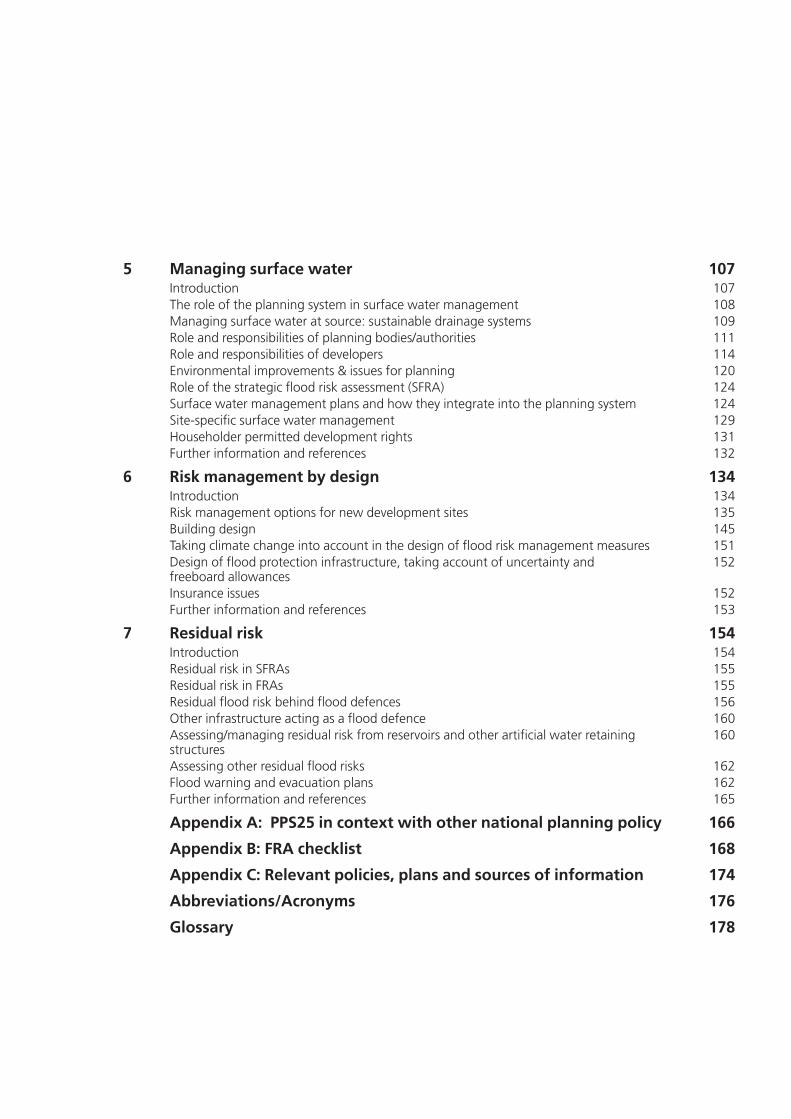