The Cochno stone: an archaeological investigation Phase 1 ...
Phase I Archaeological Documentary and Field Testing Study for the Proposed Development at Page Avenue and
Giegerich Avenue (NYSOPRHP # 04PR04095) Block 7792 (Lots 228, 242, 250, 252, 278 and 279) Staten Island
(Richmond County), New York
Final Report Prepared for: Bay Properties, Inc. 343 Sand Lane Staten Island, New York 10305-4500 and New York State Office of Parks, Recreation and Historic Preservation Albany, New York Prepared by: Alyssa Loorya, M.A., R.P.A., Principal Investigator and Christopher Ricciardi, Ph.D. July 2005

Phase I Archaeological Documentary and Field Testing Study for the Proposed Development at Page
Avenue and Giegerich Avenue (NYSOPRHP # 04PR04095) Block 7792 (Lots 228, 242, 250, 252, 278
and 279) Staten Island (Richmond County), New York
Final Report Prepared for: Bay Properties, Inc. 343 Sand Lane Staten Island, New York 10305-4500 and New York State Office of Parks, Recreation and Historic Preservation Albany, New York Prepared by: Alyssa Loorya, M.A., R.P.A., Principal Investigator and Christopher Ricciardi, Ph.D. July 2005

MANAGEMENT SUMMARY In anticipation of the development of Block 7792, Lots 228, 242, 250, 252, 278 and 279, (Page Avenue and Giegerich Avenue Residential Development – NYSOPRHP #04PR04095) in Richmond County (Staten Island), New York, a Phase I Archaeological Study was undertaken. This combined Documentary Study and Field Survey Testing was undertaken to determine if the possibility existed to uncover significant buried cultural resources within the project area. This study was undertaken by Alyssa Loorya, M.A., R.P.A. and assisted by Christopher Ricciardi, Ph.D., R.P.A., in accordance with the New York State Office of Parks, Recreation and Historic Preservation (NYSOPRHP), the New York City Landmarks Preservation Commission (NYC LPC) and New York Archaeological Council (NYAC) guidelines. The project area is currently a fresh water wetland area that is under review by the New York City Department of Environmental Conservation. The proposed development of the area is to include approximately four dozen houses, along with restoration of the wetland and the creation of a buffer zone between the development and the water. According to NYSOPRHP records, over a dozen Native American sites, or possible sites, are located within a two mile radius of the project area. Local residents indicate that they have recovered surface finds of unknown/unidentified Native American origin throughout the area. Located in the historic town of Tottenville, the area is situated between the Atlantic Ocean to the east and the Arthur Kill to the west. The proximity to these waterways and its relation to a body of fresh water historically made this area popular with the local Native American groups. However, no documented information could be recovered that detailed any Native American activity within the immediate project area. Due to the nature of the wetland, by the historic time, little had changed with regard to land use. A review of documents, tax records and historic maps does not reflect any permanent occupation of the site prior to the last quarter of the nineteenth century. Since then, only sporadic development of Block 7792 has occurred. Field testing included a walking survey of the property, overlaying of a grid, in fifteen meter intervals over the entire site, and the excavation of one hundred twenty-two (122) half meter (0.5m) by half meter (0.5m) Standardized Test Pits (STPs) and one, two by two (2x2) meter test pit. Approximately three hundred artifacts were recovered including coal, clinker, clam and oyster shells, brick, ceramic, window and bottle glass, nails, iron and lead fragments, modern garbage material including tin cans and plastics as well as one Native American point and approximately three dozen Native American flakes.
i

None of the artifacts were recovered from significant, or distinct stratigraphic layers. Overall, the site topography indicated a thin layer of top soil, averaging approximately fifteen (15cm) centimeters in depth, followed by a reddish sandy layer with some clay mixed throughout. Ground water is present throughout the entire site at a depth ranging between fifty (50cm) centimeters and one hundred (100cm) centimeters below surface. The single Native American point was found in association with two flakes, as well as historic bottle glass. The approximately three dozen other flakes were recovered in various STPs in association with historic materials and not in any context that could be clearly defined as a Native American layer. Of the historic artifacts, most are typical trash materials, coal, clinker, brick fragments, etc. Once again, none were found in any concentration or distinct stratigraphic layer. None of the artifacts were distinctive. Most of the ceramics were post 1850 plain whiteware. This type was continually made into the twentieth century as well. Following the guidelines set forth by organizations such as the NYSOPRHP, NYC LPC, NYAC and the Department of the Interior’s criteria for National Register listing, the site of Block 7792 does not meet any criteria for National Register listing, nor does it possess the potential for significant buried resources that would make it either a local or state concern. With a limited stratigraphic record, a documentary record that reveals little activity on site, the recovery of artifacts that are fairly typical, non-descript and not in any significant context and the high water table, it is the recommendation of this report that no further cultural resource investigation be undertaken at this site. The work undertaken for this Phase 1 Archaeological Report, could not find any evidence that significant buried archaeological resources will be disturbed by the activities planned for the site.
ii

TALBE OF CONTENTS
Page: Management Summary i Table of Contents iii List of Photographs iv Acknowledgements vii I. Introduction 1 II. Site Proposal and Current Description 2 III. Geographic Setting 6 IV. Paleoenvironment 7 V. Prehistoric Occupation 8 VI: Historic Occupation 13 VII. Field Testing Report 22 VIII. Summary and Recommendations 72 IX. References 74 Appendices A – Archaeological Scope of Work 81 B – Current site plans 86 C – Field Recording Sheets and Database 88 D – Laboratory Recording Sheets and Database 114 E – Other Images 129 F – Correspondences and Local Informant Contacts/Information 146 F – C.V. 177
iii

LIST OF PHOTOGRAPHS Title: Page: Photograph 01. SI Block 7792 – current field conditions 1 Photograph 02. SI Block 7792 – location in relation to NYC and vicinity 2 Photograph 03. Current site conditions 3 Photograph 04. Portion of the wetland showing the water way 3 Photograph 05. Abandoned car in the interior of Block 7792 4 Photograph 06. Illegally dumped modern garbage in the interior of Block 7792 5 Photograph 07. Recently burned structure 5 Illustration 08. Overall map of the New York City region 6 Illustration 09. 2001 Hagstrom Map showing the project area 7 Illustration 10. 1891 Bien Map of southern Staten Island 15 Illustration 11. 1845 U.S. Coast Survey Map 16 Illustration 12. 1874 Beers Atlas of Staten Island 17 Illustration 13. 1898 Robinson Atlas of Staten Island 18 Illustration 14. 1907 Robinson Atlas of Staten Island 19 Illustration 15. 1917 Bromley Atlas of Staten Island 20 Illustration 16. Staten Island – Block 7792 – Site Map 24 Photograph 17. Water route through center of site 25 Photograph 18. Clearing the site of wild growth thorn bushes 25 Illustration 19. General Stratigraphic record of the site 26 Photograph 20. STP 00.06 – ground water enters the test pit 27 Photograph 21. STP Line 01 area – site of recently razed house 28 Photograph 22. STP 01.03 – chain link fence adjacent to STP 29 Photograph 23. STP 01.05 – ground water enters the test pit 30 Photograph 24. STP 02.04 – ground water enters the test pit 31 Photograph 25. Backyard fire-place remains 32 Photograph 26. Test Pit #1: half way between STP 02.05 and 02.06 33 Photograph 27. STP 03.05 – ground water enters the test pit 34 Photograph 28. STP 03.06 – reddish-clay-sandy soil 35 Photograph 29. STP 04.00 – ground water enters the test pit 36 Photograph 30. STP 04.06 – reddish-orange clay-sand mixture 37 Photograph 31. STP 05.02 – ground water enters the test pit 38 Photograph 32. STP 05.05 – note mislabeling in the field as STP 05.06 39 Photograph 33. STP 05.10 – ground water enters the test pit 40 Photograph 34. STP 06.00 – ground water enters the test pit 41 Photograph 35. STP 06.10 – ground water enters the test pit 42 Photograph 36 STP 06.10A - ground water enters the test pit 43 Photograph 37 STP 06.10A - ground water enters the test pit 44 Photograph 38 STP 06.10A - ground water enters the test pit 45
iv

Photograph 39 STP 06.10A - ground water enters the test pit 46 Photograph 40. STP 07.01 47 Photograph 41. STP 07.10 – ground water enters the test pit 48 Photograph 42. STP 08.02 – end of level 1 – prior to ground water entering 49 Photograph 43. STP 08.10 50 Photograph 44. STP 09.02 – ground water enters the test pit 51 Photograph 45. STP 09.10 – note the mislabeling in the field as STP 09.11 51 Photograph 46. STP 10.02 52 Photograph 47. STP 10.03A - ground water enters the test pit 53 Photograph 48. STP 10.03B - ground water enters the test pit 54 Photograph 49. STP 10.09 – note the mislabeling in the field as STP 10.10 55 Photograph 50. STP 11.03 – ground water enters the test pit 56 Photograph 51. STP 11.10 – note the mislabeling in the field as STP 11.10 57 Photograph 52. STP 11-12A - ground water enters the test pit 58 Photograph 53. STP 11-12C - ground water enters the test pit 59 Photograph 54. STP 11-12D - ground water enters the test pit 60 Photograph 55. STP 12.00 – just prior to ground water entering the test pit 61 Photograph 56. STP 12.05 – ground water enters the test pit 62 Photograph 57. STP 12.10 63 Photograph 58. STP 13.04 64 Photograph 59. STP 14.00 – ground water enters the test pit 65 Photograph 60. STP 14.03 66 Photograph61. STP 15.03 67 Photograph 62. STP 15.07 68 Photograph 63. STP 16.03 69 Photograph 64. STP 16.05 70 Illustration 65. Proposed Development of Block 7792 87 Photograph 66. Levanna Point 127 Photograph 67. Various Points recovered from site 127 Photograph 68. Stoneware Shards 128 Photograph 69. General Artifacts recovered from site 128 Illustration 70. Photographic Site Map 130 Photograph 71. Site location of recently demolished house 131 Photograph 72. Looking north along Page Avenue 131 Photograph 73. Interior of Block 7792 132 Photograph 74. Interior of Block 7792 132 Photograph 75. Interior of Block 7792 133 Photograph 76. Interior of Block 7792 133 Photograph 77. Illegal modern refuse deposited within the wetland 134 Photograph 78. Illegal modern refuse deposited within the wetland 134 Photograph 79. Interior of Block 7792 135 Photograph 80. Interior of Block 7792 135
v

Photograph 81. Interior of Block 7792 136 Photograph 82. Interior of Block 7792 136 Photograph 83. Interior of Block 7792 137 Photograph 84. Interior of Block 7792 137 Photograph 85. Interior of Block 7792 138 Photograph 86. Interior of Block 7792 138 Photograph 87. Interior of Block 7792 139 Photograph 88. STP field testing – December 2004-January 2005 139 Photograph 89. STP field testing – December 2004-January 2005 140 Photograph 90. STP field testing – December 2004-January 2005 140 Photograph 91. STP field testing – December 2004-January 2005 141 Photograph 92. STP field testing – December 2004-January 2005 141 Photograph 93. STP field testing – December 2004-January 2005 142 Photograph 94. STP field testing – December 2004-January 2005 142 Photograph 95. STP field testing – December 2004-January 2005 143 Photograph 96. STP field testing – December 2004-January 2005 143 Photograph 97. STP field testing – December 2004-January 2005 144 Photograph 98. STP field testing – typical red sandy/clay as seen in the back dirt 144 Photograph 99. Recently construction along Giegerich Avenue with construction 145
debris deposited into the APE. Photograph 100. Recently construction along Giegerich Avenue with construction 145
debris deposited into the APE. ** NOTES:
a) All images were taken by Alyssa Loorya, except where noted. b) Images included in Appendix F, the MFR are not counted in the Photograph
listings above.
vi

ACKNOWELDGEMENTS The authors wish to thank Igor Fleyshmakher and Bay Properties, Incorporated of Staten Island, for inviting us to participate in this project. It was a pleasure to work with the entire staff and we have never encountered an organization that was as helpful and interested in the cultural resource process as they were. In particular, Vincent was a great help to us. Douglas Mackey and Mike Schifferli from the New York State Office of Parks, Recreation and Historic Preservation as well as Amanda Sutphin from the New York City Landmarks Preservation Commission were helpful with advice and strategy. Carlotta of the Staten Island Historical Society provided background information that was invaluable. Paula Licitra Raymond Matarazo, Assistant Curator - Science Staten Island Institute of Arts and Sciences provided valuable information with regard to previously excavated materials from within the project area. Finally, we would like to thank our field crew (in no particular order): Kevin, Kirsten, Gabe, Lynn, Bobbi-Jo, Diane, Eric, Slobodon and Vincent. They all worked through the cold, the mud and especially the thorn bushes.
vii

1
I: INTRODUCTION In anticipation of the development of Block 7792, Lots 228, 242, 250, 252, 278 and 279, (Page Avenue and Giegerich Avenue Residential Development – NYSOPRHP #04PR04095) in Richmond County (Staten Island), New York by Bay Properties, Incorporated (BPI), the New York City Department of Environmental Conservation (NYC DEC) in conjunction with the New York State Office of Parks, Recreation and Historic Preservation (NYSOPRHP) determined that a Phase I Archaeological Study was required prior to issuing a permit, by the NYC DEC, for development. This combined Documentary Study and Field Survey Testing was undertaken to determine the possible presence of significant buried cultural resources in the project area (Photograph 01)1.
Photograph 01: SI Block 7792 – current field conditions
Alyssa Loorya, M.A, R.P.A. was hired to conduct the Phase 1 Project. Christopher Ricciardi, Ph.D, R.P.A. served as the field director for the Phase 1B portion of the project.
1 See Illustration 70, page 130, for the Photographic Site Map that details where and from which direction each photograph was taken.

2
According to the records of the NYSOPRHP, over a dozen Native American, or possible Native American sites, are located within a two mile radius of the project area. Prior to the initial surface and site survey, a discussion was held with four separate adjacent property owners. Some of the residents claimed to have recovered Native American material remains from the surface of the project area. At that time, none could confirm exactly where those artifacts were recovered, nor could they produce the artifacts for review. However, once field work was completed, two informants came forward with specific information (see Appendix F for a detailed description of the contact, information provided and correspondences). Located in the town of Tottenville, which was previously called Westfield, the area is situated between the Atlantic Ocean to the east and the Arthur Kill to the west (Illustration 02). The proximity to these waterways and its relation to a fresh body of water historically made this area popular with the local Native American groups, and later, with Dutch settlers.
Illustration 02: SI Block 7792 – location in relation to New York City and vicinity
II: SITE PROPOSAL AND CURRENT DESCRITPION BPI has proposed to develop portions of Block 7792 for housing. Approximately four dozen, two storey, homes have been proposed for construction. Along with this construction, BPI’s proposal includes the partial restoration of the wetland area and the creation of a buffer zone between the housing development and the wetland (see Appendix B – Current Site Plans for the current proposed project construction) (Photograph 03).

3
Photograph 03: Current site conditions
Currently, the site is an overgrown, undeveloped wetland. Trees, most less than one hundred years in age, along with scrub brush and thorn bushes comprises the majority of the site that is either not within the water itself, or in the surrounding sandy area (Photograph 04).
Photograph 04: Portion of the wetland showing the water way – the fresh water source of
the stream was not determined as it appears to continue to run its course beyond the property.

4
Historically only a limited number of lots were previously developed so the overall area has remained mostly uninhibited by permanent occupation. Due, in part, to the lack of development of the area, it has become a dumping ground for all types of modern refuse (Photographs 05 and 06) and a place people have used for various activities, including the construction of a wooden “fort-like structure” that was located on the grounds and was recently destroyed by fire (Photograph 07).2 Currently there are no extant structures on the property which is to be developed. However, twentieth century residences do stand adjacent to the project area on three lots within Block 7792 and in the immediately adjacent street of Giegerich Avenue. All housing constructions on Giegerich Avenue are recent, occurring within the last five to ten years (Bay Properties 2004). Housing on Page Avenue is from the second quarter of the twentieth century (Sanborn 1907, 1917 and 1937).
Photograph 05: Abandoned car in the interior of Block 7792
2 See Appendix E – Other Site Images for more images of the current site conditions and modern trash filled areas.

5
Photograph 06: Illegally dumped modern garbage in the interior of Block 7792
Photograph 07: Recently burned structure

6
III: GEOGRAPHICAL SETTING The proposed site, a majority of Block 7792, is located within the Coastal Plain on southern Staten Island in Richmond County, New York, part of the five boroughs the City of New York. The property is a wetland area and lies across the road from a New York City Department of Parks and Recreation preserved wetland site, Long Pond Park (Illustrations 08 and 09). The Atlantic shore of Staten Island was formed as a result of the terminal moraine from the final Pleistocene glaciation, the Wisconsin glacial period. The project area lies within the general vicinity of the terminal moraine. Glacial deposits in the area consist of unconsolidated sands and gravels overlying earlier Cretaceous sand, silt and clay (Raber 1996).
Illustration 08: Overall map of the New York City region

7
Illustration 09: 2001 Hagstrom map showing the project area
IV: PALEOENVIRONMENT Within the project area the Pleistocene Epoch brought a series of cold periods and associated ice ages. The most recent ice age was the Wisconsin Glacial period which occurred approximately 14,000 to 12,000 years ago; the Wisconsin ice sheet was approximately three and a half meters (3.5m) to four and a half (4.5m) meters in thickness. Some of the major impacts of this period were a significant lowering of average temperatures and a dramatic lowering of sea levels. During the final glaciation of the Wisconsin period sea levels dropped as much as one hundred and thirty (130) meters. Along the Atlantic Coast, the shoreline lay approximately one hundred (100k) kilometers east of the modern day shoreline. The shift in sea levels had a prevailing effect on the development of the landscape within this area (Historic Sites Research 1981; Raber 1996; Boton 1920). Following the last glaciations of the Pleistocene, sea levels began to rise as a result of the release of water from the melting ice sheets. Sea levels continued to rise during the Holocene Epoch and there was an overall shift in climatic patterns. This shift brought warmer temperatures. As the sea levels rose, beginning c. 14,000 years ago, it began to cover the land mass of the Coastal Plain to the west. The rise in sea level proceeded rapidly until about 7000 years ago (Panamerican 2004).

8
The climatic changes of both the Pleistocene and the Holocene had a profound impact on the paleoenvironment of Staten Island. The climatic changes resulted in a shift of various vegetation northward as marine and eustatic environments approached from the east. As temperatures warmed, and the climate alternated between dry and moist periods, open grassy environments were replaced by boreal forests. These would later be followed by deciduous forests. As the coastline moved steadily inland, the local environment of south western Staten Island evolved into a tidal salt marsh environment (Panamerican 2004; Raber 1996). The timing and nature of the climatic shifts of the Holocene were directly relevant to prehistoric occupation of the region. Human occupation of the Upper Delaware River Valley in the Middle Atlantic Region began by 11,000 – 10,500 years B.P.. Evidence of Paleoindian occupation on the Coastal Plains of New Jersey has generally been in the form of isolated fluted point sites recovered largely during non-systematic surface collections. It has been argued that these points and associated finds are indicative of hunting and game processing activities (Bonfiglio and Cresson 1978). These sites reflect the presence of early human groups in the region. This occupation occurred within the boreal forests of the area, that were composed primarily of pine and birch but shifted to pine and oak as temperatures warmed (Dent 1991; Stewart 1990, 1991). Vegetation coverage was similar throughout much of the region, although the presence of favorable microenvironments considerably influenced prehistoric subsistence and adaptations (Baugher-Perlin and Bluefeld 1980). During the time of Paleoindian habitation Staten Island was not a coastal location. Southern Staten Island was covered by an inland forest with nearby water sources. Evidence of Paleoindian occupation, along western and southern Staten Island does not relate directly to coastal environments but toward the exploitation of inland forest habitats (Edwards and Memlly l977). Paleoindian occupants co-inhabited the region with a variety of fauna. The mammoth, generally not found in forest environments, may have occupied the region prior to human habitation. Extinct forms such as the forest mastodon and giant beaver were a contemporary of early Paleoindians; as well as bison, elk, horse, deer and possibly caribou (Ritchie 1980). The proximity of a riverine habitat would have supported both animal and plant based aquatic resources (Edwards and Memlly l977).

9
V: PEHSITORIC OCCUPATION Staten Island has been a focus of professional and advocational archaeologists, as well as collectors since the late nineteenth century. Unfortunately, much of these explorations lack specifics or detail. The prehistoric period is divided into the following categories: Paleoindian (c. 10,000 B.C. – 8,000 B.C.), Early Archaic (c. 8,000 B.C. – 6,000 B.C.), Middle Archaic (c. 6,000 B.C. – 4,000 B.C.), Late Archaic (c. 4,000 B.C. – 1700 B.C.), Early Woodland (1000 B.C. – 1 A.D.), Middle Woodland ( 1A.D. – 1000 A.D.) and Late Woodland (1000 A.D. – European Contact) (Jacobson 1980; Lenik 1992; Bolton 1934).
PALEOINDIAN The evidence for Paleoindian occupation is demonstrated by isolated fluted point finds from central and southern portions of Staten Island (Pagano 1985). However, there are no Paleoindian sites in the immediate project area as determined by a review of New York City Landmarks Preservation Commission (LPC) and New York State Office of Parks, Recreation and Historic Preservation (NYSOPRHP) site files. The closest Paleoindian sites are markedly north of the project area. These are the the Port Mobil and the Charlestown Beach sites. The Port Mobil site, located along the Arthur Kill, was identified within the Mobil Oil tank farm (Ritchie 1980; Kraft 1977a, 1977b). The site was heavily disturbed by construction of the tank farm ( Pagano 1985) and yielded fifty-one (51) lithic artifacts, including eight (8) "stubby" fluted, points, end and side scrapers and unifacial tools (Eisenberg 1978; Pagano 1985). The Port Mobil site contained three contiguous areas of Paleoindian occupation that may represent separate sites. The Charlestown Beach site, determined to be heavily disturbed, as well as surface collected, by Salwen, was eroding from a peat layer at the edge of the Arthur Kill. The site has never been fully described, but a site form was prepared by Salwen in 1967. The site yielded at least ten (10) Paleoindian fluted points, including examples of Clovis and Cumberland. Numerous phases of prehistoric occupation are indicated at the Charlestown Beach site, including Early or Middle Woodland (Pagano 1985; Bolton 1920, 1934).
EARLY ARCHAIC The Early Archaic period (Custer 1989, 1994) has been combined by some with the Paleoindian period into a broad Late Pleistocene-Early Holocene adpatational continuum. The Early Archaic is generally classified by the development of a mixed diffuse economy based on hunting, fishing and gathering. Four stratified sites have been indentified and excavated (by avocational archaeologists) in southern Staten Island. Two of these lie within the vicinity of the project area. The Hollowell site excavated by Albert Anderson and Donald Hollowell, is located near Ward's Point south of the current project area. This multicomponent site contained three prehistoric strata: a Late Woodland stratum, a Woodland/Archaic stratum with Vinette I ceramic and a Vosburg point, and a layer of brown mottled sand which yielded 24 points, including Kanawha, Stanly (Middle Archaic) and Eva types. A charcoal sample from the brown sand was dated to 3110+/-90 B.P., which seems to most likely be associated with intrusive charcoal from the overlying Woodland/Archaic occupation (Ritchie and Funk 1971).

10
The Ward's Point site is a large multicomponent site located on a low sandy knoll in Tottenville, at the southernmost point of Staten Island, south and west of the project area. The Early/Middle Archaic is similarly stratified, as the Hollowell site, lying beneath Late Woodland, early Middle Woodland and Transitional stratum. An underlying mottled reddish brown sand contained Kanawha, LeCroy (Middle Archaic) and Kirk points, and two hearths with charcoal yielding radiocarbon dates of 7260+/-125 and 8250+/-140 B.P. were uncovered. The site dates from the Early Archaic to the Historic period (Ritchie and Funk 1971).
MIDDLE ARCHAIC Hypothetical reconstructions of the Middle Atlantic coast between 6000 and 8000 years ago suggest estuarine areas were approaching the current coastline location, but that location still remained inland (Edwards and Emery 1977). Tidal salt marshes may have emerged in advance of the transgressing shoreline by about 5000 years ago. By approximately 3000 years ago the Atlantic coastline had reached its current location (Kraft,1977). At this time climatic conditions were warm and somewhat moister than in the preceding Boreal phase. Oak and hemlock were dominant floral species (Deevef 1952; Dent 1979), with pine persisting in coastal areas. This climatic period coincides with the archaeologically defined human adaptational phase of the Middle Archaic. The climate changes led to the availability of a more diverse reource base and data suggest a pattern of seasonal food capture during this period. Material culture changes during the Middle Archaic include the appearance of ground stone tools in addition to flaked stone artifacts. The raw materials utilized for tools also generally shift during this period from cryptocrystalline rocks to rhyolite, argillite and other rock types. These shifts in materials use are suggestive of shifts in mobility and possibly shifts in social organization. Site types include spring fishing and hunting camps (Custer 1986, 1989, 1994; Ritchie and Funk 1971). Middle Archaic sites in the southern portion of the Middle Atlantic have been attributed to macro-band and micro-band base camps in areas of "maximum habitat overlap" (Custer 1989, 1994), such as interior freshwater swamps and Coastal tidal salt marshes and estuarine environments. These would have been resource-rich habitats, particularly with regard to food resources, available for exploitation. Occupation sites associated with cultural materials dating to the Middle Archaic are considered to be rare on Staten Island (Pagano 1995). The Early Archaic sites discussed previously also had bifurcate-based (LeCroy) and later stemmed Stanly and Kanawha points. These forms span as much as 2000 years in the southeastern United States and into the Middle Archaic (Ritchie and Funk 1971). Possible explanations for this mixture of points may relate to geomorphological changes affecting soil accumulation rates across Staten Island, and/or micro-stratigraphic changes which were not recognized during the excavations (Hunter 1995a, 1995b). One other site, the Wort Farm site in Tottenville also yielded scatterd Middle Archaic remains (Williams 1968).

11
LATE ARCHAIC The climatic changes that began about 4,600 years ago produced the warmest and driest conditions of the current post-glacial period. Oak remained a dominant tree species and hickory was becoming more widely available. The climatic changes at this time appear to roughly coincide with the emergence of the archaeologically defined Late Archaic phase. The Late Archaic is typified by diagnostic lithic forms and an increase in base camps. Late Archaic sites throughout the region are found in an array of environmental settings and display diversified resource use. Late Archaic occupations have been found on or near the Arthur Kill in southern Staten Island, and is represented on Staten Island by several small sites that likely represent short-term occupation. Most of these sites are disturbed or the result of surface collections (Hunter 1995a, 1995b; Bolton 1922) One site, the Public School 6-R site in Tottenville is within the immediate vicinity of the project area. The site revealed evidence of a lithic workshop that dated to the later archaic period. Among the artifacts were flakes and fragments including fire cracked rock (Historical Perspectives 1998a, 1998b).
WOODLAND3
The appearance of cache pits and ceramic storage vessels during the successive Transitional4 and Early-Middle Woodland indicates a greater degree of sedentism. Evidence of Transitional occupations in the form of distinctive "fish-tail" projectile points are indicated at Ward's Point and Smoking Point. The appearance of fired clay ceramics about 1000 B.C. marks the ambiguous beginning of the Woodland Phase. The Woodland is largely a continuation of the Archaic economy. The increase of shell middens during this period may be due to a more sednetary lifestyle and/or the changing coastline that stabilized around this time. Woodland occupations are reflected at Hollowell, Pottery Farm and Smoking Point. The Rossville site, north of Smoking Point, was identified in the early twentieth century by Alanson Skinner, and is the type site for a distinctive Middle Woodland projectile point form. The burial mounds of Burial Ridge in the southern portion of the island were identified in the late nineteenth century. Jacobson’s 1980 survey of archaeological investigations in Tottenville reports that only two percent of all sites in the area can be classified as Early Woodland. Middle Woodland sites are noted as being scatterd and poorly documented (Jacobson 1980; Bolton 1920, 1922) About 2,000 years B.P. the warm and dry climatic conditions began to yield to a cooler, moister modern climate. By 1,000 A.D. the archaeologically defined Late Woodland phase emerged. Increasing evidence of sedentism is manifested in the expanded use of storage facilities and more permanent house structures. Increased gathering of shellfish and plant harvesting reflects an intensification of food procurement evidently related to population growth. The emergence of agricultural production is also related to this sedentary settlement pattern which was maintained until European contact. Material culture is typified by distinctive ceramic forms and small
3 The Woodland Phase is divided into three distinct phases, Early, Middle and Late, but will be discussed under the general Woodland heading in this report. 4 This is the period between the Late Archaic and the Early Woodland.

12
triangular projectile points, the latter evidently indicative of bow-and-arrow technology (Custer 1989; Ritchie 1980). Many Staten Island sites have a Late Woodland component. Late Woodland occupations are indicated at Hollowell, Ward's Point, Wort Farm and other smaller loci. Many of the smaller sites are referenced in Jacobson (1980) and again poorly documented from the notes of avocational archaeologists and colllectors. At Wort Farm Williams recovered Late Woodland Madison and Levanna points and a small number of ceramics (1968). At Smoking Point, cermaic finds included a Middle or Late Woodland pipe with incised decoration (Rubertone 1974). The largest amount of Late Woodland remains on Staten Island comes from the Burial Ridge site in Tottenville (Jacobson 1980) The sites closest to the project area are the Honey Blossom site; the P.S. 6-R site (briefly discussed earlier) and the Page Avenue Development site. The Honey Blossom site is east of the project area. This site revealed stray material finds from within a plow zone. Artifacts dated to the Middle to Late Woodland period and were mixed with historic materials (Greenhouse 1987). The Page Avenue Development site uncovered a range of ltihic materials from the Woodland Period. According to the site report while there were distict stratigraphic layers, the artifact finds were fragmentary and there were no discernible artifact patterns within the assemblage (Greenhouse 1987). While there have been a great many prehistoric sites on southern Staten Island, the majority have yielded fragmentary evidence of Native American occupation at best. Although the possiblity remains that additional undisturbed site(s) may be present in the area of the current project site, it is difficult to not only uncover these sites, but to determine if the finds represent an actual site. Unless the material remains are recovered from an insitu, stratified deposit, the possibility exists that they could be secondary deposits. Evidence from two sites in Brooklyn, New York have shown that stray Native American artifacts were recovered from within clearly historical deposits (see Bankoff, Ricciardi and Loorya 1997 and Ricciardi 2004). In a review of the various site reports within the two mile radius of the project area, one can interpret the Native American finds for most of these sites in the same manner.

13
VI: HISTORIC OCCUPATION CONTACT AND THE DUTCH PERIOD In 1524, Giovanni Verrazano, a Florentine navigator in a French vessel, led the first European exploration of the area that would become the City if New York. He is believed to have anchored briefly off the Narrows on the Long Island side of the Lower Bay. Though Dutch whalers probably visited the region throughout the sixteenth century, the discovery of New York Bay is generally credited to Henry Hudson. In 1669, while searching for a westerly route to Asia on behalf of the Dutch East India Company, he discovered Upper New York Bay and explored the lower section of what would become known as the Hudson Valley (Burrows and Wallace 1999). At the time of European Contact the area was widely occupied by varoius groups within the earlier Lenape Native American group. The Lenape were part of the Delaware Nation; Staten Island5 was specifically inhabited by the Raritan and the Hackensack. By 1652 Canarsee were coming to Staten Island after having sold their land rights on Long Island to the Dutch and finally the English (Ricciardi 2004). It is historically assumed that the Native Americans who occupied Staten Island and other areas around the Upper and Lower Bays saw Hudson and, the many other explorers who followed, as a threat. In response to the newcomers, the native peoples are believed to have established signaling stations on Todt Hill in northeastern Staten Island (and at various other prominent positions) to warn neighboring groups when European vessels entered the Upper Bay (O’Callaghan 1846, 1861-1865). By the late 1620s and early 1630s, the recently incorporated Dutch West India Company was imposing the patroonship system in the new colony of New Netherland as a means of stimulating settlement. Through this system, three unsuccessful attempts were made at establishing permanent settlements on Staten Island. The first attempt was headed by David Peterse De Vries. De Vries kept a detailed journal, the Korte Historical, about his colonization efforts on Staten Island. He left Holland in 1638 arriving in the New World in late December of 1638 or early January of 1639. He reported that he "brought the ship” … “before Staten Island, which belonged to me, where I intended to settle my people. I sent my people to Staten Island to begin to plant a colony there and build." The settlement, believed to have been located at present-day Tompkinsville, was short-lived. In 1641 it was attacked and destroyed by Indians (Stokes 1915-1928; Anderson and Sainz 1965:83; Black 1983:9-10). The second and third attempts at settlement on Staten Island were led by Cornelius Melyn. Shortly after the assault on the settlement by the local Native Ameircans, DeVries was asked by William Kieft, then Governor of New Netherland, if Melyn could make another attempt at a settlement. DeVries agreed and Melyn was granted all the lands of Staten Island except for a portion of land that had been previously settled by DeVries. Another raid by the Native Americans and the general state of tension between the Dutch and the Indians led to the 5 Hudson was responsible for naming Staten Island, calling it "Island Staatan Eylandt" (Island of the States) in honor of the States-General, the governing body of the Netherlands.

14
abandonment of Melyn's settlement in 1643 (Anderson and Sainz 1965:83; Black 1983:10). According to Charles Leng and William Davis's History of Staten Island and its People, Melyn’s settlement was likely located in the vicinity of Fort Wadsworth, at the southeastern end of the Island (Leng and Davis 1930). In 1650, Melyn determined to restock his ruined colony. According to later testimony by Melyn, sixteen "handsome farms" were started in this new settlement which lasted five years. It was then attacked and burned by the local Native American tribe. A traveller in October 1655 wrote, "on the 21st we sailed to the North-River, from Staten Island, by the watering place, and saw that all the houses there, and about Melyn's house, were burned by the Indians." This account appears to place Melyn's second settlement in the present-day Tompkinsville area, near the location of the original De Vries settlement. Shortly after this third abortive attempt at a permanent settlement on Staten Island, the Dutch abandonned the system of patroonship (Black 1983:12). Despite the ongoing hostilities between local the Native Americans and the Europeans, as well as three failed attempts at settlement, the Dutch did not give up. A few Dutch settlers did succeed on Staten Island during the 1640s and 1650s. In the mid 1650s a small garrison was stationed on the island to provide protection for the settlers (Bayles 1887, O’Callaghan 1848-1851). It wasn’t until the early 1660s however that the first truly permanent Dutch-American settlement was established on Staten Island. This settlement formed a small community known as Oude Dorp ("Old Town"). It was located approximately one mile southwest of the present day Verrazano-Narrows Bridge. The settlement was comprised of a loose cluster of farms, inefficiently protected by a blockhouse manned by a detachment of soldiers supplied by the Dutch West India Company. This settlement was still in existence in 1664 when the English seized control of New Netherland (Anderson and Saintz 1965:84; Black 1983:14; Clute 1877).
ANGLO-AMERICAN SETTLEMENT English rule began in 1664 when King Charles II of England bestowed a grant of all the territory lying between the Connecticut and Delaware Rivers (i.e., including virtually all of the province of New Netherland) to his brother James, the Duke of York. In August of the same year, the Duke of York dispatched four frigates, manned with 450 men, to New York harbor to claim his property. In September, Governor Stuyvesant of New Netherland surrendered the province to the English commander, who assumed the position of new governor. The Duke of York recognized limited Dutch claims to Staten Island. The new English governor, Colonel Richard Nicolls parcelled out land grants to both original settlers and to the soldiers who served under him (Burrows and Wallace 1999). Staten Island was subdivided. Oude Dorp was placed within the newly created town of Dover (Morris 1900). Nicolls successor, Francis Lovelace, purchased all Native American land rights to Staten Island in 1670. Following the acquisition lots were laid out along the north, east and south sides of the island (Bayles 1887, O’Callaghan 1846, 1861-1865).

15
Throughout the Colonial and Early Federal period (circa 1675 – 1815) Staten Island consisted of a dispersed network of agrarian and fishing communities. These communities were fairly isolated as transportation to and from Staten Island was limitied to four ferries (not all in operation at the same time). Staten Island remained sparsely populated during this period with the population growing from a few hundred in c. 1670 to 4400 persons in 1800 (Morris 1900, O’Callaghan 1846, 1861-1865). Due to its isolation and limited transpotation, commercial and industrial growth was slow throughout the eighteenth and early nineteenth centuried. The Island’s isolation kept if from experiencing the speculative boom of the 1830s that occurred in most of the region (Burrows and Wallace 1999.) It wasn’t until the 1860s that Staten Island’s agricultural and sea based economy began to draw large industry and manufacture to its wide open spaces. During the latter half of the nineteenth century the northern side of Staten Island developed a contiguous array of commercial and residential communities ( Burrows and Wallace 1999:661-662 and Raber 1996).
Illustration 10: 1891 Bien Map of southern Staten Island showing the various towns

16
Despite the development occurring on the northern shore and eastern half of Staten Island, the shouth shore remained relatively undeveloped. This was particularly evident in the southwestern section of Staten Island and, in particular, the Town of Westfield and later the subdivided Town of Tottenville. According to the Staten Island Historical Socieity (SIHS) Tottenville is perhaps the most poorly documented area of Staten Island (SIHS 2005). Tottenville was first established as Bentley Manor in 1668 when the Duke of York granted Captain Christopher Billopp a 932 acre tract of land, later expanded to 1600 acres, that covered all of Tottenville. In the 1780s Billopp’s descendants began to sell parcels of the Manor. In 1781 the community had adopted the name Tottenville for Gilbert and Joseph Totten who were indtrumental in establishing the Bethel Methodist Church, the towns first organized congregation, in 1772 (Bayles 1887 and Clute 1877) (Illustration 10).
Illustration 11: 1845 U.S. Coast Survey Map showing the project area as being part of a
farmland-wooded area Throughout most of its history Tottenville has remained a small agricultural and fishing community (Illustration 11). As the consolidation of the five boroughs of the City of New York approached in 1898 City residents began to purchase vacation homes in the area. This allowed for Tottenville’s small town atmosphere to continue into the twentieth century. Due to Tottenville’s location, its relative distance from the remainder of Staten Island’s more developed areas, the residential development of the area did not begin until the second quarter of the

17
twentieth century. Even then, development was relatively sparse due to a lack of public transportation (SIHS 2004; Bayles 1887, Morris 1900). Renewed interest in the development of the area in and around the Tottenville began circa 1990. Since then a number of private homes and housing developments have been, and continue to be, constructed (Bay Properties Inc. 2004). The project area is an example of the renewed interest in development of the Tottenville area. The project area occupies a significant portion of New York City Tax Block 7792, which is largely undeveloped. The area is represented in a series of maps as having been mostly undeveloped until to second quarter of the twentieth century. An 1845 United States Coast Survey map (Illustration 11) and the 1891 Joseph Bien Atlas of the Metropolitan District (Illustration 10) show the project area as being an undeveloped wooded land area. Until circa 1917 the boundary street of Page Avenue was known as Beach Avenue (sometimes referred to as Beach Street) and the boundary streets of Giegerich and Minerva Avenues were first laid circa 1907. Prior to that time the western boundary street closest to the project area was Manee Avenue (present day Bedell Avenue) laid between 1874 and 1898 and Amboy Road to the north.
Illustration 12: 1874 Beers Atlas of Staten Island – project area is outlined and is
subdivided revealing three possible structures.

18
By 1874 the project area was subdivided into seven parcels of land. (Illustration 12) The largest parcel was owned by E.J. Totten; the other owners, F. Hurdon, L. Cooley, H. Cooley. W. Decker and W.C. owned smaller parcels equaling 2 acres or less. With the exception of 3 small framed structures on 3 parcels bordering Beach Avenue, the project area was undeveloped. This property division is represented on the 1874 Beers Atlas of Richmond County and reveals that with the exception of Beach Avenue, none of the other boundary streets had been laid at this time.
Illustration 13: 1898 Robinson Atlas of Staten Island – property usurped by one owner.
By 1898 all of the parcels of land within the project area, with the exception of the parcel owned by E.J. Totten, were acquired by Nancy B. Cheevers (referred to as Nancy Chavers on the 1898 Robinson Atlas of Richmond County) (Illustration 13). The three earlier structures remained on

19
the property now owned by Cheevers. It is known that these were framed structures, but their purpose remains unclear as there is no supporting documentation on them. Due to the nature of the geography, it is questionable that they were household structures. These structures were not present in any of the reviewed 1860s maps. Block 7792 retains the same configuration until 1907 by which time the boundary streets of Giegerich and Minerva Avenues had been laid (Illustration 14). On Cheevers’ property only two of the original three structures remained. The northern corner of Property Block 7792 was grided in anticipation of development. The only area to be grided that is within the project area is the north-west corner of Block 7792. This small area was subdivided into seven lots averaging dimensions of twenty-five (25) feet by one hundred (100) feet.
Illustration 14: 1907 Robinson Atlas of Staten Island – note that only two structures
remain
20
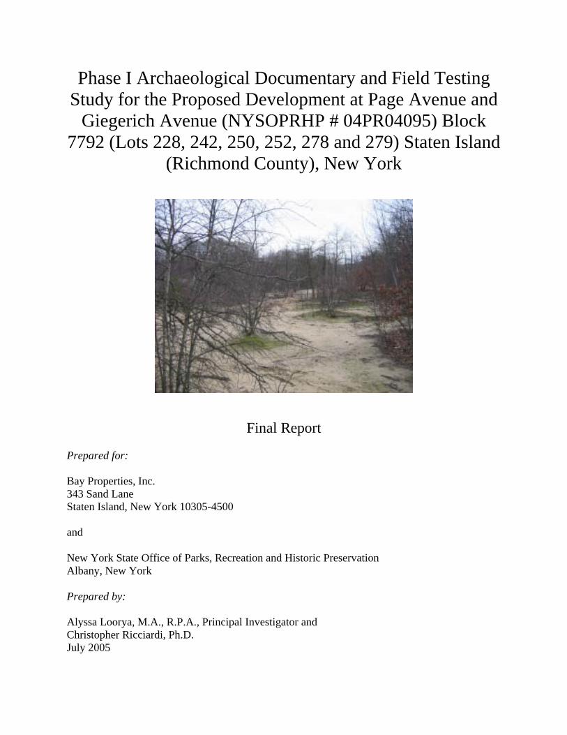
Illustration 15: 1917 Bromley Atlas of Staten Island –
note no structures are listed as being present In 1917 the majority of the project area was still owned by Nancy B. Cheevers and no structures exist on the property. The three structures that once stood on this property were erected some time between 1864 and 1874. They were removed between 1907 and 1917. All three structures had lifespan of less than fifty years, and, as previously stated, the function of the structures is undetermined. The section that had been grided earlier remained undeveloped and was never developed according to tax records (New York City Tax Assessment Office Records6). The
6 Tax Records of Richmond County were only available from 1937 onwards.

21
Sanborn Fire Insurance maps from 1907 and 1917 do not cover the project area, again reflecting the undeveloped nature of the area (see Illustration 15 for the 1917 Bromley map of the area). The project area is first represented in the Sanborn maps in the 1937 edition7. At that time the present day Block and Lot configuration is denoted on the map. Two twenty (20) by one hundred (100) foot plots are shown along Page Avenue. Each plot contains a two-story framed structure with a one story garage toward the rear of the lot. Three other twenty (20) by one hundred (100) foot plots are shown at the southern most point of the property once owned by Cheevers. These three lots are not within the project area. Two streets, Low Street and Baylor Street are displayed on the 1937 Sanborn and 1942 Hagstrom maps as intersecting the mid-section of Block 7792 (and the project area) but they were never constructed. Several attempts were made to trace the property ownership. Searches were conducted at the Staten Island Historical Society, the Special Collections Reading Room at the College of Staten Island, CUNY, the Staten Island Registrar’s Office, the NYC DEP and the New York City Tax Assessors records. Unfortunately, most attempts at uncovering the exact chain of title and property owner(s) were fruitless. Tax Assessment records for the eighteenth and nineteenth century were not available at the New York City Tax Assessors Office, nor at the Staten Island Registrar’s Office. Chain of title records at the Staten Island Registrar’s Office only date back to the first quarter of the twentieth century. All other records are boxed away and unavailable, at this time, for review. Several attempts were made to contact the NYC DEC to determine when sewer and water lines were installed in the area. Over one dozen phone calls were made to the NYC DEC to request the information, but none were returned. In discussions with several residents, who reside on the Giegerich Avenue side of the property, all spoke of having their homes serviced by septic systems. Due to this lack of primary source material, the majority of the information presented relies heavily on secondary sources and a study of the various historic maps. Although it would be preferable to have more primary source material for review, the amount of secondary source material, previous cultural resource reports and the historic maps all reveal that the area, for the most part, remained undeveloped. Structures do not appear on most of Block 7792 until the last quarter of the nineteenth century and were removed by the first quarter of the twentieth century. During the last half of the twentieth century, two other structures were constructed, and demolished by 2004 as well.
7 The 1937 Sanborn map was available for review but not reproduction.

22
VII: PHASE 1B ARCHAEOLOGICAL FIELD TESTING: Based upon recommendations and discussions with the NYSOPRHP, a Phase 1B Archaeological Sensitivity Field Test was undertaken to determine the potential for significant buried archaeological deposits. The site’s location, and proximity to over a dozen recorded archaeological sites, required this next phase of testing be undertaken. The field crew consisted of: Alyssa Loorya, M.A., R.P.A. (Principal Investigator), Christopher Ricciardi, Ph.D., R.P.A., (Field Director) and a crew comprised of: Lynn Rakos, M.A., R.P.A., Diane George, M.A., Kirsten Davis, Kevin Smyth, Bobbi Jo McClain, Slobodan Mitrovic, Erik Serras, Gabe Stein and Vincent Accurso.
Methodology As previously stated the site of Block 7792 is approximately two hundred fifteen (215) meters wide by one hundred forty-six (146) meters long. Based upon discussions with Michael Schifferli and Douglas Mackey from the NYSOPRHP and in consultation with the New York Archaeological Council’s (NYAC) Handbook for Standards of Archaeological Investigations, it was determined that a testing pattern would be conducted at fifteen (15) meter intervals. A grid was created over the site and by means of a surface survey; each fifteen (15) meter interval was marked on the ground with flagging and orange spray paint. Based on information gathered in the field, and in discussion with Mr. Mackey, STPs in three areas were expanded beyond the original grid layout to test for higher concentrations of artifact remains. A single two by two (2x2) meter test pit was excavated between two STPs on STP Line 02. Testing was accomplished using Standard Test Pits (STPs). Each STP was excavated as a fifty (50) centimeter area and to a depth of approximately one hundred and twenty-five (125) centimeters, unless ground water was encountered. All excavated material was sifted through one quarter (1/4) inch mesh screening. Artifact and ecofact remains were bagged for later washing, recording and analysis. However, it was determined in the field not to save every fragmentary remain that was recovered. Examples of each type of artifact discarded were saved. All discarded material was noted on the field recording sheets. Modern surface garbage material (i.e. plastics, paper, discarded beer cans, etc.) were noted and discarded in the field. Only modern material that was recovered from below the ground surface was saved. Photographs were taken using a Canon Power-shot A80 Digital Camera. Images were saved in a 300dpi JPEG format8. A total of one hundred forty-nine (149) STPs were laid out. Using Page Avenue as the north/south line, seventeen (17) STP lines were laid using the existing concrete sidewalk as the starting point for each of the lines. STPs lines were labeled from 0 through 16. Within each of the 17 lines, individual STPs were then given numbers ranging from 0, the first STP in the line along the concrete sidewalk of Page Avenue, following numerically through 11. Not every line had a full succession of 12 STPs laid out. Based on the construction plans, not all of the grid intersection points were to be excavated. STPs that fell within the tidal wetland zone, that the NYS DEC requires the property developers to avoid, were not excavated. Some STPs were also 8 Note: Although digital photographs were taken of almost every STP, not every image is presented in this section. Some images are included in Appendix E: Other Site Images.

23
overlaid onto preexisting private properties and therefore were not included. For example, STP lines 13, 15 and 16 begin with STPs numbers 13.03, 14.04 and 16.01 respectively since STPs 13.00 to 13.02, 14.00 to 14.03 and 16.00 were located on private property, not included in the project area. Only one STP in Line 00 fell within the Area of Potential Effect (APE). Based upon field work and recommendations from the NYSOPRHP, a series of eleven (11) additional STPs and one, two by two (2x2) meter, Test Pit were excavated beyond the original field test. The STPs were located off of the original grid lines to test for artifact concentration areas. These tested areas included STP Line 6 and 10, in between STP Lines 11 and 12 and the one test pit excavated between STP 2.5 and STP 2.6 Out of the 149 STPs plotted, one hundred and twenty-two (122) were excavated (Illustration 16: Site Map)9.
9 Note: Illustration 16 - Overall Site Map lists not only the excavated STPs and Test Pit from the Area of Potential Effect (APE), but outlines the general area in which Raymond Matarazo of the Staten Island Institute of Arts and Science collected surface and below surface Native American material remains. The collections of these materials came from within the DEC regulated “buffer zone” around the wetland and are not in the construction zone/APE. For further information on the materials recovered by Mr. Matarazo see Appendix F.

24
Illustration 16: Staten Island – Block 7792 – Site Map

25
Photograph 17: Water route through center of site
Prior to excavation, much of the site had to be cleared of wild growth thorn bushes. Without this initial clearing, excavation of the STPs along Lines 01 through 08 could not occur. The entire site was covered with this growth (Photograph 17 and Photograph 18).
Photograph 18: Clearing the site of wild-growth thorn bushes

26
Field Results For clarity, the results of the fieldwork will be discussed in a line by line fashion, beginning with STP Line 0 and followed by a discussion on the artifacts/ecofacts recovered and the recommendations for the project area. For detailed information on each STP excavated, see Appendix C – Field Test Recording Sheets. These sheets recorded the soil conditions (i.e. matrix, Munsell readings, etc.) as well as what artifact/ecofacts materials were recovered. Without exception, each STP was practically identical in stratigraphic nature. Each contained a fairly thin top soil layer (with an approximate depth to fifteen (15) centimeter) followed by a sandy subsurface layer that contained most of the artifacts recovered and noted (with an approximate depth to thirty (30) centimeters) and finally clean sand, sometimes mixed with clay, (with an approximately depth to at least one hundred and twenty-five (125) centimeters) (see Illustration 19 for examples of the general, overall stratigraphic record of the site).
Illustration 19: General Stratigraphic record of the site

27
STP Line 00 STP Line 0 was located in the narrow-most portion of the property (Photograph 16). Due to the shape, only one STP 00.06 could be excavated. Two levels within the STP were excavated. Most of the material from within the STP was fine grained sand. At seventy-five (75) centimeters ground water flooded the bottom of the STP and fieldwork ceased. From within this STP only one piece of a fragmentary clam shell and a modern glass soft drink (Coca-Cola) bottle fragment were uncovered. These were noted and discarded in the field (Photograph 20).
Photograph 20: STP 00.06 – ground water enters the test pit
STP Line 01 A total of seven STPs, 01.00 thru 01.06, were excavated (Photograph 16) along this line. All were located between Page Avenue and the wetland area. This STP line was located in an area where historic maps showed a previous structure, dating to post 1917 (Photograph 21). According to the current property owners, a modern structure was razed in 2004. The remains of a chain-link fence encompassed the area (Photograph 21).

28
Photograph 21: STP Line 01 area – site of recently razed house
STP 01.00 was excavated to a total depth of fifty (50) centimeters. Ground water flooded the STP and excavation was halted. Historic whiteware plate shard, coal and window glass were recovered from the first level of the STP, which was excavated to fifteen (15) centimeters below surface. Clinker, coal and window glass was recovered between fifteen (15) and fifty (50) centimeters. The artifacts were noted on the field sheet. The soil matrix was comprised mostly of sand. STP 01.01 was excavated to a total depth of sixty-five (65) centimeters. Brick, clinker, coal, glass and historic whiteware ceramic shards were recovered throughout the STP. Modern materials, such as plastic straws and Styrofoam were also recovered at a depth of sixty (60) centimeters. The artifacts were noted on the field sheet. The soil matrix was comprised mostly of sand. STP 01.02 was excavated to a total depth of sixty (60) centimeters. Brick, historic whiteware shards, clinker, shell, coal, glass and a pipe fragment were recovered throughout the STP along with chunks of asphalt and chain link portions of a fence. The artifacts were noted on the field sheet. The soil matrix was comprised mostly of sand.

29
Photograph 22: STP 01.03 – chain-link fence adjacent to STP
STP 01.03 was excavated to a depth of fifty (54) centimeters. Brick, historic whiteware ceramic, shell, coal, a molded rim pipe bowl, and two pieces of quartz were recovered from within the STP along with large chunks of concrete, asphalt and plastic. Artifacts, excluding the concrete and asphalt from this STP were saved. The soil matrix was comprised mostly of sand (Photograph 22). STP 01.04 was excavated to a depth of seventy (70) centimeters. Ground water flooded the STP and the excavation was halted. This STP contained crushed clam and oyster shell fragments recovered from the upper portion of the STP. The soil matrix was comprised mostly of sand. STP 01.05 was excavated to a depth of seventy (70) centimeters. Ground water flooded the STP at this depth and the excavation was halted. Crushed clam and oyster shell fragments were recovered from within the STP. Some of the fragments were saved. The soil matrix was comprised mostly of sand (Photograph 23). STP 01.06 was excavated to a depth of seventy (70) centimeters. Ground water flooded the STP and the excavation was halted at this depth. Crushed clam and oyster shell fragments were recovered from within the STP. The artifacts were noted on the field sheet. The soil matrix was comprised mostly of sand.

30
Photograph 23: STP 01.05 – ground water enters the test pit
STP Line 02
A total of seven STPs, 02.00 thru 02.06, and one two by two meter test pit, were excavated (Photograph 16) in this line. All were located between Page Avenue and the wetland area. Portions of this line fall within the area where a twentieth century house stood and was recently razed. STP 02.00 was excavated to a depth of forty-two (42) centimeters. Ground water flooded the STP and the excavation was halted at this depth. Animal bone fragments, brick, clinker, shell, historic whiteware body pieces and were recovered from within the STP, along with modern garbage, i.e. plastic, asphalt and aluminum cans. All the materials were saved. The soil matrix of this STP, although sandy, had more clay mixed throughout. STP 02.01 was excavated to a depth of thirty-eight (38) centimeters. Brick, shell, coal, window glass and modern garbage material (i.e. plastic, asphalt and concrete) were recovered from within the STP. One shell was saved as a representative artifact. Excavation was halted when a modern ceramic sewer pipe was encountered. This pipe must have extended to the twentieth century

31
house that was razed in the area. The soil matrix of this STP, although sandy, had more clay mixed throughout. STP 02.02 was excavated to a depth of fifty-five (55) centimeters. Ground water flooded the STP and the excavation was halted. Brick, shell, coal, glass and plastic were recovered from the STP. Only the plastic materials were saved. The soil matrix of this STP, although sandy, had more clay mixed throughout. STP 02.03 was excavated to a depth of eighty (80) centimeters. Coal and window glass were recovered. Only the glass was saved. A thick lens of what appears to be modern ash from a fireplace was uncovered toward the bottom of the STP. The matrix of this STP was comprised mostly of sand. STP 02.04 was excavated to a depth of sixty-five (65) centimeters. Ground water flooded the STP and the excavation was halted. Only clam and oyster shell fragments were recovered. All were saved. The matrix of this STP was comprised mostly of sand (Photograph 24).
Photograph 24: STP 02.04 – ground water enters the test pit
Approximately four (4) meters behind STP 02.04 a modern brick in-ground backyard fireplace remains in situ. This was part of the backyard to the twentieth century structure that was recently demolished (Photograph 25).

32
Photograph 25: Backyard fire-place remains - approximately four meters behind STP
02.04 and just in front of STP 02.05 STP 02.05 was excavated to a depth of sixty-six (66) centimeters. Ground water flooded the STP and the excavation was halted at this depth. Clam and oyster fragments along with four Native American flakes and one Late Woodland Levanna type point were recovered. The matrix of this STP, although sandy, had more clay mixed throughout. STP 02.06 was excavated to a depth of twenty-seven (27) centimeters. Ground water flooded the STP and the excavation was halted. Clam shells and one possible Native American flake were recovered. All artifacts were saved. The matrix of this STP was comprised mostly of sand. Based on the recommendation of the NYSOPRHP, a test pit was excavated in between STP 02.05 and 02.06. This Test Pit, labeled Test Pit #1, was located approximately half way between the two previously excavated STPs. Due to the nature of the ground cover the Test Pit, which was originally set to be a one meter by one meter square was lengthened to a two meter by two meter (2x2) square. It was determined to make it a 2x2 to allow for a greater view of the area to insure that no in situ material or stratigraphic remains were present (Photograph 26).

33
Photograph 26: Test Pit #1: located half way between STP 02.05 and STP 02.06
As with the STPS, the 2x2 was excavated by stratigraphic layers. One half of the test pit was excavated to a depth of approximately eighty (80) centimeters. The other half was excavated to a depth of approximately fifty (50) centimeters. Three distinct layers were present; top soil, a dark brown loamy layer and a sandy bottom layer. Material remains were found in the top soil and the top of the loamy layers. These included modern garbage refuse, plastic food wrappers, fragments of coal and clinker, perhaps coming from the free-standing fire place (Photograph 25) that was located approximately three (3) meters to the east, whiteware body fragments and two round nails. STP Line 03 A total of seven STPs, 03.00 thru 03.06, were excavated (Photograph 16) in this line. All were located between Page Avenue and the wetland area. STP 03.00 was excavated to a depth of sixty-five (65) centimeters. Ground water flooded the STP and the excavation was halted at this depth. The artifacts were noted on the field sheet. beThe matrix of this STP was comprised mostly of sand. STP 03.01 was excavated to a depth of forty (40) centimeters. Brick, clinker, coal, historic whiteware body pieces, window glass and a modern 1964 U.S. penny were recovered from below the top soil layer. All artifacts were saved. The matrix of this STP was comprised mostly of sand.

34
STP 03.02 was excavated to a depth of seventy-five (75) centimeters. Ground water flooded the STP and the excavation was halted at this depth. Animal bone, clinker, coal, historic whiteware body pieces, clear window glass and two pieces of lead were recovered. All artifacts were saved. The matrix of this STP was comprised mostly of sand. STP 03.03 was excavated to a depth of seventy (70) centimeters. Ground water flooded the STP and the excavation was halted at this depth. Animal bone, historic whiteware ceramic, clinker, coal, glass and a metal pipe were recovered. The artifacts were noted on the field sheet. The matrix of this STP was comprised mostly of sand. STP 03.04 was excavated to a depth of sixty-five (65) centimeters. Animal bone, clam and oyster shell fragments, clear window glass and a piece of metal were recovered. The artifacts were noted on the field sheet. The matrix of this STP was comprised mostly of sand. STP 03.05 was excavated to a depth of eight (80) centimeters. Ground water flooded the STP and the excavation was halted at this depth. No artifacts were recovered. The matrix of this STP was comprised mostly of sand (Photograph 27).
Photograph 27: STP 03.05 – ground water enters the test pit
STP 03.06 was excavated to a depth of fifty-five (55) centimeters. Clam and oyster shell fragments were recovered. The matrix of this STP was comprised mostly of sand that was more reddish in color than the rest of the site (Photograph 28).

35
Photograph 28: STP 03.06 – reddish-clay-sandy soil
STP Line 04 A total of seven STPs, 04.00 thru 04.06, were excavated (Photograph 16) in this line. All were located between Page Avenue and the wetland area. STP 04.00 was excavated to a depth of forty-six (46) centimeters. Ground water flooded the STP and the excavation was halted at this depth. One historic whiteware shard and two clear window glass fragments were recovered. The matrix of this STP was comprised mostly of sand (Photograph 29). STP 04.01 was excavated to a depth of seventy-one (71) centimeters. One historic whiteware shard, coal, clam and oyster fragments, window and bottle glass along with one crushed egg shell were recovered. The matrix of this STP was comprised mostly of sand.

36
Photograph 29: STP 04.00 – ground water enters the test pit
STP 04.02 was excavated to a depth of forty-seven (47) centimeters. Ground water flooded the STP and the excavation was halted at this depth. Clinker, coal and window glass, along with one possible piece of fire cracked rock were recovered. The matrix of this STP was comprised mostly of sand. STP 04.03 was excavated to a depth of sixty-five (65) centimeters. Ground water flooded the STP and the excavation was halted. Only shell fragments were recovered. None of the fragments were saved. The matrix of this STP was comprised mostly of sand. STP 04.04 was excavated to a depth of seventy-five (75) centimeters. Ground water flooded the STP and the excavation was halted at this depth. The artifacts were noted on the field sheet. The matrix of this STP, although sandy, had more clay mixed throughout.

37
STP 04.05 was excavated to a depth of seventy (70) centimeters. Ground water flooded the STP and the excavation was halted at this depth. Coal, clam and oyster fragments and a historic whiteware body shard were recovered from within the STP. The matrix of this STP, although sandy, had more clay mixed throughout. STP 04.06 was excavated to a depth of eighty-eight (88) centimeters. Only fragmentary pieces of shell were recovered. The artifacts were noted on the field sheet. The matrix of this STP was comprised mostly of a reddish-orange sand (Photograph 30).
Photograph 30: STP 04.06 – reddish-orange clay-sand mixture

38
STP Line 05 A total of eight STPs, 05.00 thru 05.05, 05.09 and 05.10 were excavated (Photograph 16) in this line. STPs 05.00 to 05.05 were located between Page Avenue and the wetland area. STPs 05.09 to 05.10 were located between the wetland area and Giegerich Avenue. STP 05.00 was excavated to a depth of sixty (60) centimeters. Clinker and coal remains were recovered. The artifacts were noted on the field sheet. The matrix of this STP was comprised mostly of sand. STP 05.01 was excavated to a depth of forty-eight (48) centimeters. Ground water flooded the STP and the excavation was halted at this depth. Clinker was recovered from within the STP. The artifacts were noted on the field sheet. The matrix of this STP was comprised mostly of sand. STP 05.02 was excavated to a depth of seventy (70) centimeters. Ground water flooded the STP and the excavation was halted at this depth. Coal, clam and oyster fragments, clear bottle glass, lead and burnt wood were recovered. The matrix of this STP was comprised mostly of sand (Photograph 31).
Photograph 31: STP 05.02 – ground water enters the test pit

39
STP 05.03 was excavated to a depth of fifty (50) centimeters. Ground water flooded the STP and the excavation was halted at this depth. Brick, coal, clam and oyster fragments, clear bottle glass, historic whiteware rim shards and burnt wood were recovered. The matrix of this STP was comprised mostly of sand. STP 05.04 was excavated to a depth of fifty (50) centimeters. Ground water flooded the STP and the excavation was halted at this depth. Historic pearlware blue-edgeware fragments, and two pieces of iron were recovered. The matrix of this STP was comprised mostly of sand. STP 05.05 was excavated to a depth of sixty (60) centimeters. Shell fragments were recovered. None were saved. The matrix of this STP was comprised mostly of reddish-orange sand (Photograph 32).
Photograph 32: STP 05.05 – note mislabeling in the field as STP 05.06.

40
STP 05.09 was excavated to a depth of eighty (80) centimeters. Ground water flooded the STP and the excavation was halted at this depth. One piece of historic whiteware ceramic was recovered. The artifacts were noted on the field sheet. The matrix of this STP was comprised mostly of sand. STP 05.10 was excavated to a depth of ninety-five (95) centimeters. Ground water flooded the STP and the excavation was halted at this depth. One piece of clinker and clear window glass were recovered. The artifacts were noted on the field sheet. The matrix of this STP was comprised mostly of sand (Photograph 33).
Photograph 33: STP 05.10 – note the mislabeling in the field as 05.11 –
ground water enters the test pit.

41
STP Line 06 A total of twelve STPs, 06.00 thru 06.04, 06.09 and 06.10 were excavated (Photograph 16) in this line. STPs 06.00 to 06.05 were located between Page Avenue and the wetland area. STPs 06.09 to 06.10 were located between the wetland area and Giegerich Avenue. STPs 06.10A, 06.10B, 06.10C and 06.10D were excavated around STP 06.10, based upon the recommendation of the NYSOPRHP to determine if a heavy concentration of material remains existed within the area around the originally excavated STP. STP 06.00 was excavated to a depth of one hundred (100) centimeters. Ground water flooded the STP and the excavation was halted at this depth. Brick, clinker and glass were recovered. The artifacts were noted on the field sheet. The matrix of this STP was comprised mostly of sand (Photograph 34).
Photograph 34: STP 06.00 – ground water enters the test pit

42
STP 06.01 was excavated to a depth of one hundred (100) centimeters. Ground water flooded the STP and the excavation was halted at this depth. The artifacts were noted on the field sheet. The matrix of this STP was comprised mostly of sand. STP 06.02 was excavated to a depth of sixty-five (65) centimeters. Only one piece of clear window glass was recovered. The artifact was noted on the field sheet. The matrix of this STP was comprised mostly of sand. STP 06.03 was excavated to a depth of sixty (60) centimeters. Ground water flooded the STP and the excavation was halted at this depth. Clinker and coal were recovered. The artifacts were noted on the field sheet. The matrix of this STP was comprised mostly of sand. STP 06.04 was excavated to a depth of eighty (80) centimeters. Ground water flooded the STP and the excavation was halted at this depth. The artifacts were noted on the field sheet. The matrix of this STP was comprised mostly of sand. STP 06.09 was excavated to a depth of seventy-five (75) centimeters. Shell and coal fragments were recovered. The artifacts were noted on the field sheet. The matrix of this STP was comprised mostly of sand. STP 06.10 was excavated to a depth of sixty-five (65) centimeters. Ground water flooded the STP and the excavation was halted at this depth. Coal, historic whiteware shards, green window and bottle glass, iron and over two dozen possible Native American flakes were recovered. The matrix of this STP was comprised mostly of sand (Photograph 35).
Photograph 35: STP 06.10 – ground water enters the test pit

43
STP06.10A was excavated to a depth of eighty (80) centimeters. Ground water flooded the STP and the excavation was halted at this depth. The matrix of this STP was comprised mostly of sand. A clear shard of modern bottle glass and a late nineteenth century whiteware ceramic shard were uncovered in the top layer of the STP. The artifacts were noted on the field sheet and discardede (Photograph 36).
Photograph 36: STP 06.10A - ground water enters the test pit
STP06.10B was excavated to a depth of seventy-five (75) centimeters. Ground water flooded the STP and the excavation was halted at this depth. The matrix of this STP was comprised mostly of sand. One coal fragment was recovered in the second layer of the STP. The artifacts were noted on the field sheet and discarded (Photograph 37).

44
Photograph 37: STP 06.10B - ground water enters the test pit
STP06.10C was excavated to a depth of eighty-five (85) centimeters. Ground water flooded the STP and the excavation was halted at this depth. The matrix of this STP was comprised mostly of sand. A piece of brown bottle glass, most likely a modern beer bottle was recovered in the top layer of the STP. The artifacts were noted on the field sheet only (Photograph 38).

45
Photograph 38: STP 06.10C - ground water enters the test pit
STP06.10D was excavated to a depth of eighty-five (85) centimeters. Ground water flooded the STP and the excavation was halted at this depth. The matrix of this STP was comprised mostly of sand. A piece of brick, brown bottle glass, most likely a modern beer bottle and a rusty round nail were uncovered in the STP. The artifacts were noted on the field sheet only (Photograph 39).

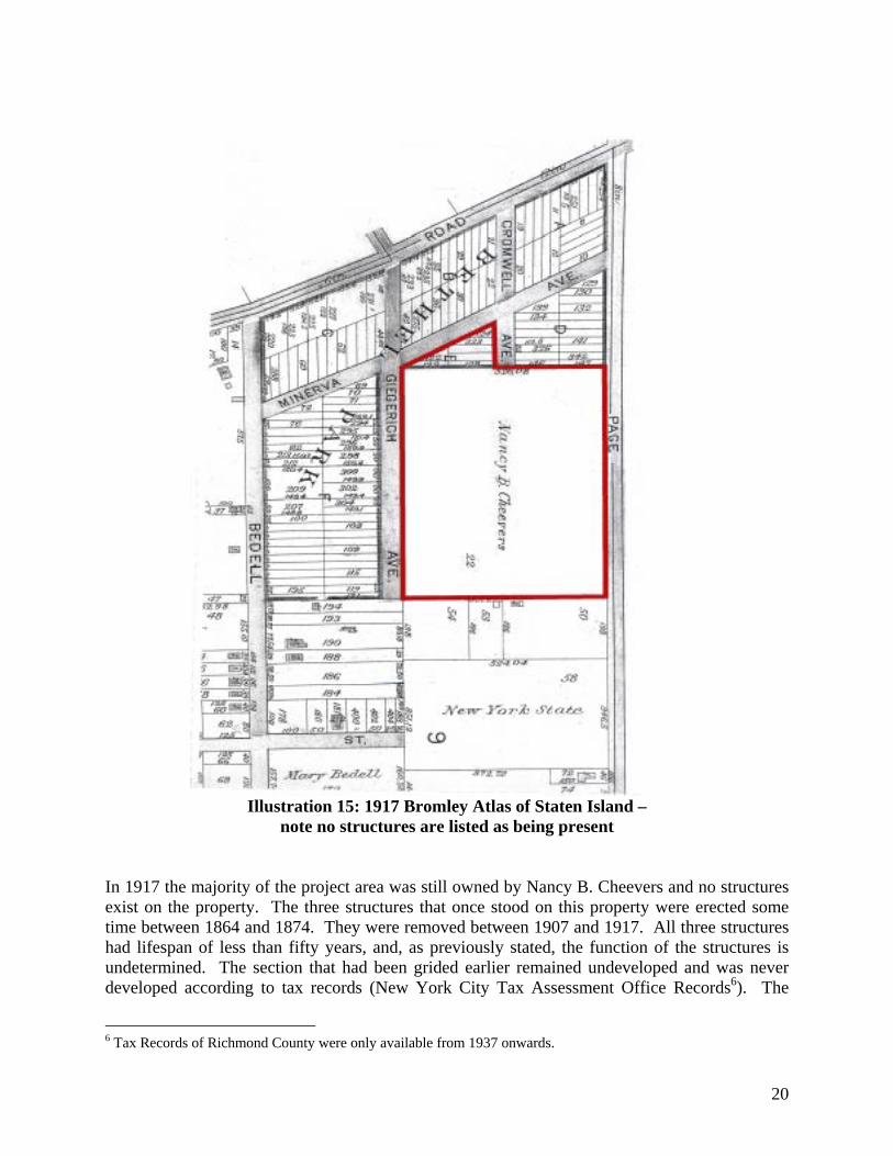
46
Photograph 39: STP 06.10D - ground water enters the test pit
STP Line 07 A total of five STPs, 07.00 thru 07.02, 07.09 to 07.10 were excavated (Photograph 16) in this line. STPs 07.00 to 07.02 were located between Page Avenue and the wetland area. STPs 07.09 to 07.10 were located between the wetland area and Giegerich Avenue. STP 07.00 was excavated to a depth of one hundred (100) centimeters. Ground water flooded the STP and the excavation was halted at this depth. The artifacts were noted on the field sheet. The matrix of this STP was comprised mostly of sand. STP 07.01 was excavated to a depth of seventy (70) centimeters. Shell, coal, window glass and metal were recovered along with modern plastic and asphalt chunks. The artifacts were noted on the field sheet. The matrix of this STP was comprised mostly of sand (Photograph 40).

47
Photograph 40: STP 07.01
STP 07.02 was excavated to a depth of eighty (80) centimeters. Ground water flooded the STP and the excavation was halted. Coal, window glass and modern nails were recovered. The matrix of this STP was comprised mostly of sand. STP 07.09 was excavated to a depth of one hundred (100) centimeters. Ground water flooded the STP and the excavation was halted at this depth. Shell remains were recovered from the upper portion of the STP. The artifacts were noted on the field sheet. The matrix of this STP was comprised mostly of sand. STP 07.10 was excavated to a depth of sixty-five (65) centimeters. Ground water flooded the STP and the excavation was halted at this depth. Shell remains were recovered from the upper portion of the STP. The artifacts were noted on the field sheet. The matrix of this STP was comprised mostly of sand (Photograph 41).

48
Photograph 41: STP 07.10 – ground water enters the test pit
STP Line 08 A total of five STPs, 08.00 to 08.02 and 08.09 to 08.10 were excavated (Photograph 16) in this line. STPs 08.00 to 08.02 were located between Page Avenue and the wetland area. STPs 08.09 to 08.10 were located between the wetland area and Giegerich Avenue. STP 08.00 was excavated to a depth of seventy (70) centimeters. Ground water flooded the STP and the excavation was halted at this depth. Clinker, coal, window glass and one historic ceramic shard were recovered along with modern plastic and asphalt chunks. The artifacts were noted on the field sheet. The matrix of this STP was comprised mostly of sand.

49
STP 08.01 was excavated to a depth of eighty (80) centimeters. Ground water flooded the STP and the excavation was halted at this depth. Window glass and three pieces of transferprinted whiteware ceramic body pieces were recovered. The matrix of this STP was comprised mostly of sand. STP 08.02 was excavated to a depth of seventy (70) centimeters. Ground water flooded the STP and the excavation was halted at this depth. Clinker, shell and coal were recovered. The artifacts were noted on the field sheet. The matrix of this STP was comprised mostly of sand (Photograph 42).
Photograph 42: STP 08.02 – end of level 1 – prior to ground water entering the test pit
STP 08.09 was excavated to a depth of eighty (80) centimeters. Coal, burnt wood and rocks were recovered. The matrix of this STP was comprised mostly of sand. STP 08.10 was excavated to a depth of eighty (80) centimeters. Shell fragments were recovered. The artifacts were noted on the field sheet. The matrix of this STP was comprised mostly of sand (Photograph 43).

50
Photograph 43 STP 08.10
STP Line 09 A total of five STPs, 09.00 to 09.02 and 09.09 to 09.10 were excavated (Photograph 16) in this line. STPs 09.00 to 09.02 were located between Page Avenue and the wetland area. STPs 09.09 to 09.10 were located between the wetland area and Giegerich Avenue. STP 09.00 was excavated to a depth of sixty-five (65) centimeters. Ground water flooded the STP and the excavation was halted at this depth. Clinker, shell and coal were recovered. The artifacts were noted on the field sheet. The matrix of this STP was comprised mostly of sand. STP 09.01 was excavated to a depth of eighty-five (85) centimeters. Ground water flooded the STP and the excavation was halted at this depth. Brick and clinker were recovered. The artifacts were noted on the field sheet. The matrix of this STP was comprised mostly of sand. STP 09.02 was excavated to a depth of fifty-five (55) centimeters. Ground water flooded the STP and the excavation was halted at this depth. Clinker, shell and window glass were recovered. The matrix of this STP was comprised mostly of sand (Photograph 44).

51
Photograph 44: STP 09.02 – ground water enters the test pit
STP 09.09 was excavated to a depth of eighty (80) centimeters. The artifacts were noted on the field sheet. The matrix of this STP was comprised mostly of sand. STP 09.10 was excavated to a depth of seventy (70) centimeters. The artifacts were noted on the field sheet. The matrix of this STP was comprised mostly of sand (Photograph 45).
Photograph 45: STP 09.10 – note the mislabeling in the field as STP 09.11

52
STP Line 10 A total of ten STPs, 10.00 to 10.03 and 10.08 to 10.10 were excavated (Photograph 16) in this line. STPs 10.00 to 10.03 were located between Page Avenue and the wetland area. Based upon the recommendation of the NYSOPRHP STPs 10.03A, 10.03B and 10.03C were excavated to determine the extent of the artifact concentration in STP 10.03. STPs 10.08 to 10.10 were located between the wetland area and Giegerich Avenue. STP 10.00 was excavated to a depth of one hundred and ten (110) centimeters. Ground water flooded the STP and the excavation was halted at this depth. The artifacts were noted on the field sheet. The matrix of this STP was comprised mostly of sand. STP 10.01 was excavated to a depth of seventy (70) centimeters. Ground water flooded the STP and the excavation was halted at this depth. Whiteware ceramic body shards, metal and shell fragments were recovered. The matrix of this STP was comprised mostly of sand. STP 10.02 was excavated to a depth of seventy (70) centimeters. Animal bone, clinker, historic redware and whiteware ceramics, clear window glass and coal were recovered. The matrix of this STP was comprised mostly of sand (Photograph 46).
Photograph 46: STP 10.02

53
STP 10.03 was excavated to a depth of forty-five (45) centimeters. Ground water flooded the STP and the excavation was halted at this depth. Several whiteware body pieces, a stoneware shard, square cut metal nail and three possible Native American flakes and fire cracked rock were recovered. The matrix of this STP was comprised mostly of sand. STP10.03A was excavated to a depth of fifty (50) centimeters. Ground water flooded the STP and the excavation was halted at this depth. The matrix of this STP was comprised of a mixture of sand and loam. A piece of brick and a clam shell fragment were uncovered in the STP. The artifacts were noted on the field sheet only (Photograph 47).
Photograph 47: STP 10.03A - ground water enters the test pit
STP10.03B was excavated to a depth of forty-fifty (45) centimeters. Ground water flooded the STP and the excavation was halted at this depth. The matrix of this STP was comprised of a mixture of sand and loam. A piece of coal, one whiteware shard and a clear bottle fragment were uncovered in the STP. The artifacts were noted on the field sheet only (Photograph 48).

54
Photograph 48: STP 10.03B - ground water enters the test pit
STP10.03C was excavated to a depth of fifty (50) centimeters. Ground water flooded the STP and the excavation was halted at this depth. The matrix of this STP was comprised of a mixture of sandy and loam. A piece of clinker was uncovered in the top layer of the STP. The artifact was noted on the field sheet only. STP 10.08 was excavated to a depth of sixty-five (65) centimeters. Ground water flooded the STP and the excavation was halted at this depth. Shell and coal fragments were recovered. The artifacts were noted on the field sheet. The matrix of this STP was comprised mostly of sand. STP 10.09 was excavated to a depth of one hundred and ten (110) centimeters. Ground water flooded the STP and the excavation was halted at this depth. The artifacts were noted on the field sheet. The matrix of this STP was comprised mostly of sand (Photograph 49). STP 10.10 was excavated to a depth of ninety-five (95) centimeters. No artifacts were recovered. The matrix of this STP was comprised mostly of sand.
55
Photograph 49: STP 10.09 – note the mislabeling in the field as STP 10.10
STP Line 11 A total of eleven STPs, 11.00 thru 11.10 were excavated (Photograph 16) in this line. The entire line of STPs runs between Page Avenue and Giegerich Avenue. The protected wetland area abuts STPs 11.05 and 11.06, but is to the south of the line. STP 11.00 was excavated to a depth of seventy-five (75) centimeters. Ground water flooded the STP and the excavation was halted at this depth. The artifacts were noted on the field sheet. The matrix of this STP was comprised mostly of sand. STP 11.01 was excavated to a depth of eighty-six (86) centimeters. One shell and one possible Native American flake were recovered. The matrix of this STP was comprised mostly of sand. STP 11.02 was excavated to a depth of seventy (70) centimeters. Clinker, shell and coal fragments were recovered. The artifacts were noted on the field sheet. The matrix of this STP was comprised mostly of sand.

56
STP 11.03 was excavated to a depth of one hundred (100) centimeters. Ground water flooded the STP and the excavation was halted at this depth. One piece of clear window glass and one whiteware ceramic rim with gold banding were recovered. The matrix of this STP was comprised mostly of sand (Photograph 50).
Photograph 50: STP 11.03 – ground water enters the test pit
STP 11.04 was excavated to a depth of eighty (80) centimeters. Ceramic, clinker and coal fragments were recovered. The matrix of this STP was comprised mostly of sand. STP 11.05 was excavated to a depth of eighty (80) centimeters. Ground water flooded the STP and the excavation was halted at this depth. Clinker and shell were recovered. The artifacts were noted on the field sheet. The matrix of this STP was comprised mostly of sand.

57
STP 11.06 was excavated to a depth of seventy (70) centimeters. Ground water flooded the STP and the excavation was halted at this depth. Brick, clinker and shell were recovered. The artifacts were noted on the field sheet. The matrix of this STP was comprised mostly of sand. STP 11.07 was excavated to a depth of fifty (50) centimeters. Ground water flooded the STP and the excavation was halted at this depth. Clinker was recovered. The matrix of this STP was comprised mostly of sand. STP 11.08 was excavated to a depth of eighty (80) centimeters. Ground water flooded the STP and the excavation was halted at this depth. Brick, clinker and coal were recovered. The artifacts were noted on the field sheet. The matrix of this STP was comprised mostly of sand. STP 11.09 was excavated to a depth of seventy-five (75) centimeters. Although the STP was moist, ground water did not flood it. Clinker, window glass and shell were recovered. The artifacts were noted on the field sheet. The matrix of this STP was comprised mostly of sand. STP 11.10 was excavated to a depth of sixty (60) centimeters. Ground water flooded the STP and the excavation was halted at this depth. No artifacts were recovered. The matrix of this STP was comprised mostly of sand (Photograph 51).
Photograph 51: STP 11.10 – note the mislabeling in the field as STP 11.10

58
STP Line 11-12 STP11-12A was excavated to a depth of eighty (80) centimeters. Ground water flooded the STP and the excavation was halted at this depth. The matrix of this STP was comprised of a mixture of sand and reddish-brown loam. A brick fragment, whiteware shard and a piece of clinker were uncovered in the STP. The artifacts were noted on the field sheet only (Photograph 52).
Photograph 52: STP 11-12A - ground water enters the test pit
STP11-12B was excavated to a depth of eighty-five (85) centimeters. Ground water flooded the STP and the excavation was halted at this depth. The matrix of this STP was comprised of a mixture of sand and reddish-brown loam. A brick fragment, clear bottle shard and a piece of clinker were uncovered in the STP. The artifacts were noted on the field sheet only. STP11-12C was excavated to a depth of seventy-five (75) centimeters. Ground water flooded the STP and the excavation was halted at this depth. The matrix of this STP was comprised of a mixture of sand and reddish-brown loam. No artifacts were recovered from the STP (Photograph 53).

59
Photograph 53: STP 11-12C - ground water enters the test pit
STP11-12D was excavated to a depth of eighty (80) centimeters. Ground water flooded the STP and the excavation was halted at this depth. The matrix of this STP was comprised of a mixture of sand and reddish-brown loam. Fragments of brick, coal, oyster and clam shells were uncovered in the STP. The artifacts were noted on the field sheet only (Photograph 54).
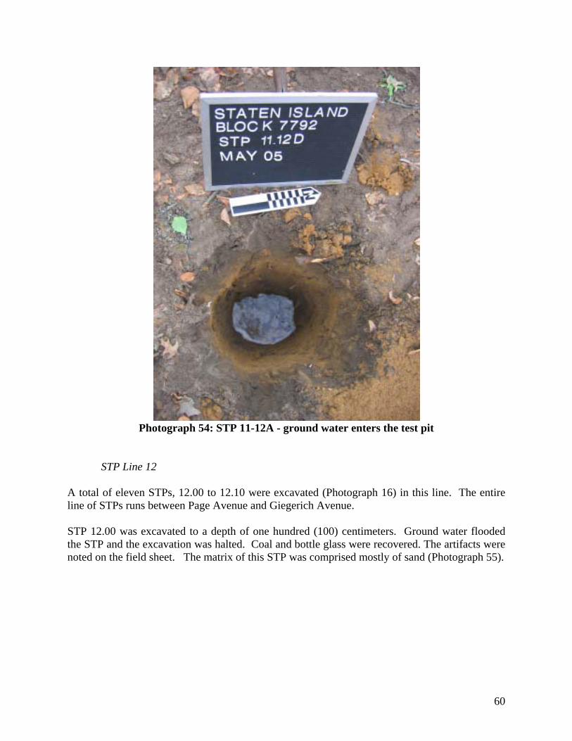
60
Photograph 54: STP 11-12A - ground water enters the test pit
STP Line 12 A total of eleven STPs, 12.00 to 12.10 were excavated (Photograph 16) in this line. The entire line of STPs runs between Page Avenue and Giegerich Avenue. STP 12.00 was excavated to a depth of one hundred (100) centimeters. Ground water flooded the STP and the excavation was halted. Coal and bottle glass were recovered. The artifacts were noted on the field sheet. The matrix of this STP was comprised mostly of sand (Photograph 55).

61
Photograph 55: STP 12.00 – just prior to ground water entering the test pit
STP 12.01 was excavated to a depth of seventy (70) centimeters. Shell, pearlware ceramic base shard, clear window glass, brown bottle glass, round nails and one pipe stem fragment were recovered. The matrix of this STP was comprised mostly of sand. STP 12.02 was excavated to a depth of one hundred (100) centimeters. Brick, shell, porcelian ceramics, clear window glass, brown bottle glass, round and square nails recovered. The matrix of this STP was comprised mostly of sand. STP 12.03 was excavated to a depth of sixty-five (65) centimeters. No artifacts were recovered. The matrix of this STP was comprised mostly of sand. STP 12.04 was excavated to a depth of one hundred (100) centimeters. One piece of a clam shell fragment was recovered. The matrix of this STP was comprised mostly of sand. STP 12.05 was excavated to a depth of seventy (70) centimeters. Ground water flooded the STP and the excavation was halted at this depth. Brick and bottle glass were recovered. The matrix of this STP was comprised mostly of sand (Photograph 56).

62
Photograph 56: STP 12.05 – ground water enters the test pit
STP 12.06 was excavated to a depth of sixty-five (65) centimeters. Ground water flooded the STP and the excavation was halted at this depth. No artifacts were recovered. The matrix of this STP was comprised mostly of sand. STP 12.07 was excavated to a depth of thirty (30) centimeters. Ground water flooded the STP and the excavation was halted at this depth. No artifacts were recovered. The matrix of this STP was comprised mostly of sand. STP 12.08 was excavated to a depth of seventy-five (75) centimeters. Ground water flooded the STP and the excavation was halted at this depth. Brick, clam fragments and historic whiteware ceramic shards were recovered. The matrix of this STP was comprised mostly of sand. STP 12.09 was excavated to a depth of eighty-five (85) centimeters. Brick, clinker, shell, coal and metal fragments were recovered. The artifacts were noted on the field sheet. The matrix of this STP was comprised mostly of sand.

63
STP 12.10 was excavated to a depth of one hundred (100) centimeters. Brick, clinker, shell, coal and metal fragments were recovered. The artifacts were noted on the field sheet. The matrix of this STP was comprised mostly of sand (Photograph 57).
Photograph 57: STP 12.10
STP Line 13
A total of six STPs, 13.02 thru 13.07 were excavated (Photograph 16) in this line. The entire line of STPs runs between Page Avenue and Giegerich Avenue. STPs 13.00 and 13.01 could not be excavated, or laid out, since a private property structures stands on that particular portion of the lot. The area this structure resides on is not part of the overall property improvement plan. STP 13.08, originally laid out in the initial survey was not excavated since it too was directly on the property line of an adjacent property, not involved in the improvement plan. Due to recent construction of this property, massive amounts of fill and garbage were deposited in this area, thus making it impossible to test. Overall the area beginning from STP Line 13 and continuing through Line 16 is comprised of a slope that leads down towards the rest of the property and wetland area. The area appears to have been used as fill for construction materials related to the recent construction along Giegerich Avenue.

64
STP 13.02 was excavated to a depth of forty-five (45) centimeters. Brick, clinker, shell, glass and metal were recovered along with modern garbage material including concrete and asphalt chunks. The artifacts were noted on the field sheet. The matrix of this STP was comprised mostly of sand. STP 13.03 was excavated to a depth of eighty-five (85) centimeters. No artifacts were recovered. The matrix of this STP was comprised mostly of sand. STP 13.04 was excavated to a depth of fifty (50) centimeters. Brick, clinker, shell, historic ceramic shards, glass and metal were recovered along with modern garbage material including concrete and asphalt chunks. The artifacts were noted on the field sheet. The matrix of this STP was comprised mostly of sand (Photograph 58).
Photograph 58: STP 13.04
STP 13.05 was excavated to a depth of sixty-five (65) centimeters. Brick, shell, glass and metal were recovered along with modern garbage material including concrete and asphalt chunks. The artifacts were noted on the field sheet. The matrix of this STP was comprised mostly of sand. STP 13.06 was excavated to a depth of eighty-five (85) centimeters. Brick, shell, glass and metal were recovered along with modern garbage material including concrete and asphalt chunks. The artifacts were noted on the field sheet. The matrix of this STP was comprised mostly of sand. STP 13.07 was excavated to a depth of seventy-five (75) centimeters. Brick, shell, glass and metal were recovered along with modern garbage material including concrete and asphalt chunks. The artifacts were noted on the field sheet. The matrix of this STP was comprised mostly of sand.

65
STP Line 14 A total of eight STPs, 14.00 to 14.07 were excavated (Photograph 16) in this line. The entire line of STPs runs between Page Avenue and Giegerich Avenue. STP 14.08, originally laid out in the initial survey was not excavated since it was directly on the property line of an adjacent property, not involved in the improvement plan. Due to recent construction of this property, massive amounts of fill and garbage were deposited in this area, thus making it impossible to test. This STP line resides on a slight slope that leads down toward the rest of the property and wetland area. The area appears to have been used as fill for construction materials related to the recent construction along Giegerich Avenue. It should be noted that this condition exists for STP Lines 15 and 16 as well. STP 14.00 was excavated to a depth of ninety (90) centimeters. Ground water flooded the STP and the excavation was halted at this depth. Brick, historic ceramic shard, clinker, shell, coal, glass and metal fragments were recovered. The artifacts were noted on the field sheet. The matrix of this STP was comprised mostly of sand (Photograph 59).
Photograph 59: STP 14.00 – ground water enters the test pit
STP 14.01 was excavated to a depth of eighty (80) centimeters. Shell and metal fragments were recovered. The artifacts were noted on the field sheet. The matrix of this STP was comprised mostly of sand. STP 14.02 was excavated to a depth of seventy (70) centimeters. Brick, glass and coal fragments were recovered. The artifacts were noted on the field sheet. The matrix of this STP was comprised mostly of sand.

66
STP 14.03 was excavated to a depth of sixty-five (65) centimeters. Ceramic, shell, glass and metal fragments were recovered. The artifacts were noted on the field sheet. The matrix of this STP was comprised mostly of sand (Photograph 60).
Photograph 60: STP 14.03
STP 14.04 was excavated to a depth of seventy (70) centimeters. Clinker and glass fragments were recovered. The matrix of this STP was comprised mostly of sand. STP 14.05 was excavated to a depth of ninety (90) centimeters. Shell and brick fragments were recovered. The artifacts were noted on the field sheet. The matrix of this STP was comprised mostly of sand.

67
STP 14.06 was excavated to a depth of sixty-five (65) centimeters. No artifacts were recovered. The matrix of this STP was comprised mostly of sand. STP 14.07 was excavated to a depth of seventy-five (75) centimeters. Glass and metal fragments were recovered. The artifacts were noted on the field sheet. The matrix of this STP was comprised mostly of sand.
STP Line 15 A total of five STPs, 15.03 to 15.07 were excavated (Photograph 16) in this line. The entire line of STPs runs between Page Avenue and Giegerich Avenue. STPs 15.00 to 15.02 could not be excavated, or laid out, since a private property structures remains on that particular portion of the lot. The area this structure resides on is not part of the overall property improvement plan. STP 15.08, originally laid out in the initial survey was not excavated since it was directly on the property line of an adjacent property, not involved in the improvement plan. STP 15.03 was excavated to a depth of forty-five (45) centimeters. Clinker, shell and coal fragments were recovered. The artifacts were noted on the field sheet. The matrix of this STP was comprised mostly of sand (Photograph 61).
Photograph 61: STP 15.03

68
STP 15.04 was excavated to a depth of seventy-five (75) centimeters. Coal and window glass fragments were recovered. The artifacts were noted on the field sheet. The matrix of this STP was comprised mostly of sand. STP 15.05 was excavated to a depth of eighty-five (85) centimeters. An historic ceramic shard, coal and window glass fragments were recovered. The matrix of this STP was comprised mostly of sand. STP 15.06 was excavated to a depth of one hundred (100) centimeters. Glass and metal fragments were recovered. The artifacts were noted on the field sheet. The matrix of this STP was comprised mostly of sand. STP 15.07 was excavated to a depth of seventy-five (75) centimeters. Coal, glass and metal fragments were recovered. The artifacts were noted on the field sheet. The matrix of this STP was comprised mostly of reddish-orange sand (Photograph 62).
Photograph 62: STP 15.07
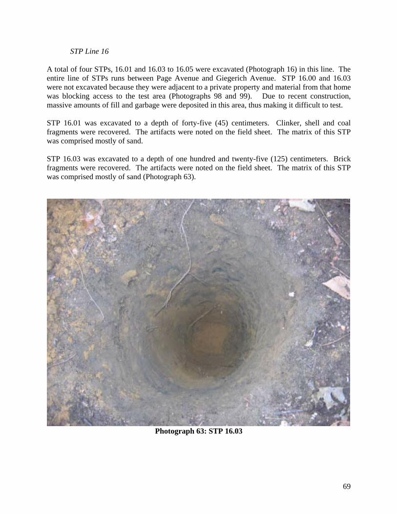
69
STP Line 16 A total of four STPs, 16.01 and 16.03 to 16.05 were excavated (Photograph 16) in this line. The entire line of STPs runs between Page Avenue and Giegerich Avenue. STP 16.00 and 16.03 were not excavated because they were adjacent to a private property and material from that home was blocking access to the test area (Photographs 98 and 99). Due to recent construction, massive amounts of fill and garbage were deposited in this area, thus making it difficult to test. STP 16.01 was excavated to a depth of forty-five (45) centimeters. Clinker, shell and coal fragments were recovered. The artifacts were noted on the field sheet. The matrix of this STP was comprised mostly of sand. STP 16.03 was excavated to a depth of one hundred and twenty-five (125) centimeters. Brick fragments were recovered. The artifacts were noted on the field sheet. The matrix of this STP was comprised mostly of sand (Photograph 63).
Photograph 63: STP 16.03

70
STP 16.04 was excavated to a depth of one hundred and twenty-five (125) centimeters. Clinker, brick, coal, shell and glass fragments were recovered. The artifacts were noted on the field sheet. The matrix of this STP was comprised mostly of sand. STP 16.05 was excavated to a depth of one hundred and twenty-five (125) centimeters. Clinker, brick, coal and glass fragments were recovered. The artifacts were noted on the field sheet. . The matrix of this STP was comprised mostly of sand (Photograph 64).
Photograph 64: STP 16.05

71
Laboratory Analysis Of the four hundred and thirty (430) artifacts recorded in the field, approximately three hundred ninety (390) were washed, catalogued, recorded and bagged for storage (see Appendix D – Artifact Database for a complete listing of recorded artifacts as well as artifact images). The majority of the artifacts recovered were typical indistinguishable historic materials such as brick, coal, clinker, shell, plain undecorated window and bottle glass. Of the clearly datable artifacts, whiteware ceramics, which date to post 1850, were the most prevalent. Redware and stoneware accounted for a couple of the shards, and pearlwares accounted for four of the forty-three (43) recovered shards. Only one Native American point was recovered, a Late Woodland Levanna10 period point (Photograph 56 – and see Photographs 57-60 for other artifact images). Approximately forty flakes and a dozen fire cracked rocks were recovered as well.
Artifact Totals:
Animal Bone 5 Brick 13
Clinker 15 Coal 29
Clam Shell 36 Oyster Shell 86
Ceramic Body 42 Ceramic Base 2 Ceramic Rim 5
Glass – Window 36 Glass – Bottle 62 Glass – Other 3
Pipe Stem 1 Pipe Bowl 1 Round Nail 9 Square Nail 7
Iron 6 Lead 6 Tin 1
Native Amer. Flakes 43 Native Amer. Point 1 Fire Cracked Rock 13
Despite a range of artifacts recovered from the site, there were no discernible artifact patterns. Many of the artifacts were from a mixed context. For example, the Native American flakes recovered from STP 06.10 were found in association with a post 1850 whiteware ceramic shard. 10 The point was identified using the guide set up by Ritchie (1971).

72
VIII: SUMMARY AND RECOMMENDATION Although this property does not fall under Section 106 of the National Historic Preservation Act of 1966, as amended, the use of the National Register of Historic Places guidelines drive most local and state cultural resource methodologies. As described in the National Park Service’s, National Register Bulletin 15: How to Apply the National Register Criteria for Evaluation, second II: National Register Criteria for Evaluation break down evaluation into four categories:
Criteria for Evaluation: The quality of significance in American history, architecture, archeology, engineering, and culture is present in districts, sites, buildings, structures, and objects that possess integrity of location, design, setting, materials, workmanship, feeling, and association, and: A. That are associated with events that have made a significant contribution to the broad patterns of our history; or B. That are associated with the lives of significant persons in or past; or C. That embody the distinctive characteristics of a type, period, or method of construction, or that represent the work of a master, or that possess high artistic values, or that represent a significant and distinguishable entity whose components may lack individual distinction; or D. That have yielded or may be likely to yield, information important in history or prehistory.
Upon examination of the properties within Block 7792, the site does not qualify for: Criteria A since no historically significant events have transpired at that site (see Burrows and Wallace 1999; Bayles 1887; Clute 1877; Morris 1900); Criteria B since no historically famous person resided on site (based on Chain of Title research); Criteria C since the twentieth century brick house no longer exists as it was demolished last year (Bay Properties 2004); Criteria D since it appears that the site would not be able to yield significant, original information on either the prehistoric or historic time periods (based on Phase 1B field test). All of the prehistoric materials uncovered were either from a disturbed context or were not in clearly distinguishable stratigraphic layers. Most were in a mixed context of prehistoric and historic artifacts. Based upon the historical documentation, field work and artifact interpretation, this site posses limited to no potential to reveal significant prehistoric information. Likewise, the historic artifacts were fairly undistinguishable in terms of quantity, quality and stratigraphic contexts. The artifacts appear to be typical late nineteenth to early twentieth century in nature. Based on the historical documentation, field work and artifact interpretation, this site posses limited to no potential to reveal significant historic information.

73
As previously stated, several local residents claimed to have recovered Native American artifacts from the surface of the project area. A walk-over of the site with Ray Matarazio was undertaken in June 2005. Mr. Matarazio pointed out the locations that he, and others, have been recovering material remains. All of the locations directed to by Mr. Matarazio were located within the pre-existing DEC “buffer-zone” around the wetland and were not within the APE. Therefore, the location from where the recovery of the material remains occurred will not be impacted by the proposed development (see Appendix F for further details and information from the site visit). The excavation of the additional STPs and test pit around previously identified artifact concentrations did not provide either significant material remains or stratigraphic information. All of the STPs reflected the disturbed nature of the site, in that modern alcoholic bottle glass fragments were found in association with late nineteenth century whiteware ceramic shards. Although this area was fairly undeveloped throughout its history, much of the APE appears to have been recently disturbed by the various construction projects that surround Bock 7792. At least ten properties were constructed in the last ten years along Giegerich Avenue, according to the same local residents that provided the information with regard to the Native American artifacts recovered on site (Photographs 98 and 99). Construction debris, particularly in the southern and southeastern portion of the property was great, hence the inability to test in that area (see Photograph 16 for the areas that were not tested). Along Giegerich Avenue, the majority of soils that were uncovered in the STPs were either clean sand or sand mixed with construction debris. The apparent transportation and deposition of soils from other areas, probably excavated material for the recently developed structures, is the most likely cause of this disturbance to the site. The majority of artifacts recovered in STPs from within numbers above six were from the upper most portions of the test pits. This disturbance reduces the significance of the recovered materials since it is impossible to determine exactly where these artifacts originated from. It is the conclusion of this report that no significant buried cultural resources will be disturbed by the construction of the new housing on the various lots within Block 7792. The site does not meet any of the four Federally recognized Criteria for Consideration of inclusion on the National Register of Historic Places. Nor does the site possess significant stratigraphic contexts that could be used for interpretation. The consistently high water table, at approximately fifty (50) to seventy-five (75) centimeters below surface indicates that this site has traditionally been a wetland area. This is reinforced by the historic maps that are available. Based on a study of the chain of title, previous site reports from within the project area and the maps of the area, the archaeological information uncovered during the field testing and subsequent laboratory analysis, there does not appear to be any significant buried archaeological remains within the various lots of Block 7792. No further Cultural Resource Investigations should take place for this site.

74
IX: REFERNECES Bankoff, H. Arthur, Christopher Ricciardi and Alyssa Loorya.
1997 The History and Archaeology of the Wyckoff Homestead. Report on file with the New York City Department of Parks And Recreation’s Historic House Trust Division, New York, New York.
Baugher, Sherene and Bluefeld, Frederick. 1980 A Background Study of Historic Land Use Of The Gateway National Recreation
Area, Staten Island Unit. Report on file with the U.S. Army Corps of Engineers – New York District, New York, New York. February.
1985 The Potential For Submerged Archaeological Resources In The Proposed
Dredging Area; Surface Action Group, Stapleton, Staten Island, New York. Report on file with the U.S. Army Corps of Engineers – New York District, New
York, New York. September. Bayles, Richard M. (editor) 1887 The History of Richmond County (Staten Island) From its Discovery to the
Present Time. L.E. Preston and Company, New York, New York. Beers, Frederick. 1874 Atlas of the County of Richmond (Staten Island), New York. Berger, Louis and Associates.
1985 The Potential For Submerged Archaeological Resources In The Proposed Dredging Area; Surface Action Group, Stapleton, Staten Island, New York. Report on file with the U.S. Army Corps of Engineers – New York District, New York, New York.
1986 A Proposal for a Phase II Cultural Resource Survey of the Howland Hook Marine Terminal Expansion, Staten Island, New York. Report on file with the U.S. Army Corps of Engineers – New York District, New York, New York. June.
1990 Stage I Cultural Resource Investigation – Gateway Cathedral – Staten Island,
New York – CEQR # 89-318R. Report on file with the New York State Office of Parks, Recreation and Historic Preservation. Albany, New York.
1992 Phase I Historical And Archaeological Survey – Liberty Pipeline Project – Borough Of Richmond, New York, New York. Report on file with the New York State Office of Parks, Recreation and Historic Preservation. Albany, New York.
Bien, Joseph. 1881 Atlas of the County of Richmond (Staten Island), New York.

75
Boesch, Eugene J. 1994 Archaeological Evaluation And Sensitivity Assessment Of Staten Island, New
York. Report on file with the New York City Landmarks Preservation Commission, New York, New York.
Bolton, Reginald Pelham.
1920 New York City in Indian Possession. Indian Notes and Monographs. Museum of the American Indian, New York, New York.
1922 Indian Paths in the Great Metropolis. Indian Notes and Monographs. Museum of the American Indian, New York, New York.
1934 Indian Life of Long Ago In The City of New York. Joseph Graham (Boltons Books), New York, New York
Bromley, 1917 Atlas of the County of Richmond (Staten Island), New York. City/Scape: Cultural Resource Consultants.
1995 Block 7792 – Lot 430 – Archaeological Field Survey – Site Location Scope Of Work And Proposed Test Locations – Staten Island, New York. Report on file with the New York City Landmarks Preservation Commission, New York, New York.
Clute, J.J. 1877 Annals of Staten Island from its Discovery to the Present Time. Press of Charles Vogt. New York, New York. Greenhouse Consultants, Inc. 1987a Stage IB/II Archaeological Survey Of The Page Avenue Development Project –
Staten Island, New York. Report on file with the New York State Office of Parks, Recreation and Historic Preservation. Albany, New York.
1987b Stage IA Archaeological Survey Of The Honey Blossom Development Project – Staten Island, New York Report on file with the New York State Office of Parks,
Recreation and Historic Preservation. Albany, New York. 1987c Stage IB Archaeological Survey Of The Honey Blossom Development Project – Staten Island, New York Report on file with the New York State Office of Parks,
Recreation and Historic Preservation. Albany, New York. 1987d Stage IB Archaeological Survey Of The Chateau Du Bois Development Project – Staten Island, New York Report on file with the New York State Office of Parks,
Recreation and Historic Preservation. Albany, New York.

76
1987e Stage IB Archaeological Survey Of The Surfside Village Development Project – Staten Island, New York Report on file with the New York State Office of Parks,
Recreation and Historic Preservation. Albany, New York.
1988 Phase 1A Historical/Archaeological Sensitivity Evaluation Of The Maguire Estates Development Project – Staten Island, New York – CEQR # 88-151R. Report on file with the New York City Landmarks Preservation Commission, New York, New York.
1993 Stage 1A Archaeological/Historical Sensitivity Evaluation Of The Joline Avenue
Residences Project – Staten Island, New York. Report on file with the New York City Landmarks Preservation Commission, New York, New York.
1994 Stage 1B Archaeological/Historical Sensitivity Evaluation Of The Joline Avenue
Residences Project – Staten Island, New York. Report on file with the New York City Landmarks Preservation Commission, New York, New York.
1997a Archaeological Survey Of Lot 30 Page and Bartow Avenues Development –
Staten Island, New York – CEQR # 95-DGS-002R. Report on file with the New York City Landmarks Preservation Commission, New York, New York.
1997b Archaeological Survey Of The Page And Bartow Avenues Development – Staten
Island, New York – CEQR # 95-DGS-002R. Report on file with the New York City Landmarks Preservation Commission, New York, New York.
1997c Stage 1A Archaeological/Historical Sensitivity Evaluation Of The Page And
Bartow Avenues Development – Staten Island, New York. Report on file with the New York City Landmarks Preservation Commission, New York, New York.
1997d Stage 1A Archaeological/Historical Sensitivity Study Of The Page And Bartow
Avenues Development – Staten Island, New York. Report on file with the New York City Landmarks Preservation Commission, New York, New York.
Grossman and Associates, Inc.
1987 Testing Recommendations For A Subsurface Archaeological Evaluation Of The Proposed Hyland Boulevard Shopping Center Parcel, Staten Island, New York. Report on file with the New York City Landmarks Preservation Commission, New York, New York.
Hagstrom Corporation. 2001 Map of the City of New York. Hagstrom Corporation. New York, New York.

77
Historical Perspectives, Inc. 1998a Stage IB Archaeological Test Excavations At The Proposed P.S. 6-R School Site
Property – Tottenville, Staten Island, New York. Report on file with the New York State Office of Parks, Recreation and Historic Preservation. Albany, New York.
1998b Stage II Archaeological Investigation of The P.S. 6-R School Prehistoric Site Page Avenue, Staten Island, New York. Report on file with the New York State Office of Parks, Recreation and Historic Preservation. Albany, New York.
Hunter, Richard, Michael Tomkins and Brooke Blades. 1995a An Archaeological Assessment Of Fort Wadsworth, Staten Island, Richmond
County, New York City, New York State. Report on file with the U.S. Army Corps of Engineers – New York District, New York, New York. February.
1995b A Phase 1A Archaeological Survey For The Arthur Kill Factory Outlet Center,
Staten Island, Borough Of Richmond County, New York City, New York. Report on file with the New York City Landmarks Preservation Commission, New York, New York.
Jacobson, Jerome. 1980 Richmond County – Archaeological Research Near Burial Ridge, Tottenville And
Burial Ridge, Tottenville, Staten Island, New York – Archaeology At New York City’s Largest Prehistoric Cemetery. Staten Island Institute of Arts and Science. Staten Island, New York.
Kardas, Susan and Edward Larrabee. 1977 Cultural Resource Reconnaissance – Northeast Shore, Staten Island – New York
Harbor Collection And Removal Of Drift Project. Report on file with the U.S. Army Corps of Engineers – New York District, New York, New York. February.
1981a Cultural Resource Reconnaissance of 700 MW Fossil Plant, Staten Island,
New York. Report on file with the U.S. Army Corps of Engineers – New York District, New York, New York. February.
1981b Archaeological Survey of 700 MW Fossil Plant, Staten Island, New York. Report on file with the U.S. Army Corps of Engineers – New York
District, New York, New York. September. 1989a Documentary Research Study For Cultural Resources For Property At 7273
Amboy Road (Lot 1, Block 8042) Tottenville, Staten Island, New York – CEQR- 89-001R, 5 July 1988. Report on file with the New York City Landmarks Preservation Commission, New York, New York.

78
1989b Archaeological Testing Of Property At 7273 Amboy Road (Lot 1, Block 8042) Tottenville, Staten Island, New York – CEQR-89-001R, 5 July 1988. Report on file with the New York City Landmarks Preservation Commission, New York, New York.
Lenik, Edward J.
1992 Native American Archaeological Resources In Urban America: A View From New York City. The Bulletin Of The New York State Archaeological Association (103):20-29.
Lipson, Clara, John Piet, Michael Alterman and Kris Egelhof. 1976 Phase I: Cultural Resource Reconnaissance – Beach Erosion Control and
Hurricane Protection Project at Staten Island. Report on file with the U.S. Army Corps of Engineers – New York District, New York, New York. February.
Milner, John and Associates. 2000 Phase IB/II Archaeological Investigations Of The Bricktown Centre At
Charleston – Staten Island, New York. Report on file with the New York State Office of Parks, Recreation and Historic Preservation. Albany, New York.
Morris, Ira K. 1900 Morris’s Memorial History of Staten Island. Memorial Publishing Company. New York, New York. New York (City) – Annual Record of Assessed Valuation of Real Estate.
Various Tax Assessors Office. New York, New York. New York (City) – Staten Island Registrar’s Office. Various Liber, Deeds and Mortgage information. New York (City) – Landmarks Preservation Commission. 1991 An Archaeological Investigation: The Conference House Park Site – Staten
Island, New York. Report on file with the New York State Office of Parks, Recreation and Historic Preservation. Albany, New York.
O’Callaghan, Edmund Bailey. 1846 History of New Netherland; or New York Under the Dutch (Volumes 1 & 2).
B. Appleton and Company, New York, New York. 1848-1851 The Documentary History Of The State Of New York (Volumes 1-4).
Weed, Parsons And Company, Printers, Albany, New York. 1861-1865 Documents Relative To The Colonial History Of The State Of New York:
1657-1678 (Volumes 1-16). Weed, Parsons and Company, Printers, Albany, New York.

79
Panamerican Consultants, Inc. 1999 Cultural Resource Survey, New York Harbor Collection And Removal Of Drift
Project, Arthur Kill, New York Reach; Arthur Kill, New Jersey Reach; And Kill Van Kull, New York Reach – Volume I. Report on file with the New York State Office of Parks, Recreation and Historic Preservation. Albany, New York.
2004 Phase 1 Combined Erosion Control And Storm Damage Reduction Protection Study, South Shore Of Staten Island, Richmond County, New York. Report on file with the U.S. Army Corps of Engineers – New York District, New York, New York. May.
Pickman, Arnold.
1988 Phase I Archaeological Survey – Tax Lots 188, 184 And 181, Block 8005 – Tottenville, Staten Island, New York. Report on file with the New York State Office of Parks, Recreation and Historic Preservation. Albany, New York.
1990 State 1A Archaeological Survey Amboy/Bedell Shopping Plaza – Pleasant Plains,
Staten Island, New York – CEQR # 90-175R. Report on file with the New York City Landmarks Preservation Commission, New York, New York.
Pickman, Arnold and Eugene Boesch.
1990 Stage 1B Archaeological Investigations Amboy/Bedell Shopping Plaza – Pleasant Plains, Staten Island, New York – CEQR #90-175R. Report on file with the New York City Landmarks Preservation Commission, New York, New York. October.
Pickman, Arnold and Rebecca Yamin.
1984 Oakwood Beach Water Pollution Control Project – Phase 1 Cultural Resource Survey – Hylan Boulevard At Richmond Avenue To Arthur Kill Road At Kreischer Street. Report on file with the New York State Office of Parks, Recreation and Historic Preservation. Albany, New York.
Raber, Michael S. 1996 Reconnaissance Cultural Resource Investigations – Kill Van Kull, New York
Reach, Richmond County, New York – New York Harbor Collection And Removal Of Drift Project. Report on file with the U.S. Army Corps of Engineers – New York District, New York, New York. January.
Rakos, Lynn. 1995 A Cultural Resource Reconnaissance Study Of The South Shore Of Staten Island,
Richmond County, New York. Report on file with the U.S. Army Corps of Engineers – New York District. New York, New York.
1996 Summary Of Archaeological Investigations In Connection With The Oakwood
Beach Section 103 Storm Damage Reduction Project, Oakwood Beach, Staten Island, Richmond County, New York. Report on file with the U.S. Army Corps of Engineers – New York District. New York, New York.

80
Ricciardi, Christopher. 2004 Changing Through The Century: Life on the Lott Family Farm, Town of
Flatlands, Kings County (Brooklyn), New York in the Nineteenth Century. Doctoral Dissertation, Department of Anthropology, Syracuse University, Syracuse, New York.
Ritchie, William A. 1971 A Typology and Nomenclature for New York Projectile Points. Bulletin Number
384. New York State Museum Division of Research and Collections. The State Education Department. Albany, New York
Robinson, E. 1898 Atlas of the Borough of Richmond (Staten Island), New York. 1907 Atlas of the Borough of Richmond (Staten Island), New York. Rockman, Diana diZerega and Nan A. Rothschild. 1979 A Preliminary Assessment of Cultural Resources on Shooters Island, Richmond
County, New York, and Hudson and Union Counties, New Jersey: Final Report. Report on file with the U.S. Army Corps of Engineers – New York District, New
York, New York. September. Rubinson, Karen.
1988 Documentary Study And Field Survey – Totten’s Landing Project – Tottenville, Staten Island – NYSDEC Application Number: 20-85-0948 Totten’s Land Corporation. Report on file with the New York State Office of Parks, Recreation and Historic Preservation. Albany, New York.
Salvedeo, Nicholas.
1985 Permit for Tottenville, Staten Island, New York. Report on file with the New York State Office of Parks, Recreation and Historic Preservation. Albany, New York.
Staten Island Historical Society. 2004 Various files and information on Tottenville. Staten Island Historical Society. Staten Island, New York.
TRC Environmental Group.
1998 The Tottenville Post Office Project – Phase IA Archaeological Survey Of 2.5 Acres In Tottenville, Richmond County, New York. Report on file with the New York State Office of Parks, Recreation and Historic Preservation. Albany, New York.
United States. 1845 U.S. Coast Survey Map of Staten Island.

81
Appendix A:
Archaeological Scope of Work and Proposal

82
Alyssa Loorya, M.A., R.P.A. 4110 Quentin Road
Brooklyn, New York 11234-4322 Phone: (718) 645-3962
Cell: (347) 922-5581 Fax: (718) 951-3169
December 1, 2004 Bay Properties, Inc. Igor Fleyshmakher, President Vincent Motts, Associate Phone: (718) 815-1336 Fax: (718) 815-3070 Re: DEC Proposed Development at Page Avenue and Giegerich Avenue Staten Island, Richmond County 04PR04095 (Block 7792 – Lots 228, 242, 250, 252, 278, 279) Dear Mr. Fleyshmakher: Thank you for contacting me with regard to the Cultural Resource Management Phase I Project for the Proposed Development at Page Avenue and Giegerich Avenue, Staten Island (Richmond County), New York. As registered professional archaeologists my partner Christopher Ricciardi, and myself are qualified, under the New York State Office of Parks, Recreation and Historic Preservation (NYSOPRHP) and the New York City Landmarks Preservation Commission (NYCLPC) guidelines for professional archaeologists, to undertake this project. As part of the State Environmental Quality Review Act (SEQRA) and the City Environmental Quality Review Act (CEQRA) a Cultural Resource Phase I Project has been determined to be necessary for the project site. Based on the requirements outlined in the letter dated 15 November 2004 from the granting agency, NYSOPRHP and in subsequent phone, and e-mail conversations on 30 November 2004, with Michael Schifferli from the NYSOPRHP, this project has been deemed significant, thus requiring both a Phase 1A Documentary Study and a Phase 1B Field Survey and Testing to be completed before a permit can be issued. A Phase IA Documentary Study will outline basic historical (and current) information of a project site and its surrounding vicinity. Although by no means an exhaustive history of the area, the Phase IA will be used to supply the NYSOPRHP and the NYCLPC with enough background information for them to determine whether or not further Cultural Resource work (i.e. a Phase 2 and possible Phase 3 testing project) will be required. As part of this report process, the history of the site, possibly a chain of title listing previous owners of the property, historic information

83
of the area, and historic maps will be compiled and reviewed to determine if there may be any significant historic/cultural remains buried on the site. Based on the phone and e-mail conversations with Mr. Schifferli and following the guidelines provided in Section 2.3.2 Subsurface Shovel Testing of the Standards for Cultural Resource Investigations and the Curation of Archaeological Collections in New York State, the project is required to conduct a Phase 1B Field Survey and Testing Study as well. This portion of the project must include a walking survey of the project area and the excavation of Standardized Test Pits (STPs) at a distance of no greater than every fifteen (15) meters and extending to a depth of sterile soil, to be determined in the field. Based on the approximate size of the project area, two hundred seventy (270m) meters by one hundred seventy (170m) meters, approximately two hundred (200) STPs will be required. STPs are generally 50 centimeters square (.5x.5cm) and are excavated to sterile soil, earthen layer which contains no cultural resource materials, at a depth that will be determined in the field. Obviously this is a large amount of test pits and will require a small labor crew. All archaeologically recovered materials will be brought to my laboratory facility where they will be washed, catalogued and identified following the field work. The materials will then be returned to you upon completion of the report. Once the field and laboratory work is completed a report will be prepared and combined with the Phase 1A Documentary Study. This combined report, called the Draft Phase 1 Report, will be sent to both NYSOPRHP and NYC LPC for review and comment. You will also have the opportunity to comment on the report and its conclusions. NYSOPRHP and NYC LPC have between thirty (30) to forty-five (45) days to review and comment on the report. Once those comments are received, they will be incorporated into the report. A final version will be sent to both agencies and yourself. Based on the findings of the Phase 1 Report, the agencies may require further field testing. If this is to occur a new agreement would be required between us for the continuation of the project. Although not anticipated, if during the Phase 1B Field Testing, any human remains are unearthed we will stop work and inform the NYSOPRHP, the NYC LPC and the NYC Police Department as per required City and State regulations for archaeologists. Once the organizations determine the age of the remains uncovered work may proceed. If human remains are uncovered more time and funding will be required to deal with the situation and an amendment to our agreement will be required. What follows is a list of tasks required for the Phase 1A and 1B projects as well as a very rough estimation for a schedule of when activities would occur:
84
Phase 1A Documentary Study Report Start: December 2004 Finish: January 2004 Tasks: historical documentary research at research facilities including: NYS Office of Parks, Recreation and Historic Preservation
(NYSOPRHP) (Albany) New York State Museum (Albany) New York Historical Society New York Public Library – 42nd Street Map Room New York City Landmarks Preservation Commission (NYC LPC)
Staten Island County Register’s Office Staten Island Historical Society Richmondtown Restoration Research Library Report preparation and production The Phase 1A research may be completed sooner depending on the start
time for the field work. Phase 1B Field Survey and Field Testing Report Start: December 2004 Finish: January 2004 Tasks: Field Survey Subsurface Field Testing Approximately 150 (.5x.5 meter wide pits – excavated to sterile
soil) Laboratory analysis of recovered artifacts Report preparation and production Note: Excavation work is weather dependant. If the weather becomes too cold,
or the ground freezes over, archaeological work cannot proceed. We will attempt to finish the field portion of the project in December, since it is January when the weather usually becomes significant. However, being the holiday season it may be difficult in terms of scheduling for us and the crew that we will need to hire to assist in the field testing.
The fee for the combined Phase 1A and 1B project is what was discussed. This fee includes all expenses incurred (field and laboratory labor, document gathering, incidental expenses (tools, travel, etc.), report preparation, reproduction and submission). Generally I prefer to invoice the total fee in three installments. However, this can be worked out with you prior to the signing of an official contract.

85
I hope that the end result of the Phase 1 Report is that the NYSOPRHP and the NYC LPC agree that no further Cultural Resource work is required. All along the process I will keep you informed as to whether or not the documentary and archaeological materials being unearthed indicate whether further work may be required. I will also endeavor to complete the entire project by the end of January. As of now the only hold-up I can foresee is related to the weather and the holiday. I will keep you informed on a regular basis with regard to the schedule. As stated, if in the event that both agencies require the next phase of Cultural Resource process to occur, a Phase 2 Project, a new proposal and contract will be required. I am attaching to this Proposal the NYSOPRHP guidelines/requirements for archaeological work so that you may have a better understanding of their requirements. This information provides greater detail to the outline I provided you during our meeting. If you have any questions with regard to this proposal and/or the content of the Phase I Report, or the Cultural Resource Management Process and Requirements, please contact me at the number(s) listed above. Once again, thank you for the chance to work with you on this project.
Sincerely,
Alyssa Loorya Enclosures

86
Appendix B:
Proposed Development Site Plan

87
Illustration 65: Proposed Development of Block 7792

88
Appendix C:
Field Recording Sheets and Field Database

89
Staten Island – Block 7792 Phase 1B Field Test Project Standardized Test Pits (STPs) Recording Sheet
Date_____________ Recorder______________________
STP #______________ Level #_____________
ELEVATIONS AND COORDINATES:
Bottom Elevation of Level (below ground surface): _____________________________
Other point elev. (specify)_______________________________________________
SOIL MATRIX/DESCRIPTIONS:
a) Matrix:_________________________________________________________________
b) Color:_________________(Munsell) Texture:__________________________________
c) General Notes:______________________________________________________________
_______________________________________________________________
ARTIFACTS: (what artifacts are present - descriptions of unusual artifacts)
Bone: Present Absent Coal: Present Absent Brick: Present Absent Glass: Present Absent Ceramics: Present Absent Metal: Present Absent Clinker: Present Absent Pipe: Present Absent Shell: Present Absent N.A. Ceramic Present Absent N.A. Flake Present Absent N.A. Point Present Absent Wampum Present Absent Fire Cracked Rock Present Absent Other Miscellaneous Artifacts (please list):
___________________________________________________________________________________________
_____________________________________________________________________________________________
_________________________________________________________________________________________
Number of Artifact bags:______________________
Features or Other Anomalies (including their location within the unit)
_____________________________________________________________________________________________
_____________________________________________________________________________________________
_______________________________________________________________________________________

SI Block 7792 STP Recording Sheets
Date STP Level Bottom Elevation Matrix Munsell General notes: Bone BrickCeramic, Historic
Ceramic, Native
American Clinker12/18/2004 00.06 1 25cm top soil 10YR 3/3 very moist12/18/2004 00.06 2 75cm sand 10YR 4/6 very wet
12/18/2004 01.00 1 15cm top soil 10YR 2/2 wet, lots of roots X12/18/2004 01.00 2 50cm sandy 10YR 4/4 very wet - reddish X
12/18/2004 01.01 1 30cm top soil 10YR 3/4lots of construction (i.e. concrete) debris in level X X X
12/18/2004 01.01 2 65cm sandy 10YR 5/6 reddish X X X
12/18/2004 01.02 1 55cm top soil - fill 10YR 2/2 lots of construction debris X X X
12/18/2004 01.02 2 60cm grey - sandy 10YR 5/2 lots of construction debris
12/18/2004 01.03 1 54cm loam 10YR 3/2 dark top soil X X
12/18/2004 01.04 1 30cm top soil 10YR 3/2 wet X
12/18/2004 01.04 2 70cm sandy 10YR 4/4 wet
12/18/2004 01.05 1 10cm top soil 10YR 3/3 moist - lots of roots
12/18/2004 01.05 2 20cm sandy loam 10YR 2/2 dark and moist
12/18/2004 01.05 3 30cm loam 10YR 3/3 looks like the top soil again
12/18/2004 01.05 4 70cm sandy 10YR 5/8 reddish12/18/2004 01.06 1 10cm top soil 10YR 2/1 sand mixed throughout12/18/2004 01.06 2 30cm silty 10YR 3/2 sand mixed throughout12/18/2004 01.06 3 70cm sandy 10YR 4/612/18/2004 02.00 1 12cm top soil 10YR 4/2 loamy
12/18/2004 02.00 2 25cm clay 2.5YR 4/3 very maliable X X X12/18/2004 02.00 3 42cm sand 10YR 4/6 very wet X X
12/18/2004 02.01 1 28cm top soil 10YR 4/3 X X
12/18/2004 02.01 2 38cm sand-clay 2.5YR 4/2 X12/18/2004 02.02 1 32cm top soil 10YR 4/4 X

SI Block 7792 STP Recording Sheets
Date STP Level Bottom Elevation Matrix Munsell General notes: Bone BrickCeramic, Historic
Ceramic, Native
American Clinker
12/18/2004 02.02 2 55cm sand-clay 2.5YR 4/4 X12/18/2004 02.03 1 9cm top soil 10YR 4/3
12/18/2004 02.03 2 27cm sand-clay 2.5YR 4.312/18/2004 02.03 3 32cm ash-sand lense X12/18/2004 02.03 4 80cm sand 10YR 5/4 wet
12/18/2004 02.04 1 65cm top soil 10YR 3/4 wet12/18/2004 02.05 1 11cm top soil 10YR 4.4 dark X
12/18/2004 02.05 2 36cm loamy 10YR 3/3 wet X12/18/2004 02.05 3 66cm sand-clay 5YR 4/1 wet
5/28/2005 TP#1 1 15cm top soil 10YR 3/4 roots X X5/28/2005 TP#1 2 40cm loam 10YR 3/3 lots of roots X X X5/28/2005 TP#1 3 80 cm clay-sand 5YR 4/1 wet
12/18/2004 02.06 1 10cm top soil 10YR 3/4 dark12/18/2004 02.06 2 27cm sand 10YR 5/5 fine12/18/2004 03.00 1 65cm top soil 10YR 5/4 lots of roots12/18/2004 03.01 1 40cm top soil 10YR 4/4 lots of roots X X X12/18/2004 03.02 1 30cm top soil 10YR 4/3 lots of roots X X12/18/2004 03.02 2 75cm sand 10YR 5/5 wet X12/18/2004 03.03 1 10cm top soil 10YR 4/4 X X X12/18/2004 03.03 2 70cm sand 10YR 5/4 wet X12/18/2004 03.04 1 22cm top soil 10YR 5/5 lots of roots X12/18/2004 03.04 2 65cm sand 10YR 5/4 moist12/18/2004 03.05 1 12cm top soil 10YR 5/5 sand mixed in12/18/2004 03.05 2 80cm sand 10YR 4/6 wet12/18/2004 03.06 1 20cm top soil 10YR 5/4 lots of roots mixed in X12/18/2004 03.06 2 55cm sand 10YR 5/512/18/2004 04.00 1 18cm top soil 10YR 4/3 X12/18/2004 04.00 2 46cm sand 10YR 5/4 wet12/18/2004 04.01 1 10cm top soil 10YR 4/3 humus X12/18/2004 04.01 2 40cm sand 10YR 5/4 medium color X12/18/2004 04.01 3 71cm sand 10YR 5/6 medium color12/18/2004 04.02 1 11cm top soil 10YR 4/3 X
12/18/2004 04.02 2 35cm sand 2.5YR 4/2 medium color X
12/18/2004 04.02 3 47cm sandy 7.5YR 5/6 medium12/18/2004 04.03 1 10cm top soil 10YR 4/3
12/18/2004 04.03 2 65cm sand 7.5YR 5/5 wet

SI Block 7792 STP Recording Sheets
Date STP Level Bottom Elevation Matrix Munsell General notes: Bone BrickCeramic, Historic
Ceramic, Native
American Clinker12/18/2004 04.04 1 15cm top soil 10YR 4/4 dark12/18/2004 04.04 2 75cm clay-sand 5YR 4/1 wet12/18/2004 04.05 1 40cm top soil 10YR 4/3 fine to medium X12/18/2004 04.05 2 70cm sand 10YR 5/6 medium
12/18/2004 04.06 1 13cm sand 2.5YR 6/1 fine
12/18/2004 04.06 2 52cm sand 7.5YR 7/8 medium
12/18/2004 04.06 3 88cm sand 7.5YR 7/6 medium12/18/2004 05.00 1 10cm top soil 10YR 5/5 roots12/18/2004 05.00 2 60cm sand 10YR 2/1 roots X12/18/2004 05.01 1 10cm top soil 10YR 2/1 roots X12/18/2004 05.01 2 35cm sand 10YR 5/4 medium X12/18/2004 05.01 3 48cm sand 10YR 5/6 medium
12/18/2004 05.02 1 10cm top soil 2.5YR 6/1 sandy12/18/2004 05.02 2 70cm sand 10YR 4/3 yellowish X X
12/18/2004 05.03 1 25cm top soil 2.4YR 6/1 sandy X12/18/2004 05.03 2 50cm sand 10YR 4/3
12/18/2004 05.04 1 10cm top soil 2.4YR 6/1 fine sand mixed in12/18/2004 05.04 2 50cm sand 10YR 4/3 molted
12/18/2004 05.05 1 8cm sand 2.5YR 6/1 fine
12/18/2004 05.05 2 60cm sand 7.5YR 7/8 fine
12/19/2004 05.09 1 80cm sand 7.5YR 7/6wet - with yellow and brown
mixed in X
12/19/2004 05.10 1 95cm sand 7.5YR 7/7wet - with red, yellow and
brown mixed in12/18/2004 06.00 1 80cm top soil 10YR 3/3 fine sand mixed in X X12/18/2004 06.00 2 100cm sand 5YR 6/8 wet X12/18/2004 06.01 1 15cm top soil 10YR 5/6 roots12/18/2004 06.01 2 100cm sand 5YR 6/7 wet
12/18/2004 06.02 1 65cm sandy 7.5YR 7/6 wet
12/18/2004 06.03 1 60cm sand 7.5YR 7/7 wet X12/18/2004 06.04 1 12cm top soil 10YR 6/6 lots of roots
12/18/2004 06.04 2 80cm sand 7.5YR 7/6 yellowish

SI Block 7792 STP Recording Sheets
Date STP Level Bottom Elevation Matrix Munsell General notes: Bone BrickCeramic, Historic
Ceramic, Native
American Clinker12/19/2004 06.09 1 10cm top soil 10YR 3/3 X12/19/2004 06.09 2 75cm sandy 10YR 5/8 wet12/19/2004 06.10 1 15cm top soil 10YR 6/512/19/2004 06.10 2 65cm sand 10YR 5/4 wet X5/27/2005 06.10A 1 10cm sandy/soil 10YR 3/3 medium X5/27/2005 06.10A 2 80cm sand 10YR 5/8 wet5/27/2005 06.10B 1 15cm sandy/soil 10YR 3/3 medium X5/27/2005 06.10B 2 75cm sand 10YR 5/4 wet5/27/2005 06.10C 1 15cm sandy/soil 10YR 3/3 medium5/27/2005 06.10C 2 85cm sand 10YR 5/4 wet5/27/2005 06.10D 1 10cm sandy/soil 10YR 3/3 medium X5/27/2005 06.10D 2 85cm sand 10YR 5/8 wet
12/18/2004 07.00 1 100cm sandy 7.5YR 5/612/18/2004 07.01 1 15cm top soil 10YR 2/1 silty12/18/2004 07.01 2 40cm loam 10YR 4/4 silty
12/18/2004 07.01 3 70cm sand 7.5YR 5/612/18/2004 07.02 1 50cm sand 10YR 5/4 medium12/18/2004 07.02 2 80cm sand 10YR 4/4 wet12/19/2004 07.09 1 100cm sand 10YR 4/3 wet12/19/2004 07.10 1 65cm sand 10YR 4/3 wet12/18/2004 08.00 1 10cm top soil 10YR 4/4 X X12/18/2004 08.00 2 70cm sand 10YR 4/3 wet12/19/2004 08.01 1 20cm top soil 10YR 4/4 wet X X12/19/2004 08.01 2 80cm sand 10YR 4/3 wet X12/19/2004 08.02 1 20cm top soil 10YR 4/4 wet X12/19/2004 08.02 2 70cm sand 10YR 4/3 wet12/19/2004 08.09 1 10cm top soil 10YR 4/6 rich12/19/2004 08.09 2 30cm sand 10YR 2/1 brown-dark
12/19/2004 08.09 3 80cm sand 2.5YR 3/2 reddish12/19/2004 08.10 1 20cm top soil 10YR 3/2 rooty
12/19/2004 08.10 2 80cm sand 2.5YR 4/6 reddish12/19/2004 09.00 1 65cm top soil-sand 10YR 3/4 wet X12/19/2004 09.01 1 85cm top soil-sand 10YR 4/4 wet X X12/19/2004 09.02 1 55cm top soil-sand 10YR 4/3 wet X12/19/2004 09.09 1 17cm top soil 10YR 3/2 lots of sand mixed in
12/19/2004 09.09 2 80cm sand 2.5YR 4/6 fine12/19/2004 09.10 1 15cm top soil 10YR 3/3 lots of sand mixed in

SI Block 7792 STP Recording Sheets
Date STP Level Bottom Elevation Matrix Munsell General notes: Bone BrickCeramic, Historic
Ceramic, Native
American Clinker
12/19/2004 09.10 2 70cm sand 2.5YR 4/5 fine12/19/2004 10.00 1 25cm top soil 10YR 2/212/19/2004 10.00 2 110cm sand 10YR 4/612/19/2004 10.01 1 15cm top soil 10YR 2/212/19/2004 10.01 2 30cm sand 10YR 3/4 X12/19/2004 10.01 3 70cm sand 10YR 4/4 X
12/19/2004 10.02 1 10cm top soil 10YR 2/1ash lens (Munsell 2.5YR
2.5/1) X X12/19/2004 10.02 2 70cm sand 10YR 5/6 X
12/19/2004 10.03 1 10cm top soil 10YR 2/1some ash about 2-3cm below
surface X X12/19/2004 10.03 2 45cm sand 10YR 5/65/27/2005 10.03A 1 15cm top soil 10YR 2/1 X5/27/2005 10.03A 2 50cm sand 10YR 5/65/27/2005 10.03B 1 10cm top soil 10YR 2/1 X5/27/2005 10.03B 2 45cm sand 10YR 5/65/27/2005 10.03C 1 10cm top soil 10YR 2/1 X5/27/2005 10.03C 2 50cm sand 10YR 5/6
12/19/2004 10.08 1 65cm sand 10YR 5/512/19/2004 10.09 1 110cm sand 10YR 5/412/19/2004 10.10 1 25cm top soil 10YR 3/2 sand mixed in
12/19/2004 10.10 2 95cm sand 2.5YR 5/6 reeddish12/19/2004 11.00 1 75cm top soil-sand 10YR 5/412/19/2004 11.01 1 10cm top soil 10YR 2/2 dark-loamy12/19/2004 11.01 2 29cm sand 10YR 4/2 greyish X12/19/2004 11.01 3 86cm sand 10YR 4/6 reddish-brown12/19/2004 11.02 1 10cm top soil 10YR 2/2 X12/19/2004 11.02 2 30cm sand 10YR 4/212/19/2004 11.02 3 70cm sand 10YR 4/3 reddish12/19/2004 11.03 1 25cm top soil 10YR 3/212/19/2004 11.03 2 80cm sand 10YR 4/6 silty12/19/2004 11.03 3 100cm sand 10YR 4/5 more reddish12/19/2004 11.04 1 20cm top soil 10YR 4/4 lots of roots12/19/2004 11.04 2 60cm sand 10YR 2/1 X X12/19/2004 11.04 3 80cm sand 10YR 4/3 silty12/19/2004 11.05 1 20cm top soil 10YR 4/3 X12/19/2004 11.05 2 80cm sand 10YR 2/1 silty12/19/2004 11.06 1 15cm top soil 10YR 4/3 X X12/19/2004 11.06 2 70cm sand 10YR 2/1 silty12/19/2004 11.07 1 10cm top soil 10YR 4/4 X12/19/2004 11.07 2 50cm sand 10YR 4/3

SI Block 7792 STP Recording Sheets
Date STP Level Bottom Elevation Matrix Munsell General notes: Bone BrickCeramic, Historic
Ceramic, Native
American Clinker12/19/2004 11.08 1 15cn top soil 10YR 2/1 lots of roots X X12/19/2004 11.08 2 80cm sand 10YR 2/1 brownish12/19/2004 11.09 1 25cm top soil 10YR 4/4 X12/19/2004 11.09 2 75cm sand 10YR 2/3 more reddish12/19/2004 11.10 1 15cm top soil-sand 10YR 2/1 lots of roots12/19/2004 11.10 2 25cm sand 10YR 4/4 silty12/19/2004 11.10 3 60cm sand 2.5YR 4/4 reddish brown5/28/2005 11-12A 1 10cm top soil 10YR 3/2 X X5/28/2005 11-12A 2 80cm loam-sandy 2.5YR 4/6 reddish brown X5/28/2005 11-12B 1 10cm top soil 10YR 4/4 X X5/28/2005 11-12B 2 85cm loam-sandy 2.5YR 4/4 reddish brown5/28/2005 11-12C 1 15cm top soil 10YR 3/25/28/2005 11-12C 2 75cm loam-sandy 2.5YR 4/4 reddish brown5/28/2005 11-12D 1 15cm top soil 10YR 5/45/28/2005 11-12D 2 80cm loam-sandy 2.5YR 4/6 reddish brown X
12/19/2004 12.00 1 30cm top soil 10YR 3/2 fill from road
12/19/2004 12.00 2 100cm sand 2.5YR 4/6 reddish12/19/2004 12.01 1 15cm top soil 10YR 3/2 X
12/19/2004 12.01 2 70cm loam 2.5YR 4/6 loamy sand X X12/19/2004 12.02 1 30cm top soil 10YR 3/2 X X
12/19/2004 12.02 2 100cm sand 2.5YR 4/6 reddish12/19/2004 12.03 1 10cm top soil 10YR 3/2
12/19/2004 12.03 2 65cm sand 2.5YR 5/6 fine
12/19/2004 12.04 1 100cm top soil-sand 2.5YR 4/512/19/2004 12.05 1 10cm top soil 10YR 4/5 X
12/19/2004 12.05 2 30cm sand 7.5YR 4/4 reddish12/19/2004 12.05 3 70cm sand 10YR 5/4 more greyish and wet12/19/2004 12.06 1 20cm top soil 10YR 3/2
12/19/2004 12.06 2 65cm sand 2.5YR 4/612/19/2004 12.07 1 10cm top soil 10YR 3/2
12/19/2004 12.07 2 30cm sand 2.5YR 5/6 wet12/19/2004 12.08 1 20cm top soil 10YR 4/2 X X X
12/19/2004 12.08 2 75cm sand 2.5YR 4/6 wet

SI Block 7792 STP Recording Sheets
Date STP Level Bottom Elevation Matrix Munsell General notes: Bone BrickCeramic, Historic
Ceramic, Native
American Clinker
12/21/2004 12.09 1 15cm top soil 10YR 3/4 lots of roots X X
12/21/2004 12.09 2 85cm sand 2.5YR 5/4 moist X
12/21/2004 12.10 1 10cm top soil 10YR 4/4 X X
12/21/2004 12.10 3 100cm sand 10YR 6/5 dark and moist X12/21/2004 13.02 1 15cm top soil 10YR 3/2 roots X X12/21/2004 13.02 2 45cm sand 10YR 4/5 moist X
12/21/2004 13.03 3 85cm sand 2.5YR 4/4 reddish12/21/2004 13.04 1 25cm top soil 10YR 3/4 darkish X X X12/21/2004 13.04 2 50cm sand 10YR 3/2 lighish X X12/21/2004 13.05 1 15cm top soil 10YR 4/4 lots of roots X12/21/2004 13.05 2 65cm sand 10YR 5/6 darkish12/21/2004 13.06 1 15cm top soil 10YR 4/4 lots of roots X12/21/2004 13.06 2 85cm sand 10YR 5/6 darkish12/21/2004 13.07 1 22cm top soil 10YR 4/4 lots of roots X12/21/2004 13.07 2 75cm sand 10YR 5/6 darkish12/21/2004 14.00 1 30cm top soil 10YR 6/4 wet X X X12/21/2004 14.00 2 90cm sand 10YR 3/4 wet X X12/21/2004 14.01 1 25cm top soil 10YR 6/4 lots of roots12/21/2004 14.01 2 80cm sand 10YR 5/4 reddish-yellow12/21/2004 14.02 1 15cm top soil 10YR 4/4 lots of roots X12/21/2004 14.02 2 70cm sandy 10YR 4/5 reddish12/19/2004 14.03 1 65cm sandy 10YR 3/4 lots of roots X12/19/2004 14.04 1 70cm top soil - sand 10YR 6/4 lots of roots X12/19/2004 14.05 1 90cm top soil - sand 10YR 4/4 lots of roots X12/19/2004 14.06 1 65cm top soil - sand 10YR 4/3 lots of roots12/21/2004 14.07 1 75cm top soil - sand 10YR 4/412/21/2004 15.03 1 10cm top soil 10YR 4/3 lots of roots X12/21/2004 15.03 2 45cm sub soil 10YR 4/2 dark layer X12/19/2004 15.04 1 75cm top soil - sand 10YR 4/512/19/2004 15.05 1 85cm top soil - sand 10YR 4/512/21/2004 15.06 1 100cm top soil - sand 10YR 4/412/21/2004 15.07 1 75cm top soil - sand 10YR 4/412/21/2004 16.01 1 15cm top soil 10YR 4/6 lots of tree roots X12/21/2004 16.01 2 45cm sub soil 10YR 4/2 dark layer X12/21/2004 16.01 3 85cm sand 10YR 2/1 silty X
12/21/2004 16.03 1 45cm soil 10YR 4/3lots of construction debris
mixed in X12/21/2004 16.03 2 125cm sand 10YR 4/6 X X

SI Block 7792 STP Recording Sheets
Date STP Level Bottom Elevation Matrix Munsell General notes: Bone BrickCeramic, Historic
Ceramic, Native
American Clinker
12/21/2004 16.04 1 50cm top soil 10YR 4/4lots of construction debris
mixed in X X12/21/2004 16.04 2 125cm sand 10YR 4/6 X X
12/21/2004 16.05 1 50cm top soil 10YR 4/4lots of construction debris
mixed in X X12/21/2004 16.05 2 125cm sand 10YR 4/6 X X

SI Block 7792 STP Recording Sheets
Date STP12/18/2004 00.0612/18/2004 00.06
12/18/2004 01.0012/18/2004 01.00
12/18/2004 01.01
12/18/2004 01.01
12/18/2004 01.02
12/18/2004 01.02
12/18/2004 01.03
12/18/2004 01.04
12/18/2004 01.04
12/18/2004 01.05
12/18/2004 01.05
12/18/2004 01.05
12/18/2004 01.0512/18/2004 01.0612/18/2004 01.0612/18/2004 01.0612/18/2004 02.00
12/18/2004 02.0012/18/2004 02.00
12/18/2004 02.01
12/18/2004 02.0112/18/2004 02.02
Shell
Points, including
flakes Coal Glass Metal Pipe Other Misc ArtifactsNumber of
Artifact BagsX shells mostly from the surface 0
0
X X 0X X 0
X Xmodern garbage (plastic, styrofoam, etc.) mixed
throughout 0
X Xmodern garbage (i.e. plastic and styrofoam)
mixed throughout
X X X Xlots of modern garbage and trash mixed
thoughout this construction debris filled STP
X 0
X X X 1
X a lot of crushed shells 1
X 1
X lots of crushed oyster and clam shell fragments 0
X lots of crushed oyster and clam shell fragments 0
X lots of crushed oyster and clam shell fragments 0
X lots of crushed oyster and clam shell fragments 0X X 0X 0X 0
0
X X X 1X 0
X X Xlots of modern garbage (i.e. plastic) mixed
throughout - nothing saved 1
X X X modern sewer pipe 1X X wood 1

SI Block 7792 STP Recording Sheets
Date STP
12/18/2004 02.0212/18/2004 02.03
12/18/2004 02.0312/18/2004 02.0312/18/2004 02.03
12/18/2004 02.0412/18/2004 02.05
12/18/2004 02.0512/18/2004 02.05
5/28/2005 TP#15/28/2005 TP#15/28/2005 TP#1
12/18/2004 02.0612/18/2004 02.0612/18/2004 03.0012/18/2004 03.0112/18/2004 03.0212/18/2004 03.0212/18/2004 03.0312/18/2004 03.0312/18/2004 03.0412/18/2004 03.0412/18/2004 03.0512/18/2004 03.0512/18/2004 03.0612/18/2004 03.0612/18/2004 04.0012/18/2004 04.0012/18/2004 04.0112/18/2004 04.0112/18/2004 04.0112/18/2004 04.02
12/18/2004 04.02
12/18/2004 04.0212/18/2004 04.03
12/18/2004 04.03
Shell
Points, including
flakes Coal Glass Metal Pipe Other Misc ArtifactsNumber of
Artifact Bags
X X X plastic button and porcelain electrical outlet 1X 0
X 1X X 1X 0
X 1X 1
X X 1X X 1
X X X 0X 0
0X 1X 1
0X X X modern penny 1X X 1
0X X X 0
010
X 00
X 1X 0
X 1egg shell 1
X X 1X 1
00
X X 1
00
X 0

SI Block 7792 STP Recording Sheets
Date STP12/18/2004 04.0412/18/2004 04.0412/18/2004 04.0512/18/2004 04.05
12/18/2004 04.06
12/18/2004 04.06
12/18/2004 04.0612/18/2004 05.0012/18/2004 05.0012/18/2004 05.0112/18/2004 05.0112/18/2004 05.01
12/18/2004 05.0212/18/2004 05.02
12/18/2004 05.0312/18/2004 05.03
12/18/2004 05.0412/18/2004 05.04
12/18/2004 05.05
12/18/2004 05.05
12/19/2004 05.09
12/19/2004 05.1012/18/2004 06.0012/18/2004 06.0012/18/2004 06.0112/18/2004 06.01
12/18/2004 06.02
12/18/2004 06.0312/18/2004 06.04
12/18/2004 06.04
Shell
Points, including
flakes Coal Glass Metal Pipe Other Misc ArtifactsNumber of
Artifact Bags00
X X 1X 0
0
X 0
00
X 0X X X 0
00
1X X X 0
X X 0X 1
X 10
X 0
X 0
0
0X 0
000
X 0
X 00
0

SI Block 7792 STP Recording Sheets
Date STP12/19/2004 06.0912/19/2004 06.0912/19/2004 06.1012/19/2004 06.105/27/2005 06.10A5/27/2005 06.10A5/27/2005 06.10B5/27/2005 06.10B5/27/2005 06.10C5/27/2005 06.10C5/27/2005 06.10D5/27/2005 06.10D
12/18/2004 07.0012/18/2004 07.0112/18/2004 07.01
12/18/2004 07.0112/18/2004 07.0212/18/2004 07.0212/19/2004 07.0912/19/2004 07.1012/18/2004 08.0012/18/2004 08.0012/19/2004 08.0112/19/2004 08.0112/19/2004 08.0212/19/2004 08.0212/19/2004 08.0912/19/2004 08.09
12/19/2004 08.0912/19/2004 08.10
12/19/2004 08.1012/19/2004 09.0012/19/2004 09.0112/19/2004 09.0212/19/2004 09.09
12/19/2004 09.0912/19/2004 09.10
Shell
Points, including
flakes Coal Glass Metal Pipe Other Misc ArtifactsNumber of
Artifact BagsX X X X X modern garbage (i.e. plastic) mixed in as well 0X 0
11
X 000
X 0X 0
0X 0
X 0
0X X X 0X X X X 0
X X 0X 1
1X 0X 0
X X 1010
X X 0X 0
0X X 1
0X 1
0X X 0
0X 1
0
00

SI Block 7792 STP Recording Sheets
Date STP
12/19/2004 09.1012/19/2004 10.0012/19/2004 10.0012/19/2004 10.0112/19/2004 10.0112/19/2004 10.01
12/19/2004 10.0212/19/2004 10.02
12/19/2004 10.0312/19/2004 10.035/27/2005 10.03A5/27/2005 10.03A5/27/2005 10.03B5/27/2005 10.03B5/27/2005 10.03C5/27/2005 10.03C
12/19/2004 10.0812/19/2004 10.0912/19/2004 10.10
12/19/2004 10.1012/19/2004 11.0012/19/2004 11.0112/19/2004 11.0112/19/2004 11.0112/19/2004 11.0212/19/2004 11.0212/19/2004 11.0212/19/2004 11.0312/19/2004 11.0312/19/2004 11.0312/19/2004 11.0412/19/2004 11.0412/19/2004 11.0412/19/2004 11.0512/19/2004 11.0512/19/2004 11.0612/19/2004 11.0612/19/2004 11.0712/19/2004 11.07
Shell
Points, including
flakes Coal Glass Metal Pipe Other Misc ArtifactsNumber of
Artifact Bags
0000
X 1X 1
X X X 1X X X 1
X X 1X 0
0X 0
X 0X 0
00
X X 000
010
X X X 10
X 0X X 0
0X 1X 0
0010
X 00
X 0000

SI Block 7792 STP Recording Sheets
Date STP12/19/2004 11.0812/19/2004 11.0812/19/2004 11.0912/19/2004 11.0912/19/2004 11.1012/19/2004 11.1012/19/2004 11.105/28/2005 11-12A5/28/2005 11-12A5/28/2005 11-12B5/28/2005 11-12B5/28/2005 11-12C5/28/2005 11-12C5/28/2005 11-12D5/28/2005 11-12D
12/19/2004 12.00
12/19/2004 12.0012/19/2004 12.01
12/19/2004 12.0112/19/2004 12.02
12/19/2004 12.0212/19/2004 12.03
12/19/2004 12.03
12/19/2004 12.0412/19/2004 12.05
12/19/2004 12.0512/19/2004 12.0512/19/2004 12.06
12/19/2004 12.0612/19/2004 12.07
12/19/2004 12.0712/19/2004 12.08
12/19/2004 12.08
Shell
Points, including
flakes Coal Glass Metal Pipe Other Misc ArtifactsNumber of
Artifact BagsX 0
0X X 0
0000000
X 000
X X 0X 0
X X 0
00
X X X X 1X X X X X 1
00
0
X 1X 0
100
01
0X X 1
0

SI Block 7792 STP Recording Sheets
Date STP
12/21/2004 12.09
12/21/2004 12.09
12/21/2004 12.10
12/21/2004 12.1012/21/2004 13.0212/21/2004 13.02
12/21/2004 13.0312/21/2004 13.0412/21/2004 13.0412/21/2004 13.0512/21/2004 13.0512/21/2004 13.0612/21/2004 13.0612/21/2004 13.0712/21/2004 13.0712/21/2004 14.0012/21/2004 14.0012/21/2004 14.0112/21/2004 14.0112/21/2004 14.0212/21/2004 14.0212/19/2004 14.0312/19/2004 14.0412/19/2004 14.0512/19/2004 14.0612/21/2004 14.0712/21/2004 15.0312/21/2004 15.0312/19/2004 15.0412/19/2004 15.0512/21/2004 15.0612/21/2004 15.0712/21/2004 16.0112/21/2004 16.0112/21/2004 16.01
12/21/2004 16.0312/21/2004 16.03
Shell
Points, including
flakes Coal Glass Metal Pipe Other Misc ArtifactsNumber of
Artifact Bags
X X 0
X X X 0
X X X X 0
X 0X X X 0X 0
0X X X 0
0X X 0
X 0X X 0
X 0X X 0
X 0X X X X plastic 0
X 0X X 0
0X 0
X 0X X X 0X 1X 0
0X X X 0
X X 1X X 0
X X 0X X 1X X X 0X X X 0X 0
X X 00
0X 0

SI Block 7792 STP Recording Sheets
Date STP
12/21/2004 16.0412/21/2004 16.04
12/21/2004 16.0512/21/2004 16.05
Shell
Points, including
flakes Coal Glass Metal Pipe Other Misc ArtifactsNumber of
Artifact Bags
X X X 0X 0
X X X 0X 0

SI Block 7792 STP Recording Sheets
Date STP12/18/2004 00.0612/18/2004 00.06
12/18/2004 01.0012/18/2004 01.00
12/18/2004 01.01
12/18/2004 01.01
12/18/2004 01.02
12/18/2004 01.02
12/18/2004 01.03
12/18/2004 01.04
12/18/2004 01.04
12/18/2004 01.05
12/18/2004 01.05
12/18/2004 01.05
12/18/2004 01.0512/18/2004 01.0612/18/2004 01.0612/18/2004 01.0612/18/2004 02.00
12/18/2004 02.0012/18/2004 02.00
12/18/2004 02.01
12/18/2004 02.0112/18/2004 02.02
Feature or othe Anomalies Notes RecorderCR
water fills the STP CRblack lense, either ash or coal, at 10cm below surface and approximately 2cm thick - Munsell
reading is 2.5YR 3/3 DGhit water - flooded STP DG
DG
DGhollow pipe - made from compressed tar paper - running along southern scarp wall
between 40 and 50cm below surface. DG
water at 60cm fills the STP -
STP was located in what appears to be a modern fenced in area - lots of construction
debris littered the STP and surrounding area. DGgrey sandy lense - with decayed shells in it - in
the first level - Munsell - 10 YR 5/2 DGSTP was located in what appears to be a
modern fenced in area - lots of construction debris littered the STP and surrounding area. DG
water fills the STP - less shells than in level 1 DG
DG
DG
DG
water fills the STP DGDGDG
water fills the STP DGKD
KDwater fills the STP KD
KD
STP stopped when concrete "slab" was hit KDKD

SI Block 7792 STP Recording Sheets
Date STP
12/18/2004 02.0212/18/2004 02.03
12/18/2004 02.0312/18/2004 02.0312/18/2004 02.03
12/18/2004 02.0412/18/2004 02.05
12/18/2004 02.0512/18/2004 02.05
5/28/2005 TP#15/28/2005 TP#15/28/2005 TP#1
12/18/2004 02.0612/18/2004 02.0612/18/2004 03.0012/18/2004 03.0112/18/2004 03.0212/18/2004 03.0212/18/2004 03.0312/18/2004 03.0312/18/2004 03.0412/18/2004 03.0412/18/2004 03.0512/18/2004 03.0512/18/2004 03.0612/18/2004 03.0612/18/2004 04.0012/18/2004 04.0012/18/2004 04.0112/18/2004 04.0112/18/2004 04.0112/18/2004 04.02
12/18/2004 04.02
12/18/2004 04.0212/18/2004 04.03
12/18/2004 04.03
Feature or othe Anomalies Notes Recorder
water fills the STP KDKD
KDKD
very moist soil KDdark loam mixed throughout - lots of crushed
shells - water fills the STP KDKD
clam, oyster and welk shells, point and flake found KD
water fills the STP KDCRCRCRKD
water fills the STP KDwater fills the STP ES
ESES
water fills the STP ESES
water fills the STP ESESESES
water fills the STP ESESESLR
water fills the STP LRLRLRLRLR
LR
water fills the STP LRLR
water fills the STP LR

SI Block 7792 STP Recording Sheets
Date STP12/18/2004 04.0412/18/2004 04.0412/18/2004 04.0512/18/2004 04.05
12/18/2004 04.06
12/18/2004 04.06
12/18/2004 04.0612/18/2004 05.0012/18/2004 05.0012/18/2004 05.0112/18/2004 05.0112/18/2004 05.01
12/18/2004 05.0212/18/2004 05.02
12/18/2004 05.0312/18/2004 05.03
12/18/2004 05.0412/18/2004 05.04
12/18/2004 05.05
12/18/2004 05.05
12/19/2004 05.09
12/19/2004 05.1012/18/2004 06.0012/18/2004 06.0012/18/2004 06.0112/18/2004 06.01
12/18/2004 06.02
12/18/2004 06.0312/18/2004 06.04
12/18/2004 06.04
Feature or othe Anomalies Notes RecorderLR
water filsl the STP LRlots of crushed shell fragments LR
water fills the STP LR
open sandy road area LR
fragments only LR
LRLRLRLRLR
water fills the STP LR
LRwater fills the STP LR
LRwater fills the STP LR
LRwater fills the STP LR
LR
LR
water fills the STP ES
water fills the STP ESSM
water fills the STP SMSM
water fills the STP SM
SM
water fills the STP SMSM
water fills the STP SM

SI Block 7792 STP Recording Sheets
Date STP12/19/2004 06.0912/19/2004 06.0912/19/2004 06.1012/19/2004 06.105/27/2005 06.10A5/27/2005 06.10A5/27/2005 06.10B5/27/2005 06.10B5/27/2005 06.10C5/27/2005 06.10C5/27/2005 06.10D5/27/2005 06.10D
12/18/2004 07.0012/18/2004 07.0112/18/2004 07.01
12/18/2004 07.0112/18/2004 07.0212/18/2004 07.0212/19/2004 07.0912/19/2004 07.1012/18/2004 08.0012/18/2004 08.0012/19/2004 08.0112/19/2004 08.0112/19/2004 08.0212/19/2004 08.0212/19/2004 08.0912/19/2004 08.09
12/19/2004 08.0912/19/2004 08.10
12/19/2004 08.1012/19/2004 09.0012/19/2004 09.0112/19/2004 09.0212/19/2004 09.09
12/19/2004 09.0912/19/2004 09.10
Feature or othe Anomalies Notes RecorderBMBMBM
water fills the STP BMCR
water fills the STP CRCR
water fills the STP CRCR
water fills the STP CRCR
water fills the STP CR
water fills the STP DGDGDG
DGDG
water fills the STP DGwater fills the STP SMwater fills the STP SM
SMwater fills the STP SM
SMwater fills the STP SM
SMwater fills the STP SM
KDKD
KDKD
KDwater fills the STP SMwater fills the STP ESwater fills the STP ESwater fills the STP KD
water fills the STP KDwater fills the STP KD

SI Block 7792 STP Recording Sheets
Date STP
12/19/2004 09.1012/19/2004 10.0012/19/2004 10.0012/19/2004 10.0112/19/2004 10.0112/19/2004 10.01
12/19/2004 10.0212/19/2004 10.02
12/19/2004 10.0312/19/2004 10.035/27/2005 10.03A5/27/2005 10.03A5/27/2005 10.03B5/27/2005 10.03B5/27/2005 10.03C5/27/2005 10.03C
12/19/2004 10.0812/19/2004 10.0912/19/2004 10.10
12/19/2004 10.1012/19/2004 11.0012/19/2004 11.0112/19/2004 11.0112/19/2004 11.0112/19/2004 11.0212/19/2004 11.0212/19/2004 11.0212/19/2004 11.0312/19/2004 11.0312/19/2004 11.0312/19/2004 11.0412/19/2004 11.0412/19/2004 11.0412/19/2004 11.0512/19/2004 11.0512/19/2004 11.0612/19/2004 11.0612/19/2004 11.0712/19/2004 11.07
Feature or othe Anomalies Notes Recorder
water fills the STP KDDG
water fills the STP DGDGDG
water fills the STP DG
DGDG
BMwater fills the STP BM
ALwater fills the STP AL
ALwater fills the STP AL
ALwater fills the STP ALwater fills the STP BMwater fills the STP BM
KD
KDlots of construction fill water fills the STP GS
GSGSGSGSGSGSGSGS
water fills the STP GSGSGSGSGS
water fills the STP GSGS
water fills the STP GSGS
water fills the STP GS

SI Block 7792 STP Recording Sheets
Date STP12/19/2004 11.0812/19/2004 11.0812/19/2004 11.0912/19/2004 11.0912/19/2004 11.1012/19/2004 11.1012/19/2004 11.105/28/2005 11-12A5/28/2005 11-12A5/28/2005 11-12B5/28/2005 11-12B5/28/2005 11-12C5/28/2005 11-12C5/28/2005 11-12D5/28/2005 11-12D
12/19/2004 12.00
12/19/2004 12.0012/19/2004 12.01
12/19/2004 12.0112/19/2004 12.02
12/19/2004 12.0212/19/2004 12.03
12/19/2004 12.03
12/19/2004 12.0412/19/2004 12.05
12/19/2004 12.0512/19/2004 12.0512/19/2004 12.06
12/19/2004 12.0612/19/2004 12.07
12/19/2004 12.0712/19/2004 12.08
12/19/2004 12.08
Feature or othe Anomalies Notes RecorderGS
water fills the STP GSGS
wet - but not filled with water GSGSGS
water fills the STP GSAL
water fills the STP ALAL
water fills the STP ALAL
water fills the STP ALAL
water fills the STP ALKD
water fills the STP KDKD
KDKD
KDKD
KD
KDKD
KDwater fills the STP KD
KD
water fills the STP KDKD
water fills the STP KDKD
water fills the STP KD

SI Block 7792 STP Recording Sheets
Date STP
12/21/2004 12.09
12/21/2004 12.09
12/21/2004 12.10
12/21/2004 12.1012/21/2004 13.0212/21/2004 13.02
12/21/2004 13.0312/21/2004 13.0412/21/2004 13.0412/21/2004 13.0512/21/2004 13.0512/21/2004 13.0612/21/2004 13.0612/21/2004 13.0712/21/2004 13.0712/21/2004 14.0012/21/2004 14.0012/21/2004 14.0112/21/2004 14.0112/21/2004 14.0212/21/2004 14.0212/19/2004 14.0312/19/2004 14.0412/19/2004 14.0512/19/2004 14.0612/21/2004 14.0712/21/2004 15.0312/21/2004 15.0312/19/2004 15.0412/19/2004 15.0512/21/2004 15.0612/21/2004 15.0712/21/2004 16.0112/21/2004 16.0112/21/2004 16.01
12/21/2004 16.0312/21/2004 16.03
Feature or othe Anomalies Notes Recorderlots of modern debris mixed throughout -
close to newly built home CRlots of modern debris mixed throughout -
close to newly built home CRlots of modern debris mixed throughout -
close to newly built home CRlots of modern debris mixed throughout -
close to newly built home CRCRCR
CRCRCRCR
wet - but not filled with water CRCR
wet - but not filled with water CRCR
wet - but not filled with water CRlots of modern garbage CR
water fills the STP CRCRCRCRCR
on a slope filled with construction debris ESon a slope filled with construction debris ESon a slope filled with construction debris ESon a slope filled with construction debris ESon a slope filled with construction debris CRon a slope filled with construction debris ESon a slope filled with construction debris CRon a slope filled with construction debris ESon a slope filled with construction debris ESon a slope filled with construction debris CRon a slope filled with construction debris CR
CRCR
wet - but not filled with water CR
on a slope filled with construction debris CRon a slope filled with construction debris CR

SI Block 7792 STP Recording Sheets
Date STP
12/21/2004 16.0412/21/2004 16.04
12/21/2004 16.0512/21/2004 16.05
Feature or othe Anomalies Notes Recorder
on a slope filled with constructoin debris CRon a slope filled with construction debris CR
on a slope filled with constructoin debris CRon a slope filled with construction debris CR

114
Appendix D:
Laboratory Recording Sheet and Database

115
Staten Island – Block 7792 Artifact Count Sheet
Excavation Date ________________ Date Counted/ Inventoried _______________________
STP # _________________ Level # ________________ Recorder ________________
Bone: ___________ Brick: _________ Clinker: __________ Coal: __________
Shell: Clam __________ Complete? Yes No Oyster __________ Complete? Yes No
Other___________________ Nuts: ____________________
Pottery/Ceramics: Complete pieces? Yes No
Body sherds: _______________ Distinctive Types: ____________________________________
Rims: ____________________ ___________________________________________________
Bases: ____________________ ___________________________________________________
Other forms: _______________ Total number of ceramic pieces: ______________________
Unidentifiable: _____________
Glass: Complete bottles? Yes No Other complete Pieces? Yes No
Window: ________________
Bottle: __________________ Clear______ Blue_______ Brown _______ Green______
Red_______ Other_______
Other forms: _____________
Unidentifiable: ___________ Total Glass: ________________
Notes: _____________________________________________________________________________
___________________________________________________________________________________
Pipes: Stems______________ Bowls_________________
Notes:______________________________________________________________________________
Metal: Nails (square cut)____________ Nails (round cut) ________________
Total Nails _________________
Other Iron items:___________________ Tin/Aluminum: __________________
Copper:__________________________ Other: _________________________
Notes:________________________________________________________________________________________
_________________________________________________________________________
Native American Artifacts:
Ceramic __________ Flake __________ Point __________ Fire Cracked Rock _______________
Notes: _______________________________________________________________________________
Other Miscellaneous Artifacts (List): ____________________________________________________
___________________________________________________________________________________
___________________________________________________________________________________
Total Artifact Count __________________________
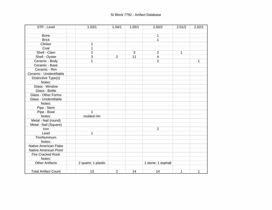
SI Block 7792 - Artifact Database
STP - Level 1.03/1 1.04/1 1.05/1 2.00/2 2.01/2 2.02/1
Bone 1Brick 1
Clinker 1Coal 1
Shell - Clam 2 3 2 1Shell - Oyster 3 2 11 4
Ceramic - Body 1 2 1Ceramic - BaseCeramic - Rim
Ceramic - UnidentifiableDistinctive Type(s)
Notes:Glass - WindowGlass - Bottle
Glass - Other FormsGlass - Unidentifable
Notes:Pipe - StemPipe - Bowl 1
Notes: molded rimMetal - Nail (round)
Metal - Nail (Square)Iron 2Lead 1
Tin/AluminumNotes:
Native American FlakeNative American Point
Fire Cracked RockNotes:
Other Artifacts 2 quartz; 1 plastic 1 stone; 1 asphalt
Total Artifact Count 13 2 14 14 1 1

SI Block 7792 - Artifact Database
STP - Level
BoneBrick
ClinkerCoal
Shell - ClamShell - Oyster
Ceramic - BodyCeramic - BaseCeramic - Rim
Ceramic - UnidentifiableDistinctive Type(s)
Notes:Glass - WindowGlass - Bottle
Glass - Other FormsGlass - Unidentifable
Notes:Pipe - StemPipe - Bowl
Notes:Metal - Nail (round)
Metal - Nail (Square)IronLead
Tin/AluminumNotes:
Native American FlakeNative American Point
Fire Cracked RockNotes:
Other Artifacts
Total Artifact Count
2.02/2 2.03/2 2.03/3 2.04/1 2.05/1 2.05/2 2.05/3 Test Pit #1/1
36
5 1 110 1 13 1
1 2
whiteware3 1
1
1 41
1 plastic; 2 plastic buttons 1 rock 2 stones
3 3 1 15 3 18 5 13

SI Block 7792 - Artifact Database
STP - Level
BoneBrick
ClinkerCoal
Shell - ClamShell - Oyster
Ceramic - BodyCeramic - BaseCeramic - Rim
Ceramic - UnidentifiableDistinctive Type(s)
Notes:Glass - WindowGlass - Bottle
Glass - Other FormsGlass - Unidentifable
Notes:Pipe - StemPipe - Bowl
Notes:Metal - Nail (round)
Metal - Nail (Square)IronLead
Tin/AluminumNotes:
Native American FlakeNative American Point
Fire Cracked RockNotes:
Other Artifacts
Total Artifact Count
Test Pit #1/2 2.06/1 2.06/2 3.01/1 3.02/1
11 11 3 1
2 1
1 21 4 2
stoneware; porcelain; 2 earthenwareswhiteware
22 4
3 clear; 1 green
1
1 1 pipe; 1 small bar
1 1
1 stone 1964 penny; brick recovered stamped CORNING
4 4 4 16 9

SI Block 7792 - Artifact Database
STP - Level
BoneBrick
ClinkerCoal
Shell - ClamShell - Oyster
Ceramic - BodyCeramic - BaseCeramic - Rim
Ceramic - UnidentifiableDistinctive Type(s)
Notes:Glass - WindowGlass - Bottle
Glass - Other FormsGlass - Unidentifable
Notes:Pipe - StemPipe - Bowl
Notes:Metal - Nail (round)
Metal - Nail (Square)IronLead
Tin/AluminumNotes:
Native American FlakeNative American Point
Fire Cracked RockNotes:
Other Artifacts
Total Artifact Count
3.04/1 3.06/1 4.00/1 4.00/2 4.01/1 4.01/2 4.02/2 4.05/1
2
1 1 16 1 1 47 1 12
2 1 22
11 2 1 3
clear clear brown 2 clear; 1 brown
1
1
1 rock 5 egg shell fragments burnt wood burnt wood
18 3 3 5 3 5 3 21

SI Block 7792 - Artifact Database
STP - Level
BoneBrick
ClinkerCoal
Shell - ClamShell - Oyster
Ceramic - BodyCeramic - BaseCeramic - Rim
Ceramic - UnidentifiableDistinctive Type(s)
Notes:Glass - WindowGlass - Bottle
Glass - Other FormsGlass - Unidentifable
Notes:Pipe - StemPipe - Bowl
Notes:Metal - Nail (round)
Metal - Nail (Square)IronLead
Tin/AluminumNotes:
Native American FlakeNative American Point
Fire Cracked RockNotes:
Other Artifacts
Total Artifact Count
5.02/1 5.03/2 5.04/1 6.10/1 6.10/2 6.10A/1 6.10B/1 6.10B/2
1 1
3 3 1 11 21 3 1
2 1 1
2blue edged whiteware whiteware
1 16 1
2clear clear 2 green clear
1 2 1
28 4
1
1 egg shell; 1 rock; burnt wood burnt wood
12 10 5 33 5 2 1 1

SI Block 7792 - Artifact Database
STP - Level
BoneBrick
ClinkerCoal
Shell - ClamShell - Oyster
Ceramic - BodyCeramic - BaseCeramic - Rim
Ceramic - UnidentifiableDistinctive Type(s)
Notes:Glass - WindowGlass - Bottle
Glass - Other FormsGlass - Unidentifable
Notes:Pipe - StemPipe - Bowl
Notes:Metal - Nail (round)
Metal - Nail (Square)IronLead
Tin/AluminumNotes:
Native American FlakeNative American Point
Fire Cracked RockNotes:
Other Artifacts
Total Artifact Count
6.10C/1 6.10D/1 6.10D/2 7.02/1 7.02/2 8.01/1 8.09/2
1
1
3
whiteware transferprinted
1 1 1 1 1
brown brown green clear green
14
3 rocks; 3 burnt wood
1 2 1 1 5 4 7

SI Block 7792 - Artifact Database
STP - Level
BoneBrick
ClinkerCoal
Shell - ClamShell - Oyster
Ceramic - BodyCeramic - BaseCeramic - Rim
Ceramic - UnidentifiableDistinctive Type(s)
Notes:Glass - WindowGlass - Bottle
Glass - Other FormsGlass - Unidentifable
Notes:Pipe - StemPipe - Bowl
Notes:Metal - Nail (round)
Metal - Nail (Square)IronLead
Tin/AluminumNotes:
Native American FlakeNative American Point
Fire Cracked RockNotes:
Other Artifacts
Total Artifact Count
8.10/1 9.02/1 10.01/2 10.01/3 10.02/1 10.02/2 10.03/1 10.03A/1
11
1 2
2 1 2 3
1 handle; 1 other whiteware redware; whiteware stoneware
2 2
clear clear
2 1
3
1
2 charcoal
1 2 2 2 8 2 10 1
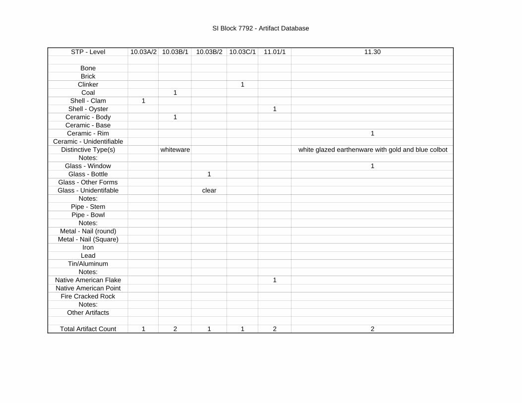
SI Block 7792 - Artifact Database
STP - Level
BoneBrick
ClinkerCoal
Shell - ClamShell - Oyster
Ceramic - BodyCeramic - BaseCeramic - Rim
Ceramic - UnidentifiableDistinctive Type(s)
Notes:Glass - WindowGlass - Bottle
Glass - Other FormsGlass - Unidentifable
Notes:Pipe - StemPipe - Bowl
Notes:Metal - Nail (round)
Metal - Nail (Square)IronLead
Tin/AluminumNotes:
Native American FlakeNative American Point
Fire Cracked RockNotes:
Other Artifacts
Total Artifact Count
10.03A/2 10.03B/1 10.03B/2 10.03C/1 11.01/1 11.30
11
11
1
1
whiteware white glazed earthenware with gold and blue colbot
11
clear
1
1 2 1 1 2 2

SI Block 7792 - Artifact Database
STP - Level
BoneBrick
ClinkerCoal
Shell - ClamShell - Oyster
Ceramic - BodyCeramic - BaseCeramic - Rim
Ceramic - UnidentifiableDistinctive Type(s)
Notes:Glass - WindowGlass - Bottle
Glass - Other FormsGlass - Unidentifable
Notes:Pipe - StemPipe - Bowl
Notes:Metal - Nail (round)
Metal - Nail (Square)IronLead
Tin/AluminumNotes:
Native American FlakeNative American Point
Fire Cracked RockNotes:
Other Artifacts
Total Artifact Count
11.04/2 11-12A/1 11-12A/2 11-12B/1 11-12B/2 11-12D/1 11-12D/2 12.01/2
1 1 11 1
1 11 1
1 10
1 1
pearlwarewhiteware
141 10
clear 14 clear; 10 brown1
5/64"3
1 burnt item
1 2 1 2 1 2 2 41

SI Block 7792 - Artifact Database
STP - Level
BoneBrick
ClinkerCoal
Shell - ClamShell - Oyster
Ceramic - BodyCeramic - BaseCeramic - Rim
Ceramic - UnidentifiableDistinctive Type(s)
Notes:Glass - WindowGlass - Bottle
Glass - Other FormsGlass - Unidentifable
Notes:Pipe - StemPipe - Bowl
Notes:Metal - Nail (round)
Metal - Nail (Square)IronLead
Tin/AluminumNotes:
Native American FlakeNative American Point
Fire Cracked RockNotes:
Other Artifacts
Total Artifact Count
12.02/1 12.04/1 12.05/2 12.07/1 12.08/1 14.04/1
1 2 11
41 1 112 3
porcelain; stoneware whiteware
318 1 1
1
17 clear; 1 brown clear jar rim 3 clear; 1 brown
33
1
10
46 1 2 1 4 6

SI Block 7792 - Artifact Database
STP - Level
BoneBrick
ClinkerCoal
Shell - ClamShell - Oyster
Ceramic - BodyCeramic - BaseCeramic - Rim
Ceramic - UnidentifiableDistinctive Type(s)
Notes:Glass - WindowGlass - Bottle
Glass - Other FormsGlass - Unidentifable
Notes:Pipe - StemPipe - Bowl
Notes:Metal - Nail (round)
Metal - Nail (Square)IronLead
Tin/AluminumNotes:
Native American FlakeNative American Point
Fire Cracked RockNotes:
Other Artifacts
Total Artifact Count
15.03/1 15.05/1 Total Artifact Count:
51416293686
1 412
1 6jacknife brown with blue banding pink glazed
276112
11
97661
43113
1 1 431

127
Photograph 66: Levanna Point
Photograph 67 – various points recovered

128
Photograph 68: Stoneware shards
Photograph 69: Artifacts from SI Block 7792 - drying

129
Appendix E
Other Site Images

130
Photograph 70: Photographic Site Map

131
Photograph 71: Location of recently demolished house in 2004
Photograph 72: Looking north along Page Avenue

132
Photograph 73: Interior of Block 7792
Photograph 74: Interior of Block 7792

133
Photograph 75: Interior of Block 7792
Photograph 76: Interior of Block 7792

134
Photograph 77: Illegal modern refuse deposited within the wetland
Photograph 78: Illegal modern refuse deposited within the wetland

135
Photograph 79: Interior of Block 7792
Photograph 80: Interior of Block 7792

136
Photograph 81: Interior of Block 7792
Photograph 82: Interior of Block 7792

137
Photograph 83: Interior of Block 7792
Photograph 84: Interior of Block 7792

138
Photograph 85: Interior of Block 7792
Photograph 86: Interior of Block 7792

139
Photograph 87: Interior of Block 7792
Photograph 88: STP field testing – December 2004-January 2005

140
Photograph 89: STP field testing – December 2004-January 2005
Photograph 90: STP field testing – December 2004-January 2005

141
Photograph 91: STP field testing – December 2004-January 2005
Photograph 92: STP field testing – December 2004-January 2005
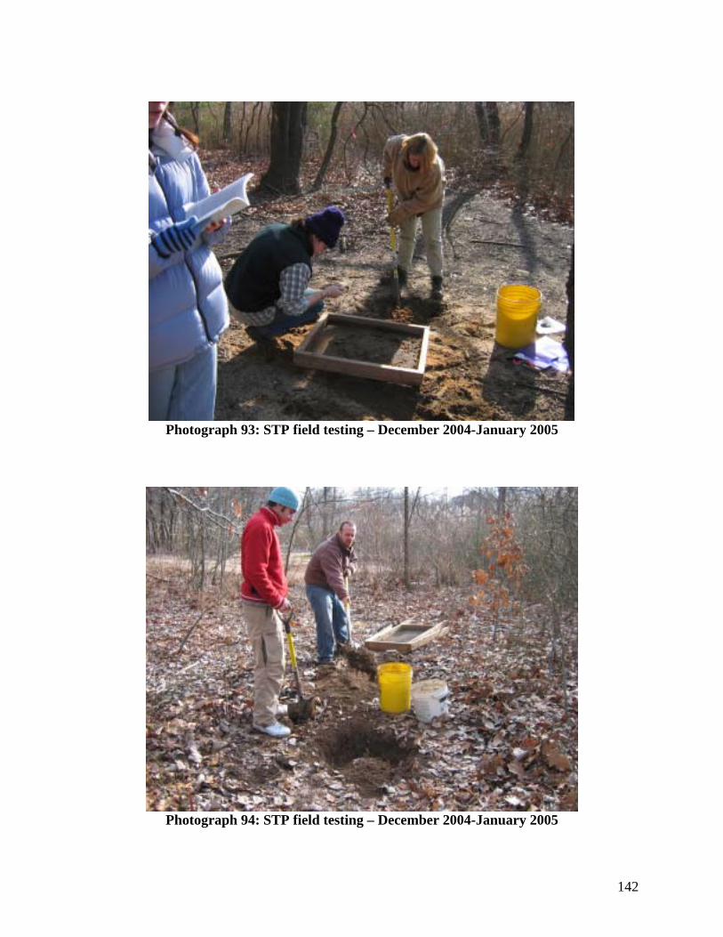
142
Photograph 93: STP field testing – December 2004-January 2005
Photograph 94: STP field testing – December 2004-January 2005

143
Photograph 95: STP field testing – December 2004-January 2005
Photograph 96: STP field testing – December 2004-January 2005

144
Photograph 97: STP field testing – December 2004-January 2005
Photograph 98: STP field testing – typical red sandy/clay as seen in back dirt

145
Photograph 99: Recently construction along Giegerich Avenue with construction debris
deposited into the APE.
Photograph 100: Recently construction along Giegerich Avenue with construction debris deposited into the APE.

146
Appendix F
Correspondences

147
The following are copies of the various correspondences with regard to the draft report between the authors, the New York City Landmarks Preservation Commission (LPC) and the New York State Office of Parks, Recreation and Historic Preservation (NYSOPRHP).

148
Alyssa Loorya, M.A., R.P.A. and Christopher Ricciardi, Ph.D., R.P.A.
4110 Quentin Road Brooklyn, New York 11234-4322
Phone/Fax: (718) 645-3962 Cell: (347) 922-5581
[email protected] or [email protected] February 5, 2005
Douglas Mackey NYS Office of Parks, Recreation & Historic Preservation
Historic Preservation Field Service Bureau Peebles, Island, P.O. Box 189 Waterford, New York 12188-0189 Re: DEC Proposed Development at Page Avenue and Giegerich Avenue
Block 7792 – Lots 228, 242, 250, 252, 278, 279 Staten Island, Richmond County NYSOPRHP #: 04PR04095 Dear Doug, Enclosed is the draft report, Phase I Archaeological Documentary and Field Testing Study for the Proposed Development at Page Avenue and Giegerich Avenue (NYSOPRHP # 04PR04095) Block 7792 (Lots 228, 242, 250, 252, 278 and 279) Staten Island (Richmond County), New York, completed on behalf of Bay Properties, Inc., of Staten Island, New York. It is the recommendation of the report that no further cultural resource testing be required at the site. Several factors have led us to this determination, as outlined, including a high water table, ranging from approximately fifty (50) to seventy-five (75) centimeters throughout most of the site, the limited amount of material remains recovered and the disturbed context in which they were recovered, the limited amount of Native American materials recovered and their recovery from clearly historic disturbed layers, lack of stratigraphy for the site and finally, limited historic development on site prior to the 1870s. We hope that your office will concur with the recommendations/conclusions of this report. If you have any questions please do not hesitate to contact us at the numbers listed above. Since this site resides within the City of New York, as a courtesy we have sent a copy of this report to Amanda Sutphin, Director of Archaeology at the New York City Landmarks Preservation Commission for her review. We look forward to hearing back from your office, with your comments, if any, as soon as possible. Thank you very much. Sincerely, Christopher Ricciardi Christopher Ricciardi, Ph.D., R.P.A. cc: Amanda Sutphin, Director of Archaeology
New York City Landmarks Preservation Commission Bay Properties, Inc. Igor Fleyshmakher, President

149

150

151

152
Alyssa Loorya, M.A., R.P.A. and Christopher Ricciardi, Ph.D., R.P.A.
4110 Quentin Road Brooklyn, New York 11234-4322
Phone/Fax: (718) 645-3962 Cell: (347) 922-5581
[email protected] or [email protected] May 23, 2005
Douglas Mackey NYS Office of Parks, Recreation & Historic Preservation Historic Preservation Field Service Bureau Peebles, Island, P.O. Box 189 Waterford, New York 12188-0189 Re: DEC Proposed Development at Page Avenue and Giegerich Avenue
Block 7792 – Lots 228, 242, 250, 252, 278, 279 Staten Island, Richmond County NYSOPRHP #: 04PR04095 Dear Mr. Mackey: My co-author, Christopher Ricciardi, Ph.D., and I are in receipt of your fax dated May 19, 2005 with your comments regarding the draft report, Phase I Archaeological Documentary and Field Testing Study for the Proposed Development at Page Avenue and Giegerich Avenue (NYSOPRHP # 04PR04095) Block 7792 (Lots 228, 242, 250, 252, 278 and 279) Staten Island (Richmond County), New York, completed on behalf of Bay Properties, Inc., of Staten Island, New York. We would like to respond to your letter and determination as we have several concerns with the determination. Overall, we disagree with your assessment that further Phase 1B field testing is required of the site. Although we will address specific issues below, in general, we do not believe that significant material has been uncovered at this site to warrant further testing. The scattering of possible Native American artifacts recovered from clearly mixed contexts that contain historic materials as well as modern day refuse deposits as well as transplanted soils (i.e. sand brought to the site from another location) does not lead to the scientific conclusion that a potential in-tact/in situ Native American site is located within the project area. When one takes into consideration the amount of clearly modern deposited sand along with the overall high water table, fifty centimeters (on average), one cannot conclude that this is an area of significance. Rather, it is an area of heavy disturbance. With regard to specific issues raised in your fax:

153
Issue #2: It is stated that although we have met the New York State Standards, as they were written for a Phase 1 type of investigation when this project began in December 2004, you have received information from local informants that state, “an array of archaeological finds” have been found on site. You further state that those informants could not produce either the artifacts or provide the exact location of where and when they were recovered. This confirms what we encountered and reported on in our Phase 1 Report. Therefore, this information can only be considered hearsay and should not counteract the overwhelming archaeological data, or lack of, that was uncovered during the field work. We do not see how the unsubstantiated claims of the local residents and the sparse material recovered leads to a determination of significance. During your meeting with Dr. Ricciardi on Friday, May 20, 2005, you produced several pages of Xeroxed copies of artifacts that the local Assemblyman claimed was given to him from area residents. Upon examination of the Xeroxes, it was clear to both of you that the artifacts were clearly a mixture of types and styles. There was no association with the images and some even contained “artifacts cataloguing numbers” that indicates they may have been from a private collection, or perhaps even a discarded museum type collection. This further supports the reports conclusion that the information provided by local area residents cannot be considered as a trusted/viable source and should be discounted. Issue #3: We do not state that this site was used for the purposes of agriculture in the past. In fact, it appears, based on maps and other evidence presented that this site was mostly wooded and wet throughout its history. Dwelling houses were not present until the end of the nineteenth century and no map details it as farmland. The 1845 U.S. Coast Survey and the 1891 Bein Map shows the area as overgrown, suggesting a woodland environment. Although the Coast Survey map does show a portion of the area cleared, which usually is an indication of agriculture, there is no further evidence to support this in either the documented history or the map history. There is no documented information that states this wetland was ever cleared for farming and therefore your supposition that “sites that have been used for agricultural practices in the past…” is not valid in this particular circumstance. The recovery of one Native American flake, from a historic context as well as fragments of flaked rocks, from a disturbed context (modern sand that was clearly brought to the site during modern construction) does not lead to the conclusion that this is a potentially significant National Register site. The materials appear to be random and could have come from anywhere from both within and outside of the project area at any time post 1800. Therefore, there is no primary or secondary Native American context to the artifacts, but rather a clear historic period association.

154
Issue #4: Once again, we disagree that one flake and a small scattering of cracked rock, from a modern strata, constitutes a significant site that warrants further field testing. Since the context for the flake was mixed with historic remains the flake was clearly not in situ with regard to the Native American time period. The rocks were associated with clean sandy fill, which was most likely deposited in the area some time after the turn of the twentieth century, when the majority of the houses were constructed around the project area as well as a modern day burnt down structure. Issue #5: Once again, we disagree with the term “significant”. Finding artifacts that are out of context, in this instance removed from the Native American context of their use, diminishes, if not negates, their significance. There is no way to glean significance from artifacts that are in a mixed context because one can argue that it is impossible to tell when those artifacts were deposited or if they were picked up from another site and moved to their present location. The TPQ only suggests a date that the artifacts could have been deposited, but as you are aware, that deposition could have happened any time between the 1870s and today. Therefore significance cannot be given to the scattering. Issue #6: The finding of one or two Native American artifacts does not, in our opinion, constitute a potentially significant site. Artifacts such as these are found littered throughout similar areas; usually in highly disturbed contexts. Finding one or two Native American flakes next to historic whiteware ceramics and just below a late twentieth century plastic food wrapper clearly indicates the disturbed context of the site and by the very nature of archaeological theory and law (i.e. superposition) negates any possible significance of primary Native American context and/or activity. Issue #7: Based on the one hundred plus STPs, the amount of transplanted modern soil/sand on the site and the highly mixed contexts of artifacts recovered, we cannot in our professional opinion and combined twenty years of experience consider this site to be potentially significant for inclusion on the National Register. As stated in the report, almost every STP excavated encountered ground water at approximately fifty centimeters. With the high water table it is highly unlikely that this marsh area was ever a site. The damage that the high water table has caused, in potentially mixing whatever context may have been present, negates eligibility.

155
As previously stated, Dr. Ricciardi met with you on Friday, May 20, 2005 to discuss the report and your recommendations. Although our objections were raised at the meeting, are clearly stated in this response, and we believe, supported by scientific evidence in the Phase 1 report, we understand your concerns with regard to the scattering of Native American material remains that were recovered. Your response letter posed several requirements for further field work and, based on the meeting and our understanding, we propose to undertake the following additional tests to satisfy your concerns. a) For STP 10.2, in which fire cracked rock was recovered, you state that a thermal feature may be near-by. STP 11.1, which is along the adjacent transect line and just to the north of STP 10.2, was also identified by you as an area of interest. It should be noted that a recently burned shack is located in the area of these two STPs and most likely was the cause of the fire cracked rocks, Additionally we will open a one by one (1x1) meter test pit between the two STPs to search for any potentially buried deposits. b) STP 10.3 is located just within the Area of Potential Effect (APE). We will open three additional STPs just to the north, south and west of it to search for any potentially buried deposits. c) Although the materials from STP 6.10 were recovered in the sandy fill we will open four STPs around it to search for any potentially buried deposits. d) Finally, along transect line 2; we will open a one by one (1x) meter test pit in between STP 2.5 and 2.6 to search for any potentially buried deposits. e) As agreed upon during the meeting, the findings from the proposed two 1x1 meter test pits and seven additional STPs will be integrated into the original report. Changes will also be made to the site map and the addition of an image reference map will be created and included. We will undertake all additional field work beginning this Saturday, May 28, 2005. Therefore, if you disagree with our assessment regarding the proposed additional field work, please inform us by fax or e-mail by Thursday, May 26, 2005 as all arrangements have to be made. As ethical archaeologists, we cannot in good faith continue to cause a delay in the overall project schedule. We have assured the property owners that our fieldwork, and the revised report, will be mailed to you by U.S. Priority Mail for review no later than Friday, June 3, 2005. We hope that you will be able to review the additional field work and make a determination within a timely fashion, so that the project may proceed.

156
Finally, we have one request. Pease send us the contact information, including the fax number, of Assemblyman Vincent Ignizio. As he was sent a copy of your letter, our response must go to him as well. We thank you for your comments and concerns and look forward to hearing back from you with regard to our additional testing plan before the end of the week. Sincerely,
Alyssa Loorya Alyssa Loorya, M.A., R.P.A. cc: Igor Fleyshmakher, Bay Properties, Inc. Amanda Sutphin, NYC Landmarks Preservation Commission Philip Rampulla, Rampulla Associates Assemblyman Vicent Ignizio John Cryan, NYSDEC Region 2

157
From: Alyssa Loorya [mailto:[email protected]] Sent: Wednesday, May 25, 2005 2:03 PM To: Mackey, Douglas (PEB) Subject: NYSOPRHP # 04PR04095 (Staten Island Block 7792 Phase 1 Report) Doug, Just want to confirm that you received my response letter sent both via email and fax. Alyssa From: [email protected] [mailto:[email protected]] Sent: Wednesday, May 25, 2005 2:36 PM To: [email protected] Subject: RE: NYSOPRHP # 04PR04095 (Staten Island Block 7792 Phase 1 Report) It was here this morning when I came in, though I have not had the opportunity to read through it yet. I was in the field yesterday. From: Alyssa Loorya [mailto:[email protected]] Sent: Thursday, May 26, 2005 11:08 AM To: Mackey, Douglas (PEB) Subject: RE: NYSOPRHP # 04PR04095 (Staten Island Block 7792 Phase 1 Report) Doug, We’ve requested that you respond to our response letter by today since we are planning to begin work this weekend (i.e. tomorrow morning). We’d like to wrap this up as soon as possible. Please let me know if you concur with our proposal. You can reach me through email, fax or my cell 347-922-5581. Alyssa From: [email protected] Sent: Thursday, May 26, 2005 11:16 AM To: [email protected] Subject: RE: NYSOPRHP # 04PR04095 (Staten Island Block 7792 Phase 1 Report) The proposed work is fine.

158
Alyssa Loorya, M.A., R.P.A. and Christopher Ricciardi, Ph.D., R.P.A.
4110 Quentin Road Brooklyn, New York 11234-4322
Phone/Fax: (718) 645-3962 Cell: (347) 922-5581
[email protected] or [email protected] June 20, 2005
Douglas Mackey NYS Office of Parks, Recreation & Historic Preservation Historic Preservation Field Service Bureau Peebles, Island, P.O. Box 189 Waterford, New York 12188-0189 Re: DEC Proposed Development at Page Avenue and Giegerich Avenue
Block 7792 – Lots 228, 242, 250, 252, 278, 279 Staten Island, Richmond County NYSOPRHP #: 04PR04095 Dear Mr. Mackey: This letter is a follow-up with regard to the above referenced project and the previously submitted draft report, Phase I Archaeological Documentary and Field Testing Study for the Proposed Development at Page Avenue and Giegerich Avenue (NYSOPRHP # 04PR04095) Block 7792 (Lots 228, 242, 250, 252, 278 and 279) Staten Island (Richmond County), New York, completed on behalf of Bay Properties, Inc., of Staten Island, New York. As per your recommendations, my co-author, Christopher Ricciardi, Ph.D., and I spoke and met with two local interested parties: Paula Licitra 80 Grandville Court - 1232 Wakefield, Rhode Island 02879 Cell: (480) 390-3783 E-mail: [email protected] and Raymond Matarazo, Assistant Curator - Science Staten Island Institute of Arts and Sciences 75 Stuyvesant Place Staten Island, New York 10301-1998 Phone: (718) 727-1135 Fax: (718) 273-5683 E-mail: [email protected]

159
Attached to this cover letter is the Memorandum for the Record (MFR) of the various phone conversations, e-mail correspondences and in-person meeting. Ms. Licitra and Mr. Matarazo provided your office with pictorial information representing various Native American material remains that reportedly came from the site. Although the Phase 1B Field Testing did not support the various types and amount of material remains as depicted in the Xerox copies, it was agreed that a meeting should take place to gather as much factual information as possible. After making arrangements through phone conversations, Dr. Ricciardi and I met with Mr. Matarazo at the site on Monday, June 13, 2005. A full description of the meeting is included in the attached MFR. Based on the meeting with Mr. Matarazo, the existing site map depicting the Area of Potential Effect (APE), STPs and Test Pit excavated, along with the wetland and sand buffer zone, as detailed on the map, the areas in which Mr. Matarazo, and others, recovered evidence of Native American remains are within the sand buffer zone and are outside of the APE. Therefore, since the materials were recovered from an area of the property that will not be developed, but is slated to be left as a buffer zone between the proposed project plans and the fresh water wetland, we do not believe that this newly uncovered information will have any effect on the original determination of the draft report. Based on the current project plans, the excavation of over one hundred and twenty Standardized Test Pits (STPs) and one Test Pit, the lack of substantial primary source historical information for the project area, the high water table and the influx of recently disturbed soils, it is our professional opinion that no further Cultural Resource testing be undertaken. We did not uncover any significant evidence that warrants further undertakings. As per the most recent phone conversation between Dr. Ricciardi and yourself on Thursday, June 16, 2005, we will incorporate the information with regard to the conversations and meetings with Ms. Licitra and Mr. Matarazo, along with the updated site map showing the location of the recovered Native American materials, as well as the other agreed upon changes with regard to the site map, labeling of photographs, and a photographic site map in the final version of the report. We hope that the New York State Office of Parks, Recreation and Historic Preservation will concur with our recommendations and allow the project to proceed forward. Sincerely,
Alyssa Loorya Alyssa Loorya, M.A., R.P.A. cc: Bay Properties, Inc. Philip Rampulla and Associates

160

161

162
Appendix XX:
Local contact information (various)

163
The following is the Memorandum for the Report (MFR) between the authors, the NYSOPRHPA and the various local informants with regard to the project area. Images of the material remains recovered on site, and provided by the local informants, as well as a revised site map detailing the area in which the materials were recovered from, is also presented. Electronic mail correspondences are also included for the record.

164
Alyssa Loorya, M.A., R.P.A. and Christopher Ricciardi, Ph.D., R.P.A.
4110 Quentin Road Brooklyn, New York 11234-4322
Phone/Fax: (718) 645-3962 Cell: (347) 922-5581
[email protected] or [email protected] June 20, 2005
Douglas Mackey NYS Office of Parks, Recreation & Historic Preservation Historic Preservation Field Service Bureau Peebles, Island, P.O. Box 189 Waterford, New York 12188-0189 Re: DEC Proposed Development at Page Avenue and Giegerich Avenue
Block 7792 – Lots 228, 242, 250, 252, 278, 279 Staten Island, Richmond County NYSOPRHP #: 04PR04095 Dear Mr. Mackey: This letter is a follow-up with regard to the above referenced project and the previously submitted draft report, Phase I Archaeological Documentary and Field Testing Study for the Proposed Development at Page Avenue and Giegerich Avenue (NYSOPRHP # 04PR04095) Block 7792 (Lots 228, 242, 250, 252, 278 and 279) Staten Island (Richmond County), New York, completed on behalf of Bay Properties, Inc., of Staten Island, New York. As per your recommendations, my co-author, Christopher Ricciardi, Ph.D., and I spoke and met with two local interested parties: Paula Licitra 80 Grandville Court - 1232 Wakefield, Rhode Island 02879 Cell: (480) 390-3783 E-mail: [email protected] and Raymond Matarazo, Assistant Curator - Science Staten Island Institute of Arts and Sciences 75 Stuyvesant Place Staten Island, New York 10301-1998 Phone: (718) 727-1135 Fax: (718) 273-5683 E-mail: [email protected]
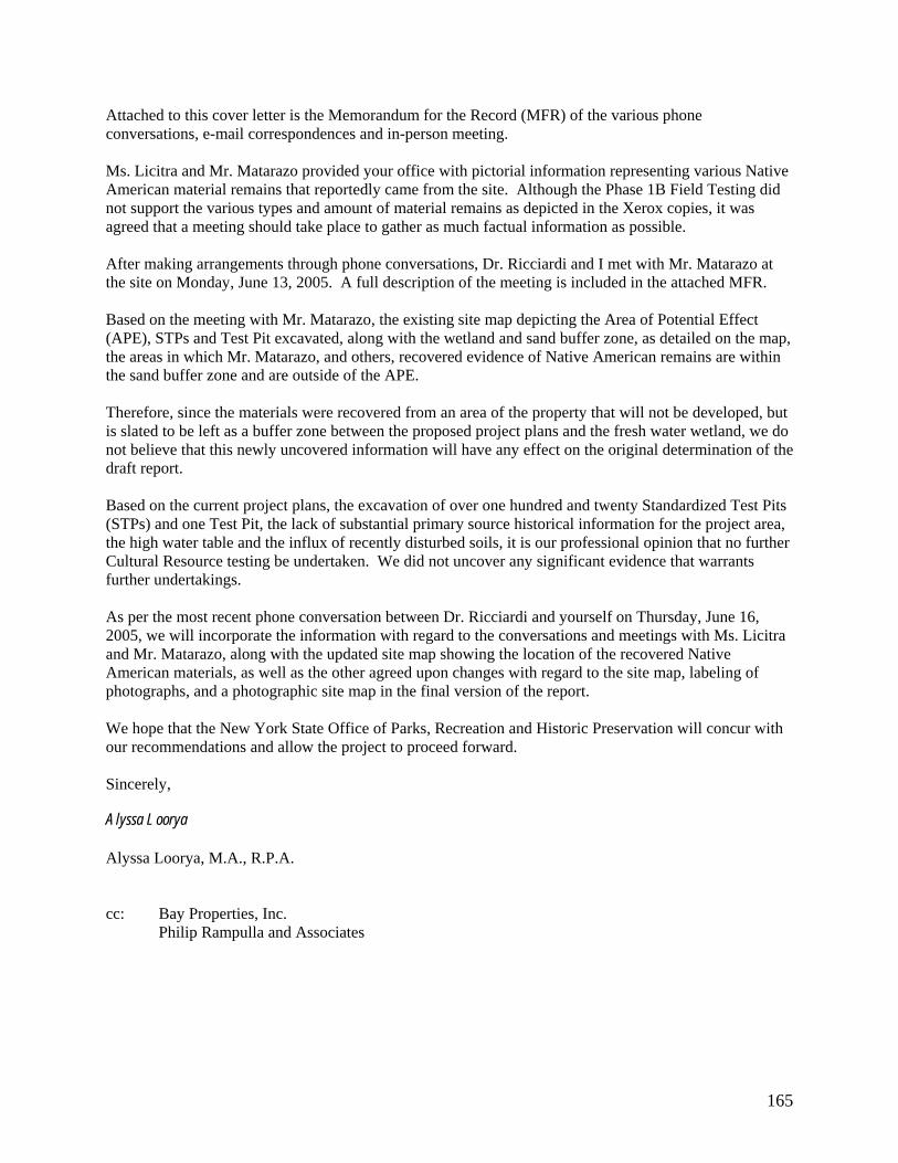
165
Attached to this cover letter is the Memorandum for the Record (MFR) of the various phone conversations, e-mail correspondences and in-person meeting. Ms. Licitra and Mr. Matarazo provided your office with pictorial information representing various Native American material remains that reportedly came from the site. Although the Phase 1B Field Testing did not support the various types and amount of material remains as depicted in the Xerox copies, it was agreed that a meeting should take place to gather as much factual information as possible. After making arrangements through phone conversations, Dr. Ricciardi and I met with Mr. Matarazo at the site on Monday, June 13, 2005. A full description of the meeting is included in the attached MFR. Based on the meeting with Mr. Matarazo, the existing site map depicting the Area of Potential Effect (APE), STPs and Test Pit excavated, along with the wetland and sand buffer zone, as detailed on the map, the areas in which Mr. Matarazo, and others, recovered evidence of Native American remains are within the sand buffer zone and are outside of the APE. Therefore, since the materials were recovered from an area of the property that will not be developed, but is slated to be left as a buffer zone between the proposed project plans and the fresh water wetland, we do not believe that this newly uncovered information will have any effect on the original determination of the draft report. Based on the current project plans, the excavation of over one hundred and twenty Standardized Test Pits (STPs) and one Test Pit, the lack of substantial primary source historical information for the project area, the high water table and the influx of recently disturbed soils, it is our professional opinion that no further Cultural Resource testing be undertaken. We did not uncover any significant evidence that warrants further undertakings. As per the most recent phone conversation between Dr. Ricciardi and yourself on Thursday, June 16, 2005, we will incorporate the information with regard to the conversations and meetings with Ms. Licitra and Mr. Matarazo, along with the updated site map showing the location of the recovered Native American materials, as well as the other agreed upon changes with regard to the site map, labeling of photographs, and a photographic site map in the final version of the report. We hope that the New York State Office of Parks, Recreation and Historic Preservation will concur with our recommendations and allow the project to proceed forward. Sincerely, Alyssa Loorya Alyssa Loorya, M.A., R.P.A. cc: Bay Properties, Inc. Philip Rampulla and Associates

166
Memorandum for the Record (MFR) Discussions with Local Informants with regard to: DEC Proposed Development at Page Avenue and Giegerich Avenue Staten Island, Richmond County 04PR04095 Representatives: Paula Licitra Cell: (480) 390-3783 E-mail: [email protected] and Raymond Matarazo, Assistant Curator - Science Staten Island Institute of Arts and Sciences 75 Stuyvesant Place Staten Island, New York 10301-1998 Phone: (718) 727-1135 Fax: (718) 273-5683 E-mail: [email protected] 8 June 2005 Phone messages left on the home answering machine of Alyssa Loorya (AL) and Christopher Ricciardi (CR) by Paula Licitra (PL) and Ray Matarazzoi (RM). Both were given phone number of AL and CR by Douglas Mackey (DM) from the New York State Office of Parks, Recreation and Historic Preservation (NYSOPRHP). AL and CR left a phone message for DM to discuss the project. 9 June 2005 2:00pm DM returns AL and CR phone call. Discusses the current status of the project and the upcoming contact with PL and RM.

167
4:00pm AL and CR returned call to RM AL and CR asked RM what information he had pertaining to the above referenced site. RM described how for decades people have been picking up and digging within the project area for artifacts. He stated that the Staten Island Institute of Arts and Sciences (SIIAS) had one third of the collection of all the known artifacts from the area. He indicated that two private collectors had the rest of the materials. He asked if AL and CR were in possession of pictures of the materials and AL stated no. CR indicated that he reviewed the images with DM during a meeting three weeks prior. AL asked why when she visited the history research library of the SIMA in November and December of 2004 and inquired about the project area none of this information was provided. She was informed that there was “nothing” in the SIMA relating to that area and that according to the information the SIMA had, there never was anything there. RM refuted this. AL also stated this was reported to her by the Staten Island Historical Society as well. RM stated that this area has always been a known Native American location. CR suggested that a meeting would be in order and asked if it could be at the site. RM agreed. It was decided to meet on Monday, June 13, 2005 at approximately 11am. CR asked if RM could walk the site with him and AL and point out exactly where the reported artifacts were located. He also said it would be helpful to know when they were recovered and if they were excavated or found on the surface. AL described to RM that surface finds do not always indicate what may be located below surface and that the recent disturbance to the site may have led to the uncovering of these artifacts. RM indicated that he believed most of the artifacts were collected as far back as several decades ago. All agreed that a meeting would be good. RM stated that he would bring some of the artifacts in the SIMA as well as copies of the pictures of the other artifacts. 4:30pm AL and CR returned call to PL PL thanked AL and CR for taking time out of their busy schedule to return her call. She stated that she was only acting as a go-between for the community and that the real person to talk to was RM. PL was happy to hear that AL and CR had just finished talking with, and scheduled to meet RM on Monday. CR invited PL to attend the meeting, and told her if she could not, he would send the MFR from the meeting to her. She thanked him for that. PL described her feelings with regard to the area and the development. She stated that she was not up on the lingo that everyone was using, but was only concerned to make sure that nothing important was being destroyed. AL described all of the work undertaken and that she hoped the meeting with RM would help to complete their study. PL stated that she realized that the scientific method would, in the end, dictate what would happen next for the site and not just images from the past, or words that could not be verified. However, she stated that the development of the area was not, in her opinion, the best thing for the community. AL stated that her position required her to separate any personal opinion she may have towards something from her requirements as a professional archaeologist. PL stated she understood as in her profession she faces the same choices. PL was glad that a meeting would take place and was unsure if she could attend. She thanked CR for being willing to provide the meeting minutes to her through e-mail. AL and CR promised to be in touch.

168
June 13, 2005 10:45am - Met with RM at the site RM met with AL and CR on Page Avenue. After brief introductions, RM gave a brief overview of the various prehistoric sites within the area surrounding the project area. AL described her two visits to the Staten Island Institute of Arts and Sciences (SIIAS) and how during both trips, the Research and History libraries failed to produce any information regarding the project area. Nor did they inform her of RM and his collection of materials. RM produced photographic copies of artifacts that have been collected for over the past thirty-five (35) years at the site by him and various collectors. He described how for the past few years he has been taking summer camp children to the site to dig for artifacts. The images (see Appendix A for examples of the images which were provided by PL attached to this summary) display several dozen various types of Native American and one historic smoking pipe bowl that were surface and reportedly sub-surface collected at the site. Images of Jasper chert, points, flakes, scrapers, hand tools, drills, banner stones and other debitage were shown. Many of the artifacts could have been from the late Archaic to the Woodland periods of Native American occupation. The majority of the collection RM stated was collected by Al Hartie, a local pot hunter. CR asked if RM could point out where materials were recovered from. RM led AL and CR into the project area. While on the way to the collection sites, a discussion was hand on the current state of Cultural Resource protection laws and how that even in the event that a buried, in situ site was uncovered, which none were archaeologically, that the intentions of the private property owners were still valid. Most likely, nothing potentially uncovered could stop whatever the current plans for the site are. RM stated that he understood that but he wanted to make sure that as much information with regard to the Native Americans was taken into consideration. CR asked if he cared about the historic remains and he stated that there is no interest in that. RM led AL and CR to the interior of the site. As shown in Appendix B, the area RM showed as being the area where the heaviest concentration of surface finds were recovered was actually outside of the Area of Potential Effect (APE) and therefore, outside of the testing of the Phase 1B. AL described how the sandy area (identified as the “soil treatment area” in Appendix B) was not to be developed according to the field plans and therefore was not subjected to anything but minor testing. Seven (7) Standardize Test Pits (STPs) were placed within this area to test for the potential of buried deposits. None of the STPs within this sandy area revealed any evidence of human disturbance. However, STP 06.10, located just outside of this sandy area and within the APE did reveal several Native American flakes. At the request of DM four additional STPs were excavated around the original STP to determine if a potential disturbance area was located there. No further artifacts were recovered from the additional four (4) STPs. While walking the area, a few possible of surface finds were noticed. These included broken shells, nineteenth century whiteware and bottle fragments and two possible Native American chert flakes. RM asked what the procedure with regard to surface finds was. AL described how surface finds only provide hints as to what may be located beneath the surface, but just because something was on top does not always reflect what is below ground, depending on the level of site disturbance. There was ample evidence of heavy disturbance to the sandy area including

169
deep ruts from motorcycle tires and water scouring. AL stated that many of the finds could have been originally located below ground, but this disturbance has destroyed the context of the artifacts, AL and CR showed RM the site map detailing the amount of STPs that were undertaken at the site. RM was impressed with the number of STPs, but was dismayed at the lack of materials that were uncovered from within them. CR described the high water table, roughly fifty (50) centimeters below surface and stated that this could account for part of the disturbance. RM stated that he too encountered the high water table as well. RM was somewhat relived what AL told him that the area he was most concerned with was outside of the development area. However, he did lament that he would no longer be able to bring children to the site to continue scouring for finds. RM stated that the freshwater wetland contained many rare examples of flora and pointed some examples out. RM also asked AL and CR specifically how they went about their work on site with regard to laying out the grid, the type of sifters used and other experience on Staten Island. AL stated that the grid pattern was created in accordance with the pre-existing guidelines set by the NYSOPRHP and NYAC and with consultation with DM. CR stated that one-quarter inch wire mesh was used in the field and that crews of up to eight persons were on site working during the winter months. At the request of RM, AL and CR stated that they would contact PL to obtain copies of the artifact images as she, according to RM, is the real spear-head behind the local movement to save the site. CR stated that he would ask the property owners that if they did not want the artifacts recovered from the site, if they would consider donating them to the SIIAS. RM stated that they would only be interested in the Native American artifacts and not the historic materials. AL and CR stated that they would create a Memorandum for the Record (MFR) of the telephone and in-person contacts that occurred on since June 8, 2005. The MFR would be included in the correspondence section of the final report to the NYSOPRHP. 2:00pm As per the advice of RM, CR e-mails PL requesting digital copies of the images RM showed AL and CR in the field. June 15, 2005 PL returns CR e-mails and states that she can get the information to AL and CR, but it would take about a week or so. CR stated that it was not a problem and looked forward to receiving the information as soon as she could provide it.

170
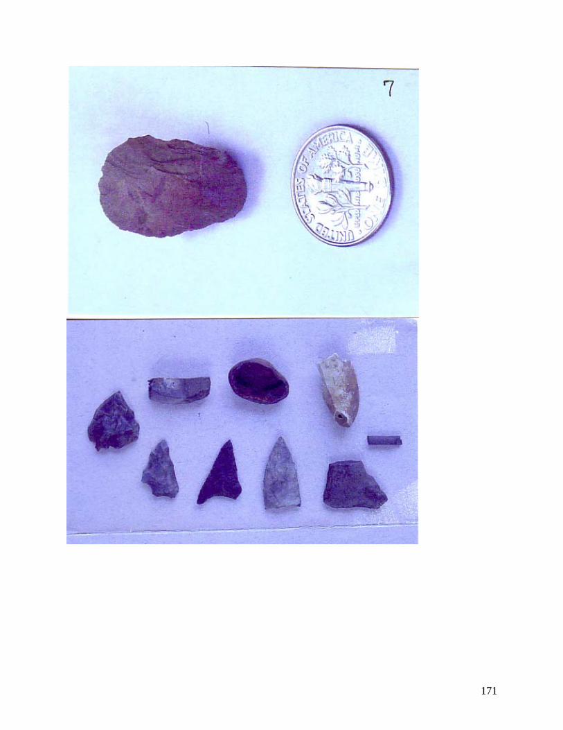
171

172

173
From: paula licitra [mailto:[email protected]] Sent: Saturday, June 04, 2005 4:45 PM To: Mackey, Douglas (PEB) Subject: wetlands in Tottenville, Staten Island Dear Mr. Mackey: I received a copy of a letter from you addressed to Alyssa Loorya dated May 19, 2005. I have been working with others in the community to preserve this parcel of land on Page Avenue & Giegerich Avenue in Totenville Staten Island and was excited to read your letter recommending further studies. Below are names of three individuals who have been instrumental in aiding the preservation of this land. They have acted as my "local informants" and can possibly help you gather the additional information you stated you needed in #2 of your key points in your letter. I will be driving cross country for the next few days and can best be reached by cell phone # 480 390 3783. I have sent you copies of photos of artifacts and findings of collaborative efforts from numerous collectors. Several are available at the Staten Island Museum for further examination. Please contact me after you receive the photos of the artif acts and guide me as what to do from here to request further testing by the DEC. Thank you for your time and efforts. Paula Licitra cc:[email protected], [email protected], [email protected] From: [email protected] [mailto:[email protected]] Sent: Monday, June 06, 2005 11:41 AM To: [email protected]; [email protected]; [email protected]; [email protected] Cc: [email protected] Subject: RE: wetlands in Tottenville, Staten Island Mr. Licitra and others, You should discuss any material you have with the consulting archaeologist. I have mentioned this to a number of individuals that have contacted me previously on this project. Any claims regarding previous finds must be reported to the consulting archaeologist so that they have the opportunity to verify them and test the appropriate locations. Based on their initial submission it does not appear that the information previously submitted to me is verifiable "in the field". Additionally, the archaeologist has indicated to me that they have attempted to contact local individuals regarding such claims, but that they had not received any helpful responses. It is imperative that you work with them and provide specific information to be evaluated. To this point the archaeological consultant have met our standards for testing intervals and have identified very little in the way material. If the additional investigations do not identify any more substantial deposits, and you are not able to provide them with additional information to consider, it is likely that we will not have any further concerns for this project. Douglas Mackey

174
From: Alyssa Loorya [[email protected]] Sent: Tuesday, June 07, 2005 9:16 PM To: [email protected] Subject: RE: wetlands in Tottenville, Staten Island Doug, Thank you for forwarding this. I hope you received the report discussing the additional field testing. As you will read, the additional 11 STPs and the one 2x2, which worked better logistically, did not reveal any additional information with regard to Native American activity. All of the tests revealed pretty much the same as the earlier testing…a high water table with evidence of modern disturbance. As part of the Phase 1A we visited and spoke with representatives (as outlined in the acknowledgements section) from both the Staten Island Historical Society and the Staten Island Museum of Arts and Sciences. At no time did anyone mention and/or show us materials that were “from the site”. Nor did they reveal any pertinent historical information either. As you clearly indicated to Ms. Licitra, without “proof” of exactly where the materials came from, and when, it is impossible to determine, based on the claims of non-professionals, where or when the artifacts were found or in what context. The Phase 1B does not back up the claims of the local residents. As professionals, we have to separate what we personally believe and what the science tells us. Although filling in a wetland to construct housing may not be the ideal scenario for an open area site as they are limited in NY; as professionals, we cannot say that the project area requires or warrants site status and/or further mitigation. The materials and stratigraphic remains, or lack thereof, coupled with the documentary history of the area, does not support any further consideration of this property from a historical or archaeological perspective. Take care, Alyssa (and Chris too!) From: Christopher Ricciardi [[email protected]] Sent: Monday, June 13, 2005 2:11 PM To: '[email protected]' Subject: SI Archaeology Paula, Alyssa and I met with Raymond this morning. She stated that you have digital images of some of the artifacts that were reportedly found at the site and that you could e-mail them to us. We want to use them in the memo/correspondence report for this stage of the overall archaeology report. Thanks, Chris Ricciardi

175
From: Paula Licitra [[email protected]] Sent: Wednesday, June 15, 2005 11:54 AM To: Christopher Ricciardi Subject: Re: SI Archaeology I have hard copies of them that I can mail to you or I can scan them and email them to you. Postal mail is easier for me, but you let me know your preference. Where shall I mail them and do you need to have them by a certain date? I am helping my sister move in until Monday, so I hope it can wait until then. Thanks to you and Alyssa for your time and efforts and taking the time to meet with Ray and return my call. From: [email protected] Sent: Wednesday, June 15, 2005 12:15 PM To: Paula Licitra Subject: Re: SI Archaeology Howdy Paula, Anyway, if you can, please make copies and mail them to us. Hate to say it, but if you could take care of this by the end of next week that would be grand. Mail to: Alyssa Loorya and Chris Ricciardi 4110 Quentin Road Brooklyn, New York 11234-4322 Phone/Fax: (718) 645-3962 E-mail: [email protected] or [email protected] Thanks! Chris. From: Paula Licitra [[email protected]] Sent: Monday, June 20, 2005 12:05 PM To: [email protected] Subject: Re: SI Archaeology I put them in the mail today & you should receive them by the end of the week. Thanks so much. Paula From: Christopher Ricciardi [[email protected]] Sent: Monday, June 20, 2005 3:04 PM To: 'Paula Licitra' Subject: RE: SI Archaeology Great…once we get them will get the info out to everyone.

176
Chris. From: Christopher Ricciardi [[email protected]] Sent: Wednesday, June 22, 2005 7:27 PM To: 'Paula Licitra' Subject: thank you for the images Paula, The images arrived today. Thank you! Chris (and Alyssa) From: Christopher Ricciardi [[email protected]] Sent: Sunday, June 19, 2005 6:18 PM To: [email protected] Cc: '[email protected]'; '[email protected]' Subject: Staten Island Block 7792 - MFR of meeting with local interested parties Attachments: SI Block 7792 - SHPO MFR Letter (20-June-2005).doc Doug, As per our phone conversation from last Thursday, attached is the Memorandum for the Record of our contact with the various locally interested parties, a revised Site Map reflecting the areas the Native American “pot hunted” finds were recovered from and our overall assessment. As we talked about on the phone, the recommendation from the draft report still has not changed. Please consider the information provided in the attached file along with the revised draft report, which you are already in possession of. As stated, we will incorporate the new information into the final version of the report. Let us know as soon as possible as to your decision. Thanks, Chris and Alyssa.

177
Appendix G
Curriculum Vitae

178
Alyssa Loorya, M.A., Mfill, R.P.A. 4110 Quentin Road
Brooklyn, New York 11234-4322 (718) 645-3962 or (347) 922-5581
[email protected] EDUCATION: CITY UNIVERSITY OF NEW YORK GRADUATE SCHOOL AND UNIVERSITY CENTER; New York, New York. Ph.D. Candidate in Anthropology/Historical Archaeology, expected graduation: Fall 2005. HUNTER COLLEGE; New York, New York. M.A. in Anthropology, June 1998. BROOKLYN COLLEGE; Brooklyn, New York. B.A. in Anthropology, History and Education, Magne Cum Laude and Departmental Honors, January 1995. PROFESSIONAL LICENSES: Register of Professional Archaeologists New York City Department of Education, Per Diem Substitute Teaching Certificate Number: 775621 EMPLOYMENT: BROOKLYN COLLEGE, CITY UNIVERSITY OF NEW YORK RESEARCH FOUNDATION Laboratory Director, September 2001 to present
City Hall Park Project BROOKLYN COLLEGE ARCHAEOLOGICAL RESEARCH CENTER Teacher Assistant, June 2001 to present
Hendrick I. Lott House, Brooklyn, NY, New Utrecht Church, Brooklyn, NY, Van Cortlandt Parks, Bronx, NY, Marine Park, Brooklyn, NY, Erasmus High School, Brooklyn, NY
NEW JERSEY INSTITUE OF TECHNOLOGY Educational Consultant, March 2001 to December 2004
Developing special content curriculum for NYC Department of Education to meet national and state standards using primary resource historic preservation material. Teacher development and classroom teaching.
BROOKLYN COLLEGE AND DEPARTMENT OF EDUCATION, STAR HIGH SCHOOL Consultant, July 2004 to present Teaching special content classes and grant writing. BROOKLYN COLLEGE, CITY UNIVERSITY OF NEW YORK RESEARCH FOUNDATION Project Director and Graphic Artist, January 2004 to present Revolutionary War Heritage Tourism Trail project.

179
COMPUTER CONSULTANT 1999 to present
Independent consultant teaching private clients in all aspects of basic computer skills and software, including Microsoft Windows 95/98/Me/XP, Microsoft Office, Microsoft Internet Explorer and Outlook, Corel Word Perfect, Netscape, Adobe Suite of Products.
BAY PROPERTIES, INCORPORATED Principal Investigator, Block 7792 Staten Island Project, December 2004 to February 2005 GAMLA ENTERPRISES, N.A. INCORPORATED Principal Investigator, 63/65 Columbia Street Project, October 2004 to present UA CONSTRUCTION CORPORATION Principal Investigator, Martin’s Field Project, September 2004 to present TRC ENVIRONMENTAL CORPORATION Archaeologist, Greenpoint Project, Brooklyn, NY October 2004 MONDOL CONSTRUCTION CORPORATION Principal Investigator, Queens County Farm Museum Project, July 2004 to December 2004 DELL-TECH ENTERPRISES Principal Investigator, Pieter Claesen Wyckoff House Project, May 2004 to December 2004 Principal Investigator, Roger Morris Park Project, January 2005 to present NEW YORK CITY DEPARTMENT OF EDUCATION Educational Consultant - Archaeology and Historic Preservation - City Hall Academy September 2003 – June 2004 and November 2004 to present
QUIGG DEVELOPMENT CORPORATION Principal Investigator, Wayanda Park Project, August 2003 A.J. CONTRACTING INCORPORATED Principal Investigator, Gravesend Cemetery Project, January-March 2002 AUDUBON SOCIETY OF CONNECTICUT Project Archaeologist and Educational Consultant, May 2001 – May 2002
SAYVILLE HISTORICAL SOCIETY Co-Director, Edwards Homestead Archaeological Project October 2000, May 2001 CITY UNIVERSITY OF NEW YORK GRADUATE SCHOOL AND UNIVERSITY CENTER Teacher Assistant, September 1998 to December 2001
John Bowne House, Queens, NY and Hendrick I. Lott House, Brooklyn, NY
SOUTH STREET SEAPORT MUSEUM Archaeological Educator, September 1999 to June 2001 NEW YORK CITY LANDMARKS PRESERVATION COMMISSION Assistant Site Supervisor, October 1998 to December 1998
Chambers Street Project; New York, NY INSTITUTE FOR ARCHAEOLOGICAL EDUCATION AT MANHATTANVILLE COLLEGE Curriculum Developer and Archaeological Educator, September 1997 to December 1998
PS 134, New York, NY, Scarsdale Elementary School, Scarsdale, NY, Congregation Emmanuel of Harrison, NY, Temple Israel of New Rochelle, NY

180
VOLUNTEER EXPERIENCE: NEW YORK CITY DEPARTMENT OF EDUCATION, BRONX EXPEDITIONARY HIGH SCHOOL Educational and Curriculum Consultant, August 2004 to present NEW YORK CITY BOARD OF EDUCATION, DISTRICT 22 Grant writer and consultant, May 2002 to September 2002 NEW YORK CITY LANDMARKS PRESERVATION COMMISSION Laboratory Assistant, October 1997 to December 1997
Stone Street Historical District Project BROOKLYN COLLEGE ARCHAEOLOGICAL RESEARCH CENTER - FIELD SCHOOL Co-Director, August 1999
147 Hicks Street Cistern Excavation Project Site Supervisor, August 1997, June 1995 and June 1996, May 1996 and October 1997
Marine Park, Brooklyn, NY; Pieter Claesen Wyckoff House, Brooklyn, NY; Timothy Knapp House, Rye, NY
Excavator, May 1995 and June 1994 Pieter Claesen Wyckoff House, Brooklyn, NY; Timothy Knapp House, Rye, NY
BROOKLYN COLLEGE – DEPARTMENT OF ANTHROPOLOGY AND ARCHAEOLOGY
Teacher Assistant, September 1996 to June 1998 Introduction to Archaeological Laboratory Methods WEB & MEDIA DESIGN: BROOKLYN COLLEGE ARCHAEOLOGICAL RESEARCH CENTER Created press and field school promotional material and packets. Developed and maintains web site for the Department’s archaeology program. http://depthome.brooklyn.cuny.edu/anthro/dept HENDRICK I. LOTT HOUSE PRESERVATION ASSOCIATION Created press and promotional material and packets. Newsletter designer and editor. Developed and maintains web site for the organization. http://www.lotthouse.org PIETER CLAESEN WYCKOFF HOUSE MUSEUM AND ASSOCAITION Created 350th Anniversary Flyer and Conference Information. AWARDS: Brooklyn Borough President’s Historians Award (through the Brooklyn College Archaeological Research
Center) - 1998 CUNY-PSE Grant (through the Brooklyn College Archaeological Research Center) - 1998, 1999, 2000 Conference Travel Grant – CUNY Graduate Center, New York, New York 2001 PROFESSIONAL SERVICES: 1999 to present Board of Directors – The Hendrick I. Lott House Preservation Association 2003 to present Member – Historic House Trust Educators Alliance 2002 to present Advisory Board – Pieter Claesen Wyckoff House Museum 2002 to present Advisory Board - Brooklyn Heritage Inc.

181
PUBLICATION(S): Loorya, Alyssa. 2002 The Gravesend Cemetery Project. Report on file with the New York City Landmarks
Preservation Commission. New York, New York. 1998 Stewardship in Practice: Integrating Archaeology Into The Grade School Curriculum.
Masters Thesis on file with the Department of Anthropology; Hunter College, New York, New York.
Loorya, Alyssa and Christopher Ricciardi.
2005a Phase IA Archaeological Documentary Study for the proposed development of 63-65, Columbia Street, (Block 299, Lots 7 and 8), Brooklyn (Kings County), New York – BSA 04BSA005K. Report on file with the New York City Landmarks Preservation Commission. New York, New York.
2005b Phase 1 Archaeological Report for Block 7792 – Staten Island (Richmond County), New
York. Report on file with the New York State Office of Parks, Recreation and Historic Preservation. Albany, New York.
2005c Phase 1B Archaeological Monitoring of the Reconstruction of the Retaining Wall for
Morris-Jurmel Mansion-Robert Morris Park, New York, New York. Report on file with the New York City Landmarks Preservation Commission. New York, New York.
2004a Queens County Farm Museum – Phase 1B Monitoring Project; Queens, New York.
Report on file with the New York City Landmarks Preservation Commission. New York, New York.
2004b Pieter Claesen Wyckoff House – Phase 1B Monitoring Project; Brooklyn, New York.
Report on file with the New York City Landmarks Preservation Commission. New York, New York.
2003 Wayanda Park Project, Queens, New York. Report on file with the New York City
Landmarks Preservation Commission. New York, New York. 1998a The PS 134 Archaeological-Education Program October 1997 through January 1998,
New York, New York. Report on file with the Institute for Archaeological Education at Manhattanville College; Purchase, New York.
1998b Unearthing Van Cortlandt Park: The History and Material Culture of the Van Cortlandt
Family; Bronx, New York. Report on file with the Brooklyn College Archaeological Research Center; Brooklyn College, Brooklyn, New York.
Bankoff, H. Arthur, Christopher Ricciardi and Alyssa Loorya. 2004a “The Secret Room”. Seaport, 39(1) Winter-Spring: 32-35. 2004b “Field Work at the Lott House” Seaport, 39(1) Winter-Spring:40.
2001 “Remember African Under The Eaves: A forgotten room in a Brooklyn farmhouse yields evidence of religious ritual among slaves.” Archaeology Magazine, 54(3):36-40, May- June.
1998a Gerritsen’s Creek: 1997 Archaeological Field Excavations Report on file with the
Brooklyn College Archaeological Research Center, Brooklyn, New York.

182
1998b Under the Floor: Excavating the front Parlor of the Timothy Knapp House. Report on file with the Rye New York Historical Society; Rye, New York.
1998c “Excavating Brooklyn’s Historic Past: The Archaeology of the Hendrick I. Lott Homestead” Historic House Trust Newsletter, 9(4):Fall.
1998d “Excavating Historic Brooklyn”. De Boerenwoning, 1(1):3-6.
1997 The History and Archaeology of the Wyckoff Homestead. Report on file with the New
York City Department of Parks and Recreation’s Historic House Trust Division, New York, New York.
Ricciardi, Christopher and Alyssa Loorya. 2001 Report of the Public Archaeological Dig Program at The Edwards Homestead, Sayville,
New York. Report on file with the Sayville Historical Society, Sayville, New York. 1999 “127 Hicks Street Cistern Report”. Report on file with the Brooklyn College
Archaeological Research Center; Brooklyn, New York. Ricciardi, Christopher, Alyssa Loorya and Dr. H. Arthur Bankoff. 2002 “A forgotten story comes to light”, Footsteps Magazine, May-June:41-45.
2000 “Not Your Typical New Yorkers: Uncovering Brooklyn’s Historic Past at
the Hendrick I. Lott House.” This Side Up Magazine, 12(Winter):15-16.
Membership In Professional Organizations: The Council for Northeast Historical Archaeology (CNEHA) The Professional Archaeologists of New York City (PANYC) The Register of Professional Archaeologists (ROPA) The Society for Historical Archaeology (SHA) Conference Papers/Lectures/Teacher Workshops: 01-09-97 Society for Historical Archaeology Conference; Corpus Christi, Texas
“Archaeology and Education: An Example from Rye, New York” 03-09-97 Middle Atlantic Archaeological Conference; Ocean City, Maryland
“Archaeology and Education: An Example from Rye, New York” 01-08-97 Society for Historical Archaeology Conference; Atlanta, Georgia
“Education and Archaeology: Getting Grade Schools Involved” 01-27-98 The Science Activity Exchange - Dig Into Archaeology; Greenwich, Connecticut "Integrating Archaeology Into The Grade School" 06-12-98 I.S. 211; Brooklyn, New York: “Archaeology at the Lott House” 04-10-99 Middle Atlantic Archaeological Conference; Harrisburg, Pennsylvania
“Excavating Brooklyn Farmsteads: Urban Archaeology Meets Rural Sites” 07 & 08-99 South Street Seaport - Dig Camp at the Hendrick I. Lott 07-19-99 92nd Street YM-YWHA Dig Day at the Hendrick I. Lott 07-21-99 Brooklyn Center for the Urban Environment; Brooklyn, New York “Excavating The Lott House” 10-16-99 New York State Archives, New York, New York
“Teaching Into the Millennium: Integrating Archaeology into the Curriculum” 11-16-99 Marine Park Civic Association; Brooklyn, New York: “Excavating the Lott House” 01-08-00 Society for Historical Archaeology Conference; Quebec City, Canada “Excavating Brooklyn, NY’s Rural Past: The Hendrick I. Lott Farmstead Project” 05-23-00 I.S. 68; Brooklyn, New York: “Digging at the Lott House”

183
05-28-00 92nd Street YM-YWHA Dig Day at the Hendrick I. Lott House in Brooklyn, NY 06-01-00 Millennial Stews: Food and Food Systems in the Global City, Brooklyn, NY
“Food ways at the Lott House” 06-12-00 Dyker Heights Middle School: Dig Camp at the Lott House 06-13-00 I.S. 68: Dig Camp at the Lott House 07 & 08-00 South Street Seaport - Dig Camp at the Hendrick I. Lott House in Brooklyn, NY 07-10-00 Salt Marsh Environmental Center; Brooklyn, NY: “Discover Brooklyn’s Cultural
Landscape Through Archaeology at the Lott House and Marine Park” 08-02-00 Brooklyn Historical Society: Dig Camp at the Lott House 08-00 South Street Seaport - Dig Camp at the Hendrick I. Lott House in Brooklyn, NY 04-19-01 Society for American Archaeology Conference, New Orleans, Louisiana “Beyond Community Involvement: The Hendrick I. Lott House
Archaeological Project and its Impact in the Surrounding Community” 10-19-01 Council for Northeast Historical Archaeology Conference, Niagara, Canada
“Unearthing 19th Century Farm Life in New York: The Lott House Project” 01-17-03 Society for Historical Archaeology Conference, Providence, Rhode Island. “The City Hall Park Project Poster Session” 04-19-03 Professional Archaeologists of New York City Conference, New York, NY “Archaeology and Historic Preservation as Educational Learning Tools” 10-00-03 Hendrick I. Lott House; Brooklyn, New York: “Teacher Workshop-Archaeology” 01-22-04 Bartow-Pell Society: Bronx, NY: “Archaeology and Education” 09-21-04 Pieter Claesen Wyckoff House, Brooklyn, NY. “Archaeology, Historic Preservation and
Education: Bringing the Past to the Present” 11-13-04 Hendrick I. Lott House; Brooklyn, New York: “Teacher Workshop - Archaeology” 11-20-04 Pieter Claesen Wyckoff House; Brooklyn, New York: “Teacher Workshop – Archaeology” 12-02-04 City Hall Academy; New York, NY: “On Being An Archaeologist” 01-12-05 City Hall Academy; New York, NY: “NYC Archaeology” 01-20-05 City Hall Academy; New York, NY: “NYC in the Revolutionary War” Computer skills: Windows 95/98/ME/XP MS Office, Publisher and FrontPage Adobe Acrobat, Illustrator, Page Maker and Photoshop Macromedia Dreamweaver and Fireworks Quark XExpress

184
References: Professor H. Arthur Bankoff Chairman of Anthropology and Archaeology Brooklyn College Bedford Avenue and Avenue H Brooklyn, New York 11210 (718) 951-5507 [email protected] Thomas H. McGovern Department of Anthropology and Archaeology Hunter College, CUNY 695 Park Avenue New York, New York 10021 (212) 772-5655 [email protected] Kate Ottavino and Ruth Baker Center for Architecture and Building Science Research New Jersey Institute of Technology 323 Dr. Martin Luther King Boulevard Campbell Hall, Room 335 Newark, New Jersey 07102 (973) 596-3097 [email protected] Charles Henkels, AIA President - Hendrick I. Lott House Preservation Association 815 Greenwich Street – Apt. 4A New York, New York 10014-5191 (212) 255-3352 (phone) [email protected]

185
CHRISTOPHER RICCIARDI, Ph.D., R.P.A. 4110 Quentin Road
Brooklyn, New York 11234-4322 (718) 645-3962 or (917) 892-2033
[email protected] EDUCATION:
SYRACUSE UNIVERSITY; Syracuse, New York. Ph.D in Anthropology/Historical Archaeology, June 2004 M.A. in Anthropology/Historical Archaeology, May 1997
BROOKLYN COLLEGE; Brooklyn, New York. B.A. in History and Archaeology, minor Secondary Education, Cum Laude, June 1992.
EMPLOYMENT:
UNITED STATES ARMY CORPS OF ENGINEERS Project Archaeologist, September 2001 to present Cultural Resource Specialist, EIS and NHPA Compliance, Environmental Coordinator, Project Manager – Mattituck Inlet Study
Project area includes: Long Island and the Hudson Valley. Projects include Storm Damage Reduction, Ecosystem Restoration, Navigation Control
CITY UNIVERSITY OF NEW YORK’S RESEARCH FOUNDATION Archaeologist, October 2004 Lecturer at the City Hall Academy on archaeology AUDUBON SOCIETY OF CONNECTICUT Archaeologist, May 2001 URS-GREINER WOODWARD-CLYDE Principal Investigator, January to February 2000, February to May 2001 Stone Street, New York, NY, Bronx River Parkway Extension, New York, NY,
Westchester Creek Storage Tank Project, Bronx, NY. ELLIS ISLAND FOUNDATION Archaeologist, November – December 2000 Ellis Island Project, New York, NY SAYVILLE HISTORICAL SOCIETY Co-Director, Edwards Homestead Archaeological Project October 2000, April-May 2001 NATIONAL PARKS SERVICE Archaeological Technician, April 2000 Liberty Island Project, New York, NY NEW YORK COUNCIL FOR THE HUMANITIES Lecturer - Speakers in the Humanities Program, January 2000 to December 2002 NATIONAL ENDOWNMENT FOR THE HUMANITIES Archaeological Educator, November 1999

186
HENDRICK I. LOTT HOUSE PRESERVATION ASSOCIATION, INC. Project Director, September 1999 to September 2001 BROOKLYN COLLEGE ARCHAEOLOGICAL RESEARCH CENTER Co-Director, May 1998 to August 2001
Hendrick I. Lott House Archaeology Project; Brooklyn, NY BROOKLYN NEW SCHOOL, BROOKLYN, NEW YORK Archaeology Educator, December 1998 NEW YORK CITY LANDMARKS PRESERVATION COMMISSION Site Supervisor, October 1998 to December 1998
Chambers Street Project; New York, NY DEPARTMENT OF SOCIOLOGY AND ANTRHOPOLOGY; FORDHAM UNIVERSITY Adjunct Instructor (Anthropology), January 1998 to May 1998 Introduction to Archaeology INSTITUTE FOR ARCHAEOLOGICAL EDUCATION AT MANHATTANVILLE COLLEGE Curriculum Developer and Archaeological Educator, September 1997 to December 1998 PS 134; New York, NY, Parkway School; Greenwich, CT, Congregation Emmanuel of
Harrison, NY; Temple Israel of New Rochelle, NY NEW YORK CITY LANDMARKS PRESERVATION COMMISSION Intern – Archaeologist, September 1997 to December 1997
Stone Street Project; New York, NY
SYRACUSE UNIVERSITY - DEPARTMENT OF ANTHROPOLOGY Graduate Assistant, September 1995 to December 1995 and September 1996 to May 1997 WILLIAM AND MARY COLLEGE
Teacher Assistant, August to May 1993-1994 Introduction to Cultural Anthropology RYE (NEW YORK) HISTORICAL SOCIETY
Co-Director, May 1993, 1994, 1995, 1996, 1997, June and October 1997 Timothy Knapp House; Rye, NY
ARCOPLEX/KEY PERSPECTIVES, ARCHAEOLOGICAL GROUP Excavator, July 1990, July, August 1991
Sign Road; Staten Island, NY, Bartow-Pell Mansion; Bronx, NY, Elmhurst Park; Queens, NY
VOLUNTEER EXPERIENCE: ROGER MORRIS PARK; MANHATTAN, NEW YORK Field Director, January 2005 to present STATEN ISLAND – Block 7792 PROJECT Field Director, December 2004 to present
CITY UNIVERSITY OF NEW YORK’S RESEARCH FOUNDATION Archaeologist, November 2004 to present City Hall Academy Educational Project

187
MARTIN’S FIELD PROJECT Field Director, September 2004 to present 63-65 COLUMIBA STREET PROJECT Researcher, October to December 2004
QUEENS COUNTY FARM MUSEUM PROJECT Field Director, July 2004 to December 2004 PIETER CLAESEN WYCKOFF HOUSE PROJECT Field Director, May 2004 to December 2004
WAYANDA PARK PROJECT Field Director, August 2003
GRAVESEND CEMETERY PROJECT Field Director, January 2002 HUBBARD HOUSE HISTORY PROGRAM Archaeological Director, May to June 1998 Elias Hubbard House; Brooklyn, NY BROOKLYN COLLEGE ARCHAEOLOGICAL RESEARCH CENTER Co-Director, August 1999
147 Hicks Street Cistern Excavation Project; Brooklyn, NY Laboratory Assistant – Volunteer Instructor, June 1994 to July 1995; June 1997 to July 2001 Introduction to Archaeological Laboratory Methods Assistant to the Director - Teacher Assistant, June 1993, 1994, 1995, 1996; August 1997;
Marine Park; Brooklyn, NY, Pieter Claesen Wyckoff House; Brooklyn, NY, Bartow-Pell Mansion; Bronx, NY
Trench Supervisor, July-August 1994 Kamenska Chuka; Blagoevgrad, Bulgaria
SYRACUSE UNIVERSITY FALL FIELD EXCAVATION Excavator, September-October 1995
The Erie House; Port Byron, NY
WILLIAM AND MARY FIELD SCHOOL Surveyor, May 1994
St. Martin; Netherlands Antilles RESEARCH EXPERIENCE:
NEW YORK CITY LANDMARKS PRESERVATION COMMISSION Intern – Archaeologist, September 1997 NEW YORK CITY DEPARTMENT OF PARKS: HISTORIC HOUSE TRUST DIVISION Research Assistant, January 1995 to July 1996

188
AWARDS/GRANTS:
Brooklyn Borough President’s Historians Award (through the Brooklyn College Archaeological Research Center) - 1998
CUNY-PSE Grant (through the Brooklyn College Archaeological Research Center) - 1998, 1999, 2000
Dissertation Grant - The Holland Society, New York, New York - 1998 Conference Travel Grant - Syracuse University, Syracuse, New York – 1997 through 2001 Honorarium - Glenville School, Glenville, Connecticut - May 1997; Norwalk Connecticut
Community College - October 1999; Archaeological Society of Staten Island, Staten Island, New York – 2003, 2004; Bartow-Pell Society, Bronx, New York – January 2004, Woodlawn Historic Society, Queens, New York – March 2004
Performance Awards, U.S. Army Corps of Engineers – New York District 2002, 2003, 2004 PROFESSIONAL ORGANIZATIONS:
The Council for Northeast Historical Archaeology (CNEHA) The Friends of New Netherland Society (FNN) The New York State Archaeological Association (NYSAA) The New York Archaeological Council (NYAC) The Professional Archaeologists of New York City (PANYC) The Register of Professional Archaeologists (ROPA) The Society for Historical Archaeology (SHA)
PROFESSIONAL SERVICES:
2004 to 2005 President – Professional Archaeologists of New York City 2003 to present President – Brooklyn Heritage, Incorporated 2002 Trustee/Treasurer - Brooklyn Heritage, Incorporated 2002 to 2003 Vice President – Professional Archaeologists of New York City 2001 to present Advisor - Pieter Claesen Wyckoff House Museum Advisory Board
2001 Advisor - Brooklyn Heritage, Incorporated 1997 to present Trustee - The Hendrick I. Lott House Preservation Association 1997 to 2001 Secretary - Metropolitan Chapter–NYS Archaeological Association
REPORTS AND PUBLICATIONS: Ricciardi, Christopher.
2005a Phase 1A Documentary Study for the Mattituck Inlet Study, Village of Mattituck, Suffolk County, New York. Report on file with the U.S. Army Corps of Engineers, New York District, New York, New York.
2005b Phase 1A Documentary Study for the Lake Montauk Harbor Navigation Project, Lake
Montauk, Suffolk County, New York. Report on file with the U.S. Army Corps of Engineers, New York District, New York, New York.
2004a Changing Through The Century: Life on the Lott Family Farm, Town of Flatlands, Kings County (Brooklyn), New York in the Nineteenth Century. Doctoral Dissertation, Department of Anthropology, Syracuse University, Syracuse, New York.
2004b Phase 1A Documentary Study for the Village of Northport, Suffolk County, New York.
Report on file with the U.S. Army Corps of Engineers, New York District, New York, New York.

189
2003 Phase 1A Documentary Study for Spring Creek, Kings/Queens County, New York Report on file with the U.S. Army Corps of Engineers, New York District, New York, New York.
2001a Phase 1A Archaeological Survey and Documentary Research Study - East River CSO Facility Planning Project – P.I.N. X027.05 P.C.N. Bronx River Greenway Adjacent To I- 895 Bronx, New York. Report on file with U.R.S. Corporation, Florence, New Jersey.
2001b Phase 1A Archaeological Survey and Documentary Research Study – Westchester
Creek CSO Storage Tank Project, Bronx Psychiatric Center Campus, Bronx, New York. Report on file with U.R.S. Corporation, Florence, New Jersey
2001c Report of the Archaeological Monitoring of the Installation of the Electrical Trench
Excavation at The Edwards Homestead in Sayville, New York. Report on file with The Sayville Historical Society, Sayville, New York.
1998a “Current Research: Brooklyn, New York – Hendrick I. Lott House Project” Society for Historical Archaeology Newsletter, 31(4):13-14, Winter. 1998b “Current Research: Brooklyn, New York – Hendrick I. Lott House Project” Council for Northeast Historical Archaeology Newsletter, 41:4-5, October.
1997a From Private to Public: The Changing Landscape of Van Cortlandt Park; Bronx, New York in the Nineteenth Century. Masters Thesis, Department of Anthropology, Syracuse University, Syracuse, New York.
1997b Archaeology and Education – A Report of the 1997 Field Excavation.
Report on file with the Rye New York Historical Society; Rye, New York.
Ricciardi, Christopher and Alyssa Loorya. 2001 Report of the Public Archaeological Dig Program at The Edwards Homestead, Sayville,
New York. Report on file with the Sayville Historical Society, Sayville, New York. 1999 “127 Hicks Street Cistern Report”. Report on file with the Brooklyn College Archaeological Research Center; Brooklyn, NY. Ricciardi, Christopher, Alyssa Loorya and Dr. H. Arthur Bankoff. 2002 “A forgotten story comes to light”, Footsteps Magazine, May-June:41-45. 2000 “Not Your Typical New Yorkers: Uncovering Brooklyn’s Historic Past at the Hendrick I. Lott House.” This Side Up Magazine, 12(Winter):15-16. Bankoff, H. Arthur and Christopher Ricciardi.
1996 Excavations At The Timothy Knapp House; Rye, New York. Report on file with the Rye New York Historical Society; Rye, New York. Bankoff, H. Arthur, Christopher Ricciardi and Alyssa Loorya. 2004a “The Secret Room”. Seaport, 39(1)Winter-Spring: 32-35. 2004b “Field Work at the Lott House” Seaport, 39(1)Winter-Spring:40.
2001 “Remember African Under The Eaves: A forgotten room in a Brooklyn farmhouse yields evidence of religious ritual among slaves.” Archaeology Magazine, 54(3):36-40, May- June.

190
1998a Gerritsen’s Creek: 1997 Archaeological Field Excavations Report on file with the Brooklyn College Archaeological Research Center, Brooklyn, New York.
1998b Under the Floor: Excavating the front Parlor of the Timothy Knapp House; Rye, New York.
Report on file with the Rye New York Historical Society; Rye, New York.
1998c “Excavating Brooklyn’s Historic Past: The Archaeology of the Hendrick I. Lott Homestead” Historic House Trust Newsletter, 9(4):Fall.
1988d “Excavating Historic Brooklyn”. De Boerenwoning, 1(1):3-6.
1997 The History and Archaeology of the Wyckoff Homestead. Report on file with the New York City Department of Parks And Recreation’s Historic House Trust Division, New York, New York.
Bankoff, H. Arthur, Frederick A. Winter and Christopher Ricciardi.
in press “The History and Archaeology of Van Cortlandt Park”. in Gilbert (ed.), The Archaeology of The Bronx, Bronx Historical Society, Bronx, NY.
1998 “Digging Up Old Brooklyn”. Archaeology Magazine, 51(5):19, September/October. Loorya, Alyssa and Christopher Ricciardi.
2005a Phase IA Archaeological Documentary Study for the proposed development of 63-65, Columbia Street, (Block 299, Lots 7 and 8), Brooklyn (Kings County), New York – BSA 04BSA005K. Report on file with the New York City Landmarks Preservation Commission. New York, New York.
2005b Phase 1 Archaeological Report for Block 7792 – Staten Island (Richmond County), New
York. Report on file with the New York State Office of Parks, Recreation and Historic Preservation. Albany, New York.
2005c Phase 1B Archaeological Monitoring of the Reconstruction of the Retaining Wall for
Morris-Jurmel Mansion-Robert Morris Park, New York, New York. Report on file with the New York City Landmarks Preservation Commission. New York, New York.
2004a Queens County Farm Museum – Phase 1B Monitoring Project; Queens, New York.
Report on file with the New York City Landmarks Preservation Commission. New York, New York.
2004b Pieter Claesen Wyckoff House – Phase 1B Monitoring Project; Brooklyn, New York.
Report on file with the New York City Landmarks Preservation Commission. New York, New York.
1998a The PS 134 Archaeological-Education Program October 1997 through January 1998,
New York, New York. Report on file with the Institute for Archaeological Education at Manhattanville College; Purchase, New York.
1998b Unearthing Van Cortlandt Park: The History and Material Culture of the Van Cortlandt
Family; Bronx, New York. Report on file with the Brooklyn College Archaeological Research Center; Brooklyn College, Brooklyn, New York.

191
MEDIA DESIGN:
BROOKLYN COLLEGE ARCHAEOLOGICAL RESEARCH CENTER Created press and field school promotional material and packets.
HENDRICK I. LOTT HOUSE PRESERVATION ASSOCIATOIN Created press and promotional material and packets. Project’s Newsletter co-editor.
TRAINING: Introduction to Civil Works (U.S. Army Corps of Engineers) 2002 Leadership Training (U.S. Army Corps of Engineers) 2002 Introduction to Cultural Resource Management (U.S. Army Corps of Engineers) 2003 Identification of Mid-Twentieth Century Historic Structures (N.P.I.) 2004 CONFERENCE PAPERS/CHAIRS: 04-08-95 Middle Atlantic Archaeological Conference; Ocean City, Maryland
“The History And Archaeology Of Van Cortlandt Park; Bronx, NY” 04-22-95 New York State Archaeological Association Conference; Syracuse, New York
“The History And Archaeology Of Van Cortlandt Park; Bronx, NY” 10-20-96 Council for Northeast Historical Archaeology Conference; Albany, New York
“Archaeological Investigations at the Timothy Knapp House; Rye, NY” 01-09-97 Society For Historical Archaeology Conference; Corpus Christi, Texas “From Private to Public: The Changing Landscape of Van Cortlandt Park; Bronx,
NY” 01-09-97 Society For Historical Archaeology Conference; Corpus Christi, Texas
“Archaeology and Education: An Example from Rye, NY” 03-09-97 Middle Atlantic Archaeological Conference; Ocean City, Maryland
Chairperson: Current Perspectives In CRM Archaeology In The Middle Atlantic 03-09-97 Middle Atlantic Archaeological Conference; Ocean City, Maryland
“Archaeology and Education: An Example from Rye, NY” 05-02-97 National Council on Public History Conference; Albany, New York “Education in Archaeology: Using local history as a tool to educate the public on issues of preservation” 09-27-97 Lower Hudson Valley Conference; New Paltz, New York “From Private to Public: The Changing Landscape of Van Cortlandt Park; Bronx,
NY” 10-18-97 Council for Northeast Historical Archaeology Conference; Altoona, Pennsylvania “From Private to Public: The Changing Landscape of Van Cortlandt Park; Bronx,
NY” 01-08-98 Society For Historical Archaeology Conference; Atlanta, Georgia
“Education and Archaeology: Getting Grade Schools Involved” 01-09-98 Society For Historical Archaeology Conference; Atlanta, Georgia
“Where Did The Family Farm Go? Excavating 19th Century Brooklyn, NY” 04-05-98 1998 Annual Meeting of The Holland Society; New York, New York " Rediscovering Brooklyn's Dutch Heritage: The Hendrick I. Lott House Project" 04-14-98 New York State Archaeological Association - Metropolitan Chapter; New York, New York "Excavating the 4th Largest City in America: The Hendrick I. Lott House
Archaeological Project" 04-10-99 Middle Atlantic Archaeological Conference; Harrisburg, Pennsylvania Chairperson – Contributed Papers in Farmstead Archaeology Session 04-10-99 Middle Atlantic Archaeological Conference; Harrisburg, Pennsylvania
“Excavating Brooklyn’s Farmsteads: Urban Archaeology Meets Traditional Rural Sites”

192
10-12-99 New York State Archaeological Association - Metropolitan Chapter; New York, New York “More Questions Then Answers: The Hendrick I. Lott Archaeology Project” 10-14-99 Norwalk Community-Technical College, Norwalk, Connecticut Lecture Series “Historical Archaeology at the Hendrick I. Lott House in Brooklyn, NY” 01-08-00 Society for Historical Archaeology Conference; Quebec City, Canada “Excavating Brooklyn, New York’s Rural Past: The Hendrick I. Lott Farmstead
Project” 04-16-00 Professional Archaeologists of New York City’s Public Program, New York, New York “Archaeology at the Hendrick I. Lott House in Brooklyn, NY” 06-13-00 Suffolk County Archaeological Association, Long Island, New York
“Historical Archaeology at the Hendrick I. Lott House in Brooklyn, NY” 06-15-00 New York History Annual Conference; Bronx, New York “Public Archaeology at the Hendrick I. Lott House in Brooklyn, New York” 04-19-01 Society for American Archaeology Conference, New Orleans, Louisiana “Beyond Community Involvement: The Hendrick I. Lott House Archaeological
Project and its Impact in the Surrounding Community” 10-07-01 Gotham Center for New York City History Conference, New York, New York
“Unearthing 19th Century Farm Life in New York: The Lott House Project” 10-19-01 Council for Northeast Historical Archaeology Conference, Niagara, Canada
“Unearthing 19th Century Farm Life in New York: The Lott House Project” 11-26-01 New York University; New York, NY: “Slavery at the Lott House” 10-03-02 The Dutch In New York Conference, Brooklyn College, Brooklyn, New York
Conference Chairman and Organizer 04-19-03 Professional Archaeologists of New York City – 23rd Annual Conference, New York, New
York: Conference Chairman and Organizer LECTURES TO COMMUNITY GROUPS, TEACHER WORKSHOPS, GRADE/HIGH SCHOOL CLASSES: 04-20-93 John Dewey High School; Brooklyn, New York: “The Archaeology Of New York City” 06-05-95 St. Luke’s School; New York City, New York: “What It’s Like To Be An Archaeologist” 04-10-97 Cos Cob Elementary School; Cos Cob, Connecticut: “Archaeology in Your Backyard” 05-20-97 Parkway School; Greenwich, Connecticut: “Archaeology and History – What it all Means” 05-29-97 Order of Colonial Lords of Manors in America Annual Meeting; New York, New York
“The Archaeology of Van Cortlandt Park; Bronx, NY” 06-08-97 Glenville Elementary School; Glenville, CT: “Archaeology and History – What it Means” 01-27-98 The Science Activity Exchange - Dig Into Archaeology; Greenwich, Connecticut "Integrating Archaeology Into The Grade School" 03-12-98 John Dewey High School; Brooklyn, New York: “Archaeology in Your Backyard” 03-17-98 James Madison High School; Brooklyn, New York: “Archaeology and the Lott Family” 04-04-98 James Madison High School; Brooklyn, New York: “The Archaeology of Flatlands” 09-08-98 Community Board 13; Brooklyn, New York: “Archaeology and Education in Brooklyn” 09-15-98 Marine Park Civic Association; Brooklyn, New York: “Excavating the Lott House” 10-25-98 Brooklyn History Day; Brooklyn, New York: “Brooklyn History from the Dirt Up” 12-21-98 Brooklyn New School, Brooklyn, New York: “The Archaeology of Brooklyn” 01-28-99 Brooklyn Historical Society/Saint Francis College, Brooklyn, New York:
“Archaeology In Brooklyn – Excavations at the Hendrick I. Lott House”
03-09-99 Historic House Trust Lecture Series; New York, New York: “The Archaeology of New York City’s Historic Houses”
06-09-99 Architectural Institute of America - Brooklyn Chapter; Brooklyn, New York “Excavating the Hendrick I. Lot House” 07 & 08-99 South Street Seaport - Dig Camp at the Hendrick I. Lott House in Brooklyn, New York 07-19-99 92nd Street YM-YWHA Dig Day at the Hendrick I. Lott House in Brooklyn, New York

193
07-21-99 Brooklyn Center for the Urban Environment; Hendrick I. Lott House; Brooklyn, New York “Excavating The Lott House” 10-16-99 New York State Archives, New York, New York
“Teaching Into the Millennium: Integrating Archaeology into the Curriculum” 10-26-99 Brooklyn History Day; Brooklyn, New York: “Brooklyn History from the Dirt Up” 11-16-99 Marine Park Civic Association; Brooklyn, New York: “Excavating the Lott House in ‘99” 11-19-99 Hewlitt School; New York, New York: “Archaeology In Your Backyard” 12-02-99 P.S. 207 Brooklyn, New York: “Archaeology In Your Backyard” 04-28-00 Marble Hill Senior Center; Bronx, New York: “The Archaeology Of New York City” 05-12-00 James Madison High School; Brooklyn, New York: “Archaeology at the Lott House” 05-23-00 I.S. 68; Brooklyn, New York: “Digging at the Lott House” 05-28-00 92nd Street YM-YWHA Dig Day at the Hendrick I. Lott House in Brooklyn, New York 06-01-00 Millennial Stews: Food and Food Systems in the Global City, Brooklyn, New York
“Foodways at the Lott House” 06-12-00 Dyker Heights Middle School: Dig Camp at the Lott House 06-13-00 I.S. 68: Dig Camp at the Lott House 07 & 08-00 South Street Seaport - Dig Camp at the Hendrick I. Lott House in Brooklyn, New York 07-10-00 Salt Marsh Environmental Center; Brooklyn, New York: “Discover Brooklyn’s Cultural
Landscape Through Archaeology at the Lott House and Marine Park” 08-13-00 The Museum at Stony Brook; Stony Brook, NY: “The Archaeology of New York City” 08-14-00 Brooklyn Historical Society: Dig Camp at the Lott House 09-19-00 Five Towns Senior Center; Queens, NY: “The Archaeology of New York City” 10-11-00 Fraiser Civic Association, Brooklyn, NY: “The Lott House Archaeology Project 10-21-00 Richmond Hill Historical Society; Queens, NY: “The Archaeology of New York City” 10-26-00 New York Public Library; New York, NY: “The Archaeology of New York City” 11-11-00 Selfhelp Clearview Senior Center; Queens, NY: “The Archaeology of New York City” 01-04-01 Roy Reuther Senior Center; Queens, NY: “The Archaeology of New York City: 03-25-01 Mount Vernon Museum and Garden, New York, NY: “The Archaeology of New York City” 03-28-01 Katonah Village Library, Katonah, New York: “The Archaeology of New York City” 05-08-01 Long Beach Senior Center; Long Beach, New York: “The Archaeology of New York City” 05-30-01 Audubon Society of Connecticut; Greenwich, CT: Archaeological-Education Dig Day 06-01-01 P.S. 195; Brooklyn, New York: “Digging Up Your Backyard: Archaeology in NYC” 10-09-01 Suffren Library; Suffren, New York: “The Archaeology of New York City” 11-11-01 Brooklyn Historical Society; Brooklyn, NY: “Archaeology in Your Backyard” 11-18-01 Brooklyn Historical Society; Brooklyn, NY: “Lott House Archaeology Project” 01-06-02 Archaeological Society of Staten Island; Staten Island, NY: “The Archaeology of NYC” 03-16-02 New Images for the Widowed: New York, New York: “The Archaeology of NYC” 06-02-02 Planting Field Arboretum; Long Island, New York: “The Archaeology of New York City” 06-26-02 Woodhaven Historical Society; Queens, New York: “The Archaeology of New York City” 07-08-02 Freeport Memorial Library; Freeport, NY: “The Archaeology of the Lott House” 10-26-02 King Manor Historical Society; Queens, New York: “The Archaeology of New York City” 10-27-02 Fishkill Historical Society; Fishkill, New York: “The Archaeology of New York City” 11-08-02 Port Washington Library; Port Washington, NY: “The Archaeology of New York City” 11-20-02 Bay Ridge Historical Society; Brooklyn, New York: “Lott House Archaeology Project” 12-16-02 Curtis High School; Staten Island, New York: “Archaeology in Your Backyard” 02-05-03 Society for Old Brooklyn; Brooklyn, NY: “The Lott House Archaeology Project” 02-09-03 Archaeological Society of Staten Island; Staten Island, NY: “Lott House Archaeology” 02-28-03 Leif Erickson Society; Brooklyn, NY: “The Lott House Archaeology Project” 10-00-03 Hendrick I. Lott House; Brooklyn, New York: “Teacher Workshop-Archaeology” 01-15-04 Bartow-Pell Society; Bronx, NY: “The Lott House Archaeology Project” 01-30-04 Malloy College; Rockville Center, NY: “The Archaeology of New York City” 03-09-04 Fraunces Tavern; New York, NY: “The Archaeology of New York City” 04-13-04 Oyster Bay Historical Society; Oyster Bay, NY: “The Lott House Archaeology Project” 06-30-04 Woodhaven Historical Society; Queens, NY: “The Lott House Archaeology Project” 07-12-04 Historic District Council/Architectural Institute of America Conference; New York, NY:
“Archaeology and Preservation – Working Together”

194
08-29-04 Sons of the American Revolution; Brooklyn, NY: “The Revolutionary War Project” 10-22-04 City Hall Academy; New York, NY: On Being An Archaeologist 11-08-04 BELHS High School; Bronx, NY: “On Being An Archaeologist” 11-13-04 Hendrick I. Lott House; Brooklyn, New York: “Teacher Workshop-Archaeology” 11-20-04 The Wyckoff House; Brooklyn, NY: “Teacher Workshop – Archaeology” 12-02-04 City Hall Academy; New York, NY: “On Being An Archaeologist” 01-12-05 City Hall Academy; New York, NY: “NYC Archaeology” 01-20-05 City Hall Academy; New York, NY: “NYC in the Revolutionary War”

195
REFERENCES: Professor H. Arthur Bankoff Chairman of Anthropology/Archaeology or Advisor to the Commissioner on Archaeology Brooklyn College New York Landmarks Preservation Commission Bedford Avenue and Avenue H Municipal Building – 1 Center Street – 9th Floor Brooklyn, New York 11210 New York, New York 10007 (718) 951-5507 (212) 669-7820 [email protected] Professor Christopher DeCorse Department of Anthropology/Archaeology 209 Maxwell Hall Syracuse University Syracuse, New York 13244-1090 (315) 443-4647 [email protected] Professor Allan Gilbert Department of Sociology and Anthropology Rose Hill Campus - Dealy Hall, Room 407 Fordham University 441 East Fordham Road Bronx, New York 10458 (718) 817-3850 [email protected] Charles Henkels, President Hendrick I. Lott House Preservation Association 815 Greenwich Street – Apt. 4A New York, New York (212) 255-3352 [email protected] Mr. Leonard Houston, Chief – Environmental Branch U.S. Army Corps of Engineers - Planning Division Jacob K. Javits Federal Building 26 Federal Plaza – Room 2151 New York, New York 10278-0090 (212) 264-2122 [email protected] Dr. Fred Winter Office of Challenge Grants National Endowment for the Humanities 1000 Pennsylvania Avenue, NW - Room 420 Washington, DC 20506 (202) 606-8309 [email protected]