Reclamation District No. 0785 Driver of California - Department of Water Resources - Division of...
25
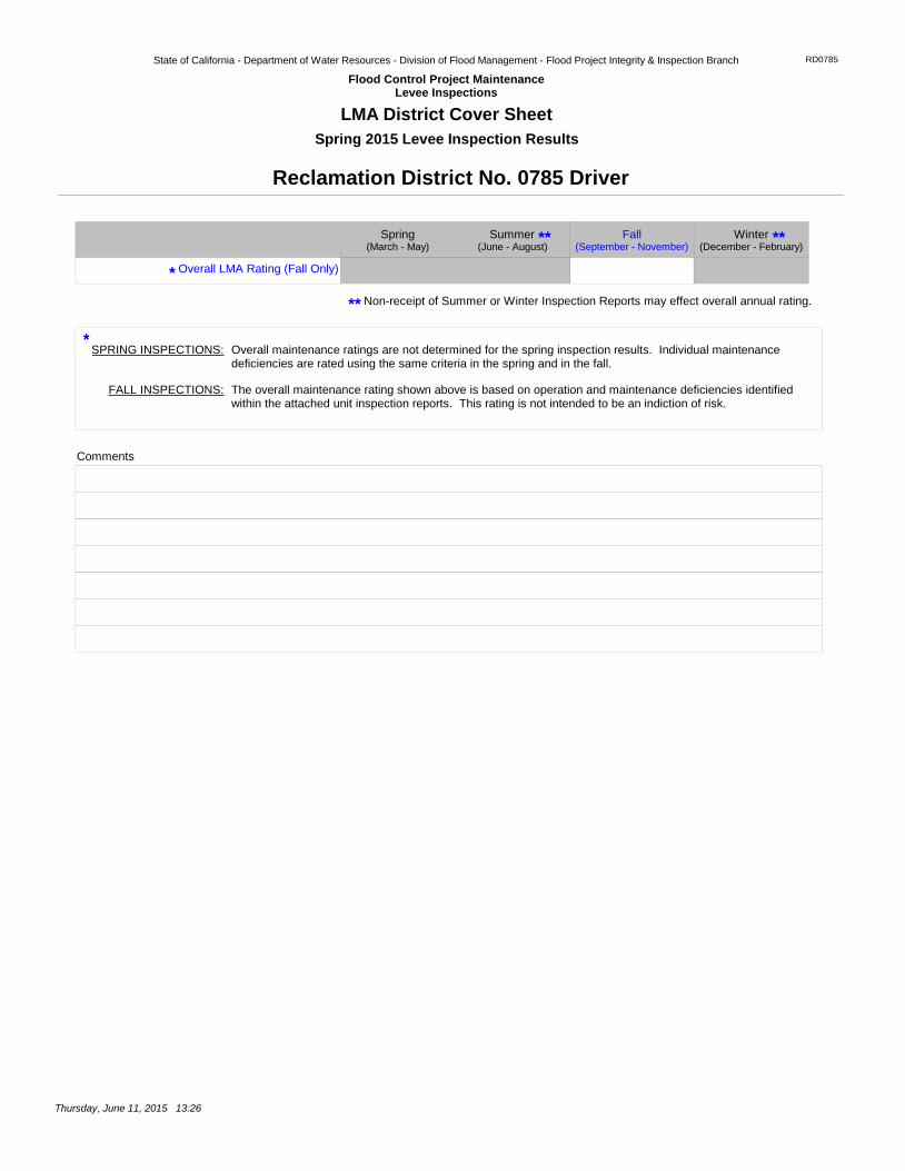
State of California - Department of Water Resources - Division of Flood Management - Flood Project Integrity & Inspection Branch Flood Control Project Maintenance Levee Inspections RD0785 LMA District Cover Sheet Spring 2015 Levee Inspection Results Reclamation District No. 0785 Driver Non-receipt of Summer or Winter Inspection Reports may effect overall annual rating. Overall LMA Rating (Fall Only) Comments Overall maintenance ratings are not determined for the spring inspection results. Individual maintenance deficiencies are rated using the same criteria in the spring and in the fall. SPRING INSPECTIONS: FALL INSPECTIONS: The overall maintenance rating shown above is based on operation and maintenance deficiencies identified within the attached unit inspection reports. This rating is not intended to be an indiction of risk. * * ** Summer Winter (September - November) Spring Fall (June - August) (December - February) (March - May) ** ** Thursday, June 11, 2015 13:26
Transcript of Reclamation District No. 0785 Driver of California - Department of Water Resources - Division of...
State of California - Department of Water Resources - Division of Flood Management - Flood Project Integrity & Inspection Branch
Flood Control Project MaintenanceLevee Inspections
RD0785
LMA District Cover Sheet
Spring 2015 Levee Inspection Results
Reclamation District No. 0785 Driver
Non-receipt of Summer or Winter Inspection Reports may effect overall annual rating.
Overall LMA Rating (Fall Only)
Comments
Overall maintenance ratings are not determined for the spring inspection results. Individual maintenance deficiencies are rated using the same criteria in the spring and in the fall.
SPRING INSPECTIONS:
FALL INSPECTIONS: The overall maintenance rating shown above is based on operation and maintenance deficiencies identified within the attached unit inspection reports. This rating is not intended to be an indiction of risk.
*
*
**
Summer Winter(September - November)
Spring Fall(June - August) (December - February)(March - May)
** **
Thursday, June 11, 2015 13:26

State of California - Department of Water Resources - Division of Flood Management - Flood Project Integrity & Inspection Branch
Flood Control Project MaintenanceLevee Inspections
RD0785
Unit Cover Sheet
Spring 2015 Levee Inspection Results
Reclamation District No. 0785 Driver
Waterway
Unit No. 01 Sacramento River
Bank
Right
Unit Miles
2.26
Summer Winter
Date of Inspection
(September - November)
Unit Maintenance Rating (Fall Only)
SpringFall(June - August) (December - February)(March - May)
04/14/2015 - 04/14/2015
DWR Inspector Jai Lor
Accompanied By
If the LMA is unable to submit information on this webpage, please contact DWR for assistance.
The Local Maintaining Agency (LMA) is responsible for summer and winter inspections. The LMA is required to submit a report regarding summer and winter inspections to the California Department of Water Resources (DWR).
DWR must be informed on the: a) completion of the inspection b) any changes other than the results of normal maintenance c) corrections to deficiencies noted in this report
If additional items are noted, further documentation of those items must also be submitted.
The LMA should submit this information to DWR using the LMA web application tool available at:
http://cdec.water.ca.gov/lma.html
The LMA should submit the information and any associated documentation by September 30 for summer inspections and March 31 for winter inspections.
Summer & Winter Inspections
Thursday, June 11, 2015 13:26

State of California - Department of Water Resources - Division of Flood Management - Flood Project Integrity & Inspection Branch
Flood Control Project MaintenanceLevee Inspections
RD0785
Levee Inspection Report By Mile - Spring 2015
Waterway
Unit No. 01 Sacramento River
Bank
Right
Unit Miles
2.26
InspectionStart/End
04/14/201504/14/2015
Reclamation District No. 0785 Driver
Inspector
JaiLor
No Photos
CategoryEarthen Levee
M
LS
ItemEmergency Supplies & Equipment
Issue Type + Ma
° °
° °
3
DWR ID DWR_RD0785_01_s _ 2013_3
LM Start
LM End Location *
Rating **
GPS Latitude/Longitude
Start End
Issue No.
Action/Comments
Inspector Comments: Unable to contact LMA for Fall 2014 inspection.
No Photos
CategoryEarthen Levee
M
LS
ItemFlood Preparedness & Training
Issue Type + Ma
° °
° °
7
DWR ID DWR_RD0785_01_s _ 2013_7
LM Start
LM End Location *
Rating **
GPS Latitude/Longitude
Start End
Issue No.
Action/Comments
Inspector Comments: Unable to contact LMA for Fall 2014 inspection.
No Photos
CategoryEarthen Levee
M
LS
ItemOperations & Maintenance Manuals
Issue Type + Ma
° °
° °
10
DWR ID DWR_RD0785_01_s _ 2012_10
LM Start
LM End Location *
Rating **
GPS Latitude/Longitude
Start End
Issue No.
Action/Comments
Inspector Comments: Unable to contact LMA for Fall 2014 inspection.
Page 1 of 14Thursday, June 11, 2015 13:26 FINAL DATA
* Location
: Land Side
: Water Side
: Crown
LS
WS
CR
: Acceptable
: Minimally Acceptable
: Unacceptable
A
M
U
** Rating
N
C
A/W
Ma
Ob
En
: Not Inspected/Rated
: Corrected
: Acceptable but Monitor & Maintain
: Maintenance Deficiancy
: Design & System Obsolescence
: Enforcement
+ Issue Type
: Not ApplicableN/A

State of California - Department of Water Resources - Division of Flood Management - Flood Project Integrity & Inspection Branch
Flood Control Project MaintenanceLevee Inspections
RD0785
Levee Inspection Report By Mile - Spring 2015
Waterway
Unit No. 01 Sacramento River
Bank
Right
Unit Miles
2.26
InspectionStart/End
04/14/201504/14/2015
Reclamation District No. 0785 Driver
Inspector
JaiLor
No Photos
0.00
0.00
CategorySupplemental
U
LS
ItemDWR UCIP Field Study
Issue Type + En
°38.660986 °38.660986
°-121.613532 °-121.613532
11
DWR ID
LM Start
LM End Location *
Rating **
GPS Latitude/Longitude
Start End
Issue No.
Action/Comments
Inspector Comments: FS_ID:43903DS_ID:22974EP_NO: N/ARepair Type: UrgentCrossing Status: FoundUCIP Comments: Pipe appears to be abandoned and should be done so properly as it is open on the LS inside the pumphouse. Dense vegetation on both sides of the levee.FIELD_STRUCT_DESC: 30-inch steel pipe through levee 10.0 feet below crown. Landward end open inside concrete pumphouse on LS shoulder, unable to find pipe on water side. Originally included in O&M Manual SAC 122-Part 1, RM: 69.50 Aug. 1955.FS Date: 03/19/2015
Levee mile 0.00, vegetation on the land side slope. Fall 2014.
Photo 1 of 1 : SP_2015_RD0785_185_14_20150401_00011.jpg0.00
2.31
CategoryEarthen Levee
A/W
LS
ItemVegetation
Issue Type + Ma
° °
° °
14
DWR ID DWR_RD0785_01_f _ 2014_14
LM Start
LM End Location *
Rating **
GPS Latitude/Longitude
Start End
Issue No.
Action/Comments
Control annual grass and weeds on the levee slopes and easements.
Page 2 of 14Thursday, June 11, 2015 13:26 FINAL DATA
* Location
: Land Side
: Water Side
: Crown
LS
WS
CR
: Acceptable
: Minimally Acceptable
: Unacceptable
A
M
U
** Rating
N
C
A/W
Ma
Ob
En
: Not Inspected/Rated
: Corrected
: Acceptable but Monitor & Maintain
: Maintenance Deficiancy
: Design & System Obsolescence
: Enforcement
+ Issue Type
: Not ApplicableN/A

State of California - Department of Water Resources - Division of Flood Management - Flood Project Integrity & Inspection Branch
Flood Control Project MaintenanceLevee Inspections
RD0785
Levee Inspection Report By Mile - Spring 2015
Waterway
Unit No. 01 Sacramento River
Bank
Right
Unit Miles
2.26
InspectionStart/End
04/14/201504/14/2015
Reclamation District No. 0785 Driver
Inspector
JaiLor
The trees were cut by PG&E'S tree contractor. The district will take care of the stumps in the future.
Photo 1 of 1 : SP_2015_RD0785_185_4_20150401_00003.jpg0.12
1.34
CategoryEarthen Levee
N
LS
ItemTrim / Thin Trees
Issue Type + Ma
°38.660160 °38.646214
°-121.611619 °-121.598596
4
DWR ID DWR_RD0785_01_s _ 2012_4
LM Start
LM End Location *
Rating **
GPS Latitude/Longitude
Start End
Issue No.
Action/Comments
Tree stumps.
Brush and other vegetation partially blocks visibility or access to the levee slope. Fall 2013
Photo 1 of 2 : SP_2015_RD0785_185_16_20150401_00012.jpg0.21
1.35
CategoryEarthen Levee
M
WS
ItemVegetation
Issue Type + Ma
°38.659340 °38.646093
°-121.610405 °-121.598518
16
DWR ID DWR_RD0785_01_f _ 2013_16
LM Start
LM End Location *
Rating **
GPS Latitude/Longitude
Start End
Issue No.
Action/Comments
Remove the wild growth other than native grasses from the levee slopes.
Brush and other vegetation partially blocks visibility. Spring 2014
Photo 2 of 2 : SP_2015_RD0785_185_16_20150401_00013.jpg0.21
1.35
M
WSIssue Type + Ma
16 (cont)LM Start
LM End Location *
Rating ** Issue No.
Page 3 of 14Thursday, June 11, 2015 13:26 FINAL DATA
* Location
: Land Side
: Water Side
: Crown
LS
WS
CR
: Acceptable
: Minimally Acceptable
: Unacceptable
A
M
U
** Rating
N
C
A/W
Ma
Ob
En
: Not Inspected/Rated
: Corrected
: Acceptable but Monitor & Maintain
: Maintenance Deficiancy
: Design & System Obsolescence
: Enforcement
+ Issue Type
: Not ApplicableN/A

State of California - Department of Water Resources - Division of Flood Management - Flood Project Integrity & Inspection Branch
Flood Control Project MaintenanceLevee Inspections
RD0785
Levee Inspection Report By Mile - Spring 2015
Waterway
Unit No. 01 Sacramento River
Bank
Right
Unit Miles
2.26
InspectionStart/End
04/14/201504/14/2015
Reclamation District No. 0785 Driver
Inspector
JaiLor
View of the debris on the landward side of the levee looking downward. Spring 2015.
Photo 1 of 1 : SP_2015_RD0785_185_346_20150417_00021.jpg0.23
0.23
CategoryEarthen Levee
M
LS
ItemEncroachments
Issue Type + En
°38.659103 °38.659103
°-121.610172 °-121.610172
346
DWR ID DWR_RD0785_01_s _ 2015_346
LM Start
LM End Location *
Rating **
GPS Latitude/Longitude
Start End
Issue No.
Action/Comments
Garbage
View of the tree on the wateward side of the levee taken from the landward side of the levee. Spring 2015.
Photo 1 of 1 : SP_2015_RD0785_185_347_20150417_00022.jpg0.24
0.24
CategoryEarthen Levee
M
WS
ItemEncroachments
Issue Type + En
°38.658927 °38.658927
°-121.610057 °-121.610057
347
DWR ID DWR_RD0785_01_s _ 2015_347
LM Start
LM End Location *
Rating **
GPS Latitude/Longitude
Start End
Issue No.
Action/Comments
Tree or limb
Elderberry
Photo 1 of 1 : SP_2015_RD0785_185_1_20150401_00001.jpg0.28
0.28
CategoryEarthen Levee
A/W
LS
ItemVegetation
Issue Type + Ma
°38.658467 °38.658467
°-121.609573 °-121.609573
1
DWR ID DWR_RD0785_01_s _ 2012_1
LM Start
LM End Location *
Rating **
GPS Latitude/Longitude
Start End
Issue No.
Action/Comments
Elderberries are blocking visibility and flood fight capability.
Page 4 of 14Thursday, June 11, 2015 13:26 FINAL DATA
* Location
: Land Side
: Water Side
: Crown
LS
WS
CR
: Acceptable
: Minimally Acceptable
: Unacceptable
A
M
U
** Rating
N
C
A/W
Ma
Ob
En
: Not Inspected/Rated
: Corrected
: Acceptable but Monitor & Maintain
: Maintenance Deficiancy
: Design & System Obsolescence
: Enforcement
+ Issue Type
: Not ApplicableN/A

State of California - Department of Water Resources - Division of Flood Management - Flood Project Integrity & Inspection Branch
Flood Control Project MaintenanceLevee Inspections
RD0785
Levee Inspection Report By Mile - Spring 2015
Waterway
Unit No. 01 Sacramento River
Bank
Right
Unit Miles
2.26
InspectionStart/End
04/14/201504/14/2015
Reclamation District No. 0785 Driver
Inspector
JaiLor
View of the tree limb on the landward side of the levee. Spring 2015.
Photo 1 of 1 : SP_2015_RD0785_185_348_20150417_00023.jpg0.30
0.30
CategoryEarthen Levee
M
LS
ItemEncroachments
Issue Type + En
°38.658275 °38.658275
°-121.609397 °-121.609397
348
DWR ID DWR_RD0785_01_s _ 2015_348
LM Start
LM End Location *
Rating **
GPS Latitude/Longitude
Start End
Issue No.
Action/Comments
Tree or limb
View of the slope stability on the landward side of the levee looking downstream. Spring 2015.
Photo 1 of 1 : SP_2015_RD0785_185_349_20150417_00024.jpg0.34
0.34
CategoryEarthen Levee
M
LS
ItemSlope Stability
Issue Type + Ma
°38.657798 °38.657798
°-121.608898 °-121.608898
349
DWR ID DWR_RD0785_01_s _ 2015_349
LM Start
LM End Location *
Rating **
GPS Latitude/Longitude
Start End
Issue No.
Action/Comments
Repair slope instability.
Elderberry
Photo 1 of 1 : SP_2015_RD0785_185_2_20150401_00002.jpg0.40
0.44
CategoryEarthen Levee
A/W
LS
ItemVegetation
Issue Type + Ma
°38.657168 °38.656697
°-121.608270 °-121.607845
2
DWR ID DWR_RD0785_01_s _ 2012_2
LM Start
LM End Location *
Rating **
GPS Latitude/Longitude
Start End
Issue No.
Action/Comments
Elderberries are blocking visibility and flood fight capability.
Page 5 of 14Thursday, June 11, 2015 13:26 FINAL DATA
* Location
: Land Side
: Water Side
: Crown
LS
WS
CR
: Acceptable
: Minimally Acceptable
: Unacceptable
A
M
U
** Rating
N
C
A/W
Ma
Ob
En
: Not Inspected/Rated
: Corrected
: Acceptable but Monitor & Maintain
: Maintenance Deficiancy
: Design & System Obsolescence
: Enforcement
+ Issue Type
: Not ApplicableN/A

State of California - Department of Water Resources - Division of Flood Management - Flood Project Integrity & Inspection Branch
Flood Control Project MaintenanceLevee Inspections
RD0785
Levee Inspection Report By Mile - Spring 2015
Waterway
Unit No. 01 Sacramento River
Bank
Right
Unit Miles
2.26
InspectionStart/End
04/14/201504/14/2015
Reclamation District No. 0785 Driver
Inspector
JaiLor
View of a old dock on the waterward side of the levee looking upstream. Spring 2015.
Photo 1 of 1 : SP_2015_RD0785_185_351_20150417_00026.jpg0.61
0.61
CategoryEarthen Levee
M
WS
ItemEncroachments
Issue Type + En
°38.654887 °38.654887
°-121.605845 °-121.605845
351
DWR ID DWR_RD0785_01_s _ 2015_351
LM Start
LM End Location *
Rating **
GPS Latitude/Longitude
Start End
Issue No.
Action/Comments
Equipment
No Photos
0.65
0.65
CategorySupplemental
M
WS
ItemDWR UCIP Field Study
Issue Type + En
°38.654407 °38.654407
°-121.605937 °-121.605937
15
DWR ID
LM Start
LM End Location *
Rating **
GPS Latitude/Longitude
Start End
Issue No.
Action/Comments
Inspector Comments: FS_ID:43965DS_ID:22976EP_NO: N/ARepair Type: Non-UrgentCrossing Status: FoundUCIP Comments: Pipe appears abandoned and should be done so properly.FIELD_STRUCT_DESC: 1 of 2: 3/4-inch steel conduit through the levee 1-foot below the crown.FS Date: 03/19/2015
Page 6 of 14Thursday, June 11, 2015 13:26 FINAL DATA
* Location
: Land Side
: Water Side
: Crown
LS
WS
CR
: Acceptable
: Minimally Acceptable
: Unacceptable
A
M
U
** Rating
N
C
A/W
Ma
Ob
En
: Not Inspected/Rated
: Corrected
: Acceptable but Monitor & Maintain
: Maintenance Deficiancy
: Design & System Obsolescence
: Enforcement
+ Issue Type
: Not ApplicableN/A
State of California - Department of Water Resources - Division of Flood Management - Flood Project Integrity & Inspection Branch
Flood Control Project MaintenanceLevee Inspections
RD0785
Levee Inspection Report By Mile - Spring 2015
Waterway
Unit No. 01 Sacramento River
Bank
Right
Unit Miles
2.26
InspectionStart/End
04/14/201504/14/2015
Reclamation District No. 0785 Driver
Inspector
JaiLor
No Photos
0.65
0.65
CategorySupplemental
M
WS
ItemDWR UCIP Field Study
Issue Type + En
°38.654641 °38.654641
°-121.605538 °-121.605538
17
DWR ID
LM Start
LM End Location *
Rating **
GPS Latitude/Longitude
Start End
Issue No.
Action/Comments
Inspector Comments: FS_ID:43963DS_ID:22982EP_NO: N/ARepair Type: Non-UrgentCrossing Status: FoundUCIP Comments: Part of abandoned pipe also found on waterside that should be removed.No access to landside across the highway.FIELD_STRUCT_DESC: 2 of 2: 12-inch steel irrigation pipe through the levee, 11.0-feet below the crown, slant pump on the waterside slope. Pipe crosses under highway fill and discharge into irrigation ditch.FS Date: 11/21/2013
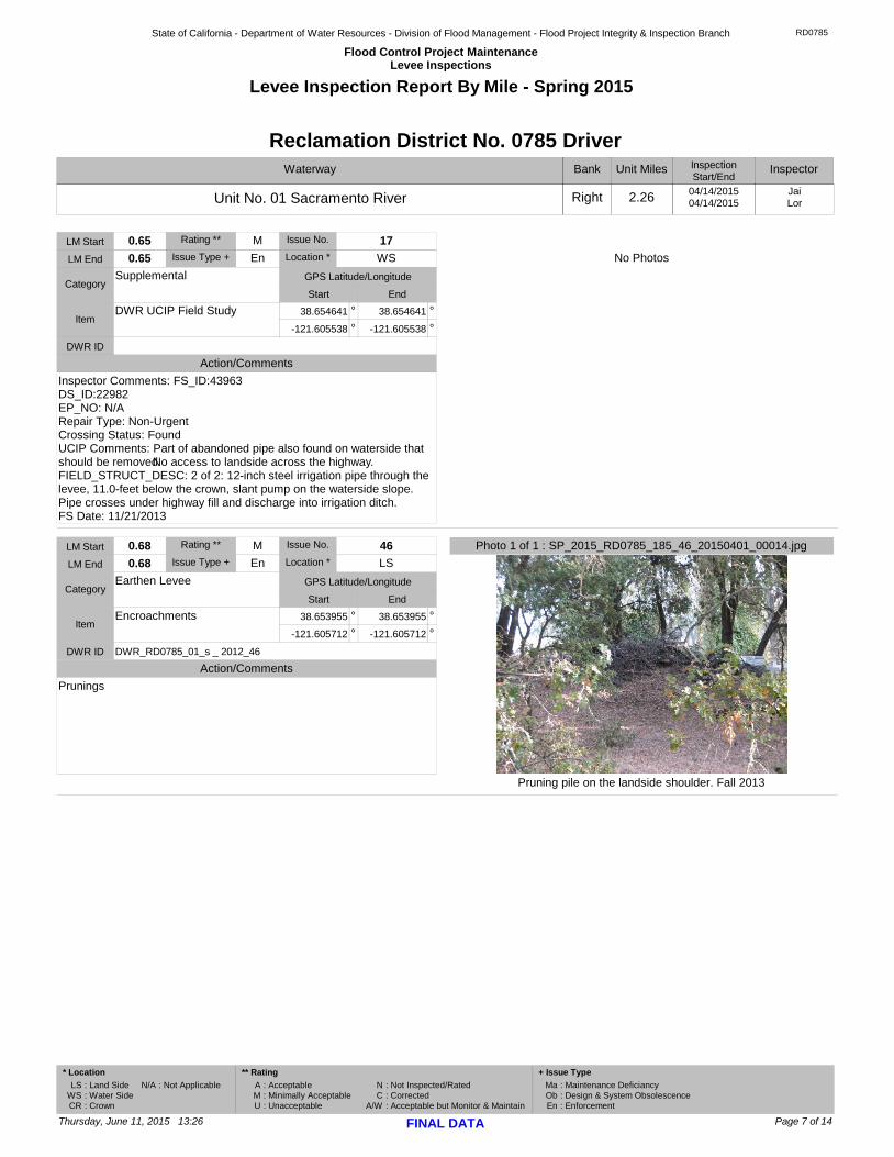
Pruning pile on the landside shoulder. Fall 2013
Photo 1 of 1 : SP_2015_RD0785_185_46_20150401_00014.jpg0.68
0.68
CategoryEarthen Levee
M
LS
ItemEncroachments
Issue Type + En
°38.653955 °38.653955
°-121.605712 °-121.605712
46
DWR ID DWR_RD0785_01_s _ 2012_46
LM Start
LM End Location *
Rating **
GPS Latitude/Longitude
Start End
Issue No.
Action/Comments
Prunings
Page 7 of 14Thursday, June 11, 2015 13:26 FINAL DATA
* Location
: Land Side
: Water Side
: Crown
LS
WS
CR
: Acceptable
: Minimally Acceptable
: Unacceptable
A
M
U
** Rating
N
C
A/W
Ma
Ob
En
: Not Inspected/Rated
: Corrected
: Acceptable but Monitor & Maintain
: Maintenance Deficiancy
: Design & System Obsolescence
: Enforcement
+ Issue Type
: Not ApplicableN/A
State of California - Department of Water Resources - Division of Flood Management - Flood Project Integrity & Inspection Branch
Flood Control Project MaintenanceLevee Inspections
RD0785
Levee Inspection Report By Mile - Spring 2015
Waterway
Unit No. 01 Sacramento River
Bank
Right
Unit Miles
2.26
InspectionStart/End
04/14/201504/14/2015
Reclamation District No. 0785 Driver
Inspector
JaiLor
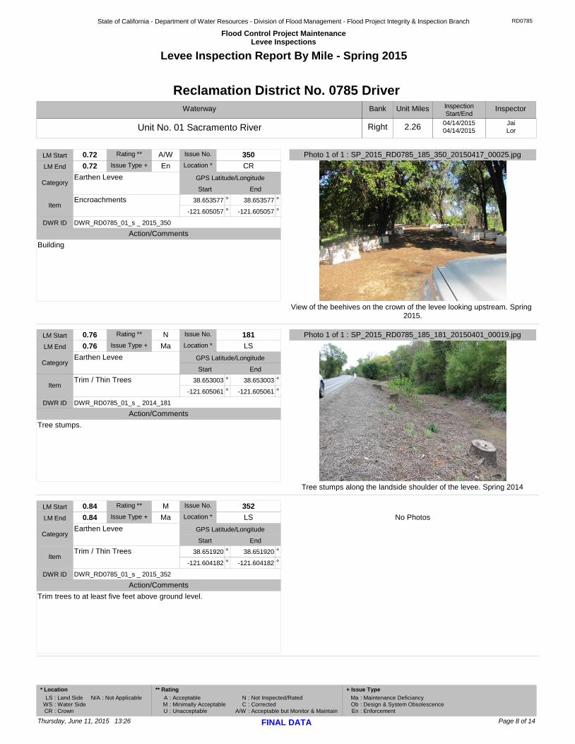
View of the beehives on the crown of the levee looking upstream. Spring 2015.
Photo 1 of 1 : SP_2015_RD0785_185_350_20150417_00025.jpg0.72
0.72
CategoryEarthen Levee
A/W
CR
ItemEncroachments
Issue Type + En
°38.653577 °38.653577
°-121.605057 °-121.605057
350
DWR ID DWR_RD0785_01_s _ 2015_350
LM Start
LM End Location *
Rating **
GPS Latitude/Longitude
Start End
Issue No.
Action/Comments
Building
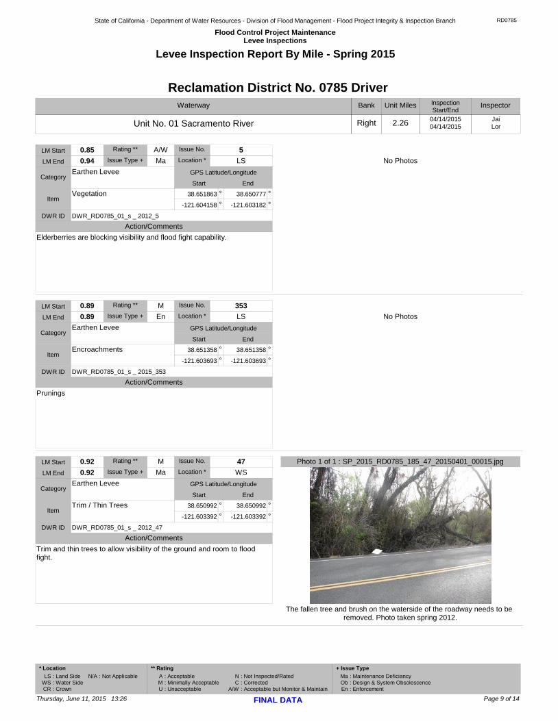
Tree stumps along the landside shoulder of the levee. Spring 2014
Photo 1 of 1 : SP_2015_RD0785_185_181_20150401_00019.jpg0.76
0.76
CategoryEarthen Levee
N
LS
ItemTrim / Thin Trees
Issue Type + Ma
°38.653003 °38.653003
°-121.605061 °-121.605061
181
DWR ID DWR_RD0785_01_s _ 2014_181
LM Start
LM End Location *
Rating **
GPS Latitude/Longitude
Start End
Issue No.
Action/Comments
Tree stumps.
No Photos
0.84
0.84
CategoryEarthen Levee
M
LS
ItemTrim / Thin Trees
Issue Type + Ma
°38.651920 °38.651920
°-121.604182 °-121.604182
352
DWR ID DWR_RD0785_01_s _ 2015_352
LM Start
LM End Location *
Rating **
GPS Latitude/Longitude
Start End
Issue No.
Action/Comments
Trim trees to at least five feet above ground level.
Page 8 of 14Thursday, June 11, 2015 13:26 FINAL DATA
* Location
: Land Side
: Water Side
: Crown
LS
WS
CR
: Acceptable
: Minimally Acceptable
: Unacceptable
A
M
U
** Rating
N
C
A/W
Ma
Ob
En
: Not Inspected/Rated
: Corrected
: Acceptable but Monitor & Maintain
: Maintenance Deficiancy
: Design & System Obsolescence
: Enforcement
+ Issue Type
: Not ApplicableN/A
State of California - Department of Water Resources - Division of Flood Management - Flood Project Integrity & Inspection Branch
Flood Control Project MaintenanceLevee Inspections
RD0785
Levee Inspection Report By Mile - Spring 2015
Waterway
Unit No. 01 Sacramento River
Bank
Right
Unit Miles
2.26
InspectionStart/End
04/14/201504/14/2015
Reclamation District No. 0785 Driver
Inspector
JaiLor
No Photos
0.85
0.94
CategoryEarthen Levee
A/W
LS
ItemVegetation
Issue Type + Ma
°38.651863 °38.650777
°-121.604158 °-121.603182
5
DWR ID DWR_RD0785_01_s _ 2012_5
LM Start
LM End Location *
Rating **
GPS Latitude/Longitude
Start End
Issue No.
Action/Comments
Elderberries are blocking visibility and flood fight capability.
No Photos
0.89
0.89
CategoryEarthen Levee
M
LS
ItemEncroachments
Issue Type + En
°38.651358 °38.651358
°-121.603693 °-121.603693
353
DWR ID DWR_RD0785_01_s _ 2015_353
LM Start
LM End Location *
Rating **
GPS Latitude/Longitude
Start End
Issue No.
Action/Comments
Prunings
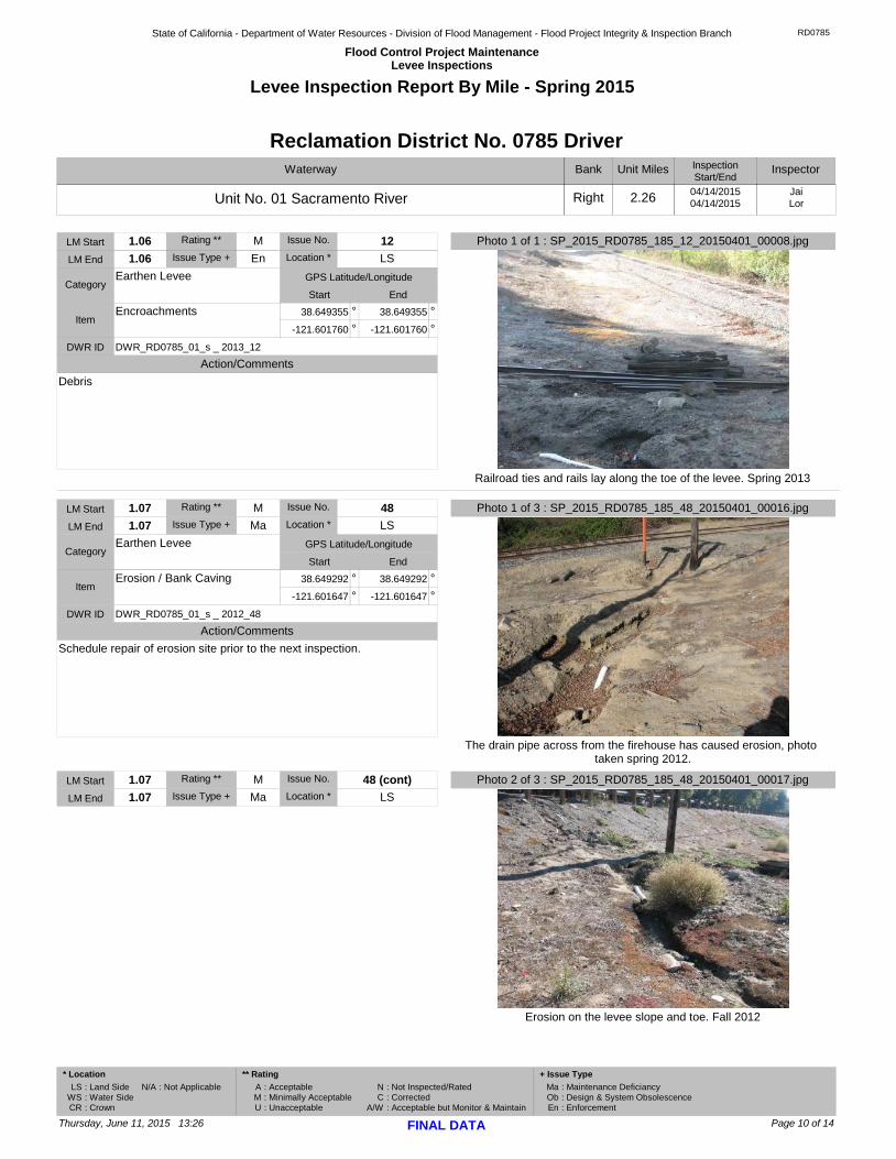
The fallen tree and brush on the waterside of the roadway needs to be removed. Photo taken spring 2012.
Photo 1 of 1 : SP_2015_RD0785_185_47_20150401_00015.jpg0.92
0.92
CategoryEarthen Levee
M
WS
ItemTrim / Thin Trees
Issue Type + Ma
°38.650992 °38.650992
°-121.603392 °-121.603392
47
DWR ID DWR_RD0785_01_s _ 2012_47
LM Start
LM End Location *
Rating **
GPS Latitude/Longitude
Start End
Issue No.
Action/Comments
Trim and thin trees to allow visibility of the ground and room to flood fight.
Page 9 of 14Thursday, June 11, 2015 13:26 FINAL DATA
* Location
: Land Side
: Water Side
: Crown
LS
WS
CR
: Acceptable
: Minimally Acceptable
: Unacceptable
A
M
U
** Rating
N
C
A/W
Ma
Ob
En
: Not Inspected/Rated
: Corrected
: Acceptable but Monitor & Maintain
: Maintenance Deficiancy
: Design & System Obsolescence
: Enforcement
+ Issue Type
: Not ApplicableN/A
State of California - Department of Water Resources - Division of Flood Management - Flood Project Integrity & Inspection Branch
Flood Control Project MaintenanceLevee Inspections
RD0785
Levee Inspection Report By Mile - Spring 2015
Waterway
Unit No. 01 Sacramento River
Bank
Right
Unit Miles
2.26
InspectionStart/End
04/14/201504/14/2015
Reclamation District No. 0785 Driver
Inspector
JaiLor
Railroad ties and rails lay along the toe of the levee. Spring 2013
Photo 1 of 1 : SP_2015_RD0785_185_12_20150401_00008.jpg1.06
1.06
CategoryEarthen Levee
M
LS
ItemEncroachments
Issue Type + En
°38.649355 °38.649355
°-121.601760 °-121.601760
12
DWR ID DWR_RD0785_01_s _ 2013_12
LM Start
LM End Location *
Rating **
GPS Latitude/Longitude
Start End
Issue No.
Action/Comments
Debris
The drain pipe across from the firehouse has caused erosion, photo taken spring 2012.
Photo 1 of 3 : SP_2015_RD0785_185_48_20150401_00016.jpg1.07
1.07
CategoryEarthen Levee
M
LS
ItemErosion / Bank Caving
Issue Type + Ma
°38.649292 °38.649292
°-121.601647 °-121.601647
48
DWR ID DWR_RD0785_01_s _ 2012_48
LM Start
LM End Location *
Rating **
GPS Latitude/Longitude
Start End
Issue No.
Action/Comments
Schedule repair of erosion site prior to the next inspection.
Erosion on the levee slope and toe. Fall 2012
Photo 2 of 3 : SP_2015_RD0785_185_48_20150401_00017.jpg1.07
1.07
M
LSIssue Type + Ma
48 (cont)LM Start
LM End Location *
Rating ** Issue No.
Page 10 of 14Thursday, June 11, 2015 13:26 FINAL DATA
* Location
: Land Side
: Water Side
: Crown
LS
WS
CR
: Acceptable
: Minimally Acceptable
: Unacceptable
A
M
U
** Rating
N
C
A/W
Ma
Ob
En
: Not Inspected/Rated
: Corrected
: Acceptable but Monitor & Maintain
: Maintenance Deficiancy
: Design & System Obsolescence
: Enforcement
+ Issue Type
: Not ApplicableN/A
State of California - Department of Water Resources - Division of Flood Management - Flood Project Integrity & Inspection Branch
Flood Control Project MaintenanceLevee Inspections
RD0785
Levee Inspection Report By Mile - Spring 2015
Waterway
Unit No. 01 Sacramento River
Bank
Right
Unit Miles
2.26
InspectionStart/End
04/14/201504/14/2015
Reclamation District No. 0785 Driver
Inspector
JaiLor
Drain pipe is causing erosion on the landside of the levee between the slope and railroad tracks. Spring 2014
Photo 3 of 3 : SP_2015_RD0785_185_48_20150401_00018.jpg1.07
1.07
CategoryEarthen Levee
M
LS
ItemErosion / Bank Caving
Issue Type + Ma
°38.649292 °38.649292
°-121.601647 °-121.601647
48 (cont)
DWR ID DWR_RD0785_01_s _ 2012_48
LM Start
LM End Location *
Rating **
GPS Latitude/Longitude
Start End
Issue No.
Action/Comments
Schedule repair of erosion site prior to the next inspection.
No Photos
1.20
1.20
CategoryEarthen Levee
M
LS
ItemTrim / Thin Trees
Issue Type + Ma
°38.647847 °38.647847
°-121.600152 °-121.600152
354
DWR ID DWR_RD0785_01_s _ 2015_354
LM Start
LM End Location *
Rating **
GPS Latitude/Longitude
Start End
Issue No.
Action/Comments
Trim trees to at least five feet above ground level.
This is a very large Elderberry bush.
Photo 1 of 1 : SP_2015_RD0785_185_6_20150401_00004.jpg1.30
1.30
CategoryEarthen Levee
A/W
LS
ItemVegetation
Issue Type + Ma
°38.646712 °38.646712
°-121.599095 °-121.599095
6
DWR ID DWR_RD0785_01_s _ 2012_6
LM Start
LM End Location *
Rating **
GPS Latitude/Longitude
Start End
Issue No.
Action/Comments
Elderberries are blocking visibility and flood fight capability.
Page 11 of 14Thursday, June 11, 2015 13:26 FINAL DATA
* Location
: Land Side
: Water Side
: Crown
LS
WS
CR
: Acceptable
: Minimally Acceptable
: Unacceptable
A
M
U
** Rating
N
C
A/W
Ma
Ob
En
: Not Inspected/Rated
: Corrected
: Acceptable but Monitor & Maintain
: Maintenance Deficiancy
: Design & System Obsolescence
: Enforcement
+ Issue Type
: Not ApplicableN/A
State of California - Department of Water Resources - Division of Flood Management - Flood Project Integrity & Inspection Branch
Flood Control Project MaintenanceLevee Inspections
RD0785
Levee Inspection Report By Mile - Spring 2015
Waterway
Unit No. 01 Sacramento River
Bank
Right
Unit Miles
2.26
InspectionStart/End
04/14/201504/14/2015
Reclamation District No. 0785 Driver
Inspector
JaiLor
The erosion has become a trail for fishermen and contributes to it. Spring 2013
Photo 1 of 2 : SP_2015_RD0785_185_13_20150401_00009.jpg1.31
1.31
CategoryEarthen Levee
M
WS
ItemErosion / Bank Caving
Issue Type + Ma
°38.646671 °38.646671
°-121.598915 °-121.598915
13
DWR ID DWR_RD0785_01_s _ 2013_13
LM Start
LM End Location *
Rating **
GPS Latitude/Longitude
Start End
Issue No.
Action/Comments
Schedule repair of erosion site prior to the next inspection.
The waterside levee slope has erosion from surface run off. Spring 2013
Photo 2 of 2 : SP_2015_RD0785_185_13_20150401_00010.jpg1.31
1.31
M
WSIssue Type + Ma
13 (cont)LM Start
LM End Location *
Rating ** Issue No.
No Photos
1.33
1.33
CategorySupplemental
M
WS
ItemDWR UCIP Field Study
Issue Type + En
°38.646547 °38.646547
°-121.598924 °-121.598924
18
DWR ID
LM Start
LM End Location *
Rating **
GPS Latitude/Longitude
Start End
Issue No.
Action/Comments
Inspector Comments: FS_ID:41984DS_ID:22978EP_NO: N/ARepair Type: Non-UrgentCrossing Status: FoundUCIP Comments: Dense vegetation on waterside. No pipe found/visible
Page 12 of 14Thursday, June 11, 2015 13:26 FINAL DATA
* Location
: Land Side
: Water Side
: Crown
LS
WS
CR
: Acceptable
: Minimally Acceptable
: Unacceptable
A
M
U
** Rating
N
C
A/W
Ma
Ob
En
: Not Inspected/Rated
: Corrected
: Acceptable but Monitor & Maintain
: Maintenance Deficiancy
: Design & System Obsolescence
: Enforcement
+ Issue Type
: Not ApplicableN/A

State of California - Department of Water Resources - Division of Flood Management - Flood Project Integrity & Inspection Branch
Flood Control Project MaintenanceLevee Inspections
RD0785
Levee Inspection Report By Mile - Spring 2015
Waterway
Unit No. 01 Sacramento River
Bank
Right
Unit Miles
2.26
InspectionStart/End
04/14/201504/14/2015
Reclamation District No. 0785 Driver
Inspector
JaiLor
No Photos
1.62
1.62
CategoryEarthen Levee
A/W
LS
ItemTrim / Thin Trees
Issue Type + Ma
°38.643297 °38.643297
°-121.595152 °-121.595152
355
DWR ID DWR_RD0785_01_s _ 2015_355
LM Start
LM End Location *
Rating **
GPS Latitude/Longitude
Start End
Issue No.
Action/Comments
Trim trees to at least five feet above ground level.
No Photos
1.68
1.68
CategoryEarthen Levee
N
LS
ItemTrim / Thin Trees
Issue Type + Ma
°38.642650 °38.642650
°-121.594168 °-121.594168
356
DWR ID DWR_RD0785_01_s _ 2015_356
LM Start
LM End Location *
Rating **
GPS Latitude/Longitude
Start End
Issue No.
Action/Comments
Tree stumps.
The pine trees along the shoulder have been topped and thin out. Oleanders still on the shoulder. Fall 2013
Photo 1 of 2 : SP_2015_RD0785_185_8_20150401_00005.jpg2.00
2.09
CategoryEarthen Levee
M
LS
ItemVegetation
Issue Type + En
°38.641623 °38.642005
°-121.588558 °-121.586993
8
DWR ID DWR_RD0785_01_s _ 2012_8
LM Start
LM End Location *
Rating **
GPS Latitude/Longitude
Start End
Issue No.
Action/Comments
LandscapingInspector Comments: Trees have been raised for visibility. Pine trees and oleander planted on shoulder.
Page 13 of 14Thursday, June 11, 2015 13:26 FINAL DATA
* Location
: Land Side
: Water Side
: Crown
LS
WS
CR
: Acceptable
: Minimally Acceptable
: Unacceptable
A
M
U
** Rating
N
C
A/W
Ma
Ob
En
: Not Inspected/Rated
: Corrected
: Acceptable but Monitor & Maintain
: Maintenance Deficiancy
: Design & System Obsolescence
: Enforcement
+ Issue Type
: Not ApplicableN/A

State of California - Department of Water Resources - Division of Flood Management - Flood Project Integrity & Inspection Branch
Flood Control Project MaintenanceLevee Inspections
RD0785
Levee Inspection Report By Mile - Spring 2015
Waterway
Unit No. 01 Sacramento River
Bank
Right
Unit Miles
2.26
InspectionStart/End
04/14/201504/14/2015
Reclamation District No. 0785 Driver
Inspector
JaiLor
Pines and oleanders along shoulder.
Photo 2 of 2 : SP_2015_RD0785_185_8_20150401_00006.jpg2.00
2.09
CategoryEarthen Levee
M
LS
ItemVegetation
Issue Type + En
°38.641623 °38.642005
°-121.588558 °-121.586993
8 (cont)
DWR ID DWR_RD0785_01_s _ 2012_8
LM Start
LM End Location *
Rating **
GPS Latitude/Longitude
Start End
Issue No.
Action/Comments
LandscapingInspector Comments: Trees have been raised for visibility. Pine trees and oleander planted on shoulder.
Page 14 of 14Thursday, June 11, 2015 13:26 FINAL DATA
* Location
: Land Side
: Water Side
: Crown
LS
WS
CR
: Acceptable
: Minimally Acceptable
: Unacceptable
A
M
U
** Rating
N
C
A/W
Ma
Ob
En
: Not Inspected/Rated
: Corrected
: Acceptable but Monitor & Maintain
: Maintenance Deficiancy
: Design & System Obsolescence
: Enforcement
+ Issue Type
: Not ApplicableN/A
State of California - Department of Water Resources - Division of Flood Management - Flood Project Integrity & Inspection Branch
Flood Control Project MaintenanceLevee Inspections
RD0785
Unit Cover Sheet
Spring 2015 Levee Inspection Results
Reclamation District No. 0785 Driver
Waterway
Unit No. 02 Yolo Bypass
Bank
Left
Unit Miles
3.31
Summer Winter
Date of Inspection
(September - November)
Unit Maintenance Rating (Fall Only)
SpringFall(June - August) (December - February)(March - May)
04/14/2015 - 04/14/2015
DWR Inspector Jai Lor
Accompanied By
If the LMA is unable to submit information on this webpage, please contact DWR for assistance.
The Local Maintaining Agency (LMA) is responsible for summer and winter inspections. The LMA is required to submit a report regarding summer and winter inspections to the California Department of Water Resources (DWR).
DWR must be informed on the: a) completion of the inspection b) any changes other than the results of normal maintenance c) corrections to deficiencies noted in this report
If additional items are noted, further documentation of those items must also be submitted.
The LMA should submit this information to DWR using the LMA web application tool available at:
http://cdec.water.ca.gov/lma.html
The LMA should submit the information and any associated documentation by September 30 for summer inspections and March 31 for winter inspections.
Summer & Winter Inspections
Thursday, June 11, 2015 13:26

State of California - Department of Water Resources - Division of Flood Management - Flood Project Integrity & Inspection Branch
Flood Control Project MaintenanceLevee Inspections
RD0785
Levee Inspection Report By Mile - Spring 2015
Waterway
Unit No. 02 Yolo Bypass
Bank
Left
Unit Miles
3.31
InspectionStart/End
04/14/201504/14/2015
Reclamation District No. 0785 Driver
Inspector
JaiLor
No Photos
0.00
0.00
CategorySupplemental
M
WS
ItemDWR UCIP Field Study
Issue Type + En
°38.641086 °38.641086
°-121.620350 °-121.620350
1
DWR ID
LM Start
LM End Location *
Rating **
GPS Latitude/Longitude
Start End
Issue No.
Action/Comments
Inspector Comments: FS_ID:24750DS_ID:22985EP_NO: 16982Repair Type: Non-UrgentCrossing Status: Indicator FoundUCIP Comments: Only a damaged indicator post found on landside across the road.Damaged indicator needs to be fixed.FIELD_STRUCT_DESC: Three 2-inch-diameter and three 1.5-inch diameter HDPE conduits containing fiber optic cables across and under the east levee (County Road 124), 67 feet below the crown. HDPE pipes were pulled through an 8-inch bore hole and backfilled with bentonite. (App. No. 16982 - Pacific Fiber Link)FS Date: 12/02/2013
View of the vegetation on the landward side of the levee looking upstream. Spring 2015.
Photo 1 of 1 : SP_2015_RD0785_186_2_20150417_00018.jpg0.00
3.30
CategoryEarthen Levee
A/W
LS
ItemVegetation
Issue Type + Ma
° °
° °
2
DWR ID DWR_RD0785_02_f _ 2014_2
LM Start
LM End Location *
Rating **
GPS Latitude/Longitude
Start End
Issue No.
Action/Comments
Control annual grass and weeds on the levee slopes and easements.
Page 1 of 8Thursday, June 11, 2015 13:26 FINAL DATA
* Location
: Land Side
: Water Side
: Crown
LS
WS
CR
: Acceptable
: Minimally Acceptable
: Unacceptable
A
M
U
** Rating
N
C
A/W
Ma
Ob
En
: Not Inspected/Rated
: Corrected
: Acceptable but Monitor & Maintain
: Maintenance Deficiancy
: Design & System Obsolescence
: Enforcement
+ Issue Type
: Not ApplicableN/A

State of California - Department of Water Resources - Division of Flood Management - Flood Project Integrity & Inspection Branch
Flood Control Project MaintenanceLevee Inspections
RD0785
Levee Inspection Report By Mile - Spring 2015
Waterway
Unit No. 02 Yolo Bypass
Bank
Left
Unit Miles
3.31
InspectionStart/End
04/14/201504/14/2015
Reclamation District No. 0785 Driver
Inspector
JaiLor
No Photos
0.00
3.30
CategoryEarthen Levee
A/W
WS
ItemVegetation
Issue Type + Ma
° °
° °
3
DWR ID DWR_RD0785_02_f _ 2014_3
LM Start
LM End Location *
Rating **
GPS Latitude/Longitude
Start End
Issue No.
Action/Comments
Control annual grass and weeds on the levee slopes and easements.
No Photos
0.09
0.09
CategorySupplemental
M
WS
ItemDWR UCIP Field Study
Issue Type + En
°38.639874 °38.639874
°-121.619612 °-121.619612
4
DWR ID
LM Start
LM End Location *
Rating **
GPS Latitude/Longitude
Start End
Issue No.
Action/Comments
Inspector Comments: FS_ID:41985DS_ID:22983EP_NO: N/ARepair Type: Non-UrgentCrossing Status: Not FoundUCIP Comments: Dense vegetation on waterside.FIELD_STRUCT_DESC: 10-inch abandoned pipe through the levee, 5.8 feet below the crown, open and in poor condition should be removed or grouted. (Martha Ensher) Visible on landward slope. Originally included in O+M manual at STA 169+25, 1955.FS Date: 12/02/2013
Rodent holes on the landside levee slope, photo taken spring 2012.
Photo 1 of 1 : SP_2015_RD0785_186_25_20150401_00003.jpg0.12
0.12
CategoryEarthen Levee
M
LS
ItemAnimal Control
Issue Type + Ma
°38.639670 °38.639670
°-121.619460 °-121.619460
25
DWR ID DWR_RD0785_02_s _ 2012_25
LM Start
LM End Location *
Rating **
GPS Latitude/Longitude
Start End
Issue No.
Action/Comments
No rodents visible, but rodent burrows visible; need to backfill and compact or grout burrows.Inspector Comments: Unable to see slope.
Page 2 of 8Thursday, June 11, 2015 13:26 FINAL DATA
* Location
: Land Side
: Water Side
: Crown
LS
WS
CR
: Acceptable
: Minimally Acceptable
: Unacceptable
A
M
U
** Rating
N
C
A/W
Ma
Ob
En
: Not Inspected/Rated
: Corrected
: Acceptable but Monitor & Maintain
: Maintenance Deficiancy
: Design & System Obsolescence
: Enforcement
+ Issue Type
: Not ApplicableN/A

State of California - Department of Water Resources - Division of Flood Management - Flood Project Integrity & Inspection Branch
Flood Control Project MaintenanceLevee Inspections
RD0785
Levee Inspection Report By Mile - Spring 2015
Waterway
Unit No. 02 Yolo Bypass
Bank
Left
Unit Miles
3.31
InspectionStart/End
04/14/201504/14/2015
Reclamation District No. 0785 Driver
Inspector
JaiLor
No Photos
0.13
0.13
CategorySupplemental
M
LS
ItemDWR UCIP Field Study
Issue Type + En
°38.639385 °38.639385
°-121.619316 °-121.619316
5
DWR ID
LM Start
LM End Location *
Rating **
GPS Latitude/Longitude
Start End
Issue No.
Action/Comments
Inspector Comments: FS_ID:43383DS_ID:22988EP_NO: N/ARepair Type: Non-UrgentCrossing Status: Not FoundUCIP Comments: Dense vegetation on watersideFIELD_STRUCT_DESC: *DELETE* DUPLICATEFS Date: 02/13/2015
No Photos
0.26
0.26
CategoryEarthen Levee
M
LS
ItemAnimal Control
Issue Type + Ma
°38.637913 °38.637913
°-121.618388 °-121.618388
26
DWR ID DWR_RD0785_02_s _ 2012_26
LM Start
LM End Location *
Rating **
GPS Latitude/Longitude
Start End
Issue No.
Action/Comments
No rodents visible, but rodent burrows visible; need to backfill and compact or grout burrows.Inspector Comments: Unable to see slope.
View of the slope stability on the landward side of the levee looking upstream. Spring 2015.
Photo 1 of 1 : SP_2015_RD0785_186_280_20150417_00019.jpg0.38
0.38
CategoryEarthen Levee
M
LS
ItemSlope Stability
Issue Type + Ma
°38.636265 °38.636265
°-121.617422 °-121.617422
280
DWR ID DWR_RD0785_02_s _ 2015_280
LM Start
LM End Location *
Rating **
GPS Latitude/Longitude
Start End
Issue No.
Action/Comments
Repair slope instability.
Page 3 of 8Thursday, June 11, 2015 13:26 FINAL DATA
* Location
: Land Side
: Water Side
: Crown
LS
WS
CR
: Acceptable
: Minimally Acceptable
: Unacceptable
A
M
U
** Rating
N
C
A/W
Ma
Ob
En
: Not Inspected/Rated
: Corrected
: Acceptable but Monitor & Maintain
: Maintenance Deficiancy
: Design & System Obsolescence
: Enforcement
+ Issue Type
: Not ApplicableN/A

State of California - Department of Water Resources - Division of Flood Management - Flood Project Integrity & Inspection Branch
Flood Control Project MaintenanceLevee Inspections
RD0785
Levee Inspection Report By Mile - Spring 2015
Waterway
Unit No. 02 Yolo Bypass
Bank
Left
Unit Miles
3.31
InspectionStart/End
04/14/201504/14/2015
Reclamation District No. 0785 Driver
Inspector
JaiLor
Rodent holes on the landside levee slope, photo taken spring 2012.
Photo 1 of 1 : SP_2015_RD0785_186_27_20150401_00004.jpg0.40
0.40
CategoryEarthen Levee
A/W
LS
ItemAnimal Control
Issue Type + Ma
°38.636065 °38.636065
°-121.617295 °-121.617295
27
DWR ID DWR_RD0785_02_s _ 2012_27
LM Start
LM End Location *
Rating **
GPS Latitude/Longitude
Start End
Issue No.
Action/Comments
No rodents visible, but rodent burrows visible; need to backfill and compact or grout burrows.Inspector Comments: Unable to see slope. Vegetation to tall to see.
Many rodent holes with in 25' of each other, photo taken spring 2012.
Photo 1 of 2 : SP_2015_RD0785_186_28_20150401_00005.jpg0.48
0.48
CategoryEarthen Levee
A/W
LS
ItemAnimal Control
Issue Type + Ma
°38.634978 °38.634978
°-121.616612 °-121.616612
28
DWR ID DWR_RD0785_02_s _ 2012_28
LM Start
LM End Location *
Rating **
GPS Latitude/Longitude
Start End
Issue No.
Action/Comments
No rodents visible, but rodent burrows visible; need to backfill and compact or grout burrows.Inspector Comments: Unable to see slope. Vegetation too tall to see.
Rodent holes on the landside levee slope, photo taken spring 2012.
Photo 2 of 2 : SP_2015_RD0785_186_28_20150401_00006.jpg0.48
0.48
A/W
LSIssue Type + Ma
28 (cont)LM Start
LM End Location *
Rating ** Issue No.
Page 4 of 8Thursday, June 11, 2015 13:26 FINAL DATA
* Location
: Land Side
: Water Side
: Crown
LS
WS
CR
: Acceptable
: Minimally Acceptable
: Unacceptable
A
M
U
** Rating
N
C
A/W
Ma
Ob
En
: Not Inspected/Rated
: Corrected
: Acceptable but Monitor & Maintain
: Maintenance Deficiancy
: Design & System Obsolescence
: Enforcement
+ Issue Type
: Not ApplicableN/A

State of California - Department of Water Resources - Division of Flood Management - Flood Project Integrity & Inspection Branch
Flood Control Project MaintenanceLevee Inspections
RD0785
Levee Inspection Report By Mile - Spring 2015
Waterway
Unit No. 02 Yolo Bypass
Bank
Left
Unit Miles
3.31
InspectionStart/End
04/14/201504/14/2015
Reclamation District No. 0785 Driver
Inspector
JaiLor
Slope instability at shoulder of landside levee buldge at toe.
Photo 1 of 2 : SP_2015_RD0785_186_29_20150401_00007.jpg0.54
0.54
CategoryEarthen Levee
M
LS
ItemSlope Stability
Issue Type + Ma
°38.634180 °38.634180
°-121.616142 °-121.616142
29
DWR ID DWR_RD0785_02_s _ 2012_29
LM Start
LM End Location *
Rating **
GPS Latitude/Longitude
Start End
Issue No.
Action/Comments
Repair slope instability.
Buldge at the landside toe of the levee, photos taken spring 2012.
Photo 2 of 2 : SP_2015_RD0785_186_29_20150401_00008.jpg0.54
0.54
M
LSIssue Type + Ma
29 (cont)LM Start
LM End Location *
Rating ** Issue No.
Cracking along the shoulder causing slope instibility. Spring 2014
Photo 1 of 1 : SP_2015_RD0785_186_143_20150401_00015.jpg0.88
0.88
CategoryEarthen Levee
M
LS
ItemSlope Stability
Issue Type + Ma
°38.629693 °38.629693
°-121.613436 °-121.613436
143
DWR ID DWR_RD0785_02_s _ 2014_143
LM Start
LM End Location *
Rating **
GPS Latitude/Longitude
Start End
Issue No.
Action/Comments
Repair slope instability.
Page 5 of 8Thursday, June 11, 2015 13:26 FINAL DATA
* Location
: Land Side
: Water Side
: Crown
LS
WS
CR
: Acceptable
: Minimally Acceptable
: Unacceptable
A
M
U
** Rating
N
C
A/W
Ma
Ob
En
: Not Inspected/Rated
: Corrected
: Acceptable but Monitor & Maintain
: Maintenance Deficiancy
: Design & System Obsolescence
: Enforcement
+ Issue Type
: Not ApplicableN/A

State of California - Department of Water Resources - Division of Flood Management - Flood Project Integrity & Inspection Branch
Flood Control Project MaintenanceLevee Inspections
RD0785
Levee Inspection Report By Mile - Spring 2015
Waterway
Unit No. 02 Yolo Bypass
Bank
Left
Unit Miles
3.31
InspectionStart/End
04/14/201504/14/2015
Reclamation District No. 0785 Driver
Inspector
JaiLor
Large rodent hole close to the toe of the levee. Spring 2014
Photo 1 of 1 : SP_2015_RD0785_186_42_20150401_00013.jpg0.89
0.92
CategoryEarthen Levee
M
LS
ItemAnimal Control
Issue Type + Ma
°38.629589 °38.629259
°-121.613372 °-121.613156
42
DWR ID DWR_RD0785_02_s _ 2014_42
LM Start
LM End Location *
Rating **
GPS Latitude/Longitude
Start End
Issue No.
Action/Comments
No rodents visible, but rodent burrows visible; need to backfill and compact or grout burrows.
Slope instability along the waterside shoulder. Spring 2014
Photo 1 of 1 : SP_2015_RD0785_186_144_20150401_00016.jpg1.12
1.12
CategoryEarthen Levee
M
WS
ItemSlope Stability
Issue Type + Ma
°38.626676 °38.626676
°-121.611325 °-121.611325
144
DWR ID DWR_RD0785_02_s _ 2014_144
LM Start
LM End Location *
Rating **
GPS Latitude/Longitude
Start End
Issue No.
Action/Comments
Repair slope instability.
There is slope instability with three step like spots. The cuts are 1' to 1.5' deep. Photo taken spring 2012.
Photo 1 of 4 : SP_2015_RD0785_186_30_20150401_00009.jpg2.21
2.21
CategoryEarthen Levee
M
LS
ItemSlope Stability
Issue Type + Ma
°38.613104 °38.613104
°-121.600915 °-121.600915
30
DWR ID DWR_RD0785_02_s _ 2012_30
LM Start
LM End Location *
Rating **
GPS Latitude/Longitude
Start End
Issue No.
Action/Comments
Repair slope instability.
Page 6 of 8Thursday, June 11, 2015 13:26 FINAL DATA
* Location
: Land Side
: Water Side
: Crown
LS
WS
CR
: Acceptable
: Minimally Acceptable
: Unacceptable
A
M
U
** Rating
N
C
A/W
Ma
Ob
En
: Not Inspected/Rated
: Corrected
: Acceptable but Monitor & Maintain
: Maintenance Deficiancy
: Design & System Obsolescence
: Enforcement
+ Issue Type
: Not ApplicableN/A

State of California - Department of Water Resources - Division of Flood Management - Flood Project Integrity & Inspection Branch
Flood Control Project MaintenanceLevee Inspections
RD0785
Levee Inspection Report By Mile - Spring 2015
Waterway
Unit No. 02 Yolo Bypass
Bank
Left
Unit Miles
3.31
InspectionStart/End
04/14/201504/14/2015
Reclamation District No. 0785 Driver
Inspector
JaiLor
Slope instability. Photo fall 2012.
Photo 2 of 4 : SP_2015_RD0785_186_30_20150401_00010.jpg2.21
2.21
CategoryEarthen Levee
M
LS
ItemSlope Stability
Issue Type + Ma
°38.613104 °38.613104
°-121.600915 °-121.600915
30 (cont)
DWR ID DWR_RD0785_02_s _ 2012_30
LM Start
LM End Location *
Rating **
GPS Latitude/Longitude
Start End
Issue No.
Action/Comments
Repair slope instability.
Slope instability is still there. Spring 2013
Photo 3 of 4 : SP_2015_RD0785_186_30_20150401_00011.jpg2.21
2.21
M
LSIssue Type + Ma
30 (cont)LM Start
LM End Location *
Rating ** Issue No.
Current view of the slope instability. Spring 2014
Photo 4 of 4 : SP_2015_RD0785_186_30_20150401_00012.jpg2.21
2.21
M
LSIssue Type + Ma
30 (cont)LM Start
LM End Location *
Rating ** Issue No.
Page 7 of 8Thursday, June 11, 2015 13:26 FINAL DATA
* Location
: Land Side
: Water Side
: Crown
LS
WS
CR
: Acceptable
: Minimally Acceptable
: Unacceptable
A
M
U
** Rating
N
C
A/W
Ma
Ob
En
: Not Inspected/Rated
: Corrected
: Acceptable but Monitor & Maintain
: Maintenance Deficiancy
: Design & System Obsolescence
: Enforcement
+ Issue Type
: Not ApplicableN/A

State of California - Department of Water Resources - Division of Flood Management - Flood Project Integrity & Inspection Branch
Flood Control Project MaintenanceLevee Inspections
RD0785
Levee Inspection Report By Mile - Spring 2015
Waterway
Unit No. 02 Yolo Bypass
Bank
Left
Unit Miles
3.31
InspectionStart/End
04/14/201504/14/2015
Reclamation District No. 0785 Driver
Inspector
JaiLor
Discarded branches lay at the toe of the levee. The trees is about to fall over and may cause damage to the levee. Spring 2014
Photo 1 of 1 : SP_2015_RD0785_186_56_20150401_00014.jpg3.01
3.01
CategoryEarthen Levee
M
WS
ItemEncroachments
Issue Type + En
°38.603222 °38.603222
°-121.593231 °-121.593231
56
DWR ID DWR_RD0785_02_s _ 2014_56
LM Start
LM End Location *
Rating **
GPS Latitude/Longitude
Start End
Issue No.
Action/Comments
Tree or limb
Page 8 of 8Thursday, June 11, 2015 13:26 FINAL DATA
* Location
: Land Side
: Water Side
: Crown
LS
WS
CR
: Acceptable
: Minimally Acceptable
: Unacceptable
A
M
U
** Rating
N
C
A/W
Ma
Ob
En
: Not Inspected/Rated
: Corrected
: Acceptable but Monitor & Maintain
: Maintenance Deficiancy
: Design & System Obsolescence
: Enforcement
+ Issue Type
: Not ApplicableN/A