PALESTINE - Food and Agriculture Organization
62
PALESTINE country report 1 PALESTINE: COUNTRY REPORT TO THE FAO INTERNATIONAL TECHNICAL CONFERENCE ON PLANT GENETIC RESOURCES (Leipzig, 1996) Prepared by: The Palestinian Institute for Arid Land and Environmental Studies (PIALES) Hebron, June 1996
Transcript of PALESTINE - Food and Agriculture Organization

PALESTINE country report 1
PALESTINE:
COUNTRY REPORT TO THE FAOINTERNATIONAL TECHNICALCONFERENCEON PLANT GENETIC RESOURCES(Leipzig, 1996)
Prepared by:
The Palestinian Institute for Arid Land andEnvironmental Studies (PIALES)
Hebron, June 1996

PALESTINE country report 2
Note by FAO
This Country Report has been prepared by the national authorities in the con-text of the preparatory process for the FAO International Technical Conferenceon Plant Genetic Resources, Leipzig, Germany, 17-23 June 1996.
The Report is being made available by FAO as requested by the InternationalTechnical Conference. However, the report is solely the responsibility of thenational authorities. The information in this report has not been verified byFAO, and the opinions expressed do not necessarily represent the views or policyof FAO.
The designations employed and the presentation of the material and maps in thisdocument do not imply the expression of any option whatsoever on the part ofthe Food and Agriculture Organization of the United Nations concerning thelegal status of any country, city or area or of its authorities, or concerning thedelimitation of its frontiers or boundaries.

PALESTINE country report 3
Table of Contents
CHAPTER 1PALESTINE - BASIC BACKGROUND 5
1.1 THE LAND 51.1.1 West Bank by Region 51.1.2 Gaza 61.1.3 Physical Features and Important Statistics in Palestine 6
1.2 CLIMATE 91.3 POPULATION 91.4 ECONOMIC INDICATORS 9
CHAPTER 2AGRICULTURE 10
2.1 BACKGROUND 102.2 LAND TENURE AND AGRICULTURAL TECHNIQUES 112.3 IRRIGATED FARMING 122.4 RAINFED FARMING 142.5 LIVESTOCK 15
2.5.1 Current Status of Rangeland and Pastures 16
CHAPTER 3FORESTLAND 18
CHAPTER 4INDIGENOUS PLANT GENETIC RESOURCES 20
CHAPTER 5RESERVES AND PROTECTED AREAS 23
CHAPTER 6CAUSES OF DEGRADATION OF PGR AND BIODIVERSITY 24
CHAPTER 7ONGOING ACTIVITIES FOR THE PRESERVATION OFBIODIVERSITY AND PGR 26
ANNEX 1LIST OF NATIVE LEGUMES PLANTS IN PALESTINE 28

PALESTINE country report 4
ANNEX 2LIST OF NATIVE GRASSES IN PALESTINE 34
ANNEX 3LIST OF INDIGENOUS FOREST TREES IN PALESTINE 39
ANNEX 4LIST OF 1995 AGRICULTURAL CROPS RESERVES FORTHE WEST BANK & GAZA (IN DUNUMS) 40
ANNEX 5LIST OF ECOLOGICAL AND AGRICULTURAL SENSITIVEAREAS IN PALESTINE 44
CRITERIA FOR SITE SELECTION 44Hebron Region 45Bethlehem Region 49Jerusalem Region 51Jericho Region 52Ramallah Region 53Nablus District 55Tulkarem District 57Jenin District 57
References 61

PALESTINE country report 5
CHAPTER 1Palestine - Basic Background
1.1 THE LAND
The Palestinian territories (West Bank and Gaza, or Northern Palestinian Dis-tricts and Southern Palestinian Districts) are situated between the Mediterra-nean Sea and the Jordan River and Dead Sea at between 29° and 33° NorthLatitude and 35° and 39° Longitude. Comprising a total area of 6,065 Km2(6,065,000 dunums), this area is divided into two distinct land masses. Thelarger of these two areas is the West Bank (covering 5,700 Km2 ), with the GazaStrip covering only 365 Km2. (Figure 1) The West Bank (Northern PalestinianDistricts) runs along the mountain range that makes up the spine of geographicPalestine, and down to the Jordan Valley and Dead Sea. The Gaza Strip runsalong the Mediterranean Sea on the edge of the Sinai and Negev deserts. Rainfallin Israel / the Palestinian territories is highest in the north-west mountains anddecreases as one moves to the south and east.
1.1.1 West Bank by Region
The West Bank is administratively divided into 7 sub-districts. The southernmost, and most populated district in the West Bank is Hebron (with approxi-mately 400,000 residents and an area of around 1,000,000 dunams). It is knownfor the production of grapes and fruit trees, for the large areas of range land (seebelow), and for the commercial savey of its inhabitants (especially those whocome from inside of the city of Hebron itself). Bethlehem is a smaller sub-dis-trict, known for the production of olives, and other fruit trees and for range areaand the tourist industry.
Jerusalem is of course the city which is heralded for its importance to all threereligion. The sub- district which encompasses the eastern part of the city itself aswell as its surrounding area is not known for its agricultural production (in largepart because of its high population density), but does contain agricultural areasin its western part and range area in the eastern part of the sub-district which arenot occupied by settlers or military areas. The sub-districts of Ramallah andNablus are north of Jerusalem and are known for their olive and fruit tree pro-duction, with some field crop production in the plains of Nablus and range areain the eastern part of the regions. Nablus’s administrative boundaries also extend

PALESTINE country report 6
east to the Jordan Valley, where irrigated agriculture is practiced near springs andother water sources in these areas. Tulkarem, Jenin and Qalqilya are known asirrigated agricultural areas and Jenin represents some of the most important agri-cultural land in the West Bank, as soil quality is better and rainfall higher thanmore southern locations. (See Below) The Jericho region is located just north ofthe Dead Sea and west of the Jordan River between 200 and 250 meters belowsea level. Although warm throughout the year, it is fed with four major springswhich supply the water for significant irrigated fruits and vegetables.
1.1.2 Gaza
The Gaza Strip is divided into four sub-districts: Rafah, Khan Younis, Deir Al-Balah and Gaza city. It is one of the most populated stretches of land on earth,inhabited by more than 1,000,000 souls. Rainfall ranges from 200 mm in thesouth at Rafah to 400 mm in Gaza, the northern part of the Strip. Most agricul-ture in the area is irrigated (approximately 60%), and the crops produced aremostly vegetables and citrus. However, non-irrigated field crops are also pro-duced, specifically in the Khan Younis and Rafah sub-districts.
It is worth noting that while Palestine has a high population density per squarekilometer, there are only three major urban centers in the West Bank; Jerusalem,Nablus, and Hebron. The Gaza Strip is a smaller area, and generally standards ofliving are significantly lower than the West Bank, but it contains a larger popu-lation, mostly of refugees from the 1948 War and their families. There are threemajor urban areas in the Gaza Strip (not counting areas classified as refugeecamps); Gaza, Khan Younis and Rafah. The rest of the Palestinian populationlives in the 440 villages and 27 refugee camps. (Figure 2)
1.1.3 Physical Features and Important Statistics in Palestine
1 The Agroclimatical Zones
Topographically, the Occupied Territories can be divided into the followingagroclimatical zones (SAAR 1992):
2 The Coastal Zone (The Gaza Strip)
This zone is located along the eastern coastal plain of the Mediterranean, in closevicinity to the Negev. Sinai desert to its south and west determines its semi-aridMediterranean climate of long, hot summers and mild winters with fluctuatingrainfall. Average rainfall ranges between 200 mm in the south and reaches 400mm in the far north. The total area of the Gaza Strip is about 365 square kilometers

PALESTINE country report 7
of which nearly 190 square kilometers are currently cultivated by Arab farmersand Israeli settlers. The Gaza Strip can be divided according to climatologicalconditions into three distinct regions:
a) The Northern Region: This region is characterized by its relatively highaverage annual rainfall, acceptable quality of its ground water, and highfertile soil which make it the most important part of the Gaza Strip forintensive agricultural production. Vegetables, citrus, and strawberries arethe main crops produced in this region.
b) The Middle Region: This region is characterized by the high salinity ofground water and the fluctuations in precipitation. Vegetables, citrus, anddates are the main crops produced in the region, but with less intensivepatterns.
c) The Southern Region: This region is characterized by its low level of rain-fall and low water quality. Major crops produced in this area include fieldcrops, vegetables, guave and almonds.
3 The Semi-coastal and Mountains Zone
It extends in the north and northwestern comer of the West Bank and it has arelatively high average yearly rainfall of about 600 mm. This zone comprises verynarrow area of the edge of the coastal plain, the western foothills, hills and fertilevalleys, the gently western slopes towards the Mediterranean sea, the bulk andpeak of the mountain series of the West Bank from north to south with itsplateaus and the narrow edge of the eastern slopes. It represents the last extensionof the Palestinian Mediterranean coastal in-land.
This zone is elevated from about 200 meters in the north-west, up to 1000 me-ters in the south east. Many fertile valleys and plateaus are found in this zone. Itnearly represents all soil types. Soils in semi coastal plain and valleys are mostlyAlluvial Soil series as silt or loam. It differs in properties according to parentmaterials and ways of forming. Terra Rosa soil series with all its varieties may beconsidered dominant on tops of mountain and slopes.
This zone (approximately 400,000 dunums) represents more than 60 per cent oftotal are of the West Bank. All rainfed and nearly half of irrigated land are withinthis zone.
About 1,050,000 dunums of fruit trees, namely olives, grapes, almonds, andother deciduous fruit trees are planted in this zone. Most of the winter crops, allsummer crops and rainfed vegetables are grown in this zone. Also, most sheepand goats flocks, cows herds and nearly all poultry farms are located in this zone.

PALESTINE country report 8
4 The Eastern Slopes Zone
This zone represents the semi-desert climate as transitional zone between the trueMediterranean and desert climate. It is located between the Jordan Valley andthe Central Highland Regions. It extends from the eastern parts of Jenin to theDead Sea in the south. The steep mountains with little rainfall that predominatein this region make it an almost semi-arid to desert zone. It is suitable for grazingand, to a certain extent, is utilized for field crops varieties that survive with theaverage yearly rainfall of 150-300 mm such as barley and wheat. Recently someolive groves began to thrive on gentle slopes and in valleys where soil moisturecan be retained.
The soils of this zone are mostly from Gray Calcareous Steppe Series. WhileRendzina Soil series with all varieties especially the gray color are well repre-sented. In the valleys, Alluvial Soil Series are dominant. Terra Rosa may be foundalso in some patches. The total area of this zone is approximately 1,500,000dunums, with altitudes varying from 800 meters above sea level to 50 metersbelow sea level.
5 The Jordan Valley Zone (Ghors Zone)
This zone has unique topographic and climatic conditions. The approximately400,000 dunums that comprise this region lie 90-390 meters below the sea level,surrounded by two high series of mountains from both eastern and western sides,and characterized by hot summers and warm winters. Most of the soil containshigh ratio of sodium and brackish.
Due to the hot and dry climate, the rainfall is not truly effective to agriculture.So, all kinds of agriculture are entirely irrigated. Uncultivated areas are used asnatural grazing lands. The availability of both springs and ground water makesthis region most suitable for off-season vegetables cropping and for semi-tropicaltree plantations. All strains and varieties of dates palm trees and still in existence.Citrus orchards with special taste and early season are remarkable in the JordanValley.
Recently, early grapes strains began to take place as an economical crop. Withoutaccess to water this region would be a desert.
The West Bank includes three governorates, names Nablus, Jerusalem, andHebron. These governorate are further sub-divided into six districts: Jenin,Tulkarem, Nablus, Hebron, Ramallah, Jericho (Jordan Valley).

PALESTINE country report 9
1.2 CLIMATE
In general, the climate of the Occupied Territories is Mediterranean, with along, hot, dry summer, a rainy winter and a drier-than-spring autumn season.Accordingly, the climate of the Palestinian Territories is classified as an easternMediterranean climate.
The temperature increases towards the south and towards the Ghors, with rain-fall ranging from 100 to 700 millimeters annually, depending on the location.
1.3 POPULATION
According to the Palestinian Statistics Bureau, the population of this combinedarea is about 2.5 million. Approximately 27 percent of the West Bank Palestin-ian population live in urban centers, 17 percent live in refugee camps and theremaining 55 percent live in rural areas. While it was chiefly rural before thecreation of the State of Israel and the resulting influx of refugees in 1948, thepopulation in Gaza is much more urban, averaging 2,330 persons per kilometerin the Strip, with the large majority of the population living either in cities orrefugee camps. In recent years, the estimated natural population growth rate forPalestinians has been between 3 and 5 percent. More than twice this number ofPalestinians live outside, for the most part having fled the wars that establishedthe State of Israel and the Israeli occupation of the West Bank and Gaza. Abouttwo thirds of these live in refugee camps in neighboring countries.
1.4 ECONOMIC INDICATORS
According to World Bank and United Nations Commission on Trade and De-velopment (UNCTAD) figures, the Palestinian per capita GDP averages aroundUS $1,500 annually, mostly coming from a service and day labor sector, withagriculture making up between 18 and 30 percent and industry making up verylittle. This means that Palestinian environmentalists must worry about sustain-able development, not just nature conservation (especially when living next to Is-rael, which has a per capita GDP of between US $10,000 and US $15,000 per year).

PALESTINE country report 10
CHAPTER 2Agriculture
2.1 BACKGROUND
Palestine was basically an agricultural nation until 1967. During the Ottomanand British periods, agricultural production was responsible for the vast majorityof the GDP of the West Bank and Gaza. During the Jordanian period(1948-1967) there were some efforts at industrialization, particularly in Nablusand Hebron, but the West Bank was mostly viewed as the largest agricultural(and thus food) producer for the Hashemite Kingdom of Jordan.
Agriculture continues to make up a large part of both the Palestinian economyand land use, representing 40% of the Palestinian gross domestic product (GDP)(44% in the West Bank and 26% in the Gaza Strip), with more than 50 percentof the population benefiting directly from agricultural production. In terms ofland use, only 32% of the land in the Palestinian territories is cultivated, withanother 25-30% classified as grazing land. Less than 5% of the agricultural landin the is under irrigated production (although agriculture is by far the largestwater use in the country).
It is worth noting that the cultivated area for field crops in the West Bank droppedfrom 955,000 dunums (95,500 hectares) in 1968 to 588,000 dunums in 1990(a rise from 439,000 dunams in 1986), while the area for vegetables rose from107,000 dunams in 1968 to 150,000 dunams in 1990, and fruit trees rose from670,000 dunains in 1968 to 1,055,000 dunams in 1990. The figures for theGaza Strip follow a similar pattern. These figures are probably at least in part dueto land tenure laws by which the Israeli occupation authorities would confiscateland which was not cultivated, thus making it more secure to plant tree crops, asfield crops often require a period of fallowing. (FAO, 1995) In the last 5 yearsthat total cultivated area has fallen about 6%.

PALESTINE country report 11
Table 1 Cultivated Area for Selected Years in the West Bank. (Areain thousand Dunums)
Source: United Nations Conference on Trade and Development, 1993. “The Agriculture Sec-tor of the West Bank and the Gaza Strip”. UNCTAD/DSD/SEU/Misc.5. (p. 105).
Table 2 Cultivated Area for Selected Years in the Gaza Strip. (Area inthousand Dunums)
Source: United Nations Conference on Trade and Development, 1993. “The Agriculture Sec-tor of the West Bank and the Gaza Strip”. UNCTAD/DSD/SEU/Misc.5. (p. 105).
2.2 LAND TENURE AND AGRICULTURAL TECHNIQUES
Land holdings in Palestine tend to be small, and land-holding size per farmer hasdecreased. significantly since 1967 mostly because of population growth andtraditional tenure arrangements. The result is that now the more than 50 percentof the holdings in the West Bank are I hectare or less. Less than a quarter of thePalestinian farms are more than 2 hectares and less than 10 percent are morethan 5 hectares. (ARIJ, 1994)
A recent study on farming systems in the West Bank and the Gaza Strip hasconcluded the following (Agricultural Database, 1995)
1 The farming systems in the West Bank can be classified into:
a) private ownership 54.6 per cent;
b) family sharing 21.2 per cent;
Crop Year1968-70 1978-80 1984-86 1990
Field crops 955 530 439 588 Vegetables 107 101 170 150 Fruit trees 670 983 1034 1055
Total 1732 1614 1640 1793
Crop Year1968-70 1978-80 1984-86 1990
Field crops 53 23 35 37 Vegetables 20 39 40 48 Fruit trees 69 93 108 103
Total 142 155 183 188

PALESTINE country report 12
c) sharing 10.9 per cent;
d) fixed rent 4.8 per cent;
e) rent 4.5 per cent; and
f) hired labor 4.0 per cent,
2 And in the Gaza Strip:
a) private ownership 77.0 per cent;
b) sharing 14.0 per cent;
c) rent 5.5 per cent;
d) family labor 2.2 per cent; and
e) hired labor 1.3 per cent.
Studies have also shown that while traditional farming technics are still widelyused, mechanized farming increasingly implemented, especially in land prepara-tion (where more than 50% of farmers cultivating field crops, 80% in green-house vegetables and 40% in horticultural crops use this technique). Animaltraction is generally used where mechanization is not in this activity. Seeding andharvesting is still largely done manually. (Agricultural Database, 1995, Vol 2 (8))
In large part because of Israeli restrictions on water usage, over 90 percent ofPalestinian agricultural land is rain-fed, mostly in the West Bank. Gaza, Tulkarem,Jenin and Jericho have major irrigated areas - largely using well or spring water.About 70 percent of agriculture on Israeli settlements in the both the West Bankand Gaza is irrigated.
2.3 IRRIGATED FARMING
Irrigated farming is the most productive sector in Palestinian agriculture, thoughit is produced on only 21,000 hectares. The vast majority of this land is used toproduce vegetables, citrus and bananas, though attempts are now being made todiversify the crops grown, especially in Gaza, where farmers have been badly hitby marketing crises and closures of the territory in recent years. While produc-tive, this type of farming contains inherent risks, including:
• Dependence on scarce and politically sensitive water resources. This makesefficiency essential. Fifty-nine percent of the land devoted to vegetable pro-duction in the West Bank and almost all land in Gaza are grown usingwater-efficient micro-irrigation systems. However, only 18 percent of theirrigation for citrus in the West Bank is modem, wasting a great deal of

PALESTINE country report 13
water through seepage, leakage and overflow. Added to the natural waterpressures caused by population increases, Israel has severely limited theamount of water available to Palestinians during the occupation. Whilethis must change, the resources will remain severely taxed unless Israel iswilling to dramatically alter its consumption. Furthermore, some estimatesare that fresh water will only suffice for domestic and industrial needs byearly in the next century. To maintain irrigated agriculture in Palestineadvances in the use of wastewater and runoff water will need to be made.
• Irrigated agriculture tends to be much more input intensive, including theuse of chemical fertilizers and plastic mulches. The Israeli ministry of envi-ronment has already stated that the Israeli coastal aquifer is saline due tonitrates from the large amounts of fertilizer used. This is certainly also arisk in Palestine. Likewise with plastics. There are 963 hectares of green-houses in Palestine, and many of the 21,000 hectares of irrigated areas aremulched with plastics. While European researchers have developed meansof disposing of the plastic once used (specifically through high temperatureincineration), these methods have not yet been introduced here and anestimated 30 percent is lost into the soil - undoubtedly upsetting the soilecology and texture.
• Intensive agriculture often also carries with it more intensive pesticide use.A total of 123 pesticides are currently being used in Palestine, mostly onirrigated agriculture and all either manufactured by or shipped throughIsraeli companies. Among them, fourteen pesticides are internationally sus-pended, canceled or banned and seven are members of the “dirty dozen”,namely Aldicarb, Chlordan, DDT, Lindane, Paraquate, Parathion and Pen-tachlorophenol. There is frighteningly little knowledge by farmers aboutthe best practices, storage or disposal, and labels which exist are almostalways in Hebrew, a language most farmers do not read. Clearly, the impli-cations for the health of farmers and the consumer are serious, not to men-tion the implications for export. An added problem is the effect of thesechemicals on plant genotypes, specifically with the growing use of herbi-cides, fungicides and soil fumigators. Serious work will be needed to pro-vide both integrated pest management training to farmers and extensionagents and alternatives to the toxic pesticides now available for use.
• The intensive nature of irrigated market horticulture has the other draw-back that farmers tend to use a relatively small gene pool of the varietiesplanted, preferring to use particular varieties that have certain marketablecharacteristics rather than the wider range of less predictable local varieties.In 1994 it became evident that this problem exists in Palestine when thefailure of the stock of seeds and seedlings from one company caused a se-vere shortage in the tomato market throughout Palestine and Israel.(Gasteyer, Isaac-Biodiversity, February 1994).

PALESTINE country report 14
2.4 RAINFED FARMING
The total rainfed area is around 198,000 hectares, made up of field crops andforages (particularly wheat, barley, chickpeas, lentils, sorghum, vetch, and veg-etables), fruit trees (olives, almonds, other nuts, plums, apricots, peaches, pearsand cherries), and grapes. (See Annex 4).
The field crops and forages are grown in the winter (rainy season), and manyfarmers follow with vegetables grown on residual water in the spring. The areaplanted tends to be small by western standards, measured in dunums (one tenthof a hectare) with often as little as 1 hectare per farmer. Methods used are relativelytraditional, including animal traction and few inputs other than manure, althoughmechanization, chemical fertilization and herbicides are all being introduced.
Rainfed fruit orchards span much of the West Bank. Most prominent are olivesand almonds, which tend, ironically to have low per hectare yields because ofhow they are maintained. Of smaller area, but larger economic importance arevarious stone fruits, including plums, peaches and apricots, which are bettermaintained and therefore produce better. Throughout Palestine, especially inthe Hebron district, grapes are an important rainfed crop as well.
Experiments have shown that there is good potential yield improvement with theintroduction of high yielding varieties, fertilization, and improvement of agricul-tural technics such as crop rotation and pruning (of trees). Certainly, practicessuch as terracing for hillside agriculture, which have been carried out for millen-nia by Palestinian farmers, should be encouraged as they prevent erosion.
It is important to note that as a neglected sector, rainfed farming may well harborsome of the most important cultivated genetic resources. It is now clear that thelarge majority of the field crops planted are “Baladi”, or local varieties, the char-acteristics of which may well vary from village to village, or even farmer to farmer.Likewise with tree or vine crops (grapes), the local varieties may vary signifi-cantly, and may well contain characteristics that are of genetic importance. Thereis better knowledge of the range of gene-stock and chorology in grapes, plums,peaches and citrus, but serious work is needed to identify the range of theseresources in olives, almonds and other field crops.

PALESTINE country report 15
2.5 LIVESTOCK
Poultry, small ruminants and small numbers of beef and dairy cattle all exist inPalestine, making up about 40 percent of the agricultural GNP, according to theRural Research Center at An-Najah. Of most importance to plant genetic re-sources are small ruminants, which are very important to the lifestyle, cultureand agricultural economy of the Palestinian territories. However, restriction ofthe grazing area (mostly in the Eastern Slopes eco-region as “Israeli military ar-eas”), to just 15 percent of what it was in 1967, has caused production to dimin-ish in the last almost three decades. While the numbers of range-produced live-stock were unsustainable in the West Bank in 1967, with such limited grazingareas available to shepherds, there is now both an unsustainable ratio of livestockper dunum, and thus overgrazing, and higher production costs in the livestocksector, due to the need to purchase supplemental feed. More recently there hasbeen a decline altogether in the number of livestock in Palestine because of re-duced marginal returns.
Since the beginning of this century, areas and patterns of grazing have beenincreasingly restricted, first due to restrictions imposed by the British MandateAuthorities, later by the State of Israel which, when they had established the statein the late 1940s, were determined to settle Israelis in the Negev Desert, whichhad been a large rangeland area. At this time many herders which had beenlocated in the Negev either migrated, or were transferred to the West Bank andGaza. (Anglo- American Survey of Palestine, 1944) This increased markedly thenumbers of animals on the land and led to significant desertification of the larg-est grazing area in the West Bank (the Eastern Slopes eco-region) between 1948and 1967. (Abed Rabboh, 1995) With the Israeli occupation following the JuneWar of 1967, large tracts of this same area (approximately 85%) were restricted,mostly as military or security zones. (Citation) This further restricted the grazingarea, leading to an animal-to-land ratio that far overwhelmed the grazing capac-ity, with there being 580,000 animals grazing approximately 225,000 dunums.
With over 2500 plant species, a number of which are known to be indigenous,and with the within species divetypical of arid areas, the Eastern Slopes couldwell be a gold mine in biological diversity and possibly provide the gene stock forfuture agricultural and medical advances in the Middle East region. The area isalso an important crossing point for migratory birds and is the home of wildlifenative to geographic Palestine.

PALESTINE country report 16
2.5.1 Current Status of Rangeland and Pastures
About one third of the West Bank and 12% of Gaza can be considered as pasturalrangeland, suitable for the production of grazed livestock (specifically small ru-minants such as sheep and goats). In the West Bank, Palestinians however, haveaccess to only about 15-20% of the rangeland area in the Eastern Slopes (thelargest parcel of this land), as much of it remains closed as either military areas,natural reserves or settlements, classified as “area c” under the “Oslo 2” agree-ment. This means that they remain under Israel’s control., with the possibilitythat they will be yielded to Palestinian control over time. (ARIJ 1994, GazaProfile 1994, Oslo 2 Agreement)
Most of the 580,000 thousand animals grazed by Palestinians in the West Bank,follow generally a grazing pattern that involves moving animals to the lower andless abundant pastures of the Jordan valley during the rainy season, and drivingthem back to the relatively more fertile highlands (usually in the upper EasternSlopes) for the spring and summer. Most herders now feed their animals onpurchased barley or forage concentrates during a certain part of the year (usuallysummer), due to the degraded nature of the range area.
Little is known about the actual capacity of the Eastern Slopes area because ofthe dramatic changes in numbers of animals and people in the area in the last onehundred years. Only a few pilot projects are currently under way to attempt todetermine the capacity of the area if not grazed, both for natural regenerationand for reforestation. Other small areas do exist, that provide a measure of thepotential productivity of the land. In areas which are now prohibited to Palestin-ians for “security reasons,” it is possible to see the difference in biomass produc-tion, although there have also been reports from botanists in Israel about mortal-ity in acacia and other desert species, very possibly because a small amount ofgrazing is needed to spur growth.
The level to which degradation of arid lands has taken place here is evidenced incomparisons between areas which have been protected from grazing and areaswhich have not over the last 20 years. Just southeast of Yatta is one such location.Next to the small Israeli settlement of Sussya is a reserve which was initiallycordoned off by the agricultural department of Hebron, at that time under theIsraeli military administration of the area, more than twenty years ago. Numer-ous species of flora are now seen in the area, including Atriplex, Juniper, andAcacia species.
Much more study is needed to determine both the current and past grazingpatterns in far greater specificity, as well as ownership and land holding divisionsnow and in the past, and to determine the actual capacity and potential of theland. It is estimated that pasture land in the southern part of the West Bankproduces currently about 50 kilograms (kg) of biomass per dunum on average

PALESTINE country report 17
throughout the year, with variation, of course, depending on the climate andtopography (i.e. water availability). The average small ruminant head eats ap-proximately 7 kg per day of biomass and thus each animal would need about 10dunums (I hectare) to sustain it throughout the year. Given this, it is clear thatthere are grave risks of overgrazing and unsustainable pastural management, asthe number of animals far exceed the land’s carrying capacity.
Experts suspect that plant biodiversity and biomass in the Eastern Slopes hasdecreased substantially in the open areas since 1967. These estimates are basedon the number and frequency of rangeland species present in the area. Slightlymore than 200 species are rare or endangered in the West Bank. Some of thethese include important rangeland forages such as Coleutea, Artemisia herba-alba, Spinaristia, Haloxylon pesicum, Acacia albida. The vegetative potential ofthese plants as forage as well as green cover is high. It is necessary that a manage-ment system be put into place that will allow flowering and seeding, and thusregeneration to occur in the rangeland.

PALESTINE country report 18
CHAPTER 3Forestland
The West Bank contains about 260,000 dunams (26,000 hectares) of forestedarea, according to the forestry department of the Ministry of Agriculture. Ofthis, more than 195,000 dunams are natural forests and just over 37,100 dunamsare man-made forest areas. An additional 28,400 dunams are unplanted areawith forest potential. (Abed Rabboh, 1995) Native forest species are listed in theannexes.
In the southern most areas (Hebron, Bethlehem, Jerusalem, Ramallah) the ma-jority of the forested areas (about 20,000 of the 21,300 dunams) are introducedand mostly coniferous (made up mostly of pine) and planted either by the Brit-ish, Jordanian or Israeli authorities. While not native, in many cases they oftenharbor significant wildlife and plant genetic resources. Historical and recent naturaldata indicate that these areas were probably naturally planted with tree speciessuch as juniper, caroub, and oak, as well as cultivated species such as olives andfruit trees. (Robinson 1838, Guerin 1852, Tristram 1892). In many cases, therehas now been a mixing of the various species in these areas, so that forested areasare often made up of both introduced coniferous and other species. While mostthese forested areas are in the district of Hebron, Ramallah does contain severalimportant forested areas including Im Safa, the oldest planted forest in the WestBank.
Very little forested area exists in Nablus, with most apparent on the outskirts ofthe city of Nablus itself. For the most part this area is introduced, though it is clearthat climatically potential exists for development of forestry in the sub-district.
The Tulkarem and Jenin sub-districts make up the largest forested areas in theWest Bank, making up more than 235,000 of the total 260,000 dunams offorest. Because the sub-districts are relatively less populated than the rest of theWest Bank and receive relatively more rainfall, they tend to be more suited fornaturally occuring forested area (and indeed the large majority of forests in thenorth are natural). The forests tend to be diverse, composed of Pinus halapensis,Pistachea spp., Ceratonia siliqua, Cuppressus sempverence, and Quercus spp.,among others.
Gaza is renowned for the severity of the population crisis (see below). As a largepercentage of the population is involved in agriculture for their livelihood, muchof the land that is not directly inhabited is under cultivation. However, unoccu-

PALESTINE country report 19
pied and uncultivated land does exist (113,000 hectares, or 42% of the total landarea) and is in need of revitalization, or at least stabilization. Much of this area isin fact of restricted access for security reasons. There is effectively no land whichcan be considered forest area in Gaza, in large part because of the climate and soil.
PALESTINE country report 20
CHAPTER 4Indigenous Plant Genetic Resources
Indigenous plant genetic resources have been identified through work by PIALES,using available literature. The literature search of flora and fauna in Palestinerevealed that the study of floristic biodiversity here is least developed in the WestBank and Gaza. While Flora Palaestina (Zohary 1966), indicates that approxi-mately 2500 species occur in the West Bank and Gaza, representing a high de-gree of biological diversity, little is known about the documentation of specieschorology and distribution pattern.
In the last 30 years great economical, industrial, urban, and political changeshave taken place in the Palestinian territories. The influence of these on thestatus of biological diversity is imagined to have been destructive, especially inthe sense that their geographical and habitat range have narrowed and in thesense that local populations are small, as many as 40 plant species are reportedendangered and about 150 are known to be rare (see annex). Some of these plantsare listed now as protected species by the Israeli Nature Reserve Authority (NRA).
In terms of the scope of literature available on flora in Palestine, there are recordson this topic dating back to the late 19th century, when Tristram (1892) wrotethe Natural History of Palestine, which drew on the work done by the PalestineExploration Fund to produce Flora of Palestine in the late 1880s. While useful asan historical record, the work, and even the updates done through the 1940s bythe Palestine Exploration Fund, have at this point been surpassed by more recentpublications.
Aaronsohn (1934) in his Trans-Jordan Flora gave a general description of plantsin Hebrew but provided little information on plant geography. Zohary (1966)and Feinbrun-Dothan (1978) assumed the West Bank to comprise of fourphytogeographical districts, known as Samarian, Judean mountains, Judean desertand the lower Jordan Valley, while Pitmann et al. (1983), has added anotherdistrict to eastern side of Samaria named as the Eastern Samaria. This comes as aresult of its unique, rather different climatological and topographical characteris-tics which ultimately affect the type of the native flora and the richness of itsbiota. Most of the available plant collections are deposited at the herbarium ofthe Hebrew University in Jerusalem. Although Pitmann et al. (1983) andFeinbrun-Dothan and Danin (1991) present their taxa on grid-shaded maps, it is

PALESTINE country report 21
unfortunate that the documentation of taxa abundance and distribution in theliterature is rather general and only refers to the botanical district mentionedabove.
Attempts from the Palestinian side to study the plant biodiversity and to evaluatein particular species composition and distribution in Palestine have been some-what limited, making the identification of ecologically sensitive areas and thejustification for these decisions challenging. Abu-Irmeileh (1988) highlightedthe existence of poisonous plants in the region and evaluated important rangelandand garden plant species in the Palestinian-Jordanian environment. However,nothing is found in his account about chorological and distributional patterns. Asignificant portion of the available literature on plants in the region has beenmainly devoted to the medicinal, agricultural and cultural attributes, rather thanviewing them from the ecological or scientific perspective (Najim 1992; andJuneidi 1973, 1994).
Among the most important indigenous plant groups adapted for the arid landenvironment here are acacia, artimisia, prosopis, Ziziphus, populus and platanusspecies. While some literature exists about the phyto-sociological and ecologicalimportance of these species, little is known about their distribution in Palestin-ian habitat (Daninn, 1988) and thus the available knowledge on these taxa is stillgeneral, and accurate figures and maps are still required (Ashkenzi 1995); (Ben-David and Shik 1994).
According to Waisel (1982) and Shmida (1992), the pool of genetic resourcesand vegetation biomass in Israel and the West Bank is declining. Therefore, it isnow of the utmost importance to undertake investigations on the ecological sta-tus of these species and figure out the appropriate means of conservation andmanagement.
The situation in wildlife diversity is not entirely different from botanical diver-sity, though, obviously, animals have less endenousity than plants, due to con-tinuous movement from one place to another. In the end this means that infor-mation of Fauna and its biodiversity, is more difficult to obtain. The first studieson fauna in Palestine were also made by the Palestine Exploration Fund in thelate 19th century (Tristram, 1892), but lacked precision and reliability. Even inmore modern studies, while numbers of wildlife in Palestine are estimated, theirmonitoring and evaluation is sketchy due to their continuous movement and thechanges in their population (Abbadi, 1988; Andrews, 1995). The available lit-erature, as well, regarding animal biodiversity and wild life movement does notentirely cover Palestinian territories Approximate figures about wild life numbershave been obtained from NRA, IUCN and literature by Isaac, et al. (1992, 1993).It is estimated that there are approximately 500 bird species; 100 mammal spe-cies, 120 reptiles; and 5-10 thousand insects.

PALESTINE country report 22
Annexes 1, 2, 3 give details from this literature review on three specific areas ofimportance:
• Forestry Resources: These range significantly depending on the climate andenvironment. Certainly, there are a range of types of trees. In the annexbelow are listed the native species, their general location, notes on theirusefulness to humans and a record of their availability.
• Agricultural landraces and pasture plants: These are made up mostly oflegumes and cereals, which are either wild relatives of cultivated crops orare useful as wild forage for goats, sheep, and other range animals. They arelisted in the table below with notes about their location, usefulness to hu-mans and their availability.

PALESTINE country report 23
CHAPTER 5Reserves and Protected Areas
In its 27 years of controlling the West Bank and Gaza, the Israeli occupationauthorities have declared and implemented 73 natural reserves, all in the WestBank. These have tended to be around forested areas and water sources, thoughnot always, and often coincide with closed military areas. Negotiations are stillunderway between the Palestinian Authority and the Nature Reserves Authorityregarding the transfer of information about these reserves. Under the “Oslo 2”agreement between Israel and the Palestinian Authority, control of the naturereserves within the area over which the PA has been given control are to betransferred to the PA’s Ministry of Agriculture.

PALESTINE country report 24
CHAPTER 6Causes of Degradation of PGR andBiodiversity
The danger of degradation of Plant Genetic Resources is significant in the Pales-tinian territories. The reasons for this are numerous and predictable, related to arecently established authority and lack of proper pollution control laws and fa-cilities. These include:
1. Poisoning the environment through solid waste. There are no registeredwaste dumps or land fills in the West Bank and very little room for thedisposal of waste in Gaza. The result of this and the lack of public aware-ness about the dangers of solid waste, is that unmonitored land fills existthroughout the West Bank, often next to or on top of ecologically impor-tant sites. In an attempt to dispose of this problem, waste is often burned,resulting in toxins being released into the air from plastics and other mate-rials mixed in with the waste. In Gaza Strip, some attempts have been madeto address the solid waste problem, which had reached crisis proportions bythe time the Strip was given over to the control of the Palestinian Author-ity. However, given the high population and small area, the problem of thedisposal of solid waste remains a major difficulty. It is worth noting that anestimated 65% of waste in the PT is organic, meaning that significantpotential exists for recycling and composting.
2. Industrial pollution. Likewise no system exists for the disposal of industrialand medical waste, which is often simply dumped with solid waste, releas-ing toxic substances and gasses. Included in this category, and a particularlyvisible example of the damaging effects of industrial pollution, are the ef-fects of runoff from stone cutting and crushing facilities, the lime-richrunnoff from which runs down wadis in the West Bank, damaging vegeta-tion and soil quality.
3. Waste-water (Sewage). While wastewater treatment facilities have been in-stalled in Ramallah and Jenin in the West Bank and Jabalia and Gaza Cityin Gaza, and efforts are currently underway to develop a system of wastewatercollection and treatment in Bethlehem/Beit Jala, none of these facilities areyet running at optimal capacity. Most wastewater is currently dumped intowadis, flowing generally toward the Jordan Valley (from the West Bank) orthe Mediterranean Sea from Gaza, and risks not only contaminating thewadis, but also possibly contaminating groundwater. No hamlets or vil-lages in the West Bank and Gaza are served by wastewater collection net-

PALESTINE country report 25
works. These communities tend to use cesspits or septic tanks, which eithercontaminate the ecosystem through faulty bottoms or after overflow, or arepumped into trucks, which generally dispose of their wastewater into wadis.
4. The intensification of agriculture, with the increasing usage of agriculturalchemicals and the increasing tendency toward exotic higher yielding varie-ties presents serious risks for PGR in the West Bank and Gaza, particularityin vegetable and horticulture crops, but also increasingly in grain crops.
5. The expansion of housing, roads and other infrastructure to meet the growingpopulation also presents risks to PGR, from resulting erosion of soil textureand biomass and loss of crop land. This problem is exagerated by the con-tinued presence and expansion of Israeli military and civilian settlementinstallations in the West Bank and Gaza Strip and the declared need for“security roads” for their safety.
6. Lastly, but of great importance, is the low level of awareness from the Pal-estinian population as a whole about the importance of preservation of theenvironment generally, and biodiversity and PGR in particular, and theeffects of pollution on these things. Programs are newly under way to try tochange this, but this process will be long and complicated by the prevailinguncertain political and economic situation.

PALESTINE country report 26
CHAPTER 7Ongoing Activities for the Preservation ofBiodiversity and PGR
Despite the problems regarding the degradation of Plant Genetic Resources causedby pollution and other human processes, and the problems in developing pro-grams in the implementation of national level programs to handle this problem,there have been a number of activitites already launched, or in the process ofbeing launched that should be noted and supported.
1. Recognizing the importance of the issues of desertification and degradationof and land resources, Palestinian Authority President Yasser Arafat or-dered in 1994 the establishment of the Palestine Institute for Arid Landand Environmental Studies (PIALES), with a mandate to act as the leadinstitution in the carrying out research and implementation of activities tocombat desertification, including the preservation and development of PGRand biodiversity.
2. An ad hoc committee has been formed under the auspices of PIALES andthe Palestinian Ministry of Agriculture, which includes representatives fromthese and other ministries or departments, Universities, and NGOs. Thiscommittee’s purpose is to discuss the formation of a strategy for the conser-vation of plant biodiversity, and to identify the areas to be targeted for theprotection of PGR and plant biodiversity more generally. This will hope-fully lead to further in depth research as part of a regional program for theconservation of agricultural biodiversity.
3. The Palestinian Ministry of Planning and International Cooperation hasorganized an emergency program for the identification of ecologically sen-sitive areas, which should be protected throughout the West Bank, in co-operation with PIALES, universities, and other NGOs and governmentalorganizations. In each of the sub-districts, relatively large areas of high eco-logical sensitivity, agricultural areas of high sensitivity, areas for which EIAsshould be done prior to building, and major pollution sites have all beenidentified. The report from this project will lead to the establishment of astrategy for natural resources protection to carried out through inter-min-isterial and inter-organizational coordination.

PALESTINE country report 27
4. Efforts are underway by the Ministry of Agriculture, PIALES, NARC andPalestinian NGOs to identify PGR, specifically those resources of use foragriculture and range management. Basic efforts have also been made toscreen varieties for important characteristics.
5. Basic, small scale herbariums and nurseries have been started and main-tained (with more or less success depending on the location and the person-nel in charge of the maintenance) at Birzeit University, University of Beth-lehem and An’Najah University in Nablus. While representing a start, allof these could use significant improvement. Likewise, a national herbarium,separate from the University structures, is needed at this time to provide acentral location and clearinghouse.
6. PIALES, the Palestine Geographic Center (PALGRIC), and ARIJ have allbegun looking at how to use remote sensing and GIS technologies in theidentification of plant genetic resources in Palestine. PALGRIC and PIALEShave specifically been looking at the application of satellite images in iden-tifying general plant cover, and ARIJ has been using digitized aerial photo-graphs in demonstrating land use in the West Bank. Environmental de-partment of the Ministry of Planning has been involved in similar activitiesin the both Gaza and the West Bank.
7. Several initiatives have recently been started to increase awareness of envi-ronmental issues, including preservation of plant biodiversity. Among theleaders of this are Hand by Hand for the Protection of the Environment,Education for Awareness and Involvement, Children for the Protection ofNature in cooperation with the Palestinian National Commission for Edu-cation, Culture and Science/PLO.

PALESTINE country report 28
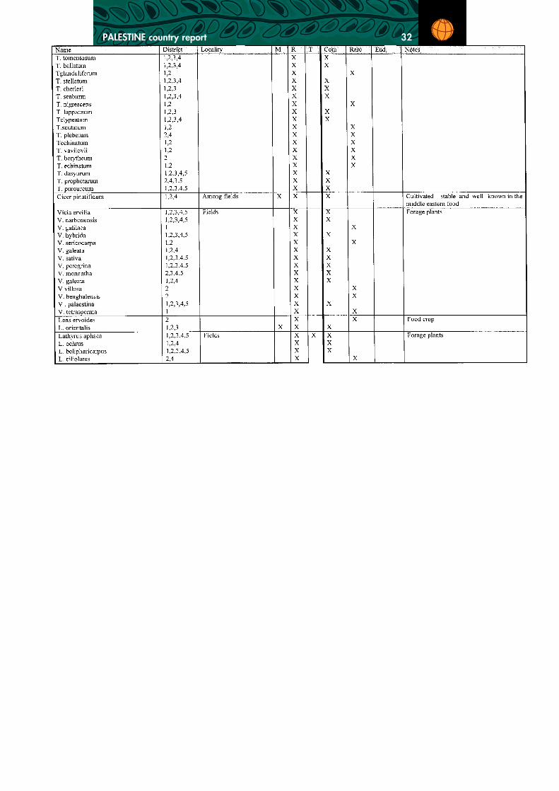
ANNEX 1
List of Native Legumes Plants in Palestine

PALESTINE country report 29

PALESTINE country report 30

PALESTINE country report 31
PALESTINE country report 32

PALESTINE country report 33

PALESTINE country report 34
ANNEX 2
List of Native Grasses in Palestine

PALESTINE country report 35

PALESTINE country report 36

PALESTINE country report 37

PALESTINE country report 38

PALESTINE country report 39
ANNEX 3List of Indigenous Forest Trees in Palestine
Acacia spp., albida Delile,Acacia laeta Bentham,Acacia tortilis (Forsk) Hayne,Acacia radiana Savi,Arbutus andrachne L.,Cupressus sempervirens L.,Ceratonia siliqua L.,Laurus nobilis L.,Pinus halepensis - Miller,Pinus pinea L.,Pistacia lentiscus L.,Pistacia atlantica Desf.,Pistacia saportae Burnat,Pistacia palaestina Boiss.,Populus euphrantica - Oliver,Quercus spp.,Tamarix spp.,Tamarix aphylla (L.) Karsten,Tamarix arvensis Zohary,Tamarix amplexicaulis Ehrenb,Tamarix tetragyna Ehrenb,Tamarix parviflora DC. etc.,Ziziphus spina-christi (L) Desf.,Ziziphus lotus (L.) Lam.

PALESTINE country report 40
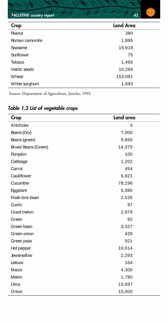
ANNEX 4List of 1995 Agricultural Crops Reserves forthe West Bank & Gaza (in dunums)
Table 1 List of orchards - genetic resources (fruit trees) Crop Land Area
Crop Land Area Almond 75,690
Apple 10,000
Apricot 5,320
Avocado 43
Banana 5,802
Date Palms 2,820
Fig 22,750
Grapefruit 3,760
Guava 4,535
Jajoba 83
Java 4,198
Juava 683
Kaki 13
Land grape 69,150
Lemon 3,054
Loquate 88
Mandalina 6,034
Mandrin 1,173
Mango 5
Olives (non prod.) 35,300
Olives (prod) 769,250
Citruses 80,000
Orange (Blood)
Orange (Farshawi)
Orange (Joint)
Orange (Local)
Orange (Shamuti)
Orange (Valencia)
Other fruits 53,407
Palm 750

PALESTINE country report 41
Source: Department of Agricolture, Jericho, 1995
Table 2 List of cultivated field crops
Crop Land Area Peach & Nectarine 938
Pear 285
Pecan 45
Pistachio 116
Plum 30,450
Pogmond 260
Pomegranate 70
Quince 140
Trellise Grape 12340
Valencia 2,860
Vines 88,000
Walnut 320w
Washingtonia 1,955w
Crop Land Area Anise 725
Barley 133,965
Bitter vetch 27,293
Broad bean 6,354
Broom sorghum 6,763
Chick peas 26,121
Coriandor 265
Dill 580
Dry onion 20,028
Dry peas 339
Dry vetch 16,540
Fenugreek 570
Garlic 2,166
Green forage 804
Lentils 29387
Local tobaco 1,094
Nigella 820
Onion seeds 448
Onion-sets 510
PALESTINE country report 42
Source: Department of Agriculture, Jericho, 1995.
Table 1.3 List of vegetable crops
Crop Land Area Peanut 380
Roman camomile 1,895
Seasame 16,919
Sunflower 75
Tobaco 1,465
Vetch/seeds 10,269
Wheat 153,091
White sorghum 1,693
Crop Land area Artichoke 4
Beans (Dry) 7,000
Beans (green) 9,850
Broad Beans (Green) 14,370
Pumpkin 100
Cabbage 1,202
Carrot 454
Cauliflower 6,821
Cucumber 78,196
Eggplant 5,080
Fresh broi bean 2,535
Garlic 97
Giant melon 2,979
Green 92
Green bean 3,327
Green onion 439
Green peas 921
Hot pepper 10,014
Jewsmallow 2,293
Lettuce 164
Maize 4,300
Melon 1,780
Okra 15,697
Onion 15,000
PALESTINE country report 43
Source: Department of Agriculture, Jericho, 1995.
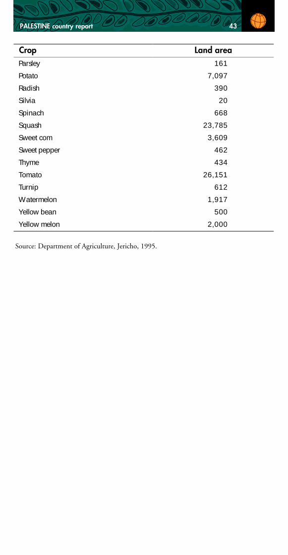
Crop Land area Parsley 161
Potato 7,097
Radish 390
Silvia 20
Spinach 668
Squash 23,785
Sweet com 3,609
Sweet pepper 462
Thyme 434
Tomato 26,151
Turnip 612
Watermelon 1,917
Yellow bean 500
Yellow melon 2,000

PALESTINE country report 44
ANNEX 5List of Ecological and Agricultural SensitiveAreas in Palestine
CRITERIA FOR SITE SELECTION
At this stage land will be classified into the following three categories as a meansof determining the level of restrictions on human activities needed on the land:highly sensitive areas (HSA), such as natural reserves and valuable ecosystemswhich need to be protected for the common good; agriculturally sensitive areas(ASA), which includes important agricultural areas which should be protectedfrom development; or moderately sensitive areas (MSA) land of some ecologicalimportance on which development should require an environmental impact as-sessment; and areas with no particular sensitivity (NS), where the current situa-tion should remain in tact whereby building is permitted as long as it followscommon standards of laws and regulations. As mentioned above, the criteriaused for making decisions about the extent to which areas are ecologically HighlySensitive Areas are as follows
1. the habitats or biological communities are considered exceptional;
2. the area contains an ecosystem with limited representation;
3. the area has an unusually high diversity of biological communities or species;
4. the area provides natural habitat for indigenous species (plants and/or ani-mals) that are rare or endangered;
5. the area is a key lynchpin or a watershed with ramifications for adjacentareas.
Agriculturally Sensitive Areas have been chosen according to their suitability for:
1. grazing
2. field crops
3. vineyards
4. orchards
5. vegetables

PALESTINE country report 45
Moderately Sensitive Areas have been marked as such on the following criteria:
1. The area is of potential ecological value but characteristics such as rare floraor fauna, provision of habitat, or placing that would make the area keyecologically have not been spotted;
2. Even if the area may contain important flora or fauna, it is a large enougharea that it is possible that human activities will not necessarily disruptnature, if proper measures are taken;
3. It is not necessarily agriculturally important area, but human activities arekey to the ecology;
4. The area would be either agriculturally important or highly sensitive but isdegraded and needs rehabilitation.
Hebron Region
Highly Sensitive Areas
1. Beit Cahal Natural Reserve (Wadi Al-Qof) - Forest containing Rhamnuspalaestinus, (buck thorn) Quericus calliprines (oak), Cyclemen persicum(protocol, a well known protected plant), and Populus euphrantica Olivier(Hour tree). Terracing exists which is said to date back to Byzantine andRoman times. There are two varieties of Cuppressus, C. sempervirens L. Chorizontalis (Mill) (Gordon), Phlomis pungens Willdr. & P. brachyodonBoiss. (Zohary) and many trees of the Eucalyptus family. In terms of wild-life, while none were sighted by the research team, discussion with localpeople revealed that some mountain gazelles, Husaini (fox) and many rab-bits are known to live in and/or pass by the area. The protected area en-compasses both sides of Wadi Qof (west of Beit Cahal).
2. Between the villages of Tarqoumia and Nuba an ecological site of naturalforest that includes Quericus calliprinos, a few Ceratonia siliqua L., manyPinus halapensis (Miller), Olea europaea L., Eucalyptus sp., and Opuntiaficus-indica. According to locals, animal life includes gazelle, wild rabbits.The protected area should runs along the top of the mountain to the im-mediate east between Tarqoumia and Nuba.
3. South-east of the town of Idna, near the village of Suba-forest containingQuericus calliprinos, Rhamnus alternus, Rhamnus palaestinus, Pinushalapensis, in addition to some annual-biennial plants that have not beenidentified at this stage (date January 15th, 1996).

PALESTINE country report 46
4. Just to the south-west of Al-Fawwar Refugee Camp - forest containingQuericus caliprinos, Pinus halapensis, Cupressus sempervirens and Euca-lyptus spp. Moreover, while currently a sewage stream drains from Hebronand settlements to the west, the area is a natural water drainage basin andwadi, thus increasing the importance of the surrounding area.
5. Just to the west of the village of Karma is a forested area, planted in Jorda-nian times, which appears to provide an important natural habitat. Theforest is dominated by the tree species of Quericus, and Pinus, and harborsCupressus spp. and other vegetation. Rodents, gazelles and wolfs have allbeen sighted in the area.
6. East of Deir Rizah near Dura-here is a large forested area-no specific specieshave yet been identified.
7. North of the road leading into Dura is a forested area providing habitat toflora including Quericus and Pinus, and fauna including wolves, gazelles,rabbits.
8. In the Southern-Eastern Slopes, the region surrounding the Israeli settle-ments of Karmel and Maoun, is degraded rangelands with some scatteredPinus and Cuppressus trees and a Thymelaea hirsuta that form a batha sortof vegetation. The area is a habitat to important wild-life including birds,such as Dwairi-Draiji (dunlin), Hassoun, Bulbul, Hodhod (Hoopoe), AbuSa’ad, as well as wild pigeons, and mammals, such as mountain gazelle,rabbits, fox, Huseini, and wolves.
9. South-west of the town of Beit Ommar is a forested area, probably impor-tant in the maintenance of the mountain ecosystem. It includes many for-est trees, and is famous for orchards of cultivated species such as malus,plum, peach and Nactarina (Nectarine). To the West of the town, impor-tant terraces of watershed and mountain landscaping.
10. While mostly pine, the forests surrounding Kufr Ascion should be pro-tected as well (although most are under the protection of Gush Etzionsettlement). Little is known about the type of wildlife existent in the area.
11. There is a forest between Beit Ommar and Arroub which contains Pinusspp., Quericus, caliprinus, Q. boisseri, Pistacea, and a few cupressus. Itcovers a hilltop just southwest of the Arroub refugee camp, and is thoughtto be an important habitat for fauna.
12. The forest just prior to Beit Fajjar (from Arroub to Beit Fajjar) is urgentlyin need of both protection and rehabilitation. It has important habitat, andcovers a mountainous area which overshadows agriculturally important areas.Surface water drains off the mountain into wadis, spring sand water catch-ments. It is also biologically important as a habitat for not only Pinus spp.,but also for other species of flora and fauna. The entire hilltop to be refor-ested is to be protected.

PALESTINE country report 47
Agriculturally Sensitive Areas
These are areas which are used for agriculture production. Often the agriculturalpractices (such as terracing) are important for the maintenance of ecosystems.
1. To the East of Beni Na’im are rangelands and cultivated areas. Orchards ofolive and some other fruit trees (specifically almond) and dry land fieldcrops have been planted in the area. It is suitable for grazing of livestock asthe potential biomass production of forage plants is quite high, includinglegumes and short grasses that appear especially when rainfall is adequate.However the present pressure of grazing of herders in the region affect thebiomass and decreases the rangeland potential of the region. Our observa-tions in last December showed only few forms Iris Palestina, manyAsphodelus ramosus Miller (a poisonous plant when green) andSarcopoterium spinosum (L.) Spach (unpalatable species). The area extendsdown to the Jordan Valley and is ideal for water harvesting all the waythrough. A double check visit to the area in April showed the followingnative species: Paronychia argentea, Majorana syriacum, Gundeliatournefortii, Aruma palestinum and Chamomile.
2. East of Hebron is a terraced agricultural area where grapes, fruit trees, andfield crops are produced.
3. The valley between Beit Omar, Arroub, Kafr Ascion and Beit Fajjar isagriculturally valuable land, farmed with grapes, figs and stone fruits. It isalso the site of the Arroub Agricultural Research Station and agriculturalschool, where stone fruits, field crops and livestock are all produced and tested.
4. The wadi leading from Sa’ir and Arroub east is agriculturally importantland used currently for vegetables, fruit trees, and field crops.
5. In the area leading from Halhul to Sa’ir is an important terraced agricul-tural area, especially for the production of grapes, fruit trees and some fieldcrops. The southern most Quericus boisseri in the world is existent in thisarea as well.
6. Between Halhul and Hebron are important terraced grape vineyards andsome orchards. Not only is their production important, but the terracing isimportant in the biological maintenance of the area.
7. The plain west of Surif and northeast of Nuba, including the area knownas Beir El-Qous, is both valuable for irrigated and rainfed agricultural pro-duction - includes some orchards, Pinus halapensis on small hills, and quiteoften, many annual plants that are good for grazing of herders.
8. Along the road to Beit Awwa, Idna, Tarqumia and Nuba, west to the greenline, has dry and irrigated agriculture including orchards, field crops and grapes.
9. The area around Ein el-Fawwar, between Fawwar, Yatta and Samoa is asite for irrigated agriculture including vegetables.

PALESTINE country report 48
10. On either side of the main road from Idna to Hebron are valley agricultureincluding olives and stone fruit. Villages such as Taffuh have planted inthese wadis.
11. West of Dhahiriya toward the hamlets of Khirbet Mamara and Khirbet al-Jabri are important areas for field crop production and grazing. Some grapes,olives and stone fruits are also produced in the area. It includes the areanear by Dharya-Arab Al-Rabaddin and Al-Beirih agricultural station whichwas famous for cultivation of orchards and represents an ecological gradi-ent shown by its different climate and native flora. The most abundantwild plants are Thymalia hirsuta, Carlia coromposa and many crucifers.
12. The area behind (east of) Dhahiriya, is important grazing and agriculturalarea. Within the wadis and watersheds, agricultural areas (rainfed fruit treesand field crops) are prominent. On hill tops and east of the cultivated areas,grazing is important.
13. South-east of Dura to Dhahiryeh the area is planted with field crops andsome orchards.
Moderately Sensitive Areas
1. The mountain just below the village of Beit Cahal includes few olives andgrapes as well as fruit trees and naturally occuring wood species (a fewRhamnus palaestinus and probably pistiacea).
2. The area between Karma, Dhahiryeh and Samoa is an important naturalwatershed site. In the region there are sites of water wells and natural waterresources.
3. Between Zif, the settlement of Carmel, and the hamlet of Al Carmel isimportant for rangelands, and includes Olea europaea and Amygdalus com-munis (almond) trees, natural water catchments (now dug as wells or cis-terns), and wildlife- gazelles, shinnar birds, many wild pigeon.
4. To the north-east of Sa’ir, Wadi Sa’ir and to the west is an area with goodlandscaping potential, suitable watershed as well as agricultural field cropsand orchards. It also has rich diversity of native plants biota, of whichTamarix is the most common.
5. West of the mountainous forested area at Karma is a mountainous areawith significant biological potential.
6. Just west of Duma is a valley of potential importance, but more study isneeded and possibly revitalization of the area might well be necessary.
7. West of Halhoul, south of Al-Baqar, is a valley with significant potentialagricultural and ecological importance.

PALESTINE country report 49
8. West of Um Alas to the “Green Line”, is a hill of significant potential,directly abutting an area of agricultural and environmental potential.
Bethlehem Region
Highly Sensitive Areas
1. Valley between Takoa Settlement and Herodian is a forested wadi-impor-tant both as erosion control and watershed, but also probably as flora andfauna habitat. More research is needed to determine the species type exist-ent in the wadi, though oak and Pinus spp. have been spotted. Presumablywildlife would be prevalent in the area, though more study is needed.
2. The area directly around Mar Saba-specifically both sides of the QidronValley, where wild caperis (Capparis spinosa L.) have been sighted-shouldbe considered of high importance. In terms of wildlife, gazelles, and variousbird species have been spotted in the area.
3. The north side of the valley behind Beit Jala contains important ecologicalresources including sarcopoterium spinosum, Thymus bovei,, Asphodelusramosus, Oak, Phlomis, some Trifloium and medicago species, and somefrequent Olea europaea. Various types of rodents and birds, as well as im-portant insect varieties are known to exist in this area (Shmida Pers. Comm.).
4. The controversial Jabal Ghneim (Har Homa-between Beit Sahour and EastTalpiot) is a mountain covered with old forest (mostly Pinus) which acts asa habitat for flora and fauna. The area is said to be inhabited by rodentsand mammal predators as well as bird species.
5. The area around King Soloman’s Pools is well known as a religious andarcheological site. It also contains old trees, as well as important aquaticvegetation, including Potamogeton filliformis, Ornithogalum, Narscissusspp. According to the literature some protected plant species have beenrecorded there as well including Narscissus, Tulipa, and some Irises. Ani-mal species are not terribly prevalent because of the site’s proximity toneighboring towns and villages. However, there are rodents, birds and otherwildlife which inhabit the areas.
6. The area behind Husan and Wadi Foqeen is terraced and forested (mostlywith pine) providing important habitat for animals and plant life. It is alsoan irrigated agriculture site in the area.
Agriculturally Sensitive Areas
1. The agricultural area just above to the west of the village of Taqoa is plantedwith orchards of stone fruit, olives and vineyards.

PALESTINE country report 50
2. The village of Taqoa is planted with olives.
3. Just below the settlement of Efrat is a valley planted with orchards and fieldcrops.
4. The area immediately south-west of Al-Khadir village is terraced agricul-tural land mostly cropped with grapes, fruit trees and field crops.
5. The area immediately around Wadi Foqeen is one of the most importantirrigated agricultural sites in the Bethlehem district.
6. The area to the west of Husan is cropped with olives and other fruit trees.
7. Most of the area around Beit Jala to the west is important agriculturallyterraced land.
8. The same is true of both immediately north and south of Beit Sahour andBethlehem. Significant agricultural and grazing areas exist throughout thedistrict.
9. The area southeast of Obediyeh and east of Beit Sahour (Ta’amara andZa’atara) are ecologically important as agricultural and grazing areas as well.(See Map)
10. Extending from east of Abu-Ghneim mountain to Wadi Qidron is an agri-cultural area planted with fruit trees, field crops and orchards.
11. The area around wadi Al-Khadir, village of Artas, has a high potential forirrigated agriculture, specifically fruit trees and vegetables.
Moderately Sensitive Area
1. The far eastern part of the district, including the area from Obediyeh south-east and from Herodian east contains greatly more unused, not terriblyvaluable land than the west and central parts of the districts. However, thevalue of the pasture in this area is important as wild varieties of medics,grasses and legumes have been spotted here.
2. The north side of the Batir / Husan mountain facing Beit Jala and Walajais terraced and interspersed with low level agriculture and green area. Whileno evidence of important flora or fauna have yet been revealed, it is verypossible that the area is of ecological importance.

PALESTINE country report 51
Jerusalem Region
Highly Sensitive Areas
There are few truly expansive forests in the Jerusalem area. However, there areseveral sites which should be protected from the overwhelming pace of develop-ment around East Jerusalem. Obviously protection of some of these sites is pro-visional on a change in the current control of east Jerusalem. From east to west:
1. On the land of Mar Elias, next to East Talpiot, is a forest which also servesas an important habitat for flora and fauna.
2. By the College of Abu-Deis grounds is an old forest which not only pro-vides a habitat for flora and fauna but is also an important check againstsoil and biodiversity degradation in the area.
3. In the valley leading from Wadi Nar is biologically relatively fertile andcontains plantation of varieties ranging from olive to acacia.
4. The area just behind the Mount of Olives and Mount Scopus on the landof the Luthern Augusta Victoria Hospital is an area wooded with relativelyold forest which should be preserved.
5. The area between the Mount of Olives, El-Eizaryieh and the settlement ofMa’aleh Adumim is the center of origin of the species Nicotiana glucuaand contains several older Pinus and cuppressus forests-apparently goodhabitat providers for flora and fauna.
6. The area around the village of Anata is forested and there is rare habitat forflora and fauna (pinus, oak and cuppressus).
7. The water source and recharge area for Wadi Qelt exists in the district ofJerusalem and should be protected both as an important water source andas a habitat for a variety of tree, shrub, plant and animal species. (Markedfrom the top of Israeli natural reserves marked area).
Agriculturally -Sensitive Areas
Much of the land in and around Jerusalem is already being used for construction,industry or housing (either for Palestinians or Israeli settlers). However, someland does exist which is used for agricultural production.
1. Around the village of Sur el-Baher, the valleys both to the north and southhave been planted with fruit trees and field crops.
2. The valley to the east of Jabal Makabr is planted with fruit trees and fieldcrops and terraced.
3. Some agricultural area exists in Hizma and Anata which should be pro-tected as well.

PALESTINE country report 52
4. South of El-Jib is agricultural area planted with field crops, vegetables,fruit trees and olives.
5. West of Beit Hanina is land that is planted mostly with olives and fruit trees.
Moderately Sensitive Areas
1. The north-west of the Mount of Olives between Getsemene and MountScopus is forested with fruit and wood trees.
2. The area east of Abu Deis going toward Wadi Nar. The land is used forgrazing and low level agriculture. Trees are important in hold the hillsidesand construction should only take place if an alternative strategy for pre-venting erosion can be implemented.
3. Land east of El-Eizaryieh stretching toward the Jordan valley is valuable aspasture and may well provide a habitat for desert vegetation and animallife, but is badly degraded and needs reclamation.
Jericho Region
Highly Sensitive Areas
In Jericho most of the important areas (until more time exists for in-depth studyof flora and fauna) corresponds either with water sources or important archeo-logical sites which have been identified. These are from south to north:
1. Nabi Musa is located to the south-west of Jericho itself, and would beprime grazing area where it open to herders. It has more or less been closedas a military practice range however, since 1967. Existing there are classicEastern Slopes vegetation including sarcopeterium spinosa, acacia spp., andwild grasses and legumes including vetch. Gazelles, Ibex and other crea-tures of the Jordan Valley are known to frequent the area.
2. Wadi Hajla and the adjacent wadi, 2 km to the north, is a rich oasis to theeast of Jericho with a high abundance of Ziziphus spini-christe, Eucolaptus,and Pinus halapensis. Although the wadi is closed to the Jordan Valleyborder, it appears as a good path for the passing of the wild life west-east orvice versa allowing Gazelle, wild rabbits to cross. Crows have also been seenin the area.
3. Wadi Al-Auja: has a beautiful landscape, and a wide space of land suitablefor both irrigated and rainfed agriculture. A representation of its biota in-cluded Date palms, Ziziphus, Cuppressus, Rhamnus alternus, EchiumPalaestinum, Podonsoma, Onosoma giggentea, Notobasis syriaca, Centurea.,Ballota undollata, in addition to many composites and crucifer species.Gazelle, porcupine (Neis), fox (Husaini) are among the wild animals whichwere usually abundant in the wadi. The local herders say that the wadi

PALESTINE country report 53
represents another passing path of wild animals that normally pass by fordrinking and might well be for shelter. The area has been frequented forgenerations by herders. They are probably an important part of the ecosys-tem, and should be incorporated into protection schemes in the area.
4. Within Ein El-Sultan and its surrounding area is tremendous biomass incomparison to the prevailing landscape of Jericho. Grass and bush speciesare of particular prominence. This is due to the high water availability.
Agriculturally Sensitive Areas
1. Immediately surrounding most built-up areas and along the road to thenorth in the Jericho District are irrigated agricultural lands. Generally theseareas should be classified as sensitive, requiring EIA for major construction.It is some of the most valuable agricultural land (hectare per hectare) inPalestine. Also sporadic native trees were found in Jericho area such asCalotropis procera, Ziziphus spini-cristi, and Acacia albida and A. tortilis.There are some Artimisa sieberi Besser, Haloxylon persicum Bunge,Hammada negevensis Iljin et Zohary and very few Balanitis aegyptiaca (L.)Delili further north.
2. The area surrounding Ein el-Dyouk is agriculturally important with ba-nanas and vegetable plantations fed by the waters of the spring.
3. The area surrounding Ein el-Nuweima is agriculturally important withbananas and vegetable plantations fed by the waters of the spring.
Moderately Sensitive Areas
1. The area south of Jericho toward the Dead Sea contains savannah-like veg-etation including grass species as well as, Zizaphus, Calatropis, Acacia.
2. The wadi to the north of Wadi el-Qelt also feeds Jericho and may wellcontain relatively important species diversity, especially in winter.
Ramallah Region
Highly Sensitive Areas
The highly sensitive areas are less prevalent in the Ramallah district, as much ofthe land in the area is agricultural or built up. In this preliminary investigationfour sites of importance have been identified
1. On the road between Ramallah and Birzeit, the land on Star Mountainschool for the handicapped is forested, containing species of Pinus spp.,Quericus spp. and fruit trees. Wildlife spotted there by local residents in-cludes gazelles and rodents.

PALESTINE country report 54
2. The land on the campus of Birzeit University is relatively newly plantedforested, including Qericus spp., Acacia spp., Pastacia spp. and other spe-cies.
3. The area directly across from the refugee camp of Jalazone includes manynative plants (Leguminus such as, Calicotomi villosa Link, Sarcopoteriumspinosum, olives, almond, Ficas caria, Asphodilus, many liliaceae, severalCapparis spinosa, Urtica sp., and few Crataegous aronia (L.), plants fromthe Decandle family.
4. There is a significant wooded area north of the village of Turmus Aya(between Turmus Aya and Sinjil) which is important as habitat for bothflora, including Inula viscosa, Quericus spp., Ficus spp., Lorenthus spp.,and several composite species, and fauna.
5. The areas of Ein Qiniya is an important watershed and has tremendousbiological production. It is an important habitat for both flora and fauna.
6. Between Um Al-Safa and Nabi Saleh is one of the oldest wooded forests inPalestine, constituting some of the most important habitat for flora andfauna.
Agriculturally Sensitive Areas
Aside from those areas mentioned above as highly sensitive areas, land outside ofvillages in the Ramallah district is important as agricultural land. In particular:
1. The area between Jifna and Turmus Aya is marked by old terraces and olivegroves which are important in maintaining healthy soil and preventing ero-sion, thus preventing degradation of biodiversity.
2. Land to the east of Ramallah (toward and past Taibeh) is generally impor-tant grazing land, with some agricultural potential as well. More study isneeded to determine its importance as a natural habitat.
3. The area between Jifna, Ein-Seinia, Sinjil and Aboueen, to the north-westof Ramallah are plentiful with fruit trees, agriculture, and with many na-tive species of Crataegus aroni, Pyrus syriaca and many other legumes.
4. The land west of Ramallah city, between Ramallah and Ein Qinya is plantedwith terraced olives and fruit trees, with grazing on the uncultivated hillsand some vegetable production in the valleys.
5. The valley between Deir Abziah, Ein Arik (west of Betunia) and Beit AurFauqa and Beit Aur Tahta is important for irrigated and dry orchard agri-culture.
6. The area between Sinjil and Salfit stretching west to Biroquin is terracedolives and fruit trees with some field crops and vegetables in the valley.
7. Between Beit Rema and Abud are terraced orchards of olives and fruit trees.

PALESTINE country report 55
8. The land to the west of the district is either hilly land, which is generally“natesh” (Sarcopotarium spp.) covered, lightly cropped with olive or fruittrees, and used for grazing, or the more plains land that is used as agricul-tural land (generally used for growing vegetables and fruit trees under irri-gation). Some more pristine areas have been developed by the Israelis onthe sites of destroyed villages in the northwestern corner of the district.
9. In the plains and valleys south and west of Beit Laqia are irrigated and dryland areas for the production of field crops, vegetables and fruit trees.
Moderately Sensitive Areas
1. North of Taibeh is a mountainous area which extends down toward theJordan Valley. It is currently used as grazing area but also has significantagricultural potential.
Nablus District
Highly Sensitive Areas (HSA)
1. On the road to west Burkka passing by the south of Yaibud is anotherforest area of pine and cuppressus trees (HSA).
2. The angle bridge nearby the junction of Al Badan town is an area of beau-tiful landscaping, watershed and high plant diversity including Ferula com-munis (indigenous to the Al Badan region), Haloxylon persicum, Ziziphusspina- christi, Euphobia spp., Thymus, Ranunarlus, Pinus, Artimisia, etc.(HSA)
3. Just before the town of Tallouza is a forest land of Pinus, cuppressus, al-mond trees and some ordinate perennial plants (HSA).
4. On the Al-ttour mountain (Jerseem) to the east of the mountain is a forestland of pine and cuppressus trees that allow the survival of other plant biotaenhance the beauty of the landscape in the area (HSA).
5. The north mountain of the city of Nablus has also a similar forest plant ofpine and cuppressus trees (HSA).
6. The mountain to the east of the city of Nablus facing Atsqar refugee campsand close to the Aloun Moraih settlements is another forest land (HSA).
7. There is also another forest land close to the District Coordination Liaisonoffice in Nablus, where the dominant trees there is Pinus (HSA).
8. While the town of Sabastia is known for having valuable archeological sites,it is also famous for its native biota, olive cultivation, and some other fieldcrops (HSA).

PALESTINE country report 56
Agriculturally Highly Sensitive Areas (AHS)
1. On the way from Tallouza to Atseera is a large agricultural area plantedwith olive, almond, some citrus as well as native plant biota (AHS).
2. The junction from Atseera to Beit Imrein has also a similar capacity forcultivation of olive and other orchards as well as cereal and vegetable crops(AHS).
3. Close to the town of Ejneseniah is dense olive trees forming another agri-culturally sensitive area (AHS).
4. Nearby the town of Al Nassarieh is an agricultural land cultivated for veg-etables and includes some native Ziziphus and Calotropis trees (AHS).
5. Nearby the towns of Al Funduq and Jean Safut is a wide agricultural fieldsthat is cultivated for rainfed crops such as wheat and barley (AHS).
6. Nearby the town of Tel is a wide area of agricultural land cultivated mainlyfor Ficus carrica and olive trees as well as field crops (AHS).
7. Close to the town of Kabalan are many olive trees and oak, pistacio areoccurring (AHS).
8. Deir Sharaf junction on the way from Nablus to Anabta is well known forits agricultural potential of field crops and olive trees (AHS).
Moderately Sensitive Areas (MSA)
1. The mountain to the north of Al Badan on the east side of the way toNablus is a moderately sensitive area (MSA) for having some potential fornative biota of pine trees and some short grasses.
2. The mountains to the east of the towns of Akraba up to the town of MajdalBeni Fadel is a rangelands and include some perennial plant vegetation andshort grasses (MSA).
3. Nearby the town of Salem and Deir Al Hatab is some rangelands and agri-cultural fields which makes the area as moderate sensitive area. (MSA).
4. Close to the town of Yetma is olive trees, almonds, as well as some plantbiota (MSA).
5. Nearby Azzoweih town - acacia trees have been seen among the wheatfields and the olive orchards places (MSA).

PALESTINE country report 57
Tulkarem District
Highly Sensitive Areas (HSA)
1. The pine and olive forest to the west side of the town of Anabta is a highlysensitive area (HSA).
2. The area between Tulkarem and Azzoun includes old forest lands as well asagricultural land cultivated for olive, almond, and citrus trees. In the areathere are also many perennial and annual plants - some of them belong tothe Labiatea, Compositi, Umbelleferae and Leguminosea. The area is con-sidered as (HSA).
3. On the road from Qalqeelia to Nablus, a few kilometers before Nablusnearby the settlements of Shamron-Araiel, is an area with many Acaciatrees, beautiful biodiversity of native biota including Calycotmi, Pistacio,Ceratonia, Albisia plants as well as olive fields (HSA).
Agriculturally Highly Sensitive Areas (AHS)
1. The town of Saida, especially on the hills nearby, are hundred of dunumsof olive trees and orchards which makes the area agriculturally highly sen-sitive (AHS).
2. To the west of Tulkarem - agriculturally fields are cultivated for vegetables,cereals, citrus and other orchards; many nurseries are present in the region(AHS).
Moderately Sensitive Areas (MSA)
1. The area from Azzoun to Jaiyouse is a moderate sensitive area (MSA) whereit has a few olive trees and some rangelands.
Jenin District
Highly Sensitive Areas (HSA)
1. The mountain to the north west of Tubas, known as lbzeeq, is an area ofhigh ecological significance as it includes a rich vegetational cover ofrangelands species, including many legume pulses other grass plants, inaddition to forest trees of Pinus, Cupressus that were planted at the begin-ning of this century, and wild peagons together with many other birds areseen passing by the region (HSA).

PALESTINE country report 58
2. To the east of Tubas is Lehif Jader mountain with some scattered Pinushalapensis and few olive trees on the western slope; to the north eastern sideof the mountain, after the town of Tyaseer, is the West Bank best rangelandsthat is associated with high diversity of native flora, including Pistacialentiscus, Quericus caliprinose and Ceratonia ciliqua as well as numerousAnemone and Tuilpa flowers. The presence Cyclamen persicum, Podonsomasyriaca,, some other gigantea, some other Anchusa spp., and many com-posites such as Bellis silvestris, Notobasis syriaca, Selybum marianum,Centaurea iberica, and Onopordium spp.). In the area, beautiful birds ofAbu Al-A’ala, Qubbara and the short-toed Eagle, wild cat, mountain Ga-zelle, and the little owl. Unfortunately the mountain as a whole is too bigto be declared HSA and some housing development already exists then.While some parts of the mountain are to be designated as HSA other partsare treated as MSA.
3. Few Kms to the east of Tubas-Tyaseer is location of natural water springnamed as Ein Al-Malih where water represent a valuable natural sourcethat we believe play an important role in the course of species richness anddiversity. The natural biota in the place includes many plants of Retamaraetem, Gundelia tournefortii, (Akkoub), Pistacia sp., Callignum comosum,ziziphus lotus, Ephedra, Mericuriales (male and female species), and manyBrassica, Pistacia species (HSA).
4. To the northwest of Tubas on the way to Zababdih passing through thevillage of Aqqaba, the area has a great potential for growing olive trees andthe cultivation of many cereal crops. In the area to that there is some scat-tered Pinus trees on the hills of a beautiful rangelands. The giant fennel(Ferula communis) and probably Euphorbia sp. together with many com-posites and legumes have spotted during the field visit. The area is bestclassified as Agricultural High sensitive (AHS).
5. The forest on the myrter triangle just before the entrance to the city ofJenin is an old pine and cupressus forest. (HSA)
6. The Raba forest to the north east of Aqqaba is another highly sensitive areaof pine, oak and cuppresus trees, in addition to agricultural land which fitsperfectly for cereal plantation (HSA).
7. Although the top of the mountain facing the town of Sanour from the easthas less vegetation, but many almonds and olive trees, some opuntias, oc-cur on the Western slope. More importantly is the presence of Quericussp., Pistacia, Rhmnus sp. together with a high diversity of many annualgrasses and a collection of legumes, composites, umbellifera an latiate spe-cies. In addition to the biomass, the area has a beautiful archeological sitesand landscaping and capacity for water harvesting (HSA).
8. A forest to the northwest of the city of Jenin has many pine, cuppresus, andoak trees as well as some olive nearby, it is a highly sensitive area (HSA).

PALESTINE country report 59
9. About two kilometers north of the town of Aaneen is a national forest,known as Um Al Reehan forest, that include pine, cuppressus trees, Euca-lyptus, oak, Pistacio, Rhmnus, and a diversity of other plant biota flowersincluding many Ranunculus, Euphorbia, Narcissus, labietae and compos-ites plants. (HSA)
Agriculturally High Sensitive Areas (AHS)
1. Near the town of Seer is an agricultural land cultivated by vegetables, cere-als, as well as olive trees. The area expresses an excellent topography forwatershed, and in particular the Al-Fara’a spring. It has also some nativebiota of pistchio and rhumnus (AHS).
2. By the town of Mesileh is an agricultural area of olive, almonds trees, someacacia, pistacia trees occur naturally in the hill as well as a variety of wildflowers including calocotomy, tulip and Ridolfia. The presence of housingdevelopment in the area together with big areas put restriction in designat-ing the area in HSA and thus it is (AHS).
3. The hill facing the town of Jab’a has many orchards including almond andolive trees. It is agriculturally sensitive area (AHS).
4. In the town of Kabatia a great portion of its land is considered agriculturalwhich is cultivated for cereals, vegetables and olive trees and thus it is con-sidered as an agriculturally sensitive area. Unfortunately, the town has manynearby quarries that causes much pollution hazards to all land animals,human beings and plant biota. (AHS)
5. The plain of Marj Ibn Amer to the northwest of Jenin is heavily utilized foragricultural purposes including cereals (wheat, barley, lentils, chick pea)and vegetables both irrigated and rainfed. (AHS).
6. To the southeast of Al Far’ah refugee camp is a valuable water resourcecalled Al Far’ah spring that is heavily used for the irrigation of the agricul-tural land nearby, (AHS). Citrus is most common, together with wide spacearea of vegetables. The native biota includes Eucolyptus, Acacia, Albozia,and several native flowers.
Moderately Sensitive Areas (MSA)
1. The area from Zababdih to Imm-Etout, just before the village of Raba hasa great potential for rangelands and olive trees, observed. An example of thenative plants, includes Pimpinella, Ridolfia segetum, Achillea critica. (MSA)
2. To the west of Mesileh is a mountain that has a beautiful labiatae andloguminosae plants together with native oak, Pistacia, lentisus. (MSA).

PALESTINE country report 60
3. The region after the town of Ta’anick includes natural biota of FicusCycomorus, olives, almonds, oak, pistacio, but it is sparse sort of commu-nity and not in a forest sort of shape, so it is a moderately sensitive area(MSA). While there are many types of birds are expected to inhabit thearea, only the Israik bird was seen.
4. On the way between Ta’anick and Aaneen is a rangeland area. It has asporadic olive trees, optunia, oak and carob trees, so it is a moderatelysensitive area (MSA).
5. The area on the southeast of Tubas - Tamoun is a rangeland suitable forlivestock herders and might have some agricultural potential (MSA).

PALESTINE country report 61
References
1. Aaronsohn, A. (1934). The Flora of Trans-Jordan. 386 pp. Originally pub-lished in French by the Botanical Society in Geneva, 1930, Vol. 22.
2. Abed Rabboh, Walid, 1995 “Forestry and Rangeland Development in theOccupied Territories,” PECDAR, Ramallah, West Bank.
3. Abu-Irmeilah, B. (1988). Poisenous Plants in the Jordanian Environment.Jordan University.
4. Aloun, A. (1992). Trees and Crops. Society for Protection of Nature inIsrael (SPNI).
5. Aloun, A. (1992) Wildflowers in Rainbow Colors. Society for Protection ofNature in Israel (SPNI).
6. Agricultural Database, Agricultural Relief Committees, and Arab Thought Fo-rum (1995). “Final Report on Farming Systems in the West Bank and GazaStrip” Vol. 2, No. 8, 1995. Jerusalem.
7. Andrews, I.J. (1995). The Birds of the Hashemite Kingdom of Jordan. 185pp. I.J. Andrews.
8. Anglo-American Survey of Palestine, 1945. Palestine Exploration Fund,London.
9. Applied Research Institute - Jerusalem. 1994. Dry Land Farming in Pales-tine, ARIJ, Bethlehem, West Bank.
10. Ashkenzi, S. (1955). Acacia trees in the Negev and the Arava, Israel. JewishNational Fund. Jerusalem.
11. Danin, A. (1988). Flora and vegetation of Israel and adjacent areas. p. 129-157. The Zoogeography of Israel. Junk, Dordrecht.
12. Danin, A. and Feinbrun-Dothan N., (1991). Analytical Flora of Eretz-Israel.CANA Publishing House Ltd, Jerusalem.
13. Feinbrun-Dothan, N. (I 978). Flora Palaestina, Vols. 3 and 4, Israel Academyof Science and Humanities, Jerusalem.
14. Food and Agriculture Organization, 1995. “National Farm Data Handbook:Occupied Territories (West Bank and the Gaza Strip)” United Nations,New York.
15. Guerin, J. 1852. Journee du Palestine, Vol 1-5, Paris.

PALESTINE country report 62
16. INCD. (1995). Biological Diversity in the Drylands of the World.
17. Isaac, J, Gasteyer, S. (1995). The case of Biodiversity in Palestine. ICARDA,Syria.
18. Isaac, J., and Kharoub, J. (1992). Palestinian Migratory Birds. Applied Re-search Institute of Jerusalem (ARIJ).
19. Isaac, J., Ishaq, I., Al-Sous, B. (1993). Mammals in Palestine. Applied Re-search Institute of Jerusalem (ARIJ).
20. Juneidi (1973). Natural Plants of Jordan and their ecological distribution.Amarzyan Publishing Co. Amman
21. Juneidi (1994). Wild plants of Palestine and their medicinal values. Interna-tional Engineering and Printing Company (IEC). Amman.
22. Lincoln, R.J., Boxshall, GA., and Clark PF. (1988). A Dictionary of Ecology,Evolution and Sytematics.
23. Najim (1992). A Dictionary of Medicinal Plants.
24. PECDAR (1995). Agriculture institutional and Policy Study: The West Bankand Gaza.
25. Philips, R., and M. Rix. (1989). Bulbs. Pan Books Ltd.
26. Pitmann U., Heyen C., Danin A., and Shmida A. (1982). Pictorial Flora ofIsrael. The Hebrew University, Jerusalem.
27. Robinson, R. 1838. Travel through the Holy Land, New York.
28. Shmida A., and Darom, D. (1990). Handbook of Wild Flowers of Israel. 3vols., Keter Publishing House Ltd., Jerusalem.
29. Shmida A., and Darom, D. (1992) Handbook of Trees and Bushes of Israel.Keter Publishing House Ltd. Jerusalem.
30. Society for Austro-Arab Relations, 1992. “Development Perspectives for Ag-riculture in the Occupied Palestinian Territories” Lindengasse, Vienna.(pp 18-19).
31. Tristman, C. (1892). The Natural History of Palestine. Palestine ExplorationFund.
32. Waisel, Y., G. Pollack and Y. Cohen (1982). Ecology of the vegetation inIsrael. Tel Aviv University.
33. Zohary M. (1966). Flora Palaestina. Vols 1 and 2, Israel Academy of Scienceand Humanities, Jerusalem.