Outdoor Recreation - myellensburg.com Recreation. 7 Th e Canyon Hike: dS Th e Canyon hike is much...
12
Transcript of Outdoor Recreation - myellensburg.com Recreation. 7 Th e Canyon Hike: dS Th e Canyon hike is much...

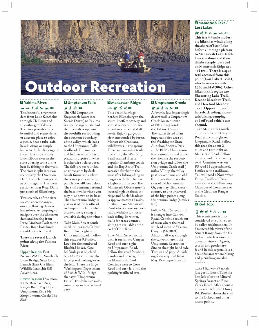
1 Yakima River:|+SdCNXThis beautiful river mean-ders from Lake Keechelus through Cle Elum and Ellensburg to Yakima. The river provides for a beautiful and scenic drive, or a serene place to enjoy a picnic, float a tube, raft, kayak, canoe or simply listen to the birds along the shore. It is also the only Blue Ribbon river in the state offering some of the best fly fishing in the west. The river is split into two sections by the Diversion Dam. Launch points exist in both regions. The lower section ends at Roza Dam, just south of Ellensburg.
Two stretches of the river are considered danger-ous and floating them is hazardous. Attempting to navigate over the diversion dam and floating from Irene Rinehart Park to the Ringer Road boat lunch should not attempted
There are several launch points along the Yakima River:
Upper Region: East Nelson WA St.; South Cle Elum Bridge; State Boat Launch (East Cle Elum Wildlife Launch); Rill Adventures.
Lower Region: Diversion; KOA; Rinehart Park; Ringer Road; Big Horn; Umptanum; Red’s Fly Shop; Lmuma Creek; The Slab.
2 Umptanum Falls:dSYXThe Old Umptanum Stagecoach Route (see Scenic Drives) to Yakima is a scenic sagebrush road that meanders up onto the foothills surrounding the southern boundary of the valley, which leads to the Umptanum Falls trailhead. The smaller and hidden waterfall is a pleasant surprise in what is otherwise a desert area. The falls are surrounded on three sides by dark basalt formations where the water pours into the punch bowl 40 feet below. The trail continues around the basalt walls where you may hike down to its base. The Umptanum Ridge is just west of the trailhead to Umptanum Falls where cross-country skiing is available during the winter.
Take Main Street south until it turns into Canyon Road. Turn right onto Umptanum Road. Follow this road for 9.8 miles. Look for the numbered Bluebird boxes. One half mile past bluebird box No. 73, turn into the large gravel parking lot on the left. There is a large Washington Department of Fish & Wildlife sign that says “Umptanum Falls.” This hike is 2 miles round trip and considered easy.
3 Manastash Ridge: FDYdXThis beautiful ridge borders Ellensburg to the south. It offers scenery and several opportunities for varied interests and skill levels. Enjoy a gorgeous view surrounded by forest, Manastash Creek and wildflowers in the spring. There are two main trails to the top, the Westburg Trail, named after a popular Ellensburg coach and the Boy Scout Trail, accessed further to the west after hiking along an irrigation ditch. There is a logbook at the top. The Manastash Observatory is located high on the south ridge and Buck Meadows is approximately 15 miles further up on Manastash Road where there are horse trails available for horse-back riding. In winter, trails for cross-country skiing are available at the end of Cove Road.
Take Main Street south until it turns into Canyon Road and turn right on Umptanum Road. Follow this road for about 2 miles and turn right on Manastash Road. Continue west to Cove Road and turn left into the parking/trailhead area.
4 Umptanum Creek: DdSjCXA favorite low impact high desert trail is Umptanum Creek, located south of Ellensburg inside the Yakima Canyon. The trail is listed as an important bird area by the Washington State Audubon Society. Park at the BLM’s Umptanum Recreation Site and cross the river via the suspen-sion bridge and follow the Umptanum Creek trail (4 miles RT) up the valley past beaver dams and old fruit trees that mark the sites of old homesteads. Or, you may climb cross-country to one or several of the high points along Umptanum Ridge (6 miles RT).
Follow Main Street until it changes into Canyon Road. Continue south out of town where the road will lead into the Yakima Canyon (SR #821). Almost half way through the canyon there is the Umptanum Recreation Site on the right hand side. Turn in and park. A park-ing fee is required from May 15 – September 15.
5 Manastash Lake / Lost Lake: DdSjNJFThis is a 4.4 mile moder-ate hike that winds along the shore of Lost Lake before climbing a plateau to Manastash Lake. It fol-lows the shore and then climbs steeply to its end on Manastash Ridge at a 4x4 trail. There is a spur trail accessed from this point (Lost Lake #1350.1, which connects trails 1350 and 4W306). Other hikes in this region are Shoestring Lake Trail, Keenan Meadows Trail, and Hereford Meadow Trail. Opportunities for horseback riding, moun-tain biking, camping, and off-road vehicle use abound.Take Main Street south until it turns into Canyon Road and turn right on Umptanum Road. Follow this road for about 2 miles and turn right on Manastash Road. Follow it to the end of the county road. Continue west on FS road 31 approximately 8 miles to the trailhead. You will need a Northwest Forest Trailhead Pass, available at the Ellensburg Chamber of Commerce or at the Cle Elum Ranger Station.
6 Red Top:
NDdSSjXThis scenic area is also considered one of the best by valley rockhounders. It has incredible views of the Stuart Range from the fire lookout which is usually open for visitors. Agates, crystal and geodes are found in this region. It is a beautiful area where hiking and picnicking are also available.
Take Highway 97 north just past Liberty. Take the first left after the Mineral Springs Resort on Blue Creek Road. After about 2 miles turn left onto Hovey Rd. Proceed down the trail to the lookout and other access points.
Outdoor Recreation
7 Th e Canyon Hike:dSTh e Canyon hike is much steeper but shorter than Manastash and provides a wonderful view of the Yakima River Valley. You can see Mt. Stuart and Mt. Rainier. Th is hike is also one of the most popular hikes in the canyon. Th ere is a logbook at the top for anyone to sign.
Drive south on Main Street and continue as the road turns into Canyon Road. Continue south on Canyon Road. Th e trailhead is 2.7 miles from Th rall road inside the Yakima Canyon. Th ere is a big bend to the left, which has a turnout on the left hand side of the road with the trail leading up the canyon.
8 Yakima Rim Skyline Trail /Umptanum Ridge:SFYdTake Main Street south until it turns into Canyon Road. Turn right on to Umptanum Road (at the Subway & McDonalds) and follow for about 5 miles. Turn left on to the unpaved, and historic Jacob Durr Road. Proceed across the high plateau and commence the steep, narrow, rough descent to the fl oor of Umptanum Canyon. At 4.1 miles from Umptanum Road is the ford of Umptanum Creek. A 3-mile climb, for a total 12.1 miles from Canyon road, culminates at the North Trailhead – eleva-tion 3375. A day hike out along the Umptanum Ridge from Jacob Durr Road is an easy picnic for children. Backpacking and mountain biking is also popular with cross-country skiing opportunities in the winter. Th e South Trailhead is about 10 miles from the Damman Elementary School.
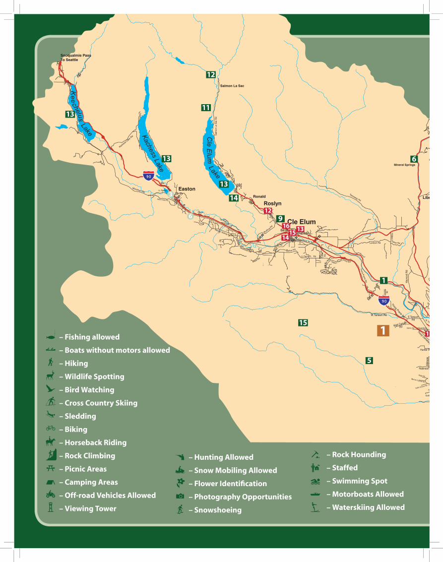
9 Coal Mines Trail:SFDY{Th e Coal Mines Trail was established in 1994 as a cooperative eff ort of the City of Cle Elum, Roslyn and Kittitas County and is dedicated to the pioneers who fi rst settled in this area.
Th is interpretive trail is the original trail that the coal miners took to the mines, and is the old abandoned Burlington Northern Rail Bed, from the late 1880’s to 1963, when the last mine in Roslyn closed with little market for coal after the railroads converted to diesel engines in the years’ prior.
A walk on the trail aff ords visitors a fi rst hand look at the coal-mining heritage through the remains of Roslyn’s mines, at the railroad depot site and barn, and at Powder House Road where dynamite was stored. You may also view the Coal Miners Memorial located in Roslyn.
Th e offi cial trail is charted at 4.7 miles from Flagpole Park to Ronald with op-portunity to explore vari-ous spur trails, as well as going to the ethnic Roslyn cemetery where many of the miners are buried. Th e “easy” trail is open for multi-use, including trekkers, horses, bicyclists, cross-country skiers, sled dogs, and snowmobilers. It is closed to all motorized vehicles except for snow-mobiles in the winter.
To get there from Ellensburg head west-bound on 1-90 and take exit # 84 (Cle Elum / S. Cle Elum). Exit right onto Oakes Ave. and then turn left on First St. W. and continue to the Flag Pole Park at First St. W andSouth Cle Elum.
10 Swauk Forest Discovery Trail:SFDY{/dCIn 1992 this trail was con-structed by the Northwest Youth Group, a non-profi t
CLE ELUMROSLYN
RONALD
VANTAGE
ELLENSBURG
KITTITAS
THORP
CLE ELUM
821
970
97
97
10
organization of teenagers from all over the United States. Th is Forest Service project was planned and implemented by a team representing wildlife biol-ogy, botany, silviculture, fi re science, landscape architecture, engineering, recreation planning, and interpretive writing. Th is 3-mile trail includes 25 interpretive brochure stops and other interpretive signs. From the summit of Blewett Pass, the trailhead is located one-half mile south of Hwy 97 on FS number 9716.
11 Knox Creek Wildfl ower TrailSfX Th is trail begins on a hillside meadow bursting with wildfl owers. It climbs quickly out of the meadow through patchy sub-alpine forest onto open rocky
outcrops; with a surprising amount of diverse habitat in such a short distance. Opportunities along the trail abound for plant identifi cation, photogra-phy, drawing or any other activity wildfl owers inspire.
From I-90, take exit 80 and travel north to highway 903. Turn left (following signs to Roslyn) and travel approximately 11 miles to forest road 4308 (French Cabin Creek). Turn left over the Cle Elum River onto road 4308. Follow the signs to Knox Creek Trailhead (Trail #1315.1).
12 Salmon la Sac / Cooper Lake:SFDOYNTh ese two popular areas are nestled in the Cle Elum District of the Wenatchee National Forest northwest of Cle Elum and Roslyn.
Summer & winter outdoor recreational opportuni-ties abound including, hiking, biking, horseback riding, snowshoeing and cross-country skiing.From Ellensburg take Exit 80 (two miles after Cle Elum). Th en turn north on Bullfrog Road, and drive four miles to Highway 903. Continue north on Highway 903 for 21 miles. Th ere is a campground on the left.
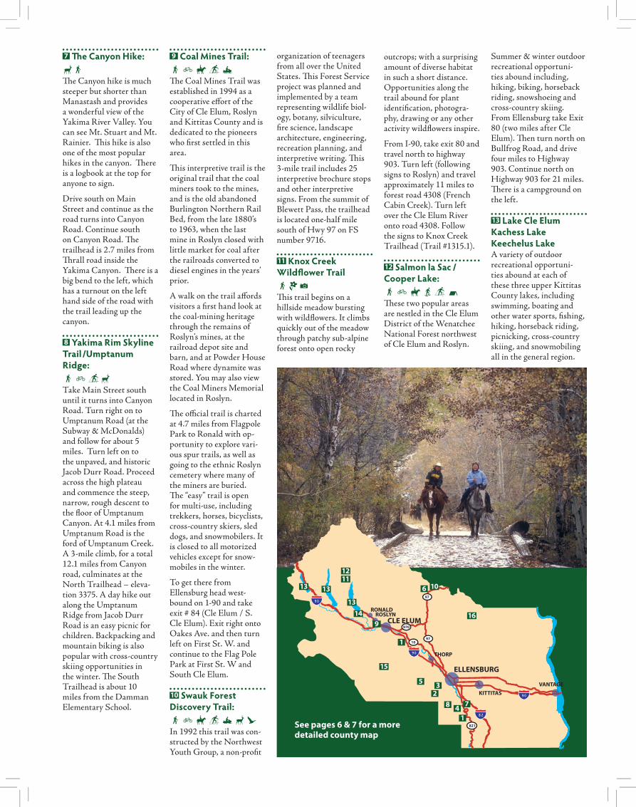
13 Lake Cle ElumKachess LakeKeechelus LakeA variety of outdoor recreational opportuni-ties abound at each of these three upper Kittitas County lakes, including swimming, boating and other water sports, fi shing, hiking, horseback riding, picnicking, cross-country skiing, and snowmobiling all in the general region.
1
1
2 3
4
5
6
7 8
9
10
12 11
13
13 13
14
15
16
See pages 6 & 7 for a more detailed county map
14 Salmon Spawning Viewing Trail:SThis trail is on USFS public lands but there are no signs leading to it. Drive toward Salmon la Sac on SR 903. After reaching the Old #3 in Ronald, continue on SR 903 for another 1.7 miles. Turn left on Lake Cabins Road and drive straight on the pavement for four tenths of a mile to an unmarked dirt/gravel road on the left. Turn there and follow the dirt road on level ground to the outhouses at three tenths of a mile. Here you can choose to park (the road becomes steeper with larger ruts) or continue down the more rugged dirt road to an area just before the river (you’ll see the old bridge just ahead) where you can park. No permit is required. The trail begins in forest and wraps back alongside the Cle Elum River. After paralleling the river you will see log seats placed where you can safely view spawning Salmon in the waters below. This trail is now ADA approved. Salmon spawn in this area usually from September 15th – October 10th each year. This trail is a great place to take a stroll or have a picnic lunch during the summer months as well. The trail is about a quarter of a mile long.
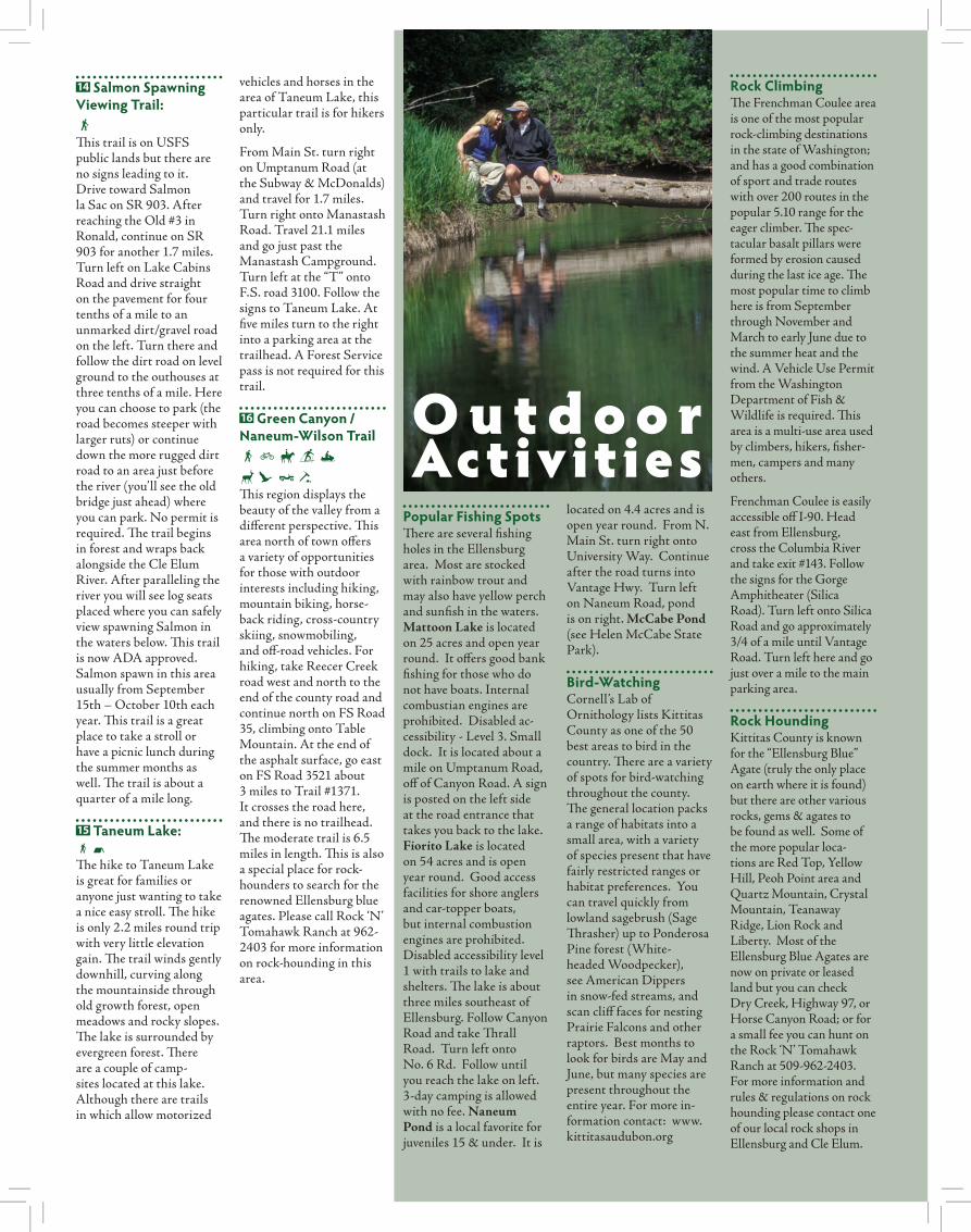
15 Taneum Lake:SNThe hike to Taneum Lake is great for families or anyone just wanting to take a nice easy stroll. The hike is only 2.2 miles round trip with very little elevation gain. The trail winds gently downhill, curving along the mountainside through old growth forest, open meadows and rocky slopes. The lake is surrounded by evergreen forest. There are a couple of camp-sites located at this lake. Although there are trails in which allow motorized
vehicles and horses in the area of Taneum Lake, this particular trail is for hikers only.
From Main St. turn right on Umptanum Road (at the Subway & McDonalds) and travel for 1.7 miles. Turn right onto Manastash Road. Travel 21.1 miles and go just past the Manastash Campground. Turn left at the “T” onto F.S. road 3100. Follow the signs to Taneum Lake. At five miles turn to the right into a parking area at the trailhead. A Forest Service pass is not required for this trail.
16 Green Canyon / Naneum-Wilson TrailSFDY{/dCJSThis region displays the beauty of the valley from a different perspective. This area north of town offers a variety of opportunities for those with outdoor interests including hiking, mountain biking, horse-back riding, cross-country skiing, snowmobiling, and off-road vehicles. For hiking, take Reecer Creek road west and north to the end of the county road and continue north on FS Road 35, climbing onto Table Mountain. At the end of the asphalt surface, go east on FS Road 3521 about 3 miles to Trail #1371. It crosses the road here, and there is no trailhead. The moderate trail is 6.5 miles in length. This is also a special place for rock-hounders to search for the renowned Ellensburg blue agates. Please call Rock ‘N’ Tomahawk Ranch at 962-2403 for more information on rock-hounding in this area.
O u t d o o r Activities
located on 4.4 acres and is open year round. From N. Main St. turn right onto University Way. Continue after the road turns into Vantage Hwy. Turn left on Naneum Road, pond is on right. McCabe Pond (see Helen McCabe State Park).
Bird-WatchingCornell’s Lab of Ornithology lists Kittitas County as one of the 50 best areas to bird in the country. There are a variety of spots for bird-watching throughout the county. The general location packs a range of habitats into a small area, with a variety of species present that have fairly restricted ranges or habitat preferences. You can travel quickly from lowland sagebrush (Sage Thrasher) up to Ponderosa Pine forest (White-headed Woodpecker), see American Dippers in snow-fed streams, and scan cliff faces for nesting Prairie Falcons and other raptors. Best months to look for birds are May and June, but many species are present throughout the entire year. For more in-formation contact: www.kittitasaudubon.org
Rock ClimbingThe Frenchman Coulee area is one of the most popular rock-climbing destinations in the state of Washington; and has a good combination of sport and trade routes with over 200 routes in the popular 5.10 range for the eager climber. The spec-tacular basalt pillars were formed by erosion caused during the last ice age. The most popular time to climb here is from September through November and March to early June due to the summer heat and the wind. A Vehicle Use Permit from the Washington Department of Fish & Wildlife is required. This area is a multi-use area used by climbers, hikers, fisher-men, campers and many others.
Frenchman Coulee is easily accessible off I-90. Head east from Ellensburg, cross the Columbia River and take exit #143. Follow the signs for the Gorge Amphitheater (Silica Road). Turn left onto Silica Road and go approximately 3/4 of a mile until Vantage Road. Turn left here and go just over a mile to the main parking area.
Rock HoundingKittitas County is known for the “Ellensburg Blue” Agate (truly the only place on earth where it is found) but there are other various rocks, gems & agates to be found as well. Some of the more popular loca-tions are Red Top, Yellow Hill, Peoh Point area and Quartz Mountain, Crystal Mountain, Teanaway Ridge, Lion Rock and Liberty. Most of the Ellensburg Blue Agates are now on private or leased land but you can check Dry Creek, Highway 97, or Horse Canyon Road; or for a small fee you can hunt on the Rock ‘N’ Tomahawk Ranch at 509-962-2403. For more information and rules & regulations on rock hounding please contact one of our local rock shops in Ellensburg and Cle Elum.
Popular Fishing SpotsThere are several fishing holes in the Ellensburg area. Most are stocked with rainbow trout and may also have yellow perch and sunfish in the waters. Mattoon Lake is located on 25 acres and open year round. It offers good bank fishing for those who do not have boats. Internal combustian engines are prohibited. Disabled ac-cessibility - Level 3. Small dock. It is located about a mile on Umptanum Road, off of Canyon Road. A sign is posted on the left side at the road entrance that takes you back to the lake. Fiorito Lake is located on 54 acres and is open year round. Good access facilities for shore anglers and car-topper boats, but internal combustion engines are prohibited. Disabled accessibility level 1 with trails to lake and shelters. The lake is about three miles southeast of Ellensburg. Follow Canyon Road and take Thrall Road. Turn left onto No. 6 Rd. Follow until you reach the lake on left. 3-day camping is allowed with no fee. Naneum Pond is a local favorite for juveniles 15 & under. It is

mile past the turn. Parking is available at the site. Th e gates at Robinson and Watt Canyon are closed to all public use from late November-early December each year and re-open on May 1st. For more infor-mation call 509-925-6746.
2 Quilomene Wildlife AreaSDY{FDdhCL Th is wildlife area spans “the breaks” between the Columbia River and pine-dotted eastern foothills of the Cascade Mountains, an area of shrub-steppe ridges and numerous wild creek valleys. Th e Quilomene area is located east of Ellensburg, north of Vantage, and south of Wenatchee. It has a network of primative roads suitable for 4WD, mountain bikes, horses, foot travel, cross-country skiing and snowshoeing. Th e area is also home to a variety of wildlife, birds and wildfl owers. Remote camping sites are also avail-able. Th e area includes the Whiskey Dick Wildlife Area in its south half, next to the Ginkgo Petrifi ed Forest State Park and the old Vantage Highway. Th e Colockum Wildlife Area is connected and lies to the north of the Quilomene Wildlife Area. Th e wildlife
CLE ELUMROSLYN
RONALD
VANTAGE
ELLENSBURG
KITTITAS
THORP
CLE ELUM
821
970
97
97
10
area is managed by the Department of Fish & Wildlife and requires a vehicle use permit.
3 Wildlife Access AreadSj|Th e Washington Department of Wildlife maintains the natural set-ting of the park along the Yakima River, providing public fi shing and scenic nature trails that follow the river. Th e park is located 3 miles south of Ellensburg. Follow Canyon Road to Ringer Loop Road and turn right. Follow the road until you see the pub-lic fi shing sign. A parking
permit is required and can be obtained from any store location that sells hunting and fi shing licenses.
4 Paul Rogers Wildlife Refuge:dSCLocated on Judge Ronald Road, approximately one mile from Ellensburg, a 19.8 acre park provides a diverse wildlife habitat to observe while walking on groomed trails and paths. Th e refuge consists of open fi elds, wetlands, and woods that provide temporary and permanent habitats for a variety of fl ora and fauna in the area. Th e variety of
vegetation provides food for birds such as chicka-dees, fi nches, pheasants, California quail, hawks, mallards, coyotes and cot-tontail rabbits.
From N. Main Street go East on University Way. Continue until the road changes to Vantage Highway. Turn left at Pfenning Rd then right on Judge-Ronald Rd until you reach the Refuge.
WildlifeAreas
1 L.T. Murray Wildlife Area / Watt & Robinson CanyonSDY{FDUdhCJX|LWith over 50,000 acres of land, there are boundless recreational opportunities, including hiking, mountain biking, horseback riding, camping, sightseeing, picnicking, photography, ATV / Quad vehicle use (Green Dot road system), hunting and fi shing, sled-ding and watching the an-nual elk feeding in winter. (Feed is generally put out at 8:00 a.m., but elk are visible throughout the day). Th e landscape rises from sagebrush steppe hillsides to dense stands of pon-derosa pine and Douglas fi r and is home to a large elk herd, mule deer, bear, spotted owls, northern gos-hawk, golden eagles, pile-ated woodpeckers, salmon, migratory and local birds, beaver, and other small mammals.
Take the Th orp Exit from Interstate 90 (exit 101); head south on Th orp Highway, and proceed about ¾ mile to Th orp Cemetery road and turn right (one mile south of the exit); travel west for 2.5 miles and turn left on Watt Canyon Road. During the winter, the elk feeding site is located one
3 1
2
4
See pages 6 & 7 for a more detailed county map
|+SdCYUFDFjNLN
– Fishing allowed
– Boats without motors allowed
– Hiking
– Wildlife Spotting
– Bird Watching
– Cross Country Skiing
– Sledding
– Biking
– Horseback Riding
– Rock Climbing
– Picnic Areas
– Camping Areas
– Off-road Vehicles Allowed
– Viewing Tower
h{fXO
– Hunting Allowed
– Snow Mobiling Allowed
– Flower Identification
– Photography Opportunities
– Snowshoeing
SZc&n
– Rock Hounding
– Staffed
– Swimming Spot
– Motorboats Allowed
– Waterskiing Allowed
1
3
6
11
12
13 14
1516
1
5
6
9
12
11
13
13
13
14
15
^thkcswht\
– Boat Launch
– Parking Available
– Covered Picnic Area
– Playground
– Covered Swimming
– Sauna
– Jacuzzi
– Weight Lifting
– Tennis/Racquet Ball
– Restrooms
2
3
4
4
5
2
6
6
1
11
15
PSE Wildhorse Renewable Energy Center
1
2
3
4
6
7
8
10
16

Scenic Drives & Historic Areas
Yakima Canyon:The Yakima Canyon provides numerous scenic views and picnic areas with several turnouts located next to the Yakima River. There are four recreational sites with camping avail-able through the Bureau of Land Management. A use fee or permit is required from May 15 – September 15 to park or camp at these sites. The canyon is home to bald eagles, hawks, blue heron, and our region’s somewhat elusive big horn sheep. This is a great scenic drive anytime but during the spring and fall it is at its best with the new spring or autumn colors on the trees that bank the river shores.
Follow Main Street until it changes into Canyon Road. Continue south out of town where the road will lead into the Yakima Canyon (SR #821). The road continues to the city of Yakima 40 miles from Ellensburg.
Peoh Point:This scenic point offers spectacular panoramic views of the Cle Elum Valley. Elevation is 4,020’. The road leading to Peoh Point is gravel for the first eight miles, the last two miles are a primitive road.
From Ellensburg drive west on 1-90 and take the Cle Elum Exit 84. Drive on South Cle Elum Rd to Madison St. and turn right. Turn left on 6th Street. Stay on this road as it curves around and becomes West-side road. Continue past Mohar Road. Turn left on USFS Rd 3350 (also South Cle Elum Ridge Road), signed “Peoh Point”. Continue for 8 miles. Near the top, look for a cattle guard and a sign directing you to Peoh Point just before a 5-way intersection. (first dirt road to left with a marker saying 3350 and 115). Follow this primitive road for 2 miles to the point. Peoh Point is not accessible during win-ter snow and spring muddy season.
Lion Rock:From this scenic view-point, you can see Mt. Rainier, Mt. Adams, and the Stuart Range. It’s great for picnicking, hiking, photography and horseback riding and other outdoor activities. Take Reecer Creek Road north for approximately 11 miles until it becomes FS Road 35 (Reecer Creek Sno-Park). Follow the road north for about 7 miles to Lion Rock. Look for signs along the way. No parking permits are required. This is a great place to see deer and elk in spring. This road also leads to Liberty. Snowmobiling is allowed at the Reecer Creek Sno-Park. A Sno-Park Pass is required.
Manastash LookoutTake a short drive up to Manastash Lookout to get a panoramic view of the Kittitas Valley and of the Mount Stuart range. The elevation is 2672 ft. Travel I-90 east to I-82 east, the lookout is approx. 7 miles. Look for the well marked road sign.
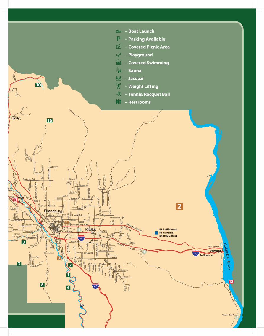
Whisky Dick Mountain:The high point between Ellensburg and areas to the east is now the home of the PSE Wild Horse Wind Facility. Visit the Renewable Energy Center which boasts an exhibit topics ranging from renewable energy to local natural history. The center is located near the summit of Whisky Dick, just past mile marker 16, where you can enjoy panoramic views of the Kittitas Valley and the Columbia River Gorge.
Take Vantage Hwy east from Ellensburg 13 miles, turn left on Beacon Hill Road. Open seasonally.
Taneum RoadThis scenic road ends up in the same foothills that the Manastash Road winds through. After you reach Taneum Junction there is a multi-use trail system that is enjoyed by motor-cyclists, hikers, horseback riders, and mountain bikers during the summer. There are 4 campgrounds along the Taneum Road. A Northwest Forest Pass is required at Taneum Junction.
Take I-90 to Thorp (Exit 101), turn left and travel approximately 1 mile to the Thorp Cemetery Road. Turn right. Travel 4 ¾ miles and turn left onto Taneum Road. As you continue the road will become FS #33. At the end and to the left is Taneum Junction.
EllensburgEllensburg was named after the wife of John Shoudy, Mary Ellen and became incorporated in 1883. When the Northern Pacific Railroad came to town in 1886 Ellensburg was being talked of as the “Pittsburgh of the West.” Due to its central location, many thought it a natural site for the capitol of the soon-to-be state. But because of the 1889 devastating fire of downtown Ellensburg, these hopes were extinguished. But the downtown was quickly rebuilt in what you see today and become the home to the State Normal School now known as Central Washington University. Ellensburg is still rich in its local history and is well maintained with the help of the Kittitas County Historical Museum and the Ellensburg Library.
LibertyThis well-preserved gold-mining town is listed in the National Historical Register. Take University Way west to exit Highway 97 (the Blewett Pass Highway) and watch for signs.
Roslyn/Cle ElumRoslyn (and Cle Elum) was platted as a town site in 1886 due to the discovery of large coal deposits underlying the region which helped fuel the steam engines for the Northern Pacific Railroad and it’s trips up the Cascade Mountains. When railroads converted to diesel engines, there was little market for this type of soft coal, and Roslyn’s last mine closed in 1963. During the thriving days of the mines, immigrants came from all over the world to Roslyn and Cle Elum to work the mines. Among other historic buildings and museums, there are also 26 old ethnic cemeteries (Roslyn).

CLE ELUMROSLYN
RONALD
VANTAGE
ELLENSBURG
KITTITAS
THORP
CLE ELUM
821
970
97
97
10
State Parks1 Olmstead Place
State ParkjSYZOlmstead Place is one of the fi rst homesteads in the Kittitas Valley and celebrates the legacy of the family farm. It features the original log cabin, barns and authentic materials from the late 1800’s. Th e .75-mile Altapes Creek Trail runs from the red barn to the Seaton Cabin School House located at the north end of the park. A trail guide is available to interpret the farm and the plant life growing along the stream bank. Th e park also features carefully restored historic gardens and can be booked for weddings or par-ties. During the winter the park is open to cross-coun-try skiing and snowshoeing (no groomed trails). Park Hours: April 1 - Sept. 30 from 6:30am to dusk and Oct.1 - March 31, 8am to dusk. Free public tours are given every weekend from 12:00pm – 4:00pm. 509-925-1943
From Main Street heading south, turn left (east) on Mountain View Ave. As you head east, this road will turn into Kittitas Highway. Turn right (south) on North Ferguson Road. At the end of the road you will come upon the homestead.
2 Ginkgo Petrifi ed Forest State ParkSdjZTh e Ginkgo Petrifi ed Forest is one of only four locations in the world known to have petrifi ed Ginkgo trees and en-compasses 7,469.88 acres of land with freshwater shoreline on the Wanapum Reservoir. Th e Natural Areas consist of a series of short trails through a pre-historic lake bed; including a paved trail down to the “Indian Rock Pictures”. An Interpretive Center over-looks the river below. You may also notice a variety of wildlife in the park such as deer, elk, coyotes, rabbits, birds, lizards and rattle-snakes.
Th e Interpretive Center is open from 10:00am-6:00pm May 16-September 15th. (509-856-2700). Th e Interpretive Trails are open year round: October 1-March from 8:000am to dusk; and April –September from 6:30 am to dusk (509-856-2710). Th e park is located an easy 27 miles east of Ellensburg on 1-90 to the Vantage Exit. Continue north on the Old Vantage Hwy. Follow signs to the Ginkgo Petrifi ed forest Interpretive Center.
3 Lake Easton State Park / River Walk TrailjS{Yc|& +dCLake Easton State Park is a forested, 516-acre year-round camping park with access on the shores of Lake Easton in the Cascade Mountain foothills. Th e park has beautiful mountain views and trails to explore in the summer and cross country skiing and snowmobiling trails to enjoy in the win-ter. Lake Easton State Park is a great spot for hiking, biking, fi shing, boating, swimming, wildlife and birds, camping, canoeing, and kayaking.
From I-90: Take exit #70, and follow signs to the park. It is located one mile west of the town of Easton.
4 Wanapum State Park & Columbia Riverjnc|^+Two miles south of Vantage, the park’s grassy, tree-fi lled area features picnicking, swimming, boat ramp, trailer park and camping. Th is is a popular area for water skiing and soaking in the sun.
From I-90, take the Vantage exit, proceed south following the signs.509-856-2700
5 Helen McCabe State Park / Interpretive Trail|STh is day-use only park facility and interpretive trail was created by the Kittitas Environmental Education Network (KEEN) in 2006. Th e trail loops around McCabe pond (a popular fi shing spot) and off ers family fun, a learning experience and mostly year-round access. Interpretive brochures are available at the self-serve information bulletin board located at the beginning of the trail.
Follow Main St. south, it will turn into Canyon Road. Continue for about 5 miles. Th e State Park is located just past Th rall Road on the left hand side. Signs are posted.
6 Iron Horse State Park/John Wayne TrailSDY{FTh is is a 1,613-acre park that includes the John Wayne Pioneer Trail. With more than 100 miles of trails extend-ing from Cedar Falls in the Cascade Mountains to the Columbia River in Central Washington, the John Wayne Pioneer Trail is perfect for long or short trips. Th e trail leads
travelers past high trestles with spectacular views of the valley below, moun-tainous terrain, sagebrush desert, arid scrublands and charming country-side farmlands of the Columbia Basin. Hikers, bicyclists, equestrians, wagoners, cross-country skiers, snowshoers and dog sledders can discover the rugged beauty of the Pacifi c Northwest by trek-king this unique trail that follows the path of the old Chicago-Milwaukee-St. Paul-Pacifi c Railroad, also known as the Milwaukee Road. Th is family-friendly trail has a light gravel surface, a gentle and easy-to-negotiate grade and camping along the way. A State Park Parking Permit is required at all trailhead parking areas. During the winter season a Non-Motorized Sno-Park Permit is required. Th e Park is open year-round ex-cept for the closure of the tunnel during the winter months.
45
3
2
6
6
6
1
See pages 6 & 7 for a more detailed county map

1 Kittitas County Historical MuseumThe museum houses exceptional and diverse collections showcasing the history of the Kittitas Valley in 9,000 square feet of permanent and changing displays. Special events and hands-on programs are also offered throughout the year. Located at 114 E. #rd Ave. For more information & hours call: 509-925-3778
2 Gallery OneFeaturing contemporary art, this gallery is a reward-ing attraction to the city. Located at 408 1/2 N. Pearl St. Foe more information & hours call: 509-962-2670
3 Clymer Museum of ArtAs a tribute to the late John Ford Clymer (Ellensburg’s native son), the Clymer Museum of Art is located at 416 N. Pearl St. Foe more information & hours call: 509-962-6416
4 Sarah Spurgeon Gallery:Randall Hall houses CWU’s premier art gallery that features contemporary art exhibits throughout the year, as well as graduate art students’ theses. Foe more information & hours call: 509-963-2665
5 Chimpanzee and Human Communication Institute (CHCI)Founded by Roger and Deborah Fouts, the insti-tute offers Chimposiums - one hour educational workshops involving the world renowned chimpan-zees who have acquired extensive American Sign Language vocabularies. Reservations are recom-mended for the weekend programs. Foe more information & hours call: 509-963-2244
MuseumsGalleries
& Points of Interest6 Leah Polacek Butterfly GardenEstablished in 2006 and located on the Central Washington University campus, the Butterfly Garden serves as a unique and educational sanctu-ary for butterflies and as a place of reflection. There is also an interpretive walk illustrating the life cycle of the butterfly with plants and trees that are native to Kittitas Valley and Central Washington. The garden, located next to Mitchell Hall, is dedicated to Leah Kinney Polacek, a 1995 CWU graduate and teacher.
7 Children’s Activity Museum: A great place to stop with the kids for some “hands on” fun & activity. Located at 118 E. 4th Ave. For more information & hours call: 509-925-6789
8 CWU Japanese GardensCWU’s Japanese garden, designed by renowned landscape architect Masa Muzano (Lake Oswego, Ore.) combines the natural beauty of the Kittitas Valley with a traditional Japanese flavor.
9 Dick and Jane’s SpotThis unique and reflective work of art has received na-tional attention. It is also the home of the artists who started this endeavor over 30 years ago. There have been over 35 artists who have contributed to the house and landscape. It is located at 101 N. Pearl St.
10 Frontier VillageLocated at the Kittitas County Fairgrounds this village is a showcase for original cabins and build-ings from the valley’s past, including the original trad-ing post, Robbers’ Roost. Tours may be arranged by contacting the Fairgrounds office. 509-962-7639.
11 Thorp MillBuilt in 1883, the Thorp Grist Mill offers another glimpse into the agricul-tural history of the area and is one of the few mills left in the state and the oldest industrial artifact in Kittitas County. The Grist Mill was powered by water from the Yakima River and was used to provide feed for livestock, and flour for the local residents. In 1906, the wheels were used to generate electricity. Located off I-90 Exit 101, west of Ellensburg, the beautifully restored mill is
in a park-like setting that invites a stay. The park is open from Memorial Day through the end of September, there are interpretive signs to guide youon your self-guided tour. Weekend tours are available. Foe more information & hours call: 509-964-9640
12 Roslyn MuseumThis historic museum is full of early coal mining equipment, antique furni-ture and an extensive col-lection of old photographs. The museum also features the collection, “Roslyn Cemeteries,” which com-pliments the unique ethnic cemeteries. Established in 1886, Roslyn’s story preserved in its downtown museum offers you a trip through time spanning 120 years. Guided tours are available upon request. The museum is located at 203 Pennsylvania Ave. Foe more information & hours call: 509-648-2355
13 Carpenter House Museum & GalleryThis beautiful 1914 Mansion holds the story of Cle Elum’s first successful banker and his family. The Carpenter family donated the house, with all of its original furnishings, in 1989 in order to preserve its history. In addition to the museum, the building boasts an art gallery by the High Country Artists by which whom provide docent and care-taking services for the museum. Located at 301 W. Third St. in Cle elum. Foe more information & hours call: 509-675-7639
14 Milwaukee Road DepotIn 2006 the 1908 Milwaukee Road Depot in South Cle Elum was successfully restored by the partnership of the Northern Kittitas County Historical Society and the Cascade Rail Foundation. The depot is situated in Iron Horse State Park along the John Wayne trail and is at
the hub for recreation and historic research. It also includes the Depot Café.
15 Wanapum Dam and Tourist CenterArtifacts, photos and art provide an interesting and educational insight into the lives of Native Americans, fur traders, soldiers, miners and ranchers. Public viewing of the dam’s powerhouse, generator gallery and fish-viewing room is available. Arrange group visits in advance. Take I-90 east to Vantage at Exit #136. Cross the Columbia River and turn south onto Highway 243. Watch for signs. 509-754-3541 or 509-764-0500
16 Cle Elum Fish HatcheryBegun in 1997 and sponsored by the Yakama Tribe the goal of the Cle Elum Supplementation and Research Facility is to boost the production of wild fish through supplementation techniques and to evaluate the program’s long-term suc-cess; and to educate people. At the facility guests learn about the work being done and how they can contribute to the success of the salmon runs in the Northwest. Visitors may walk through the facility on a self-guided tour or arrange to partici-pate in an educational tour with the summer’s hatchery hosts.
From Ellensburg head west on I-90 and take Exit 84 (Cle Elum). Turn left on 1st Ave in Cle Elum. Next turn left on So. Cle Elum Rd and then right on Charter Rd (before the bridge). In less then a mile turn left on Spring Chinook Way. The main office to the Cle Elum Fish Hatchery will be at the end of the road. Foe more information & hours call: 509-656-2287
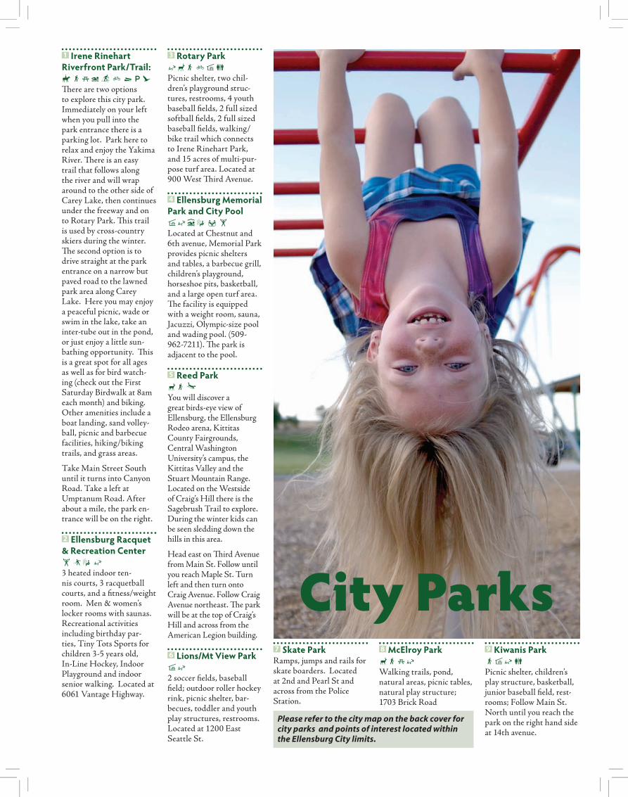
1 Irene Rinehart Riverfront Park/Trail: DSjcYF^tCThere are two options to explore this city park. Immediately on your left when you pull into the park entrance there is a parking lot. Park here to relax and enjoy the Yakima River. There is an easy trail that follows along the river and will wrap around to the other side of Carey Lake, then continues under the freeway and on to Rotary Park. This trail is used by cross-country skiers during the winter. The second option is to drive straight at the park entrance on a narrow but paved road to the lawned park area along Carey Lake. Here you may enjoy a peaceful picnic, wade or swim in the lake, take an inter-tube out in the pond, or just enjoy a little sun-bathing opportunity. This is a great spot for all ages as well as for bird watch-ing (check out the First Saturday Birdwalk at 8am each month) and biking. Other amenities include a boat landing, sand volley-ball, picnic and barbecue facilities, hiking/biking trails, and grass areas.
Take Main Street South until it turns into Canyon Road. Take a left at Umptanum Road. After about a mile, the park en-trance will be on the right.
2 Ellensburg Racquet & Recreation Center htsk3 heated indoor ten-nis courts, 3 racquetball courts, and a fitness/weight room. Men & women’s locker rooms with saunas. Recreational activities including birthday par-ties, Tiny Tots Sports for children 3-5 years old, In-Line Hockey, Indoor Playground and indoor senior walking. Located at 6061 Vantage Highway.
3 Rotary ParkkdSFh\Picnic shelter, two chil-dren’s playground struc-tures, restrooms, 4 youth baseball fields, 2 full sized softball fields, 2 full sized baseball fields, walking/bike trail which connects to Irene Rinehart Park, and 15 acres of multi-pur-pose turf area. Located at 900 West Third Avenue.
4 Ellensburg Memorial Park and City Pool hkcs whLocated at Chestnut and 6th avenue, Memorial Park provides picnic shelters and tables, a barbecue grill, children’s playground, horseshoe pits, basketball, and a large open turf area. The facility is equipped with a weight room, sauna, Jacuzzi, Olympic-size pool and wading pool. (509-962-7211). The park is adjacent to the pool.
5 Reed ParkdSUYou will discover a great birds-eye view of Ellensburg, the Ellensburg Rodeo arena, Kittitas County Fairgrounds, Central Washington University’s campus, the Kittitas Valley and the Stuart Mountain Range. Located on the Westside of Craig’s Hill there is the Sagebrush Trail to explore. During the winter kids can be seen sledding down the hills in this area.
Head east on Third Avenue from Main St. Follow until you reach Maple St. Turn left and then turn onto Craig Avenue. Follow Craig Avenue northeast. The park will be at the top of Craig’s Hill and across from the American Legion building.
6 Lions/Mt View Park hk2 soccer fields, baseball field; outdoor roller hockey rink, picnic shelter, bar-becues, toddler and youth play structures, restrooms. Located at 1200 East Seattle St.
7 Skate ParkRamps, jumps and rails for skate boarders. Located at 2nd and Pearl St and across from the Police Station.
8 McElroy ParkdSjkWalking trails, pond, natural areas, picnic tables, natural play structure; 1703 Brick Road
9 Kiwanis ParkShk\Picnic shelter, children’s play structure, basketball, junior baseball field, rest-rooms; Follow Main St. North until you reach the park on the right hand side at 14th avenue.
City Parks
Please refer to the city map on the back cover for city parks and points of interest located within the Ellensburg City limits.
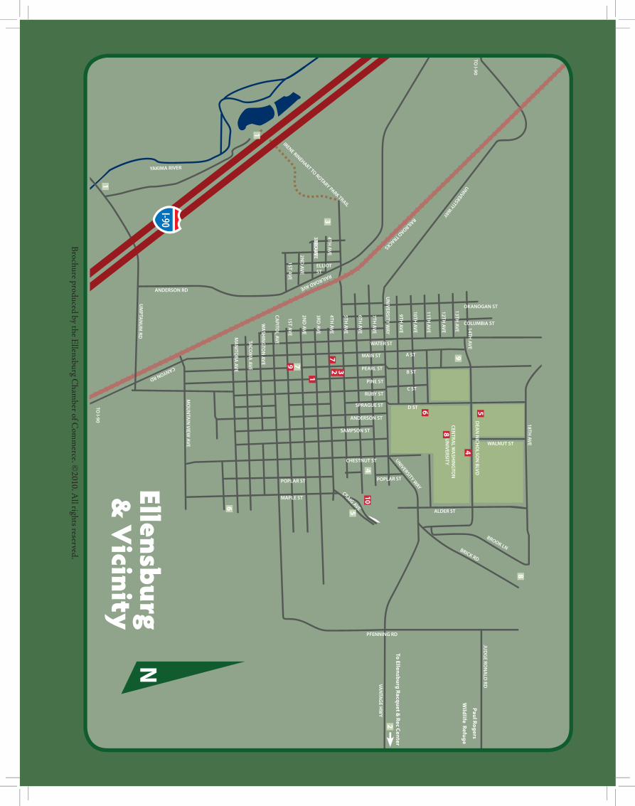
I-90
13TH AVE 14TH
AVE
18TH AVE
12TH AVE
11TH AVE
10TH AVE
9TH AVE
UN
IVERSITY WAY
7TH AVE
6TH AVE
5TH AVE
4TH AVE
4TH AVE
3RD AVE
3RD AVE
3RD AVE
2ND
AVE2N
D AVE
1ST AVE1ST AVE
CAPITO
L AVE
WA
SHIN
GTO
N AVE
TACO
MA
AVE
MA
NITO
BA AVE
MO
UN
TAIN
VIEW AVE
TO I-90
CANYON RD
UM
PTAN
UM
RD
DEA
N N
ICHO
LSON
BLVD
JUD
GE RO
NA
LD RDVA
NTA
GE H
WY
CENTRA
L WA
SHIN
GTO
N
UN
IVERSITY
MAIN ST
WATER ST
COLUMBIA ST
OKANOGAN ST
ELLIOT ST
ANDERSON RD
RAILROAD AVE
RAILROAD TRACKS
UNIVERSTIY WAY
YAKIMA RIVER
PEARL ST
PINE ST
B ST
A ST
C ST
D ST
ALDER ST
PFENNING RD
CHESTNUT ST
POPLAR ST
WALNUT ST
POPLAR ST
MAPLE ST
CRAIG AVE
UNIVERSITY WAY
BRICK RD
BROOK LN
ANDERSON ST
SAMPSON ST
SPRAGUE ST
RUBY ST
TO I-90
IRENE RINEHART TO ROTARY PARK TRAIL
N
1
3
4
6
5
7
8
9
3 1
2
6 5
8
9
7
4
10
2
To E
llen
sbu
rg R
acqu
et &
Re
c Ce
nte
r
Pau
l Ro
ge
rs
Wild
life Re
fug
e
Brochure produced by the E
llensburg Cham
ber of Com
merce. ©
2010. All rights reserved.
Ellensburg &
Vicinity
1