Recreation Impact Monitoring - Utah · Recreation Impact Monitoring FALL 2017 SNOW CANYON &...
12
Recreation Impact Monitoring FALL 2017 SNOW CANYON & PARADISE CANYON Paradise Rim 2017 Briget Eastep, Associate Professor Outdoor Recreation Chastiney Rae, Research Assistant Dave Maxwell, SUU GIS Lab Director
Transcript of Recreation Impact Monitoring - Utah · Recreation Impact Monitoring FALL 2017 SNOW CANYON &...

Recreation Impact Monitoring FALL 2017
SNOW CANYON & PARADISE CANYON
Paradise Rim 2017
Briget Eastep, Associate Professor Outdoor Recreation Chastiney Rae, Research Assistant Dave Maxwell, SUU GIS Lab Director

Desired Conditions
Trails:
Trail width and depth* stable or declining
Unauthorized trails clearly marked as closed, re-vegetated, etc.
Trail nodes stable or declining
No off trail impacts; No proliferation of trails
No unauthorized trail access points
Recreational Activities:
No campfires in lowland zone
Recreation in lowland zones to occur on designated trails
Camping restrictions followed
Climbing restricted to designated areas
Upland Zone Uses:
Well defined trail not excessive or redundant
No trail proliferation
Minimal impacts from camping
Impacts short-term
Note: recreation impact monitoring is focused on the lowland zone
Plants:
Nonnative weeds controlled
No human caused plant destruction
Perennial plant population maintained
Vegetative ground cover stable or increasing
Non-native animals: Pets on leash* (this assessment and enforcement is through a volunteer patrol) Feral animals controlled No unmanaged domestic livestock General Habitat Conditions Intact crypotobiotic crust Soils maintained Boundary fences, signs, markers, etc. intact* Seasonal closures enforced No human-induced tortoise mortality* Refuse: No recreational human waste or liter No non-recreational (construction) trash* Prohibited or heavily restricted activities: Motorized vehicles on designated roads only No paintball activities No target shooting

Methods Field
◦ Hiked October 10, 20, 28, 31st & December 8 ◦ Stop every 1/4 mile for interval data
◦ Recorded visual disturbance, severe erosion, and notables along the routes.
◦ Data recorded in ARC GIS Collector App
◦ Analysis of interval and visual disturbance patterns in excel
Consistency ◦ Data dowloaded into ArcPad 10.1 and analyzed
◦ Inter-rater reliability check through systematic analysis of photos and data points in ARCGIS.

Examples
Green Severity: Gila Yellow Severity: Paradise Rim
Red Severity: Johnson Canyon
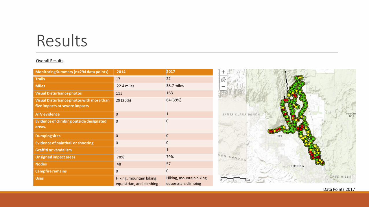
Results Overall Results
Monitoring Summary (n=294 data points) 2014 2017
Trails 17 22
Miles 22.4 miles 38.7 miles
Visual Disturbance photos 113 163
Visual Disturbance photos with more than
five impacts or severe impacts
29 (26%) 64 (39%)
ATV evidence 0 1
Evidence of climbing outside designated
areas.
0 0
Dumping sites 0 0
Evidence of paintball or shooting 0 0
Graffiti or vandalism 1 1
Unsigned impact areas 78% 79%
Nodes 48 57
Campfire remains 0 0
Uses Hiking, mountain biking,
equestrian, and climbing
Hiking, mountain biking,
equestrian, climbing
Data Points 2017
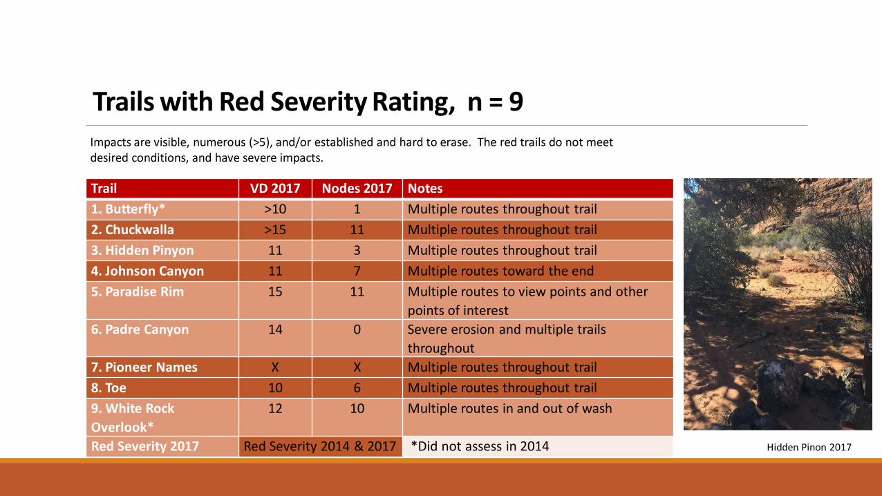
Trails with Red Severity Rating, n = 9
Impacts are visible, numerous (>5), and/or established and hard to erase. The red trails do not meet desired conditions, and have severe impacts.
Trail VD 2017 Nodes 2017 Notes
1. Butterfly* >10 1 Multiple routes throughout trail
2. Chuckwalla >15 11 Multiple routes throughout trail
3. Hidden Pinyon 11 3 Multiple routes throughout trail
4. Johnson Canyon 11 7 Multiple routes toward the end
5. Paradise Rim 15 11 Multiple routes to view points and other
points of interest
6. Padre Canyon 14 0 Severe erosion and multiple trails
throughout
7. Pioneer Names X X Multiple routes throughout trail
8. Toe 10 6 Multiple routes throughout trail
9. White Rock
Overlook*
12 10 Multiple routes in and out of wash
Red Severity 2017 Red Severity 2014 & 2017 *Did not assess in 2014 Hidden Pinon 2017

Trails with Yellow Severity Rating, n =8 Impacts are visible, but not dominate. The yellow trails do not meet desired conditions, but the impacts are comparatively moderate. 3-5 Visual Disturbances recorded at intervals.
Trail VD 2017 Nodes 2017 Notes
1.Beck Hill 5 1 Mild to moderate impacts
2.Gap 3 0 Alternate route established
3.Halfway Wash 5 3 Multiple routes
4. Lava Flow 9 8 Multiple routes and nodes - mild
5. Jenny’s Canyon* 5 3 Multiple VD at the end
6.Sand Dunes* >5 >5 Multiple routes and nodes in sand
7.Turtle Wall 6 1
8.Gecko 3 0 Multiple routes established
Yellow Severity
2017
Yellow Severity 2014 & 2017 *Not assessed in 2014
Jenny’s Canyon 2017

Trails with Green Severity Rating, n = 6 No impacts visible at interval photos. The green trails are relatively in good shape and closest to meeting desired
conditions.
Trail VD 2017 Nodes 2017 Notes
1. Gila 20 7 7.5 miles, most impacts near arch. Site
2. Petrified Sand Dunes 0 0 Slick rock
3. Scout’s Cave 6 4 Some impacts, but mild to moderate
4. West Canyon 1 0 Paved trail keeps people on trail?
5. Whiptail 7 0 Paved trail keeps people on trail, most impacts
behind Sand Dunes.
6. White Rocks* 4 5
Green Severity 2017 Green Severity 2014 & 2017 *Not assessed in 2014
White Rocks 2017

Erosion Report N = 153 Mild Moderate Severe
Data Points 72% 24% 4%
Severe Erosion: Johnson Canyon 2017 Moderate Erosion: Chuckwalla 2017 Mild Erosion: Beck Hill 2017

Analysis of Desired Conditions Desired Conditions Being Met
Camping restrictions followed ◦ In the monitored area, no campfire remains were found
Climbing restricted to designated areas ◦ Climbing was retained at Chuckwalla, but several unauthorized access trails
were found near all climbing areas in Snow Canyon
No recreational human waste or litter ◦ No litter was found
Motorized vehicles on designated roads only ◦ 1 set of ATV tracks on Toe Trail
No paintball activities ◦ No paintball remnants found
No target shooting ◦ No target shooting evidence found
No non-recreational (construction) trash ◦ No signs of dumping
Desired Conditions NOT Met
Unauthorized trails clearly marked as closed, re-vegetated, etc. ◦ Unauthorized trails to view points and other attractions are common. 79% of
visual disturbance points captured were unsigned.
No off trail impacts ◦ Every trail has off trail impacts
No proliferation of trails ◦ Every trail has social trails present
No unauthorized access points ◦ Every housing development has unauthorized access points
Recreation in lowland zones to occur on designated trails ◦ Social trails to view points and attractions are common
No human caused plant destruction ◦ Off trail impacts and nodes destroy plants
Intact cryptobiotic crust ◦ Some off trail impacts were in cryptobiotic crust

Discussion
◦ Impacts are increasing. Interval data points with more than five impacts or severe impacts went from 26% in 2014 to 39% in 2017. ◦ Recommendation: signage at trailheads giving clear expectations and reasons
◦ Use continues to be hikers, mountain bikers, and equestrian. ◦ Hikers caused the most off trail impacts (85% in 2017 and 74% in 2014). Equestrian use accounted for 15% in 2017 and 21% in
2014, and mountain bikers 24% in 2017 and 20% in 2014.
◦ Severe ratings were due to multiple routes throughout the trails listed. ◦ People like to wander and take in views. Can routes be designated? Can routes to attractions (ie. rocks and view points) be
designated? Is Snow Canyon having any positive results with raking to keep people on designated trails?
◦ Re-sign and put in natural deterrents (ie. vertical mulch) in severe areas
◦ Washes lead to multiple routes
◦ Trail maintenance & volunteer patrols are important management tools ◦ 4% of data points reported severe erosion while 74% reported mild erosion. This shows trails are being maintained.

Refining • Analysis of desired conditions
• Recreation leads to impacts. Are the impacts a threat to the desert tortoise?
• Further analysis of data to understand use patterns
• Collector and ARCGIS Online
White Rock Overlook 2017