Online Environment Reconstruction for Biped Navigation · Online Environment Reconstruction for...
6
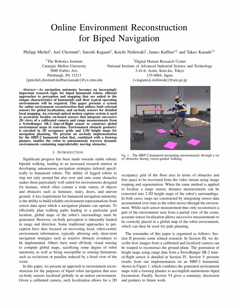
Online Environment Reconstruction for Biped Navigation Philipp Michel † , Joel Chestnutt † , Satoshi Kagami ‡ , Koichi Nishiwaki ‡ , James Kuffner †‡ and Takeo Kanade †‡ † The Robotics Institute ‡ Digital Human Research Center Carnegie Mellon University National Institute of Advanced Industrial Science and Technology 5000 Forbes Ave. 2-41-6, Aomi, Koto-ku, Tokyo Pittsburgh, PA 15213 135-0064, Japan {pmichel,chestnutt,kuffner,kanade}@cs.cmu.edu {s.kagami,k.nishiwaki}@aist.go.jp Abstract— As navigation autonomy becomes an increasingly important research topic for biped humanoid robots, efficient approaches to perception and mapping that are suited to the unique characteristics of humanoids and their typical operating environments will be required. This paper presents a system for online environment reconstruction that utilizes both external sensors for global localization, and on-body sensors for detailed local mapping. An external optical motion capture system is used to accurately localize on-board sensors that integrate successive 2D views of a calibrated camera and range measurements from a SwissRanger SR-2 time-of-flight sensor to construct global environment maps in real-time. Environment obstacle geometry is encoded in 2D occupancy grids and 2.5D height maps for navigation planning. We present an on-body implementation for the HRP-2 humanoid robot that, combined with a footstep planner, enables the robot to autonomously traverse dynamic environments containing unpredictably moving obstacles. I. I NTRODUCTION Significant progress has been made towards stable robotic bipedal walking, leading to an increased research interest in developing autonomous navigation strategies tailored specif- ically to humanoid robots. The ability of legged robots to step not only around but also over and onto some obstacles makes them particularly well suited for environments designed for humans, which often contain a wide variety of objects and obstacles such as furniture, stairs, doors, and uneven ground. A key requirement for humanoid navigation autonomy is the ability to build reliable environment representations from sensor data upon which a navigation planner can operate. To efficiently plan walking paths leading to a particular goal location, global maps of the robot’s surroundings must be generated. However, on-body perception is inherently limited in range and direction. Some traditional approaches to per- ception have thus focused on recovering local, robot-centric environment information, typically allowing only short-term navigation strategies such as reactive obstacle avoidance to be implemented. Others have used off-body visual sensing to compute global maps, sacrificing some degree of robot autonomy as well as being susceptible to sensing limitations such as occlusions or parallax induced by a fixed view of the scene. In this paper, we present an approach to environment recon- struction for the purposes of biped robot navigation that uses on-body sensors localized globally in an indoor environment. Given a calibrated camera, such localization allows for a 2D Fig. 1. The HRP-2 humanoid navigating autonomously through a set of obstacles during vision-guided walking. occupancy grid of the floor area in terms of obstacles and free space to be recovered from the video stream using image warping and segmentation. When the same method is applied to localize a range sensor, distance measurements can be converted into 2.5D height maps of the robot’s surroundings. In both cases, maps are constructed by integrating sensor data accumulated over time as the robot moves through the environ- ment. While each sensor measurement thus only reconstructs a part of the environment seen from a partial view of the scene, accurate sensor localization allows successive measurements to be correctly placed in a global map of the robot environment, which can then be used for path planning. The remainder of this paper is organized as follows: Sec- tion II presents some related research. In Section III, we de- scribe how images from a calibrated and localized camera can be warped to reconstruct the ground plane. The generation of height maps using range data from a SwissRanger SR-2 time- of-flight sensor is detailed in Section IV. Section V presents results from our implementation on an HRP-2 humanoid, shown in Figure 1, which combines the generated environment maps with a footstep planner to accomplish autonomous biped locomotion. Finally, Section VI gives a summary, discussion and pointers to future work.
Transcript of Online Environment Reconstruction for Biped Navigation · Online Environment Reconstruction for...
Online Environment Reconstructionfor Biped Navigation
Philipp Michel†, Joel Chestnutt†, Satoshi Kagami‡, Koichi Nishiwaki‡, James Kuffner†‡ and Takeo Kanade†‡
†The Robotics Institute ‡Digital Human Research CenterCarnegie Mellon University National Institute of Advanced Industrial Science and Technology
5000 Forbes Ave. 2-41-6, Aomi, Koto-ku, TokyoPittsburgh, PA 15213 135-0064, Japan
{pmichel,chestnutt,kuffner,kanade}@cs.cmu.edu {s.kagami,k.nishiwaki}@aist.go.jp
Abstract— As navigation autonomy becomes an increasinglyimportant research topic for biped humanoid robots, efficientapproaches to perception and mapping that are suited to theunique characteristics of humanoids and their typical operatingenvironments will be required. This paper presents a systemfor online environment reconstruction that utilizes both externalsensors for global localization, and on-body sensors for detailedlocal mapping. An external optical motion capture system is usedto accurately localize on-board sensors that integrate successive2D views of a calibrated camera and range measurements froma SwissRanger SR-2 time-of-flight sensor to construct globalenvironment maps in real-time. Environment obstacle geometryis encoded in 2D occupancy grids and 2.5D height maps fornavigation planning. We present an on-body implementationfor the HRP-2 humanoid robot that, combined with a footstepplanner, enables the robot to autonomously traverse dynamicenvironments containing unpredictably moving obstacles.
I. INTRODUCTION
Significant progress has been made towards stable roboticbipedal walking, leading to an increased research interest indeveloping autonomous navigation strategies tailored specif-ically to humanoid robots. The ability of legged robots tostep not only around but also over and onto some obstaclesmakes them particularly well suited for environments designedfor humans, which often contain a wide variety of objectsand obstacles such as furniture, stairs, doors, and unevenground. A key requirement for humanoid navigation autonomyis the ability to build reliable environment representations fromsensor data upon which a navigation planner can operate. Toefficiently plan walking paths leading to a particular goallocation, global maps of the robot’s surroundings must begenerated. However, on-body perception is inherently limitedin range and direction. Some traditional approaches to per-ception have thus focused on recovering local, robot-centricenvironment information, typically allowing only short-termnavigation strategies such as reactive obstacle avoidance tobe implemented. Others have used off-body visual sensingto compute global maps, sacrificing some degree of robotautonomy as well as being susceptible to sensing limitationssuch as occlusions or parallax induced by a fixed view of thescene.
In this paper, we present an approach to environment recon-struction for the purposes of biped robot navigation that useson-body sensors localized globally in an indoor environment.Given a calibrated camera, such localization allows for a 2D
Fig. 1. The HRP-2 humanoid navigating autonomously through a setof obstacles during vision-guided walking.
occupancy grid of the floor area in terms of obstacles andfree space to be recovered from the video stream using imagewarping and segmentation. When the same method is appliedto localize a range sensor, distance measurements can beconverted into 2.5D height maps of the robot’s surroundings.In both cases, maps are constructed by integrating sensor dataaccumulated over time as the robot moves through the environ-ment. While each sensor measurement thus only reconstructs apart of the environment seen from a partial view of the scene,accurate sensor localization allows successive measurements tobe correctly placed in a global map of the robot environment,which can then be used for path planning.
The remainder of this paper is organized as follows: Sec-tion II presents some related research. In Section III, we de-scribe how images from a calibrated and localized camera canbe warped to reconstruct the ground plane. The generation ofheight maps using range data from a SwissRanger SR-2 time-of-flight sensor is detailed in Section IV. Section V presentsresults from our implementation on an HRP-2 humanoid,shown in Figure 1, which combines the generated environmentmaps with a footstep planner to accomplish autonomous bipedlocomotion. Finally, Section VI gives a summary, discussionand pointers to future work.
Motion CaptureLocalization
Extrinsics
R , t
Camera Calibration /Undistortion
Intrinsics
K
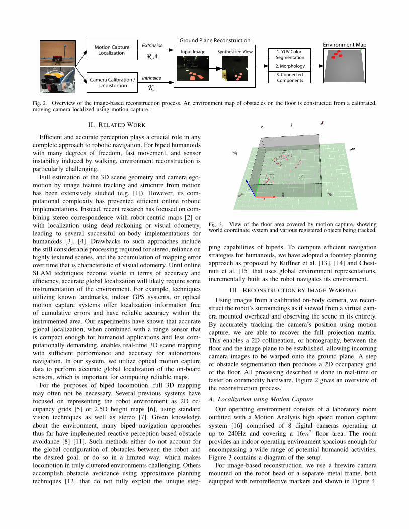
Ground Plane Reconstruction
Input Image Synthesized View 1. YUV ColorSegmentation
2. Morphology
3. ConnectedComponents
Environment Map
Fig. 2. Overview of the image-based reconstruction process. An environment map of obstacles on the floor is constructed from a calibrated,moving camera localized using motion capture.
II. RELATED WORK
Efficient and accurate perception plays a crucial role in anycomplete approach to robotic navigation. For biped humanoidswith many degrees of freedom, fast movement, and sensorinstability induced by walking, environment reconstruction isparticularly challenging.
Full estimation of the 3D scene geometry and camera ego-motion by image feature tracking and structure from motionhas been extensively studied (e.g. [1]). However, its com-putational complexity has prevented efficient online roboticimplementations. Instead, recent research has focused on com-bining stereo correspondence with robot-centric maps [2] orwith localization using dead-reckoning or visual odometry,leading to several successful on-body implementations forhumanoids [3], [4]. Drawbacks to such approaches includethe still considerable processing required for stereo, reliance onhighly textured scenes, and the accumulation of mapping errorover time that is characteristic of visual odometry. Until onlineSLAM techniques become viable in terms of accuracy andefficiency, accurate global localization will likely require someinstrumentation of the environment. For example, techniquesutilizing known landmarks, indoor GPS systems, or opticalmotion capture systems offer localization information freeof cumulative errors and have reliable accuracy within theinstrumented area. Our experiments have shown that accurateglobal localization, when combined with a range sensor thatis compact enough for humanoid applications and less com-putationally demanding, enables real-time 3D scene mappingwith sufficient performance and accuracy for autonomousnavigation. In our system, we utilize optical motion capturedata to perform accurate global localization of the on-boardsensors, which is important for computing reliable maps.
For the purposes of biped locomotion, full 3D mappingmay often not be necessary. Several previous systems havefocused on representing the robot environment as 2D oc-cupancy grids [5] or 2.5D height maps [6], using standardvision techniques as well as stereo [7]. Given knowledgeabout the environment, many biped navigation approachesthus far have implemented reactive perception-based obstacleavoidance [8]–[11]. Such methods either do not account forthe global configuration of obstacles between the robot andthe desired goal, or do so in a limited way, which makeslocomotion in truly cluttered environments challenging. Othersaccomplish obstacle avoidance using approximate planningtechniques [12] that do not fully exploit the unique step-
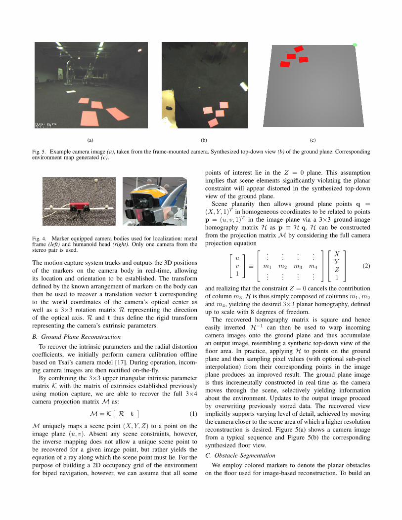
Fig. 3. View of the floor area covered by motion capture, showingworld coordinate system and various registered objects being tracked.
ping capabilities of bipeds. To compute efficient navigationstrategies for humanoids, we have adopted a footstep planningapproach as proposed by Kuffner et al. [13], [14] and Chest-nutt et al. [15] that uses global environment representations,incrementally built as the robot navigates its environment.
III. RECONSTRUCTION BY IMAGE WARPING
Using images from a calibrated on-body camera, we recon-struct the robot’s surroundings as if viewed from a virtual cam-era mounted overhead and observing the scene in its entirety.By accurately tracking the camera’s position using motioncapture, we are able to recover the full projection matrix.This enables a 2D collineation, or homography, between thefloor and the image plane to be established, allowing incomingcamera images to be warped onto the ground plane. A stepof obstacle segmentation then produces a 2D occupancy gridof the floor. All processing described is done in real-time orfaster on commodity hardware. Figure 2 gives an overview ofthe reconstruction process.
A. Localization using Motion Capture
Our operating environment consists of a laboratory roomoutfitted with a Motion Analysis high speed motion capturesystem [16] comprised of 8 digital cameras operating atup to 240Hz and covering a 16m2 floor area. The roomprovides an indoor operating environment spacious enough forencompassing a wide range of potential humanoid activities.Figure 3 contains a diagram of the setup.
For image-based reconstruction, we use a firewire cameramounted on the robot head or a separate metal frame, bothequipped with retroreflective markers and shown in Figure 4.
(a) (b) (c)
Fig. 5. Example camera image (a), taken from the frame-mounted camera. Synthesized top-down view (b) of the ground plane. Correspondingenvironment map generated (c).
Fig. 4. Marker equipped camera bodies used for localization: metalframe (left) and humanoid head (right). Only one camera from thestereo pair is used.
The motion capture system tracks and outputs the 3D positionsof the markers on the camera body in real-time, allowingits location and orientation to be established. The transformdefined by the known arrangement of markers on the body canthen be used to recover a translation vector t correspondingto the world coordinates of the camera’s optical center aswell as a 3×3 rotation matrix R representing the directionof the optical axis. R and t thus define the rigid transformrepresenting the camera’s extrinsic parameters.
B. Ground Plane Reconstruction
To recover the intrinsic parameters and the radial distortioncoefficients, we initially perform camera calibration offlinebased on Tsai’s camera model [17]. During operation, incom-ing camera images are then rectified on-the-fly.
By combining the 3×3 upper triangular intrinsic parametermatrix K with the matrix of extrinsics established previouslyusing motion capture, we are able to recover the full 3×4camera projection matrix M as:
M = K[R t
](1)
M uniquely maps a scene point (X, Y, Z) to a point on theimage plane (u, v). Absent any scene constraints, however,the inverse mapping does not allow a unique scene point tobe recovered for a given image point, but rather yields theequation of a ray along which the scene point must lie. For thepurpose of building a 2D occupancy grid of the environmentfor biped navigation, however, we can assume that all scene
points of interest lie in the Z = 0 plane. This assumptionimplies that scene elements significantly violating the planarconstraint will appear distorted in the synthesized top-downview of the ground plane.
Scene planarity then allows ground plane points q =(X, Y, 1)T in homogeneous coordinates to be related to pointsp = (u, v, 1)T in the image plane via a 3×3 ground-imagehomography matrix H as p ≡ H q. H can be constructedfrom the projection matrix M by considering the full cameraprojection equation u
v1
≡
......
......
m1 m2 m3 m4
......
......
XYZ1
(2)
and realizing that the constraint Z = 0 cancels the contributionof column m3.H is thus simply composed of columns m1, m2
and m4, yielding the desired 3×3 planar homography, definedup to scale with 8 degrees of freedom.
The recovered homography matrix is square and henceeasily inverted. H−1 can then be used to warp incomingcamera images onto the ground plane and thus accumulatean output image, resembling a synthetic top-down view of thefloor area. In practice, applying H to points on the groundplane and then sampling pixel values (with optional sub-pixelinterpolation) from their corresponding points in the imageplane produces an improved result. The ground plane imageis thus incrementally constructed in real-time as the cameramoves through the scene, selectively yielding informationabout the environment. Updates to the output image proceedby overwriting previously stored data. The recovered viewimplicitly supports varying level of detail, achieved by movingthe camera closer to the scene area of which a higher resolutionreconstruction is desired. Figure 5(a) shows a camera imagefrom a typical sequence and Figure 5(b) the correspondingsynthesized floor view.
C. Obstacle SegmentationWe employ colored markers to denote the planar obstacles
on the floor used for image-based reconstruction. To build an
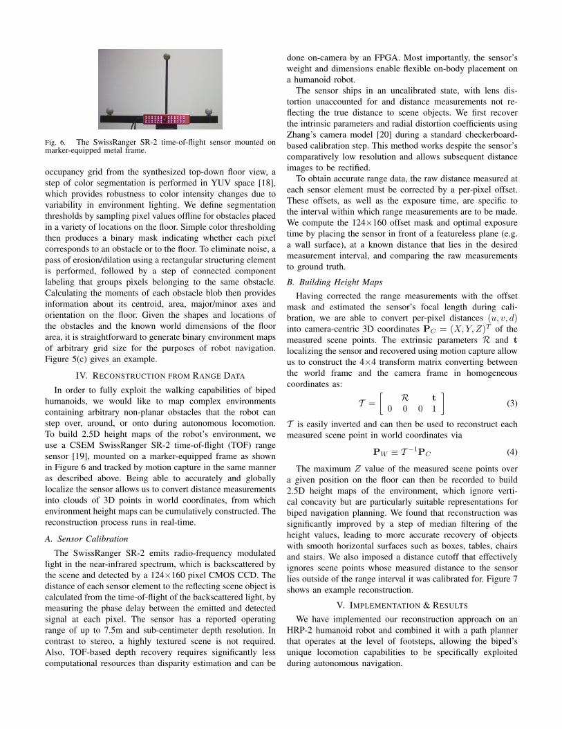
Fig. 6. The SwissRanger SR-2 time-of-flight sensor mounted onmarker-equipped metal frame.
occupancy grid from the synthesized top-down floor view, astep of color segmentation is performed in YUV space [18],which provides robustness to color intensity changes due tovariability in environment lighting. We define segmentationthresholds by sampling pixel values offline for obstacles placedin a variety of locations on the floor. Simple color thresholdingthen produces a binary mask indicating whether each pixelcorresponds to an obstacle or to the floor. To eliminate noise, apass of erosion/dilation using a rectangular structuring elementis performed, followed by a step of connected componentlabeling that groups pixels belonging to the same obstacle.Calculating the moments of each obstacle blob then providesinformation about its centroid, area, major/minor axes andorientation on the floor. Given the shapes and locations ofthe obstacles and the known world dimensions of the floorarea, it is straightforward to generate binary environment mapsof arbitrary grid size for the purposes of robot navigation.Figure 5(c) gives an example.
IV. RECONSTRUCTION FROM RANGE DATA
In order to fully exploit the walking capabilities of bipedhumanoids, we would like to map complex environmentscontaining arbitrary non-planar obstacles that the robot canstep over, around, or onto during autonomous locomotion.To build 2.5D height maps of the robot’s environment, weuse a CSEM SwissRanger SR-2 time-of-flight (TOF) rangesensor [19], mounted on a marker-equipped frame as shownin Figure 6 and tracked by motion capture in the same manneras described above. Being able to accurately and globallylocalize the sensor allows us to convert distance measurementsinto clouds of 3D points in world coordinates, from whichenvironment height maps can be cumulatively constructed. Thereconstruction process runs in real-time.
A. Sensor Calibration
The SwissRanger SR-2 emits radio-frequency modulatedlight in the near-infrared spectrum, which is backscattered bythe scene and detected by a 124×160 pixel CMOS CCD. Thedistance of each sensor element to the reflecting scene object iscalculated from the time-of-flight of the backscattered light, bymeasuring the phase delay between the emitted and detectedsignal at each pixel. The sensor has a reported operatingrange of up to 7.5m and sub-centimeter depth resolution. Incontrast to stereo, a highly textured scene is not required.Also, TOF-based depth recovery requires significantly lesscomputational resources than disparity estimation and can be
done on-camera by an FPGA. Most importantly, the sensor’sweight and dimensions enable flexible on-body placement ona humanoid robot.
The sensor ships in an uncalibrated state, with lens dis-tortion unaccounted for and distance measurements not re-flecting the true distance to scene objects. We first recoverthe intrinsic parameters and radial distortion coefficients usingZhang’s camera model [20] during a standard checkerboard-based calibration step. This method works despite the sensor’scomparatively low resolution and allows subsequent distanceimages to be rectified.
To obtain accurate range data, the raw distance measured ateach sensor element must be corrected by a per-pixel offset.These offsets, as well as the exposure time, are specific tothe interval within which range measurements are to be made.We compute the 124×160 offset mask and optimal exposuretime by placing the sensor in front of a featureless plane (e.g.a wall surface), at a known distance that lies in the desiredmeasurement interval, and comparing the raw measurementsto ground truth.
B. Building Height Maps
Having corrected the range measurements with the offsetmask and estimated the sensor’s focal length during cali-bration, we are able to convert per-pixel distances (u, v, d)into camera-centric 3D coordinates PC = (X, Y, Z)T of themeasured scene points. The extrinsic parameters R and tlocalizing the sensor and recovered using motion capture allowus to construct the 4×4 transform matrix converting betweenthe world frame and the camera frame in homogeneouscoordinates as:
T =[
R t0 0 0 1
](3)
T is easily inverted and can then be used to reconstruct eachmeasured scene point in world coordinates via
PW ≡ T −1PC (4)
The maximum Z value of the measured scene points overa given position on the floor can then be recorded to build2.5D height maps of the environment, which ignore verti-cal concavity but are particularly suitable representations forbiped navigation planning. We found that reconstruction wassignificantly improved by a step of median filtering of theheight values, leading to more accurate recovery of objectswith smooth horizontal surfaces such as boxes, tables, chairsand stairs. We also imposed a distance cutoff that effectivelyignores scene points whose measured distance to the sensorlies outside of the range interval it was calibrated for. Figure 7shows an example reconstruction.
V. IMPLEMENTATION & RESULTS
We have implemented our reconstruction approach on anHRP-2 humanoid robot and combined it with a path plannerthat operates at the level of footsteps, allowing the biped’sunique locomotion capabilities to be specifically exploitedduring autonomous navigation.
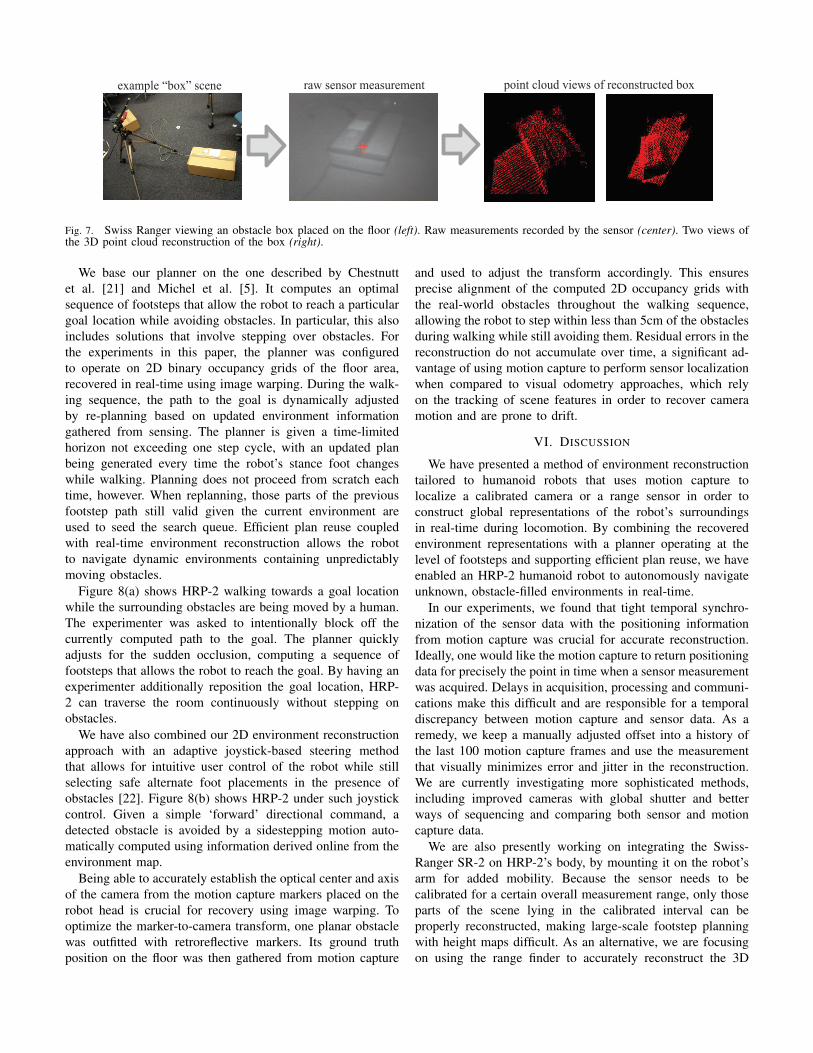
example “box” scene raw sensor measurement point cloud views of reconstructed box
Fig. 7. Swiss Ranger viewing an obstacle box placed on the floor (left). Raw measurements recorded by the sensor (center). Two views ofthe 3D point cloud reconstruction of the box (right).
We base our planner on the one described by Chestnuttet al. [21] and Michel et al. [5]. It computes an optimalsequence of footsteps that allow the robot to reach a particulargoal location while avoiding obstacles. In particular, this alsoincludes solutions that involve stepping over obstacles. Forthe experiments in this paper, the planner was configuredto operate on 2D binary occupancy grids of the floor area,recovered in real-time using image warping. During the walk-ing sequence, the path to the goal is dynamically adjustedby re-planning based on updated environment informationgathered from sensing. The planner is given a time-limitedhorizon not exceeding one step cycle, with an updated planbeing generated every time the robot’s stance foot changeswhile walking. Planning does not proceed from scratch eachtime, however. When replanning, those parts of the previousfootstep path still valid given the current environment areused to seed the search queue. Efficient plan reuse coupledwith real-time environment reconstruction allows the robotto navigate dynamic environments containing unpredictablymoving obstacles.
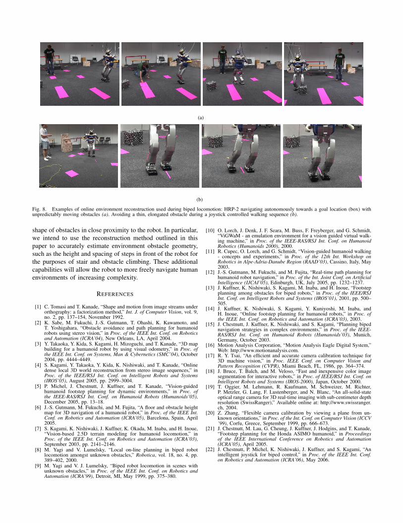
Figure 8(a) shows HRP-2 walking towards a goal locationwhile the surrounding obstacles are being moved by a human.The experimenter was asked to intentionally block off thecurrently computed path to the goal. The planner quicklyadjusts for the sudden occlusion, computing a sequence offootsteps that allows the robot to reach the goal. By having anexperimenter additionally reposition the goal location, HRP-2 can traverse the room continuously without stepping onobstacles.
We have also combined our 2D environment reconstructionapproach with an adaptive joystick-based steering methodthat allows for intuitive user control of the robot while stillselecting safe alternate foot placements in the presence ofobstacles [22]. Figure 8(b) shows HRP-2 under such joystickcontrol. Given a simple ‘forward’ directional command, adetected obstacle is avoided by a sidestepping motion auto-matically computed using information derived online from theenvironment map.
Being able to accurately establish the optical center and axisof the camera from the motion capture markers placed on therobot head is crucial for recovery using image warping. Tooptimize the marker-to-camera transform, one planar obstaclewas outfitted with retroreflective markers. Its ground truthposition on the floor was then gathered from motion capture
and used to adjust the transform accordingly. This ensuresprecise alignment of the computed 2D occupancy grids withthe real-world obstacles throughout the walking sequence,allowing the robot to step within less than 5cm of the obstaclesduring walking while still avoiding them. Residual errors in thereconstruction do not accumulate over time, a significant ad-vantage of using motion capture to perform sensor localizationwhen compared to visual odometry approaches, which relyon the tracking of scene features in order to recover cameramotion and are prone to drift.
VI. DISCUSSION
We have presented a method of environment reconstructiontailored to humanoid robots that uses motion capture tolocalize a calibrated camera or a range sensor in order toconstruct global representations of the robot’s surroundingsin real-time during locomotion. By combining the recoveredenvironment representations with a planner operating at thelevel of footsteps and supporting efficient plan reuse, we haveenabled an HRP-2 humanoid robot to autonomously navigateunknown, obstacle-filled environments in real-time.
In our experiments, we found that tight temporal synchro-nization of the sensor data with the positioning informationfrom motion capture was crucial for accurate reconstruction.Ideally, one would like the motion capture to return positioningdata for precisely the point in time when a sensor measurementwas acquired. Delays in acquisition, processing and communi-cations make this difficult and are responsible for a temporaldiscrepancy between motion capture and sensor data. As aremedy, we keep a manually adjusted offset into a history ofthe last 100 motion capture frames and use the measurementthat visually minimizes error and jitter in the reconstruction.We are currently investigating more sophisticated methods,including improved cameras with global shutter and betterways of sequencing and comparing both sensor and motioncapture data.
We are also presently working on integrating the Swiss-Ranger SR-2 on HRP-2’s body, by mounting it on the robot’sarm for added mobility. Because the sensor needs to becalibrated for a certain overall measurement range, only thoseparts of the scene lying in the calibrated interval can beproperly reconstructed, making large-scale footstep planningwith height maps difficult. As an alternative, we are focusingon using the range finder to accurately reconstruct the 3D
(a)
(b)
Fig. 8. Examples of online environment reconstruction used during biped locomotion: HRP-2 navigating autonomously towards a goal location (box) withunpredictably moving obstacles (a). Avoiding a thin, elongated obstacle during a joystick controlled walking sequence (b).
shape of obstacles in close proximity to the robot. In particular,we intend to use the reconstruction method outlined in thispaper to accurately estimate environment obstacle geometry,such as the height and spacing of steps in front of the robot forthe purposes of stair and obstacle climbing. These additionalcapabilities will allow the robot to more freely navigate humanenvironments of increasing complexity.
REFERENCES
[1] C. Tomasi and T. Kanade, “Shape and motion from image streams underorthography: a factorization method,” Int. J. of Computer Vision, vol. 9,no. 2, pp. 137–154, November 1992.
[2] K. Sabe, M. Fukuchi, J.-S. Gutmann, T. Ohashi, K. Kawamoto, andT. Yoshigahara, “Obstacle avoidance and path planning for humanoidrobots using stereo vision,” in Proc. of the IEEE Int. Conf. on Roboticsand Automation (ICRA’04), New Orleans, LA, April 2004.
[3] Y. Takaoka, Y. Kida, S. Kagami, H. Mizoguchi, and T. Kanade, “3D mapbuilding for a humanoid robot by using visual odometry,” in Proc. ofthe IEEE Int. Conf. on Systems, Man & Cybernetics (SMC’04), October2004, pp. 4444–4449.
[4] S. Kagami, Y. Takaoka, Y. Kida, K. Nishiwaki, and T. Kanade, “Onlinedense local 3D world reconstruction from stereo image sequences,” inProc. of the IEEE/RSJ Int. Conf. on Intelligent Robots and Systems(IROS’05), August 2005, pp. 2999–3004.
[5] P. Michel, J. Chestnutt, J. Kuffner, and T. Kanade, “Vision-guidedhumanoid footstep planning for dynamic environments,” in Proc. ofthe IEEE-RAS/RSJ Int. Conf. on Humanoid Robots (Humanoids’05),December 2005, pp. 13–18.
[6] J.-S. Gutmann, M. Fukuchi, and M. Fujita, “A floor and obstacle heightmap for 3D navigation of a humanoid robot,” in Proc. of the IEEE Int.Conf. on Robotics and Automation (ICRA’05), Barcelona, Spain, April2005.
[7] S. Kagami, K. Nishiwaki, J. Kuffner, K. Okada, M. Inaba, and H. Inoue,“Vision-based 2.5D terrain modeling for humanoid locomotion,” inProc. of the IEEE Int. Conf. on Robotics and Automation (ICRA’03),September 2003, pp. 2141–2146.
[8] M. Yagi and V. Lumelsky, “Local on-line planning in biped robotlocomotion amongst unknown obstacles,” Robotica, vol. 18, no. 4, pp.389–402, 2000.
[9] M. Yagi and V. J. Lumelsky, “Biped robot locomotion in scenes withunknown obstacles,” in Proc. of the IEEE Int. Conf. on Robotics andAutomation (ICRA’99), Detroit, MI, May 1999, pp. 375–380.
[10] O. Lorch, J. Denk, J. F. Seara, M. Buss, F. Freyberger, and G. Schmidt,“ViGWaM - an emulation environment for a vision guided virtual walk-ing machine,” in Proc. of the IEEE-RAS/RSJ Int. Conf. on HumanoidRobotics (Humanoids 2000), 2000.
[11] R. Cupec, O. Lorch, and G. Schmidt, “Vision-guided humanoid walking- concepts and experiments,” in Proc. of the 12th Int. Workshop onRobotics in Alpe-Adria-Danube Region (RAAD’03), Cassino, Italy, May2003.
[12] J.-S. Gutmann, M. Fukuchi, and M. Fujita, “Real-time path planning forhumanoid robot navigation,” in Proc. of the Int. Joint Conf. on ArtificialIntelligence (IJCAI’05), Edinburgh, UK, July 2005, pp. 1232–1237.
[13] J. Kuffner, K. Nishiwaki, S. Kagami, M. Inaba, and H. Inoue, “Footstepplanning among obstacles for biped robots,” in Proc. of the IEEE/RSJInt. Conf. on Intelligent Robots and Systems (IROS’01), 2001, pp. 500–505.
[14] J. Kuffner, K. Nishiwaki, S. Kagami, Y. Kuniyoshi, M. Inaba, andH. Inoue, “Online footstep planning for humanoid robots,” in Proc. ofthe IEEE Int. Conf. on Robotics and Automation (ICRA’03), 2003.
[15] J. Chestnutt, J. Kuffner, K. Nishiwaki, and S. Kagami, “Planning bipednavigation strategies in complex environments,” in Proc. of the IEEE-RAS/RSJ Int. Conf. on Humanoid Robots (Humanoids’03), Munich,Germany, October 2003.
[16] Motion Analysis Corporation, “Motion Analysis Eagle Digital System,”Web: http://www.motionanalysis.com.
[17] R. Y. Tsai, “An efficient and accurate camera calibration technique for3D machine vision,” in Proc. IEEE Conf. on Computer Vision andPattern Recognition (CVPR), Miami Beach, FL, 1986, pp. 364–374.
[18] J. Bruce, T. Balch, and M. Veloso, “Fast and inexpensive color imagesegmentation for interactive robots,” in Proc. of IEEE/RSJ Int. Conf. onIntelligent Robots and Systems (IROS-2000), Japan, October 2000.
[19] T. Oggier, M. Lehmann, R. Kaufmann, M. Schweizer, M. Richter,P. Metzler, G. Lang, F. Lustenberger, and N. Blanc, “An all-solid-stateoptical range camera for 3D real-time imaging with sub-centimeter depthresolution (SwissRanger),” Available online at: http://www.swissranger.ch, 2004.
[20] Z. Zhang, “Flexible camera calibration by viewing a plane from un-known orientations,” in Proc. of the Int. Conf. on Computer Vision (ICCV’99), Corfu, Greece, September 1999, pp. 666–673.
[21] J. Chestnutt, M. Lau, G. Cheung, J. Kuffner, J. Hodgins, and T. Kanade,“Footstep planning for the Honda ASIMO humanoid,” in Proceedingsof the IEEE International Conference on Robotics and Automation(ICRA’05), April 2005.
[22] J. Chestnutt, P. Michel, K. Nishiwaki, J. Kuffner, and S. Kagami, “Anintelligent joystick for biped control,” in Proc. of the IEEE Int. Conf.on Robotics and Automation (ICRA’06), May 2006.


![Marcin SZAREK, Gözde ÖZCAN [Biped Robot]](https://static.fdocuments.net/doc/165x107/577cc4671a28aba711992e3b/marcin-szarek-goezde-oezcan-biped-robot.jpg)