NORTHWEST RAPID TRANSIT PROJECT INTEGRATED …
85
NORTHWEST RAPID TRANSIT PROJECT INTEGRATED MANAGEMENT SYSTEM CONSTRUCTION COMPOUND AND ANCILLARY FACILITIES MANAGEMENT PLAN FOR SYDNEY METRO NORTHWEST OPERATIONS, TRAINS and SYSTEMS PPP DOCUMENT NUMBER: NWRLOTS-NRT-PRD-PM-PLN-000848 NRT-PIMS NUMBER: PIMS-SP-17/01 REVISION: 07 CONTROL STATUS: Unmaintained unless stated otherwise
Transcript of NORTHWEST RAPID TRANSIT PROJECT INTEGRATED …
NORTHWEST RAPID TRANSIT PROJECT INTEGRATED MANAGEMENT SYSTEM
CONSTRUCTION COMPOUND AND ANCILLARY FACILITIES MANAGEMENT PLAN
FOR
SYDNEY METRO NORTHWEST OPERATIONS, TRAINS and SYSTEMS PPP
DOCUMENT NUMBER: NWRLOTS-NRT-PRD-PM-PLN-000848
NRT-PIMS NUMBER: PIMS-SP-17/01
REVISION: 07
CONTROL STATUS: Unmaintained unless stated otherwise

NWRLOTS-NRT-PRD-PM-PLN-000848-07 ii
Construction Compound and Ancillary Facilities Management Plan Approval Records
Approval Record
FUNCTION POSITION NAME SIGNATURE DATE
Prepared by Environment Manager
Peter Monsted
Reviewed By IMO Director Ron Azzi
Reviewed by Infrastructure Director David Jackson
Reviewed by Trains & Systems Director
Roger Ho
Reviewed by D&D Director Malachy Breslin
Reviewed by MTS CEO Ivan Lai
Approved by NRT CEO Mark Elliott
Amendment Record Changes made to this document since its last revision, which affect its scope or sense, are marked in the right margin by a vertical bar ( | ).
DATE REV AMENDMENT DESCRIPTION BY INITIALS
29/10/2015 03
Updated following TfNSW & IC informal comments
Cameron Newling
CN
09/03/2016 03.01
Updated to include Norwest Pedestrian Link works and 33kV Underground Feeder Powerline works
Alex Bamford
Cameron Newling
AB
CN
19/12/2016 04
Yearly update Cameron Newling
CN
28/08/2017 05
Review and update as part of annual recertification
Cameron Newling
CN
6/6/2018 06
Updated following Castle Hill New Site Office location addition to the plan
Candice Choma
CC
grace.li
Stamp
NWRLOTS-NRT-PRD-PM-PLN-000848-07 iii
DATE REV AMENDMENT DESCRIPTION BY INITIALS
22/06/2018 06.01 Minor update to the consultation log following approval by DP&E and the ER.
Peter Monsted PM
6/11/2018 7 Review and update as part of annual recertification
Peter Monsted PM

NWRLOTS-NRT-PRD-PM-PLN-000848-07 iv
Certification Record
DATE REV AMENDMENT DESCRIPTION BY INITIALS
10/07/2015 00 NWRLOTS-OIC-1NL-PM-CER-000024 OIC OIC
07/10/2016 01 NWRLOTS-OIC-1NL-PM-CER-000039 OIC OIC
02/03/2016 03 NWRLOTS-OIC-1NL-PM-CER-000065 OIC OIC
13/02/2017 04 NWRLOTS-OIC-1NL-PM-CER-000122 OIC OIC
15/11/2017 05 NWRLOTS-OIC-1NL-PM-CER-000151 OIC OIC
01/08/2018 06 NWRLOTS-OIC-1NL-PM-CER-000192 OIC OIC

NWRLOTS-NRT-PRD-PM-PLN-000848-07 v
Table of Contents
1 Introduction 1 1.1 OTS PPP 1 1.2 Purpose and Application 1 1.3 Compound and Ancillary Facilities Management Objectives and Targets 8 1.4 NRT Environmental Management System 9 1.5 Approval Before Submission 10 1.6 Certification by Independent Certifier 10 1.7 Update and Ongoing Development 10
2 Legal and Other Requirements 11 2.1 Relevant Legislation 11 2.2 Compliance Requirements 11 2.3 Relevant Guidelines 11 2.4 Environment Protection Licence 12
3 Roles and Responsibilities 13
4 Aspects and Potential Impacts 14
5 Compound and Ancillary Facilities Management 16 5.1 Overview of OTS Compounds 16
5.1.1 Phase 1 Works 16 5.1.2 ECRL Conversion Works 17 5.1.3 Phase 2 Works 18 5.1.4 Norwest Pedestrian Link Works 22 5.1.5 33kV Underground Feeder Powerline Works 22 5.1.6 Rouse Hill Temporary Bypass Powerline Works 23
5.2 Worksite Handover, Decommissioning and Rehabilitation 23 5.3 General Management 23 5.4 Compound and Ancillary Facility Decommissioning and Rehabilitation 24 5.5 Site Environment Plans 24 5.6 Mitigation and Management 25 5.7 Assessment of Ancillary Facilities 25
6 Training, Reporting and Review 27 6.1 Training 27 6.2 Monitoring, Compliance and Reporting 27 6.3 Review and Improvement 27
Annexure A Compound and Ancillary Facility Management Measures and Compliance Matrix 29
vi NWRLOTS-NRT-PRD-PM-PLN-000848-07
Annexure B Register of Compound and Ancillary Facility Assessments 34
Annexure C Ancillary Facility Assessment Checklist 51
Annexure D RTRF Compounds Plan 53
Annexure E Cudgegong Road Compound Plan 55
Annexure F Epping Services Facility Compound 56
Annexure G Phase 2 Worksites 57
Annexure H Glossary 75
Table of Tables
Table 1 Roles and Responsibilities 13 Table 2 Summary of Overall Aspects and Potential Impacts 14 Table 3 Overview of NRT Compounds for Phase 1 Works 16 Table 4 Overview of NRT Compounds for ECRL Conversion Works 18 Table 5 Overview of NRT Compounds for Phase 2 19
Table of Figures
Figure 1 Schematic of NWRL OTS Phase 1, ECRL and Phase 2 Works 3 Figure 2 Indicative NWRL OTS Phase 1 Site: RTRF and Cudgegong Road Station 4 Figure 3 Indicative ECRL Conversion Works Area 5 Figure 4 Indicative NWRL OTS Phase 2 Works Areas 6 Figure 5 Artist Impression of the Norwest Pedestrian Link 6 Figure 6 Overview of the 33kV Underground Feeder Powerline Route 7 Figure 7 Rouse Temporary Bypass Powerline Work Area 8

NWRLOTS-NRT-PRD-PM-PLN-000848-07 1
1 Introduction This Construction Compound and Ancillary Facilities Management Plan (CCAMP) outlines the construction environmental management arrangements by which Northwest Rapid Transit (NRT), in partnership with Transport for NSW (TfNSW), is delivering the Operations, Trains and Systems (OTS) Public Private Partnership (PPP) component of the Northwest Rail Link (NWRL) Project, now renamed as ‘Sydney Metro Northwest’.
Note: In June 2015, TfNSW changed the project’s name to Sydney Metro Northwest (from the North West Rail Link) to reflect its role in Sydney’s new railway network. Any references to the North West Rail Link in this plan can be assumed to be referring to the Sydney Metro Northwest. Similarly, the Rapid Transit Rail Facility (RTRF) is now known as the Sydney Metro Trains Facility (SMTF).
1.1 OTS PPP Sydney Metro is Australia’s largest public transport project. Sydney Metro Northwest, formerly known as the North West Rail Link, is the first stage of Sydney’s new fully-automated metro system and will open to customers in the first half of 2019.
Stage 2, Sydney Metro City & Southwest, will extend metro rail under Sydney Harbour, through the CBD and southwest to Bankstown.
The $8.3 billion Sydney Metro Northwest will deliver eight new railway stations and 4,000 commuter car parking spaces to Sydney’s growing North West. Services will start with a train every four minutes in the peak. The project also includes the upgrade and conversion of five existing railway stations to metro standards.
The OTS contract is a 15-year PPP project – the largest in the history of New South Wales as well as the largest of the three delivery contracts for Sydney Metro Northwest.
NRT is delivering Sydney’s new generation metro trains; building the new stations and car parks; installing tracks, signalling, mechanical and electrical systems; building and operating the RTRF at Tallawong Road; upgrading and converting the railway between Epping to Chatswood to rapid transit standards; and operating Sydney Metro Northwest – including all maintenance work.
1.2 Purpose and Application This CCAMP describes how NRT will manage construction compounds and ancillary facilities during Phase 1 (RTRF and Cudgegong Road Station), Epping to Chatswood Rail Link (ECRL) Conversion Works, Phase 2 (remaining new stations and associated infrastructure) the Norwest Pedestrian Link Works, 33kV Underground Feeder Powerline and the Rouse Hill Temporary Bypass Powerline Works of the delivery of the NWRL OTS contract.
Ancillary facilities are defined in the project approvals as temporary facilities for construction not identified in the EISs or Submissions Reports. This includes facilities such as office and amenities compounds, construction compounds, batch plants,

2 NWRLOTS-NRT-PRD-PM-PLN-000848-07
materials storage compounds, maintenance workshops, testing laboratories or material stockpile areas.
Figure 1 below illustrates the delineation of the Phase 1, ECRL Conversion and Phase 2 of the OTS Works.

NWRLOTS-NRT-PRD-PM-PLN-000848-07 3
Figure 1 Schematic of NWRL OTS Phase 1, ECRL and Phase 2 Works

4 NWRLOTS-NRT-PRD-PM-PLN-000848-07
The NWRL OTS Phase 1 Works are those associated with the delivery of the RTRF and the Cudgegong Road Precinct Enabling Works, being the works west of Cudgegong Road and including the initial earth works in the vicinity of Cudgegong Road Station – see Figure 2 below.
Figure 2 Indicative NWRL OTS Phase 1 Site: RTRF and Cudgegong Road Station
The ECRL Conversion works refer to the conversion of the existing Epping to Chatswood Rail Line to rapid transit. See Figure 3 below.
Rapid Transit Rail Facility

NWRLOTS-NRT-PRD-PM-PLN-000848-07 5
Figure 3 Indicative ECRL Conversion Works Area
The Phase 2 Works refer to the construction of:
• New railway stations and precincts at Rouse Hill, Kellyville, Bella Vista, Norwest, Showground, Castle Hill and Cherrybrook (connecting to the Phase 1 works to the west and ECRL Conversion works to the south-east. These works include the major civil construction work areas, including but not limited to the seven stations sites and six sites associated with the above rail corridor from Bella Vista to the Phase 1 work areas.
• Services facilities at Cheltenham and Epping.
• Rail infrastructure and systems.
• Infrastructure such as road works, pedestrian/cycle facilities, landscaping associated with construction of precincts and stations.
The scope of Phase 2 Works is illustrated in Figure 4 below.
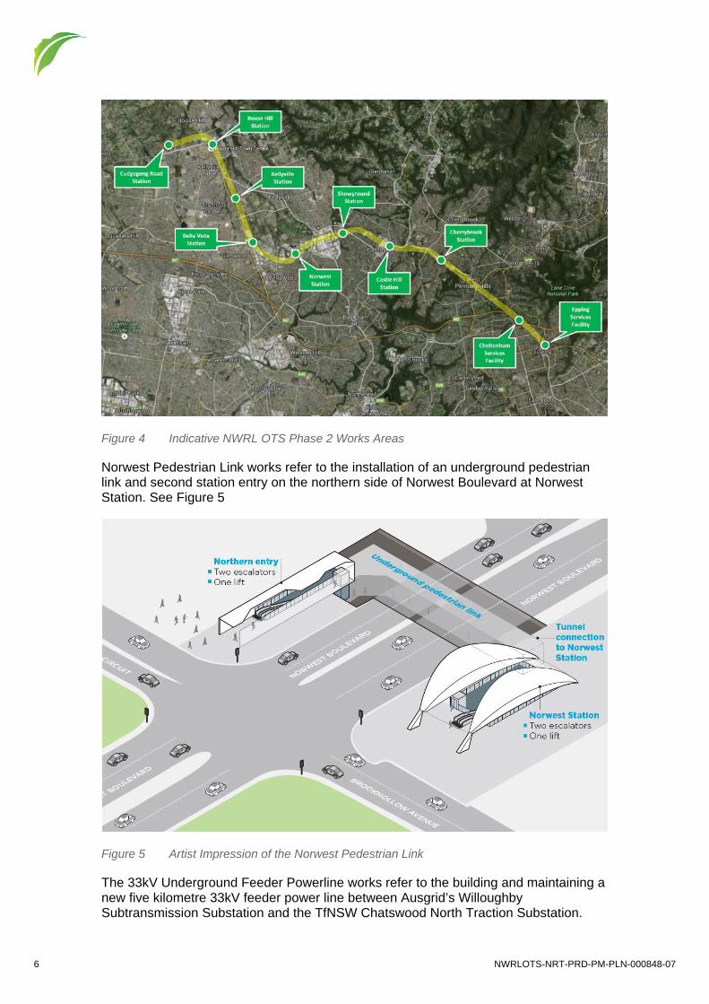
6 NWRLOTS-NRT-PRD-PM-PLN-000848-07
Figure 4 Indicative NWRL OTS Phase 2 Works Areas
Norwest Pedestrian Link works refer to the installation of an underground pedestrian link and second station entry on the northern side of Norwest Boulevard at Norwest Station. See Figure 5
Figure 5 Artist Impression of the Norwest Pedestrian Link
The 33kV Underground Feeder Powerline works refer to the building and maintaining a new five kilometre 33kV feeder power line between Ausgrid’s Willoughby Subtransmission Substation and the TfNSW Chatswood North Traction Substation.

NWRLOTS-NRT-PRD-PM-PLN-000848-07 7
The proposal is required to provide dedicated, independent 33kV connection in order to meet the reliable supply of electricity requirements for this project. See Figure 6
Figure 6 Overview of the 33kV Underground Feeder Powerline Route
The Rouse Temporary Bypass Powerline involves the construction of a temporary powerline from the southern side of the Sydney Metro Windsor Road Bridge crossing Schofields Road, running underground through Castlebrook Memorial Park transitioning back to overhead and crossing Windsor Road to the Rouse Hill traction substation located south of Sanctuary Drive. The purpose of the temporary powerline is to enable energisation and commissioning of the rail systems associated with the construction of Sydney Metro Northwest. See Figure 7 below

8 NWRLOTS-NRT-PRD-PM-PLN-000848-07
Figure 7 Rouse Temporary Bypass Powerline Work Area
Specifically, this Sub Plan:
• Describes the legislative framework specific to Compound and Ancillary Facility issues and relevant guidelines that must be followed
• Identifies the existing worksite issues
• Identifies key risks and impacts associated with the works
• Describes procedures that will be used for management of aspects and potential impacts associated with Compound and Ancillary Facilities.
This Plan is a Sub Plan of the OTS Construction Environmental Management Plan (CEMP). The relationship of this Plan to other NRT Plans is described in detail below in Section 9.
1.3 Compound and Ancillary Facilities Management Objectives and Targets
This CCAMP addresses the following requirements:
• OTS Project Deed, Operations, Trains and Systems, Exhibit 1, Scope and Performance Requirements, Appendix 54 – Project Plan Requirements, Section 3.17
• Project Planning Approval – Rapid Transit Rail Facility (ref SSI-5931) – All Conditions applicable to Phase 1 and 2 NWRL OTS works
• Project Planning Approval (and Modification 20 May 14) – NWRL Stage 2 – Stations, Rail Infrastructure & Systems (SSI-5414) – applicable to Phase 1 NWRL OTS works, as defined in Staging Report
• ECRL Conversion Determination Report Conditions of Approval
NWRLOTS-NRT-PRD-PM-PLN-000848-07 9
• Applicable Revised Environmental Mitigation Measures from Project EISs — Environmental Impact Statement 2 (EIS2) and Submissions Report (including –
NWRL Stage 2 Stations, Rail Infrastructure and Systems (2012/3) — Environmental Impact Statement and Submissions Report – Tallawong Road,
Rouse Hill Rapid Transit Rail Facility (JBA 2013)
• ECRL Conversion Review of Environmental Factors (Parsons Brinkerhoff, 10 October 2014) and Submissions Report (Parsons Brinkerhoff, 5 February 2015)
• Norwest Pedestrian Link Review of Environmental Factors (Parsons Brinkerhoff 4 June 2015) and Submissions Report (Parsons Brinkerhoff, 1 October 2015)
• Norwest Pedestrian Link Determination Report Conditions of Approval (27 October, 2015)
• Willoughby to North Chatswood 33kV Underground Feeder Powerline Review of Environmental Factors (Parsons Brinkerhoff 20 October 2015) and Submissions Report (Parsons Brinkerhoff 9 March 2016)
• 33kV Underground Feeder Powerline Determination Report Conditions of Approval (March ,2016)
• Rouse Hill Temporary Bypass Powerline Environmental Impact Assessment (EIA)
• NWRL Construction Environmental Management Framework (Rev 1.4)
• Applicable Legislative Obligations.
The Compliance Matrix in Annexure A details how the CCAMP complies with the requirements of the applicable Minister’s Conditions of Approval (CoA) requiring this Plan to be prepared and approved. It provides a comprehensive list of compliance requirements, environmental documents and the contract documents. Additional detail on compliance management is also contained in Section 2.2
NRT’s construction compound and ancillary facilities objectives and targets for the delivery of the OTS Contract are:
• Ensure that construction site areas are managed according to statutory requirements.
• Define a process for evaluating any ancillary sites or facilities required during construction.
1.4 NRT Environmental Management System In accordance with the OTS Project Deed, Exhibit 1, Scope and Performance Requirements, Section 5.2, NRT must implement and maintain an effective Management System, which addresses all its obligations under the Deed.
The Management Systems must seamlessly integrate all NRT’s systems and processes, including those related to rail safety and rail accreditation quality, environmental, sustainability, health and safety and they must accommodate, coordinate and give effect to the Project Plans.
Details of NRT’s Integrated Management System including the integrated relationship of the CCAMP with the other Project Plans and with the delivery Core Processes are contained in the Project Management Plan. As improvements are made to the

10 NWRLOTS-NRT-PRD-PM-PLN-000848-07
processes and systems, these will be reflected in updates to the relevant Project Plans. All elements of the Integrated Management System will reside on Aconex as controlled copies. An intranet will contain a front page to the Integrated Management System with links between documents, processes and forms utilising the Aconex search engine.
1.5 Approval Before Submission The CCAMP and future updates are to be approved by NRT’s CEO before being submitted to TfNSW.
1.6 Certification by Independent Certifier This CCAMP and any future update is to be submitted, in accordance with the provisions of clause 8 of the Deed, to TfNSW for comment and to the OTS Independent Certifier for certification prior to its implementation by NRT.
1.7 Update and Ongoing Development The CCAMP is incorporated as Appendix 76 of the Deed.
The CCAMP will be updated regularly in accordance with the requirements of the Deed, clause 8 and annually as required in Exhibit 1, Scope and Performance Requirements, Appendix 54 – Project Plan Requirements, Table 1.
NRT will undertake the ongoing development, amendment and updating of the CCAMP to ensure it remains consistent with Project priorities, risk management, client requirements and Project objectives, taking into account:
• The status and progress of NRT’s activities
• Changes in the design, delivery and operations processes and conditions
• Lessons learnt during delivery and operations
• Changes in other related Project Plans
• Requirements and matters not covered by the existing Project Plans
• Changes to Plans resulting from any comments from the OTS Independent Certifier
• Changes to Project Plans as directed by TfNSW’s Representative under the Deed
• Taking over project sites from previous contracts, and the addition of other construction compounds and ancillary facilities.

NWRLOTS-NRT-PRD-PM-PLN-000848-07 11
2 Legal and Other Requirements
2.1 Relevant Legislation The key legislation relevant to construction compound and ancillary facilities management includes:
• Environmental Planning and Assessment Act 1979 (EP&A Act)
• Protection of the Environment Operations Act 1997 (POEO Act)
• Contaminated Land Management Act 1997 (CLM Act)
• Threatened Species and Conservation Act 1995 and amendments (TSC Act)
• Environmental Protection and Biodiversity Conservation Act 1999 (Cth) (EPBC Act)
• Heritage Act 1977
• Work Health and Safety Act 2011
Refer to the CEMP for further details of relevant legislation.
2.2 Compliance Requirements Management requirements from the Project Deed, Project Approval and Revised Environmental Mitigation Measures are included in Annexure A of this Plan.
All compliance requirements associated with this Sub Plan including the Revised Environmental Management and Mitigation Measures from the NWRL Project Environmental Impact Assessments, the ECRL REF and Submissions Report the Norwest Pedestrian Link REF and Determination Report and the 33kV Underground Feeder Powerline REF and Determination Report that are pertinent to this sub plan are tracked and reported via the OTS compliance tracking program developed in accordance with CoA D5((a)-(h)).
2.3 Relevant Guidelines Additional guidelines and standards relating to the management of construction compounds and ancillary facilities include:
• Managing Urban Stormwater: Soils and Construction. Volume 2D: Main Road, DECC (2008)
• Managing Urban Stormwater: Soils and Construction. Volume 1 of the ‘Blue Book’), Landcom (2004)
• Crime Prevention through Environmental Design (CPTED) principles
• NWRL Style Guidelines (Co-branding) (TfNSW, November 2012).
12 NWRLOTS-NRT-PRD-PM-PLN-000848-07
2.4 Environment Protection Licence The NRT Environment Protection Licence (No. 20544) sets out conditions applicable to the works, including hours of work, assessment, monitoring and management requirements.

NWRLOTS-NRT-PRD-PM-PLN-000848-07 13
3 Roles and Responsibilities The roles and responsibilities of key NRT Personnel with respect to construction compounds and ancillary facilities are as follows:
Table 1 Roles and Responsibilities
Project Director Manage the delivery of the Project including overseeing implementation of compound management measures.
Act as Contractor’s Representative.
Environment Manager (EM) Manage the on-ground application of worksite management measures during construction.
Provide guidance to senior management with regard to aspects and risks associate with management of compounds and ancillary facilities.
Responsible for managing ongoing compliance with the CoA and environmental document requirements.
Commercial Manager (CM) Ensure that relevant environmental and sustainability requirements are considered in procuring materials and services.
Construction Managers
Site Superintendent (SS)
Manage the delivery of the construction process, in relation to worksite management across all sites in conjunction with the Environment and Sustainability team.
Senior Sustainability Manager Coordinate the implementation of the sustainability strategy, including providing guidance on the sustainable design of the NRT Worksites.
Environmental Coordinators (EC)
Develop and oversee implementation of on-ground management documents associated with each of the NRT Worksites, including site environmental plans.
Manage review and continual improvement of this plan.
Inspection and reporting on compliance.
Project Engineers Implement management activities during construction works, as directed by the Construction Manager and or the Environment Manager.

14 NWRLOTS-NRT-PRD-PM-PLN-000848-07
4 Aspects and Potential Impacts The key aspects and potential impacts associated with the management of compounds and ancillary facilities during the delivery of NWRL OTS Works are listed in Table 2.
These identified risks have been taken into account in the development of the compound and ancillary facilities management strategy and site-specific procedures for the works.
Table 2 Summary of Overall Aspects and Potential Impacts
Aspects Potential impacts/opportunities
Risk level for Works (qualitative)
Flora and fauna • Disturbance or mortality of fauna during clearing works
• Additional habitat loss
• Additional habitat degradation
• Additional fragmentation and severance
• Potential for vegetation removal to increase visual exposure of the construction site.
L
Erosion and sedimentation
• Sediment laden/contaminated runoff entering creeks and defined drainage lines, including stormwater systems, causing pollution
• Potential traffic safety issues from sediment and gravel on roads.
M
Noise and vibration
• Potential to cause disturbance to neighbouring sensitive receivers during compound/ancillary facility establishment and construction operation of ancillary facilities for facilities such as batch plants, workshop, labs etc.
M
Air quality • Potential for high winds generating airborne dust form stockpiles and access roads
• Exhaust emissions from vehicles and static plant generators.
M
Heritage • Permanent disturbance/destruction or temporary alteration to identified items
• Change to the construction footprint resulting in impacts to areas not previously assessed to be affected.
L
Traffic • Traffic impacts associated with spoil haulage including potential conflicts with local traffic and increased congestion
• Traffic impacts from access and egress movements of workers
• Traffic impacts of deliveries during peak periods.
M
Storage of hazardous substances
• Potential for pollutants to wash into the storm water system, then into receiving waters
• Failure of storage systems and bunding.
M
Waste and recycling
• Potential for waste generated during establishment and operation of construction compounds and ancillary facilities to be disposed of incorrectly.
M

NWRLOTS-NRT-PRD-PM-PLN-000848-07 15
Aspects Potential impacts/opportunities
Risk level for Works (qualitative)
Visual amenity • Potential for site hoardings or other exposed surfaces to be vandalised
• Potential for site lighting to affect the amenity of surrounding land uses
• Potential for waste to not be placed in appropriate bins and result in litter around the construction worksites.
L
Contamination • Potential for uncovering previously unidentified contaminated material
• Potential for contamination at plant and equipment servicing / refuelling locations and hazardous substance storage areas.
• Potential for contamination with spills leaks during refuelling activities.
L
Flooding • Flooding of worksites during intense rain events. L
16 NWRLOTS-NRT-PRD-PM-PLN-000848-07
5 Compound and Ancillary Facilities Management
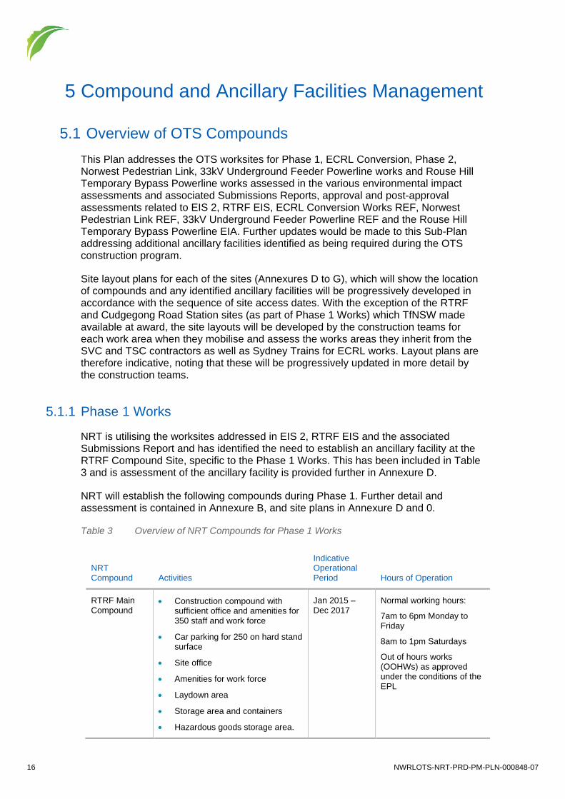
5.1 Overview of OTS Compounds This Plan addresses the OTS worksites for Phase 1, ECRL Conversion, Phase 2, Norwest Pedestrian Link, 33kV Underground Feeder Powerline works and Rouse Hill Temporary Bypass Powerline works assessed in the various environmental impact assessments and associated Submissions Reports, approval and post-approval assessments related to EIS 2, RTRF EIS, ECRL Conversion Works REF, Norwest Pedestrian Link REF, 33kV Underground Feeder Powerline REF and the Rouse Hill Temporary Bypass Powerline EIA. Further updates would be made to this Sub-Plan addressing additional ancillary facilities identified as being required during the OTS construction program.
Site layout plans for each of the sites (Annexures D to G), which will show the location of compounds and any identified ancillary facilities will be progressively developed in accordance with the sequence of site access dates. With the exception of the RTRF and Cudgegong Road Station sites (as part of Phase 1 Works) which TfNSW made available at award, the site layouts will be developed by the construction teams for each work area when they mobilise and assess the works areas they inherit from the SVC and TSC contractors as well as Sydney Trains for ECRL works. Layout plans are therefore indicative, noting that these will be progressively updated in more detail by the construction teams.
5.1.1 Phase 1 Works
NRT is utilising the worksites addressed in EIS 2, RTRF EIS and the associated Submissions Report and has identified the need to establish an ancillary facility at the RTRF Compound Site, specific to the Phase 1 Works. This has been included in Table 3 and is assessment of the ancillary facility is provided further in Annexure D.
NRT will establish the following compounds during Phase 1. Further detail and assessment is contained in Annexure B, and site plans in Annexure D and 0.
Table 3 Overview of NRT Compounds for Phase 1 Works
NRT Compound Activities
Indicative Operational Period Hours of Operation
RTRF Main Compound
• Construction compound with sufficient office and amenities for 350 staff and work force
• Car parking for 250 on hard stand surface
• Site office
• Amenities for work force
• Laydown area
• Storage area and containers
• Hazardous goods storage area.
Jan 2015 – Dec 2017
Normal working hours:
7am to 6pm Monday to Friday
8am to 1pm Saturdays
Out of hours works (OOHWs) as approved under the conditions of the EPL

NWRLOTS-NRT-PRD-PM-PLN-000848-07 17
NRT Compound Activities
Indicative Operational Period Hours of Operation
RTRF Satellite Compound
• Construction compound with sufficient office and amenities for 150 staff including small site office shed for site foremen and engineering plans
• Limited parking for construction vehicles
• Amenities for work force
• Laydown area
• Storage area and containers
Oct 2015 – Dec 2017
Normal working hours
7am to 6pm Monday to Friday
8am to 1pm Saturdays
Out of hours works (OOHWs) as approved under the conditions of the EPL
Cudgegong Road Precinct Enabling Works
• Workforce facilities for 100 people, including parking, amenities
• Consisting of demountable buildings
• Hazardous goods storage area.
Jan 2015 – Dec 2017
Normal working hours
7am to 6pm Monday to Friday
8am to 1pm Saturdays
Out of hours works (OOHWs) as approved under the conditions of the EPL
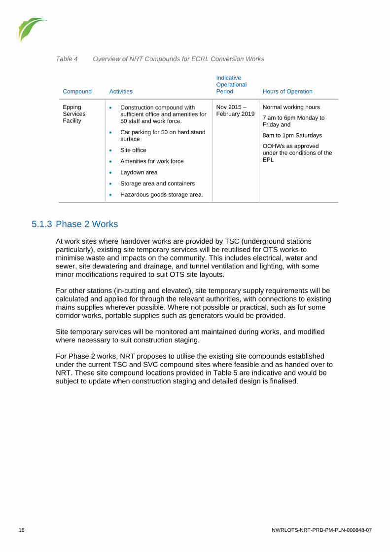
5.1.2 ECRL Conversion Works
As noted in the ECRL Conversion REF, there is minimal space available within the Epping to Chatswood railway corridor for site compounds and materials storage. NRT proposes to utilise the existing site compound at the Epping Services Facility which would be shared with TSC (Tunnel and Stations Contractor), and then eventually handed over to NRT.
As included in Table 4 below, NRT will occupy the following compound during the ECRL Conversion Works. Further detail and assessment is contained in Annexure B, and site plans in Annexure D and 0.
Smaller temporary storage areas may be required at station sites during possessions. Further investigation of these options would be carried out closer to each possession in discussions with Sydney Trains and would be identified on Site Environmental Plans.
18 NWRLOTS-NRT-PRD-PM-PLN-000848-07
Table 4 Overview of NRT Compounds for ECRL Conversion Works
Compound Activities
Indicative Operational Period Hours of Operation
Epping Services Facility
• Construction compound with sufficient office and amenities for 50 staff and work force.
• Car parking for 50 on hard stand surface
• Site office
• Amenities for work force
• Laydown area
• Storage area and containers
• Hazardous goods storage area.
Nov 2015 – February 2019
Normal working hours
7 am to 6pm Monday to Friday and
8am to 1pm Saturdays
OOHWs as approved under the conditions of the EPL
5.1.3 Phase 2 Works
At work sites where handover works are provided by TSC (underground stations particularly), existing site temporary services will be reutilised for OTS works to minimise waste and impacts on the community. This includes electrical, water and sewer, site dewatering and drainage, and tunnel ventilation and lighting, with some minor modifications required to suit OTS site layouts.
For other stations (in-cutting and elevated), site temporary supply requirements will be calculated and applied for through the relevant authorities, with connections to existing mains supplies wherever possible. Where not possible or practical, such as for some corridor works, portable supplies such as generators would be provided.
Site temporary services will be monitored ant maintained during works, and modified where necessary to suit construction staging.
For Phase 2 works, NRT proposes to utilise the existing site compounds established under the current TSC and SVC compound sites where feasible and as handed over to NRT. These site compound locations provided in Table 5 are indicative and would be subject to update when construction staging and detailed design is finalised.

NWRLOTS-NRT-PRD-PM-PLN-000848-07 19
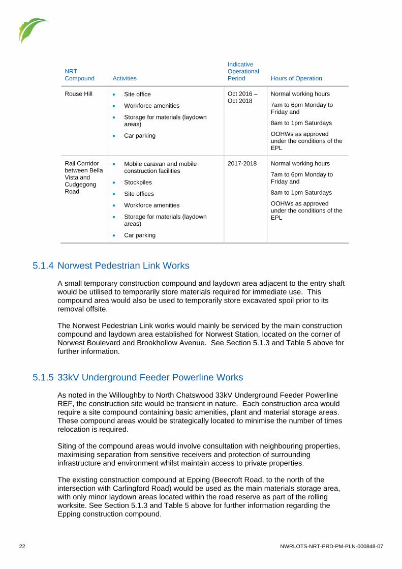
Table 5 Overview of NRT Compounds for Phase 2
NRT Compound Activities
Indicative Operational Period Hours of Operation
Epping Services Facility
• Construction compound with sufficient office and amenities for 50 staff and work force.
• Car parking for 50 on hard stand surface
• Site office
• Amenities for work force
• Laydown area
• Storage area and containers
• Hazardous goods storage area
• Batching plant
Jul 2016 – Dec 2018
Normal working hours
7 am to 6pm Monday to Friday and
8am to 1pm Saturdays
OOHWs as approved under the conditions of the EPL
Cheltenham Services Facility
• Temporary relocation of sporting facilities
• Service facility shaft
• Offices and amenities
• Car parking
Jul 2016 – Dec 2018
Normal working hours
7 am to 6pm Monday to Friday and
8am to 1pm Saturdays
OOHWs as approved under the conditions of the EPL
Cherrybrook Station
• Site accommodation established within the site boundary, adjacent to Franklin Rd.
• Site office will include staff amenities including a site canteen to avoid unnecessary vehicle and pedestrian movements from the site at morning and lunch breaks, and prevent productivity losses.
• Staff parking within the site will be provided.
• Cranage will be via mobile and crawler cranes.
• Concrete pumping will be via truck mounted boom pump at street level.
• Solid hoardings and noise walls will surround the perimeter of the site, the majority of which are handed over by the TSC contractor.
• A temporary sediment basin handed-over by the TSC contractor will be used until the permanent basin has been constructed.
• Other site facilities include laydown area, storage area and containers and hazardous goods storage area.
Jul 2016 – Dec 2018
Normal working hours
7 am to 6pm Monday to Friday and
8am to 1pm Saturdays
OOHWs as approved under the conditions of the EPL

20 NWRLOTS-NRT-PRD-PM-PLN-000848-07
NRT Compound Activities
Indicative Operational Period Hours of Operation
• Concrete Batching Plant
Castle Hill • Site office
• Workforce amenities
• Storage for materials (laydown areas)
• Car parking (limited at Castle Hill).
• Batching plant
Apr 2017 – Dec 2018
Normal working hours
7am to 6pm Monday to Friday
8am to 1pm Saturdays
OOHWs as approved under the conditions of the EPL
Castle Hill New Site Office
• Site office
• Car parking
• Workforce amenities
• Toilets
• Access and egress to Brisbane Rd
• Storage for materials (laydown areas)
May 2018 – Dec 2018
Normal working hours
7am to 6pm Monday to Friday
8am to 1pm Saturdays
OOHWs as approved under the conditions of the EPL
Showground • Site office
• Workforce amenities
• Storage for materials (laydown areas)
• Car parking
• Full site accommodation will be established within the site boundary, including staff parking
• A site canteen will be provided, which will avoid unnecessary vehicle and pedestrian movements from the site at morning and lunch breaks, and prevent productivity losses
• Mobile and crawler cranes will be used
• In addition to stairs, a man and materials hoist will be provided for access into the station box
• Concrete pumping will be via truck mounted boom pump at street level (for the station box and multi-storey car park)
• Solid hoardings and noise walls will surround the perimeter of the site. (The majority of these are handed over by the TSC contractor)
• A temporary sediment basin will handed over by the TSC contractor and used until the permanent basin has been constructed.
Apr 2016 – Dec 2018
Normal working hours
7am to 6pm Monday to Friday and
8am to 1pm Saturdays
OOHWs as approved under the conditions of the EPL

NWRLOTS-NRT-PRD-PM-PLN-000848-07 21
NRT Compound Activities
Indicative Operational Period Hours of Operation
Norwest • Site office
• Workforce amenities
• Storage for materials (laydown areas)
• Car parking
• Concrete Batching Plant
Apr 2016 – Dec 2018
Normal working hours
7am to 6pm Monday to Friday and
8am to 1pm Saturdays
OOHWs as approved under the conditions of the EPL
Bella Vista • Site office
• Workforce amenities
• Storage for materials (laydown areas)
• Car parking within worksite
• Concrete Batching Plant
Apr 2016 – Dec 2019
Normal working hours
7am to 6pm Monday to Friday
8am to 1pm Saturdays
OOHWs as approved under the conditions of the EPL
Kellyville • Site accommodation established within the site boundary, adjacent Samantha Riley Drive, whilst maintaining a temporary public car park with 400 spaces for the T-way
• A site canteen will be provided, which will avoid unnecessary vehicle and pedestrian movements from the site at morning and lunch breaks and prevent productivity losses
• Parking for staff and workers provided within the site
• Cranage up to the viaduct will be via mobile cranes
• Concrete pumping will be via truck mounted boom pump at ground level
• Site fencing with a minimum of branded shade cloth covering will surround the perimeter of the site
• Access to the viaduct and platform zone will be via a set of scaffold access stairs at each end of the station area
• A temporary sediment basin will be utilised during construction until the permanent stormwater management system has been constructed.
• Protection fences will be installed to exclude the listed heritage areas along the original formation of Old Windsor Rd (T-Way alignment) from the construction site.
Oct 2016 – Dec 2018
Normal working hours
7am to 6pm Monday to Friday and
8am to 1pm Saturdays
OOHWs as approved under the conditions of the EPL
22 NWRLOTS-NRT-PRD-PM-PLN-000848-07
NRT Compound Activities
Indicative Operational Period Hours of Operation
Rouse Hill • Site office
• Workforce amenities
• Storage for materials (laydown areas)
• Car parking
Oct 2016 – Oct 2018
Normal working hours
7am to 6pm Monday to Friday and
8am to 1pm Saturdays
OOHWs as approved under the conditions of the EPL
Rail Corridor between Bella Vista and Cudgegong Road
• Mobile caravan and mobile construction facilities
• Stockpiles
• Site offices
• Workforce amenities
• Storage for materials (laydown areas)
• Car parking
2017-2018 Normal working hours
7am to 6pm Monday to Friday and
8am to 1pm Saturdays
OOHWs as approved under the conditions of the EPL
5.1.4 Norwest Pedestrian Link Works
A small temporary construction compound and laydown area adjacent to the entry shaft would be utilised to temporarily store materials required for immediate use. This compound area would also be used to temporarily store excavated spoil prior to its removal offsite.
The Norwest Pedestrian Link works would mainly be serviced by the main construction compound and laydown area established for Norwest Station, located on the corner of Norwest Boulevard and Brookhollow Avenue. See Section 5.1.3 and Table 5 above for further information.
5.1.5 33kV Underground Feeder Powerline Works
As noted in the Willoughby to North Chatswood 33kV Underground Feeder Powerline REF, the construction site would be transient in nature. Each construction area would require a site compound containing basic amenities, plant and material storage areas. These compound areas would be strategically located to minimise the number of times relocation is required.
Siting of the compound areas would involve consultation with neighbouring properties, maximising separation from sensitive receivers and protection of surrounding infrastructure and environment whilst maintain access to private properties.
The existing construction compound at Epping (Beecroft Road, to the north of the intersection with Carlingford Road) would be used as the main materials storage area, with only minor laydown areas located within the road reserve as part of the rolling worksite. See Section 5.1.3 and Table 5 above for further information regarding the Epping construction compound.

NWRLOTS-NRT-PRD-PM-PLN-000848-07 23
5.1.6 Rouse Hill Temporary Bypass Powerline Works
A small compound would be established in the north-east corner of the Castlebook Memorial Park in order to construct the underground sections of the powerline. The compound would consist of basic amenities and the storage of small quantities of construction materials. All other works would be constructed general within the Sydney Metro Northwest Corridor.
5.2 Worksite Handover, Decommissioning and Rehabilitation TfNSW will progressively handover sites to NRT once the TSC and SVC Works are completed. The sites established under the TSC Works will be progressively handed over to TfNSW once tunnelling and station box excavations are complete to allow construction of OTS Works to commence.
At the time of taking possession of Construction Site areas, NRT will assume all obligations and responsibilities for the Civil Works on those areas, including all local Authority licences relating to occupation of the construction site and all site security, including monitoring and management of entry into the Construction Site.
Full decommissioning of worksites (sites accepted by OTS during handover and OTS established sites) would be undertaken by NRT. All construction access points, including those provided by the Civil Works contractors, will be restored to their pre-construction state or upgraded in accordance with the OTS design, to the satisfaction of the relevant authority. In accordance with condition 3.5 of the Project Deed, where OTS make use of or occupy a temporary area, the temporary area will be reinstated as per the condition.
5.3 General Management In recognition of Section 5.1.4, Construction Compounds and Ancillary Facilities will be constructed in accordance with the following requirements (where applicable):
• Site sheds would be as new and maintained in excellent condition and be established at locations and positions that minimise the impact on adjoining properties and residents.
• Temporary site facilities would meet the sustainability requirements of the project.
• Temporary site facilities, including site sheds, would be maintained free of graffiti.
• Compounds will be located outside of the 50m riparian buffer zones of watercourses.
• All facilities utilised for the purpose of NRT’s activities must be sited, constructed and maintained to meet the requirements of TfNSW and relevant authorities.
• For the duration of the Delivery Phase, NRT must provide site facilities for use by TfNSW and the OTS Independent Certifier.
• Daily inspections of all temporary site facilities including site sheds.

24 NWRLOTS-NRT-PRD-PM-PLN-000848-07
Site establishment elements, including sheds will be made from as-new materials or in excellent condition, with the layout of each site arranged to minimise impacts on the surrounding community and in accordance with the requirements of TfNSW and relevant authorities.
Work is to be undertaken during periods specified in the planning conditions. Any work outside these periods will be subject to risk assessment and environmental approval. The currently approved hours of work are:
• RTRF, stations, precincts, service facilities and corridor works: — Monday to Friday: 7am to 6pm Monday to Friday and Saturday 8am to 1pm. — Activities involving impulsive or tonal noise emissions: Monday to Friday 8am to
5pm, in continuous blocks not exceeding three hours each with a minimum respite from those activities and works of not less than one hour between each block.
• Track work and fitout works within tunnels: — 24 hours per day, 7 days per week.
Specific activities for which works would need to occur outside standard construction hours would include delivery and loading of rail systems equipment into tunnels for short periods of time which would be subject to a night shift but which would be complete by 10pm, underground rail works which would be undertaken in a night shift and any other deliveries required to be undertaken out of hours to comply with the requirements of RMS, such as large equipment deliveries.
In addition, some utility and roadworks will need to be undertaken outside normal construction hours, such as nights, to minimise the impact to local traffic. Any out of hours works would be managed through the Environmental Protection Licence condition process.
5.4 Compound and Ancillary Facility Decommissioning and Rehabilitation
Dilapidation surveys would be completed of compound areas (and ancillary facilities if required) that don’t form part of the permanent works. Once the compound or ancillary facility is no longer required for construction activities all materials, buildings and equipment will be removed and the site reinstated to their preconstruction condition, unless otherwise agreed by the site owner or as determined as per Section 5.1.3 and 5.2 of this Sub Plan.
Compound Sites would be progressively rehabilitated as each part of the OTS Works is completed in accordance with the landscaping specification in the Design Landscape Plan (DPL) for the RTRF and the Urban Design and Corridor Landscape Plan (UDCLP) for the remaining OTS Works.
5.5 Site Environment Plans Site Environment Plans (SEPs) will be progressively developed for each of the OTS Compounds, including any future Ancillary Facilities and as required by the aspect specific management plans.

NWRLOTS-NRT-PRD-PM-PLN-000848-07 25
SEPs are designed to provide site-specific detail and will include:
• GIS based illustrative and descriptive management and control measures, e.g. no-go zones, haulage routes, sensitive receivers etc.
• Overview of the scope of works.
• Clear references to internal Hold Points and relevant Environment Procedures. The SEPs will initially be prepared to address site establishment works and will be progressively updated as construction progresses and conditions change within the OTS Compounds and Ancillary Facilities. The Environment Representative will endorse each SEP to ensure compliance with the Project Approval prior to the commencement of works and re-endorse the SEPs as they are progressively updated to address tunnelling operations.
SEPs will be displayed at the crib sheds of their respective OTS Compound. Copies of SEPs will also be provided to Project Managers, Construction Managers, Superintendents and Supervisors, so they can be communicated amongst their teams.
5.6 Mitigation and Management As set out above, the SEPs will reference the Environmental procedures applicable to the OTS Works. Environment procedures detail key environmental management processes for the construction workforce, how they need to be carried out, and hold points for the implementation of controls, management and mitigation measures. Where possible, procedures include flow diagrams for any required processes or steps to be undertaken and provide an easy reference point for all site personnel. They provide a comprehensive and informative means of communicating environmental management requirements to site personnel.
Additional Environment procedures will be developed as required during delivery of the OTS Works. The Environment procedures are a key site management tool and will be revised and updated as construction progresses and in response to any issues identified during implementation.
5.7 Assessment of Ancillary Facilities Ancillary facilities are defined in the project approvals as temporary facilities for construction not identified in the EISs or Submissions Reports. This includes facilities such as office and amenities compounds, construction compounds, batch plants, materials storage compounds, maintenance workshops, testing laboratories or material stockpile areas.
If ancillary facilities are identified as being required during construction they will be assessed against the criteria in Annexure C of This Plan. When completed for a site, the facility will be added to Annexure B.
NRT will communicate with TfNSW and the ER when there is a requirement to assess additional ancillary facilities.
Note: if the criteria in Annexure C is not met, approval must be sought from the Secretary of the Department of Planning and Environment. NRT / TfNSW will

26 NWRLOTS-NRT-PRD-PM-PLN-000848-07
demonstrate to the satisfaction of the Secretary that there will be no significant adverse impact from the facility’s construction and operation.

NWRLOTS-NRT-PRD-PM-PLN-000848-07 27
6 Training, Reporting and Review
6.1 Training All personnel working on site will undergo site induction training relating to the use of the compound and ancillary facility sites. The induction training will include:
• SEPs
• Working hours
• Management of waste and recycling
• Emergency requirements i.e. pollution event, major spills etc.
• Hazardous chemicals storage and bunding requirements
• Refuelling processes and practices
• Housekeeping and waste management.
Further details regarding staff induction and training are outlined in the CEMP.
6.2 Monitoring, Compliance and Reporting The Environment Manager will include the site compounds and ancillary facilities as part of their weekly inspection and review the performance of mitigation measures that have been documented on the SEP against what has been implemented. These inspections will be documented on the weekly checklist. Daily visual inspections would also be carried out site supervisory staff.
The Environmental Representative will inspect the site regularly and will inspect any environmental controls established at these sites.
Typical compliance records would consist of:
• Inspections records
• Non-conformance reports
• Incident reports.
Results and outcomes of inspections, monitoring and auditing will be reported internally on a monthly basis. Six-monthly construction compliance reports will be prepared to report on compliance with the Project Approval.
6.3 Review and Improvement A non-conformance is an action or omission that does not conform to the requirements of this Plan or any legal and other requirements. Any member of the project team or the Environmental Representative can identify a non-conformance or opportunity for improvement. The CEMP identifies the process for identifying, reporting, recording and reviewing non-conformances. This will ensure continual improvement.

28 NWRLOTS-NRT-PRD-PM-PLN-000848-07
The processes described in the CEMP may result in the need to update or revise this Plan. This will occur as needed. This Plan will be audited within six months of the commencement of construction and thereafter as per the CEMP. The Plan shall be reviewed and updated based on the findings of the audit.

NWRLOTS-NRT-PRD-PM-PLN-000848-07 29
Annexure A Compound and Ancillary Facility Management Measures and Compliance Matrix
ID Measure Timing Requirement Responsibility Reference
Project Approval – Specific Management Plan Requirements
1) A Construction Compound and Ancillary Facilities Management Plan to detail the management of Ancillary Facilities associated with the SSI. The Plan shall include but not be limited to;
Before Construction
RTRF Approval SSI-5931 CoA E29(a)
OTS Approval SSI-5414 CoA E35(i)
Environment Manager
This Plan
2) A description of the facility, its components and the surrounding environment Before Construction
RTRF Approval SSI-5931 CoA E29(a)i
OTS Approval SSI-5414 CoA E35(a)i
Environment Manager
Section 5, Annexure B
3) Details of the activities to be carried out at each facility, including the hours of use and the storage of dangerous and hazardous goods
Before Construction
RTRF Approval SSI-5931 CoA E29(a)ii
OTS Approval SSI-5414 CoA E35(a)ii
Environment Manager
Annexure B
4) An assessment against the location criteria outlined in condition E25/E30 Before Construction
RTRF Approval SSI-5931 CoA E29(a)iii
Environment Manager
Section 5.7, Annexure B. Annexure C, Annexure D

30 NWRLOTS-NRT-PRD-PM-PLN-000848-07
ID Measure Timing Requirement Responsibility Reference
OTS Approval SSI-55414 CoA E35(a)iii
5) Details of the mitigation and management procedures specific to the facility that would be implemented to minimise environmental and amenity impacts and an assessment of the adequacy of the mitigation or offsetting measures
Before Construction
RTRF Approval SSI-5931 CoA E29(a)iv
OTS Approval SSI-5414 CoA E34(a)iv
Environment Manager
This Table, Section 5
6) Identification of the timing for the completion of activities at the facility and how the site will be decommissioned (including any necessary rehabilitation); and
Before Construction
RTRF Approval SSI-5931 CoA E29(a)v
OTS Approval SSI-5414 CoA E35(a)v
Environment Manager
Section 5
7) Mechanisms for the monitoring, review and amendment of this Plan Before Construction
RTRF Approval SSI-5931 CoA E29(a)vi
OTS Approval SSI-5414 CoA E35(a)vi
Environment Manager
Section 6.2, 6.3
Project Approval – Specific Conditions
8) Unless otherwise approved by the Director General, the location of Ancillary Facilities shall:
(a) be located more than 50 metres from a waterway;
(b) be located within or adjacent to land where the SSI is being carried out;
(c) have ready access to the road network;
Before Construction
RTRF Approval SSI-5931 CoA E25
OTS Approval SSI-5414 CoA E31
Environment Manager
Section 5.7, Annexure B, Annexure C, Annexure D

NWRLOTS-NRT-PRD-PM-PLN-000848-07 31
ID Measure Timing Requirement Responsibility Reference
(d) be located to minimise the need for heavy vehicles to travel through residential areas;
(e) be sited on relatively level land;
(f) be separated from nearest residences by at least 200 metres (or at least 300 metres for a temporary batching plant);
(g) not require vegetation clearing beyond that already required by the SSI;
(h) not impact on heritage items (including areas of archaeological sensitivity) beyond those already impacted by the SSI;
(i) not unreasonably affect the land use of adjacent properties;
(j) be above the 20 ARI flood level unless a contingency plan to manage flooding is prepared and implemented; and
(k) provide sufficient area for the storage of raw materials to minimise, to the greatest extent practical, the number of deliveries required outside standard construction hours.
The location of the ancillary facilities shall be identified in the Construction Environmental Management Plan and include consideration of the above criteria. Where the above criteria cannot be met for any proposed ancillary facility, the Proponent shall demonstrate to the satisfaction of the Director General that there will be no significant adverse impact from that facility's construction or operation. Such assessment(s) can be submitted separately or as part of the Construction Environmental Management Plan."
9) All Ancillary Facilities shall be rehabilitated to at least their pre-construction condition, unless otherwise agreed by the landowner where relevant
During Construction
RTRF Approval SSI-5931 CoA E26
OTS Approval SSI-5414 CoA E32
Environment Manager
Section 5.1.4, 5.4
Northwest Rail Link Construction Environmental Management Framework

32 NWRLOTS-NRT-PRD-PM-PLN-000848-07
ID Measure Timing Requirement Responsibility Reference
10) NWRL Principal Contractors will consider the following in the layout of construction sites:
• The location of noise intensive works and 24 hour activities in relation to noise sensitive receivers.
• The location of site access and egress points in relation to noise and light sensitive receivers, especially for sites proposed to be utilised 24 hours per day.
• The use of site buildings to shield noisy activities from receivers.
• The use of noise barriers and / or acoustic sheds where feasible and reasonable for sites proposed to be regularly used outside of daytime hours.
• Aim to minimise the requirement for reversing, especially of heavy vehicles.
Before Construction
NWRL CEMP Framework Section 6.1
Environment Manager
Project Engineer
Section 5
Project Deed Requirements
11) The Construction Environmental Management Plan must include, as sub-plans, the following plans that are required by the Environmental Documents:
• Construction Compound and Ancillary Facilities Management Plan;
Project Deed App 54 – Section 3.17 3 (i)
Environment Manager
This Plan
12) Temporary site facilities
(a) Site sheds must be as-new and must be maintained in excellent condition.
(b) Site sheds must be established at locations and positions that minimise the impact on adjoining properties and residents.
(c) All facilities utilised for the purpose of OpCo’s Activities must be sited, constructed and maintained to meet the requirements of TfNSW and relevant Authorities.
(d) For the duration of the Delivery Phase, OpCo must provide site facilities for use by TfNSW and the OTS Independent Certifier in accordance with Appendix 7.
Project Deed SPR Main Body 6.5.11a) –g)
Environment Manager
Section 5.3

NWRLOTS-NRT-PRD-PM-PLN-000848-07 33
ID Measure Timing Requirement Responsibility Reference
(e) Temporary site facilities must satisfy the sustainability requirements of Appendix 50.
(f) All temporary site facilities, including site sheds, must be maintained free of graffiti and any advertising material not authorised by the TfNSW’s Representative.
(g) OpCo must carry out daily inspections of all temporary site facilities including site sheds.

34 NWRLOTS-NRT-PRD-PM-PLN-000848-07
Annexure B Register of Compound and Ancillary Facility Assessments
No. Site Name Existing Site Characteristics Surrounding Environmental Characteristics Activities
Potential Key Community Issues Potential Environmental Risks
Key Environmental Controls–(refer to the following documents)
1 RTRF Site Compounds (Main and Satellite)
The site slopes generally from a high point at the eastern Tallawong Road boundary to a low point at the western site boundary adjacent to First Ponds Creek
A small spur runs from west to east within the site from the mid-point of Tallawong Road before falling towards First Ponds Creek. As a result, overland stormwater flows to the north, south and west are in several sub-catchments prior to draining to First Ponds Creek.
Vegetation within the site is predominately comprised of native and introduced grasses and trees. The vegetation on site includes River Flat Eucalyptus Forest, which is listed under the Threatened Species Conservation Act 1995 as an Endangered Ecological Community (EEC). The River Flat Eucalyptus Forest is in poor and moderate condition at the site, as it has been subject of clearing for agricultural and residential purposes.
The site is now a construction worksite.
Development in the immediate vicinity of the subject site includes a range of low-medium density housing, rural residential, agricultural and market garden uses.
The RTRF site is bound by Tallawong Road to the east, beyond which is a mix of rural residential properties, market gardens and other agricultural uses. Development opposite the site on the eastern side of Tallawong Road.
Land to the north of the site is comprised of predominately rural residential properties, market gardens and agricultural uses (such as poultry farming).
A total of five existing dwelling houses are located within 100 metres of the northern site boundary between Oak Street and Tallawong Road. The Lankarama Sri Lankan Buddhist temple is located approximately 200 metres to the north of the site on the western side of Oak Street.
Land to the west of First Ponds Creek is currently sparsely developed with a small number of rural residential properties and market gardens accessible from Boundary Road, Gordon Road and Oak Street
• Large site accommodation
• Site amenities
• Security office
• Laydown area
• Workforce parking
• Hazardous materials storage
• Fencing and signage
• Internal haul road
• Topsoil stockpiling
• RTRF construction works
• Potential noise, traffic, and dust impacts on properties on Tallawong Road and Schofields Road.
• Refer to Community Liaison Implementation Plan.
Traffic management relating to delivery of raw materials, transportation of precast segments, and arrival and departure of workers. Affected streets may Tallawong Road and Schofields Road.
• Site Environment Plan
• Site-specific Traffic Control Plan
Erosion and sediment generation • Site-specific Erosion and Sediment Control Plan
Potential for spills (e.g. fuel, chemicals, etc.) occurring adjacent to First Ponds Creek.
• Spill Management Procedure
Potential for discovery of contaminated soils relating to rural land on which the site sits
• Contamination Management Procedure
Site establishment will require clearing of groundcover. Potential for injury of fauna during vegetation clearing.
• Site-specific Pre-Clearing Surveys
• Vegetation Clearing Procedure
• Fauna Handling Procedure
• Ecological Unexpected Finds Procedure
Riparian habitat along First Ponds Creek • Ecological Monitoring Program
Waste management:
• Demolition of site buildings
• Green waste
• General construction waste
• Waste Management and Recycling Plan
• Waste Management Procedure
Visual impact of construction site, including hoardings, on surrounding rural residential properties
• Visual Amenity Management Plan
Potential for light spillage from night works impacting upon surrounding residents.
• Visual Amenity Management Plan
2 Cudgegong Road Station Precinct
The site generally slopes from North to South with a low point in the middle. Vegetation is similar in nature to the RTRF site.
Second Ponds creek exists to the south east of the site but does not directly impact it.
The site is now a construction worksite.
Development in the immediate vicinity of the subject site includes a range of low-medium density housing, rural residential, agricultural and market garden uses.
Surrounding receivers are similar to the RTRF site.
• Small site accommodation
• Site amenities
• Laydown area
• Workforce parking
• Hazardous material storage
• Potential noise, traffic, and dust impacts on properties on Cudgegong Road and Schofields Road.
• Refer to Community Liaison
• Traffic management relating to delivery of raw materials, transportation of precast segments, and arrival and departure of workers.
• Affected streets may be Schofields Road.
• Site Environment Plan
• Site-specific Traffic Control Plan
• Erosion and sediment generation • Site-specific Erosion and Sediment Control Plan

NWRLOTS-NRT-PRD-PM-PLN-000848-07 35
No. Site Name Existing Site Characteristics Surrounding Environmental Characteristics Activities
Potential Key Community Issues Potential Environmental Risks
Key Environmental Controls–(refer to the following documents)
Implementation Plan. • Potential for spills (e.g. fuel,
chemicals, etc.) occurring to Second Ponds Creek.
• Spill Management Procedure
• Potential for discovery of contaminated soils relating to rural land on which the site sits
• Contamination Management Procedure
Waste management:
• Demolition of site buildings
• Green waste
• General construction waste
• Waste Management and Recycling Plan
• Waste Management Procedure
• Visual impact of construction site, including hoardings, on surrounding rural residential properties
• Visual Amenity Management Plan
• Potential for light spillage from night works impacting upon surrounding residents.
• Visual Amenity Management Plan
3 Epping Services Facility
The Epping Worksite is to be located along Beecroft Road within the established town centre of Epping, which is centred on Epping railway station. The footprint of the site is to be located on commercial land. Vegetation within the site consists mainly of exotic plantings, with a small area of Sydney Turpentine Ironbark Forest in poor condition to the northwest.
A small tributary of Devlins creek flows in a north-westerly direction along the Worksite’s southern boundary. This waterway has been completely modified and straightened as a result of past urbanisation and is now a concrete and brick-lined channel. Most of the vegetation species surrounding the channel are exotic weeds.
The site is now a construction worksite.
The area surrounding the Epping Worksite consists mainly of lower density dwellings, with some medium to high density residential development surrounding the town centre. A number of community facilities are located within close proximity to the proposed Epping Services Facility site, including Essex Street Scout Hall, places of worship, and educational establishments.
Directly adjacent to the north of the site, there is a vegetated area consisting of Sydney Turpentine Ironbark Forest in poor condition.
Watercourses around this area have been extensively modified for urban development. Runoff from urban areas is generally piped directly to watercourses without treatment. A rehabilitated drainage line runs into the worksite from the west and connects with the tributary of Devlins Creek.
• Small site accommodation
• Site amenities
• Laydown area
• Workforce parking
• Hazardous materials storage
• Services facility construction
• Cumulative traffic impacts associated with Epping Station.
• Noise and air quality impacts on surrounding businesses, residents and community facilities.
• Traffic management relating to delivery of materials
• Arrival and departure of workers.
• Site Environment Plan
• Site-specific Traffic Control Plan
• Spills occurring adjacent to creek • Spill Management Procedure
• Visual impact of construction site, including hoardings, on surrounding rural residential properties
• Visual Amenity Management Plan
• Construction Waste • Waste Management and Recycling Plan
• Waste Management Procedure
4 Cheltenham Services Facility
The Cheltenham Services Facility is located between Castle Howard Road (to the north) and the M2 Motorway (to the south).
The worksite is located within the middle reaches of the main Devlins Creek catchment.
The area surrounding the Cheltenham Worksite consists of low density residential dwellings and areas of established vegetation, open space, and recreational facilities. The vegetation consists predominantly of Coastal Shale-Sandstone Forest in good to poor condition, with
• Small site accommodation
• Site amenities
• Laydown area
• Workforce parking
• Temporary loss of community sporting facilities for shaft excavation.
• Disturbance to bushland in Beecroft Reserve
• Traffic management relating to heavy vehicle movements associated with material deliveries and arrival and departure of workers. Affected streets may include Kirkham Street, Murray Farm Road, Castle Howard Road, and the M2 Motorway.
• Construction Traffic Management Plan
• Site Environment Plan
• Site-specific Traffic Control Plan

36 NWRLOTS-NRT-PRD-PM-PLN-000848-07
No. Site Name Existing Site Characteristics Surrounding Environmental Characteristics Activities
Potential Key Community Issues Potential Environmental Risks
Key Environmental Controls–(refer to the following documents)
The footprint of the proposed works is located in an area of open space that includes the former Netball courts at Cheltenham Oval and some vegetation associated with Beecroft Reserve. Site establishment required vegetation clearance consisting predominantly of Coastal Shale-Sandstone Forest, some exotic plantings and a small area of Sydney Turpentine Ironbark Forest. Threatened species Epacris purpurascens var. purpurascens, is known to occur at two areas within the worksite, in close proximity to the heavy vehicle access road easement. Drainage at the Worksite has been significantly modified by construction of the M2 motorway and the nearby recreational facilities. The Worksite drains southward towards a large stormwater pit adjacent to the M2, which conveys water directly to Devlins Creek.
The site is now a construction worksite.
some exotic plantings and a small area of Sydney Turpentine Ironbark Forest. There are a number of community facilities within the vicinity of the proposed construction site, including Beecroft Nursing Home, Chesalon Care Beecroft, an aged care facility, Beecroft Reserve and Cheltenham Oval. The Hornsby Shire Council declared Beecroft Reserve a Wildlife Protection Area in 2006, and the area is used for various activities, and has an active bush regeneration group. Devlins reek runs east between the M2 (to the north) and residential development (to the south), and is relatively incised in this area.
• Hazardous materials storage
• Services facility construction
for site access track.
• Potential safety concerns over continued use of adjacent oval.
• Potential air quality and noise impacts on surrounding residential streets including Castle Howard Road.
• Traffic impacts, in particular conflicts with local traffic.
• Refer to Community Liaison Implementation Plan.
• Erosion and sediment control – highly erosive and permeable soils
• Site-specific Erosion and Sediment Control Plan
• Adjacent habitat may be impacted including Coastal Shale-Sandstone Forest located near Devlins Creek and Sydney Turpentine Ironbark Forest located in north east area of the site assessed as being in good Condition.
• Tree hollows identified in the area may provide habitat for powerful and barking owls. The area may also provide foraging habitat for the Spotted-tailed Quoll.
• Ecological Monitoring Program
• Potential Aboriginal Deposit (PAD) located within worksite
• Non-Indigenous Heritage
• Historic and Aboriginal Heritage Procedure
• Waste management relating to:
— Demolition of site buildings
— Green waste
— General construction waste
— Other wastewater streams – dust suppression and washdown.
• Waste Management and Recycling Plan
• Waste Management Procedure
• Visual impact of construction site, including hoardings, on surrounding residential areas (namely along Murray Road and Castle Howard Road), users of Cheltenham Oval, and users of surrounding transport routes (including Kirkham Street and the M2 Motorway).
• Visual Amenity Management Plan
• Potential noise and vibration impacts associated with the operation of the construction compound, site hoarding would mitigate some of these issues.
• Construction Noise and Vibration Management Plan
5 Cherrybrook Station The Cherrybrook Worksite is located on the corner of Castle Hill, Robert, and Franklin Roads within the Cherrybrook residential neighbourhood. The construction footprint has been cleared of vegetation and previous houses. The compound consists of spoil sheds, hoardings, Tunnelling operations support facilities and equipment. The construction site is surrounded by residential land
The area surrounding the Cherrybrook Worksite consists mainly of low density dwellings (with some pockets of medium density housing), surrounded by established vegetation, green open space and corridors, and an undulating topography. A high voltage transmission line crosses the eastern portion of the site, with one transmission tower located within the construction footprint. A
• Small site accommodation
• Site amenities
• Laydown area
• Workforce parking
• Hazardous materials storage
• Concrete batch plant
• Potential noise and air quality impacts on surrounding residential streets, including Robert Road, Castle Hill Road and Franklin Road, and educational facilities, including child care centre
• Traffic management relating to heavy vehicle movement associated with the removal of spoil from site, material deliveries, and arrival and departure of workers. Affected streets include Castle Hill Road, Glenhope Road, Franklin Road, and Robert Road.
• Construction Traffic Management Plan
• Site Environment Plan
• Site-specific Traffic Control Plan

NWRLOTS-NRT-PRD-PM-PLN-000848-07 37
No. Site Name Existing Site Characteristics Surrounding Environmental Characteristics Activities
Potential Key Community Issues Potential Environmental Risks
Key Environmental Controls–(refer to the following documents)
use with exotic and native vegetation along Franklin Road and on the southern perimeter of Castle Hill Road. A portion of the site consisted of Blue Gum High Forest in poor condition. Directly north of the site there is a significant area of Blue Gum High Forest in good condition. The worksite lies on a ridge adjacent to Castle Hill Road, in the upper catchment of Pyes Creek, and slopes towards the north. Pyes Creek ultimately flows to Berowra Waters.
The site is now a construction worksite.
number of community facilities are located in close proximity to the construction site, including educational establishments, childcare centres, and an adult day care service. Vegetation surrounding the site consists of Blue Gum High Forest in good condition. A patch of Cumberland Plain Woodland in poor condition occurs opposite the worksite adjacent to Franklin Road. The Cherrybrook Worksite is located in the upper reaches of Pyes Creek (a tributary of Berowra Creek). The catchment of Pyes Creek is largely urbanised, but with several tracts of native riparian forest retained in the lower reaches.
• Station construction and fit-out
• Station precinct works
on Castle Hill Road, and Inala School and Tangara School on Franklin Road.
• Construction traffic impacts, particularly during school pick up and drop off times.
• Potential impacts on businesses on Glenhope Road, including child care centre and bed and breakfast.
• Refer to Community Liaison Implementation Plan.
• Erosion and sediment control - highly erosive soils, moderate soil salinity.
• Construction Soil and Water Management Plan
• Waste water from station construction and surface water captured within the site will be treated prior to discharge.
• Construction Soil and Water Management Plan
• Water Reuse and Discharge Management Procedure
• Spills (e.g. fuel, chemicals, etc.) occurring adjacent to creek.
• Spill Management Procedure
• Impacts to adjacent habitat:
— Blue Gum High Forest in good condition located to the north of the site
— Cumberland Plain Woodland in poor condition located to the east of the site.
— Potential habitat for powerful and barking owls.
— Riparian habitat – Pyes Creek flows adjacent to western portion of worksite
• Ecological Monitoring Program
• Ecological Unexpected Finds Procedure
• Impacts to Aboriginal heritage sites or potential to uncover an unexpected find:
— A registered Aboriginal site (45-6-2861, Stone Artefact Concentration [SAC]) was found to be located within the centre of this construction site Non-Indigenous Heritage:
— Glenhope (113 Castle Hill Road)
— Inala (160-168 Castle Hill Road)
• Note TfNSW has completed required investigation and salvage works prior to Early Works and TSC site establishment
• Historic and Aboriginal Heritage Procedure
• Waste management relating to:
— Demolition of site buildings
— Green waste
— General construction waste
• Waste Management and Recycling Plan
• Waste Management Procedure
• Visual impact of construction site, including hoardings, upon surrounding residential properties (along Robert Road, Franklin Road, and Castle Hill Road), the Inala Rudolf Steiner School
• Visual Amenity Management Plan

38 NWRLOTS-NRT-PRD-PM-PLN-000848-07
No. Site Name Existing Site Characteristics Surrounding Environmental Characteristics Activities
Potential Key Community Issues Potential Environmental Risks
Key Environmental Controls–(refer to the following documents)
(opposite the site on Franklin Road), and users of surrounding transport routes (including Castle Hill Road and Franklin Road).
• Potential for light spillage from night works impacting upon surrounding residents.
• Visual Amenity Management Plan
• Potential construction noise and vibration impacts from station construction will be mitigated by hoarding and acoustic enclosures.
• Construction Noise and Vibration Management Plan
• Potential for dust emissions associated with bulk excavation and tunnelling works.
• Construction Air Quality Management Plan
• Air Quality and Dust Management Procedure
6 Castle Hill Station The Castle Hill Worksite is located within the centre of the highly urbanised Castle Hill retail precinct adjacent to the Castle Towers and Castle Mall shopping centres. The footprint of the construction site will be located on Arthur Whitling Park, land presently utilised as open space, and one commercial property on Castle Hill Road. Vegetation within this area consists of exotic plantings. The worksite lies on a ridge, so is well away from any watercourses. Drainage in and around the worksite is completely piped and flows in a northerly direction, ultimately towards Castle Hill Creek.
The site is now a construction worksite.
The area surrounding the Castle Hill Worksite is dominated by commercial and residential uses, consisting mainly of single detached dwellings on larger blocks, with some higher density residential integrated throughout. The area is also a major thoroughfare for traffic and public transport services. Community facilities located within the surrounding area include Castle Hill Community Information Centre, Castle Hill Police Station, Castle Hill Senior Citizens Centre, Castle Hill Adventists Church, a number of educational facilities, and a childcare centre. The site will temporarily require Arthur Whitling Park, which contained a war memorial and other monuments. Vegetation within the park consists of exotic plantings.
• Station construction – underground civil works
• 3-4m high hoardings (TSC handover)
• Installation of site sheds
• Concrete batching plant
• Spoil stockpiles
• Laydown area
• Station construction and fit-out
• Station precinct works
• Potential noise and air quality impacts on surrounding businesses including Castle Towers Shopping Centre as well as nearby residential propertie.
• Construction traffic impacts, particularly on Old Castle Hill Road.
• Cumulative impacts of proposed Castle Towers shopping centre expansion.
• Refer to Community Liaison Implementation Plan.
• Traffic management relating to heavy vehicle movements associated with the removal of spoil from site, material deliveries, and arrival and departure of workers. Affected streets include Old Northern Road and Terminus Street, McMullen Avenue, Crane Road. Bus movements may also be affected.
• Site Environment Plan
• Site-specific Traffic Control Plan
• Erosion and sediment control – highly erosive soils, moderate soil salinity.
• Site-specific Erosion and Sediment Control Plan
• Management of spoil from station box excavation.
• Spoil Management Plan
• Potential for discovery of contaminated soils relating to former service station site located to the south of the worksite.
• Contamination Management Procedure
• Impact on non-indigenous heritage:
— Arthur Whitling Park
— Potential archaeological remains from Parramatta to Castle Hill tramway
— Note TfNSW has completed required investigation and salvage works prior to Early Works and TSC site establishment.
• Historic and Aboriginal Heritage Procedure
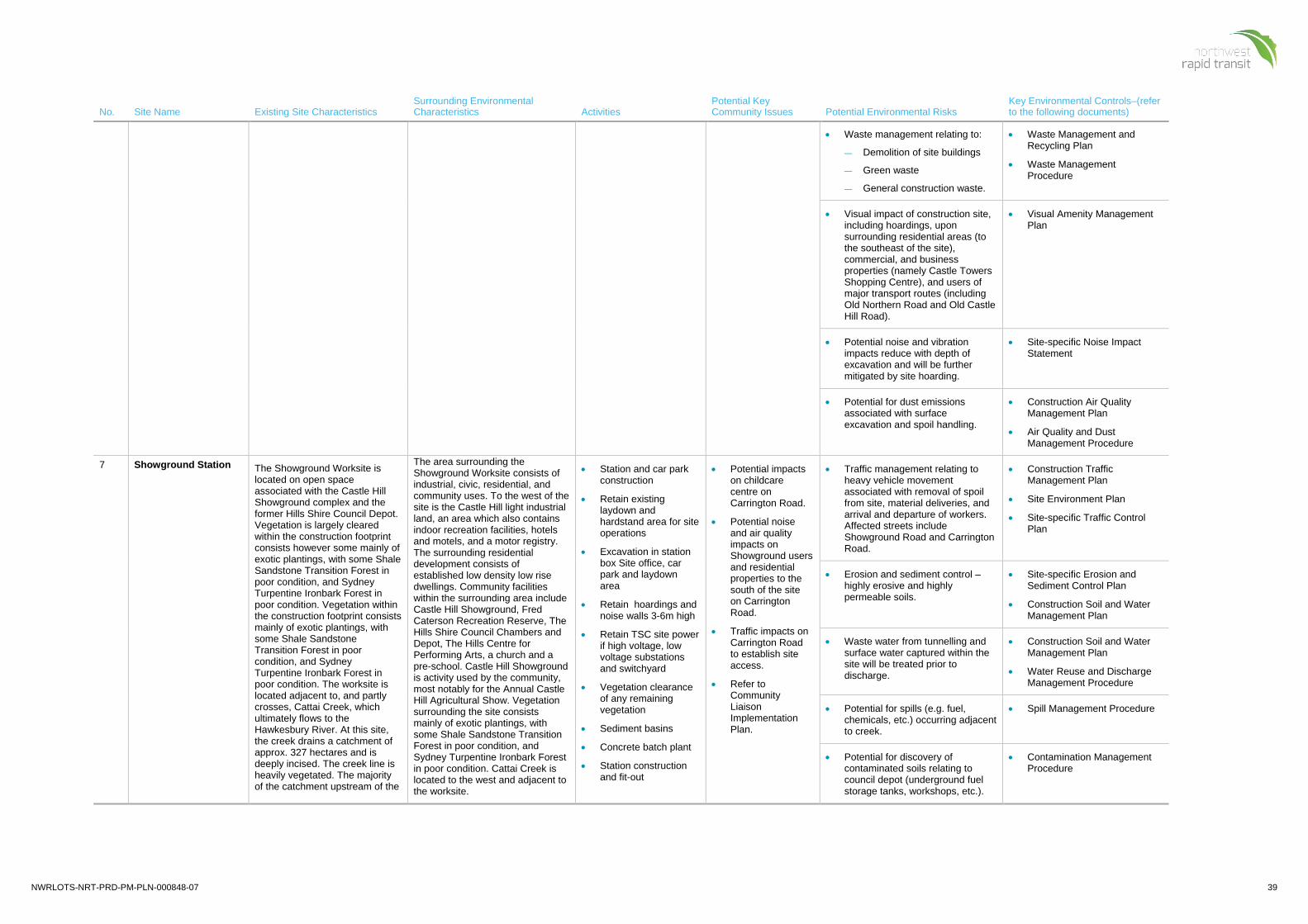
NWRLOTS-NRT-PRD-PM-PLN-000848-07 39
No. Site Name Existing Site Characteristics Surrounding Environmental Characteristics Activities
Potential Key Community Issues Potential Environmental Risks
Key Environmental Controls–(refer to the following documents)
• Waste management relating to:
— Demolition of site buildings
— Green waste
— General construction waste.
• Waste Management and Recycling Plan
• Waste Management Procedure
• Visual impact of construction site, including hoardings, upon surrounding residential areas (to the southeast of the site), commercial, and business properties (namely Castle Towers Shopping Centre), and users of major transport routes (including Old Northern Road and Old Castle Hill Road).
• Visual Amenity Management Plan
• Potential noise and vibration impacts reduce with depth of excavation and will be further mitigated by site hoarding.
• Site-specific Noise Impact Statement
• Potential for dust emissions associated with surface excavation and spoil handling.
• Construction Air Quality Management Plan
• Air Quality and Dust Management Procedure
7 Showground Station The Showground Worksite is located on open space associated with the Castle Hill Showground complex and the former Hills Shire Council Depot. Vegetation is largely cleared within the construction footprint consists however some mainly of exotic plantings, with some Shale Sandstone Transition Forest in poor condition, and Sydney Turpentine Ironbark Forest in poor condition. Vegetation within the construction footprint consists mainly of exotic plantings, with some Shale Sandstone Transition Forest in poor condition, and Sydney Turpentine Ironbark Forest in poor condition. The worksite is located adjacent to, and partly crosses, Cattai Creek, which ultimately flows to the Hawkesbury River. At this site, the creek drains a catchment of approx. 327 hectares and is deeply incised. The creek line is heavily vegetated. The majority of the catchment upstream of the
The area surrounding the Showground Worksite consists of industrial, civic, residential, and community uses. To the west of the site is the Castle Hill light industrial land, an area which also contains indoor recreation facilities, hotels and motels, and a motor registry. The surrounding residential development consists of established low density low rise dwellings. Community facilities within the surrounding area include Castle Hill Showground, Fred Caterson Recreation Reserve, The Hills Shire Council Chambers and Depot, The Hills Centre for Performing Arts, a church and a pre-school. Castle Hill Showground is activity used by the community, most notably for the Annual Castle Hill Agricultural Show. Vegetation surrounding the site consists mainly of exotic plantings, with some Shale Sandstone Transition Forest in poor condition, and Sydney Turpentine Ironbark Forest in poor condition. Cattai Creek is located to the west and adjacent to the worksite.
• Station and car park construction
• Retain existing laydown and hardstand area for site operations
• Excavation in station box Site office, car park and laydown area
• Retain hoardings and noise walls 3-6m high
• Retain TSC site power if high voltage, low voltage substations and switchyard
• Vegetation clearance of any remaining vegetation
• Sediment basins
• Concrete batch plant
• Station construction and fit-out
• Potential impacts on childcare centre on Carrington Road.
• Potential noise and air quality impacts on Showground users and residential properties to the south of the site on Carrington Road.
• Traffic impacts on Carrington Road to establish site access.
• Refer to Community Liaison Implementation Plan.
• Traffic management relating to heavy vehicle movement associated with removal of spoil from site, material deliveries, and arrival and departure of workers. Affected streets include Showground Road and Carrington Road.
• Construction Traffic Management Plan
• Site Environment Plan
• Site-specific Traffic Control Plan
• Erosion and sediment control – highly erosive and highly permeable soils.
• Site-specific Erosion and Sediment Control Plan
• Construction Soil and Water Management Plan
• Waste water from tunnelling and surface water captured within the site will be treated prior to discharge.
• Construction Soil and Water Management Plan
• Water Reuse and Discharge Management Procedure
• Potential for spills (e.g. fuel, chemicals, etc.) occurring adjacent to creek.
• Spill Management Procedure
• Potential for discovery of contaminated soils relating to council depot (underground fuel storage tanks, workshops, etc.).
• Contamination Management Procedure
40 NWRLOTS-NRT-PRD-PM-PLN-000848-07
No. Site Name Existing Site Characteristics Surrounding Environmental Characteristics Activities
Potential Key Community Issues Potential Environmental Risks
Key Environmental Controls–(refer to the following documents)
worksite is urbanised, and the headwaters and most small tributaries have been piped. The prevailing topography and drainage at the Worksite conveys all flows north and west.
The site is now a construction worksite.
• Station precinct works • Part of the site is potentially
impacted by Cattai Creek during storm events. Surface water flows will be managed through contouring during site establishment.
• Construction Soil and Water Management Plan
• Adjacent habitat for Sydney Turpentine Ironbark Forest located around Cattai Creek (in poor condition). The creek may provide habitat for the Large-footed (Southern) Myotis bat.
• Adjacent habitat for Cumberland Plain Woodland located to the east of the site.
• Ecological Monitoring Program
• Ecological Unexpected Finds Procedure
• Non-Indigenous Heritage:
— Castle Hill Showground is a heritage site of local significance.
— Potential for archaeological remains from two pre-1920s buildings and potential car remains.
Note TfNSW has completed required investigation and salvage works
• Historic and Aboriginal Heritage Procedure
• Waste management relating to:
— Demolition of site buildings
— Green waste
— General construction waste
— Waste water from tunnelling
— Other wastewater streams– dust suppression and washdown.
• Waste Management and Recycling Plan
• Waste Management Procedure
• Water Reuse and Discharge Management Procedure

NWRLOTS-NRT-PRD-PM-PLN-000848-07 41
No. Site Name Existing Site Characteristics Surrounding Environmental Characteristics Activities
Potential Key Community Issues Potential Environmental Risks
Key Environmental Controls–(refer to the following documents)
• Visual impact of construction site, including hoardings, upon surrounding residential and business properties (namely along Carrington Road), users of the Castle Hill Showground facilities, and users of surrounding transport routes (Carrington Road and Showground Road).
• Potential for light spillage from night works impacting upon surrounding residents.
• Visual Amenity Management Plan
• Potential construction noise and vibration impacts from 24 hour station construction. Noise will be mitigated by hoarding and acoustic enclosures.
• Construction Noise and Vibration Management Plan
• Dust associated with station construction and precinct works.
• Construction Air Quality Management Plan
• Air Quality and Dust Management Procedure
8 Norwest Station (including Pedestrian Link works)
Norwest Worksite is to be located in the existing specialised centre of Norwest. Norwest is a major employment area characterised by large commercial buildings, including extensive car parking and road networks. The footprint of construction works will be located on Norwest Boulevard. Vegetation within the worksite consists of exotic plantings. There are no watercourses on or adjacent to the worksite. The prevailing topography and drainage conveys stormwater to the existing piped system under Norwest Boulevard, where it mixes with runoff from surrounding roads and commercial developments. From there it drains to Strangers Creek via a series of rehabilitated watercourses and Norwest Lake.
The site is now a construction worksite.
Norwest is a major employment area characterised by large commercial buildings. Community facilities located within the surrounding area include Hillsong Church, Convent of St Joseph, retail facilities (Bunnings and Norwest Marketown), restaurants, gyms, and some residential buildings (mostly single detached dwellings, with some medium density currently being developed). Vegetation surrounding the site consists of exotic plantings. Two small, ephemeral watercourses flow in a northerly direction from Norwest, joining to become Strangers Creek (a tributary of Cattai Creek) approximately 500m north of Norwest Boulevard. Both of these watercourses have been significantly rehabilitated and modified, including stormwater quality improvement devices (SQIDs) such as constructed wetlands.
• Station construction
• Existing 3m high hoardings
• Clearance of remaining where required
• Installation/ or resumption of existing site sheds
• Earthworks will be undertaken to level site and provide enough laydown and hardstand area for site operations
• Piling will be undertaken for the station box
• Bulk excavation of station box will be undertaken using excavators and bulldozer
• Potential noise and air quality impacts on surrounding businesses in Norwest Business Park and residential properties to the south of the site.
• Construction traffic impacts on Brookhollow Avenue.
• Potential impacts on businesses in Brookhollow Avenue.
• Refer to Community Liaison Implementation Plan.
• Traffic management relating to heavy vehicle movements associated with the removal of spoil from site, material deliveries, and arrival and departure of workers. Affected streets include Norwest Boulevard and Brookhollow Avenue.
• Construction Traffic Management Plan
• Site Environment Plan
• Site-specific Traffic Control Plan
• Erosion and sediment control – highly erosive soils, moderate to high soil salinity.
• Site-specific Erosion and Sediment Control Plan
• Potential for discovery of contaminated soils relating to presence of nearby Shell service station.
• Contamination Management Procedure
• Management of spoil from station box excavation.
• Spoil Management Plan
• Waste management relating to: Demolition of site buildings, Green waste and General construction waste.
• Waste Management and Recycling Plan
• Waste Management Procedure

42 NWRLOTS-NRT-PRD-PM-PLN-000848-07
No. Site Name Existing Site Characteristics Surrounding Environmental Characteristics Activities
Potential Key Community Issues Potential Environmental Risks
Key Environmental Controls–(refer to the following documents)
• Utility adjustments and relocations, and local area works including road works, are required to establish this site
• Materials laydown and spoil stockpiling
• Site Amenities • Concrete batch plant • Station construction
and fit-out
• Station precinct works
• Visual impact of construction site, including hoardings, upon businesses at Norwest Market Town Shopping Centre, commercial properties along Brookhollow Avenue, community facilities including Hillsong Church, and on users of Norwest Boulevarde.
• Visual Amenity Management Plan
• Potential noise and vibration impacts reduce with depth of excavation and will be further mitigated by site hoarding.
• Construction Noise and Vibration Management Plan
• Potential for dust emissions associated with surface spoil handling.
• Construction Air Quality Management Plan
• Air Quality and Dust Management Procedure
• Potential for impact on utilities services not identified
• Community Liaison Implementation Plan
• Business Management Plan
9 Bella Vista Station The Bella Vista Precast Facility site was previously vegetated, including Cumberland Plain Woodland. There was some residential development scattered throughout the site. The Bella Vista Tunnelling site was previously occupied by the Totally Home Centre bulky goods retail complex. The site is located to the north of the western extent of the Norwest Specialised Centre with frontage to Old Windsor Road.
The site is now a construction worksite.
Surrounding areas are characterised as rural and low density residential development exists to the west.
EIS 1 indicates that the area to the east of the site is mostly low density residential with small pockets of medium density townhouse development. Areas to the north and north east are mostly rural.
• Utilise the existing TSC site office, establish site amenities for the workforce at the TSC shed location
• Demolition / Removal of some TSC handover elements
• Convert small TSC car park to OTS laydown area
• Additional scaffold for station platform construction (access at tunnel portal is alternate access)
• Excavation, piling and station construction
• Site Amenities to include:
— Staff amenities
— Containers and materials storage
— Dangerous goods storage (Hazmat container)
• Barriers around station box, site fencing / noise walls and Site Access utilise
• Potential noise and air quality impacts on surrounding businesses as well as nearby residential properties
• Construction traffic impacts on nearby roads.
• Traffic management relating to heavy vehicle movements associated with the removal of spoil from site, material deliveries, and arrival and departure of workers.
• Construction Traffic Management Plan
• Site Environment Plan
• Site-specific Traffic Control Plan
• Erosion and sediment control –erosive soils, moderate to high soil salinity
• Site-specific Erosion and Sediment Control Plan
• Waste management relating to: Demolition of site buildings, Green waste and General construction waste.
• Waste Management and Recycling Plan
• Waste Management Procedure
• Potential for spills (e.g. fuel, chemicals, etc.) occurring close to Strangers Creek.
• Construction Soil and Water Management Plan
• Management of spoil from construction works.
• Spoil Management Plan
• Potential for dust emissions associated with surface spoil handling.
• Construction Air Quality Management Plan
• Air Quality and Dust Management Procedure
• Adjacent habitat for Cumberland Plain Woodland located to the east of the site.
• Primary and Secondary Habitat for Green and Golden Bell Frog.
• Ecological Monitoring Program
• Ecological Unexpected Finds Procedure
NWRLOTS-NRT-PRD-PM-PLN-000848-07 43
No. Site Name Existing Site Characteristics Surrounding Environmental Characteristics Activities
Potential Key Community Issues Potential Environmental Risks
Key Environmental Controls–(refer to the following documents)
handover elements from TSC project
• Concrete batch plant
• General civil works
• Station construction and fit-out
• Station precinct works
• Potential noise and vibration impacts due to construction works. Where relevant, noise and vibration will be mitigated by site hoarding.
• Construction Noise and Vibration Management Plan
• Site-specific Noise Impact Statement
10 Balmoral Road The Balmoral Road site was approved to be approximately 190,000m2 in size, located on the corner of Old Windsor Road and Balmoral Road, to the north of the proposed Bella Vista Station.
The site was previously semi-rural open space.
The site is currently utilised by the SVC Contractor and is a construction worksite.
These two construction sites are surrounded by residential development and service installations. The natural creek line and riparian vegetation surrounding Elizabeth Macarthur Creek demonstrates some areas of moderate to high environmental sensitivity. The T-way is a recent transport infrastructure with parking and roadway running parallel to Windsor Road, running adjacent to these worksites.
• Aboveground civil works
• Internal road
• Potential noise, air quality, visual and other amenity impacts on surrounding residential properties surrounding the site (particularly to east and west).
• Construction traffic impacts on Balmoral Road.
• Traffic management relating to heavy vehicle movements associated with the removal of spoil from site, material deliveries, and arrival and departure of workers.
• Impact to the T-Way
• Construction Traffic Management Plan
• Site Environment Plan
• Site-specific Traffic Control Plan
• Waste management relating to: Demolition of site buildings, Green waste and General construction waste.
• Waste Management and Recycling Plan
• Waste Management Procedure
• Potential for spills (e.g. fuel, chemicals, etc.) occurring.
• Construction Soil and Water Management Plan
• Site-specific Erosion and Sediment Control Plan
• Potential for dust emissions associated with surface spoil handling.
• Construction Air Quality Management Plan
• Air Quality and Dust Management Procedure
• Adjacent habitat for Cumberland Plain Woodland located to the east of the site.
• Primary and Secondary Habitat for Green and Golden Bell Frog
• Flora and Fauna Ecological Monitoring Program
• Ecological Unexpected Finds Procedure
11 Memorial Avenue The Memorial Avenue construction site is approved to encompass an area of approximately 120,000m2, located on the south eastern corner of Old Windsor Road and Memorial Avenue extending back to Balmoral Road.
A T-way car park and bus station, open space and some semi-rural properties occupy the site and a 132kV high voltage electrical transmission line crosses over the site at the southern end.
The North-West T-way bus station and carriageway would likely remain unaffected during the construction period, however
These two construction sites are surrounded by residential development and service installations. The natural creek line and riparian vegetation surrounding Elizabeth Macarthur Creek demonstrates some areas of moderate to high environmental sensitivity. The T-way is a recent transport infrastructure with parking and roadway running parallel to Windsor Road, running adjacent to these worksites.
• Aboveground civil works
• Temporary relocation of the T-way car park
• Internal road
• Potential noise, air quality, visual and other amenity impacts on surrounding residential properties surrounding the site (particularly to east and west).
• Construction traffic impacts on Memorial Avenue.
• Traffic management relating to heavy vehicle movements associated with the removal of spoil from site, material deliveries, and arrival and departure of workers.
• Impact to the T-Way
• Construction Traffic Management Plan
• Site Environment Plan
• Site-specific Traffic Control Plan
• Waste management relating to: Demolition of site buildings, Green waste and General construction waste.
• Waste Management and Recycling Plan

44 NWRLOTS-NRT-PRD-PM-PLN-000848-07
No. Site Name Existing Site Characteristics Surrounding Environmental Characteristics Activities
Potential Key Community Issues Potential Environmental Risks
Key Environmental Controls–(refer to the following documents)
the T-way car parking is temporarily relocated to the eastern side of the bus station to allow for the viaduct construction under the SVC Contract.
The site is currently occupied by the SVC Contractor with the site used to construct a section of viaduct, in a bridge over Memorial Avenue. The construction works associated with the permanent rail alignment through this site would include cutting and embankment construction, as well as viaduct construction.
The site is now a construction worksite.
• Waste Management Procedure
• Potential for spills (e.g. fuel, chemicals, etc.) occurring on site and adjacent to Elizabeth Macarthur Creek.
• Construction Soil and Water Management Plan
• Site-specific Erosion and Sediment Control Plan
• Potential for dust emissions associated with surface spoil handling.
• Potential noise and vibration impacts due to construction works. Where relevant, noise and vibration will be mitigated by site hoarding.
• Construction Air Quality Management Plan
• Air Quality and Dust Management Procedure
• Adjacent habitat for Cumberland Plain Woodland located to the east of the site.
• Primary and Secondary Habitat for Green and Golden Bell Frog.
• Flora and Fauna Ecological Monitoring Program
• Ecological Unexpected Finds Procedure
• Potential for impact to European Heritage along Windsor Road.
• Historic and Aboriginal Heritage Procedure
12 Kellyville Station The Kellyville Station construction site is approved to cover an area of approximately 100,000m2, extending from Memorial Avenue to Samantha Riley Drive. The site previously included a North-West T-way car park and bus station, open space, and semi-rural properties however the worksite is currently occupied by the SVC Contractor. Major civil construction works currently at this site involve: • Temporary and permanent
road works, including the temporary relocation of some T-way facilities. The existing T-way car parking facilities are likely to be shifted to the south with a dedicated pedestrian walkway established from this car park, along Samantha Riley
T-way car park and bus station, open space, and semi-rural properties.
This site is surrounded by residential and services development and the establishment of the Northwest T-way. Native vegetation has been largely stripped, except adjacent to Elizabeth Macarthur Creek.
• Aboveground civil works and Station construction
• Site accommodation established within the site boundary, adjacent Samantha Riley Drive, whilst maintaining a temporary public car park with 400 spaces for the T-way.
• A site canteen will be provided, which will avoid unnecessary vehicle and pedestrian movements from the site at morning and lunch breaks and prevent productivity losses
• Potential noise, air quality, visual and other amenity impacts on surrounding residential properties surrounding the site (particularly to east and west).
• Construction traffic impacts on Samantha Riley Drive.
• Traffic management relating to heavy vehicle movements associated with the removal of spoil from site, material deliveries, and arrival and departure of workers.
• Impact to the T-Way
• Construction Traffic Management Plan
• Site Environment Plan
• Site-specific Traffic Control Plan
• Waste management relating to: Demolition of site buildings, Green waste and General construction waste.
• Waste Management and Recycling Plan
• Waste Management Procedure
• Potential for spills (e.g. fuel, chemicals, etc.) occurring adjacent to Elizabeth Macarthur Creek.
• Construction Soil and Water Management Plan
• Site-specific Erosion and Sediment Control Plan
• Potential for dust emissions associated with surface spoil handling.
• Construction Air Quality Management Plan
• Air Quality and Dust Management Procedure

NWRLOTS-NRT-PRD-PM-PLN-000848-07 45
No. Site Name Existing Site Characteristics Surrounding Environmental Characteristics Activities
Potential Key Community Issues Potential Environmental Risks
Key Environmental Controls–(refer to the following documents)
Drive to the current T-way bus station.
• Viaduct launch and support site, including a rail bridge over Samantha Riley Drive and storage and laydown areas.
• Station civil construction works on the viaduct structure.
Access to and egress from the site is off Samantha Riley Drive and Memorial Avenue, with internal roads established within the site. This construction site would be utilised by NRT to construct Kellyville Station. The site includes car parking, site offices, a workshop and stores at the southern end.
The site is now a construction worksite.
• Parking for staff and workers provided within the site
• Cranage up to the viaduct will be via mobile cranes
• Concrete pumping will be via truck mounted boom pump at ground level
• Site fencing with a minimum of branded shade cloth covering will surround the perimeter of the site
• Access to the viaduct and platform zone will be via a set of scaffold access stairs at each end of the station area
• A temporary sediment basin will be utilised during construction until the permanent stormwater management system has been constructed.
• Protection fences will be installed to exclude the listed heritage areas along the original formation of Old Windsor Rd (T-Way alignment) from the construction site.
• Adjacent habitat for Cumberland Plain Woodland located to the east of the site.
• Primary and Secondary Habitat for Green and Golden Bell Frog.
• Flora and Fauna Ecological Monitoring Program
• Ecological Unexpected Finds Procedure
• Potential noise and vibration impacts due to construction works. Where relevant, noise and vibration will be mitigated by site hoarding.
• Construction Noise and Vibration Management Plan
• Site-specific Noise Impact Statement
• Impacts to Heritage sites (Old Windsor Road precinct and Archaeological site )
• Historic and Aboriginal Heritage Procedure
13 Windsor Road/Old Windsor Road
The site extends from Samantha Riley Drive to the Windsor Road / Old Windsor Road intersection and is approved to cover an area of approximately 50,000m2. The site previously consisted of open space, located on an existing floodplain.
The site would be used to support viaduct construction and a bridge over Windsor Road, as currently being completed under the SVC Works.
Access to and egress from the site would is directly on and off Samantha Riley Drive and Windsor Road. Internal roads
This area has been developed more recently with housing and water utilities and the establishment of the Northwest T-way. Native vegetation has been largely stripped, except adjacent to Elizabeth Macarthur Creek.
• Corridor construction Works (mobile worksites)
• Potential air quality, visual and other amenity impacts on surrounding residential properties surrounding the site (particularly to east and west).
• Construction traffic impacts on Windsor Road.
• Potential for noise and vibration impacts to sensitive receivers
• Traffic management relating to heavy vehicle movements associated with the removal of spoil from site, material deliveries, and arrival and departure of workers.
• Impact to the T-Way
• Construction Traffic Management Plan
• Site Environment Plan
• Site-specific Traffic Control Plan
• Potential for spills (e.g. fuel, chemicals, etc.) occurring adjacent to creek.
• Construction Soil and Water Management Plan
• Site-specific Erosion and Sediment Control Plan
• Potential for dust emissions associated with surface spoil handling.
• Air Quality and Dust Management Procedure
46 NWRLOTS-NRT-PRD-PM-PLN-000848-07
No. Site Name Existing Site Characteristics Surrounding Environmental Characteristics Activities
Potential Key Community Issues Potential Environmental Risks
Key Environmental Controls–(refer to the following documents)
have been established through the site.
The site is now a construction worksite.
including John XXIII Catholic Primary School.
• Adjacent habitat for River-flat Eucalypt Forest located to the north-east of the site.
• Primary and Secondary Habitat for Green and Golden Bell Frog.
• Removal of hollow-bearing trees and vegetation removal in proximity to Elizabeth Macarthur Creek.
• Flora and Fauna Ecological Monitoring Program
• Ecological Unexpected Finds Procedure
• Flora and Fauna Management Plan
• Potential for impact to Aboriginal heritage sites – Previously identified PAD covers the whole site due to the proximity to Elizabeth Macarthur Creek and potential for Aboriginal occupation.
• Potential for impact to European Heritage along Old Windsor Road.
• Historic and Aboriginal Heritage Procedure
• Potential noise and vibration impacts due to construction works. Where relevant, noise and vibration will be mitigated by site hoarding.
• Construction Noise and Vibration Management Plan
• Site-specific Noise Impact Statement
14 Old Windsor Road/White Hart Drive
The site extends from Windsor Road / Old Windsor Road intersection to White Hart Drive and is approved to cover an area of approximately 97,000m2. The site consists of waterways and associated floodplains. There were a number of commercial properties at the southern end. The site spans Sanctuary Drive.
Currently the site is occupied by the SVC Contractor and is used for the major civil construction works including:
• Major works on the North-West T-way.
• Viaduct launch and support site.
• Worker amenities, and material storage and laydown at the southern end of the site.
The site is located on the eastern side of Windsor Road, north of the intersection with Old Windsor Road Note that although listed separately in the EIS report on which this document is based, it has since been determined by the heritage consultants that the Swan Inn and the White Hart Inn are the same structure which have historically been referred to by different names.
• Corridor construction Works (mobile worksites)
• Potential air quality, visual and other amenity impacts on surrounding residential properties surrounding the site (particularly to east and west).
• Construction traffic impacts on Sanctuary Drive.
• Potential impacts to European heritage site – White Hart Inn.
• Traffic management relating to heavy vehicle movements associated with the removal of spoil from site, material deliveries, and arrival and departure of workers.
• Impact to the T-Way
• Construction Traffic Management Plan
• Site Environment Plan
• Site-specific Traffic Control Plan
• Potential for spills (e.g. fuel, chemicals, etc.) occurring adjacent to creek.
• Construction Soil and Water Management Plan
• Site-specific Erosion and Sediment Control Plan
• Potential for dust emissions associated with surface spoil handling.
• Construction Air Quality Management Plan
• Air Quality and Dust Management Procedure
• Erosion and sediment control –erosive soils, moderate to high soil salinity.
• Construction Soil and Water Management Plan
• Site-specific Erosion and Sediment Control Plan

NWRLOTS-NRT-PRD-PM-PLN-000848-07 47
No. Site Name Existing Site Characteristics Surrounding Environmental Characteristics Activities
Potential Key Community Issues Potential Environmental Risks
Key Environmental Controls–(refer to the following documents)
Access to and egress from the site is off Windsor Road and Sanctuary Drive. Internal roads have been established through the site.
The site is now a construction worksite.
• Adjacent habitat for River-flat Eucalypt Forest located to the east of the site and Cumberland Plain Woodland within the site north of Sanctuary Drive.
• Primary and Secondary Habitat for Green and Golden Bell Frog.
• Removal of hollow-bearing trees and vegetation removal in proximity to Caddies Creek.
• Flora and Fauna Ecological Monitoring Program
• Ecological Unexpected Finds Procedure
• Construction Flora and Fauna Management Plan
• Potential for impact to Aboriginal heritage sites – Previously identified PAD covers the whole site due to the proximity to Elizabeth Macarthur Creek and potential for Aboriginal occupation.
• Potential for impact to European Heritage – White Hart Inn
• Historic and Aboriginal Heritage Procedure
• Potential noise and vibration impacts due to construction works. Where relevant, noise and vibration will be mitigated by site hoarding.
• Construction Noise and Vibration Management Plan
• Site-specific Noise Impact Statement
15 Rouse Hill Station The Rouse Hill Station construction site is located adjacent to Windsor Road directly in front of Rouse Hill Town Centre. The site is approved to cover approximately 18,000m2 in area and encompasses the previously located existing bus station. The bus station and layover have temporarily been relocated.
The site is currently occupied by the SVC Contractor with major civil construction works including:
• Viaduct launch and support site, including limited storage of pre-cast viaduct elements.
• Station civil construction works on the viaduct structure (form OTS Works to be completed by NRT).
The construction works will be staged along the frontage of the Rouse Hill Town Centre. Access to and egress from the site is via one access/egress point on Windsor Road, located near White Hart Drive and one access/egress point near Rouse Hill Drive. Internal access roads
Rouse Hill Shopping Precinct. The site is surrounded by the grounds of the Rouse Hill Town Centre with the majority of the area cleared and subject to extensive urban development.
• Station construction
• Temporary relocation of the T-way station
• Internal road
• Fencing/Hoarding ensure delineated thoroughfare for pedestrians.
• Site office, amenities & site parking – use existing car park (handover from SVC)
• Services connection
• Retain access road into site car park
• Erect Scaffold tower for access to the viaduct.
• Removal of the Tower clock opposite main street
• Removal of existing buildings along Tempus street
• Use of Northern Car Park for site parking and additional lay
• Potential noise and air quality impacts on surrounding businesses at the Rouse Hill Shopping Precinct, residential properties to the west of the site and the Castle Lawn Cemetery and Crematorium to the south-west of the site.
• Construction traffic impacts on White Hart Drive and Windsor Road Refer to Community Liaison Implementation Plan.
• Traffic management relating to heavy vehicle movements associated with the removal of spoil from site, material deliveries, and arrival and departure of workers. Affected streets include White Hart Drive and Windsor Road.
• Traffic impacts on the operation of the NorthWest Transit Way (T-Way)
• Construction Traffic Management Plan
• Site Environment Plan
• Site-specific Traffic Control Plan
• Erosion and sediment control –erosive soils, moderate to high soil salinity.
• Site-specific Erosion and Sediment Control Plan
• Potential for discovery of contaminated soils relating to previous agricultural and light mining land use.
• Contamination Management Procedure
• Visual impact of construction site, including hoardings, upon businesses and residents located at the Rouse Hill Town Centre, and motorists and pedestrians accessing Rouse Hill Town Centre.
• Loss of amenity and views for Castlebrook Lawn Cemetery and Crematorium.
• Visual Amenity Management Plan

48 NWRLOTS-NRT-PRD-PM-PLN-000848-07
No. Site Name Existing Site Characteristics Surrounding Environmental Characteristics Activities
Potential Key Community Issues Potential Environmental Risks
Key Environmental Controls–(refer to the following documents)
have been established between these two points.
Site office and amenities are provided at the northern end of the site with car parking located at the southern end. The site includes two laydown areas, extending along the majority of the site at the westerns and eastern perimeters. Construction staging will affect the localities of amenities and storage and workshop during construction.
The site is now a construction worksite.
down areas if required. • Potential for dust emissions
associated with surface spoil handling.
• Construction Air Quality Management Plan
• Air Quality and Dust Management Procedure
• Impacts to Heritage sites (Battle of Vinegar Hill Memorial)
• Historic and Aboriginal Heritage Procedure
• Potential for impact on utilities services not previously identified.
• Community Liaison Implementation Plan
• Business Management Plan
16 Windsor Road Viaduct Construction sites have been approved to occur on the north east and north west corners of the Windsor Road, Schofields Road and Rouse Hill Drive intersection.
The site would be utilised specifically to support the viaduct construction over Windsor Road and Rouse Hill Drive. The site is approved to cover an area of approximately 61,000m2.
The site previously comprised an open space utilised as an overflow (untimed) car park for Rouse Hill Town Centre on the north-east side.
An internal road links the site with the proposed access off Schofields Road at the Terry Road reserve.
The site is occupied by the SVC Contractor. The site contains office and amenities located at the northern end of the site.
The north eastern site (also occupied by the SVC Contractor) includes car parking for construction workers.
The site is now a construction worksite.
This area is relatively undeveloped, with low-level of ground disturbance through vegetation clearance. Agricultural, low level rural properties and some light industrial/commercial land use is common in this area.
• Viaduct construction
• Bridge works at Windsor Road
• Potential air quality, visual and other amenity impacts on surrounding residential properties surrounding the site (particularly to east and west).
• Construction traffic impacts on nearby roads.
• Traffic management relating to heavy vehicle movements associated with the removal of spoil from site, material deliveries, and arrival and departure of workers.
• Impacts to Schofields Road
• Construction Traffic Management Plan
• Site Environment Plan
• Site-specific Traffic Control Plan
• Potential for discovery of contaminated soils relating to previous agricultural and light mining land use.
• Contamination Management Procedure
• Erosion and sediment control –erosive soils, moderate to high soil salinity.
• Site-specific Erosion and Sediment Control Plan
• Potential for spills (e.g. fuel, chemicals, etc.) occurring.
• Construction Soil and Water Management Plan
• Site-specific Erosion and Sediment Control Plan
• Adjacent habitat for Cumberland Plain Woodland located south and north of the site and adjacent to Schofields Road.
• Flora and Fauna Ecological Monitoring Program
• Ecological Unexpected Finds Procedure
• Construction Flora and Fauna Management Plan
• Potential noise and vibration impacts due to construction works. Where relevant, noise and vibration will be mitigated by site hoarding.
• Construction Noise and Vibration Management Plan
• Site-specific Noise Impact Statement
• Potential for dust emissions associated with surface spoil handling and spoil excavation.
• Construction Air Quality Management Plan
• Air Quality and Dust Management Procedure

NWRLOTS-NRT-PRD-PM-PLN-000848-07 49
No. Site Name Existing Site Characteristics Surrounding Environmental Characteristics Activities
Potential Key Community Issues Potential Environmental Risks
Key Environmental Controls–(refer to the following documents)
17 Windsor Road Viaduct to Cudgegong Road
The site extends from the end of the proposed viaduct structure to Cudgegong Road. Currently, this site incorporates the edge of an existing quarry, open space, residential properties, and Second Ponds Creek and its associated floodplain. The site is approved to cover an area of approximately 83,000m2.
A 132kV high voltage electrical transmission line crosses under the site at the western end, immediately prior to Cudgegong Road.
The site is currently occupied by the SVC Contractor and is used to support and undertake general civil works including cutting and embankment construction, and bridge construction under the SVC Works.
Access to and egress from the site would is provided via Cudgegong Road and Schofields Road. An internal road has been established adjacent to the NWRL alignment along the length of the site.
The site is now a construction worksite.
This area has predominant land use characteristic of rural properties concerned with agricultural, grazing and farming activities. Schofields Road has recently been widened and residential development to the south of Schofield Road is rapidly growing. To the north of Schofields Road, the landscape is changing to accommodate the construction of the proposed rail corridor; however various rural properties still surround the proposed alignment.
• Above ground civil works
• Viaduct construction
• Pre-fabrication yard
• Potential air quality, visual and other amenity impacts on surrounding residential properties surrounding the site (particularly to east and west).
• Construction traffic impacts on nearby roads.
• Traffic management relating to heavy vehicle movements associated with the removal of spoil from site, material deliveries, and arrival and departure of workers.
• Construction Traffic Management Plan
• Site Environment Plan
• Site-specific Traffic Control Plan
• Potential for discovery of contaminated soils relating to previous agricultural and light mining land use.
• Contamination Management Procedure
• Erosion and sediment control –erosive soils, moderate to high soil salinity.
• Site-specific Erosion and Sediment Control Plan
• Adjacent habitat for River-flat Eucalypt Forest located north and south of the site, along Seconds Pond Creek system.
• Primary and Secondary Habitat for Green and Golden Bell Frog.
• Flora and Fauna Ecological Monitoring Program
• Ecological Unexpected Finds Procedure
• Construction Flora and Fauna Management Plan
• Potential for spills (e.g. fuel, chemicals, etc.) occurring within Second Ponds Creek.
• Construction Soil and Water Management Plan
• Site-specific Erosion and Sediment Control Plan
• Potential noise and vibration impacts due to construction works. Where relevant, noise and vibration will be mitigated by site hoarding.
• Noise and Vibration Management Plan
• Site-specific Noise Impact Statement
• Potential for dust emissions associated with surface spoil handling and spoil excavation.
• Construction Air Quality Management Plan
• Air Quality and Dust Management Procedure
18 Willoughby to North Chatswood The site extends from Ausgrid’s
Willoughby substation to the TfNSW Chatswood North Traction Substation (William Street, Chatswood). Works would be carried out predominantly within the existing road reserves.
Residential receivers are located along the length of the proposal. The works take place within the road corridor and may be approximately 5–10 metres from receivers when works are at their closest point to residential receivers. Residential receivers are located within the vicinity of all of the works, with the exception of works on Campbell Street, Clarendon Street and Dickson Avenue, which are primarily commercial and light industrial land uses.
• Excavation works
• Hammering/saw cutting
• Laying of cable
• Small compounds with basic amenities and storage
• Potential air quality, visual and other amenity impacts on surrounding residential properties
• Construction traffic impacts on nearby roads.
• Access to properties and businesses
• Traffic management relating to heavy vehicle movements associated with the removal of spoil from site, material deliveries, and arrival and departure of workers
• Construction Traffic Management Plan
• Site Environment Plan
• Site-specific Traffic Control Plan
• Potential noise and vibration impacts due to construction works being close to residential properties
• Noise and Vibration Management Plan
• Site-specific CNVIS
• Potential for dust emissions associated with surface spoil handling.
• Air Quality and Dust Management Procedure

50 NWRLOTS-NRT-PRD-PM-PLN-000848-07
No. Site Name Existing Site Characteristics Surrounding Environmental Characteristics Activities
Potential Key Community Issues Potential Environmental Risks
Key Environmental Controls–(refer to the following documents)
19 Rouse Hill Temporary Bypass Powerline The worksite runs from the
southern side of the Sydney Metro Windsor Road Bridge crossing Schofields Road, running underground through Castlebrook Memorial Park transitioning back to overhead and crossing Windsor Road to the Rouse Hill traction substation located south of Sanctuary Drive.
See Sections 14- 16 in this table for the surrounding environment
• Excavation works
• Laying of cable
• Pole Installation
• Small compound with basic amenities and storage within Castlebrook Memorial Park
• Noise impacts during services at the Memorial Park
• Potential air quality, visual and other amenity impacts on surrounding residential properties
• Construction traffic impacts on nearby roads
• Traffic management relating to heavy vehicle movements associated with the removal of spoil from site, material deliveries, and arrival and departure of workers
• Construction Traffic Management Plan
• Site Environment Plan
• Site-specific Traffic Control Plan
• Potential noise impacts due to construction works being close to services in the memorial park
• Noise and Vibration Management Plan
• Site-specific CNVIS
• Scheduling of works around services where possible
• Potential for dust emissions associated with surface spoil handling.
• Air Quality and Dust Management Procedure
20 Castle Hill Site Office Relocation The proposed ancillary facility
site at 331-333 Old Northern Rd, Castle Hill and 1A Brisbane Rd, Castle Hill is located directly opposite Old Northern Road to Castle Hill Station Site. This site is proposed to be used as the new site office, staff car parking and small laydown as to progress works on site the current site office and parking area is required.
The site identified for the new site office is adjacent Castle Hill Station Site on Old Northern Rd. Residential receivers are within close proximity to 331-333 Old Northern Rd, being immediately next door at 335 Old Northern Rd along with close surrounding community. There have been no identified nearby waterways, heritage items or vegetation of significance.
• Car park
• Portable offices
• Crib shed / lunch room
• Toilets
• Access and egress to Brisbane Rd
• Laydown area
• Potential air quality, visual and other amenity impacts on surrounding residential properties
• Construction traffic impacts on nearby roads
• Visual impact of construction site, including hoardings, upon surrounding residential areas (to the southeast of the site), commercial, and business properties (namely Castle Towers Shopping Centre), and users of major transport routes (including Old Northern Road and Old Castle Hill Road).
• Visual Amenity Management Plan
• Potential noise and vibration impacts reduce with depth of excavation and will be further mitigated by site hoarding.
• Site-specific Noise Impact Statement
• Approved Ancillary Facilities Checklist for Castle Hill Site Office Relocation dated 18th June 2018. DP&E Approval was received to undertake these works on 18th June 2018.
• Relocation of two possum dreys within nearby vegetated area prior to any clearing as per condition of approval in DP&E letter dated 18th June 2018

NWRLOTS-NRT-PRD-PM-PLN-000848-07 51
Annexure C Ancillary Facility Assessment Checklist
The following checklist will be used to assess any future Ancillary Facilities not identified in the EIS or this CCAMP.
Criteria Comments
Compliant
Y/N
More than 50 metres from a waterway
Within or adjacent to OTS works areas
Ready access to the road network
Minimises the need for heavy vehicle movements in residential areas
Sited on relatively level land
Separated from nearest residences by at least 200 metres or are at least 300 metres away for a batching plant
No additional vegetation clearing
No impact on heritage items (including areas of archaeological sensitivity) beyond those already impacted by OTS works
No unreasonable impact to use of adjacent properties
Above the 20 year ARI flood level, unless a contingency plan to manage flooding is prepared and implemented
Sufficient area for storage of raw materials to minimise deliveries required outside standard construction hours.
Note: if any of the above are non-compliant, approval must be sought from the Director General of the Department of Planning and Environment. NRT / TfNSW will demonstrate to the satisfaction of the Director General that there will be no significant adverse impact from the facility’s construction and operation”

52 NWRLOTS-NRT-PRD-PM-PLN-000848-01

NWRLOTS-NRT-PRD-PM-PLN-000848-07 53
Annexure D RTRF Compounds Plan
Indicative RTRF Main Compound
SITE ACCESS POINT
PARKING
SITE OFFICE AND AMENITIES
LAYDOWN

54 NWRLOTS-NRT-PRD-PM-PLN-000848-07
Indicative RTRF Satellite Compound and Surrounding Features (Note: Not to scale)

NWRLOTS-NRT-PRD-PM-PLN-000848-07 55
Annexure E Cudgegong Road Compound Plan
Indicative site layout
The final layout may vary depending on construction requirements.

56 NWRLOTS-NRT-PRD-PM-PLN-000848-07
Annexure F Epping Services Facility Compound
Epping Worksite – Indicative site layout
The actual layout may vary depending on construction requirements.

NWRLOTS-NRT-PRD-PM-PLN-000848-07 57
Annexure G Phase 2 Worksites
Cheltenham Worksite – Indicative site layout (Source: EIS 2)
The actual layout may vary depending on construction requirements.

58 NWRLOTS-NRT-PRD-PM-PLN-000848-07
CherrybrookWorksite – Indicative site layout
The actual layout may vary depending on construction requirements.
Concrete Batch Plant

NWRLOTS-NRT-PRD-PM-PLN-000848-07 59
Castle Hill Worksite – Indicative site layout
The actual layout may vary depending on construction requirements.

60 NWRLOTS-NRT-PRD-PM-PLN-000848-07
Proposed Site Office for Castle Hill Worksite

NWRLOTS-NRT-PRD-PM-PLN-000848-07 61
Showground Worksite – Indicative site layout
The actual layout may vary depending on construction requirements.
Concrete Batch Plant

62 NWRLOTS-NRT-PRD-PM-PLN-000848-07
Norwest Worksite – Indicative site layout
The actual layout may vary depending on construction requirements.
Concrete Batch Plant

NWRLOTS-NRT-PRD-PM-PLN-000848-07 63
Bella Vista Worksite – Indicative site layout
The actual layout may vary depending on construction requirements.
Concrete Batch Plant

64 NWRLOTS-NRT-PRD-PM-PLN-000848-07
Balmoral Road Worksite – Indicative site layout (Source: EIS 2)
The actual layout may vary depending on construction requirements.

NWRLOTS-NRT-PRD-PM-PLN-000848-07 65
Memorial Avenue Worksite – Indicative site layout (Source: EIS 2)
The actual layout may vary depending on construction requirements.
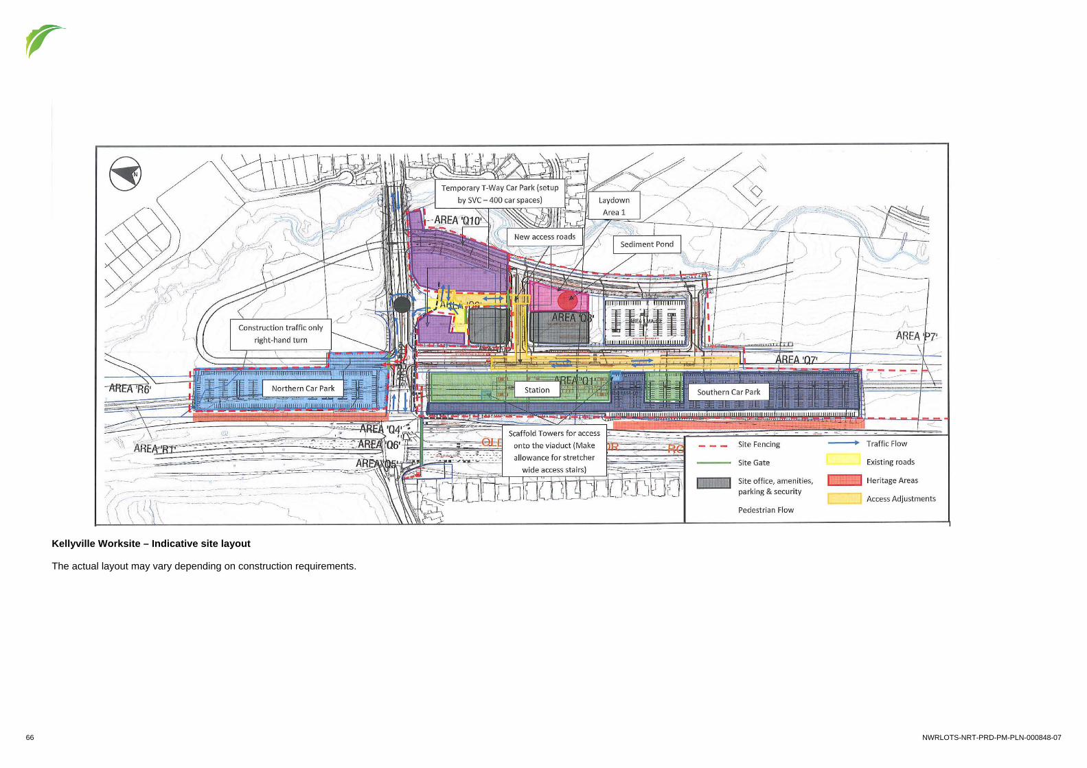
66 NWRLOTS-NRT-PRD-PM-PLN-000848-07
Kellyville Worksite – Indicative site layout
The actual layout may vary depending on construction requirements.

NWRLOTS-NRT-PRD-PM-PLN-000848-07 67
Rouse Hill Worksite – Indicative site layout
The actual layout may vary depending on construction requirements.

68 NWRLOTS-NRT-PRD-PM-PLN-000848-07
Samantha Riley Drive to Windsor Road Worksite including revised Shared Path Site – Indicative site (Source: EIS 2)
Shared Path work site
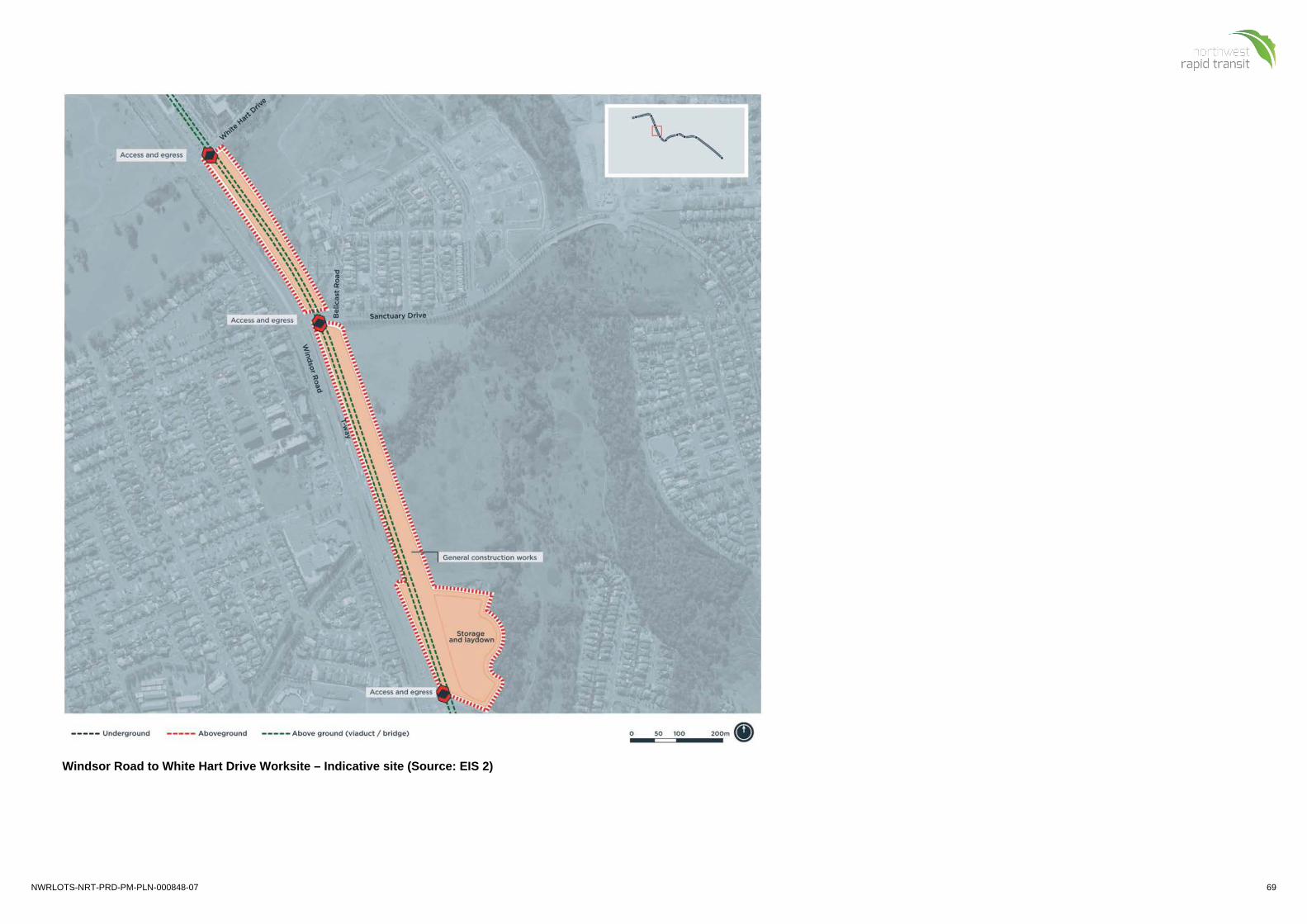
NWRLOTS-NRT-PRD-PM-PLN-000848-07 69
Windsor Road to White Hart Drive Worksite – Indicative site (Source: EIS 2)

70 NWRLOTS-NRT-PRD-PM-PLN-000848-07
Windsor Road Viaduct Worksite – Indicative site (Source: EIS 2)

NWRLOTS-NRT-PRD-PM-PLN-000848-07 71
Windsor Road Viaduct to Cudgegong Road Worksite – Indicative site (Source: EIS 2)

72 NWRLOTS-NRT-PRD-PM-PLN-000848-07
Norwest Pedestrian Link Site Compound

NWRLOTS-NRT-PRD-PM-PLN-000848-07 73
Transient compounds would be located within the alignment of the 33kV works
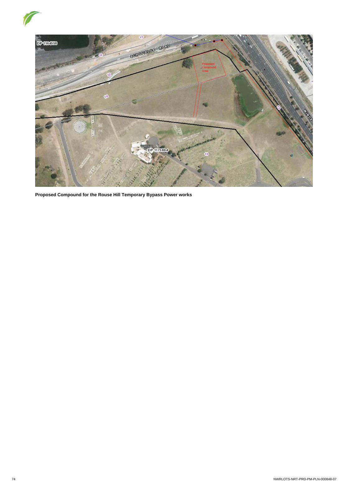
74 NWRLOTS-NRT-PRD-PM-PLN-000848-07
Proposed Compound for the Rouse Hill Temporary Bypass Power works

NWRLOTS-NRT-PRD-PM-PLN-000848-07 75
Annexure H Glossary Term Definition
AEC Areas of Environmental Concern
AHIMS Aboriginal Heritage Information Management System
AMS Activity Method Statement
ANZECC Australian and New Zealand Environment Conservation Council
ARI Average Recurrence Interval
ARMCANZ Agriculture and Resources Management Council of Australia and New Zealand
ASS Acid Sulfate Soil
Blue Book Managing Urban Stormwater: Soils and Construction (Landcom 2004)
BOM Bureau of Meteorology
CAQMP Construction Air Quality Management Plan
CBD Central Business District
CCAMP Construction Compounds and Ancillary Facilities Management Plan
CEEC Critically Endangered Ecological Community
CEMF Construction Environmental Management Framework
CEMP Construction Environmental Management Plan
CFFMP Construction Flora and Fauna Management Plan
CHMP Construction Heritage Management Plan
CNVIS Construction Noise and Vibration Impact Statement
CNVMP Construction Noise and Vibration Management Plan
CoA Condition of Approval
CoPC Contaminants of Potential Concern
CPESC Certified Professional in Erosion and Sediment Control
CSWMP Construction Soil and Water Management Plan
DACHA Darug Aboriginal Cultural Heritage Assessments
DACHi Darug Aboriginal Land Care Inc.
DCAC Darug Custodian Aboriginal Corporation
DECC Department of Environment and Climate Change (now OEH and EPA)
DECCW Department of Environment, Climate Change and Water (now OEH and EPA)

76 NWRLOTS-NRT-PRD-PM-PLN-000848-07
Term Definition
DLALC Darkinjung Local Aboriginal Land Council
DLO Darug Land Observations
DLWC Department of Land and Water Conservation (now NSW Office of Water)
DP&E Department of Planning and Environment
DPI Department of Primary Industries
DTAC Darug Tribal Aboriginal Corporation
EM Environment Manager
EC Environmental Coordinator
ECRL Epping to Chatswood Rail Link
EEC Ecologically Endangered Community
EIA Environmental Impact Assessment
EIL Ecological Investigation Levels
EIS Environmental Impact Statement
EIS 1 EIS for SSI-5100 – NWRL Early Works and Major Civil Construction Works (Incorporating Staged Infrastructure Modification Assessment)
EIS 2 EIS for SSI-5414 – NWRL works associated with the construction and operation of stations and wider precincts, service facilities, rail infrastructure and systems
EMS Environmental Management System
EP&A Act Environmental Planning and Assessment Act 1979
EP&A Regulation Environmental Planning and Assessment Regulation 2000
EPA Environment Protection Authority
EPBC Act Environmental Protection and Biodiversity Conservation Act 1999 (Cth)
EPL Environment Protection Licence
EPM Environmental Planning and Approvals Manager
ER Environmental Representative
ERP Emergency Response Plan
ESCP Erosion and Sediment Control Plan
GDE Groundwater Dependant Ecosystems
IC Independent Certifier
IFD Intensity-Frequency-Duration

NWRLOTS-NRT-PRD-PM-PLN-000848-07 77
Term Definition
IJV Infrastructure Joint Venture (of NRT)
ITP Inspection and Test Plan
JHET John Holland Event Tracking
JHPL John Holland Propriety Limited
LCPL Leighton Contractors Propriety Limited
LOR Limits of Reporting
MLALC Metropolitan Local Aboriginal Land Council
NEPM National Environment Protection Measure
NHMRC National Health and Medical Research Council
NOW NSW Office of Water
NPW Act National Parks and Wildlife Act 1974
NPWS National Parks and Wildlife Service
NRT Northwest Rapid Transit
NTU Nephelometric Turbidity Units
NWRL North West Rail Link (now Sydney Metro Northwest)
OEH Office of Environment and Heritage
OpCo OTS Operating Company
OTS Operations, Trains and Systems
PAD Potential Archaeological Deposit
PASS Potential Acid Sulfate Soil
PIMS Project Integrated Management System
PIRMP Pollution Incident Response Management Plan
PMF Probable Maximum Flood
POEO Act Protection of the Environment Operations Act 1997
PPP Public Private Partnership
Project Sydney Metro Northwest OTS Project
Project Approval Minister for Planning and Infrastructure’s Approval for SSI-5414, SSI-5931 and TfNSW's Approval for the ECRL Conversion Works
RAP Registered Aboriginal Parties
REF Review of Environmental Factors

78 NWRLOTS-NRT-PRD-PM-PLN-000848-07
Term Definition
REMM Revised Environmental Mitigation Measures
RFP Request for Proposal
RFT Request for Tender
RMS Roads and Maritime Services
RTRF Rapid Transit Rail Facility (now Sydney Metro Trains Facility)
RTRF EIS EIS for SSI-5931 – Rapid Transit Rail Facility
SDS Safety Data Sheet
SEP Site Environment Plan
SEPP State Environmental Planning Policy
SES State Emergency Service
SEWPaC Department of Sustainability, Environment, Water, Population and Communities (now Department of the Environment)
SM OTS Sustainability Manager
SMP Spoil Management Plan
SMTF Sydney Metro Trains Facility (formerly the Rapid Transit Rail Facility)
Spoil Material generated by excavation into the ground
SPR Scope and Performance Requirements
SQERM Safety, Quality and Environment Risk Management
SSI State Significant Infrastructure
SVC Surface and Viaduct Civil Works
SWTC Scope of Works and Technical Criteria
TBM Tunnel Boring Machine
TDS Total Dissolved Solids
TfNSW Transport for New South Wales
TRA Task Risk Assessment
TSC Tunnels and Station Civil Works
TSC Act Threatened Species Conservation Act 1995
TSS Total Suspended Solids
VAMP Visual Amenity Management Plan

NWRLOTS-NRT-PRD-PM-PLN-000848-07 79
Term Definition
VENM Virgin Excavated Natural Material – natural material (such as clay, gravel, sand, soil and rock) that is not mixed with any other type of waste and/or has been excavated from areas of land that are not contaminated
WAD Works Authorisation Deed
WBNM Watershed Bound Network Model
WM Act Water Management Act 2000
WMRP Waste Management and Recycling Plan
WRA Workplace Risk Assessment
WRAPP Waste Reduction and Purchasing Policy
WTP Water Treatment Plant