
North Shore Heritage - Auckland Council › arts-culture-heritage › heritage … · North Shore...
125
North Shore Heritage Thematic Review Report 1 July 2011 TR2011/010
Transcript of North Shore Heritage - Auckland Council › arts-culture-heritage › heritage … · North Shore...

North Shore HeritageThematic Review Report
1 July 2011
TR20
11/0
10

North Shore HeritageVolume 1
A Thematic History of the North Shore
TR20
11/0
10

Auckland Council TR2011/010, 1 July 2011 ISSN 2230-‐4525 (Print) ISSN 2230-‐4533 (Online) Volume 1 ISBN 978-‐1-‐927169-‐20-‐9 (Print) ISBN 978-‐1-‐927169-‐21-‐6 (PDF) Volume 2 ISBN 978-‐1-‐927169-‐22-‐3 (Print) ISBN 978-‐1-‐927169-‐23-‐0 (PDF) 2-‐volume set ISBN 978-‐1-‐927169-‐24-‐7 (Print) ISBN 978-‐1-‐927169-‐25-‐4 (PDF)
Reviewed by: Approved for AC Publication by:
Name: Leslie Vyfhuis Name: Noel Reardon
Position: Principal Specialist, Built Heritage Position: Manager, Heritage
Organisation: Auckland Council Organisation: Auckland Council
Date: 1 July 2011 Date: 1 July 2011
Recommended Citation: North Shore Heritage - Thematic Review Report. Compiled by Heritage Consultancy Services for Auckland Council. 1 July 2011. Auckland Council Document TR 2011/010.
© 2011 Auckland Council
This publication is provided strictly subject to Auckland Council's (AC) copyright and other intellectual property rights (if any) in the publication. Users of the publication may only access, reproduce and use the publication, in a secure digital medium or hard copy, for responsible genuine non-commercial purposes relating to personal, public service or educational purposes, provided that the publication is only ever accurately reproduced and proper attribution of its source, publication date and authorship is attached to any use or reproduction. This publication must not be used in any way for any commercial purpose without the prior written consent of AC. AC does not give any warranty whatsoever, including without limitation, as to the availability, accuracy, completeness, currency or reliability of the information or data (including third party data) made available via the publication and expressly disclaim (to the maximum extent permitted in law) all liability for any damage or loss resulting from your use of, or reliance on the publication or the information and data provided via the publication. The publication and information and data contained within it are provided on an "as is" basis.
Title page images: Background: Moving the pick-a-back section of Auckland Harbour Bridge into place, November 1958. Photographer: Ron Clark. North Shore Libraries, T7213. Inserts, top to bottom: The camp ground at Long Bay, c.1930s. North Shore Libraries, E0018. The Chelsea Sugar Refinery, c.1910-15. Auckland War Memorial Museum, C26310. St Francis de Sales and All Souls’ Catholic Church in Albert Street, Devonport. North Shore Libraries, D_GBC_0001.

North Shore Heritage - Thematic Review Report
3
Contents
Volume 1
Introduction 4 Authorship 5 Acknowledgements 5 Thematic Assessment Framework 6 Section A A Thematic History of the North Shore 7 1 Land and People 8 2 Infrastructure 16 3 Building the City 31 4 Work 43 5 Government 68 6 Ways of Life 87 7 Into the Future 115 8 Bibliography 116 9 Thematic Heritage Overview Maps i-xxi Volume 2 Section B North Shore Area Studies 125 1 Devonport 127 2 Takapuna 194 3 Northcote 249 4 Birkenhead 300 5 Birkdale – Beach Haven 343 6 Glenfield 368 7 Albany 392 8 East Coast Bays 413 Section C Places of Historic Heritage Significance on the North Shore 439 1 North Shore City District Plan Scheduled Items 441

North Shore Heritage - Thematic Review Report
4
Introduction This review was commissioned by North Shore City Council (now Auckland Council) in 2009. It represents the successful completion of actions contained in the North Shore City Historic Heritage Strategy [2009] to carry out a thematic assessment framework review of the existing District Plan schedule and systematically identify additional historic heritage items and areas for scheduling. The review had a number of broad objectives. These are:
To prepare a thematic overview of the historical development of the North Shore. While a number of local area histories have been written, until very recently, no general history of the North Shore was available to assist those seeking to better understand and appreciate the development of the area as a whole. The overview collates information gathered from a number of secondary sources, but also introduces new information obtained from an examination of primary materials.
To review the range of buildings, objects and places currently identified in the District Plan, and identify any potential heritage resources (buildings, objects and places) that have previously been overlooked.
To identify areas or precincts on the North Shore of distinctive character, and evaluate their potential heritage values.
To further research and assess heritage resources that embody identified themes, and make recommendations regarding their sustainable management, particularly in relation to protection under the District Plan.
The thematic framework approach chosen for the review is widely used in New Zealand and internationally, and is promoted by the New Zealand Historic Places Trust as the best practice approach. It is a useful way of identifying buildings and places of heritage significance, and the people and events associated with them, in an historical context. Such an approach is also helpful when locating heritage resources within a local, regional, national and even an international context, determining the comparative significance of resources, and thereby facilitating decisions about statutory protection and management. The thematic overview should not be considered as a comprehensive history of the North Shore; neither should the lists of places that represent themes be considered exhaustive. For example, the project team recognise that there are likely to be gaps in the narrative relating to Maori association with this area, and this will be reflected in the identification of places relating to specific themes. In part, this gap is due to the lack of robust information about the history of Maori on the North Shore that is available in the public domain, but it is also because it has not been possible for the project team to fully engage with tangata whenua in the preparation of the review. It is important to understand that the identification and evaluation of heritage resources is a work in progress. The history of places, and the people and events associated with them, is not static; it is continuously being told and retold, in the light of new information, new perspectives, and the passage of time. Inevitably, there will be places whose stories have not been revealed through the research associated with the review. The Council will need to continue to update the information it has gathered in the course of this review, especially in relation to those places of heritage significance that warrant district plan protection. Completion of the thematic review report is the first, critical stage of an ongoing process to better identify, protect and appropriately manage the historic heritage resources of Auckland’s North Shore. The resources identified through this review as having the potential to be protected in the district plan require further analysis and assessment before recommendations for inclusion can be considered by Auckland Council, and decisions made about initiating changes to the district plan. The further analysis and assessment of specific sites and areas, and any recommendations regarding district plan protection are still under consideration, and are therefore not available for inclusion in this thematic review report. The report is comprised of three sections: Section A contains the thematic historic overview that identifies key themes in the development of the North Shore – Land and People, Infrastructure, Building the City, Work, Government and Ways of Life. Using this thematic framework (see below), the overview explores the history of the North Shore, telling the stories of important places and the people associated with them, and placing both within a regional and national context.
North Shore Heritage - Thematic Review Report
5
The principal author of the thematic history is Tania Mace, who built upon an initial draft prepared by David Verran. Bruce Hayward and Russell Gibb contributed to the text relating to geology and Maori association with the North Shore, while Dan Davis provided graphic design input to the maps produced by the review’s project team. Section B is comprised of a number of focused area studies that use the thematic framework developed in Section A to direct more detailed investigation, and to identify structures, buildings and areas that embody the North Shore’s heritage narratives. Sections A and B of this report should be read in tandem so that the more detailed information contained in the area studies can be considered within the context of the wider sweep of the thematic history. The principal authors of the area studies are: Takapuna-Devonport - Salmond Reed Architects Ltd and Susan Yoffe Northcote, Birkenhead, Birkdale-Beach Haven and Glenfield - Matthews & Matthews Architects Ltd and Lisa Truttman Albany and East Coast Bays - Archifact Ltd Section C contains the appendices from the North Shore City District Plan that itemise the heritage buildings, places and sites subject to protection under the provisions of the plan.
Authorship The review report is in large part the result of the collaborative efforts of a project team composed of heritage consultants and Council officers. The team included the following people: Tania Mace, Historian David Verran, Historian Richard Bollard, Bruce Petry and Jeremy Salmond, Salmond Reed Architects Ltd Jane Matthews, Matthews & Matthews Architects Ltd Heike Lutz and Theresa Chan, Archifact Ltd Susan Yoffe, Historian Lisa Truttman, Historian Tony Barnes, Auckland Council Aranne Donald, North Shore City Council Russell Gibb and Dan McCurdy, Geometria Dan Davis, Graphic Artist Dr Ann McEwan, Heritage Consultancy Services Leslie Vyfhuis, Auckland Council
Acknowledgements The review could not have been completed without the support and assistance of many people, both within the Council and the wider community, and the report authors wish to thank all those who have assisted with its preparation. While it is not possible to acknowledge everyone, the staff at North Shore Libraries, Auckland City Libraries, Auckland War Memorial Museum Library, Alexander Turnbull Library and Devonport Museum deserve special mention. We are especially grateful to Karen Gillard, Archives Officer at Auckland Council, Keith Giles in the Sir George Grey Special Collections at Auckland City Libraries, and Rod Cornelius and Peter Weeks of Devonport Museum for permission to reproduce photographs, plans and other documents, and for their ongoing support throughout the project. Special thanks also to Kirsty Webb, New Zealand Collection Librarian, Takapuna Library. We are also grateful to Mrs Margaret Field, and all North Shore residents who generously shared their knowledge of the area with the review authors. Their generous contribution of personal stories, recollections and historical information during the community workshop held in November 2009 and throughout the course of the project was invaluable to our understanding of North Shore’s development.

North Shore Heritage - Thematic Review Report
6
Thematic Framework Chapter 1 Land and People
Section 1.1 Geology Section 1.2 The People of the North Shore
Chapter 2 Infrastructure
Section 2.1 Transport 2.1.1 Water Transport 2.1.2 Trams 2.1.3 Buses
Section 2.2 Roads Section 2.3 Communication Section 2.4 Utilities
2.4.1 Water Supply 2.4.2 Drainage 2.4.3 Power
Chapter 3 Building the City
Section 3.1 Subdivision of Land Section 3.2 Commercial Architecture Section 3.3 Residential Architecture Section 3.4 Public Spaces
Chapter 4 Work
Section 4.1 Farming Section 4.2 Industry
4.2.1 Quarrying 4.2.2 Kauri Gum and Timber 4.2.3 Brickmaking 4.2.4 Boatbuilding 4.2.5 Sugar Works
Section 4.3 Commerce Section 4.4 Tourism
Chapter 5 Government
Section 5.1 Local Government Section 5.2 Defence Section 5.3 Justice Section 5.4 Healthcare
Chapter 6 Ways of Life
Section 6.1 Religion 6.1.1 Anglican Church 6.1.2 Catholic Church 6.1.3 Methodist Church 6.1.4 Presbyterian Church 6.1.5 Other Denominations
Section 6.2 Education 6.2.1 Pre-school Education 6.2.2 Primary Education 6.2.3 Secondary Education 6.2.4 Tertiary Education
Section 6.3 The Arts Section 6.4 Cinemas and Halls Section 6.5 Local Media Section 6.6 Sport Section 6.7 Community Organisations and Facilities Section 6.8 Remembering the Past and Preserving it for the future

North Shore Heritage - Thematic Review Report
7
Section A A Thematic History of the North Shore
The MV Albatross sails beneath the almost complete Auckland Harbour Bridge, 1958. PHG LaVie © Elizabeth Lancaster, North Shore Libraries, N0116015
Principal authors: Tania Mace & Russell Gibb

North Shore Heritage - Thematic Review Report
8
Chapter 1 Land and People Section 1.1 Geology
The landmass of the North Shore was formed over millions of years through a combination of tectonic and more recent volcanic forces. The landscape shaped by this period of formation activity has subsequently been continually modified and shaped by geomorphic process, and more recently, by human intervention. The basement rocks of the North Shore, like most of New Zealand, are composed of greywacke and argillite, which were uplifted 150 million years ago during the formation of the New Zealand landmass, well before it separated from Gondwanaland 80 million years ago.
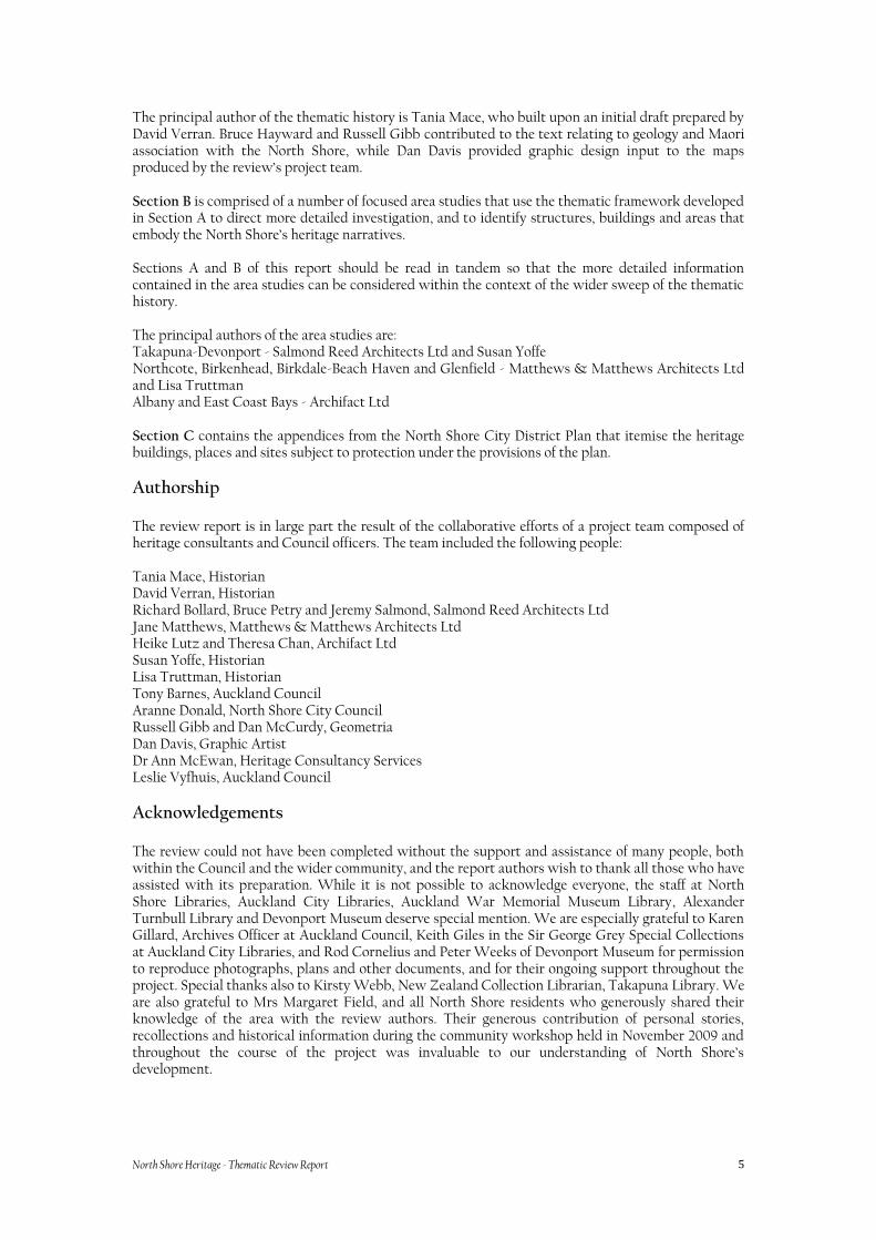
Fig. 1. Pre-volcanic North Shore during low sea level Glacial Periods. Broken lines show position of Shoal Bay Stream, which was a tributary of the ancestral Waitemata River. Heavy lines show the form of the islands that existed when the sea level rose at the end of each of the Glacial Periods (from Searle, 1959).
North Shore Heritage - Thematic Review Report
9
Underlying most of the North Shore is a geologic formation called the Waitemata Formation, a sequence of alternating sandstones and mudstones that accumulated on the seabed during the early Miocene (16-22 million years ago), which then uplifted and eroded to form the present landforms.1 The erosion occurred during glacial periods over several millions of years when low sea levels extended the coastline beyond Great Barrier Island. The North Shore formed a ridge on the edge of the Waitemata River valley that occupied the harbour. Two tributaries of the Waitemata River flowed through the North Shore eroding and exposing the sand and mudstones.2 Today, the Waitemata sandstones and mudstones can be seen in many of the cliffs around the Waitemata Harbour and East Coast Bays, and also appear in a weathered form as the clay-rich soils that cover the majority of the district. Many of the headlands around the East Coast Bays also contain deposits of coarser Parnell Grit, produced by lahars during the Miocene Period.3
Evidence of past volcanic activity on the North Shore includes the scoria cones of North Head, Mt Cambria and Mt Victoria in Devonport, and the explosion (maar) craters at Lake Pupuke, Tank Farm (Tuff Crater) and Onepoto Basin.4 These volcanic forms are part of the Auckland field that has been active for 250,000 years and extends from Lake Pupuke in the north to Wiri Mountain in the south, and from Mount Albert in the east to Pigeon Mountain in the west.5
Lake Pupuke is the largest explosion crater on
the North Shore, which was formed by a series of eruptions that occurred some 140,000 years ago, and caused the Wairau River, which used to flow out at Little Shoal Bay, to change to its present course north of Milford, where the Milford marina is located.6 Lava from the Pupuke eruption also flowed out towards Thorne Bay and the northern end of Takapuna Beach over what is now Hurstmere Road, engulfing a forest in its path and preserving casts of the lowland forest trees before incinerating them. The remnants of approximately 500 tree stumps on the reef near the Takapuna boat ramp that were covered by lava during this event is New Zealand’s only example of a fossil forest.7 At Thorne Bay, natural springs discharge water flowing through underground cracks from the lake.8 The Onepoto and Tank Farm maar craters, which formed 30-40,000 years ago, have been breached and opened to the sea. Onepoto has largely been reclaimed, and is today a park, Onepoto Domain, while Tuff Crater Reserve hosts a tidal mangrove swamp.9 Section 1.2 The People of the North Shore People have been part of the North Shore landscape for centuries. Migrations from eastern Polynesia brought ancestral Polynesians to Aotearoa probably around the 1200s. Oral history tells of the Tainui canoe first landing at Te Hau Kapua (Torpedo Bay) where the Tohunga Taikehu climbed Takapuna Hill (North Head) to survey the surrounding area before leaving for the south.10 At this time the North Shore landscape was mostly covered with a mixed podocarp-broadleaf forest dominated by kauri (agathisaustralis), and somewhat altered by volcanic activity. Pohutukawa forest lined the coastal margins.11
1 At this time a deep marine depression known as the Waitemata Basin covered the greater Auckland area. 2 Bruce W. Hayward, ‘Geological Heritage of the Takapuna CBD’, Matthews & Matthews Architects, David Verran and Lisa Truttman, Central Takapuna Preliminary Heritage Overview, Auckland, 2007, p.87. 3 ‘Geology of the Auckland Region’, http://en.wikipedia.org/wiki/Geology_of_the_Auckland_Region, accessed 10 March 2011. 4 Maar craters are generated by eruptions when magma encounters water, superheats, and causes a sudden explosive eruption that produces a large crater, surrounded by a tuff ring. 5 Hayward, p.88. 6 There is evidence that the crater was formed by volcanic action from at least two and probably three centres of eruption. Anomalous magnetic readings near the entrance to the semicircular bay on the north-eastern side of Pupuke, suggest this is a small subsidiary explosion crater. North Shore City Council, Lake Pupuke Investigation: Physical Description of the Lake Pupuke Catchment, 2006, p.6. 7 Louise Anderson, Takapuna – Milford Walk, North Shore City Council, 2002, p.2. 8 Lake Pupuke Investigation, p.4. 9 ‘Geology of the Auckland Region’, accessed 10 March 2011. 10 Paul Moon, The Struggle for Tamaki Makaurau: The Maori Occupation of Auckland to 1820, Auckland, 2007, p.23 and Michael King, The Penguin History of New Zealand Illustrated, 3rd Ed., Auckland, 2007, p.45. 11 North Shore City Council, North Shore Ecological Survey, 2005, pp.19-22.
North Shore Heritage - Thematic Review Report
10
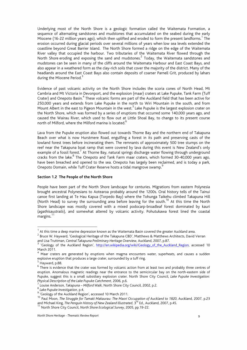
Fig. 2. North Shore regatta with Taheretikitiki off Devonport, 1898. Auckland War Memorial Museum, C9499. In the wake of Taikehu, others were attracted to the North Shore by its valuable resources. The area boasted good fishing grounds, plentiful fresh water at places like Lake Pupuke, and fertile volcanic soils at Takapuna and Devonport. However, the poor clay soils and inland forest that predominated in much of the rest of the North Shore hindered settlement. Many small settlements were established around the coastal margins where there was easy access to kai moana (seafood) and transport routes. Good soils at Devonport and Takapuna were suitable for gardening and larger Maori settlements (kainga) were established in these areas, as well as at Te Oneroa o Kahu (Long Bay), while fishing grounds and forested areas in other parts of the North Shore were utilised in season.12 Despite these natural riches, the North Shore was not nearly as well resourced as Tamaki Makaurau to the south, which became amongst the most populous areas of Aotearoa.13 Tribal conflicts also played a part in Maori settlement patterns on the North Shore. The area was the gateway to the north, and as such it served as a buffer between the tribes of Tamaki Makaurau and those residing further north. The North Shore offered natural defences and good vantage points that would be utilised by Maori. Coastal headlands such as Northcote Point (Te Onewa) Kauri Point (Te Matarae a Mana) and the headland above Castor Bay (Rahopara Pa) offered defensive advantages and these are amongst the locations where hilltop pa were constructed.14 Warfare, or the threat of it, would cause the iwi of the North Shore to relocate to other areas when necessary. In the early 1820s, for example, raids by the musket armed Nga Puhi had a devastating effect on the populations of the North Shore and Tamaki Makaurau. While some iwi fled to safe havens elsewhere, others remained. They were attacked, and suffered significant losses. The survivors of these raids fled, leaving the North Shore
12 Margaret McClure, The Story of Birkenhead, Auckland, 1987, pp.10 and 11. 13 Tamaki Makaurau had extensive areas of fertile volcanic soil for gardening, good fishing grounds and forests supplying further food resources, and a valuable canoe portage linking the eastern and western coasts. RCJ Stone, From Tamaki-Makau-Rau to Auckland, Auckland, 2001, pp.3, 4 and 6. 14 McClure, p. 11 and David Verran, The North Shore: An Illustrated History Auckland, 2010, pp.15 and 17.
North Shore Heritage - Thematic Review Report
11
virtually devoid of people.15 While some returned in the 1830s, the following decade would see the settlement of the North Shore by a new group.16 Parts of Aotearoa had been visited in the late eighteenth century and the early decades of the nineteenth century by numbers of foreigners including traders, sailors, whalers and missionaries. They came from various places including Britain, France and Australia, and small settlements had been formed by some of these newcomers in areas with significant populations of receptive Maori, or where there was easy access to lucrative export goods. Resident foreigners offered local Maori increased opportunities for trade and access to prized foreign goods.17 The North Shore did not attract much attention from foreigners, however, probably because opportunities for trade or religious conversion were limited by the small numbers of Maori present, and because export commodities were more difficult to extract than in other areas. During the late 1830s some land sales were negotiated between local Maori and new settlers, but these appear to have been few and far between.18 It was the Crown acquisition of land after the signing of the Treaty of Waitangi in 1840 that allowed newcomers to settle on the North Shore. Virtually all of the land on the North Shore was acquired from Maori by the Crown in a series of purchases from 1841 to 1844.19 The establishment of the new colony’s capital on the southern shore of the Waitemata harbour in 1840 brought numerous settlers within the vicinity of the North Shore. Ships brought people predominantly from Great Britain to Auckland, where they either settled or moved to other parts of the colony to establish a new life for themselves. Auckland quickly became the main population centre of New Zealand, offering employment and business opportunities.20 By the late 1850s settlers outnumbered Maori in the young colony.21 During Auckland’s infancy, the North Shore’s main role was as a defence point. Due to the deepwater frontage at Devonport it was the preferred anchorage of visiting Royal Navy vessels. The suitability of Devonport for naval purposes saw the first naval station in the colony established there in the early 1840s.22 While settlement on the southern shore of the Waitemata flourished, the North Shore remained sparsely populated.23 Although the subdivision and sale of land to promote the expansion of settlement began in 1843, when the first North Shore suburban farms were offered for sale, plentiful land on the more easily accessed southern side of the harbour meant there was little demand for land to the north at this time. The settler population on the North Shore remained small through the 1840s and 1850s, despite the development of a ferry service linking Northcote, Devonport and Shoal Bay with the city in the mid 1850s. These locales became the main areas of settlement, with farming the principal occupation.24 Other residents arrived at Shoal Bay in 1849 when the Catholic Church established St Mary’s College. The school taught a small number of Maori who came from other regions.25 In the 1840s at nearby Awataha (Barrys Point), the Nga Puhi chief Patuone settled, and in 1853 a group of Ngati Paoa arrived
15 McClure, pp.12 and 13. 16 Small groups of Te Kawerau returned to live at Te Matarae and Tauhinu in the 1830s. Ibid, p.14. 17 King, The Penguin History of New Zealand Illustrated, pp. 115-118 and Malcolm McKinnon, ed., New Zealand Historical Atlas, Auckland, 1997, pp.27b and 28a. 18 For example, William Webster acquired land on the banks of the Oruamo Creek in 1837 while Alexander Brodie Spark negotiated the purchase of an area at Devonport in 1839. Each of these purchases was investigated by the colonial government after the Treaty of Waitangi was signed and Sparks land claim was subsequently disallowed. McClure, p.16 and Verran, The North Shore, pp.15 and 17. 19 W Norman Hutchinson, Takapuna: A Historical Portfolio Commemorating 60 Years of Municipal Government 1913-1973, Auckland, 1973, p.49. 20 Stone, p.299. 21 King, The Penguin History of New Zealand Illustrated, p.147. 22 Grant Howard, The Navy in New Zealand: An Illustrated History, Wellington, 1981, pp.5-6. 23 Verran, The North Shore, p.53. 24 Paul Titchener, Beginnings: A History of the North Shore of Auckland, Vol. 1, p.7; Vol. 2, p.16 and Verran, The North Shore, p.53. 25 Verran, The North Shore, pp.19-21.

North Shore Heritage - Thematic Review Report
12
and settled in the area. By this time Patuone had established a settlement on his estate at Takapuna, named Waiwharariki, on land gifted by Governor Grey. Patuone had taken the side of the British in 1851 when Ngati Paoa threatened to attack Auckland, and was consequently viewed by the colonial community as a trusted Maori whose presence on the North Shore would aid the security of Auckland.26
Fig. 3. St Mary’s College, Takapuna. Auckland War Memorial Museum, C22636. Accessible stands of timber to the north of these early North Shore communities attracted settlers who established milling operations at Hellyers Creek from the 1840s.27 Many North Shore areas also retained the gum of long dead kauri trees, which provided a new industry for the area from the 1840s and offered employment for locals and visitors alike.28 Maori dug gum seasonally and dominated the gumfields until the 1860s, but by this stage rising returns from this resource attracted settlers to the trade. Gumfields close to Auckland were dug by North Shore residents as well as those domiciled across the harbour who dug gum during the week before returning home for the weekend.29 Continuing tribal conflict, coupled with increased pressure on Maori to sell land and ongoing illegal transactions led to the New Zealand Wars of the 1860s, which prompted the departure of large numbers of Maori from the Auckland area. With war clouds gathering in the Waikato in 1863, the Colonial Government’s demand that all Maori in the area swear allegiance to the Queen or leave led to the departure of virtually all Maori on the North Shore and in Auckland.30 Settlers in Devonport witnessed this exodus when all the occupants of a kainga situated on the slopes of Maungauika (North Head) abandoned the village overnight and departed south.31 This no doubt paved the way for settler dominance on the North Shore gumfields.
26 Titchener, Beginnings, Vol. 7, p.5. 27 McClure, pp.16-17 and 18-19. 28 Alison Harris and Robert Stevenson, Once there were Green Fields: The Story of Albany New Zealand, Auckland, 1993, p.21. 29 Duncan Mackay, Frontier New Zealand: The Search for Eldorado 1800-1920, Auckland, 1992, p. 99 and AH Reed, The Gumdiggers: The Story of Kauri Gum, 3rd ed., Auckland, 2006, p.42. 30 Titchener, Beginnings, Vol. 2, p.8. 31 Ibid.

North Shore Heritage - Thematic Review Report
13
In the 1850s and ‘60s new industries were established at Devonport, which had become the dominant settlement on the North Shore, a role it would retain for many decades. This settlement was blessed with a deepwater frontage needed for boatbuilding, and good clay deposits for brickmaking. Both commodities were important to the local economy throughout the nineteenth century.32 There was little development in the northern area of the North Shore during this period, although Lucas Creek (now known as Albany) developed into a local centre, with a church, school, post office and hotel built in the 1850s and 1860s.33 The majority of the North Shore population at this time hailed from the British Isles, with a scattering of immigrants from other parts of the world. A French family settled at Birkenhead in the 1850s, while at Lucas Creek there were Norwegian immigrants in the 1870s.34 The 1860s saw the emergence of smaller allotments as larger landholdings to the North of Devonport started to be subdivided, encouraging further population growth.35 By the early 1880s the population of the North Shore had grown to nearly 2000, over 1300 of whom lived in the Devonport area.36 Improvements in ferry services during the 1880s brought Auckland City within easy reach for the people of Devonport, Northcote and Birkenhead, and encouraged settlement by city workers around the ferry landings. Devonport’s boatyards, brickworks and timbermills also attracted new residents to the North Shore, as did the Chelsea sugar refinery and its associated workers’ village, established at Birkenhead in 1883-1884. The refinery was by far the largest single industrial enterprise on the North Shore and would play a major role in the residential development of the western part of the North Shore over the coming years.37 Local services expanded in areas of significant population growth. At Devonport there were numerous shops, along with a hotel, church and school. Such amenities were also found in the smaller communities of Birkenhead, Northcote, Takapuna and Albany. While Devonport was the most developed part of the North Shore at this time, patterns of settlement that would remain throughout the rest of the nineteenth century were evident in other parts of the district. Lake Pupuke and the area around Takapuna Beach was becoming a fashionable residential area for the well to do, with a number of grand homes overlooking the lake, surrounded by farms. Tourism was also developing here and would be boosted significantly in the late 1880s by the erection of the grand Lake Hotel overlooking the lake. By this stage farms had been developed in the more remote parts of the North Shore including the East Coast Bays, Glenfield and Albany.38 While immigration continued, by the mid-1880s the majority of the New Zealand population had been born in New Zealand.39 Gradual population expansion continued on the North Shore into the twentieth century, with the southern parts becoming increasingly urban. In the first decades of the twentieth century farming and horticulture continued to dominate the more remote areas, but the extractive industries of timber and gum, which had been part of the economic landscape, were in decline. At
32 AJ Packington-Hall, Intensive Survey of the Historic R & R Duder Brickworks Site in Devonport Auckland, Auckland, 1992, map showing North Shore heavy clay deposits and distribution of brickworks; BJ Griffiths, ‘The North Shore: Its Character and Functions in 1888, 1913 and 1936’, unpublished thesis, University of New Zealand, 1959, p.12 and Titchener, Beginnings, Vol. 1, p.9. 33 Harris and Stephenson, pp. 25 and 27. 34 Ibid, p.33 and McClure, p.23. 35 From this period the large farms around Lake Pupuke first started to be subdivided into smaller allotments. For example, in 3rd February 1863 a map was published advertising Takapuna villa sites for positive sale by S. Cochrane on Tuesday, NZMaps 4496-16, Sir George Grey Special Collections, Auckland City Libraries. 36 The 1881 census records that the Devonport Highway District had a population of 1316 while the Lake and North Shore Highway Districts had 267 and 334 residents respectively. This gives a total North Shore area population of 1917. Results of a Census of the Colony of New Zealand 1881, Wellington, 1882, p.22. 37 Griffiths, pp.24-25 and McClure, pp. 40-46. 38 WJ Dimery, ‘Man’s Changing Role in Takapuna: From Farmland to City’, unpublished thesis, University of Auckland, 1967, p.6; Griffiths, pp.13, 14, 20, 26, 29 and figure 8; Jean Bartlett, ‘The Lake’, Jean Bartlett, ed., Takapuna: People and Places, Auckland, 1989, p.17; James Mackay, ‘The First Schools’, Takapuna: People and Places, p.33 and James Mackay, ‘Kauri Gum Digging on the North Shore’, Takapuna: People and Places, p.38. 39 King, The Penguin History of New Zealand Illustrated, p.208.

North Shore Heritage - Thematic Review Report
14
Browns Bay tourism flourished, with a guesthouse offering accommodation. Here, and at other eastern coastal beaches north of Takapuna, holiday homes sprang up along the beachfront and brought a seasonal influx of Auckland holidaymakers. The Takapuna beachfront also became a playground for Aucklanders. More permanent residential development intensified in areas well served by transport links, so that on the eve of World War II some 90% of the North Shore population lived on just 20% of the land, with the vast majority of the population still living at Devonport, Takapuna, Northcote and Birkenhead.40
Fig. 4. AD Willis, A view of Northcote with Devonport and Rangitoto beyond, postcard c.1886. Alexander Turnbull Library, Wellington, E-068-015-1. Much like Waiheke Island today, the North Shore in the pre-bridge era offered Aucklanders a pleasant and easily reached holiday spot, and city commuters a more relaxed place of residence in an attractive seaside setting. By the middle of the twentieth century, geographers and urban planners began to forecast dramatic growth for the North Shore, with the population projected to triple from the early 1960s to the early 1980s. It was apparent that the opening of the Auckland Harbour Bridge would be a major catalyst for residential expansion.41 Indeed, proximity to Auckland’s city centre has been one of the major determinants of development on the North Shore and the harbour bridge undoubtedly forged a closer relationship between the two. From 1959 when the bridge opened, former farmland was rapidly swallowed up by housing and industry, dramatically changing the landscape. Auckland was now more accessible and there were increasing employment opportunities on the North Shore with the development of industry at Barrys Point and the Wairau Valley.42 As the North Shore population grew in the post-war era, it also diversified. However, the pattern of change would be far less dramatic than that experienced by other areas of growth in the wider Auckland area. From the Second World War there was a major shift in the Maori population of New Zealand from
40 Griffiths, p.37. 41 Eugene Grayland, ‘Education: A Headache for Planners’, Donald F. Manley, ed., North Shore Expands, Auckland, 1963, p.70. 42 McKinnon, p.75b; Dimery, p.34 and North Shore Times Advertiser, 13 April 1972, p.15.

North Shore Heritage - Thematic Review Report
15
rural areas to the cities.43 While Maori were drawn in large numbers to South Auckland, fewer were drawn to the North Shore. Similarly, the North Shore gained some Pacific Island residents in the wave of post-war immigration from the islands but they too would be relatively few in number. The North Shore lacked the support structures, affordable housing and unskilled jobs that attracted Maori and Pacific Island people in large numbers to South Auckland.44 Many of those new to the North Shore in the 1960s and 1970s were British immigrants, seeking a new life on the other side of the world, who were drawn to the North Shore by the prospect of owning a seaside property, something that would have been well beyond many of them back home.45 The opening of the Auckland Harbour Bridge was the major transport improvement of the twentieth century, but further improvements to the roading system also allowed better access to the more remote parts of the North Shore. In 1975 the Upper Harbour Bridge was opened, connecting West Auckland with Greenhithe. This development, combined with the extension of the motorway system northwards, improved access to the North Shore’s rural districts, thus encouraging residential and industrial development there.46 In the late twentieth century the North Shore continued to offer a relaxed atmosphere which attracted those leading less conventional lifestyles. In the late 1970s the Centrepoint commune was developed at Albany, and became the largest and most influential community of its kind in New Zealand, before folding in 2000.47 At the same time the demographic structure of the North Shore was changing along with that of the wider Auckland area, but again to a lesser extent than many areas on the southern side of the harbour. Parts of the North Shore became popular with retirees seeking a pleasant place by the sea to spend their latter years. By the early 1990s Takapuna and the East Coast Bays had very high proportions of people aged over 60. Northcote and the East Coast Bays gained significant Asian populations with local shops and churches emerging to cater for new Korean and Chinese communities amongst others. However, the vast majority of the population were still Pakeha, descended from the waves of immigrants who came predominantly from the British Isles, but also other parts of Europe, in the nineteenth and twentieth centuries.48 By the outset of the twenty-first century suburbia had spread throughout the North Shore, merging the isolated communities of earlier years. Through this process the people of the North Shore developed an identity of their own, aspects of which have been reflected through the arts and in popular culture. The holiday culture of Takapuna in the 1930s is evident in Bruce Mason’s play The End of the Golden Weather, while contemporary youth culture is represented in the television series Go Girls. The North Shore has come a long way from its origins but residents continue to enjoy the pleasant surroundings and relaxed atmosphere that attracted people to the area in earlier years.
43 King, The Penguin History of New Zealand Illustrated, p.403. 44 McKinnon, pp.91b, 95a and 95b and ‘North Shore City Demographic Profile’, North Shore City report, February 1991, p.11. 45 McKinnon, p.76a. 46 Verran, The North Shore, p.257. 47 Lucy Sargisson and Lyman Tower Sargent, Living in Utopia: New Zealand’s Intentional Communities, Aldershot, 2004, pp.72-74. 48 McKinnon, pp.95a and 95b; Paul Spoonley, North Shore: A Post Suburban Landscape? Auckland, 1997, p.11.

North Shore Heritage - Thematic Review Report
16
Chapter 2 Infrastructure Section 2.1 Transport 2.1.1 Water Transport
In pre-European times waterways were the essential transport routes. Canoe travel linked small coastal communities, provided access to the much-valued coastal resources and fishing grounds, and in times of war, provided access to or from an enemy’s territory. The distribution of archaeological sites around the inner harbour at locations like Lucas and Hellyers Creeks, and coastal waterways such as the Okura River and Vaughan’s Stream (Awaruaika) attests to the importance of these waterways as early transport nodes. When European settlers arrived Maori began trading with the expanding settlement on the isthmus and were still greatly reliant on canoe transport to reach this new market.49
From the early days of the colony a variety of vessels from waka to steamships have provided transport to and from the North Shore, but the most important for the area’s settlers were the ferries that regularly plied the waters from the mid nineteenth century. Ferry services were essential to the development of the North Shore during the early days and today still remain an important means of transport for commuters and tourists. Regular ferry services date back to the 1850s when the Auckland Provincial Council received a petition from 18 North Shore residents requesting that a service be established.50 The council recognised that a ferry connection would serve to promote development on the North Shore thus adding to the prosperity of the province.51 In 1854 ferry services began linking the city with North Shore six days a week. Landing points varied with the day and the tide, with Stokes Point (Northcote), Shoal Bay and Devonport all on the ferry schedule.52 Services were gradually improved when the whaleboats of the 1850s gave way to the paddle steamers of the 1860s.53 While the early ferries had promoted settlement in the areas that were serviced, there was significant room for improvement. Ferry transport of the era was not as well organised or efficient as it could be. At Devonport rival operators connected the city with developing commercial centres at Church Street and Victoria Road. The Holmes brothers, who instigated a new service to a wharf at the end of Victoria Road in the mid 1860s, owned a substantial landholding in the area as well as the Flagstaff Hotel. The development of a major commercial centre at Victoria Road promised to make them wealthy from the sale of their land, and increased patronage of their hotel and ferry enterprises. Similarly, new ferry services were established by those with financial interests in the Church Street area. Other locales were serviced too with Riverhead, Shoal Bay and O’Neills Point connected with the city in the 1860s.54 The ferry services of the late 1860s and 1870s were an improvement on those of earlier years, but complaints about irregularity continued. The advent of new ferry operators in the 1880s resulted in an era of intense competition with resultant lower prices and improved services. In 1881 the Devonport Steam Ferry Company Limited was formed with the Alison brothers, Ewan and Alexander, holding leading positions in the firm. The Alison brothers were astute businessmen who ran an inexpensive and efficient service that was able to ward off the challenge of rival companies emerging later that decade. They steered a careful course through the long depression of the late 1880s and 1890s, and their transport enterprise did much to encourage the residential and commercial development of Devonport, from which the Alison family were to profit considerably.55 In the early 1890s, their company took over
49 Bruce Hayward, ‘Prehistoric pa sites of metropolitan Auckland’, Tane, 29, 2, 1983, pp.3-14. See also New Zealand Archaeological Association Site Record Forms. 50 Southern Cross, 25 November 1853, p.3. 51 Titchener, Beginnings, Vol. 2, p.16. 52 Southern Cross, 10 January 1854, p.1 and 3 March 1854, p.2. 53 Titchener, Beginnings, Vol. 2, pp.17, 18 and 19. 54 Ibid, Vol. 2, p.20; Verran, The North Shore, p.176; Hutchinson, p.97; Gael Ferguson, ‘Industry and Commerce’, S Musgrove, ed., The Hundred of Devonport: A Centennial History, Auckland, 1986, pp.53 and 54. 55 WA Laxon, ‘Alison, Ewen William 1852-1945’, Dictionary of New Zealand Biography, updated 22 June 2007, http://www.dnzb.govt.nz.

North Shore Heritage - Thematic Review Report
17
the routes of the Birkenhead and Northcote Steam Ferry Company which had served the Birkenhead, Northcote and Chelsea areas since the 1880s.56 Along with these regular ferry services were the holiday excursions that brought visitors by the boatload to tourist spots such as Takapuna and Browns Bay during the nineteenth and early twentieth centuries.57
Fig. 5. When the tide was out at Browns Bay the wharf could not be reached so passengers would have to disembark into lifeboats and be rowed to the wharf. North Shore Libraries, E256. By 1900, the Devonport Steam Ferry Company dominated ferry transport to the North Shore with nine paddle steamers. Vehicular ferries started with the Goshawk in 1909, followed by the 1911 Sparrowhawk, designed for the Birkenhead and Northcote routes. As well as passengers, the Goshawk could take 35 carts or cars, and the Sparrowhawk 20, greatly expediting the transport of agricultural goods to the city markets. Previously, farmers had to load their produce by hand.58 In 1910 a new ferry and tram service linked the city with Bayswater and Takapuna. The new Takapuna Tramways and Ferry Company conveyed passengers by ferry to Bayswater and thence to Takapuna by steam tram.59 The regular tram and ferry service encouraged city workers to settle in the area, and thus promoted the residential and commercial development of Takapuna.60 The less densely populated coastal areas of the North Shore were also served by water transport. The Waitemata Steam Ferry Company served Riverhead and the upper Waitemata in the 1860s and various trading cutters, steamships and launches plied the waters of the Greenhithe and Albany areas, transporting mainly goods, but also passengers. Along the East Coast Bays small steamers, cutters and launches called in on their way north to Arkles Bay and Silverdale, and on the return voyage to the city.61
56 Verran, The North Shore, p.181. 57 Observer, 9 January 1892, p.6; Titchener, Beginnings, Vol. 3, p.37 and Tania Mace, Browns Bay Heritage Walk, North Shore City Council, 2006, Introduction. 58 Verran, The North Shore, pp.181-2. 59 Titchener, Beginnings, Vol. 1, p.30. 60 Dimery, pp.6, 8 and 9. 61 Dimery, pp.182 and 184-5.

North Shore Heritage - Thematic Review Report
18
Fig. 6. It was not only people who travelled by ferry, as shown in this image of 70 horses onboard the Devonport Ferry Company’s steamer Eagle, ready to depart Auckland on their way to the Takapuna races in June 1900. Sir George Grey Special Collections, Auckland City Libraries, AWNS-19000608-3-1. Throughout the twentieth century ferries remained a constant presence on the Devonport to city run, in spite of the fact that improvements to road transport, particularly the opening of the Auckland Harbour Bridge in the late 1950s, provided alternative means of getting to and from the city. Some of the ferry routes of earlier years withered through lack of patronage, but in recent years ferry services and facilities have been upgraded, helping to boost passenger numbers. Fullers Group Limited now operate ferry services connecting the city with Devonport, Stanley Bay, Bayswater, Northcote and Birkenhead.62 2.1.2 Trams Trams provided a relatively short lived link between the ferry landings and beach and lakeside areas of Devonport and Takapuna. In the mid 1880s a horse tramway was established running along the waterfront from the Devonport ferry landing to Cheltenham beach. It was clearly not a great success, lasting just two years.63 In the early twentieth century a new tramway was established to link the ferry wharf at Bayswater to Takapuna. Steam trams plied the circuit along King Edward Avenue (now Bayswater Avenue), Lake Road, Hurstmere Road, Kitchener Road, Shakespeare Road, Taharoto Road and Anzac Street before returning down Lake Road and King Edward Avenue to the ferry landing. The enterprise was established by the Takapuna Tramways and Ferry Company Limited which also ran the ferry services that connected Bayswater with the city. This innovation was a major factor in the development of Takapuna. Prior to this, excursion ferries rarely visited Takapuna.64 While the service was initially a boon for Takapuna, the trams became unpopular in later years. There were frequent complaints about inefficient service, and passengers were commonly asked to disembark and walk part of the distance along Lake Road as the tram struggled to get up the hill. The service that had begun with such promise in 1910, finally ceased in 1927, with buses taking over.65
62 McClure, p.204; Verran, The North Shore, p.182 and www.fullers.co.nz. 63 Verran, The North Shore, p.185. 64 Griffiths, p.23 and 24; New Zealand Herald, 6 March 1991, Sec.2, p.1. 65 Verran, The North Shore, pp.185 and 192-3, and Evening Post, 6 August 1926, p.12.

North Shore Heritage - Thematic Review Report
19
Fig. 7. This image of the steam tram that plied the Bayswater-Takapuna route was taken not long before motorbuses took over in 1927. North Shore Libraries, T0134. 2.1.3 Buses Early bus services on the North Shore were established to connect the ferry wharves with the main commercial and residential centres. Prior to the advent of motorised buses, horse drawn buses offered transport to and from the wharves. At Devonport the Davis Brothers ran a bus service connecting the Devonport ferry wharf with Takapuna in the mid 1880s, while in Birkenhead Thomas Horton’s horse drawn six passenger cart operated as the first public bus between the wharf and Chelsea village in the early 1900s.66 The year 1904 saw the advent of motorised buses when the North Shore Takapuna Motor Bus Syndicate began services connecting Devonport wharf with Milford Road in Takapuna.67 By late 1915, the Birkenhead Motor Bus and Transit Company ran buses from the Birkenhead wharf west to Verrans Corner and north to Glenfield Road. This firm, operating after 1922 as the Marine Suburbs Bus Company, faced rivalry from Blue Star Motor Service, which also offered an additional service to the Beach Haven wharf. Blue Star won the battle in early 1928, but not the financial war, and was bought out by Charles Inwards, who eventually formed the Birkenhead Transport Company in 1933. Northcote also had its own motorbus company from 1919.68 In addition to a number of small bus companies running passenger services to Milford, Cheltenham, Narrow Neck and Stanley Bay in the 1920s, the Devonport Steam Ferry Company ran a bus service for the Devonport area and soon extended services along the Takapuna and Milford route.69 However, the poor condition of the roads north of Takapuna hindered the development of regular bus services, with travellers to Browns Bay in the 1920s reliant on storeowners who offered rides in their trucks from Takapuna.70 By 1936 five bus companies operated on the North Shore. The North Shore Transport Company covered Devonport, Takapuna, Castor Bay and Browns Bay from its depot in Takapuna. The Waitemata Bus and Transport Company covered a route from Northcote wharf to Onewa Road (but only as far as Wernham
66 Griffiths, Appendix 1, Table 5 and Verran, The North Shore, p.193. 67 Observer, 10 December 1904, p.18 and 17 December 1904, p.20. 68 Verran, The North Shore, p.195. 69 Ibid, pp.195 and 196. 70 Ibid.
North Shore Heritage - Thematic Review Report
20
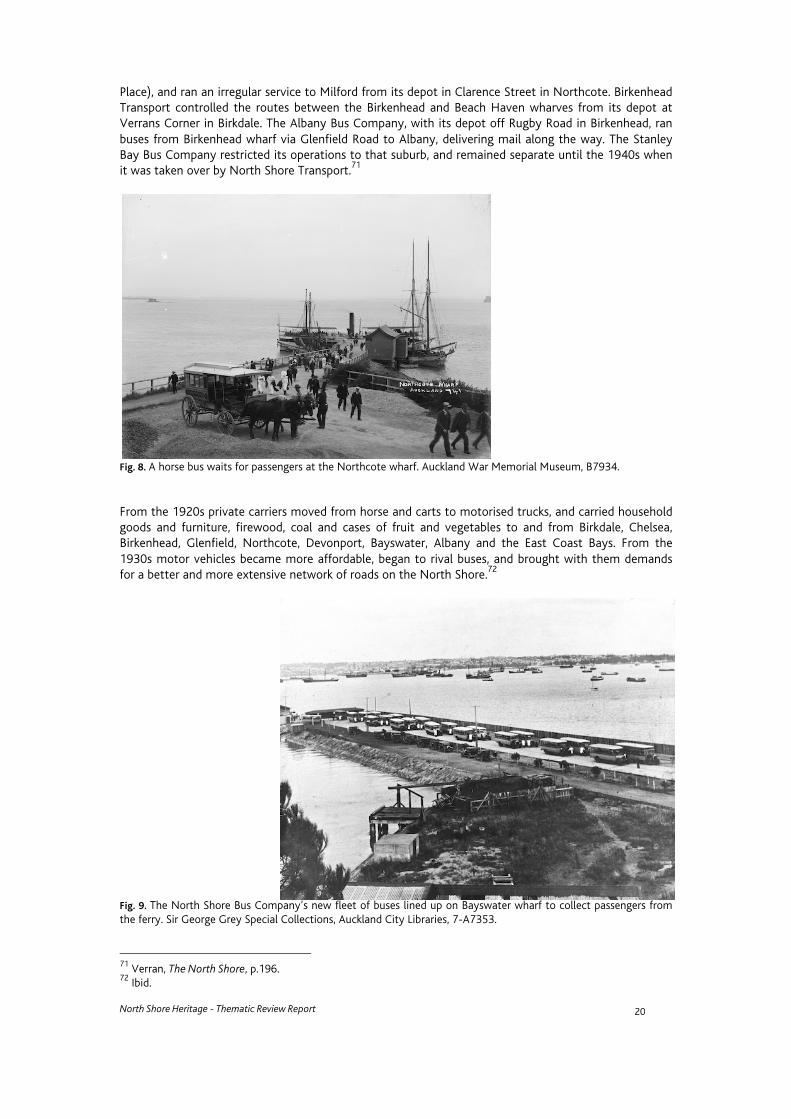
Place), and ran an irregular service to Milford from its depot in Clarence Street in Northcote. Birkenhead Transport controlled the routes between the Birkenhead and Beach Haven wharves from its depot at Verrans Corner in Birkdale. The Albany Bus Company, with its depot off Rugby Road in Birkenhead, ran buses from Birkenhead wharf via Glenfield Road to Albany, delivering mail along the way. The Stanley Bay Bus Company restricted its operations to that suburb, and remained separate until the 1940s when it was taken over by North Shore Transport.71
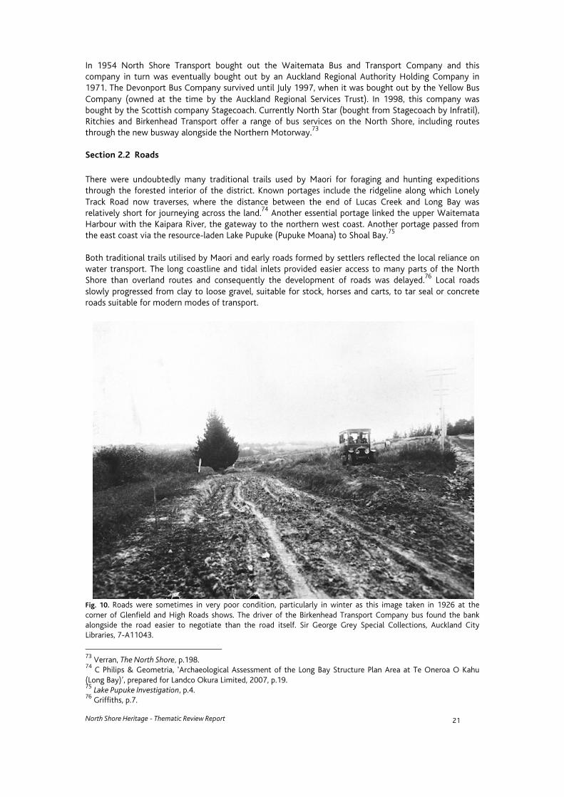
Fig. 8. A horse bus waits for passengers at the Northcote wharf. Auckland War Memorial Museum, B7934. From the 1920s private carriers moved from horse and carts to motorised trucks, and carried household goods and furniture, firewood, coal and cases of fruit and vegetables to and from Birkdale, Chelsea, Birkenhead, Glenfield, Northcote, Devonport, Bayswater, Albany and the East Coast Bays. From the 1930s motor vehicles became more affordable, began to rival buses, and brought with them demands for a better and more extensive network of roads on the North Shore.72
Fig. 9. The North Shore Bus Company’s new fleet of buses lined up on Bayswater wharf to collect passengers from the ferry. Sir George Grey Special Collections, Auckland City Libraries, 7-A7353.
71 Verran, The North Shore, p.196. 72 Ibid.
North Shore Heritage - Thematic Review Report
21
In 1954 North Shore Transport bought out the Waitemata Bus and Transport Company and this company in turn was eventually bought out by an Auckland Regional Authority Holding Company in 1971. The Devonport Bus Company survived until July 1997, when it was bought out by the Yellow Bus Company (owned at the time by the Auckland Regional Services Trust). In 1998, this company was bought by the Scottish company Stagecoach. Currently North Star (bought from Stagecoach by Infratil), Ritchies and Birkenhead Transport offer a range of bus services on the North Shore, including routes through the new busway alongside the Northern Motorway.73 Section 2.2 Roads
There were undoubtedly many traditional trails used by Maori for foraging and hunting expeditions through the forested interior of the district. Known portages include the ridgeline along which Lonely Track Road now traverses, where the distance between the end of Lucas Creek and Long Bay was relatively short for journeying across the land.74 Another essential portage linked the upper Waitemata Harbour with the Kaipara River, the gateway to the northern west coast. Another portage passed from the east coast via the resource-laden Lake Pupuke (Pupuke Moana) to Shoal Bay.75 Both traditional trails utilised by Maori and early roads formed by settlers reflected the local reliance on water transport. The long coastline and tidal inlets provided easier access to many parts of the North Shore than overland routes and consequently the development of roads was delayed.76 Local roads slowly progressed from clay to loose gravel, suitable for stock, horses and carts, to tar seal or concrete roads suitable for modern modes of transport.
Fig. 10. Roads were sometimes in very poor condition, particularly in winter as this image taken in 1926 at the corner of Glenfield and High Roads shows. The driver of the Birkenhead Transport Company bus found the bank alongside the road easier to negotiate than the road itself. Sir George Grey Special Collections, Auckland City Libraries, 7-A11043.
73 Verran, The North Shore, p.198. 74 C Philips & Geometria, ‘Archaeological Assessment of the Long Bay Structure Plan Area at Te Oneroa O Kahu (Long Bay)’, prepared for Landco Okura Limited, 2007, p.19. 75 Lake Pupuke Investigation, p.4. 76 Griffiths, p.7.

North Shore Heritage - Thematic Review Report
22
By the late 1880s the main north road ran from Devonport, skirting the western side of Lake Pupuke before following the ridge to Okura, Wade and Warkworth. A second road linked Birkenhead with Albany. There were frequent complaints about the poor quality of the roads in the less populous northern region.77
Fig. 11. Roadmaking was an expensive and labour intensive undertaking as shown in this image of road improvements at the corner of Mokoia and Rawene Roads. North Shore Libraries, B0310. Reflecting its early settlement and continued prominence as a transport node, Devonport roads were sealed relatively early. Changes in transport technology led to roading improvements in the Bayswater and Takapuna areas, where the weight of the steam trams running from 1910 required higher quality roading, utilising durable pit quarried metal.78 The interwar years saw significant roading improvements made in Northcote, Birkenhead, Glenfield and Albany. In the late 1920s Northcote’s main thoroughfare, Queen Street, was rebuilt in concrete, and work began on tar sealing the main road north from Birkenhead, reaching as far as Schnapper Rock Road in 1930.79 The coastal areas north of Takapuna retained their poor quality roads for longer.80 While roading improvements occurred gradually, the single most significant road link for the North Shore would be the construction of the bridge across the harbour that has linked the area with Auckland City since 1959. This single development would have an immediate and far reaching effect on the number and location of new roads as residential and commercial development intensified.
77 Griffiths, p.9 and figure 4. 78 PJ McDermott, ‘Evolution of the Wairau Valley Industrial Area: Man’s Changing Role in the Physiographic Environment’, unpublished research essay, University of Auckland, 1970, pp.11 and 13. 79 Valerie Rounthwaite, The Story of Rural Glenfield, Auckland, 1989, p.77. 80 ECB: The Years to 1989, Auckland, 1989, unpaginated.

North Shore Heritage - Thematic Review Report
23
Fig. 12. The completion of the Auckland Harbour Bridge in 1959 provided a road link to the city that would change the North Shore forever. PHG LaVie, 1958 © Elizabeth Lancaster, North Shore Libraries, N0116015. A bridge across the Waitemata harbour was considered for many years before work began on the structure. As far back as 1860 plans for a trans-harbour bridge were drawn up by Ponsonby farmer Frederick A. Bell. The idea failed to get support, as did numerous subsequent plans through the 1880s and 1890s. Discussion on the feasibility of a harbour bridge continued through the early years of the twentieth century, with an Auckland Harbour Bridge Association being established in the 1920s. Public support for the idea grew, and a 25,000 signature petition presented to Parliament prompted central government to establish a Royal Commission in 1929 to look into the matter.81 After considering five sites for the bridge, hearing a large number of submissions, and looking at bridge usage in similar harbours including Sydney, Vancouver and New York, the commission ultimately drew the conclusion that transport needs could be met simply by increasing the number of ferry crossings. However, the people of the North Shore were not convinced. Plans and petitions continued to be compiled and in 1946 a new Royal Commission was appointed. By this stage there was widespread agreement on the location of a bridge, as well as significant support from both sides of the harbour. The favourable report of the commission spurred the project on, with construction finally beginning in 1955. The bridge, designed with a high span to allow ship movements to and from the sugar refinery at Chelsea and the naval armaments depot at nearby Kauri Point, was officially opened on 30 May 1959. It proved so successful that by 1969 additional lanes had to be constructed.82 The construction of the Auckland Harbour Bridge had an enormous effect on the pace of development of the North Shore, acting as a catalyst for the transformation of large areas of agricultural land for residential housing, commercial and industrial use. The Northern Motorway has moved steadily northwards over the last 50 years and now reaches into Puhoi, while the completion of the Upper Harbour crossing in 1975 and further motorway development now allows a direct link with West Auckland.83
81 McClure, pp.174 and 175. 82 Ibid, pp.177, 179 and 180 and Verran, The North Shore, p.205. 83 Verran, The North Shore, p.257.

North Shore Heritage - Thematic Review Report
24
Section 2.3 Communication Prior to the opening of post offices on the North Shore, residents had to travel to Auckland where mail could be collected from the post office in the city. It appears that the first post office on the North Shore was established at Albany in 1858, quite some distance from the Auckland central post office. The mail would arrive once a week by packhorse, having come from Birkenhead via a bridle track.84 In 1863 the people of Devonport (then known as Flagstaff) requested that the Auckland Provincial Council provide a post office for the area. Later that year a post office was established in the Devonport schoolhouse with the teacher, Oliver Mays, taking the additional role of postmaster. The arrangement worked well as the schoolchildren were able to carry home any mail for their household. The post office would move several times in the next decade, operating from the various houses and business premises occupied by Mays.85 Devonport soon became the main clearinghouse for mail to the North Shore. Short lived post offices were established at Stokes Point (Northcote) and Takapuna in the 1860s but they closed after just a year, probably due to a lack of patronage. A post office was re-established at Northcote in 1870s, with Takapuna following in 1880. In 1884 Birkenhead gained a post office to serve the area, which now included the newly constructed village for workers employed at the Chelsea sugar refinery. The refinery also had its own company post office at Chelsea.86
Fig. 13. In the early days shops and hotels were often used to house the local post office but there were also examples of small purpose built post offices serving remote areas. This modest post office building was in Oneroa, now known as Torbay. North Shore Libraries, E0098. Post offices in the more sparsely populated areas gradually opened. Glenfield’s first post office commenced business in 1888, with Birkdale following in 1894 and Oneroa (Torbay) in 1897.87 During the first decades of the twentieth century, impressive purpose built post offices were opened in the well settled parts of the North Shore. Two storey masonry post offices were erected at Devonport and Takapuna in 1908 and 1914 respectively, with Birkenhead gaining a single storey timber building in 1908. In 1929 a fine single storey post office was opened at Northcote.88 Purpose built post offices would follow in other areas as population densities increased. In 1882 an underwater telephone cable was laid across the harbour connecting Auckland with the North Shore. Landing at Northcote Point, the cable was connected with the post offices at Takapuna and Devonport by overland lines. Further undersea cables were laid as telephone services expanded. In 1902
84 Harris and Stephenson, p.25. 85 Titchener, Beginnings, Vol. 1, p.15. 86 Ibid, Vol. 6, p.28 and Verran, The North Shore, p.151. 87 Verran, The North Shore, p.151; Rounthwaite, p.86; Jennifer Sturm, ‘Post Office’, Marie Gray and Jennifer Sturm, eds., And then Came the Bridge: A History of Long Bay and Torbay, Auckland, 2008, p.115. 88 Verran, The North Shore, p.151 and Evening Post, 15 May 1908, p.2.
North Shore Heritage - Thematic Review Report
25
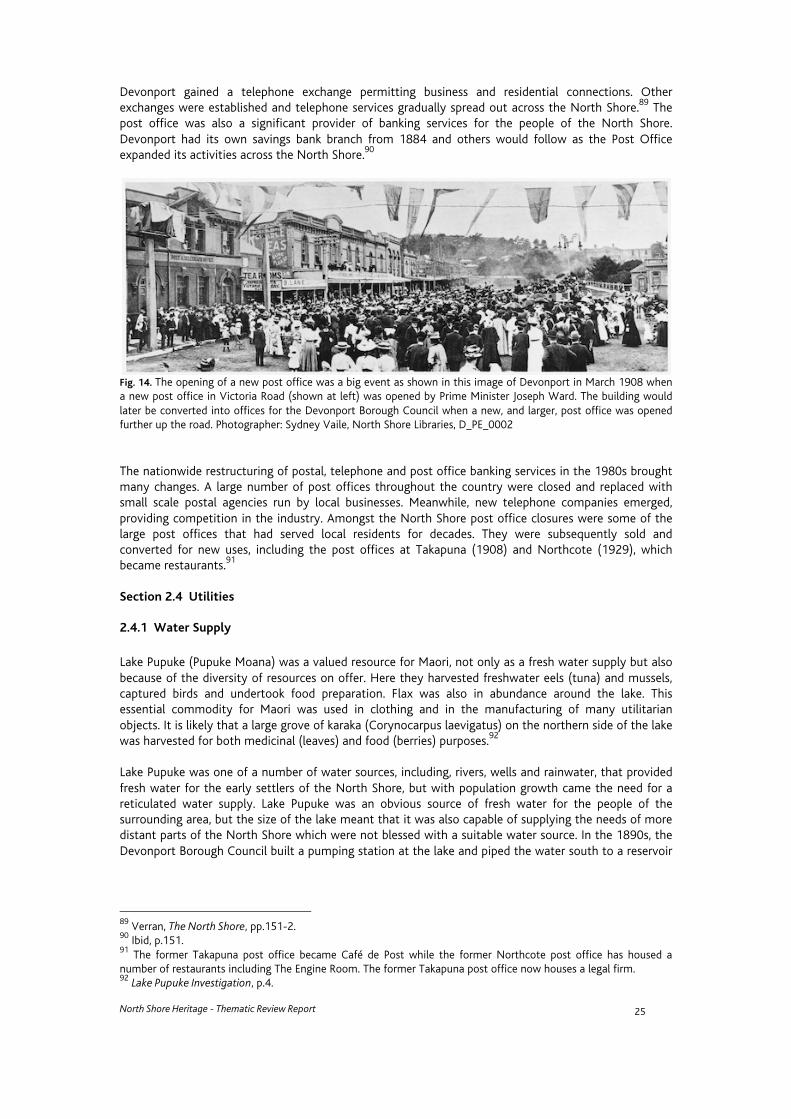
Devonport gained a telephone exchange permitting business and residential connections. Other exchanges were established and telephone services gradually spread out across the North Shore.89 The post office was also a significant provider of banking services for the people of the North Shore. Devonport had its own savings bank branch from 1884 and others would follow as the Post Office expanded its activities across the North Shore.90
Fig. 14. The opening of a new post office was a big event as shown in this image of Devonport in March 1908 when a new post office in Victoria Road (shown at left) was opened by Prime Minister Joseph Ward. The building would later be converted into offices for the Devonport Borough Council when a new, and larger, post office was opened further up the road. Photographer: Sydney Vaile, North Shore Libraries, D_PE_0002 The nationwide restructuring of postal, telephone and post office banking services in the 1980s brought many changes. A large number of post offices throughout the country were closed and replaced with small scale postal agencies run by local businesses. Meanwhile, new telephone companies emerged, providing competition in the industry. Amongst the North Shore post office closures were some of the large post offices that had served local residents for decades. They were subsequently sold and converted for new uses, including the post offices at Takapuna (1908) and Northcote (1929), which became restaurants.91 Section 2.4 Utilities 2.4.1 Water Supply
Lake Pupuke (Pupuke Moana) was a valued resource for Maori, not only as a fresh water supply but also because of the diversity of resources on offer. Here they harvested freshwater eels (tuna) and mussels, captured birds and undertook food preparation. Flax was also in abundance around the lake. This essential commodity for Maori was used in clothing and in the manufacturing of many utilitarian objects. It is likely that a large grove of karaka (Corynocarpus laevigatus) on the northern side of the lake was harvested for both medicinal (leaves) and food (berries) purposes.92 Lake Pupuke was one of a number of water sources, including, rivers, wells and rainwater, that provided fresh water for the early settlers of the North Shore, but with population growth came the need for a reticulated water supply. Lake Pupuke was an obvious source of fresh water for the people of the surrounding area, but the size of the lake meant that it was also capable of supplying the needs of more distant parts of the North Shore which were not blessed with a suitable water source. In the 1890s, the Devonport Borough Council built a pumping station at the lake and piped the water south to a reservoir
89 Verran, The North Shore, pp.151-2. 90 Ibid, p.151. 91 The former Takapuna post office became Café de Post while the former Northcote post office has housed a number of restaurants including The Engine Room. The former Takapuna post office now houses a legal firm. 92 Lake Pupuke Investigation, p.4.
North Shore Heritage - Thematic Review Report
26
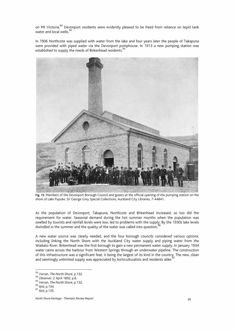
on Mt Victoria.93 Devonport residents were evidently pleased to be freed from reliance on tepid tank water and local wells.94 In 1906 Northcote was supplied with water from the lake and four years later the people of Takapuna were provided with piped water via the Devonport pumphouse. In 1913 a new pumping station was established to supply the needs of Birkenhead residents.95
Fig. 15. Members of the Devonport Borough Council and guests at the official opening of the pumping station on the shore of Lake Pupuke. Sir George Grey Special Collections, Auckland City Libraries, 7-A4841. As the population of Devonport, Takapuna, Northcote and Birkenhead increased, so too did the requirement for water. Seasonal demand during the hot summer months when the population was swelled by tourists and rainfall levels were low, led to problems with the supply. By the 1930s lake levels dwindled in the summer and the quality of the water was called into question.96 A new water source was clearly needed, and the four borough councils considered various options, including linking the North Shore with the Auckland City water supply and piping water from the Waikato River. Birkenhead was the first borough to gain a new permanent water supply. In January 1934 water came across the harbour from Western Springs through an underwater pipeline. The construction of this infrastructure was a significant feat, it being the largest of its kind in the country. The new, clean and seemingly unlimited supply was appreciated by horticulturalists and residents alike.97
93 Verran, The North Shore, p.132. 94 Observer, 2 April 1892, p.6. 95 Verran, The North Shore, p.132. 96 Ibid, p.134. 97 Ibid, p.135.

North Shore Heritage - Thematic Review Report
27
The removal of Birkenhead from the Lake Pupuke supply temporarily increased the water available for the other boroughs, but the problems of poor water quality remained. Northcote borough pumped water from a bore in Hillcrest Avenue for local use, but it was acknowledged that a new supply would ultimately be needed.98 The Takapuna, Northcote and Birkenhead boroughs continued to dither over the issue until 1941 when the Board of Health forced them to accept a new water supply from the Waitakere Ranges, which was piped through to Birkenhead. A further pipeline was added in 1948. Meanwhile, Lake Pupuke was retained as a back up supply for several years.99
Fig. 16. This reservoir in Waipa Street, Birkenhead held water pumped from Lake Pupuke. North Shore Libraries, B0325. While the more populous areas of the North Shore had been enjoying a public water supply since the late nineteenth and early twentieth centuries, the outlying districts continued to rely on collected rainwater for household use. During the 1950s residents of the East Coast Bays had to draw water from tanks provided by council when household water supplies ran out in summer. In the late 1950s work began on a scheme to provide piped water to the people of the East Coast Bays. A reservoir was built at the corner of Kowhai and East Coast Roads, followed by another at Pine Hill. By early 1964 more than half the residents of the borough were connected with the new water supply.100 In the 1970s water reservoirs were built in Forrest Hill and Albany, further extending water reticulation on the North Shore.101 From the 1960s the Auckland Regional Authority was given responsibility for providing bulk fresh water to the North Shore, and then from the late 1980s Watercare took on this role.102
98 Northcote Borough: Golden Jubilee 1908-1958, Auckland, 1958, pp.13 and 18. 99 Verran, The North Shore, p.136. 100 Auckland Scrap Book, Auckland City Libraries, December 1957, p.85; September 1959, p.44 and December 1963, p.21. 101 Ibid, October 1972, p.160. 102 Verran, The North Shore, p.136.

North Shore Heritage - Thematic Review Report
28
2.4.2 Drainage Demand for the bulk removal of waste or dirty water produced the same disagreements between the North Shore Boroughs. Initially, the disposal of waste water and faecal matter was accomplished by digging a ditch or ‘long drop’ in the backyard, but increased urbanisation made that ‘do it yourself’ option less sustainable and palatable, especially in the more built up locales. Nevertheless, the ‘dunny’ down the backyard, with regular removal of the metal drum by the ‘night soil man’, remained a part of life for people in the less populous northern areas until the mid twentieth century.103 The substantial coastline of the North Shore was utilised for the easy disposal of both sewerage and stormwater into the sea. In the early twentieth century those living in the southern parts of Devonport enjoyed a drainage scheme which piped sewerage into the harbour through an outfall at North Head. Northcote was also soon utilising Shoal Bay to dispose of local sewerage and in the early 1920s the Devonport system was extended to service Stanley Bay. In the late 1920s a sewerage and stormwater scheme was installed at Takapuna with outfalls at St Leonards Beach and at the lava outcrop between Takapuna and Milford beaches. The more built up areas of Birkenhead gained access to a sewerage and stormwater system in the mid 1930s. While this was no doubt a welcome innovation, the extension of the scheme throughout the borough would take many years, with some parts of the Birkenhead borough still not connected in the 1960s.104 The discharge of raw sewerage into the harbour was far from ideal, particularly as population densities increased. In 1951 the North Shore Drainage Board was established with the support of the North Shore boroughs, and the board looked into various options for the treatment of sewerage. They eventually resolved to build oxidation ponds in the Wairau Valley but the proposed site was needed for the extension of the motorway. Finally in 1962 a sewerage treatment plant was opened at Rosedale, with the treated waste discharged into the sea between Campbells Bay and Castor Bay.105 This brought the sewerage system closer to the people of the northern East Coast Bays, and in the mid 1960s pipes were laid to connect the homes and businesses of Browns Bay, Rothesay Bay and Murrays Bay.106 The development of residential areas above the Wairau Valley led to an increase in run off and flooding problems. In the early 1970s a new drainage scheme was developed by the Waitemata County Council and Takapuna City Council to resolve the issue.107 However, increased industrial development exacerbated the problem, and during the 1980s and 1990s a series of detention ponds were formed in the Wairau Valley to help the drainage system cope with heavy rainfalls.108 2.4.3 Power Gas provided power for lighting and cooking prior to the advent of electricity. In 1865 the first city streets across the harbour in Auckland were illuminated with gas, and by the early 1880s the Auckland Gas Company saw the potential to make a profit across the water in Devonport. In 1882 the company purchased a site near the corner of Lake Road and Mozeley Avenue where a gas works was built. In May 1883 the gas was turned on and the people of Devonport had access to the new power source. The Auckland Gas Company later extended their services to Takapuna where a storage facility was built in Huron Street.109 In 1902 a new gas company was formed to supply the people of Birkenhead and Northcote. By mid 1903 the Birkenhead and Northcote Gas Company was supplying its first customers in Northcote, with the service extending to Birkenhead from 1906. The gas works at Little Shoal Bay would become a substantial local employer.110
103 Verran, The North Shore, pp.136-7. 104 Ibid, p.137. 105 Ibid, pp.137-8. 106 Auckland Scrap Book, Auckland City Libraries, December 1963, p.21. 107 McDermott, p.36. 108 S.L. Ferguson, ‘The Wairau Valley: Industrial Evolution and Rental Growth since 1989’, unpublished research project, University of Auckland, 1989, p.24. 109 Auckland Gas Company Limited: 100 Years of Progress 1862-1962, Auckland, 1962, p.3 and Verran, The North Shore, p.141. 110 Verran, The North Shore, pp.141 and 142.

North Shore Heritage - Thematic Review Report
29
By this stage there had been another modern power source in use at Birkenhead for a decade. In 1896 the Chelsea sugar refinery was lit with electric light. The refinery manager, Mr Miller, was in the fortunate position of being able to have his residence at Chelsea connected with the refinery supply, over a decade before the residents of Auckland City gained access to public electrical power.111 This appears to have been the first commercial and residential use of electricity on the North Shore. Other North Shore residents would have to wait many years before a public supply was available. Finally in 1915 the Electricity Supply Company of New Zealand was formed and work was undertaken to provide Devonport with electricity for street lighting and domestic use. In Devonport the merits of electric street lighting had been debated for several years, and the residents were no doubt glad to see the new lights glowing in 1916.112
Fig. 17. View of the Auckland Gas Company Building in Northcroft Street, Takapuna, 1940s. Auckland War Memorial Museum, 13389. The 1920s would see a substantial expansion of electric power on the North Shore. In 1915 the government took responsibility for electrical generation, and to this end began building power stations and transmission lines which dramatically increased the supply of electricity. In 1918 the Electric Power Boards Act was passed to aid the extension of electric power supply into rural areas. Under the Act the Waitemata Electric Power Board was constituted in 1924 to reticulate and sell electricity in West Auckland and the North Shore. The company acquired the power station at Devonport, which was soon made redundant when national transmission lines reached the area.113 Electricity was promoted as a
111 Refinery Manager’s Letterbook June 1892-February 1898, Box 145, Chelsea Archive, Birkenhead Public Library, 12 May 1896 and 20 May 1896 and Jennifer King, Sign of Service: A History of the Auckland Electric Power Board 1922-1972, Auckland, 1972, pp.7-8. 112 GWA Bush, Decently and In Order: The Centennial History of the Auckland City Council, 1971, Auckland, p.114 and Verran, The North Shore, p.138. 113 John E Martin, ed., People Politics and Power Stations: Electric Power Generation in New Zealand 1880-1998, 2nd ed., Wellington, 1998, pp.70 and BS Phillips, 60 Years in Power: Waitemata Electric Power Board, Auckland, 1985, p.4.
North Shore Heritage - Thematic Review Report
30
cheap and clean power source that was quickly taken up by customers as it became more widely available. In the mid 1920s Birkenhead and Northcote were wired for electricity and in 1927 the new power source was available in Glenfield. A decade later reticulation had reached as far as Albany.114 Gas was still being supplied to the more populous areas of the North Shore, but the rapid expansion of electrical reticulation and the popularity of electricity as a power source hindered the extension of gas lines. In 1953 the Auckland Gas Company took over the Birkenhead and Northcote Gas Company. In the interests of efficiency a high pressure pipeline was subsequently installed to bring gas from the Devonport gas works, making the old gas works at Shoal Bay redundant. In 1960 the Devonport gas works met the same fate, with gas now piped from the Auckland Gas Company works across the harbour at Beaumont Street.115 In the late 1960s natural gas was piped from the Kapuni gas field, and it soon replaced coal gas as an energy source. Natural gas has since become a popular choice for cooking and water heating, leading to an expansion of gas reticulation.116 In the early 1990s the electrical and gas supply industry was restructured. Today there are numerous companies selling electricity and gas to the people of the North Shore.117
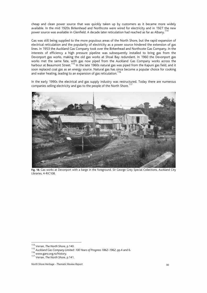
Fig. 18. Gas works at Devonport with a barge in the foreground. Sir George Grey Special Collections, Auckland City Libraries, 4-RIC108.
114 Verran, The North Shore, p.140. 115 Auckland Gas Company Limited: 100 Years of Progress 1862-1962, pp.4 and 6. 116 www.ganz.org.nz/history. 117 Verran, The North Shore, p.141.

North Shore Heritage - Thematic Review Report
31
Chapter 3 Building the City Section 3.1 Subdivision of Land
The Crown’s 1840 purchase of the Mahurangi Block, which extended from Devonport up the East Coast to Mahurangi, was in fact a series of land purchases negotiated between 1840 and 1854. This resulted in the initial subdivision of land on the North Shore. The protracted negotiations for the various tracts of land within the Mahurangi Block were due to the number of different iwi involved in the sale process. These included a confederacy of Hauraki iwi (Ngati Tamatera, Ngati Whanaunga, Ngati Maru and Ngati Paoa), Ngati Whatua, Nga Puhi, Te Kawerau, and further negotiations with Ngati Paoa.118
Fig. 19. Plans of Land Purchases in the North Island of New Zealand. Volume One: Province of Auckland. H. Hanson Turton, Wellington, Govt. Printer, 1877-1878. Even though the entire Mahurangi Block transaction had not officially been finalised, the land was cut into sizeable areas suitable for farming and offered for sale from the 1840s.119 While farms were developed, smaller residential sections would become part of the landscape at the city end of the North Shore. Closer settlement at Devonport and Birkenhead was encouraged by improved transport links with
118 David Verran, ‘Maori and Pakeha on the North Shore 1840 – 1926. Members Stories’, Birkenhead Historical Society, http://www.historicbirkenhead.com/membersstories43.htm, p.1, accessed 17 March 2011. 119 Advertisements for North Shore farms appear in newspapers from the 1840s. See, for example, New Zealander, 20 September 1845, p.1; 11 July 1846, p.1 and Southern Cross, 4 September 1847, p.1.

North Shore Heritage - Thematic Review Report
32
the city and the availability of local industrial employment. While the promise of new and efficient ferry services prompted some landowners to subdivide their properties into residential sites from the 1860s, there was little demand for parcels of land of this size until the 1880s, when efficient and reliable ferry services became a reality.120 Through the last two decades of the nineteenth century much of the farmland at Devonport was subdivided for residential use. The area thereafter became an attractive marine suburb with a well developed commercial centre that was home to both city workers and the locally employed.121
Fig. 20. Original subdivision plan for the Borough of Devonport. North Shore Libraries, T2297. At Birkenhead, residential development was instigated by the sugar refinery established at Chelsea in the mid 1880s. The shortage of local residences led the Colonial Sugar Refinery Company (CSR) to build a village for its workers on site. The subsequent growth of the enterprise led to a demand for local residential sites for workers wanting to live in their own homes beyond the confines of the refinery site. These developments were further encouraged by housing loans provided by CSR.122 The location of transport links played a key role in residential development on the North Shore. The ferry landings at Bayswater, Northcote and Birkenhead were the nodes around which large parcels of land would be subdivided for residential use. From 1910 when steam trams began to ply the route from the Bayswater wharf to Takapuna, the demand for residential sites in the area grew. With Takapuna now more accessible, a wave of suburban development occurred in the area.123 The development of the tourist trade at Takapuna Beach and Browns Bay encouraged farmers along the east coast to subdivide their beachside land into sites for baches in the first decades of the twentieth
120 For example the Devonport West, North Cheltenham and Northfleet residential subdivisions at Devonport were offered for sale in the 1860s. NZ Maps 4496-1, 4496-6 and 4496-2, Sir George Grey Special Collections, Auckland City Libraries and Griffiths, pp.12 and 24. 121 Gael Ferguson, ‘The Borough’, The Hundred of Devonport: A Centennial History, p.35. 122 McClure, pp.40-46 and Peter Luke, Sugar Workers Sugar Town: An Oral History of Chelsea Sugar Refinery 1884-1984, Auckland, 1984, p.6. 123 Dimery, pp.8 and 9.

North Shore Heritage - Thematic Review Report
33
century. Summer residences sprang up along the coast from Takapuna north, while inland areas retained their rural character.124
Fig. 21. Campbell’s Beach Estate, 1908. Sir George Grey Special Collections, Auckland City Libraries, NZ Map 6564. The next major trigger for further subdivision of large amounts of farmland was the construction of the Auckland Harbour Bridge in the late 1950s. The new transport link provided another means of getting to and from jobs on the southern side of the harbour. It also encouraged the development of local industry in new industrial zones in the Wairau Valley, the expansion of industry at Barrys Point, and consequently new employment opportunities for the people of the North Shore.125 The availability of low interest housing finance in the post-war era through the State Advances Corporation allowed many New Zealand families to build new homes in the suburbs. New subdivisions on the North Shore benefited from this cash injection and much of the farmland on the outskirts of older residential areas was subdivided in the residential building boom that occurred. State sponsored Parades of Homes were held in various North Shore locations including Northcote, Forrest Hill and Mairangi Bay in the 1950s and 60s. They provided an aspirational model of suburban life that fuelled public interest in new suburban housing areas. For those on lower incomes, the new state housing development in central Northcote offered medium density rental housing on a substantial tract of rural land.126
124 ECB: The Years to 1989, Auckland, 1989, unpaginated and JA Mackay, ‘The East Coast Bays on Auckland’s North Shore’, Auckland-Waikato Historical Journal, Vol. 16, April 1970, p.2 125 Dimery, p.34 and North Shore Times Advertiser, 13 April 1972, p.15. 126 Muriel Fisher, History of the Development from the Earliest Days to 1968 of the North Shore Borough of Birkenhead, Auckland, 1969, p.39; Gael Ferguson, Building the New Zealand Dream, Palmerston North, 1994, pp.196-7; Tania Mace and Greg Bowron, ‘Homes for the People: A Thematic Survey of State Housing in New Zealand’, unpublished Housing New Zealand Corporation report, July 2009, p.7; Auckland Scrap Book, Auckland City Libraries, December 1963, p.37; Auckland Star, 6 December 1958, p.12 and Greg Bowron, Housing New Zealand Corporation Heritage Inventory, Item 17, Parade of Homes, Tonar Street, Northcote.
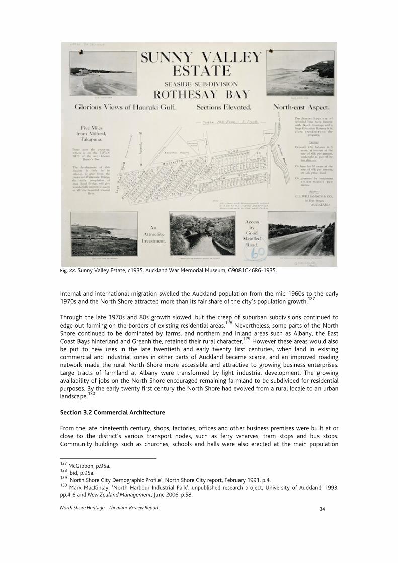
North Shore Heritage - Thematic Review Report
34
Fig. 22. Sunny Valley Estate, c1935. Auckland War Memorial Museum, G9081G46R6-1935. Internal and international migration swelled the Auckland population from the mid 1960s to the early 1970s and the North Shore attracted more than its fair share of the city’s population growth.127 Through the late 1970s and 80s growth slowed, but the creep of suburban subdivisions continued to edge out farming on the borders of existing residential areas.128 Nevertheless, some parts of the North Shore continued to be dominated by farms, and northern and inland areas such as Albany, the East Coast Bays hinterland and Greenhithe, retained their rural character.129 However these areas would also be put to new uses in the late twentieth and early twenty first centuries, when land in existing commercial and industrial zones in other parts of Auckland became scarce, and an improved roading network made the rural North Shore more accessible and attractive to growing business enterprises. Large tracts of farmland at Albany were transformed by light industrial development. The growing availability of jobs on the North Shore encouraged remaining farmland to be subdivided for residential purposes. By the early twenty first century the North Shore had evolved from a rural locale to an urban landscape.130 Section 3.2 Commercial Architecture From the late nineteenth century, shops, factories, offices and other business premises were built at or close to the district’s various transport nodes, such as ferry wharves, tram stops and bus stops. Community buildings such as churches, schools and halls were also erected at the main population
127 McGibbon, p.95a. 128 Ibid, p.95a. 129 ‘North Shore City Demographic Profile’, North Shore City report, February 1991, p.4. 130 Mark MacKinlay, ‘North Harbour Industrial Park’, unpublished research project, University of Auckland, 1993, pp.4-6 and New Zealand Management, June 2006, p.58.

North Shore Heritage - Thematic Review Report
35
centres. Simple timber structures gave way to more elaborate commercial and public buildings utilising a variety of building materials. In the less populous areas of the North Shore, however, simple timber buildings remained common.131 Substantial remnants of commercial and public architecture dating from the nineteenth and early twentieth centuries can be found in the earlier settled parts of the North Shore, particularly around Devonport and Birkenhead. The heritage value of these older buildings is increasingly appreciated by the public.
Fig. 23. Early commercial premises often put function well before aesthetics as can be seen in this image of the first Glenfield shop, which was housed in an old army hut on the corner of Wairau and Glenfield Roads, c1944. North Shore Libraries, T6346. Through the twentieth century the various borough and city councils of the North Shore provided or supported new types of community buildings, including libraries and council offices, Plunket rooms, community halls and war memorials. The designs of these buildings generally reflected their era and the favoured style for that building type, with similar examples of library, Plunket and council buildings being found in other parts of the country. The residential land boom heralded by the opening of the Auckland Harbour Bridge in 1959 gradually drew national and international commercial enterprises to the North Shore. Commercial buildings constructed to accommodate these new businesses in the latter twentieth and early twenty first centuries reflect both national and international commercial architectural trends.132 Some of these, like the Sovereign Building at Smales Farm Takapuna, have been recognised for the innovative design and use of new technologies.133
131 In places like Browns Bay timber commercial buildings were the norm well into the twentieth century while in places like Devonport, commercial buildings were built in permanent materials from around the early twentieth century. 132 In places like Albany and the business parks at Akoranga and Smales Farm there has been a large amount of recent commercial development of a style that can be found in commercial areas of a similar age throughout New Zealand and elsewhere. There are also similarities in the design of branches of local banks, insurance offices, and government buildings. 133 http://www.smalesfarm.co.nz/our_properties/sovereign
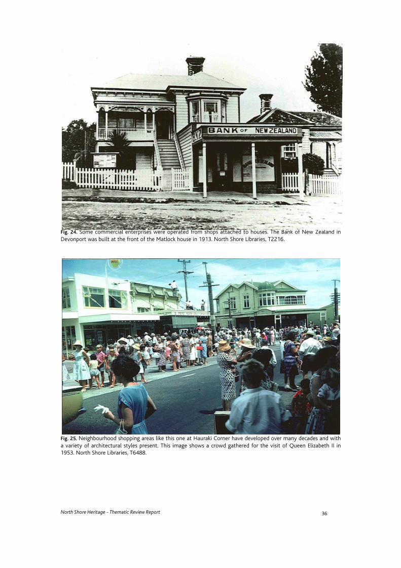
North Shore Heritage - Thematic Review Report
36
Fig. 24. Some commercial enterprises were operated from shops attached to houses. The Bank of New Zealand in Devonport was built at the front of the Matlock house in 1913. North Shore Libraries, T2216.
Fig. 25. Neighbourhood shopping areas like this one at Hauraki Corner have developed over many decades and with a variety of architectural styles present. This image shows a crowd gathered for the visit of Queen Elizabeth II in 1953. North Shore Libraries, T6488.

North Shore Heritage - Thematic Review Report
37
Section 3.3 Residential Architecture Early houses on the North Shore were simple dwellings built from locally available resources, either with sod walls and roofs thatched with raupo, or pit sawn kauri walls and kauri shingle roofs.134 In the more rural, northern areas, there were many instances where tents or sod and raupo huts served as gumdiggers’ accommodation.135
Fig. 26. Group at Forgham’s house ‘Fern Bank’, Lucas Creek, 1870. Alexander Turnbull Library, Wellington ½-096143-G. North Shore housing styles from the mid-nineteenth century until the Second World War reflected the colonial cottage, villa, transitional and bungalow styles that dominated New Zealand domestic architecture in the period. Often using plans and basic parts sourced from catalogues, and readily available timber, especially kauri, settlers in Devonport, Northcote Point and Birkenhead, and the scattered farms and communities beyond these areas, built their own homes, or employed small-scale builders and handymen to do so. While their design and size varied, often depending on the wealth of the owner, these houses were generally well-built, and positioned in orderly fashion within the emerging land subdivisions, with their best face to the street. Homes of the more affluent residents were often built on large lots, with a harbour view, and close to a beach. Many boasted verandas and intricate, machine-worked decoration, though simpler cottages and farmhouses often went unadorned. The Victorian and Edwardian housing stock of Devonport, Birkenhead and Northcote has survived in a largely intact form, and today is the distinctive and treasured feature of these suburbs.136 The substantial homes built in the late nineteenth century at Takapuna, particularly near Lake Pupuke, in its heyday as the resort for the wealthy, have been demolished, though others, like the Wilson Home, have been adapted for other uses.137
134 JA Mackay, ‘Pioneer Farming on the North Shore’, Auckland-Waikato Historical Journal, Vol. 14, April 1969, p.15. 135 Harris and Stephenson, pp.21-22 and James Mackay, ‘Kauri Gum Digging on the North Shore’, Takapuna: People and Places, p.36. 136 J. Salmond, Old New Zealand Houses 1800-1940, Auckland, 1986, pp.89-112 and Verran, The North Shore, pp. 275-6. 137 Jean Bartlett, ‘The Businessmen’, Takapuna: People and Places, pp.39-42 and Verran, The North Shore, p.275.
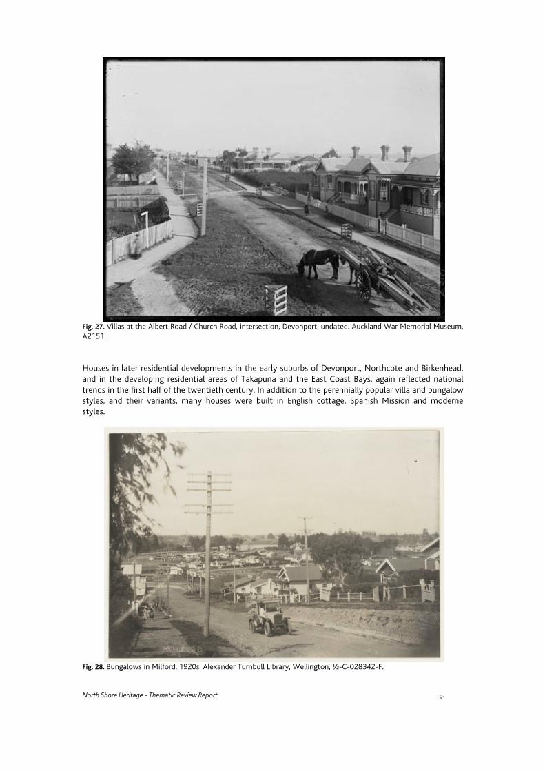
North Shore Heritage - Thematic Review Report
38
Fig. 27. Villas at the Albert Road / Church Road, intersection, Devonport, undated. Auckland War Memorial Museum, A2151. Houses in later residential developments in the early suburbs of Devonport, Northcote and Birkenhead, and in the developing residential areas of Takapuna and the East Coast Bays, again reflected national trends in the first half of the twentieth century. In addition to the perennially popular villa and bungalow styles, and their variants, many houses were built in English cottage, Spanish Mission and moderne styles.
Fig. 28. Bungalows in Milford. 1920s. Alexander Turnbull Library, Wellington, ½-C-028342-F.

North Shore Heritage - Thematic Review Report
39
From the early twentieth century, bach communities developed along the east coast north from Takapuna, adding another type of housing to the mix. Many of these were later improved to become permanent residences.138 The North Shore baches, like their counterparts elsewhere in the country, were almost always modest affairs, with few amenities, built from cheap or recycled materials, including corrugated iron, used timber, fibrolite, or even old packing cases or disused caravans. Probably the most famous surviving North Shore bach is Frank Sargeson’s Esmonde Road, Takapuna home, built after the Second World War, and today engulfed by suburban development.
Fig. 29. Baches varied in size and style as shown in this circa 1930s image of the beachfront at Browns Bay. The last remaining baches were removed from this area in the early twenty first century and the area converted into a public beachside park. North Shore Libraries, E0263. From the late 1930s state houses became part of the landscape, with the first North Shore state house opening in Niccol Avenue, Devonport in 1938. Further state houses were soon built in the Niccol Avenue area in a bid to abate the housing shortage that gripped the country at the time.139 While large areas of state housing were built across the harbour and in major New Zealand cities, relatively small numbers were built on the North Shore as poor transport links to major industrial areas made commuting difficult for working people. At Northcote the largest concentration of North Shore state houses was developed from the 1950s, utilising medium density housing designs, including Star Flats and Duplex Flats, that had been developed to decrease urban sprawl.140 In the 1970s a small area of state housing was developed in Birkdale using a split level housing design that was conceived to reduce building costs on sloping sites.141 In recent years a community renewal programme has been initiated in the state housing area at Northcote, which had become rundown and was beset by social problems. The neighbourhood revitalisation project is a partnership between Housing New Zealand Corporation and the community, and includes the upgrading of some existing state housing in the area, along with the construction of 44 new state houses.142
138 Griffiths, p.57; JA Mackay, ‘The East Coast Bays on Auckland’s North Shore’, Auckland-Waikato Historical Journal, p.2 and ECB: The Years to 1989, unpaginated. 139 Verran, The North Shore, p.280. 140 Mace and Bowron, pp.54 and 55. 141 Ibid, p.69. 142 Ibid, pp.34-35 and North Shore Times, 3 March 2009, p.2.

North Shore Heritage - Thematic Review Report
40
Fig. 30. Group Architects outside Second House, Takapuna, Auckland. Alexander Turnbull Library PAColl-0811-12-07-01 The location of defence facilities on the North Shore saw central government develop housing for defence staff from around the 1950s. In Devonport, Bayswater and Belmont houses were built for naval staff, and some existing dwellings were also purchased for the purpose. Amongst these houses was a series of two storey terraced housing originally designed by Group Architects, but considerably revised by government architect Gordon Wilson and Auckland district architect, Graham Dawson. Built at Ngataringa Bay in the early 1950s, this development was demolished in 2003, but other substantial blocks of naval housing remain in these North Shore suburbs today.143 The government was also responsible for the construction of a village at Paremoremo in the 1960s to house staff at the new prison.144 From the 1950s the opening up of substantial land developments encouraged the growth of large construction companies offering standardised house designs. In the 1960s and 1970s such firms focussed on the growth areas of greater Auckland. Companies such as Reidbuilt Homes and Sunline Homes operated in the Milford area, Universal Homes and John Senior concentrated on Beach Haven. Others, like Paramount Homes, W.G. Archer and Dempsey Morton, Franchi and Iron, Keith Hay, Neil and Beazley Homes were found in most of the developing residential areas. Local building companies in the main followed regional and even national design trends, with a consequent visual monotony. Without sight of Rangitoto or the harbour bridge, the new suburbs appeared much like any other in Auckland. The character of the extensive post-war subdivisions of west and south Auckland were not mirrored to the same extent on the North Shore however, due to the hilly, and in parts, unstable topography of the areas available for development on the North Shore.145 Here, many individualised homes were also being built. The added attraction of sea views across a great proportion of the eastern parts of the North Shore pushed up residential land prices and more often than elsewhere in Auckland the architect-designed houses necessary to make the best use of more expensive sites also made for unique buildings in these areas.146 In addition, from the 1970s a number of older houses from long established parts of Auckland were relocated to the newer suburbs of the North Shore, contributing a somewhat artificial historic character to some of these areas.
143 Julia Gatley, Group Architects: Towards a New Zealand Architecture, Auckland, 2010, p.152. 144 North Shore Times Advertiser, 8 October 1968, p.1 and 24 July 1973, p.20. 145 Verran, The North Shore, pp.277-278. 146 Ibid, p.278.

North Shore Heritage - Thematic Review Report
41
More recently, a number of apartment buildings have been constructed to provide a new style of housing for North Shore residents.147 While apartments have replaced some of the older housing stock on the North Shore, there has also been an increasing appreciation of the value of housing dating from the nineteenth and early twentieth century, particularly where large collections of this type of housing remain in Devonport, Takapuna, Northcote and Birkenhead. Section 3.4 Public Spaces In the early days of colonial settlement it was not hard to find undeveloped land which could be used by the public for picnics and recreation. The numerous North Shore beaches offered recreational opportunities, while some private landowners provided tourists with access to their land for such purposes. Ewan Allison owned land near the wharf at Takapuna where numerous tourists enjoyed picnics.148 Some North Shore parks were formed from lands reserved for various purposes by the Auckland Provincial Council and other bodies, including the Auckland Harbour Board, in the nineteenth century. These include Devonport’s Windsor Reserve, which was initially reserved for naval purposes, and North Head, a defence reserve.149 The setting aside of land for recreational purposes and the development of parks was one of the many functions undertaken by local government bodies on the North Shore. In the more densely populated areas of Devonport and Birkenhead, public parks were developed relatively early. These areas, which had substantial populations and were governed by borough councils from the nineteenth century, were able to raise rating revenue for the purchase and development of parks. Windsor Reserve was developed into a park in the early twentieth century, and boasted a fine band rotunda.150 Birkenhead’s Civic Reserve, now known as Nell Fisher Reserve, was also attractively laid out and equipped with a band rotunda in the 1920s.151 Other parks were formed from remnants of surviving bush providing an alternative recreation experience. Amongst these are Kauri Glen (1907) and Kauri Park (1922) which occupy steep gullies in Northcote and Birkenhead.152 In sparsely populated areas under the control of the Waitemata County Council it was hard enough to get funding for basic services like roading, much less for public parks. With little rating revenue available for such facilities, community organisations were responsible for creating and improving early parks. The Browns Bay Progressive and Ratepayers Association purchased land that was opened as Freyberg Park in 1945. In 1952 they gifted the park to the Crown and it has since been further developed.153 As residential areas expanded through the latter half of the twentieth century there was an increased need for reserves, parks and sportsgrounds. As former farmland was subdivided and sold off, provision was made for open space to serve the new neighbourhoods that developed. The beaches of the North Shore have always been important public spaces, and efforts have been made in recent years to improve access and beautify beachfront areas. At Browns Bay a beachfront esplanade was completed in the early twenty-first century after the purchase and removal of beachfront houses.154
147 Examples of apartment complexes can be found in many parts of the North Shore including Takapuna, Browns Bay and Albany. 148 Jean Bartlett, ‘The Businessmen’, Takapuna: People and Places, pp.42-43. 149 Gael Ferguson, ‘The Borough’, The Hundred of Devonport: A Centennial History, pp.32-33. 150 David Barrett, ‘The Garrison’, The Hundred of Devonport: A Centennial History, p.68 and photograph showing Windsor Reserve c1916, p.148. 151 Birkenhead Borough Council Minute Book 1922-1927, BBC Series 111 Item 9, North Shore City Archives, 7 April 1926, p.384 and 21 April 1926, p.396. 152 Kingston Reynolds Thom & Allardice, ‘North Shore Scenic Board Reserves Management Plan’, September 1980, pp.1 and 3-4. 153 Mace, Item 17. 154 Ibid, Item 6.

North Shore Heritage - Thematic Review Report
42
Fig. 31. The North Shore is fortunate in having some surviving pockets of bush for the public to enjoy including Kauri Glen, Northcote shown here in the 1920s. North Shore Libraries, NO113114. Some public parks have been formed on land formerly required for defence purposes, such as North Head, Fort Takapuna and Kennedy Park. Many of these retain historic defence structures.155 The formation of parks continues into the twenty first century with the recent addition of Chelsea Estate Heritage Park at Birkenhead.156 Today, the North Shore boasts a wide variety of pleasant open spaces, from beachfront parks and bush reserves to hilltop lookouts and sportsgrounds.
Fig. 32. Opening ceremony at Freyberg Park, Browns Bay, 1945. North Shore Libraries, E0399.
155 Auckland Scrap Book, Auckland City Libraries, August 1963, p.117; September 1982, p.180 and New Zealand Herald, 19 June 2000, Sec. A, p.9. 156 New Zealand Herald, 3 September 2008, Sec. 1, p.3.
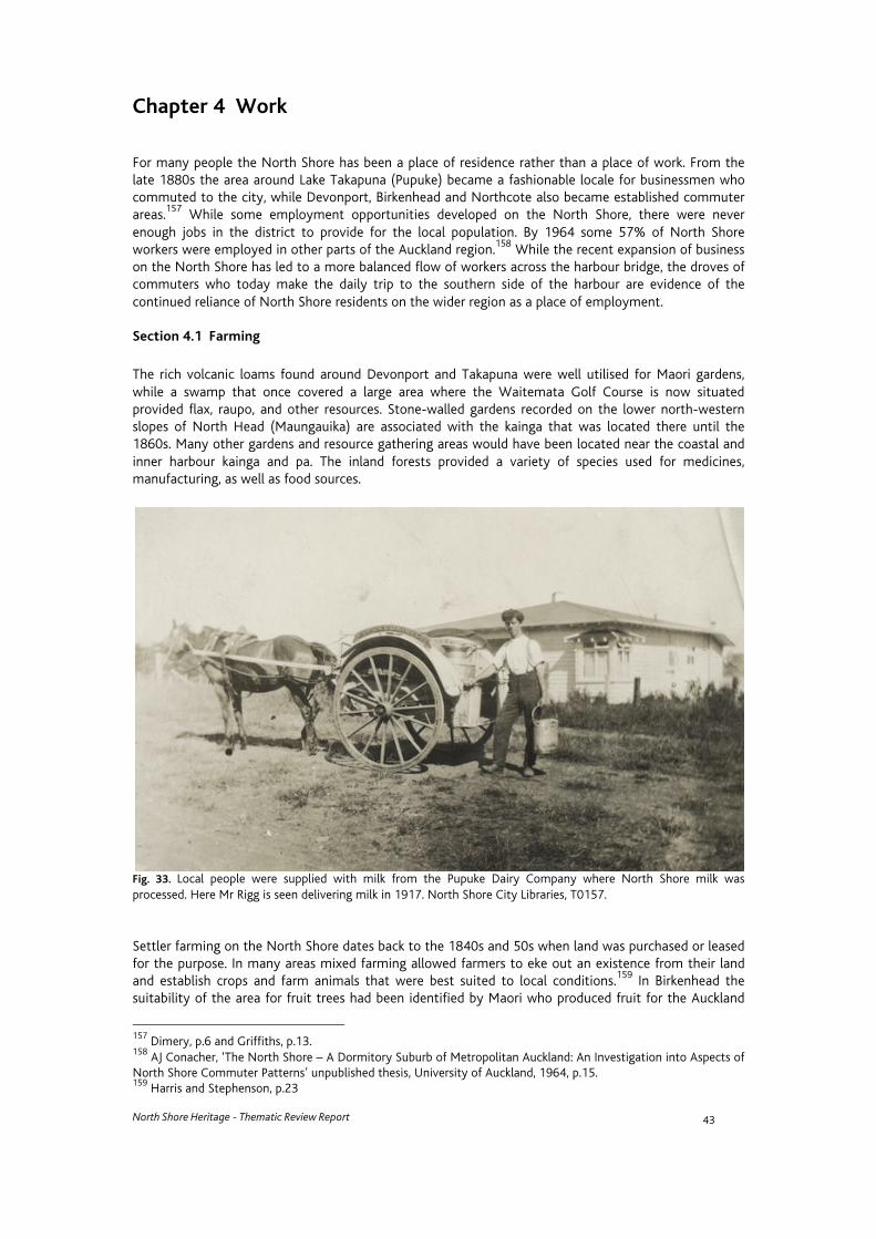
North Shore Heritage - Thematic Review Report
43
Chapter 4 Work For many people the North Shore has been a place of residence rather than a place of work. From the late 1880s the area around Lake Takapuna (Pupuke) became a fashionable locale for businessmen who commuted to the city, while Devonport, Birkenhead and Northcote also became established commuter areas.157 While some employment opportunities developed on the North Shore, there were never enough jobs in the district to provide for the local population. By 1964 some 57% of North Shore workers were employed in other parts of the Auckland region.158 While the recent expansion of business on the North Shore has led to a more balanced flow of workers across the harbour bridge, the droves of commuters who today make the daily trip to the southern side of the harbour are evidence of the continued reliance of North Shore residents on the wider region as a place of employment. Section 4.1 Farming
The rich volcanic loams found around Devonport and Takapuna were well utilised for Maori gardens, while a swamp that once covered a large area where the Waitemata Golf Course is now situated provided flax, raupo, and other resources. Stone-walled gardens recorded on the lower north-western slopes of North Head (Maungauika) are associated with the kainga that was located there until the 1860s. Many other gardens and resource gathering areas would have been located near the coastal and inner harbour kainga and pa. The inland forests provided a variety of species used for medicines, manufacturing, as well as food sources.
Fig. 33. Local people were supplied with milk from the Pupuke Dairy Company where North Shore milk was processed. Here Mr Rigg is seen delivering milk in 1917. North Shore City Libraries, T0157. Settler farming on the North Shore dates back to the 1840s and 50s when land was purchased or leased for the purpose. In many areas mixed farming allowed farmers to eke out an existence from their land and establish crops and farm animals that were best suited to local conditions.159 In Birkenhead the suitability of the area for fruit trees had been identified by Maori who produced fruit for the Auckland
157 Dimery, p.6 and Griffiths, p.13. 158 AJ Conacher, ‘The North Shore – A Dormitory Suburb of Metropolitan Auckland: An Investigation into Aspects of North Shore Commuter Patterns’ unpublished thesis, University of Auckland, 1964, p.15. 159 Harris and Stephenson, p.23

North Shore Heritage - Thematic Review Report
44
market on the poor clay soils at Onewa Point from the 1840s. The following decade saw Henry Hawkins establish a nursery and orchard that grew into a successful enterprise.160 Birkenhead would become a successful fruit growing district, particularly well known for its strawberries from the 1870s.161 Northcote, Glenfield and Albany also shared the poor clay soils that proved to be suitable for fruit growing at Birkenhead. Fruit production became important in these areas once the pioneering farming era was over.162 Albany became associated with new fruit varieties including the famous Albany Beauty apple and Albany Surprise grape.163 The area was also home to an experimental farm established by the Department of Agriculture in the early twentieth century. This was one of a number of such farms set up in the in developing farming areas which faced challenging conditions. Mixed farming was carried out to try to find the best methods and crops for the local environment.164
Fig. 34. Picking strawberries at Northcote. Auckland War Memorial Museum, C16244. In Takapuna where fertile volcanic soils were found, sheep and dairy farms predominated, although crops including wheat and oats were also grown.165 Devonport and the East Coast Bays also appear to have followed the pattern of farming that existed early on in Takapuna. In the more remote areas of the North Shore, farmers used their land to supply a variety of household needs. Peter Brown, who arrived in Browns Bay in the mid 1870s, established a dairy farm on his property, but he also kept an orchard, grew grapes from which he made wine, and kept bees. When the Brown family started farming the nearest store was located at Devonport so it made sense for Brown and other landholders in outlying areas to grow most of what their families needed.166 Some of the North Shore land that had been utilised for fruit growing was converted to dairy pasture in the 1890s due to a downturn in the Auckland fruit market. These small dairy farming enterprises mainly
160 McClure, p.27. 161 Ibid, p.34. 162 Titchener, Beginnings, Vol. 5, p.33 and Harris and Stephenson, pp.37-38 and 46-47. 163 Albert Farmer, ‘Origin and Development of New Zealand Grown Fruits: The Gravenstein Family’, Vertical File, Takapuna Library, p.2 and Auckland Scrap Book, Auckland City Libraries, January 1972, p.158. 164 Thames Star, 22 January 1917, p.4; Evening Post, 3 February 1917, p.10 and Tony Nightingale, White Collars and Gumboots: A History of the Ministry of Agriculture and Fisheries 1892-1992, Palmerston North, 1992, pp.64 and 66. 165 McClure, p.34; James Mackay, ‘The First Farmers’, Takapuna: People and Places, p.24 and JA Mackay, ‘The East Coast Bays on Auckland’s North Shore’, Auckland-Waikato Historical Journal, p.5. 166 JA Mackay, ‘The East Coast Bays on Auckland’s North Shore’, Auckland-Waikato Historical Journal, p.2.

North Shore Heritage - Thematic Review Report
45
supplied the growing North Shore market. Dairy companies were established in the Takapuna and Devonport areas from the early twentieth century to process and distribute products locally. In the late 1920s the Eldora icecream factory opened at Devonport, providing another use for local milk.167
Fig. 35. Despite the conversion of much farmland to residential use in many parts of the North Shore, there was still some farming carried out near residential neighbourhoods in the 1960s. Cows here can be seen on the Smale property at Taharoto Road, Takapuna in August 1960. Auckland War Memorial Museum, H1236. By the turn of the twentieth century Devonport had developed into a residential area devoid of farms, although Takapuna, Northcote and Birkenhead retained a number of farms amongst the growing residential areas.168 Over the years the expansion of suburban development would decrease the amount of arable land in these areas, and eventually the farms would disappear altogether. In the second decade of the twentieth century the Brown farm at Browns Bay was subdivided for summer residences, introducing what would become the new dominant land use along the nearby bays.169 Northern inland areas remained predominantly rural for longer. Farmland in Glenfield’s Wairau Valley that had supported dairy herds, strawberry growing, viticulture, poultry farming, orcharding and market gardening finally gave way to industrial uses from the 1960s, and residential development further decreased the number of farms. But the western parts of Glenfield retained their rural character for years to come.170 Suburban and industrial development would come later to Albany. As the twentieth century drew to a close the North Shore shook off the last vestiges of its earlier rural identity, becoming well and truly an urban area. Section 4.2 Industry In the nineteenth and early twentieth centuries extractive industries dominated the industrial landscape of the North Shore. In the 1830s Daniel Lucas, for whom Lucas Creek is named, established a flax mill at
167 Verran, The North Shore, p.39 and 43. 168 There is no mention of farming in the description of Devonport published in the Cyclopedia of New Zealand – Auckland Provincial District, Vol. 2, Christchurch, 1902, pp.526-7, 530 and 537-538. 169 JA Mackay, ‘The East Coast Bays on Auckland’s North Shore’, Auckland-Waikato Historical Journal, p.2 and ECB: The Years to 1989, unpaginated. 170 North Shore Times Advertiser, 13 April 1972, p.15 and Rounthwaite, p.114-121.

North Shore Heritage - Thematic Review Report
46
a waterfall in the upper reaches of the creek.171 Flax milling was also carried out at Torbay and Albany but these enterprises did not last long. Quarrying, gumdigging and timber milling gradually developed into important trades on the North Shore. Along with these, there were other industries that relied on locally available raw materials. Brickmaking required a good supply of local clay and this was readily available at Devonport and Takapuna, where the industry subsequently flourished.172 In the nineteenth century the North Shore had one major industry that processed imported raw materials for the local and export markets. This was the Chelsea Sugar Refinery, which was established in the 1880s and remains a major industrial enterprise.173 Another business which also brought raw materials from elsewhere was the Auckland Chemical Works at Stokes Point (Northcote), established in 1878 to process sulphur mined on Whale Island in the Bay of Plenty.174 Both industries were attracted to the North Shore by available land with good water access. The Stokes Point and Birkenhead locations had the added advantage of being close to Auckland City, from which the finished products could be distributed. An earlier industry at Stokes Point that also relied on proximity to the city for the sale of its wares was Clarke’s Soap and Candle Works. Founded in 1848, this business sold its products through Brown & Campbell at Auckland.175 While the Chelsea sugar works remains a prominent feature of the Birkenhead landscape, the Stokes Point enterprises were not so long lived. The sulphur works ran into problems when the foundations of the building gave way, and the business was closed after a brief period of productivity.176 The soap and candle works also appears to have operated for only a short period.177 From 1890 to 1910 numerous substantial industrial enterprises relocated from outlying areas in Auckland to the central city. The harbour board reclamations of the era provided new land that was well served by local infrastructure, and made the central city a more attractive locale for industry.178 The pull of the city saw the transformation of the Devonport waterfront from a boatbuilding and timber milling hub into a more picturesque, less industrial area. This metamorphosis was encouraged by the Devonport Borough Council, which passed a resolution in 1898 to clear the foreshore between North Head and Stanley Bay.179 There were other industries that continued to need local resources, however, and so were not able to relocate. Brickmaking and quarrying relied on local deposits of clay and stone and these businesses remained in various places across the North Shore, primarily supplying local needs. The sense of relative isolation of the North Shore from central Auckland prior to the opening of the Auckland Harbour Bridge meant that most pre-1960s industries served the local market exclusively, with the notable exception of the Chelsea sugar works.180 Most businesses appear to have been small in scale and scattered through residential and retail areas. Although by the late 1960s there were no major industrial areas in Devonport, Northcote or the East Coast Bays, local bodies recognised the need to provide for these.181 A light industrial area had been developed around Barrys Point Road, Takapuna from the 1950s, and reclamation was planned to provide a further 14 acres of light industrial land there.182 Its location close to the harbour bridge, by which
171 ‘A Brief History of Albany Village (Lucas Creek)’, unpublished manuscript, Vertical File – Early History, Albany Library, p.1. 172 Packington-Hall, map showing North Shore heavy clay deposits and distribution of brickworks. 173 Shelley Howells, ‘Pretty in Pink’, Heritage New Zealand, Summer 2006, online: www.historic.org.nz/en/Publications/HeritageNZMagazine/HeritageNz2006. 174 North Otago Times, 8 April 1878, p.4. 175 Northcote Borough: Golden Jubilee 1908-1958, Auckland, 1958, p.5. 176 Ibid, p.7. 177 Ibid. 178 Gordon M Winder, ‘Making Space: Clusters and Districts in Auckland Manufacturing, 1889-1908’, Ian Hunter and Dianna Morrow, eds., City of Enterprise: Perspectives on Auckland Business History, Auckland, 2006, pp.110-111. 179 Gael Ferguson, ‘Industry and Commerce’, The Hundred of Devonport: A Centennial History, p.51. 180 Conacher, p.75. 181 New Zealand Trade & Development, Vol. 1, No. 1, October/November 1969, p.65. 182 Ibid, Vol. 1, No. 1, October/November 1969, p.45 and Dimery, p.34.

North Shore Heritage - Thematic Review Report
47
goods could reach the Auckland market and beyond, was ideal. It also benefited from having a local labour supply.183 At the same time, 450 acres in the Wairau Valley had been zoned for light and heavy industry by the two controlling local bodies, Waitemata County Council and the Takapuna City Council. The valley was by the early 1970s the largest area of industry on the North Shore, with only 100 acres remaining undeveloped.184 Not only did the Wairau Valley have available land zoned for industry, it was also close to the Auckland market, and to the burgeoning suburbs of the North Shore, where there was a steadily growing labour force and expanding market. Zoning changes in other parts of the North Shore further encouraged the drift to the valley. These factors attracted small North Shore businesses that had outgrown their original locations, as well as larger central Auckland companies wanting to tap into the increasingly large North Shore market. Businesses like Morgan Brothers upholsterers and chairmakers, which had started business in Auckland in 1945 before moving to Northcote four years later, made the move to the Wairau Valley due to rezoning problems.185 In 1960 Winstones established their North Shore branch there, to take advantage of local demand for their building products.186 Although by the early 1970s the Auckland urban area was the main market for goods produced at Wairau Valley enterprises, some products were also being sold throughout the country and beyond.187 The area attracted national and international firms seeking opportunities to establish a local branch close to the substantial Auckland consumer market and the transport links offered by the port, rail and roading networks emanating from Auckland City.188 During the latter years of the 1970s work began on a 70 acre industrial estate off Sunset Road in Mairangi Bay after the Takapuna City Council zoned the land for industry. Neil Construction, who spearheaded the development, originally planned to build housing on the site, but the Takapuna City Council felt that the land was better suited to industry. With land for such activity now scarce at Barrys Point Road and Wairau Valley, there was a clear need for the development of a new industrial area. The Sunset Road location was considered well suited to this purpose, being close to the motorway. Development of the estate continued through the 1980s and the planned motorway linking the area to West Auckland no doubt added to its attractions.189 While the development of these industrial estates saw a huge growth and concentration of North Shore industry, a few industrial enterprises remained in more residential areas. Clothing firms that had been established in Browns Bay and Devonport continued to occupy and flourish at their original sites. BE Haywood & Co of Devonport had become the largest specialist babywear and childswear manufacturer in the southern hemisphere by the early 1970s, and Ambler and Co, manufacturer of Summit Shirts, remained at its Browns Bay site and was a significant employer.190 But even these relics of the scattered industrial landscape of earlier years were soon to follow the march to large industrial centres. The growing population of the North Shore continued to provide an expanding local work force for new industry and prompted discussion that industrial development of the Albany Basin would make the North Shore more self-sufficient in employment and defer the need for an additional harbour crossing.191 While Albany had remained largely a farming area when neighbouring parts of the North Shore were developed, there were indications from the early 1960s that it would not always be so. In 1963 the government purchased some 1500 acres of land at Albany under the Public Works Act, earmarking it for state housing. Earthworks were carried out, but in 1969 the work stopped and for the
183 Dimery, p.34. 184 North Shore Times Advertiser, 13 April 1972, p.15. 185 Ibid, 13 April 1972, p.15 and EAJ Holdaway, ‘Northcote: A Desirable Place to Live’, Donald F Manley, ed., North Shore Expands, Auckland, 1963, p.67. 186 New Zealand Trade & Development, Vol. 1, No. 1, October/November 1969, p.60. 187 McDermott, p.46. 188 Ibid, pp.46 and 48. 189 North Shore Times Advertiser, 1 September 1981, p.2 and 27 August 1987, pp.33, 34 and 38. 190 Ibid, 13 April 1972, p.15 and Mace, Introduction. 191 MacKinlay, p.5.

North Shore Heritage - Thematic Review Report
48
next two decades the formerly productive land lay idle.192 While the abandonment of the planned state housing development left the land open to other uses, various plans for the area stagnated, and it was only after the formation of North Shore City Council that development of the area was pushed ahead.193 In the last two decades Albany has seen dramatic change with a substantial light industrial zone developed in the Bush Road area.194 Today industry on the North Shore is concentrated in well-defined industrial zones. Planning by local bodies in the last half century has largely separated industry from residential activity, offering residents a pleasant place to live, with industrial jobs within easy reach. The recent expansion of North Shore industry has also seen numbers of workers from the southern side of the harbour commuting to jobs on the North Shore. 4.2.1 Quarrying Parts of the North Shore were abundant with deposits of volcanic rock, which provided an ample supply of source materials for the developing area. It appears that the earliest quarry in the area was established at the head of Barrys Point, where stone was extracted and dressed to build St Mary’s College in the 1840s. Dressed stone from the quarry was also sent across the harbour to Auckland.195 By the late 1880s three large quarries operated on the North Shore, primarily extracting scoria, basalt and metal to support the construction of new roads and buildings. One was located on the south-western edge of Lake Pupuke, while another was on the coast to the south of the lake. The third was in Devonport.196 Quarrying at Devonport was carried out at Duders Hill, which would be virtually destroyed by the industry, as well as at Mt Cambria, which was extensively quarried by the early 1920s.197 In the 1920s Mr Sands operated a scoria and basalt quarry at Milford adjoining the Goldie property (now the Circle Apartments).198 During the first two decades of the twentieth century quarrying was carried out at the southern end of the Wairau Valley, where there was easily accessible scoria needed for roading. The scoria was extracted during the summer months by itinerant workers from Auckland who stayed in temporary camps. With the development of steam trams came a need for more durable pit quarried metal to build higher quality roads. This was supplied by the HH Adams quarry, south west of Lake Pupuke, which was later acquired by the Smale family.199 By the 1970s Smales Quarry was producing a variety of stone products that were mainly used for residential purposes. The company provided rock for foundation stones and walls as well as pebble gardens.200 W.S. Stevenson and Son also operated a nearby quarry owned by the Takapuna City Council.201 4.2.2 Kauri Gum and Timber Much of the North Shore was once covered in dense kauri forest, but by the nineteenth century the vegetation had changed significantly in many areas. Devonport was covered in herbaceous plants with some bushes, but few trees, while many other areas such as Birkenhead and Birkdale were covered in a successional forest dominated by fern and manuka (Leptospermum).202 While some timber remained to be logged, fallen kauri trees also held a gum resource that was exploited. In the early days logs were hauled out of the Lucas Creek area by bullock teams and collected at Lucas Landing before being rafted
192 Harris and Stephenson, p.109. 193 Ibid, pp.109-110 and 120. 194 Ibid, pp.120 and 121. 195 Auckland Scrap Book, Auckland City Libraries, December 1958, p.247 and October 1968, p.77. 196 Griffiths, Figure 7. 197 Auckland Scrap Book, Auckland City Libraries, December 1963, p.107 and Weekly News, 21 July 1921, p.38. 198 Keitha Alison, ‘Milford: Polar Bears and a Castle’, Takapuna: People and Places, p.81. 199 McDermott, pp.11 and 13 and North Shore Times Advertiser, 6 November 1975, p.11. 200 North Shore Times Advertiser, 20 January 1970, p.10. 201 Auckland Scrap Book, Auckland City Libraries, May 1970, p.147. 202 North Shore City Council, North Shore Ecological Survey. 2005, pp. 19-22.

North Shore Heritage - Thematic Review Report
49
to Auckland for milling.203 Thomas Hellyer established a short lived timber mill at the creek that was named for him, but by the close of 1841 he had died and his business was finished.204 William Crush Daldy purchased the Hellyer property in 1845 and entered the timber trade cutting small spars, collecting firewood and supplying timber shingles to the Auckland market. Around 1850 Daldy left the area, going on to become a leading public figure in Auckland, serving as a member of the House of Representatives and chairman of the Auckland Harbour Board.205 The Smith brothers of Torbay established a flax mill to utilise this local resource, but the flax quickly ran out and they soon turned to timber milling at Deep Creek.206 While kauri logging proved a short-lived industry, kauri gum, the hardened resin from kauri trees, became one of the three biggest export earners for the Auckland province from the 1860s through to the 1890s.207 It was utilised mainly in the manufacture of linoleum and varnish.208 The area north of Auckland was known for its good quality gum and it was here that the vast majority of gumlands were located.209 Prior to the 1860s gum was dug almost entirely by Maori who worked the gumfields seasonally, but rising returns attracted immigrants to the trade. From the late 1860s settlers dominated the industry.210 The North Shore was located at the southern end of the northern gumlands, with the most lucrative tracts in the nineteenth century being the area from O’Neills Point to Belmont and from Narrow Neck to Hauraki. This locale reputedly held the best quality gum in the Auckland district and its location close to Auckland made it attractive to locals and visitors alike.211 Gum was being dug as early as the 1860s at Takapuna and Birkenhead.212 When work was scarce in Auckland, men would come daily from the city to dig gum at Northcote, Birkenhead and Devonport. In 1887 up to 130 men were making the daily trip across the harbour, where gum was easy to find in these coastal areas.213 Gum was also uncovered during the process of forming farmland. When Joseph Murray of Murrays Bay broke in his ti tree covered land, considerable gum was unearthed through ploughing and this provided funds for improving the land. Many North Shore farms were improved with funds provided in this way, however the presence of easily found gum coupled with high prices could also delay the improvement of land for farming.214 In these circumstances making a living from gumdigging required far less effort than breaking in the land. In times of low yields and prices, this pattern would be reversed. In 1894 the New Zealand Herald reported that poor profits had prompted settlers at Albany to abandon gumdigging in favour of farming and fruit growing.215 While gum was dug by farmers breaking in their land and by the unemployed in times of hardship, it was a full-time occupation for others. Each of the gullies between Campbells Bay and Okura had a gumdiggers camp until around 1910. Takapuna storekeeper Joe Sheriff would make a weekly trip to deliver provisions to the camps and collect the gumdiggers’ harvest.216 Meanwhile, Phillips’ and
203 ‘A Brief History of Albany Village (Lucas Creek)’, unpublished manuscript, Vertical File – Early History, Albany Library, p.1. 204 McClure, pp.16-17. 205 Ibid, pp.18-19. 206 Margaret Fraser, ‘Charles Ross Cholmondeley-Smith’, And then Came the Bridge: A History of Long Bay and Torbay, p.44. 207 Duncan Mackay, Frontier New Zealand, p.99. 208 BW Marshall, ‘Kauri Gum Digging 1885-1920’, unpublished thesis, University of Auckland, 1968, pp.2 and 5. 209 Ibid, p.3. 210 Duncan Mackay, Frontier New Zealand, p.99. 211 Ibid, p.5. 212 Reed, p.42. 213 BW Marshall, ‘Kauri Gum Digging 1885-1920’, p.13 and JA Mackay, ‘The East Coast Bays on Auckland’s North Shore’, Auckland-Waikato Historical Journal, p.5 214 JA Mackay, ‘The East Coast Bays on Auckland’s North Shore’, p.5. 215 BW Marshall, ‘Kauri Gum Digging 1885-1920’, p.6. 216 JA Mackay, ‘The East Coast Bays on Auckland’s North Shore’, Auckland-Waikato Historical Journal, p.5.

North Shore Heritage - Thematic Review Report
50
Stevensons’ stores provided for the gumdiggers’ camps at Schnapper Rock, on the banks of Lucas Creek, and Cuthill, at the head of Hellyers Creek.217 Full-time gumdiggers came from a variety of backgrounds and had a mixed reputation amongst settlers. In Northcote in 1887 the gumdiggers were evidently causing trouble, trespassing on private land, extracting gum, and leaving huge holes in their wake for local landowners to remedy.218 These problems persisted, with the Chelsea sugar refinery considering employing a watchman in the early twentieth century to stop people gumdigging on their property.219 While kauri gum was primarily an export commodity, there was a local attempt to found a varnish industry. In 1873 a Mr Howard sought to establish a varnish factory near Callan’s Point on the North Shore. While his initial experiments in varnish making met with some success, it appears that the planned factory never eventuated.220 By the close of the first decade of the twentieth century the local gumdigging industry was in decline. The American economy had faltered in 1907, leading to a reduction of demand in this previously lucrative market. Then the First World War brought about the cessation of shipping directly to the European market. The government responded by propping up the ailing industry during the First World War.221
Fig. 36. Kauri Timber Company Limited, Devonport, 1906. North Shore Libraries, D_GBB_0006.
217 Harris and Stevenson, p.41; JA Mackay, ‘Timber and Kauri Gum Trade on Auckland’s North Shore’, Auckland-Waikato Historical Journal, September 1970, p.2 and RE King, Tauhinu: A History of Greenhithe, Auckland, 1984, p.9. 218 Marshall, ‘Kauri Gum Digging 1885-1920’, p.13 and Weekly News, 3 September 1887, p.9. 219 Sydney-Auckland Letterbook January 1905-December 1906, Box 151, Chelsea Archive, 2 August 1905. 220 Daily Southern Cross, 7 August 1873, p.2 and 27 August 1873, p.3. 221 Albert William Smith, ‘The Development of the Kauri-Gum Industry and its Role in the Economy of Northland, N.Z.’, unpublished thesis, University of Washington, 1952, pp.139, 140 and 142.

North Shore Heritage - Thematic Review Report
51
In the early years of the Great Depression some unemployed men fossicked about in the Albany area for kauri gum, thus repeating an earlier pattern of turning to gumdigging in times of hardship.222 By this stage kauri gum’s heyday was well and truly over. Synthetic alternatives had been developed and gumdigging had largely become a thing of the past.223 The timber resource of the North Shore was also largely gone but timber mills continued to operate, utilising timber from other areas. These mills provided work for locals and produced timber for export as well as local use. During the nineteenth century the New Zealand Timber Company had established a mill on the Devonport foreshore where logs could be easily conveyed to the site by water. The original mill was destroyed by fire in December 1885, but it was later rebuilt and continued to operate for several more years.224 It was around this time that H.H. Adams & Son established a sawmill at Barrys Point, milling timber cut from around the Hauraki Gulf and delivered to the site by scow. Pinus insignis trees located around Takapuna were also processed at the mill.225 Meanwhile the Smith mill that had been established around the 1880s at Deep Creek continued to operate into the twentieth century.226 By the mid 1920s timber could be purchased from a number of yards and mills on the North Shore. H. Bond operated a yard at Lake Road, Takapuna, and there were two in Queens Parade Devonport, one run by Bond and the other by David Lawson. George Nicks operated a yard in Northcroft Street, Takapuna.227 As residential development intensified in places like Devonport and Takapuna, local timber milling operations began to outlive their welcome. Timber was still needed for the local building trade, but there was a gradual relocation of milling operations to less built up areas and new industrial centres. By the mid 1930s there were no mills in the Devonport waterfront area, but there were some operating in other parts of the North Shore, including Nicks at Takapuna and another at Albany.228 In 1943 a new sawmill was established in Bush Road, Albany by Don Ballantyne and Bill Leslie. This business operated for three decades.229 Other small mills appear to have operated during the twentieth century for specific purposes or to take advantage of local stands of timber. In the 1920s the Robinsons of Albany had a mill producing fruit cases which were much in demand locally.230 Similarly, Birkdale orchardist James S. Levesque established a sawmill on his property to make fruit cases.231 In Birkenhead there was a mill in Hinemoa Street operated by Harry Campbell which milled local pine, and another in Rangatira Road run by Cliff Fenwick.232 By the 1970s there was one remaining mill at Takapuna. Nicks Timber had been built in Northcroft Street in 1926 but by 1971 it had become an aberration in a retail and commercial zone. The Takapuna City Council was keen to see it go, and in mid-1971 the operation was moved to the Wairau Valley where industrial land was available. By this time it had been operated by three generations of the Nicks family.233
222 Charles Olsen, ‘Greenhithe Road Corner – a dissertation on life in Old Albany in the 1920s’, vertical file, Takapuna Library, p.3. 223 Smith, pp.139 and 145-6. 224 Evening Post, 11 December 1885, p.2 and T Walsh, An Illustrated Story of Devonport and the Old North Shore From 1841 to 1924, Auckland, 1970, p.23. 225 Auckland Scrap Book, Auckland City Libraries, December 1958, p.247. 226 Griffiths, Figure 11. 227 Cleaves Auckland Provincial Directory, 1925, pp.2075 and 2076. 228 Griffiths, Figure 19. 229 Harris and Stevenson, p.98. 230 Olsen, p.4. 231 McClure, p.78. 232 Colleen Christie, ed., Back Then: Oral History Interviews from the Birkenhead Public Library, Vol. 4, Auckland, 1991, p.44. 233 Auckland Scrap Book, Auckland City Libraries, April 1971, p.18.

North Shore Heritage - Thematic Review Report
52
Today there is a sawmill operating in Rosedale Road, Albany, but most timber for local building purposes is milled elsewhere and sold through the various building supply companies operating on the North Shore. 4.2.3 Brickmaking The North Shore was blessed with an abundance of clay suitable for brickmaking, and a number of brickyards would become part of the North Shore landscape during the nineteenth and twentieth centuries. Substantial clay deposits formed during the Miocene and Pleistocene periods were found in Devonport, Bayswater, the southern area of Takapuna and the Barrys Point Road area, as well as at Northcote, Birkenhead and the Wairau Valley.234 It appears that the first brickworks established on the North Shore was James Hammond’s enterprise at Stanley Point, which began operating in 1844. Other brickworks soon followed, including Tiller & King’s works at Ngataringa Bay and Phillip Callan’s works at Stokes Point (Northcote). Mr Menary established works at Takapuna, which he later moved to O’Neills Point. By the late 1880s more than ten brickworks had been established along the coast from Devonport to Birkenhead.235 The coastal locations of these industries meant that the finished product could be easily transported by water. Some brickworks were established for particular building projects, with the bricks for the Calliope Dock being made in Clarence Street, and the bricks for the Chelsea Sugar Refinery made on site in Birkenhead.236
Fig. 37. Bricks drying on the site of the Chelsea Sugar Refinery, Birkenhead, 1883. North Shore Libraries, B0091.
234 Packington-Hall, map showing North Shore heavy clay deposits and distribution of brickworks. 235 JA Mackay, ‘Pioneer Farming on the North Shore’, Auckland-Waikato Historical Journal, Vol. 14, April 1969, p.21 and Packington-Hall, map showing North Shore heavy clay deposits and distribution of brickworks. 236 JA Mackay, ‘Pioneer Farming on the North Shore’, Auckland-Waikato Historical Journal, p.22; Titchener, Beginnings, Vol. 3, p.1 and Shelley Howells, ‘Pretty in Pink’, Heritage New Zealand, Summer 2006, online: www.historic.org.nz/en/Publications/HeritageNZMagazine/HeritageNz2006.

North Shore Heritage - Thematic Review Report
53
In the first decade of the twentieth century the major brickmaking firms in Auckland formed an agreement to protect their interests. Signatories included the Duder brothers, who had long been established in Ngataringa Bay. They agreed not to sell their wares across the harbour while the other parties, firms based in West Auckland, agreed not to sell on the North Shore.237 Over the coming years the brick and tile works of West Auckland would come to dominate the industry in the region, and their attempts to stifle competition would be felt by North Shore operators. In 1910 the Auckland Gas Company, which had established a gas works at Devonport in 1883, began making bricks and other fired clay goods for both domestic and industrial uses. As well as standard goods, they also produced custom made wares. The enterprise would continue for many decades to come.238
Fig. 38. This claystore was part of the brickworks at the Auckland Gas Company works in Devonport, 1970s. North Shore Libraries, D_GBB_0002. In Glenfield, two brickworks were established in the 1920s. Charlie Smart established a brickmaking yard in Wairau Road opposite Archers Road, and James Mackay and Jimmy Atherton set up another. Atherton had formerly worked at the Duders’ Brickworks at Devonport. The 1930s would be a difficult time in the brickmaking industry, with very little building work carried out during the depression years. The Napier earthquake of 1931 threatened the industry further, with doubts being raised as to the safety of brick buildings in an earthquake. During the late 1920s and early 1930s a number of brickworks across the harbour were merged, taken over or closed in an effort to reduce competition.239 The Amalgamated Brick and Pipe Company of New Lynn became the leading company in Auckland, and in 1935 efforts to reduce competition further would see the demise of several brickworks on the North Shore. The
237 Dick Scott, Fire on the Clay: The Pakeha Comes to West Auckland, Auckland, 1979, p.126. 238 Muriel F Lloyd Prichard and James Bruce Tabb, Auckland Gas Company: 100 Years of Progress 1862-1962, Auckland, 1967, p.33 and Auckland Gas Company Limited: 100 Years of Progress 1862-1962, p.4 and ‘Illustrated Catalogue of Standard Shapes or High-Grade Fireclay Goods Manufactured by the Auckland Gas Company’, 1923 Edition, Vertical File, Takapuna Library. 239 Scott, pp.132, 133, 136 and 137.
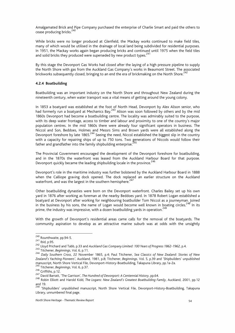
North Shore Heritage - Thematic Review Report
54
Amalgamated Brick and Pipe Company purchased the enterprise of Charlie Smart and paid the others to cease producing bricks.240 While bricks were no longer produced at Glenfield, the Mackay works continued to make field tiles, many of which would be utilised in the drainage of local land being subdivided for residential purposes. In 1951, the Mackay works again began producing bricks and continued until 1975 when the field tiles and solid bricks they produced were superseded by new product types.241 By this stage the Devonport Gas Works had closed after the laying of a high pressure pipeline to supply the North Shore with gas from the Auckland Gas Company’s works in Beaumont Street. The associated brickworks subsequently closed, bringing to an end the era of brickmaking on the North Shore.242 4.2.4 Boatbuilding Boatbuilding was an important industry on the North Shore and throughout New Zealand during the nineteenth century, when water transport was a vital means of getting around the young colony. In 1853 a boatyard was established at the foot of North Head, Devonport by Alex Alison senior, who had formerly run a boatyard at Mechanics Bay.243 Alison was soon followed by others and by the mid 1860s Devonport had become a boatbuilding centre. The locality was admirably suited to the purpose, with its deep water frontage, access to timber and labour and proximity to one of the country’s major population centres. In the mid 1860s there were already four significant operators in business. The Niccol and Son, Beddoes, Holmes and Messrs Sims and Brown yards were all established along the Devonport foreshore by late 1865.244 Seeing the need, Niccol established the biggest slip in the country with a capacity for repairing ships of up to 750 tons. Two generations of Niccols would follow their father and grandfather into the family shipbuilding enterprise.245 The Provincial Government encouraged the development of the Devonport foreshore for boatbuilding, and in the 1870s the waterfront was leased from the Auckland Harbour Board for that purpose. Devonport quickly became the leading shipbuilding locale in the province.246 Devonport’s role in the maritime industry was further bolstered by the Auckland Harbour Board in 1888 when the Calliope graving dock opened. The dock replaced an earlier structure on the Auckland waterfront, and was the largest in the southern hemisphere.247 Other boatbuilding dynasties were born on the Devonport waterfront. Charles Bailey set up his own yard in 1876 after working as foreman at the nearby Beddoes yard. In 1878 Robert Logan established a boatyard at Devonport after working for neighbouring boatbuilder Tom Niccol as a journeyman. Joined in the business by his sons, the name of Logan would become well known in boating circles.248 In its prime, the industry was impressive, with a dozen boatbuilding yards in operation.249 With the growth of Devonport’s residential areas came calls for the removal of the boatyards. The community aspiration to develop as an attractive marine suburb was at odds with the unsightly
240 Rounthwaite, pp.94-5. 241 Ibid, p.95. 242 Lloyd Prichard and Tabb, p.33 and Auckland Gas Company Limited: 100 Years of Progress 1862-1962, p.4. 243 Titchener, Beginnings, Vol. 6, p.11. 244 Daily Southern Cross, 22 November 1865, p.4; Paul Titchener, Sea Classics of New Zealand: Stories of New Zealand’s Yachting Pioneers’, Auckland, 1981, p.8; Titchener, Beginnings, Vol. 5, p.39 and ‘Shipbuilders’ unpublished manuscript, North Shore Vertical File, Devonport-History-Boatbuilding, Takapuna Library, pp.1a-2a. 245 Titchener, Beginnings, Vol. 6, p.37. 246 Griffiths, p.12. 247 David Barratt, ‘The Garrison’, The Hundred of Devonport: A Centennial History, pp.64. 248 Robin Elliott and Harold Kidd, The Logans: New Zealand’s Greatest Boatbuilding Family, Auckland, 2001, pp.12 and 19. 249 ‘Shipbuilders’ unpublished manuscript, North Shore Vertical File, Devonport-History-Boatbuilding, Takapuna Library, unnumbered final page.

North Shore Heritage - Thematic Review Report
55
boatyards that littered the foreshore. Just across the harbour the Auckland Harbour Board reclamations at Freemans Bay offered more suitable sites for the industry, and the 1890s would see the closure or relocation of many Devonport boatbuilding enterprises.250 With steel replacing timber as the primary boatbuilding material, boatyards needed to be close to foundries and ironworks which were operating on the city side of the harbour.251
Fig. 39. A yacht in the boatyard of Thomas Le Huquet at Devonport. Sir George Grey Special Collections, Auckland City Libraries, 4-3095. While the days of Devonport as a major centre of the boatbuilding industry were gone by the close of the nineteenth century, there were still boats being built in the area. Ted Le Huquet remained boatbuilding at Devonport into the 1920s.252 A shed at the Logan family property at 18 Stanley Point Road was where numerous Logan designed yachts were built after 1910 when the Logan Bros yard across the harbour was closed.253 In 1921 Bert Wollacott, an English boatbuilder, moved to Stanley Bay where he continued the trade he had practiced in England and the United States. He designed and built boats at his home in Bond Street (now known as William Bond Street) until the mid 1950s, with many of his yachts competing in the Auckland to Suva yacht race over the years.254 George Beaumont-Hogan, an amateur boatbuilder of Devonport, built early speedboats in the 1920s, with his famed boat “Miss Devonport” setting a number of coastal speed records.255 Colin Wild also began boatbuilding at Ngataringa Bay during this period and would continue this trade until a fire destroyed his premises in 1951. While Wild was keen to rebuild, he faced opposition from his neighbours and the Devonport Borough Council who considered it an inappropriate activity in a residential area. The council would not grant him a permit to rebuild on the site, forcing him to
250 ‘Shipbuilders’ unpublished manuscript, North Shore Vertical File, p.3a. 251 C.A. Stephenson, ‘The Politics of Place: A Study of Contemporary Devonport’, unpublished thesis, 1993, p.34. 252 Cleaves Auckland Provincial Directory, 1925, p.1905. 253 Elliot and Kidd, pp.79, 83 and 88. 254 Titchener, Beginnings, Vol. 3, pp.33 and 34. 255 Titchener, Sea Classics of New Zealand, pp.14-15.

North Shore Heritage - Thematic Review Report
56
relocate.256 The evolution of Devonport into a quiet residential suburb had cast out the small scale boatbuilder, just as the larger boatyards had been expelled from the locale just over half a century earlier. Some boatbuilders squeezed out of the Devonport waterfront did find alternative North Shore locations, including Sulphur Beach, Northcote Point.257 In 1925 Bailey and Lowe and James Reid were operating boatbuilding enterprises at Sulphur Beach, while Brown & Sons were working in Northcote. At the same time, Angus Nicholson carried on the trade in Takapuna and other boatbuilders operated in the Browns Bay area.258
Fig. 40. Bailey and Lowe boatshed and slipway at Sulphur Beach, Northcote, 1913. The Lady Eva is shown on a cradle at the centre of the image. Photographer: William Arthur Price, Alexander Turnbull Library, Wellington, N.Z., C-1690-1/2. After the First World War yachting in New Zealand evolved from being a sport of the wealthy into a pastime within the grasp of ordinary New Zealanders. From the 1920s smaller, simpler yacht designs were produced, thereby ushering in a new era of yachting, and the North Shore would be well represented in this development.259 Two of the key figures were John Brooke of Devonport and John Spencer of Browns Bay. Spencer, who ran a boatyard in Clyde Road, Browns Bay from the 1950s to the 1980s, pioneered lightweight construction of small boats utilising marine grade plywood in the 1950s, and later developed larger yachts from his successful designs. These ‘lightweight flyers’ changed the basics of keelboat design internationally. His boats were cheap and relatively easy to build, and many yachties subsequently learnt to sail in a Spencer designed boat.260
256 Titchener, Beginnings, Vol. 3, pp.21 and 22. 257 Ibid, Vol. 6, p.19. 258 Cleaves Auckland Provincial Directory, 1925, pp.1904-1905 and Mace, Introduction. 259 Graeme Anderson, Fast Light Boats: A Century of Kiwi Innovation, Wellington, 1999, pp.3 and 4. 260 Ibid, p.132 and Mace, Item 20.

North Shore Heritage - Thematic Review Report
57
There were also other boatyards operating in Browns Bay at this time, including that of Keith Atkinson, located just a few doors away from Spencer.261 Like Spencer, Jack Brooke, who resided in Old Lake Road, Devonport, was a notable North Shore yacht designer. Despite being employed in an unrelated field, he found time to design a number of well-known boats including the Frostbite (1938) and the Sunburst (1957). After retiring in the early 1970s, he designed the Spirit of Adventure, a training ship for the young.262 By the 1950s local roading improvements meant that boatyards no longer needed a waterfront location, and boatbuilding yards opened in the Wairau Valley, where industrial land was available. The area continues to be associated with the industry.263 Ferro Cement Ltd of Greenhithe began producing concrete hulled boats in the mid 1960s. These vessels were cheaper, quicker to build and just as durable as timber or steel hulls.264 In 1970 Terry Cookson and the Ferrocraft firm were also building concrete boats at premises in Takapuna.265 From the 1980s the New Zealand boatbuilding industry gained increased international recognition through the success of New Zealand manufactured boats in international boating events such as the Whitbread Race, Admirals Cup and Americas Cup.266 During this period, Roger Land, Ian Waters and Don Senior were all operating boatbuilding businesses in Glenfield, while Salthouse Boatbuilders were located in nearby Greenhithe.267 In addition, numerous boats were being built for the export market, from the kitset yachts that Elliott Marine exported to Japan in the 1990s from their Wairau Valley premises, to the luxury yachts produced at Glenfield by Export Yachts and Launches.268 While the North Shore has had a long connection with the private boatbuilding industry, it has also had an important role in the maintenance of naval ships through the Calliope Dock in Devonport. The dock was originally built as a public facility, but the area around it was transferred to the navy in the mid 1930s. The dock has been enlarged several times and has been well used as a facility for the maintenance of large ships.269 Today, it is leased by a private company, V.T. Fitzroy, who manage it as a joint venture, with the navy retaining use rights. 4.2.5 Sugar Works The 1880s would see the arrival of large scale industry on the North Shore with the erection of a sugar refinery to serve the New Zealand market. In the early 1880s Edward Knox of Australia’s Colonial Sugar Refining Company made a tour of the four main centres seeking a site for a New Zealand refinery. Birkenhead was soon chosen, having considerable advantages for this type of industry including the deep water frontage needed for landing imported raw sugar. Clean water was also a necessity and Duck Creek would be utilised for this purpose, while the wooded area above the creek provided an ideal water catchment. Building materials were also close at hand, with on site clay resources used to form bricks for the construction of the refinery buildings.270 The project was an amalgam of Australian expertise and local and Australian finance. Construction was overseen by Scottish Australian Edwin Muir of the Colonial Sugar Refining Company, who had supervised the erection of some of the world’s largest sugar refineries.271
261 Mace, Item 18. 262 New Zealand Herald, 10 August 1992, Sec. 1, p.20 and Jason Corkin, ‘Brooke, John Balmain 1907-1992’, Dictionary of New Zealand Biography, updated June 2007, http://www.dnzb.govt.nz. 263 McDermott, p.30. 264 Auckland Scrap Book, Auckland City Libraries, November 1966, p.270. 265 Ibid, August 1970, p.295. 266 Michael R Glass, ‘The New Zealand Custom Boat-Building Industry: Innovation and Information within a Local Milieu’, unpublished thesis, University of Auckland, 1998, p.38. 267 New Zealand Herald, 10 July 2010, online edition: nzherald.co.nz. 268 New Zealand Herald, 6 June 1992, Sec.4, p.1 and Vertical File-Industry-Boatbuilding, Takapuna Library. 269 Barratt, pp.64 and 71-2. 270 Luke, p.8. 271 McClure, p.41.
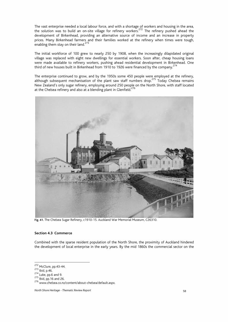
North Shore Heritage - Thematic Review Report
58
The vast enterprise needed a local labour force, and with a shortage of workers and housing in the area, the solution was to build an on-site village for refinery workers.272 The refinery pushed ahead the development of Birkenhead, providing an alternative source of income and an increase in property prices. Many Birkenhead farmers and their families worked at the refinery when times were tough, enabling them stay on their land.273 The initial workforce of 100 grew to nearly 250 by 1908, when the increasingly dilapidated original village was replaced with eight new dwellings for essential workers. Soon after, cheap housing loans were made available to refinery workers, pushing ahead residential development in Birkenhead. One third of new houses built in Birkenhead from 1910 to 1926 were financed by the company.274 The enterprise continued to grow, and by the 1950s some 450 people were employed at the refinery, although subsequent mechanisation of the plant saw staff numbers drop.275 Today Chelsea remains New Zealand’s only sugar refinery, employing around 250 people on the North Shore, with staff located at the Chelsea refinery and also at a blending plant in Glenfield.276
Fig. 41. The Chelsea Sugar Refinery, c1910-15. Auckland War Memorial Museum, C26310. Section 4.3 Commerce Combined with the sparse resident population of the North Shore, the proximity of Auckland hindered the development of local enterprise in the early years. By the mid 1860s the commercial sector on the
272 McClure, pp.43-44. 273 Ibid, p.46. 274 Luke, pp.6 and 9. 275 Ibid, pp.16 and 26. 276 www.chelsea.co.nz/content/about-chelsea/default.aspx.
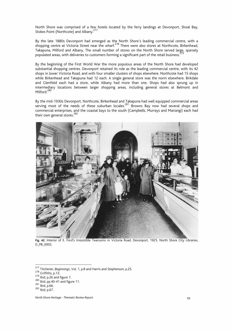
North Shore Heritage - Thematic Review Report
59
North Shore was comprised of a few hotels located by the ferry landings at Devonport, Shoal Bay, Stokes Point (Northcote) and Albany.277 By the late 1880s Devonport had emerged as the North Shore’s leading commercial centre, with a shopping centre at Victoria Street near the wharf.278 There were also stores at Northcote, Birkenhead, Takapuna, Milford and Albany. The small number of stores on the North Shore served large, sparsely populated areas, with deliveries to customers forming a significant part of the retail business.279 By the beginning of the First World War the more populous areas of the North Shore had developed substantial shopping centres. Devonport retained its role as the leading commercial centre, with its 42 shops in lower Victoria Road, and with four smaller clusters of shops elsewhere. Northcote had 15 shops while Birkenhead and Takapuna had 12 each. A single general store was the norm elsewhere. Birkdale and Glenfield each had a store, while Albany had more than one. Shops had also sprung up in intermediary locations between larger shopping areas, including general stores at Belmont and Milford.280 By the mid-1930s Devonport, Northcote, Birkenhead and Takapuna had well equipped commercial areas serving most of the needs of these suburban locales.281 Browns Bay now had several shops and commercial enterprises, and the coastal bays to the south (Campbells, Murrays and Mairangi) each had their own general stores.282
Fig. 42. Interior of E. Ford’s Irresistible Tearooms in Victoria Road, Devonport, 1925. North Shore City Libraries, D_PB_0002.
277 Titchener, Beginnings, Vol. 1, p.8 and Harris and Stephenson, p.25. 278 Griffiths, p.13. 279 Ibid, p.26 and figure 7. 280 Ibid, pp.40-41 and figure 11. 281 Ibid, p.66. 282 Ibid, p.67.

North Shore Heritage - Thematic Review Report
60
The opening of the Auckland Harbour Bridge, and the consequent population increase coupled with greatly increased use of motor vehicles, encouraged a significant expansion of small local shopping centres in the latter part of the twentieth century. As Takapuna became the main centre for the offices of various government departments, it also attracted branch stores of major national and international retailers including Woolworths, Rendells and Milne & Choyce.283 While most commercial centres developed gradually over a number of decades, a new commercial area sprang up at Northcote in the 1960s to serve the surrounding rapidly developing residential area which included a substantial tract of state housing. Sited on an 11 acre plot between Lake Road and College Road, it was comprehensively planned as a major shopping centre with community facilities including council offices, public library and Plunket rooms.284 From the 1960s enclosed shopping malls were introduced to New Zealand from the United States, bringing with them an alternative shopping experience. The Glenfield Shopping Mall opened in 1971 and Shore City in Takapuna arrived in the same decade.285 Since then, there has been further retail expansion, with a new mall development at Highbury opening in the mid 1990s and the Link Drive retail area developing at the same time. However, it is Albany that has seen the most dramatic change in recent years, being transformed into a major retail and commercial centre.286
Fig. 43. Hall’s Corner has been one of the major shopping areas of the North Shore for many decades. This image shows the busy corner in 1966. North Shore Libraries, T0148. In recent years business parks adjacent to the northern motorway, including the Akoranga Business Park and Smales Farm have opened to provide office space for a variety of commercial enterprises. Amongst the businesses at Akoranga is the visually prominent headquarters of The Warehouse, a business now operating 85 stores throughout New Zealand which started life as a single Wairau Valley store in 1982.287
283 SJ Melville, ‘Takapuna: A Destination Sub-Regional Shopping Centre of the Future’, unpublished research project, University of Auckland, 1991, p.12. 284 Holdaway, p.63. 285 Timothy Lewis, ‘The Potential for Redevelopment of the Glenfield Shopping Mall’, unpublished research project, University of Auckland, 1992, p.3. 286 Shore News, 3 May 1995, p.3. 287 www.thewarehouse.co.nz/red/content/homepage/about-us/history.

North Shore Heritage - Thematic Review Report
61
Fig. 44. Commercial enterprises in more remote areas were required to serve a number of purposes. This converted Browns Bay bungalow was the Hayes & Tankard Four Square store, with petrol bowsers and a public telephone located at the entrance, c1960s. North Shore Libraries, EF0366. Section 4.4 Tourism The early development of tourism on the North Shore was closely associated with the provision of ferry services. The first North Shore hotel was the North Auckland Hotel at Stokes Point (Northcote) which opened for business in 1858, on the site now occupied by the Northcote Tavern.288 The area was connected with the city by the North Shore’s first regular ferry service, established four years earlier.289 As early as the 1859 visiting geologist and writer Ferdinand Hochstetter, who had extensively travelled in the Auckland province, noted that the North Shore was destined to become the playground of Auckland.290 By the mid-1860s, in addition to a shop and school, Takapuna had a ferry service and hotel located at Barrys Point, the area closest to the city. Edward Barry gained a bush licence in 1863, allowing him to serve alcohol at his Takapuna Hotel.291 Another hotel licence was granted in 1864 to Roger Barry, for his Shoal Bay premises, but it appears that he was soon running the Takapuna Hotel that had earlier been established by Edward .292 Takapuna quickly became popular with tourists who enjoyed horse races and picnics on the beach. Visitors from the city were conveyed to the area, either by ferry to Barrys Point and then overland to Takapuna beach, or by a cargo vessel that made the trip directly to Takapuna beach on summer weekends.293 Takapuna was a particularly popular excursion for Aucklanders celebrating the birth of their city in late January. On Auckland Anniversary Weekend in 1864, for example, visitors enjoyed horse races, rowing on the lake, and sports including cricket, football and foot racing, with a grand ball held in a large marquee overlooking the lake.294 In 1865 John Logan Campbell
288 Southern Cross, 17 September 1858, p.2. 289 Judith Christmas, A History of Northcote, Auckland, 1983, p.16. 290 Ferdinand von Hochstetter, New Zealand its Physical Geography, Geology and Natural History with Specific Reference to the Results of Government in the Provinces of Auckland and Nelson, Stuttgard, 1867, p.249 and C.A. Fleming, ‘Hochstetter, Christian Gottlieb Ferdinand von 1829-1884’, Dictionary of New Zealand Biography, updated June 2007, http://www.dnzb.govt.nz. 291 Daily Southern Cross, 22 April 1863, p.3 and 5 September 1866, p.4. 292 Ibid, 20 April 1864, p.4 and 18 April 1867, p.6. 293 Titchener, Beginnings, Vol. 3, p.37. 294 Ibid, Vol. 3, p.37.

North Shore Heritage - Thematic Review Report
62
added to the area’s attractions by forming a pleasure garden for tourists in Killarney Street, overlooking both the beach and lake.295 Two additional hotels were established in the mid 1860s on the waterfront at Devonport. In 1864 a license was granted to James Holmes for the Flagstaff Hotel, located on the site now occupied by the Esplanade Hotel, which was built in 1901, and in 1866 Frederick Cock opened the neighbouring Lake Road Hotel (later renamed the Masonic).296 These hotels were joined in the mid 1860s by the British and Victoria hotels, both located on Victoria Street, Devonport.297 While part of the Devonport beach was fenced off for bathing, other parts of the foreshore were littered with boat building yards. Devonport therefore failed to develop into a tourist area at this time with Takapuna offering more for the North Shore visitor.298 In 1866 two more hotel licences were granted at Takapuna to cater for the tourist trade. These new hotels were the Hylton at O’Neills Point, run by John Holmes, and Copland’s Inn, established by James Gratton in central Takapuna.299 A hotel was opened at Albany in the mid-1880s, to serve the travelling public en route to other destinations. Water transport was subject to the vagaries of the tides, often leaving travellers stranded until the next high tide. Not possessing the tourist potential of other parts of the North Shore, Albany would remain a staging post rather than a holiday destination.300
Fig. 45. This image of the Lake Hotel was taken in 1908, not long before it was destroyed by fire. The view from the roof of the hotel must have been spectacular and several people can be seen enjoying the vista. North Shore Libraries, T0305.
295 Hutchinson, p.24. 296 The Flagstaff Hotel had been erected by late 1863 but did not have a liquor license until 1864. Daily Southern Cross, 31 December 1863, p.1; 15 August 1864, p.6; 20 June 1866, p.4 and 6 December 1866, p.4. 297 In April 1864 The Daily Southern Cross mentions a 20 roomed hotel that had recently been opened by Hobson & Co who are also credited in the article with building a jetty at Flagstaff. This appears to be a misspelling of Holmes & Co who are also referred to in the article as boatbuilders who were planning to extend the jetty. It seems clear that the 20-roomed hotel mentioned was the Flagstaff Hotel owned by the Holmes Brothers, which was soon to become a licensed premises. New North Shore bush licenses were granted to W.H. Brown for the Victoria Hotel in 1866 and Michael Wood of the British Hotel in 1867. Daily Southern Cross, 6 April 1864, p.4; 18 April 1866, p.5 and 18 April 1867, p.6. 298 Gael Ferguson, ‘Industry and Commerce’, The Hundred of Devonport: A Centennial History, p.53 and Walsh, p.27. 299 Daily Southern Cross, 5 September 1866, p.4, 13 November 1866, p.1 and 6 December 1866, p.4. 300 Auckland Scrap Book, Auckland City Libraries, September 1969, p.245.

North Shore Heritage - Thematic Review Report
63
The 1880s saw Takapuna further develop as a tourist centre with Lake Pupuke as the key attraction. The Lake Hotel, opened in 1888, was an impressive three storey building that quickly became popular with honeymooning couples as well as other holidaymakers.301 The lake offered boating, swimming and trout fishing as well as pleasant walks and seasonal entertainments.302 It was estimated that some 30,000 people visited the North Shore during the Christmas-New Year period in 1887-1888, many of whom visited the lake.303 By this stage Devonport was also vying for the tourist trade, with local ferry operators providing two new tourist attractions to boost visitor numbers from across the harbour. In the early 1880s work began on developing the Victoria Gardens, featuring a seaside zoo on the Devonport foreshore. In 1882 the public was invited to a band contest and moonlight carnival featuring fireworks and dancing at the Victoria Gardens. The fact that 3000 people attended the event proved that well publicised tourist attractions at Devonport could pull a significant crowd, even though the so called gardens consisted of a recently ploughed field with not a plant in sight, and proved to be a bitter disappointment to visitors. The planned zoo subsequently got as far as having a couple of bears that had been purchased from a circus and the attraction became briefly known as the “Bear Gardens” before closing for business.304 Fortunately, the other Devonport attraction of the period was more successful.
Fig. 46. Summer events at the beach resorts attracted numerous visitors. This image shows Ray Natali and Ray Jones in fancy dress entertaining the crowd at Browns Bay beach on New Years Eve, 1952. North Shore Libraries, E0370. The strawberry gardens on Beach Road in Devonport were operating in the 1880s serving fresh strawberries from Northcote and cream from Lake Takapuna. This venture was established by the Alison family and it no doubt helped their ferry business survive in a climate of fierce competition.305 Birkenhead and Northcote also became popular destinations during the strawberry season. Visitors
301 Observer, 8 June 1899, p.3 and Titchener, Beginnings, Vol. 3, p.23. 302 Bay of Plenty Times, 4 February 1895, p.3. 303 Dimery, pp.6 and 7. 304 New Zealand Herald, 4 March 1882, pp.5 and 8; Auckland Evening Star, 6 March 1882, p.3; Brian Bond, 90 Seasons: A History of the North Shore United Association Football Club, Auckland, 1977, p.12. 305 Griffiths, p.17 and Walsh, p.31.

North Shore Heritage - Thematic Review Report
64
arrived by ferry and were invited to partake of strawberries, scones, cake and tea at the strawberry farms, with walks on the beach and dancing in the local hall providing other entertainments.306 From 1910 tourists from all over New Zealand came to visit the Wragge Institute and Museum and the surrounding Waiata Tropical Gardens in Arawa Street, Birkenhead. The brainchild of meteorologist Clement Wragge, the gardens featured 40 different kinds of palms and a variety of exotic edible plants including bananas and ginger. Wragge played host to his visitors dressed in a turban, helped by his Indian wife who told the fortunes of tourists. He offered lectures and lantern slide shows on diverse subjects, and was happy to share his eccentric theosophical beliefs. After his death in 1922, his son kept his home and gardens open to visitors.307
Fig. 47. Mrs Edris Wragge stands on the veranda at the Waiata Tropical Gardens, Birkenhead, Auckland (c.1920). WA Price Collection, Alexander Turnbull Library, Wellington, 1/2-000920-G. While tourism on the North Shore was primarily centred around the more populous and easily accessible areas of Takapuna, Devonport, Northcote and Birkenhead in the nineteenth century, there was a more remote area that was also a tourist locale. The Brown family of Browns Bay established a boarding house and store in the 1880s, bringing tourism to the northern bays. In 1916 the Brown property was subdivided for seaside cottages. This subdivision of former coastal farmland for holiday purposes was part of a wider change in land use that saw baches built in the nearby bays.308
306 McClure, p.74. 307 Ibid, p.134. 308 JA Mackay, ‘The East Coast Bays on Auckland’s North Shore’, Auckland-Waikato Historical Journal, p.2 and ECB: The Years to 1989, unpaginated.
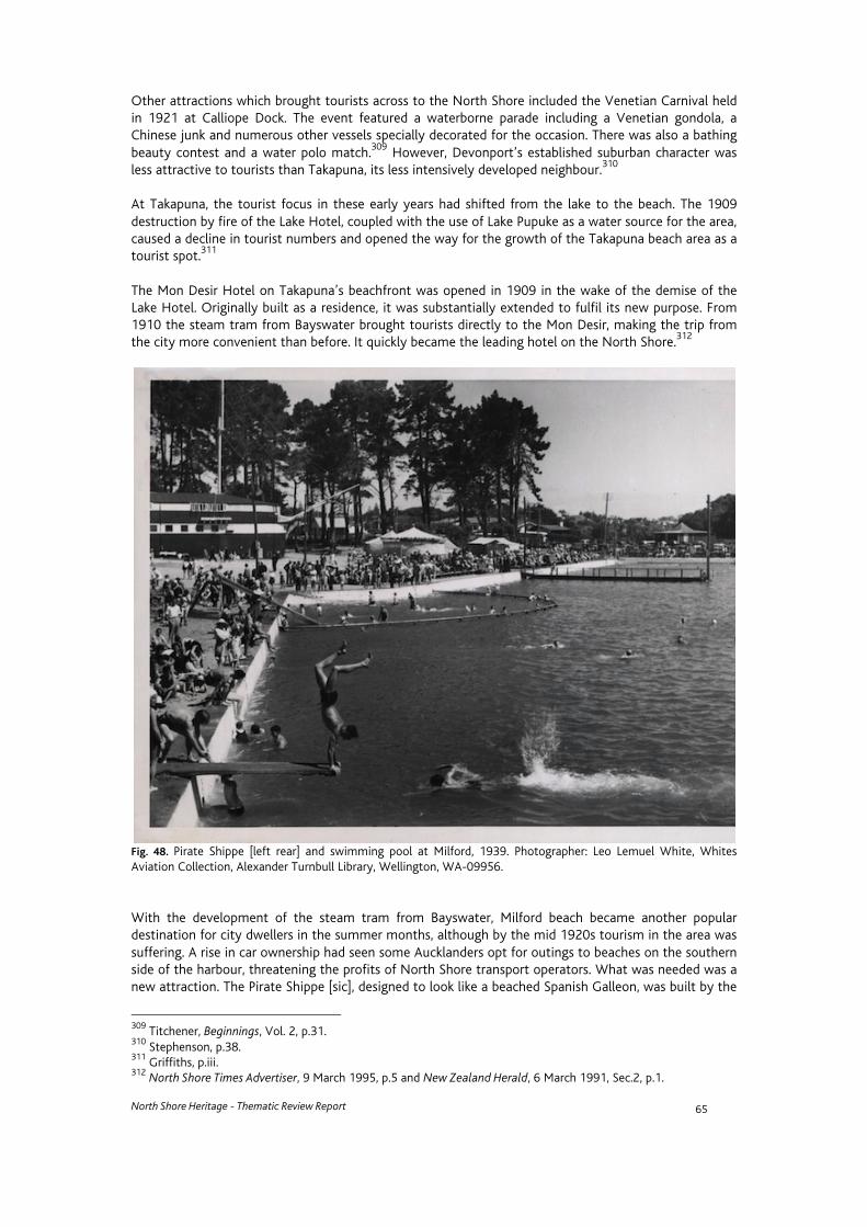
North Shore Heritage - Thematic Review Report
65
Other attractions which brought tourists across to the North Shore included the Venetian Carnival held in 1921 at Calliope Dock. The event featured a waterborne parade including a Venetian gondola, a Chinese junk and numerous other vessels specially decorated for the occasion. There was also a bathing beauty contest and a water polo match.309 However, Devonport’s established suburban character was less attractive to tourists than Takapuna, its less intensively developed neighbour.310 At Takapuna, the tourist focus in these early years had shifted from the lake to the beach. The 1909 destruction by fire of the Lake Hotel, coupled with the use of Lake Pupuke as a water source for the area, caused a decline in tourist numbers and opened the way for the growth of the Takapuna beach area as a tourist spot.311 The Mon Desir Hotel on Takapuna’s beachfront was opened in 1909 in the wake of the demise of the Lake Hotel. Originally built as a residence, it was substantially extended to fulfil its new purpose. From 1910 the steam tram from Bayswater brought tourists directly to the Mon Desir, making the trip from the city more convenient than before. It quickly became the leading hotel on the North Shore.312
Fig. 48. Pirate Shippe [left rear] and swimming pool at Milford, 1939. Photographer: Leo Lemuel White, Whites Aviation Collection, Alexander Turnbull Library, Wellington, WA-09956. With the development of the steam tram from Bayswater, Milford beach became another popular destination for city dwellers in the summer months, although by the mid 1920s tourism in the area was suffering. A rise in car ownership had seen some Aucklanders opt for outings to beaches on the southern side of the harbour, threatening the profits of North Shore transport operators. What was needed was a new attraction. The Pirate Shippe [sic], designed to look like a beached Spanish Galleon, was built by the
309 Titchener, Beginnings, Vol. 2, p.31. 310 Stephenson, p.38. 311 Griffiths, p.iii. 312 North Shore Times Advertiser, 9 March 1995, p.5 and New Zealand Herald, 6 March 1991, Sec.2, p.1.

North Shore Heritage - Thematic Review Report
66
Fletcher Construction Company and opened in January 1929. Offering refreshments during the day, and at night it became a fashionable destination with its two dance floors and restaurant. The tourist facilities at Milford got another boost in 1936 when an enormous seawater swimming pool was opened alongside the Pirate Shippe. Milford had become a major tourist hot spot, but this would not last. The war years saw a major decline in patronage as young men were called up to defend their country and petrol restrictions hindered travel for others. Along with other tourist attractions in the area, the Pirate Shippe was allowed to deteriorate. It was finally demolished in the 1950s.313 Takapuna’s role as a tourist magnet declined from around the 1930s. Up until then it had been a popular resort, both for day trippers from the city, and for other visitors who made good use of its numerous holiday baches for longer stays. Residential development of Takapuna saw these baches gradually replaced by permanent dwellings, and city folk seeking somewhere to get away from it all now had to search further afield.314 The East Coast Bays area retained the rural feel that had earlier attracted tourists to Takapuna, and the subdivision of farmland in the bays provided opportunities for new summer bach communities to develop. A camping ground was established at Browns Bay on the site of the former Brown homestead and the summer carnivals at Browns Bay were popular attractions.315 As had already occurred in coastal communities closer to Auckland, the East Coast Bays were gradually swallowed up by the boom in permanent residential development, following the opening of the harbour bridge. No longer a place to get away from the hustle and bustle of city life, the North Shore gradually carved out a new niche in the tourist landscape. There would be somewhat of a resurgence of tourism at Takapuna in the 1960s, with new hotels attracting tourists who stayed for longer periods.316 The Milford Marina Hotel opened in 1965, and in the same year the original Mon Desir Hotel was replaced with a new building, designed by Stephenson and Turner Architects in a Japanese influenced style. It won a New Zealand Institute of Architects’ National Award of Merit with its imaginative site planning noted by the judges. One of the novel features of the hotel was a beer garden, the first to be opened in Auckland. The new international standard hotel became a popular place to stay for visiting entertainers including David Bowie.317 Meanwhile the nearby camping ground which had been established on The Promenade in the early twentieth century continued to be a popular holiday spot.318 Following international trends in tourist accommodation, a number of motor inns and motels were built from the 1960s in various parts of the North Shore. One of the earliest and best known was the Poenamo in Northcote, which opened in late 1963. It was Auckland’s first fully licensed motel and it had a number of on-site facilities including two bars, a restaurant, recreation hall and swimming pool.319 In the closing decades of the twentieth century Devonport evolved from a quiet suburban area into a pleasant tourist locale. The upgrading of the wharf facilities in 1992, the opening of numerous bars, restaurants, antique shops, art galleries and bed and breakfasts, and the growing public appreciation of its large and relatively intact stock of early 20th century buildings, boosted tourist numbers.320 Currently the shops and restaurants of Takapuna also attract the tourist dollar while the pleasant beaches of the North Shore continue to draw visitors. At the same time, there has been investment in developing and promoting the tourist potential of the surviving natural and historic features of the North Shore. Today tourists can enjoy heritage walks, bush and coastal walks, along with numerous attractive and safe beaches. A range of accommodation is on
313 Titchener, Beginnings, Vol. 1, pp.43-44 and Vol. 6, pp.4-6. 314 Dimery, p.36. 315 Mace, Introduction and Item 12 and ECB: The Years to 1989, unpaginated. 316 Dimery, p.36. 317 North Shore Times Advertiser, 18 June 1973, p.35; 20 June 1968, p.18 and New Zealand Herald, 6 March 1991, Sec.2, p.1. 318 North Shore Times Advertiser, 1 December 1977, p.1. 319 Auckland Scrap Book, Auckland City Libraries, March 1962, p.164 and August 1963, p.196. 320 Metro, October 1993, p.109.

North Shore Heritage - Thematic Review Report
67
offer on the North Shore from motels, campgrounds, and bed and breakfasts, to hotels including the high rise Spencer on Byron, which is a recent and prominent addition to the Takapuna skyline. The holiday attractions and summer carnivals that boosted visitor numbers in earlier years are a thing of the past but new cultural events have been developed to pull visitors to the North Shore. New Zealand Sculpture OnShore, established in 2006, is a popular outdoor art event showcasing the work of New Zealand sculptors and is held at the Fort Takapuna Historic Reserve overlooking the harbour. Since 1990 the annual Devonport Wine and Food Festival has also brought huge crowds to the Devonport waterfront.321
321 Metro, October 1993, p.109.

North Shore Heritage - Thematic Review Report
68
Chapter 5 Government Section 5.1 Local Government Much of the history of local government on the North Shore has been about reconciling local demands for services and infrastructure with the revenue made available by ratepayers to pay for them. Often that demand has outpaced the ability of existing institutions to provide them and the desire of ratepayers to service them adequately. Roads were the first service required of local government, with responsibility apportioned between highway boards and the provincial and later, central government. This was followed by the provision of drainage, fresh water supply, parks and other municipal facilities. The first local administrative body for the area was the Hundred of Pupuke, one of six hundreds formed in 1848 within the Eden County land district. The Hundred took in the eastern portion of the North Shore including Devonport, Takapuna and the East Coast Bays as far north as Murrays Bay. This early local body was responsible for the formation of roads and other public works as well as the administration of crown ‘wastelands’ for lease.322 However, the small amounts of Crown land available for pasturing, local rivalries over road expenditure and questions over subsidies to the Devonport ferry service, eventually led to the dissolution of the Hundred in 1856.323 With the demise of the Hundred of Pupuke, administration of the North Shore passed to the Auckland Provincial Council. The 1862 Highways Act allowed residents to petition the Provincial Council to form a Highway District Board, with the ability to raise rates for roads and bridges. Five trustees could be elected on an annual basis, with electors given votes according to the size of the land rated.324 Under the provisions of the 1862 Act, the North Shore Highway District was defined in 1864, taking in all land to the south of a line linking the Okura River and Lucas Creek. As nothing was done to elect a board, it appears that North Shore residents were not keen to have such a large administrative area. Two new highway districts were subsequently formed within the North Shore Highway District boundaries. The Lake (Takapuna) and Flagstaff (Devonport) highway districts were delineated in 1866. These districts elected trustees and were underway early in 1867. In the following year the North Shore Highway District Board finally commenced work, administering what is now Birkenhead, most of Glenfield and Albany. Meanwhile a highway district was delineated at Stokes Point (Northcote) and a board elected.325 Unlike the Flagstaff Highway Board, which had its first meeting on 25 February 1867, the Lake Road Board did not run smoothly and the entire Board was voted out at the 1868 meeting. Reports of the meeting include many motions moved and failed and a general lack of order.326 This was not the only short lived local body on the North Shore. In 1886 a highway board was formed at Greenhithe but it folded after just two years.327 While the Stokes Point Highway Board initially went through a troubled period, it survived into the mid-1870s.328 With the abolition of the provinces in 1876 came the establishment of numerous counties throughout the country to administer local public works where road boards (formerly known as highway boards) had not been established.329 On the North Shore, road boards continued to manage local affairs in Devonport, Takapuna and Northcote (Stokes Point), but the remainder of the area came under the jurisdiction of Waitemata County. The county was enormous, encompassing a largely rural area that
322 GT Bloomfield, The Evolution of Local Government Areas in Metropolitan Auckland 1840-1971, Auckland, 1973, pp.41. 323 Verran, The North Shore, p.119. 324 Ibid. 325 Verran states that the board also administered Northcote, however this area was administered by the Stokes Point Highway Board. Ibid, p.120; Bloomfield, pp.124, 125 and 126; Daily Southern Cross, 5 February 1867, p.3; 7 February 1867, p.5; 7 March 1868, p.3 and 24 March 1868, p.4. 326 Verran, The North Shore, p.120. 327 Bloomfield, pp.124 and 128. 328 Daily Southern Cross, 3 March 1870, p.3 and 29 May 1876, p.2. 329 McKinnon, p.51.

North Shore Heritage - Thematic Review Report
69
included West Auckland and the northern and western parts of the North Shore.330 By 1884 the people of Birkenhead were ready for local control and the area was subsequently defined as a road district.331
Fig. 49. Birkenhead Borough Council chambers shown on its original site in Hinemoa Street. North Shore Libraries, B0441. In 1886 Devonport evolved from a road board into a borough, becoming the first body of its kind on the North Shore. It was soon followed by Birkenhead, which elected its first borough council in 1888.332 Not all areas evolved from road board to borough council administration. In June 1889 the Lake (Takapuna) and Northcote road boards were dissolved in favour of direct Waitemata County control. Local works committees were then established by the county for Northcote, Takapuna and the rural part of Birkenhead, which did allow some expenditure on local roads. The members were elected at annual meetings of householders. The county was divided into ridings, which each had their own individual rate, along with the general county rate, and Takapuna had its own foreman of works.333 In the 1890s local petitioners sought the formation of separate boroughs for Takapuna and Northcote. Although Waitemata County successfully contested both, the increasing sense of local community was undeniable. Northcote became a borough in 1908 and Takapuna in 1913.334 The North Shore now had borough councils administering local affairs in the most densely populated districts, with the sparsely settled areas to the north and west of Takapuna remaining under Waitemata County Council control. Residents of the East Coast Bays became increasingly disgruntled with the lack of funds available for local improvements, and in the early 1950s a petition signed by nearly half the eligible voters was sent to the Department of Internal Affairs seeking a more local administration. The
330 Verran, The North Shore, p.120 and Bloomfield, p.55, 56 and 57. 331 Bloomfield, p.124. 332 Ibid, p.125 333 Verran, The North Shore, p.123. 334 Ibid, pp.123 and 125.

North Shore Heritage - Thematic Review Report
70
proclamation of the East Coast Bays Borough in 1954 allowed the area to move forward with major infrastructure projects and other local improvements.335
Fig. 50. A night view of the Devonport Borough Council Offices on Victoria Road (formerly the Post Office) specially decorated and lit for the visit of Queen Elizabeth II in 1953. North Shore Libraries, D_GBB_0017.
Fig. 51. Old Northcote Borough Council Chambers building, 1950s. North Shore Libraries, N0101001.
While Glenfield remained under the control of Waitemata County, the growing population of the area was recognised with the formation of Glenfield County Town in 1961, one of a number of such towns formed in the suburban parts of the county. This meant that more of the revenue from local rates was spent on improvements in Glenfield.336
335 Mace, Item 19. 336 Bloomfield, p.84.

North Shore Heritage - Thematic Review Report
71
Population growth eventually led to some of the North Shore boroughs achieving city status. The first was Takapuna, which became a city in 1961, with East Coast Bays and Birkenhead following in 1975 and 1978.337 In the second half of the twentieth century, Takapuna City expanded its boundaries to include Castor Bay in 1954 and Glenfield and Albany in 1974.338 This move toward larger local bodies would take a significant step forward in the late 1980s. In 1989 local government throughout New Zealand was overhauled with the abolition of boroughs and counties in favour of larger city or regional councils. All the cities and boroughs in the North Shore area were amalgamated into one new North Shore City. There was significant opposition to the merging of Devonport Borough into the new administrative body, but this sentiment did not prevail.339 In November 2010 a new era dawned with the formation of the new Auckland Council, taking in the areas formerly administered by North Shore, Auckland, Waitakere and Manukau city councils, along with Franklin, Rodney and Papakura district councils. Section 5.2 Defence
The North Shore has a long history as a place of defence. Pre-European Maori defended themselves at headland pa sites, and the district has been utilised for defence purposes since the early years of the colony, well before the formation of any local permanent armed forces.340
The attraction of the North Shore headlands for Maori lay not only in their suitability for adaptation to defensive units but their proximity to traditional areas of occupation, natural resources, and traditional travel routes. Not all the headlands were transformed to pa however, nor were all North Shore pa as large or heavily terraced as some on the Auckland isthmus. This reflected the distribution of smaller iwi and hapu units around the coastal margins in pre-European times, with groups from a number of hapu occupying different areas. When conflict arose, the coastal pa offered protection to the local kainga. At various points in time the occupants of these pa included Ngai Tai, Te Kawerau, Ngati Whatua, Ngati Paoa, or hapu of these.341
Many of the smaller inner harbour pa, such as Te Matarae A Mana (Kauri Point), which overlooks a traditional shark breeding ground, and Te Onewa (Northcote Point), with its commanding views up and down the harbour, were established close to traditional fishing and cultivation areas, on land that afforded good views of the harbour and direct access to coastal and inland resources.342 Further up the harbour, pa located around Paremoremo and Greenhithe offered refuge and protection to local kainga cultivating the land there. Along the east coast, Rahopara Pa at Castor Bay was a Te Kawerau stronghold that provided direct access to the Hauraki Gulf and beyond, and a bastion to invading northern forces.
Several larger pa were also located around Devonport, where the large volcanic cones were well-suited for adaptation for defence and the rich volcanic loams offered fertile garden soils, along with easy access to the coastal resources.343 A large swamp, now reclaimed land in the area of the Waitemata Golf Course, provided flax and raupo for the manufacture of utilitarian objects, and food sources. These pa, which included Takuranga (Mt Victoria), Maungauika (North Head), Takamaiwaho (Duder’s Hill) and Takararo (Mt Cambria) also protected the entrance to the Waitemata.344
337 Verran, The North Shore, pp.126 and 129. 338 Ibid, p.126. 339 Ibid, p.285. 340 McClure, p.11. 341 Verran, ‘Maori and Pakeha on the North Shore 1840 – 1926’, accessed 17 March 2011. 342 Birkenhead City Council, Kauri Point Centennial Park Management Plan, Queen Elizabeth II National Trust, 1989, p.5. 343 A large traditional garden area once existed in the area bounded by Domain Street, Burgess Road, Tainui Road and Vauxhall Road. New Zealand Archaeological Association Site Record Form R11/1953. 344 New Zealand Archaeological Association Site Record Forms R11/109, R11/97, R11/108, R11/110.

North Shore Heritage - Thematic Review Report
72
By the time of European settlement in Auckland around the 1840s, the pa of the North Shore were mostly unoccupied, and those few that had occupants were later abandoned, largely due to the sale of the North Shore during the Mahurangi purchase.345 While the military might of early colonial Auckland was centred around Fort Britomart across the harbour, where Imperial forces were stationed, the importance of the North Shore in the protection of Auckland City was soon recognised. As early as the 1840s naval ships from the Australasian squadron visited Auckland, choosing to anchor at Devonport, which offered deeper water than the city side of the harbour. Captain Hobson, officer of the Royal Navy and first Governor of New Zealand, recognised the need for a naval officer to serve at Auckland. Lieutenant Snow was soon appointed to the post and a naval signal station established on Mt Victoria, which offered a clear view of the harbour approaches.346 The appointment of Snow was the first naval appointment in the country, at a time when the establishment of a fully fledged local naval service was decades away. With the outbreak of the Waikato War in 1863 came the need for a permanent naval base at Auckland. Devonport was the obvious choice, being close to the city while also offering a deep water frontage. Naval ships began arriving and the Royal Navy subsequently played an important role in the Waikato campaign.347 While military might was primarily centred on internal conflicts during the first decades of the young colony, there would soon be a threat from elsewhere which would result in the establishment of a significant coastal defence system. Although physically distant from the major international conflicts of the nineteenth century, New Zealand’s status as a colony of the British Empire made it a potential target for British enemies. Worsening relations between Britain and Russia in the 1880s heightened the threat from Russia that had been bubbling away for decades, and finally led to a national coastal defence system funded by the colonial government.348 Coastal defences against potential invasion had been mooted and abandoned several times, as the young colony struggled to deal with its own civil wars, along with numerous other demands on the public purse. However, from the mid 1880s a series of coastal defences were finally built to protect New Zealand’s major harbours.349 In Auckland, many of these Victorian coastal defence works were sited in Devonport and Takapuna, areas well located to defend the approaches to the Waitemata Harbour.350 North Head was in prime position overlooking the junction of the Rangitoto and Motukoreho channels and it would be Auckland’s key coastal defence for many decades. Three batteries were built on North Head and guns were installed at Mt Victoria to the west. Fort Takapuna was erected on a headland above Narrow Neck beach to protect the Rangitoto Channel and was Auckland’s outermost fort of the era.351 These coastal defences were manned by small corps of volunteers raised under the Militia Act of 1858.352 In 1886 four torpedo boats were sent to New Zealand from Britain to bolster coastal defences in the four main cities. A torpedo yard was established at Devonport in what became known as Torpedo Bay. This depot replaced one which had been built across the harbour at Biddicks Bay, near Bastion Point, and was designed to lay and maintain a minefield across the harbour.353
345 Verran, ‘Maori and Pakeha on the North Shore 1840 – 1926’, accessed 17 March 2011. 346 Howard, pp.5-6. 347 Denis Fairfax, ‘Wiseman, William Saltonstall 1814-1874’, Dictionary of New Zealand Biography, updated June 2007, http://www.dnzb.govt.nz. 348 Russell Glackin, In Defence of Our Land: A Tour of New Zealand’s Historic Harbour Forts, Auckland, 2009, pp.9-10. 349 Ibid, pp.14-19, 24, and 33. 350 Peter Cooke, Defending New Zealand: Ramparts on the Sea 1840-1950s, Wellington, 2000, p.31. 351 Peter D. Corbett, A First Class Defended Port: The History of the Coast Defences at Auckland, its Harbour and Approaches, Auckland, 2003, pp.15, 20, 22, 24 and 29. 352 R.M. Wicksteed, The New Zealand Army: A History from the 1840s to the 1980s, Wellington, 1982, p.5. 353 Corbett, p.37.
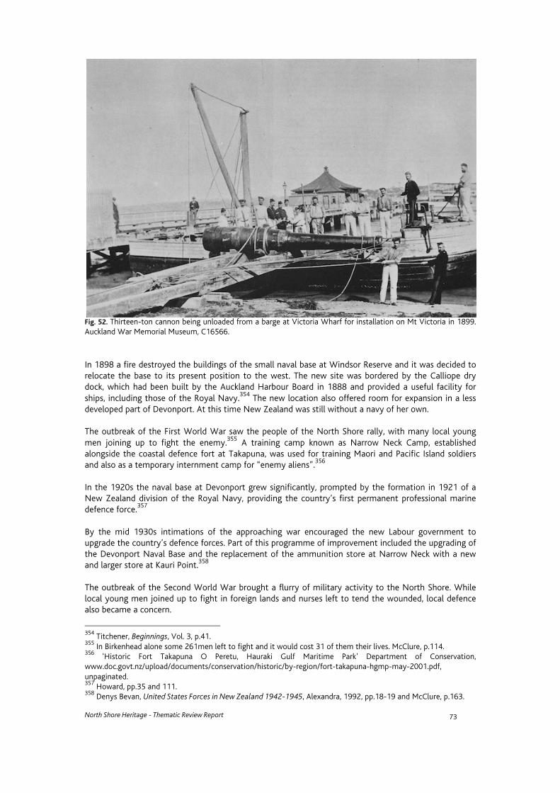
North Shore Heritage - Thematic Review Report
73
Fig. 52. Thirteen-ton cannon being unloaded from a barge at Victoria Wharf for installation on Mt Victoria in 1899. Auckland War Memorial Museum, C16566. In 1898 a fire destroyed the buildings of the small naval base at Windsor Reserve and it was decided to relocate the base to its present position to the west. The new site was bordered by the Calliope dry dock, which had been built by the Auckland Harbour Board in 1888 and provided a useful facility for ships, including those of the Royal Navy.354 The new location also offered room for expansion in a less developed part of Devonport. At this time New Zealand was still without a navy of her own. The outbreak of the First World War saw the people of the North Shore rally, with many local young men joining up to fight the enemy.355 A training camp known as Narrow Neck Camp, established alongside the coastal defence fort at Takapuna, was used for training Maori and Pacific Island soldiers and also as a temporary internment camp for “enemy aliens”.356 In the 1920s the naval base at Devonport grew significantly, prompted by the formation in 1921 of a New Zealand division of the Royal Navy, providing the country’s first permanent professional marine defence force.357 By the mid 1930s intimations of the approaching war encouraged the new Labour government to upgrade the country’s defence forces. Part of this programme of improvement included the upgrading of the Devonport Naval Base and the replacement of the ammunition store at Narrow Neck with a new and larger store at Kauri Point.358 The outbreak of the Second World War brought a flurry of military activity to the North Shore. While local young men joined up to fight in foreign lands and nurses left to tend the wounded, local defence also became a concern.
354 Titchener, Beginnings, Vol. 3, p.41. 355 In Birkenhead alone some 261men left to fight and it would cost 31 of them their lives. McClure, p.114. 356 ‘Historic Fort Takapuna O Peretu, Hauraki Gulf Maritime Park’ Department of Conservation, www.doc.govt.nz/upload/documents/conservation/historic/by-region/fort-takapuna-hgmp-may-2001.pdf, unpaginated. 357 Howard, pp.35 and 111. 358 Denys Bevan, United States Forces in New Zealand 1942-1945, Alexandra, 1992, pp.18-19 and McClure, p.163.

North Shore Heritage - Thematic Review Report
74
Fig. 53. During World War II barbed wire was strewn across the beaches of the North Shore to hamper enemy landings. Here two children play in the sand close by the defences. Auckland War Memorial Museum, C20965. Many of the coastal defences that had been built from the mid 1880s were added to and upgraded during the late 1930s and early 1940s.359 The beaches were strewn with barbed wire to hamper enemy landings, roadblocks and ditches were formed, and new guns were installed along the coast from Long Bay in the north to Takapuna in the south.360 There was also a fear of airborne attack, and the concentration of military facilities on the North Shore made it a particular target. Anti-aircraft guns were installed at various places around Auckland including Bayswater, Belmont, Northcote, Stanley Bay, Castor Bay, Devonport Dockyard, Kauri Point, North Head and Takapuna. These were aided by searchlights installed at Belmont, Stanley Bay and Mt Victoria.361 In 1942 a camp was established at Hillcrest to house the First Auckland Battalion, but with their departure came a new military force from the far side of the Pacific Ocean.362 As the battlefront moved into the Pacific, and closer to New Zealand, help was needed locally. New Zealand had already sent much equipment and manpower to the war effort far from home, leaving the country ill equipped and ill prepared for the feared Japanese invasion. From 1942 local military forces were boosted with the arrival of United States personnel. Camps were established to house the troops, many of them in and around Auckland.363 At Hillcrest a collection of farm buildings and tents housed the 950th Anti-aircraft Artillery Automatic Weapons Battalion and the 250th Searchlight Group.364
359 Corbett, pp.134-5. 360 Ibid, pp.163-7. 361 Ibid, pp.157-160. 362 Jack and June Hinton, The Friendly Invasion of New Zealand by American Armed Forces June 1942-October 1944, Wellington, 1993, p.28. 363 Bevan, pp.20, 21, 22, 52 and 53. 364 The site of Camp Hillcrest is now a reserve and is marked with a commemorative plaque. Hinton, p.7.

North Shore Heritage - Thematic Review Report
75
The US forces brought an air of security and a sense of excitement to the North Shore. The troops were invited into local homes and enjoyed socialising at places like the Pirate Shippe in Milford, and the Esplanade Hotel and Victoria Theatre in Devonport.365 But locals also had a role in the war effort at home, with many men who were unable to serve overseas joining the Home Guard. Volunteers trained with the Red Cross in case they were needed to treat the sick and wounded. Some North Shore women worked as land girls, growing and harvesting crops for the war effort, or filled in for absent men in a variety of traditionally masculine jobs.366 After the Second World War, the North Shore continued to have a significant defence role. Narrow Neck camp was utilised by both the army and the navy for training purposes and the Devonport Naval Base continued to expand.367 However, the old forts which had watched over the approaches to the Auckland harbour were now obsolete. Changes in military technology had altered the landscape of modern warfare. Invasion was no longer seen as a threat and in 1959-60 the last of New Zealand’s remaining coastal defences were closed.368
Fig. 54. The Home Guard exercising at Browns Bay, c1942. North Shore Libraries, EF0507. Many of the former military sites have become parks and reserves including those at North Head, Fort Takapuna and Castor Bay (now John F Kennedy Memorial Park). Here locals and tourists alike can enjoy the sweeping views that had attracted defence planners and explore what remains of the nineteenth and twentieth century military installations. Today the navy remains a significant presence on the North Shore. Along with the Devonport Naval Base, the naval armaments depot at Kauri Point remains in use, as does the naval training facility at Narrow Neck.
365 Hinton, p.8 and 28. 366 McClure, pp.165, 169 and 169 and Lowrie, p.59. 367 Howard, p.112 and ‘Historic Fort Takapuna O Peretu, Hauraki Gulf Maritime Park’ Department of Conservation, www.doc.govt.nz/upload/documents/conservation/historic/by-region/fort-takapuna-hgmp-may-2001.pdf, unpaginated. 368 Glackin, p.139.
North Shore Heritage - Thematic Review Report
76
Section 5.3 Justice With the founding of Auckland in 1840 came the establishment of the first police force in the fledgling settlement.369 During the colony’s infancy, Auckland’s North Shore was one of the few places in the country where a police presence was relatively close to hand, with the Auckland police located just across the harbour. In the mid-1840s the police system in the colony was overhauled, and it was the new armed police force that would visit the Devonport in 1847 to investigate, following the discovery of the mutilated bodies of Lieutenant Robert Snow, his wife Hannah and daughter Mary in their home in King Edward Parade. The Snow family were among the few Pakeha settlers on the North Shore at the time, where Snow held the post of Head of Naval Operations in the colony. After considerable investigation Joseph Burns of Shoal Bay was convicted of the crime. Justice was meted out in June 1848 when he was transported across to Devonport and hanged at the scene of the crime. Burns thus became the first European person to be hanged for a capital crime in New Zealand.370 The North Shore was policed from Auckland until 1869 when the first local cop was appointed by the Flagstaff Highway Board.371 By this stage the police had become a nationwide force, known as the armed constabulary, with the dual roles of policing and defence.372 In 1873 a special constable was appointed at Devonport to take over some of the duties of the existing policeman, including keeping the local pound and dealing with the rabbit nuisance on Mt Victoria.373 By the late 1870s Devonport policeman was tasked with keeping order as far north as the Wade River and Lucas Creek.374 In 1886 policing in New Zealand was reorganised, with the police relinquishing their role in defence. Although the force would remain part of the Defence Department until 1896, when it was handed over to the Department of Justice, these changes enabled the police force to concentrate on policing.375 The first home of the Devonport police appears to have been in Victoria Road. A house in nearby Clarence Street later served as the police residence and office.376 By the close of the nineteenth century the police force at Devonport could no longer cope with the expanding population. A police station was opened at 11 Clarence Street, Northcote, at the turn of the century and this was followed by one at 110 Hinemoa Street, Birkenhead, in 1905-6.377 In May 1912 a station was opened in Takapuna with Constable Henry Steere as the sole charge policeman. He was responsible for policing the area north of Roberts Avenue in Belmont all the way to Hatfields Beach in the north and to Riverhead in the west. Needless to say, this was a difficult task.378 Steere was supervised by Sergeant Baskiville of Devonport.379 The appointment of Constable Steere at Takapuna in 1912 brought the total police force for the North Shore to seven, with four stationed at Devonport and one policeman at each of the other stations.380
369 Richard S Hill, Policing the Colonial Frontier, Part I, Wellington, 1986, pp.146-7. 370 Janice C Mogford, ‘Burns, Joseph, 1805/6?-1848’, Dictionary of New Zealand Biography, Vol. 1, 2nd ed., Wellington, 1993, p.58; RS Hill, Policing the Colonial Frontier, p.216; New Zealander, 21 June 1848, p.2 and New Zealand Herald, 11 July 1998, Sec. A, p.11. 371 North Shore Times Advertiser, 28 January 1975, p.17. 372 Murray Hill, In the Line of Duty: 100 Yeas of the New Zealand Police, Auckland, 1986, p.11. 373 ‘Takapuna H.Q. Northern Police Division: Souvenir Programme of 62nd Anniversary of Station Opening, 29 May 1912’, Vertical File, Police, Takapuna Library, p.12. 374 Ibid, p.12. 375 Murray Hill, In the Line of Duty: 100 Yeas of the New Zealand Police, pp.12 and 13. 376 ‘Takapuna H.Q. Northern Police Division: Souvenir Programme’, Vertical File, Takapuna Library, p.12. 377 Appendices to the Journals of the House of Representatives, 1900, H-16, p.1 and 1906, H-16, p.8. 378 ‘Takapuna H.Q. Northern Police Division: Souvenir Programme’, Vertical File, Takapuna Library, p.19 379 Ibid, p.19. 380 Appendices to the Journals of the House of Representatives, 1913, H-16, p.17.
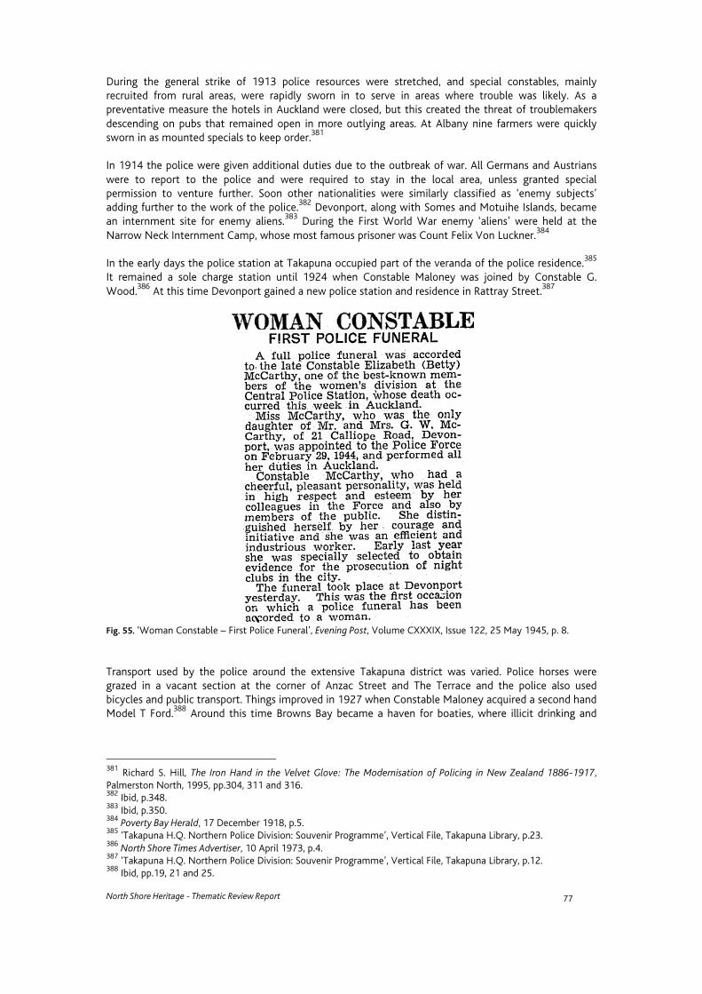
North Shore Heritage - Thematic Review Report
77
During the general strike of 1913 police resources were stretched, and special constables, mainly recruited from rural areas, were rapidly sworn in to serve in areas where trouble was likely. As a preventative measure the hotels in Auckland were closed, but this created the threat of troublemakers descending on pubs that remained open in more outlying areas. At Albany nine farmers were quickly sworn in as mounted specials to keep order.381 In 1914 the police were given additional duties due to the outbreak of war. All Germans and Austrians were to report to the police and were required to stay in the local area, unless granted special permission to venture further. Soon other nationalities were similarly classified as ‘enemy subjects’ adding further to the work of the police.382 Devonport, along with Somes and Motuihe Islands, became an internment site for enemy aliens.383 During the First World War enemy ‘aliens’ were held at the Narrow Neck Internment Camp, whose most famous prisoner was Count Felix Von Luckner.384 In the early days the police station at Takapuna occupied part of the veranda of the police residence.385 It remained a sole charge station until 1924 when Constable Maloney was joined by Constable G. Wood.386 At this time Devonport gained a new police station and residence in Rattray Street.387
Fig. 55. ‘Woman Constable – First Police Funeral’, Evening Post, Volume CXXXIX, Issue 122, 25 May 1945, p. 8. Transport used by the police around the extensive Takapuna district was varied. Police horses were grazed in a vacant section at the corner of Anzac Street and The Terrace and the police also used bicycles and public transport. Things improved in 1927 when Constable Maloney acquired a second hand Model T Ford.388 Around this time Browns Bay became a haven for boaties, where illicit drinking and
381 Richard S. Hill, The Iron Hand in the Velvet Glove: The Modernisation of Policing in New Zealand 1886-1917, Palmerston North, 1995, pp.304, 311 and 316. 382 Ibid, p.348. 383 Ibid, p.350. 384 Poverty Bay Herald, 17 December 1918, p.5. 385 ‘Takapuna H.Q. Northern Police Division: Souvenir Programme’, Vertical File, Takapuna Library, p.23. 386 North Shore Times Advertiser, 10 April 1973, p.4. 387 ‘Takapuna H.Q. Northern Police Division: Souvenir Programme’, Vertical File, Takapuna Library, p.12. 388 Ibid, pp.19, 21 and 25.

North Shore Heritage - Thematic Review Report
78
rowdy behaviour earned it the moniker “Naughty Bay”, prompting Constable Maloney to visit the area on weekends and holidays.389 Improvements were made at Takapuna in 1927 when the timber lock up was moved and one of the cells converted into an office. This served as the Takapuna police station until 1948 when Takapuna finally acquired a purpose-built police station of six rooms on the Anzac Street site.390 By the early 1960s the Auckland Police District, which included the rapidly growing North Shore, had become unwieldy and was divided into five districts, with the Takapuna District encompassing all of the North Shore.391 Further change came in 1966 with the Northern Police Division being formed, with Takapuna as its headquarters.392 Accommodation at Takapuna was stretched, with several buildings on the site put to new uses. Two staff residences were converted into office space, while two wooden garages were utilised as storage rooms.393 The late 1960s and early 1970s would bring the opening of both a prison and courthouse on the North Shore. Facilities in central Auckland were no longer sufficient to cope with the needs of the growing population north of the harbour bridge. In 1968 a prison was opened at Paremoremo with a village of 100 houses for prison staff. The locale was a sparsely settled farming area where land was readily available for the prison and associated village. It was still close enough to Auckland to attract good staff, and the inmates also had access to a wide range of Auckland based specialists.394 A Magistrates Court was opened in 1970 in Huron Street, Takapuna, occupying a purpose built building that also housed the Ministry of Works. It was a convenient location for the police with their district headquarters nearby, and it reinforced the identity of Takapuna as the administrative centre of the North Shore. The Takapuna Magistrates Court was the only courthouse between Auckland and Warkworth.395 The late 1960s and early 1970s also heralded changes for the police force. During the late 1960s a national survey of the police department resulted in restructuring of the organisation. In an effort to improve efficiency many smaller stations were closed and their staff moved to larger stations where police were available both day and night. Improved technology allowed police to serve larger areas from these central stations, utilising motorised patrols and modern communication equipment. The local cop on foot patrol largely became a thing of the past.396 As a result, Glenfield and Birkenhead police stations were closed and replaced with patrol bases that provided a daytime service only.397 In 1969 the Northcote police station was closed and responsibility for the area given to the Birkenhead mobile patrol, with after hours cover provided by Takapuna.398 The Devonport police station in Rattray Street was also closed and the area policed from Takapuna.399 By 1973 the Takapuna had a staff of 70, and a fleet of 10 vehicles.400 New station facilities were desperately needed, and in 1976 a new station was built on the site of the former station. As the headquarters of the Northern Division, staff at Takapuna oversaw police activities all the way to Wellsford in the north.401
389 Mace, Item 26. 390 ‘Takapuna H.Q. Northern Police Division: Souvenir Programme’, Vertical File, Takapuna Library, p.27. 391 Susan Butterworth, More than Law and Order: Policing a Changing Society 1945-1992, Dunedin, 2005, p.108. 392 Owen J. Cherrett, Without Fear or Favour: 150 Years Policing Auckland 1840-1990, Auckland, 1989, p.343. 393 ‘Takapuna H.Q. Northern Police Division: Souvenir Programme’, Vertical File, Takapuna Library, p.29. 394 North Shore Times Advertiser, 8 October 1968, p.1 and 24 July 1973, p.20. 395 Ibid, 5 February 1970, p.6. 396 Butterworth, pp.132, 135 and 136. 397 Ibid, p.137. 398 North Shore Times Advertiser, 3 July 1969, p.3. 399 Ibid, 28 January 1975, p.17. 400 Ibid, 10 April 1973, p.4. 401 Rodney Times, 20 June 2006, p.11 and North Shore Times Advertiser, 4 September 1976, p.8.
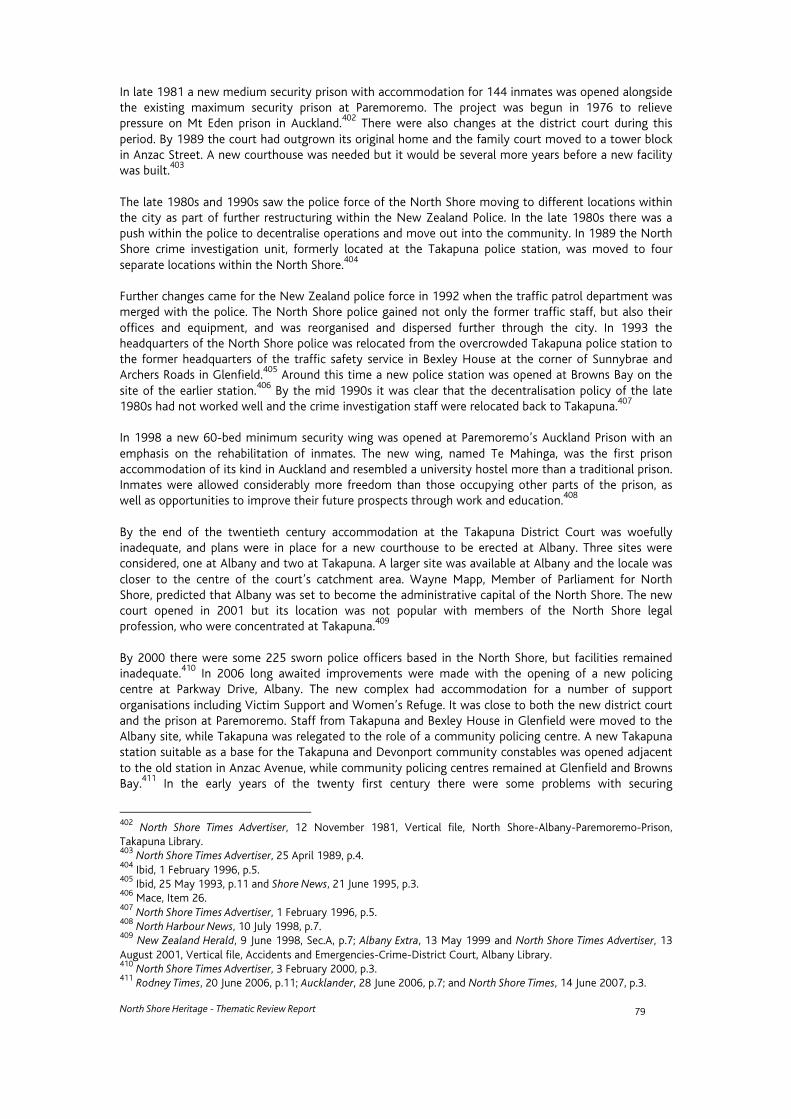
North Shore Heritage - Thematic Review Report
79
In late 1981 a new medium security prison with accommodation for 144 inmates was opened alongside the existing maximum security prison at Paremoremo. The project was begun in 1976 to relieve pressure on Mt Eden prison in Auckland.402 There were also changes at the district court during this period. By 1989 the court had outgrown its original home and the family court moved to a tower block in Anzac Street. A new courthouse was needed but it would be several more years before a new facility was built.403 The late 1980s and 1990s saw the police force of the North Shore moving to different locations within the city as part of further restructuring within the New Zealand Police. In the late 1980s there was a push within the police to decentralise operations and move out into the community. In 1989 the North Shore crime investigation unit, formerly located at the Takapuna police station, was moved to four separate locations within the North Shore.404 Further changes came for the New Zealand police force in 1992 when the traffic patrol department was merged with the police. The North Shore police gained not only the former traffic staff, but also their offices and equipment, and was reorganised and dispersed further through the city. In 1993 the headquarters of the North Shore police was relocated from the overcrowded Takapuna police station to the former headquarters of the traffic safety service in Bexley House at the corner of Sunnybrae and Archers Roads in Glenfield.405 Around this time a new police station was opened at Browns Bay on the site of the earlier station.406 By the mid 1990s it was clear that the decentralisation policy of the late 1980s had not worked well and the crime investigation staff were relocated back to Takapuna.407 In 1998 a new 60-bed minimum security wing was opened at Paremoremo’s Auckland Prison with an emphasis on the rehabilitation of inmates. The new wing, named Te Mahinga, was the first prison accommodation of its kind in Auckland and resembled a university hostel more than a traditional prison. Inmates were allowed considerably more freedom than those occupying other parts of the prison, as well as opportunities to improve their future prospects through work and education.408 By the end of the twentieth century accommodation at the Takapuna District Court was woefully inadequate, and plans were in place for a new courthouse to be erected at Albany. Three sites were considered, one at Albany and two at Takapuna. A larger site was available at Albany and the locale was closer to the centre of the court’s catchment area. Wayne Mapp, Member of Parliament for North Shore, predicted that Albany was set to become the administrative capital of the North Shore. The new court opened in 2001 but its location was not popular with members of the North Shore legal profession, who were concentrated at Takapuna.409 By 2000 there were some 225 sworn police officers based in the North Shore, but facilities remained inadequate.410 In 2006 long awaited improvements were made with the opening of a new policing centre at Parkway Drive, Albany. The new complex had accommodation for a number of support organisations including Victim Support and Women’s Refuge. It was close to both the new district court and the prison at Paremoremo. Staff from Takapuna and Bexley House in Glenfield were moved to the Albany site, while Takapuna was relegated to the role of a community policing centre. A new Takapuna station suitable as a base for the Takapuna and Devonport community constables was opened adjacent to the old station in Anzac Avenue, while community policing centres remained at Glenfield and Browns Bay.411 In the early years of the twenty first century there were some problems with securing
402 North Shore Times Advertiser, 12 November 1981, Vertical file, North Shore-Albany-Paremoremo-Prison, Takapuna Library. 403 North Shore Times Advertiser, 25 April 1989, p.4. 404 Ibid, 1 February 1996, p.5. 405 Ibid, 25 May 1993, p.11 and Shore News, 21 June 1995, p.3. 406 Mace, Item 26. 407 North Shore Times Advertiser, 1 February 1996, p.5. 408 North Harbour News, 10 July 1998, p.7. 409 New Zealand Herald, 9 June 1998, Sec.A, p.7; Albany Extra, 13 May 1999 and North Shore Times Advertiser, 13 August 2001, Vertical file, Accidents and Emergencies-Crime-District Court, Albany Library. 410 North Shore Times Advertiser, 3 February 2000, p.3. 411 Rodney Times, 20 June 2006, p.11; Aucklander, 28 June 2006, p.7; and North Shore Times, 14 June 2007, p.3.

North Shore Heritage - Thematic Review Report
80
community constables to serve on the North Shore, and Devonport and Albany were both without community constables for a time. In 2008 a new Albany community police patrol base was opened in Library Lane in the Albany Village. It was housed in a building which had served as a patrol house at Glenfield from the 1960s before being relocated to Albany in the mid 1980s.412 One of the early buildings associated with justice on the North Shore has also been put to new uses. In 1995 the North Shore Vintage Car Club began restoring the original lock up from the Takapuna police station. Dating from around 1912, the timber building had served a number of purposes. Part of it had been converted for office use in 1927 and as such it served as the Takapuna station until 1948. The building was later moved to Rothesay Bay where it was used as a bach. In 1989 the Takapuna City Council purchased the building, intending to move it to a permanent home and restore it. It was relocated to the council depot in Bush Road, Albany, where it stayed for a few years. A mix up saw the building moved to a nearby site where it was utilised as a base for the Framework Trust, a community group working with the mentally ill. The building was later moved yet again and restored for use as a library by the Vintage Car Club.413 The North Shore is now part of the Waitemata Police District, which is one of the largest police districts in the country. Its headquarters are in Takapuna.414 Section 5.4 Healthcare In the nineteenth century many people on the North Shore had to travel great distances to get medical attention. Evelyn Patten who lived at Chelsea recalled that one of her brothers died on the ferry trying to get to a doctor. There were no doctors in the area at the time and local people had to travel to the city for medical treatment.415 Local women with nursing experience helped in times of need. During the late nineteenth century Mrs Holland of Sunny Brae Road, Glenfield served as the local nurse and midwife for the surrounding area, while Mrs Battersby appears to have been the only person in the Albany area with nursing experience.416 The St John Ambulance Corps was active on the North Shore in the 1890s, with several members in Devonport and one in Birkenhead. These areas had good transport links to Auckland where St John Ambulance held its classes. Members of the corps were trained in emergency care, but in the event of a serious accident or illness patients were taken by ferry to the city where they could be treated at Auckland Hospital. At Birkenhead, Northcote and Devonport, patients were put on a stretcher which was then placed on a St John Ambulance litter and wheeled down to the wharf ready for the trip to the city. If emergency transport was needed to the city at night the local ferryman would be woken.417 One of the earliest medical facilities on the North Shore was the New Zealand Hydropathic and Fruit Hospital established at Glenfield in 1890. The establishment was run by Mr and Mrs Warmoll (also spelled Wormall). Mr Warmoll had consulting rooms in Albert Street where prospective patients could apply for admission, while women could also apply in writing to Mrs Warmoll. Treatments appear to have consisted of a raw vegan diet and therapeutic baths. A range of ailments were treated including rheumatic gout, hysteria, dropsy, diabetes and constipation.418
412 North Harbour News, 12 December 2008, Vertical file, Accidents and Emergencies-Crime-District Court, Albany Library. 413 North Shore Times Advertiser, 17 October 1989, p.12; 14 January 1992, p.12; 19 May 1992, p.1; and 30 June 1995, p.9. 414 New Zealand Herald, 29 June 2010, online edition, www.nzherald.co.nz. 415 Christie, Vol. 2, p.53. 416 Mrs Holland died in the early 1890s. Takapuna: Heart of the North Shore Golden Jubilee 1913-1963, n.d, n.p. North Shore Vertical File, Takapuna Library, p.39 and Harris and Stephenson, p.59. 417 Christie, Vol. 2, p.20 and Rex Wright-St Clair, ed., St John in New Zealand 1885-1995, Wellington, 1985, p.66. 418 Bay of Plenty Times, 6 October 1890, p.2 and Old Glenfield: A Portrait in Photographs, Auckland, 2005, p.52.

North Shore Heritage - Thematic Review Report
81
Fig. 56. Staff and patients at the Hydropathic hospital in Glenfield, 1910. North Shore Libraries, T2734.
In the early years of the twentieth century Devonport gained a doctor and, in 1908, a nursing division of St John Ambulance.419 Local members were no doubt kept busy a decade later when the influenza epidemic stretched local medical resources. When Doctor Fullerton of Takapuna came down with influenza the nearest doctor, located in Devonport, had to serve an extensive district, reaching Waiwera in the north. A fumigation centre was established at the rear of the council chambers in Takapuna where local people could have their throats sprayed as a preventative measure. Three hospitals and a convalescent home staffed by nurses and volunteers served the ill of the Takapuna area. The hospitals were located at the Sanderson home in Dodson Avenue, Milford, Lake House on Takapuna Beach, and a hospital in Ocean View Road run by the Sisters Speedy and Cadeaux. The Kiosk at the foot of The Strand was converted into a convalescent home. People were asked to stay home to prevent spreading the illness, and those in need were to attract the help of neighbours or volunteers by hanging something on their gate. Schools were closed and regular life virtually came to a standstill.420 In Birkenhead, Dr Meikle, the only resident doctor, and his wife were very busy tending to the sick of Birkenhead and Northcote. Inhaling plants, like the one at Takapuna, were established in the Forresters Hall and the Northcote Council Chambers. A temporary hospital and morgue staffed by volunteers was set up at Northcote Primary School. Mr Hurley, the local undertaker, was extremely busy and local carriers were called in to take many of the dead to the cemetery for burial.421 During the first half of the twentieth century medical services were concentrated around the Devonport, Takapuna and Birkenhead areas where most of the North Shore population lived. In 1920 there were three doctors attending Devonport, with a fourth, Dr Hagen, practising in the city but residing at Devonport. There were two doctors at Takapuna and another at Birkenhead. Takapuna and Devonport also had private hospitals, the Cotswold Private Hospital at 68 Vauxhall Road in Devonport, run by Sister Jessie Milne, and a private hospital run by the Misses Kelly in The Strand, Takapuna.422
419 HC Bennett, surgeon, is listed as a resident of Devonport in the Wises street directory of 1904. Wises New Zealand Post Office Directory, 1904, p.86 and Graeme Hunt, First to Care: 125 Years of the Order of St John in New Zealand 1885-2010, Auckland, 2009, p.257. 420 ‘Notes on the Influenza Epidemic of November, 1918’, Vertical File, Takapuna Library; Titchener, Beginnings, Vol. 3, Auckland, 1884, p.27 and Hutchinson, p.84. 421 Christie, Vol. 1, p.133 and Vol. 2, pp.35 and 99 and Vol. 4, pp.50 and 51. 422 Cleaves Auckland Provincial Directory, 1920, pp.321, 1488, 1498, 1499 and 1500 and Sarah Campion, ‘Women of the Borough’, The Hundred of Devonport: A Centennial History, p.121.

North Shore Heritage - Thematic Review Report
82
From the 1920s the Gables Nursing Home in Birkenhead hosted the births of hundreds of babies.423 A number of local women in the Birkenhead and Birkdale areas worked as midwives around this time, with Nurses Derrickson, Gulley and Webb in Birkenhead and Nurse McDonald in Birkdale.424 During the 1930s the shortcomings of healthcare services on the North Shore were pointed out by a delegation of North Shore representatives at a meeting with the Auckland Hospital Board. While the people of the North Shore were levied a hospital and charitable aid rate paid to the Auckland Hospital Board (AHB), there were no public hospital services available on the northern side of the harbour. The delegation requested that a North Shore hospital be built, but the AHB was non-committal. In frustration the Mayor of Birkenhead sought a change in legislation so that Birkenhead could set up its own hospital using the rate formerly paid to the AHB. This never eventuated, but the AHB did secure the services of a private hospital at Devonport to treat night time emergency cases that would normally have been the responsibility of the AHB.425 In 1934 the first North Shore unit of the St John Ambulance Brigade was established. It occupied various premises in Devonport and Takapuna but served a much wider area. Over the coming decades local divisions would be established in other parts of the North Shore.426
Fig. 57. Illustration taken from E McKinlay’s Ways and By-Ways of a Singing Kiwi with the NZ Divisional Entertainers in France, Dunedin, 1939, pp.157-8. Available at www.nzetc.org. The late 1930s would see the establishment of a specialised institution, the Wilson Home, to treat and care for physically disabled children who had formerly been cared for at Auckland Hospital. In 1937 25 children were transferred to the former home of the Wilson family at Takapuna. The Wilsons made their fortune in the publishing industry, with W.C. Wilson founding the New Zealand Herald. The Wilsons’
423 Christie, Vol. 1, p.87. 424 Ibid, Vol. 1, p.128 and Vol. 3, p.95. 425 New Zealand Herald, 27 February 1936, Vertical file, North Shore-Birkenhead-History, Takapuna Library. 426 North Shore Times Advertiser, 29 June 1984, p.16.
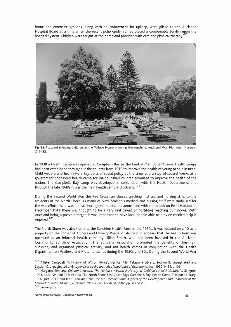
North Shore Heritage - Thematic Review Report
83
home and extensive grounds, along with an endowment for upkeep, were gifted to the Auckland Hospital Board at a time when the recent polio epidemic had placed a considerable burden upon the hospital system. Children were taught at the home and provided with care and physical therapy.427
Fig. 58. Postcard showing children at the Wilson Home enjoying the sunshine. Auckland War Memorial Museum, C19433. In 1938 a Health Camp was opened at Campbells Bay by the Central Methodist Mission. Health camps had been established throughout the country from 1919 to improve the health of young people in need. Child welfare and health were key parts of social policy at the time, and a stay of several weeks at a government sponsored health camp for malnourished children promised to improve the health of the nation. The Campbells Bay camp was developed in conjunction with the Health Department, and through the late 1940s it was the main health camp in Auckland. 428 During the Second World War the Red Cross ran classes teaching first aid and nursing skills to the residents of the North Shore. As many of New Zealand’s medical and nursing staff were mobilised for the war effort, there was a local shortage of medical personnel, and with the attack on Pearl Harbour in December 1941 there was thought to be a very real threat of hostilities reaching our shores. With Auckland being a possible target, it was important to have local people able to provide medical help if required.429 The North Shore was also home to the Sunshine Health Farm in the 1950s. It was located on a 10 acre property on the corner of Archers and Chivalry Roads in Glenfield. It appears that the health farm was operated as an informal health camp by Lillian Smith, who had been involved in the Auckland Community Sunshine Association. The Sunshine Association promoted the benefits of fresh air, sunshine, and organised physical activity, and ran health camps in conjunction with the Health Department on Waiheke and Motuihe Islands during the 1920s and 30s. During the Second World War
427 Allister Campbell, ‘A History of Wilson Home’, Vertical File, Takapuna Library, Section B, unpaginated and Section C, unpaginated and Appendices to the Journals of the House of Representatives, 1950, H-31, p.106. 428 Margaret Tennant, Children’s Health, The Nation’s Wealth: A History of Children’s Health Camps, Wellington, 1994, pp.31, 24 and 215; Vertical File-North Shore-East Coast Bays-Campbells Bay-Health Camp, Takapuna Library, 19 August 1937; and Ian F. Faulkner, The Decisive Decade: Some Aspects of the Development and Character of the Methodist Central Mission, Auckland, 1927-1937, Auckland, 1982, pp.20 and 21. 429 Lowrie, p.59.
North Shore Heritage - Thematic Review Report
84
the association went into recess. As the Health Department took greater control of the health camp movement some voluntary organisations, like the Auckland Community Sunshine Association, found themselves squeezed out.430 Smith was a woman of strong and unusual opinions relating to health, and was dedicated to the improvement of general welfare. She believed that modern life was ruining the health of the nation and that hospitals and drug treatments were the worst thing for the ill. She advocated a diet of homegrown food raised without chemical fertilisers. At her Glenfield farm she practised what she preached, serving home grown fruit and vegetables as well as bread made from flour milled from her own wheat. During the interwar years there was a nationwide shift toward hospital based childbirth that resulted in the growth in the number of obstetric hospitals serving the North Shore around the middle of the twentieth century. In 1920 most babies born in New Zealand were born at home or in unlicensed one bed homes run by the local midwife, where a doctor would only attend if problems arose. By 1935 more than three quarters of babies were born in maternity hospitals. This shift had been the result of an increasing concern for maternal and child welfare and up skilling within the medical profession.431 The change in birthing culture saw an increasing need for maternity facilities on the North Shore at a time when the post-war baby boom was getting underway. In the late 1940s Pentlands Hospital, which had been run as a private concern in Devonport, was purchased by the Auckland Hospital Board for use as an obstetric hospital to serve the North Shore. By 1950 it was joined by the Eastcliffe Obstetric Hospital at Castor Bay, which served mothers from the East Coast Bays. By this stage Narrow Neck also had an obstetric hospital and the Gables Maternity Home continued to serve the women of Birkenhead. Plunket had facilities in the more populous areas of Devonport, Takapuna and Northcote.432 Meanwhile, the sick were cared for at the Stanleigh Private Hospital in Devonport while naval staff were catered for at the Devonport Naval Hospital. The area also had a district nurse based at Browns Bay, where health services were limited .433 By the mid 1950s there were doctors practising throughout the coastal areas of the North Shore from Birkenhead to Torbay, where the population was most concentrated. Residents of the less populous locales of Albany and Glenfield were reliant on doctors from other areas. Takapuna had already developed an identity as a centre of medical care and this would be further bolstered by developments in the coming years. In the mid 1950s more than a third of the doctors on the North Shore were practising at Takapuna and it was the location of the medical specialists.434 While medical facilities had earlier been centred around the more densely populated areas of Devonport and Birkenhead, Takapuna was well sited as a central location for medical facilities to serve the entire North Shore. On 19 July 1958, when the new North Shore Hospital officially opened, the North Shore finally got a much longed for purpose built public hospital. It had 44 maternity beds and just six casualty beds. The casualty department provided treatment for minor accidents, and emergency treatment for more serious cases that could be then transferred to the large hospitals on the other side of the harbour.435 Emergency cases also benefited from the donation of the North Shore’s first ambulance by Mrs A Foster of Devonport in 1958.436 In an effort to decrease the numbers of North Shore patients needing treatment at the city hospital, the Devonport Naval Hospital was opened to the public in the early 1960s. Two private hospitals, the Melita and the Lister in Takapuna, offered surgical treatment.437
430 Tennant, pp.97-102 and North Shore Times, 8 June 1960, p.2. 431 Philippa Mein Smith, Maternity in Dispute: New Zealand 1920-1939, Wellington, 1986, p.1. 432 North Shore Times Advertiser, 18 May 1989, p.1; Wises Auckland Provincial Directory, 1950, pp.19a, 26a and 999a; Who’s Who on the North Shore, 1955, pp.72-74. 433 Who’s Who on the North Shore, 1955, pp.72-74 and Wises Auckland Provincial Directory, 1950, pp.998a and 999a. 434 Who’s Who on the North Shore, 1955, pp.72-74 and Wises New Zealand Post Office Directory, Vol. 1, Auckland City-Province, 1956, pp.261-2 and 304. 435 Celebrating Half a Century of Maternity Care for Women and their Children at North Shore Hospital, n.p., 2008, pp.3 and 4. 436 North Shore Advertiser, 6 August 1958, p.6. 437 Tony Mortiboy, ‘Hospitals and Health Services’, Donald F. Manley, ed., North Shore Expands, Auckland, 1963, p.87.

North Shore Heritage - Thematic Review Report
85
In the mid 1970s the Lister Trust Hospital, at 25 Anzac Avenue, Takapuna, was the only surgical hospital on the North Shore, catering for some 3000 patients annually.438 As Takapuna developed into a busy commercial hub, the site was no longer considered suitable and the Southern Cross Society, which had purchased the hospital in 1985, began planning a new hospital for the North Shore. In 1991 the hospital closed its doors in Anzac Avenue and services were transferred to the new North Harbour Medical Centre in Wairau Road, Glenfield. Larger than its predecessor, the new hospital was the second largest of the ten Southern Cross hospitals operating in New Zealand at the time. It had 65 beds, four operating theatres and offered post-natal care for mothers giving birth at North Shore Hospital.439 The Southern Cross hospital continues to operate on this site today. From the 1960s there was a movement toward community-based care for chronic patients. Changes in public healthcare policy though the late 1980s and early 1990s furthered the closure and restructuring of institutions that had formerly provided live-in care for the handicapped and mentally ill.440 Both developments would have an impact on the North Shore as more outpatient and community support services were required. In the mid 1970s Pentlands Hospital was closed as an obstetric facility and reopened as an outreach for Carrington Psychiatric Hospital.441 A hostel was also opened at Castor Bay in the late 1970s to provide a smaller, less institutionalised home for teenagers who had formerly lived at the Wilson Home. Staffed by nurses from the Wilson Home, it operated until the mid 1980s before being relocated to the Wilson Home.442 In 1985 mental health services on the North Shore expanded with the opening of Auburn House in Takapuna. Operated as a satellite service to Pentlands in Devonport, the Takapuna facility was a more central location for the people of the North Shore. It would later become the sole public mental heath service facility on the North Shore when Pentlands closed its doors in the mid 1980s.443 To meet the needs of a growing and aging, North Shore population, North Shore Hospital in Takapuna expanded in 1973, with four geriatric wards opening for both short and long term patients.444 Several rest homes with hospitals attached were also opened to cater for the needs of the elderly. In 1968 the Lady Allum Home opened in Milford, the Northbridge Home in Northcote followed in 1974, and in 1978 the Beachhaven Hospital began taking admissions.445 Care of the aged has continued to be a national growth industry in recent years and this has been reflected in developments on the North Shore. In 1983 the North Shore Hospice was formed to provide palliative care for the terminally ill in their own homes. Since 1995 they have also offered on-site care at a hospice in Takapuna.446 In 1998 the Lady Allum Home was reopened after a major rebuilding programme. The facility now has three rest home wings and three hospital units accommodating 145 people.447 The Fairview Retirement Village in Albany also opened at this time, with hospital accommodation for some 47 patients and retirement home accommodation for many more. Albany was one of the few places on the North Shore that offered large tracts of land available for such development.448
438 North Shore Times Advertiser, 4 March 1975, p.4 and Wises New Zealand Post Office Directory, Vol. 1, Auckland City and Environs, 1970-71, p.663. 439 North Shore Times Advertiser, 30 July 1992, p.27; 9 July 1991, p.18 and 28 September 1994, p.5. 440 Janett Levien, ‘Formal and Informal Sectors’, Peter Davis and Kevin Dew, eds., Health and Society in Aotearoa New Zealand, Melbourne, 1999, p.150. 441 North Shore Times Advertiser, 18 May 1989, p.1. 442 Campbell, Section C, unpaginated. 443 North Shore Times Advertiser, 26 September 1985, p.1 and 22 April 2003, p.7. 444 Vertical File-North Shore-Shakespeare Road-North Shore Hospital, Takapuna Library, 1 January 2000, p.31. 445 Directory of Homes and Hospitals Controlled by Religious and Welfare Organisations and Hospital Boards and Private Operators, Wellington, 1983, pp.64 and 65 and North Shore Times Advertiser, 29 September 1988, p.5. 446 www.nshospice.co.nz/nshospice/about.asp. 447 North Shore Times Advertiser, 19 March 1998, p.29. 448 www.fairviewvillage.co.nz.

North Shore Heritage - Thematic Review Report
86
The North Shore Hospital itself has continued to expand, becoming a major public hospital by the 1980s when the first tower block arose.449 Emergency services were strengthened when a subcentre of St John Ambulance was established at the North Shore Hospital site in 1984.450 In 1990 one of the former obstetric blocks was converted into an acute mental health unit. It was the first of several such units to be opened throughout Auckland in response to the closure of Carrington Hospital in Point Chevalier.451 Emergency medical care has recently been improved with a new St John’s Ambulance base at Apollo Drive, Albany, opening in 2006. This 24-hour facility was needed to cater for the huge population growth in the Albany and East Coast Bays areas, and replaced a daytime base that had operated in Rosedale Road for several years.452 The North Shore has thus grown from being a sparsely populated area with few medical services to a suburban area with a wide variety of healthcare services available throughout.
Fig. 59. Aerial view of North Shore Hospital under construction in April 1958. Whites Aviation Collection, Alexander Turnbull Library, Wellington, N.Z., WA-43637.
449 Vertical File-North Shore-Shakespeare Road-North Shore Hospital, Takapuna Library, 1 January 2000, p.31. 450 North Shore Times Advertiser, 11 September 1984, p.34. 451 Vertical File-North Shore-Shakespeare Road-North Shore Hospital, Takapuna Library, 19 July 1990. 452 North Harbour News, 13 January 2006, p.2 and North Shore Times, 4 July 2006, p.4.

North Shore Heritage - Thematic Review Report
87
Chapter 6 Ways of Life Section 6.1 Religious belief For the second half of the nineteenth century, and into the first half of the twentieth, the church was an important part of the local communities on the North Shore. Church services were initially held in private homes or sometimes on the beach. A local church was often one of the first public buildings to be erected, and commonly served a number of different community purposes, particularly in the more rural areas. Early churches were sometimes shared by various Christian denominations before population expansion reached the point where each could afford to build their own church.
Fig. 60. The absence of a local church did not prevent services from taking place. This outdoor church service was held at Mairangi Bay in 1923. North Shore Libraries, T2304.
Fig. 61. Some buildings served as churches for a number of denominations. The Glenfield Mission Hall was built to by the local community in a single day and it is shown here almost complete at 3pm on 4 September 1915. Anglican, Presbyterian and Methodist services were held on successive Sundays in the hall and it also served a number of other community purposes. Alexander Turnbull Library, Wellington, N.Z., G-1862-1/2.

North Shore Heritage - Thematic Review Report
88
The second half of the twentieth century was associated with a dramatic decline in church attendance throughout New Zealand that the churches of the North Shore did not avoid. This has led to the reuse of some church buildings for other purposes.453 New immigrant groups arriving in the last few decades have spurred on the development of some new church congregations associated with particular cultures.454The rise of new charismatic churches has also made its mark on the North Shore in recent years.455 In 2006 just over half the population of the North Shore identified themselves as Christian, mirroring national trends. There are now also significant numbers of North Shore residents practising other religions.456 6.1.1 Anglican Church In 1854, 15 Anglican families on the North Shore are recorded as supporting an Anglican church and school in the Devonport area. Previously services were held in private homes, including some taken by the early colonial Bishops Selwyn and Patterson in the 1850s. The first Anglican church and school in Devonport, constructed the corner of Vauxhall Road and Church Street, served a parish extending all the way out to Albany. The Reverend Edward H. Heywood would walk to Northcote and Takapuna to conduct services. Heywood was appointed on 18 May 1856, and until 1863 was also the local Devonport schoolmaster. The new shipping yards along the Devonport waterfront increased the local population, encouraging the church to expand. A second church building on the same site was consecrated on 3 September 1865, and on 11 March 1881 the congregation opened a third church, this one designed by noted Auckland architect Edward Bartley.457 St Michael’s Church in Bayswater established in December 1864 with a gift of land, and was opened the following year, with Holy Trinity’s Reverend Thomas Kerr as its Vicar.458 Sometime before 1908, the church burned down, and was replaced with the present building in 1910. Services at St Michael’s were still conducted by the Vicar of Holy Trinity until December 1923.459 Although an acre of land was donated at the end of 1853, the land for St John the Baptist in Northcote was not consecrated until 1859, and the church building dedicated on 24 June 1860. Reverend Heywood from Holy Trinity was Minister here as well, as were succeeding Ministers from Holy Trinity until January 1882.460 In 1884, the Bishop of Auckland confirmed the new Devonport Parish boundaries to include Chelsea, Lucas Creek, the Wade and Waiwera. In the same year, a chapel was built just behind the Chelsea sugar works, and in June 1885 St Peter’s Mission Hall was added to the building. The chapel was later moved to Birkdale Road and re-dedicated on 29 December 1907. In 1958 it was moved slightly to allow for the construction of a Sunday school hall, and on 3 November 2000 it was moved again to Tramway Road in Beach Haven.461
453 For example St Anne’s Hall in Browns Bay began life as a dwelling before being converted into a church in 1943. In the 1970s it relinquished its role as a church and now serves as a venue for hire, used by a variety of community groups. Mace, Item 16. 454 For example there are a number of Korean Christian congregations active on the North Shore including the Korean Community Church in Mairangi Bay and Kwanglim Methodist Church in Murrays Bay. http://across.co.nz/KoreanChurchesNZ.html. 455 Charismatic churches active today on the North Shore include the City Impact Church at Browns Bay and the North Shore New Life Christian Fellowship in Northcote. 456 Verran, The North Shore, p.227. 457 Ibid, pp.228-9 458 Martin Cole, The Anglican Church in Bayswater 1864-1985, Auckland, 1985, pp.3 and 5. 459 Verran, The North Shore, pp.229-230. 460 Ibid, p.230. 461 Ibid.

North Shore Heritage - Thematic Review Report
89
As early as 1886 a church, known as St Mary’s by the Sea, was built at Torbay to serve the small local population. By the late 1970s it had been deconsecrated and was moved to a new site at the Awaruku Bush Reserve, where it was later destroyed by fire. The old church was replaced with a new structure in 1979 to serve both the Anglican and Presbyterian communities.462 Church services were also held in Takapuna at Menary’s combined Protestant church and school building on Northcote Road. In 1883 St Peter’s Church was erected at Takapuna, with the present St Peters being erected in Killarney Street in the late 1950s.463 Anglican Services were also held in the Glenfield schoolroom at Albany, and from 1908, in the first Forester's Hall in Birkenhead on the west side of what is now Hinemoa Street, just down from the corner of Rawene Road. This became church property in January 1911. All Saint’s Church in Birkenhead offered services from August 1913 and was relocated to its present site in Hinemoa Street in July 1923.464
At Glenfield the sparse population of the area could not support individual church buildings for each denomination, so a Mission Hall was built by the Glenfield community in 1915 to serve as a church for local Anglican, Methodist and Presbyterian worshipers.465
By 1959, there were three Parochial Districts within the Archdeaconry on the North Shore: Birkenhead, East Coast Bays and Northcote. Birkenhead Parochial District included All Saint’s, St Peter’s in Birkdale, and Greenhithe, Beach Haven and Pine Island. East Coast Bays Parochial District comprised of St Mary-by-the-Sea in Torbay, St John-by-the-Sea in Browns Bay, and Murrays Bay. Northcote Parochial District included St John the Baptist, along with Glenfield and Albany. St Barnabas Anglican Church in Glenfield was dedicated on 10 June 1962, adding a new church to the Northcote Parochial District.466 The former Parochial Districts have now been replaced with Ministry Units located in the following areas: Albany/Greenhithe, Birkdale/Beach Haven, Birkenhead, Devonport/Stanley Bay, Milford/Castor Bay/Campbells Bay/Sunnynook, Northcote, Torbay and Takapuna/Bayswater, as well as the Vaughan Park Renewal and Conference Centre.467
6.1.2 Catholic Church
The history of the Catholic church on the North Shore dates back to the early colonial era. In 1849 St Mary’s College was established at Takapuna, as a Catholic school. There was a church at St Mary’s College from as early as the 1860s, which was used by local Catholics.468 The next Catholic church to be established on the North Shore was St Francis de Sales, which was housed in a building formerly used as a mortuary chapel for the Catholic section of Symonds Street Cemetery, before being barged across the harbour for reuse in 1893.469
The early twentieth century saw the Catholic church on the North Shore expand. In 1902 the first Devonport based priest, Father Joseph Loughlin Ahern, was appointed, and that same year a new church was built at Takapuna on the old St Mary’s College site. This church was associated with St Josephs Orphanage, which then occupied the former St Mary’s College property. In the 1920s the church at the orphanage would be moved to a nearby site to serve the local Catholic community.470
462 Gray and Sturm, pp.96 and 97. 463 www.takapunaanglican.co.nz/theparish. 464 Verran, The North Shore, pp.230 and 232. 465 Old Glenfield: A Portrait in Photographs, p.25. 466 Verran, The North Shore, pp.232 and 233. 467 Ibid, pp.228-233. 468 In April 1868 the Daily Southern Cross reported a marriage ceremony which had taken place at St Mary’s Roman Catholic Church, North Shore. Daily Southern Cross, 18 April 1868, p.2 and Patricia E. Soar, The Catholic Church in the East Coast Bays 1938-1998, Auckland, 1997, p.17. 469 Soar, p.57. 470 Soar, p.58 and Colleen Petricevich, ed., St Joseph’s Takapuna 1996-2006, Auckland, 2007, pp.4 and 5.

North Shore Heritage - Thematic Review Report
90
By 1905, Northcote Catholics could attend services at the Gladstone Hall. In 1916, they finally bought the hall and the surrounding four and a half acres for £500. In the 1930s the Presbytery was a rented house in nearby Fairfax Avenue, and the Fathers served a vast area that included Puhoi. The other important Catholic institution on Onewa Road was founded in December 1933 with the Dominican nuns establishing their parish school on the south side, now known as the De Paul House.471
Catholic churches had also been built in other parts of the North Shore including St John the Baptist Church, at the corner of Inverness and Glen Roads, Browns Bay in 1938, and Milford’s St Vincent De Paul’s Church in 1949.472 However, Catholics in other areas were still not well catered for. The Catholic community at Beach Haven held services in a fruit shed and the back of a local store, until 1957 when they purchased a cottage which was converted into a church and meeting place.473
Fig. 62. St Francis de Sales and All Souls Catholic Church in Albert Street, Devonport still looks as imposing as it did in this 1920s photograph. North Shore Libraries, D_GBC_0001.
As the population of the North Shore expanded from the 1960s after the opening of the Auckland Harbour Bridge, so too did Catholic congregations, particularly in areas where residential growth was greatest. This prompted a new wave of church building, with new churches being founded and older churches replaced with larger structures. In 1960 St Luke’s Church in Belmont was erected, while St Mary’s Church at Northcote opened in 1964. Two years later Takapuna gained a new St Joseph’s Church on Tahoroto Road, and in 1967 Beach Haven finally got a purpose built church named Maria Assumpta.474
In 1977 St Francis De Sales’ Church opened in Finchely Road, Torbay. This replaced St John the Baptist Church at Browns Bay, which was sold for removal after the site was purchased by the East Coast Bays City Council for a village green development. Glenfield finally gained a local Catholic church in 1983 when St Thomas Moore Church opened.475
471 Verran, The North Shore, p.234. 472 Soar, pp.56 and 58. 473 www.beachhavencatholic.org/nz/OurStory. 474 Petricevich, p.7; Soar, p.58 and www.beachhavencatholic.org/nz/OurStory. 475 Soar, p.56.

North Shore Heritage - Thematic Review Report
91
In 1994 the Catholic church consolidated its activities in the East Coast Bays area with the opening of the new St John the Baptist Church in Mairangi Bay in 1994. The new church was located alongside St John the Baptist School, which had been opened in 1961.476
Currently there are Catholic churches at Devonport, Belmont, Takapuna, Milford, Northcote, Beach Haven, Glenfield, Mairangi Bay and Torbay. The church also operates the Auckland Charismatic Catholic Renewal Centre Fred Thomas Drive, Takapuna, and De Paul House in Northcote, opposite St Mary’s Church in Onewa Road.
6.1.3 Methodist Church
The first Methodist services were held at Shoal Bay and North Head, and from 1855 were organised from the Pitt Street Church in Auckland. As a result of an active missionary programme, some local Maori were also Wesleyan. The first Wesleyan baptisms on the Shore were conducted in 1846, most likely at private residences.477 Early services were held by lay helpers and preachers from Auckland.478 In the mid 1860s Reverend William Morley, of Auckland, was rowed across the harbour on Saturday night and back on Monday morning so that he could take Methodist services on the North Shore.479
The schoolroom at the corner of Vauxhall Road and Church Street in Devonport was used for Methodist services from 1862. A church was opened on 13 August 1865, on land given by William Trevarthan, which is the site of the current Devonport Primary School. However, the area’s Methodist population declined soon after, and with a debt remaining on the building the property was sold to the school in 1869. Cottage meetings in private homes and a small shed in Clarence Street were the next step, although later the Devonport Assembly Hall was used. A replacement Devonport church able to seat 200 people was finally opened in what is now King Edward Parade in March 1877.480
The first resident Minister was Reverend George W.J. Spence, who arrived in 1882 and ministered to the new North Shore Circuit, comprising of Devonport, Northcote, Birkenhead and Takapuna. Spence was based at the Devonport church, which was soon ready to expand. In 1885 a larger site on Church Street was purchased, and the church building moved. A Sunday schoolroom was added in 1894, and a separate church was built at Stanley Bay in 1898. The Circuit was shared from 1900 to 1907, when Birkenhead separated. The Vauxhall Road Church was opened on 26 September 1925.481
Despite land being donated by William Creamer at what was known as Prospect or now Zion Hill in 1854, the land remained unoccupied for many years. In 1881 a church was finally opened with accommodation for 80. The local population soon swelled with the opening of the Chelsea Sugar Refinery and associated village for workers. The existing church quickly became inadequate and in March 1885 a new church was opened, and the older building reused as a Sunday school.482
The Takapuna congregation was initially housed in Menary’s combined Protestant church and school building on Northcote Road, and services were later held in the Takapuna public hall in Anzac Street. In February 1901 the foundation stone was laid for the new Wesleyan church constructed at the corner of Huron Street and Lake Road, Takapuna. In 1917 Takapuna acquired its first full-time minister and in 1920 it became a separate Circuit. By 1923, the congregation had swelled sufficiently for a new church to be built on the corner of Lake Road and Tennyson Avenue. In 1959, the present church was built on the Lake Road.483
476 Soar, pp.38, 39 and 56. 477 Verran, The North Shore, p.235. 478 HA Cochrane, Let Us Give Thanks: Jubilee Celebrations in Devonport Methodism, Auckland, 1946, p.2 479 Frank Sutherland, 75 Years 1883-1958: The Story of the Takapuna Methodist Church, Auckland, 1958, pp.4 and 5. 480 Verran, The North Shore, p.235. 481 Ibid. 482 www.historicbirkenhead.com/membersstories56.htm. 483 Verran, The North Shore, p.236.
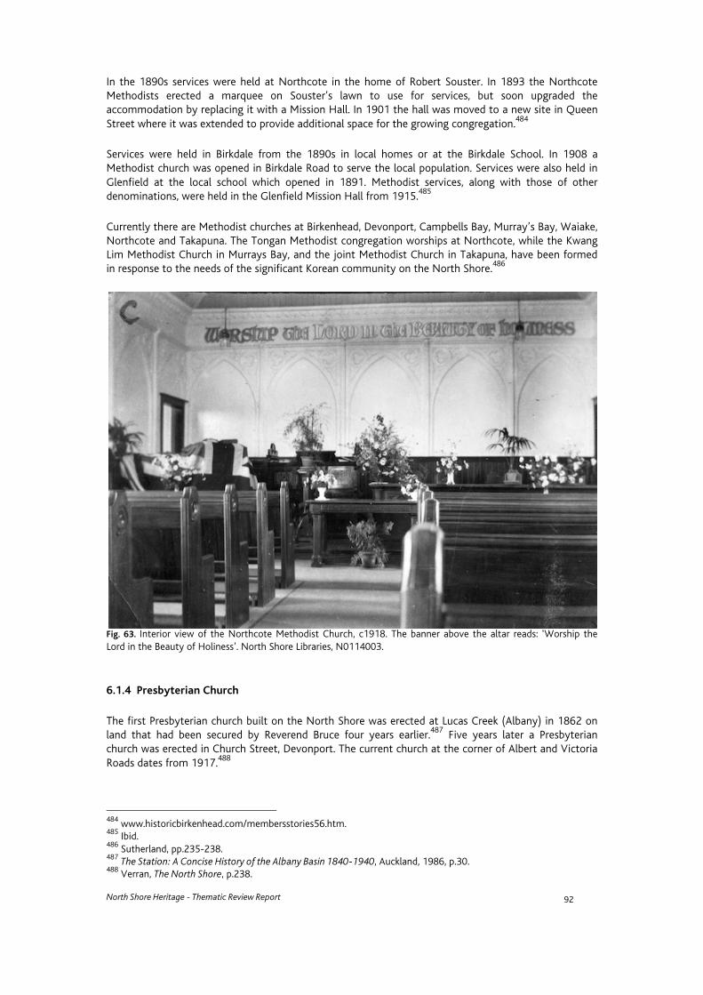
North Shore Heritage - Thematic Review Report
92
In the 1890s services were held at Northcote in the home of Robert Souster. In 1893 the Northcote Methodists erected a marquee on Souster’s lawn to use for services, but soon upgraded the accommodation by replacing it with a Mission Hall. In 1901 the hall was moved to a new site in Queen Street where it was extended to provide additional space for the growing congregation.484
Services were held in Birkdale from the 1890s in local homes or at the Birkdale School. In 1908 a Methodist church was opened in Birkdale Road to serve the local population. Services were also held in Glenfield at the local school which opened in 1891. Methodist services, along with those of other denominations, were held in the Glenfield Mission Hall from 1915.485
Currently there are Methodist churches at Birkenhead, Devonport, Campbells Bay, Murray’s Bay, Waiake, Northcote and Takapuna. The Tongan Methodist congregation worships at Northcote, while the Kwang Lim Methodist Church in Murrays Bay, and the joint Methodist Church in Takapuna, have been formed in response to the needs of the significant Korean community on the North Shore.486
Fig. 63. Interior view of the Northcote Methodist Church, c1918. The banner above the altar reads: ‘Worship the Lord in the Beauty of Holiness’. North Shore Libraries, N0114003.
6.1.4 Presbyterian Church
The first Presbyterian church built on the North Shore was erected at Lucas Creek (Albany) in 1862 on land that had been secured by Reverend Bruce four years earlier.487 Five years later a Presbyterian church was erected in Church Street, Devonport. The current church at the corner of Albert and Victoria Roads dates from 1917.488
484 www.historicbirkenhead.com/membersstories56.htm. 485 Ibid. 486 Sutherland, pp.235-238. 487 The Station: A Concise History of the Albany Basin 1840-1940, Auckland, 1986, p.30. 488 Verran, The North Shore, p.238.

North Shore Heritage - Thematic Review Report
93
Anglicans, Methodists and Presbyterians in the Takapuna area all at different times used Menary’s combined protestant church and school building on Northcote Road. There were regular services held there from 1892 which were taken by the Devonport minister. On 20 July 1902, the foundation stone for St George’s Church was laid by Governor Lord Ranfurly, while the current Takapuna building had its first service on 21 February 1965. There was also a church and church hall in Belmont from May 1910.489
Birkenhead became a separate parish with the opening of St Andrew's Church on 13 December 1914, in Mariposa Crescent off Hinemoa Street. The church was moved to its present site in December 1928. To 1914, the Northcote Parish had included Birkenhead. Birkdale, Glenfield, Albany, Greenhithe, and reached as far north as Dairy Flat.490
Fig. 64. A crowd gathered to witness Lord Ranfurly lay the foundation stone for St George’s Presbyterian Church, Takapuna, in 1902. The inset portrait is of Reverend R. Ferguson. Sir George Grey Special Collections, Auckland City Libraries, 7-A5631.
St Aidan’s Church in Northcote started in the Gladstone Hall on Onewa Road, located on the site of the current St Mary’s Catholic Church, in September 1888, with a new church opening further up Onewa Road on 20 October 1889. That was replaced on 12 March 1932 by the present church building. The people of Glenfield erected a Mission Hall in 1915 which was utilised for Presbyterian, Anglican and Methodist services.491 The Castor Bay church was opened 10 December 1933, and from 1978 the local Presbyterian and Anglican communities decided to share the church buildings; All Hallows now serves both.492 During the 1930s Presbyterian services were held in Mairangi Bay and Campbells Bay by Morgan Richards, and soon work was underway to raise the necessary funds to build a church for to serve the East Coast Bays. Mairangi Bay was chosen as a central locale and in 1942 a church was opened in Hastings Road.493
489 Verran, The North Shore, p.238. 490 Ibid, pp.238 and 240. 491 Old Glenfield: A Portrait in Photographs, p.25. 492 Verran, The North Shore, p.240. 493 Betty Dance, Pressing on Regardless: the Story of the Mairangi Bay Presbyterian Church, Auckland, 2004, pp.6, 10 and 11.

North Shore Heritage - Thematic Review Report
94
Currently there are Presbyterian churches at Albany, Belmont, Birkenhead, Browns Bay, Devonport, Forrest Hill, Glenfield, Mairangi/Castor Bay, Northcote and Takapuna.494
6.1.5 Other Denominations
The Birkenhead Gospel Hall opened in what is now lower Hinemoa Street, in October 1929. Baptist churches were established in Belmont, Birkdale, Glenfield, Milford, Northcote, Torbay and Windsor Park, the latter on the site of a former tavern. The Salvation Army has halls in Browns Bay and Glenfield, and amongst other faiths or denominations are the Birkdale Radio Chapel, the Buddhist Fellowship in Browns Bay, St Mark’s Coptic Orthodox Church in Beach Haven, the Apostolic Church in Torbay, the Assembly of God in Takapuna, the Church of Jesus Christ of Latter Day Saints in Takapuna and Beach Haven, Jehovah's Witnesses in Glenfield, and City Impact Church and the Northcross Community Church both in Browns Bay. Today many charismatic churches are flourishing on the North Shore, as they do in many other parts of New Zealand.495
Fig. 65. Church of Jesus Christ of the Latter Day Saints, Taharoto Road, Takapuna. Sir George Grey Special Collections, Auckland City Libraries, 998-170.
Section 6.2 Education
6.2.1 Preschool Education An early preschool operated in Devonport from the 1920s, and at the beginning of the next decade a kindergarten, known as St Anne’s, was established at Takapuna. St Anne’s would go on to develop into a school catering for pupils from pre-school to secondary level.496 In Northcote a private kindergarten was established in 1930s.497
494 Sutherland, pp.238-240 495 Verran, The North Shore, pp.240-241. 496 Devonport Flagstaff, 4 May 2000, pp.14-15 and North Shore Times Advertiser, 5 September 1972, p.5. 497 Brian Marshall, A History of the Auckland Kindergarten Association, Auckland, 1983, p.28.

North Shore Heritage - Thematic Review Report
95
During the Second World War Shirley Brickell, mother of the noted potter Barry Brickell, started the first Playcentre in Devonport to relieve the stress of full-time childcare for the wives of servicemen.498
Fig. 66. Pupils from St Anne’s Preparatory and Kindergarten School on the beach at Takapuna, 1939. North Shore Libraries, T4083. There was a significant growth in the sector from the late 1930s through to the 1950s with the establishment of numerous free kindergartens run by the Auckland Kindergarten Association (AKA). The association had established its first kindergarten at Freemans Bay in 1910, an area where poverty was rife, and continued to expand into other poor areas where the need for free kindergartens was greatest. By the early 1930s there were eight AKA kindergartens on the southern side of the harbour and later that decade the Association would be active on the North Shore. At Northcote a private kindergarten that had been in operation for some time was taken over by the AKA in 1937.499 Soon a number of other AKA kindergartens were operating in the more populous areas of the North Shore. The Birkenhead kindergarten opened in 1941 and was soon joined by Takapuna in 1944, Belmont-Bayswater and Devonport in 1945, with Milford following in 1950.500 Parents in other areas were keen to have free kindergartens established. In 1955 a public meeting and house-to-house survey in the Westlake-Forrest Hill area found considerable support for a local kindergarten, with some 250 children keen to attend. Although a local committee was established and an approach made to the AKA, it would be over a decade before an AKA kindergarten opened there. In the intervening years the local committee ran a private kindergarten which closed in 1966 when the AKA kindergarten was opened. Similarly, a local committee at Glenfield established a private kindergarten which operated for a number of years prior to the opening of the AKA Glenfield kindergarten in 1967.501 Many of the early kindergartens on the North Shore started out in rented accommodation before moving to purpose built premises. On the North Shore the Milford, Belmont-Bayswater and Torbay
498 Christine Leov-Lealand, Barry Brickell: A Head of Steam, Auckland, 1996, p.14. 499 Brian Marshall, A History of the Auckland Kindergarten Association, pp.14, 25, 28 and 99. 500 Ibid, pp.68, 69, 75, 80-1, 94 and 119. 501 Ibid, pp.80-81 and 123.

North Shore Heritage - Thematic Review Report
96
kindergartens were designed by the Group Architects and Wilson & Juriss, leading figures in the development of New Zealand modernist architecture.502 Recent decades have seen considerable growth in the number and variety of pre-schools and childcare centres operating on the North Shore. It is now common for both parents of pre-school aged children to be in paid employment, and consequently the education and care of young children has been a growth industry. The types of preschool education available have also diversified, encompassing different educational philosophies and cultural values. Amongst the educational landscape of the North Shore today are well attended Montessori preschools, Kohanga Reo, playcentres and playgroups.503 6.2.2 Primary Education Early schools on the North Shore were centred in the more populous areas of Devonport, Northcote and Takapuna, with Albany, the largest population centre in the north, also establishing a school relatively early. The first school to open its doors on the North Shore was St Mary's Catholic College which began in 1849, but by the mid 1850s the Anglican Flagstaff School had opened in Devonport. This school would in 1870 be incorporated into the new Devonport School.504 In the 1850s some children in the Takapuna area were taught at home by a governess who was hired by several families, but soon there would be an alternative for the children of the area.505 In 1861 a combined church and school building was opened at Northcote Road on the site of the present Takapuna Golf Course, the land being gifted by local farmer Benjamin Menary. During the week lessons were taught and on Sundays church services were held. In 1879 the school moved to the corner of Northcote and Taharoto where it became known as the Lake School, and was later shifted to Anzac Street and renamed Takapuna School.506 In the mid 1860s a school for young ladies was opened at Cheltenham.507 A school was established at Albany in 1865, but the teacher was found to be inadequate and it soon closed. In such a remote location it was no doubt hard to find suitable teaching staff.508 Following the 1872 Education Act, Auckland Provincial Government funds became available for public schools. Parents were to pay a shilling a week for each child attending, and there was a similar Auckland Education Board subsidy. This funding provided the impetus for new schools to be established. In 1873 a new school opened at Albany and two years later another at Northcote, occupying a former vicarage.509 The 1877 Education Act established free compulsory education for primary school children. By this stage there were schools operating at Devonport, Takapuna, Northcote and Albany, and the Act had a direct impact on their rolls. But there were still other parts of the North Shore which were devoid of educational facilities. The Brown children of Browns Bay had no local school prior 1888, and as the closest school was at Albany, too far away to make the daily trip, they boarded in Auckland and attended the Parnell School.510 The Johnson children of Campbells Bay attended school at Takapuna in the 1880s and 90s. The journey to school involved a seven mile round trip on foot.511 The ever-expanding population of the North Shore put pressure on the Auckland Education Board to open new schools. In 1888 a school was opened at Browns Bay, and two years later the children of
502 Gatley, p.157. 503 These include Acorn Montessori Children’s House in Devonport, Nga Whare Maha Te Kohanga Reo in Northcote and Greenhithe Playcentre. 504 Verran, The North Shore, pp.77-78, 80, 82 and 84. 505 J.A. Mackay, ‘The East Coast Bays on Auckland’s North Shore’, Auckland-Waikato Historical Journal, p.4. 506 North Shore Times, 1 October 2004, p.2. 507 Verran, The North Shore, p.77. 508 Harris and Stephenson, p.27 509 Verran, The North Shore, pp.80 and 84. 510 J.A. Mackay, ‘The East Coast Bays on Auckland’s North Shore’, Auckland-Waikato Historical Journal, p.3. 511 Ibid, p.4.
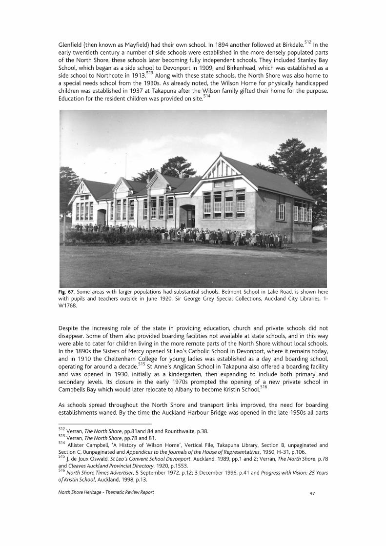
North Shore Heritage - Thematic Review Report
97
Glenfield (then known as Mayfield) had their own school. In 1894 another followed at Birkdale.512 In the early twentieth century a number of side schools were established in the more densely populated parts of the North Shore, these schools later becoming fully independent schools. They included Stanley Bay School, which began as a side school to Devonport in 1909, and Birkenhead, which was established as a side school to Northcote in 1913.513 Along with these state schools, the North Shore was also home to a special needs school from the 1930s. As already noted, the Wilson Home for physically handicapped children was established in 1937 at Takapuna after the Wilson family gifted their home for the purpose. Education for the resident children was provided on site.514
Fig. 67. Some areas with larger populations had substantial schools. Belmont School in Lake Road, is shown here with pupils and teachers outside in June 1920. Sir George Grey Special Collections, Auckland City Libraries, 1-W1768. Despite the increasing role of the state in providing education, church and private schools did not disappear. Some of them also provided boarding facilities not available at state schools, and in this way were able to cater for children living in the more remote parts of the North Shore without local schools. In the 1890s the Sisters of Mercy opened St Leo’s Catholic School in Devonport, where it remains today, and in 1910 the Cheltenham College for young ladies was established as a day and boarding school, operating for around a decade.515 St Anne’s Anglican School in Takapuna also offered a boarding facility and was opened in 1930, initially as a kindergarten, then expanding to include both primary and secondary levels. Its closure in the early 1970s prompted the opening of a new private school in Campbells Bay which would later relocate to Albany to become Kristin School.516 As schools spread throughout the North Shore and transport links improved, the need for boarding establishments waned. By the time the Auckland Harbour Bridge was opened in the late 1950s all parts
512 Verran, The North Shore, pp.81and 84 and Rounthwaite, p.38. 513 Verran, The North Shore, pp.78 and 81. 514 Allister Campbell, ‘A History of Wilson Home’, Vertical File, Takapuna Library, Section B, unpaginated and Section C, 0unpaginated and Appendices to the Journals of the House of Representatives, 1950, H-31, p.106. 515 J. de Joux Oswald, St Leo’s Convent School Devonport, Auckland, 1989, pp.1 and 2; Verran, The North Shore, p.78 and Cleaves Auckland Provincial Directory, 1920, p.1553. 516 North Shore Times Advertiser, 5 September 1972, p.12; 3 December 1996, p.41 and Progress with Vision: 25 Years of Kristin School, Auckland, 1998, p.13.

North Shore Heritage - Thematic Review Report
98
of the North Shore had local schools. These varied in size considerably from the fledgling Murrays Bay School, opened in 1957, to the long established Devonport Primary School.517 As the twentieth century rolled on, new schools were needed to cater for the burgeoning population, and today there are a large number of primary schools spread throughout the neighbourhoods of the North Shore. 6.2.3 Secondary Education The continued growth in the numbers of eligible pupils promoted the need for secondary schools on the North Shore. Prior to this, those pupils who continued on to secondary schooling had to attend city schools such as Seddon Memorial Technical College or one of the Grammar Schools. The 1920s and ‘30s would see the first secondary schools open on the North Shore. Takapuna Grammar School opened in 1927, followed by the Catholic Maori boy’s school, Hato Petera College, at Northcote in 1928. Northcote District High School opened in 1931.518 St Anne’s Anglican School in Takapuna began teaching secondary pupils from the late 1940s, taking in boarders as well as day pupils.519
Fig. 68. Takapuna Grammar School was built in 1927 with a view to future growth. The main building would later be extended to the south. Sir George Grey Special Collections, Auckland City Libraries, 4-2854. Northern parts of the North Shore would have to wait until the second half of the twentieth century before more local secondary schools were available. Initially named Murrays Bay High School, Rangitoto College opened in 1956, gathering pupils from the surrounding area.520 Several new secondary schools were opened in the Takapuna/Milford area during the late 1950s and early 1960s. In 1958 Westlake High School opened as a co-educational school, but just four years later
517 Verran, The North Shore, pp.77-78, 80-85 and 87. 518 Ibid, p.80. 519 North Shore Times Advertiser, 5 September 1972, p.12. 520 Genevieve Abbott, Circumspice: A Pictorial History of Rangitoto College, Auckland, 2006, pp.10 and 17.
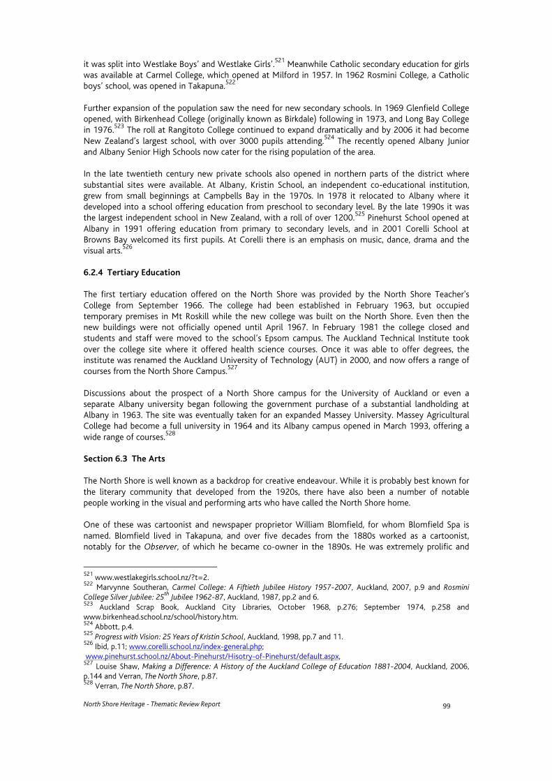
North Shore Heritage - Thematic Review Report
99
it was split into Westlake Boys’ and Westlake Girls’.521 Meanwhile Catholic secondary education for girls was available at Carmel College, which opened at Milford in 1957. In 1962 Rosmini College, a Catholic boys’ school, was opened in Takapuna.522 Further expansion of the population saw the need for new secondary schools. In 1969 Glenfield College opened, with Birkenhead College (originally known as Birkdale) following in 1973, and Long Bay College in 1976.523 The roll at Rangitoto College continued to expand dramatically and by 2006 it had become New Zealand’s largest school, with over 3000 pupils attending.524 The recently opened Albany Junior and Albany Senior High Schools now cater for the rising population of the area. In the late twentieth century new private schools also opened in northern parts of the district where substantial sites were available. At Albany, Kristin School, an independent co-educational institution, grew from small beginnings at Campbells Bay in the 1970s. In 1978 it relocated to Albany where it developed into a school offering education from preschool to secondary level. By the late 1990s it was the largest independent school in New Zealand, with a roll of over 1200.525 Pinehurst School opened at Albany in 1991 offering education from primary to secondary levels, and in 2001 Corelli School at Browns Bay welcomed its first pupils. At Corelli there is an emphasis on music, dance, drama and the visual arts.526 6.2.4 Tertiary Education The first tertiary education offered on the North Shore was provided by the North Shore Teacher's College from September 1966. The college had been established in February 1963, but occupied temporary premises in Mt Roskill while the new college was built on the North Shore. Even then the new buildings were not officially opened until April 1967. In February 1981 the college closed and students and staff were moved to the school’s Epsom campus. The Auckland Technical Institute took over the college site where it offered health science courses. Once it was able to offer degrees, the institute was renamed the Auckland University of Technology (AUT) in 2000, and now offers a range of courses from the North Shore Campus.527 Discussions about the prospect of a North Shore campus for the University of Auckland or even a separate Albany university began following the government purchase of a substantial landholding at Albany in 1963. The site was eventually taken for an expanded Massey University. Massey Agricultural College had become a full university in 1964 and its Albany campus opened in March 1993, offering a wide range of courses.528 Section 6.3 The Arts The North Shore is well known as a backdrop for creative endeavour. While it is probably best known for the literary community that developed from the 1920s, there have also been a number of notable people working in the visual and performing arts who have called the North Shore home. One of these was cartoonist and newspaper proprietor William Blomfield, for whom Blomfield Spa is named. Blomfield lived in Takapuna, and over five decades from the 1880s worked as a cartoonist, notably for the Observer, of which he became co-owner in the 1890s. He was extremely prolific and
521 www.westlakegirls.school.nz/?t=2. 522 Marvynne Southeran, Carmel College: A Fiftieth Jubilee History 1957-2007, Auckland, 2007, p.9 and Rosmini College Silver Jubilee: 25th Jubilee 1962-87, Auckland, 1987, pp.2 and 6. 523 Auckland Scrap Book, Auckland City Libraries, October 1968, p.276; September 1974, p.258 and www.birkenhead.school.nz/school/history.htm. 524 Abbott, p.4. 525 Progress with Vision: 25 Years of Kristin School, Auckland, 1998, pp.7 and 11. 526 Ibid, p.11; www.corelli.school.nz/index-general.php; www.pinehurst.school.nz/About-Pinehurst/Hisotry-of-Pinehurst/default.aspx, 527 Louise Shaw, Making a Difference: A History of the Auckland College of Education 1881-2004, Auckland, 2006, p.144 and Verran, The North Shore, p.87. 528 Verran, The North Shore, p.87.
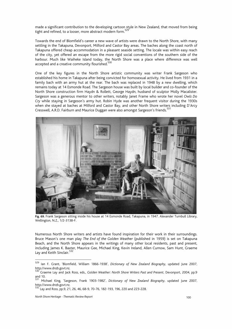
North Shore Heritage - Thematic Review Report
100
made a significant contribution to the developing cartoon style in New Zealand, that moved from being tight and refined, to a looser, more abstract modern form.529 Towards the end of Blomfield’s career a new wave of artists were drawn to the North Shore, with many settling in the Takapuna, Devonport, Milford and Castor Bay areas. The baches along the coast north of Takapuna offered cheap accommodation in a pleasant seaside setting. The locale was within easy reach of the city, yet offered an escape from the more rigid social conventions of the southern side of the harbour. Much like Waiheke Island today, the North Shore was a place where difference was well accepted and a creative community flourished.530 One of the key figures in the North Shore artistic community was writer Frank Sargeson who established his home in Takapuna after being convicted for homosexual activity. He lived from 1931 in a family bach with an army hut at the rear. The bach was replaced in 1948 by a new dwelling, which remains today at 14 Esmonde Road. The Sargeson house was built by local builder and co-founder of the North Shore construction firm Haydn & Rollett, George Haydn, husband of sculptor Molly Macalister. Sargeson was a generous mentor to other writers, notably Janet Frame who wrote her novel Owls Do Cry while staying in Sargeson’s army hut. Robin Hyde was another frequent visitor during the 1930s when she stayed at baches at Milford and Castor Bay, and other North Shore writers including D’Arcy Cresswell, A.R.D. Fairburn and Maurice Duggan were also amongst Sargeson’s friends.531
Fig. 69. Frank Sargeson sitting inside his house at 14 Esmonde Road, Takapuna, in 1947. Alexander Turnbull Library, Wellington, N.Z., 1/2-3138-F. Numerous North Shore writers and artists have found inspiration for their work in their surroundings. Bruce Mason’s one man play The End of the Golden Weather (published in 1959) is set on Takapuna Beach, and the North Shore appears in the writings of many other local residents, past and present, including James K. Baxter, Maurice Gee, Michael King, Kevin Ireland, Allen Curnow, Sam Hunt, Graeme Lay and Keith Sinclair.532
529 Ian F. Grant, ‘Blomfield, William 1866-1938’, Dictionary of New Zealand Biography, updated June 2007, http://www.dnzb.govt.nz. 530 Graeme Lay and Jack Ross, eds., Golden Weather: North Shore Writers Past and Present, Devonport, 2004, pp.9 and 10. 531 Michael King, ‘Sargeson, Frank 1903-1982’, Dictionary of New Zealand Biography, updated June 2007, http://www.dnzb.govt.nz. 532 Lay and Ross, pp.9, 21, 26, 46, 68-9, 70-76, 182-193, 196, 220 and 223-228.

North Shore Heritage - Thematic Review Report
101
Part of the legacy of former Browns Bay resident Michael King has been the establishment of the Michael King Writers’ Centre in Devonport, which offers writers’ residencies, writing courses, and other support for writers. It is the only literary centre of its kind in New Zealand and is part of an international network of writers’ centres.533 Literature on the North Shore has been celebrated in a number of collections of work by local writers.534 Today there are several large publishing houses located on the North Shore, supporting its strong literary tradition and well located in its substantial light industrial areas.535 Smaller publishers can be found in numerous parts of the North Shore.536 While best known for its writers, other artists have also flourished on the Shore. One of New Zealand’s best-known potters, Barry Brickell, was free to explore his creativity as a young boy living in Devonport. His first foray into kiln building was as a seven year old. Fortunately his father discovered the newly lit kiln located under the floor of the family home before it destroyed the place.537 Soon he was building larger kilns in the back garden, using bricks scavenged from the ruins of the Duder brickworks nearby.538 The relaxed lifestyle of the North Shore has suited many others working in the visual arts including potters Peter Collis, Peter Shearer and Margaret Sumich; glass artists Peter Raos and Peter Viesnik; painter Alison Pickmere; photographer Clifton Firth; and sculptor Molly Macalister, to name just a few.539 In recent years the work of North Shore visual artists has been highlighted by various exhibitions held on the North Shore, including the OnShore Sculpture exhibition at Fort Takapuna Historic Reserve and the North Shore art competition held at the Mairangi Arts Centre. The Depot in Devonport, Lake House in Takapuna and the Mairangi Arts Centre provide exhibition space for artists along with the numerous dealer galleries and art shops. From the homes of the North Shore artistic community have come a new generation who, having been nurtured in an environment where creativity was prized, also involved themselves in the arts. Brought up in Takapuna, historian Keith Sinclair’s sons Harry and Stephen became well-known in the 1980s; Harry as founding member, with Don McGlashan, of the performance group The Front Lawn, and Stephen as the co-writer of the international hit play Ladies’ Night. Harry has since gone on to become a respected New Zealand filmmaker with critically acclaimed films including Topless Women Talk About their Lives and The Price of Milk, while Stephen has forged a successful career as a screenwriter, poet and children’s author.540 A number of musicians who would become household names grew up on the North Shore. Harry Lyon and Dave McArtney of Hello Sailor grew up in Milford and attended Westlake Boys High School together, as did Don McGlashan of Kiwi bands The Front Lawn, Blam Blam Blam and The Mutton Birds.541 McGlashan’s Blam Blam Blam was one of a number of bands formed on the North Shore in the early 1980s which dominated the live music scene in Auckland City in what became known as the North Shore invasion. The Screaming Meemees, whose members had met attending Rosmini College, were also part of the invasion, and like Blam Blam Blam became a short-lived but well-known part of New Zealand’s music history.542
533 www.writerscentre.org.nz. 534 See for example Graeme Lay and Jack Ross, eds., Golden Weather: North Shore Writers Past and Present, Devonport, 2004 and the numerous publications put out by the North Shore Writers Group. 535 Publishing houses based on the North Shore include Random House, Harper Collins and McMillan. 536 For example David Ling Publishing of Birkenhead and Cape Catley of Devonport. 537 Leov-Lealand, pp.13-14. 538 Barry Brickell, ‘Devonport Reminiscences: The Old Duders Brickworks’, Vertical File, Takapuna Library, pp.5-6. 539 Kate Coolahan, ‘Pickmere, Alison Blomfield 1908-1971’; Alexa M Johnston, ‘Macalister, Molly Morell 1920-1979’; and Jennifer Gillam, ‘Firth, Reginald Clifton 1904-1980’, Dictionary of New Zealand Biography, updated June 2007, http://www.dnzb.govt.nz. 540 www.nzonscreen.com/person/harry-sinclair/biography and www.nzonscreen.com/person/stephen-sinclair/biography. 541 North Shore Times Advertiser, 28 February 1995, p.9 and Metro, February 1987, p.72 and July 1990, p.94. 542 www.simongrigg.info.blamblamblam.htm and www.simongrigg.info.screamingmeemees.htm.

North Shore Heritage - Thematic Review Report
102
Young musicians have been encouraged in recent years by Rikki Morris and Debbie Harwood who established The Bus Recording Studio in Devonport. Morris had been the technician for Dave Dobbyn’s first band Th’ Dudes before becoming a presenter on children’s television show 3.45 Live. While living on the southern side of the harbour he felt weighed down by his fame and came to Devonport to escape the constant public attention. Several North Shore bands have made their first recordings at The Bus, including The Veils, The Checks and Gin Wigmore.543 Facilities including the Pumphouse Theatre that was developed on the edge of Lake Pupuke, and the Bruce Mason Centre in central Takapuna have helped nurture the performing arts on the North Shore.544 The North Shore has also had a role in the production of local television programmes with Shortland Street initially filmed in Browns Bay, and more recently, with the filming of Go Girls, a series set on the North Shore.545 While the North Shore no longer offers the remote locale and cheap and easy living that attracted artists in years past, it is still a place that values creativity and where numerous artists feel at home. Section 6.4 Cinemas and Halls A number of halls were developed by churches and other community organisations, and frequently these served a variety of community purposes. In Devonport purpose built cinemas were developed from the second decade of the twentieth century, but in other less densely populated parts of the North Shore, halls were utilised for early film screenings.
Fig. 70. Victoria Theatre, Devonport, 1915. North Shore Libraries, D_GBB_0011. The first cinema to open on the North Shore was John L. Benwell’s Picture Palace, which opened in 1911 in Clarence Street, Devonport. It burned down on Christmas Eve 1911, and was replaced on 26 October 1912 with the Victoria Cinema on Victoria Road. On 31 May 1914, it became part of the Hayward cinema empire, but that building also burnt down in 1924. Movies were thereafter shown in the Parish Hall near the corner of Church Street and Vauxhall Road, which was renamed The Midway sometime in
543 North Shore Times, 6 May 2004, p.1. 544 Titchener, Beginnings, Vol. 4, p.28. 545 Mace, Introduction.

North Shore Heritage - Thematic Review Report
103
the 1920s. It served as a temporary cinema until the new Victoria Theatre was opened in 1929. There were a number of changes of ownership before the theatre closed in 1999.546 Across the road from the Victoria Theatre, the rival Amalgamated Theatres built the State Theatre, and opened it on 23 November 1934. Unlike the rest of the North Shore, Devonport had sufficient population to have two cinemas from which people could choose. Increasingly, access to cars meant that it was a viable option for people from all over the Shore to go the Devonport pictures. The State Theatre closed on 12 April 1970. The building was later demolished and replaced with an apartment complex.547 Takapuna gained a local cinema in 1914 when the Forester’s Hall in Anzac Street in Takapuna was built. The building included a main hall for use as a cinema. This dual-purpose hall screened films when it was not being used by The Ancient Order of Foresters, a friendly or mutual benefit society. In 1932 it became known as the Gaiety and was acquired by Phil Hayward, son of the well-known cinema proprietor Henry Hayward.548 It operated as the Tudor from 1968 to 1984. It was later reopened and replaced by a four-screen complex in August 1999. This still operates in central Takapuna as part of the Berkeley group of cinemas.549 Similarly in Birkenhead, the local members of the Birkenhead Court of the Ancient Order of Foresters opened a new hall on 12 July 1911 on the eastern side of what is now Hinemoa Street, and used it as a cinema from 1912. That hall also had an additional community function, as Birkenhead Primary School ran classes there from 1913 to 1918. As with Takapuna, the Birkenhead Forester's Hall operated as part of the Hayward cinema empire.550 In early 1940 the cinema was renamed the Kiwi, and was run by Auckland Cinemas Ltd. It went through a few name changes in the early 1960s, but the rise of television as a rival for family entertainment ensured its demise, and it closed on 31 October 1964. The hall then became a second hand shop and was later demolished.551 In the 1920s Northcote gained a cinema with the opening of the Onewa Picture Drome on 28 June 1927. Located in the E.J. Fraser building complex, the theatre was also used for dances. It closed in July 1947, but after substantial renovations and expansions, the cinema reopened on 13 November 1954 as the Bridgeway. It became a well-known arthouse cinema in the 1980s but closed in 1999.552 The cinema later successfully reopened with two screens.553 The Picturedrome in Milford was opened 22 December 1922 by Laurie Speedy, with the seating area used for dancing after the films. However, the enterprise wasn’t initially a success and the Devonport Steam Ferry Company took over the mortgage. It closed in March 1964, and became the Surfside Ballroom, returning to its dance hall roots. The land is now part of the Milford Shopping Mall.554 The Green Mill theatre by the bridge in Milford at the bottom of Sheriff’s Hill was likely named after an unsuccessful attempt to generate the requisite electricity from a waterwheel on the Milford Creek. From 1923, it was called the Bridgeway, and was also used as a skating rink. It was taken over by Laurie Speedy and reopened on 17 December 1927, using the Green Mill name. As with the Picturedrome, it offered both movies and dancing, but also continued to be used as a skating rink, for boxing matches, as a gymnasium and for public meetings. The Pirate Shippe at Milford Beach became its rival as a venue for dancing from 1929. On 12 January 1934 the Green Mill was destroyed by fire.555
546 Verran, The North Shore, pp.264 and 268 and Jan Grefstad, Auckland Cinemas, Auckland, 2002, Part 2, p.85. 547 Verran, The North Shore, p.268. 548 Grefstad, Part 1, p.137. 549 Verran, The North Shore, p.268. 550 Grefstad, Part 2, p.77. 551 Verran, The North Shore, p.268. 552 Grefstad, Part 2, pp.78, 79 and 80. 553 North Shore Times Advertiser, 29 August 2000, p.3. 554 Verran, The North Shore, p.272. 555 Ibid.

North Shore Heritage - Thematic Review Report
104
Fig. 71. Regular dances were held in the Glenfield War Memorial Hall, which opened in 1934, including this fancy dress dance featuring the local Gay Companions concert group. At the time it was built the hall boasted the largest dance floor in Auckland. Photographer: Alfred George Jasper, 1935, North Shore Libraries, G0116. The '555' cinema in Browns Bay, named after a then popular brand of cigarettes, was built in 1925. It was probably one of the least refined North Shore cinemas of the day. It had canvas deck chairs for seating and was popularly known as ‘the flea pit’.556 As with other North Shore cinemas, the 555 was a multipurpose venue, used for dances and cabarets, as well as church services. By 1960, the customers had changed from yachties and holidaymakers to permanent residents, and the appeal of television saw the building become a furniture salesroom and then a second hand shop. It was demolished to make way for shops in April 1985.557 More recently, the growth of multiplex cinemas has seen a rebirth of cinema going. As well as the Berkeley Cinemas in Takapuna and the Bridgeway in Northcote, there are now also the Hoyts Cinemas in Wairau Park and SkyCity Cinemas at the Albany shopping complex. Section 6.5 Local Media The North Shore has had a number of local newspapers over the years, but unfortunately few copies of these survive. The area has an important role in the wider communications industry, with many book publishers operating from North Shore premises and, in recent years, a number of locally based community radio stations. However, local newspapers have been the dominant form of local media. The honour of the first North Shore area newspaper goes to the Waitemata Messenger, which started as a weekly from 7 June 1885, and continued to be published until 1901. The Northcote Athenaeum Meteor was published from September 1905 to December 1915, while the Devonport Gazette and Greater North Shore Advocate was published from 3 November 1921 to 6 November 1924. The latter was then renamed the North Shore Gazette: the Official Waitemata Paper, and it lasted to 1936.
556 Mace, item 24. 557 Verran, The North Shore, pp.264, 268, 270 and 272.

North Shore Heritage - Thematic Review Report
105
The North Shore Times began publication on 30 March 1949, and was circulated as a weekly in Devonport, Takapuna, Milford, East Coast Bays, Northcote, Birkenhead and Albany. Initially it cost three pence. The first issue of the fortnightly North Shore Advertiser was dated 4 May 1954, and was circulated without charge in Bayswater, Belmont, Takapuna, Milford and Castor Bay. It later expanded into the East Coast Bays and Devonport. In June 1966, the Times and Advertiser merged to become the North Shore Times Advertiser. In March 2004 it was renamed the North Shore Times: Your Place, Your Paper and is now produced by Australasian publishing giant Fairfax. In 2003 major publishing firm APN launched the Aucklander and there is now a North Shore edition of the New Zealand Herald. Some locally published newspapers survive including Devonport’s Flagstaff and the Albany and East Coast Bays News.558 Since 2000 a number of community radio stations have been established on the North Shore, including Radio Flea and Jam Radio at Devonport, Radio Chomsky in Takapuna, Big FM at Northcote, and 88.2 Bays FM at Browns Bay.559 Section 6.6 Sport
The North Shore has a long sporting history dating from the 1860s when horse races, rowing races, cricket and football matches were organised for tourists.560 Sporting organisations and facilities gradually formed, with the earliest of these centred around Devonport. The North Shore Cricket Club was established there in 1864 under Captain Wynyard of the 58th Regiment. Wynyard had come to the North Shore to organise a volunteer company to protect the area from attack during the Waikato War.561 The North Shore Rugby Club was founded in 1873, with the North Shore Rowing Club established the following year. The local enthusiasm for sport was no doubt partly the result of the military presence, as it was a popular and useful pastime amongst the armed forces, where teamwork and fitness were important.562 Sports clubs at Devonport continued to grow in number with a tennis club formed in 1880 and a bowling club in 1885.563 Water sports have also long been popular on the North Shore, an area blessed with a long coastline suitable for the purpose. While the North Shore Rowing Club was the first such club on the Shore, it was joined in 1895 by the North Shore Sailing Club (soon to be renamed the North Shore Yacht Club) at Devonport. The Devonport Yacht Club emerged as a breakaway group from the North Shore Sailing Club in 1905.564 The Takapuna Boating Club, formed in 1920, included members of the former Bayswater Boating Club established in 1914. The premises for the Takapuna Boating Club, a relocated tannery building barged across the harbour from Panmure in 1923, is today a landmark on the coastline at Bayswater.565 Boating and surf clubs would also be established at the numerous bays north of Takapuna. While virtually all nineteenth century sports clubs on the North Shore were located at Devonport, a wave of new clubs would emerge in the years to come. By the early twentieth century the growing populations of the Birkenhead and Northcote areas were able to support clubs of their own. In 1899 the Waitemata Bowling Club (now known as the Northcote Bowling Club) was established at Northcote.566 In 1907 the Birkenhead Tennis Club was formed, and in 1910 the Northcote “Ramblers” League Football
558 Verran, The North Shore, pp.263-264. 559 Aucklander, 21 March 2007, p.4 and 19 August 2004, p.5; Devonport Flagstaff, 27 July 2000, p.19; Shore News, 26 March 2003, p.9; North Shore Times, 4 November 2008, p.4. 560 Titchener, Beginnings, Vol. 3, p.37. 561 Ibid, Vol. 1, pp.12 and 13, and www.northshorecricket.co.nz/history.php. 562 Paul Titchener, ‘Sport’, The Hundred of Devonport: A Centennial History, pp.91 and 92. 563 Ibid, pp.95 and 100. 564 Harold Kidd, ed., Devonport Yacht Club: A Centennial History, Auckland, 2005, pp.11, 13, 16 and 19. 565 Titchener, Beginnings, Vol. 3, pp.32-33. 566 The club initially used greens in Princes Street. Northcote Bowling Club Incorporated: A Centennial History, Auckland, n.d., p.5.

North Shore Heritage - Thematic Review Report
106
Club (now known as the Northcote and Birkenhead Tigers Rugby League and Sports Club) was founded.567
Fig. 72. Milford Lifesaving Club members pose on Milford beach in December 1926. North Shore Libraries, T0196. Other sports in the area had more informal beginnings. Rugby had been played at Northcote in the early twentieth century, but it was not until 1929 that the Northcote Rugby Club was formed.568 At Takapuna, sporting events including cricket and football, were organised from the 1860s to entertain tourists.569 At this time horseracing events were held along Takapuna Beach, which offered a good long stretch of hard sand at low tide. In 1881 the Takapuna Jockey Club was formed and established a racecourse just inside the Devonport borough boundary that would later become Alison Park. Given the location of the racecourse, the club might very well have been called the Devonport Jockey Club. Later, another horse racing club was formed using the name Takapuna Racing Club. Their first track was located around Puriri Street before a new course was developed in the Northcroft Street area.570 Unlike Northcote and Birkenhead, Takapuna was relatively close to Devonport with its established sporting organisations to which the people of Takapuna could belong. This is likely to have delayed the
567 The Northcote Ramblers initially played on Clows Paddock in Gladstone Road before establishing headquarters at Stafford Park. www.birkenheadtennis.co.nz/ and www.northcotetigers.com/history. 568 Bob Howitt, Northcote 75: A Celebration of the Northcote Birkenhead Rugby Club 1929-2004, Auckland, 2004, pp.22 and 23. 569 Titchener, Beginnings, Vol. 3, p.37. 570 Ibid, Vol. 1, p.39 and Titchener, ‘Sport’, The Hundred of Devonport, pp.91 and 97.

North Shore Heritage - Thematic Review Report
107
establishment of a range of sports clubs at Takapuna where it appears that horse racing clubs were the only sports clubs established prior to the twentieth century. In 1908 a small tennis club was formed by players using Mrs Shakespeare’s lawn in Milford, while another small club was established by those using courts at Mr O’Neill’s home in O’Neills Avenue. In 1912 the Takapuna Lawn Tennis Club was formed, and joint facilities were established at Bracken Avenue for both the tennis club and the Takapuna Bowling Club, which had been established in 1910.571 In 1914 the Takapuna Golf Club (later renamed the Pupuke Golf Club) was founded.572 At this time sporting clubs in the more remote areas of the North Shore, including Glenfield, Albany and the East Coast Bays, were a rarity. By far the earliest appears to have been the Taiotea Boating Club, established at Browns Bay around 1902.573 However, it would be many years before other distant parts of the North Shore could claim a sporting club of their own. Sports clubs in Devonport, Northcote, and Birkenhead gradually expanded in the interwar years. In 1925 the Vauxhall Tennis Club was founded at Devonport, and during the 1930s both the Calliope Harrier Club and the Birkenhead and Northcote Miniature Rifle Club were formed at Birkenhead.574
Fig. 73. Informal sports such as games of beach cricket and summer sports days on the beach were also part life on the North Shore. This tug of war was one of the events of a sports day at Mairangi Bay in the 1930s. North Shore Libraries, EF0205 The increase in the population after World War Two and the growth and development of new sports resulted in the emergence of a plethora of new sports clubs spread further throughout the North Shore. The Torbay Lawn Tennis Club was founded in the 1950s, by the late 1950s Glenfield had its own bowling club, and a water ski club had been established at Takapuna.575 Amongst the many clubs that
571 www.sportsground.co.nz/ClubSite.asp?SiteID=6991&PageTypeID=11&PageID=28763 and Auckland Scrap Book, Auckland City Libraries, August 1960, p.108. 572 Auckland Scrap Book, Auckland City Libraries, December 1963, p.111. 573 www.sportsground.co.nz/ClubSite.asp?SiteID=7419&PageTypeID=41178&Tab=2. 574 North Shore Times Advertiser, 17 July 1973, p.46 and Auckland Scrap Book, Auckland City Libraries, September 1974, p.202 and May 1970, p.212. 575 www.torbaytennis.org.nz and Auckland Scrap Book, Auckland City Libraries, August 1957, p.110 and November 1966, p.77.

North Shore Heritage - Thematic Review Report
108
followed was the Glenfield Rugby Football Club, which was the first to introduce the new sport of touch rugby to New Zealand in 1976.576 Lake Pupuke has also been well used for a range of sporting activities including rowing, sailing and wind surfing. The North Shore Rowing Club, originally located on King Edward Parade in Devonport, relocated to the lake in the 1960s, and since 2000 has trained on the upper harbour at Greenhithe.577 While the lake and coastal areas of the North Shore were associated with marine sports clubs, its developed inland areas supported clubs that focussed on rural pastimes. The Albany area has been home to a number of pony clubs, the earliest of which was the Albany Pony Club, established in the mid 1950s. This was followed by the Oteha Pony Club in the late 1960s and the Rosedale Pony Club in the early 1970s.578 Other pony clubs were established at Greenhithe and Chelsea.579 Today, a variety of sports use over 90 sports fields located throughout the North Shore. Many local sports clubs are based at council owned parks where they have their own clubhouses and other facilities.580 The city council also runs a variety of public swimming pools and sporting centres. Birkenhead has a leisure centre which focuses on outdoor adventure activities, while Glenfield’s Activzone features an indoor skating rink. Glenfield is also home to a multi-use leisure centre. The East Coast Bays Leisure Centre is a popular venue for indoor soccer and netball and the Beachhaven Sports Centre has facilities for racket sports. There are also council-owned swimming pools at Birkenhead, Takapuna and Glenfield. In addition, the Millennium Institute of Sport and Health in Mairangi Bay offers public swimming and sporting facilities. Completed in February 2002, the $32 million Institute was established as a national training institute to help New Zealanders excel in sport.581 The AMI Netball Centre in Northcote Road, Takapuna, another major sporting facility, is home to Netball North Harbour.582 In recent years Albany has become the sporting headquarters of the North Shore. Tennis Northern in Oteha Valley Road promotes and manages tennis from the harbour bridge to Cape Reinga, and caters for 75,000 visitors a year.583 The North Harbour Stadium which opened in 1997 hosts major sports and entertainment events.584 Harbour Sport, the regional sports trust for the North Harbour Region, is based at the stadium.585 While Albany has seen a general increase in sporting facilities, the demand for local land for housing has seen the departure of two of the local pony clubs. In 1996 the Albany Pony Club relocated to Stillwater and two years later the Oteha Pony Club closed.586 Sport remains a popular pastime amongst North Shore locals and the area today has a wide range of sports clubs. Section 6.7 Community Organisations and Facilities The development of community facilities and organisations on the North Shore has not followed a single pattern, as can be seen in the differing spread of two of the best known and most enduring community organisations of the twentieth century, the Plunket Society and the Returned Services Association (RSA). Over the years these organisations have developed a significant presence on the North Shore, along with a range of other community groups.
576 www.glenfieldrugby.co.nz/history.php and Metro, February 1990, pp.52-59. 577 http://www.sportsground.co.nz/ClubSite.asp?SiteID=113&PageTypeID=8&PageID=471 578 North Shore Times Advertiser, 1 October 1996, p.8; 2 April 1998, p.32; and 23 October 1997, p.15. 579 www.nzpca.org/new/areas/wrc/waItemata/greenhithe/ and www.nzpca.org/areas/wrc/waItemata/chelsea/. 580 North Shore City Council Parks Strategy, August 2007, p.12. 581 http://www.mish.org.nz/ 582 ww.netballnorthharbour.co.nz. 583 www.tennisnorthern.co.nz/article.aspx?ID=4079. 584 www.stadium.co.nz/?s1=who we are&s2=Ownership and Purpose 585 www.harboursport.co.nz/Information/What+We+Do.html. 586 North Shore Times Advertiser, 1 October 1996, p.8 and 2 April 1998, p.32.

North Shore Heritage - Thematic Review Report
109
Fig. 74. Northcote Plunket mothers and children, 1930s. North Shore Libraries, T6883. The Auckland Society of the Protection of Infant Health, soon to be renamed the Plunket Society, which had been formed in 1908, made its first foray into the North Shore in 1916. Mothers of babies and young children were invited to consult with a Plunket nurse who was in attendance at the premises of Eccles Chemist in Devonport for one hour on Wednesday afternoons. This was part of a move to extend Plunket services into the suburbs. Devonport was no doubt a convenient North Shore location for the society, being the most populous North Shore suburb and within easy reach of the city by ferry.587 Within a couple of years plans were afoot to extend services into Takapuna and Northcote.588 From these small beginnings the society gradually spread out across the North Shore, establishing a range of branches and sub-branches. There are currently some twelve Plunket clinics operating throughout the North Shore.589 The spread of the activities of the Plunket Society on the North Shore followed the familiar sequence, beginning in locales that were the most heavily populated before spreading to the northern and inland areas. The development of RSAs on the North Shore followed a different pattern to that of the Plunket Society. RSAs could be established by any group of interested people, whereas the Auckland Plunket Society was a body which was based in the city and required specifically trained staff for its activities. It appears that the first RSA on the North Shore was established at Browns Bay in 1925, with Devonport following in 1927, Birkenhead in 1929, Albany in 1930 and Takapuna in 1936.590 While it might seem surprising that Browns Bay with its relatively small population had such an early RSA, it was the focal point of the East Coast Bays and apparently had a strong community spirit. Until the mid 1950s the area was part of Waitemata County, which encompassed a huge but sparsely populated area where roading was a major expense. There was little money left for community facilities.591 Nevertheless, the community could boast a boating club as early as 1902 and by the mid 1930s the Browns Bay Progressive and Ratepayers Association was playing an important role in
587 Linda Bryder, Not Just Weighing Babies: Plunket in Auckland 1908-1998, Auckland, 1998, pp.1 and 10. 588 Ibid, pp.10 and 12. 589 www.plunket.org.nz/plunket-you/plunket-in-your-area/waItemata/?cat=24. 590 www.rsa.org.nz/review/art2002august/article_5.html; Mace, Item 21; North Shore Times, 24 August 1955, p.2 and 24 July 1957, p.5; and Auckland Scrap Book, Auckland City Libraries, February 1970, pp.224 and 295. 591 Mace, Item 19.

North Shore Heritage - Thematic Review Report
110
providing local amenities.592 Conversely Devonport, a small, relatively densely populated area which had its own local government body from the nineteenth century, did not form a ratepayers association until the mid-1960s.593
Fig. 75. Volunteer fire brigades were a vital community organisation. Here the Devonport Fire Brigade pose with their fire engine in 1917. Photographer: Harold Silverston, North Shore Libraries, D_PG_0024_0. Albany and Glenfield were also part of the vast Waitemata County and community organisations in these areas reflected their rural nature. In Glenfield a local branch of the Country Women’s Institute was formed in 1923, offering local women a chance to socialise and learn new skills.594 The Albany Fruitgrowers’ Association, which had been formed in 1893, was an important local organisation that founded the annual Albany Fruit and Flower Show, the forerunner of the Albany Agricultural and Pastoral Show.595 In places like Devonport, Northcote and Birkenhead, which had their own borough councils from the late nineteenth and early twentieth centuries, there was the very real possibility that local rates could be put towards community facilities and organisations. In Devonport and Northcote volunteer fire brigades were established in 1885 and 1908 with the help of local councils.596 In Birkenhead consideration was given to building a town hall and public library as early as 1901, however it would be several decades
592 www.sportsground.co.nz/ClubSite.asp?SiteID=7419&PageTypeID=41178&Tab=2 and Mace, Item 8. 593 North Shore Times, 20 July 1965, p.9. 594 Rounthwaite, p.67. 595 Harris and Stephenson, pp.59 and 60. 596 The Devonport Fire Brigade was formed in the 1885 and gained some support from the Devonport Road Board and its successor, the Devonport Borough Council. By 1888 the fire brigade had got into financial difficulties and the council took over the service. The formation of the Northcote Volunteer Fire Brigade in 1908 coincided with the birth of Northcote Borough. Titchener, Beginnings, Vol. 1, p.14; Northcote Borough: Golden Jubilee 1908-1958, Auckland, 1958, p.21 and G.M. Gillon, United to Protect: An Historical Account of the Auckland Fire Brigade 1884-1985, Auckland, 1985, p.105.
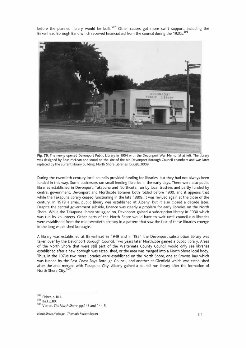
North Shore Heritage - Thematic Review Report
111
before the planned library would be built.597 Other causes got more swift support, including the Birkenhead Borough Band which received financial aid from the council during the 1920s.598
Fig. 76. The newly opened Devonport Public Library in 1954 with the Devonport War Memorial at left. The library was designed by Ross McLean and stood on the site of the old Devonport Borough Council chambers and was later replaced by the current library building. North Shore Libraries, D_GBL_0009. During the twentieth century local councils provided funding for libraries, but they had not always been funded in this way. Some businesses ran small lending libraries in the early days. There were also public libraries established in Devonport, Takapuna and Northcote, run by local trustees and partly funded by central government. Devonport and Northcote libraries both folded before 1900, and it appears that while the Takapuna library ceased functioning in the late 1880s, it was revived again at the close of the century. In 1919 a small public library was established at Albany, but it also closed a decade later. Despite the central government subsidy, finance was clearly a problem for early libraries on the North Shore. While the Takapuna library struggled on, Devonport gained a subscription library in 1930 which was run by volunteers. Other parts of the North Shore would have to wait until council-run libraries were established from the mid twentieth century in a pattern that saw the first of these libraries emerge in the long established boroughs. A library was established at Birkenhead in 1949 and in 1954 the Devonport subscription library was taken over by the Devonport Borough Council. Two years later Northcote gained a public library. Areas of the North Shore that were still part of the Waitemata County Council would only see libraries established after a new borough was established, or the area was merged into a North Shore local body. Thus, in the 1970s two more libraries were established on the North Shore, one at Browns Bay which was funded by the East Coast Bays Borough Council, and another at Glenfield which was established after the area merged with Takapuna City. Albany gained a council-run library after the formation of North Shore City.599
597 Fisher, p.101. 598 Ibid, p.80. 599 Verran, The North Shore, pp.142 and 144-5.
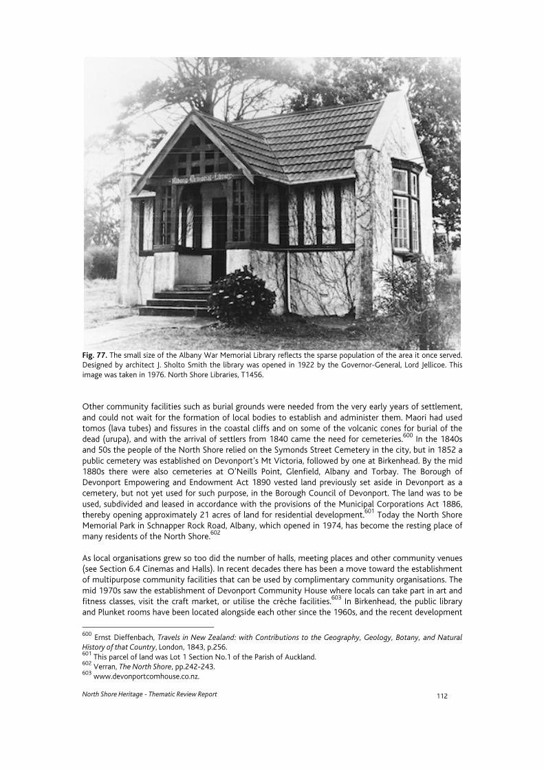
North Shore Heritage - Thematic Review Report
112
Fig. 77. The small size of the Albany War Memorial Library reflects the sparse population of the area it once served. Designed by architect J. Sholto Smith the library was opened in 1922 by the Governor-General, Lord Jellicoe. This image was taken in 1976. North Shore Libraries, T1456. Other community facilities such as burial grounds were needed from the very early years of settlement, and could not wait for the formation of local bodies to establish and administer them. Maori had used tomos (lava tubes) and fissures in the coastal cliffs and on some of the volcanic cones for burial of the dead (urupa), and with the arrival of settlers from 1840 came the need for cemeteries.600 In the 1840s and 50s the people of the North Shore relied on the Symonds Street Cemetery in the city, but in 1852 a public cemetery was established on Devonport’s Mt Victoria, followed by one at Birkenhead. By the mid 1880s there were also cemeteries at O’Neills Point, Glenfield, Albany and Torbay. The Borough of Devonport Empowering and Endowment Act 1890 vested land previously set aside in Devonport as a cemetery, but not yet used for such purpose, in the Borough Council of Devonport. The land was to be used, subdivided and leased in accordance with the provisions of the Municipal Corporations Act 1886, thereby opening approximately 21 acres of land for residential development.601 Today the North Shore Memorial Park in Schnapper Rock Road, Albany, which opened in 1974, has become the resting place of many residents of the North Shore.602 As local organisations grew so too did the number of halls, meeting places and other community venues (see Section 6.4 Cinemas and Halls). In recent decades there has been a move toward the establishment of multipurpose community facilities that can be used by complimentary community organisations. The mid 1970s saw the establishment of Devonport Community House where locals can take part in art and fitness classes, visit the craft market, or utilise the crèche facilities.603 In Birkenhead, the public library and Plunket rooms have been located alongside each other since the 1960s, and the recent development
600 Ernst Dieffenbach, Travels in New Zealand: with Contributions to the Geography, Geology, Botany, and Natural History of that Country, London, 1843, p.256. 601 This parcel of land was Lot 1 Section No.1 of the Parish of Auckland. 602 Verran, The North Shore, pp.242-243. 603 www.devonportcomhouse.co.nz.
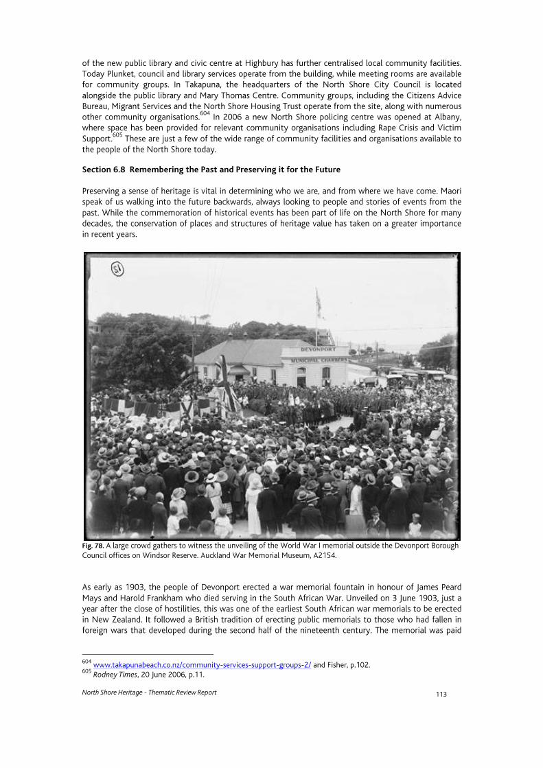
North Shore Heritage - Thematic Review Report
113
of the new public library and civic centre at Highbury has further centralised local community facilities. Today Plunket, council and library services operate from the building, while meeting rooms are available for community groups. In Takapuna, the headquarters of the North Shore City Council is located alongside the public library and Mary Thomas Centre. Community groups, including the Citizens Advice Bureau, Migrant Services and the North Shore Housing Trust operate from the site, along with numerous other community organisations.604 In 2006 a new North Shore policing centre was opened at Albany, where space has been provided for relevant community organisations including Rape Crisis and Victim Support.605 These are just a few of the wide range of community facilities and organisations available to the people of the North Shore today. Section 6.8 Remembering the Past and Preserving it for the Future Preserving a sense of heritage is vital in determining who we are, and from where we have come. Maori speak of us walking into the future backwards, always looking to people and stories of events from the past. While the commemoration of historical events has been part of life on the North Shore for many decades, the conservation of places and structures of heritage value has taken on a greater importance in recent years.
Fig. 78. A large crowd gathers to witness the unveiling of the World War I memorial outside the Devonport Borough Council offices on Windsor Reserve. Auckland War Memorial Museum, A2154. As early as 1903, the people of Devonport erected a war memorial fountain in honour of James Peard Mays and Harold Frankham who died serving in the South African War. Unveiled on 3 June 1903, just a year after the close of hostilities, this was one of the earliest South African war memorials to be erected in New Zealand. It followed a British tradition of erecting public memorials to those who had fallen in foreign wars that developed during the second half of the nineteenth century. The memorial was paid
604 www.takapunabeach.co.nz/community-services-support-groups-2/ and Fisher, p.102. 605 Rodney Times, 20 June 2006, p.11.

North Shore Heritage - Thematic Review Report
114
for by local subscription and is one of around 50 South African war memorials that were erected around the country.606 Other war memorials would follow, with many being erected in memory of those who fell in the two world wars. The form of these memorials varied from the Albany War Memorial Library erected in 1922, to the Takapuna War Memorial Hall which opened in 1953, and the Stone of Remembrance erected at the Browns Bay beachfront in 1968.607
The vast majority of New Zealand war memorials erected in memory of the fallen from World War I were monuments, and the Albany War Memorial Library was one of just a few library buildings erected in New Zealand as First World War memorials.608 By the close of World War II, utilitarian memorials including halls, swimming pools, sports grounds and other facilities used by the public had gathered favour, being a popular choice for the many centennial memorials that were erected just a few years earlier. They were also preferred by the first Labour Government which provided subsidies for war memorial purposes.609 While the Takapuna War Memorial Hall reflected the move toward utilitarian war memorials, the Stone of Remembrance at Browns Bay echoed the earlier preference for monumental memorials. Although monumental memorials had become less popular after World War II, those that were erected tended to be in places where no other public war memorials existed, and this was the case with the Stone of Remembrance at Browns Bay.610 The war memorials of the North Shore are just part of a wider collection of places that reflect the history of the North Shore. In recent years there has been a greater appreciation of the history of the North Shore from both locals and visitors. The North Shore’s heritage sites have become a major drawcard for tourists promoted by agencies like the city council and the Department of Conservation through interpretative signage, heritage walks, heritage brochures and the annual North Shore City Heritage Festival. Within the community, there has also been a move toward celebrating local history. Local historical and museum societies have sprung up in many North Shore suburbs including Glenfield, Torbay, Devonport and Birkenhead. Devonport is also home to the Navy Museum, reflecting the importance of Devonport in the naval history of New Zealand. Today there is an increasing appreciation of the built heritage of the North Shore, including both residential and commercial buildings.
606 ‘Devonport South African War Memorial’, http://www.nzhistory.net.nz/media/photo/devonport-south-african-war-memorial, (Ministry for Culture and Heritage), updated 7-Mar-2011 and 'South African War memorials', http://www.nzhistory.net.nz/war/war-memorials/south-african-boer-war-memorials, (Ministry for Culture and Heritage), updated 22-Feb-2011. 607 Evening Post, 26 December 1922, p.6 and Mace, item 1. 608 Chris MacLean and Jock Phillips, The Sorrow and the Pride: New Zealand War Memorials, Wellington, 1990, pp.74- 78. 609 Ibid, p.137-144. 610 Mace, item 1.
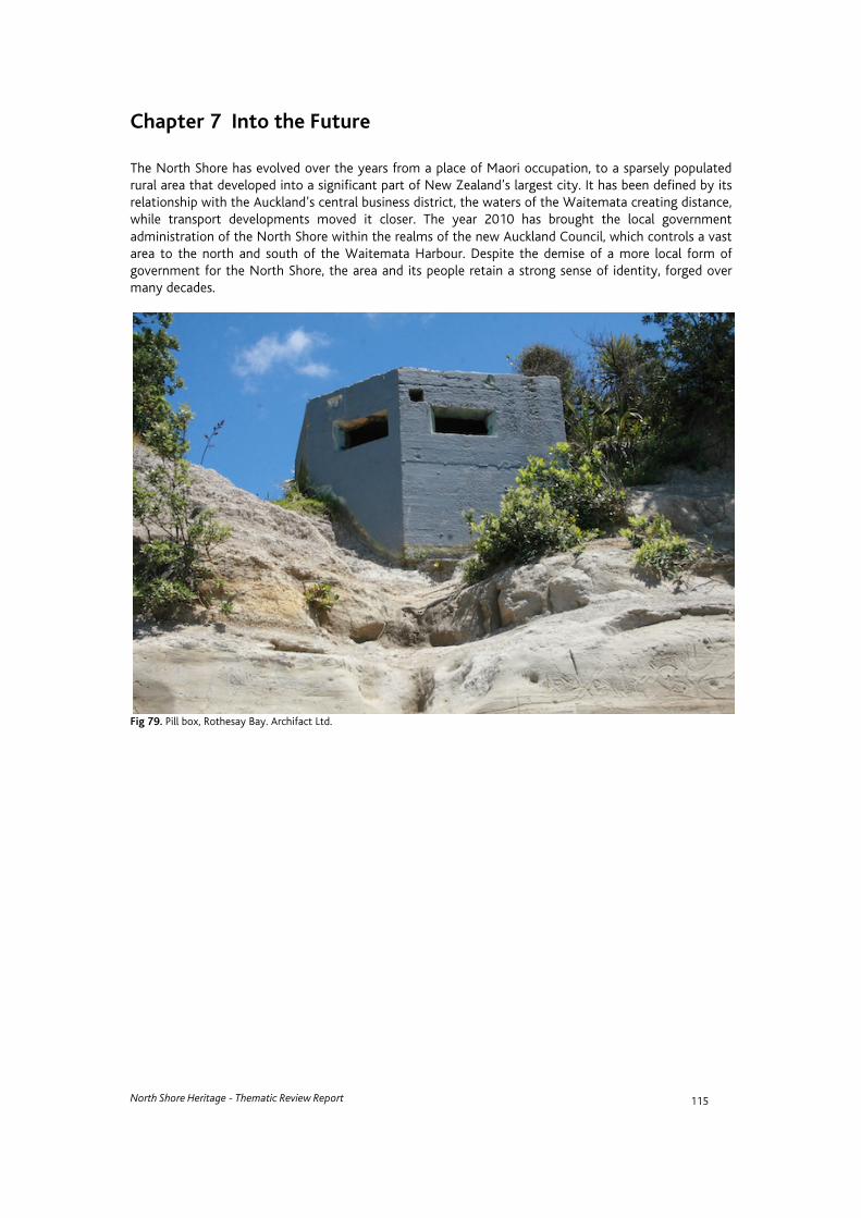
North Shore Heritage - Thematic Review Report
115
Chapter 7 Into the Future The North Shore has evolved over the years from a place of Maori occupation, to a sparsely populated rural area that developed into a significant part of New Zealand’s largest city. It has been defined by its relationship with the Auckland’s central business district, the waters of the Waitemata creating distance, while transport developments moved it closer. The year 2010 has brought the local government administration of the North Shore within the realms of the new Auckland Council, which controls a vast area to the north and south of the Waitemata Harbour. Despite the demise of a more local form of government for the North Shore, the area and its people retain a strong sense of identity, forged over many decades.
Fig 79. Pill box, Rothesay Bay. Archifact Ltd.

North Shore Heritage – Thematic Review Report 116
Bibliography Primary Sources Archival Sources Architecture Archive, University of Auckland. Birkenhead Borough Council Minute Book 1922-1927, BBC Series 111 Item 9, North Shore City Archives. Refinery Manager’s Letterbook June 1892-February 1898, Box 145, Chelsea Archive, Birkenhead Public Library. Sydney-Auckland Letterbook January 1905-December 1906, Box 151, Chelsea Archive, Birkenhead Public Library. Official Publications Appendices to the Journals of the House of Representatives, 1900, 1906, 1913, 1950 Results of a Census of the Colony of New Zealand 1881 Directories Cleaves Auckland Provincial Directory, 1920, 1925 Directory of Homes and Hospitals Controlled by Religious and Welfare Organisations and Hospital Boards and Private Operators, Wellington, 1983 Who’s Who on the North Shore, 1955 Wises New Zealand Post Office Directory, 1904, 1970-71 Wises Auckland Provincial Directory, 1950, 1956 Newspapers Albany Extra 13 May 1999 Aucklander 19 August 2004
28 June 2006 21 March 2007
Auckland Star 6 December 1958 Auckland Evening Star 6 March 1882 Bay of Plenty Times 6 October 1890
19 December 1894 4 February 1895
Daily Southern Cross 22 April 1863 31 December 1863 6 April 1864 20 April 1864 15 August 1864 22 November 1865 10 February 1866 18 April 1866 20 June 1866 5 September 1866 12 & 13 November 1866 22 November 1866 6 December 1866 5 February 1867 7 February 1867 18 April 1867 7 March 1868 24 March 1868 18 April 1868 3 March 1870 7 August 1873 27 August 1873 29 May 1876

North Shore Heritage – Thematic Review Report 117
Devonport Flagstaff 25 March 1999 15 July 1999
4 May 2000 27 July 2000 8 March 2001 28 March 2002 12 June 2006
Evening Post 11 December 1885 15 May 1908 3 February 1917 6 August 1926
New Zealander 20 September 1845 11 July 1846 21 June 1848
New Zealand Herald 4 March 1882 24 July 1894 27 February 1936 6 March 1991 6 June 1992 10 August 1992 9 June 1998 11 July 1998 19 June 2000 3 September 2008 29 June 2010 10 July 2010
North Harbour News 10 July 1998 13 January 2006 12 December 2008
North Shore Times 24 August 1955 24 July 1957 6 August 1958 8 June 1960 20 July 1965 6 May 2004 1 October 2004 4 July 2006 14 June 2007 4 November 2008 3 March 2009
North Shore Times Advertiser 20 June 1968 8 October 1968 3 July 1969 20 January 1970 5 February 1970 13 April 1972 5 September 1972 10 April 1973 18 June 1973 17 July 1973 24 July 1973 28 November 1974 28 January 1975 4 March 1975 12 June 1975 26 June 1975 6 November 1975 4 September 1976 1 December 1977

North Shore Heritage – Thematic Review Report 118
North Shore Times Advertiser 1 September 1981 12 November 1981 29 June 1984 11 September 1984 26 September 1985 27 August 1987 29 September 1988 19 March 1998 25 April 1989 18 May 1989 17 October 1989 9 July 1991 14 January 1992 19 May 1992 30 July 1992 25 May 1993 28 September 1994 28 February 1995 9 March 1995 30 June 1995 1 February 1996 1 October 1996 3 December 1996 23 October 1997 2 April 1998 30 March 1999 8 June 1999 3 February 2000 29 August 2000 13 August 2001 22 April 2003
North Otago Times 8 April 1878 Observer 9 January 1892
2 April 1892 15 February 1896 8 June 1899 10 December 1904 17 December 1904
Poverty Bay Herald 17 December 1918 Rodney Times 20 June 2006 Shore News 3 May 1995
21 June 1995 26 March 2003
Southern Cross 4 September 1847 25 November 1853 10 January 1854 3 March 1854 17 September 1858
Thames Star 22 January 1917 Torbay Newsletter March 2007 Weekly News 3 September 1887
21 July 1921 Magazines Architecture New Zealand May-June 2009 Metro February 1987
February 1990 July 1990 October 1993
North Shore Heritage – Thematic Review Report 119
New Zealand Management June 2006 New Zealand Trade & Development October/November 1969 Scrap Books Auckland Scrap Book August 1957
December 1957 December 1958 September 1959 August 1960 March 1962 August 1963 December 1963 November 1966 October 1968 September 1969 February 1970 May 1970 August 1970 April 1971 January 1972 October 1972 September 1974 September 1982
Library Collection Vertical Files
Accidents and Emergencies-Crime-District Court, Albany Library Devonport-History-Boatbuilding, Takapuna Library Early History, Albany Library. Industry-Boatbuilding, Takapuna Library North Shore-Birkenhead-History, Takapuna Library North Shore-East Coast Bays-Campbells Bay-Health Camp, Takapuna Library North Shore-Shakespeare Road-North Shore Hospital, Takapuna Library North Shore-Albany-Paremoremo-Prison, Takapuna Library Police, Takapuna Library Photographic and Map Collections Alexander Turnbull Library Auckland City Libraries Auckland War Memorial Museum Library North Shore City Libraries Secondary Sources Books Auckland Gas Company Limited: 100 Years of Progress 1862-1962, Auckland, 1962. Celebrating Half a Century of Maternity Care for Women and their Children at North Shore Hospital, 2008. Cyclopedia of New Zealand, Vol. 2, Christchurch, 1902. ECB: The Years to 1989, Auckland, 1989. Old Glenfield: A Portrait in Photographs, Auckland, 2005. Northcote Borough: Golden Jubilee 1908-1958, Auckland, 1958. Northcote Bowling Club Incorporated: A Centennial History, Auckland, n.d. North Shore City Council Parks Strategy, August 2007. Progress with Vision: 25 Years of Kristin School, Auckland, 1998. Rosmini College Silver Jubilee: 25th Jubilee 1962-87, Auckland, 1987. Takapuna: Heart of the North Shore Golden Jubilee 1913-1963, n.p, n.d. The Station: A Concise History of the Albany Basin 1840-1940, Auckland, 1986. Abbott, Genevieve, Circumspice: A Pictorial History of Rangitoto College, Auckland, 2006. Anderson, Graeme, Fast Light Boats: A Century of Kiwi Innovation, Wellington, 1999.

North Shore Heritage – Thematic Review Report 120
Anderson, Louise, Pupuke: A tour of the gentlemen and their residences on historic Lake Pupuke, 1993. Bartlett, Jean, ed., Takapuna: People and Places, Auckland, 1989. Bevan, Denys, United States Forces in New Zealand 1942-1945, Alexandra, 1992. Bloomfield, G.T., The Evolution of Local Government Areas in Metropolitan Auckland 1840-1971, Auckland, 1973. Bond, Brian, 90 Seasons: A History of the North Shore United Association Football Club, Auckland, 1977. Bryder, Linda, Not Just Weighing Babies: Plunket in Auckland 1908-1998, Auckland, 1998. Bush, G.W.A., Decently and In Order: The Centennial History of the Auckland City Council, 1971, Auckland. Butterworth, Susan, More than Law and Order: Policing a Changing Society 1945-1992, Dunedin, 2005. Cherrett, Owen J., Without Fear or Favour: 150 Years Policing Auckland 1840-1990, Auckland, 1989. Christie, Colleen, ed., Back Then: Oral History Interviews from the Birkenhead Public Library, Vols. 1-4, Auckland, 1988-1989. Christmas, Judith, A History of Northcote, Auckland, 1983. Cochrane, H.A., Let Us Give Thanks: Jubilee Celebrations in Devonport Methodism, Auckland, 1946. Cole, Martin, The Anglican Church in Bayswater 1864-1985, Auckland, 1985. Cooke, Peter, Defending New Zealand: Ramparts on the Sea 1840-1950s, Wellington, 2000. Corbett, Peter D., A First Class Defended Port: The History of the Coast Defences at Auckland, its Harbour and Approaches, Auckland, 2003. Dance, Betty, Pressing on Regardless: the Story of the Mairangi Bay Presbyterian Church, Auckland, 2004. De Joux Oswald, J., St Leo’s Convent School Devonport, Auckland, 1989. Dunmore, John, Greenhhithe Today & Yesterday, Auckland, 2001. Elliott, Robin & Harold Kidd, The Logans: New Zealand’s Greatest Boatbuilding Family, Auckland, 2001. Faulkner, Ian F., The Decisive Decade: Some Aspects of the Development and Character of the Methodist Central Mission, Auckland, 1927-1937, Auckland, 1982. Ferguson, Gael, Building the New Zealand Dream, Palmerston North, 1994. Fifty Years A-growing: Devonport Celebrates its Jubilee, Devonport, 1936. Fisher, Muriel & WJ Hilder, Birkenhead: a history of the development from the earliest days to 1968 of the North Shore Borough of Birkenhead, Auckland, 1969. Gatley, Julia, Group Architects: Towards a New Zealand Architecture, Auckland, 2010. Gillon, G.M., United to Protect: An Historical Account of the Auckland Fire Brigade 1884-1985, Auckland, 1985. Glackin, Russell, In Defence of Our Land: A Tour of New Zealand’s Historic Harbour Forts, Auckland, 2009. Grefstad, Jan, Auckland Cinemas, Auckland, 2002. Haddon, Kathy, Birkenhead: the way we were, Takapuna, 1993. Hamling, Trevor, A History of the Auckland St John Ambulance Division 1893-1993, Auckland, 1995. Harris, Alison & Robert Stevenson, Once there were Green Fields: The Story of Albany New Zealand, Auckland, 1993. Hill, Murray, In the Line of Duty: 100 Yeas of the New Zealand Police, Auckland, 1986. Hill, Richard S., Policing the Colonial Frontier, Part I, Wellington, 1986. Hill, Richard S., The Iron Hand in the Velvet Glove: The Modernisation of Policing in New Zealand 1886-1917, Palmerston North, 1995. Hinton, Jack and June, The Friendly Invasion of New Zealand by American Armed Forces June 1942-October 1944, Wellington, 1993. Hochstetter, Ferdinand von, New Zealand its Physical Geography, Geology and Natural History with Specific Reference to the Results of Government in the Provinces of Auckland and Nelson, Stuttgard, 1867. Howard, Grant, The Navy in New Zealand: An Illustrated History, Wellington, 1981. Howitt, Bob, Northcote 75: A Celebration of the Northcote Birkenhead Rugby Club 1929-2004, Auckland, 2004. Hunt, Graeme, First to Care: 125 Years of the Order of St John in New Zealand 1885-2010, Auckland, 2009. Hutchinson, W. Norman, Takapuna: A Historical Portfolio Commemorating 60 Years of Municipal Government 1913-1973, Auckland, 1973. Kidd, Harold, ed., Devonport Yacht Club: A Centennial History, Auckland, 2005. King, Jennifer, Sign of Service: A History of the Auckland Electric Power Board 1922-1972, Auckland, 1972. King, Michael, The Penguin History of New Zealand Illustrated, 3rd Ed., Auckland, 2007. King, RE, Tauhinu: A History of Greenhithe, Auckland, 1984. Lay, Graeme & Jack Ross, eds., Golden Weather: North Shore Writers Past and Present, Devonport, 2004. Leov-Lealand, Christine, Barry Brickell: A Head of Steam, Auckland, 1996.

North Shore Heritage – Thematic Review Report 121
Lloyd Prichard, Muriel F., and James Bruce Tabb, Auckland Gas Company: 100 Years of Progress 1862-1962, Auckland, 1967. Lowrie, Meryl, The Geneva Connection: Red Cross in New Zealand, Wellington, 1991. Luke, Peter, Sugar Workers Sugar Town: An Oral History of Chelsea Sugar Refinery 1884-1984, Auckland, 1984. Mackay, Duncan, Frontier New Zealand: The Search for Eldorado 1800-1920, Auckland, 1992. Marshall, Brian, A History of the Auckland Kindergarten Association, Auckland, 1983. Moon, Paul, The Struggle for Tamaki Makaurau: The Maori Occupation of Auckland to 1820, Auckland, 2007. McClure, Margaret, The Story of Birkenhead, Auckland, 1987. McKinnon, Malcolm, ed., New Zealand Historical Atlas, Auckland, 1997. Mackay, Duncan, Frontier New Zealand: The Search for Eldorado 1800-1920, Auckland, 1992. MacLean, Chris & Phillips, Jock, The Sorrow and the Pride: New Zealand War Memorials, Wellington, 1990. Mairangi Venturer Unit, History of Three Bays, Auckland, 1970. Martin, John E., ed., People Politics and Power Stations: Electric Power Generation in New Zealand 1880-1998, 2nd ed., Wellington, 1998. Mein Smith, Philippa, Maternity in Dispute: New Zealand 1920-1939, Wellington, 1986. Musgrove, S, ed., The Hundred of Devonport: A Centennial History, Auckland, 1986. Nightingale, Tony, White Collars and Gumboots: A History of the Ministry of Agriculture and Fisheries 1892-1992, Palmerston North, 1992. Packington-Hall, AJ, Intensive Survey of the Historic R & R Duder Brickworks Site in Devonport Auckland, Auckland, 1992. Parmee, Julie & Butterworth, Phyl, Torbay – Past and Present, Auckland, 1992. Petricevich, Colleen, ed., St Joseph’s Takapuna 1996-2006, Auckland, 2007. Phillips, BS, 60 Years in Power: Waitemata Electric Power Board, Auckland, 1985. Reed, AH, The Gumdiggers: The Story of Kauri Gum, 3rd Ed., Auckland, 2006. Rounthwaite, Valerie, The Story of Rural Glenfield, Auckland, 1989. Salmond, Jeremy, Old New Zealand Houses 1800-1940, Auckland, 1986. Sargisson, Lucy & Lyman Tower Sargent, Living in Utopia: New Zealand’s Intentional Communities, Aldershot, 2004. Sayers, Eric & Dumbleton, Eric, eds., Takapuna Jubilee 1917-1973, Takapuna, 1973. Scott, Dick, Fire on the Clay: The Pakeha Comes to West Auckland, Auckland, 1979, p.126. Shaw, Louise, Making a Difference: A History of the Auckland College of Education 1881-2004, Auckland, 2006. Soar, Patricia E., The Catholic Church in the East Coast Bays 1938-1998, Auckland, 1997. Southeran, Marvynne, Carmel College: A Fiftieth Jubilee History 1957-2007, Auckland, 2007. Sutherland, Frank, 75 Years 1883-1958: The Story of the Takapuna Methodist Church, Auckland, 1958. Spoonley, Paul, North Shore: A Post Suburban Landscape?, Auckland, 1997. Stone, R.C.J., From Tamaki-Makau-Rau to Auckland, Auckland, 2001. Tennant, Margaret, Children’s Health, The Nation’s Wealth: A History of Children’s Health Camps, Wellington, 1994. Titchener, Paul, Beginnings: A History of the North Shore of Auckland, Vols. 1-7, Auckland, 1977-1984. Titchener, Paul, Sea Classics of New Zealand: Stories of New Zealand’s Yachting Pioneers’, Auckland, 1981. Verran, David, The North Shore: An Illustrated History Auckland, 2010. Walsh, T., An Illustrated Story of Devonport and the Old North Shore From 1841 to 1924, Auckland, 1970. Wicksteed, R.M., The New Zealand Army: A History from the 1840s to the 1980s, Wellington, 1982. Wilson, RG & Smith, RA, Exploring the East Coast Bays, Auckland, 1983. Wright-St Clair, Rex, ed., St John in New Zealand 1885-1995, Wellington, 1985. Articles Alison, Keitha, Milford: Polar Bears and a Castle, Jean Bartlett, ed., Takapuna: People and Places, Auckland, 1989. Ballara, Angela, ‘Patuone, Eruera Maihi ?-1904’, Dictionary of New Zealand Biography, updated June 2007, URL:http://www.dnzb.govt.nz. Barratt, David, ‘The Garrison’, S. Musgrove, ed., The Hundred of Devonport: A Centennial History, Auckland, 1986. Bartlett, Jean, ‘The Businessmen’, Jean Bartlett, ed., Takapuna: People and Places, Auckland, 1989. Bartlett, Jean, ‘The Lake’, Jean Bartlett, ed., Takapuna: People and Places, Auckland, 1989.
North Shore Heritage – Thematic Review Report 122
Campion, Sarah, ‘Women of the Borough’, S. Musgrove, ed., The Hundred of Devonport: A Centennial History, Auckland, 1986. Coolahan, Kate, ‘Pickmere, Alison Blomfield 1908-1971’, Dictionary of New Zealand Biography, updated June 2007, URL:http://www.dnzb.govt.nz. Corkin, Jason, ‘Brooke, John Balmain 1907-1992’, Dictionary of New Zealand Biography, updated June 2007, URL:http://www.dnzb.govt.nz. Fairfax, Denis, ‘Wiseman, William Saltonstall 1814-1874’, Dictionary of New Zealand Biography, updated June 2007, URL:http://www.dnzb.govt.nz. Ferguson, Gael, ‘Industry and Commerce’, S. Musgrove, ed., The Hundred of Devonport: A Centennial History, Auckland, 1986. Ferguson, Gael, ‘The Borough’, S. Musgrove, ed., The Hundred of Devonport: A Centennial History, Auckland, 1986. Fleming, C.A., ‘Hochstetter, Christian Gottlieb Ferdinand von 1829-1884’, Dictionary of New Zealand Biography, updated June 2007, URL:http://www.dnzb.govt.nz. Fraser, Margaret, ‘Charles Ross Cholmondeley-Smith’, Marie Gray and Jennifer Sturm, eds., And then Came the Bridge: A History of Long Bay and Torbay, Auckland, 2008. Gillam, Jennifer, ‘Firth, Reginald Clifton 1904-1980’, Dictionary of New Zealand Biography, updated June 2007, URL:http://www.dnzb.govt.nz. Grant, Ian F., ‘Blomfield, William 1866-1938’, Dictionary of New Zealand Biography, updated June 2007, URL:http://www.dnzb.govt.nz. Grayland, Eugene, ‘Education: A Headache for Planners’, Donald F. Manley, ed., North Shore Expands, Auckland, 1963. Holdaway, E.A.J., ‘Northcote: A Desirable Place to Live’, Donald F. Manley, ed., North Shore Expands, Auckland, 1963. Howells, Shelley, ‘Pretty in Pink’, Heritage New Zealand, Summer 2006, online: www.historic.org.nz/en/Publications/HeritageNZMagazine/HeritageNz2006. Johnston, Alexa M., ‘Macalister, Molly Morell 1920-1979’, Dictionary of New Zealand Biography, updated June 2007, URL:http://www.dnzb.govt.nz. King, Michael, ‘Sargeson, Frank 1903-1982’, Dictionary of New Zealand Biography, updated June 2007, URL:http://www.dnzb.govt.nz. Laxon, W.A., ‘Alison, Ewen William 1852-1945’, Dictionary of New Zealand Biography, updated 22 June 2007, URL:http://www.dnzb.govt.nz. Levien, Janett, ‘Formal and Informal Sectors’, Peter Davis and Kevin Dew, eds., Health and Society in Aotearoa New Zealand, Melbourne, 1999. Mackay, J.A., ‘Pioneer Farming on the North Shore’, Auckland-Waikato Historical Journal, Vol. 14, April 1969. Mackay, J.A., ‘The East Coast Bays on Auckland’s North Shore’, Auckland-Waikato Historical Journal, Vol. 16, April 1970. Mackay, James, ‘Kauri Gum Digging on the North Shore’, Jean Bartlett, ed., Takapuna: People and Places, Auckland, 1989. Mackay, James, ‘The First Farmers’, Jean Bartlett, ed., Takapuna: People and Places, Auckland, 1989. Mackay, James, ‘The First Schools’, Jean Bartlett, ed., Takapuna: People and Places, Auckland, 1989. Mogford, Janice C., ‘Burns, Joseph, 1805/6?-1848’, Dictionary of New Zealand Biography, Vol. I, 2nd ed., Wellington, 1993. Mortiboy, Tony, ‘Hospitals and Health Services’, Donald F. Manley, ed., North Shore Expands, Auckland, 1963. Sturm, Jennifer, ‘Post Office’, Marie Gray and Jennifer Sturm, eds., And then Came the Bridge: A History of Long Bay and Torbay, Auckland, 2008. Titchener, Paul, ‘Sport’, S. Musgrove, ed., The Hundred of Devonport: A Centennial History, Auckland, 1986. Verran, David, ‘Maori and Pakeha on the North Shore 1840 – 1926. Members Stories’, Birkenhead Historical Society, http://www.historicbirkenhead.com/membersstories43.htm, p.1, accessed 17 March 2011. Winder, Gordon M., ‘Making Space: Clusters and Districts in Auckland Manufacturing, 1889-1908’, Ian Hunter and Dianna Morrow, eds., City of Enterprise: Perspectives on Auckland Business History, Auckland, 2006.

North Shore Heritage – Thematic Review Report 123
Theses and Research Essays Conacher, A.J., ‘The North Shore – A Dormitory Suburb of Metropolitan Auckland: An Investigation into Aspects of North Shore Commuter Patterns’ unpublished thesis, University of Auckland, 1964. Dimery, W.J., ‘Man’s Changing Role in Takapuna: From Farmland to City’, unpublished thesis, University of Auckland, 1967 Glass, Michael R., ‘The New Zealand Custom Boat-Building Industry: Innovation and Information within a Local Milieu’, unpublished thesis, University of Auckland, 1998. Griffiths, B.J., ‘The North Shore: Its Character and Functions in 1888, 1913 and 1936’, unpublished thesis, University of New Zealand, 1959. Ferguson, S.L., ‘The Wairau Valley: Industrial Evolution and Rental Growth since 1989’, unpublished research project, University of Auckland, 1989. Lewis, Timothy, ‘The Potential for Redevelopment of the Glenfield Shopping Mall’, unpublished research project, University of Auckland, 1992. MacKinlay, Mark, ‘North Harbour Industrial Park’, unpublished research project, University of Auckland, 1993. Marshall, B.W., ‘Kauri Gum Digging 1885-1920’, unpublished thesis, University of Auckland, 1968. McDermott, P.J., ‘Evolution of the Wairau Valley Industrial Area: Man’s Changing Role in the Physiographic Environment’, unpublished research essay, University of Auckland, 1970. Melville, S.J., ‘Takapuna: A Destination Sub-Regional Shopping Centre of the Future’, unpublished research project, University of Auckland, 1991. Smith, Albert William, ‘The Development of the Kauri-Gum Industry and its Role in the Economy of Northland, N.Z.’, unpublished thesis, University of Washington, 1952. Stephenson, C.A., ‘The Politics of Place: A Study of Contemporary Devonport’, unpublished thesis, 1993. Yoffe, Susan, ‘Devonport Borough 1886’, research essay, University of Auckland, 1990. Reports and Heritage Walks ‘Historic Fort Takapuna O Peretu, Hauraki Gulf Maritime Park’ Department of Conservation, www.doc.govt.nz/upload/documents/conservation/historic/by-region/fort-takapuna-hgmp-may-2001.pdf. ‘North Shore City Demographic Profile’, North Shore City report, February 1991. Kingston Reynolds Thom & Allardice, ‘North Shore Scenic Board Reserves Management Plan’, September 1980. Mace, Tania, ‘Browns Bay Heritage Walk’, North Shore City Council, 2006. Unpublished Material ‘A Brief History of Albany Village (Lucas Creek)’, unpublished manuscript, Vertical File – Early History, Albany Library. ‘Illustrated Catalogue of Standard Shapes or High-Grade Fireclay Goods Manufactured by the Auckland Gas Company’, 1923 Edition, Vertical File, Takapuna Library. ‘Notes on the Influenza Epidemic of November, 1918’, Vertical File, Takapuna Library. ‘Shipbuilders’ unpublished manuscript, North Shore Vertical File, Devonport-History-Boatbuilding, Takapuna Library. ‘Takapuna H.Q. Northern Police Division: Souvenir Programme of 61st Anniversary of Station Opening, 29 May 1912’, Vertical File, Police, Takapuna Library. ‘Takapuna H.Q. Northern Police Division: Souvenir Programme of 62nd Anniversary of Station Opening, 29 May 1912’, Vertical File, Police, Takapuna Library. Bowron, Greg, Housing New Zealand Corporation Heritage Inventory. Brickell, Barry, ‘Devonport Reminiscences: The Old Duders Brickworks’, Vertical File, Takapuna Library. Campbell, Allister, ‘A History of Wilson Home’, Vertical File, Takapuna Library. Farmer, Albert, ‘Origin and Development of New Zealand Grown Fruits: The Gravenstein Family’, Vertical File, Takapuna Library Mace, Tania, and Greg Bowron, ‘Homes for the People: A Thematic Survey of State Housing in New Zealand’, unpublished Housing New Zealand Corporation report, July 2009. Matthews & Matthews Architects Ltd, ‘Takapuna Central Area Preliminary Heritage Overview’, Takapuna, May 2007. Olsen, Charles, ‘Greenhithe Road Corner – a dissertation on life in Old Albany in the 1920s’, Vertical File, Takapuna Library. Petry, Bruce, ‘Claystore: General Assessment of Cultural Heritage Significance’, Devonport, 1992.
North Shore Heritage – Thematic Review Report 124
Websites www.across.co.nz www.awataha.co.nz www.beachhavencatholic.org www.birkenhead.school.nz www.birkenheadtennis.co.nz www.chelsea.co.nz www.corelli.school.nz www.devonportcomhouse.co.nz www.dnzb.govt.nz www.doc.govt.nz www.fairviewvillage.co.nz www.fullers.co.nz www.ganz.org.nz www.glenfieldrugby.co.nz www.harboursport.co.nz www.historicbirkenhead.com www.nzhistory.net.nz www.northshorecity.govt.nz/LeisureAndCulture/ParksWalksAndPlay/Parks/Documents/literary-walks.pdf www.mish.org.nz www.netballnorthharbour.co.nz www.newzealandatoz.com www.northcotetigers.com www.northshorecricket.co.nz www.nshospice.co.nz www.nzherald.co.nz www.nzpca.org www.nzonscreen.comslie www.paperspast.natlib.govt.nz www.pinehurst.school.nz www.plunket.org.nz www.rsa.org.nz www.simongrigg.info www.sportsground.co.nz www.stadium.co.nz www.takapunaanglican.co.nz www.takapunabeach.co.nz www.tennisnorthern.co.nz www.thewarehouse.co.nz www.torbaytennis.org.nz www.westlakegirls.school.nz www.writerscentre.org.nz


