NOAA IOOS Program Office Regional Status Assessment for April 30, 2008 Evan Richert, University of...
29
NOAA IOOS Program Office Regional Status Assessment for April 30, 2008 Evan Richert, University of Southern Maine John Trowbridge, Woods Hole Oceanographic Institution
-
Upload
anabel-helena-mckenzie -
Category
Documents
-
view
213 -
download
0
Transcript of NOAA IOOS Program Office Regional Status Assessment for April 30, 2008 Evan Richert, University of...

NOAA IOOS Program OfficeRegional Status Assessment for
April 30, 2008Evan Richert, University of Southern Maine
John Trowbridge, Woods Hole Oceanographic Institution
RA Structure and GovernanceExecutive Committee
Representing geographic & stakeholder diversity
Art Allen - USCG HQ, Search & Rescue Philip Bogden - GoMOOSJanet Campbell - UNH Coastal Ocean Observing Center Paul Currier - New Hampshire Department of Environmental ServicesTed Diers - New Hampshire Deptartment of Environmental ServicesJames O’Donnell - University of ConnecticutAvijit Gangopadhyay - University of Massachusetts DartmouthAl Hanson - URI Graduate School of OceanographyJon Hare - NOAA/NMFSNeal Pettigrew - University of MaineRon Rozsa - Long Island Sound ProgramsEvan Richert - University of Southern MainePeter Smith - Bedford Institute of OceanographyJohn Trowbridge - WHOI

Advisory CommitteeRepresenting geographic & stakeholder diversity
• Army Corps of Engineers • Atlantic States Marine Fisheries Commission • EPA Region 1• Bedford Institute of Oceanography • Council of Presidents of NE Land Grant Universities • Gulf of Maine Council• Gulf of Maine Research Institute Island Institute• Long Island Sound Programs • MACOORA• Massachusetts Coastal Zone Management• Maine Department of Marine Resources • Maine State Planning Office• Maine Lobstermen's Association • NE COSEE, Marine Educators• Massachusetts Water Resources Authority • New Brunswick Dept. of Environment & Local
Government • New England CZM Programs• Metoc Halifax Naval Undersea Warfare Center • NE NERRS Programs
• New England Fishery Management Council• New England Sea Grant Programs• NOAA’s National Weather Service • Northeast States Emergency Consortium• North Atlantic Ports Association • GoM Ocean Data Partnership• Regional Association for Research on the Gulf of
Maine• RI Dept of Environmental Management • School for Marine Science & Technology• UMASS Boston • United States Geological Society - Woods Hole
Science Center • University of Connecticut• University of Maine• University of Massachusetts Dartmouth• University of Southern Maine • US Army Corps of Engineers• URI Graduate School of Oceanography• USACE-New England USCG HQ• Woods Hole Oceanographic Institute

Organizational and Governance Structure
• 501(c)(3)• Board of Academic, End-user, and
State/Provincial Government Representatives
• Products Requirements and Science Requirements Teams
• Stakeholder Council

Organizational and Governance Structure
The Board• Up to 7 directors representing academic and research
institutions;• Up to 7 directors representing state and provincial
governments;• Up to 7 directors representing marine-related industrial,
governmental, non-profit organizations and other users of ocean data and data products; and
• Up to 4 additional persons who have knowledge or skills or represent geographies or constituencies deemed important.
• Non-voting representatives from agencies otherwise barred by agency rules from serving in a voting capacity

Products Requirements Team Responsible for: • Identifying the data and product needs of users of ocean
observations and predictions; • Defining the data management, integration, and communications
requirements to achieve the desired products; and • Recommending priorities among products and data management
and communications needs.
Consists of:• End users, • Professionals in information technology, • Agency data providers, and • Scientists.
Stakeholder Engagement

Science Requirements Team Responsible for: • Identifying requirements for maintaining existing capacities for
ocean observing and modeling in the Northeast; • Identifying ocean observing and modeling capacities needed to
address the priority needs of users as established by the Product Requirements Team;
• Identifying the best methods to address the needs; and • Prioritizing the methods based on achievability, effectiveness, and
costs.
Consists of: • Principal and co-investigators named in the RCOOS grant awarded
in 2007 by NOAA • Representatives of the sub-regions of the Northeast.
Stakeholder Engagement

Stakeholders’ Council Responsible for: • Education and outreach to users of ocean observing data and data
products; and • Providing input to the Product Requirements Team and Science
Requirements Team concerning the needs of users and the usefulness of ocean observations and products.
Consists of:• Up to 35 users of ocean observing data and data products, including
specialists in education, outreach, and marketing. • Representatives of the sub-regions of the Northeast
Stakeholder Engagement

Stakeholder Engagement
Key issues of importance to regional stakeholders– Representation: Board structure, Product
Requirements Team, Stakeholders’ Council– Real time data: Priority on preserving existing
regional observing assets– Useful products: Direct service to Fed/state
agencies; prototyping, based on stated needs

Key Issues: Useful ProductsThe Advisory Committee identified five initial focus areas:1) Harmful Algal Blooms, 2) Inundation, 3) Water Quality, 4)
Living Marine Resources, and 5) Marine Operations
User Needs Assessments have revealed high priority needs for: • Alerts (email or SMS text message) of probability of HAB formation when
oceanographic conditions are met. • Web based portal to access all types of data.• Visualization tool to depict storm impact based on water level and the
size of ocean waves.• Maps with nutrient layers in areas of concern. • Finer scale water quality monitoring in bays and estuaries.• Visualization of various species dynamics with other oceanographic data.• Real-time tide data combined with wind and wave information.
…And Much More

Key Issues: Useful Products
Needs are addressed by: • Prototyping products to better
understand functionality.• Assessing technical
requirements of expressed need.
• Understanding existing versus needed resources.
• Prioritizing funding and activities based on value to end users and feasibility.
Low hanging fruit
Black holes
Difficulty (time, investment)
Val
ue
(RO
I)HL
Differentia
tors
Time w
asters

Useful Products

Useful Products

Stakeholder Engagement
Expressions of support from stakeholders• Willing participation of key stakeholders in
NERACOOS’s governance• Academic Consortium• Northeast Regional Oceans Council: Governors, Premiers,
Coastal Managers• Sea Grant: Users and Industry
• 2-1/2 years of active participation by Advisory Committee
• Organization of Data Providers

Stakeholder Engagement
Data Providers• 3-year old MOU• Establishes Gulf of Maine Ocean Data
Partnership• Brings in partners from across coastal
ocean domains: environmental, physical, biological, geological
• A cornerstone of “integration”

Serving Stakeholders“Buoy data and storm-surge predictions during a severe New England storm allowed for early public warnings. As a result, no lives were lost and emergency managers had the information they needed."
-Maine EMS
• NHDES uses buoy data to assess baseline and episodic water turbidity as well as water clarity impacts on seagrass beds.
• MWRA uses depth-resolved dissolved oxygen and nutrient data for water quality monitoring in Mass. Bay.
• Coastal forecasters routinely use the ocean observations and models from various partners.
• Water quality managers use Alexandrium sampling, conducted in collaboration with regional ECOHAB.

Serving Stakeholders"As a local television meteorologist I find this information very useful and a welcome addition to the NOAA buoy reports.
Much of the information I gather is passed onto the general public; while other information is used in producing forecasts."
-Meteorologist
• Resource managers use observations to understand the ocean’s ecosystem and predict its response to natural and anthropogenic changes.
• Thousands of mariners use daily sea surface conditions information, improving safety at sea.
• Educators benefit from online resources and other efforts, including a display at the NH Seacoast Science Center, Google Earth lesson plans, and an annual secondary school teachers workshop.
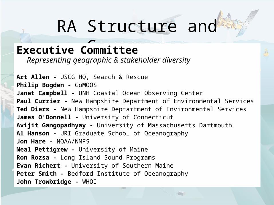
Current Activities & Funding: FY07 RCOOS Grant
Organization Funding Role
BIO $50,000 Wave model, HABs, NE Channel transect
GoMOOS $100,000 Data management
NEFSC 0 Fisheries expertise
U Conn $225,000 Long Island Sound buoys
U Maine $450,000 Gulf of Maine buoys, modeling, satellites
U Mass D $125,000 NECOFS
UNH $125,000 Great Bay buoy, transect
URI $125,000 Nutrient sensors
WHOI 0 Project administration
TOTAL $1,200,000
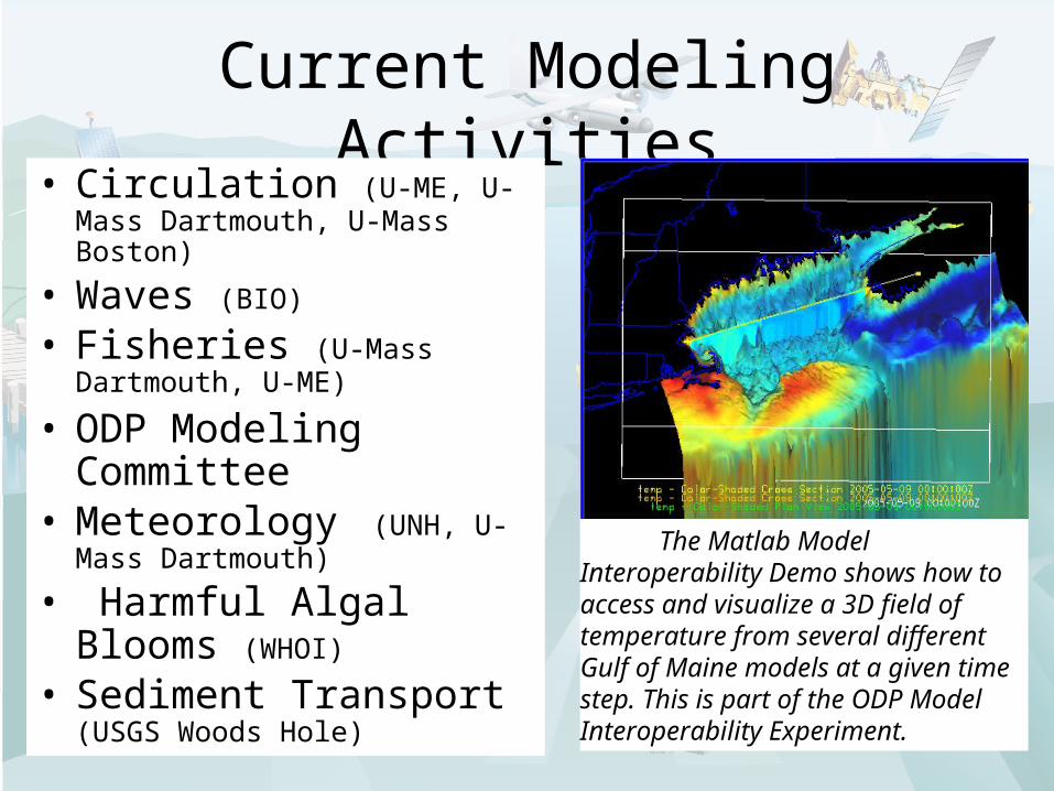
Current Modeling Activities• Circulation (U-ME, U-Mass
Dartmouth, U-Mass Boston)
• Waves (BIO)
• Fisheries (U-Mass Dartmouth, U-ME)
• ODP Modeling Committee
• Meteorology (UNH, U-Mass Dartmouth)
• Harmful Algal Blooms (WHOI)
• Sediment Transport
(USGS Woods Hole)
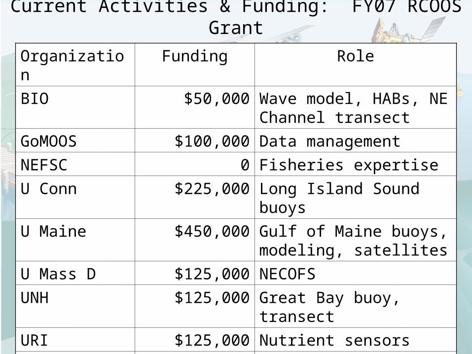
The Matlab Model Interoperability Demo shows how to access and visualize a 3D field of temperature from several different Gulf of Maine models at a given time step. This is part of the ODP Model Interoperability Experiment.

Current Activities and Funding
Data Management and Integration• Ocean Data Partnership• Matching EPA and NOAA funding to harmonize
protocols and enable integration of data in coastal ocean and watershed
• www.OOSTethys.org, Open source tools and best practices for interoperability with NOAA/IOOS (Open Geospatial Consortium)

Interaction with Federal Agencies
• Planning - Strong federal participation on advisory committee.
• Governance - Specific provision for agency participation on BoD.
• Data - Key players in Ocean Data Partnership and holders of major ongoing and legacy data sets.
• Projects - Shrimp tool, Splashover tool, BIO wave modeling, Exchange Network.
Bedford Institute of Oceanography
Coastal Services Center
Environmental Protection Agency
National Data Buoy Center
NASA Global Change Master Directory
National Estuarine Research Reserve System
National Marine Fisheries Service
National Ocean Service
New England Fishery Science Center
Stellwagen Bank National Marine Sanctuary
U.S. Army Corps of Engineers
U.S. Coast Guard National Weather Service
U.S. Geological Survey

RA Coordination: Progress to Date
• Many stakeholders aware of, conversant in, contributors to the Regional Association
• Advanced data management and interoperability through the Gulf of Maine Ocean Data Partnership
• Draft by-laws and governance structure—ready to incorporate
• User needs assessments• Product prototypes for HABs, Inundation,
Living Marine Resources, and Water Quality.• Region-wide coordination on RCOOS

RA Coordination: Next Steps• Convene the NERACOOS Board of Directors in
robust strategic planning to address goals, objectives, place of incorporation, business plan, and operating plan
• Incorporate the organization• Establish Committees (Conflict of Interest
Management, Finance, and Nominations), and Teams and Council (Products Requirements Team, Science Requirements Team, and Stakeholders’ Council)
• Board to establish central office and hire staff, if it decides to have a central office and staff
• Continue user needs assessments and gap analysis (ongoing)
RA Coordination:Activities under the FY08 RA grant
• Development of integrated, coordinated, regional plans for•Products and product development•Science and technology•Data
• Staffing NERACOOS office

RA Views on Regional and National IOOS
• Ready access to “National Backbone” agencies for legacy data bases– Cooperation in making them
discoverable, accessible, interoperable
• Pre-operations to operations – how to sustain operations
• In-shore v off-shore: big system dynamics v everyday users

Cross-regional Coordination
• Conscious decision to expand Northeast region to overlap with Mid-Atlantic
• Step toward aligning regional system with Northeast Fisheries jurisdiction and large area ecosystem
• Do not know if it can be sustained
• Many areas of overlapping scientific interest

Best Practices andLessons Learned
• Geography: political identity v oceanographic considerations
• Cost of sustaining observing network – IOOS may not be enough
• Prototyping of products a good way to build relationships with agencies – USCG, NWS, State Marine Resources, State Environmental Protection

Thank You!
Evan Richert
University of Southern Maine
John Trowbridge
Woods Hole Oceanographic Institution