
New Lidar Technologies for 3DEP - University of South … · New Lidar Technologies for 3DEP + 2...
34
+ Steve Shivers National Map Liaison National Geospatial Program July 25, 2017 New Lidar Technologies for 3DEP
Transcript of New Lidar Technologies for 3DEP - University of South … · New Lidar Technologies for 3DEP + 2...

+
Steve Shivers
National Map Liaison
National Geospatial ProgramJuly 25, 2017
New Lidar Technologies
for 3DEP
+ 2+ 2
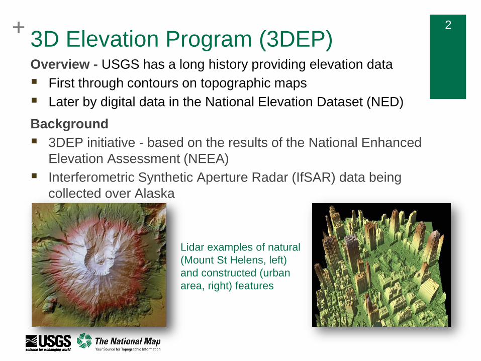
Overview - USGS has a long history providing elevation data
First through contours on topographic maps
Later by digital data in the National Elevation Dataset (NED)
Background
3DEP initiative - based on the results of the National Enhanced
Elevation Assessment (NEEA)
Interferometric Synthetic Aperture Radar (IfSAR) data being
collected over Alaska
Lidar examples of natural
(Mount St Helens, left)
and constructed (urban
area, right) features
3D Elevation Program (3DEP)
+ 3+ 3
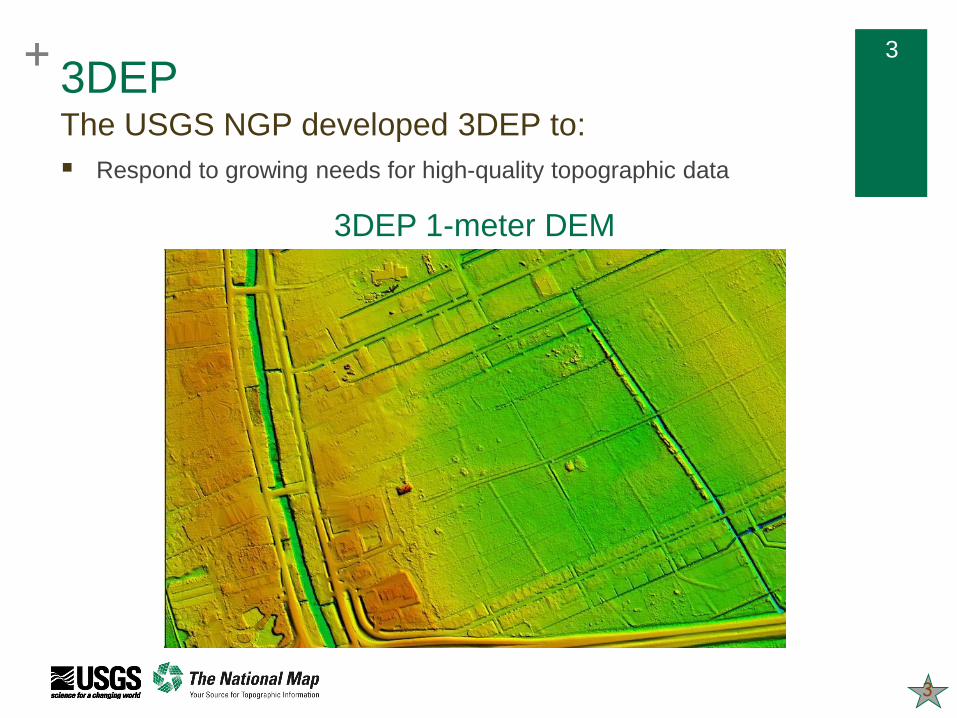
Respond to growing needs for high-quality topographic data
3DEP The USGS NGP developed 3DEP to:
30-meter DEM10-meter DEM3-meter DEM3DEP 1-meter DEM
3
+ 4+ 4
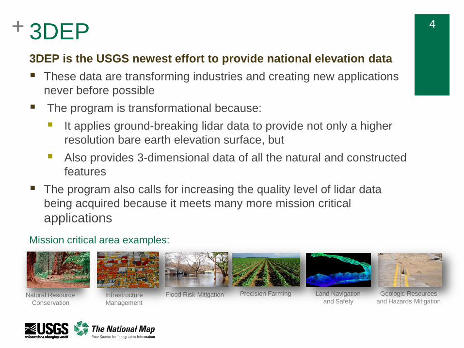
3DEP is the USGS newest effort to provide national elevation data
These data are transforming industries and creating new applications
never before possible
The program is transformational because:
It applies ground-breaking lidar data to provide not only a higher
resolution bare earth elevation surface, but
Also provides 3-dimensional data of all the natural and constructed
features
The program also calls for increasing the quality level of lidar data
being acquired because it meets many more mission critical
applications
Natural Resource
Conservation
Infrastructure
Management
Flood Risk Mitigation Precision Farming Land Navigation
and Safety
Geologic Resources
and Hazards Mitigation
Mission critical area examples:
3DEP
+ 5+ 5
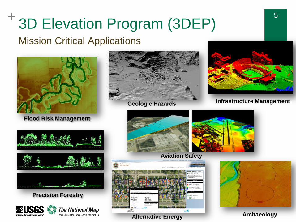
3D Elevation Program (3DEP)Mission Critical Applications
Infrastructure ManagementGeologic Hazards
Archaeology
Precision Forestry
Aviation Safety
Flood Risk Management
Alternative Energy

+ 6+ 63DEP
Quality Levels
Quality
LevelSource
Vertical
Accuracy
RMSEz
Aggregate
Nominal Pulse
Spacing
(ANPS) (m)
Aggregate
Nominal Pulse
Density (NPD)
(pls/m2)
DEM Cell Size
(minimum)
QL0 Lidar 5.0 cm ≤ 0.35 ≥ 8.0 0.5 m / 1 ft
QL1 Lidar 10 cm ≤ 0.35 ≥ 8.0 0.5 m / 1 ft
QL2 Lidar 10 cm ≤ 0.71 ≥ 2 1.0 m / 2 ft
QL3 Lidar 20 cm ≤ 1.41 ≥ 0.5 2.0 m / 5 ft
QL5 IfSAR 185 cm ≤ 5 ≥ 0.04 5 meters
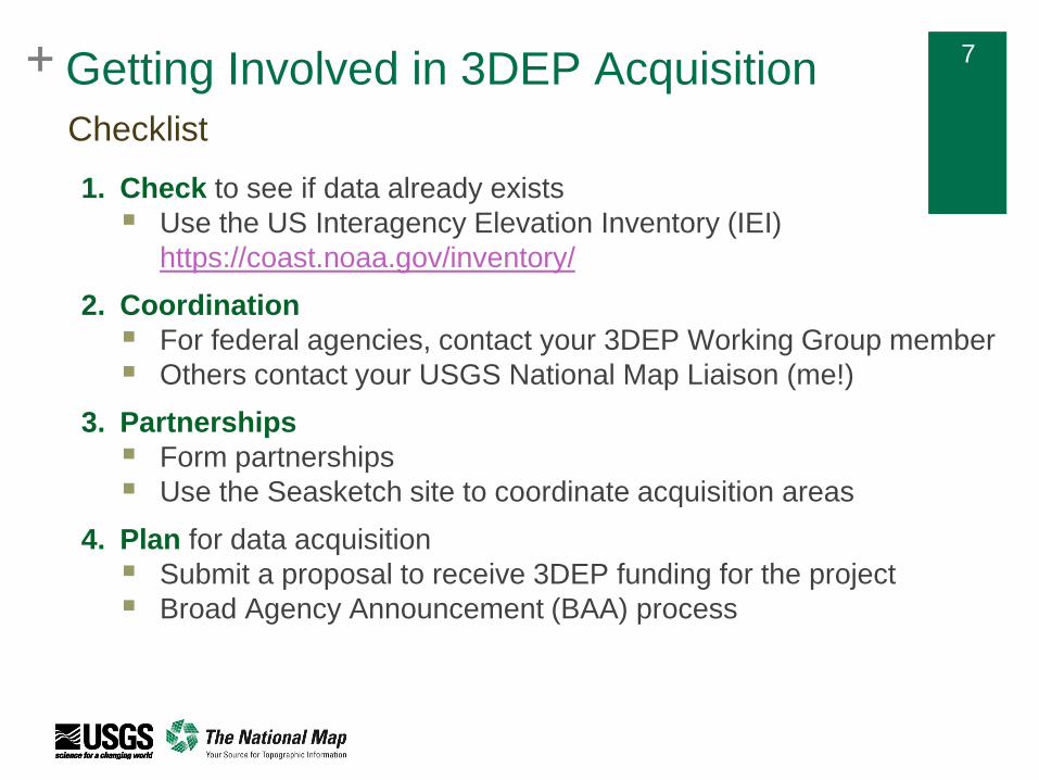
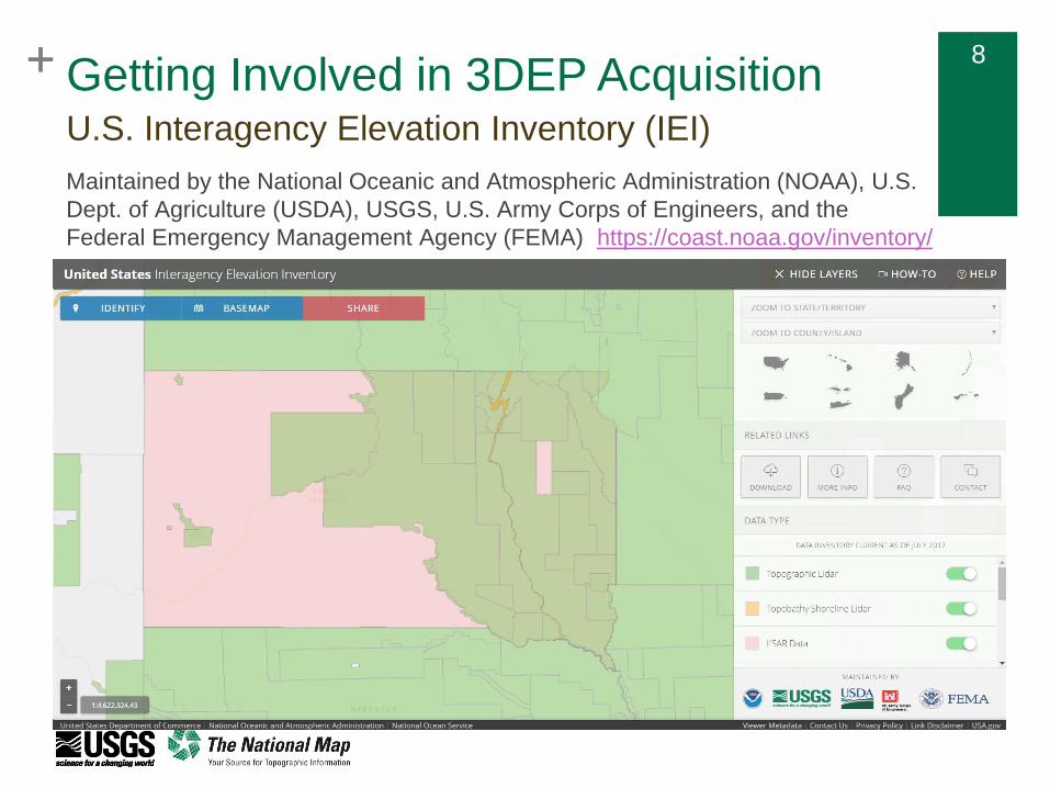
+ 7+ 7Getting Involved in 3DEP Acquisition
Checklist
1. Check to see if data already exists
Use the US Interagency Elevation Inventory (IEI)
https://coast.noaa.gov/inventory/
2. Coordination
For federal agencies, contact your 3DEP Working Group member
Others contact your USGS National Map Liaison (me!)
3. Partnerships
Form partnerships
Use the Seasketch site to coordinate acquisition areas
4. Plan for data acquisition
Submit a proposal to receive 3DEP funding for the project
Broad Agency Announcement (BAA) process
+ 8+ 8
U.S. Interagency Elevation Inventory (IEI)
Maintained by the National Oceanic and Atmospheric Administration (NOAA), U.S.
Dept. of Agriculture (USDA), USGS, U.S. Army Corps of Engineers, and the
Federal Emergency Management Agency (FEMA) https://coast.noaa.gov/inventory/
Getting Involved in 3DEP Acquisition
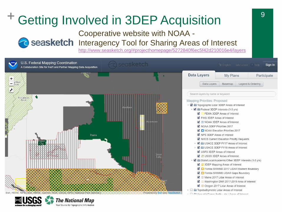
+ 9+ 9
Cooperative website with NOAA -
Interagency Tool for Sharing Areas of Interesthttp://www.seasketch.org/#projecthomepage/5272840f6ec5f42d210016e4/layers
Getting Involved in 3DEP Acquisition
+ 10+ 10
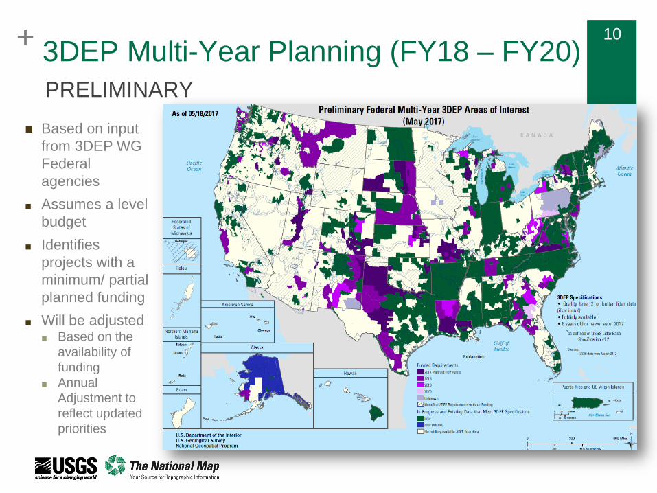
3DEP Multi-Year Planning (FY18 – FY20)
PRELIMINARY
Based on input
from 3DEP WG
Federal
agencies
■ Assumes a level
budget
■ Identifies
projects with a
minimum/ partial
planned funding
■ Will be adjusted ■ Based on the
availability of
funding
■ Annual
Adjustment to
reflect updated
priorities

+ 11+ 11
11
Target Release Date: August 15th
Initial Proposal Due Date: October 20th
Decisions November – January (based of availability of funding)
Public Webinars: August 10th at 12 PM CT & August 17th at 2 PM CT
Register for Webinars at
https://cms.geoplatform.gov/elevation/3DEP/PublicMeetings
More Info: http://nationalmap.gov/3DEP/
3DEP Broad Agency AnnouncementFY17 BAA (for FY18 Projects)
+ 12
Emerging Lidar Technologies
+ 13
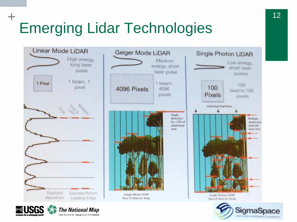
Emerging Lidar TechnologiesGeiger-mode Lidar (GML)
Creates a point cloud differently than linear lidar
Rather than a laser pulse, GML uses a photo diode array to flood an area with
infrared light
Each diode in the array is then sensitive enough to detect a single photon that was
reflected from the illuminated area and is registered as an elevation measurement.
GML does not create a point from a single elevation measurement.
Instead, array is mounted on a scanner which rotates at an angle to create a cone
shaped field of view
Result is that the ground field of view is a circle, not a line like a linear scanner. As the
scanner rotates the photo diode array flashes up to 50,000 times every second and
takes 4,096 measurements per flash, meaning 205 million elevation measurements
can be taken every second
Purpose of this ‘multiple look’ approach is to have a point on the ground be measured
thousands of times instead of just once, as is the case with a linear scanner
In theory this would allow the GML sensor to be flown higher and faster and still
acquire the desired pulse density (or equivalent) and same quality of data hence
lowering the cost Source: ‘Geiger Mode and Single Photon Lidar
Technology Evaluation,’ US Forest Service
Reimbursable Project Report; April 26, 2016
+ 14
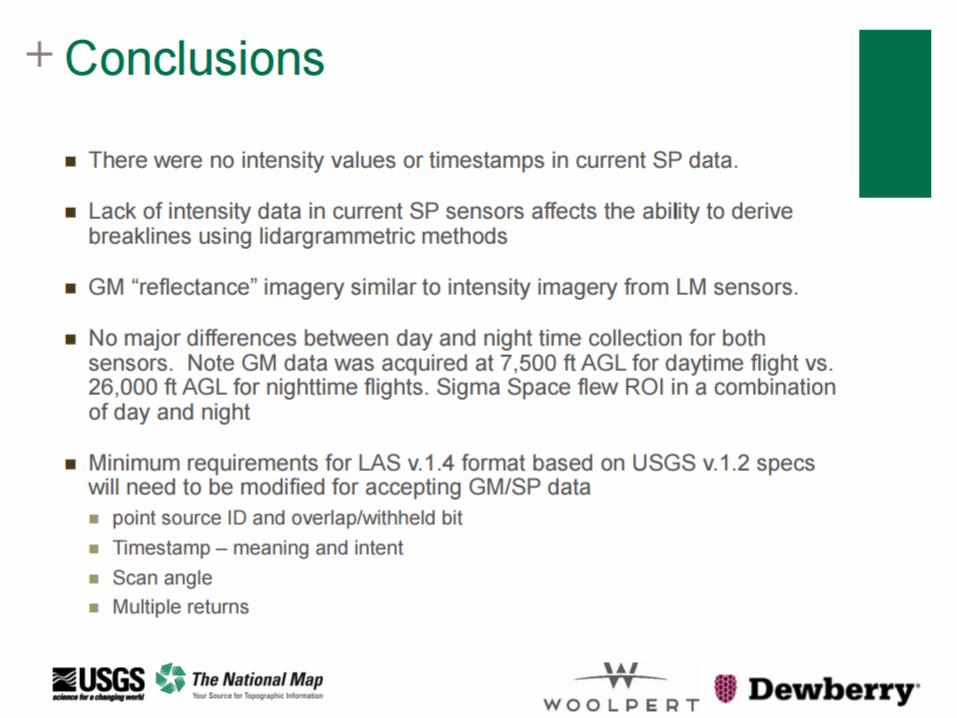
Emerging techs are not a 1:1 substitution
USGS goal is to have a seamless, consistent national 3D layer
that is used for multiple uses
Bare Earth
Structures (infrastructure)
Vegetation
Different instruments collect this information differently
Pulse/returns/intensity/scan angles/processing
THERE ARE TRADE OFFS!
Education is key to understanding the trade offs and acceptability
to the decision makers
Emerging Lidar Technologies
+ 15+ 15
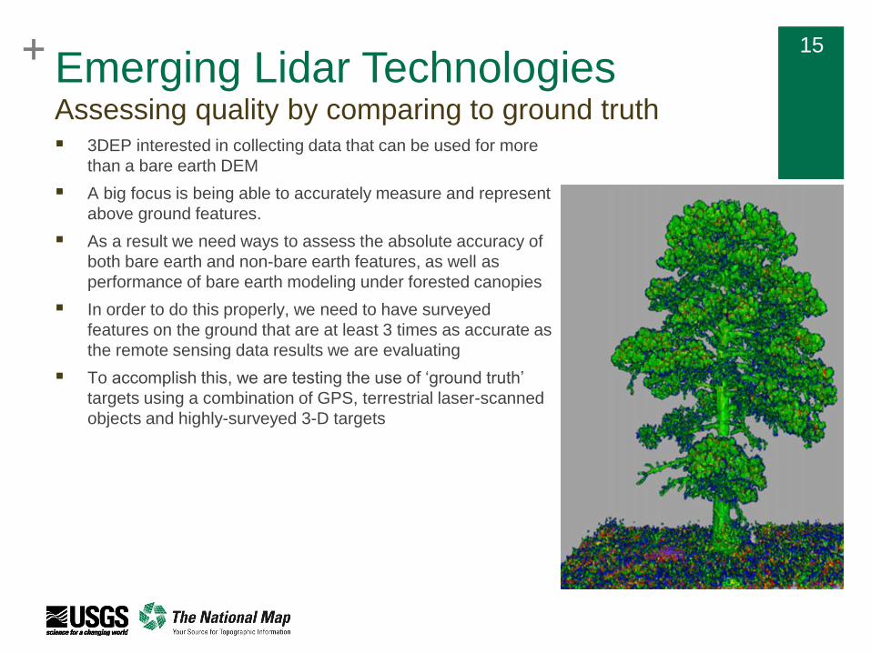
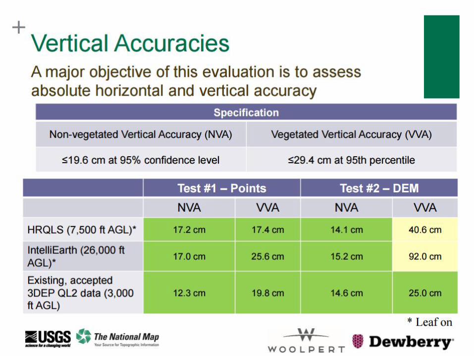
Assessing quality by comparing to ground truth 3DEP interested in collecting data that can be used for more
than a bare earth DEM
A big focus is being able to accurately measure and represent
above ground features.
As a result we need ways to assess the absolute accuracy of
both bare earth and non-bare earth features, as well as
performance of bare earth modeling under forested canopies
In order to do this properly, we need to have surveyed
features on the ground that are at least 3 times as accurate as
the remote sensing data results we are evaluating
To accomplish this, we are testing the use of ‘ground truth’
targets using a combination of GPS, terrestrial laser-scanned
objects and highly-surveyed 3-D targets
Emerging Lidar Technologies
+ 16
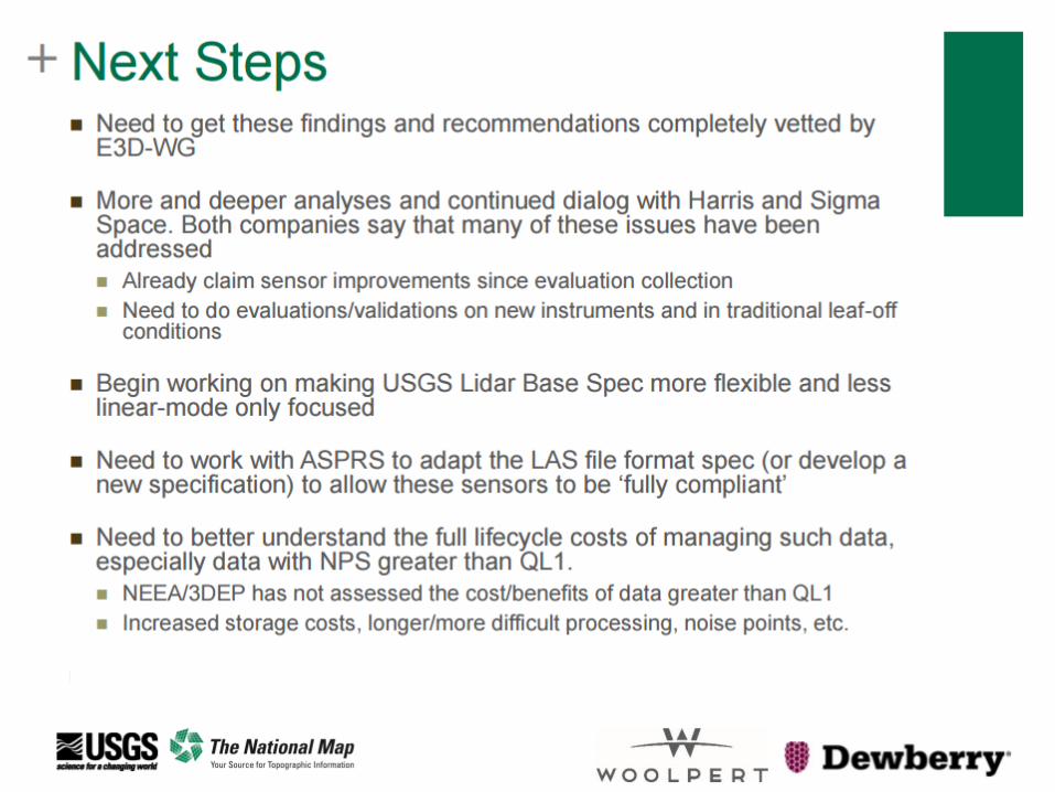
Path aheadFoster maturation of new technologies for 3DEP
Ongoing/additional review and testing of GM/SPL
Use the test projects to better understand how the data is processed through existing
workflows, review the data throughout the lifecycle
Check calibration between collections (i.e., point-to-plane comparison)
Collect terrestrial lidar data to evaluate accuracy of surfaces, in addition to single points
Assess costs associated with storage and hosting of higher density collections
For FY18, continue with limited investments in GM / SPC data acquisition
Set a total funding and/or total square mile investment
Allow for growth and incremental acceptance of the new technologies
Provide flexibility to continue to work with partners interested in Geiger/SPC
Develop repeatable procedures to assess new technologies against our requirements
2x3D measurements per square meter, vertically accurate to within 10 cm RMSE and
resolve both bare earth and non bare earth features
Other technologies to consider - SfM (structure from motion), topobathy sensors, multi-
wavelength lidar, waveform lidar, lidar from other kinematic platforms (UAS, mobile
mappers), imagery-derived elevation models
Continue to evolve the base specification to allow innovation while retaining standard,
consistent 3D data nationwide
+ 17
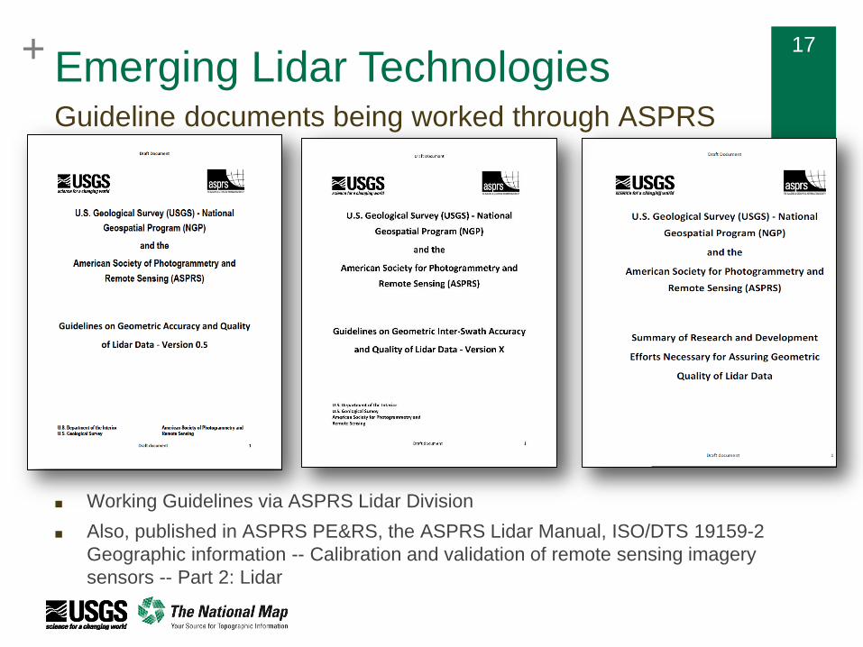
Guideline documents being worked through ASPRS
■ Working Guidelines via ASPRS Lidar Division
■ Also, published in ASPRS PE&RS, the ASPRS Lidar Manual, ISO/DTS 19159-2
Geographic information -- Calibration and validation of remote sensing imagery
sensors -- Part 2: Lidar
Emerging Lidar Technologies
+ 18
Emerging Lidar Test ProjectsFoster maturation of new technologies for 3DEP
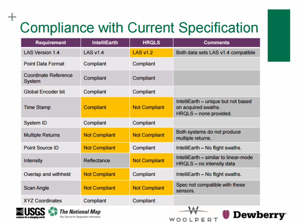
Resulting data will meet accuracies, but will not meet attributes of the current specification related to linear
mode lidar (for example multiple returns and time stamp); those specification attributes are being waived for
these test projects, and the data will be designated as provisional
Since we have not processed or distributed data from these sensors before, there is a higher level of
uncertainty across the lifecycle of the projects that is being communicated to stakeholders
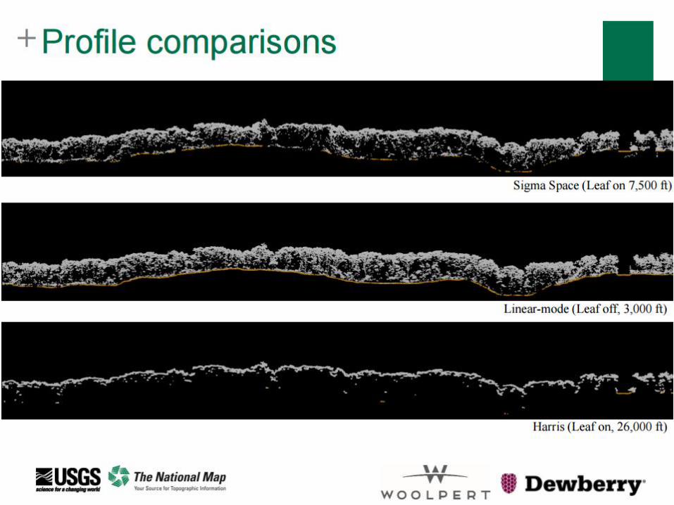
Published paper in the journal Remote Sensing special issue Airborne Laser Scanning on emerging
technologies: Stoker, J.M., Abdullah, Q. A., Nayegandhi, A., and Winehouse, J., 2016, "Evaluation of Single
Photon and Geiger Mode Lidar for the 3D Elevation Program,” Remote Sens. 2016, 8, 767.
* Adjustments to cost and other details may occur as projects mature
Location
Area
Square
Miles
Sensor
3DEP Investment
(USGS, FEMA,
NRCS)
State/Local
Investments
Total
Project
Cost
Status
Illinois 3,358 GM $336K $739K $1.1 MProject
extended
South
Dakota11,805
GM and
SPC$2.8M $0 $2.8 M In progress
North
Carolina4,200 GM $362K $805K $1.2 M
Sample data
received
+ 19
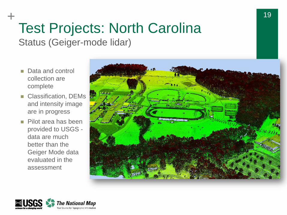
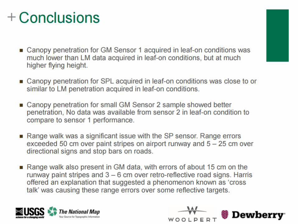
Test Projects: North CarolinaStatus (Geiger-mode lidar)
Data and control
collection are
complete
Classification, DEMs
and intensity image
are in progress
Pilot area has been
provided to USGS -
data are much
better than the
Geiger Mode data
evaluated in the
assessment
+ 20
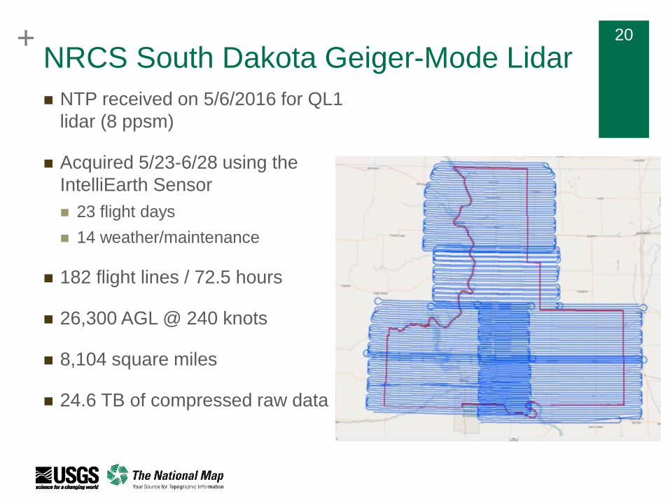
NRCS South Dakota Geiger-Mode Lidar
NTP received on 5/6/2016 for QL1
lidar (8 ppsm)
Acquired 5/23-6/28 using the
IntelliEarth Sensor
23 flight days
14 weather/maintenance
182 flight lines / 72.5 hours
26,300 AGL @ 240 knots
8,104 square miles
24.6 TB of compressed raw data
+ 21
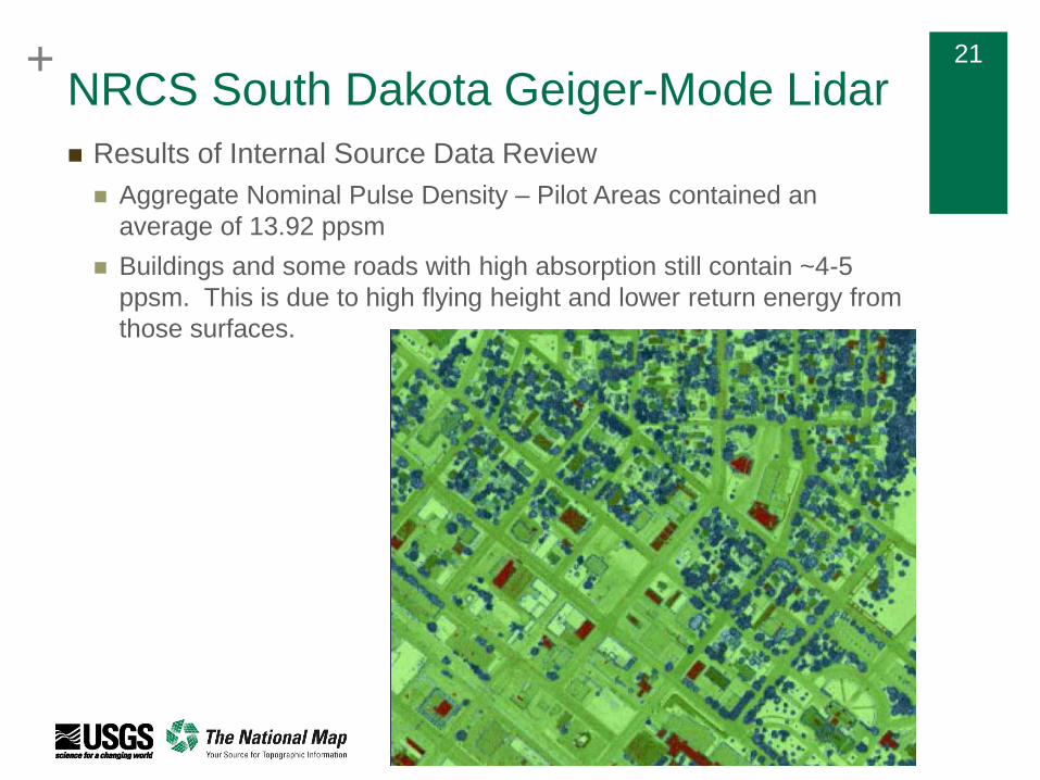
NRCS South Dakota Geiger-Mode Lidar
Results of Internal Source Data Review
Aggregate Nominal Pulse Density – Pilot Areas contained an
average of 13.92 ppsm
Buildings and some roads with high absorption still contain ~4-5
ppsm. This is due to high flying height and lower return energy from
those surfaces.

+ 22
NRCS South Dakota Geiger-Mode Lidar
Range “walk” on retro-reflective surfaces
+ 23
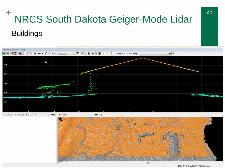
NRCS South Dakota Geiger-Mode Lidar
Buildings
+ 24
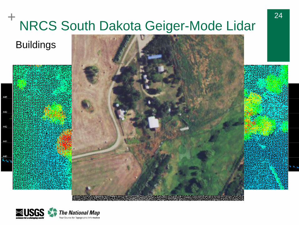
NRCS South Dakota Geiger-Mode Lidar
Buildings
+ 25+ 2525
+ 26+ 26
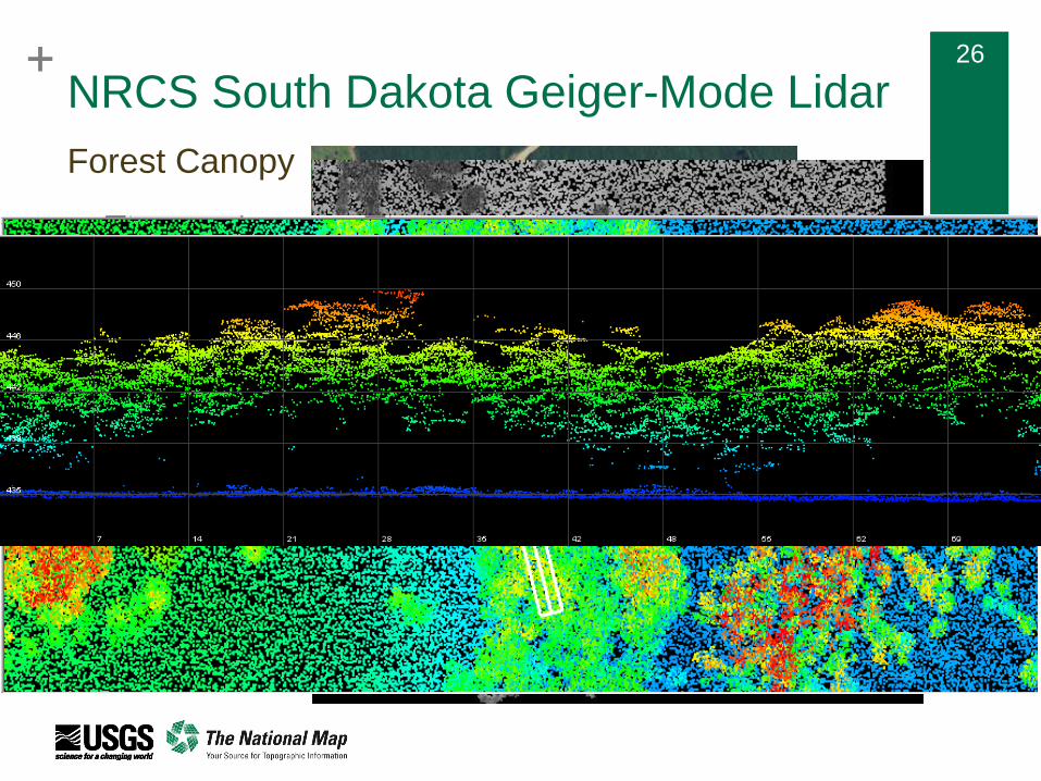
NRCS South Dakota Geiger-Mode Lidar
Forest Canopy
+ 27
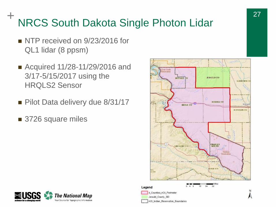
NRCS South Dakota Single Photon Lidar
NTP received on 9/23/2016 for
QL1 lidar (8 ppsm)
Acquired 11/28-11/29/2016 and
3/17-5/15/2017 using the
HRQLS2 Sensor
Pilot Data delivery due 8/31/17
3726 square miles
+ 28+ 28
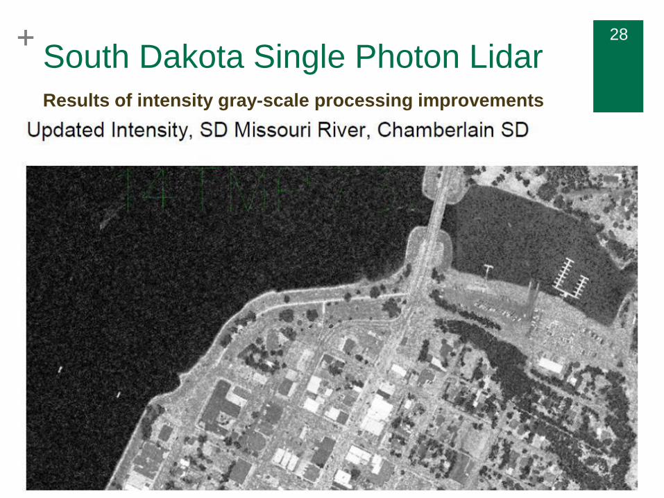
South Dakota Single Photon LidarResults of intensity gray-scale processing improvements
+ 29+ 2929
+ 30+ 3030
+ 32+ 3232
+ 33+ 3333
+ 34+ 3434