
New Grafton Correctional Centre Document No: JHG-NGCC-PLN ... · (BFMP). Biodiversity B18 The...
118
Page 1 of 38 Uncontrolled when Printed CONSTRUCTION FLORA AND FAUNA MANAGEMENT PLAN Rev Date Version Prepared by Reviewed by Approved by A 12/05/2017 Draft K Fels Paul Rossington, Lukas Clews Rachel Vazey B 25/05/2017 Draft Rachel Vazey Paul Rossington, Lukas Clews Rachel Vazey C 09/06/2017 Final Sarah Saunders Rachel Vazey Rachel Vazey 0 16/06/2017 Final Sarah Saunders Rachel Vazey Rachel Vazey 1 11/01/18 Final Sarah Saunders Trent Doyle Paul Cassel New Grafton Correctional Centre Document No: JHG-NGCC-PLN-FFMP-024
Transcript of New Grafton Correctional Centre Document No: JHG-NGCC-PLN ... · (BFMP). Biodiversity B18 The...

Page 1 of 38 Uncontrolled when Printed
CONSTRUCTION FLORA AND FAUNA
MANAGEMENT PLAN
Rev Date Version Prepared by Reviewed by Approved by
A 12/05/2017 Draft K Fels Paul Rossington, Lukas Clews
Rachel Vazey
B 25/05/2017 Draft Rachel Vazey Paul Rossington, Lukas Clews
Rachel Vazey
C 09/06/2017 Final Sarah Saunders Rachel Vazey Rachel Vazey
0 16/06/2017 Final Sarah Saunders Rachel Vazey Rachel Vazey
1 11/01/18 Final Sarah Saunders Trent Doyle Paul Cassel
New Grafton Correctional Centre
Document No: JHG-NGCC-PLN-FFMP-024

Page 2 of 38 Uncontrolled when Printed
CONTENTS
LIST OF ACRONYMS ............................................................................................................ 3
1. INTRODUCTION.............................................................................................................. 5
OBJECTIVES AND GOALS .................................................................................................... 5 INTERACTION WITH OTHER PLANS ........................................................................................ 6
2. LEGAL AND OTHER REQUIREMENTS ........................................................................ 7
3. FLORA AND FAUNA CONDITIONS OF APPROVAL ................................................... 8
4. EXISTING ENVIRONMENT ........................................................................................... 12
FLORA ............................................................................................................................. 12 WEEDS ............................................................................................................................ 13 FAUNA ............................................................................................................................. 16 AQUATIC FLORA AND FAUNA ............................................................................................. 18
5. ECOLOGICAL IMPACTS .............................................................................................. 18
6. ENVIRONMENTAL CONSTRAINTS MAPS (SEPS) .................................................... 21
7. MANAGEMENT AND MITIGATION MEASURES ........................................................ 22
APPENDIX 1 - CLEARING AND GRUBBING MANAGEMENT PLAN ..................................... 34
APPENDIX 2 - WEED AND PATHOGEN MANAGEMENT PLAN ............................................ 35
APPENDIX 3 – VEGETATION RETENTION PLAN .................................................................. 36
APPENDIX 4 - FAUNA RESCUE AND RELOCATION PROCEDURE ..................................... 37

Page 3 of 38 Uncontrolled when Printed
List of acronyms
ACHMP Aboriginal Cultural Heritage Management Plan
AMS Activity Method Statement
APZ Asset Protection Zone
BAR Biodiversity Assessment Report
BFMP Bushfire Management Plan
BOS Biodiversity Offset Strategy
CEMP Construction Environment Management Plan
CFFMP Construction Flora and Fauna Management Plan
Consent Conditions
NGCC Stage 1 and 2 Development Conditions of Consent
DECC Department of Environment and Climate Change
DEH Department of Environment and Heritage
DoEE Department of Environment and Energy
DPI Department of Primary Industries
ECP Environmental Control Plan
EEC Endangered Ecological Community
EIS Environmental Impact Statement
EPA Environmental Protection Authority
EPBC Act Commonwealth Environment Protection & Biodiversity Conservation Act 1999
FFMP Flora and Fauna Management Plan
IBRA Imterium Biogeographic Region of Australia
IECA International Erosion Control Association
IER Independent Environmental Representative
ISO International Standards Organisation
KTP Key Threatening Process
LGA Local Government Area
NSW New South Wales

Page 4 of 38 Uncontrolled when Printed
OEH Office of Environment and Heritage
PCT Plant Community Type
PER Principal Environmental Representative (John Holland)
REM Regional Environmental Manager
PM Project Manager
RFS Rural Fire Service
SEP Site Environmental Plan
SOP Standard Operating Procedure
SSD State Significant Development
TSC NSW Threatened Species Conservation Act 1995
WIRES Wildlife Information, Rescue and Education Services
WRA Workplace Risk Assessment
Page 5 of 38 Uncontrolled when Printed
1. Introduction
Jacobs has been engaged by John Holland Group (JHG) to prepare this Construction
Flora and Fauna Management Plan (CFFMP) for the New Grafton Correctional Centre
(NGCC) project. This CFFMP details the measures that will be used to minimise
disturbance to native vegetation and habitats during the construction phase of the
Project. In particular, this plan details the mitigation measures to be used to reduce the
potential impacts of the Project on flora, fauna and vegetation communities. The key
objectives of this plan are to ensure that impacts to flora and fauna are minimised and
are within the scope permitted by the Development Conditions of Consent.
This plan provides an overview of the legal and other requirements including the
Consent Conditions, describes the existing environment (including flora, fauna and
aquatic biodiversity), summarises the Project impacts, and identifies the proposed
mitigation and management measures of flora and fauna during the construction phase.
This plan includes specific instruction relating to clearing and grubbing, weeds and
pathogens, and landscape rehabilitation, which are detailed in the following appendices:
• Appendix 1: Clearing and Grubbing Management Plan - details the requirements and specification for clearing and grubbing of vegetation to minimise harm to flora and fauna throughout construction.
• Appendix 2: Weed and Pathogen Management Plan – includes mitigation measures to be implemented to avoid the introduction of weeds and pathogens; and suppress and control the spread of existing weeds.
• Appendix 3: Vegetation Retention Plan – details the construction and operation phase requirements for retention, rehabilitation and restoration of vegetation on the Project Site.
• Appendix 4 – Fauna Rescue and Relocation Procedure – details methods for the handling of fauna requiring movement or care on site.
Operation phase management will be detailed in the Operation Flora and Fauna Management Plan.
Objectives and Goals
The key objectives and goals for the management of flora and fauna on site are to ensure:
• No clearing outside approved clearing limits.
• Minimise indirect impacts to surrounding vegetation.
• Do not exceed the clearing limits of 13.7 ha of native vegetation for the Project as defined in the Biodiversity Assessment Report and the Biodiversity Offset Strategy.
• Minimise all impacts to the aquatic ecosystems.

Page 6 of 38 Uncontrolled when Printed
• Minimise injury/mortality to all fauna.
• Minimise all erosion and sedimentation during clearing operations.
• Minimise clearing for ancillary facilities. e.g. haul roads, stockpile areas, site compounds.
• Retention of fauna habitat connectivity throughout the Project Area.
• Fauna Habitats outside of approved work zone are not impacted by works.
Specific objectives relating to ecological restoration, clearing and grubbing and weed and pathogen management are with these relevant plans.
Interaction with other plans
There are interrelationships with other plans that provide associated information
relevant to environmental management of flora and fauna impacts, these include:
• Construction Environmental Management Plan (CEMP) - demonstrates systems and procedures to ensure that controls are established and maintained to manage potential environmental impacts during the construction of the Project. It details the responsibilities of the Project team relating to environmental management, and all other requirements under the Environmental Management System framework under ISO 14001 including system review, audits and inspections and communication.
• Biodiversity Offset Strategy (BOS) - Developed to meet the requirements of the Consent Condition, B18. This report details the methods to guarantee long-term protection and management of biobank sites to offset impacts to the ecological communities and habitat for threatened species.
• Soil and Water Management Plan – includes mitigation measures to minimise erosion and sedimentation.
• The Aboriginal Cultural Heritage Management Plan (ACHMP).
• The health risk assessment that identifies the measures to be implemented to ameliorate the impact of biting insects and to minimise breeding areas on the site.
• Bush Fire Management Plan (BFMP).
• Traffic Management Plan.

Page 7 of 38 Uncontrolled when Printed
2. Legal and Other Requirements
1.1 References
Federal Legislation State legislation Local Government Laws
Standards / Codes Other Documentation
Environmental Protection & Biodiversity Conservation Act 1999
– Protection of the Environment and Operations Act 1997.
– Environmental Planning and Assessment Act, 1979.
– Threatened Species Conservation Act 1995.
– National parks and Wildlife Act 1974.
– Native Vegetation Act 2003.
– Fisheries Management Act 1994.
– Noxious Weed Act 1993 no.11.
NA Best Practise Erosion & Sediment Control, International Erosion Control Association (IECA) (2008).
Hygiene protocol for the control of diseases in frogs (DECC, 2008).
Commonwealth threat abatement plan for the infection of amphibians with chytrid fungus (DEH, 2006).
Commonwealth threat abatement plan for dieback caused by the root-rot fungus phytophthora cinnamomi (Environment Australia 2002).
Statement of intent: Infection of native plants by Phytophthora cinnamomi.
Introduction and establishment of Exotic Rust Fungi of the order Uredinales pathogenic on plants of the family Myrtaceae - Proposed Key Threatening Process Listing (DECC).
AS 4373—2007; Australian Standard - Pruning of amenity trees.
AS 4970—2009; Australian Standard - Protection of trees on development sites.
Construction Environmental Management Plan.
Development Consent SSD 7413
Jacobs, Biodiversity Assessment Report, March 2017.
Jacobs, Biodiversity Offset Stragey, March 2017.
JH specifications / SOPs / standards.

Page 8 of 38 Uncontrolled when Printed
3. Flora and Fauna Conditions of Approval
Approval Ref Approval requirement Project Phase
FFMP section/s in which issue is addressed
CEMP section/s in which issue is also addressed
Landscaping
B16
The development application for Stage 2 must include detailed plans identifying the species to be used in the site buffer and other landscape areas (preferably species indigenous to the area).
Pre-construction
A detailed plan of vegetation rehabilitation zones, proposed vegetation structure and plant species is provided in Appendix 3.
Vegetation Restoration Plan – Appendix 3.
Bushfire Protection
B17
The development application for Stage 2 must demonstrate that bushfire protection measures, comply with the relevant provisions of Planning for Bushfire Protection 2006 and the requirements of RFS in relation, but not limited, to:
• Asset Protection Zones (APZ).
• Fire-fighting vehicles access roads.
• Fire-fighting water supply.
Pre-construction
Bushfire Protection requirements were considered in the identification of appropriate vegetation restoration zones (refer Appendix 3 for zones).
Bush Fire Management Plan (BFMP).
Biodiversity
B18
The development application for Stage 2 must demonstrate that the proposal is consistent with the endorsed BAR and BOS.
Pre-clearing All sections of this plan.
All management measures of relevance to the construction phase of the Project contained in the endorsed BAR have been replicated and built upon in this CFFMP.
Vegetation Restoration Plan -Appendix 3.
Schedule 3 –Conditions of Consent for Stage 1 Works
Part A: Administrative conditions

Page 9 of 38 Uncontrolled when Printed
Approval Ref Approval requirement Project Phase
FFMP section/s in which issue is addressed
CEMP section/s in which issue is also addressed
Obligation to Minimise Harm to the Environment
A11
In addition to meeting the specific performance criteria established under this approval, the Applicant must implement all reasonable and feasible measures to prevent and/or minimise any harm to the environment from the construction or operation of the development.
Pre-clearing
Construction
All sections of this plan.
All management measures of relevance to impact minimisation that are contained in the endorsed BAR have been replicated and built upon in this CFFMP.
Clearing and Grubbing Plan – Appendix 1.
Weed and Pathogen Management Plan – Appendix 2.
Vegetation Restoration Plan -Appendix 3.
Schedule 3 –Conditions of Consent for Stage 1 Works
Part B: Prior to the commencement of works
Vegetation Retention Plan
B9
A vegetation retention plan must be prepared by a suitable qualified consultant, which must:
a) identify and provide details of the retention of any tress (particularly hollow bearing) and groundcover
b) provides details on the maintenance and improvement of retained or planted vegetation, particularly within the buffer areas; and
c) be reviewed by a suitably qualified bushfire consultant and include certification that any APZ meets the relevant standards.
Pre-clearing Refer Appendix 3.
A Vegetation Restoration Plan has been prepared for the construction phase and operation phases of the Project, refer to Appendix 3.

Page 10 of 38 Uncontrolled when Printed
Approval Ref Approval requirement Project Phase
FFMP section/s in which issue is addressed
CEMP section/s in which issue is also addressed
Flora and Fauna Management
B29
A Flora and Fauna Management Plan (FFMP), prepared by a suitably qualified person, must be submitted to and approved by the Certifying Authority. The FFMP must address, but not be limited to, the following matters:
a) Minimising the risk, introduction and spread of invasive species and diseases;
Pre-clearing Appendix 1 - Weed and Pathogen Plan, and
Section 10 Management and Mitigation Measures.
N/A
b) Traffic management procedures (including signage, speed limits and help information for incidents) in regard to the protection of the Koala and Rufous Bettong;
Section 7.
Traffic Management Plan
c) Fauna protection/relocation procedures for displaced wildlife, identifying potential release sites and timing protocols; and
Appendix 4, and
Section 10 Management and Mitigation Measures.
N/A
d) Identifying suitable receiving sites for displaced aquatic/amphibian fauna
Appendix 4, and
Section 10 Management and Mitigation Measures.
N/A
B30 The Applicant must submit a copy of the approved FFMP to the Department and Council prior to the commencement of works.
Pre-clearing N/A N/A
Schedule 3 –Conditions of Consent for Stage 2 Works
Part B: Prior to the commencement of works

Page 11 of 38 Uncontrolled when Printed
Approval Ref Approval requirement Project Phase
FFMP section/s in which issue is addressed
CEMP section/s in which issue is also addressed
Flora and Fauna Management
B35
A Flora and Fauna Management Plan (FFMP), prepared by a suitably qualified person, must be submitted to and approved by the Certifying Authority. The FFMP must address, but not be limited to, the following matters:
e) Minimising the risk, introduction and spread of invasive species and diseases;
Pre-clearing Appendix 1 - Weed and Pathogen Plan, and
Section 10 Management and Mitigation Measures.
N/A
f) Traffic management procedures (including signage, speed limits and help information for incidents) in regard to the protection of the Koala and Rufous Bettong;
Section 7.
Traffic Management Plan
g) Fauna protection/relocation procedures for displaced wildlife, identifying potential release sites and timing protocols; and
Appendix 4, and
Section 10 Management and Mitigation Measures.
N/A
h) Identifying suitable receiving sites for displaced aquatic/amphibian fauna
Appendix 4, and
Section 10 Management and Mitigation Measures.
N/A

Page 12 of 38 Uncontrolled when Printed
4. Existing Environment
The site covers an area of approximately 195 ha and is located approximately 12.5 km
southeast of Grafton, within the Clarence Valley Local Government Area (LGA). The
broader area (within which the site is located) has been extensively cleared and
converted to grazing land, sugar cane plantations and rural residential properties with
highly modified drainage and water control structures.
Flora
Scattered small patches of remnant vegetation are present on site, contiguous with
similar vegetation to the west and south. Remnant vegetation patches on the western
boundary are part of a large patch of native vegetation patch that extends to the south
and west outside the property boundary.
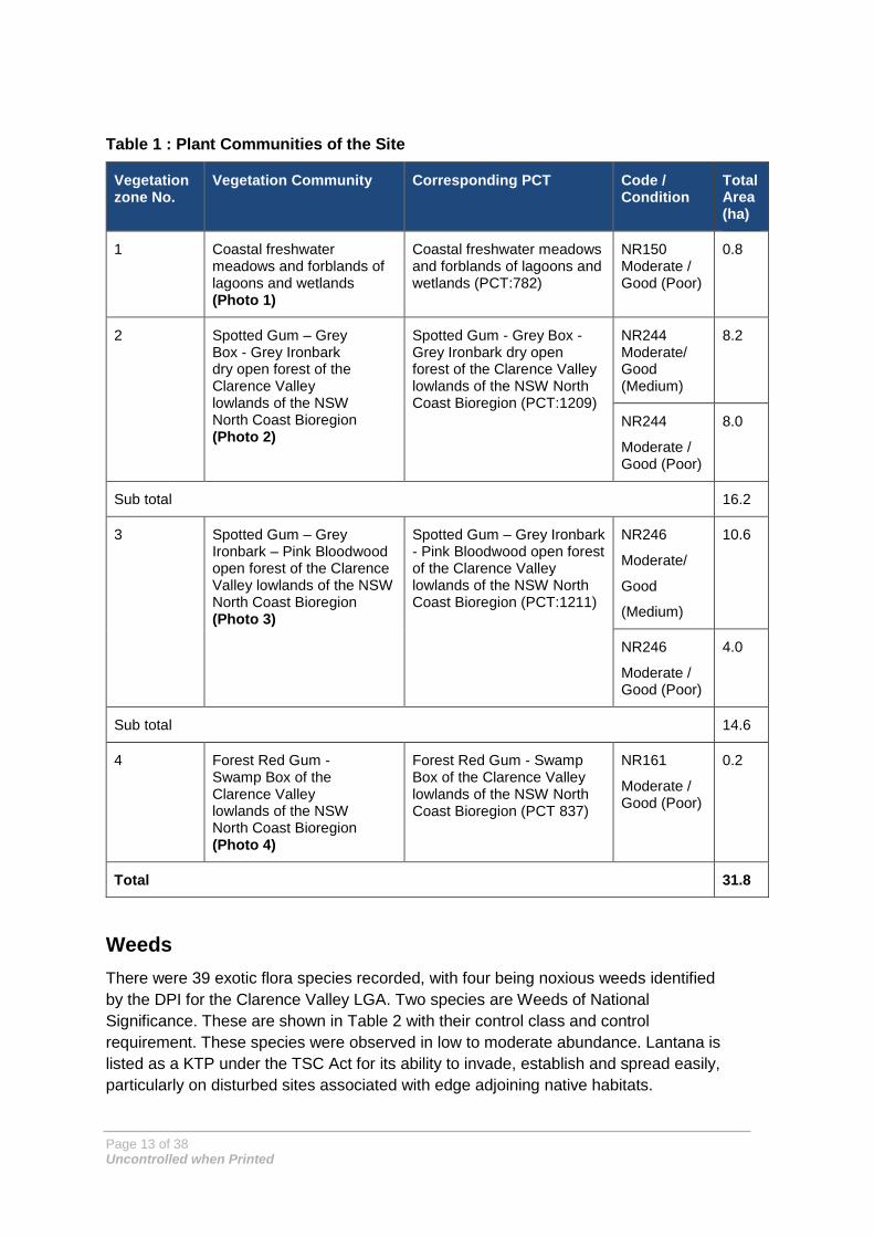
The biodiversity survey (Jacobs, 2016), identified the presence of four Plant Community
Types (PCTs) covering 31.8 ha (see Table 1) within the two lot and DPs that comprise
the Project Site as defined in the Stage DA. The native vegetation is located within and
adjacent to 163.2 ha of cleared grazing land (a grassland habitat of mixed exotic and
common native species). The native vegetation communities were in moderate to good
(medium) to moderate to good (poor) condition (i.e. all native communities present have
been modified) (Jacobs, 2017). Figure 1 shows the distribution of PCTs on the site.
One PCT Forest Red Gum - Swamp Box of the Clarence Valley lowlands of the NSW
North Coast Bioregion (PCT 837) is part of the Subtropical Coastal Floodplain Forest of
the New South Wales North Coast Bioregion endangered ecological community as
listed under the Threatened Species Conservation Act 1995 (TSC Act). The lagoons /
wetlands are not consistent with the EEC listing under the (TSC Act) as they are
artificially constructed dams and do not occur on the Coastal floodplain.
Based on habitats occurring within the Project area, 11 threatened flora species were
considered moderately likely to occur within the Project area and were targeted during
flora surveys (BAR, pp 38, Jacobs 2017). No threatened flora species were detected
during the survey on site; however one species, Weeping Paperbark Melaleuca irbyana
(Endangered, TSC Act), was recorded on property immediately adjacent the eastern
site boundary (along Avenue Road).
Page 13 of 38 Uncontrolled when Printed
Table 1 : Plant Communities of the Site
Vegetation zone No.
Vegetation Community Corresponding PCT Code / Condition
Total Area (ha)
1 Coastal freshwater meadows and forblands of lagoons and wetlands (Photo 1)
Coastal freshwater meadows and forblands of lagoons and wetlands (PCT:782)
NR150 Moderate / Good (Poor)
0.8
2 Spotted Gum – Grey Box - Grey Ironbark dry open forest of the Clarence Valley lowlands of the NSW North Coast Bioregion (Photo 2)
Spotted Gum - Grey Box - Grey Ironbark dry open forest of the Clarence Valley lowlands of the NSW North Coast Bioregion (PCT:1209)
NR244 Moderate/ Good (Medium)
8.2
NR244
Moderate / Good (Poor)
8.0
Sub total 16.2
3 Spotted Gum – Grey Ironbark – Pink Bloodwood open forest of the Clarence Valley lowlands of the NSW North Coast Bioregion (Photo 3)
Spotted Gum – Grey Ironbark - Pink Bloodwood open forest of the Clarence Valley lowlands of the NSW North Coast Bioregion (PCT:1211)
NR246
Moderate/
Good
(Medium)
10.6
NR246
Moderate / Good (Poor)
4.0
Sub total 14.6
4 Forest Red Gum - Swamp Box of the Clarence Valley lowlands of the NSW North Coast Bioregion (Photo 4)
Forest Red Gum - Swamp Box of the Clarence Valley lowlands of the NSW North Coast Bioregion (PCT 837)
NR161
Moderate / Good (Poor)
0.2
Total 31.8
Weeds
There were 39 exotic flora species recorded, with four being noxious weeds identified
by the DPI for the Clarence Valley LGA. Two species are Weeds of National
Significance. These are shown in Table 2 with their control class and control
requirement. These species were observed in low to moderate abundance. Lantana is
listed as a KTP under the TSC Act for its ability to invade, establish and spread easily,
particularly on disturbed sites associated with edge adjoining native habitats.

Page 14 of 38 Uncontrolled when Printed
Table 2 : Noxious weed recorded at the Site
Species Class Control requirement Weed of
National
Significance
Annual ragweed
(Ambrosia
artemisiifolia)
5 Restricted Plant
The requirements in the NW Act for a notifiable
weed must be complied with. Low abundance.
No
Groundsel bush
(Baccharis halimifolia)
3 Regionally Controlled Weed
The plant must be fully and continuously
suppressed and destroyed. Low abundance.
No
Lantana
(Lantana camara)
4 Locally Controlled Weed
The growth of the plant must be managed in a
manner that continuously inhibits the ability of
the plant to spread. Low abundance in the west
of the site.
Yes
Fireweed
(Senecio
madagascariensis)
4 Locally Controlled Weed
The plant must not be sold, propagated or
knowingly distributed. Moderate abundance and
widespread.
Yes

Page 15 of 38 Uncontrolled when Printed
Figure 1 : Vegetation Zones and PCTs (from Jacobs, 2016)

Page 16 of 38 Uncontrolled when Printed
Fauna
The Project Site, is zoned RU2 – Rural Landscape under the Clarence Valley Local Environmental Plan 2011, has been subject to extensive clearance and degradation of understorey layers from historic grazing. Remnant native habitat is fragmented on site, but is concentrated on the western boundary. The vegetation on the western boundary links into identified Dry Climate Change Corridors connecting through to regional fauna corridors and the Glenugie State Forest.
The fauna survey recorded 83 species, a relatively high fauna species richness despite the small area of forested habitat on site (Jacobs 2017). Of the 83 species, there were 8 amphibians, 6 reptiles, 9 terrestrial mammals, 4 bats, 55 bird species and 1 fish. An additional nine bats were detected but could not be positively identified. The high diversity of fauna is a result of the size and condition of contiguous habitats off the site.
Nine (9) species recorded are listed are listed as threatened under the TSC Act and/or the EPBC Act; 3 mammals (including 2 bats) and 6 bird species:
• Grey-headed Flying Fox (Pteropus poliocephalus) – vulnerable under the TSC
Act and EPBC Act.
• Little Bentwing Bat (Miniopterus australis) – vulnerable under TSC Act.
• Rufous Bettong (Aepyprymnus rufescens) – vulnerable under TSC Act.
• Little Lorikeet (Glossopsitta pusilla) – vulnerable under TSC Act.
• Grey-crowned Babbler (eastern subspecies, Pomatostomus temporalis
temporalis) – vulnerable under TSC Act.
• Brolga (Grus rubicunda) – vulnerable under TSC Act.
• Glossy Black-Cockatoo (Calyptorhynchus lathami) – vulnerable under TSC Act.
• Brown treecreeper (Climacteris picumnus) – vulnerable under TSC Act.
• Black-necked Stork (Ephippiorhynchus asiaticus) – vulnerable under TSC Act.
In addition, two migratory bird species (as under the EPBC Act) were recorded:
• Rainbow Bee-eater (Merops ornatus).
• Satin Flycatcher (Myiagra cyanoleuca).
See Figure 2 below for the threatened fauna recorded in the Project site.

Page 17 of 38 Uncontrolled when Printed
Figure 2 : Threatened fauna records and habitat features of the Project site (from Jacobs 2016)

Page 18 of 38 Uncontrolled when Printed
The site is also likely to provide suitable foraging and / or breeding and sheltering habitat for additional threatened fauna species as described in the BAR (Jacobs 2017). A number of eucalypt tree species on the site are important nectar food resources for threatened fauna such as the Little Lorikeet (Glossopsitta pusilla), Swift Parrot (Lathamus discolor), Black-chinned Honeyeater (Melithreptus gularis gularis) and Yellow-bellied Glider (Petaurus australis). Although modified, the open grasslands of the site will provide important habitat for nesting and foraging Rufous Bettong and are highly likely to be used by Coastal Emu (Dromaius novaehollandiae). While there were no Koalas (Phascolarctos cinereus) reported on the site and no evidence observed of Koalas using these habitats, there are several older records within the locality and potential habitat based on present food tree proportions.
Aquatic Flora and Fauna
Minor tributaries of the Coldstream River are present as drainage lines located at the
western boundary and are in poor condition with a low potential for impacts from the
Project. Wetlands are limited on the Project Site to four artificially constructed farm
dams in poor condition with limited macrophyte cover and moderate levels of stock
pugging.
Aquatic and amphibious fauna recorded on site during the survey included:
• Plague Minnow (Gambusia holbrooki), a significant predator of native fish and a
key threatening process under the TSC Act.
• Brown-striped Frog (Limnodynastes peronii).
• Spotted Grass Frog (Limnodynastes tasmaniensis).
• Eastern Sign-bearing Froglet (Crinia parinsignifera).
• Common Eastern Froglet (Crinia signifera).
• Green Tree Frog (Litoria caerulea).
• Bleating Tree Frog (Litoria dentata).
• Eastern Dwarf Tree Frog (Litoria fallax).
• Rocket Frog (Litoria nasuta, protected).
The degraded aquatic habitats present may add to refuge habitat present in the broader
region for threatened wetland bird species such as Magpie Goose, Black-neck Stork
(recorded on site) and Brolga (recorded on site). The dams may also provide foraging
areas for insectivorous micro-bats.
5. Ecological Impacts
The Project would not clear more than 13.7 hectares of native vegetation identified as
plant community types (PCTs) requiring offset under the Framework for Biodiversity
Assessment (Office of Environment and Heritage 2014a), refer to Figure 3 and as
defined in the BAR and the BOS compelted for the Project. The breakdown of native
vegetation clearing to occur is as follows:

Page 19 of 38 Uncontrolled when Printed
• Coastal freshwater meadows and forblands of lagoons and wetlands (PCT 782)
– 0.8 ha.
• Spotted Gum - Grey Box - Grey Ironbark dry open forest of the Clarence Valley
lowlands of the NSW North Coast Bioregion (PCT 1209) – 8.3 ha.
• Spotted Gum - Grey Ironbark – Pink Bloodwood open forest of the Clarence
Valley lowlands of the NSW North Coast Bioregion (PCT 1211) – 4.6 ha.
Proposed perimiter landscaping and rehabilitation of retained habitats will further
improve the functionality and linkage of habitats on site (refer Vegetation Restoration
Plan, see Appendix 3).
No significant impacts to important waterways, wetlands and / or key fish habitats are
expected. There is a small potential for construction works to increase sedimentation
and erosion along drainage lines which has been considered for mitigation.

Page 20 of 38 Uncontrolled when Printed
Figure 3 : Clearing footprint

Page 21 of 38 Uncontrolled when Printed
6. Environmental Constraints Maps (SEPs)
John Holland brands its Environmental Constraint Maps as Site Environmental Plans (SEPs). These maps show the location of the environmentally sensitive areas to be protected, and detail environmental controls to be installed prior to the commencement of works and during construction works. They also include operational controls relevant to the areas of works covered by the SEP (e.g. working hours, discharge protocols and limits, etc.).
The John Holland Project Environmental Representative (PER) in consultation with all relevant personnel shall first establish the scope of the activities being considered to enable the ‘boundaries’ of SEPs to be established. The SEP shall be compiled taking into consideration the environmental ‘Aspects and Impacts’ as identified in the Activity Method Statements. Activity Method Statements are explained in Section 1.3 of the CEMP. The SEP must also include controls and mitigation measures outlined in the CEMP sub plans relevant to the planned Project activities described in the Activity Method Statement (AMS).
For the input of ecological constraints in the SEP the PER must consult with the Project ecologist. The information from the ecological surveys during the Environmental Assessment in 2016 by Jacobs is to provide the base for these maps. The additions from the Project ecologist will include any significant finds during the pre-clearing surveys. These should include but are not limited to:
• Additional habitat trees (hollow bearing, stags, nest trees).
• Previously unrecorded threatened fauna species or species habitat.
• Previously unrecorded threatened flora species or species habitat.
The Site Environmental Plans (SEP’s) will be developed prior to work’s taking place in any area. The SEPs for the clearing activities will be developed after the ecologist’s pre clearing surveys and will include any identified ecological constraints detailed above. Other key information that will be detailed in all SEPs will include:
• Location of waterways, floodway’s and drainage lines.
• Areas of weed infestation.
• Sensitive Community receivers (identified along the Project route).
• Approved clearing boundaries (formation and ancillary).
• Project Approval boundary.
• Details and locations of all environmental field controls except erosion and sediment
controls (these will be covered in the ESCPs).
• Demarcation measures in the field.
• Locations of stockpiles, chemical storage areas, spill kits, concrete washouts.
• Threatened flora and fauna Species as well as any identified habitat.
The SEPs are to be reviewed and updated after each work activity is completed, e.g. clearing works. Also they are to be updated for any required change of control measures during activities. Since they are also used as information maps, any feature location changes must also be added to a new revision to SEP. For example, this could include the Project boundary or clearing boundary change or the location of a new fauna fence or chemical storage area.

Page 22 of 38 Uncontrolled when Printed
7. Management and Mitigation Measures
This Flora and Fauna Management Plan provides detailed management measures to be implemented on the Project to ensure compliance with the Project Conditions of Approval. The management and mitigation measures are detailed below in Table 3.
Table 3 : Proposed management and mitigation measures
Management of Flora and Fauna Potential Impacts
Actions
Reference No.
Actions Required Staff Responsible When
Pre Clearing
1. All personnel taking part in construction activities shall be instructed through the site specific induction or toolbox process with regards to the importance of clearing limits and retention of remnant/individual trees of significant value. The induction or toolbox talk will cover details on:
• Potential and actual significant flora and fauna species within the Project area, including Commonwealth and State listed threatened species.
• Clearing procedure and boundary marking.
• Habitat trees and the two stage clearing process.
• Procedure for encountering native fauna onsite including injured fauna.
• Potential impacts to threatened nocturnal fauna when travelling to or working at the Project Site during dusk to dawn hours (particularly during winter) and where possible to minimise light and noise impacts to fauna.
• Key contacts in case of environmental emergency.
• Reporting of environmental incidents involving fauna.
• Potential and actual weed species that occur within the Project area.
• Other pests that occur within the Project area and the management of these; includes fauna, flora and pathogens.
PER Prior to clearing

Page 23 of 38 Uncontrolled when Printed
Management of Flora and Fauna Potential Impacts
Actions
Reference No.
Actions Required Staff Responsible When
2. An Activity Method Statement (AMS) will be developed for the clearing operations to assess all risks to flora and fauna and the appropriate control measures. This is to be developed with the clearing sub-contractors.
PM/PER/Engineers/ Foreman
Prior to clearing
3. Restrict clearing of native vegetation to the minimum area necessary for construction (not exceed 13.7 hectares of native vegetation for the Project as defined in Figure 3). Clearance will be staged with each stage of the Project as required so that vegetation will be retained as a buffer area until future stages commence.
Locate temporary infrastructure (plant sites and construction offices, access tracks etc.) in cleared areas away from vegetation to minimise vegetation removal. Locate and upgrade any access tracks in a manner which minimises the removal of mature trees, hollow-bearing trees and dead trees.
All sediment and erosion controls are to be in place (where possible, also utilising existing degraded farm dams as temporary sediment detention basins to minimise additional potential clearance). Refer Soil and Water Management Plan
Designers/PM/PER Prior to clearing
4. Accurately and clearly mark out the limits of clearing (where appropriate) and the trees/vegetation to be retained outside of the construction footprint and / or used for post landscaping by fencing. The fencing marking the clearing boundaries is to remain in place for the entirety of the construction Project.
Regular inspections to be undertaken by the Principal and relevant personnel to ensure all retained vegetation/fauna habitat is clearly marked and that fencing is in place (where appropriate), and immediately prior to clearing events.
PM/PER/Engineers/ Foreman
Prior to clearing
5. The clearing limits will cover formation works and all ancillary facilities.
PM/PER/Engineers/ Foreman
Prior to clearing

Page 24 of 38 Uncontrolled when Printed
Management of Flora and Fauna Potential Impacts
Actions
Reference No.
Actions Required Staff Responsible When
6. A suitably qualified fauna ecologist will undertake a pre-clearing inspection to identify and physically mark hollow-bearing trees and dead standing trees (stags), and any large bird nests or fauna habitat structures within the clearing areas which may need temporary protection until fauna have left the structure or been relocated. The pre-clearing survey should also conduct a search for any koalas which may be present on the site.
The survey must be undertaken with sufficient time to develop the environmental constraints map for the area proposed for clearing. The pre clearing survey is to occur after the clearing limits for the particular area to be cleared have been demarcated in the field. Follow-up inspections on the day of clearing when walking over the site with the clearing contractor and PER and during clearing will confirm that the sites subject to pre-clearance surveys remain free of fauna.
Suitable receiving sites for displaced fauna (including aquatic/amphibian fauna) will be identified at this stage and marked on maps to show where the relocation site is located.
PER / ecologist Prior to clearing
7. Prior to the clearing any hollow-bearing trees, install nest boxes to provide replacement hollows for displaced fauna.
PER / ecologist Prior to clearing
8. Site Environmental Plans (SEPs) detailing all sensitive areas including habitat trees, weed management areas etc. and the associated environmental controls will be progressively developed as work commences on site.
Sensitive Areas (No Go zones) are to be demarcated with a different colour bunting which is to remain through construction and site restoration, and also mapped on the SEPs.
Construction works will not commence until the SEPs have been approved for each respective portion of the site.
PER Prior to clearing

Page 25 of 38 Uncontrolled when Printed
Management of Flora and Fauna Potential Impacts
Actions
Reference No.
Actions Required Staff Responsible When
9. All noxious weeds which are cleared as part of the Project will be disposed of appropriately. The noxious weeds inside the clearing limits are to be controlled prior to clearing activities in accordance with the Noxious Weeds Act 1993. Refer the Weed and Pathogen Plan for further detail.
PER Prior to construction
10. Hollow bearing trees with active European bee hives should be identified during the pre-clearing survey. These trees should be felled with other hollow bearing trees accordance with the two stage clearing process outlined in the clearing and grubbing management plan. Once on the ground bee hives should be destroyed by spraying with an appropriate insecticide, and hollows re-instated as fallen timber in rehabilitation zones.
PER / ecologist
Prior to clearing
11. Any dewatering of artificial farm dams if necessary has potential to impact on the breeding cycle of several frog species. As a precautionary measure dewatering of the structure should avoid the period late spring and summer to avoid the breeding period for most frog species. Dewatering of dams will be supervised by a suitably experienced aquatic ecologist. A suitable aquatic fauna release site (for eels, native fish, tadpoles and frogs) should be identified in proximity to the site prior to dewatering of dams.
Any native fish that are found in dams as dewatering occurs, are to be relocated to water bodies outside of the design footprint by the PER or ecologist in accordance with Appendix 4 - Fauna Rescue and Relocation Procedure.
PER / ecologist Prior to clearing
12. Minimise the area of disturbance in and near drainage lines, clearly mark out work zones in wetland and wet meadow areas, where appropriate.
Ensure all works within close proximity to aquatic habitats have adequate sediment and erosion control. Refer Soil and Water Management Plan for further detail.
PER / ecologist Prior to clearing

Page 26 of 38 Uncontrolled when Printed
Management of Flora and Fauna Potential Impacts
Actions
Reference No.
Actions Required Staff Responsible When
During Clearing / Construction
13. A two-staged habitat removal procedure will be adopted to firstly remove non-habitat trees (i.e. trees with no hollows) 48 hours prior to removal of habitat trees. Refer to Appendix 1 the Clearing and Grubbing Plan for further detail. This process will be managed by an experienced ecologist.
Any identified hollow bearing trees to be removed can be nudged and/or knocked before felling to allow any fauna to escape. Habitat is to be removed as carefully as possible to avoid injury to any fauna still remaining in trees. If possible, the use equipment that would allow the habitat trees to be lowered to the ground will minimise potential impact (e.g. claw extension on an excavator).
An experienced and licensed wildlife carer and/or ecologist will inspect habitat once it is removed e.g. after a tree is felled). Animals that emerge will be captured, inspected for injury where possible then relocated to pre-determined habitat identified for fauna release. Suitable release sites are recommended in bushland to the west of the site.
Any long grass areas that contain potential habitat or refuge site for Rufous Bettong will be slashed with tractor mounted slasher prior to pre-stripping of those areas.
Any uninjured nocturnal fauna encountered will be held in a dark, quiet, warm, well ventilated box or carrier for release the following night. Wildlife Information, Rescue and Education Services (WIRES) Clarence Valley (Ph: 1300 094 737) should be consulted if any injured fauna are encountered.
PER / ecologist During clearance
14. Provide sediment and erosion controls to manage exposed soil surfaces and stockpiles to prevent sediment discharge into waterways, vegetation and fauna habitat.
Clearly identify stockpile and storage locations and provide erosion and sediment controls around stockpiles. Refer Soil and Water Management Plan for further detail.
PER Construction
15. Toolbox meetings will be held covering topics on fauna and flora as well as clearing procedures. Toolbox talks will be held with subcontractors to discuss details in the Environmental Constraints Maps and John Holland SEPs (Site Environmental Plans)
PER/ecologist During Construction

Page 27 of 38 Uncontrolled when Printed
Management of Flora and Fauna Potential Impacts
Actions
Reference No.
Actions Required Staff Responsible When
16. NO GO zones demarcated with blue and white bunting in the field are not under any circumstance allowed to be entered by any plant or machinery without approval from the PER.
PER At all times
17. All personnel taking part in construction activities shall be instructed through the site specific induction process with regards to the importance of clearing limits and remnants / individual trees of significant value as well as requirements for vegetation retention and other sensitivities in the construction envelope.
PER At all times
18. Where possible, construction is to be confined to daylight hours only to limit disturbance to nocturnal native fauna, and to minimise travel during night hours where potential risk of vehicle collisions with fauna are high.
Signage, speed limits and help information for incidents will be located along roadways to reduce the incidence of roadkill to species such as the Koala and Rufous Bettong. Motor vehicle speeds will be restricted to 40 km/h in areas near habitat for Koalas and Rufous Bettongs. Fauna crossing signs will be erected at points where animals are likely to cross any roads.
PER At all times
19. All Clearing and Grubbing will follow the Clearing and Grubbing plan and cannot commence without sign off of the clearing and grubbing permit
PER At all times
20. Native vegetation removed will be reused elsewhere in the site (e.g. retention / rehabilitation areas) and or given offsite for reuse (e.g. in offset areas). This shall include use for fauna habitat augmentation purposes onsite (as whole felled logs)
PER At all times
21. Trees outside of clearing boundaries that have limbs overhanging construction zones are to be pruned in accordance with AS4373.
PER At all times

Page 28 of 38 Uncontrolled when Printed
Management of Flora and Fauna Potential Impacts
Actions
Reference No.
Actions Required Staff Responsible When
General site requirements during construction
22. Appropriate natural habitat features and resources (such as hollow-logs, felled branches and bush rocks) removed from the clearance zones will be relocated to adjacent rehabilitation and retention zones to provide alternative temporary or permanent habitat for displaced fauna. The Project ecologist and PER are to decide the best habitat features and resources and the required numbers for rehabilitation.
PER/Ecologist At all times
23. The fencing used to flag the clearing boundaries will remain in place for the duration of the Project to prevent vehicles driving or working outside the approved working limits.
PER/PM At all times
24. All injured wildlife and relocation of fauna is to be dealt with in accordance with the Fauna Relocation Procedure
PER At all times
25. Ensure that any machinery arriving on site be inspected for any foreign soil or plant matter/weed material and be washed down before entering the site.
All vehicles driving to and from site should follow a protocol to prevent the spread or introduction of Phytophthora, Myrtle Rust or Chytrid Fungus, namely vehicles should be clean and dry, including the tyres and any equipment used.
Refer the Weed and Pathogen Plan for further detail.
PER At all times
Aquatic Fauna and Flora

Page 29 of 38 Uncontrolled when Printed
Management of Flora and Fauna Potential Impacts
Actions
Reference No.
Actions Required Staff Responsible When
26. The impacts of construction of waterway crossings on aquatic organisms shall be minimised by following all mitigation measures in the Soil and Water Management Plan
PM/PER At all times
27. Ensure that soil disturbance is minimised following clearing of trees and vegetation to reduce sediment entering the minor drainage lines as per all mitigations set out in the Soil and Water Management Plan.
PER/SV During clearing
Rehabilitation & Demobilisation
28. The Landscaping and Rehabilitation Plan describes in detail the management strategies regarding rehabilitation on the Project. The Landscape Management Plan will consider a range of constraints and opportunities associated with the Project including collection and propagation of local seed, salvage and reuse of topsoil and woody debris. The Landscape Management Plan will aim to revegetate buffer lands using the same species composition and structure as currently exists on the site and includes a program for monitoring and maintenance of plantings.
PER Prior to commencement of construction
29. Large logs encountered within the works will be retained and scattered throughout the remaining forest habitats adjacent to the site rather than mulched. This should be conducted using the most sensitive manner possible (i.e. not piled up in a heap at the edge of the property or pushed into the forest with a bulldozer).
PER During rehabilitation
Monitoring
No Monitoring Required Staff Responsible When
1. The details on the monitoring of Clearing procedures are included in the Clearing and Grubbing Plan. PER
Prior to commencement of construction

Page 30 of 38 Uncontrolled when Printed
Management of Flora and Fauna Potential Impacts
Actions
Reference No.
Actions Required Staff Responsible When
2. Ecological monitoring during construction will comprise weekly inspections of all areas of the Project, documented in the Environmental Site Inspection Checklist which will be developed in conjunction with the environmental representative (ER) prior to work commencing. The effectiveness of flora and fauna mitigation measures must be included in the inspections, including effectiveness of fauna habitat augmentation (e.g. nest boxes and woody debris), demarcated protection boundaries.
PER/ER At all times
3. Monitoring will include checks on the health of the site environment, including any sedimentation, impacts from exposure, die back, introduction or spread of invasive and noxious weeds etc.
PER/ER Weekly
4. Three monthly pictorial weed surveys will be undertaken by the PER in accordance with weed and pathogen management plan.
PER Quarterly
5. Bunting used to demarcate the clearing boundaries will be checked weekly to ensure any damage is repaired and that clearing is compliant.
PER Weekly
6. Weekly monitoring will include inspection of the site and surrounding road areas for dead fauna (native and introduced). In the instance that deceased fauna is discovered this will be reported in the weekly site inspection checklist and the reason behind the death investigated. This monitoring shall also include records of native road kill along the Project alignment.
PER Weekly
7. All fauna relocations will be kept on record, including details on species, location found and location released. Also, fauna deaths and injuries including road kill will be kept on record
PER, Ecologist At all times
8. Sediment basins will be monitored to assess use for feral pests this will be included in the weekly site inspection checklist.
PER, Ecologist At least twice per year during Spring/summer

Page 31 of 38 Uncontrolled when Printed
Management of Flora and Fauna Potential Impacts
Actions
Reference No.
Actions Required Staff Responsible When
Reporting
No Reporting Required Staff Responsible When
1. All complaints / incidents regarding fauna / flora control shall be reported to the PER, who will notify the OEH of any incidents regarding fauna/flora.
All staff Following complaint / incident
2. The PER will investigate all incidents and report findings to the PM and Client. Environmental Incident reports shall be completed and forwarded to the Project Manager.
PER All times
3. Details of flora / fauna management including incidents will be recorded on the Weekly Environment Inspection Checklist and reported to the Client on a monthly basis.
PER At all times
4. Where fauna and flora impact mitigation measures are not functioning effectively the issue must reported to the PER immediately. The control must be rectified to guarantee effectiveness in giving protection to flora and fauna within 48 hours. Where the control or mitigation measure is permanent design e.g. fauna structure or vegetated median, the PER and the OEH must be consulted to ensure rectification is consistent.
PER At all times
5. The OEH will be informed of any threatened species finds (flora and fauna) and consulted on management measures proposed for the species. DoEE must be also notified if EPBC Act listed threatened species that were not previously identified are found. The notification to these agencies must occur before the end of shift on the day of the discovery so that the correct management strategies can be implemented.
PER At all times
6. A review of mitigation measures (including a checklist) should be developed to ensure that all measures proposed have been undertaken
PER Quarterly

Page 32 of 38 Uncontrolled when Printed
Table 4 : Corrective actions
Corrective Actions
Problem Corrective Actions Required
Deceased Fauna/ injured fauna ▪ Remove wildlife from site ▪ If injured contact the local WIRES representative or Ecologist and carry out relocation of fauna in accordance with
the Fauna Relocation Procedure ▪ Investigate reason for injury/death ▪ If it is construction related follow the incident management procedure and notify within 24 hours ▪ Evaluate failure of any controls ▪ Report injury / death in weekly site inspection report. ▪ OEH to be informed if deceased / injured fauna is threatened species.
Discovery of a Threatened Species that is not identified in the BAR or other Project documentation
▪ Advise the Project Manager and cease all work that may affect the threatened species ▪ Notify and consult with the OEH(threatened species unit) re proposed management for the species ▪ DoEE must be also notified if EPBC Act listed threatened species that were not previously identified are found. ▪ The notification to these agencies must occur before the end of shift on the day of the discovery so that the correct
management strategies can be implemented. ▪ Do not recommence work likely to affect the threatened species until the OEH have advised to ▪ PER to record the location, number, species, relocation of the threatened species. ▪ Review the Environmental Authorisation and revise/reassess impacts where applicable.
Clearing of unapproved areas / loss or degradation of native vegetation
▪ Stop Work, and notify PM and PER immediately. ▪ Review site environmental plan and location of control structures. ▪ Investigation into unapproved clearing, reasons, cause, effect ▪ Evaluate alternative or additional controls and conduct staff education. ▪ Report unapproved clearance to OEH
Invasive and/or noxious weed infestation identified
▪ Investigate and identify affected areas and reasons behind infestation ▪ Report infestation to PM and Client within 24 hours. ▪ Detail type of weeds, area, extent of infestation and likely cause in the weekly site inspection and monthly
environmental report ▪ Arrange for a suitably qualified weed control officer to implement a control program ▪ The eradication of the weeds must commence, weather permitting within 30 days of the discovery

Page 33 of 38 Uncontrolled when Printed
Exceedance of trigger values detailed in the surface water monitoring plan for work in waterways.
▪ Stop all work within 25m of the waterway and inform PM, PER Fisheries and OEH. ▪ Install additional controls if required ▪ Follow Soil and Water management plan and surface water monitoring plan

Appendix 1 - Clearing and Grubbing Management Plan

Page 1 of 18 Uncontrolled when Printed
CLEARING AND GRUBBING PLAN
Rev Date Version Prepared by Reviewed by Approved by
A 12/05/2017 Draft K Fels L Clews R Vazey
B 25/05/2017 Draft R Vazey L Clews R Vazey
C 09/06/2017 Final S Saunders R Vazey R Vazey
D 15/06/2017 Final S Saunders R Vazey R Vazey
New Grafton Correctional Centre

Page 2 of 18 Uncontrolled when Printed
CONTENTS
LIST OF ACRONYMS AND ABBREVIATIONS ................ .......................................................................................... 3
1. INTRODUCTION .............................................................................................................................................. 4
2. OBJECTIVES AND GOALS .............................. .............................................................................................. 4
3. CLEARING REQUIREMENTS.............................. ........................................................................................... 4
4. SPECIALISED ROLES ASSOCIATED WITH CLEARING OPERATIO NS .................................................... 6
5. HOLD POINTS FOR CLEARING AND GRUBBING ACTIVITIES .. ................................................................ 7
6. PROCEDURE FOR CLEARING AND GRUBBING ............... ......................................................................... 7
6.1 Prior to commencement of clearing works: ..................................................................................................... 7
6.2 Ecologists assigned work tasks for the clearing and grubbing procedure ...................................................... 8
6.3 Sequence of Clearing ...................................................................................................................................... 9
6.4 For removal of vegetation without fauna habitat structures .......................................................................... 10
6.5 For removal of vegetation with fauna habitat structures ............................................................................... 11
7. CLEARING AND GRUBBING PERMIT ...................... .................................................................................. 13
ACTION PLAN ....................................... .................................................................................................................... 17
APPENDIX 1 – PLAN SHOWING PREVIOUSLY SURVEYED HOLLO W BEARING TREES ................................ 18

Page 3 of 18 Uncontrolled when Printed
List of Acronyms and Abbreviations AMS Activity Method Statement
BOS Biodiversity Offset Strategy
DOEE Department of Environment and Energy
ECP Environmental Control Plan
EPA Environmental Protection Authority
EPBC Act Commonwealth Environment Protection & Biodiversity Conservation Act 1999
ESCP Erosion and Sediment Control Plan
GIS Geographic Information System
NGCC New Grafton Correctional Centre
NSW New South Wales
OEH Office of Environment and Heritage
PCT Plant Community Type
PER Principal Environmental Representative (John Holland)
REM Regional Environmental Manager
PM Project Manager
SEP Site Environmental Plan
WIRES Wildlife Information, Rescue and Education Services
WRA Workplace Risk Assessment

Page 4 of 18 Uncontrolled when Printed
1. Introduction
Jacobs has been engaged by John Holland Group (JHG) to prepare this clearing and grubbing plan which is a sub-plan to the Construction Flora and Fauna Management Plan (CFFMP) that has been prepared for the New Grafton Correctional Centre (NGCC) project. This plan details the requirements and specification for clearing and grubbing of flora to minimise harm to flora and fauna throughout construction. Where harm cannot be avoided mitigation measures will be implemented to off-set any disturbance or destruction. There are a number of threatened species identified within the construction area. The clearing of native vegetation should be minimised with the objective of reducing impacts to threatened species to the greatest extent practicable.
2. Objectives and Goals
The key Objectives and goals for the Clearing and Grubbing Plan are the same as the Flora and Fauna Management Plan, they include:
• No indirect impacts to surrounding vegetation. • Do not exceed the clearing limits of 13.7 ha for the project. • Minimise all impacts to the aquatic ecosystems. • Minimise injury/mortality to all fauna. • Minimise all erosion and sedimentation during clearing operations. • Minimise clearing for ancillary facilities. e.g. stockpile areas, site compounds. • Retention of fauna connectivity throughout the provision of perimeter landscaping. • No impact on fauna habitats outside of approved work zone.
3. Clearing Requirements The project is not to clear more than 13.7 hectares of native vegetation across three plant community types. The breakdown of native vegetation to be cleared:
• Coastal freshwater meadows and forblands of lagoons and wetlands (PCT 782) – 0.8 ha • Spotted Gum - Grey Box - Grey Ironbark dry open forest of the Clarence Valley lowlands of
the NSW North Coast Bioregion (PCT 1209) – 8.3 ha • Spotted Gum - Grey Ironbark – Pink Bloodwood open forest of the Clarence Valley lowlands
of the NSW North Coast Bioregion (PCT 1211) – 4.6 ha. Figure 1 illustrated proposed clearance envelopes, as well as proposed rehabilitation and retention zones. The proposed locations of ancillary facilities will be within the proposed clearance footprint and adjacent areas of grassland, devoid of native tree canopy thereby eliminating potential additional clearance requirements. The criteria for this condition is outlined later in this section. Ancillary areas would include stockpile areas, site compounds, laydowns and access roads.

Page 5 of 18 Uncontrolled when Printed
Refer to the PDF figure that will be inserted into the final report following JHG review of the draft document
Figure 1 : NGCC Clearing Footprint

Page 6 of 18 Uncontrolled when Printed
4. Specialised Roles Associated With Clearing Opera tions Ecologist - A suitably qualified ecologist will supervise the clearing and grubbing process. The ecologist will carry out initial surveys of the land to be cleared and will prepare a Site Environmental Plan (SEP) showing sensitive areas, weeds, aquatic habitat, habitat trees and other features / constraints present on site. As detailed in the Flora and Fauna Management Plan there are several threatened species that occur or have the potential to occur in the project area. Prior to clearing the ecologist will map all the environmental constraints surveyed and will flag these items in the field. All these environmental constraints are to be surveyed as well as marked in the field. No – Go zones are to be identified and demarcated in the field. Any fauna that area able to be relocated prior to clearing are to be relocated in accordance with the procedure for fauna relocation in the Flora and Fauna Management Plan. During clearing operations that involve the clearing of habitat trees the ecologist is to be present to supervise the operations and ensure that any fauna are rescued and relocated in accordance with the clearing and grubbing procedure below and the fauna relocation procedure. Survey team – The surveyors are to set out the clearing boundaries for both permanent and temporary (ancillary) works. They are to flag the boundary clearly with fluorescent tape so that the work teams can easily identify to erect bunting along the boundary. They are also to assist marking out any of the environmental constraints and no-go zones identified by the ecologist. Clearing contractors – The clearing contractor will need to be inducted into this procedure and the Flora and Fauna Management Plan as well as all relevant Erosion and Sediment Control Plans (ESCPs) for clearing activities. A detailed activity method statement (AMS) will be developed with the clearing contractor, the PER, engineers, Foreman and Project Manager. This will cover all of the environmental risks and controls. The inputs will include the mapped ecological constraints and clearing boundaries, the Flora and Fauna Management Plan, Weed and pathogen Management Plan and this Plan.

Page 7 of 18 Uncontrolled when Printed
5. Hold Points For Clearing And Grubbing Activities
Hold point
Prior to the commencement of vegetation clearing works a copy of the Clearing and Grubbing Plan that clearly identifies the limits of clearing and measures adopted to prevent damage to flora and fauna outside the identified limits. The ecologist report is to be included showing weed infestation areas. Required seven days prior to clearing.
Hold point Clearing of any area of work will first require a clearing and grubbing plan to be approved. At least seven days before the start of any clearing.
Hold point
Clearing of any areas outside of the formation will require the submission of a clearing and grubbing plan with details on weed infestation areas and unsound trees. This must be received at least 7 days before any clearing.
6. Procedure For Clearing And Grubbing
6.1 Prior to commencement of clearing works:
1. All personnel taking part in construction activities shall be instructed through the site specific induction process with regards to the importance of clearing limits. The induction will cover details on:
• Threatened flora species that may occur within the project area, including commonwealth and state listed threatened species.
• Threatened fauna species within the project area, including commonwealth and state listed threatened species.
• Clearing procedure and boundary marking. • Habitat trees and the two stage clearing process. • Procedure to follow if native animals are encountered on site including injured
animals. • Reporting of environmental incidents involving native animals. • The weed species that occur, and may occur, within the project area. • Other pests that occur, and may occur, within the project area and the management of
these species. Includes animals, plants and pathogens.
2. A progressive ESCP is to be developed to cover each area of clearing. The Progressive ESCP is to be developed in consultation with the Project Soil Conservation consultant in accordance with the framework outlined in the Soil and Water Management Plan.
3. A detailed activity method statement (AMS) will be developed with the clearing contractor, the PER, engineers, Foreman and Project Manager. This will cover all of the environmental risks and controls. The inputs will include the mapped ecological constraints and clearing boundaries, the Flora and Fauna Management Plan, Weed and pathogen Management Plan and this Plan.
4. All relevant personnel would be subject to a prestart meeting that will include training in
the identification of known/potentially occurring threatened species; and the locations of significant habitat features within and adjacent to the construction areas.

Page 8 of 18 Uncontrolled when Printed
5. The NO GO zones and clearing boundaries will be clearly marked on the SEP. On site the NO GO zones will be marked with Blue and White bunting. The SEP displaying these details must be provided to the relevant clearing personnel.
6. The clearing boundaries will be surveyed and marked with orange bunting in the field
and this bunting is required to be in place for the duration of construction.
7. All infestations of noxious weeds identified within the clearing area during the pre-clearing survey are to be managed prior to clearing and grubbing. There are varying methods of weed management detailed in the Weed and Pathogen Management Plan and the control method used for each species will depend on the weed species, the size of the infestation and its location.
8. A suitably qualified Ecologist will undertake pre clearing surveys and associated
clearing tasks as detailed in Section 6.2 below. Habitat trees will be marked in the field with high visibility paint.
9. The clearing and grubbing permit is be used for all forms of clearing associated with
the project. The checklist is to be completed by the work team and signed off by the PER and RMS.
6.2 Ecologists assigned work tasks for the clearing and grubbing procedure
The assigned work tasks and methodology for Ecologist during clearing and grubbing is summarised in the table below.
Task Work Components
Comments Regarding Methodology
Pre-clearing tasks for Ecologist
During Clearing for the ecologist
Preliminary ground-truthing surveys, field marking and mapping of environmentally sensitive areas, fauna habitat structures and weeds.
Pre-clearing survey report.
Assist in determining locations of “no-go” fencing.
� Exhaustive preliminary ground-truthing surveys have been completed, mapping and describing all environmentally sensitive areas, significant species and or habitat, habitat trees, and weeds during the initial stage of the project, to maximise efficiency in the field and allow for comprehensive planning of clearing.
� Fauna Habitat Structures include: hollow bearing trees, foraging trees, nesting trees, roosting trees, high use fauna trees, ground habitat features including hollow logs, boulders, drainage depressions for frog species.
� Detailed GIS maps and layers would be developed and provided to the Contractor to assist with the development of SEPs for the clearing activities.
� Verification of no-go fencing within relevant clearing zone.
� Liaison regarding the location of environmentally sensitive and “no-go” areas.
� Assist with preparation of “procedure of entry” if access to the “no-go” zone is required.

Page 9 of 18 Uncontrolled when Printed
Task Work Components
Comments Regarding Methodology
Walk clearing area with Clearing Contractor on first day of clearing a new area.
Supervision of stage clearing works (clearing of habitat trees, feed trees, nesting trees)
� Technical advice on flora/fauna related matters and the clearing process. Indicate to the clearing contractor all the sensitive areas as per the SEP and explain the demarcation in the field as per the SEP.
� Assist with sign off of clearing permit (section 7 of this plan)
� Clearing supervision during clearing and fauna rescue including liaison with the local Wildlife Care and Rescue group (WIRES Northern Rivers).
� Searches during clearing to include the inspection of felled trees for nests and all fauna, inspection of hollow logs and burrow, and inspection of hollow bearing trees after clearing.
6.3 Sequence of Clearing
Once all the items in Section 6.1 have been completed during the pre-clearing process, the clearing and grubbing activities will follow the sequence below:
1. Boundary is walked on the day of clearing with PER, RMS, Ecologist, Plant operator and all other relevant personnel.
2. Boundary clearing will occur first to establish a clear delineation for the boundary. A spotter will be used to direct machinery to ensure the boundary is cleared in the correct location.
3. If necessary to clear certain areas for establishment of erosion and sediment
controls this should be done early around the same time as boundary clearing. The Erosion and sediment controls must be installed in accordance with the progressive ESCP for the area.
4. The clearing will first involve removal of shrubs and any small trees (non habitat
trees <30cm diameter at breast height) whilst avoiding removal all marked habitat trees, no go zones (delineated) and drainage lines. All trees will be felled in a manner that ensures the trees will fall within the clearing boundary.
5. Large trees/logs encountered within the works will be retained and scattered
throughout the remaining forest habitats adjacent to the site rather than mulched. This should be conducted using the most sensitive manner possible (i.e. not piled up in a heap at the edge of the property or pushed into the forest with a bulldozer).
6. Seeds will be gathered from the clearing area prior to clearance, where feasible, to
grow seedlings for use in revegetation works.
7. If fauna habitat structures were present they cannot be cleared until 24hrs after clearing of the shrub layer and small trees and the ecologist is to be present during this second stage clearing for fauna relocation. Fauna habitat structures include but are not limited to; hollow bearing trees, foraging trees, nesting trees, roosting

Page 10 of 18 Uncontrolled when Printed
trees, high use fauna trees, ground habitat features including hollow logs, boulders, drainage depressions for frog species.
8. Grubbing of any remaining tree stumps can occur and the holes left behind are to
be backfilled and compacted to prevent erosion and ponding.
9. Once all the trees and shrubs are cleared, ground cover and topsoil stripping can occur.
10. The topsoil stripping is to occur as a staged process and must observe any areas
identified on the maps for weed infestation. Weed control is to occur prior to stripping these areas unless otherwise advised by ER.
11. The topsoil is to be carted to the designated stockpile areas making sure that
topsoil from areas where weed infestation occurred is stored separately and disposed of according to the Weed and Pathogen Management Plan procedure.
6.4 For removal of vegetation without fauna habitat structures
� NOTE : fauna habitat structures include but are not limited to; hollow bearing trees, foraging trees, nesting trees, roosting trees, high use fauna trees, ground habitat features including hollow logs, boulders, drainage depressions for frog species.
1. The Contractor would designate a supervisor and the plant operator for undertaking the pre-clearing inspections with the PER in accordance with the clearing and grubbing permit prior to any vegetation clearing events.
2. A suitably qualified ecologist would undertake the initial pre-clearing survey, mark out the environmental constraints in the field and provide the contractor and PER with the information for the SEP.
3. Erosion and sediment controls must be installed in accordance with the
progressive ESCP for the area.
4. Completing the Pre- clearing Checklist and getting it approved by the PER.
5. Stopping work and notifying the PER if any potential heritage discoveries occur during the clearing operations. The procedure that must be followed is the unexpected finds procedure in the heritage management plan.
6. Clearly marking clearing buffers when fauna or potential heritage items are
detected. Buffers would be a minimum of 50 m for threatened fauna / flora species discoveries and 100 m for potential heritage finds.
7. Stop work and notify the PER any fauna detected in the clearing area.
8. On notification of the discovery of any fauna, previously undetected threatened
fauna / flora species the PER is to follow the Fauna Relocation Procedure in the Flora and Fauna Management Plan.

Page 11 of 18 Uncontrolled when Printed
9. Buffers for fauna must be installed and maintained until the detected fauna voluntarily moves on, or until a suitably qualified and licensed person (e.g. Ecologist or WIRES member) captures and relocates the fauna in accordance with the Fauna Relocation Procedure
10. If threatened species are discovered the PER must notify the OEH (threatened
species unit) and consult with OEH on proposed Management strategies for the species. DOEE must be also notified if EPBC Act listed threatened species that were not previously identified are found.
11. Record all fauna losses, relocations or injuries during clearing.
6.5 For removal of vegetation with fauna habitat structures �
� NOTE : fauna habitat features include but are not limited to; hollow bearing trees, foraging trees, nesting trees, roosting trees, high use fauna trees, ground habitat features including hollow logs, boulders, drainage depressions for frog species.
1. Fauna habitat structures are to be identified and marked in the field by the Ecologist, there are also to appear on the SEP. Hollow bearing trees will be surveyed and will be provided on a map to be attached to this plan (Appendix 1). These must re-identified and clearly marked by the ecologist in the pre clearing survey as with any previously unidentified habitat trees (including hollow bearing).
2. Fauna Habitat Structures may be removed no less than 24 hours after the removal of adjacent non-habitat trees and structures.
3. Fauna Habitat Structures may only be removed when a suitably qualified ecologist is
present. They are to be cleared using the following procedures where possible and in accordance with all Occupational Health and Safety requirements:
• The subject habitat tree should be gently “bumped ” three times over a minimum 5 minute period (minimum 1 minute pause between bumps). The aim of this procedure is to encourage nesting/denning/roosting hollow dependant fauna to disperse.
• At least 1 minute after the final bump, the subject tree may be felled. Where
possible the tree should be felled using an excavator with a “claw” attachment to gently lower the tree.
• Once fallen the suitably qualified ecologist would inspect the hollows and capture and relocate any detected fauna in accordance with the Fauna Relocation Procedure. All fauna relocations as well as any detected fauna mortality or injury are to be recorded.
• The tree would be left on the ground at the felled site for at least 24 hours prior to relocating.

Page 12 of 18 Uncontrolled when Printed
4. If threatened species are discovered the PER must notify the OEH (threatened species unit) and consult with OEH on proposed Management strategies for the species. DoEE must be also notified if EPBC Act listed threatened species that were not previously identified are found.
5. Hollow bearing trees with active European bee hives should be identified during the pre-clearing survey. These trees should be felled with other hollow bearing trees accordance with the two stage clearing process outlined in the clearing and grubbing management plan. Once on the ground bee hives should be destroyed by spraying with an appropriate insecticide, and hollows re-instated as fallen timber in rehabilitation zones.
6. The Pre-Clearing Checklist is part of the Clearing and Grubbing Permit and should be
completed and approved by the PER prior to all clearing.
7. Large and or hollow bearing trees and logs removed will be recycled as a habitat logs for restoration works. The project ecologist and PER will determine the valuable hollow bearing trees and logs to be retained for ground fauna habitat. They are to be carefully relocated via earthmoving machinery to adjacent stockpile areas and later established in rehabilitation or retention areas.

Page 13 of 18 Uncontrolled when Printed
7. Clearing and Grubbing Permit
Clearing Permit Number:
Permission is requested to disturb the following ar ea: (Site, Description, Position)
Drawings Indicating Area to be disturbed/cleared :
Site Environmental Plan (SEP) number:
Does this clearing area fall outside of the design footprint? If yes sign off is required for this permit
Expiry Date:
Purpose of clearing: (Clear description)
Dimension of area to be cleared for ancillary areas : (m2)
Chainage and surveyed location:
Date clearing is to commence :
How long Is it expected that the area will remain un-rehabilitated?
Method and machinery to be used :
NO WORK outside this scope may be performed under this Approval
A tick (����) should be placed in the Yes/No box. If an item is not applicable, write N/A.
If an action is identified and fixed immediately, details are to be recorded in the Comments and Actions column.
If an item cannot be actioned immediately, then it will be recorded in the Action Plan , to be signed off and dated once actions are complete.
All actions should be addressed prior to any pre-clearing works commencing, unless otherwise approved by the Environmental Representative.
The Site Environmental Plan and Activity Method Statement (AMS) should be referred to confirm environmental constraints and controls required in the area.
No Control Measure Yes No Comments & Actions Close Out Date
1st Stage Clearing
1 Have the limits of clearing been delineated by orange
bunting?
3 If the clearing is outside of the approved clearance zone,
has approval been obtained to release the Hold Point for
Clearing outside of approved clearance areas?
4 Has a pre-clearance survey been completed by an
experienced ecologist in the area to be cleared?
5 Has the ecologist identified; weeds threatened flora
species, and any trees outside of clearing limits that are
likely to fall on roadway or private property?

Page 14 of 18 Uncontrolled when Printed
6 Has the ecologist provided a map of the environmentally
sensitive areas and does this information appear in the
SEP?
7 Have all habitat trees been identified and flagged off with
a buffer of at least 5 m
9 For boundary clearing has a spotter been appointed?
11 Has the SEP and ESCP for area been developed and
with the operator?
12 Have habitat trees to be avoided been appropriately
marked with blue and white bunting?
14 Have machinery operators read and understood the
clearing and grubbing procedure?
15 Are the drainage lines from culverts to be left with
vegetation and only cleared immediately prior to
construction in that area
16 Have protocols to prevent introduction or spread of
weeds been prepared and followed?
17 Has weed control been completed?
18
Are there effective sediment and erosion control
measures in place in accordance with the ESCP (e.g.
clean water diversions, sediment fence, sediment basins,
hay bales etc.).
If all the above are Yes then 1 st stage clearing can proceed with sign off from the PER, Plant Operator and supervisor below (OEH sign off required for clearing outside of formation). If any are any No’s then put a corrective action in the action plan to do prior to clearing.
Plant Operator to sign in the presence with the PER.
I understand and accept all conditions stated in this permit. I have completed the following pre-clearing checklist on the 1st day of and before commencing the clearing task:
Tick �
□ Over clearing has been included on the TRA and discussed with plant operator(s)
□ SEP and ESCP with the plant operator and supervisor
□ All required flagging of the clearing boundaries and No – Go Zones are in place
□ Physical walk around of the clearing boundary has been conducted with each plant operator (and spotter if required)
□ All hold points and other special conditions have been identified and discussed with the plant operator(s)
□ Current drawings of the approved SEP showing ecologically sensitive areas has been given to the plant operator
I have walked the clearing boundary with my Supervisor on the 1st day of and before commencing the clearing task. I clearly understand the limits of the approved clearing and any other special conditions before commencing work
Plant Operator Signature: ......................................................Name................................................... Date: ...........................
Contractor Supervisor Signature: .......................................... Name................................................... Date: ...........................
PER Signature:………………………………………………………… Name................................................... Date: ...........................
Sign off for clearing habitat trees Nominated representative signiture:………………………Name......................................................Date....................................

Page 15 of 18 Uncontrolled when Printed
2nd Stage of Clearing
No Control Measure Yes No Comments & Actions Close Out Date
1 Have the habitat trees been left for a minimum of 24 hrs
prior to the first stage of clearing
2 Is the Ecologist present for the felling of the habitat
trees?
3 Has trees marked as containing hollows or nests been
checked for the presence of any fauna by the wildlife
handler?
4 Have trees containing fauna been carefully nudged to
encourage fauna to vacate the tree before removal
(pushing over) of the tree?
5
Has any fauna identified been appropriately relocated
with assistance from the wildlife handler or WIRES (if
required) in accordance with the Fauna Relocation
Procedure?
If all the above are answered Yes then 2 nd stage clearing can proceed with sign off from the PER and Plant Operator. If any are any No’s then put a corrective action in the action plan to do prior to clearing Plant Operator to sign in the presence with the PER.
I understand and accept all conditions stated in this permit. I have completed the following pre-clearing checklist on the 1st day of and before commencing the clearing task:
Tick �
□ Over clearing has been included on the TRA and discussed with plant operator(s)
□ SEP and ESCP with the plant operator and supervisor
□ All required flagging of the clearing boundaries and No – Go Zones are in place
□ Physical walk around of the clearing boundary has been conducted with each plant operator (and spotter if required)
□ All RMS hold points and other special conditions have been identified and discussed with the plant operator(s)
□ Current drawings of the approved SEP showing ecologically sensitive areas has been given to the plant operator
I have walked the clearing boundary with my Supervisor on the 1st day of and before commencing the clearing task. I clearly understand the limits of the approved clearing and any other special conditions before commencing work
Plant Operator Signature: ......................................................Name................................................... Date: ...........................
Contractor Supervisor Signature: .......................................... Name................................................... Date: ...........................
PER Signature:………………………………………………………… Name................................................... Date: ...........................

Page 16 of 18 Uncontrolled when Printed
Post clearing
No Control Measure Yes No Comments & Actions
Close Out Date
1 Have habitat trees been stockpiled in an approved area and have seeds been
added to the seed bank as necessary for reuse in rehabilitation?
2 Have habitat elements i.e. logs or branches been stockpiled for later use in
rehabilitation?
3 Have all trees and stumps on or within the limits of clearing been removed by
grubbing and holes backfilled and compacted?

Action Plan
Date: ………………
Inspected by: ………………………
Item No. Required Corrective Action Person Responsible
Completed – Date / Initials

Refer to the PDF figure that will be inserted into the final report following JHG review of the draft document
Appendix 1 – Plan showing previously surveyed hollo w bearing trees

Appendix 2 - Weed and Pathogen Management Plan
No changes from Stage 1 previous issue

1 of 17
WEED AND PATHOGEN MANAGEMENT PLAN
Rev Version Date Prepared by Reviewed by Approved by
A Draft 12/05/2017 K Fels L Clews, P Rossington Rachel Vazey
B Draft 26/05/2017 R Vazey L Clews, P Rossington Rachel Vazey
C Final 09/06/2017 Sarah Saunders Rachel Vazey Rachel Vazey
New Grafton Correctional Centre

2 of 17
CONTENTS LIST OF ACRONYMS AND ABBREVIATIONS ...................................................................................3
1. INTRODUCTION ....................................................................................................................4
OBJECTIVES AND GOALS ...........................................................................................................4
2. WEEDS ON SITE ...................................................................................................................4
3. PATHOGENS .........................................................................................................................5
Phytophthora – Die Back ....................................................................................................................... 6
Chytrid Fungus ...................................................................................................................................... 6
Myrtle Rust ............................................................................................................................................ 6
4. MANAGEMENT AND MITIGATION MEASURES ................ .................................................7
PESTICIDE AND HERBICIDE APPLICATION ...................................................................................7
APPENDIX A – PESTICIDE APPLICATION RECORDS SHEET .. .............................................. 13
APPENDIX B – WASH DOWN / DISINFECTANT PROCEDURE ... ............................................. 14
METHODOLOGY ..................................................................................................................... 14
APPENDIX C - LIST OF IDENTIFIED WEED SPECIES ...... ........................................................ 15
APPENDIX D – EXTRACT FROM PLANT HAZARD ASSESSMENT . ........................................ 17

3 of 17
List of Acronyms and Abbreviations AMS Activity Method Statement
BAR Biodiversity Assessment Report
CEMP Construction Environment Management Plan
DOEE Department of Environment and Energy
DPI Department of Primary Industries
ECP Environmental Control Plan
EPA Environmental Protection Authority
ER Independent Environmental Representative
KTP Key Threatening Process
LGA Local Government Area
OEH Office of Environment and Heritage
PER Principal Environmental Representative (John Holland)
PM Project manager
REM Regional Environmental Manager
SEP Site Environmental Plan
TSC Act NSW Threatened Species Conservation Act 1995
WRA Workplace Risk Assessment

4 of 17
1. Introduction This Weed and Pathogen Management Plan details the procedure to identify, manage and control the spread of weeds and pathogens during the construction of the New Grafton Correctional Centre project.
Objectives and Goals The key objectives and goals for the management of weeds and pathogens across the site are that:
• New weeds and pathogens are not introduced to the site • Class 1, Class 2 and Class 3 three noxious weeds that already exist within the
project area are eradicated. • Reduction in the abundance and potential to spread of Class 4 and Class 5
noxious weeds. • No increase in the level, abundance or presence of weeds and pathogens onsite
or adjacent to the site. • Ensure that noxious weeds are not spread across the project or into adjacent
land. • Ensure that sensitive frog habitat areas are protected from the potential
introduction of chytrid fungus. • Ensure that the risk of myrtle rust and Phytophthora introduction and spread are
reduced throughout the construction.
2. Weeds on site A survey of the site identified 39 exotic flora species (Refer to Appendix C). Four (4) of the 39 species are considered noxious weeds by the DPI for the Clarence Valley LGA and two are also Weeds of National Significance (WoNS), shown in Table 1 with their class and control requirement. Lantana is listed as a Key Threatening Process (KTP) under the TSC Act for its ability to invade, establish and spread easily, particularly on disturbed sites associated with edge adjoining native habitats. Noxious weeds were not found to be present as thickets or patches, but rather are distributed throughout the site as individuals or small groupings.
Table 1 : Noxious weeds and control requirements
Species Class Control Requirement Weeds of National Significance
Abundance
Annual ragweed Ambrosia artemisiifolia
5 Restricted Plant. The requirements in the NW Act for a notifiable weed must be complied with. There are no requirements to control
No Low

5 of 17
Species Class Control Requirement Weeds of National Significance
Abundance
existing plants of Class 5 weeds. However, the weeds are "notifiable" and a range of restrictions on their sale and movement exists.
Groundsel bush Baccharis halimifolia
3 Regionally Controlled Weed. The plant must be fully and continuously suppressed and destroyed.
No Low
Lantana Lantana camara
4 Locally Controlled Weed. The growth of the plant must be managed in a manner that continuously inhibits the ability of the plant to spread.
Yes Low abundance in the west of the site.
Fireweed Senecio madagascariensis
4 Locally Controlled Weed. The plant must not be sold, propagated or knowingly distributed.
Yes Moderate abundance and widespread.
Noxious weeds will be controlled prior to clearing and grubbing and throughout the construction phase of the project. Other introduced plant species occurring within native vegetation communities will be treated/removed where this can be undertaken with minimal off-target impact on native species.
3. Pathogens There are no previous investigations or surveys to suggest that the pathogens listed below occur on site. The Biodiversity Assessment Report (BAR) (Jacobs 2016) notes that there is a moderate likelihood for the potential risk of pathogens on the Project Site during construction given the requirements to excavate and transport soil. There is a particular risk for site access routes near waterways or floodplain habitats. John Holland recognises this risk and as a precaution, will implement pathogen management throughout all stages of construction. The management practices include hygiene procedures for construction plant and surveillance of the site for indicators of the presence of these pathogens. The construction environmental management plan will address the following potential disease pathogens:

6 of 17
Phytophthora – Die Back Phytophthora cinnamomi is a soil borne pathogen that spreads in plant roots in warm, moist conditions. The pathogen appears to be widespread in coastal forests but may also occur at higher elevations. Phytophthora cinnamomi infects a large range of species. Susceptible species display a range of symptoms; some are killed, some are damaged but endure, and some show no apparent symptoms. In some circumstances, P. cinnamomi may contribute to plant death where there are other stresses present (e.g. waterlogging, drought, and wildfire). The pathogen lives in soil and plant material therefore it is possible to be spread throughout the project area by construction machinery, boots and drainage waters.
Chytrid Fungus The Chytrid fungus is a fungus that attacks the parts of a frog's skin that have keratin in them. Since frogs use their skin in respiration, this makes it difficult for the frog to breathe. The fungus also damages the nervous system, affecting the frog's behaviour. A sick frog may:
• Have discoloured skin. • Be sloughing, or peeling, on the outside layers of its skin - this can vary from obvious
peeling of skin (particularly on the feet), to a roughness of the frog's skin that you can barely see.
• Sit out in the open, not protecting itself by hiding. • Be sluggish, and have no appetite. • Have its legs spread slightly away from itself, rather than keeping them tucked close
to its body. In more extreme cases, the frog's body will be rigid, and its back legs will trail behind it.
Chytrid fungus is probably transferred by direct contact between frogs and tadpoles or through exposure to infected water. The disease may not kill frogs immediately, and they can swim or hop to other areas before they die, spreading fungal spores to new ponds and streams. This means it is very important not to move frogs from one area to another. Wet or muddy boots and tyres, may also contribute to the spread of the disease. Chytrid fungus may be spread on footwear and vehicle tyres and could be spread by construction activities. The likelihood that Chytrid fungus would be spread during construction is reduced by the ephemeral nature of waterbodies. However, the risk of spread would increase during and after storm events if staff or vehicles move between drainage lines and wetlands over a short period of time.
Myrtle Rust Myrtle Rust (Puccinia psidii s.l.) is a newly described fungus that is closely related to the Eucalyptus/Guava rusts. These rusts are serious pathogens which affect plants

7 of 17
belonging to the family Myrtaceae (e.g. Callistemon spp., Melaleuca spp. and eucalypts) Myrtle Rust is distinctive in that it produces masses of powdery bright yellow or orange-yellow spores on infected plant parts. It infects leaves of susceptible plants producing spore-filled lesions on young actively growing leaves, shoots, flower buds and fruits. Leaves may become buckled or twisted and may die as a result of infection. Sometimes these infected spots are surrounded by a purple ring. Older lesions may contain dark brown spores. Infection on highly susceptible plants may result in plant death.
4. Management and Mitigation Measures
Pesticide and Herbicide Application Use of pesticides must be in accordance with the Pesticides Act 1999, other relevant legislation, label directions and any relevant industry codes of practice. A record sheet (Appendix A) must be completed for all pesticide applications. The following measures should be implemented whenever pesticides are intended to be used adjacent to sensitive areas such as patches of retained vegetation and water bodies:
• Use of mechanical means of pest control (such as slashing or mowing) where feasible.
• Use of hand-held application of pesticides where mechanical means of pesticides are not feasible.
Avoid applying pesticides:
• On hot days and when plants are water stressed. • After seed has set for annual weeds. • Within 24 hours of heavy rain or when rain is predicted within the following six
hours. • When winds will cause drift of pesticides into non target areas.
The following precautions will be taken whilst on-site to avoid spread of Chytrid:
• Only touch frogs when absolutely necessary. Remember to use disposable gloves, sample bags and sterile equipment.
• Clean and dry all equipment and wet or muddy footwear before and between visiting frog sites. This may include cleaning the tyres of your vehicle before visiting known high-risk sites where threatened frog species may live.
• Never move a frog from one area to another. • Carry cleaning utensils and a disinfectant for use between
sites.

8 of 17
Management of Weed and Pathogens
Actions
No Actions Required Staff Responsible When
1. A weed survey identifying the noxious and/or invasive weeds on-site will be undertaken by the PER. Class 1, Class 2 and Class 3 noxious weeds that occur within proposed work areas are to be eradicated prior to clearing operations.
PER Prior to construction
2.
Site Environmental Plans (SEPs) detailing all environmental controls to be installed across the site will be progressively developed as work commences on-site. Construction works will not commence until the SEPs have been approved for each respective portion of the site by the PER. These will include measures to limit soil disturbance, weed management areas and controls
PER Prior to construction and progressive
3. Identification of noxious weeds (Annual Ragweed, Fireweed, Groundsel Bush, Lantana) and proposed management measures will be included in the site induction given to all onsite staff.
PER At all times
4. Annual Ragweed, Fireweed, Groundsel Bush, Lantana where identified will be treated/ removed prior to construction. PER/SV Prior to
construction
5.
Risk of root rot (P. Cinnamomi) and Myrtle Rust spread will be managed and minimised by having construction equipment washed down before entering the project area. Should root rot be detected in or nearby the project area, it is proposed that a root-rot Fungus Management Plan be prepared and implemented.
PER At all times
6. Pre-clearing and Environmental Inspections will include a visual inspection for symptoms of Root Rot (P. cinnamomi) and Myrtle Rust. Symptoms as described in Section 3 of this management plan.
PER At all times
7. A brief summary of Chytrid fungus and Myrtle Rust and how it is spread and the management practices required to prevent its spread will be included in the site induction given to all onsite staff.
PER At all times
8. All noxious weeds shall be managed in accordance with the Noxious Weeds Act, including preventing the spread of noxious weeds through movement of contaminated plant and equipment into uninfected areas.
PER At all times
9. Herbicide use must comply with the Pesticides Act 1999 PER At all times

9 of 17
Management of Weed and Pathogens
10.
Where noxious weed infestation is present: • For those species listed by the relevant local government authority as noxious
categories Class 1, Class 2, Class 3 or Class 4 under the Noxious Weeds Act 1993, take action as required by the Act and the local government authority.
PER At all times
11. A biodegradable red dye is to be included with the herbicide spray. The dye content used must be sufficient to ensure that the treated areas can be identified. PER At all times
12. Areas sprayed with herbicide must remain undisturbed for the period recommended by the herbicide manufacturer. PER/PM At all times
13. Do not spray herbicide in windy conditions (>10km/h) or within such distance of a watercourse which would permit the herbicide to enter the water (noting the closest watercourse is located approximately 2km north-east of the site).
PER At all times
14.
Alternative measures such as physical removal will be the preferred option for areas of frog habitat such as in close proximity to minor drainage lines and farm dams. Areas of frog habitat will be clearly identified and communicated to personnel undertaking weed control measures.
PER At all times
15. Herbicide must be currently registered for the treatment of weeds by the Australian Pesticides and Veterinary Medicines authority and must be frog friendly herbicide given the detection of frog species on site (Jacobs, 2017)..
PER At all times
16. Management controls and staff awareness processes will be implemented to pro-actively control the spread of weeds and pests (e.g.; root rot and chytrid fungus). PER At all times
17.
All ground engaging plant is to be clean before entering the site; this is to be covered in the John Holland plant hazard assessment form and in accordance with the Washdown Procedure. The John Holland plant hazard assessment form will be signed off by a John Holland representative before the plant is used on site.
PM/PER At all times
18.
Complete a pesticide application sheet within 24 hours of applying pesticide and supply a copy to the PM. Submission of a pesticide application sheet is exempt when complying with the following;
• the pesticide is only applied by hand or using hand-held equipment; and • if applied outdoor on any single occasion in quantities of no more than 5 litre/5
kilograms of concentrated product or 20 litres/20 kilograms of ready-to-use product, or if applied indoors in quantities no more than 1 litre/kilogram of
PER During Construction

10 of 17
Management of Weed and Pathogens
concentrate or 5 litres/kilograms of ready-to-use product.
19. All persons using pesticides will be appropriately trained in their use. PER At all times
20. Noxious-weed (Class 1 to 3) contaminated topsoil will not be used in the works. PM/SV At all times
21. Noxious-weed (Class 1 to 3) contaminated topsoil will be stockpiled and disposed of offsite or buried onsite to prevent weed seed germination. SV At all times
22.
Weed contaminated topsoil can be buried away from any pavement, structure, watercourse or drainage path and covered with fill (free of noxious weeds) of a minimum 500 mm compacted thickness. The fill must be:
• From the specified earthworks or when authorised by the Principle from borrow. • Suitable for the re-establishment of native groundcover vegetation is located
outside of areas proposed for infrastructure.
SV/PM/PER At all times
23. Cleared native vegetation, excluding hollow trees and large woody debris, will be mulched and re-used for landscaping and native vegetation restoration where practical SV/PER During
Construction
Aquatic Habitat
24. All foot wear must be thoroughly cleaned and dried before entering and when leaving an aquatic zone
25. Frogs should not be transported from one water body to another at any time PER At all times
Monitoring
No Monitoring Required Staff Responsible When
1.
Ground engaging plant will be inspected upon entry to the site to check for the presence mud / dirt from other areas. There is a sign off on the Plant hazard Assessment (Appendix D) to ensure weed and seed hygiene of ground engaging plant before entering site. Ground engaging plants include; drill rigs, loaders, excavators, tracked vehicles, piling rigs. Any of these plants that arrive on site with signs of soil will not be allowed entry to site before first cleaning the plant at an approved wash-down facility.
PER/ When first entering site
2. All access to water bodies will be monitored by the PER/ environmental team. PER At all times
3. Weekly monitoring of weed levels, frog health (visual inspection for dead frogs in water bodies) and native vegetation health (indicators of myrtle rust, chytrid fungus and
PER Weekly

11 of 17
Management of Weed and Pathogens
phytophthora) will occur and will be included in the site environmental inspection checklist.
4.
Three monthly photographic and qualitative weed monitoring surveys will be undertaken by the PER at sites where weeds have been identified by the ecologist during pre-clearing surveys, or where weeds have been identified as a result of the action and provided in the next monthly environmental report.
PER Three Monthly
5. Long term monitoring of weed management post completion will occur in accordance with the Operational phase Flora and Fauna Management Plan. RMS Post completion
Reporting
No Reporting Required Staff Responsible When
6. All complaints / incidents regarding fauna/flora control shall be reported to the PER. All staff Following complaint / incident
7. The three monthly weed monitoring survey results will be lodged in the John Holland Monthly Environmental Report which is sent to the PM and the John Holland REM. PER All times
8. The PER will investigate all incidents and report findings to the PM the incidents are to be classified in accordance with the JH Environmental Classification Matrix. PER All times
9. Environmental Incident reports shall be completed and forwarded to the Project Manager and the John Holland REM within 24hrs as per the procedure detailed in the CEMP. PER All times
10. Flora and fauna monitoring will be reported in the weekly environmental checklist and evidence of these inspections and the associated corrective actions will be lodged in the John Holland Monthly Environmental Report.
PER Weekly

12 of 17
Corrective Actions
Problem Corrective Action
Outbreak of flora or fauna disease
� Notify PM immediately and the Client, the ER, OEH and Fisheries within 24hrs. Notify DoEE if it poses potential risk to any Commonwealth threatened species
� Investigate reasons behind the outbreak. � Implement a containment and control management plan, developed in conjunction with relevant
government stakeholders. � Complete the incident notification form with corrective and preventative actions and submit to all
those included in the notification within 7 days.
New, highly invasive and/or noxious weed infestation identified
� Notify PM within 24hrs. � Investigate reasons behind infestation. � Detail type of weeds, area, extent of infestation and likely cause in the weekly site inspection and
monthly environmental report. � Arrange for a suitably qualified weed control officer to implement a control program � The eradication of the weeds must commence, weather permitting within 30 days of the discovery

13 of 17
Appendix A – Pesticide Application Records Sheet
Information to be recorded Brief Description Enter Data Here
Date and Time Start and finish date and time:
Who applied the pesticide Full operator name and contact details:
Who owns/occupies the land Full owner name and contact details:
Boundaries of treated area and order of treatment
List areas treated and order treated. Include a map:
Problem Treated Identify the pest or problem treated:
Product Used Record full name or product code:
Equipment Used Describe:
Quantity applied and dilution Total amount used and mix ratio:
Area covered by application In square meters or hectares:
Wind speed and direction Estimate and write down any changes during application:
Other weather details Temp, humidity, rainfall:

14 of 17
Appendix B – Wash down / Disinfectant Procedure This document is intended to be read in conjunction with the Weed and Pathogen Management Plan. The purpose of this procedure is to detail the method to be used in order to mitigate the risk of Chytrid Fungus and pathogens, specifically:
- Chytrid fungus. - Phytophthora. - Myrtle Rust. - Various noxious weeds.
Methodology
ON ENTERING SITE
Step 1
Ensure that all mobile plant is clean and dry upon arrival to site. If they are not, use an approved wash down facility to clean wheels, attachments and tracks of vehicles thoroughly to ensure all mud, dirt, weeds and seeds have been removed. Particular attention is to be paid to the undercarriage where seeds, mud and dirt can become trapped.
If working in a water way, proceed to Step 2.
WORKING IN A WATERWAY
Step 2 Notify PER of intent to work in waterway. No works to occur in Waterway without approval.
Step 3 Repeat Step 1.
Step 4 Stand in disinfection solution (Benzalkonium Chloride) to disinfect soles of boots and spray remainder of boots with disinfection solution.
Step 5 Spray the wheels/ tracks of vehicles/plant with disinfection solution
Step 6 Complete the disinfection register.
Step 7 Date and attach the disinfection sticker to the vehicle.
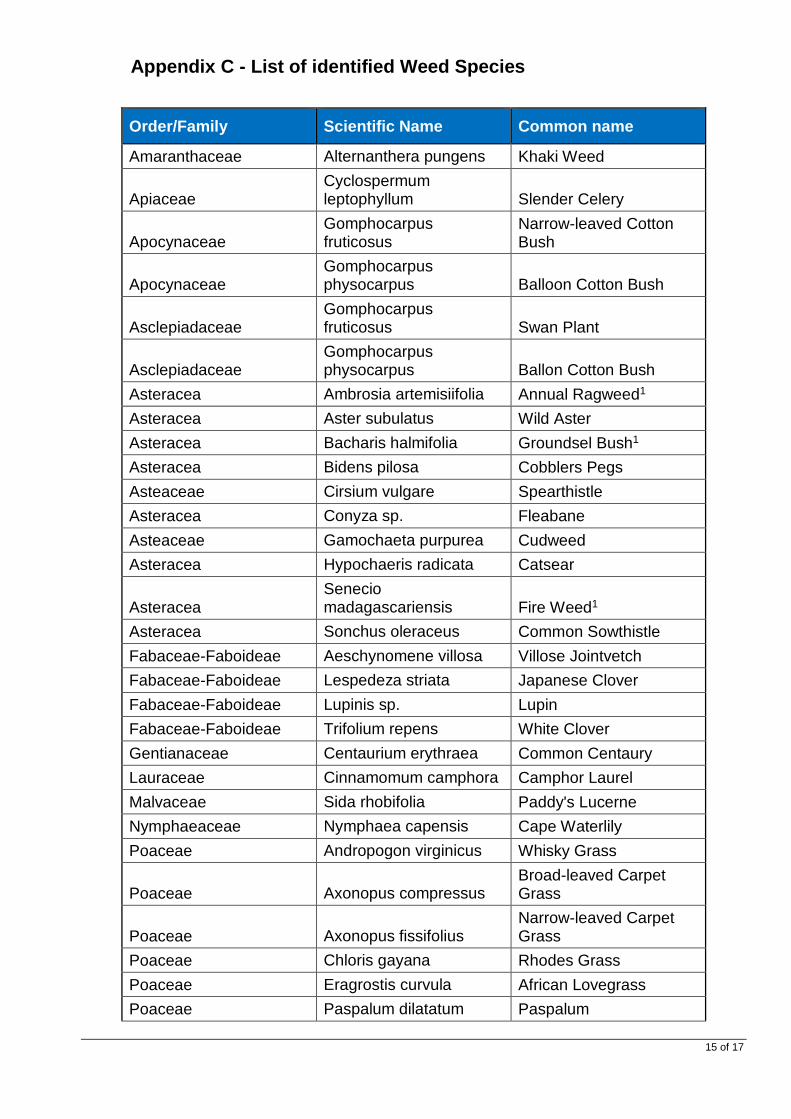
15 of 17
Appendix C - List of identified Weed Species
Order/Family Scientific Name Common name
Amaranthaceae Alternanthera pungens Khaki Weed
Apiaceae Cyclospermum leptophyllum Slender Celery
Apocynaceae Gomphocarpus fruticosus
Narrow-leaved Cotton Bush
Apocynaceae Gomphocarpus physocarpus Balloon Cotton Bush
Asclepiadaceae Gomphocarpus fruticosus Swan Plant
Asclepiadaceae Gomphocarpus physocarpus Ballon Cotton Bush
Asteracea Ambrosia artemisiifolia Annual Ragweed1
Asteracea Aster subulatus Wild Aster
Asteracea Bacharis halmifolia Groundsel Bush1
Asteracea Bidens pilosa Cobblers Pegs
Asteaceae Cirsium vulgare Spearthistle
Asteracea Conyza sp. Fleabane
Asteaceae Gamochaeta purpurea Cudweed
Asteracea Hypochaeris radicata Catsear
Asteracea Senecio madagascariensis Fire Weed1
Asteracea Sonchus oleraceus Common Sowthistle
Fabaceae-Faboideae Aeschynomene villosa Villose Jointvetch
Fabaceae-Faboideae Lespedeza striata Japanese Clover
Fabaceae-Faboideae Lupinis sp. Lupin
Fabaceae-Faboideae Trifolium repens White Clover
Gentianaceae Centaurium erythraea Common Centaury
Lauraceae Cinnamomum camphora Camphor Laurel
Malvaceae Sida rhobifolia Paddy's Lucerne
Nymphaeaceae Nymphaea capensis Cape Waterlily
Poaceae Andropogon virginicus Whisky Grass
Poaceae Axonopus compressus Broad-leaved Carpet Grass
Poaceae Axonopus fissifolius Narrow-leaved Carpet Grass
Poaceae Chloris gayana Rhodes Grass
Poaceae Eragrostis curvula African Lovegrass
Poaceae Paspalum dilatatum Paspalum

16 of 17
Order/Family Scientific Name Common name
Poaceae Paspalum urvillei Vasy Grass
Poaceae Setaria Sphacelata South African Pigeon Grass
Poaceae Sporobolus africanus Parramatta Grass
Poaceae Sporobolus fertilis Giant Parramatta Grass
Poaceae Stenotaphrum secundatum Buffalo Grass
Plantaginaceae Plantago lanceolata Plantain
Rubiaceae Richardia stellaris
Solanaceae Solanum chenopodioides Whitetip Nightshade
Verbenaceae Lantana camara Lantana1
Verbenaceae Verbena bonariensis Purple Top
Verbenaceae Verbena rigidus Creeping Verbena Note: 1 = Noxious Weed under the Noxious Weeds Act 1993

17 of 17
Appendix D – Extract from Plant Hazard Assessment

Appendix 3 – Vegetation Retention Plan
No changes from Stage 1 previous issue

Page 1 of 45 Uncontrolled when Printed
Vegetation Retention Plan
Rev Version Date Prepared by Reviewed by Approved by
A Draft 25/05/2017 Paul Rossington Lukas Clews Rachel Vazey
B Final 16/06/2017 Paul Rossington Rachel Vazey Rachel Vazey
New Grafton Correctional Centre Document No: JHG-NGCC-PLN-VRP-027

Page 2 of 45 Uncontrolled when Printed
CONTENTS
1. INTRODUCTION ........................................................................................................................ 3
1.1 RELEVANT CONDITIONS OF APPROVAL (COA) STAGE 1 ........................................................ 4 1.2 LEGAL AND OTHER REQUIREMENTS ..................................................................................... 8
2. CONSTRUCTION PHASE VEGETATION RETENTION, MANAGEMENT AND RESTORATION .......................................................................................................................... 9
2.1 CONSTRUCTION PHASE MANAGEMENT MEASURES FOR VEGETATION RETENTION, RESTORATION AND MANAGEMENT ............................................................................................................ 16
3 OPERATION PHASE VEGETATION RETENTION AREAS AND MANA GEMENT APPROACH .................................................................................................................................................. 21
3.1 OPERATION PHASE MANAGEMENT MEASURES FOR VEGETATION RETENTION, RESTORATION AND MANAGEMENT ................................................................................................................... 23
APPENDIX MATERIAL
Appendix A - List of indigenous plant species recorded on the site in each vegetation type which may be suitable for landscaping and restoration ........................................................................... 28 Appendix B - Weed Species identified on site ............................................................................. 40 Appendix C - High Threat Weeds ................................................................................................. 42

Page 3 of 45 Uncontrolled when Printed
1. Introduction Jacobs has been engaged by John Holland Group (JHG) to prepare this Vegetation Retention Plan for the New Grafton Correctional Centre (NGCC) project. This plan details the measures that will be used to manage and rehabilitate vegetation on site during the construction and operation phases of the Project. This plan is an attachment to the Construction Flora and Fauna Management Plan (CFFMP) and the Operation Flora and Fauna Management Plan (OFFMP) and should be read in conjunction with both these report. This Vegetation Retention Plan details the requirements to ensure that vegetation is retained and restored during the construction phase of the project and maintained throughout the operation of the correctional centre. The key aim of the retention and restoration of vegetation on the site is to ensure that the biodiversity values of these areas are maintained and/or improved over time, to reach a condition that requires a low intensity of ongoing maintenance. This Vegetation Retention Plan has been developed to meet the relevant Conditions of Approval for the project (see Table 1.1 below). This Vegetation Retention Plan outlines the approach and management measures designed to:
• Retain native vegetation (trees, shrubs and groundcover), and • Establish and maintain additional areas of native vegetation (particularly within the buffer
areas). This Vegetation Retention Plan has been reviewed by a suitably qualified bushfire consultant. There are interrelationships between this plan and other documents that provide additional information on environmental management relating to landscape and vegetation restoration. These documents include:
• Soil and Water Management Plan – Includes details on soil management techniques that minimise erosion including during rehabilitation. It details the staging of decommissioning sediment controls during rehabilitation works and the stabilisation and minimal disturbance practices associated with works in waterways and riparian zones.
• Landscape plan – details the plant species and locations for all proposed landscape plantings; including the Vegetation Buffer area, interior of the facility and other plantings within the Boundary fence.
• Weed and Pathogen Management Plan – Details mitigation measures to reduce the chance of weeds or pathogen spread across site. These mitigations are to be implemented from initial clearing right through rehabilitation works.
• Flora and Fauna Management Plan (main body of plan) – includes rehabilitation of land from a fauna habitat perspective. Rehabilitation is to reinstate fauna structures (e.g. large woody debris) that were harvested during clearing operations and build new fauna structures (nest boxes).
• Bushfire Management Plan (BFMP) – details the management requirements to reduce bushfire hazard to people and property; requires vegetation to be regularly mown/slashed within the site Asset Protection Zone (APZ) (however, the BFMP does not require any management of vegetation outside of the APZ).
• Construction Environmental Management Plan (CEMP) - demonstrates systems and procedures to ensure that controls are established and maintained to manage potential environmental impacts during the construction of the Project. It details the responsibilities of the project team relating to environmental management, and all other requirements under the Environmental Management System framework under ISO 14001 including system review, audits and inspections and communication.

Page 4 of 45 Uncontrolled when Printed
1.1 Relevant Conditions of Approval (CoA) Stage 1
Table 1.1: Relevant Conditions of Approval (CoA) St age 1
Approval Reference
Approval requirements Section/s in which issue is addressed
Other documents in which issue is also addressed
Schedule 2 - Conditions of Consent for concept appr oval
Part B - Conditions to be satisfied in future devel opment applications
B16 (Landscaping)
The development application for Stage 2 must include detailed plans identifying the species to be used in the site buffer and other landscape areas (preferably species indigenous to the area).
Appendix A includes a list of native species that may be used for restoration.
Landscape Report for the NGCC Stage 2 EIS (Lorna Harrison Landscape Architects, 2017) which includes proposed planting species for all landscape plantings; including the vegetation buffer area, interior of the facility and other plantings within the new boundary fence.
B18 (Biodiversity)
The development application for Stage 2 must demonstrate that the proposal is consisted with the endorsed BAR and BOS. Relevant landscape and rehabilitation elements from the BAR and BOS include: • A Landscape Management Plan is to be developed as
part of the CEMP for the NGCC Stage 2 which provides specific details for the re-establishment of native vegetation (shrubs and groundcovers) in areas to be identified in the Stage 2 DA. The Landscape Management Plan will need to consider a range of constraints and opportunities associated with the project including collection and propagation of local seed, salvage and reuse of topsoil and woody debris. The Landscape Management Plan should aim to revegetate buffer lands using the same species composition and structure as currently exists on the site and include a program for monitoring and maintenance of plantings.
This plan includes the following: • A map of existing vegetation to
be retained, including a vegetation buffer area.
• Guidelines for construction-phase vegetation restoration techniques.
• A list of native species which may be used for restoration.
Refer to the Landscape Report for the NGCC Stage 2 EIS (Lorna Harrison Landscape Architects, 2017) which includes proposed planting of indigenous species in the vegetation buffer area and other plantings between the APZ and the new boundary fence.

Page 5 of 45 Uncontrolled when Printed
Approval Reference
Approval requirements Section/s in which issue is addressed
Other documents in which issue is also addressed
Schedule 2 - Conditions of Consent for concept appr oval Part B – Prior to the Commencement of Works
B9 (Biodiversity) A vegetation retention plan must be prepared by a suitably qualified consultant, which must: a) Identify and provide details of the retention of trees
(particularly hollow bearing) and groundcover; b) Provides details on the maintenance and improvement
of retained or planted vegetation, particularly within the buffer areas; and
c) Be reviewed by a suitable qualified bushfire consultant and include certification that any vegetation retained within an APZ meets the relevant standards.
Figure 1 shows the areas if vegetation being retained and Figure 2 shows the restoration areas. Restoration and management measures to be implemented during the construction phase of the project are detained in Section 2.1. Maintenance and improvement of retained vegetation beyond the construction phase is included in Section 3.1. Retained vegetation within the APZ for the site will consist only of grasses and other groundcover vegetation that will be maintained in accordance with the BFMP.
Refer to the Landscape Report for the NGCC Stage 2 EIS (Lorna Harrison Landscape Architects, 2017) which includes proposed planting of indigenous species in the vegetation buffer area and other plantings between the APZ and the new boundary fence.

Page 6 of 45 Uncontrolled when Printed
Figure 1 Mapped areas of retained vegetation Refer to the PDF map that will be inserted into the final PDF copy of the report

Page 7 of 45 Uncontrolled when Printed
Figure 2 Restoration and management zones Insert Figure 2 here

Page 8 of 45 Uncontrolled when Printed
1.2 Legal and Other Requirements
References
Federal Legislation State legislation Local
Government Laws
Standards / Codes Other Documentation
• Environmental Protection and Biodiversity Conservation Act 1999.
• Protection of the Environment and Operations Act 1997.
• Environmental Planning and Assessment Act, 1979.
• Threatened Species Conservation Act 1995.
• National Parks and Wildlife Act 1974. • Native Vegetation Act 2003. • Noxious Weeds Act 1993. • Forestry Act 1916.
• N / A • JH Standards. • Construction Environmental Management Plan.
• Development Consent SSD 7413. • Jacobs, Biodiversity Assessment
Report, March 2017. • Jacobs, Biodiversity Offset Strategy,
March 2017. • JH specifications / SOPs / standards.

Page 9 of 45 Uncontrolled when Printed
2. Construction phase vegetation retention, managem ent and restoration
The site includes 31.8 ha of native vegetation communities present as patches of varying types and condition classes (i.e. the ‘vegetation zones’ as described in the BAR). The four different vegetation communities present are bordered by a further 163.2 ha of previously cleared native habitat that has been modified by stock grazing, and now presents as a grassland habitat of mixed exotic and common native species. Vegetation communities on the western boundaries form part of a larger patch of vegetation extending west and north of the site. Native vegetation communities were found to be in moderate to good (medium) degrading to low condition as shown by Table 2.1 (i.e. all native communities present have been modified). As described in the Biodiversity Assessment Report and Biodiversity Offset Strategy for the Stage 2 NGCC Project a total of 13.7 hectares of native vegetation identified as plant community types under the OEH Framework for Biodiversity would be cleared for the NGCC project.
Table 2.1: Native Vegetation Communities of the Sit e
Vegetation Community Corresponding PCT Code / Condition
Total Area (ha)
Clearing Area (ha)
Area to be retained (ha)
Coastal freshwater meadows and forblands of lagoons and wetlands (Photo 1)
Coastal freshwater meadows and forblands of lagoons and wetlands (PCT:782)
NR150 Moderate / Good (Poor)
0.8 0.8 0
PCT:782 Total 0.8 0.8 0
NR244 Moderate/ Good (Medium)
8.2 4.6 3.6
NR244 Moderate / Good (Poor)
8.0 3.7 4.3
PCT:1209 Total 16.2 8.3 7.9
NR246 Moderate/ Good (Medium)
10.6 3.9 6.7
NR246 Moderate / Good (Poor)
4 0.7 3.3
PCT:1211 Sub-total 14.6 4.6 10
Forest Red Gum - Swamp Box of the Clarence Valley lowlands of the NSW North Coast Bioregion (Photo 6)
Forest Red Gum - Swamp Box of the Clarence Valley lowlands of the NSW North Coast Bioregion (PCT 837)
NR161 Moderate / Good (Poor)
0.2 0 0.2
PCT:837 Sub-total 0.2 0 0.2
Total 31.8 13.7 18.1

Page 10 of 45 Uncontrolled when Printed
With the exception of the very small area of PCT 837, which will not be affected by the project, the vegetation types on the site are not endangered ecological communities (EEC). Figure 1 shows vegetation being retained, Figure 3 shows vegetation being cleared and photos 1-6 are indicative of vegetation condition prior to the commencement of construction.
Photo 1: Coastal freshwater meadows and forblands o f lagoons and wetlands, in poor condition
Photo 2 and 3: Spotted Gum – Grey Box - Grey Ironba rk dry open forest of the Clarence Valley lowlands of the NSW North Coast Bio region, in Medium (left) and Poor (right) condition

Page 11 of 45 Uncontrolled when Printed
Photo 4 and 5: Spotted Gum – Grey Ironbark – Pink B loodwood open forest of the Clarence Valley lowlands of the NSW North Coast Bio region, in Medium (left) and Poor (right) condition
Photo 6: Forest Red Gum - Swamp Box of the Clarence Valley l owlands of the NSW North Coast Bioregion

Page 12 of 45 Uncontrolled when Printed
Figure 3 : Vegetation being cleared Refer to the PDF map that will be inserted into the final PDF copy of the report

Page 13 of 45 Uncontrolled when Printed
The native vegetation area to be retained is concentrated on the south-west site boundary with small fragments also retained within a largely cleared area in the north. Connection between the retained vegetation and other landscape patches to the north and east of the site will be achieved via a landscaped vegetation buffer (to be rehabilitated). Specific categories of vegetation retention and restoration are described in Table 2.2 and the management zones in which they will be undertaken are shown in Figure 2.
Table 2.2: Vegetation retention, restoration and ma nagement zones
Flora and Fauna Management Zone
Description and Proposed restoration/management approach
1. Primary Conservation Area A
Existing areas of native forest (PCT’s 1209, 1211 and 837) outside of the new boundary fence which are contiguous with the large vegetation patch outside of the Project Site to the west.
These areas will be allowed to regenerate naturally with the aid of weed control and the addition of fauna habitat structures (assisted natural regeneration).
Weed control in accordance with the Weed and Pathogen Management Plan attachment to the CFFMP.
2. Primary Conservation Area B
Other areas of mixed native and exotic grassland within the site, outside of the new boundary fence.
Existing forest within these areas will be allowed to regenerate naturally with the aid of weed control (assisted natural regeneration).
Areas devoid of native canopy cover will receive topsoil stripped from vegetation clearing areas within the development footprint.
Addition of fauna habitat structures as described in the body of the CFFMP.
Weed control in accordance with the Weed and Pathogen Management Plan attachment to the CFFMP.
3. Vegetation Buffer Zone
The vegetation buffer area is currently largely clear of native vegetation with the exception of some areas of forest on the northern and southern boundaries of the site and isolated trees.
Retention of all existing native forest patches and isolated native trees.
Mass screen planting of indigenous canopy and mid-storey trees, shrubs and grasses. May also include topsoil translocation recipient sites.
Weed control in accordance with the Weed and Pathogen Management Plan attachment to the CFFMP.
4. Secondary Conservation Area
Small patches and peripheral areas of native forest (PCT1209 and 837) with low canopy cover within the new boundary fence.
These areas will be allowed to regenerate naturally with the aid of weed control only (assisted natural regeneration).
Weed control in accordance with the Weed and Pathogen Management Plan attachment to the CFFMP.

Page 14 of 45 Uncontrolled when Printed
Flora and Fauna Management Zone
Description and Proposed restoration/management approach
5. Stormwater Zone
Land utilised for stormwater infrastructure including overland drainage structures and vegetated detention basins.
Management will be primarily for the purposes of water quality.
Planting of native indigenous aquatic plants in accordance with the Landscape Plan. Baumea spp., Carex spp., Cyperus spp., Eleocharis spp., Philydrum lanuginosum, Schoenoplectus mucronata, Juncus spp. and, if available, other native aquatic and semi-aquatic species from the list in Appendix A.
Weed control in accordance with the Weed and Pathogen Management Plan attachment to the CFFMP.
6. Grassland Zone
Areas of mixed native and exotic grassland within the site, inside the Boundary fence.
Mowing/slashing in accordance with the Bushfire Management Strategy.
Weed control in accordance with the Weed and Pathogen Management Plan attachment to the CFFMP.
7. Landscape Zone
Landscape tree planting areas between the APZ and the Boundary Fence.
Planting of indigenous canopy and mid-storey trees.
Mowing/slashing of grass between trees in accordance with the Bushfire Management Strategy.
Weed control in accordance with the Weed and Pathogen Management Plan attachment to the CFFMP.
8. Centre Operation Zone
The buildings, roads, playing fields, asset protection zone, parking and other infrastructure areas associated with the NGCC.
All woody vegetation and much of the groundcover vegetation will be removed from this zone during construction.
Management of vegetation associated with buildings, roads, playing fields etc in accordance with the Landscape Report.
Mowing/slashing of APZ and other cleared grassland areas in accordance with the Bushfire Management Strategy.
Weed control in accordance with the Weed and Pathogen Management Plan attachment to the CFFMP.
9. Perimeter Fence Zone
Area extending 5 metres to the inside of the new boundary fence, required for fence construction and maintenance and vegetation management.
Mowing/slashing of understory to maintain informal vehicle access.
Pruning of overhanging branches of trees to maintain 2-5 metre canopy separation between trees on the inside and trees on the outside of the fence in accordance with the Bushfire Management Plan.

Page 15 of 45 Uncontrolled when Printed
Other areas of the site, including grassland areas cleared by John Holland, outside of the areas described in Table 3.1, or infrastructure locations (e.g. asset protection areas), will be stabilised with appropriate low maintenance covers (i.e. grassland with low invasive potential) consistent with the existing species found on site.

Page 16 of 45 Uncontrolled when Printed
2.1 Construction phase management measures for vege tation retention, restoration and management Management measures for landscape management and restoration during the construction phase of the project are detailed in Table 2.3.
Table 2.3: Construction phase management measures f or vegetation retention, restoration and management
Management Actions
No Actions To Be Undertaken Applicable zones Staff Responsible
When
1. A new boundary fence will be installed in the location shown in Figure 1. Land between the new boundary fence and the Lot and DP Boundary, that is outside of the vegetation buffer, will be designated as a conservation area to be managed by assisted natural regeneration as described under Action 2. Gates would be installed in this fence to allow access for management purposes.
Zone 9 - Perimeter Fence Zone 1 - Primary Conservation Area A Zone 2 - Primary Conservation Area B
PM/PER Prior to the commencement of clearing and grubbing
2. Assisted natural regeneration during the construction phase would involve: • Topsoil translocation as described under Action 2 (Zone 2 only). • Weed control as described in the Weed and Pathogen Management
Plan attachment to the CFFMP. • Augmentation with habitat structures as described in Table 3, Action
23 of the body of the CFFMP.
Zone 1 - Primary Conservation Area A Zone 2 - Primary Conservation Area B
PM/PER Throughout construction

Page 17 of 45 Uncontrolled when Printed
3. Topsoil translocation would involve: • Identification and marking of soil translocation donor and recipient
sites, by an ecologist, during pre-clearing inspections. • Recipient sites would be areas currently devoid of native forest and
with low native ground layer diversity/abundance within zone 2 and zone 3 (areas adjacent to zones 1 and 2).
• Donor sites would be higher condition (moderate/good -medium) areas of forest within the clearing footprint (refer Figure 1).
• Recipient sites would be stripped of existing topsoil to a depth of approximately 100mm and the resulting spoil would be spread in adjacent areas of cleared land (Zone 6 and Zone 7)
• Removal of topsoil (to a depth of approximately 100 mm depth) from donor sites.
• Spreading of topsoil in recipient sites to a depth of approximately 100 mm.
Zone 8 - Centre Operation Zone (donor sites). Zone 2 - Primary Conservation Area B (main recipient sites). Zone 3 - Vegetation Buffer (secondary recipient sites). Zone 6 – Grassland and Zone 7 – Landscape (receiving of topsoil stripped from recipient sites).
PM/PER/Project ecologist.
Preparation of recipient sites at commencement of vegetation clearing works. Soil translocation to occur immediately after woody vegetation is cleared from donor sites.
4. Areas of existing native forest within Vegetation Buffer will: • Be retained, allowed to regenerate naturally, and where necessary
augmented with additional planting of indigenous trees and shrubs • Be subject to weed control as described in the weed and pathogen
management plan attachment to the CFFMP.
Zone 3 - Vegetation Buffer.
PM/PER/Project ecologist.
Throughout construction.
5. Areas within the Vegetation Buffer which are currently devoid of native forest will be restored to a forest structure through a combination of:
• Assisted Natural Regeneration in areas adjacent to existing native forest and subject to soil translocation.
• Planting of indigenous trees and shrubs. • Weed control as described in the Weed and Pathogen Management
Plan attachment to the CFFMP.
Zone 3 - Vegetation Buffer.
PM/PER/Project ecologist.
Completed prior to the end of construction.
6. Species planted in the Landscape Buffer, will comprise native locally indigenous plants and seed from local suppliers and or from seed / cuttings collected during clearing works.
Zone 3 - Vegetation Buffer.
PM/PER. Completed prior to the end of construction.

Page 18 of 45 Uncontrolled when Printed
7. Any fertilisers used for landscaping must be of an organic type and the principal is to be notified 2 days prior to the intended day of application
Zone 3 - Vegetation Buffer. Zone 8 - Centre Operation Zone. Zone 7 - Landscape
PM/PER. Throughout construction.
8. Establishment of forest in the Vegetation Buffer will include; ripping and topsoiling of any areas that are compacted or lacking topsoil; weed control; seeding/planting; watering; monitoring; and preplacement planting if necessary.
Zone 3 - Vegetation Buffer.
PM/PER. Completed prior to the end of construction.
9. All disturbed areas outside of vegetation restoration areas (including storage areas, haul roads etc.) must be restored to a condition at least similar to the existing condition before disturbance at completion of construction. Restoration includes ripping, topsoiling, weed control and seeding, planting, watering and maintenance. Ripping, topsoiling, seeding and planting should occur within 6 months of demobilisation/ completion of the disturbed areas.
Zone 8 - Centre Operation Zone. Zone 6 – Grassland. Zone 7 – Landscape.
PM/PER. Completed prior to the end of construction.
10. Minor tributary watercourses affected by the project shall, where feasible and reasonable, be rehabilitated to emulate a natural stream system. The rehabilitation of watercourses shall be consistent with the Guidelines for Controlled Activities: In-stream works and stream armouring should be minimised to the greatest extent practicable.
Zone 7 – Landscape. Zone 5 – Stormwater.
PM/PER. Completed prior to the end of construction.
11. Temporary vegetation may be used to stabilize stockpiles; in such cases, a non-invasive cover crop will be applied.
Zone 8 - Centre Operation Zone. Zone 6 – Grassland. Zone 7 – Landscape.
PM/PER. Throughout construction.
12. Possibilities for the use of native seed sourced from the site will be explored; given the history of grazing, and sparse shrub layer on the site, additional; sources of seeds and plant material from outside the site are likely to be required.
Zone 3 - Vegetation Buffer Zone 7 - Landscape
PM/PER/Project ecologist
Prior to vegetation clearing.
13. Any nursery from which plant of the family Myrtaceae plants are obtained will be asked for certification that they are Myrtle Rust free.
Zone 3 - Vegetation Buffer. Zone 7 – Landscape.
PM/PER. Throughout construction.

Page 19 of 45 Uncontrolled when Printed
Monitoring
No Monitoring Required Staff Responsible When
1. Vegetation restoration areas will be monitored weekly by the PER and monthly by the Project ecologist, until the end of the construction phase of the project. Monitoring will include:
• Health of plants in Zone 3 and Zone 7. • Native species regeneration in topsoil recipient sites. • Weed infestations in planted and topsoiled areas.
Zone 2 - Primary Conservation Area B (topsoil recipient sites). Zone 3 - Vegetation Buffer. Zone 7 - Landscape
PER/PM/Project ecologist.
Weekly/Monthly.
2. Weed monitoring throughout the areas disturbed by construction phase activities.
Zone 2 - Primary Conservation Area B (topsoil recipient sites). Zone 3 - Vegetation Buffer. Zone 5 – Stormwater. Zone 6 – Grassland. Zone 7 – Landscape. Zone 8 - Centre Operation Zone. Zone 9 - Perimeter Fence.
PER/PM/Project ecologist.
Minimum weekly.

Page 20 of 45 Uncontrolled when Printed
3. Weed monitoring in areas within the project site that have not been disturbed by construction phase activities, targeting the interface with adjacent zones.
Zone 1 - Primary Conservation Area A Zone 4 - Secondary Conservation Area
PER/PM/Project ecologist
Minimum monthly
Suggested Corrective Actions
Problem Suggested Corrective Action Staff Responsible
� Management/restoration works not progressing as planned
� Investigate reasons behind lack of works progress. � Review and if necessary modify communication and works planning
procedures related to vegetation clearing and restoration. � Retrain staff on site regarding the restoration requirements of this
plan. � Continue weekly monitoring to ensure that corrective actions have
been successful and restoration works are progressing as planned. � Repeat the above steps until works are being progressed to a
satisfactory standard.
PER/PM.

Page 21 of 45 Uncontrolled when Printed
3 Operation phase vegetation retention areas and ma nagement approach
At the completion of the construction phase, native vegetation on the site will consist of:
• Remnant areas of native forest (PCTs 1209, 1211 and 837) (refer Figure 1 and Photos 1-6).
• Recent mass screen planting of indigenous canopy and mid-storey trees, shrubs and grasses in the Vegetation Buffer (Zone 3 in Figure 2).
• Recent plantings of indigenous canopy and mid-storey trees in landscape planting areas (Zone 7 in Figure 2).
• Immature forest regrowth from topsoil translocation and natural regeneration, primarily in Zone 2 but also within Zones 1 and 3 (refer Figure 2).
The flora and fauna management zones that are to be used to guide maintenance works during operation of the site and the associated vegetation retention approaches are shown in Table 3.1.
Table 3.1: Operation phase vegetation retention app roach for each management zone
Flora and Fauna Management Zone
Description Proposed retention / maintenance approach
1. Primary Conservation Area A
Remnant areas of native forest (PCTs 1209, 1211 and 837), outside of the new boundary fence, which are contiguous with the large vegetation patch outside of the Project Site to the west. Other small areas of mixed native and exotic grassland within forest patches.
These areas will be allowed to regenerate naturally with the aid of weed control (assisted natural regeneration).
Monitoring to detect and plan responses to any significant weed proliferation.
2. Primary Conservation Area B
Immature forest regrowth from topsoil translocation and natural regeneration.
Other areas of mixed native and exotic grassland within the site, outside of the new boundary fence.
These areas will be allowed to regenerate naturally with the aid of weed control (assisted natural regeneration).
Monitoring to detect and plan responses to any significant weed proliferation.
3. Vegetation Buffer Zone
The vegetation buffer area is currently largely clear of native vegetation with the exception of some areas of forest on the northern and southern boundaries of the site and isolated trees.
Monitoring to detect and plan responses to weed proliferation and poor health of plantings.
Weed control.
Any watering, plant protection and replacement planting requirements determined through monitoring.
4. Secondary Conservation Area
Small patches and peripheral areas of native forest (PCT1209 and 837) with low canopy cover within the new boundary fence.
These areas will be allowed to regenerate naturally with the aid of weed control only (assisted natural regeneration).
Monitoring to detect and plan responses to any significant weed proliferation.

Page 22 of 45 Uncontrolled when Printed
Flora and Fauna Management Zone
Description Proposed retention / maintenance approach
5. Stormwater Zone Land utilised for stormwater infrastructure including overland drainage structures and vegetated detention basins.
Management will be primarily for the purposes of water quality.
Weed control.
6. Grassland Zone Areas of mixed native and exotic grassland within the site, inside the new boundary fence.
Mowing/slashing between plantings to limit the risk of loss due to grass fire.
Weed control.
7. Landscape Zone Landscape tree planting areas between the APZ and the new boundary fence.
Monitoring to detect and plan responses to weed proliferation and poor health of plantings.
Mowing/slashing between plantings to limit the risk of loss due to grass fire.
Weed control.
Any watering, plant protection and replacement planting requirements determined through monitoring.
8. Centre Operation Zone
The buildings, roads, playing fields, asset protection zone, parking and other infrastructure areas associated with the NGCC.
Outside of the scope of this vegetation retention plan. Refer to the body of the OFFMP.
9. Perimeter Fence Zone Area extending 5 metres to the inside of the new boundary fence, required for fence construction and maintenance and vegetation management.
Mowing/slashing of understory to maintain informal vehicle access for other activities.
Pruning of trees overhanging the fence to maintain a canopy separation of 5 metres from surrounding bushland areas.
Weed control.

Page 23 of 45 Uncontrolled when Printed
3.1 Operation phase management measures for vegetat ion retention, restoration and management Management measures for vegetation retention, landscape management and restoration during the operation phase of the project are detailed in Table 3.2.
Table 3.2: Operation phase management actions, moni toring and corrective actions
Management Actions
No Actions To Be Undertaken Applicable zones Staff Responsible
When
1. Assisted natural regeneration during the operation phase would involve the following weed control measures:
• Slashing of annual weeds in early spring to limit seed; in areas in which native plants dominate the ground layer vegetation.
• Spot-spraying of perennial weeds ground layer weeds, in areas in which native plants dominate the ground layer vegetation.
• Small patch spraying of weeds with herbicide; in areas in which exotic plants dominate the ground layer vegetation
• Cutting and applying undiluted herbicide to the stems of woody weeds.
• Other measures recommended in Clarence Valley Council publications.
Weed control would, as a minimum, include:
• Species declared under the Noxious Weeds Act 1993 (or equivalent legislation) for the Local Control Authority area of Clarence Valley Council (refer Appendix B for species recoded on site to date).
• High threat weeds identified in the OEH draft Biodiversity assessment Methodology (refer Appendix A for species recoded on site to date and Appendix C for all high threat Weeds).
Zone 1 - Primary Conservation Area A. Zone 2 - Primary Conservation Area B. Zone 3 - Vegetation Buffer (any topsoil recipient sites). Zone 4 - Secondary Conservation Area.
Site operation / maintenance manager. Weed and Pest Control Contractor.
Monthly as a minimum for the first year of operation. Quarterly as a minimum during the second and third years of operation. Annually as a minimum throughout the operation of the centre. Actual frequency and intensity of weed control will be as necessary to supress weed proliferation throughout operation in response to monitoring results.

Page 24 of 45 Uncontrolled when Printed
Monitoring
2. Monitoring remnant native forest would include: • Distribution and abundance of noxious and high threat
weeds. • Signs of damage to vegetation as a result of exotic
animals. • Vegetation structure in terms of native canopy, mid-
storey and ground layer foliage cover benchmarks for associated Plant Community Type.
• Mapping the extent of the remnant native forest to ensure that the sizes of vegetation patches are not decreasing (will provide evidence that the size of patches are being retained or increased).
Zone 1 - Primary Conservation Area A Zone 4 - Secondary Conservation Area.
Site operation / maintenance manager. Independent Environmental Monitoring Contractor.
Twice a year as a minimum during the first and second years of operation. Annually as a minimum throughout the remainder of the operation of the centre.
3. Monitoring soil translocation sites and natural regrowth areas would include:
• Distribution and abundance of noxious and high threat weeds.
• Signs of damage to vegetation as a result of exotic animals.
• Native plant species composition in terms of dominant native species in the canopy, mid-storey and ground layer.
• Vegetation structure in terms of native canopy, mid-storey and ground layer foliage cover benchmarks for associated Plant Community Type.
Zone 2 - Primary Conservation Area B. Zone 3 - Vegetation Buffer (any topsoil recipient sites).
Site operation / maintenance manager. Independent Environmental Monitoring Contractor.
Quarterly as a minimum during the first and second years of operation. Annually as a minimum throughout the remainder of the operation of the centre.
4. Monitoring the vegetation buffer would include: • Distribution and abundance of noxious and high threat
weeds. • Signs of damage to vegetation as a result of exotic
animals. • Vegetation structure in terms of native canopy, mid-
storey and ground layer foliage cover. • Tree and shrub health including vigour, foliage density,
dieback, weeping sap, fungal infection, wilting.
Zone 3 - Vegetation Buffer.
Site operation / maintenance manager. Independent Environmental Monitoring Contractor.
Quarterly as a minimum during the first and second years of operation. Annually as a minimum throughout the remainder of the operation of the centre.

Page 25 of 45 Uncontrolled when Printed
5. Monitoring the landscaped areas would include: • Distribution and abundance of noxious and high threat
weeds. • Signs of damage to trees as a result of exotic animals. • Tree heath including vigour, foliage density, dieback,
weeping sap, fungal infection, wilting.
Zone 7 – Landscape.
Site operation / maintenance manager. Independent Environmental Monitoring Contractor.
Quarterly as a minimum during the first and second years of operation. Annually as a minimum throughout the remainder of the operation of the centre.
6. Monitoring the other areas would include: • Distribution and abundance of noxious and high threat
weeds
Zone 6 – Grassland. Zone 5 – Stormwater. Zone 8 – Centre Operation Zone. Zone 9 – Perimeter Fence.
Site operation / maintenance manager. Independent Environmental Monitoring Contractor.
Quarterly as a minimum during the first and second years of operation. Annually as a minimum throughout the remainder of the operation of the centre.

Page 26 of 45 Uncontrolled when Printed
Suggested Corrective Actions
Problem Suggested Corrective Action Staff Responsible
Increase in the distribution and/or abundance of noxious and high threat weeds.
Increase frequency of monitoring and weed control until weed distribution and/or abundance has declined between each of three monitoring events over the course of at least six months.
Site operation / maintenance manager. Independent Environmental Monitoring Contractor. Weed and Pest Control Contractor.
Signs of significant damage to vegetation as a result of exotic animals.
Increase the frequency of monitoring and exotic animal control until signs of damage have declined between each of three monitoring events over the course of at least six months.
Site operation / maintenance manager. Independent Environmental Monitoring Contractor. Weed and Pest Control Contractor.
Tree and/or shrub cover in any of Zones 1, 2 and 4 is significantly higher than cover benchmarks for associated Plant Community Type, potentially affecting the value of habitat for threatened species and overall biodiversity.
Areas of vegetation significantly above benchmarks should be thinned through selective removal of individuals and small stands of trees and shrubs to ensure that these areas are structurally complex and able to provide habitat for a variety of species which utilise denser and more open areas.
Site operation / maintenance manager. Independent Environmental Monitoring Contractor. Weed and Pest Control Contractor.
Tree and/or shrub cover in any of Zones 1, 2 and 4 is significantly lower than cover benchmarks for associated Plant Community Type and does not appear to be increasing, potentially affecting the value of habitat for threatened species and overall biodiversity.
Areas of vegetation significantly below benchmarks should be supplemented through selective planting of individuals and small stands of trees and shrubs (see Appendix A for a species list) to ensure that these areas are structurally complex and able to provide habitat for a variety of species which utilise denser and more open areas.
Site operation / maintenance manager. Independent Environmental Monitoring Contractor. Weed and Pest Control Contractor.

Page 27 of 45 Uncontrolled when Printed
Suggested Corrective Actions
Problem Suggested Corrective Action Staff Responsible
The health of planted trees and shrubs in the vegetation buffer and landscaped area is poor.
Recommence watering of plantings if low rainfall is suspected cause. Replace any dead or very sick plants, using the species that seem to be growing more vigorously on the site (i.e. plant species that are better suited to the conditions).
Site operation / maintenance manager. Independent Environmental Monitoring Contractor. Weed and Pest Control Contractor.
The physical size of the remnant native forest patches in Zone 1 and/or Zone 4 have decreased in size during the operational phase indicating vegetation is not being retained.
The cause of the decreased vegetation patch size must be determined and suitable corrective actions undertaken. If the reduced patch size is the result of accidental tree removal from maintenance works then maintenance methods must be corrected to ensure no further tree removal occurs. To rectify any loss in the physical size of the remnant native forest patches, revegetation works will be undertaken to reinstate the area lost.
Site operation / maintenance manager. Grounds maintenance staff. Independent Environmental Monitoring Contractor

Page 28 of 45 Uncontrolled when Printed
Appendix A - List of indigenous plant species recorde d on the site in each vegetation type which may be suitable for landscapin g and restoration
Growth form / stratum
Family Scientific name Common name Coastal freshwater meadows and forblands of lagoons and wetlands (PCT:782)
Spotted Gum - Grey Box - Grey Ironbark dry open forest of the Clarence Valley lowlands of the NSW North Coast Bioregion (PCT:1209)
Spotted Gum - Grey Ironbark - Pink Bloodwood open forest of the Clarence Valley lowlands of the NSW North Coast Bioregion (PCT:1211)
Aquatic - emergent CYPERACEAE Eleocharis dietrichiana
Spike-rush x
Aquatic - emergent CYPERACEAE Schoenoplectiella mucronata
Angled Club-rush x
Aquatic - emergent MENYANTHACEAE Villarsia reniformis x
Aquatic - emergent CYPERACEAE Eleocharis equisetina
Spike-rush x
Aquatic - emergent PHILYDRACEAE Philydrum lanuginosum
Frogsmouth x
Aquatic - emergent CYPERACEAE Eleocharis acuta Common Spike-rush
Aquatic - emergent CYPERACEAE Eleocharis sphacelata
Tall Spike-rush
Aquatic emergent CYPERACEAE Eleocharis gracilis Slender Spike-rush x
Aquatic herb - submerged/floating
HALORAGACEAE Myriophyllum latifolium
Water-milfoil
Aquatic herb - submerged/floating
LENTIBULARIACEAE Utricularia gibba Floating Bladderwort
Aquatic herb - submerged/floating
MENYANTHACEAE Nymphoides indica White Marshwort

Page 29 of 45 Uncontrolled when Printed
Growth form / stratum
Family Scientific name Common name Coastal freshwater meadows and forblands of lagoons and wetlands (PCT:782)
Spotted Gum - Grey Box - Grey Ironbark dry open forest of the Clarence Valley lowlands of the NSW North Coast Bioregion (PCT:1209)
Spotted Gum - Grey Ironbark - Pink Bloodwood open forest of the Clarence Valley lowlands of the NSW North Coast Bioregion (PCT:1211)
Aquatic herb - submerged/floating
ONAGRACEAE Ludwigia peploides subsp. montevidensis
Water Primrose
Aquatic(semi) - edge
CYPERACEAE Cyperus polystachyos
Bunchy Flat-sedge x
x
Aquatic(semi) - edge
CYPERACEAE Cyperus fulvus Sticky Sedge x
Aquatic(semi) - edge
JUNCACEAE Juncus usitatus Common Rush x
Aquatic(semi) - edge
JUNCACEAE Juncus polyanthemus
Many-flowered Rush
x
Aquatic(semi) - edge
CYPERACEAE Cyperus flaccidus Lax Flat-sedge x
Aquatic(semi) - edge
POACEAE Paspalum distichum Water Couch x
Aquatic(semi) - edge
CYPERACEAE Cyperus haspan x
Aquatic(semi) - edge
JUNCACEAE Juncus prismatocarpus
Branching Rush x
Aquatic(semi) - edge
APIACEAE Hydrocotyle laxiflora Stinking Pennywort x
Aquatic(semi) - edge
GOODENIACEAE Goodenia paniculata Panicled Goodenia x
Aquatic(semi) - edge
LOBELIACEAE Lobelia alata Angled Lobelia x
Aquatic(semi) - edge
SCROPHULARIACEAE Gratiola pedunculata x

Page 30 of 45 Uncontrolled when Printed
Growth form / stratum
Family Scientific name Common name Coastal freshwater meadows and forblands of lagoons and wetlands (PCT:782)
Spotted Gum - Grey Box - Grey Ironbark dry open forest of the Clarence Valley lowlands of the NSW North Coast Bioregion (PCT:1209)
Spotted Gum - Grey Ironbark - Pink Bloodwood open forest of the Clarence Valley lowlands of the NSW North Coast Bioregion (PCT:1211)
Aquatic(semi) - edge
CYPERACEAE Cyperus difformis Dirty Dora
Aquatic(semi) - edge
CYPERACEAE Cyperus trinervis
Aquatic(semi) - edge
POLYGONACEAE Persicaria decipiens Slender Knotweed
Aquatic(semi) - edge
POLYGONACEAE Persicaria hydropiper
Water Pepper
Aquatic(semi) - edge
POLYGONACEAE Persicaria strigosa Spotted Knotweed
Aquatic(semi) - edge
MARSILEACEAE Marsilea mutica Nardoo
Grass POACEAE Bothriochloa macra Red-leg Grass x x
Grass POACEAE Dichelachne micrantha
Short-hair Plume Grass
x x
Grass POACEAE Paspalidium criniforme
Paspalidium x x x
Grass POACEAE Oplismenus imbecillis
Narrow-leaf Beard-grass
x x
Grass POACEAE Microlaena stipoides var. stipoides
Weeping Grass x x
Grass POACEAE Capillipedium spicigerum
Scented-top Grass
x
Grass POACEAE Panicum decompositum
Native Millet
x
Grass POACEAE Panicum simile Two-colour panic x

Page 31 of 45 Uncontrolled when Printed
Growth form / stratum
Family Scientific name Common name Coastal freshwater meadows and forblands of lagoons and wetlands (PCT:782)
Spotted Gum - Grey Box - Grey Ironbark dry open forest of the Clarence Valley lowlands of the NSW North Coast Bioregion (PCT:1209)
Spotted Gum - Grey Ironbark - Pink Bloodwood open forest of the Clarence Valley lowlands of the NSW North Coast Bioregion (PCT:1211)
Grass POACEAE Digitaria diffusa Open Summer-grass
x x
Grass POACEAE Oplismenus aemulus Broad-leaf Beard-grass
x x
Grass POACEAE Sporobolus creber Slender Rats Tail Grass
x x
Grass POACEAE Eragrostis leptostachya
Paddock Lovegrass x x
Grass POACEAE Eragrostis brownii Brown's Lovegrass x x
Grass POACEAE Themeda australis Kangaroo Grass x x
Grass POACEAE Paspalum orbiculare Ditch Millet x
Grass POACEAE Entolasia stricta Wiry Panic x
Grass POACEAE Echinopogon caespitosus
Hedgehog Grass x x
Grass POACEAE Aristida vagans Three-awned Spear Grass
x x
Grass POACEAE Cymbopogon refractus
Barbed Wire Grass x x
Grass POACEAE Aristida ramosa Three-awned Spear Grass
x x
Grass POACEAE Imperata cylindrica Blady Grass x x
Grass POACEAE Digitaria parviflora Small-flower Finger Grass
x
Grass POACEAE Cynodon dactylon Common Couch x

Page 32 of 45 Uncontrolled when Printed
Growth form / stratum
Family Scientific name Common name Coastal freshwater meadows and forblands of lagoons and wetlands (PCT:782)
Spotted Gum - Grey Box - Grey Ironbark dry open forest of the Clarence Valley lowlands of the NSW North Coast Bioregion (PCT:1209)
Spotted Gum - Grey Ironbark - Pink Bloodwood open forest of the Clarence Valley lowlands of the NSW North Coast Bioregion (PCT:1211)
Grass POACEAE Alloteropsis semialata
Cockatoo Grass x
Grass POACEAE Chloris ventricosa Tall Windmill Grass x
Grass POACEAE Aristida benthamii Three-awned spear grass
x
Grass POACEAE Digitaria didactyla Queensland Blue Couch
x
Grass POACEAE Deyeuxia quadriseta Reed Bent-grass
Grass POACEAE Echinopogon ovatus Hedgehog Grass
Grass POACEAE Entolasia marginata Margined Panic
Grass POACEAE Eragrostis elongata Narrow Lovegrass
Grass POACEAE Lachnagrostis filiformis
Blown Grass
Grass POACEAE Panicum effusum Hairy Panic
Grass POACEAE Paspalidium distans Paspalidium
Grass POACEAE Sporobolus elongatus
Slender Rats Tail Grass
Groundcover ACANTHACEAE Pseuderanthemum variable
Pseuderanthemum x x
Groundcover ACANTHACEAE Brunoniella australis Blue Trumpet x x
Groundcover ANTHERICACEAE Tricoryne elatior Yellow Rush-lily x x

Page 33 of 45 Uncontrolled when Printed
Growth form / stratum
Family Scientific name Common name Coastal freshwater meadows and forblands of lagoons and wetlands (PCT:782)
Spotted Gum - Grey Box - Grey Ironbark dry open forest of the Clarence Valley lowlands of the NSW North Coast Bioregion (PCT:1209)
Spotted Gum - Grey Ironbark - Pink Bloodwood open forest of the Clarence Valley lowlands of the NSW North Coast Bioregion (PCT:1211)
Groundcover ANTHERICACEAE Arthropodium milleflorum
Vanilla Lily x x
Groundcover ANTHERICACEAE Laxmannia gracilis Grass Wire-lily x x
Groundcover ANTHERICACEAE Dichopogon strictus Chocolate Lily x x
Groundcover CAMPANULACEAE Wahlenbergia gracilis
Sprawling Bluebell x x
Groundcover COMMELINACEAE Commelina cyanea Scurvy Weed x x
Groundcover CYPERACEAE Scleria mackaviensis x x
Groundcover CYPERACEAE Cyperus brevifolius Mullumbimby Couch
x x
Groundcover FABACEAE-FABOIDEAE
Desmodium gunnii Slender Tick Trefoil x x
Groundcover FABACEAE-FABOIDEAE
Glycine clandestina Twining Glycine x x
Groundcover GOODENIACEAE Velleia paradoxa Spur Velleia x x
Groundcover LAMIACEAE Ajuga australis Austral Bugle x x
Groundcover LOBELIACEAE Pratia purpurascens White Root x x
Groundcover LOMANDRACEAE Lomandra filiformis subsp. coriacea
Wattle Mat-rush x x
Groundcover MYOPORACEAE Eremophila debilis Winter Apple x x
Groundcover OXALIDACEAE Oxalis perennans x x
Groundcover PHORMIACEAE Dianella longifolia var. longifolia
Long-leaf Flax Lily x x

Page 34 of 45 Uncontrolled when Printed
Growth form / stratum
Family Scientific name Common name Coastal freshwater meadows and forblands of lagoons and wetlands (PCT:782)
Spotted Gum - Grey Box - Grey Ironbark dry open forest of the Clarence Valley lowlands of the NSW North Coast Bioregion (PCT:1209)
Spotted Gum - Grey Ironbark - Pink Bloodwood open forest of the Clarence Valley lowlands of the NSW North Coast Bioregion (PCT:1211)
Groundcover PHYLLANTHACEAE Phyllanthus virgatus Small-leaf Spurge x x
Groundcover PLANTAGINACEAE Plantago debilis Slender Plantain x x
Groundcover POLYGALACEAE Polygala japonica Dwarf Milkwort x x
Groundcover SOLANACEAE Solanum prinophyllum
Forest Nightshade x x
Groundcover VIOLACEAE Hybanthus stellarioides
x x
Groundcover CYPERACEAE Fimbristylis dichotoma
Common Fringe-rush
x x
Groundcover FABACEAE-FABOIDEAE
Desmodium varians Slender Tick-trefoil x x
Groundcover FABACEAE-FABOIDEAE
Glycine tabacina x x
Groundcover ADIANTACEAE Cheilanthes sieberi subsp. sieberi
Slender Cloak-fern
x
Groundcover APIACEAE Hydrocotyle peduncularis
Hairy Pennywort
x
Groundcover ASTERACEAE Chrysocephalum apiculatum
Yellow Buttons
x
Groundcover ASTERACEAE Epaltes australis Spreading Nut-heads
x
Groundcover CLUSIACEAE Hypericum gramineum
Narrow-leaf St. John’s Wort
x

Page 35 of 45 Uncontrolled when Printed
Growth form / stratum
Family Scientific name Common name Coastal freshwater meadows and forblands of lagoons and wetlands (PCT:782)
Spotted Gum - Grey Box - Grey Ironbark dry open forest of the Clarence Valley lowlands of the NSW North Coast Bioregion (PCT:1209)
Spotted Gum - Grey Ironbark - Pink Bloodwood open forest of the Clarence Valley lowlands of the NSW North Coast Bioregion (PCT:1211)
Groundcover PHORMIACEAE Dianella caerulea var. caerulea
Leafy Blue Flax Lily
x
Groundcover PHYLLANTHACEAE Sauropus hirtellus x
Groundcover ASTERACEAE Euchiton gymnocephalus
x x
Groundcover CONVOLVULACEAE Polymeria calycina Woodland Bindweed
x x
Groundcover CYPERACEAE Cyperus gracilis Slender Flat Sedge x x
Groundcover GOODENIACEAE Goodenia heterophylla
Variable-leaf Goodenia
x x
Groundcover SCROPHULARIACEAE Veronica plebeia Trailing Speedwell x x
Groundcover APIACEAE Centella asiatica Swamp Pennywort x x
Groundcover ASTERACEAE Vernonia cinerea var. cinerea
Vernonia x x
Groundcover FABACEAE-FABOIDEAE
Podolobium scandens
Netted Shaggy-pea
x
Groundcover CONVOLVULACEAE Dichondra repens Kidney Weed x x
Groundcover AMARANTHACEAE Alternanthera denticulata
Lesser Joyweed x
Groundcover ASTERACEAE Eclipta platyglossa Eclipta x
Groundcover ASTERACEAE Lagenophora stipitata
Bottle-daisy x
Groundcover COMMELINACEAE Murdannia graminea Grass Lily x

Page 36 of 45 Uncontrolled when Printed
Growth form / stratum
Family Scientific name Common name Coastal freshwater meadows and forblands of lagoons and wetlands (PCT:782)
Spotted Gum - Grey Box - Grey Ironbark dry open forest of the Clarence Valley lowlands of the NSW North Coast Bioregion (PCT:1209)
Spotted Gum - Grey Ironbark - Pink Bloodwood open forest of the Clarence Valley lowlands of the NSW North Coast Bioregion (PCT:1211)
Groundcover FABACEAE-FABOIDEAE Glycine tomentella
Woolly Glycine x
Groundcover LOMANDRACEAE Lomandra multiflora subsp. multiflora
Many-flowered Mat-rush
x
Groundcover RUBIACEAE Asperula gemella Twin-leaved Bedstraw
x
Groundcover VIOLACEAE Viola betonicifolia Showy Violet x
Groundcover CYPERACEAE Carex inversa Knob Tassel-sedge x
Groundcover FABACEAE-FABOIDEAE
Vigna vexillata var. angustifolia
Wild Cow Pea x
Groundcover LAMIACEAE Plectranthus parviflorus
Cockspur Flower x
Groundcover APIACEAE Hydrocotyle tripartita Tre-foil Pennywort
Groundcover ASTERACEAE Centipeda minima subsp. minima
Spreading Sneeze Weed
Groundcover ASTERACEAE Ozothamnus diosmifolius
Tall Paperdaisy
Groundcover FABACEAE-FABOIDEAE
Desmodium rhytidophyllum
Rusty Tick-trefoil
Groundcover FABACEAE-FABOIDEAE
Galactia tenuiflora var. lucida
Groundcover HALORAGACEAE Haloragis heterophylla
Variable Raspwort
Groundcover HYPOXIDACEAE Hypoxis hygrometrica var. villosisepala
Yellow Weather-grass

Page 37 of 45 Uncontrolled when Printed
Growth form / stratum
Family Scientific name Common name Coastal freshwater meadows and forblands of lagoons and wetlands (PCT:782)
Spotted Gum - Grey Box - Grey Ironbark dry open forest of the Clarence Valley lowlands of the NSW North Coast Bioregion (PCT:1209)
Spotted Gum - Grey Ironbark - Pink Bloodwood open forest of the Clarence Valley lowlands of the NSW North Coast Bioregion (PCT:1211)
Groundcover LAMIACEAE Mentha satureioides Creeping Mint
Groundcover LOGANIACEAE Mitrasacme alsinoides
Groundcover LOMANDRACEAE Lomandra filiformis subsp. filiformis
Wattle Mat-rush
Groundcover LOMANDRACEAE Lomandra longifolia subsp. longifolia
Spiny Mat-rush
Groundcover ORCHIDACEAE Spiranthes sinensis var. australis
Austral Ladies Tresses
Groundcover PHORMIACEAE Dianella revoluta var. revoluta
Black-anther Flax Lily
Groundcover PHYLLANTHACEAE Poranthera microphylla
Small Poranthera
Groundcover RANUNCULACEAE Ranunculus lappaceus
Common Buttercup
Groundcover RUBIACEAE Opercularia diphylla Stinkweed
Shrub DILLENIACEAE Hibbertia vestita Hairy Guinea-flower
x
Shrub FABACEAE-FABOIDEAE
Daviesia ulicifolia Gorse Bitter-pea
x
Shrub FABACEAE-MIMOSOIDEAE
Acacia concurrens Curracabah
x
Shrub PHYLLANTHACEAE Breynia oblongifolia Breynia x
Shrub THYMELEACEAE Pimelea linifolia subsp. linifolia
Slender Rice Flower
x

Page 38 of 45 Uncontrolled when Printed
Growth form / stratum
Family Scientific name Common name Coastal freshwater meadows and forblands of lagoons and wetlands (PCT:782)
Spotted Gum - Grey Box - Grey Ironbark dry open forest of the Clarence Valley lowlands of the NSW North Coast Bioregion (PCT:1209)
Spotted Gum - Grey Ironbark - Pink Bloodwood open forest of the Clarence Valley lowlands of the NSW North Coast Bioregion (PCT:1211)
Shrub FABACEAE-FABOIDEAE Lespedeza juncea
x
Shrub MORACEAE Maclura cochinchinensis
Cockspur Thorn
Tree - large MYRTACEAE Eucalyptus tereticornis
Forest Red Gum x x
Tree - large MYRTACEAE Eucalyptus siderophloia
Northern Grey Ironbark
x x
Tree - large MYRTACEAE Eucalyptus fibrosa Broad-leaf Ironbark
x
Tree - large MYRTACEAE Eucalyptus eugenioides
Thin-leaved Stringybark
x x
Tree - large MYRTACEAE Corymbia intermedia Pink Bloodwood x x
Tree - large MYRTACEAE Eucalyptus moluccana
Grey Box x x
Tree - large MYRTACEAE Corymbia henryi Spotted Gum x x
Tree - large MYRTACEAE Eucalyptus propinqua
Small-fruited Grey Gum
x
Tree - large MYRTACEAE Angophora subvelutina
Broad-leaved Apple
Tree - large MYRTACEAE Eucalyptus seeana Narrow-leaved Red Gum
Tree - medium RHAMNACEAE Alphitonia excelsa Red Ash x x
Tree - medium MYRTACEAE Lophostemon suaveolens
Swamp Turpentine
x

Page 39 of 45 Uncontrolled when Printed
Growth form / stratum
Family Scientific name Common name Coastal freshwater meadows and forblands of lagoons and wetlands (PCT:782)
Spotted Gum - Grey Box - Grey Ironbark dry open forest of the Clarence Valley lowlands of the NSW North Coast Bioregion (PCT:1209)
Spotted Gum - Grey Ironbark - Pink Bloodwood open forest of the Clarence Valley lowlands of the NSW North Coast Bioregion (PCT:1211)
Tree - medium CASUARINACEAE Allocasuarina littoralis
Black She-oak
Tree - medium CASUARINACEAE Casuarina glauca Swamp Oak
Vine LUZURIAGACEAE Eustrephus latifolius Wombat Berry x x
Vine APOCYNACEAE Parsonsia straminea Common Silkpod x
Vine LUZURIAGACEAE Geitonoplesium cymosum
Scrambling Lily
Vine OLEACEAE Jasminum suavissimum

Page 40 of 45 Uncontrolled when Printed
Appendix B - Weed Species identified on site Scientific Name Order/Family Common name
Aeschynomene villosa Fabaceae-Faboideae Villose Jointvetch
Alternanthera pungens Amaranthaceae Khaki Weed 2
Ambrosia artemisiifolia Asteraceae Annual Ragweed 1
Andropogon virginicus Poaceae Whisky Grass 2
Aster subulatus Asteraceae Wild Aster
Axonopus compressus Poaceae Broad-leaved Carpet Grass
Axonopus fissifolius Poaceae Narrow-leaved Carpet Grass 2
Baccharis halimifolia Asteraceae Groundsel Bush 1, 2
Bidens pilosa Asteraceae Cobblers Pegs
Centaurium erythraea Gentianaceae Common Centaury
Chloris gayana Poaceae Rhodes Grass 2
Cinnamomum camphora Lauraceae Camphor Laurel 2
Cirsium vulgare Asteraceae Spearthistle
Conyza sp. Asteraceae Fleabane
Cyclospermum leptophyllum Apiaceae Slender Celery
Eragrostis curvula Poaceae African Lovegrass 2
Gamochaeta purpurea Asteraceae Cudweed
Gomphocarpus fruticosus Apocynaceae Narrow-leaved Cotton Bush
Gomphocarpus fruticosus Asclepiadaceae Swan Plant
Gomphocarpus physocarpus Apocynaceae Balloon Cotton Bush
Gomphocarpus physocarpus Asclepiadaceae Balloon Cotton Bush
Hypochaeris radicata Asteraceae Catsear
Lantana camara Verbenaceae Lantana 1, 2
Lespedeza striata Fabaceae-Faboideae Japanese Clover
Lupinus sp. Fabaceae-Faboideae Lupin

Page 41 of 45 Uncontrolled when Printed
Scientific Name Order/Family Common name
Nymphaea capensis Nymphaeaceae Cape Waterlily
Paspalum dilatatum Poaceae Paspalum 2
Paspalum urvillei Poaceae Vasey Grass
Plantago lanceolata Plantaginaceae Plantain
Richardia stellaris Rubiaceae Richardia
Senecio madagascariensis Asteraceae Fire Weed 1
Setaria Sphacelata Poaceae South African Pigeon Grass
Sida rhombifolia Malvaceae Paddy's Lucerne
Solanum chenopodioides Solanaceae Whitetip Nightshade
Sonchus oleraceus Asteraceae Common Sowthistle
Sporobolus africanus Poaceae Parramatta Grass
Sporobolus fertilis Poaceae Giant Parramatta Grass 2
Stenotaphrum secundatum Poaceae Buffalo Grass 2
Trifolium repens Fabaceae-Faboideae White Clover
Verbena bonariensis Verbenaceae Purple Top
Verbena rigidus Verbenaceae Creeping Verbena Note: 1 = Noxious Weed under the Noxious Weeds Act 1993, 2 = High Threat Weed as identified under the draft Biodiversity Assessment methodology (OEH, 2017)

Page 42 of 45 Uncontrolled when Printed
Appendix C - High Threat Weeds Species name
Acacia karroo Baccharis halimifolia Chlorophytum comosum
Acacia nilotica Bidens spp. (B. aurea, B. bipinnata, B. pilosa, B. subalternans & B. tripartita) Chrysanthemoides monilifera ssp. monilifera
Acer negundo Brassica tournefortii Chrysanthemoides monilifera subsp. rotundata
Acetosa sagittata Briza subaristata Cinnamomum camphora
Acetosella vulgaris Bromus diandrus Colocasia esculenta
Achillea millefolium Brugmansia x candida Cortaderia jubata
Rhaponticum repens (syn. Acroptilon repens) Bryophyllum delagoense Cortaderia richardii
Ageratina adenophora Cabomba caroliniana Cortaderia selloana
Ageratina riparia Caesalpinia decapetala Corymbia torelliana
Agrostis capillaris Canna indica Cotoneaster spp.
Ailanthus altissima Cardiospermum grandiflorum Crataegus monogyna
Alternanthera philoxeroides Carrichtera annua Crocosmia crocosmiiflora
Alternanthera pungens Carthamus lanatus Cryptostegia grandiflora
Amelichloa brachychaeta Caulerpa taxifolia Cuscuta campestris
Andropogon virginicus Cenchrus ciliaris
Cylindropuntia spp (C. fulgida, C. imbricata, C. kleiniae, C. leptocaulis, C. prolifera, C. rosea and C. spinosior)
Anredera cordifolia Cenchrus clandestinum Cyperus eragrostis
Araujia sericifera Cenchrus echinatus Cyperus teneristolon
Aristolochia elegans (syn. Aristolochia littoralis) Cenchrus longisetus Cytisus scoparius
Arundo donax Cenchrus pennisetiformis Delairea odorata

Page 43 of 45 Uncontrolled when Printed
Species name
Asparagus aethiopicus Cenchrus setaceus Dolichandra unguis-cati (Syn. Macfadyena unguis-cati )
Asparagus africanus Cenchrus setiger Egeria densa
Asparagus asparagoides Cenchrus spinifex (syn. Cenchrus incertus) Ehrharta calycina
Asparagus plumosus Cestrum parqui Ehrharta erecta
Eichhornia azurea Hypoestes phyllostachya Olea europaea
Eichornia crassipes Ipomoea alba Opuntia spp.
Equisetum arvense Ipomoea cairica Parkinsonia aculeata
Eragrostis curvula Ipomoea indica Parthenium hysterophorus
Erythrina crista-galli Ipomoea purpurea Paspalum dilatatum
Erythrina sykesii Juncus acutus Paspalum quadrifarium
Fraxinus angustifolia Juncus articulatus Paspalum wettsteinii
Galenia pubescens Koelreuteria formosana Pereskia aculeata
Gazania rigens Lagarosiphon major Phoenix canariensis
Genista linifolia Lantana camara Phyla canescens
Genista monspessulana Leucanthemum vulgare Phyla nodiflora
Gleditsia triacanthos Ligustrum lucidum Phyllostachys spp. (P. aurea and P. nigra)
Gloriosa superba Ligustrum sinense Pinus spp.
Gymnocoronis spilanthoides Limnobium laevigatum Pistacia chinensis
Handroanthus chrysotrichus Limnobium spongia Pistia stratiotes
Harrisia martinii Limnocharis flava Polygala myrtifolia
Hedera helix Lonicera japonica Polygala virgata
Heliotropium amplexicaule Ludwigia peruviana Populus spp. (P. alba and P. nigra cv. Italica)
Heteranthera dubia Lycium ferocissimum Prosopis glandulosa
Heteranthera reniformis Maclura pomifera Prosopis juliflora

Page 44 of 45 Uncontrolled when Printed
Species name
Hieracium aurantiacum Megathyrsus maximus Triadica sebifera
Hydrocotyle ranunculoides Melinis minutiflora Ulex europaeus
Hygrophila costata Moraea flaccida Urochloa mutica
Hygrophila polysperma Moraea miniata Vachellia farnesiana
Hymenachne amplexicaulis Myriophyllum spicatum Vinca major
Hyparrhenia hirta Nassella spp. Watsonia meriana
Hyparrhenia rufa Nymphaea mexicana Xanthium occidentale
Hypericum perforatum Ochna serrulata Xanthium spinosum
Robinia pseudoacacia Prosopis pallida
Romulea rosea Prosopis velutina
Rubus fruticosus agg. Psidium littorale/cattleianum
Sagittaria montevidensis subsp. calycina Psilocaulon granulicaule (Psilocaulon tenue)
Salix spp. Pueraria lobata
Salvinia molesta Pyracantha spp.
Schefflera actinophylla Ranunculus repens
Schinus terebinthifolius Ricinus communis
Senecio crassiflorus Sporobolus fertilis
Senecio glastifolius Sporobolus natalensis
Senecio jacobaea Stenotaphrum secundatum
Senecio madagascarensis Tamarix spp. (T. aphylla and T. ramosissima)
Senna pendula Tecoma stans
Solanum elaeagnifolium Tipuana tipu
Solanum seaforthianum Tradescantia fluminensis
Sorghum halepense Trapa natans

Page 45 of 45 Uncontrolled when Printed

Appendix 4 - Fauna Rescue and Relocation Procedure
SCOPE
This procedure is applicable to all native and introduced fauna species that are found in the Project site.
PURPOSE
This procedure outlines the correct process to follow for the interaction with any fauna on site during construction activities. In particular the clearing operations. This procedure will cover instances where fauna is shocked, trapped, injured, or if eggs or juvenile fauna are discovered.
TRAINING
This procedure will be communicated during the site induction, during toolboxes and during development of the Activity Method Statements (AMS).
RESPONSIBILITIES
The Principal Environmental Representative for John Holland (PER) in conjunction with the consultant ecologist will have the responsibility of ensuring this procedure is followed.
PROCEDURE
1. Stop work if encountering any Fauna within work area
• If fauna is not injured allow it to move out of work area. If fauna will not move out of work area due to injury or other reasons contact the PER. The PER is to contact the ecologist or WIRES.
2. For Injured Fauna – to be handled by a person licensed to handle fauna
• Minimise stress to fauna – cover fauna with large blanket or towel and place in a cotton bag and contain the animal inside a pet carrier
• Retain the animal in a quiet, warm location that is well ventilated
• The PER will contact the relevant fauna rescue service and /or local veterinary surgery Contacts are;
WIRES (Rescue Hotline) 1300 094 737
WIRES (Northern Rivers – Lismore) 02 6628 1898
RSPCA (Tweed Heads) 07 5536 5135
Ballina Veterinary Hospital 02 6686 4889
Grafton Veterinary Clinic 02 6642 3681
Koala Rescue 02 6622 1233
Project Ecologist – TBA TBA
• Once the rescue agency arrives at the site, they are responsible for the animal. Any decisions regarding the care of the animal will be made by the rescue agency2

• In the event the rescue service and/or local veterinary service cannot be contacted, the PER and/or the Ecologist will deliver the injured/captured animal to the rescue agency within 24hrs.
3. For Threatened Fauna Species
• Advise the Project Manager and cease all work that may affect the threatened species
• Notify the OEH (threatened species unit) and consult with OEH on proposed Management strategies for the species. DoEE must be also notified if EPBC Act listed threatened species that were not previously identified are found.
• Do not recommence work likely to affect the threatened species until the OEH have given advice to do so.
• Relocation of fauna species of conservation significance will be undertaken by WIRES or a suitably qualified fauna specialist in consultation with OEH.
• PER to record the location, number, species, relocation of the threatened species.
4. For Native Fish
• Only use a fish friendly landing net to capture the fish
• Use the water from the pond to 2/3 fill a double plastic bag.
• Seal tightly, before being placing in a polystyrene container for stability during relocation
• Identify the species as a native common to the area and if so relocate to a section of water in the same drainage line that is outside of the footprint of construction.
5. For Noxious Fish • Noxious fish are to be euthanized using an ice-slurry and disposed of to landfill.
6. For Cane Toads
• Evidence of the use of sediment basins by Cane toads will be reported to OEH. • Cane toads are to be euthanised by using ice slurry until no more movement is detected,
then placing in a freezer and disposed of to landfill.
7. For Venomous reptiles, or raptors, etc.
• Only to be handled by an appropriately trained and registered handler.
• If the animal cannot be handled (i.e. venomous reptiles), the exact location of the animal is to be recorded and provided to the appropriate rescue agency and all workers to be excluded from the vicinity.
8. Release Process
If the animal is not injured or stressed it may be released nearby, in accordance with the following:
• If the species is nocturnal, release will be carried out at dusk.
• The release area will be as close to the original habitat as possible in an area that is not to be disturbed by the construction.
• No release would take place during periods of heavy rainfall, unless WIRES or the ecologist determines that the animal is too stressed to be held any longer.
• PER is to record the details of the release in a Register for relocation of native fauna. This register is also to be used for all Fauna deaths and injuries on site.


![18450[1] jhgljh jhg jklhli hg](https://static.fdocuments.net/doc/165x107/563db98b550346aa9a9e5159/184501-jhgljh-jhg-jklhli-hg.jpg)


