NEVREF research team...13 411,947 altimeter -derived . along-track QG height differences . 453,334...
36
1 NEVREF research team
Transcript of NEVREF research team...13 411,947 altimeter -derived . along-track QG height differences . 453,334...

1
NEVREF research team

2 Philipp Rupprecht photography

3 Philipp Rupprecht photography

4 Philipp Rupprecht photography

5 Philipp Rupprecht photography

6 Philipp Rupprecht photography
- Challenge & approach
- NLGEO2018, the new Dutch quasi-geoid model
- NLLAT2018, the new Dutch LAT model
Outline

7
The problem…
onshore offshore
NAP
Typically, the separation chart datum/ height reference surface is a spatially varying function only known at the tide gauges!
tide gauge
LAT

8
The problem…
onshore offshore
reference ellipsoid
LAT
NLGEO2004

9
The problem…
onshore offshore
NLGEO2004
LAT
LAT reduction matrix MSL
GEONZ97
reference ellipsoid
LAT reduction matrix = difference LAT – “MSL” in open sea and LAT - NAP along the coast (smooth transition)
10
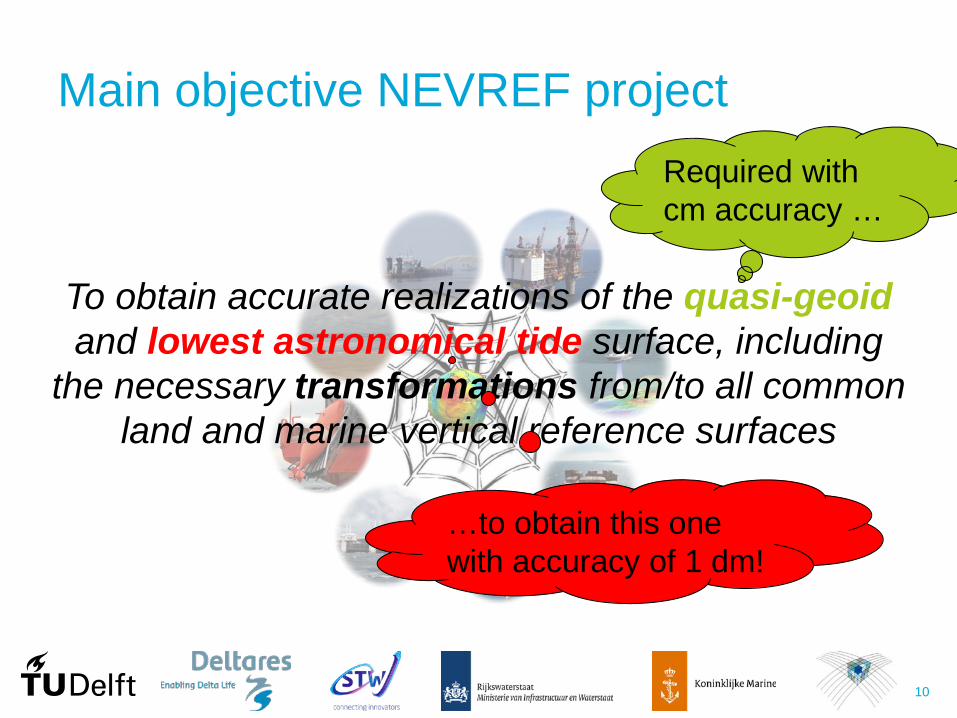
Main objective NEVREF project
To obtain accurate realizations of the quasi-geoid and lowest astronomical tide surface, including
the necessary transformations from/to all common land and marine vertical reference surfaces
Required with cm accuracy …
…to obtain this one with accuracy of 1 dm!

11
Approach
hQG
Tide Gauges /
GNSS
Coastal-waters-inclusive continuous (CWIC) 3D description of LAT
Hydro. model
+
Gravi- metric data
Radar Altimetry
QGLATζ

12
NLGEO2018, the new Dutch quasi-geoid model…

13
411,947 altimeter-derived along-track QG height differences
453,334 terrestrial gravity anomalies
8,205 airborne gravity disturbances
94,137 shipboard gravity anomalies
7,179 spatially interpolated gravity anomalies
• Altimeter data corrected for dynamic topography from Dutch operational storm-surge model;
• Colored noise in altimeter-derived QG height differences accounted for;
• New terrestrial gravity data in Limburg, Germany, Belgium;
• New airborne data in German Bight; • Shipboard data re-processed; • Remove-compute-restore:
– GOCO05S as a-priori gravity field; – RTM correction applied using the TS
(tesseroid) software;

14
• Quasi-geoid is parameterized using spherical radial basis functions.
• Parameters are estimated using weighted least-squares.
• Variance component estimation is applied for proper weighting of all datasets.
• Systematic errors in gravity datasets are accounted for.
• Full noise covariance matrix of estimated quasi-geoid.

15
NLGEO2018 - gravimetric quasi-geoid

16
GNSS NAP geometric gravimetric( ) quasi-geoidh Hε ζ ζ= − − = −
- Acquired during 1996–1997 (5th primary leveling);
- Reprocessed by L. Huisman using Bernese Software Version 5.2;
- ITRF2005;
- Tide free mean crust;
- 5 mm (5 days data) hσ ≈
- Acquired within 1 month after GNSS meas.;
- Correction to NAP heights resulting from 5th primary leveling applied;
- Mean tide zero tide (Mäkinen 2008);
-
0.50
0.40
0.35
0.25
0.10
cent
imet
ers
0.45
0.30
0.20
0.15 Hσ =
Validation - Netherlands

17
Validation - Netherlands
-0.5
-1.0
-1.5
-2.0
-2.5
-3.0
cent
imet
ers
Nr of points: 82 Mean: -1.93 SD: 0.66 Min: -4.1 Max: -0.62
Differences [centimeters] -3.5 -2.5 -1.5 -0.5 0.5 -4.5
14
12
10
8
6
4
2
0
Occ
urre
nces
geometric gravimetricε ζ ζ= −
< 1 cm (better than target accuracy)

18

19

20

21
Validation - Netherlands
x true false
0.70
0.66
0.62
0.58
0.54
0.50
cent
imet
ers
0.68
0.64
0.60
0.56
0.52
εσ
abs( ) 2 εε σ>
geometric gravimetricε ζ ζ= −
22
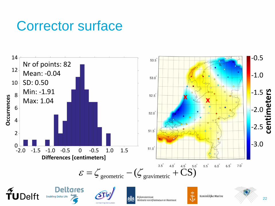
Corrector surface
-0.5
-1.0
-1.5
-2.0
-2.5
-3.0
cent
imet
ers
geometric gravimetric( CS)ε ζ ζ= − +
Differences [centimeters] -1.5 -0.5 0 -0.5 1.5 -2.0
14
12
10
8
6
4
2
0
Occ
urre
nces
Nr of points: 82 Mean: -0.04 SD: 0.50 Min: -1.91 Max: 1.04
-1.0 1.0
x x

23
Tide free mean crust (GNSS)
Zero crust over zero geoid to mean crust over mean geoid
Corrector surface
NLGEO2018 (gravimetric part)
NLGEO2018

24
NLGEO2018
25
NLLAT2018, the new Dutch LAT model…

26
LAT computations: setup Mean atmospheric fluxes (wind + pressure) ERA-Interim
Sea level = tides + mean surge + mean baroclinic
Mean horizontal density gradients (salinity + temperature fields)
Internal tide
Assimilating tidal water levels @ 31 tide gauges
in deep water
Vertical reference of hydrodynamic model NAP

27 Source: http://www.kvibe.com/wp-content/uploads/2015/05/
28
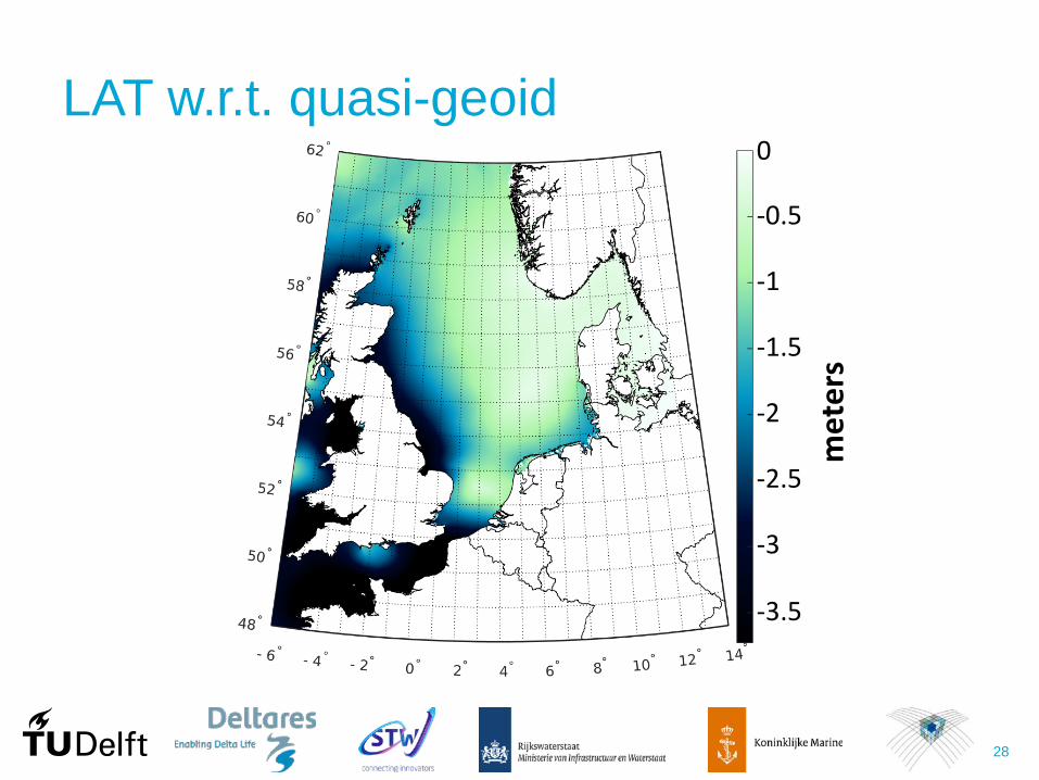
LAT w.r.t. quasi-geoid 0
-0.5
-1
-1.5
-2
-2.5
met
ers
-3
-3.5

29
LAT w.r.t. quasi-geoid - validation Obs – Mod LAT
10
5
0
-10
-15
-20
-25
-5
cent
imet
ers
Mod
el-d
eriv
ed L
AT
Observation-derived LAT
Region Nr Rms (cm) Range (cm) Mean (cm) Std (cm)
North Sea 47 10.6 57.6 -2.7 10.4
Wadden Sea 18 24.0 59.5 -18.7 15.4
All 92 14.9 77.6 -7.2 13.1

30
LAT w.r.t. quasi-geoid – Dutch waters
Region Nr rms (cm)
North Sea 19 6.6
Wadden Sea 12 14.8
All 31 10.5
0
-0.5
-1
-1.5
-2
-2.5
met
ers

31
LAT in the Wadden Sea?
In tidal flats, LAT = no-water level! LAT ≠ smooth
0
-0.5
-1
-1.5
-2
-2.5
met
ers

32
In the Wadden Sea LAT pseudo LAT 0
-0.5
-1
-1.5
-2
-2.5
met
ers
To obtain pseudo-LAT, we added 2 m of water to open boundary conditions & assimilated tidal water levels

33
In the Wadden Sea LAT pseudo LAT 0
-0.5
-1
-1.5
-2
-2.5
met
ers
NOT valid outside Dutch waters!!!

34
NLLAT2018

35
NLLAT2018

36 Thank you! https://snapsbox.com/images/2018/01/29/
lamborghini-terzo-millennio-promo.jpg