National River Inventory - Jeff Simley, US Geological Survey
33
The National Hydrography Dataset The Watershed Boundary Dataset
-
Upload
rshimoda2014 -
Category
Technology
-
view
517 -
download
0
Transcript of National River Inventory - Jeff Simley, US Geological Survey

The National Hydrography Dataset The Watershed Boundary Dataset

2
• U.S. Geological Survey - the NHD represents the nation’s surface water features and drainage network
• U.S. Forest Service- additional streams and other features provided as NHD stewards
• Environmental Protection Agency – data on impaired waters (red lines)
• U.S. Army Corps of Engineers - dams (red dot)
• U.S. Fish and Wildlife Service - data on streams flowing through culverts (yellow symbols ) and waterfalls (orange dots), which were assembled by the State of California
NHD as a framework for a water information system
Dams, culverts, and waterfalls can act as barriers to fish passage; the USFWS and others use these data to support studies to improve fish migration to spawning grounds

What is the National Hydrography Dataset? Essentially the surface water features found on topographic maps

The NHD organized into drainage units

Creating the Watershed Boundary Dataset

Integrating data to better understand the landscape
19

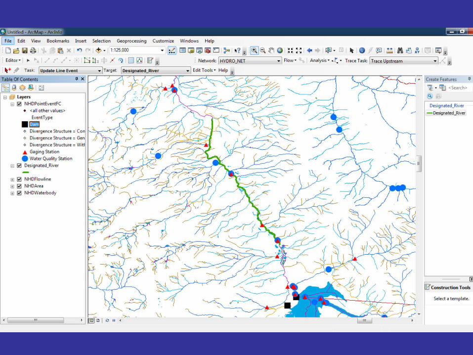
Using GIS to visualize the data
20

The spatial view of streams

The network view of streams

The nation’s hydrographic network using The National Map
- a 7.5-million mile network

Streams – Creating the fundamental network
Swan Creek
Perennial
Intermittent
Ephemeral

Flow Direction – Providing intelligence to the data

Navigation – The basis for analysis

Navigation – Where does a toxic spill go?

Reach 14010002000421
Reach 14010002003345
Linear Referencing – Stream “Reaches”

100
0
50
75 25
14010002000421
Linear Referencing – Stream addresses

USGS Streamgage 09050000
Address: Reach – 14010002000421 Measure – 19.8392
Coordinate 106 05 13.955 W 39 32 43.472 N
Linear Referencing – Data “Events”

Connecting the streamgage to the network
Streamgage
Dam
Blue River Artificial Path (Blue River)
Green Mountain Reservoir


The NHDPlus – Synthesizing information

Medium Resolution NHD

High Resolution NHD

Local Resolution NHD