Mr. Aaron BBS GEOGRAPHY AND CULTURES OF ASIA. Warm Up Why would people want to preserve their...
23
Mr. Aaron BBS GEOGRAPHY AND CULTURES OF ASIA
-
Upload
paulina-malone -
Category
Documents
-
view
214 -
download
1
Transcript of Mr. Aaron BBS GEOGRAPHY AND CULTURES OF ASIA. Warm Up Why would people want to preserve their...

Mr. AaronBBSGEOGRAPHY AND
CULTURES OF ASIA

Warm Up Why would people want to preserve their culture and
cultural practices in today’s global world?General Announcements
Tests Grade Update
KWL Chart Exercise You will have five minutes to complete the first two columns
(Know and Want to Know). KWL Discussion
Student Activity Geography and Cultures of Asia Documentary
You are responsible for completing the organizer and submitting it by the end of the period.
Homework Bring textbook to next class period
DAY ONEOBJECTIVE: UNIT OVERVIEW OF GEOGRAPHY AND CULTURES OF
ASIA

Warm Up Global IQ Assessment
https://www.qzzr.co/quiz/what-s-your-global-iq Link found on class website in the Unit Two folder After completing the assessment, email me your score and if you did better or
worse than expected/why at [email protected]
Student Activity Human Geography Activity
Homework Bring textbook to next class period
DAY TWOOBJECTIVE: UNIT OVERVIEW OF GEOGRAPHY AND CULTURES OF
ASIA

Warm Up Looking at page 607, which countries in Eastern and
Southeastern Asia are landlocked? What are the drawbacks of being landlocked?
Student Activity Read Chapter 27 (page 615-633)
Take Notes Make sure to include all highlighted vocabulary words in your notes
Do not answer the questions
Homework Bring textbook to next class period
DAY THREEOBJECTIVE: UNIT OVERVIEW OF GEOGRAPHY AND CULTURES OF
ASIA

Warm Up What climate types are found in China? (Review your notes
and page 617 for reference)Announcement
Tests and Grades will be distributed Thursday, October 23Student Activity
Read Chapter 27 (page 615-633) Take Notes
Make sure to include all highlighted vocabulary words in your notes Do not answer the questions
Complete worksheetHomework
Bring textbook and colored pencils to next class period Feel free to share supplies with those at your table.
DAY FOUROBJECTIVE: UNIT OVERVIEW OF GEOGRAPHY AND CULTURES OF
ASIA

Warm Up Quiz
Announcement Tests and Grades will be distributed Thursday, October 23
Student Activity Create Political and Physical Maps of Eastern/Southeastern
Asia Pages 26 & 27 in The Oxford World Atlas
Homework People in Chinese History Worksheet
DAY FIVEOBJECTIVE: CREATE POLITICAL AND PHYSICAL MAPS OF ASIA

Warm Up How should you approach taking notes when reading from a
text?Announcement
Tests and Grades will be distributed Thursday, October 23Student Activity
Create Political and Physical Maps of Eastern/Southeastern Asia Pages 26 & 27 in The Oxford World Atlas
Homework Complete notes on Chapter 27
DAY SIXOBJECTIVE: CREATE POLITICAL AND PHYSICAL MAPS OF ASIA

Political Physical
• Country Names • Country Names
• Capital Cities • Geographic Features: Mountain ranges, deserts, rivers, plateaus
• Oceans and Seas
MAPS

Warm Up Is a political map considered a “thematic map”? Why?
Announcement Tests and Grades will be distributed TODAY
You will have five minutes to review your test before returning it.
Student Activity Create Political and Physical Maps of Eastern/Southeastern
Asia Large Map Activity
Homework People in Chinese History Worksheet Progress Report Signed
DAY SEVENOBJECTIVE: CREATE POLITICAL AND PHYSICAL MAPS OF EASTERN
AND SOUTHEASTERN ASIA

Political Physical
• Country Names • Country Names
• Capital Cities • Geographic Features: Mountain ranges, deserts, rivers, plateaus
• Oceans and Seas
MAPS
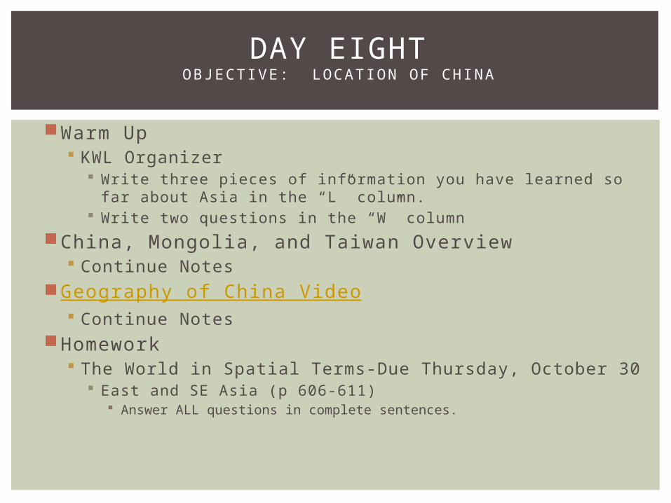
Warm Up KWL Organizer
Write three pieces of information you have learned so far about Asia in the “L” column.
Write two questions in the “W” column
China, Mongolia, and Taiwan Overview Continue Notes
Geography of China Video Continue Notes
Homework The World in Spatial Terms-Due Thursday, October 30
East and SE Asia (p 606-611) Answer ALL questions in complete sentences.
DAY EIGHTOBJECTIVE: LOCATION OF CHINA
THE GEOGRAPHY OF CHINA, MONGOLIA, AND TAIWAN
GeographyBBS2014-2015

NATURAL ENVIRONMENTS
China is the third largest country in land area behind Russia and Canada respectively.
The Himalayas, the world’s largest mountain range, are located along the SW border with Nepal and Bhutan.
Between the mountain ranges border the north and south is the Plateau of Tibet.
The plains and river valleys of eastern China are the most densely populated areas in the country.
To the north of China is Mongolia. The Mongolian Plateau makes up the majority of the country. The Gobi Desert extends from China into Mongolia as well.
Southeast of China is the island of Taiwan located in the Pacific Ocean. This island is located near active tectonic plates so earthquakes do occur.
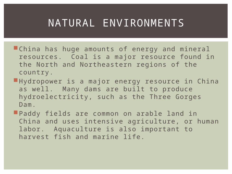
NATURAL ENVIRONMENTS
China has huge amounts of energy and mineral resources. Coal is a major resource found in the North and Northeastern regions of the country.
Hydropower is a major energy resource in China as well. Many dams are built to produce hydroelectricity, such as the Three Gorges Dam.
Paddy fields are common on arable land in China and uses intensive agriculture, or human labor. Aquaculture is also important to harvest fish and marine life.

HISTORY AND CULTURE
For centuries, China had contact with the outside world mostly through overland trade routes, such as the Silk Road extending from China to the Black Sea.
European influences reached China in the 1500s.The Republic of China was formed in 1912 after the
overthrowing of the Qing dynasty after attempts to keep out colonizing powers (Europe, Japan, the US).
In 1945 after years of unrest with Japan, the Communist Party began fighting for control to create the People’s Republic of China (PRC) under Mao Zedong. This eventually came to fruition by 1949.

HISTORY AND CULTURE
Communists had the challenge to feed the people of China and how to parcel land.
Gender equality became the norm under communism in China.
In 1958 under the Great Leap Forward initiative, Mao attempted to industrialize the country. It did not work.
The Cultural Revolution (1966-77) came in direct response to the Great Leap Forward.
After Mao’s death in 1976, new leader Deng Xiaoping pushed forward to modernize China and to introduce a market economy.

THE REGION TODAY
China Southern China is the most productive region economically because
of it population and place (physical characteristics). Shanghai, Guangzhou, and Hong Kong are located in this region.
Taiwan Taiwan is one of Asia’s richest and most industrialized countries. Its
major trading partners are China, Japan, and the US. China’s Communist government claims that Taiwan is still a
province of China. However, Taiwan’s government claims to be the legitimate government of China.
Mongolia Mongolia is the least densely populated country in the world. The country had its first free elections in 1990. Before this, it had
been under the influence of the Soviet Union. Recently, its economy has opened up to foreign aid and investment.

Warm Up KWL Organizer
Write three pieces of information you have learned so far about Asia in the “L” column.
Write two questions in the “W” column
China, Mongolia, and Taiwan Overview Continue Notes
Geography of China Video Continue Notes
Homework The World in Spatial Terms-Due Wednesday, October 29
East and SE Asia (p 606-611) Answer ALL questions in complete sentences.
DAY EIGHTOBJECTIVE: LOCATION OF CHINA

Warm Up Quiz
Map Making Workshop Groups will create large maps of Asia
Must include Political and Physical Features Country Names/Capitals Five Mountain Ranges Five Rivers Three Plateaus All Oceans and Seas
Key Latitude/Longitude Lines
Homework The World in Spatial Terms-Due Wednesday, October 29
East and SE Asia (p 606-611) Answer ALL questions in complete sentences.
DAY NINEOBJECTIVE: MAP MAKING WORKSHOP

Warm Up What do lines of latitude indicate? Lines of longitude? Video
Map Making Workshop Groups will create large maps of Asia
Must include Political and Physical Features Country Names/Capitals Five Mountain Ranges Five Rivers Three Plateaus All Oceans and Seas
Key Latitude/Longitude Lines
Homework Journal Five
Due 7:00am on Sunday, November 2
DAY TENOBJECTIVE: MAP MAKING WORKSHOP

BLOCK THREE: JOURNAL FIVE
In at least one paragraph, respond to this question:
How do you think the differing points of view held by China’s and Taiwan’s governments make unification diffi cult? Why do you suppose the two countries have increased economic ties despite these differing points of view?
All journal assignments wil l be submitted using Turn It In via Moodle. Your journals wil l be assessed based on general response/ideas, connections to outside information, spel l ing, grammar, and length (al l journals must be at least one paragraph).
Due on Moodle on Monday, November 3 at 7:00am

BLOCK SEVEN: JOURNAL FIVE
In at least two paragraphs, respond to this question:
How do you think the differing points of view held by China’s and Taiwan’s governments make unification diffi cult? Why do you suppose the two countries have increased economic ties despite these differing points of view?
All journal assignments wil l be submitted using Turn It In via Moodle. Your journals wil l be assessed based on general response/ideas, connections to outside information, spel l ing, grammar, and length (al l journals must be at least two paragraphs).
Due on Moodle by 7:00am on Sunday, November 2.

Warm Up What do lines of latitude indicate? Lines of longitude? Video
Map Making Workshop Groups will create large maps of Asia
Must include Political and Physical Features Country Names/Capitals Five Mountain Ranges Five Rivers Three Plateaus All Oceans and Seas
Key Latitude/Longitude Lines
Homework Journal Five
Due 7:00am on Sunday, November 2
DAY TENOBJECTIVE: MAP MAKING WORKSHOP