Missouri Resources - DNR Resources Fall 2015 • Volume 32 • Number 4. State of Missouri, Governor...
28
Missouri Resources Fall 2015 • Volume 32 • Number 4 Missouri Resources
Transcript of Missouri Resources - DNR Resources Fall 2015 • Volume 32 • Number 4. State of Missouri, Governor...
MissouriResources
Fall 2015 • Volume 32 • Number 4
MissouriResources

State of Missouri, Governor Jeremiah W. (Jay) Nixon
Department Director Sara Parker Pauley
Deputy Director Todd Sampsell
Director, Division of Administrative Support Lori Gordon
Director, Division of Environmental Quality Leanne Tippett Mosby
Director, Missouri State Parks Bill Bryan
Director, Missouri Geological Survey Joe Gillman
Director, Environmental Improvement and Energy Resources Authority Karen Massey
printed on recycled paper
EditorStuart Westmoreland
Design DirectorBelinda Hughes
PhotographersBen NickelsonAndrew Richmond
Assistant EditorAndrew Richmond
CirculationShannon HuttonCheri Hodges
Editorial BoardLarry ArcherAndrea BalkenbushHylan BeydlerRenee BungartSteph DeidrickStuart Westmoreland
MISSOURI RESOURCES is published quarterly by the MissouriDepartment of Natural Resources to inform readers about important natu-ral resource issues and how they are being addressed. Any correspon-dence should be directed to the editor at the Department of NaturalResources, Publications, PO Box 176, Jefferson City, MO 65102-0176, or call 800-361-4827. Email address: [email protected]. MoDNR home page: dnr.mo.gov. To subscribe or unsubscribe online:dnr.mo.gov/magazine/subscription.htm.
MISSOURI RESOURCES is available in alternative formats.
As a recipient of federal funds, the Department of Natural Resources can-not discriminate against anyone on the basis of race, color, national origin, religion, age, sex, disability, sexual orientation or veteran status.
If anyone believes he or she has been subjected to discrimination for anyof these reasons, he or she may file a complaint with either theDepartment of Natural Resources or the Office of Equal Opportunity, U.S.Department of the Interior, Washington, D.C., 20240.
Missouri Resources is printed with soy ink on recycled paper at Walsworth Publishing Co., Marceline, Mo.
Mission StatementThe mission of the Missouri Department of Natural Resources is to protect our air,
land and water; to preserve our unique natural and historic places; and to provide recreational and learning opportunities for everyone.
Fall 2015Volume 32 • Number 4
from simple day trips to multi-day expeditions atmissouririverwatertrail.org.The website uses a familiar Google maps
interface to help users locate river access points,determine driving directions, explore additionalservices such as lodging, camping, grocerystores, restaurants, along with myriad amenitiesclose to the river.A truly unique aspect of the Missouri River
Water Trail is the synergy with Katy Trail StatePark, which follows the river for more than 200miles, as well as several other Missouri stateparks and historic sites located along the river.With a little planning, you can cycle on Katy Trail
State Park back to your car after a trip paddling down theriver. Don’t forget to log your Missouri Blue Miles as part ofGovernor Nixon’s 100 Missouri Miles Challenge. Visit 100missourimiles.com to learn more. Learn more by reading about the history of The Big
Muddy, as well as, Missouri State History Flows on its GreatRiver, in this issue of Missouri Resources. I hope to see youon the Missouri!
director’s
MissouriResources
Sara Parker PauleyMissouri Department of Natural Resources
T he Missouri River is a vital resource for the state ofMissouri. It flows approximately 553 miles through the
Show-Me State before it joins the Mississippi River in St.Louis at Edward “Ted” and Pat Jones-Confluence PointState Park. Nearly half of all Missourians receive their drink-ing water from the river. The river is also crucial to our statefor the power generation, water supply, river commerce, fishand wildlife habitat and the recreation it provides. Many floaters or anglers may not immediately think
about navigating the Missouri River when planning theirnext weekend out on the water – but don’t dismiss the MightyMo too quickly. The Missouri River offers an opportunity topaddle through history with help from the recently dedicatedMissouri River Water Trail. The Missouri Department ofNatural Resources and its Missouri State Parks, Departmentof Conservation and the Division of Tourism launched thewebsite last year to showcase the beauty of paddling theLower Missouri River. Paddlers will find information for planning everything

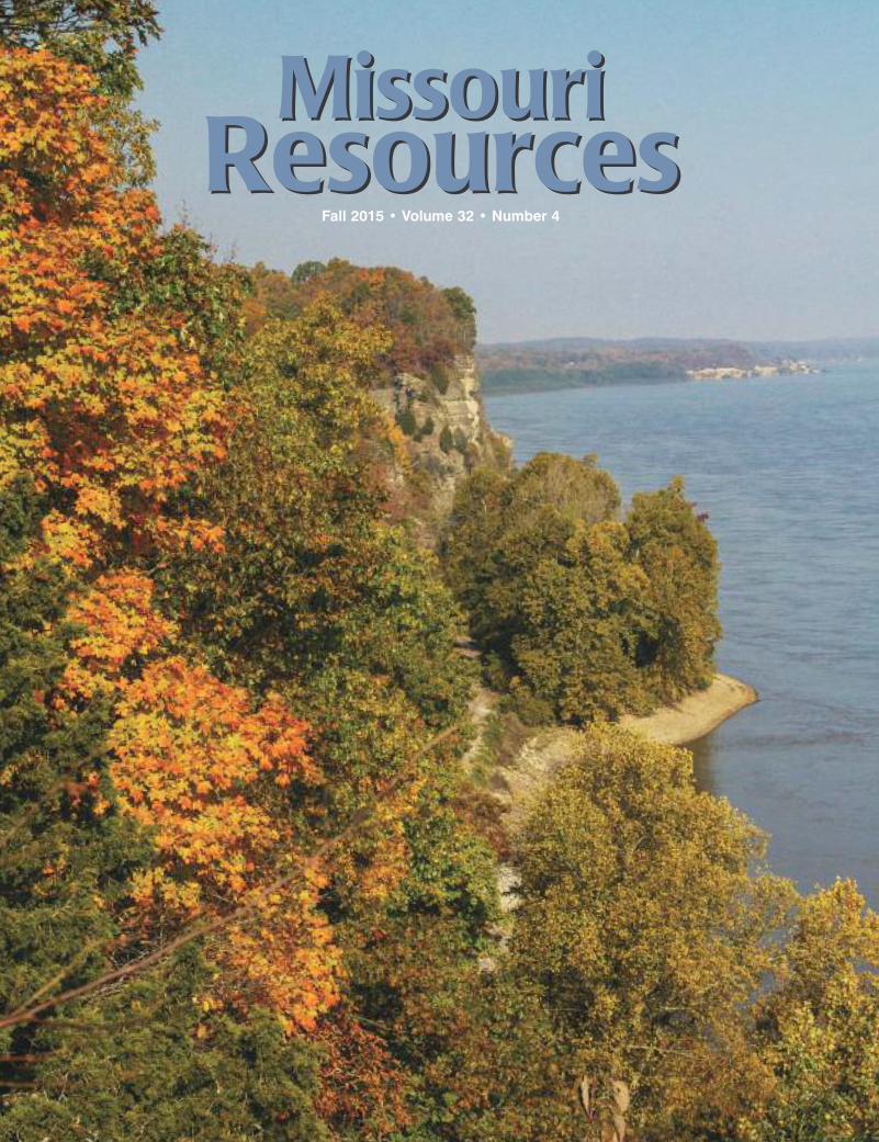
Above: The Lewis and Clark Interpretive Plaza at Lewis and Clark State Park in southwest Buchanan County.Front Cover: The Mississippi River as viewed from the overlook at Trail of Tears State Park in Cape Girardeau County.Back Cover: The Mayhan family, Claysville, enjoys a walk on the Katy Trail in Callaway County. DNR photos by Ben Nickelson.
departments18 Explore Missouri 20 DNR News 22 Top Spots 25 … But Not Least
2 The Big MuddyA Timeless Resourceby Joe GillmanThe Missouri River has provided life-sustaining water for millennia. We might be surprised that its massive watershed drains nearly one-sixth of the United States. Protecting this resource today will benefit future generations of Missourians and their neighbors.
6 From Eyesore to AssetRural Brownfield Sites Going Back to Workby Larry ArcherIt can be a tall order to restore an environmentally contaminated property back to appropriate health standards. In rural settings, the issues are challenging due to smaller tax bases and magnified when the site must be passed over for a less desirable alternative.
12 Missouri State History Flows on its Great Riverby Tom UhlenbrockIn 1804, 35 years after the founding of St. Charles, Lewis and Clark met in that fledgling river town to plan their historic expedition. That same trip today boasts many reminders of just why the Missouri River meant so much to so many – and still does today.
2 Missouri Resources
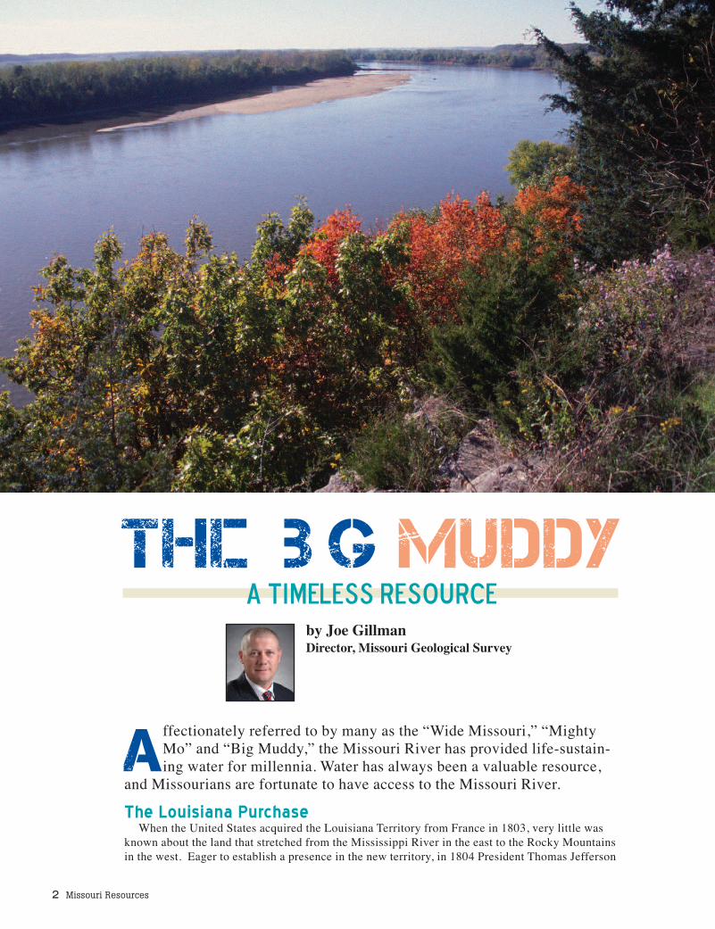
Affectionately referred to by many as the “Wide Missouri,” “MightyMo” and “Big Muddy,” the Missouri River has provided life-sustain-ing water for millennia. Water has always been a valuable resource,
and Missourians are fortunate to have access to the Missouri River.The Louisiana Purchase
When the United States acquired the Louisiana Territory from France in 1803, very little wasknown about the land that stretched from the Mississippi River in the east to the Rocky Mountainsin the west. Eager to establish a presence in the new territory, in 1804 President Thomas Jefferson
The IBig MuddyA Timeless Resource
by Joe GillmanDirector, Missouri Geological Survey
Fall 2015 3
commissioned Meriwether Lewis andWilliam Clark to lead the Corps of Discov-ery on an expedition to the Pacific North-west. The U.S. interests were both scientificand commercial – study the geography, ge-ology and biology, and establish a traderoute to the Pacific through the then OregonTerritory. This epic journey started in St.Louis on the Missouri River and ended onthe Pacific coast.
The Big Muddy - Present-dayThe modern Missouri River courses from
the Rockies across the Great Plains, eventu-ally emptying its contents into the Missis-sippi River and Gulf of Mexico. Along theway, it picks up and transports large quanti-ties of silt-sized sediment deposited by theglaciers. As the powerful river slowlyerodes at the soft sediment of the Plainsstates, this material becomes suspended inthe water column, giving the river that char-acteristic muddy look.
WatershedThe Missouri is the longest river in the
U.S. and combines with the Jefferson andMississippi rivers to make up the world’sfourth largest river system. A watershed isan area of land that drains water into a par-ticular river, lake or wetland. Watershedscan be divided into smaller watersheds suchas an area surrounding a specific smallcreek or stream. The Missouri River has adrainage area of 529,000 square miles(about one-sixth of the U.S.) and drainsparts or all of Montana, Wyoming, NorthDakota, South Dakota, Nebraska, Colorado,Kansas, Minnesota, Iowa, Missouri and twoCanadian provinces. The river flows ap-proximately 2,350 miles from its headwa-ters at the confluence of the Gallatin, Madi-son and Jefferson rivers in western Montanato its confluence with the Mississippi Rivernear St. Louis, Mo.
Life-sustaining WaterThe Missouri River has sustained many
societies. Native cultures utilized the riveras a source of navigation, food supply, tradeand shelter. Upon European settlement, theMissouri provided one of the main corridorsof westward expansion of a growing nationseeking riches in the fur trade and gold dis-coveries. As the population expanded andpermanent communities were established,control of the river was needed for a variety
of purposes. Numerous dams were con-structed along the river for power, to con-trol flooding, and to assist agriculture.
Later, in response to repeated floodingalong the river and continued pressures forutilization of water resources, Congresspassed the Flood Control Act of 1944 al-lowing several major dams to be construct-ed and managed by the U.S. Army Corps ofEngineers and the U.S. Bureau of Reclamation.
Today, these dams form the MissouriRiver main stem system and provide bene-fits to the entire Missouri River basin forwater supply, irrigation, navigation, recre-ation, power generation and flood control.
DNR file pho
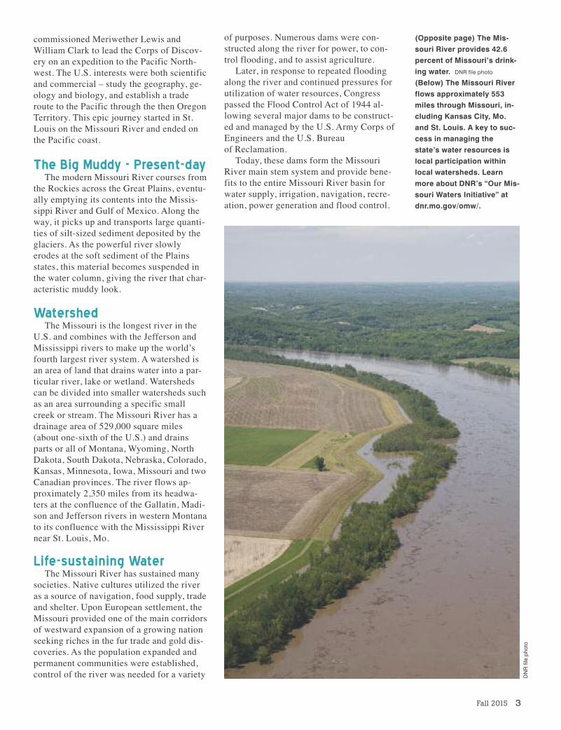
to
(Opposite page) The Mis-souri River provides 42.6percent of Missouri’s drink-ing water. DNR file photo(Below) The Missouri Riverflows approximately 553miles through Missouri, in-cluding Kansas City, Mo.and St. Louis. A key to suc-cess in managing thestate’s water resources islocal participation withinlocal watersheds. Learnmore about DNR’s “Our Mis-souri Waters Initiative” atdnr.mo.gov/omw/.

Access to Water for Missourians
Water is an extremely valuable re-source and is critical to our state’s pros-perity. Missourians’ interest in the Mis-souri River includes recreation, watersupply, power generation, transporta-tion and habitat for fish and game. Ac-cording to the U.S. Geological Survey,the average discharge at Hermann, Mo.is a little more than 87,000 cubic feetper second. That is equal to approxi-mately 39 million gallons every minute.Nearly half of all Missourians receivetheir drinking water from the river andits alluvium – the fine-grained soil con-sisting of mud, silt and sand formed byflowing water.
Increased demands on our water re-All of the land that drains water into the Missouri River from Three Forks, Mont., to St.Louis, Mo., is referred to as the Missouri River Basin.
Navigation and flood control are two important river uses the department advocates for on behalf of all Missourians.
4 Missouri Resources
Water Resources CenterThe Missouri Department of Natural Re-
sources’ Water Resources Center (WRC) isresponsible for addressing the development,conservation and utilization of the state’swater resources.
“Our staff members assist communities,public entities and state and federal agen-cies by providing expert technical assis-tance and guidance about issues such as in-terstate water management, drought andflood assessment, water resources planningand monitoring, statewide water use, in-stream flow recommendations and dam andreservoir safety,” said Andrea Collier, thedepartment’s Water Resources Center direc-tor and a deputy director with the MissouriGeological Survey, a division of the Depart-ment of Natural Resources. “Staff are com-mitted to ensuring the quantity of the state’swater resources are maintained at the high-est level practicable to support present andfuture use.”
DNR file pho
to
Fall 2015 5
sources, such as its use in energy produc-tion and agriculture, underline the need toprotect Missourians’ access to adequatesupplies of water from the river. As popula-tions expand, the demand for water increas-es and more projects are likely to be pro-posed and developed.
Writing to his mother from Fort Mandan,N.D., March 31, 1805, Lewis observed,“This immense river so far as we have yetascended, waters one of the fairest portionsof the globe, not do I believe that there is inthe universe a similar extent of country,equally fertile, well-watered, and intersect-ed by such a number of navigable streams.”
Much like the Corps of Discovery, thedepartment recognizes the value of the Mis-souri River and continues to advocate onbehalf of all Missourians so future genera-tions of Show-Me State residents can de-pend on it.
Learn more at dnr.mo.gov/env/wrc/interstate-waters/missouri_river.htm.
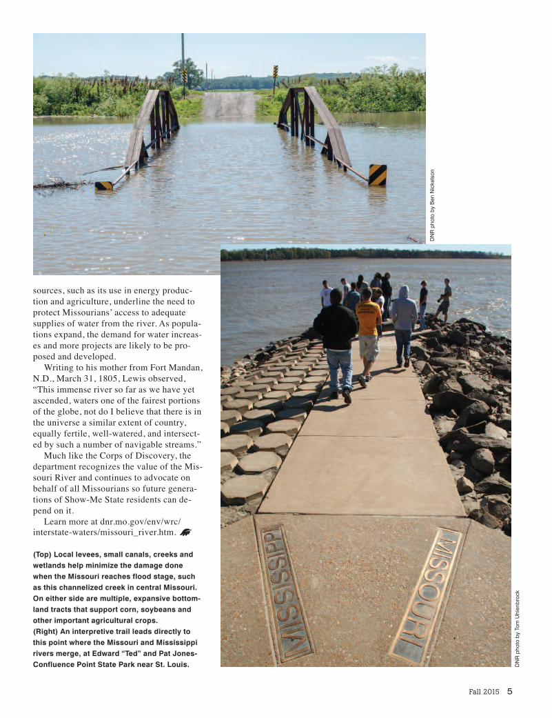
(Top) Local levees, small canals, creeks andwetlands help minimize the damage donewhen the Missouri reaches flood stage, suchas this channelized creek in central Missouri.On either side are multiple, expansive bottom-land tracts that support corn, soybeans andother important agricultural crops. (Right) An interpretive trail leads directly tothis point where the Missouri and Mississippirivers merge, at Edward “Ted” and Pat Jones-Confluence Point State Park near St. Louis.
DNR pho
to by Ben
Nicke
lson
DNR pho
to by To
m Uhlen
broc
k
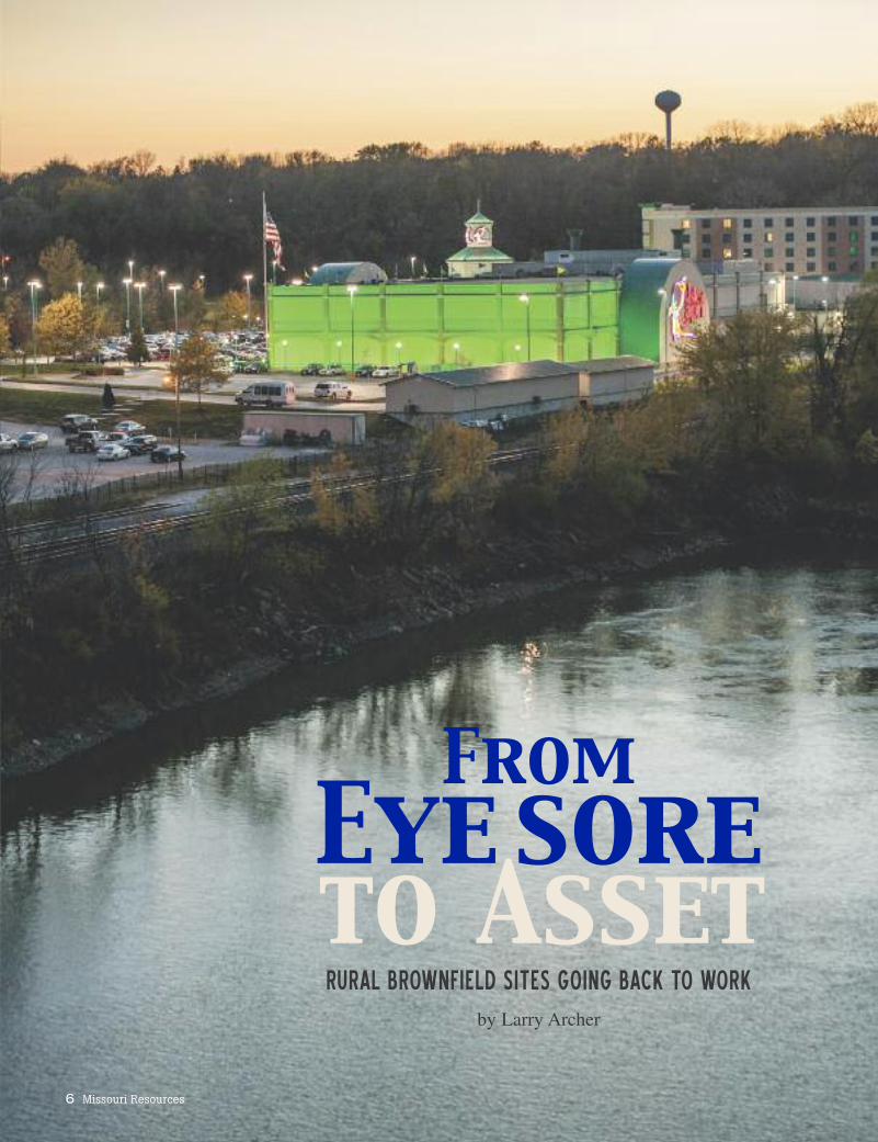
From Eye soreto AssetRURAL BROWNFIELD SITES GOING BACK TO WORK
by Larry Archer
6 Missouri Resources
Fall 2015 7
or decades, the North Street Gas Sta-tion in the mid-Missouri town of Cal-ifornia offered fuel and automotive
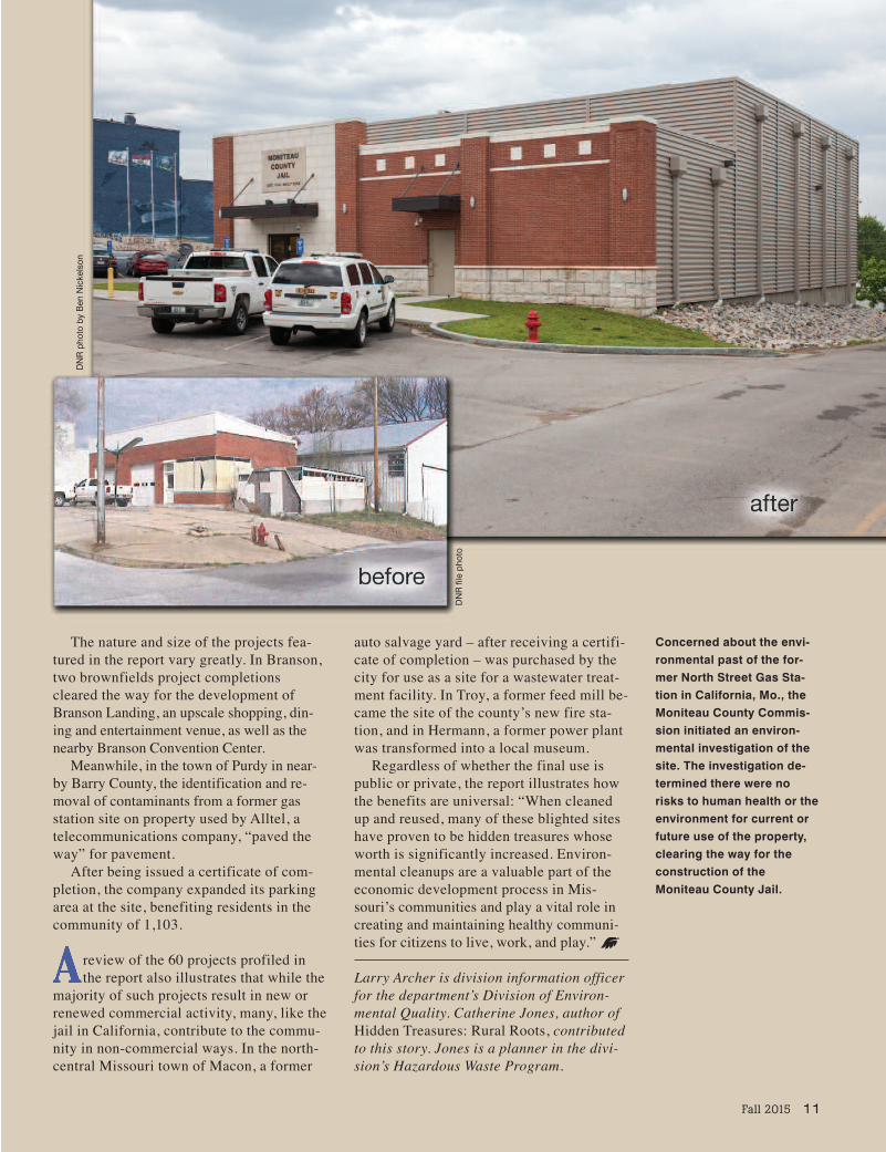
services to motorists. But by 2006, it of-fered nothing but a vivid example of thenegative effects an abandoned, potentiallycontaminated site can have on a community.
With trash at the site piling up on top ofthe ground, and uncertain contaminantslurking beneath, the location was sendingthe wrong message concerning the healthand vitality of the city of California.
“It was a trash heap,” said MoniteauCounty Presiding Commissioner KennethKunze, who would see the building daily onhis way into the county courthouse. “It wasan eyesore in the city.”
With its proximity to the courthouse, thecorner lot held potential, but the possibilityof residual contamination from its past as aservice station caused concern for the coun-ty commission, Kunze said.
“When we decided to build a new jail, wethought that was a good location,” he said.“Our main concern … was to make sure itwas clean.
“If it were contaminated, we wouldn’thave done it.”
To ensure all they were buying was prop-erty and not future headaches born of alegacy of leftover contaminants, the com-mission reached out to the Missouri Depart-ment of Natural Resources’Brownfields/Voluntary Cleanup Program toguide the effort to prepare the site for rede-velopment by giving it an environmentalclean bill of health, if appropriate.
“There was still the fear that there wascontamination at the site,” said ChristineO’Keefe, the department’s project managerfor the site. “They wanted to conduct aPhase 1 assessment before they purchasedthe property.”
The Phase 1 assessment, which is a his-torical review of the site, includes a recordsreview and interviews with neighbors andothers who might be familiar with the site.The assessment determined that no addi-tional cleanup was necessary for the site to
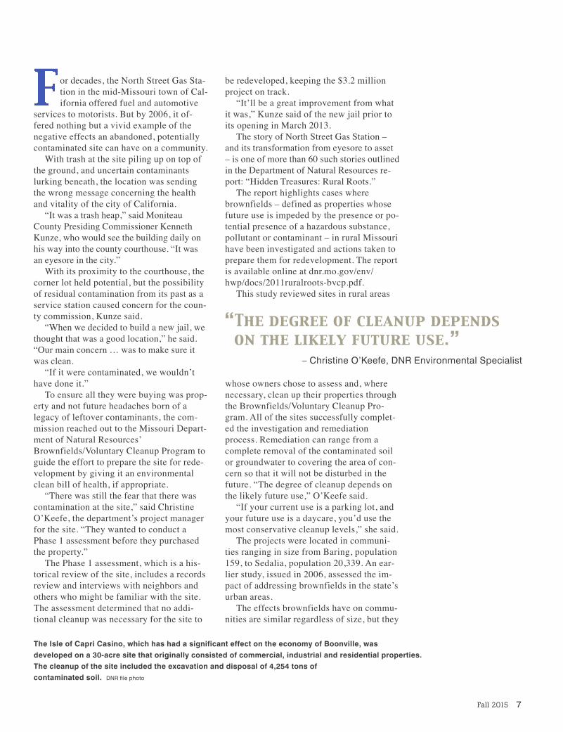
The Isle of Capri Casino, which has had a significant effect on the economy of Boonville, was developed on a 30-acre site that originally consisted of commercial, industrial and residential properties.The cleanup of the site included the excavation and disposal of 4,254 tons of contaminated soil. DNR file photo
be redeveloped, keeping the $3.2 millionproject on track.
“It’ll be a great improvement from whatit was,” Kunze said of the new jail prior toits opening in March 2013.
The story of North Street Gas Station –and its transformation from eyesore to asset – is one of more than 60 such stories outlinedin the Department of Natural Resources re-port: “Hidden Treasures: Rural Roots.”
The report highlights cases wherebrownfields – defined as properties whosefuture use is impeded by the presence or po-tential presence of a hazardous substance,pollutant or contaminant – in rural Missourihave been investigated and actions taken toprepare them for redevelopment. The reportis available online at dnr.mo.gov/env/hwp/docs/2011ruralroots-bvcp.pdf.
This study reviewed sites in rural areas
whose owners chose to assess and, wherenecessary, clean up their properties throughthe Brownfields/Voluntary Cleanup Pro-gram. All of the sites successfully complet-ed the investigation and remediationprocess. Remediation can range from acomplete removal of the contaminated soilor groundwater to covering the area of con-cern so that it will not be disturbed in thefuture. “The degree of cleanup depends onthe likely future use,” O’Keefe said.
“If your current use is a parking lot, andyour future use is a daycare, you’d use themost conservative cleanup levels,” she said.
The projects were located in communi-ties ranging in size from Baring, population159, to Sedalia, population 20,339. An ear-lier study, issued in 2006, assessed the im-pact of addressing brownfields in the state’surban areas.
The effects brownfields have on commu-nities are similar regardless of size, but they
“The degree of cleanup depends on the likely future use.”
– Christine O’Keefe, DNR Environmental Specialist
8 Missouri Resources
are magnified in rural communi-ties whose population and em-ployment base is smaller. The re-port outlines some of thenegative effects: “Properties withhazardous substance contamina-tion have significant effects upontheir communities. Contaminatedproperties are a blight on thespirit and economy of a commu-nity, and may represent threats toboth human and environmentalhealth,” according to the study.“Both the negative effects of abrownfield property and the posi-tive influence of its cleanup andredevelopment have a greaterproportional effect on a smallercommunity than in a large city.
“In all cases, the public healthexposure has been reduced andthe brownfield has been removedfrom the community,” the studywent on to state.
As with the case of the NorthStreet Gas Station in California,many sites require only a Phase1 assessment to determinewhether the site is suitable forcontinued redevelopment.
owever, one project high-lighted in the brownfields
redevelopment study requiredsome additional work in order toconvert a site in Lebanon, Mo.,into a new business employingmore than 30 people.
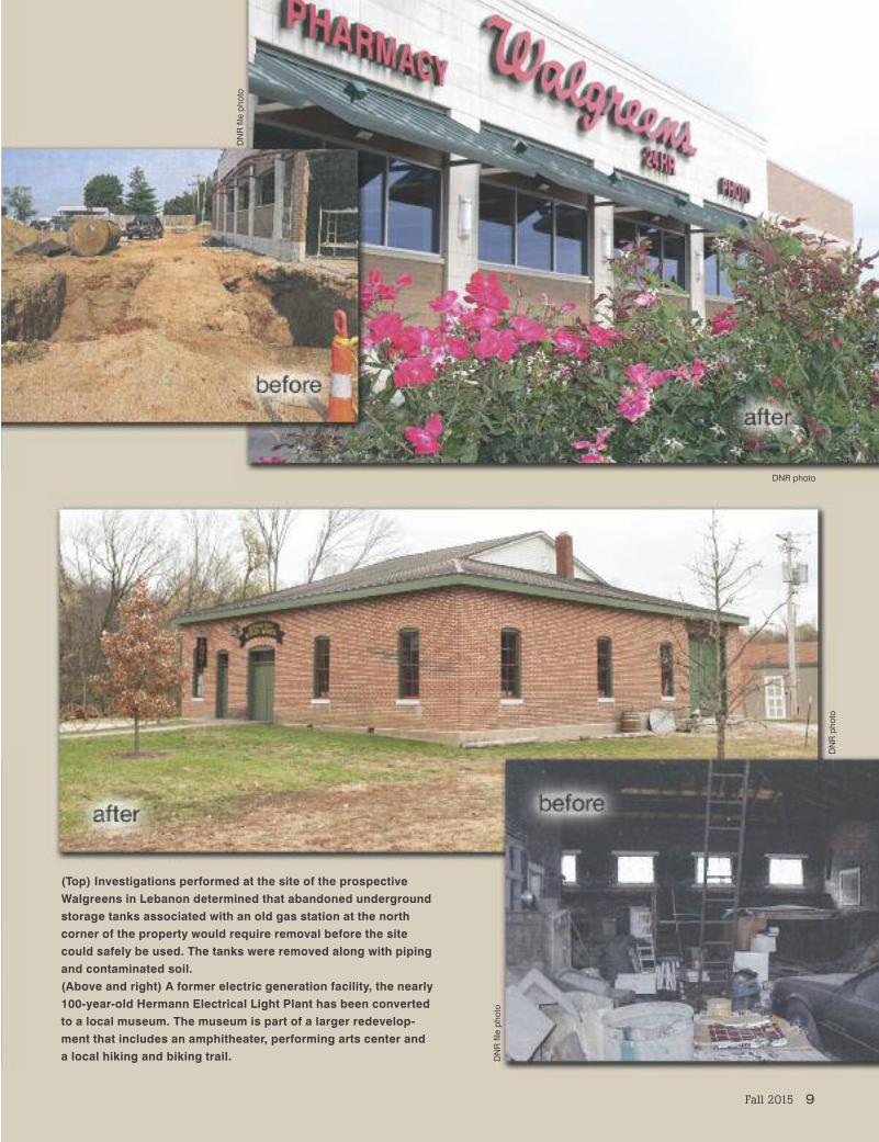
The national pharmacy chainWalgreens had identified the cor-ner of Jefferson and East Elm inLebanon as an ideal store loca-tion, but the site’s past, which in-cluded gas stations and a cardealership, was troubling.
“It’s their policy to have aclean piece of property beforethey begin,” said Chris Cady, thedepartment’s project managerwho oversaw the certificationprocess. Investigations indicatedthe site still possessed an under-ground fuel storage tank and soilcontaminated with heating oil,hydraulic fuel and gasoline. Re-moval of the tanks, related pipingand contaminated soil was re-quired for the project to continue.
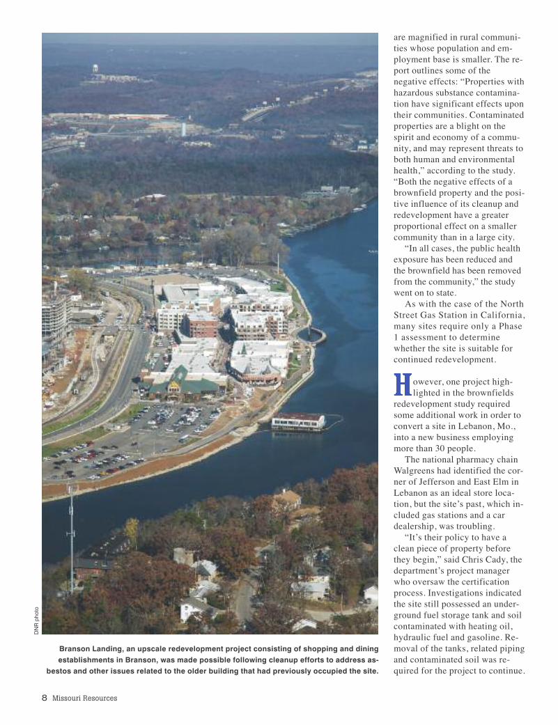
Branson Landing, an upscale redevelopment project consisting of shopping and dining establishments in Branson, was made possible following cleanup efforts to address as-
bestos and other issues related to the older building that had previously occupied the site.
DNR pho
to
Fall 2015 9
(Top) Investigations performed at the site of the prospectiveWalgreens in Lebanon determined that abandoned undergroundstorage tanks associated with an old gas station at the northcorner of the property would require removal before the sitecould safely be used. The tanks were removed along with pipingand contaminated soil.(Above and right) A former electric generation facility, the nearly100-year-old Hermann Electrical Light Plant has been convertedto a local museum. The museum is part of a larger redevelop-ment that includes an amphitheater, performing arts center anda local hiking and biking trail.
DNR pho
to
DNR photo
DNR file pho
to
DNR file pho
to

10 Missouri Resources
“Determining the location of a new storedepends on demographics, including futuregrowth, demand and competition,” accord-ing to Emily Hartwig of Walgreen’s mediarelations office. “However, environmentaluncertainty can affect the cost of develop-ing a site and the final decision of where tolocate a store.
“Having a clean bill of health positivelyimpacts the overall cost of the project andlowers the cost of the operation of thestore,” Hartwig said. “The severity of reme-diation needed could make it financiallyprohibitive to pursue a particular property.”
In addition to converting blight to busi-ness, projects like the Walgreens develop-ment also aid the bottom line of local cof-fers, according to Mark Stombaugh,president of Lebanon Regional EconomicDevelopment Incorporated (REDI).
“What wasn’t a productive property isnow spitting out all sorts of sales tax rev-enue,” Stombaugh said of the remediatedWalgreens site.
Stombaugh and Lebanon REDI are work-
ing with the department on other sitesthrough the Brownfields/Voluntary CleanupProgram, and recognize the potential effecton local tax revenue.
ringing in new business is only half theeconomic benefit of addressing brown-
fields in the rural community. The other halfinvolves retention of existing employers,the report noted.
“Over half of the sites continue to servethe current business owner, which in turnhelps keep them in business, keeps localpeople employed, and keeps bringing taxrevenue to the community,” the study re-ported. “Retaining businesses in rural com-munities is an important economic develop-ment tool in the quest for sustainabledevelopment.”
Similarly noted in the report was the factthat the effects do not end with the econom-ics. Addressing these issues also increases theaesthetic value of the property and helps allaythe health and environmental concerns heldby those who work and live near the sites.
Once the location of a man-ufactured gas plant, this
site near A.T. Still Universityin Kirksville required the re-moval of several thousandtons of contaminated soil,
debris and coal tar before itcould safely be convertedinto a parking lot for the
university. The site also issubject to a management
plan to ensure proper handling during anyfuture construction.
DNR file pho
to
DNR pho
to
The nature and size of the projects fea-tured in the report vary greatly. In Branson,two brownfields project completionscleared the way for the development ofBranson Landing, an upscale shopping, din-ing and entertainment venue, as well as thenearby Branson Convention Center.
Meanwhile, in the town of Purdy in near-by Barry County, the identification and re-moval of contaminants from a former gas station site on property used by Alltel, atelecommunications company, “paved theway” for pavement.
After being issued a certificate of com-pletion, the company expanded its parkingarea at the site, benefiting residents in thecommunity of 1,103.
review of the 60 projects profiled inthe report also illustrates that while the
majority of such projects result in new orrenewed commercial activity, many, like thejail in California, contribute to the commu-nity in non-commercial ways. In the north-central Missouri town of Macon, a former
auto salvage yard – after receiving a certifi-cate of completion – was purchased by thecity for use as a site for a wastewater treat-ment facility. In Troy, a former feed mill be-came the site of the county’s new fire sta-tion, and in Hermann, a former power plantwas transformed into a local museum.
Regardless of whether the final use ispublic or private, the report illustrates howthe benefits are universal: “When cleanedup and reused, many of these blighted siteshave proven to be hidden treasures whoseworth is significantly increased. Environ-mental cleanups are a valuable part of theeconomic development process in Mis-souri’s communities and play a vital role increating and maintaining healthy communi-ties for citizens to live, work, and play.”
Larry Archer is division information officerfor the department’s Division of Environ-mental Quality. Catherine Jones, author ofHidden Treasures: Rural Roots, contributedto this story. Jones is a planner in the divi-sion’s Hazardous Waste Program.
Concerned about the envi-ronmental past of the for-mer North Street Gas Sta-tion in California, Mo., theMoniteau County Commis-sion initiated an environ-mental investigation of thesite. The investigation de-termined there were norisks to human health or theenvironment for current orfuture use of the property,clearing the way for theconstruction of theMoniteau County Jail.
Fall 2015 11
DNR file pho
to
DNR pho
to by Ben
Nicke
lson

12 Missouri Resources
by Tom Uhlenbrock
he tale of human history in Missouri follows the great river that stretches across the state’smiddle. Traveling up this river takes visitors to state parks and historic sites that help tellthe story.
When the French explorers Jacques Marquette and Louis Jolliet arrived at the confluence of theMissouri and Mississippi rivers north of St. Louis in 1673, they were told a tribe of Native Ameri-cans living on the muddy river that led west was called the Oumessourit.
The name translated to “people of the big canoes,” and evolved into Missouria for the tribe, andto Missouri for the river and later the state that bordered its lower reaches.
DNR file photo

Fall 2015 13
Our voyage upriver begins at Edward“Ted” and Pat Jones-Confluence PointState Park, the only spot where a visitorcan put a foot in both of America’s greatrivers. A short walk from the interpretativekiosk ends at the meeting of the waters.
Some 20 miles upriver, on the south sideof a bend in the river, French traders in1769 founded the city that would becomeSt. Charles. Lewis and Clark met there in1804 to plan their grand expedition.
The First Missouri State Capitol StateHistoric Site explains how a now restoredbrick building on the city’s South MainStreet served as the first state capitol from1821 to 1826, when the capital was movedto Jefferson City.
A German lawyer and writer named Gottfried Duden visited the lower MissouriRiver Valley and published a book about itin 1829 in his homeland. His glowing ac-count of the area spawned a wave of immi-gration of Germans who founded townsfrom St. Louis to Boonville, with Augusta,Washington, Marthasville, New Haven andHermann in between.
Deutschheim State Historic Site at Her-mann, which retains its German heritage tothis day, features two homes that display theGerman architecture and lifestyle, insideand out. The handsome Pommer-Gentnerhouse was built in 1840, and was the firsttwo-story brick home in town.
An excellent way to explore the lowerriver valley is at Katy Trail State Park, alinear recreational trail built on an aban-doned rail line that stretches 240 miles,from Machens in St. Charles County toClinton near Kansas City.
he Katy Trail, which celebrates its 25thanniversary in 2015, includes a 165-
mile segment that follows the MissouriRiver from Machens to Boonville and isdesignated as part of the Lewis & Clark Na-tional Historic Trail.
The trail passes through Missouri winecountry, where the German immigrants es-tablished their grape-growing and wine-making traditions.
After the seat of government moved up-river to Jefferson City, James A. Crumpbuilt a three-story, white-stone building in1839 on the Missouri Landing, a blockaway from the state capitol.
Charles Lohman later bought the build-ing, which today is one of two that make upthe Jefferson Landing State Historic Site.Displays inside the renovated building ex-plain how it was a bustling commercial andtransportation hub as the nation was begin-ning its move west.
Business declined after railroads by-passed Jefferson City in the 1870s, and theLohman Building later was used for stor-age. Missouri State Parks recreated an
(Above) The “Big Muddy”and “Mighty Mississippi”merge into one near Manitou Bluffs, just north ofSt. Louis. Edward “Ted” andPat Jones-Confluence PointState Park features outdoorinterpretive exhibits aboutthe history of the rivers andthe role they played in theLewis and Clark Expedition.Pictured here is the conflu-ence prior to constructionof the park’s present-dayvisitor access (see page 5).Unlike the page 5 photo, thephotographer’s vantagepoint in this shot was reversed, putting the Mississippi on the right, and Missouri on the left.
DNR file pho
to

1850s general store inthe lower floor of thebuilding, which fea-tures a short movie toillustrate the area’shistory.
The Arrow Rockbluffs on the riverwest of Boonville firstappeared on a Frenchmap in 1732 as “pierrea fleche” – the rock of
arrows. The area became known as Boone’sLick Country because the sons of the leg-endary pioneer Daniel Boone operated asalt-manufacturing business in the river val-ley in 1805.
A narrow, winding trail now leads to thesite of the salt spring in the valley atBoone’s Lick State Historic Site. Interpre-tative signs help you visualize the substan-tial frontier industry once located there.
A ferry was established at Arrow Rock in1815, and the earliest travelers on the SantaFe Trail crossed the river on it.
y the middle of the 19th century,Arrow Rock had grown to a small city
of more than 1,000 residents. But railroadsand highways replaced river travel, and
(Top) The First Missouri StateCapitol State Historic Site inSt. Charles was Missouri’s
governing chambers from 1821 to 1826.
(Above) The Pommer-Gentner House at
Deutschheim State HistoricSite was the first two-storybrick building in Hermann.(Right) Missouri's AmericanIndian Cultural Center at Van
Meter State Park, Saline County, offers displays that in-terpret the cultural history of
the nine tribes that called Missouri home in the early 19th century.
DNR pho
tos by
Tom
Uhlen
broc
k
DNR pho
to by Ben
Nicke
lson
14 Missouri Resources
Arrow Rock declined to its present popula-tion of about 50 permanent residents.
Today, the Arrow Rock State HistoricSite preserves the charming town as a stepback in time with historic buildings and amodern visitor center. The J. Huston Tav-ern, built in 1834, still serves some of thebest fried chicken in the state.
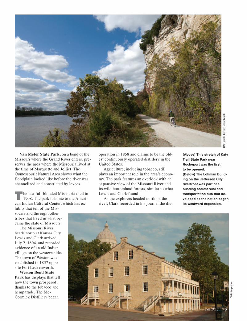
Van Meter State Park, on a bend of theMissouri where the Grand River enters, pre-serves the area where the Missouria lived atthe time of Marquette and Jolliet. TheOumessourit Natural Area shows what thefloodplain looked like before the river waschannelized and constricted by levees.
he last full-blooded Missouria died in1908. The park is home to the Ameri-
can Indian Cultural Center, which has ex-hibits that tell of the Mis-souria and the eight othertribes that lived in what be-came the state of Missouri.
The Missouri Riverheads north at Kansas City.Lewis and Clark arrivedJuly 2, 1804, and recordedevidence of an old Indianvillage on the western side.The town of Weston wasestablished in 1837 oppo-site Fort Leavenworth.
Weston Bend StatePark has displays that tellhow the town prospered,thanks to the tobacco andhemp trade. The Mc-Cormick Distillery began
operation in 1858 and claims to be the old-est continuously operated distillery in theUnited States.
Agriculture, including tobacco, stillplays an important role in the area’s econo-my. The park features an overlook with anexpansive view of the Missouri River andits wild bottomland forests, similar to whatLewis and Clark found.
As the explorers headed north on theriver, Clark recorded in his journal the dis-
(Above) This stretch of KatyTrail State Park nearRocheport was the first to be opened.(Below) The Lohman Build-ing on the Jefferson Cityriverfront was part of abustling commercial andtransportation hub that de-veloped as the nation beganits westward expansion.
Fall 2015 15
DNR pho
to by To
m Uhlen
broc
k
DNR file pho
to

covery of a lake “full of Geese & Goslings.”Today, the lake is the centerpiece of Lewisand Clark State Park.
The lake still draws waterfowl, especial-ly during fall migration when its surface iscrowded with geese, ducks, great blueherons, eagles, swans and snowy egrets.
Visitors can view the expansive natureshow from the Lewis and Clark Bicentenni-al Plaza that includes a scenic overlook andinterpretive materials.
Before they left the stretch of the riverthat bordered what became the northwestcorner of Missouri, the explorers recordedother oxbow lakes that had been left behindwhen the Missouri changed its course.
ig Lake, the largest remaining oxbowlake in Missouri, would have attracted
their attention. Big Lake State Park is on the east side
of the 625-acre lake, and acts like a magnet
(Above) After a short walkto the overlook, visitors toWeston Bend State Park
are rewarded with a beautiful view of the Missouri River Valley.
(Below) An estimated 500,000snow geese visited Big Lake
State Park in Holt County during winter 2014-2015.
DNR photo by Tom Uhlenbrock
16 Missouri Resources
DNR pho
to by Ben
Nicke
lson

Fall 2015 17
to attract waterfowl migrating in the springand fall over the agricultural fields.
ast winter, wildlife researchers estimat-ed 500,000 snow geese, and nearly 100
bald eagles, were resting and feeding at thelake – the largest number ever recorded.
One of the great wildlife spectacles inMissouri in winter is the rising of the snowgeese from the misty lake each morning in awhirling white tornado. Unlike the honkingof Canada geese, snow geese have ascreeching call that makes for an eerie ca-cophony in the silence of daybreak.
Like the Missouria and other first inhabi-tants, and the explorers and traders that fol-lowed them, the waterfowl use the MissouriRiver as their highway. If the weather at BigLake grows cold, the snow geese will movesouth and may end up in the pools and wet-lands near Confluence Point State Park.
For more information, visitmostateparks.com.
Tom Uhlenbrock is a writer for MissouriState Parks.
(Above) Bikers follow Katy Trail State Park along the Missouri River inCallaway County on a sunny fall day.(Below) A reproduction of Lewis and Clark’s keelboat can be viewedat Lewis and Clark State Park in Buchanan County.
DNR pho
to by Ben
Nicke
lson
DNR pho
to by Ben
Nicke
lson
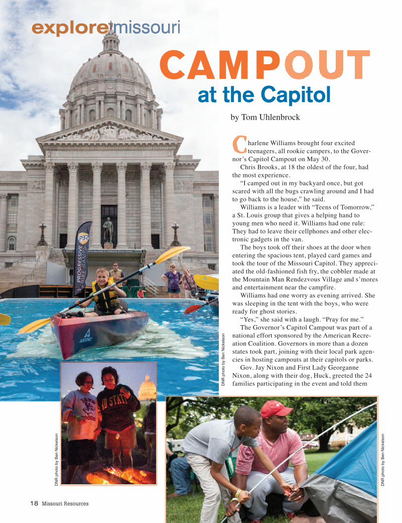
harlene Williams brought four excitedteenagers, all rookie campers, to the Gover-
nor’s Capitol Campout on May 30.Chris Brooks, at 18 the oldest of the four, had
the most experience.“I camped out in my backyard once, but got
scared with all the bugs crawling around and I hadto go back to the house,” he said.
Williams is a leader with “Teens of Tomorrow,”a St. Louis group that gives a helping hand toyoung men who need it. Williams had one rule:They had to leave their cellphones and other elec-tronic gadgets in the van.
The boys took off their shoes at the door whenentering the spacious tent, played card games andtook the tour of the Missouri Capitol. They appreci-ated the old-fashioned fish fry, the cobbler made atthe Mountain Man Rendezvous Village and s’moresand entertainment near the campfire.
Williams had one worry as evening arrived. Shewas sleeping in the tent with the boys, who wereready for ghost stories.
“Yes,” she said with a laugh. “Pray for me.”The Governor’s Capitol Campout was part of a
national effort sponsored by the American Recre-ation Coalition. Governors in more than a dozenstates took part, joining with their local park agen-cies in hosting campouts at their capitols or parks.
Gov. Jay Nixon and First Lady GeorganneNixon, along with their dog, Huck, greeted the 24families participating in the event and told them
18 Missouri Resources
CAMPat the Capitol
by Tom Uhlenbrock
explore
DNR pho
to by Ben
Nicke
lson
DNR pho
to by Ben
Nicke
lson
DNR pho
to by Ben
Nicke
lson
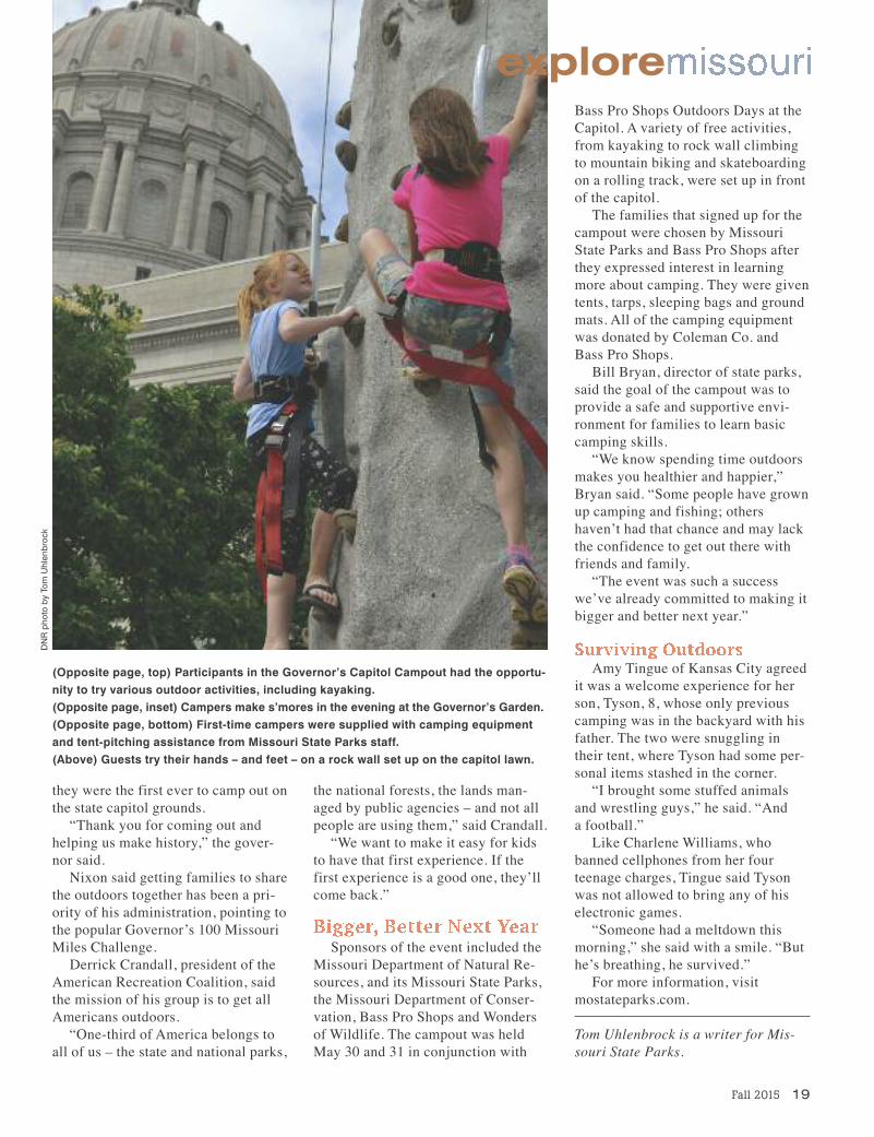
they were the first ever to camp out onthe state capitol grounds.
“Thank you for coming out andhelping us make history,” the gover-nor said.
Nixon said getting families to sharethe outdoors together has been a pri-ority of his administration, pointing tothe popular Governor’s 100 MissouriMiles Challenge.
Derrick Crandall, president of theAmerican Recreation Coalition, saidthe mission of his group is to get allAmericans outdoors.
“One-third of America belongs toall of us – the state and national parks,
the national forests, the lands man-aged by public agencies – and not allpeople are using them,” said Crandall.
“We want to make it easy for kidsto have that first experience. If thefirst experience is a good one, they’llcome back.”
Sponsors of the event included theMissouri Department of Natural Re-sources, and its Missouri State Parks,the Missouri Department of Conser-vation, Bass Pro Shops and Wonders of Wildlife. The campout was heldMay 30 and 31 in conjunction with
Bass Pro Shops Outdoors Days at theCapitol. A variety of free activities,from kayaking to rock wall climbingto mountain biking and skateboardingon a rolling track, were set up in frontof the capitol.
The families that signed up for thecampout were chosen by MissouriState Parks and Bass Pro Shops afterthey expressed interest in learningmore about camping. They were giventents, tarps, sleeping bags and groundmats. All of the camping equipmentwas donated by Coleman Co. andBass Pro Shops.
Bill Bryan, director of state parks,said the goal of the campout was toprovide a safe and supportive envi-ronment for families to learn basiccamping skills.
“We know spending time outdoorsmakes you healthier and happier,”Bryan said. “Some people have grownup camping and fishing; othershaven’t had that chance and may lackthe confidence to get out there withfriends and family.
“The event was such a successwe’ve already committed to making itbigger and better next year.”
Amy Tingue of Kansas City agreedit was a welcome experience for herson, Tyson, 8, whose only previouscamping was in the backyard with hisfather. The two were snuggling intheir tent, where Tyson had some per-sonal items stashed in the corner.
“I brought some stuffed animalsand wrestling guys,” he said. “And a football.”
Like Charlene Williams, whobanned cellphones from her fourteenage charges, Tingue said Tysonwas not allowed to bring any of hiselectronic games.
“Someone had a meltdown thismorning,” she said with a smile. “Buthe’s breathing, he survived.”
For more information, visit mostateparks.com.
Tom Uhlenbrock is a writer for Mis-souri State Parks.
Fall 2015 19
(Opposite page, top) Participants in the Governor’s Capitol Campout had the opportu-nity to try various outdoor activities, including kayaking.(Opposite page, inset) Campers make s’mores in the evening at the Governor’s Garden.(Opposite page, bottom) First-time campers were supplied with camping equipmentand tent-pitching assistance from Missouri State Parks staff.(Above) Guests try their hands – and feet – on a rock wall set up on the capitol lawn.
exploreDNR pho
to by To
m Uhlen
broc
k

20 Missouri Resources
dnr100 Missouri MilesChallenge ReceivesNational Award
American Trails, a na-tional, nonprofit organi-zation working on behalfof the nation’s hiking,biking and riding trails,has recognized Missouriwith the OutstandingMedia Award for the Governor’s 100Missouri Miles Challenge,an initiative launched by Gov. JayNixon in 2013.
The award was announced in Mayat the International Trails Symposiumin Portland, Ore. The national awardrecognizes significant and sustainedefforts to provide positive public expo-
sure and education in the field of trailuse, planning, design, implementationor policies.
For more information and to takethe challenge, visit MO.gov. Partici-pants also can share adventures, postphotos and learn about upcomingevents by connecting with 100 Mis-souri Miles on Facebook and Twitterusing #100MoMiles.
Pembroke Hill High SchoolWins Second NationalNCF-Envirothon
Held in Springfield July 27-Aug. 2,the national event saw Pembroke HillHigh School take top honors for thesecond time, winning previously in2012. The team also earned the top
score for aquatics, oral presentationand current issue, competing against52 other teams from the United Statesand Canada.
“I’m so proud of the commitment thestudents of Pembroke Hill give to theEnvirothon,” said Judy Stinson, an envi-ronmental education specialist with thedepartment’s Soil and Water Conserva-tion Program. “We were so pleased tohave them represent Missouri,” addedStinson, co-chair of the annualstatewide Envirothon competition.
Envirothon is a natural resourcecompetition sponsored by the Mis-souri Association of Soil and WaterConservation Districts, and the localsoil and water districts. The Depart-ment of Natural Resources has been a
The Grand Army of the Republic(G.A.R) Ribbon Banner was created in1936 by Marian Kornbleet, Secretary ofthe Missouri G.A.R. and presented to theNational G.A.R. The banner is particular-ly significant for its inclusion of theG.A.R, Ladies of the Grand Army of theRepublic (L.G.A.R.) and Woman’s ReliefCorps (W.R.C.) ribbons, which wereused during the organizations’ annualencampments. The ribbons date from asearly as 1886 to as late as 1935 and arefrom groups across America.
The G.A.R was founded in 1866. Theinitial intention for the organization wasto provide benefits to Union veteransthat served during the American CivilWar, and their families. In addition to its advocacy work, the G.A.R developed into a fraternal organization. Each annual en-campment had multi-day events that included camping, formal dinners and memorials. The first encampment was held inDecatur, Ill. on April 6, 1886.
In 1888, there were 382 encampments in Missouri and numbers rose to more than 500 by 1893. There are at least twoG.A.R memorial sites in Missouri. One, located in Carthage in Park Cemetery, contains a granite monument. The other, lo-cated in Laclede at the corner of Grove and Cole streets, has a bronze statue dedicated to the Phil Kearny G.A.R. Post No. 19.
The quilt is one of approximately 30,000 artifacts in the Missouri State Museum’s collection. The Missouri State Museum,which is a part of Missouri State Parks, houses its artifacts at the Riverside Collections Facility, a secured warehouse onemile east of the Missouri State Capitol building.
Send your photo to “Time Exposures,” c/o Missouri Resources, PO Box 176, Jefferson City, MO 65102-0176. Original photos will be returned viainsured mail. Pre-1980 environmental and natural resource photos from Missouri will be considered. Please try to include the date and location ofthe picture, a brief description and any related historic details that may be of interest to our readers.
Time Exposures
DNR pho
to by And
rew Richm
ond
“I congratulate the authors and theMissouri Geological Survey for pro-ducing a superb publication,” saidJohn G. Parrish, Ph.D., PG, AASGpast-president and awards chair.
The award-winning publication isavailable for purchase at missourigeologystore.com/Paleozoic-Succession-Cambrian/.
Fall 2015 21
For news releases on the Web, visitdnr.mo.gov/news.
For a complete listing of the department’supcoming meetings, hearings and events, visitthe department’s online calendar atdnr.mo.gov/calendar/search.do.
dnrpartner since 1998, when it held itsfirst state competition. A feature storyon the 2015 Envirothon will run in thewinter issue of Missouri Resources.
Earth Science Week 2015
Earth ScienceWeek aims to helpthe public gain a bet-ter understandingand appreciation forthe Earth sciences
and to encourage stewardship of theEarth. This year’s activities will be heldOct. 11-17 and will celebrate thetheme “Visualizing Earth’s Systems.”
On National Fossil Day, Oct. 14,visitors to the Ed Clark Museum ofMissouri Geology, in Rolla, will receivea crinoid fossil. Be sure to check outthe fossils in the limestone of the Mis-souri State Capitol, as well.
Join millions in the Great CentralU.S. ShakeOut “Drop, Cover, andHold On” earthquake drill to be heldOct. 15 at 10:15 a.m.
Geologic Map Day is scheduled forOct. 16 to promote the importance ofgeologic mapping.
Missouri Geological Survey geolo-gists are sponsoring an educationalbooth Oct. 17 at the Ozark MountainGem and Mineral Society’s Rock,Gem and Mineral Show, at the ExpoCenter in Springfield.
Go ahead – be a citizen scientist.Learn more at dnr.mo.gov/geology/education.htm.
Geologists ReceivePublication Award
The Associationof American StateGeologists selectedthe Missouri Geo-logical Survey, a di-vision of the Depart-
ment of Natural Resources, as therecipient of their 2015 Charles J.Mankin Memorial Award.
Mankin, the Oklahoma state geolo-gist for more than 40 years, wasworld-renowned for his work in miner-al and energy resources.
The Paleozoic Succession in Mis-souri, Part 1 (Revised) – CambrianSystem, was authored by Justin G.Davis and Patrick S. Mulvany (MGS),James R. Palmer and Thomas L.Thompson (MGS, retired), and KevinR. Evans, Vincent E. Kurtz, James F.Miller and John F. Repetski.
This highly detailed publicationthoroughly investigates the Paleozoicstratigraphic succession and is con-sidered the leading midcontinentguide for Paleozoic stratigraphic suc-cession in the region.
The award will be presented in No-vember in Baltimore, Md., in concertwith the Geological Society of Ameri-ca’s annual meeting.
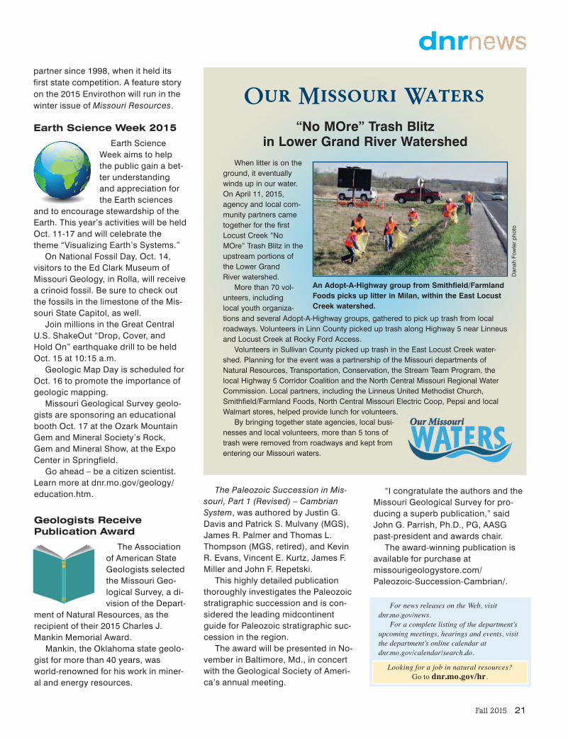
When litter is on theground, it eventuallywinds up in our water.On April 11, 2015,agency and local com-munity partners cametogether for the firstLocust Creek “NoMOre” Trash Blitz in theupstream portions of the Lower Grand River watershed.
More than 70 vol-unteers, includinglocal youth organiza-tions and several Adopt-A-Highway groups, gathered to pick up trash from localroadways. Volunteers in Linn County picked up trash along Highway 5 near Linneusand Locust Creek at Rocky Ford Access.
Volunteers in Sullivan County picked up trash in the East Locust Creek water-shed. Planning for the event was a partnership of the Missouri departments ofNatural Resources, Transportation, Conservation, the Stream Team Program, thelocal Highway 5 Corridor Coalition and the North Central Missouri Regional WaterCommission. Local partners, including the Linneus United Methodist Church,Smithfield/Farmland Foods, North Central Missouri Electric Coop, Pepsi and localWalmart stores, helped provide lunch for volunteers.
By bringing together state agencies, local busi-nesses and local volunteers, more than 5 tons oftrash were removed from roadways and kept fromentering our Missouri waters.
Our Missouri Waters“No MOre” Trash Blitz
in Lower Grand River Watershed
An Adopt-A-Highway group from Smithfield/FarmlandFoods picks up litter in Milan, within the East LocustCreek watershed.
Dan
ah Fow
ler ph
oto
Looking for a job in natural resources? Go to dnr.mo.gov/hr.

22 Missouri Resources
topspots
Top Spots to Backpack
Seventeen of Missouri’s state parks offer op-portunities for backpacking. Guests wanting
to explore the wilderness of these state parks allday and night should plan to visit Hawn, Sam A.Baker, and Meramec state parks.
The Mudlick Trail, at Sam A. Baker StatePark, climbs from 415 feet above sea level tomore than 1,300 feet above sea level over someof the most rugged terrain in the St. FrancoisMountains. Guests on the trail are given the op-portunity to view and take pictures at some of thebest sights the park has to offer, such as the coolwaters of the St. Francois River and the BigCreek Valley. The length of the trail, beginningfrom the equestrian campground, is about 16.75miles and takes an estimated 16 hours and 45minutes to complete.
The 9.75-mile Whispering Pines Trail at HawnState Park provides a mixture of hardwoods andpine forests, which is home to a variety of ani-mals, such as bobcats and wild turkeys. Expo-sures of sandstone and granite are found and canbe explored along the banks of Pickle Creek andthe River Aux Vases. The trail is easy to navigateas it is signed in a counterclockwise directionwith colored arrows; additional arrows lead tocamping areas.
The Wilderness Trail is the longest trail inMeramec State Park, totaling 8.5 miles. Back-packers will have a good opportunity to experi-ence the natural and geologic wonders of thepark with an adventure on this trail. The routewinds through the Meramec Upland Forest Natu-ral Area, which is a rugged and remote area ofthe park. There are eight backpacking camps pro-vided along the trail.
As with any lengthy backpacking trip, it is ad-vised to come prepared and be ready for chang-ing weather conditions.
(Above) Gregg and Sheila Buswell of St. Louishike the Whispering Pines Trail at Hawn StatePark with their dog, Luke. (Left) The North Loop of the Whispering PinesTrail covers 6 miles of the 9.75-mile trail.
(Bottom) The Mudlick Trail takes backpackers up Mudlick Mountain andoffers views of the Big Creek Valley in Sam A. Baker State Park. DNR photos by Tom Uhlenbrock
Fall 2015 23
trailshighlight
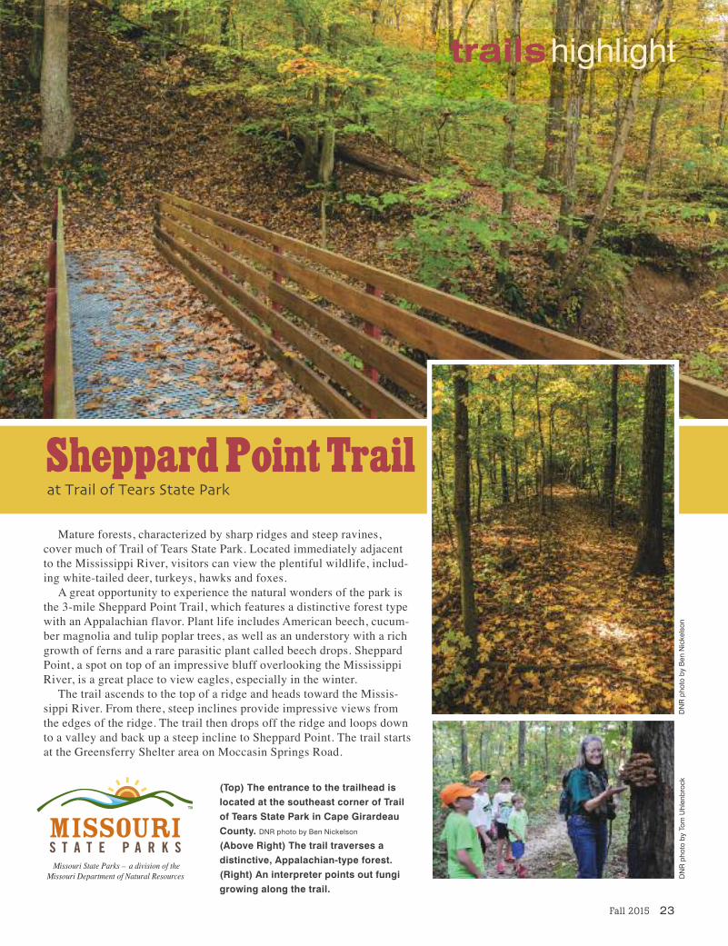
Mature forests, characterized by sharp ridges and steep ravines,cover much of Trail of Tears State Park. Located immediately adjacentto the Mississippi River, visitors can view the plentiful wildlife, includ-ing white-tailed deer, turkeys, hawks and foxes.
A great opportunity to experience the natural wonders of the park isthe 3-mile Sheppard Point Trail, which features a distinctive forest typewith an Appalachian flavor. Plant life includes American beech, cucum-ber magnolia and tulip poplar trees, as well as an understory with a richgrowth of ferns and a rare parasitic plant called beech drops. SheppardPoint, a spot on top of an impressive bluff overlooking the MississippiRiver, is a great place to view eagles, especially in the winter.
The trail ascends to the top of a ridge and heads toward the Missis-sippi River. From there, steep inclines provide impressive views fromthe edges of the ridge. The trail then drops off the ridge and loops downto a valley and back up a steep incline to Sheppard Point. The trail startsat the Greensferry Shelter area on Moccasin Springs Road.
(Top) The entrance to the trailhead is located at the southeast corner of Trailof Tears State Park in Cape GirardeauCounty. DNR photo by Ben Nickelson(Above Right) The trail traverses a distinctive, Appalachian-type forest.(Right) An interpreter points out fungigrowing along the trail.
Sheppard Point Trailat Trail of Tears State Park
DNR pho
to by To
m Uhlen
broc
kDNR pho
to by Ben
Nicke
lson
24 Missouri Resources
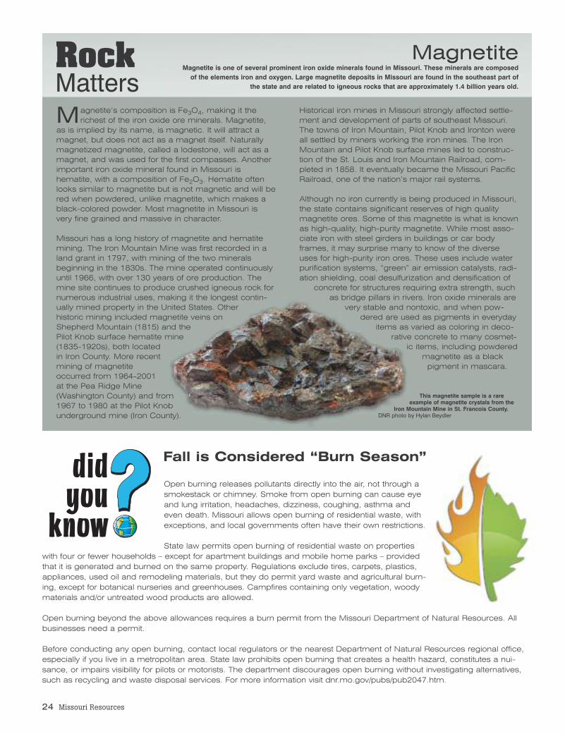
Magnetite’s composition is Fe3O4, making it therichest of the iron oxide ore minerals. Magnetite,
as is implied by its name, is magnetic. It will attract amagnet, but does not act as a magnet itself. Naturallymagnetized magnetite, called a lodestone, will act as amagnet, and was used for the first compasses. Anotherimportant iron oxide mineral found in Missouri ishematite, with a composition of Fe2O3. Hematite oftenlooks similar to magnetite but is not magnetic and will bered when powdered, unlike magnetite, which makes ablack-colored powder. Most magnetite in Missouri isvery fine grained and massive in character.
Missouri has a long history of magnetite and hematitemining. The Iron Mountain Mine was first recorded in aland grant in 1797, with mining of the two mineralsbeginning in the 1830s. The mine operated continuouslyuntil 1966, with over 130 years of ore production. Themine site continues to produce crushed igneous rock fornumerous industrial uses, making it the longest contin-ually mined property in the United States. Otherhistoric mining included magnetite veins onShepherd Mountain (1815) and thePilot Knob surface hematite mine(1835-1920s), both locatedin Iron County. More recentmining of magnetiteoccurred from 1964-2001at the Pea Ridge Mine(Washington County) and from1967 to 1980 at the Pilot Knobunderground mine (Iron County).
Historical iron mines in Missouri strongly affected settle-ment and development of parts of southeast Missouri.The towns of Iron Mountain, Pilot Knob and Ironton wereall settled by miners working the iron mines. The IronMountain and Pilot Knob surface mines led to construc-tion of the St. Louis and Iron Mountain Railroad, com-pleted in 1858. It eventually became the Missouri PacificRailroad, one of the nation’s major rail systems.
Although no iron currently is being produced in Missouri,the state contains significant reserves of high qualitymagnetite ores. Some of this magnetite is what is knownas high-quality, high-purity magnetite. While most asso-ciate iron with steel girders in buildings or car bodyframes, it may surprise many to know of the diverseuses for high-purity iron ores. These uses include waterpurification systems, “green” air emission catalysts, radi-ation shielding, coal desulfurization and densification of
concrete for structures requiring extra strength, suchas bridge pillars in rivers. Iron oxide minerals are
very stable and nontoxic, and when pow-dered are used as pigments in everyday
items as varied as coloring in deco-rative concrete to many cosmet-
ic items, including powderedmagnetite as a blackpigment in mascara.
Magnetite Magnetite is one of several prominent iron oxide minerals found in Missouri. These minerals are composedof the elements iron and oxygen. Large magnetite deposits in Missouri are found in the southeast part of
the state and are related to igneous rocks that are approximately 1.4 billion years old.
Open burning releases pollutants directly into the air, not through asmokestack or chimney. Smoke from open burning can cause eyeand lung irritation, headaches, dizziness, coughing, asthma andeven death. Missouri allows open burning of residential waste, withexceptions, and local governments often have their own restrictions.
State law permits open burning of residential waste on propertieswith four or fewer households – except for apartment buildings and mobile home parks – providedthat it is generated and burned on the same property. Regulations exclude tires, carpets, plastics,appliances, used oil and remodeling materials, but they do permit yard waste and agricultural burn-ing, except for botanical nurseries and greenhouses. Campfires containing only vegetation, woodymaterials and/or untreated wood products are allowed.
Open burning beyond the above allowances requires a burn permit from the Missouri Department of Natural Resources. Allbusinesses need a permit.
Before conducting any open burning, contact local regulators or the nearest Department of Natural Resources regional office,especially if you live in a metropolitan area. State law prohibits open burning that creates a health hazard, constitutes a nui-sance, or impairs visibility for pilots or motorists. The department discourages open burning without investigating alternatives,such as recycling and waste disposal services. For more information visit dnr.mo.gov/pubs/pub2047.htm.
did youknow
RockMatters
This magnetite sample is a rareexample of magnetite crystals from the
Iron Mountain Mine in St. Francois County.DNR photo by Hylan Beydler
Fall is Considered “Burn Season”
not least
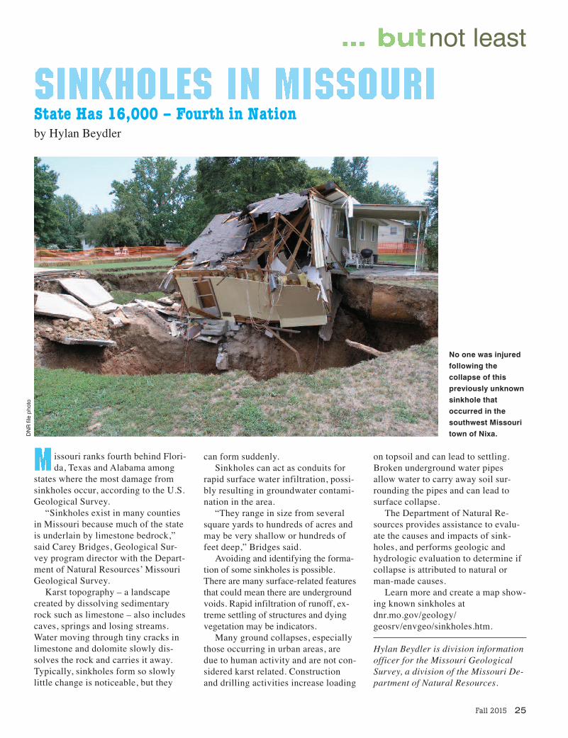
issouri ranks fourth behind Flori-da, Texas and Alabama among
states where the most damage fromsinkholes occur, according to the U.S.Geological Survey.
“Sinkholes exist in many countiesin Missouri because much of the stateis underlain by limestone bedrock,”said Carey Bridges, Geological Sur-vey program director with the Depart-ment of Natural Resources’ MissouriGeological Survey.
Karst topography – a landscapecreated by dissolving sedimentaryrock such as limestone – also includescaves, springs and losing streams.Water moving through tiny cracks inlimestone and dolomite slowly dis-solves the rock and carries it away.Typically, sinkholes form so slowlylittle change is noticeable, but they
can form suddenly. Sinkholes can act as conduits for
rapid surface water infiltration, possi-bly resulting in groundwater contami-nation in the area.
“They range in size from severalsquare yards to hundreds of acres andmay be very shallow or hundreds offeet deep,” Bridges said.
Avoiding and identifying the forma-tion of some sinkholes is possible.There are many surface-related featuresthat could mean there are undergroundvoids. Rapid infiltration of runoff, ex-treme settling of structures and dyingvegetation may be indicators.
Many ground collapses, especiallythose occurring in urban areas, aredue to human activity and are not con-sidered karst related. Constructionand drilling activities increase loading
State Has 16,000 – Fourth in Nationby Hylan Beydler
No one was injuredfollowing the collapse of this previously unknownsinkhole that occurred in thesouthwest Missouritown of Nixa.
Fall 2015 25
on topsoil and can lead to settling.Broken underground water pipesallow water to carry away soil sur-rounding the pipes and can lead tosurface collapse.
The Department of Natural Re-sources provides assistance to evalu-ate the causes and impacts of sink-holes, and performs geologic andhydrologic evaluation to determine ifcollapse is attributed to natural orman-made causes.
Learn more and create a map show-ing known sinkholes atdnr.mo.gov/geology/geosrv/envgeo/sinkholes.htm.
Hylan Beydler is division informationofficer for the Missouri GeologicalSurvey, a division of the Missouri De-partment of Natural Resources.
DNR file pho
to

MISSOURI DEPARTMENT OF NATURAL RESOURCESPO Box 176Jefferson City, MO 65102-0176
Nonprofit Org.US POSTAGE PAID
MO Dept. ofNatural
Resources
Buddy Miles“Buddy Miles” allows you to adddependents to your account so
that anyone can join the 100 Missouri Miles Challenge!Parents can log miles for theirchildren or other dependents.Pet owners can log miles fortheir pets as they join them
on the trails. Find out more at100missourimiles.com!