Mississauga Road, Old Main Street, Bush Street - PIC #1 Boards · Mississauga Road, Olde Base Line...
28
4/30/2013 1 Mississauga Road, Olde Base Line Road, Bush Street, Old Main Street, and Winston Churchill Boulevard Class EA Public Information Centre #1 Thursday, May 9, 2013 Belfountain Public School May 9, 2013 Welcome 1 • Please sign in and take a workbook • If you have any questions our team is available to help you • Place your completed workbook in the Comment Box, or send it to: Gino Dela Cruz Asha Saddi Project Manager Technical Analyst [email protected] [email protected] by Thursday, May 23, 2013
Transcript of Mississauga Road, Old Main Street, Bush Street - PIC #1 Boards · Mississauga Road, Olde Base Line...

4/30/2013
1
Mississauga Road, Olde Base Line Road, Bush Street, Old Main Street, and Winston
Churchill Boulevard Class EA
Public Information Centre #1Thursday, May 9, 2013
Belfountain Public School
May 9, 2013
Welcome1
•Please sign in and take a workbook
•If you have any questions our team is available
to help you
•Place your completed workbook in the
Comment Box, or send it to:
Gino Dela Cruz Asha Saddi
Project Manager Technical Analyst
[email protected] [email protected]
by Thursday, May 23, 2013

4/30/2013
2
May 9, 2013
Purpose of PIC #12
The purpose of this Public Information Centre (PIC) is to:
• Provide a project update on
• What has been done to date
• What we have heard
• Present a summary of Technical Work
• Share with you the
• Draft Problem Statement
• Guiding Principles
• Preliminary Alternative Solutions
• Preliminary Evaluation Criteria
• Discuss Next Steps
• Ask for your input
May 9, 2013
Municipal Class EA Process3
We are here

4/30/2013
3
May 9, 2013
Beyond the Municipal Class EA Process4
PHASE 3: ALTERNATIVE DESIGN CONCEPTS FOR THE PREFERRED SOLUTION
� Identify alternative designs to implement the preferred solution
� Inventory the natural, social, economic & cultural environments
� Identify the impacts of the alternative designs after mitigation
� Evaluate alternative designs with consideration of the impacts (preliminary recommendation made)
� Confirm the recommended design concept
PHASE 4: ENVIRONMENTAL STUDY REPORT� Complete an Environmental Study Report (ESR) which sets out all of
the activities undertaken to date through Phases 1, 2 & 3
� Notify the public and government agencies of completion of the ESR and of the PART II Order provision in the EA Act
� Place ESR on public record for 30 calendar days for review
PHASE 2: ALTERNATIVE SOLUTIONS� Identify alternative solutions to the problem
� Inventory the natural, social, economic & cultural environments
� Identify the impacts of the alternative solutions after mitigation
� Evaluate the alternative solutions with consideration of environmental and technical impacts
� Identify a recommended alternative solution(s)
PHASE 5: IMPLEMENTATION� Proceed to design and construction of the project
� Property acquisition and utility relocation
� Initiate construction as appropriate
� Monitor for environmental provisions and commitments
Notice of Study Commencement
PIC#1 Spring 2013
• Needs and Justification
• Planning Alternative Solutions
• Evaluation of Planning Alternative Solutions
• Preliminary Recommended Solution
PIC#2 Fall2013
• Alternative designs for the preferred solution
• Evaluation of alternative design concepts
• Preliminary recommended design concept
Phases
Notice of Study Completion and Filing
the ESR
PHASE 1: PROBLEM OR OPPORTUNITY� Identify and describe the problem and opportunities
We are here
In addition to the mandated
points of public contact, the
Region has chosen to
organize a Community
Working Group (CWG) for
the study.
Mandated Points of Public ContactAdditional Points of Public Contact
Open House Fall 2012
CWG Meeting Fall 2012
CWG Meeting Spring 2013
CWG Meeting Fall 2013
May 9, 2013
Process from EA Study to Construction5
This EA will include
30% design, which
consists of:
• Design Criteria
• Topographic
Survey
• Cross-sections
• Preliminary
Design Plan
Typical considerations for road design include:
Regional Standards TAC Standards MTO Standards CVC Requirements MNR Requirements MOE Requirements
4/30/2013
4
May 9, 2013
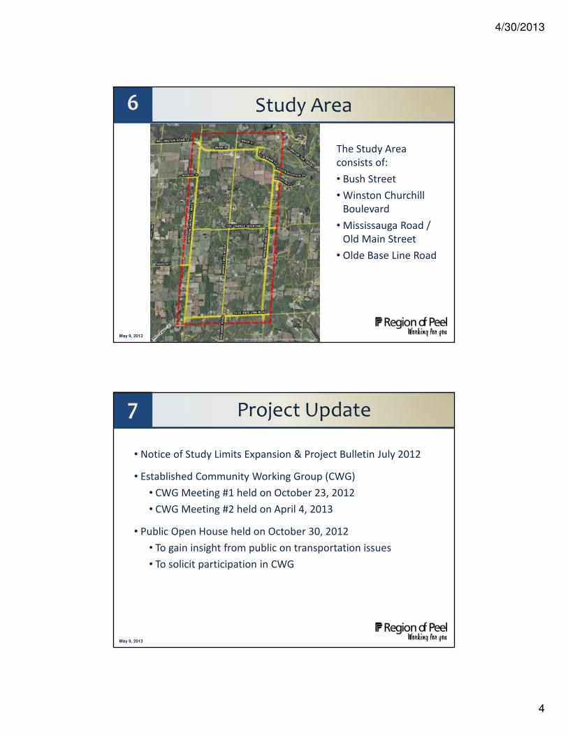
Study Area6
The Study Area
consists of:
• Bush Street
• Winston Churchill
Boulevard
• Mississauga Road /
Old Main Street
• Olde Base Line Road
May 9, 2013
7 Project Update
• Notice of Study Limits Expansion & Project Bulletin July 2012
• Established Community Working Group (CWG)
• CWG Meeting #1 held on October 23, 2012
• CWG Meeting #2 held on April 4, 2013
• Public Open House held on October 30, 2012
• To gain insight from public on transportation issues
• To solicit participation in CWG
4/30/2013
5
May 9, 2013
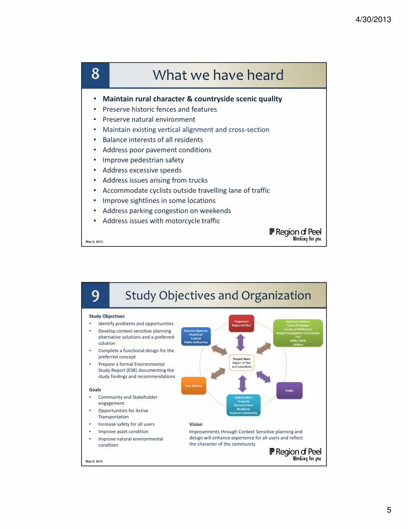
8 What we have heard
• Maintain rural character & countryside scenic quality
• Preserve historic fences and features
• Preserve natural environment
• Maintain existing vertical alignment and cross-section
• Balance interests of all residents
• Address poor pavement conditions
• Improve pedestrian safety
• Address excessive speeds
• Address issues arising from trucks
• Accommodate cyclists outside travelling lane of traffic
• Improve sightlines in some locations
• Address parking congestion on weekends
• Address issues with motorcycle traffic
May 9, 2013
Study Objectives and Organization9Study Objectives
• Identify problems and opportunities
• Develop context-sensitive planning
alternative solutions and a preferred
solution
• Complete a functional design for the
preferred concept
• Prepare a formal Environmental
Study Report (ESR) documenting the
study findings and recommendations
Goals
• Community and Stakeholder
engagement
• Opportunities for Active
Transportation
• Increase safety for all users
• Improve asset condition
• Improve natural environmental
condition
Vision
Improvements through Context Sensitive planning and
design will enhance experience for all users and reflect
the character of the community

4/30/2013
6
May 9, 2013
Strategic Plan and Term of Council Priorities for 2011-2014
10
• Environment
Protect, enhance and restore the
environment
• Transportation
Support and influence sustainable
transportation systems
• Public Safety
Ensure a safe Peel community
This Environmental Assessment supports a number of actions and initiatives related to transportation and the environment in the Region’s Strategic Plan Goals and Actions and the Term of Council Priorities
May 9, 2013
Planning and Policy Context11
Guiding Policies
• Official Plan • Official Plan
• Official Plan

4/30/2013
7
May 9, 2013
Transportation Studies and Initiatives12
May 9, 2013
13 Draft Problem StatementWork to date has confirmed similar issues identified in the 2010 study.
Existing problems on the study area roads (Mississauga Road/Old Main Street, Bush Street, Winston Churchill Boulevard and Olde Base Line Road) consist of:
• Deficient pavement conditions and drainage
• Deficient sightlines
• Safety for all road users, including safety of wildlife
• Motor vehicle accidents involving wildlife

4/30/2013
8
May 9, 2013
Based on the identified problems and issues, there is the requirement to address the following needs:
• Pavement Conditions and Drainage
• Sightlines
• Improving Safety for All Users
• Pedestrian and Cyclist Needs
Details on the Needs Assessment are provided in the following display panels.
14 Needs Assessment Summary
May 9, 2013
General Objectives of Peel’s Transportation System
• To achieve a safe convenient and efficient movement of people and goods in the Region Support the provision of improved transportation mobility to all residents, employees and visitors
• Promote and encourage all sustainable modes of transportation to provide mobility and choice
• Minimize adverse environmental impacts caused by transportation
• Support a transportation system that enhances economic growth in the Region
• Ensure Regional transportation infrastructure is sustainable and that practices and performance measures are in place to maintain a safe and efficient Regional transportation network
15 Role and Function of Regional Arterial Roads
Region of Peel Official Plan – Schedule E

4/30/2013
9
May 9, 2013
The roads in the study area provide connections to major employment destinations.
Bush Street (Regional Road 11), Mississauga Road / Old Main Street (Regional Road 1), Winston Churchill Boulevard (Regional Road 19), and Olde Base Line Road (Regional Road 12) are all part of the Peel Region arterial road network.
Winston Churchill Boulevard (Regional Road 25) is also part of the Wellington County arterial road network.
The roads in the study area also provide connections to tourist destinations in the immediate and surrounding area.
16 Broader Transportation Network
Morning Peak Period (6am to 9am) Traffic Flow to Major Employment Destinations
May 9, 2013
17 Old Main St - Mississauga Rd
³

4/30/2013
10
May 9, 2013
18 Bush Street (WCB-Old Main St)³
May 9, 2013
19 Winston Churchill (Bush-OBL)
³

4/30/2013
11
May 9, 2013
20 Olde Base Line (WCB-Mississauga)
³
May 9, 2013
21 Traffic TrendsMississauga Road and Winston Churchill Bush Street and Olde Base Line Road
Over the last 15 years, overall traffic on the four arterials has been relatively stable, with an average of 9,500 to 10,000 vehicles per day combined for the four arterial roads
4/30/2013
12
May 9, 2013
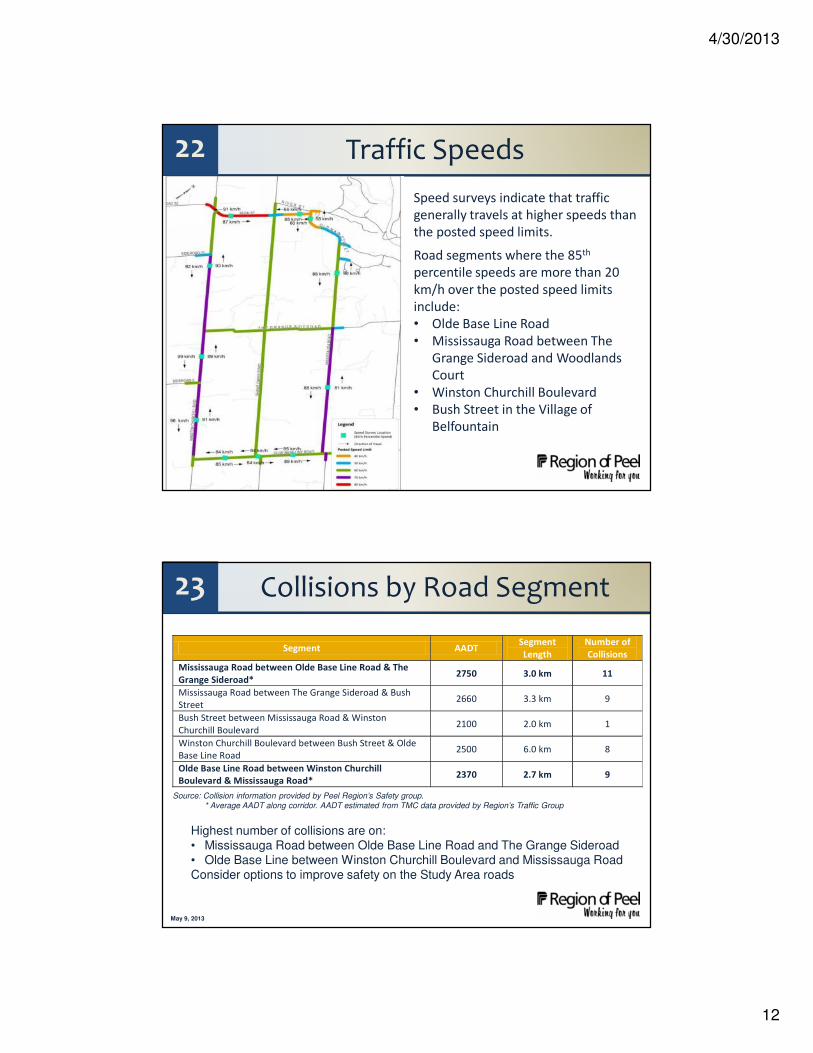
22 Traffic Speeds
Speed surveys indicate that traffic
generally travels at higher speeds than
the posted speed limits.
Road segments where the 85th
percentile speeds are more than 20
km/h over the posted speed limits
include:
• Olde Base Line Road
• Mississauga Road between The
Grange Sideroad and Woodlands
Court
• Winston Churchill Boulevard
• Bush Street in the Village of
Belfountain
May 9, 2013
23 Collisions by Road Segment
Highest number of collisions are on:• Mississauga Road between Olde Base Line Road and The Grange Sideroad• Olde Base Line between Winston Churchill Boulevard and Mississauga RoadConsider options to improve safety on the Study Area roads
Segment AADT Segment
Length
Number of
Collisions
Mississauga Road between Olde Base Line Road & The
Grange Sideroad* 2750 3.0 km 11
Mississauga Road between The Grange Sideroad & Bush
Street 2660 3.3 km 9
Bush Street between Mississauga Road & Winston
Churchill Boulevard 2100 2.0 km 1
Winston Churchill Boulevard between Bush Street & Olde
Base Line Road 2500 6.0 km 8
Olde Base Line Road between Winston Churchill
Boulevard & Mississauga Road* 2370 2.7 km 9
Source: Collision information provided by Peel Region’s Safety group.* Average AADT along corridor. AADT estimated from TMC data provided by Region’s Traffic Group

4/30/2013
13
May 9, 2013
24 Performance Safety Index (PSI)
Network screening is a process for
reviewing a roadway network
(intersections, segments, ramps) to
prioritize sites with the potential for a
safety improvement from highest to
lowest (#1 to #1000+).
It involves several analytical steps
utilizing historical data of the network
(primarily collision history).
PSI ranks are based on 587 intersections
and 777 midblock locations.
Although no location in the Study Area
ranks in the top 150 locations, this does
not preclude the need to consider safety
improvements.
May 9, 2013
25 Collisions by Severity
Property Damage Only 62 91%
Non Fatal Injury 6 9%
Fatality 0 0%
TOTAL 68 100%
(Based on 2006-2010 data)
0 collisions involving a pedestrian
1 collision involving a cyclist (sideswipe)
Non-fatal injury collisions evenly distributed
30 collisions at intersections
38 collisions at midblock (non-intersections)

4/30/2013
14
May 9, 2013
26 Collisions by Impact TypeAnimal 37%
Single Vehicle 34% (includes avoiding animals)
Angle 10%
Sideswipe 7%
Rear End 4%
Turning Movement 4%
Approach 3%
TOTAL 100%
(Based on 2006-2010 data)
44% of collisions involve animals
Second highest – single vehicles with drivers losing control
Consider options to reduce animal-related collisions
May 9, 2013
27 Roadside HazardsRoadside hazards include hydro
poles, steep slopes, and rock
cuts. The Study will consider
options to improve safety at
roadside hazard locations.

4/30/2013
15
May 9, 2013
28 Horizontal Alignment Deficiencies
May 9, 2013
29 Vertical AlignmentStopping Sight Distance Deficiencies

4/30/2013
16
May 9, 2013
30 Vertical AlignmentGrade Deficiencies
May 9, 2013
31 Sight Distances at Driveways
Yes No TOTAL
Fully Meets Minimum Standards 75 (41%) 109 (59%) 184 (100%)
Fully Meets Minimum Desirable Standards 51 (28%) 133 (72%) 184 (100%)
At many driveways, sight distances are inadequate.
Based on Transportation Association of Canada design standards. Based on drivers turning left or right from their driveways.
4/30/2013
17
May 9, 2013
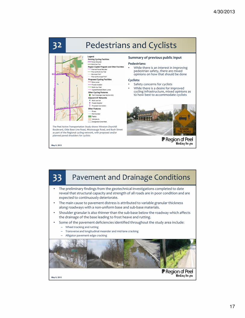
32 Pedestrians and CyclistsSummary of previous public input
Pedestrians:• While there is an interest in improving
pedestrian safety, there are mixed opinions on how that should be done
Cyclists:• Safety concerns for cyclists• While there is a desire for improved
cycling infrastructure, mixed opinions as to how best to accommodate cyclists
The Peel Active Transportation Study shows Winston Churchill Boulevard, Olde Base Line Road, Mississauga Road, and Bush Street as part of the Regional cycling network, with proposed and/or planned paved shoulders for cyclists
May 9, 2013
33 Pavement and Drainage Conditions
• The preliminary findings from the geotechnical investigations completed to date reveal that structural capacity and strength of all roads are in poor condition and are expected to continuously deteriorate.
• The main cause to pavement distress is attributed to variable granular thickness along roadways with a non-uniform base and sub-base materials.
• Shoulder granular is also thinner than the sub-base below the roadway which affects the drainage of the base leading to frost heave and rutting.
• Some of the pavement deficiencies identified throughout the study area include:– Wheel tracking and rutting
– Transverse and longitudinal meander and mid-lane cracking
– Alligator pavement edge cracking

4/30/2013
18
May 9, 2013
34 Pavement and Drainage Conditions by Roadway
Roadway Existing Conditions / Pavement Deficiencies
Mississauga Road/Old Main Street
•Granular thickness of base and sub-base highly variable
•“Bathtub” construction –granular under shoulder is thinner than under the roadway
•Wheel tracking rutting
•Slight alligator pavement edge cracking
•Moderate alligator transverse cracking
•Longitudinal meander and mid-lane cracking
•Inadequate / sub-standard ditches
•Ponding and vegetation along shoulders
Bush Street •Granular thickness of base and sub-base highly variable
•Pot holes
•Centreline and transverse cracking
•Deficient structural capacity and stability
Winston Churchill Boulevard
•Deficient structural capacity and stability
•Medium severity raveling
•Localized depressions
•Shallow bedrock does not allow for drainage under roadway
Olde Base Line Road
•High severity loss of aggregates
•Pot holes
•Frost heave and temperature related deterioration
•Water logging due to top permeable layers and bottom relatively impearmeable silty clay
•Shallow bedrock does not allow for drainage under roadway
May 9, 2013
35 Recommended Pavement Structures by Roadway
40-50 mm (1.6-2 in.)
75-80mm (3-3.2 in.)
150 mm (6 in.)
400-450 mm (16-18 in.)
subgrade
Binder Course
Surface Course
Granular A Base
Granular B Sub-base
* Note: The pavement recommendations will be confirmed in the subsequent
phases of this study.
Pavement structure granular materials must conform to OPSS (Ontario
Provincial Standard Specification) specifications.
Geotechnical Investigations completed to date have recommended the following pavement structure to address the deficient pavement conditions:

4/30/2013
19
May 9, 2013
36 Preliminary Geotechnical Recommendations
May 9, 2013
37 Ride Condition Index (RCI)
• The Ride Condition Index (RCI) is a quantitative number that represents the overall condition and quality of a Regional road network.
• The RCI aggregates the rating of many types of road defects including cracking, rutting, potholes and surface quality into one measurable number.
• Study area roads are below the network average and are deteriorating faster than the network average and will likely be below the level of service (72) for roads in the next 3- 5 years.
- Black line represents projected network RCI for all Regional Roads.
- Red line represents projected RCI for the roads in the study area.

4/30/2013
20
May 9, 2013
38 Needs Assessment• Reduce collisions and improve safety, particularly in areas where there are
steep grades, sharp curves, vertical crests, and driveways
• Accommodate pedestrians in areas of high pedestrian activity
• Improve pedestrian safety
• Reduce conflicts between cyclists and motorized vehicles
• Address substandard sightlines for the prevailing traffic speeds
• Address roadside hazards
• Reduce collisions with animals
• Improve traffic signage
• Minimize impact of increase in traffic volumes
• Address excessive speeds – cars, trucks, motorcycles
• Address poor conditions of the roadway pavement
• Address parking congestion in Belfountain experienced on weekends
• There is no need for additional travel lanes
There is a recognition that users may have competing interests and needs
May 9, 2013
39 Guiding Principles for Solutions
These principles will provide guidance to the study team when generating alternative solutions to address the problem statement:
• Maintain the rural character and countryside scenic quality
• Preserve historic fences and heritage / cultural / archaeological features
• Preserve / enhance the natural environment
• Protect the Niagara Escarpment
• Balance interests and meet needs of all road users – motorists, pedestrians, cyclists, farm vehicles, horses, trucks, wildlife
• Provide a context sensitive design
• Enhance local tourism and economic development of the area
It is recognized that different users may have competing interests

4/30/2013
21
May 9, 2013
40 Preliminary Alternative Solutions
Problem or OpportunityMississauga Rd.
/ Old Main St.Bush St.
Winston Churchill
Blvd.
Olde Base Line Rd.
1. Excessive Speeds
Alternative Solutions:i. Do nothing
ii. Lower Design Speeds
iii. Pavement markings (e.g. SLOW) v. Enforcement
iv. Narrowing travel lanes vi. Combinations of the above
v. Traffic Signage
2. Deteriorating Pavement Conditions and Drainage Deficiencies
Alternative Solutions:i. Do nothing
ii. Road Reconstruction
iii. Road Rehabilitation
iv. Combinations of the above
3. Horizontal Alignment Deficiencies OKAlternative Solutions:i. Do nothing
ii. Traffic signage
iii. Pavement markings (e.g. SLOW)
iv. Lower Design Speeds
v. Combinations of the above
May 9, 2013
41 Preliminary Alternative Solutions – cont’d
Problem or OpportunityMississauga Rd.
/ Old Main St.Bush St.
Winston Churchill
Blvd.
Olde Base Line Rd.
4. Vertical Alignment Deficiencies
•Deficient Stopping Sight Distance
•Deficient Grade
Alternative Solutions:i. Do nothing
ii. Lower Design Speeds
iii. Traffic Signage
iv. Road Reconstruction to reduce grades and bring vertical curves up to standard
v. Combinations of the above
5. Pedestrian and Cycling Needs•Regional Active Transportation Plan identifies all study roads as proposed or planned cycling facilities with paved shoulders
Alternative Solutions:i. Do nothing
ii. Widening / partially paving shoulders
iii. Sidewalks
iv. Bike racks at local businesses
v. Landscaping to shelter pedestrians from traffic
vi. Combinations of the above

4/30/2013
22
May 9, 2013
42
Problem or OpportunityMississauga Rd.
/ Old Main St.Bush St.
Winston Churchill
Blvd.
Olde Base Line Rd.
6. Safety
•Collisions by location OK•Collisions by type •Almost half of all collisions involve animals
Alternative Solutions:i. Do nothing
ii. Lower Design Speeds
iii. Pavement markings
iv. Traffic Signage including animal crossing warning
v. Seasonal communications and education regarding deer activity
vi. Combinations of the above
7. Intersection Deficiencies
•Deficient Sight lines
Alternative Solutions:i. Do nothing
ii. Roundabout
iii. Remove overgrown vegetation
iv. Lower Design Speeds
v. Road Reconstruction to reduce grades and bring vertical curves up to standard
vi. Combinations of the above
Preliminary Alternative Solutions – cont’d
May 9, 2013
43
Problem or OpportunityMississauga Rd.
/ Old Main St.Bush St.
Winston Churchill
Blvd.
Olde Base Line Rd.
8. Driveway Deficiencies
•Deficient Turning Sight Distance
•More than half of driveways have deficient turning sight distance (approximately 70%)
Alternative Solutions:i. Do nothing
ii. Lower Design Speeds
iii. Traffic Signage
iv. Road Reconstruction to reduce grades and bring vertical curves up to standard
v. Combinations of the above
9. Roadside Hazards
•Trees, ditches, steep slopes, poles, etc.
OK
Alternative Solutions:i. Do nothing
ii. Remove hazards
iii. Install guide rails
iv. Combinations of the above
Preliminary Alternative Solutions – cont’d

4/30/2013
23
May 9, 2013
44 Preliminary Evaluation Criteria
Natural Environment– Vegetation and wildlife habitat – Aquatic habitat – Terrestrial habitat– Species at Risk– Wildlife movement and safety– Wetlands and watercourses– Natural hazards
Capital Costs – Construction costs– Property acquisition
Transportation– Geometric alignment– Traffic operations – Driveway operations– Accommodation of all road users– Safety– Stormwater quality and quantity
Socio-Economic Environment–Residential properties–Farm operations–Businesses–Archaeological resources–Built and cultural heritage resources–Air, noise, vibration impacts
Maintain the rural character and countryside scenic quality
May 9, 2013
Inventory of
Existing Natural, Archaeological
and Built/Cultural Heritage
Conditions
45

4/30/2013
24
May 9, 2013
46 Greenbelt and Greenlands
Policy Areas Map
• Greenbelt
• Region of Peel Core Greenlands
³
³
May 9, 2013
47 Niagara Escarpment
• Policy Areas Map– Niagara Escarpment Plan
– NE and SE corners of study area
³
³

4/30/2013
25
May 9, 2013
ELC Communities
• Ecological Land Classification Vegetation Communities
48
May 9, 2013
May 9, 2013
Natural Areas and Features49
April 4, 2013
4/30/2013
26
May 9, 2013
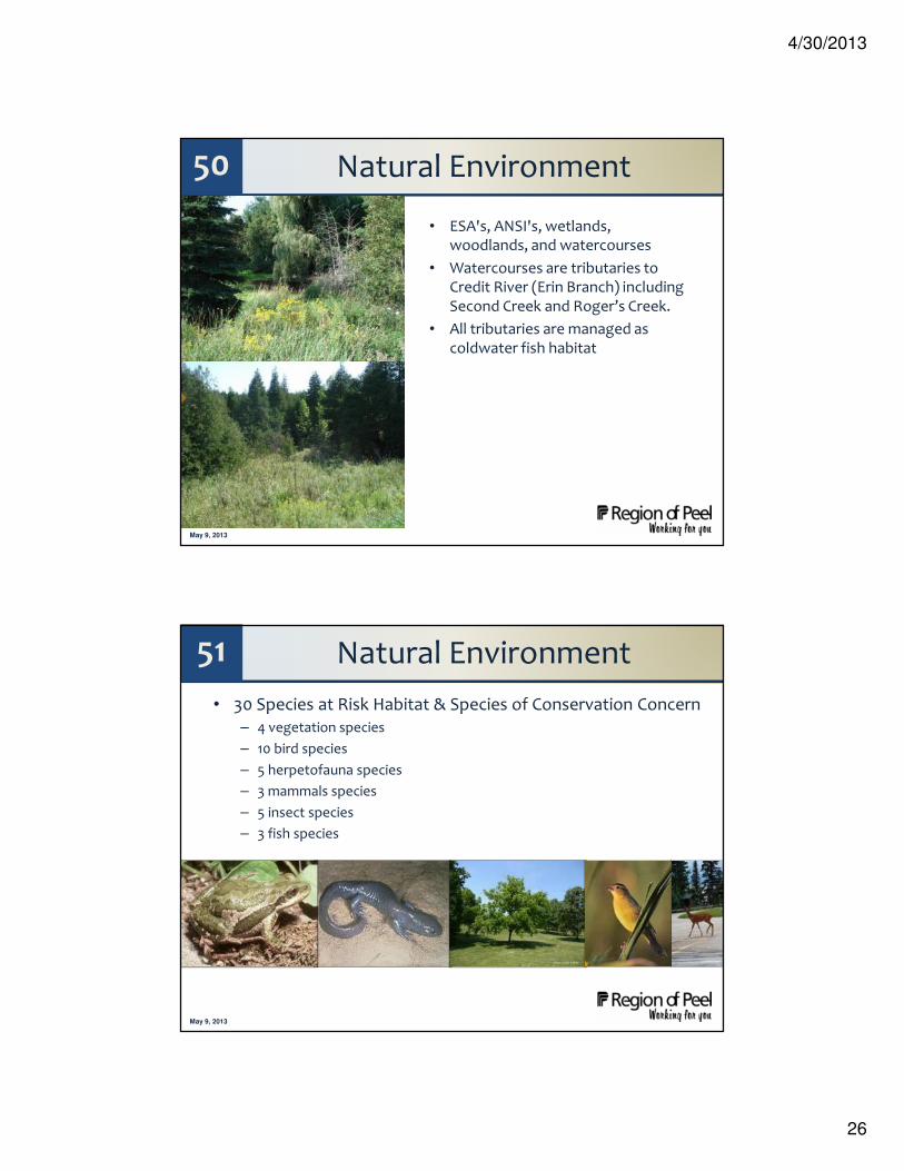
50 Natural Environment
• ESA's, ANSI's, wetlands, woodlands, and watercourses
• Watercourses are tributaries to Credit River (Erin Branch) including Second Creek and Roger’s Creek.
• All tributaries are managed as coldwater fish habitat
Map from NRSI due Wed
May 9, 2013
51 Natural Environment
• 30 Species at Risk Habitat & Species of Conservation Concern– 4 vegetation species
– 10 bird species
– 5 herpetofauna species
– 3 mammals species
– 5 insect species
– 3 fish species

4/30/2013
27
May 9, 2013
52 Archaeological Assessment
Stone wall, cedar fence on Winston Churchill Boulevard
Boulder fence and cedar rail fence, Shaw’s Creek and Olde Base Line
Cedar fence along Bush
Stone fence - Mississauga Road at The Grange
Winston Churchill Boulevard – low/wet and sloping beyond the road
Northwest view towards Bush – potential for archaeological significance in field
May 9, 2013
53 Built / Cultural Heritage
Olde Baseline / Winston Churchill
• 21 identified resources
• None designated under Ontario Heritage Act
Mississauga / Bush
• 48 identified resources
• 4 designated under Ontario Heritage Act
• 23 listed by Town of Caledon
• Another 11 listed with high significance
4/30/2013
28
May 9, 2013
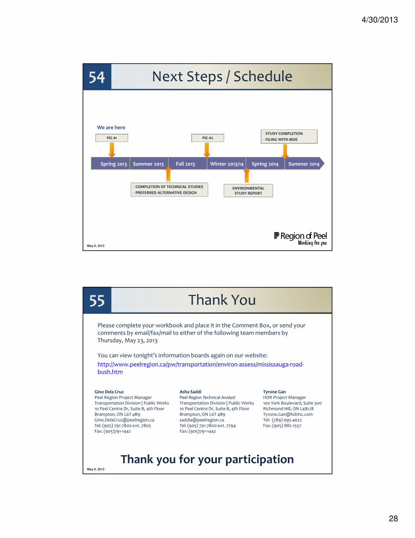
54 Next Steps / Schedule
We are here
Summer 2013 Fall 2013Spring 2013 Summer 2014Winter 2013/14 Spring 2014
PIC #1
- COMPLETION OF TECHNICAL STUDIES
- PREFERRED ALTERNATIVE DESIGNENVIRONMENTAL
STUDY REPORT
PIC #2- STUDY COMPLETION
- FILING WITH MOE
May 9, 2013
55 Thank You
Gino Dela Cruz Asha Saddi Tyrone GanPeel Region Project Manager Peel Region Technical Analyst HDR Project ManagerTransportation Division | Public Works Transportation Division | Public Works 100 York Boulevard, Suite 30010 Peel Centre Dr, Suite B, 4th Floor 10 Peel Centre Dr, Suite B, 4th Floor Richmond Hill, ON L4B1J8Brampton, ON L6T 4B9 Brampton, ON L6T 4B9 [email protected]@peelregion.ca [email protected] Tel: (289) 695-4622 Tel: (905) 791-7800 ext. 7805 Tel: (905) 791-7800 ext. 7794 Fax: (905) 882-1557 Fax: (905)791-1442 Fax: (905)791-1442
Please complete your workbook and place it in the Comment Box, or send your comments by email/fax/mail to either of the following team members by Thursday, May 23, 2013
You can view tonight’s information boards again on our website:
http://www.peelregion.ca/pw/transportation/environ-assess/mississauga-road-bush.htm
Thank you for your participation


![[XLS] · Web viewAgraharam Street, Annaji Street, AO Ramasamy Street, Brough Road, Cauvery Road, Court Street, Chinnamariamman Koil Street, Cutchery St., Gandhiji Road,Jinna Street,](https://static.fdocuments.net/doc/165x107/5ad66ba27f8b9a177c8e4c12/xls-viewagraharam-street-annaji-street-ao-ramasamy-street-brough-road-cauvery.jpg)