City of Mississauga Creditview Road Schedule C Class …€¦ · Class Environmental Assessment...
144
City of Mississauga Creditview Road Schedule C Class Environmental Assessment Final Prepared by: AECOM 300 Water Street 905 668 9363 tel Whitby, ON, Canada L1N 9J2 905 668 0221 fax www.aecom.com May 9, 2016 Project Number: 60304588
Transcript of City of Mississauga Creditview Road Schedule C Class …€¦ · Class Environmental Assessment...

City of Mississauga
Creditview Road Schedule C Class Environmental Assessment Final
Prepared by:
AECOM 300 Water Street 905 668 9363 tel Whitby, ON, Canada L1N 9J2 905 668 0221 fax www.aecom.com
May 9, 2016 Project Number: 60304588

Prepared by: AECOM 5080 Commerce Boulevard 905 238 0007 tel Mississauga, ON, Canada L4W 4P2 905 238 0038 fax www.aecom.com Project Number: 60304588 Date: May 2016
City of Mississauga
Creditview Road Municipal Class Environmental Assessment – Bancroft Drive to Old Creditview Road Environmental Study Report


City of Mississauga Creditview Road Municipal Class Environmental Assessment – Bancroft Drive to Old Creditview Road
Environmental Study Report
Creditview_Road_Final_Esr_60304588_May 2016 i
Executive Summary Introduction
AECOM Canada Limited (AECOM) was retained by the City of Mississauga to complete a Municipal Class Environmental Assessment (EA) study to investigate the need for additional north-south capacity and traffic management improvements along a 2.2 km section of Creditview Road, between Bancroft Drive to Old Creditview Road (excluding the bridge over the Credit River), in consideration of the road’s identification as a part of the City’s cultural heritage landscape and its function as a future active transportation corridor. As part of this study, a context sensitive design approach was used in recognition of the multimodal transportation needs of the area while protecting established parks, recreational areas, communities and businesses, as well as the study area’s cultural value. A number of City-wide initiatives provided policy direction for this EA study. Through the ‘Pillars for Change’ outlined in the 2009 Strategic Plan, the City envisions providing a range of mobility choices; “…to provide all with a choice to walk, cycle and use transit or active modes of transportation in all seasons”. In addition, planning for alternative modes of transportation is supported by the City’s Cycling Master Plan, the “Living Green” Master Plan and the Credit River Parks Strategy, whereby Creditview Road is identified as a future Primary Boulevard Route, and is envisaged to be transit efficient and to provide a key link to some of the City’s parks and natural areas, respectively. Consultation
Public consultation is an integral part of the Creditview Road Municipal Class EA to ensure that the interests and concerns of the public and affected groups are identified, documented, assessed and considered. The following consultation activities were carried out in order to achieve these objectives:
Posting project milestones on the City’s website (www.mississauga.ca) including Notices of Study Commencement, Project Status Update, public consultation events and Study Completion;
Holding meetings with the Credit Valley Conservation (CVC), and the Ministry of Transportation (MTO) at key points during the study;
Publication of newspaper notices in the Mississauga News for all study milestones; Direct mailing of notices to stakeholders, affected land owners, general public and review agencies
regarding project milestones; Holding two (2) public consultation events to engage and obtain input from community members, the public
and review agencies; and Placement of this ESR on the public record and distribution of the Notice of Study Completion to those
included on the study mailing list. Existing Conditions
Creditview Road is a major north-south route in the City and is designated a Major Collector in the City of Mississauga Official Plan. These types of roadways are designed to accommodate moderate volumes of traffic and are to be the focus of active transportation facilities. Within the study area, Creditview Road carries through traffic between neighbourhoods, and provides vehicular and pedestrian access to abutting businesses and indirect access to residential properties via connecting roadways. In addition, the study area serves as a transit route (MiWay) for northbound and southbound travel provides north-south connectivity for existing and further modes of transportation and east-west connectivity with intersecting roadways. At present, transit infrastructure within the study area is limited to bus stops, with no shelters or other amenities for waiting passengers.

City of Mississauga Creditview Road Municipal Class Environmental Assessment – Bancroft Drive to Old Creditview Road
Environmental Study Report
Creditview_Road_Final_Esr_60304588_May 2016 ii
At present, Creditview Road consists of a 2-lane cross-section. Approximately half of the signalized (during the PM Peak hour only) intersections and all of the unsignalized intersections (during both the AM and PM peak hours) are operating at or above capacity with significant delays. Without roadway improvements, the study area intersections are expected to operate above capacity with significant delays during the future horizon years of 2021 and 2031.
Problem and Opportunity Statement
The Problem and Opportunity Statement developed for the Creditview Road Municipal Class EA is as follows: The City of Mississauga Official Plan identifies Creditview Road as a Major Collector Road. Existing traffic volumes have reached or exceeded the available road capacity. There is projected traffic growth which will exacerbate existing conditions. An opportunity exists to address the capacity and operational deficiencies on Creditview Road while preserving the existing cultural and natural heritage of the corridor.
This opportunity allows for the implementation of City-wide strategic objectives which promote sustainable multi-modal transportation options that provide residents with opportunities to walk, cycle, or use public transit to reach their destinations. Improvements to Creditview Road will facilitate safer operations along the corridor and co-ordinate bridge capacity across Highway 401 as well as enhancing cultural and natural heritage of the corridor. Alternative Solutions
A number of alternative solutions were identified and assessed to address the identified problems and opportunities. These included: Alternative 1: Do Nothing
Alternative 2: Upgrade Parallel Roads Instead of Creditview Road
Alternative 3: Intersection and Signal Improvements
Alternative 4: Implement Travel Demand Management (TDM)
Alternative 5: Enhance Corridor Capacity
Preferred Solution
Based on the findings of the evaluation of alternative solutions, a combined solution (i.e., Alternatives 3, 4, and 5) was selected as it provides the best opportunity to address the identified capacity and operational deficiencies. The implementation of this solution in combination would comply with planning policies, have a potentially low impact on the natural and cultural environments, and allow for an opportunity to co-ordinate with MTO regarding the improvements to the Creditview Road bridge over Highway 401. In addition, this solution allows for the sustainable movement of multi-modal services, including buses, cyclists and pedestrians, and therefore, facilitates access to local community facilities, businesses, schools, and parks along Creditview Road. Alternative Design Concepts
Five (5) design alternatives were considered as part of the evaluation. Roundabout intersections were included in three (3) of the alternative designs, based on their benefits over traditional intersections (i.e., speed management,

City of Mississauga Creditview Road Municipal Class Environmental Assessment – Bancroft Drive to Old Creditview Road
Environmental Study Report
Creditview_Road_Final_Esr_60304588_May 2016 iii
increased capacity, reduced delays, decreased idling/air pollution, etc.). For all alternatives, a 4-lane section was proposed from Argentia Road to Old Creditview Road.
Alternative 1: Two Lanes with Signalized Intersections
Two lanes between Bancroft Road and Argentia Road; Four lanes between Argentia Road and Old Creditview Road; Signalized intersection improvements at Creditview Road intersections with Old Creditview Road, Argentia
Road and Kenninghall Boulevard; and Intersection improvements at Falconer Drive.
Alternative 2: Two Lanes with One Roundabout Intersection
Two lanes between Bancroft Road and Argentia Road; Four lanes between Argentia Road and Old Creditview Road; Signalized intersection improvements at Creditview Road intersections with Old Creditview Road and
Kenninghall Boulevard; Two-Lane Roundabout at Argentia Road; and Intersection improvements at Falconer Drive.
Alternative 3: Two Lanes with Three Roundabout Intersections
Two lanes between Bancroft Road and Argentia Road; Four lanes between Argentia Road and Old Creditview Road; Signalized intersection improvements at Creditview Road intersection with Old Creditview Road; One-lane roundabouts at Creditview Road intersections with Falconer Drive and Kenninghall Boulevard; and Two-Lane Roundabout at Argentia Road.
Alternative 4: Four Lanes with Signalized Intersections
Four lanes between Bancroft Road and Old Creditview Road; Signalized intersection improvements at Creditview Road intersection with Old Creditview Road; Signalized intersection improvements at Creditview Road intersections with Argentia Road and Kenninghall
Boulevard; and Intersection improvements at Falconer Drive.
Alternative 5: Four Lanes with Three Roundabout Intersections
Four lanes between Bancroft Road and Old Creditview Road; Signalized intersection improvement at Creditview Road intersection with Old Creditview Road; and Two-Lane Roundabouts at Creditview Road intersections with Kenninghall Boulevard, Falconer Drive and
Argentia Road. Preliminary Preferred Design
Based on the Evaluation of Alternative Design Concepts, Alternative 3, Two Lanes with Three Roundabout Intersections, is preferred as it addresses the future needs of the corridor. While slightly greater impacts to the natural environment would be expected, when compared to Alternatives 1 and 2, the roundabout locations (3) associated with Alternative 3 provide additional opportunities to implement enhanced landscape elements as well as stormwater bio-retention features. In addition, Alternative 3 is expected to provide significant improvements to traffic operations to Year 2031 and potentially beyond. This alternative provides more opportunities to implement designated pedestrian crosswalks as part of the design. While a higher capital cost is expected in association with Alternative 3, when compared to Alternatives 1 and 2, this alternative is expected to incur lower maintenance costs since the roundabout design avoids the maintenance associated with signal infrastructure and powering. Alternative 3 also encroaches onto the smallest area of private property.

City of Mississauga Creditview Road Municipal Class Environmental Assessment – Bancroft Drive to Old Creditview Road
Environmental Study Report
Creditview_Road_Final_Esr_60304588_May 2016 iv
Long-Term Solution
The findings of the evaluation further indicated that widening Creditview Road to 4-lanes from Bancroft Drive to Argentia Road (i.e., Alternative 5) may be beneficial as a Long-term Solution (i.e., after 2031). If and when additional capacity is required, community consultation at that stage will take place prior to the implementation of the Long-term Solution. Project Description
The Preliminary Preferred Design includes widening Creditview Road from Argentia Road to Old Creditview Road to four (4) lanes. Creditview Road from Sir Monty’s Drive/ Bancroft Drive to Argentia Road will remain as a two (2) lane cross-section with intersection improvements consisting of a two (2) lane roundabout at Argentia Road and single lane roundabouts at Falconer Driver and Kenninghall Boulevard. No intersection improvements will be undertaken at the Sir Monty’s Drive/Bancroft Drive and Creditview Road intersection. Intersection improvements of an exclusive eastbound right turn at the Old Creditview Road and Creditview Road intersection are proposed. A 3.5 m multi-use trail will be provided on the west side of Creditview Road and a 1.5 m sidewalk will be provided on the east side, as illustrated in Figure E.1 below. A 3.5 m refuge/centre lane is provided at the Creditview Road / Velebit Court and the Creditview Road / River Gate Place intersections in order to provide motorists with the opportunity to complete their left turns onto Creditview Road in two (2) stages, if required, which reduces the delay for the left turn movement. The Highway 401/Creditview Road bridge will also include a 4 lane cross-section, including a sidewalk and multi-use trail along the east and west sides, respectively. The majority of the modifications can be accommodated within the existing right-of-way. Minor property acquisition will be required on the east side of Creditview Road to accommodate the proposed roundabouts at Falconer Drive and Argentia Road as well as on both sides of the roadway in order to accommodate widening in the vicinity of the Creditview Road/Old Creditview Road intersection. Other key features of the Preliminary Preferred Design include an enhanced tree planting plan to restore the natural environment, compensate for vegetation removals, and enhance the overall aesthetic and scenic value of the corridor, as well as new noise barriers within selected locations along the corridor.
Figure E.1: Typical Cross-Section – Preliminary Preferred Design

City of Mississauga Creditview Road Municipal Class Environmental Assessment – Bancroft Drive to Old Creditview Road
Environmental Study Report
Creditview_Road_Final_Esr_60304588_May 2016 v
The recommended alignment and roadway configuration for the Preliminary Preferred Design is shown on Sheets 1 to 10 provided following the text of this ESR.
Long-term Solution
The Preferred Design is expected to support traffic operations to Year 2031 and potentially beyond. If and when additional capacity is required, community consultation at that stage will take place prior to the implementation of the Long-term Solution (please refer to Figure E.2). The Long-term Solution includes the following key elements:
Widening to four (4) lanes from Bancroft Drive to Argentia Road; and, Two (2) lane roundabouts at Kenninghall Boulevard and Falconer Drive.
Figure E.2: Typical Cross-Section – Long-Term Solution
The recommended alignment and roadway configuration for the Long-Term Solution is shown on Sheets 11 to 20 provided following the text of this ESR. Mitigation Measures and Implementation Commitments
Many of the environmental concerns related to this project have been mitigated through the process by which the preferred design was selected, as described in this Environmental Study Report. The anticipated impacts and proposed mitigation measures are described in Section 8. A detailed list of specific commitments to be carried forward to Phase 5 of the Municipal Class EA process (i.e., detailed design and implementation) is provided in Section 9. These commitments have been developed through discussions with CVC, MTO and other authorities. Monitoring of construction activities shall ensure that all environmental standards and commitments for construction are met. The City of Mississauga will work with CVC, MTO and other authorities during detail design and prior to commencement of construction activities to ensure that the proposed works are acceptable and to obtain the required permits. .


City of Mississauga Creditview Road Municipal Class Environmental Assessment – Bancroft Drive to Old Creditview Road
Environmental Study Report
Creditview_Road_Final_Esr_60304588_May 2016
Table of Contents Letter of Transmittal Executive Summary
page
1. Introduction .................................................................................................................................. 1
1.1 Background .......................................................................................................................................... 1 1.2 Purpose of the Study ........................................................................................................................... 1 1.3 Environmental Assessment Process ................................................................................................... 2 1.4 Project Team Organization .................................................................................................................. 5
2. Consultation ................................................................................................................................. 6
2.1 Public Consultation Activities ............................................................................................................... 6 2.1.1 Study Commencement ........................................................................................................... 6
2.1.1.1 Study Website ...................................................................................................... 6 2.1.1.2 Study Email Address ............................................................................................ 6 2.1.1.3 Study Contact List ................................................................................................ 6 2.1.1.4 Notice of Study Commencement .......................................................................... 6 2.1.1.5 Study Notification Letter ....................................................................................... 7
2.1.2 Public Information Centre #1 .................................................................................................. 7 2.1.3 Notice of Project Status .......................................................................................................... 7 2.1.4 Community Information Sharing Session #2 .......................................................................... 8
2.2 Agency Consultation ............................................................................................................................ 8 2.2.1 Agency Mailing List ................................................................................................................. 8 2.2.2 Agency Meetings .................................................................................................................... 9
2.2.2.1 Ministry of Transportation ..................................................................................... 9 2.2.2.2 Credit Valley Conservation Authority ................................................................... 9
2.3 Aboriginal Consultation ........................................................................................................................ 9
3. Municipal Planning Framework................................................................................................. 11
3.1 Provincial Planning Context ............................................................................................................... 11 3.1.1 Provincial Policy Statement 2014 ......................................................................................... 11 3.1.2 Places to Grow and Growth Plan for the Greater Golden Horseshoe (2006) ...................... 12 3.1.3 Highway 401 Improvements Planning .................................................................................. 12
3.1.3.1 Transportation Environmental Study Report – Highway 401 Improvements, From Highway 410/403 Interchange to East of the Credit River ................................................................................................................... 12
3.1.3.2 Transportation Environmental Study Report –Highway 401 Improvements, From East of the Credit River to Trafalgar Road ................................................ 13
3.2 Regional Planning Context ................................................................................................................ 13 3.2.1 Regional Official Plan (2014) ................................................................................................ 13 3.2.2 Regional Active Transportation Plan (2012) ......................................................................... 14
3.3 Municipal Transportation Planning Context ....................................................................................... 14 3.3.1 City of Mississauga Official Plan (2012) ............................................................................... 14
3.3.1.1 Transportation Goals and Objectives ................................................................. 14 3.3.2 City of Mississauga Strategic Plan (2009) ............................................................................ 15 3.3.3 2009 Future Directions – Master Plan for Parks and Natural Areas .................................... 16 3.3.4 City of Mississauga Cycling Master Plan (2010) .................................................................. 16

City of Mississauga Creditview Road Municipal Class Environmental Assessment – Bancroft Drive to Old Creditview Road
Environmental Study Report
Creditview_Road_Final_Esr_60304588_May 2016
3.3.5 City of Mississauga Living Green Master Plan (2012) ......................................................... 17 3.3.6 Natural Heritage and Urban Forest Strategy (2014) ............................................................ 17 3.3.7 Mississauga Transportation Strategy (Interim) ..................................................................... 18 3.3.8 Credit River Parks Study (2013) ........................................................................................... 18
3.4 Future Population and Employment Growth (2013) .......................................................................... 19
4. Description of the Existing Environment ................................................................................. 20
4.1 Transportation System ....................................................................................................................... 20 4.1.1 Road Network ....................................................................................................................... 20
4.1.1.1 Road Characteristics .......................................................................................... 20 4.1.2 Active Transportation Infrastructure ..................................................................................... 20
4.1.2.1 Mississauga Cycling Master Plan....................................................................... 23 4.1.3 Transit Services .................................................................................................................... 25 4.1.4 Safety Assessment ............................................................................................................... 28
4.1.4.1 Descriptive Collision Trends Analysis ................................................................ 29 4.1.4.2 Potential for Safety Improvement (PSI) .............................................................. 30
4.1.5 Existing Traffic Conditions .................................................................................................... 31 4.1.5.1 Data Collection and Signal Timing ..................................................................... 31 4.1.5.2 Traffic Operations Analysis ................................................................................ 34
4.1.6 Future Traffic Growth Projections ......................................................................................... 36 4.1.6.1 Horizon Year 2021 ............................................................................................. 36 4.1.6.2 Horizon Year 2031 ............................................................................................. 37
4.2 Physical Environment ........................................................................................................................ 37 4.2.1 Subsurface Soils ................................................................................................................... 37 4.2.2 Physiography and Topography ............................................................................................. 38
4.3 Natural Environment .......................................................................................................................... 38 4.3.1 Designated Natural Areas .................................................................................................... 38
4.3.1.1 Credit Valley Conservation Authority (CVC) Regulated Areas .......................... 39 4.3.1.2 City of Mississauga Natural Areas ..................................................................... 39 4.3.1.3 CVC Landscape Scale Analysis ......................................................................... 40
4.3.2 Aquatic Environment............................................................................................................. 40 4.3.3 Terrestrial Environment ........................................................................................................ 40 4.3.4 Wetlands ............................................................................................................................... 41 4.3.5 Wildlife .................................................................................................................................. 42
4.3.5.1 Species at Risk ................................................................................................... 43 4.3.5.2 Amphibian Breeding Bird and Surveys (2014) ................................................... 45
4.3.6 Significant Wildlife Habitat .................................................................................................... 46 4.3.7 Tree Inventory and Assessment ........................................................................................... 46
4.4 Socio-Economic Environment ........................................................................................................... 47 4.4.1 Existing Land Uses ............................................................................................................... 47 4.4.2 Land Use Planning Policy ..................................................................................................... 47
4.4.2.1 City of Mississauga Official Plan ........................................................................ 47 4.4.3 Limited Phase One Environment Site Assessment .............................................................. 48 4.4.4 Source Water Protection ...................................................................................................... 49
4.5 Cultural Environment ......................................................................................................................... 49 4.5.1 Cultural Heritage Resources ................................................................................................ 49 4.5.2 Archaeological Resources .................................................................................................... 51
4.6 Stormwater Management .................................................................................................................. 51 4.6.1 Existing Soil Conditions ........................................................................................................ 51 4.6.2 Water Balance ...................................................................................................................... 52 4.6.3 Roadway Drainage ............................................................................................................... 52

City of Mississauga Creditview Road Municipal Class Environmental Assessment – Bancroft Drive to Old Creditview Road
Environmental Study Report
Creditview_Road_Final_Esr_60304588_May 2016
4.6.4 Stormwater Management ..................................................................................................... 53 4.6.5 Mainline and Entrance Crossing Culverts ............................................................................ 54
5. Problem or Opportunity Statement ........................................................................................... 55
6. Alternative Solutions ................................................................................................................. 56
6.1 Identification of Alternative Solutions ................................................................................................. 56 6.2 Identification of Assessment Criteria for Alternative Solutions .......................................................... 57 6.3 Evaluation of Alternative Solutions .................................................................................................... 57 6.4 Identification of the Preferred Solution .............................................................................................. 61
6.4.1 Public Information Centre #1 ................................................................................................ 61 6.5 Alternative Design Concepts ............................................................................................................. 61
6.5.1 Design Issues and Constraints ............................................................................................. 62 6.5.2 Alternative Design Concepts Developed .............................................................................. 62
6.6 Evaluation of Alternative Design Concepts ....................................................................................... 69 6.6.1 Preliminary Preferred Design ............................................................................................... 70 6.6.2 Long-term Solution ............................................................................................................... 70 6.6.3 Selection of the Preferred Design ......................................................................................... 80
7. Project Description .................................................................................................................... 81
7.1 Recommended Alternative Design .................................................................................................... 81 7.1.1 Preliminary Preferred Design ............................................................................................... 81 7.1.2 Long-term Solution ............................................................................................................... 82
7.2 Pavement and Geotechnical Investigation ........................................................................................ 82 7.2.1 Existing Conditions ............................................................................................................... 82 7.2.2 Recommendations ................................................................................................................ 83 7.2.3 Limited Chemical Analysis .................................................................................................... 84
7.3 Cost Estimate .................................................................................................................................... 84
8. Anticipated Impacts and Proposed Mitigation ......................................................................... 85
8.1 Natural Environment .......................................................................................................................... 85 8.1.1 Aquatic Environment............................................................................................................. 85 8.1.2 Vegetation ............................................................................................................................. 85 8.1.3 Wildlife .................................................................................................................................. 85 8.1.4 Species at Risk (SAR) .......................................................................................................... 86 8.1.5 Tree Preservation Plan ......................................................................................................... 87
8.1.5.1 Root Damage ..................................................................................................... 87 8.1.5.2 Branches and Leaves ......................................................................................... 87
8.1.6 Streetscape and Landscape Plan ......................................................................................... 88 8.2 Stormwater Management .................................................................................................................. 89
8.2.1 Water Balance ...................................................................................................................... 89 8.2.2 Stormwater Quantity ............................................................................................................. 90 8.2.3 Stormwater Quality ............................................................................................................... 90 8.2.4 Sediment and Erosion Control .............................................................................................. 91
8.3 Cultural Environment ......................................................................................................................... 91 8.3.1 Heritage Resources .............................................................................................................. 91
8.3.1.1 Direct Impact ...................................................................................................... 91 8.3.1.2 Indirect Impacts .................................................................................................. 92
8.3.2 Archaeological Resources .................................................................................................... 92 8.4 Socio-economic Environment ............................................................................................................ 93
8.4.1 Contaminated Property ......................................................................................................... 93

City of Mississauga Creditview Road Municipal Class Environmental Assessment – Bancroft Drive to Old Creditview Road
Environmental Study Report
Creditview_Road_Final_Esr_60304588_May 2016
8.4.2 Direct Property Impacts ........................................................................................................ 93 8.4.3 Noise ..................................................................................................................................... 93 8.4.4 Air Quality ............................................................................................................................. 94 8.4.5 Entrances .............................................................................................................................. 94 8.4.1 Active Transportation and Transit Infrastructure .................................................................. 94 8.4.2 Temporary Disruption to Traffic Flow and Property Access ................................................. 95
8.5 Utilities ............................................................................................................................................... 95 8.6 Illumination ......................................................................................................................................... 95 8.7 Monitoring – Construction and Traffic ................................................................................................ 96
9. Mitigation Measures and Implementation Commitments ........................................................ 97
9.1 Permits and Approvals ..................................................................................................................... 101 List of Drawings
Preferred Design Plans and Profiles – Sheets 1 to 8. Preferred Design Typical Cross-sections – Sheet 9 to 10. Long-Term Solution Plans and Profiles – Sheet 11 to 18. Long-Term Solution Typical Cross-sections – Sheet 19 to 20. Utility Plan – Sheet 21. List of Figures
Figure 1: Study Area .................................................................................................................................................. 1
Figure 2: Municipal Class Environmental Assessment Process ............................................................................... 3
Figure 3: Existing Active Transportation Infrastructure in the Study Area .............................................................. 22
Figure 4: Existing Cycling Network in Northwest Mississauga ................................................................................ 23
Figure 5: Proposed Local Cycling Infrastructure in Northwest Mississauga ........................................................... 24
Figure 6: MiWay Route 38 and 38A Route Maps .................................................................................................... 25
Figure 7: MiWay Weekday Route Map for Study Area Vicinity ............................................................................... 26
Figure 8: Bus Stops in Study Area .......................................................................................................................... 27
Figure 9: Yearly Distribution of Total and Fatal/Injury Collisions (2009 – 2012) ..................................................... 28
Figure 10: Existing Conditions AM (PM) Peak Volume – Unbalanced...................................................................... 32
Figure 11: Existing Conditions AM (PM) Peak Volume – Balanced .......................................................................... 33
Figure 12: Designated Natural Areas ........................................................................................................................ 39
Figure 13: Official Plan Land Use Designations ........................................................................................................ 48
Figure 14: Existing ROW Catchment Areas .............................................................................................................. 54
Figure 15: Alternative 1 ............................................................................................................................................. 64
Figure 16: Alternative 2 ............................................................................................................................................. 65
Figure 17: Alternative 3 ............................................................................................................................................. 66
Figure 18: Alternative 4 ............................................................................................................................................. 67
Figure 19: Alternative 5 ............................................................................................................................................. 68
Figure 20: Typical Cross-Section – Preliminary Preferred Design ............................................................................ 81
Figure 21 Typical Cross Section – Long-Term Solution ........................................................................................... 82

City of Mississauga Creditview Road Municipal Class Environmental Assessment – Bancroft Drive to Old Creditview Road
Environmental Study Report
Creditview_Road_Final_Esr_60304588_May 2016
List of Tables
Table 1: Population and Employment Growth........................................................................................................ 19
Table 2: Observed Number of Collisions Classified by Severity at Intersections along Creditview Road from 2009 to 2012 .................................................................................................................................... 29
Table 3: Observed Number of Collisions Classified by Severity on Mid-Block Road Sections along Creditview Road from 2009 to 2012......................................................................................................... 30
Table 4: Intersections PSI Values .......................................................................................................................... 30
Table 5: Turning Movement Counts Inventory ....................................................................................................... 31
Table 6: Level of Service Descriptions ................................................................................................................... 34
Table 7: Existing Condition Traffic Analysis – AM and PM Peak Hours ................................................................ 35
Table 8: Incidental Wildlife Observation in the Study Area .................................................................................... 42
Table 9: Cultural Heritage Resources Located Within or Adjacent to the Study Area ........................................... 50
Table 10: Existing Impervious Area ......................................................................................................................... 53
Table 11: Evaluation Factors and Description ......................................................................................................... 57
Table 12: Evaluation of Alternative Solutions ........................................................................................................... 59
Table 13: Evaluation of Alternative Designs ............................................................................................................ 71
Table 14: Summary of Public Concerns and Associated Consideration ................................................................. 80
Table 15: Effects to Individual Trees ........................................................................................................................ 87
Table 16: Detailed Design and Construction Commitments .................................................................................... 97
Appendices
Appendix A. Consultation A-1 Study Notices A-2 Public Consultation Events A-3 Public Correspondence A-4 Agency Consultation A-5 Aboriginal Consultation
Appendix B. Active Transportation and Transit Review Appendix C. Safety Assessment of Existing Conditions Appendix D. Traffic Operations Analysis Appendix E. Natural Environment Report Appendix F. Tree Inventory and Assessment Appendix G. Limited Phase One Environmental Site Assessment Appendix H. Cultural Heritage Assessment Report Appendix I. Stage 1 Archaeological Assessment Appendix J. Stormwater Drainage Assessment Report Appendix K. Alternative Design Concepts Appendix L. Geotechnical and Pavement Investigation Appendix M. Streetscape and Landscape Plan Appendix N. Noise Assessment Appendix O. Detailed Cost Estimate


City of Mississauga Creditview Road Municipal Class Environmental Assessment – Bancroft Drive to Old Creditview Road
Environmental Study Report
Creditview_Road_Final_Esr_60304588_May 2016 1
1. Introduction
1.1 Background
AECOM Canada Limited (AECOM) was retained by the City of Mississauga to complete a Municipal Class Environmental Assessment (EA) for roadway improvements along the 2.2 kilometre (km) section of Creditview Road (Bancroft Drive to Old Creditview Road) in the City of Mississauga, Region of Peel (hereinafter referred to as the study area), excluding the bridge over the Credit River. A separate Class Environmental Assessment study was completed by the City of Mississauga in 2013 for the Creditview Road Bridge over the Credit River.
1.2 Purpose of the Study
This Class EA study is being undertaken to investigate the need for additional north-south capacity and traffic management improvements along this section of Creditview Road, taking into consideration the road’s identification as a part of the City’s cultural heritage landscape. The study also considers the future active transportation corridor, including a future multi-use trail with connections to other neighbourhoods. Using a context sensitive design approach, this study follows a comprehensive and sound planning process that will recognize the multimodal transportation needs while protecting established parks, recreational areas, communities and businesses, as well as the study area’s cultural value. The study area is shown in Figure 1.
Figure 1: Study Area

City of Mississauga Creditview Road Municipal Class Environmental Assessment – Bancroft Drive to Old Creditview Road
Environmental Study Report
Creditview_Road_Final_Esr_60304588_May 2016 2
1.3 Environmental Assessment Process
To address the need for improvements to Creditview Road, the City of Mississauga must comply with the requirements of the Municipal Engineers Association (MEA) Municipal Class Environmental Assessment (EA) document (October 2000, as amended in 2011). Approved under the Ontario Environmental Assessment Act, the Municipal Class EA process incorporates the following key principles of EA planning:
Consultation with affected parties early in and throughout the process, such that the planning process is a co-operative venture;
Consideration of a reasonable range of alternatives, both the functionally different ‘alternatives to’ and the ‘alternative methods’ of implementing the solution;
Identification and consideration of the effects of each alternative on all aspects of the environment;
Systematic evaluation of alternatives in terms of their advantages and disadvantages, to determine their net environmental effects; and,
Provision of clear and complete documentation of the planning process followed, to allow ‘traceability’ of decision-making with respect to the project.
As illustrated in Figure 2, the Municipal Class EA document outlines a five (5) phase planning and design process. Each phase is summarized below:
Phase 1: ..... Identify the problem and/or opportunity to be addressed.
Phase 2: ..... Identify alternative solutions to address the problem or opportunity by taking into consideration the existing environment, and determine the preferred solution taking into account public and regulatory agency input.
Phase 3: ..... Examine alternative methods of implementing the preferred solution, taking into account the existing environment, public and regulatory agency input, anticipated environmental impacts, and methods of minimizing negative impacts and maximizing positive impacts.
Phase 4: ..... Document, in an Environmental Study Report (ESR), a summary of the rationale and the planning, design and consultation process undertaken through Phases 1 to 3. The ESR is made available for public and agency review and comment.
Phase 5: ..... Complete contract drawings and documents, and proceed to construction and operation. Monitor construction and operation where necessary for adherence to environmental provisions and mitigation. Phase 5 is not part of this study. This phase will be undertaken immediately prior to construction.

City of Mississauga Creditview Road Municipal Class Environmental Assessment – Bancroft Drive to Old Creditview Road
Environmental Study Report
Creditview_Road_Final_Esr_60304588_May 2016 3
Figure 2: Municipal Class Environmental Assessment Process
Phase 1: Problem or Opportunity Identify and describe the problem or opportunity
Phase 2: Alternative Solutions Identify alternative solutions to the problem or opportunity Create an inventory of the natural, social and economic environment existing conditions Evaluate alternative solutions and identify a recommended solution Select the preferred solution
Phase 3: Alternative Design Concepts for Preferred Solution Identify alternative design concepts for the preferred solution Assess impacts of the alternatives on the environment and identify mitigation measures Evaluate alternative designs and identify a recommended design Select the preferred design
Phase 4: Environmental Study Report Prepare an Environmental Study Report (ESR) documenting Phases 1-3 Place the ESR on public record 30-day review with opportunity for Part II Order Request
Phase 5: Implementation Complete drawings and documents Construction and operation Monitor for environmental commitments
Problem/Opportunity Statement
Preferred Solution
Preferred Design
Environmental Study Report

City of Mississauga Creditview Road Municipal Class Environmental Assessment – Bancroft Drive to Old Creditview Road
Environmental Study Report
Creditview_Road_Final_Esr_60304588_May 2016 4
In addition, the Municipal Class EA document classifies transportation improvements as either Schedule A, A+, B or C projects based on the anticipated level of impact. Each schedule is described as follows:
Schedule A ........ Projects are limited in scale, have minimal adverse environmental impacts, and require no public notification or documentation.
Schedule A+ ...... Projects are limited in scale, have minimal adverse environmental impacts, and require no documentation; however, the public is to be advised of the project prior to implementation.
Schedule B ........ Projects have the potential for some adverse environmental impacts. The proponent is required to undertake a screening process, involving mandatory contact with the directly affected public and regulatory agencies, to ensure that they are aware of the project and that their concerns are addressed. ‘Schedule B’ projects require that a Project File be prepared and made available for public review.
Schedule C ........ Projects have the potential for significant environmental impacts and must proceed under the full planning and documentation procedures of the Municipal Class EA document. ‘Schedule C’ projects require that an ESR be prepared and filed on the public record for review by the public and regulatory agencies.
This study is classified as a ‘Schedule C’ project, which involves completion of Phases 1 through 4 of the planning and design process (Phase 5 will be completed prior to construction). The filing of the ESR for public review completes the planning and preliminary design stage for Schedule ‘C’ projects. The ESR is available for public review for a thirty (30) calendar day period commencing May 9, 2016. A Notice of Completion is published to announce the review period. Copies of the ESR are available for review and comment until June 8, 2016, at the following locations during normal business hours, and online at the City of Mississauga website:
The City of Mississauga Office of the City Clerk 300 City Centre Drive, 2nd Floor Mississauga, ON L5B 3C1 Telephone: 905.615.4311 Monday-Friday: 8:30 am to 4:30 pm Weekends: Closed
Courtneypark Branch Library 730 Courtneypark Drive West Mississauga, ON L5W 1L9 Telephone: 905.615.4745 Monday-Friday: 8:00 am to 9:00 pm Saturday: 9:00 am to 5:00 pm Sunday: 1:00 pm to 5:00 pm
If no outstanding concerns are brought forward during the review period, the City of Mississauga may proceed to the construction stage, Phase 5 of the Class EA process, when considered appropriate. If members of the public, interest groups and/or government agencies feel that their concerns have not been addressed through the Class EA study process, there is a provision that allows for changing the status of the project from a Schedule ‘C’ Class EA to an Individual Environmental Assessment. During the 30 day review period, the affected party(ies) may request the Minister of the Environment and Climate Change to make an order for the project to comply with Part II of the EA Act (referred to as a Part II Order), which addresses Individual Environmental Assessments. The Minister of the Environment and Climate Change determines whether or not this is necessary, and the decision in this regard is final. If the Part II Order is granted, the project cannot proceed unless an Individual

City of Mississauga Creditview Road Municipal Class Environmental Assessment – Bancroft Drive to Old Creditview Road
Environmental Study Report
Creditview_Road_Final_Esr_60304588_May 2016 5
Environmental Assessment (IEA) is prepared. The IEA is subject to a formal government review and approval, and may result in a formal public hearing. If the Part II Order is denied, the project may proceed, with or without further conditions. Anyone wishing to request a Part II Oder must submit a written request within the thirty (30) calendar day review period, to the Minister of the Environment and Climate Change with a copy to the Director, Environmental Approvals Branch and the City of Mississauga Project Manager:
Honorable Glen Murray Minister of Environment and Climate Change 77 Wellesley Street West, 11th Floor Toronto, Ontario M7A 2T5 E-mail: [email protected]
Director, Environmental Approvals Branch Ministry of the Environment and Climate Change 135 St. Clair Avenue West, 1st Floor Toronto, Ontario M4V 1P5
Dana Glofcheskie, P. Eng. Project Manager City of Mississauga 201 City Centre Drive, Suite 800 Mississauga, ON L5B 2T4 Tel: 905-615-3200, ext. 8243 Email: [email protected]
1.4 Project Team Organization
AECOM Canada Ltd. was retained by the City to complete the Class EA study for improvements to the section of Creditview Road from Bancroft Drive to Old Creditview Road, excluding the bridge over the Credit River. This study is being carried out by a study team consisting of staff from the City, AECOM Canada Ltd. and its subconsultants.
City of Mississauga Creditview Road Municipal Class Environmental Assessment – Bancroft Drive to Old Creditview Road
Environmental Study Report
Creditview_Road_Final_Esr_60304588_May 2016 6
2. Consultation
One of the objectives of the Municipal Class EA study is to ensure that from the earliest stages of planning, consideration is given to the environment that might reasonably be expected to be affected by a project. Communication with affected parties is an essential part of the planning process and provides a mechanism for the proponent to define and respond to issues before key decisions are made and EA documents are submitted for formal review and approval. For Schedule ‘C’ projects, three (3) mandatory points of contact are required at key milestones. In addition, Aboriginal peoples are important groups to consult, and the Municipal Class EA process identifies specific guidelines to engage those with interest in the study. Recognizing that public and regulatory agency consultation is a significant and integral part of the Municipal Class EA process, a consultation program was initiated from the onset of the study and continued throughout. Public consultation is considered an integral part of the Creditview Road Municipal Class EA so to ensure that the interests and concerns of the public and affected groups are identified, documented and assessed. A summary of the consultation activities undertaken for the study is provided below.
2.1 Public Consultation Activities
2.1.1 Study Commencement
2.1.1.1 Study Website
A website for the study was established through the City of Mississauga’s website at the initiation of the study. Information related to the study was posted to this website throughout the course of the study. This information included notices of public events, copies of material presented at public events and study updates. The website address is: http://www.mississauga.ca/portal/residents/creditviewroadenvironmentalassessmentstudy.
2.1.1.2 Study Email Address
An opportunity for users to become part of the study mailing list and/or submit their comments and/or questions was available through a study email address (i.e., [email protected]). The study email address was provided on all study notices and presented at each public consultation event.
2.1.1.3 Study Contact List
A study contact list was developed at the initiation of the study based on a list of public and stakeholder members provided by the City of Mississauga, including homeowners residing within 300 m of the study area. This list was updated regularly based on feedback received throughout the duration of the study.
2.1.1.4 Notice of Study Commencement
A Notice of Study Commencement was developed as part of study initiation to announce the study commencement, outline the study purpose and rationale, solicit comments, and invite the public to participate in the study. The notice was issued on September 16, 2013, and placed in the Mississauga News on September 18, 2013, and Thursday, September 19, 2013. In addition, the Notice of PIC was mailed to residences within 250 m to 300 m of the study

City of Mississauga Creditview Road Municipal Class Environmental Assessment – Bancroft Drive to Old Creditview Road
Environmental Study Report
Creditview_Road_Final_Esr_60304588_May 2016 7
area and mailed or e-mailed to contacts identified on the study contact list. Contact names were provided in the notice for the public to obtain additional information, if desired.
2.1.1.5 Study Notification Letter
A study notification letter was prepared and mailed to those indicated on the study contact list via standard delivery on September 15, 2013. A copy of the Notice of Study commencement was attached to the letter. Several comments were received from the public and residents following their receipt of the letter and notice. A copy of the Notice of Study Commencement and the associated study notification letter is provided in Appendix A-1 of this ESR. In addition, a copy of the City’s responses to the comments received from the public and residents following public notification is included in Appendix A-3 of this ESR.
2.1.2 Public Information Centre #1
Public Information Centre (PIC) #1 was held in February 2014 to present and solicit feedback on the background of the study, the problems and opportunities in the study area and the identification and evaluation of the preliminary alternative solutions. The Notice of PIC #1 was published in the Mississauga News on January 22 and January 29, 2014. The newspaper advertisement provided residents and stakeholders with information on how to participate actively in the study through the planned PIC. The Notice of PIC #1 was also posted on the City of Mississauga website, and mailed or emailed to contacts identified on the study contact list, as well as those who identified an interest in the study as part of study commencement. The PIC was held on Monday February 10, 2014, between 5:30 pm to 8:00 pm at the Vic Johnston Community Centre, ‘Streetsville Hall’ in Mississauga. Approximately 110 individuals signed into the PIC. Members of the study team were available to facilitate the understanding of information presented, including the Municipal Class EA process. Attendees were encouraged to complete comment forms as part of the PIC. Those who provided contact information were added to the study contact list to receive future notifications relating to the study. In total, eighty-four (84) comment forms were completed and submitted to the study team by the requested submission date of February 24, 2014. In general, respondents expressed the need to improve safety and vehicle capacity, as well as improve the cycling environment and decrease traffic speeds along the roadway. In addition, many respondents indicated their concerns associated with the potential impacts to the existing natural and cultural environment in the study area in association with the project. A copy of the material presented at the PIC, as well as the comment forms and correspondence received at/following the PIC is provided in the PIC#1 Summary Report provided in Appendix A-2 of this ESR.
2.1.3 Notice of Project Status
The City of Mississauga prepared a Notice of Project Status in June 2014 to provide the public and other stakeholders with an update on the study, given the number of comments received at/following PIC #1. The notice included a brief summary of the PIC event, including the number of attendees and the range of opinions that were received from the community. In addition, the notice indicated that based on the comments received, the preliminary preferred alternative solutions presented at the PIC were under review by the study team. It was further noted that the next public consultation event would be held in 2015 to present the design alternatives, as well as a summary of the comments received at PIC #1 and how they were considered as part of the study. The Notice of Project Status was published in the Mississauga News on June 4 and June 11, 2014, and mailed or emailed to those identified on the study contact list.

City of Mississauga Creditview Road Municipal Class Environmental Assessment – Bancroft Drive to Old Creditview Road
Environmental Study Report
Creditview_Road_Final_Esr_60304588_May 2016 8
A copy of the Notice of Project Status is provided in Appendix A-1 of this ESR.
2.1.4 Community Information Sharing Session #2
A Community Information Sharing Session (CISS) was held on Saturday, June 20, 2015, to update members of the public on the study progress and to present and discuss the background on the study, the Municipal Class EA process, the feedback received from the public since initiation of the study, the evaluation of Alternative Designs and recommended alternatives, the potential impacts and mitigation measures, the preliminary design concepts for the Preliminary Preferred and Long-term solutions, and the next steps in the study process. The Notice of CISS was published in the Mississauga News on May 28 and 29 and June 4 and 5, 2015. The newspaper advertisement provided residents and stakeholders with information on how to participate actively in the study through the planned CISS. The Notice of CISS was also posted on the City of Mississauga website. A formal presentation was offered by members of the study team, followed by a workshop activity, question and answer session and open house/informal discussion. The CISS provided an opportunity for members of the public to view the display material and ask questions and/or provide comments to members of the study team. Attendees were also encouraged to provide written comments. Representatives from the City of Mississauga and the project consulting team were available to answer questions, discuss the details of the study and facilitate the workshop activity. In total, thirty-one (31) attendees signed in to the CISS. Four (4) sets of comment sheets were populated as part of the workshop activity and represented the collective input from participants and nine (9) were received from individual members of the public at/following the CISS. Respondents generally noted their concerns with the expected change to the area aesthetics, including the implementation of noise walls. In addition, some respondents questioned the overall need for the project. However, it was also noted that the proposed roundabouts were an excellent solution to observed vehicle speeding on Creditview Road, and advantages of implementing roundabouts as part of the Preliminary Preferred Alternative while maintaining two (2) lanes from Bancroft Drive to Argentia Road were acknowledged by some attendees. The majority of respondents disagreed with the Long-term Solution and questioned the need for a widened facility in the future. A summary of the information presented, as well as the responses received at/following the CISS is offered within the CISS Summary report, provided in Appendix A-2 of this ESR. In addition, a copy of the City’s responses to the comments received from the public and residents at/following the CISS included in Appendix A-3 of this ESR.
2.2 Agency Consultation
2.2.1 Agency Mailing List
Regulatory agencies were notified of the study commencement via a letter issued on September 16, 2013. A copy of the Notice of Study Commencement was appended to the letter. Copies of the notification letter and agency list are provided in Appendix A-4 of this ESR. A Reply-Form was also included as part of the letter notification requesting agency feedback on the study. Upon receipt of agency feedback, the agency mailing list was updated to maintain accuracy.

City of Mississauga Creditview Road Municipal Class Environmental Assessment – Bancroft Drive to Old Creditview Road
Environmental Study Report
Creditview_Road_Final_Esr_60304588_May 2016 9
2.2.2 Agency Meetings
2.2.2.1 Ministry of Transportation
Two (2) meetings were held with the Ministry of Transportation (MTO) in relation to this study, given the potential impacts of the project on the existing Highway 401 bridge structure within the north portion of the study area. Meetings were held in April and July 2015 to discuss the alternative designs being considered as part of the study, including the design options for the Highway 401 bridge structure to accommodate the modified Creditview Road corridor.
2.2.2.2 Credit Valley Conservation Authority
Two (2) meetings were held with the Credit Valley Conservation Authority (CVC) throughout the course of the study. The first meeting was held in October 2013 to introduce the study and identify any key issues and/or constraints early in the study process. The second meeting was held in December 2015 to review the status of the study and confirm the CVC’s support with the recommended stormwater management strategy approach for the project. A copy of relevant agency correspondence is included in Appendix A-4 of this ESR.
2.3 Aboriginal Consultation
The Aboriginal communities and/or organizations, as well as the related government agencies contacted as part of this Class EA study included:
Aboriginal Affairs and Northern Development Canada Office of the Federal Interlocutor for Métis and Non-status Indians, Aboriginal Affairs and Northern
Development Canada Consultation Unit, Ministry of Aboriginal Affairs Strategy Policy & Planning Division, Ministry of Aboriginal Affairs (MAA) Métis Nation of Ontario Mississauga’s of the New Credit, Lands/ Research/ Membership Department
Email correspondence was received from the ‘Consultation and Accommodation Unit- Aboriginal Affairs and Northern Development Canada’ on December 10, 2013, advising that a search of the Aboriginal and Treaty Rights Information System (ATRIS) should be conducted to confirm the location and nature of established and potential Aboriginal and Treaty rights which may relate to the study area. In addition, a letter response was received from the MAA on December 6, 2013, indicating that the Mississaugas of the New Credit may have an interest in the project. Based on AECOM’s review of the information provided, it is understood that the study area is located within the Traditional Territory of the Mississaugas of the New Credit. In addition, the Mississaugas of the New Credit had previously been included on the study contact list and had received notification of the study, as well as subsequent updates. As part of the study initiation, the First Nation was notified of the study commencement via letter, which included a copy of the Notice of Commencement. A Reply-Form was included with the notification package requesting feedback on the study.

City of Mississauga Creditview Road Municipal Class Environmental Assessment – Bancroft Drive to Old Creditview Road
Environmental Study Report
Creditview_Road_Final_Esr_60304588_May 2016 10
A response was received from the Mississaugas of New Credit First Nation on July 3, 2015, confirming that the project was situated within their Traditional Territory. In addition, it was noted that the First Nation did not have a high level of concern regarding the proposed project, however requested that they be notified of any changes to the project which may impact their First Nation’s interests. A copy of the correspondence with the Mississaugas of the New Credit First Nation is included in Appendix A-5 of this ESR.

City of Mississauga Creditview Road Municipal Class Environmental Assessment – Bancroft Drive to Old Creditview Road
Environmental Study Report
Creditview_Road_Final_Esr_60304588_May 2016 11
3. Municipal Planning Framework
3.1 Provincial Planning Context
The Planning Act (2006) describes the fundamentals of land use planning in Ontario, including how land uses may be controlled and who may control them. Pursuant to the Planning Act, the Province of Ontario is the primary planning authority in Ontario. The Act enables the Province to delegate some of its planning authority to upper-tier municipalities (e.g., regional municipalities) while retaining control through the approval process. Additional details concerning provincial policies relevant to the Creditview Road Class EA are summarized in the following sections.
3.1.1 Provincial Policy Statement 2014
The Provincial Policy Statement (PPS) is the complimentary policy document to the Planning Act. Issued under the authority of Section 3 of the Planning Act, the PPS provides direction on matters of provincial interest related to land use planning and development, and promotes the provincial ‘policy-led’ planning system that recognizes and addresses the complex inter-relationship among environmental, economic and social factors in land use planning (MMAH, 2005; MMAH Website, 2007). The PPS took effect in 2005 and was updated in 2014. It provides for enhanced protection of the environment by identifying the significance of the natural heritage system and water resources, including natural hazards and water quality, air quality and energy use. The PPS ensures that transportation systems are provided which are safe, energy efficient, facilitate the movement of people and goods, and are appropriate to address projected needs. The PPS contains a section regarding “Infrastructure and Public Service Facilities”, and requires all municipalities to, in part, “ensuring that the necessary infrastructure and public service facilities are available to meet current and future needs”. Furthermore, the PPS also contains policies with respect to transportation requiring municipalities to:
Promote a land use pattern that minimizes the length and number of vehicle trips, and support the development of viable alternative transportation modes;
Integrate transportation and land use considerations through all stages of the planning process;
Use existing and planned infrastructure (including transportation infrastructure) efficiently; and
Provide a transportation system that is safe, energy efficient, facilitates goods and people movement, and has sufficient capacity for projected needs1.
The proposed improvements to the Creditview Road study area conform to the PPS by providing active and vehicular transportation infrastructure that is necessary to facilitate the movement of goods and people in the community in a safe and efficient manner.
1. Provincial Policy Statement, 2014, Ministry of Municipal Affairs and Housing

City of Mississauga Creditview Road Municipal Class Environmental Assessment – Bancroft Drive to Old Creditview Road
Environmental Study Report
Creditview_Road_Final_Esr_60304588_May 2016 12
3.1.2 Places to Grow and Growth Plan for the Greater Golden Horseshoe (2006)
In June 2006, the Province of Ontario released the Growth Plan for the Greater Golden Horseshoe (Growth Plan). The Growth Plan was prepared under the Places to Grow Act, 2005 which provides a legal framework for growth planning in Ontario. The Growth Plan guides decisions on a wide range of issues including transportation, infrastructure, land use planning, housing, natural heritage and resource protection. Planning and strategic investment for transportation, water and wastewater systems and community infrastructure to support efficient growth is outlined in the Growth Plan. Section 3 of the Plan contains policies for Infrastructure to Support Growth, including policies specific to transportation. The following policy of the Growth Plan is most relevant to the study area:
a) Section 3.2.2 Transportation – General
1. The transportation system within the Greater Golden Horseshoe will be planned and managed to –
a) offer a balance of transportation choices that reduces reliance upon any single mode and promotes transit, cycling, and walking
The Creditview Road Class EA conforms to the objectives of the Growth Plan by improving existing transportation infrastructure and integrating vehicular, cycling and pedestrian modes to support urban growth.
3.1.3 Highway 401 Improvements Planning
The Ministry of Transportation has completed Class Environmental Assessment Studies for two separate portions of Highway 401 within, and in the vicinity of the study area. The improvements to Highway 401 documented within these studies were reviewed to identify potentially significant effects on the study area transportation network.
3.1.3.1 Transportation Environmental Study Report – Highway 401 Improvements, From Highway 410/403 Interchange to East of the Credit River
This study identified the potential improvements to address the capacity and operational needs for this section of the Highway 401 corridor. The Recommended Plan included a wide range of improvements. The following lists the improvements part of the Recommended Plan that impact the Creditview Road study area (MMM, MTO, 2005):
Widening Highway 401 from a basic 6-lane Highway to a 12-lane express/collector configuration; Collector lanes consisting of three (3) general purpose lanes in each direction; Express lanes consisting of two (2) general purpose lanes and one (1) HOV lane in each direction; and Removal of the Second Line West structure over Highway 401.
The recommended closure and removal of the Second Line West bridge over Highway 401 would create the need for an alternative north-south route over Highway 401. The proposed improvements to Creditview Road will provide some support in accommodating the increased traffic as a result of the closure of the Second Line West bridge crossing over Highway 401.

City of Mississauga Creditview Road Municipal Class Environmental Assessment – Bancroft Drive to Old Creditview Road
Environmental Study Report
Creditview_Road_Final_Esr_60304588_May 2016 13
3.1.3.2 Transportation Environmental Study Report –Highway 401 Improvements, From East of the Credit River to Trafalgar Road
This study identified the potential improvements to address the capacity and operational needs for this section of the Highway 401 corridor. The Recommended Plan included a wide range of improvements. The following lists the improvements part of the Recommended Plan that impact the Creditview Road Bridge over Highway 401 and Creditview Road study area (URS, MTO, 2013):
Widen Highway 401 to a 12-lane core-collector system; including two (2) HOV lanes and ten (10) general purpose lanes, from Credit River to Winston Churchill Boulevard;
Bridge replacements at Credit River, Creditview Road, and Canadian Pacific Rail; Drainage improvements and culvert extensions; Intelligent Transportation Systems such as cameras, changeable message signs, etc.; Utility relocations; Overhead signing; and Provisions for sidewalks and/or a multi-use trail as well as future municipal road widenings (subject to
municipal funding and approvals under the Municipal Class EA). As referenced above, an element of the Recommended Plan included a bridge replacement at Creditview Road. Through an evaluation of the alternatives, in consultation with the City of Mississauga, re-aligning the Creditview Road Bridge over Highway 401 to the east was confirmed as the Preferred Alternative, namely due to lesser impacts on utilities and shorter potential closure times. The Creditview Road Bridge over Highway 401 realignment to the east was carried forward as part of the Recommended Plan into the Highway 401 from east of the Credit River to Trafalgar Road detail design and construction.
3.2 Regional Planning Context
Creditview Road is a municipal roadway, operated and maintained by the City of Mississauga. The Creditview Road study area is situated entirely within the City of Mississauga, which is a municipality in the Region of Peel. The Region has a two-tier planning system whereby planning responsibilities are divided between the Region and its three (3) area municipalities. Given that both the Region of Peel and the City of Mississauga are responsible for regulating land use and establishing policies for physical, economic and social development within their respective jurisdictions, a review of relevant Regional policy was undertaken, and is provided below.
3.2.1 Regional Official Plan (2014)
The Peel Region Official Plan is Regional council’s long-term policy framework for decision making. It sets the Regional context for detailed planning by protecting the environment, managing resources, directing growth and setting the basis for providing Regional services in an efficient and effective manner. The Official Plan provides direction for future planning activities and for public and private initiatives aimed at improving the existing physical environment. The Region of Peel has completed required updates and amendments to its Official Plan through the Peel Region Official Plan Review, which now includes leading-edge policies in a variety of focus areas, and conforms to provincial requirements identified in the Places to Grow Act, Greenbelt Plan and Provincial Policy Statement.

City of Mississauga Creditview Road Municipal Class Environmental Assessment – Bancroft Drive to Old Creditview Road
Environmental Study Report
Creditview_Road_Final_Esr_60304588_May 2016 14
The four primary goals of the Regional Official Plan are to:
Create a healthy community; Recognize the importance of the environment; Recognize the importance of a vibrant economy; and Support balanced growth and development.
The proposed improvements to Creditview Road are consistent with the Peel Region Official Plan transportation system general objectives. The following policy is of particular relevance:
5.9.1 General Objectives
5.9.1.2 To develop and promote a sustainable, safe, efficient, effective, and integrated multi-modal transportation system
3.2.2 Regional Active Transportation Plan (2012)
The Peel Active Transportation Study (PATS) was completed in 2012 and is the Region of Peel’s first regional active transportation plan. The PATS explores existing travel patterns and travel attitudes within Peel Region. The PATS recommends an integrated program of policies, programming, and infrastructure along regional roads. The PATS was developed with extensive public and stakeholder consultation. The PATS proposes cycling and pedestrian infrastructure for Regional roads in Northwest Mississauga area covering the vicinity of the Creditview Road. No regional roads pass through the Creditview Road study area, though several regional roads are within a walking or cycling distance of the study area, including Britannia Road, Mississauga Road / Erin Mills Parkway, and Derry Road.
3.3 Municipal Transportation Planning Context
Improvements to the Creditview Road study area must comply with municipal planning policies, which set out the detailed framework for transportation planning in the study area. A review of the most relevant policies is provided in the sections below.
3.3.1 City of Mississauga Official Plan (2012)
The City of Mississauga is at a decisive moment in its history as most of its Greenfield lands have been developed and much of the City’s infrastructure is in place. New growth will take place primarily through infilling and redevelopment in appropriate areas, which can benefit from growth and change. Many areas, such as existing stable residential neighbourhoods, will experience little change in the future. The Official Plan for the City of Mississauga provides a new policy framework to protect, enhance, restore and expand the Natural Areas System, to direct growth to where it will benefit the urban form, support a strong public transportation system, protect, enhance, and address the long term sustainability of the City. The City’s Official Plan will be an important instrument in City building. All change within the urban environment will be considered for its capacity to create successful places where people, businesses and the natural environment will collectively thrive.
3.3.1.1 Transportation Goals and Objectives
This Class EA study considers that the City will integrate land use and transportation planning and sustainable design so that new development is directed to locations that support existing and planned transit and active

City of Mississauga Creditview Road Municipal Class Environmental Assessment – Bancroft Drive to Old Creditview Road
Environmental Study Report
Creditview_Road_Final_Esr_60304588_May 2016 15
transportation facilities. The needs of all road users are considered in the design and management of transportation infrastructure. The City plans to achieve this by:
Developing and promoting an efficient, safe and accessible transportation system for all users; Promoting a transportation network that connects nodes with a range of transportation modes, to reduce
dependency on cars for local trips; Promoting transit as a priority for moving people; Implementing a viable and safe active transportation network for cyclists and pedestrians of all abilities; Encouraging Transportation Demand Management practices; Developing priority routes for the efficient movement of goods; Exploring and promoting opportunities to improve multi-modal connections between the City’s
transportation network and the Airport to facilitate movement of goods to key markets and border crossings; and
Developing an integrated and seamless network of mobility transportation hubs and higher order transit stations.
Creditview Road is classified as a Major Collector road as part of the City’s Official Plan. These types of roadways are to “be designed to accommodate moderate volumes of traffic”. The Official Plan also specifies long term cycling routes within the City of Mississauga. A Primary On-Road / Boulevard Route follows Creditview Road, intersecting a primary Off-Road Route that generally follows the course of the Credit River.
3.3.2 City of Mississauga Strategic Plan (2009)
Since 1992, the City has highlighted its future opportunities through its Strategic Plan. Council and staff worked together to create the current Strategic Plan – Our Future Mississauga, which has become the foundation for the City’s policies and key strategic actions. It has become the most comprehensive conversation ever held in the City, connecting with over 100,000 people. Throughout the public engagement process, members of the City’s diverse community, including City leaders and urban experts, shared their hopes, vision and ideas for Mississauga. Our Future Mississauga also identified a number of “Pillars for Change” – the numerous opportunities, challenges and external forces that can affect planning for the City’s future. These include:
Move – Developing a transit oriented city Belong – Ensuring youth, older adults and new immigrants thrive Connect – Completing our neighbourhoods Prosper – Cultivating creative and innovative businesses Green – Living green
With respect to the Creditview Road EA study area, one of the more significant ‘Pillars for Change’ is ‘Completing Our Neighbourhoods’. The aspects of this pillar for change include:
“…Our Future Mississauga is a beautiful, sustainable city with safe neighbourhoods that support a strong, connected and vibrant community – a place where all can live, work, and prosper…Principle – Mississauga is a city that nurtures a unique quality of life within each neighbourhood, where residents value the beauty of the natural environment, engage in active transportation, and support a rich, healthy and prosperous social and cultural mosaic..”

City of Mississauga Creditview Road Municipal Class Environmental Assessment – Bancroft Drive to Old Creditview Road
Environmental Study Report
Creditview_Road_Final_Esr_60304588_May 2016 16
One of the strategic goals for this ‘Pillar for Change’ especially pertinent to the study area is as follows:
Provide Mobility Choices – to provide all with the choice to walk, cycle and use transit or active modes of transportation in all seasons, because it is convenient, connected, desirable and healthy.
3.3.3 2009 Future Directions – Master Plan for Parks and Natural Areas
Mississauga has engaged in strategic planning for parks and recreation services for some years through its various parks and recreation master plans. The Parks and Natural Areas Master Plan is a component of Future Directions, which is a series of studies that examine indoor and outdoor recreation facilities, programs, parks and natural areas, and libraries. The Parks and Natural Areas Master Plan is closely tied to the Future Directions Recreation Master Plan in that it responds to the forecasts for recreation facilities and leisure activities that are supported within the land base of the open space system which includes parks and natural areas. The two studies have shared common components of data collection / evaluation of socio-demographics and forecasted change; and community consultation. The Plan illustrates numerous Parks, Open Spaces, Natural Areas, and Parkland within the Creditview Road study area. Both the 2004 and 2009 Future Directions surveys indicated very strong community support for more trail development in terms of increasing connectivity/coverage between parks and open spaces/natural areas and adding amenities to support expanded use. Section 6.4 of the Plan explains that ‘future trails/pathway development in Mississauga will focus on existing infrastructure, to provide a City-wide system that supports both recreational use and active transportation for various modes of transport (e.g., cycling, roller-blading, walking etc.).’ It is clear that the proposed improvements within the Creditview Road EA study area are consistent with the goals and direction of the Parks and Natural Areas Master Plan.
3.3.4 City of Mississauga Cycling Master Plan (2010)
The City of Mississauga’s Cycling Master Plan outlines a strategy to develop over 900 km of on and off-road cycling routes in the City over the next 20 years. The plan focuses on fostering cycling as a way of life in the City, building an integrated network of cycling routes and aims to adopt a safety first approach to cycling. The vision is to make Mississauga a City where people choose to cycle for recreation, fitness and for their daily transportation needs. When fully implemented, the plan will provide an integrated multi-modal approach to transportation throughout the City, connecting destinations and placing 95 per cent of the City’s population within 1 km of a primary cycling route. The Creditview Road Class EA study considered both the existing and proposed primary cycling networks detailed as part of the City’s Cycling Master Plan. The existing cycling route network specifies a Primary Off-Road Multi-Use Trail that terminates on the west side of Creditview Road in the vicinity of the Credit River, and a portion of the trail that terminates at a greenspace south of Argentia Road, also west of Creditview Road. On-road Shared Use Lanes are also present along Bancroft Drive, Sir Monty’s Drive, and Creditview Road immediately north of the study area. There is also an existing Boulevard Trail on Old Creditview Road. The proposed cycling route network within the study area is further described in Section 4.1.2 and includes new and/or expansions to existing facilities. Based on the above, it is evident the existing cycling network in the study area requires enhanced connectivity to fall in line with the goal of placing 95 per cent of the City’s population within 1 km of a primary cycling route. The

City of Mississauga Creditview Road Municipal Class Environmental Assessment – Bancroft Drive to Old Creditview Road
Environmental Study Report
Creditview_Road_Final_Esr_60304588_May 2016 17
strengthening of the cycling network, most importantly incorporating the Proposed Primary Boulevard Route along Creditview Road, would achieve this goal, and the broader objectives of the City of Mississauga Cycling Master Plan.
3.3.5 City of Mississauga Living Green Master Plan (2012)
The Living Green Master Plan (LGMP) is Mississauga’s first environmental master plan. It builds on the Strategic Plan vision of a clean and healthy natural environment with healthy people, clean air and water, all in a sustainable energy-efficient urban form. The Plan organizes the City’s current and future environmental policies and programs in a strategic framework for action. The purpose of the LGMP is to:
Identify priority actions to meet the environmental objectives of the Strategic Plan, Official Plan and other corporate plans;
Instil a corporate culture where City staff and elected officials consider the environmental impact of their decisions, practices, policies, activities, operations, strategic investments, administrative organization and future growth;
Identify how the City can measure its environmental performance at both a neighbourhood and city-wide level; and
Ensure that residents, community groups and businesses have the information to contribute to “living green” in their homes, businesses and neighbourhoods.
Section 2.1.1 of the Plan identifies the transportation priority actions. Some of the most pertinent actions for the Creditview Road EA study include:
Action 4: Invest in the expansion of alternative forms of transportation, including cycling, walking and car-sharing.
Action 6: Develop guidelines that advance new or rehabilitated transportation infrastructure that supports natural ecological functions.
Actions 4 and 6 have been incorporated into the City of Mississauga Transportation Strategy and Natural Heritage Systems Strategy, respectively. These studies are summarized in the sections below.
3.3.6 Natural Heritage and Urban Forest Strategy (2014)
Mississauga’s Natural Areas System (also known as its Natural Heritage System (NHS)) currently covers a total of 2,737 ha (6760 acres), or approximately 9.5 per cent of the City. These natural areas include woodlands, wetlands, watercourses, and valleylands. There are also approximately 2.1 million trees within the City located within and outside of the Natural Areas System. This includes more than 243,000 street trees and hundreds of thousands of additional trees on publicly and privately owned lands. Treed natural areas and trees outside the natural areas in the City are all part of the urban forest, and together cover about 15 per cent of the City. The Natural Heritage System and the urban forest support local biodiversity and provide a wide range of ecological benefits (also known as ecosystem services) to those who live, work and play in the City. These ecosystem services include: air pollution removal, shade, temperature moderation, moderation of stormwater flows, support for active living, improved outdoor recreational opportunities, improved mental health and community well-being, higher property values and a more aesthetically pleasing community.

City of Mississauga Creditview Road Municipal Class Environmental Assessment – Bancroft Drive to Old Creditview Road
Environmental Study Report
Creditview_Road_Final_Esr_60304588_May 2016 18
The Natural Heritage & Urban Forest Strategy is the overarching document for both natural heritage and the urban forest that includes planning direction as well as strategies addressing opportunities with respect to external planning, management, engagement and partnerships, and tracking (including targets). It includes 30 strategies that align with the various goals and visions of the Strategic Plan (2009), Official Plan (2011), Future Directions Master Plan for Park and Natural Areas (2009), and the Living Green Master Plan (2012). A significant portion of the study area is classified as a Natural Area, along the Credit River. One of the policy objectives of the study is to change the “Natural Areas System” label to “Natural Heritage System” (NHS) to be more consistent with Provincial policy direction. One of the strategic objectives of the plan most pertinent to the study area is as follows:
6. Enhance and restore the NHS and urban forest on public lands through proactive management, enforcement of applicable regulations, and education.
3.3.7 Mississauga Transportation Strategy (Interim)
According to a 2009 citizen value survey, public transit, roads, and traffic rank among the top four issues for residents of Mississauga. This strategy sets out the transportation challenges and issues facing Mississauga, provides a summary of current initiatives the City is undertaking to advance the transportation network and sets out 46 actions to be pursued over the next five (5) years. The vision of the Plan is as follows:
“The City of Mississauga will have a safe and connected multi-modal transportation system that enhances our environment, supports our economy, connects people to places and moves goods to market”
The interim Transportation Strategy is a first step towards the development of a City-wide Transportation Master Plan (TMP).
3.3.8 Credit River Parks Study (2013)
In consultation with residents, community organizations, regional, provincial and federal stakeholders, the City has developed a 25-year strategy to preserve and enhance the 1,600 acres of parkland and natural areas that run along the Credit River. The strategy identifies improvements to the natural and cultural heritage of the valley and where parks and natural areas can be connected throughout the system. Key points include:
Establishing a continuous trail system with diverse experiences and opportunities; Building new links to neighbourhoods and bridges to connect locations throughout the system to
accommodate alternative transportation such as walking and biking to support healthy lifestyles; Recognizing cultural assets and educational opportunities; Identifying areas to restore habitat, promote horticulture and urban agricultural opportunities; Enhance picnic and festival opportunities; and Create new opportunities for kayaking, canoeing and fishing.

City of Mississauga Creditview Road Municipal Class Environmental Assessment – Bancroft Drive to Old Creditview Road
Environmental Study Report
Creditview_Road_Final_Esr_60304588_May 2016 19
3.4 Future Population and Employment Growth (2013)
According to City of Mississauga Official Plan (OP) it is vital to preserve the capacity of the road system to meet the needs of Mississauga’s population and employment growth as well the growth in surrounding communities that will utilize Mississauga’s transportation system. City of Mississauga’s latest growth forecasts published in November 2013 provides population, housing units and employment forecasts for the period 2011 to 2031. The City of Mississauga undertakes growth forecasts to provide input into planning and managing growth in the City and are specifically used for the Development Charges By-law Review, service and infrastructure planning and input into the Region of Peel’s growth allocation exercise. Table 1 shows the projected population growth based on City of Mississauga growth forecasts listed on the City’s website.
Table 1: Population and Employment Growth
Location Population Employment 2011 2031 2011 2031
City of Mississauga 743,000 829,000 448,000 527,000 City of Mississauga Municipal Ward 111 61,000 66,000 32,000 37,000
Note: 1. The City of Mississauga Ward 11 encompasses the study area along Creditview Road These forecasts have been prepared in the context of the Province’s Growth Plan Amendment 2, Peel’s Regional Official Plan Amendment 24 and the City’s updated official plan. The forecasts recognize Mississauga’s evolution from a suburban community characterized by greenfield residential and employment development, to a mature urban centre where growth will primarily be accommodated through intensification moving forward.

City of Mississauga Creditview Road Municipal Class Environmental Assessment – Bancroft Drive to Old Creditview Road
Environmental Study Report
Creditview_Road_Final_Esr_60304588_May 2016 20
4. Description of the Existing Environment
The following provides an overview of the existing conditions within the study area, including a summary of the transportation system, natural environment, physical environment, socio-economic environment, and cultural environment.
4.1 Transportation System
4.1.1 Road Network
Creditview Road is designated as a Major Collector in the City of Mississauga Official Plan (OP). It is under the jurisdiction of City of Mississauga and has a posted speed of 60 km/h within the study area. Creditview Road runs between Derry Road West (northern terminus) and Burnhamthorpe Road West (southern terminus). According to the OP, Major Collectors in neighbourhoods are designed to accommodate moderate volumes of traffic and will be the focus of active transportation facilities. Vehicular access will be designed to minimize conflicts with active transportation modes. In Employment Areas, Major Collectors will be designed to serve a moderate volume of business and goods movement traffic. Vehicular access will be designed to support the efficient flow of goods movement traffic. Where possible, consolidation of access will be encouraged in neighbourhoods and employment areas. Creditview Road has a four (4) lane cross-section for the majority of segments between north of Burnhamthorpe Road West to Derry Road West except within the study area (i.e., between Bancroft Drive and Old Creditview Road where Creditview Road has a two (2) lane cross-section). This two (2) lane cross-section of Creditview Road through the study area represents a major discontinuity in the transportation network. Network continuity is an important aspect of transportation networks and leads to more efficient and adaptable corridors. Improving network continuity supports the key goal of optimizing the existing transportation system.
4.1.1.1 Road Characteristics
The Creditview Road corridor between Bancroft Drive and Old Creditview Road is a two (2) lane Major Collector with a posted speed of 60 km/h. The existing right-of-way (ROW) varies between 20.1 m and 23.2 m. The OP identifies Creditview Road as having a 30 m designated road allowance in this section. The corridor within the study area has four (4) signalized intersections at Bancroft Drive/Sir Monty’s Drive, Kenninghall Boulevard, Argentia Road and Old Creditview Road. There are three (3) unsignalized intersections at Velebit Court, Falconer Drive and Rivergate Place. All side streets crossing Creditview Road within the study area are designated as a Minor Collector or Local under the jurisdiction of City of Mississauga except for Argentia Road, which is designated as Major Collector. The posted speed limit is 50 km/h on all the Minor Collector roads and 60 km/h for Argentia Road in the vicinity of Creditview Road in the study area.
4.1.2 Active Transportation Infrastructure
The current active transportation infrastructure within the study area was reviewed to document the conditions affecting walking, cycling, and transit along Creditview Road, including existing and future infrastructure, service

City of Mississauga Creditview Road Municipal Class Environmental Assessment – Bancroft Drive to Old Creditview Road
Environmental Study Report
Creditview_Road_Final_Esr_60304588_May 2016 21
requirements, and nearby land uses. The detailed findings of the review are documented within the Active Transportation and Transit Review report provided in Appendix B of this ESR. Based on the findings of the review, active transportation infrastructure in the corridor generally includes:
A concrete sidewalk on the west side of Creditview Road from Sir Monty’s Drive / Bancroft Drive north to Argentia Road
A concrete sidewalk on the east side of Creditview Road from Sir Monty’s Drive / Bancroft Drive north to Falconer Drive
Concrete sidewalks on all cross streets, except: Both sides of Velebit Court South side of Kenninghall Crescent (east of Creditview Road) Both sides of Rivergate Place Both sides of Old Creditview Road
An asphalt multi-use trail on the west side of Old Creditview Road Crosswalks across all legs of all signalized intersections Countdown pedestrian signals for all crosswalks at the Sir Monty’s Drive / Bancroft Drive and Kenninghall
Boulevard / Kenninghall Crescent intersections and the east-west crosswalks at the Argentia Road intersection
Non-countdown pedestrian signals for the north-south crosswalk at the Argentia Road intersection and all crosswalks, except the northeast bound right-turn channel, at the Old Creditview Road intersection
Pedestrian push buttons for all crosswalks across Creditview Road Connection to the Culham Trail, the off-road trail along the Credit River, via the Velebit Court roadway
Figure 3 shows the existing pedestrian and cycling infrastructure along and intersecting Creditview Road in the study area. Figure 4 shows an excerpt of northwest Mississauga from the Existing Cycling Network map from the Mississauga Bikeways and Trails Map.

City of Mississauga Creditview Road Municipal Class Environmental Assessment – Bancroft Drive to Old Creditview Road
Environmental Study Report
Creditview_Road_Final_Esr_60304588_May 2016 22
Figure 3: Existing Active Transportation Infrastructure in the Study Area

City of Mississauga Creditview Road Municipal Class Environmental Assessment – Bancroft Drive to Old Creditview Road
Environmental Study Report
Creditview_Road_Final_Esr_60304588_May 2016 23
Figure 4: Existing Cycling Network in Northwest Mississauga
Source: Mississauga Bikeways and Trails Map, 2014
4.1.2.1 Mississauga Cycling Master Plan
As described in Section 3.3.4, the Mississauga Cycling Master Plan (CMP) was developed in 2010 to provide a comprehensive policy and infrastructure plan for improving cycling in Mississauga. The document discusses the existing policy and regulatory framework, current and potential cycling activity, the proposed network, design standards, bicycle parking, and cycling promotion. These recommendations are being considered as part of this Class EA. Along Creditview Road, the CMP plans for a multi-use trail from Rathburn Road to Old Creditview Road; the portion north of Sir Monty’s Drive / Bancroft Drive falls within the study area of this corridor. This multi-use trail would connect to the existing multi-use trail along Old Creditview Road. The Creditview Road multi-use trail would also connect to the Britannia Road multi-use trail via a future planned extension of the Creditview Road multi-use trail south of Sir Monty’s Drive / Bancroft Drive. The CMP also plans cycling infrastructure along Argentia Road and Kenninghall Boulevard. Figure 5 shows proposed cycling infrastructure in Northwest Mississauga from the CMP.
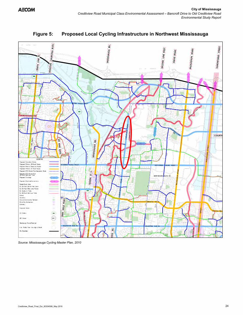
City of Mississauga Creditview Road Municipal Class Environmental Assessment – Bancroft Drive to Old Creditview Road
Environmental Study Report
Creditview_Road_Final_Esr_60304588_May 2016 24
Figure 5: Proposed Local Cycling Infrastructure in Northwest Mississauga
Source: Mississauga Cycling Master Plan, 2010

City of Mississauga Creditview Road Municipal Class Environmental Assessment – Bancroft Drive to Old Creditview Road
Environmental Study Report
Creditview_Road_Final_Esr_60304588_May 2016 25
4.1.3 Transit Services
Transit infrastructure and service within the study area is limited. There are two MiWay transit routes, 38 and 38A Creditview–Argentia, which run along this section of Creditview Road. These routes follow the same routing through the study area, travelling on Creditview Road between Bancroft Drive and Argentia Road. The difference between the two routes is:
Route 38 is the weekday service, and Route 38A is the weekend service.
South of the study area, Routes 38 and 38A follow the same routing, with the south terminus at Huron Park. Both routes share the same northern terminus at Meadowvale Town Centre, except the weekday Route 38 service and weekend Route 38A service follow different routes between Creditview Road and Meadowvale Town Centre. Figure 6 shows the route maps for MiWay Route 38 weekday and Route 38A weekend service. Figure 7 Figure 7shows the MiWay weekday route map for the vicinity of study area, showing connecting routes in the area.
Figure 6: MiWay Route 38 and 38A Route Maps
Source: MiWay website, retrieved October 2015 Route 38/38A currently provides a base level of service to the segment of Creditview Road under study. Headways on weekdays vary between 20 and 55 minutes, depending on the time of day. Saturday headways are 33 minutes and Sunday headways are 45 minutes. The headways along Route 38/38A are too large for the route to be considered a “frequent” service; typically, headways must be approximately 10 minutes or less for a route to be considered frequent.

City of Mississauga Creditview Road Municipal Class Environmental Assessment – Bancroft Drive to Old Creditview Road
Environmental Study Report
Creditview_Road_Final_Esr_60304588_May 2016 26
Figure 7: MiWay Weekday Route Map for Study Area Vicinity
Source: MiWay Weekday Service Map, September 2015 Transit infrastructure within the study area is limited to bus stops. There are no bus bays at any of the stops. None of the bus stops have shelters or other amenities for waiting passengers. Figure 8 illustrates the locations of bus stops in the study area. All bus stops are for MiWay Route 38 / 38A except for the bus stops at the Creditview Road and Old Creditview Road intersection, which are for MiWay Route 42. The eastbound bus stop on Bancroft Drive just east of Creditview Road is also served by Route 37.
Study Area
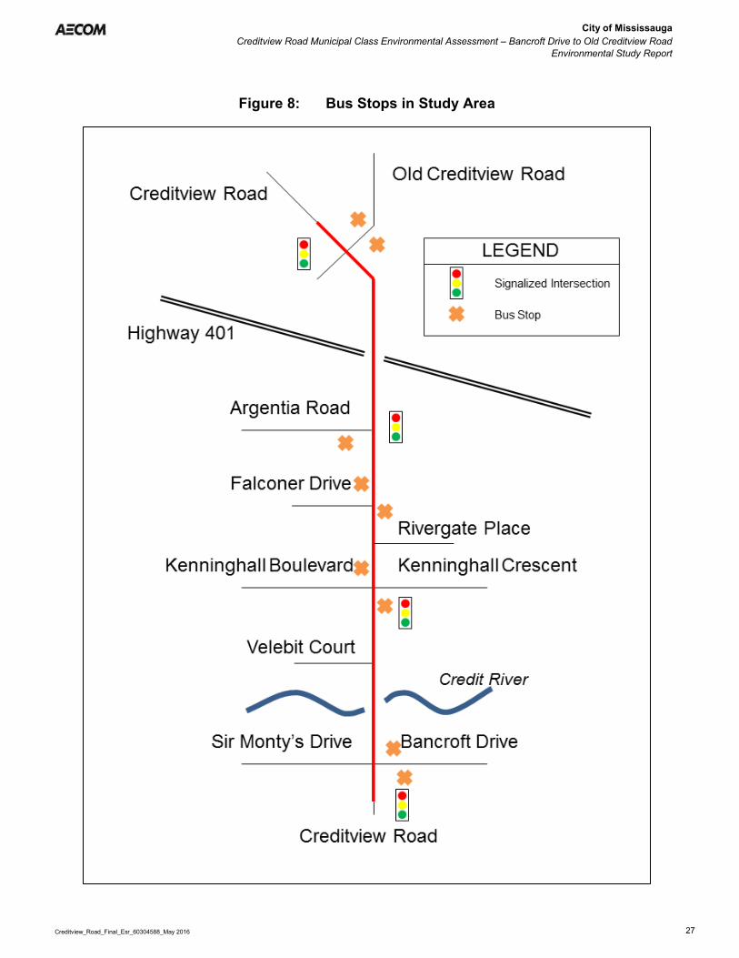
City of Mississauga Creditview Road Municipal Class Environmental Assessment – Bancroft Drive to Old Creditview Road
Environmental Study Report
Creditview_Road_Final_Esr_60304588_May 2016 27
Figure 8: Bus Stops in Study Area

City of Mississauga Creditview Road Municipal Class Environmental Assessment – Bancroft Drive to Old Creditview Road
Environmental Study Report
Creditview_Road_Final_Esr_60304588_May 2016 28
4.1.4 Safety Assessment
AECOM carried out a Safety Assessment for the study area in October 2013, the findings of which are documented in the Road Safety of Existing Conditions memorandum provided in Appendix C of this ESR. As part of the assessment, collision data (i.e., location, road surface condition, light and environmental conditions and collision severity type) for the study area were obtained from the City of Mississauga. The data was collected between January 2009 and December 2012. The following intersections along Creditview Road were analyzed as part of the assessment:
Bancroft Drive (Sir Monty’s Drive); Velebit Court; Kenninghall Boulevard; River Gate Place; Falconer Drive; Argentia Road; and Old Creditview Road.
Total of 69 reportable collisions were recorded for the study corridor over the period between January 1st, 2009 and December 31st, 2012. Of those,
1 collision was coded as “fatal”; 12 collisions were coded as “non-fatal injury”; and, 55 collisions were coded as “property damage only” (PDO).
Severity (noted as “accident classification” in the City’s collision database) for 1 collision was coded as “other”. Figure 9 shows the yearly distribution of the total number of collisions (“blue” bars) and the number of fatal /injury (i.e., non-fatal injury) collisions (“red” bars) over the four-year study period (2009 – 2012). Figure 9 shows a notable increase in both total and fatal / injury collisions from 2009 to 2010 and onward - the annual number of total and injury collisions almost doubled as compared to numbers in 2009; for fatal / injury collisions, the total number tripled; however, this change represents an increase by two, from one fatal / injury collision to three. The increases may be attributable to the random nature of collision occurrences.
Figure 9: Yearly Distribution of Total and Fatal/Injury Collisions (2009 – 2012)
11
19 19 20
1 3 4 5
0
5
10
15
20
25
2009 2010 2011 2012
TotalFatal / Injury

City of Mississauga Creditview Road Municipal Class Environmental Assessment – Bancroft Drive to Old Creditview Road
Environmental Study Report
Creditview_Road_Final_Esr_60304588_May 2016 29
In addition, as indicated above, the entire study corridor was further segmented into basic road elements (mid-block road sections and intersections) and the related facility type information stored in a new field (named as “facility type”) in the collision database. The following intersections and mid-block road sections along Creditview Road were analyzed as part of the road safety assessment. Creditview Road intersections at:
Bancroft Drive (Sir Monty’s Drive); Velebit Court; Kenninghall Boulevard; River Gate Place;
Falconer Drive; Argentia Road; and Old Creditview Road.
Mid-block road sections along Creditview Road between:
Bancroft Drive (Sir Monty’s Drive) and Velebit Court;
Velebit Court and Kenninghall Boulevard; Kenninghall Boulevard and River Gate Place;
River Gate Place and Falconer Drive; Falconer Drive and Argentia Road; and Argentia Road and Old Creditview Road.
4.1.4.1 Descriptive Collision Trends Analysis
The various collision characteristics for each of the road elements (i.e., mid-block road sections and intersections) were examined in terms of the following characteristics:
Collision severity including property damage only, injury and fatal;
Collision initial impact type;
Lighting condition; Road surface condition; and Environment condition.
Table 2 and Table 3 summarize the observed number of collisions for intersections and mid-block road sections respectively over the study period (January 2009 to December 2012). Intersections and mid-block road sections that had no reported collisions over the study period (highlighted in grey in Table 2 and Table 3) were excluded from any further analysis. As noted in the tables below, the majority of collisions (80.3% for intersections and 75.0% of mid-block road sections) were Property Damage Only (PDO) collisions. In Table 2, in comparison with other intersections within the study corridor, the two (2) intersections of Creditview Road / Bancroft Drive and Creditview Road / Argentia Road experienced a higher number of severe (fatal / injury) collisions.
Table 2: Observed Number of Collisions Classified by Severity at Intersections along Creditview Road from 2009 to 2012
Creditview Road Intersection at: Fatal Non-Fatal Injury Property Damage Only Unknown / Other Total Bancroft Drive (Sir Monty’s Drive) 0 5 17 0 22 Velebit Court 0 0 0 0 0 Kenninghall Boulevard 1 0 7 0 8 River Gate Place 0 0 1 0 1 Falconer Drive 0 1 4 0 5 Argentia Road 0 3 9 0 12 Old Creditview Road 0 1 11 1 13 Total 1 10 49 1 61

City of Mississauga Creditview Road Municipal Class Environmental Assessment – Bancroft Drive to Old Creditview Road
Environmental Study Report
Creditview_Road_Final_Esr_60304588_May 2016 30
Table 3: Observed Number of Collisions Classified by Severity on Mid-Block Road Sections along Creditview Road from 2009 to 2012
Creditview Road Mid-Block Road Section between: Non-Fatal Injury
Property Damage Only Total
Bancroft Drive (Sir Monty’s Drive) and Velebit Court 1 1 2
Velebit Court and Kenninghall Boulevard 0 2 2
Kenninghall Boulevard and River Gate Place 0 0 0
River Gate Place and Falconer Drive 0 1 1
Falconer Drive and Argentia Road 0 2 2
Argentia Road and Old Creditview Road 1 0 1
Total 2 6 8 In Table 2, the following intersections have the largest number of collisions in the study corridor:
Bancroft Drive (Sir Monty’s Drive); Old Creditview Road; and Argentia Road.
4.1.4.2 Potential for Safety Improvement (PSI)
The Potential for Safety Improvement (PSI) index is a measure of the excess crash frequency, above the expected value, that might be reduced if a safety improvement were implemented. The PSI was assessed for each of the locations reviewed as part of the Safety Assessment to evaluate the performance of each of the intersections from a safety perspective. The PSI value was calculated for each intersection based on a calculation that determines the difference between the predicted and expected safety performance (in terms of collision frequency) of a given location. In summary, locations with a positive PSI value (i.e., PSI value is greater than zero) have the potential for safety improvement. As such, an intersection with a greater PSI value implies that an intersection has a greater safety potential. Intersections with negative PSI values tend to have limited potential for safety improvements. As shown in Table 4, each of the intersections assessed as part of this Study have positive PSI values (i.e., the greatest potential for safety improvement).
Table 4: Intersections PSI Values
Creditview Road Intersection at:
Number of Legs – Traffic Control Type
Potential for Safety Improvement for FI
Collisions
Potential for Safety Improvement for PDO Collisions
Overall Potential for Safety Improvement Rank
Bancroft Drive (Sir Monty’s Drive)
Four – Traffic Signal 0.4616 2.5825 4.4935 1
Kenninghall Boulevard Four – Traffic Signal 0.0284 0.7270 0.8445 4
Falconer Drive Three – Stop Sign 0.0363 0.3867 0.6090 5
Argentia Road Three – Traffic Control 0.2481 0.8015 2.2479 2
Old Creditview Road Four – Traffic Signal 0.0334 1.4825 1.6207 3
The signalized Creditview Road intersections at Bancroft Drive, Argentia Road, and Old Creditview Road were identified as locations with relatively high potential for safety improvement and a higher number of total and severe collisions. Past speed studies completed by the City of Mississauga and recent field investigations conducted by the

City of Mississauga Creditview Road Municipal Class Environmental Assessment – Bancroft Drive to Old Creditview Road
Environmental Study Report
Creditview_Road_Final_Esr_60304588_May 2016 31
study team identified speeding and potential sightline issues (due to the vertical alignment) on the north approaches to the intersections of Creditview Road / Bancroft Drive and Creditview Road / Argentia Road as potential causal factors behind the prevalence of historic collisions at these two intersections.
4.1.5 Existing Traffic Conditions
An analysis of traffic operations based on the existing lane configurations was conducted to determine existing and future conditions along Creditview Road, including Level of Service (LOS) and volume to capacity ratio (v/c), the results of which are documented in the Traffic Operation Analysis report provided in Appendix D of this ESR. The study area extends on Creditview Road between Old Creditview Road to the north and Sir Monty’s/Bancroft Drive to the south. The traffic analysis considered the following key study area intersections:
Creditview Road/Bancroft Drive/Sir Monty’s Drive (Signalized) Creditview Road/Velebit Court (Unsignalized) Creditview Road/Kenninghall Crescent (Signalized) Creditview Road/Falconer Drive (Unsignalized) Creditview Road/Argentia Road (Signalized) Creditview Road/Old Creditview Road (Signalized)
4.1.5.1 Data Collection and Signal Timing
The Turning Movement Counts (TMC) and signal timings for the study area were provided by the City of Mississauga. All the TMCs were recorded on weekdays of Fall 2012 (October and November) or late Winter 2013 (March, 19th). Table 5 provides a list of traffic volumes inventory utilized for the existing condition analyses.
Table 5: Turning Movement Counts Inventory
No. Location Intersection Control
Date (Month, Day, Year) Source
1 Creditview Road/Old Creditview Road Signalized March 19, 2013 City of Mississauga 2 Creditview Road/Argentia Road Signalized November 6, 2012 City of Mississauga 3 Creditview Road/Kenninghall Blvd Signalized October 25, 2012 City of Mississauga 4 Creditview Road / Rivergate Place Unsignalized - Calculated1 4 Creditview Road/Falconer Drive Unsignalized October 24, 2012 City of Mississauga 6 Creditview Road/Velebit Court Unsignalized - Calculated1 5 Creditview Road/Bancroft Drive/Sir Monty’s Drive Signalized March 19, 2013 City of Mississauga
Note: 1 – Peak hour traffic volumes were generated based on Institute of Transportation Engineers (ITE) trips rates for Single Family Detached Housing
The heavy vehicle percentages for the weekday AM and PM peak hours were calculated based on the turning movement counts. Since the existing data was collected on different days, there was an inconsistency between volumes leaving an intersection with volumes arriving to the next intersection. This required a balancing process among the available counts to balance traffic flow. Figure 10 and Figure 11 compare traffic volumes before and after balancing for AM and PM peak hours.
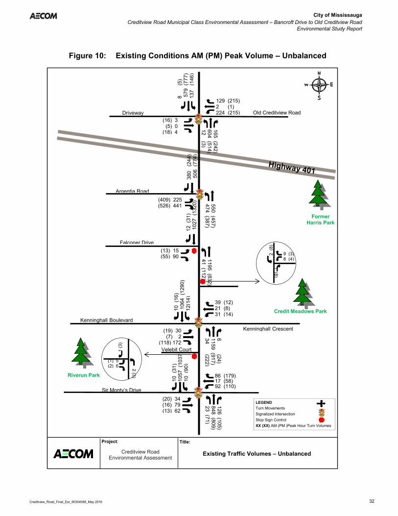
City of Mississauga Creditview Road Municipal Class Environmental Assessment – Bancroft Drive to Old Creditview Road
Environmental Study Report
Creditview_Road_Final_Esr_60304588_May 2016 32
Figure 10: Existing Conditions AM (PM) Peak Volume – Unbalanced
Creditview Road Environmental Assessment
Title: Project:
Existing Traffic Volumes – Unbalanced
Falconer Drive
Argentia Road
Sir Monty’s Drive
Riverun Park
Credit Meadows Park 39 (12) 21 (8) 31 (14)
129 (215) 2 (1) 224 (215)
126 (105) 848 (809) 23 (71)
10 (
31)
1057
(10
37)
10 (
90)
(20) 34 (16) 79 (13) 62
6 (24) 1159 (917) 34 (222)
165 (242) 604 (514) 12 (3)
(19) 30 (7) 2
(118) 172
10 (
16)
106
4 (1
290)
12
(14)
12
(31
) 1
027
(132
0)
1 (3
)
2 (3)
1195 (832) 41 (112)
LEGEND Turn Movements Signalized Intersection Stop Sign Control XX (XX) AM (PM )Peak Hour Turn Volumes
86 (179) 17 (58) 92 (110)
(13) 15 (55) 90
(1) 5 (2) 6
380
(24
4)
506
(77
4)
550 (457) 474 (387)
(409) 225 (526) 441
8
(5
) 5
79 (
777)
13
7 (
146)
(16) 3 (5) 0 (18) 4
Velebit Court
9 (3) 8 (4)
1 (8)
2 (8
)
Former Harris Park
Kenninghall Crescent
Driveway
Kenninghall Boulevard
Old Creditview Road

City of Mississauga Creditview Road Municipal Class Environmental Assessment – Bancroft Drive to Old Creditview Road
Environmental Study Report
Creditview_Road_Final_Esr_60304588_May 2016 33
Figure 11: Existing Conditions AM (PM) Peak Volume – Balanced
Creditview Road Environmental Assessment
Title: Project: Existing Traffic Volumes - Balanced
Falconer Drive
Argentia Road
Sir Monty’s Drive
Riverun Park
Credit Meadows Park 39 (12) 21 (8) 31 (14)
129 (215) 2 (1) 224 (215)
126 (105) 1076 (966) 23 (71)
10 (
31)
1252
(13
00)
10 (
90)
(20) 34 (16) 79 (13) 62
6 (24) 1159 (917) 34 (222)
165 (242) 814 (621) 12 (3)
(19) 30 (7) 2
(118) 172
10 (
16)
106
4 (1
290)
(1
4)
12 (
31)
990
(12
69)
1 (3
)
2 (3)
1195 (831) 41 (112)
LEGEND Turn Movements Signalized Intersection Stop Sign Control XX (XX) AM (PM )Peak Hour Turn Volumes
86 (179) 17 (58) 92 (110)
(13) 15 (55) 90
(1) 5 (2) 6
380
(24
4)
561
(77
4)
736 (457) 474 (387)
(409) 225 (526) 441
8
(5
) 7
13 (
785)
13
7 (
146)
(16) 3 (5) 0 (18) 4
Velebit Court
9 (3) 8 (4)
1 (8)
2 (8
)
Former Harris Park
Kenninghall Crescent
Driveway
Kenninghall Boulevard
Old Creditview Road
Bancroft Drive

City of Mississauga Creditview Road Municipal Class Environmental Assessment – Bancroft Drive to Old Creditview Road
Environmental Study Report
Creditview_Road_Final_Esr_60304588_May 2016 34
4.1.5.2 Traffic Operations Analysis
Traffic operations for all the intersections within the study area were analyzed using the Synchro 7.0 software package. The Synchro software is developed based on the Highway Capacity Manual (HCM 2000) methodologies and provides a detailed assessment of traffic operations including levels of service (LOS), delays and volume to capacity ratios (v/c) for overall, approaches, as well as individual movements of unsignalized and signalized intersections. LOS describes the “driver experience” on a transportation facility, with each LOS associated with the average delay each driver would experience at an intersection (see Table 6).
Table 6: Level of Service Descriptions
LOS Signalized Intersections Unsignalized Intersections
Description Delay Description Delay
A Very seldom does a vehicle wait longer than one red light. The approach appears open, turns are easily made and drivers have freedom of operation.
≤10 sec
Little or no traffic delay occurs. Approaches appear open, turning movements are easily made, and drivers have freedom of operation.
≤10 sec
B An occasional green light is fully used and many greens approach full use. Many drivers begin to feel somewhat restricted within groups of vehicles approaching the intersection.
≤20 sec
Short traffic delays occur. Many drivers begin to feel somewhat restricted in terms of freedom of operation.
≤15 sec
C Intersection operation is stable but often has fully used greens. Drivers feel more restricted and occasionally may wait more than one red light. Queues may develop behind turning vehicles.
≤35 sec
Average traffic delays occur. Operations are generally stable, but drivers emerging from the minor street may experience difficulty in completing their movement. This may occasionally impact on the stability of flow on the major street.
≤25 sec
D Drivers experience increasing restriction and instability of traffic flow. There are substantial delays to vehicles during short peaks within the peak hour, but there is enough time with lower demand to permit occasional clearing of queues and prevent excessive backups.
≤55 sec
Long traffic delays occur. Drivers emerging from minor streets experience significant restriction and frustration. Drivers on the major street will experience congestion and delay.
≤35 sec
E The capacity of the road is reached. There are long queues of vehicles waiting upstream of the intersection and delays to vehicles may extend to several signal cycles.
≤80 sec
Very long traffic delays occur. Operations approach the capacity of the intersection.
≤50 sec
F Vehicle demand exceeds the available capacity and delays extending through the peak hour are experienced.
>80 sec
Vehicle demand exceeds the available capacity. Very long traffic delays occur frequently.
>50 sec
The v/c ratio represents how full a road or intersection movement is, based on actual volumes versus the maximum number of vehicles that can travel. A v/c ratio between 0.00 and 0.49 means that less than half the capacity is being used by vehicles; this is generally associated with good operating conditions. As the v/c approaches 1.00, traffic conditions worsen and at 1.00 the theoretical maximum number of vehicles is reached and operations are generally very poor. The v/c can exceed 1.00, indicating very bad operations and extended traffic delays. The “critical movements” identified in the capacity analyses summary tables are those having an LOS of “E” or “F” and/or a v/c ratio of 0.85 or greater for signalized intersections, and for unsignalized intersections an LOS of “E”, or ”F”. Since the analysis is based on actual volumes, v/c > 1.00 indicates that the counted traffic volumes exceeded the capacity calculated by the analysis procedure/software. Individual movements at intersections with calculated v/c > 1.00 are operating essentially above capacity and can be expected to experience severe recurring queuing and congestion during both the AM and PM peak periods. A summary of results are provided in Table 7. All critical individual movements with respect to levels of service and volumes to capacity ratios are shown in red in Table 7.

City of Mississauga Creditview Road Municipal Class Environmental Assessment – Bancroft Drive to Old Creditview Road
Environmental Study Report
Creditview_Road_Final_Esr_60304588_May 2016 35
Table 7: Existing Condition Traffic Analysis – AM and PM Peak Hours
Intersection Movement Weekday AM Peak Hour Weekday PM Peak Hour
Delay (sec) LOS V/C Delay
(sec) LOS V/C
Creditview Road/Old Creditview Road
(Signalized)
SB Left 8.6 A 0.37 8.1 A 0.36 Thru 12.1 B 0.58 12.8 B 0.63 Right 6.1 A 0.01 6.1 A 0.00
NB Left 11.0 B 0.03 16.7 B 0.01 Thru-Right 17.6 B 0.51 25.7 C 0.43
EB Left-Thru 34.9 C 0.02 35.4 D 0.08 Right 34.7 C 0.00 34.8 C 0.01
WB Left-Thru 60.2 E 0.81 56.4 E 0.79 Right 35.5 D 0.08 35.9 D 0.14
Overall Intersection 20.6 C 0.64 24.1 C 0.66
Creditview Road/Argentia Road (Signalized)
EB Left 56.7 E 0.77 190.0 F 1.05 Right 33.2 C 0.59 31.0 C 0.71
NB Left 16.2 B 0.82 96.3 F 0.97 Thru 4.8 A 0.57 9.0 A 0.37
SB Thru 14.9 B 0.59 53.1 D 0.95 Right 6.5 A 0.24 14.1 B 0.20
Overall Intersection 17.6 B 0.78 64.3 E 0.95
Creditview Road/Kenninghall Blvd
(Signalized)
EB Left-Thru-Right 50.3 D 0.54 49.3 D 0.29 WB Left-Thru-Right 159.3 F 0.89 50.8 D 0.32
NB Left 2.9 A 0.14 103.9 F 0.96 Thru-Right 6.4 A 0.80 6.0 A 0.62
SB Left 4.2 A 0.10 5.4 A 0.06 Thru-Right 8.2 A 0.73 59.5 E 1.01
Overall Intersection 15.9 B 0.81 43.3 D 0.94
Creditview Road/Bancroft Drive/Sir Monty’s
(Signalized)
EB Left 44.6 D 0.24 45.6 D 0.29 Thru-Right 48.4 D 0.54 42.3 D 0.08
WB Left 58.0 E 0.66 51.6 D 0.61 Thru-Right 43.6 D 0.15 48.9 D 0.58
NB Left 4.1 A 0.09 7.2 A 0.29 Thru 11.5 B 0.76 9.8 A 0.69 Right 3.5 A 0.08 3.6 A 0.07
SB Left 9.0 A 0.17 7.8 A 0.30 Thru-Right 8.0 A 0.47 8.8 A 0.50
Overall Intersection 14.4 B 0.75 14.3 B 0.68
Creditview Road/Falconer Drive (Unsignalized)
EB Left 672.0 F 0.86 226.6 F 0.45 Right 24.1 C 0.32 43.7 E 0.37
NB Left 11.3 B 0.07 19.5 C 0.31 Creditview Road/Velebit Court(Unsignalized)
EB Left-Right >1000 F >2.00 >1000 F 1.17 NB Left 19.4 C 0.01 26.1 D 0.02
Creditview Road/Rivergate Place (Unsignalized)
SB Left 17.6 C 0.01 10.8 B 0.01 WB Left-Right >1000 F >2.00 140.4 F 0.21
Note: Critical movements were shown in red in the table with V/C ratios ≥ 0.85 and or LOS E or worse

City of Mississauga Creditview Road Municipal Class Environmental Assessment – Bancroft Drive to Old Creditview Road
Environmental Study Report
Creditview_Road_Final_Esr_60304588_May 2016 36
Based on the intersection capacity analyses results presented in Table 7, half of the signalized (during the PM Peak hour only) and all of the unsignalized intersections (during both the AM and PM peak hours) within the study area are operating at or above capacity with significant delays. The following individual movements are operating at LOS “E” or worse:
AM Peak Hour
Creditview Road at Old Creditview Road – westbound left-through Creditview Road at Argentia Road – eastbound left Creditview Road at Kenninghall Blvd – westbound left- through-right Creditview Road at Bancroft Drive – westbound left Creditview Road at Falconer Drive – eastbound left Creditview Road at Velebit Court – eastbound left/right Creditview Road at Rivergate Place – westbound left-through
PM Peak Hour
Creditview Road at Old Creditview Road – southbound left-through Creditview Road at Argentia Road – northbound left, eastbound left and southbound through Creditview Road at Kenninghall Blvd – northbound left and southbound through-right Creditview Road at Falconer Drive – eastbound left and eastbound right Creditview Road at Velebit Court – eastbound left/right Creditview Road at Rivergate Place – westbound left/right
The unsignalized intersections within the study area experience significant delay while exiting on to Creditview Road during both the peak hours. Since traffic volumes are heavier compared to the available capacity on Creditview Road during the peak hours, very minimal gaps are available for vehicles exiting from the stop controlled side streets. Also with respect to the individual movements, southbound through movements on Creditview Road operate at or above capacity in the peak direction during the PM peak hour.
4.1.6 Future Traffic Growth Projections
Based on projected growth rates in the City, traffic modelling software (Synchro 7.0) was used to determine the future traffic growth and demand on the Creditview Road corridor for the 2021 and 2031 horizon years. Overall, continued growth within the northwest portion of the City will increase the use of Creditview Road. As such, traffic operations for Creditview Road within the study area between Bancroft Drive and Old Creditview Road would operate beyond capacity, as described herein.
4.1.6.1 Horizon Year 2021
The future traffic volumes under ‘no improvements’ conditions were analyzed for the horizon year 2021 using the existing lane configuration and signal timings provided by the City of Mississauga. Based on the findings of the intersection capacity analyses, all signalized and unsignalized intersections within the study area are expected to operate at or above capacity with significant delays during both the AM and PM peak hours in 2021. The following individual movements are anticipated to operate at LOS “E” or worse:
AM Peak Hour
Creditview Road at Old Creditview Road – westbound left-through Creditview Road at Argentia Road – northbound left and eastbound left Creditview Road at Kenninghall Blvd – westbound left-thru-right and northbound through-right Creditview Road at Bancroft Drive – westbound left Creditview Road at Falconer Drive – eastbound left

City of Mississauga Creditview Road Municipal Class Environmental Assessment – Bancroft Drive to Old Creditview Road
Environmental Study Report
Creditview_Road_Final_Esr_60304588_May 2016 37
Creditview Road at Velebit Court – eastbound left/right Creditview Road and Rivergate Place – westbound left/right
PM Peak Hour
Creditview Road at Old Creditview Road – westbound left-through Creditview Road at Argentia Road – northbound left, eastbound left, and southbound through Creditview Road at Kenninghall Blvd – northbound left and southbound through-right Creditview Road at Falconer Drive – eastbound left and eastbound right Creditview Road at Velebit Court – eastbound left/right and northbound left Creditview Road and Rivergate Place – westbound left/right
4.1.6.2 Horizon Year 2031
Based on the intersection capacity analyses results, all signalized and unsignalized intersections within the study area will continue to operate at or above capacity with significant delays during both the AM and PM peak hours during horizon year 2031 without any improvements. The following individual movements are operating at LOS “E” or worse:
AM Peak Hour
Creditview Road at Old Creditview Road – westbound left-through Creditview Road at Argentia Road – northbound left Creditview Road at Kenninghall Blvd – westbound left-through-right and northbound through-right Creditview Road at Bancroft Drive – westbound left Creditview Road at Falconer Drive – eastbound left Creditview Road at Velebit Court – eastbound left/right and northbound left Creditview Road and Rivergate Place – westbound left/right Creditview Road and Sir Monty’s Drive/Bancroft Drive – westbound left and northbound through
PM Peak Hour
Creditview Road at Old Creditview Road – westbound left-through Creditview Road at Argentia Road – northbound left, eastbound left, and southbound through Creditview Road at Kenninghall Blvd – northbound left and southbound through-right Creditview Road at Falconer Drive – eastbound left, eastbound right, and northbound left Creditview
Road at Velebit Court – eastbound left/right and northbound left Creditview Road and Rivergate Place – westbound left/right
Based on the results of the analyses, signalized and unsignalized intersections are expected to operate above capacity with significant delays during the future horizon years 2021 and 2031 without any improvements. As such, Creditview Road intersection improvements and/or additional lanes are required to address the identified existing and future traffic operational deficiencies.
4.2 Physical Environment
4.2.1 Subsurface Soils
Subsurface conditions throughout the study area generally consist of Oneida Clay Loam and Chinguacousy Clay Loam. These soils are considered typical of the Halton Till and have limited infiltration capacity. Chinguacousy Clay Loam is classified as Hydrologic Soil Group C in the US Soil Conservation Service (SCS) system, and Oneida Clay Loam falls under soil group D. The Ontario Soil Survey Report Number 18 of Peel County (1953) indicates small areas where Fox and Berrien Sandy Loams are more predominant.

City of Mississauga Creditview Road Municipal Class Environmental Assessment – Bancroft Drive to Old Creditview Road
Environmental Study Report
Creditview_Road_Final_Esr_60304588_May 2016 38
It should be noted that the findings of a geotechnical investigation carried out as part of this EA study generally indicated that boreholes advanced within selected locations of the Creditview Road right-of-way (ROW), within the limits of the study area, encountered a layer of fill material (generally 1 m to 2 m in depth) underlain by native clayey silt till.
4.2.2 Physiography and Topography
The majority of the study area lies within the Peel Plain Physiographic Region (Chapman and Putnam, 1984). The Peel Plain is a level to undulating tract of clay with limited areas where sandy alluvium borders stream valleys. In general, the study area slopes in a southerly direction toward Lake Ontario.
4.3 Natural Environment
The existing natural environment conditions in the study area were identified based on a review of secondary source information and desktop analyses. Several field investigations were also carried out on October 18, 2013, April 21, May 22, June 6 and 23, 2014, to supplement the existing secondary source information and confirm the findings of the secondary source review, the results of which are documented in the Natural Environment Assessment report provided in Appendix E of this ESR.
4.3.1 Designated Natural Areas
According to MNR’s Natural Resource Values Information System (NRVIS) mapping (MNR, 2011), there are no Provincially or Locally Significant Wetlands, unevaluated wetlands or Provincial Parks in or within the vicinity of the study area. In addition, there are no Areas of Natural Scientific Interest (ANSI) or Environmentally Sensitive Areas (ESA) located in the study area. The Meadowvale Stations Woods ESA Conservation Area and Regionally Significant Life Science ANSI are approximately 550 m east of the study area (please refer to Figure 12) and provides habitat for a high diversity of plant and wildlife species. However, impacts to this ESA and ANSI are not expected in association with this project given its intervening distance from the study area.

City of Mississauga Creditview Road Municipal Class Environmental Assessment – Bancroft Drive to Old Creditview Road
Environmental Study Report
Creditview_Road_Final_Esr_60304588_May 2016 39
Figure 12: Designated Natural Areas
4.3.1.1 Credit Valley Conservation Authority (CVC) Regulated Areas
As noted in Figure 12, a portion of the study area traverses a regulatory floodline in association with the Credit River. These areas are under the jurisdiction of the CVC and are defined where development could be subject to flooding, erosion or dynamic beaches, or where interference with wetlands and alterations to shorelines and watercourses might have an adverse effect on those environmental features. Any proposed development, interference or alteration within a Regulated Area would require a permit from CVC.
4.3.1.2 City of Mississauga Natural Areas
The City of Mississauga employs a Natural Areas System in order to protect, enhance and restore features in the natural environment and their ecological function and integrity. According to the City of Mississauga Natural Areas Survey (NAS) 2011 Update, the CRR2 Credit Meadows natural area is located within the Credit River valley along Creditview Road, south of Highway 401. Five (5) Butternut trees (Juglans cinerea), a Species at Risk designated as Endangered under the ESA, were found in this Natural Area at two (2) locations. These Butternuts were recorded as possible hybrids given their good health and lack of canker. Bird Species at Risk documented include Barn Swallow, Bobolink and Eastern Meadowlark. Amphibian surveys conducted in 2011 concluded that American Toad and Green Frog were prevalent at this site; however, no salamander species were found. Snapping Turtle was also recorded at this Site in 2011. A large cultural meadow located within the study area along the east side of Creditview Road and south of Highway of 401 was added as a Special Management Area with the intention of restoring this cultural meadow to provide a bigger buffer to the adjacent CRR2 forests. Under Section 6.3.1.13 of the Mississauga Official Plan (City of Mississauga, 2013), development and site alteration is prohibited within or adjacent to Natural Areas and Special Management Areas unless an Environmental Impact Study (EIS) is conducted demonstrating that are no negative impacts to the features or their ecological function as result of the proposed development.

City of Mississauga Creditview Road Municipal Class Environmental Assessment – Bancroft Drive to Old Creditview Road
Environmental Study Report
Creditview_Road_Final_Esr_60304588_May 2016 40
4.3.1.3 CVC Landscape Scale Analysis
CVC conducted a Landscape Scale Analysis (LAS) of the City of Mississauga which assesses the ecosystem function of the City’s natural and semi-natural areas and complements the existing Mississauga Natural Areas Survey (NAS). LAS uses nine (9) criteria including (i) woodlands, (ii) wetlands, (iii) successional habitats, (iv) valleylands, (v) high habitat diversity, (vi) uncommon vegetation communities, (vii) ecological proximity, (viii) sub-regional connectivity and (ix) regional and provincial connectivity and applies a scoring system for each criterion based on established thresholds to determine habitat patches that are high – functioning. Based on this analysis, the study area contains lands that are considered as a high functioning woodland, wetland, successional area, valleyland, habitat diversity and regional and provincial connectivity linkage (CVC, 2012d).
4.3.2 Aquatic Environment
The study area is situated within the Credit River Watershed which covers a drainage area of approximately 1,000 square kilometres (km2) and is under the jurisdiction of the CVC. Credit River and its tributaries flow approximately 1,500 km2 southeast towards Lake Ontario from its headwaters in Orangeville (CVC, 2011). The section of the Credit River that falls within the study area supports a mix of cool and warm water fish communities. The Lower Watershed is known for its migratory runs of trout and salmon in Credit River and for its restoration of Atlantic Salmon to Lake Ontario (CVC, 2011). Although there are healthy populations of trout, salmon and bass, minnows are the most common fish species in Credit River. Fish communities in the Lower Watershed are generally classified as having poor fish community health with fish communities primarily comprised of species that are tolerant to environmental disturbance such as Blacknose Dace (Rhinichthys atratulus) and Creek Chub (Semotilus atromaculatus) (CVC, 2013c) A total of 25 fish species have historically been recorded at eight (8) monitoring stations along the Credit River, the majority of which are representative of an intermediate to tolerant, mixed cool and warmwater fish community. Common fish species include Bluntnose Minnow (Pimephales notatus), Common Shiner (Luxilus cornutus), Creek Chub, Rainbow Darter (Etheostoma caeruleum) and White Sucker (Catostomus commersonii). The existing crossing of the Credit River is not included as part of this project. As such, no impacts to the Credit River are anticipated in association with this project.
4.3.3 Terrestrial Environment
The majority of the terrestrial environment within the study area consists of roadside trees planted approximately 5 m to 10 m from Creditview Road. Other terrestrial features include riparian vegetation and wooded areas surrounding Credit River that are considered as part of the Natural Areas System, as identified in Schedule 3 of the City of Mississauga OP. Generally, the terrestrial conditions found within the study area consist of anthropogenically influenced communities comprising cultural meadows, woodlands and savannahs, as well as planted tree hedgerows along Creditview Road. In addition, the following natural areas were identified within the study area:
Credit Meadows Park; Riverrun Park; Woodland feature located on east side across from Falconer Drive; Meadow feature located on the east side of Creditview Road south of Highway 401; and Meadow features located around Creditview Road near Highway 401.

City of Mississauga Creditview Road Municipal Class Environmental Assessment – Bancroft Drive to Old Creditview Road
Environmental Study Report
Creditview_Road_Final_Esr_60304588_May 2016 41
Ecological Land Classification (ELC) vegetation communities were identified within each of these natural areas, as well as other vegetation communities situated between these natural features along Creditview Road. A general overview of the communities encountered is summarized below. A detailed description of the ELC communities and their respective locations is offered within the Natural Environment Report, provided in Appendix E of this ESR. In total, 125 plant species were observed in the study area at the time of the field investigation, 57% of which are native species. The balance of plant species are non-native and/or invasive and are indicative of a high level of disturbance. No rare and/or designated plant species were identified within the study area, with the exception of two (2) Regionally Rare Black Oak (Quercus velutina) tree species situated at the southeast corner of Velebit Court and Creditview Road. A cultural woodland and cultural hedgerow were delineated along the east and west sides of Creditview Road, between Bancroft Drive to Credit Meadows Park, respectively. Credit Meadows Park is located on the floodplain of Credit River, upstream of the Creditview Road crossing. Three vegetation communities were delineated within this portion of the study area, including two (2) cultural savannahs and one (1) deciduous forest. Riverrun Park is also located on the floodplain of Credit River, downstream of the Creditview Road crossing. Within the limits of the study area, four (4) vegetation communities were delineated within Riverrun Park, including one (1) cultural savannah and two (2) deciduous forests. The Regionally Rare Black Oak (Quercus velutina) trees were identified at the southwest corner of Velebit Court and Creditview Road during field investigations, at the western edge of the deciduous forest community. Black Oak is southern or Carolinian tree species that is at the northern edge of its range in Peel Region. The trees were measured to be 18.5 and 23.5 cm in diameter at breast height. One (1) cultural woodland and two (2) cultural hedgerows were delineated on the east side of Creditview Road between Kenninghall Crescent to Rivergate Place. In addition, a woodland feature is located on the east side of Credtview Road and occupies a portion of Park 505 – Former Harris Lands. Two (2) vegetation communities (i.e., a cultural woodland and deciduous forest) were delineated in this area at the time of the field investigation. A meadow feature was identified on the east side of Creditview Road, south of Highway 401, and consists of three (3) vegetation communities (i.e., one (1) cultural meadow and two (2) cultural hedgerows). One (1) cultural hedgerow is present on the east side of Creditview Road and primarily consists of Sugar Maple and Black Walnut. The west side of Creditview Road within this section is dominated by residential and commercial development areas; however, the cultural hedgerow primarily consists of Austrian Pine, Black Walnut and Norway Maple. The cultural meadow was delineated in the vicinity of the Creditview Road crossing of Highway. This section of Creditview Road is dominated by commercial development to the west and agricultural fields to the east. The approximately 38 ha agricultural field was planted with hay at the time of the 2013 field investigation.
4.3.4 Wetlands
A small wetland community with vernal pool is present at the bottom of a slope between the deciduous forest communities delineated at Riverrun Park within the limits of the study area. Given the presence of the vernal pool, the community was considered potentially suitable amphibian breeding habitat. Other wetland communities consist of isolated inclusions of Cattail Graminoid Mineral Meadow Marsh in shallow depressions that were individually far less than 0.5 ha in size. Other small (i.e., less than 0.5 ha in size) wetland communities were identified within the study area, however given the shallow depth of the water in the small and isolated vernal pools, they were considered unlikely to support breeding amphibian populations.

City of Mississauga Creditview Road Municipal Class Environmental Assessment – Bancroft Drive to Old Creditview Road
Environmental Study Report
Creditview_Road_Final_Esr_60304588_May 2016 42
4.3.5 Wildlife
Birds
A list of bird species within or in the vicinity of the study area was obtained from the Atlas of the Breeding Birds of Ontario Database. The majority of these birds are common and are adapted to human-modified landscapes, such as urban or suburban areas or agricultural fields. Six (6) of these bird species, including Barn Swallow (Hirundo rustica), Bobolink (Dolichonyx orzyvorus), Chimney Swift (Chaetura pelagica), Common Nighthawk (Chordeiles minor), Eastern Meadow Lark (Sturnella magna) and Peregrine Falcon (Falco peregrinus), are considered to be Species at Risk in Ontario under the Endangered Species Act 2007 (the ESA). Mammals
According to the Atlas of the Mammals of Ontario (Dobbyn, 1994), a number of mammal species may be present in the vicinity of the study area, all of which are considered common mammals, with the exception of Little Brown Bat and Northern Long-eared Bat, which are designated as Endangered under the ESA. Herpetofauna
According to the Ontario’s Reptile and Amphibian Atlas (Ontario Nature, 2013), reptile and amphibian species have historical and/or recent occurrence records within or in the vicinity of the study area, including the Jefferson Salamander, a Species at Risk that is designated as Endangered under the ESA. In addition, two (2) Snapping Turtles and two (2) Midland Painted Turtles were reported anecdotally by a local resident as roadkill near the Creditview Road Bridge, crossing the Credit River. The two (2) Snapping Turtles were reported to be laying eggs at the time. This observation confirms that there is a population of Snapping Turtles present in the Credit River and that some gravid female turtles come up from the river to lay eggs in the sand and gravely substrate shoulder of Creditview Road. Incidental Wildlife Observations
Incidental wildlife observations were recorded during the field investigations conducted by AECOM Ecologists. A summary of wildlife species including birds and small mammals observed within the study area is provided in Table 8.
Table 8: Incidental Wildlife Observation in the Study Area
Species No. of Individuals Type of Observation Location
Eastern Grey Squirrel (Sciurus carolinensis)
Unknown Tracks FOD5-1 (in Credit Meadows Park)
Eastern Cottontail (Sylvilagus floridanus)
3 Observed CUW1a, FOD6-2, FOD5-1 (in Credit Meadows Park)
American Robin (Turdus migratorius)
1+ Observed, heard calling Along Creditview Road
Mourning Dove (Zenaida macroura)
1 Observed Along Creditview Road
Red-tailed Hawk (Buteo jamaicensis)
1 Observed - soaring Along Credit River crossing of Creditview Road
Song Sparrow (Melospiza melodia)
1 Heard calling Along Creditview Road
Blue Jay (Cyanocitta cristata)
1+ Heard calling CUW1a

City of Mississauga Creditview Road Municipal Class Environmental Assessment – Bancroft Drive to Old Creditview Road
Environmental Study Report
Creditview_Road_Final_Esr_60304588_May 2016 43
American Goldfinch (Spinus tristis)
1 Heard calling Along Creditview Road
Rock Pigeon (Columba livia)
Many Observed Along Creditview Road, Credit Meadows Park
Belted Kingfisher (Megaceryle alcyon)
1 Heard Calling Along Credit River crossing of Creditview Road
Turkey Vulture (Cathartes aura)
1 Observed – soaring Along Credit River crossing of Creditview Road
4.3.5.1 Species at Risk
With respect to Species at Risk (SAR) within the study area, the Ministry of Natural Resources and Forestry (MNRF) Species at Risk in Ontario website (MNRF, 2013b) was searched for Species at Risk that may occur within the Region of Peel. A list of SAR known to occur within the Region of Peel and their preferred habitat was obtained and supplemented with the results from the Atlas of Breeding Birds in Ontario, Ontario’s Reptile and Herpetofauna Atlas and Atlas of Mammals of Ontario to create a complete list. In total, twenty-nine (29) SAR were identified in the Region of Peel. A habitat assessment for each of the SAR was completed to determine whether the species has the potential to occur in the study area based on the presence of its respective suitable habitat, including their habitat preferences, geographic distributions and assessments of potential occurrence in the study area. Based on the findings of the assessment, ten (10) SAR were determined to have suitable habitat present within the study area boundaries; as summarized below. Modifications to Creditview Road would likely require minimal vegetation removal in the vegetation communities adjacent to the road that contain suitable habitat for the identified species. The only confirmed habitat in the study area is that of Snapping Turtle, Butternut, Barn Swallow, Bobolink and Eastern Meadowlark. Although habitat for Jefferson Salamander is not confirmed in the study area as identified through the background review, there is some potential that suitable habitat may occur given the proximity of Meadowvale Station Woods, which contains confirmed habitat, close to the study area. A request was made to the Aurora MNRF District for information regarding the presence of SAR occurring in or adjacent to the study area on September 16, 2013. The response received from the MNR (on November 27, 2013) indicated that four (4) SAR (i.e., Butternut, Northern Myotis, Snapping Turtle and Milksnake) have been recorded in the vicinity of the study area. Snapping Turtle Habitat
The Snapping Turtle, designated as Special Concern is a generalist species found in a wide range of freshwater habitat although their preferred habitat is a slow-moving watercourse with soft mud bottom and dense aquatic vegetation (COSEWIC, 2010). Snapping Turtles are also tolerant of some environmental pollution and therefore can persist in urbanized areas (COSEWIC, 2010). For these reasons, the Credit River, which even though has poor water quality as determined by the Credit River Watershed Report Card 2013 (CVC), still provides suitable habitat for this species. Butternut Habitat
Butternut is designated as Endangered species and is protected under the ESA. This species typically grows in deciduous forests on rich, moist, well-drained loams often found on stream bank sites but also on well-drained gravelly sites, especially those of limestone origin. Butternuts are shade-intolerant and as a result are often found in open canopy pockets and on forest edges (COSEWIC, 2003). According to the City of Mississauga Natural Area Survey 2011 Update, five (5) Butternut trees (Juglans cinerea) were found in the CRR2 Credit Meadows Significant Natural Site, of which a small portions fall within the study area boundaries. It is likely that those Butternuts are found well away from the narrow study area. These Butternuts were recorded as possible hybrids given their

City of Mississauga Creditview Road Municipal Class Environmental Assessment – Bancroft Drive to Old Creditview Road
Environmental Study Report
Creditview_Road_Final_Esr_60304588_May 2016 44
vigorous good health and lack of canker evidence. Generally, hybrids are not afforded protection under the ESA. Nevertheless, no Butternuts were observed in the study area limits during the field investigations. Barn Swallow Habitat
Barn Swallow is designated as Threatened species and is protected under the ESA. This species lives and nests in man-made structures such as open barns, buildings, under bridges and culverts (COSEWIC, 2011a). According to the City of Mississauga Natural Area Survey 2011 Update, a Barn Swallow was observed in the CRR2 Credit Meadows Significant Natural Site. Bobolink and Eastern Meadowlark Habitat
Bobolink and Eastern Meadowlark are both designated as Threatened in the Province of Ontario and are protected under the ESA. Both inhabit similar habitats and prefer to breed in large tracts of tall grass prairies, meadows and natural grassland; although, in southern Ontario they are more commonly found in hayfields and pastures (COSEWIC 2010a and 2011b). According to the City of Mississauga Natural Area Survey 2011 Update, these species were observed in the CRR2 Credit Meadows Significant Natural Site; however, they likely occurred in the meadow area that is at least 300 m east of Creditview Road. The hayfield northeast of Creditview Road and Highway 401 another meadow east of Creditview Road south of Highway 401 were identified as having some potential to provide suitable habitat for Bobolink and/or Eastern Meadowlark. Eastern Wood Pewee
The Eastern Wood Pewee is a small non-descript flycatcher with a distinctive call that inhabits deciduous forests across southern Ontario. The species has shown a long term population decline which is why it is now designated as Special Concern, even though it is still widespread and fairly common. Jefferson Salamander Habitat
The Jefferson Salamander is designated as Endangered by the Province of Ontario and it as well as its habitat is protected under the ESA. Suitable habitat for this species includes deciduous or mixed upland forests which contain suitable breeding pools (COSEWIC, 2010b). Suitable breeding pools are often ephemeral, do not contain predatory fish, contain attachment sites for the egg masses and hold sufficient water for the duration of larval development (COSEWIC, 2010b). Suitable breeding habitat for Jefferson Salamander is located north of Highway 401 within Meadowvale Station Woods as confirmed by CVC and MNRF (AECOM, 2012 and MMM & Ecoplans Ltd., 2005). Meadowvale Station Woods is located more than 900 m away from Creditview Road. As noted above, one potential breeding site was identified within the vernal pool situated in the mineral meadow marsh on the west side of Creditview Road. It was sufficiently deep (up to 1 m in early spring) to maintain water for a sufficient period and was surrounded by mature deciduous forest approximately 1.5 ha in area that is connected to some other small patches of deciduous forest along Credit River. Milksnake Habitat
Milksnake is designated as Special Concern and can be found underneath logs, stones or boards, in farmlands and meadows, forest stands and river bottoms. The cultural meadows located in the northern end of the study area and also the cultural savannahs located along the Credit River may provide suitable habitat for this species; however this species was not observed during the field investigation. The species is highly susceptible to road mortality and therefore it is more likely to occur in habitat further removed from the roadside.

City of Mississauga Creditview Road Municipal Class Environmental Assessment – Bancroft Drive to Old Creditview Road
Environmental Study Report
Creditview_Road_Final_Esr_60304588_May 2016 45
Northern Myotis and Little Brown Myotis
Both species are designated as Endangered due to their precipitous population declines in recent years as a result of the White Nose Syndrome. Little Brown Myotis is more likely to be present in the general area as it was the most common bat in southern Ontario prior to the fairly recent spread of this disease. Northern Myotis are typically more northern in their distribution and were less numerous. These bats are migratory and hibernate in caves but inhabit cavity trees during the spring and summer season. Females use cavity trees as maternity roosts in the month of June. Given the presence of deciduous forest stands in the study area, there may be suitable habitat for this species. However, the bats are likely to avoid trees on the immediate roadside due to noise, motion and openness. Bats are more likely to use trees in mature forests, well back from the roadside. Monarch Butterfly
The Monarch butterfly is well known for its long distance migration from southern Ontario to wintering areas in Mexico. Although it was not actually observed during field investigations, the species is ubiquitous in field habitat within the GTA and during the autumn migration period in August and September, they will move through virtually every type of habitat, including urban areas. Some of the meadow areas in the study area contain Common Milkweed which is the food plant of the Monarch larvae. The species is almost certainly present in the study area as a migrant and summer resident.
4.3.5.2 Amphibian Breeding Bird and Surveys (2014)
Wildlife surveys were conducted in the spring and early summer 2014 by AECOM ecologists, as described herein. Amphibians
Given the identification of potential suitable amphibian breeding habitat within the small wetland community with vernal pool observed at the bottom of a slope between a bottomland deciduous forest communities, nocturnal amphibian surveys were conducted on April 21 and May 22, 2014 by an AECOM ecologist. Site conditions and the possible presence of amphibians were also documented at the candidate breeding site on the morning of June 6, 2014. The findings of the surveys indicated that no amphibians and/or egg masses or larvae were present within the potential habitat areas. Breeding Birds
Breeding bird surveys were conducted during the morning hours on June 6 and June 23, 2014 (i.e., the peak of the breeding season). All birds seen and heard within 100 m on either side of Creditview Road were mapped at their respective locations at the time of the surveys. A total of thirty-one (31) bird species were recorded within the area. No evidence of Eastern Meadowlark, Bobolink and/or Barn Swallows was noted during the targeted surveys. Bird species encountered generally consisted of common bird species that are adaptable to disturbed conditions, with the exception of one (1) bird SAR (i.e., Eastern Wood Pewee (Contopus virens)) was noted to be singing within the woodlot occupying a portion of Park 505 – Former Harris Lands, and situated opposite Falconer Drive at the time of the June 6, 2014 survey only. The woodlot provides suitable breeding habitat where the species would be expected and is considered large enough to support a breeding territory. A detailed list of the common bird species identified during the breeding bird surveys is offered within the Natural Environment Report provided in Appendix E of this ESR.
City of Mississauga Creditview Road Municipal Class Environmental Assessment – Bancroft Drive to Old Creditview Road
Environmental Study Report
Creditview_Road_Final_Esr_60304588_May 2016 46
Summary of Species at Risk
The study area was investigated for the presence of SAR through a combination of ELC, vegetation, breeding bird and amphibian surveys. Nearly all of the potential SAR originally identified as potentially present were found to not be present in the immediate study Area. There was clear evidence of only two (2) Special Concern species, which are Eastern Wood Pewee and Snapping Turtle. Monarchs are also expected to be present in the study area as a migrant and/or summer resident. It should be noted that habitat assessment for aquatic SAR were not specifically investigated as part of the field work but are addressed as part of planning for modifications to the Creditview Road Bridge.
4.3.6 Significant Wildlife Habitat
As per the requirements of the PPS, the potential for Significant Wildlife Habitat (SWH) was identified in the study area, based on the MNRF 2015 guidelines and specific criteria. In addition, the Peel-Caledon Significant Woodlands and Significant Wildlife Habitat were reviewed. The SWH types are grouped into five (5) main categories: Seasonal Concentration Areas; Rare Vegetation Communities; Specialized Habitats of Wildlife; Habitats of Species of Conservation Concern; and Animal Movement Corridors. A copy of the assessment of each SWH type is offered within the Natural Environment Report, provided in Appendix E of this ESR. Candidate or confirmed SWH identified within the study area is summarized below: Turtle Hibernation Habitat and Turtle Nesting Habitat
Turtle Wintering Habitat may be present along the Credit River. Hibernation would likely occur in the river itself or other wetland pockets and not near the immediate roadside. Another SWH is Turtle Nesting habitat. The floodplain of Credit River on the Credit Meadows Park may support nesting turtles since it is a suitable sandy substrate close to where Snapping Turtles and possibly Midland Painted Turtles are known to occur. The turtles are not likely nesting near the roadside as the edges are curbed without gravel shoulders. Bat Maternity Colonies
Colonies may occur in large trees containing cavities where bats are able to enter into an internal cavity for roosting and sheltering their young. Some deciduous forest occurs in the study area which may contain suitable cavity trees. Trees that are closest to the road are less likely to be used by bats than those further into the woodlot due to noise, pollution and lighting. A survey for cavity trees should be conducted at the detailed design stage prior to removal of trees. To be significant, a forest must have at least 10 suitable cavity trees per hectare. Special Concern and Rare Wildlife Species
The immediate habitat of plant or animal species which are either designated as Special Concern by MNRF, or provincially rare (S1, S2 or S3) by the Natural Heritage Information Centre, qualify as SWH. Three (3) Special Concern species were present in the study area (Eastern Wood Pewee, Snapping Turtle and Monarch).
4.3.7 Tree Inventory and Assessment
A Tree Inventory and Assessment was carried out to identify the location, species type, size, condition rating of trees in the study area. As part of the assessment, a site visit was carried out by ISA Certified Arborists on October 24 and November 8 and 21, 2013, as well as April 17, 2015, the findings of which are documented in the Tree Inventory and Assessment report provided in Appendix F of this ESR.

City of Mississauga Creditview Road Municipal Class Environmental Assessment – Bancroft Drive to Old Creditview Road
Environmental Study Report
Creditview_Road_Final_Esr_60304588_May 2016 47
In total, 541 trees were assessed in the study area, only 200 of which were determined to be in good condition. The balance of the trees within the study area were assessed to be dead or in poor to fair condition (i.e., 206 trees) and fair to good condition (i.e., 135 trees). In general, the trees along the roadway were noted to contribute to the character of the study area. Mature Shagbark Hickories are located along the southeast portion of the site and a remnant hedgerow is present along the east side of Creditview Road, comprised of mature Sugar Maples. The majority of the Sugar Maple trees are in a progressed state of decline that are not suitable for preservation and there are signs that some trees have already required removal (large stumps present). At the time of the field assessment, Grape vine was noted to have a widespread occurrence throughout the area; in many areas growing through tree canopies. The presence of this vine species was noted to be significantly inhibiting tree growth and impacting the health and/or canopies. In addition, Ash trees were observed throughout the area, however no evidence of Emerald Ash Borer infestation was found at the time of the assessment. It was suggested that any Ash trees identified would be infected and dies within the next few years. Approximately 60 Ash trees were identified within the study during the assessment. As noted in Section 4.7.2, two (2) Regionally Rare Black Oak tree species were identified in the vicinity of the Velebit Court and Creditview Road intersection and assessed to be in good condition. The trees were measured to be 18.5 cm and 23.5 cm diameter at breast height. This southern or Carolinian tree species is noted to be at the northern edge of its range in Peel Region.
4.4 Socio-Economic Environment
The existing socio-economic environment within the study area was reviewed and established based on a windshield survey and referenced documents, as described herein.
4.4.1 Existing Land Uses
The central and south portions of the study area are characterized by low-density stable residential areas. Two City-owned parks (i.e., Credit Meadows Park and Riverrun Park) are located adjacent to the Credit River, on east and west sides of Creditview Road, respectively. The northeast portion of the study area predominantly consists of natural open space (culturally influenced meadows) and a woodland bordered by the Credit River. Large scale light industrial and commercial developments occupy the northwestern portion of the study area, north of Argentia Road, extending north of Highway 401.
4.4.2 Land Use Planning Policy
4.4.2.1 City of Mississauga Official Plan
Schedule 10 of the City of Mississauga OP outlines the City’s land use designations. Figure 13 illustrates the land use designations within the study area as illustrated in the Schedule 10 of the OP.

City of Mississauga Creditview Road Municipal Class Environmental Assessment – Bancroft Drive to Old Creditview Road
Environmental Study Report
Creditview_Road_Final_Esr_60304588_May 2016 48
Figure 13: Official Plan Land Use Designations
Part 3, Section 11 of the City of Mississauga OP sets out the permitted uses within land use designations. In general, land use designations within the study area consist of Residential (Low and Medium Density, Public Open Space, Greenbelt and Business Employment). In addition, the Meadowvale Business Park Corporate Centre comprises much of the northwest portion of the study area. The majority of the study area is built out and will remain relatively stable for the foreseeable future. There are two (2) notable exceptions in the northeastern portion of the study area, where the OP designates small ‘Business Employment’ areas and ‘Residential Low Density II’ areas south and north of Highway 401, respectively, within existing open space (cultural meadows). It is also notable that the ‘Corporate Centre’ boundary extends to the east side of Creditview Road, south of Highway 401. The future land use conditions, taking into account the potential development of these small parcels of land on the north end of the study area, are conducive to accommodate more efficient transit services and active transportation on Creditview Road, including increasing connectivity to parks and open space within the study area and beyond.
4.4.3 Limited Phase One Environment Site Assessment
A Limited Phase One Environmental Site Assessment (ESA) was completed as part of this study to identify potentially contaminating activities (PCA) and areas of potential environmental concern (APECs) that have the potential to impact subsurface soil and/or groundwater conditions in the study area. As part of the Limited Phase

City of Mississauga Creditview Road Municipal Class Environmental Assessment – Bancroft Drive to Old Creditview Road
Environmental Study Report
Creditview_Road_Final_Esr_60304588_May 2016 49
One ESA, a review of relevant background information, including historical aerial photography, mapping, database records, as well as a windshield survey, was carried out to determine current and/or historical activities within and/or in proximity to the study area. Based on the findings of the Limited Phase One ESA, the following is noteworthy:
Land uses surrounding the study area were primarily utilized for agricultural purposes in 1960.
Present-day land uses comprise a mix of residential, open space and commercial/industrial development.
Two (2) gasoline service stations are located over 200 m south of the study area, at the intersection of Creditview Road and Britannia Road.
Several commercial/light industrial land uses bound the west side of the north portion of the study area, some of which were identified as historically carrying out PCAs (e.g., synthetic dye and pigment manufacturing, motor manufacturing, and machinery manufacturing).
The historical presence of historical fuel storage was noted outside the study area. Two (2) aboveground storage tanks (ASTs) are currently located approximately 200 m west of Creditview Road in association with the Maxxam Analytics operation situated at the southwest portion of the Highway 401 intersection with Creditview Road.
No waste disposal sites are located in proximity to the study area, with the exception of a closed waste disposal site located approximately more than 500 m southwest of the study area.
Based on the findings of the Limited Phase One ESA, PCAs were identified in the vicinity of the study area and six (6) APECs were identified within the study area. A copy of the Phase I ESA is provided in Appendix G of this ESR.
4.4.4 Source Water Protection
The 2006 Clean Water Act (CWA) protects existing and future sources of municipal drinking water. As part of the CWA, vulnerable areas are delineated around surface water intakes and wellheads for every existing and planned municipal residential drinking water system that is located in a Source Protection Area. These vulnerable areas are known as a Wellhead Protection Areas (WHPAs) or surface water Intake Protection Zones (IPZs). According to the Approved Source Protection Plan, no WHPAs or IPZs are located within the study area.
4.5 Cultural Environment
4.5.1 Cultural Heritage Resources
A Cultural Heritage Assessment Report (CHAR) was prepared by Unterman McPhail Associates to identify cultural heritage resources in the study area, including Cultural Heritage Landscapes and Built Heritage Resources. A copy of the CHAR is provided in Appendix H of this ESR. Historically, the area lay within the Township of Toronto in the County of Peel. Settlers arriving in the early 1800s commenced the clearing of the original forest that covered the region. The fertile soils were cleared quickly and by the mid-1800s, a pattern of agricultural fields, hedgerows, tree lines, woodlots and rural gravel roads were well established. The Credit River proved to be suited to waterpower development and several saw mills and gristmills constructed along the waterway were a benefit to the agricultural settlers. Local communities, such as Streetsville and Meadowvale, along with schools and churches grew up to support the largely rural population. The proximity to the growing City of Toronto provided a readily accessible market for local products including fruits, vegetables and poultry.

City of Mississauga Creditview Road Municipal Class Environmental Assessment – Bancroft Drive to Old Creditview Road
Environmental Study Report
Creditview_Road_Final_Esr_60304588_May 2016 50
Topographic maps illustrate the urbanization of the Greater Toronto Area through the 20th century. Until the Second World War, most of Toronto Township was in agricultural use. As the century advanced, development progressed westward from Toronto into Mississauga. Growth in Mississauga from the 1950s to the 1980s moved steadily northwards from the lakeshore with a resulting loss of agricultural land. Lands to the west of Creditview Road and south of Highway 401 were redeveloped in the early 1970s as part of the new community named Meadowvale South. Most of the historical farmland alongside Creditview Road has been redeveloped for light industrial and housing purposes from 1970 on. Some reminders of the 19th century agricultural history survive in the area, notably along the east side of the roadway. These include:
The former farmhouse at 1506 Estes Crescent (formerly 6125 Creditview Road); The farm complex at 6545 Creditview Road; and The farm complex at 1200 Old Derry Road.
The area to the west of Creditview Road forms part of the community of Meadowvale South. Meadowvale South was conceived as a fully integrated community that would provide employment opportunities supported by a range of housing options, shopping, schools and recreational activities. The Meadowvale South master plan, undertaken by Project Planning Associates Limited, located industrial uses along the Highway 401 corridor with housing to the south along Creditview Road. The residential areas were oriented onto an internal local road network. The development was set back from Creditview Road to allow for a buffer between the housing and the roadway. As a result, backyards enclosed with fencing generally border Creditview Road. Sidewalks and a landscaped boulevard were installed along the west side of Creditview Road between Argentia Road and Kenninghall Boulevard. Construction on the first phase of the development was undertaken in early 1970s. Based on the findings of the CHAR, ten (10) cultural heritage resources (please refer to Table 9) were identified in proximity to the study area.
Table 9: Cultural Heritage Resources Located Within or Adjacent to the Study Area
Resource Type and Description Known Heritage Recognition
Cultural Heritage
Landscapes
Creditview Road (Roadscape) Listed in the City of Mississauga Cultural Landscape Inventory Listed as a cultural heritage feature and noted in the City’s Heritage
Register.
Credit River Corridor (Waterscape) Listed in the City of Mississauga Cultural Landscape Inventory and included in the City’s Heritage Register.
Pearson-Harris Farm (Farm Complex)
Listed in the City of Mississauga Heritage Register and considered to be part of the Credit River Corridor and the Creditview Road Scenic Route.
Meadowvale South (Residential Subdivision)
Listed in the City of Mississauga Heritage Register because of its location within the Creditview Road Scenic Route corridor.
Highway 401 (Roadscape) The section of Highway 401 between Highway 10 and Highway 25 was opened in 1959. The Department of Highways erected a plaque in 1969 near Ivy Lea in Eastern Ontario to commemorate the completion of the highway.
Simpson-Humphries House, Sandford Farm (Farm Complex)
Designated (By-law 833-23) under the Ontario Heritage Act and included in the City of Mississauga Cultural Landscape Inventory.
Built Heritage
Resources
Brown-Milsom-Fitzwood House (former Farmhouse)
Designated under the Ontario Heritage Act and included in the City of Mississauga Cultural Landscape Inventory.
Creditview Road Bridge over the Application of the “Criteria for Determining Cultural Heritage Value or

City of Mississauga Creditview Road Municipal Class Environmental Assessment – Bancroft Drive to Old Creditview Road
Environmental Study Report
Creditview_Road_Final_Esr_60304588_May 2016 51
Credit River (Bridge) Interest” under ‘Ont. Reg. 09/06’ determined the bridge is of cultural heritage value.
Creditview Road Underpass (Bridge)
The bridge retains its original handrail system. The structure dates to the construction of Highway 401 between Highway 10 and Highway 25.
Creditview Road over Highway 401. Inventory of Highway 400 & 401 Underpass Bridges, Ministry of Transportation, Central Region, Ontario (November 2004).
Credit River Bridge (Bridge) The structure dates to the construction of Highway 401 between Highway 10 and Highway 25 and carries Highway 401 over the Credit River. The bridge has been widened and the original railing has been replaced. There is no known heritage recognition for the property.
4.5.2 Archaeological Resources
A Stage 1 Archaeological Assessment (AA) was carried out in December 2013, to determine the potential for archaeological resources to be present within the study area. The potential for archaeological resources is assessed based on a combination of physical and historical features, as well as the proximity of previously identified archaeological sites. Information collected as part of the Stage 1 AA research was drawn from:
MTCS Archaeological Sites Database (ASDB) for a listing of registered archaeological sites within a 1 km radius of the study area;
Reports of previous archaeological assessment within a 50 m radius of the study area; Recent and historical maps of the study area; Archaeological management plans or other archaeological potential mapping when available; Commemorative plaques or monuments; and Visual inspection of the study area (conducted in September 2013) to identify areas that have been
previously disturbed. Based on the findings of the Stage 1 AA, a small area of land situated on the south side of Creditview Road could not be visually determined to be previously disturbed and was identified as having archaeological potential. A copy of the Stage 1 AA report is provided in Appendix I of this ESR.
4.6 Stormwater Management
A Stormwater Drainage Assessment (SDA) was carried as part of this EA study to examine existing drainage conditions, evaluate the impact of the roadway modifications on stormwater quality, quantity and flooding, and recommend measures to mitigate any impacts associated with the preferred design. As part of the SDA, several sources of background information were reviewed, and a field reconnaissance was carried out in October 2013 to characterize the existing stormwater drainage conditions in the study area, the findings of which are documented within the SDA report provided in Appendix I of this ESR.
4.6.1 Existing Soil Conditions
As noted in Section 4.2.1, predominant soils in the study area consist of Oneida Clay Loam and Chinguacousy Clay Loam. Both soils are typical of the Halton Till and have limited infiltration capacity. Additional soils information was collected as part of the geotechnical investigation completed as part of this EA study, the findings of which indicated

City of Mississauga Creditview Road Municipal Class Environmental Assessment – Bancroft Drive to Old Creditview Road
Environmental Study Report
Creditview_Road_Final_Esr_60304588_May 2016 52
that a layer of fill material (generally 1 m to 2 m in depth) overlying native clayey silt till was encountered within the boreholes advanced along the ROW.
4.6.2 Water Balance
Water balance is the balance of infiltration, runoff, and evapotranspiration that exists in natural settings, as well as the imbalance that results through the introduction of impervious surfaces, normally associated with development. Water balance criteria have been established by the CVC with the goal of protecting groundwater, baseflow and natural features such as wetlands and woodlots. Managing the water balance may require the incorporation of infrastructure as part of development that endeavours to match the pre-development proportions of infiltration, runoff, and evapotranspiration. Based on a review of the CVC SWM Criteria guidelines, the majority of the study area is situated within a Low Volume Groundwater Recharge Area (LGRA).
4.6.3 Roadway Drainage
Old Creditview Road to Bridge over Highway 401
In general, stormwater between Old Creditview Road and Highway 401 is drained by a storm sewer system to a low point located south of Old Creditview Road. The approach to the bridge over Highway 401 drains to roadside ditches, which subsequently drain to the storm sewer system. External drainage is also collected from the roadways, industrial areas, and residential neighbourhood located northwest of this section. The storm sewer drains to the east and then to the south before discharging directly to the Credit River. The vegetated area east of the Old Creditview Road and Creditview Road intersection drains to a lined ditch to an inlet that connects to the Creditview Road storm sewer. The north half of the Highway 401 Bridge drains to two (2) catchbasins located north of the bridge deck. It is assumed that the catchbasins discharge to the drainage ditch running west to east along the north side of the highway. Bridge over Highway 401 to Falconer Drive
South of Highway 401, Creditview Road changes from a rural cross-section draining to roadside ditches along the bridge approach to an urban section draining to a storm sewer system. The storm sewers convey runoff to Argentia Road, where the system then drains to the east and discharges directly to the Credit River. The section of Creditview Road from Falconer Drive to Argentia Road also drains to the storm sewer system connecting at Argentia Road. External drainage from the residential and industrial area to the east of the study area is conveyed by a trunk storm sewer connecting at Argentia Road. The park southwest of Argentia Road and Creditview Road is drained by a bird cage inlet connecting to the storm sewer system. Another inlet is located on the west side of Creditview Road and drains a local area along the sidewalk. Falconer Drive to Bridge over Credit River
The south half of the Highway 401 Bridge drains to two (2) catchbasins located south of the bridge deck. It is assumed that the catchbasins discharge to the drainage ditch running west to east along the south side of the highway. Curb cuts drain the southern bridge approach to roadside ditches. Creditview Road has an urban section between Falconer Drive and the Credit River Bridge with a storm sewer outlet northwest of the bridge discharging to the Credit River. Several ditch inlets collect drainage from residential areas

City of Mississauga Creditview Road Municipal Class Environmental Assessment – Bancroft Drive to Old Creditview Road
Environmental Study Report
Creditview_Road_Final_Esr_60304588_May 2016 53
backing onto Creditview Road. The storm sewer system also collects external drainage from the residential area west of Creditview Road with sewer connections at Falconer Drive and Velebit Court. Bridge over Credit River to Bancroft Drive/Sir Monty’s Drive
Creditview Road has an urban section between the Credit River Bridge and Bancroft Drive with a storm sewer outlet southwest of the bridge discharging to the Credit River. A small roadside ditch is located along the east side of Creditview Road north of Bancroft Drive that is captured by the ditch inlet. The storm sewer system also collects drainage external to the study area from Creditview Road (to the southern limit located approximately 400 m south of Britannia Road) and a short section of Britannia Road west of Creditview Road. A separate storm sewer system draining the residential area east of Creditview Road crosses the study area 4 and discharges to the Credit River.
4.6.4 Stormwater Management
There are no existing SWM controls to manage runoff from Creditview Road between Old Creditview Road and Bancroft Drive, with the exception of roadside ditches. Stormwater quality control is not required for this study area as it discharges directly into the Credit River. Erosion/water balance retention and/or water quality controls will be required in relation to any increase in paved areas. As a baseline comparison, the existing ROW catchment areas are illustrated in Figure 14 and the respective impervious areas have been calculated, as summarized in Table 10.
Table 10: Existing Impervious Area
Catchment No. Drainage Area (ha)
Impervious Area (%)
1 1.89 33 2 2.54 29 3 1.05 47 4 1.51 46 5 0.78 47 6 0.61 70

City of Mississauga Creditview Road Municipal Class Environmental Assessment – Bancroft Drive to Old Creditview Road
Environmental Study Report
Creditview_Road_Final_Esr_60304588_May 2016 54
Figure 14: Existing ROW Catchment Areas
4.6.5 Mainline and Entrance Crossing Culverts
There is one mainline culvert crossing Creditview Road and three (3) entrance culverts within the study area. The existing condition of the culverts within the study area were reviewed during the field investigation undertaken in October 2013, and hydraulic analysis to assess the ability of the mainline culvert to safely convey the applicable peak flow under existing conditions. The findings of the review indicated that the entrance culvert situated at the east side of Creditview Road, south of Old Creditview Road, was removed from the ditch draining towards Old Creditview Road. The balance of the culverts all appear to have been abandoned and only provide drainage for local areas. It should be noted that the mainline culvert, located south of the bridge over the Credit River, was noted to be in very poor condition at the time of the field investigation. A copy of the SDA report is provided in Appendix J of this ESR.

City of Mississauga Creditview Road Municipal Class Environmental Assessment – Bancroft Drive to Old Creditview Road
Environmental Study Report
Creditview_Road_Final_Esr_60304588_May 2016 55
5. Problem or Opportunity Statement
A key step in the Municipal Class EA process is to develop a Problem or Opportunity Statement that defines the opportunities and challenges being addressed in the study. Based on the existing policies and analyses, the Problem and Opportunity Statement developed for the Creditview Road Municipal Class EA is as follows:
The City of Mississauga Official Plan identifies Creditview Road as a Major Collector Road. Existing traffic volumes have reached or exceeded the available road capacity. There is projected traffic growth which will exacerbate existing conditions. An opportunity exists to address the capacity and operational deficiencies on Creditview Road while preserving the existing cultural and natural heritage of the corridor.
This opportunity allows for the implementation of City-wide strategic objectives which promote sustainable multi-modal transportation options that provide residents with opportunities to walk, cycle, or use public transit to reach their destinations. Improvements to Creditview Road will facilitate safer operations along the corridor and co-ordinate bridge capacity across Highway 401 as well as enhancing cultural and natural heritage of the corridor.

City of Mississauga Creditview Road Municipal Class Environmental Assessment – Bancroft Drive to Old Creditview Road
Environmental Study Report
Creditview_Road_Final_Esr_60304588_May 2016 56
6. Alternative Solutions
Phase 2 of the Class EA process requires the identification and evaluation of alternative solutions to address the identified problems and opportunities. Alternative Solutions represent transportation planning options for addressing the identified transportation problems and opportunities. The Problem and Opportunity statement has identified the need to address transportation capacity and operational deficiencies on Creditview Road while preserving the existing cultural and natural heritage of the corridor. Alternative Solutions typically include improvements to existing roads or building new roads; improving transit; transportation systems management (optimizing transportation performance); and transportation demand management (reducing travel demand). Alternative Solutions were assessed on the basis of a comprehensive set of factors and criteria that reflected the following considerations:
Provincial and federal government legislation, policies and guidelines; Municipal policy (City of Mississauga and the Region of Peel); Existing and future social, economic, cultural and traffic conditions within the study area; Issues and concerns identified during consultation with ministries, agencies, municipalities, ratepayer and
interest groups, local community and the general public; and Study team investigations and expertise.
A number of planning alternatives were identified and subjected to a screening process, as outlined in the following sections.
6.1 Identification of Alternative Solutions
The following list of Alternative Solutions was identified as having potential to address the problems and opportunities within the study area. These Alternative Solutions were presented at the first Public Information Centre (PIC) and include:
Alternative 1: Do Nothing
The ‘Do Nothing’ alternative demonstrates what would happen if no action was taken to improve the capacity and operational deficiencies on Creditview Road. This alternative solution was included for comparison purposes for evaluating the other alternatives.
Alternative 2: Upgrade Parallel Roads Instead of Creditview Road
This alternative would involve diverting traffic that is currently using Creditview Road to other parallel corridors, and upgrading traffic capacity on those identified corridors, as required.
Alternative 3: Intersection and Signal Improvements
This alternative would involve improvements to the capacity of existing intersections within the study corridor, by means of adding turning lanes and/or optimizing traffic signal timing.
Alternative 4: Implement Travel Demand Management (TDM)
Travel Demand Management (TDM) involves the implementation of measures to reduce the number of vehicles on the roadway. Four (4) TDM measures considered suitable to the study area and consistent with the study goals were included in this alternative. Potential TDM measures include:

City of Mississauga Creditview Road Municipal Class Environmental Assessment – Bancroft Drive to Old Creditview Road
Environmental Study Report
Creditview_Road_Final_Esr_60304588_May 2016 57
Increased Transit Use; Promoting Carpooling; Promoting Flexible Work Hours; and Increased Usage of Bicycles and Walking.
Alternative 5: Enhance Corridor Capacity
This alternative would involve the addition of travel lanes and cycling lanes and/or sidewalks, in addition to intersection and signal improvements that would consider adding turning lanes and/or optimizing signal timing.
6.2 Identification of Assessment Criteria for Alternative Solutions
An evaluation framework was developed and is presented in Table 11, including technical considerations and environmental components that address the broad definition of the environment as described in the Environmental Assessment Act in addition to considering comments received from review agencies. The factor groups for evaluation criteria were confirmed through consultation with project team members and public attendees of PIC #1. The existing environment was taken into consideration leading to a descriptive or qualitative assessment based on criteria developed within the categories outlined in Table 11.
Table 11: Evaluation Factors and Description
Factor Description/Measure
Transportation Potential to improve existing traffic operations and accommodation of future travel demand Potential to improve traffic safety Potential to reduce neighbourhood traffic infiltration Potential to improve accommodation of pedestrians/cyclists Potential to improve response times for emergency vehicles Potential for impact on transit
Engineering Considerations
Potential impacts to utilities Potential capital costs to the City of Mississauga for implementation Potential construction impacts to existing traffic operations Potential impacts to drainage and stormwater management
Cultural Environment
Potential impacts to archaeological resources Potential impacts to cultural heritage landscapes Potential impacts to built heritage resources
Socio-Economic Environment
Compliance with planning policies Potential noise impacts Potential property impacts
Natural Environment
Potential impacts to vegetation and wildlife Potential impacts to trees along existing right-of-way Potential impacts to water resources and fisheries Effects on existing Natural Hazards (flooding and erosion)
6.3 Evaluation of Alternative Solutions
The alternatives were assessed using the reasoned argument method of evaluation. This method identifies and highlights the differences in net impacts associated with the various alternatives. The relative significance of the impacts is examined to provide a clear rationale for the selection of a preferred alternative solution. The Criteria

City of Mississauga Creditview Road Municipal Class Environmental Assessment – Bancroft Drive to Old Creditview Road
Environmental Study Report
Creditview_Road_Final_Esr_60304588_May 2016 58
have been put forward based on their ability to identify the potential environmental effects of each alternative and distinguish the advantages and disadvantages between them. Table 12 presents the assessment table used to evaluate the five (5) Alternative Solutions including the Do Nothing Alternative. Through this table, transportation, engineering, and the cultural, socio-economic and natural environments are used to evaluate and compare impacts of each of the Alternative Solutions. A recommendation was made for the Preferred Alternative Solution based on the results presented in this table, which was presented at PIC#1.

City of Mississauga Creditview Road Municipal Class Environmental Assessment – Bancroft Drive to Old Creditview Road
Environmental Study Report
Creditview_Road_Final_Esr_60304588_May 2016 59
Table 12: Evaluation of Alternative Solutions
Evaluation Criteria and Sub-Factors
MUNICIPAL CLASS EA FOR CREDITVIEW ROAD ALTERNATIVE SOLUTIONS EVALUATION
Do Nothing Upgrade Parallel Roads Instead of Creditview Road Intersection and Signal Improvements Implement Travel Demand Management
(TDM) Enhance Corridor Capacity
No changes made within the study area - Status quo for comparison purposes.
Diversion of traffic that is currently using Creditview Road to other parallel corridors
Improve capacity of existing intersections by means of adding turning lanes and
optimizing signal timing
Change travel demand, reducing traffic volumes (i.e., more walking, cycling, transit,
ridesharing, work at home)
Add travel lanes, turning lanes, cycling lanes and/or sidewalks in addition to intersection and signal improvements
TRANSPORTATION Existing Traffic Operations and Accommodation of Future Travel Demand Potential to accommodate long-term
vehicular travel demands Potential to serve transit travel
demand
No potential to accommodate future travel demands
Moderate potential to accommodate future travel demands
Low potential to accommodate future local travel demands as travel demands will increase over time
Low potential to address existing congestion and to accommodate future demands.
Improved traffic operations at intersections, however, mid-block roadway would not have sufficient capacity to meet future travel demands
Low potential to address existing congestion and to accommodate future travel demands
Limits traffic increase by promoting alternative modes of travel
High potential to address existing congestion and to accommodate future travel demands
Provides required capacity to accommodate both future vehicle and transit travel demands, reduce queuing and delays
Safety Potential to improve traffic safety
based on the opportunity to reduce congestion and potential for collisions
No opportunity to improve traffic safety Traffic congestion will increase over time and
increase potential for collisions due to degraded operations
Moderate potential to improve traffic safety May reduce congestion and potential for
collisions for the short term Traffic congestion may increase over time
which could increase potential for collisions
Low potential to improve traffic safety Improved traffic operations at intersections,
however, traffic congestion may increase over time which could increase potential for collisions
Low potential to improve traffic safety May reduce some auto use, with some
improved operations and slightly reduce the potential for collisions
High potential to improve traffic safety Reduced traffic congestion will improve travel
safety and reduce the potential for collisions
Neighbourhood Potential for reduction of
neighbourhood traffic infiltration
No opportunity to reduce neighbourhood traffic infiltration due to increase in future travel demands
Low potential to reduce neighbourhood traffic infiltration
Moderate potential for reduction of neighbourhood traffic infiltration due to improvements in vehicular movement at intersections
Moderate potential for reduction of neighbourhood traffic infiltration due to improvements in vehicular movement at intersections
High potential for reduction of neighbourhood traffic infiltration due to improvements in vehicular movement at intersections
Accommodation of Pedestrians/Cyclists Ability to address walking and cycling
objectives in the corridor (sidewalks, bike lanes, on-road routes, etc.)
No opportunity to improve accommodation for pedestrians/cyclists
No opportunity to improve accommodation for pedestrians/cyclists
Low potential to improve pedestrian/cyclist movements at intersections
Low potential to improve pedestrian/cyclist routes
High potential to improve pedestrian/cyclist routes
Response Times / Access for Emergency Vehicles Potential to improve response time /
accessibility for emergency vehicles due to changes in travel time
No opportunity to improve emergency service response times due to increased roadway congestion and associated travel times
Low potential to improve emergency service response times as traffic congestion increases over time
Improved traffic flow may improve emergency response times for the short term but long term traffic congestion will increase (during peak travel times), thus reducing emergency response times.
Improved traffic flow may improve emergency response times for the short term but long term traffic congestion will increase (during peak travel times), thus reducing emergency response times.
Highest potential to improve emergency service response times and improve accessibility of emergency response vehicles through provision of additional capacity and improved traffic operations and/or flow over the long term
ENGINEERING CONSIDERATIONS Utilities Potential impact to utilities within the
corridor
No impact to existing minor or major services/utilities
No impact to existing minor or major services/utilities
Moderate impact to existing minor and major services/utilities
Low impact to existing services/utilities High impact to existing services/utilities
Costs Relative cost in terms of capital costs,
property costs and maintenance costs
No cost associated Highest Costs Moderate Costs Lowest costs Highest costs
Construction Staging Impact to existing traffic operations
during construction Co-ordination with other studies
No construction impacts No direct construction impacts along Creditview Road
High temporary impact to traffic operations with intersection improvement construction
A traffic management plan would be required
Low temporary impact to existing traffic operations with pedestrian/cycling improvements within the ROW.
A traffic management plan would be required
High impact to existing traffic operations throughout study area
A traffic management plan would be required Co-ordination opportunities with the
construction schedules for Highway 401 bridge
Drainage/Stormwater Management Potential to increase stormwater
runoff (water quantity) Increase in pollutants to receiving
watercourses (water quality)
No impacts to stormwater/pollutant discharge No impacts to stormwater/pollutant discharge Moderate increase in stormwater runoff volumes due to increase in paved surface
Does not provide opportunities to improve existing drainage/stormwater management
No impacts to stormwater / pollutant discharge
Does not provide opportunities to improve existing drainage/stormwater management
Increase in stormwater runoff volumes due to increased paved surface
Can be mitigated through provision of appropriate stormwater infrastructure with CVC and City requirements

City of Mississauga Creditview Road Municipal Class Environmental Assessment – Bancroft Drive to Old Creditview Road
Environmental Study Report
Creditview_Road_Final_Esr_60304588_May 2016 60
Table 12: Evaluation of Alternative Solutions
Evaluation Criteria and Sub-Factors
MUNICIPAL CLASS EA FOR CREDITVIEW ROAD ALTERNATIVE SOLUTIONS EVALUATION
Do Nothing Upgrade Parallel Roads Instead of Creditview Road Intersection and Signal Improvements Implement Travel Demand Management
(TDM) Enhance Corridor Capacity
No changes made within the study area - Status quo for comparison purposes.
Diversion of traffic that is currently using Creditview Road to other parallel corridors
Improve capacity of existing intersections by means of adding turning lanes and
optimizing signal timing
Change travel demand, reducing traffic volumes (i.e., more walking, cycling, transit,
ridesharing, work at home)
Add travel lanes, turning lanes, cycling lanes and/or sidewalks in addition to intersection and signal improvements
CULTURAL Archaeological Resources Potential to impact undisturbed lands
No impact to undisturbed lands No impact to undisturbed lands Low impact to undisturbed lands due to localized widening to provide intersection improvements
Low impact to undisturbed lands due to localized widening to pedestrian/cycling facilities
Moderate impact undisturbed lands due to roadway widening
Cultural Landscapes Potential to impact known Cultural
Landscapes
No impact to cultural heritage features No impact to cultural heritage features Low impact to cultural heritage features Effects can be mitigated by restricting
widening and providing landscaping.
Low impact to cultural heritage features. Effects can be mitigated by restricting
widening and providing landscaping.
Moderate impact to cultural heritage features Effects can be mitigated by restricting
widening and providing landscaping. Built Heritage Resources Potential to impact known built
heritage resources
No impact to known built heritage resources No impact to known built heritage resources No impact to known built heritage resources No impact to known built heritage resources No impact to known built heritage resources
SOCIO-ECONOMIC ENVIRONMENT Planning Polices Consistency with City of Mississauga
Plans and Policies)
Does not comply with planning policies Does not comply with planning policies Partially complies with planning policies Partially complies with planning policies Complies with planning policies
Noise Impacts Potential to increase noise in Noise
Sensitive Areas (NSAs) (e.g., residential properties)
High potential to increase noise in NSAs in association with increased traffic volumes / congestion
High potential to increase noise in NSAs if improved roadways in closer proximity to existing NSAs
Improved traffic flow may decrease noise levels for the short term, but increased traffic volumes/congestion in the long term will increase noise levels
Noise mitigation measures can be implemented
Improved traffic flow may decrease noise levels for the short term, but increased traffic volumes/congestion in the long term will increase noise levels
Noise mitigation measures can be implemented
Potential to increase noise in NSAs if improved roadway in closer proximity to existing NSAs
Noise mitigation measures can be implemented
Property Impacts Potential impacts to property
No impact to property No impact to property Low impact to property in localized areas due to additional ROW width required for intersection improvements
Low impact to property in localized areas if additional ROW width required for pedestrian/cycling improvements
Potential to impact property due to additional ROW width required for widening
NATURAL ENVIRONMENT Vegetation and Wildlife Potential impact to woodlots and
vegetation communities Potential to impact plant and or animal
Species at Risk (SAR)
No impact to woodlots or vegetation communities
No impact to SAR identified in the immediate vicinity of the study area
No impact to woodlots or vegetation communities
No impact to SAR identified in the immediate vicinity of the study area
Low potential to impact to SAR identified in the immediate vicinity of the study area
No impact to woodlots or vegetation communities
No impact to SAR identified in the immediate vicinity of the study area
Low potential to impact to SAR identified in the immediate vicinity of the study area
Trees Potential impact to existing trees
along the corridor
No impact to existing trees No impact to existing trees Low potential to impact treed areas, located at the east-central portion and northeast corner of the study area
Effects can be mitigated by a tree preservation plan and landscaping
Low potential to impact treed areas, located at the east-central portion and northeast corner of the study area
Effects can be mitigated by a tree preservation plan and landscaping
High potential to encroach onto treed areas, located on both sides of Creditview Road, within the study area
Effects can be mitigated by a tree preservation plan and landscaping
Water Resources and Fisheries Potential impact to watercourses and
fisheries habitat
No impact to watercourses or fisheries habitat No impact to watercourses or fisheries habitat Moderate impact to watercourses or fisheries habitat due to increase in runoff discharge at outlets into Credit River.
Does not provide opportunities to mitigate discharge
No impact to watercourses or fisheries habitat Potential to impact watercourses or fisheries habitat due to increases in runoff discharged at outlets into Credit River
Water quality impacts can be mitigated through stormwater infrastructure in accordance with CVC and City requirements
Natural Hazards Potential impact to flooding and
erosion
No impact to flooding and erosion Does not provide opportunities to improve
any existing flooding and erosion risks.
No impact to flooding and erosion Does not provide opportunities to improve any
existing flooding and erosion risks.
Low potential to impact to flooding and erosion
Does not provide opportunities to improve existing flooding and erosion risks
No impact to flooding and erosion Does not provide opportunities to improve any
existing flooding and erosion risks
Potential to impact flooding and erosion due to increased paved surface area
Effects can be mitigated through stormwater infrastructure and/or erosion control measures in accordance with CVC and City requirements
Overall Summary and Conclusions Not Carried Forward Does Not Address
The Project Objectives
Not Carried Forward Does Not Address
The Project Objectives Carried Forward Carried Forward Carried Forward

City of Mississauga Creditview Road Municipal Class Environmental Assessment – Bancroft Drive to Old Creditview Road
Environmental Study Report
Creditview_Road_Final_Esr_60304588_May 2016 61
6.4 Identification of the Preferred Solution
Based on the detailed comparative evaluation, a combination of Alternative 3 – Intersection and Signal Improvements, Alternative 4 - Implement Travel Demand Management, and Alternative 5 – Enhance Corridor Capacity was recommended to be carried forward as the Preferred Solution.
Alternative 1: Do Nothing was not recommended as it would not address the capacity and operational deficiencies, would potentially lead to increased noise in Noise Sensitive Areas (NSAs) along Creditview Road, and does not comply with planning policies.
Alternative 2: Upgrade Parallel Roads Instead of Creditview Road was not recommended as it would not fully address the capacity and operational deficiencies, would potentially lead to increased noise in Noise Sensitive Areas (NSAs) on parallel roadways, and does not comply with planning policies.
Alternatives 3, 4, and 5 (in combination) are expected to address the Problem and Opportunity Statement as they offer the best opportunity to address the identified capacity and operational deficiencies. The implementation of these alternatives in combination would comply with planning policies, have a potentially low impact on the natural and cultural environments, and allow an opportunity to co-ordinate with MTO the improvements to the Creditview Road bridge over Highway 401.
Implementing these alternatives in combination will allow for the sustainable movement of multi-modal services, including buses, cyclists and pedestrians, and therefore, facilitate access to local community facilities, businesses, schools, and parks along Creditview Road. Based on the Preferred Solution, alternative design concepts were developed, as described below.
6.4.1 Public Information Centre #1
As noted in Section 2.1.2, PIC #1 was held on February 10, 2014, between 5:30 pm to 8:00 pm at the Vic Johnston Community Centre, ‘Streetsville Hall’ in Mississauga, the purpose of which was to present and receive feedback on the Problem and Opportunity Statement, the evaluation of Alternative Solutions and the recommended solution. Feedback received from respondents at/following the PIC indicated that many community members were concerned with potential impacts associated with the proposed recommended solution (i.e., widening). In summary, the following comments and concerns were received from members of the community at/following PIC #1:
Pedestrian and cyclist safety; Vehicular speeding; Preservation of wildlife habitat; Loss of vegetation and Natural Areas in the vicinity of the Credit River; Impact to existing trees along the roadway; Aesthetics of the proposed plan; Potential property impacts associated with the roadway widening; Potential for increase in noise impacts due to the improvements; and Preservation of unique cultural heritage features.
6.5 Alternative Design Concepts
Based on the feedback received from the public at/following PIC #1, it was understood that widening the roadway was not desired by many members of the community. The use of roundabouts was subsequently explored by the study team as a unique solution to addressing existing and future traffic demands in the study area, based on their

City of Mississauga Creditview Road Municipal Class Environmental Assessment – Bancroft Drive to Old Creditview Road
Environmental Study Report
Creditview_Road_Final_Esr_60304588_May 2016 62
demonstrated benefits over traditional/signalized intersections while reducing impacts to natural and cultural elements in the study area. In general, this type of intersection has proven to operate safely and reduce delays, noise and emissions compared to traditional intersections, and can also effectively manage corridor speeds as all motorists are forced to slow down upon entry to the roundabouts.
6.5.1 Design Issues and Constraints
The following design issues and constraints influenced the generation, assessment and evaluation of the alternative designs concepts:
Creditview Road collects and distributes traffic between local streets, other collector roads and arterial roads;
An increased number of travel lanes are required on Creditview Road, between Argentia Road and Old Creditview Road;
Creditview Road carries through traffic between neighbourhoods, provides vehicular and pedestrian access to abutting businesses, and indirectly to residential properties via minor collector and local streets;
Creditview Road provides north-south connectivity for existing and future modes of transportation, linked with east-west connectivity via intersecting arterials and major collectors;
Creditview Road has various travel modes, including local and through vehicle traffic, transit, pedestrians and cyclists;
Creditview Road is a transit route, therefore transit accommodation is required; Intersection requirements including the location and design of turn lanes, roundabouts and medians; Design standards and ROW requirements for arterial roads are identified by the City of Mississauga. Minimize property requirements; Utilities are present along both sides of Creditview Road. Where possible and cost effective, minimize
the need for utility relocations; Where possible, minimize and/or avoid impacts to the social, cultural and natural environments (i.e.,
Credit Meadows Park, Sanford Farm, Harris Farm, etc.); Where feasible, minimize impacts to the designated scenic route (i.e., Creditview Road Cultural Heritage
Landscape) and consider opportunities to complement the designation through landscape works; A future active transportation corridor, including a multi-use trail with connections to other
neighbourhoods, is identified along Creditview Road; The presence of the Creditview Road bridge over Highway 401; The presence of Creditview Road bridge over the Credit River (not included as part of this study and has
received EA Approval); Design speed, horizontal and vertical alignment; Provision of multi-use trail on one side of the roadway; Significant number of trees situated within existing ROW. Where possible, avoid impacts to existing trees
through the development and implementation of a tree preservation plan; and Buffer pedestrians and cyclists from traffic.
6.5.2 Alternative Design Concepts Developed
Given the identified parameters, five (5) design alternatives were considered as part of the evaluation. As discussed in Section 6.5, roundabouts were included in three (3) of the alternative designs, based on their benefits over traditional intersections (i.e., speed management, increased capacity, reduced delays, decreased idling/air pollution,

City of Mississauga Creditview Road Municipal Class Environmental Assessment – Bancroft Drive to Old Creditview Road
Environmental Study Report
Creditview_Road_Final_Esr_60304588_May 2016 63
etc.). An overview of the alternative design concepts is provided in the subsequent sections. For all alternatives a 4-lane section is proposed from Argentia Road to Old Creditview Road. Preliminary concept drawings for the alternative designs are provided in Appendix K of this ESR.

City of Mississauga Creditview Road Municipal Class Environmental Assessment – Bancroft Drive to Old Creditview Road
Environmental Study Report
Creditview_Road_Final_Esr_60304588_May 2016 64
Alternative 1: Two Lanes with Signalized Intersections Two lanes between Bancroft Road and Argentia Road; Four lanes between Argentia Road and Old Creditview Road; Signalized intersection improvements at Creditview Road intersections with Old Creditview
Road, Argentia Road and Kenninghall Boulevard; and Intersection improvements at Falconer Drive.
Figure 15: Alternative 1
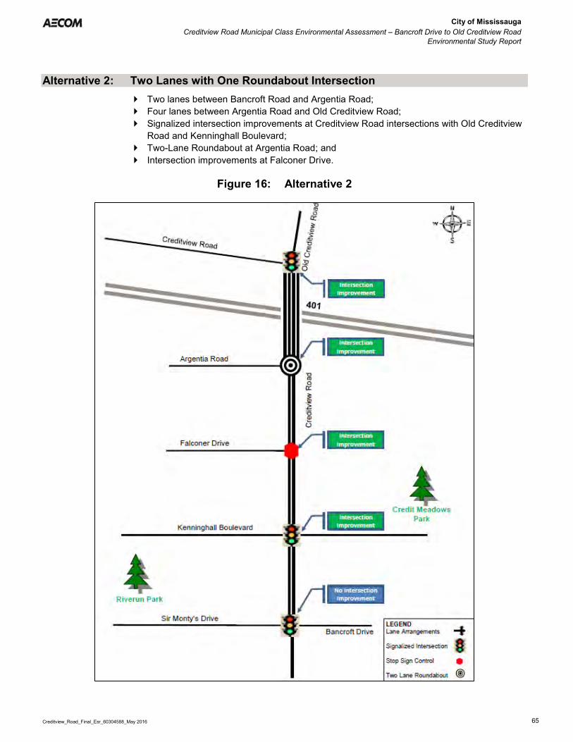
City of Mississauga Creditview Road Municipal Class Environmental Assessment – Bancroft Drive to Old Creditview Road
Environmental Study Report
Creditview_Road_Final_Esr_60304588_May 2016 65
Alternative 2: Two Lanes with One Roundabout Intersection Two lanes between Bancroft Road and Argentia Road; Four lanes between Argentia Road and Old Creditview Road; Signalized intersection improvements at Creditview Road intersections with Old Creditview
Road and Kenninghall Boulevard; Two-Lane Roundabout at Argentia Road; and Intersection improvements at Falconer Drive.
Figure 16: Alternative 2

City of Mississauga Creditview Road Municipal Class Environmental Assessment – Bancroft Drive to Old Creditview Road
Environmental Study Report
Creditview_Road_Final_Esr_60304588_May 2016 66
Alternative 3: Two Lanes with Three Roundabout Intersections Two lanes between Bancroft Road and Argentia Road; Four lanes between Argentia Road and Old Creditview Road; Signalized intersection improvements at Creditview Road intersection with Old Creditview
Road; One-lane roundabouts at Creditview Road intersections with Falconer Drive and
Kenninghall Boulevard; and Two-Lane Roundabout at Argentia Road.
Figure 17: Alternative 3

City of Mississauga Creditview Road Municipal Class Environmental Assessment – Bancroft Drive to Old Creditview Road
Environmental Study Report
Creditview_Road_Final_Esr_60304588_May 2016 67
Alternative 4: Four Lanes with Signalized Intersections Four lanes between Bancroft Road and Old Creditview Road; Signalized intersection improvements at Creditview Road intersection with Old Creditview
Road; Signalized intersection improvements at Creditview Road intersections with Argentia Road
and Kenninghall Boulevard; and Intersection improvements at Falconer Drive.
Figure 18: Alternative 4

City of Mississauga Creditview Road Municipal Class Environmental Assessment – Bancroft Drive to Old Creditview Road
Environmental Study Report
Creditview_Road_Final_Esr_60304588_May 2016 68
Alternative 5: Four Lanes with Three Roundabout Intersections Four lanes between Bancroft Road and Old Creditview Road; Signalized intersection improvement at Creditview Road intersection with Old Creditview
Road; and Two-Lane Roundabouts at Creditview Road intersections with Kenninghall Boulevard,
Falconer Drive and Argentia Road.
Figure 19: Alternative 5

City of Mississauga Creditview Road Municipal Class Environmental Assessment – Bancroft Drive to Old Creditview Road
Environmental Study Report
Creditview_Road_Final_Esr_60304588_May 2016 69
6.6 Evaluation of Alternative Design Concepts
The evaluation of Alternative Design Concepts was carried out via the reasoned argument method described in Section 6.3, which evaluates the advantages and disadvantages of each alternative in response to each criterion. Opportunities to incorporate mitigation to offset potential adverse impacts are also considered as part of this process (i.e., a “net effects” evaluation). The following criteria and factors were utilized to evaluate the Alternative Design concepts:
Transportation
Traffic Operations Traffic Safety Road Network Compatibility Accommodation of Transit/Pedestrians/
Cyclists Response Times / Access for Emergency
Vehicles
Engineering Considerations
Utilities Cost Construction Staging
Cultural Environment
Archaeological resources Cultural Landscape Built Heritage Resources
Socio-Economic Environment
Planning Policies Noise Impacts Aesthetics Property Impacts
Natural Environment
Vegetation and Wildlife Trees Surface Drainage and Groundwater
Table 13 provides a detailed assessment of the Alternative Design concepts considered. Below is a summary of the evaluation of the 5 alternatives. Alternative 1: Two Lanes with Signalized Intersections
While Alternative 1 is anticipated to impose the least impact to the natural environment, when compared to the other alternatives, it provides limited opportunities for landscaping, as well as enhancing the views and vistas of the overall cultural landscape of the roadways and scenic qualities of the study area. In addition, this alternative does not support future travel demands beyond year 2021. While this alternative can be implemented at a moderate capital cost, it is expected to incur high maintenance costs in association with the signalized intersections.
Alternative 2: Two Lanes with One Roundabout Intersection
While similar to Alternative 1 in terms of natural environment impacts and landscaping opportunities, as well as the inability to support future travel demands on Creditview Road beyond year 2021, Alternative 2 is expected to have slightly lower maintenance costs, given the reduced maintenance costs associated with roundabout treatment (i.e. maintenance and operation of traffic signal and associated equipment) at the Creditview Road intersection with Argentia Road.
Alternative 3: Two Lanes with Three Roundabout Intersections
While slightly greater impacts to the natural environment would be expected, when compared to Alternatives 1 and 2, the roundabout locations (3) associated with Alternative 3 provide additional opportunities to implement enhanced landscape elements as well as stormwater bio-retention features. In addition, Alternative 3 is expected to provide significant improvements to traffic operations to Year 2031 and potentially beyond. This alternative provides more opportunities to implement designated pedestrian crosswalks as part of the design. While a

City of Mississauga Creditview Road Municipal Class Environmental Assessment – Bancroft Drive to Old Creditview Road
Environmental Study Report
Creditview_Road_Final_Esr_60304588_May 2016 70
higher capital cost is expected in association with Alternative 3, when compared to Alternatives 1 and 2, this alternative is expected to incur lower maintenance costs since the roundabout design avoids the maintenance associated with signal infrastructure and powering. Alternative 3 also encroaches onto the smallest area of private property.
Alternative 4: Four Lanes with Signalized Intersections
Alternative 4 is expected to impact a larger area of vegetation and provides limited opportunities to incorporate landscape/streetscape features, when compared to the other alternatives. In addition, while Creditview Road would be widened to four (4) lanes, Alternative 4 is not expected to provide better traffic operations, when compared to Alternative 3. In addition, this alternative is anticipated to incur high capital cost and highest maintenance costs in association with the long term operation of the signalized intersections. Alternative 4 was also noted to potentially encroach onto the largest area of private property.
Alternative 5: Four Lanes with Three Roundabout Intersections
When compared to the other alternatives, Alternative 5 is expected to incur the largest area of impact to vegetation; however this alternative provides additional opportunities to incorporate enhanced landscape and streetscape elements. In addition, the roadway design provides significant improvements to traffic operations beyond year 2031. Similar to Alternative 3, a designated crosswalk would be provided at Falconer Road and Creditview Road and the severity of collisions would be reduced; however multi-lane roundabouts may increase complexity for users. Alternative 5 would also be expected to incur the highest capital costs, when compared to the other alternatives, however low maintenance costs would be anticipated in association with the roundabouts.
6.6.1 Preliminary Preferred Design
Based on the Evaluation of Alternative Design Concepts, Alternative 3 is the preferred alternative as it addresses the future needs of the corridor and includes the following key elements:
Maintaining 2 lanes from Bancroft Drive to Argentia Road; Widening to 4 lanes from Argentia Road to Old Creditview Road; Maintaining Bancroft Drive and Old Creditview Road as signalized intersections; Proposing 1-lane roundabouts at Kenninghall Boulevard and Falconer Drive; Proposing a 2-lane roundabout at Argentia Road; Implementing a continuous multi-use trail along the west side of the corridor; and, Implementing a continuous sidewalk along the east side of the corridor.
6.6.2 Long-term Solution
The findings of the evaluation further indicated that widening Creditview Road to 4-lanes from Bancroft Drive to Argentia Road (i.e., Alternative 5) may be beneficial as a Long-term Solution (i.e., after 2031). This alternative design concept includes the implementation of 2-lane roundabouts at Kenninghall Boulevard and Falconer Drive. The Preliminary Preferred Alternative is expected to support traffic operations to Year 2031 and potentially beyond. If and when additional capacity is required, community consultation at that stage will take place prior to the implementation of the Long-term Solution. The Preliminary Preferred Alternative and Long-Term Solution were presented to the public at the Community Information Sharing Session #2.

City of Mississauga Creditview Road Municipal Class Environmental Assessment – Bancroft Drive to Old Creditview Road
Environmental Study Report
Creditview_Road_Final_Esr_60304588_May 2016 71
Table 13: Evaluation of Alternative Designs
Evaluation Criteria and Sub-Factors
Criteria Indicators
Unit of Measure
MUNICIPAL CLASS EA FOR CREDITVIEW ROAD DESIGN ALTERNATIVES EVALUATION
Alternative #1 (2-lane with existing signals)
Alternative #2 (2-lane with 1 roundabout)
Alternative #3 (2-lane with 3 roundabouts)
Alternative #4 (4-lane with existing signals)
Alternative #5 (4-lane with 3 roundabouts)
4-lane design between Argentia Road and Old Creditview Road
Transportation Traffic Operations Ability to
accommodate future traffic demands (intersection level of service and volume-to-capacity ratio)
Old Creditview Road Preferred Signalized Intersection 2021: Overall LOS B in AM and PM AM V/C = 0.53; PM V/C = 0.47 AM Delay=18.3s; PM Delay=18.3s All movements performing at LOS D or
better except WB left/through which is predicted to operate at LOS E in AM and PM (AM V/C= 0.81; AM Delay=60.2s; PM V/C=0.79; PM Delay=56.4s)
2031: Overall LOS B in AM and PM AM V/C = 0.58; PM V/C = 0.49 AM Delay=18.4s; PM Delay=18.8 All movements performing at LOS D or
better except WB left/through which is predicted to operate at LOS E in AM and PM (AM V/C=0.81; AM Delay=60.2s; PM V/C=0.79; PM Delay=56.4s)
Preferred Signalized Intersection 2021: Though not analyzed as part of the
roundabout network analysis, results are expected to be same as Alternative #1 as this intersection is proposed to be signalized with the same configuration
2031: Though not analyzed as part of the
roundabout network analysis, results are expected to be same as Alternative #1 as this intersection is proposed to be signalized with the same configuration
Preferred Signalized Intersection 2031: Overall LOS B in AM and LOS C in PM. AM V/C = 0.69; PM V/C = 0.60. AM Delay=19.8s; PM Delay=24.5s All movements performing at LOS D or
better except WB left/thru which is predicted to operate at LOS E in AM and PM (AM V/C=0.83; AM Delay=63.2s; PM V/C=0.79; PM Delay=56.4s)
Preferred Signalized Intersection 2031: Though not analyzed as part of the
roundabout network analysis, results are expected to be same as Alternative #4 as intersection is proposed to be signalized with same configuration
Argentia Road Acceptable Signalized Intersection 2021: Overall LOS C in AM and PM. AM V/C = 0.46; PM V/C = 0.61. AM Delay=21.4s; PM Delay=26.7s EB right turn movement approaching
capacity in PM (LOS=D; V/C=0.88; Delay=52.1s).
2031: Overall LOS C in AM and PM. AM V/C = 0.49; PM V/C = 0.63. AM Delay=20.9s; PM Delay=26.2s EB right turn movement approaching
capacity in PM (LOS=D; V/C=0.87; Delay=50.7s)
Preferred Multi-lane (2-lane) Roundabout 2021: Overall LOS A in AM and PM. AM V/C = 0.55; PM V/C = 0.72. AM Delay=6.9s; PM Delay=9.7s All movements performing at LOS B or
better. 2031: Overall LOS A in AM and LOS B in PM. AM V/C = 0.61; PM V/C = 0.78. AM Delay=7.2s; PM Delay=11.2s All movements performing at LOS C or
better.
Preferred Multi-lane (2-lane) Roundabout 2021: Overall LOS A in AM and PM. AM V/C = 0.53; PM V/C = 0.69. AM Delay=6.6s; PM Delay=9.1s All movements performing at LOS B or
better. 2031: Overall LOS A in AM and LOS B in PM. AM V/C = 0.57; PM V/C = 0.74. AM Delay=6.8s; PM Delay=10.4s All movements performing at LOS C or
better.
Acceptable Signalized Intersection 2031: Overall LOS C in AM and PM. AM V/C = 0.63; PM V/C = 0.75. AM Delay=21.3s; PM Delay=28.3s All movements are performing at LOS D
or better in AM and PM.
Preferred Multi-lane (2-lane) Roundabout 2031: Overall LOS B in AM and A in PM. AM V/C = 0.80; PM V/C = 0.76. AM Delay=10.1s; PM Delay=9.2s All movements operating at LOS B or
better.

City of Mississauga Creditview Road Municipal Class Environmental Assessment – Bancroft Drive to Old Creditview Road
Environmental Study Report
Creditview_Road_Final_Esr_60304588_May 2016 72
Evaluation Criteria and Sub-Factors
Criteria Indicators
Unit of Measure
MUNICIPAL CLASS EA FOR CREDITVIEW ROAD DESIGN ALTERNATIVES EVALUATION
Alternative #1 (2-lane with existing signals)
Alternative #2 (2-lane with 1 roundabout)
Alternative #3 (2-lane with 3 roundabouts)
Alternative #4 (4-lane with existing signals)
Alternative #5 (4-lane with 3 roundabouts)
4-lane design between Argentia Road and Old Creditview Road
Falconer Drive Less Desirable Unsignalized Intersection 2021: EB left turn movement has LOS F in
AM and PM (AM V/C>2.0; AM Delay>1000s; PM V/C=0.55; PM Delay=312.5s)
EB right turn movement has LOS F in PM (V/C=0.49; Delay=67.8s)
2031: EB left turn movement has LOS F in AM
and PM (AM V/C>2.00; AM Delay>1000s; PM V/C=0.65; PM Delay=432.2)
EB right turn movement has LOS F in AM and LOS E in PM (AM V/C=0.44; AM Delay=36.7s; PM V/C=0.67; PM Delay=127.9s)
NB left turn movement has LOS E in PM (V/C=0.54; Delay=37.5s).
Traffic signals at this intersection were reviewed and determined as not warranted based on pedestrian volumes, traffic volumes, traffic delay and collision history
Less Desirable Unsignalized Intersection 2021: EB left turn movement has LOS F in AM
and PM (AM V/C>2.0; AM Delay>1000s; PM V/C>2.0; PM Delay>1000s)
EB right turn movement has LOS F in AM and PM (AM V/C>2.0; AM Delay>1000s; PM V/C>2.0; PM Delay>1000s)
NB left turn movement has LOS F in PM (V/C=0.99; Delay=171.0s)
SB through movement is performing at capacity in PM (LOS=A; V/C=0.99; Delay=4.0s)
SB right turn movement is performing at capacity in PM (LOS=A; V/C=0.99; Delay=8.7s)
2031: EB left turn movement has LOS F in AM
and PM (AM V/C>2.0; AM Delay>1000s; PM V/C>2.0; PM Delay>1000s)
EB right turn movement has LOS F in AM and PM (AM V/C>2.0; AM Delay>1000s; PM V/C>2.0; PM Delay>1000s)
NB left turn movement has LOS F in PM (V/C=1.67; Delay>1000s)
SB through movement has LOS F in PM (V/C>2.0; Delay=73.9s)
SB right turn movement has LOS F in PM (V/C>2.0; Delay=73.9s)
Alternative 2 is similar to Alternative 1; however, increased delay is experienced due to the upstream roundabout at Argentia Road, which limits the opportunity for vehicles turning off of Falconer Drive
Preferred Single-lane Roundabout 2021: Overall LOS A in AM and PM AM V/C = 0.76; PM V/C = 0.95 AM Delay=3.8s; PM Delay=5.6s SB through movement approaching
capacity in PM (LOS=A; V/C=0.95; Delay=5.9s)
SB right turn movement approaching capacity in PM (LOS=A; V/C=0.95; Delay=6.1s)
2031: Overall LOS A in AM and PM AM V/C = 0.71; PM V/C = 0.99 AM Delay=3.9s; PM Delay=8.4s SB through movement approaching
capacity in PM (LOS=A; V/C=0.99; Delay=9.9s)
SB right turn movement approaching capacity in PM (LOS=B; V/C=0.99; Delay=10.0s)
Acceptable Unsignalized Intersection 2031: EB left turn movement operates at LOS
F in AM and PM (AM V/C=0.19; AM Delay=61.3s; PM V/C=1.19; PM V/C>1000s)
Preferred Multi-lane (2-lane) Roundabout 2031: Overall LOS A in AM and PM AM V/C=0.62; PM V/C=0.67 AM Delay=4.2s; PM Delay=4.8s All movements operating at LOS B or
better
Rivergate Place Less Desirable Unsignalized Intersection 2021: WB left/right has LOS F in AM and PM
(AM V/C>2.0; AM Delay>1000s; PM V/C=0.53; PM Delay=521.6s)
2031: WB left/right has LOS F in AM and PM
(AM V/C>2.0; AM Delay>1000s; PM V/C>2.0; PM Delay>1000s)
Less Desirable Unsignalized Intersection 2021: Though not analyzed as part of the
roundabout network analysis, results are expected to be same as Alternative #1 as this intersection is proposed to be unsignalized with the same configuration
2031: Though not analyzed as part of the
roundabout network analysis, results are expected to be same as Alternative #1 as this intersection is proposed to be unsignalized with the same configuration
Less Desirable Unsignalized Intersection 2021: Though not analyzed as part of the
roundabout network analysis, results are expected to be same as Alternative #1 as this intersection is proposed to be unsignalized with same configuration
2031: Though not analyzed as part of the
roundabout network analysis, results are expected to be same as Alternative #1 as this intersection is proposed to be unsignalized with the same configuration.
Preferred Unsignalized Intersection 2031: WB left-right turn movement operates
at LOS F in AM and PM (AM V/C=0.34; AM Delay=260.3s; PM V/C=0.17; PM Delay=110.9s)
Preferred Unsignalized Intersection 2031: Though not analyzed as part of the
roundabout network analysis, results are expected to be same as Alternative #4 as this intersection is proposed to be unsignalized with the same configuration.

City of Mississauga Creditview Road Municipal Class Environmental Assessment – Bancroft Drive to Old Creditview Road
Environmental Study Report
Creditview_Road_Final_Esr_60304588_May 2016 73
Evaluation Criteria and Sub-Factors
Criteria Indicators
Unit of Measure
MUNICIPAL CLASS EA FOR CREDITVIEW ROAD DESIGN ALTERNATIVES EVALUATION
Alternative #1 (2-lane with existing signals)
Alternative #2 (2-lane with 1 roundabout)
Alternative #3 (2-lane with 3 roundabouts)
Alternative #4 (4-lane with existing signals)
Alternative #5 (4-lane with 3 roundabouts)
4-lane design between Argentia Road and Old Creditview Road Kenninghall
Boulevard Less Desirable Signalized Intersection 2021: Overall LOS B in AM and LOS F in PM. AM V/C = 0.81; PM V/C = 1.03. AM Delay=14.1s; PM Delay=129.9s NB left has LOS F in PM (V/C=1.03;
Delay=168.6s) SB through-right turn has LOS F in PM
(V/C=1.11; Delay=220.5s) 2031: Overall LOS B in AM and LOS F in PM. AM V/C = 0.89; PM V/C = 1.09. AM Delay=17.9s; PM Delay=200.4s NB left turn movement has LOS F in
PM (V/C=1.12; Delay=286.0s) NB through-right turn movement is
approaching capacity in AM (LOS=B; V/C=0.93; Delay=12.3s)
SB through-right turn movement is approaching or over capacity in AM and PM (AM LOS=B; AM V/C=0.87; AM Delay=16.9; PM LOS=F; PM V/C=1.18; PM Delay=342.4)
Less Desirable Signalized Intersection 2021: Overall LOS B in AM and LOS D in PM. AM V/C = 0.83; PM V/C = 0.97. EB left turn movement has LOS E in
AM and PM (AM V/C=0.18; AM Delay=56.3s; PM V/C=0.16; PM Delay=60.6s)
EB through movement has LOS E in PM (V/C=0.92; Delay=71.4s)
EB right turn movement has LOS E in AM and PM (AM V/C=0.77; AM Delay=60.1s; PM V/C=0.92; PM Delay=76.9s)
WB left turn movement has LOS E in AM and PM (AM V/C=0.37; AM Delay=64.9s; PM V/C=0.19; PM Delay=66.2s)
WB right turn movement has LOS E in PM (V/C=0.14; Delay=59.2s)
NB left turn movement has LOS F in PM (V/C=0.97; Delay=102.3s)
SB through movement is approaching capacity in PM (LOS=D; V/C=0.96; Delay=48.5s)
SB right turn movement is approaching capacity in PM (LOS=D; V/C=0.96; Delay=54.1s)
2031: Overall LOS B in AM and LOS C in PM. AM V/C = 0.89; PM V/C = 0.95. EB left turn movement has LOS E in
AM and PM (AM V/C=0.20; AM Delay=57.5s; PM V/C=0.18; PM Delay=61.3s)
EB through movement has LOS E in AM and PM (AM V/C=0.83; AM Delay=58.5s; PM V/C=0.92; PM Delay=71.7s)
EB right turn movement has LOS E in AM and PM (AM V/C=0.83; AM Delay=64.0s; PM V/C=0.92; PM Delay=77.2s)
WB left turn movement has LOS E in AM and PM (AM V/C=0.43; AM Delay=66.6s; PM V/C=0.19; PM Delay=66.2s)
WB right turn movement has LOS E in PM (V/C=0.16; Delay=59.6s)
NB left turn movement has LOS F in PM (V/C=0.95; Delay=91.4s)
NB through movement is approaching
Preferred Single-lane Roundabout 2021: Overall LOS A in AM and LOS B in PM. AM V/C = 0.78; PM V/C = 0.98. AM Delay=5.4s; PM Delay=14.4s SB left turn movement is approaching
capacity in PM (LOS=C; V/C=0.98; Delay=28.2s)
SB through movement is approaching capacity in PM (LOS=C; V/C=0.98; Delay=22.2s)
SB through movement is approaching capacity in PM (LOS=C; V/C=0.98; Delay=22.4s)
2031: Overall LOS A in AM and LOS B in PM. AM V/C = 0.83; PM V/C = 0.97. AM Delay=5.8s; PM Delay=5.8s SB left turn movement is approaching
capacity in PM (LOS=C; V/C=0.97; Delay=23.0s)
SB through movement is approaching capacity in PM (LOS=B; V/C=0.97; Delay=17.0s)
SB through movement is approaching capacity in PM (LOS=B; V/C=0.97; Delay=17.1s)
Acceptable Signalized Intersection 2031: Overall LOS A in AM and LOS B in PM. AM V/C = 0.69; PM V/C = 0.85. AM Delay=6.7s; PM Delay=18.4s NB left movements operates at LOS E
in PM (V/C=0.93; Delay=57.6s)
Preferred Multi-lane (2-lane) Roundabout 2031: Overall LOS A in AM and PM. AM V/C = 0.63; PM V/C = 0.79. AM Delay=4.6s; PM Delay=6.9s. All movements operating at LOS B or
better.

City of Mississauga Creditview Road Municipal Class Environmental Assessment – Bancroft Drive to Old Creditview Road
Environmental Study Report
Creditview_Road_Final_Esr_60304588_May 2016 74
Evaluation Criteria and Sub-Factors
Criteria Indicators
Unit of Measure
MUNICIPAL CLASS EA FOR CREDITVIEW ROAD DESIGN ALTERNATIVES EVALUATION
Alternative #1 (2-lane with existing signals)
Alternative #2 (2-lane with 1 roundabout)
Alternative #3 (2-lane with 3 roundabouts)
Alternative #4 (4-lane with existing signals)
Alternative #5 (4-lane with 3 roundabouts)
4-lane design between Argentia Road and Old Creditview Road capacity in AM (LOS=B; V/C=0.89; Delay=13.1s)
NB right turn movement is approaching capacity in AM (LOS=B; V/C=0.89; Delay=18.6s)
SB through movement is approaching capacity in PM (LOS=D; V/C=0.94; Delay=37.4s)
SB right turn movement is approaching capacity in PM (LOS=D; V/C=0.94; Delay=43.0s)
Velebit Court Less Desirable Unsignalized Intersection 2021: EB left/right has LOS F in AM and PM
(AM V/C>2.0; AM Delay>1000s; PM V/C>2.0; PM Delay>1000s)
NB left turn has LOS E in PM (V/C=0.03; Delay=39.1s)
2031: EB left/right has LOS F in AM and PM
(AM V/C>2.0; AM Delay>1000s; PM V/C>2.0; PM Delay>1000s)
NB Left turn movement has LOS E in AM and LOS F in PM (AM V/C=0.02; AM Delay=37.9s; PM V/C=0.04; PM Delay=51.0s)
Less Desirable Unsignalized Intersection 2021: Though not analyzed as part of the
roundabout network analysis, results are expected to be same as Alternative #1 as this intersection is proposed to be unsignalized with the same configuration.
2031: Though not analyzed as part of the
roundabout network analysis, results are expected to be same as Alternative #1 as this intersection is proposed to be signalized with the same configuration.
Less Desirable Unsignalized Intersection 2021: EB left/right has LOS F in AM and PM
(AM V/C>2.0; AM Delay>1000s; PM V/C>2.0; PM Delay>1000s)
NB left turn has LOS E in PM (V/C=0.03; Delay=39.1s)
2031: EB left/right has LOS F in AM and PM
(AM V/C>2.0; AM Delay>1000s; PM V/C>2.0; PM Delay>1000s)
NB Left turn movement has LOS E in AM and LOS F in PM (AM V/C=0.02; AM Delay=37.9s; PM V/C=0.04; PM Delay=51.0s)
Preferred Unsignalized Intersection 2031: EB left-right movement operates at
LOS F in AM and PM (AM V/C=0.38; AM Delay=201.7s; PM V/C=0.84; PM Delay=798.8s)
Preferred Unsignalized Intersection 2031: Though not analyzed as part of the
roundabout network analysis, results are expected to be same as Alternative #4 as this intersection is proposed to be unsignalized with the same configuration.
Sir Monty’s Drive/Bancroft Drive
Preferred Signalized Intersection 2021: Overall LOS B in AM and PM AM V/C = 0.79; PM V/C = 0.72 AM Delay=15.1s; PM Delay=14.9s All movements performing at LOS D or
better except WB left in AM performing at LOS E (V/C=0.66; Delay=58.0s)
2031: Overall LOS B in AM and PM AM V/C = 0.85; PM V/C = 0.78. AM Delay=16.6s; PM Delay=16.3s WB left turn movement is performing at
LOS E in AM (V/C=0.66; Delay=58.0s) NB through movement is approaching
capacity in AM (LOS=B; V/C=0.88; Delay=18.7)
Preferred Signalized Intersection 2021: Though not analyzed as part of the
roundabout network analysis, results are expected to be same as Alternative #1 as this intersection is proposed to be unsignalized with the same configuration
2031: Though not analyzed as part of the
roundabout network analysis, results are expected to be same as Alternative #1 as this intersection is proposed to be signalized with the same configuration
Preferred Signalized Intersection 2021: Overall LOS B in AM and PM AM V/C = 0.79; PM V/C = 0.72 AM Delay=15.1s; PM Delay=14.9s All movements performing at LOS D or
better except WB left in AM performing at LOS E (V/C=0.66; Delay=58.0s)
2031: Overall LOS B in AM and PM AM V/C = 0.85; PM V/C = 0.78 AM Delay=16.6s; PM Delay=16.3s WB left turn movement is performing at
LOS E in AM (V/C=0.66; Delay=58.0s) NB through movement is approaching
capacity in AM (LOS=B; V/C=0.88; Delay=18.7)
Preferred Signalized Intersection 2031: Overall LOS B in AM and C in PM AM V/C = 0.73; PM V/C = 0.74 All movements performing at LOS D or
better except WB left in AM performing at LOS E (V/C=0.66; Delay=58.0s)
Preferred Signalized Intersection 2031: Though not analyzed as part of the
roundabout network analysis, results are expected to be same as Alternative #4 as intersection is proposed to be unsignalized with the same configuration.
Overall Intersection Level of Service
Unacceptable Mix of stable and unstable flow with
major delays by 2021. Many of the individual turning
movements at the intersections are operating poorly and experiencing long delays by 2021.
Unacceptable Mix of stable and unstable flow by 2021. Kenninghall Boulevard intersection is
approaching its capacity by 2021 in the PM peak period.
Falconer Drive intersection is operating poorly with major delays by 2021 due to
Preferred Stable flow and no major delays with
intersections operating well to 2031. Although the movements are
approaching capacity by 2031 due to the function of roundabouts, motorists are able to travel through the
Acceptable Mix of stable and unstable flow to 2031. Many of the individual turning
movements at the intersections are operating poorly and experiencing long delays by 2031.
Kenninghall Boulevard intersection is
Preferred Stable flow and no delays with
intersection operating well beyond 2031.
All three roundabouts have residual capacity.
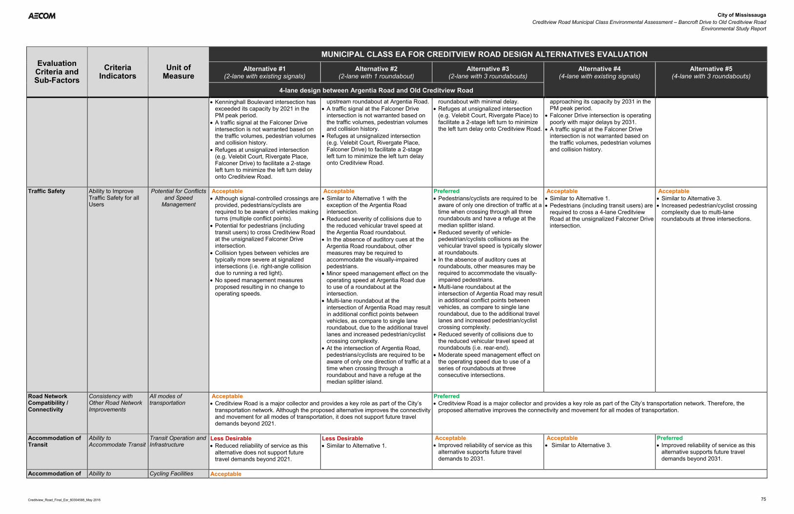
City of Mississauga Creditview Road Municipal Class Environmental Assessment – Bancroft Drive to Old Creditview Road
Environmental Study Report
Creditview_Road_Final_Esr_60304588_May 2016 75
Evaluation Criteria and Sub-Factors
Criteria Indicators
Unit of Measure
MUNICIPAL CLASS EA FOR CREDITVIEW ROAD DESIGN ALTERNATIVES EVALUATION
Alternative #1 (2-lane with existing signals)
Alternative #2 (2-lane with 1 roundabout)
Alternative #3 (2-lane with 3 roundabouts)
Alternative #4 (4-lane with existing signals)
Alternative #5 (4-lane with 3 roundabouts)
4-lane design between Argentia Road and Old Creditview Road
Kenninghall Boulevard intersection has exceeded its capacity by 2021 in the PM peak period.
A traffic signal at the Falconer Drive intersection is not warranted based on the traffic volumes, pedestrian volumes and collision history.
Refuges at unsignalized intersection (e.g. Velebit Court, Rivergate Place, Falconer Drive) to facilitate a 2-stage left turn to minimize the left turn delay onto Creditview Road.
upstream roundabout at Argentia Road. A traffic signal at the Falconer Drive
intersection is not warranted based on the traffic volumes, pedestrian volumes and collision history.
Refuges at unsignalized intersection (e.g. Velebit Court, Rivergate Place, Falconer Drive) to facilitate a 2-stage left turn to minimize the left turn delay onto Creditview Road.
roundabout with minimal delay. Refuges at unsignalized intersection
(e.g. Velebit Court, Rivergate Place) to facilitate a 2-stage left turn to minimize the left turn delay onto Creditview Road.
approaching its capacity by 2031 in the PM peak period.
Falconer Drive intersection is operating poorly with major delays by 2031.
A traffic signal at the Falconer Drive intersection is not warranted based on the traffic volumes, pedestrian volumes and collision history.
Traffic Safety Ability to Improve Traffic Safety for all Users
Potential for Conflicts and Speed
Management
Acceptable Although signal-controlled crossings are
provided, pedestrians/cyclists are required to be aware of vehicles making turns (multiple conflict points).
Potential for pedestrians (including transit users) to cross Creditview Road at the unsignalized Falconer Drive intersection.
Collision types between vehicles are typically more severe at signalized intersections (i.e. right-angle collision due to running a red light).
No speed management measures proposed resulting in no change to operating speeds.
Acceptable Similar to Alternative 1 with the
exception of the Argentia Road intersection.
Reduced severity of collisions due to the reduced vehicular travel speed at the Argentia Road roundabout.
In the absence of auditory cues at the Argentia Road roundabout, other measures may be required to accommodate the visually-impaired pedestrians.
Minor speed management effect on the operating speed at Argentia Road due to use of a roundabout at the intersection.
Multi-lane roundabout at the intersection of Argentia Road may result in additional conflict points between vehicles, as compare to single lane roundabout, due to the additional travel lanes and increased pedestrian/cyclist crossing complexity.
At the intersection of Argentia Road, pedestrians/cyclists are required to be aware of only one direction of traffic at a time when crossing through a roundabout and have a refuge at the median splitter island.
Preferred Pedestrians/cyclists are required to be
aware of only one direction of traffic at a time when crossing through all three roundabouts and have a refuge at the median splitter island.
Reduced severity of vehicle-pedestrian/cyclists collisions as the vehicular travel speed is typically slower at roundabouts.
In the absence of auditory cues at roundabouts, other measures may be required to accommodate the visually-impaired pedestrians.
Multi-lane roundabout at the intersection of Argentia Road may result in additional conflict points between vehicles, as compare to single lane roundabout, due to the additional travel lanes and increased pedestrian/cyclist crossing complexity.
Reduced severity of collisions due to the reduced vehicular travel speed at roundabouts (i.e. rear-end).
Moderate speed management effect on the operating speed due to use of a series of roundabouts at three consecutive intersections.
Acceptable Similar to Alternative 1. Pedestrians (including transit users) are
required to cross a 4-lane Creditview Road at the unsignalized Falconer Drive intersection.
Acceptable Similar to Alternative 3. Increased pedestrian/cyclist crossing
complexity due to multi-lane roundabouts at three intersections.
Road Network Compatibility / Connectivity
Consistency with Other Road Network Improvements
All modes of transportation
Acceptable Creditview Road is a major collector and provides a key role as part of the City’s
transportation network. Although the proposed alternative improves the connectivity and movement for all modes of transportation, it does not support future travel demands beyond 2021.
Preferred Creditview Road is a major collector and provides a key role as part of the City’s transportation network. Therefore, the
proposed alternative improves the connectivity and movement for all modes of transportation.
Accommodation of Transit
Ability to Accommodate Transit
Transit Operation and Infrastructure
Less Desirable Reduced reliability of service as this
alternative does not support future travel demands beyond 2021.
Less Desirable Similar to Alternative 1.
Acceptable Improved reliability of service as this
alternative supports future travel demands to 2031.
Acceptable Similar to Alternative 3.
Preferred Improved reliability of service as this
alternative supports future travel demands beyond 2031.
Accommodation of Ability to Cycling Facilities Acceptable

City of Mississauga Creditview Road Municipal Class Environmental Assessment – Bancroft Drive to Old Creditview Road
Environmental Study Report
Creditview_Road_Final_Esr_60304588_May 2016 76
Evaluation Criteria and Sub-Factors
Criteria Indicators
Unit of Measure
MUNICIPAL CLASS EA FOR CREDITVIEW ROAD DESIGN ALTERNATIVES EVALUATION
Alternative #1 (2-lane with existing signals)
Alternative #2 (2-lane with 1 roundabout)
Alternative #3 (2-lane with 3 roundabouts)
Alternative #4 (4-lane with existing signals)
Alternative #5 (4-lane with 3 roundabouts)
4-lane design between Argentia Road and Old Creditview Road Cyclists Accommodate
Cyclists All options provide a multi-use trail along the west side of the corridor. Operation of cyclists traveling through the intersections is similar for all options.
Accommodation of Pedestrians
Ability to Accommodate Pedestrians
Pedestrian Facilities
Less Desirable Facilities (sidewalk and multi-use trail)
provided. No crosswalks provided across
Creditview Road at the Falconer Drive intersection.
Less Desirable Similar to Alternative 1.
Preferred Facilities (sidewalk and multi-use trail)
provided Roundabout at Falconer Drive will
facilitate a crossing of Creditview Road.
Less Desirable Similar to Alternative 1.
Acceptable Similar to Alternative 3. Increased pedestrian/cyclist crossing complexity due to multi-lane roundabouts at three locations.
Response Times / Access for Emergency Vehicles
Potential to Improve Emergency Service Response Time
Ability to Avoid Delays and Accommodate Emergency Response Vehicles
Less Desirable There would be more delay and
queuing approaching the intersections that must be negotiated; this may be particularly challenging along segments with 2-lane cross-section.
Less Desirable Similar to Alternative 1.
Acceptable There would be less delay and queuing
approaching the intersections, facilitating faster emergency vehicle travel.
Roundabouts will be designed to accommodate emergency vehicles.
Acceptable Similar to Alternative 3. Additional passing lane is provided with
the 4-lane cross-section.
Preferred Better operations when compared to
Alternatives 3 and 4. Additional passing lane is provided with
the 4-lane cross-section. Roundabouts will be designed to
accommodate emergency vehicles.
Transportation – Overall

City of Mississauga Creditview Road Municipal Class Environmental Assessment – Bancroft Drive to Old Creditview Road
Environmental Study Report
Creditview_Road_Final_Esr_60304588_May 2016 77
Evaluation Criteria and Sub-Factors
Criteria Indicators
Unit of Measure
MUNICIPAL CLASS EA FOR CREDITVIEW ROAD DESIGN ALTERNATIVES EVALUATION
Alternative #1 (2-lane with existing signals)
Alternative #2 (2-lane with 1 roundabout)
Alternative #3 (2-lane with 3 roundabouts)
Alternative #4 (4-lane with existing signals)
Alternative #5 (4-lane with 3 roundabouts)
4-lane design between Argentia Road and Old Creditview Road
Engineering Considerations Utilities Impact to Existing and
Future Utilities Type of Impact No Significant difference between the alternatives.
Relocation of hydro poles and underground utilities (e.g., Bell, gas and hydro) maybe required.
Costs
Capital Construction Cost (roadway, utilities, etc.). Excludes property costs.
Relative Potential Cost
Acceptable Moderate capital
Acceptable Moderate capital
Acceptable Moderate Capital
Less Desirable High capital
Less Desirable Highest capital
Maintenance Costs Estimated Present Value Cost
Less Desirable Maintenance and operation costs
(power) costs incurred for traffic signals and signal equipment, respectively.
±$10,000 (approximately $2,500 for each intersection).
Less Desirable Maintenance and operation costs
(power) incurred for traffic signals and signal equipment, respectively.
±$7,500 (approximately $2,500 for each intersection).
Preferred Roundabouts have been proven to
reduce maintenance costs overtime as they do not have signal maintenance and power operation costs.
Less Desirable Maintenance and operation costs
(power) costs incurred for traffic signals and signal equipment, respectively.
±$10,000 (approximately $2,500 for each intersection).
Preferred Roundabouts have been proven to
reduce maintenance costs overtime because they don’t have signal maintenance and power operation costs.
Construction Staging
During Construction (Traffic Management Requirements)
Complexity Preferred Low Complexity. Temporary widening may be required at
some locations during the construction to keep two lanes operative all the times
Acceptable Low to Moderate Complexity. Roundabouts constructions may require
detouring all traffic to one side of the road with significant traffic disruptions.
Acceptable Low to Moderate Complexity. Lane shift and temporary widening may
be required during the construction phase to keep the two lanes operative for traffic.
Acceptable Low complexity. Requires lane restriction without closing
lanes during construction.
Less Desirable Moderate to high complexity. Requires the detouring of all traffic to
one side of the road with significant traffic disruption.
Engineering Considerations – Overall
Cultural Heritage Archaeological Resources
Potential for loss of archaeological resources
Area impacted beyond ROW
Preferred Not anticipated to impact area identified
as having archaeological potential.
Preferred Not anticipated to impact area
identified as having archaeological potential.
Acceptable Grading activities may encroach onto
portion of land identified as having archaeological potential.
Stage 2 Archaeological Assessment would be completed to confirm presence/absence of archaeological resources, if required.
Acceptable Grading activities may encroach onto
portion of land identified as having archaeological potential.
Roadway widening has potential to impact a greater area of land identified as having archaeological potential.
Stage 2 Archaeological Assessment would be completed to confirm presence/absence of archaeological resources, if required.
Acceptable Multi-lane roundabouts and associated
roadway widening has potential to impact a greater area of land identified as having archaeological potential.
Stage 2 Archaeological Assessment would be completed to confirm presence/absence of archaeological resources.
Cultural Landscapes Maintain/Enhance Character of the Roadway
Subjective Acceptable May change appearance of Creditview
Road Scenic Route. Encroaches onto cultural heritage
landscape property, (Pearson-Harris Farm); however there are opportunities to integrate with the future plans for the City parkland.
Commemorative features, enhanced landscaping, etc. may be considered as part of park planning.
Limited opportunities to compliment the overall cultural landscape of the roadway and scenic qualities.
Acceptable May change appearance of Creditview
Road Scenic Route. One roundabout encroaches on
Pearson-Harris Farm, cultural heritage landscape property; however lands being planned for future use as park land.
Commemorative features enhanced landscaping and other opportunities may be provided in the central island of the roundabout.
The Argentia Road roundabout improves the views and vistas of the overall cultural landscape of the roadway and scenic qualities.
Preferred Expected to change appearance of
Creditview Road Scenic Route. Two roundabouts encroach onto
Pearson-Harris Farm, cultural heritage landscape property; however there are opportunities to integrate with the future plans for the City parkland,
Commemorative features, enhanced landscaping and other opportunities may be provided in the central island of the three roundabouts.
Roundabouts provide opportunity to improve the views and vistas of the overall cultural landscape of the roadway and scenic qualities.
Less Desirable Expected to change appearance of
Creditview Road Scenic Route. Roadway widening further reduces the
opportunities to compliment the overall cultural landscape of the roadway and scenic qualities.
Encroaches onto, and impacts entrance to, cultural heritage landscape property, (Pearson-Harris Farm); however there are opportunities to integrate with the future plans for the City parkland.
Commemorative features, enhanced landscaping, etc. may be considered as part of park planning.
Limited opportunities to compliment the overall cultural landscape of the roadway and scenic qualities.
Less Desirable Expected to change appearance of
Creditview Road Scenic Route. Roadway widening further reduces the
opportunities to compliment the overall cultural landscape of the roadway and scenic qualities.
Impacts entrance to cultural heritage landscape property (Pearson-Harris Farm property) and requires greater area of property to accommodate modifications; however there are opportunities to integrate with the future plans for the City parkland.
Commemorative features, enhanced landscaping, and other opportunities may be provided in the central island of the three roundabouts.
Roundabouts provide opportunity to improve the views and vistas of the

City of Mississauga Creditview Road Municipal Class Environmental Assessment – Bancroft Drive to Old Creditview Road
Environmental Study Report
Creditview_Road_Final_Esr_60304588_May 2016 78
Evaluation Criteria and Sub-Factors
Criteria Indicators
Unit of Measure
MUNICIPAL CLASS EA FOR CREDITVIEW ROAD DESIGN ALTERNATIVES EVALUATION
Alternative #1 (2-lane with existing signals)
Alternative #2 (2-lane with 1 roundabout)
Alternative #3 (2-lane with 3 roundabouts)
Alternative #4 (4-lane with existing signals)
Alternative #5 (4-lane with 3 roundabouts)
4-lane design between Argentia Road and Old Creditview Road overall cultural landscape of the roadway and scenic qualities.
Built Heritage Resources
Potential for displacement of built heritage features
Area impacted beyond ROW
No Significant difference between the alternatives. No impact to built heritage resources identified and/or expected to be impacted by alternatives.
Cultural – Overall
Socio-Economic Environment Planning Polices Supports Planning
Policies Yes/No No Significant difference between the alternatives.
Each alternative will be designed to support local and regional planning policies.
Noise Impacts Proximity to Residences
Noise Level Acceptable No significant change in traffic noise
levels Noise mitigation measures can be
implemented, where warranted.
Acceptable No significant change in traffic noise
levels Noise mitigation measures can be
implemented, where warranted.
Acceptable No significant change in traffic noise
levels Noise mitigation measures can be
implemented, where warranted.
Acceptable Moderate potential increase in traffic
noise levels due to the increase of travel lanes.
Noise mitigation measures can be implemented, where warranted.
Acceptable Moderate potential increase in traffic
noise levels due to the increase of travel lanes.
Noise mitigation measures can be implemented, where warranted.
Aesthetics Potential to enhance area aesthetics
Subjective Midblock potential for aesthetics are similar for all alternatives.
Less Desirable Anticipated to provide least
opportunities to implement enhanced landscaping and community features.
Acceptable Anticipated to some provide
opportunities to implement enhanced landscaping and community features.
Streetscape elements will be considered within the central island of the roundabout.
Preferred Anticipated to provide many
opportunities to implement enhanced landscaping and community features.
Streetscape elements will be considered within the central island of the three roundabouts.
Less Desirable Anticipated to provide some
opportunities to implement enhanced landscaping and community features.
Road widening reduces midblock potential for aesthetics
Less Desirable Anticipated to provide most
opportunities to implement enhanced landscaping and community features.
Road widening reduces midblock potential for aesthetics
Streetscape and/or landscape elements can be provided within the central island of the roundabouts.
Property Impacts Impacts on Residential / Commercial/Parkland
Property access during normal operation
Preferred No impact to existing property
accesses.
Preferred No impact to existing property
accesses.
Acceptable Existing access (1) impacted to private
property on Kenninghall Crescent; however, potential to mitigate impact will be further reviewed.
Preferred No impact to existing property
accesses.
Acceptable Existing access (1) impacted to private
property on Kenninghall Crescent; however, potential to mitigate impact will be further reviewed.
Additional Right-of-Way
Area (m2) of Property (Private and City Park Lands)
Less Desirable TOTAL: Approximately 2,299 m2 City/Park Land: Approximately 2016 m2
Private Property: Approximately 283 m2
Preferred TOTAL: Approximately 2,597 m2 City/Park Land: Approximately 2,464 m2
Private Property: Approximately 137 m2
Preferred TOTAL: Approximately 3,143 m2 City/Park Land: Approximately 3,011 m2
Private Property: Approximately 132 m2
Less Desirable TOTAL: Approximately 2,433 m2 City/Park Land: Approximately 2150 m2
Private Property: Approximately 283 m2
Acceptable TOTAL: Approximately 4,018 m2 City/Park Land: Approximately 3824 m2
Private Property: Approximately 194 m2
Largest area of private property required to accommodate modifications
Private property predominantly occupied/ owned by developers, commercial/retail land uses and/or utilities.
Smallest area of private property required to accommodate modifications
Private property predominantly occupied/ owned by developers, commercial/retail land uses and/or utilities.
Smallest area of private property required to accommodate modifications
Private property predominantly occupied/ owned by developers, commercial/retail land uses and/or utilities.
Largest area of private property required to accommodate modifications.
Private property predominantly occupied/ owned by developers, commercial/retail land uses and/or utilities.
Moderate area of private property required to accommodate modifications.
Private property predominantly occupied/ owned by developers, commercial/retail land uses and/or utilities.
Socio-Economic Environment – Overall

City of Mississauga Creditview Road Municipal Class Environmental Assessment – Bancroft Drive to Old Creditview Road
Environmental Study Report
Creditview_Road_Final_Esr_60304588_May 2016 79
Evaluation Criteria and Sub-Factors
Criteria Indicators
Unit of Measure
MUNICIPAL CLASS EA FOR CREDITVIEW ROAD DESIGN ALTERNATIVES EVALUATION
Alternative #1 (2-lane with existing signals)
Alternative #2 (2-lane with 1 roundabout)
Alternative #3 (2-lane with 3 roundabouts)
Alternative #4 (4-lane with existing signals)
Alternative #5 (4-lane with 3 roundabouts)
4-lane design between Argentia Road and Old Creditview Road
Natural Environment Vegetation and Wildlife
Impact to vegetation, wildlife and wildlife habitat
Vegetation and habitat impacts
Acceptable Expected to impact the smallest area of
vegetation, when compared to the other alternatives.
Potential impacts to habitat limited to edge effects.
Impacts will be mitigated through vegetation restoration and/or enhancement, as well as habitat compensation planting and limiting construction to appropriate timing windows.
Acceptable Expected to impact a moderate area of
vegetation, when compared to the other alternatives.
Impacts limited to habitat edge effects. Impacts will be mitigated through
vegetation restoration and/or enhancement, as well as habitat compensation planting and limiting construction to appropriate timing windows.
Less Desirable Expected to impact a large area of
vegetation, when compared to the other alternatives.
Impacts limited to habitat edge effects. Impacts will be mitigated through
vegetation restoration and/or enhancement, as well as habitat compensation planting and limiting construction to appropriate timing windows.
Less Desirable Similar to Alternative 3.
Less Desirable Expected to impact the largest area of
vegetation, when compared to the other alternatives.
Impacts limited to habitat edge effects. Impacts will be mitigated through
vegetation restoration and/or enhancement, as well as habitat compensation planting and limiting construction to appropriate timing windows.
Trees Impact to Trees Number of trees to be removed
Acceptable Expected to impact +/-210 trees, many
of which are in poor to fair condition. Preserves mature Shagbark Hickory
trees and Bur Oak tree Tree planting will be undertaken to
mitigate impacts to existing trees. Significant species would be considered (Sugar Maple, Red Oak, Bur Oak, Shagbark Hickory, and Black Walnut).
Acceptable Expected to impact +/-190 trees, many
of which are in poor to fair condition. Preserves mature Shagbark Hickory
trees and Bur Oak tree Tree planting will be undertaken to
mitigate impacts to existing trees. Significant species would be considered (Sugar Maple, Red Oak, Bur Oak, Shagbark Hickory, and Black Walnut).
Less Desirable Expected to impact +/-280 trees, many
of which are in poor to fair condition Preserves mature Shagbark Hickory trees and Bur Oak tree
Tree planting will be undertaken to mitigate impacts to existing trees. Significant species would be considered (Sugar Maple, Red Oak, Bur Oak, Shagbark Hickory, and Black Walnut).
Less Desirable Expected to impact +/-310 trees, many
of which are in poor to fair condition. Tree planting will be undertaken to
mitigate impacts to existing trees. Significant species would be considered (Sugar Maple, Red Oak, Bur Oak, Shagbark Hickory, and Black Walnut).
Less Desirable Expected to impact +/-300 trees, many
of which are in poor to fair condition. Tree planting will be undertaken to
mitigate impacts to existing trees. Significant species would be considered (Sugar Maple, Red Oak, Bur Oak, Shagbark Hickory, and Black Walnut).
Significant tree species could be planted in advance/near future to allow trees to grow/mature prior to implementing ultimate design.
Surface Drainage and Groundwater
Stormwater Quality and Quantity
Additional Paved Area Less Desirable Slightly less paved areas in
intersections than roundabout Alternatives.
Slightly smaller stormwater treatment required to accommodate modifications.
Provides limited opportunities to implement Low Impact Development strategies to mitigate water quality, quantity and groundwater recharge (e.g., bioretention areas, infiltration galleries, soakways or permeable pavement).
Acceptable Slightly larger paved footprint in
intersection than traditional intersection- slightly greater stormwater treatment requirements.
Slightly more potential for reductions in groundwater recharge.
Large paved footprint at intersection makes major system conveyance across intersection slightly more difficult than traditional intersection, with less direct overland flow route.
Roundabout provides opportunity to implement Low Impact Development strategies to mitigate water quality, quantity and groundwater recharge (e.g., bioretention areas, infiltration galleries, soakways or permeable pavement).
Preferred Slightly larger paved footprint in
intersections than traditional intersections- slightly greater stormwater treatment requirements
Slightly more potential for reductions in groundwater recharge.
Large paved footprint at intersections makes major system conveyance across intersection slightly more difficult than traditional intersection, with less direct overland flow route.
Roundabouts provide more opportunities to implement Low Impact Development strategies to mitigate water quality, quantity and groundwater recharge (e.g., bioretention areas, infiltration galleries, soakways or permeable pavement.
Less Desirable More new paved areas compared to
Alternatives 1-3; corresponding larger impact to stormwater quality and quantity
Slightly less paved areas in intersections compared to Alternate 5.
Slightly smaller stormwater treatment required to accommodate modifications.
Provides limited opportunities to implement Low Impact Development strategies to mitigate water quality, quantity and groundwater recharge (e.g., bioretention areas, infiltration galleries, soakways or permeable pavement).
Acceptable More new paved areas compared to
Alternatives 1-3; corresponding larger impact to stormwater quality and quantity
Slightly more paved areas in intersections compared to Alternate 4- slightly greater stormwater treatment requirements.
Slightly more potential for reductions in groundwater recharge.
Large paved footprint at intersections makes major system conveyance across intersection slightly more difficult.
Roundabouts provide more opportunities to implement Low Impact Development strategies to mitigate water quality, quantity and groundwater recharge (e.g., bioretention areas, infiltration galleries, soakways or permeable pavement).
Natural Environment – Overall
Overall Summary and Conclusions
NOT RECOMMENDED
NOT RECOMMENDED
PREFERRED
NOT RECOMMENDED
PREFERRED LONG-TERM SOLUTION

City of Mississauga Creditview Road Municipal Class Environmental Assessment – Bancroft Drive to Old Creditview Road
Environmental Study Report
Creditview_Road_Final_Esr_60304588_May 2016 80
6.6.3 Selection of the Preferred Design
As noted, numerous comments have been received during the course of this EA study, many of which focused on several prevalent themes that have played an important role in the EA study process. Table 14 below provides a summary of the main comments received and a description of how these comments were incorporated into this EA study.
Table 14: Summary of Public Concerns and Associated Consideration
Comment Consideration Pedestrian and cyclist safety
Pedestrian and cyclist safety was considered as part of the evaluation of alternatives and selection of the Preferred Design.
A primary boulevard cycling route in the form of a multi-use trail is identified along Creditview Road. The City is proposing to construct a multi-use trail for the section between Bancroft Drive and Old Creditview Road.
Roundabout design introduced at study area intersections to manage speeds and facilitate safe pedestrian crossing.
Vehicular speeding Traffic safety was considered as part of evaluation of alternatives and selection of the Preferred Design.
Roundabout design introduced at study area intersections to manage speeds. A comprehensive traffic safety assessment was undertaken as part of this study. In addition, a
Road Safety Assessment was completed for the Preliminary Preferred Design, a copy of which is provided in Appendix C of this ESR.
Preservation of wildlife habitat Loss of vegetation and Natural Areas in the vicinity of the Credit River
Impacts to vegetation and potential habitat areas were considered as part of the evaluation of alternatives and selection of Preferred Design.
A Natural Environment Assessment was undertaken to identify existing natural heritage features in the study area and potential impacts to species and their habitats in relation to the Preferred Design.
A number of measures have been developed to mitigate any potential impacts to the Credit River. Comments received at PIC #1 regarding wildlife in the vicinity of the Creditview Road Bridge over
the Credit River were forwarded to the project team responsible for the detail design of the bridge. Impact to existing trees along the roadway
A Tree Inventory and Assessment was carried out as part of this study. Trees along the municipal ROW were identified, sized and assessed for condition, and each tree was given a subjective condition rating.
Potential impacts to individual trees were considered as part of the evaluation of alternatives. A Landscape and Streetscape Plan, as well as tree protection and planting plan (i.e., enhanced
street tree planting) has been developed as part of this study and will be confirmed during detailed design
Opportunities to plant additional trees and improve the diversity of age and species will be explored during detailed design.
Aesthetics of the proposed plan
Potential to enhance area aesthetics were considered as part of the evaluation of alternatives, including potential to provide opportunities to enhance landscaping and community features
Preservation of unique cultural heritage features
A context sensitive Landscape and Streetscape Plan design approach was used considering opportunities to enhance the existing features of the corridor.
Impacts to private property
Roundabout intersection design was introduced to meet the transportation needs of the community while maintaining Creditview Road as two (2) lanes between Bancroft Drive and Argentia Road.
Potential impacts to property were considered during the evaluation of alternatives and selection of the Preferred Design.
Noise pollution Noise impacts were considered in the evaluation of alternatives and selection of Preferred Design.
A traffic noise assessment was carried out as part of this study. MTO/MOECC Protocol indicate noise mitigation investigations are not required. However, noise levels are predicted to be greater than the City’s 60 dBA threshold and therefore noise barrier installation are proposed at most assessed locations.
Where noise barriers do not currently exist, new noise barriers are recommended to comply with the City’s policy.

City of Mississauga Creditview Road Municipal Class Environmental Assessment – Bancroft Drive to Old Creditview Road
Environmental Study Report
Creditview_Road_Final_Esr_60304588_May 2016 81
7. Project Description
7.1 Recommended Alternative Design
7.1.1 Preliminary Preferred Design
The Preliminary Preferred Design includes widening Creditview Road from Argentia Road to Old Creditview Road to four (4) lanes. Creditview Road from Sir Monty’s Drive/ Bancroft Drive to Argentia Road will remain as a two (2) lane cross-section with intersection improvements consisting of a two (2) lane roundabout at Argentia Road and single lane roundabouts at Falconer Driver and Kenninghall Boulevard. No intersection improvements will be undertaken at the Sir Monty’s Drive/Bancroft Drive and Creditview Road intersection. Intersection improvements of an exclusive eastbound right turn at the Old Creditview Road and Creditview Road intersection are proposed. A 3.5 m multi-use trail will be provided on the west side of Creditview Road and a 1.5 m sidewalk will be provided on the east side, as shown of Figure 20. A 3.5 m refuge/centre lane is provided at the Creditview Road / Velebit Court and the Creditview Road / River Gate Place intersections in order to provide motorist with the opportunity to complete their left turns onto Creditview Road in two (2) stages, if required, which reduces the delay for the left turn movement. The Class EA Study for modifications to Highway 401, from east of the Credit River to east of Trafalgar Road, was previously completed by the Ministry of Transportation and considered the widening of the Highway 401/Creditview Road bridge to potentially 4 lanes, as well as an easterly realignment of approximately 9.71 m from the existing centerline of Creditview Road. As part of the Preliminary Preferred Design, the Highway 401/Creditview Road bridge will include a 4 lane cross-section, including a sidewalk and multi-use trail along the east and west sides, respectively. The majority of the modifications can be accommodated within the existing ROW. Minor property acquisition will be required on the east side of Creditview Road to accommodate the proposed roundabouts at Falconer Drive and Argentia Road as well as on both sides of the roadway in order to accommodate widening in the vicinity of the Creditview Road/Old Creditview Road intersection.
Figure 20: Typical Cross-Section – Preliminary Preferred Design
The recommended alignment and roadway configuration for the Preliminary Preferred Design is shown on Sheets 1 to 10 provided following the text of this ESR.

City of Mississauga Creditview Road Municipal Class Environmental Assessment – Bancroft Drive to Old Creditview Road
Environmental Study Report
Creditview_Road_Final_Esr_60304588_May 2016 82
7.1.2 Long-term Solution
The Preferred Design is expected to support traffic operations to Year 2031 and potentially beyond. If and when additional capacity is required, community consultation at that stage will take place prior to the implementation of the Long-term Solution. The Long-term Solution includes the following key elements listed below and illustrated in Figure 21:
Widening to four (4) lanes from Bancroft Drive to Argentia Road; and, Proposing two (2) lane roundabouts at Kenninghall Boulevard and Falconer Drive.
Figure 21 Typical Cross Section – Long-Term Solution
The recommended alignment and roadway configuration is shown on for the Long-term Solution is provided on Sheets 11 to 20, following the text of this ESR.
7.2 Pavement and Geotechnical Investigation
SPL Consultants Ltd. (SPL) was retained to carry out a pavement evaluation and geotechnical investigation to provide design information, a pavement rehabilitation strategy and pavement structure recommendations in support of the rehabilitation/reconstruction and widening of Creditview Road. The methodology and findings of the investigation are documented within the preliminary geotechnical and pavement investigation report provided in Appendix L of this ESR. The purpose of the investigation was to determine subsurface soil and pavement conditions at selected locations in the study corridor. As part of the investigation, a total of sixteen (16) boreholes and six (6) shallow hand dug test pits were advanced in the study area.
7.2.1 Existing Conditions
The results of the borehole and test pit investigation, existing traffic data and the laboratory testing on granular and soil samples, were used to develop a pavement rehabilitation strategy, as described below. A detailed description of the existing pavement structure and associated recommendations are offered in geotechnical and pavement investigation report, provided in Appendix L of this ESR. Based on a visual assessment of the study area, Creditview Road was recently paved and the roadway is in fairly good condition. No major stresses were observed at the time of the visual assessment. Subsurface soil conditions

City of Mississauga Creditview Road Municipal Class Environmental Assessment – Bancroft Drive to Old Creditview Road
Environmental Study Report
Creditview_Road_Final_Esr_60304588_May 2016 83
encountered within the boreholes advanced as part of the drilling investigation generally consisted of clayey silt, silty sand, sand and sand and gravel fill, ranging in depths from approximately 1.0 m to 2.1 m below ground surface (bgs), underlain by clayey silt till. Based on the results of the geotechnical and pavement investigation, including laboratory testing, the existing pavement structure within the project limits is not sufficient to support future traffic.
7.2.2 Recommendations
A brief summary of the engineering recommendations is discussed below. The preliminary engineering recommendations for the proposed underground utilities and pavement design for the Long-term Solution are discussed in detail within the geotechnical and pavement investigation report provided in Appendix L of this ESR. It should be noted that a geotechnical investigation for the Preliminary Preferred Design will be completed as part of detailed design. New Construction/Widening Strategy
The pavement depth is recommended to be increased from approximately 705 mm to 804 mm along the widened roadway. As such, the recommended pavement structure for the new construction consists of:
40 mm Superpave 12.5 FC1 or HL 1 surface course 100 mm Superpave 19.0 or HDBC (Heavy Duty Binder Course) 200 mm of 19 mm Crusher Run Limestone (CRL) Base Course 500 mm Granular B Type Subbase Course
All new fill material to be placed in the widened section should consist of pre-approved fill, free of topsoil, boulders, frost, etc. and pre-screened for geotechnical and environmental suitability. The new fill is to be placed in lifts not exceeding 300 mm before compaction and is to be uniformly compacted. Reconstruction/Rehabilitation of Existing Roadway
Three (3) reconstruction/rehabilitation options for the existing roadway, including rehabilitation by excavation and rehabilitation by milling, are recommended, and are further described in the geotechnical investigation report provided in Appendix L of this ESR. Pavement Transition
Any change in grade should be transitioned to the existing grade over an appropriate length to ensure a smooth riding surface, and to minimize differential pavement performance. Creditview Road and Highway 401 Underpass
Based on subsurface conditions observed as part of a previous field program undertaken others in 2011 on behalf of the MTO, the upper native soils are considered unsuitable to support shallow foundations for the modified bridge structure. As such, deep foundations, such as driven steel piles or drilled caissons founded in shale bedrock, are required to support the modified bridge structure. A detailed investigation is recommended for the design of the modified Highway 401 underpass structure.

City of Mississauga Creditview Road Municipal Class Environmental Assessment – Bancroft Drive to Old Creditview Road
Environmental Study Report
Creditview_Road_Final_Esr_60304588_May 2016 84
7.2.3 Limited Chemical Analysis
A limited chemical analysis was conducted on selected soil/fill material samples collected as part of the geotechnical field program. In total, one (1) shallow/fill sample was collected from a depth of 0.8 m below ground surface (bgs) from four (4) of the boreholes advanced. In addition, one (1) native soil sample was collected from 4.6 m bgs. Three of the shallow samples were submitted to AGAT Laboratories for analysis of Electrical Conductivity (EC) and Sodium Adsorption Ratio (SAR), and two (2) were submitted for analysis of Benzene, Toluene, Ethylene and Xylene (BTEX). The results of the analysis were compared to Tables 2 and 3 of the Ministry of Environment and Climate Change’s (MOECC) “Soil, Groundwater and Sediment Standards for Use Under Par XV.1 of the Environmental Protection Act” (MOECC Standards). The findings of the analysis indicated that samples collected from four (4) boreholes exceeded the MOECC Table 2 and Table 3 Standards for EC/SAR for Residential/Community and/or Industrial/Commercial property uses. In addition, exceedances of the MOECC Table 2 and Table 3 Standards for ethylbenzene and/or xylene were identified in some of the samples. The detailed results of the analyses are provided as part of the geotechnical and pavement investigation report. It should be noted that elevated EC and SAR levels are associated with the application of de-icing salts to roadways. EC and SAR impacted soils are considered exempt when re-used within a highway (as defined by the Highway Traffic Act). The material should be re-tested once excavated and stockpiled to better characterize the material before its re-use. If excess material is generated, available analytical data pertaining to the material should be forwarded to the potential receiver for review prior to the removal of the excavated material. Written authorization, indicating that these data was received and reviewed, and that the receiver accepts the excavated material, should be provided to the site representative by the potential receiver. If excess soil fill and/or native materials vary from those tested as part of the geotechnical investigation, additional testing is recommended to determine suitability for disposal. A toxicity characteristic leachate procedure (TCLP) analysis completed in accordance with O.Reg. 558/00 may be required to determine the waste classification of the soil prior to disposal.
7.3 Cost Estimate
A preliminary cost estimate for the Preliminary Preferred Design and associated mitigation measures, broken down by major component of work is provided below. A detailed cost estimate is provided in Appendix O of this ESR.
Civil
$8,864,000
Roundabouts (3 Roundabouts) $210,300
Noise Wall
$1,500,000
Landscaping
$611,000
Electrical-Illumination
$1,238,000
Traffic Signals (2 Signals) $375,000
Temporary Signals & Removal (4 Signals) $400,000
Structural (Removal and New 4-lane Bridge Over Hwy 401) $13,750,000
TOTAL $26,948,300
Should the Long-term Solution be required after 2031, a detailed cost estimate will be determined at that time.

City of Mississauga Creditview Road Municipal Class Environmental Assessment – Bancroft Drive to Old Creditview Road
Environmental Study Report
Creditview_Road_Final_Esr_60304588_May 2016 85
8. Anticipated Impacts and Proposed Mitigation
8.1 Natural Environment
8.1.1 Aquatic Environment
Modifications to the bridge spanning the Credit River are not being carried out as part of this project, and has been addressed as part of the approved 2013 EA Study. Any indirect effects of the proposed modifications to the nearby Credit River can be mitigated through the use of the recommended mitigation measures, as described herein.
8.1.2 Vegetation
The area of natural vegetation that is anticipated to be affected from the roadway improvements is considered minor since potential impacts are limited to an area along the edge of an existing road ROW. Approximately 1.425 ha of natural vegetation may be removed in association with the Preliminary Preferred Design. Vegetation impacts are primarily limited to the removal of roadside vegetation. These communities are already subjected to edge impacts such as periodic cutting, road salt spray, spread of invasive groundcover, accidental damage and garbage dumping; however, trees and shrubs have developed a firm edge. Creating a new edge will result in the edge effects penetrating further into the woodlot that occupies a portion of Park 505 – Form Harris Lands, and may result in some dieback due to sunscald or exposure. More than 1 km of new edge will be created along vegetation that is dominated by trees. Much of this is hedgerow and is already quite disturbed. The approximately 180 m of new edge to deciduous forest has more potential for edge effects. Depending on where the tree trunks are situated, vegetation removal may consist only of branch trimming or it may involve tree cutting. Overall the edge effects are not expected to be significant. The only wetland vegetation to be removed is a very minor area of Tall Manna Grass Mineral Meadow Marsh (i.e., 0.001 ha). This community is dominated by a non-native grass, Giant Manna Grass and therefore was not deemed to be a highly significant feature. In addition, it does not provide amphibian breeding habitat. There is expected to be a minor area of vegetation loss within the Credit Meadows Park (i.e., 0.055 ha) as part of the Preliminary Preferred Design. Riverrun Park, located on the west side of Creditview Road, is anticipated to experience a loss of approximately 0.118 ha. Approximately 0.106 ha of vegetation within the 2.75 ha woodlot, which occupies a portion of Park 505 – Former Harris Lands, is expected to be impacted. Much of the vegetation expected to be removed is associated with the new roundabout being proposed at Falconer Road. Along most of this woodlot, the vegetation anticipated to be removed comprises a narrow strip (i.e., approximately 5 m wide). The approximate total area of vegetation loss at the roundabout may be up to 20 m in from the existing edge. The other woodlot along the west side of Creditview Road, just north of the Credit River is anticipated to lose approximately 0.065 ha of vegetation as part of the Preliminary Preferred Design The total amount of vegetation that may be removed as part of the Long-term Solution is approximately 1.67 ha, 0.92 ha of which is disturbed cultural meadow and only 0.27 ha are forest.
8.1.3 Wildlife
The area of vegetation to be removed is very small and therefore the impact to wildlife from loss of habitat is minimal. A relatively large area of natural habitat consisting of more than 100 ha occurs immediately east of Creditview Road (including Credit Meadows Park). As such, wildlife habitat is available in the area.
City of Mississauga Creditview Road Municipal Class Environmental Assessment – Bancroft Drive to Old Creditview Road
Environmental Study Report
Creditview_Road_Final_Esr_60304588_May 2016 86
The proposed road improvements consist of widening an existing transportation corridor and/or intersection modifications. The existing roadway currently forms a barrier effect to wildlife movement, however widening the roadway may add to the barrier effect. The only location for an east-west wildlife corridor is along the downstream section of the Credit River. It is understood that a wildlife crossing will be provided as part of the new crossing of the Credit River. The rest of the west side of Creditview Road is heavily urbanized and does not connect with any of the other natural vegetation units along the east side. The only Significant Wildlife Habitat that was confirmed in the study area was Turtle Hibernation Habitat and Turtle Nesting Habitat which are associated with the Credit River and associated floodplain rather than the area where road construction is proposed to occur. There is some potential for habitat for Bat maternity colonies to be present, however the potential is low. Overall potential to impact Significant Wildlife Habitat is considered low.
8.1.4 Species at Risk (SAR)
Bat
No Endangered or Threatened Species were noted to be present in the study area at the time of the field surveys. However, it should be noted tree cavity surveys should be conducted at the detailed design stage and prior to tree removal to determine if potential bat roosting trees are present and likely to be impacted by construction activities. The anticipated area of vegetation to be removed consists of a narrow strip that is very close to the existing heavily travelled roadside. As such, it is considered unlikely that roosting bats would be present within that limited area. Should the presence of bat SAR be confirmed, tree removal should be conducted outside of the bat roosting period (April 30th to September 1st) to reduce the effects of construction on Bat Maternity Roosting Habitat and potential SAR bat habitat. Eastern Wood Peewee
Three (3) Special Concern species were found or are highly suspected to be present in the study area. The Eastern Wood Pewee was noted within a 2.75 ha woodlot along the east side of Creditview Road. This woodlot is expected to be reduced by approximately 0.106 ha as a result of the Preliminary Preferred Design, and up to approximately 0.205 ha in association with the Long-term Solution. As such, more than 90% of the woodlot is expected to remain as part of the Long-term Solution. In addition, it is expected that the Eastern Wood Pewee will continue to be able to breed in this area. Snapping Turtle
The Snapping Turtle was reported to occur in the Credit River in Credit Meadows and road mortality was previously reported near the bridge over Credit River. The turtles are able to move beneath the bridge through the river but are likely moving out of the river onto the road when searching for a place to nest. Wildlife barrier fencing will be installed along the east side of Creditview Road to keep wildlife from entering the construction area. The fencing should be capable of excluding white-tailed deer, raccoons, rabbits and turtles. Monarch Butterfly
The Monarch likely occurs in adjacent meadows, mainly as a passage migrant but also as a breeder where milkweed is present. Overall the loss of meadow as a result of road upgrades is minor.

City of Mississauga Creditview Road Municipal Class Environmental Assessment – Bancroft Drive to Old Creditview Road
Environmental Study Report
Creditview_Road_Final_Esr_60304588_May 2016 87
8.1.5 Tree Preservation Plan
A Tree Preservation Plan was prepared to illustrate the existing trees and those which are required to be removed as a result of construction activities, as well as the tree protection measures for the trees that will remain. Special consideration was given to the preservation of identified significant/mature trees. Based on the preliminary design concept for the Preliminary Preferred Design, the potential effects to individual trees in the study area in relation to this project have been generally estimated, as outlined in Table 15 below. A copy of the Tree Preservation Plan is provided in Appendix M of this ESR.
Table 15: Effects to Individual Trees
Description of Potential Effect No. of Trees Approximate number of trees to be preserved (i.e., individual trees and associated Tree Protection Zones (TPZ) not expected to be impacted by grading or construction activities).
90
Trees to be impacted (trees that are located beyond 1.5 m of grading or construction activity, but where the TPZ of the tree falls within the grading or construction limit; these trees are to be retained).
70
Approximate number of trees anticipated to be removed due to the road construction 288
8.1.5.1 Root Damage
The most typical construction damage to trees is root damage through compaction and severance. Roots tend not to grow in compacted soil where there is little air space, such as beneath sidewalks and roads. Most roots are found in the upper 30 cm of soil. Diminished root function can lead to death of branches or of the entire tree and these symptoms can take several years to become evident. It is unlikely that there is a significant quantity of roots present beneath sidewalks or the roadway, and it is anticipated that root damage to trees will be minimal. Root damage can be further minimized by restricting equipment use in the vicinity of the existing trees, and limiting equipment and materials storage area to within the ROW. Especially with large trees, grade changes and construction activities that will cause soil compaction should be kept as far away as possible from trees to avoid root damage which could compromise health as well as structural stability. It is critical to avoid damage to the structural root plate in order to prevent impacting tree stability and creating a hazard. In general, roots 100 mm in diameter or larger should be considered to be structural roots. If there is any question about whether a tree’s stability may be affected, an ISA Certified Arborist should be consulted. Root pruning should occur prior to the start of construction to prevent desiccation of roots, increase root regeneration and minimize damage to root systems during construction. Roots should be pruned 15 to 30 cm back from the edge of the Tree Protection Zone (TPZ) and to a depth of 1 m or the maximum depth of root penetration (whichever is deeper). Pruning roots within the TPZ provides an area of minimally disturbed soil, allowing for new root growth. All pruning should be done with approved root-pruning equipment and under the supervision of a certified arborist.
8.1.5.2 Branches and Leaves
Broken branches and torn bark allow pathways for insects and decay. In addition, damage to leaves and overall canopy reduces the capacity for photosynthesis and limits availability of required energy. Where branches are likely to be damaged during construction, it is better to prune prior to construction to avoid branches being broken off, so that bark is not torn and wounds are not more extensive than absolutely necessary. Pruning should be done in accordance with ANSI A300 (Part 1) – Pruning (2008). Limbs that may interfere with construction should be pruned under the supervision of the contract administrator prior to construction.

City of Mississauga Creditview Road Municipal Class Environmental Assessment – Bancroft Drive to Old Creditview Road
Environmental Study Report
Creditview_Road_Final_Esr_60304588_May 2016 88
8.1.6 Streetscape and Landscape Plan
A Streetscape and Landscape Plan was developed to restore the natural environment within the study area and to compensate for vegetation removals, as well as to enhance the overall aesthetic and scenic value of the corridor. Components of the Streetscape and Landscape Plan are detailed in the memorandum and associated plan included in Appendix M of this ESR, the findings of which are summarized as follows:
Trees that will be removed or damaged during construction will be replaced in appropriate locations. Trees will be replaced at a 2:1 ratio along the corridor as much as possible. If all planting opportunities within the boulevard have been exhausted, additional tree compensation planting may be considered in adjacent City parks and natural areas. Opportunities to plant additional trees to improve the diversity of age and species within the project area were considered.
If and when the Long-term Solution for Creditview Road is implemented, opportunities to provide additional compensation plantings on adjacent City owned park lands will be explored for plantings that cannot be accommodated within the ROW.
Replacement plantings include native tree species where appropriate. Other important considerations in the selection of tree and shrub species include tolerance of urban conditions (heat, drought, pollution, salt spray and soil salts) and size restrictions due to overhead wires.
In areas with overhead wire (hydro) constraints, tree species with smaller, compact forms have been selected.
On the east side of the corridor the plantings have been designed to enhance the existing natural features and complement the existing woodlot/Harris Lands.
Proposed plant species within the roundabout islands have been selected for their hardiness, attractiveness (multi-season interest) and low-maintenance qualities.
Conflicts between underground utilities and proposed hard surface sidewalks and multi-use trails will be avoided as part of tree planting.
Significant tree species (e.g., Sugar Maple, Red Oak, Bur Oak, and Black Oak) will be planted where appropriate. Black Oak (Regionally Rare species) was observed in the study area. While no impacts to these trees are anticipated as a result of construction activities, they have been included in the Proposed Plant List if future replacement is required.
The Streetscape and Landscape Plan also recommends planting 60 mm caliper deciduous canopy trees in typical boulevard areas, and 45 mm caliper smaller form deciduous trees for areas where overhead wires are present. Trees with these calipers generally have the best success rate and overall health as compared to trees planted at a more mature stage. A summary of the proposed plant quantities in the Landscape Plan is as follows:
Deciduous Canopy Tree: ...................... 104 Small Deciduous Tree: .......................... 442 Coniferous Tree: ................................... 30 Deciduous Shrubs: ................................ 60 Coniferous Shrubs: ............................... 184 Perennials/Ornamental Grasses: .......... 270 sq.m. (average of 3 plants/1 sq.m. = 810) Overall Proposed trees: ........................ 576
Given that the proposed modifications are anticipated to impact approximately 288 individual trees, the number of overall proposed trees (i.e., 576) meets the 2:1 replacement ratio objective.

City of Mississauga Creditview Road Municipal Class Environmental Assessment – Bancroft Drive to Old Creditview Road
Environmental Study Report
Creditview_Road_Final_Esr_60304588_May 2016 89
8.2 Stormwater Management
Relative to natural ground cover, the paved surfaces of highways and roadways generate significantly greater volumes of runoff from the same storm event. Associated drainage infrastructure such as ditches and storm sewers have the potential to deliver the runoff to the receiving system much earlier relative to natural, sheet flow conditions. These elements have the potential to increase the peak flow delivered to the receiving water body, and can lead to increased flooding and erosion in the receiving watercourse. Vehicular traffic on transportation infrastructure deposit materials such as oil, grease, trace organics, trace metals and other pollutants on the roadway surface, which are then potentially washed off during storm events and delivered to the receiving water body. In addition, sand, salt and other de-icing chemicals are typically applied to roadways during the winter months, which are subsequently washed off during snowmelt and rainfall events and delivered to the receiving water body. These pollutants have the potential to impair water quality in the receiving systems, with associated impacts to aquatic habitat and other water users. The Preliminary Preferred Design will increase the impervious surface area in the study area by 1.98 ha (i.e., approximately 20%), through implementation of the proposed modifications, including:
The addition of roadway lanes throughout the study area, including the widened Creditview Road bridge over Highway 401;
Additional paved areas associated with the new roundabout intersections; and New multi-use trail and sidewalk.
The volume, rate and timing of delivery of roadway runoff to the receiving watercourses will be impacted by the proposed improvements. As the paved area and the rate and volume of runoff generated by the road are expected to increase, a corresponding increase in pollutant loadings delivered to the receiving watercourses is also expected.
8.2.1 Water Balance
As noted in Section 4.6.2, the majority of the study area is situated within a Low Volume Groundwater Recharge Area (LGRA). As per the CVC Stormwater Management Criteria, the minimum water balance requirement for a LGRA is to provide post-development recharge of the first 3 mm of runoff from the new and, where possible, existing impervious area for any precipitation event. Based on consultation with the CVC in relation to this project, low impact development (LID) infiltration measures are to be applied to provide the 3 mm of recharge. In addition, a detailed water balance is not required. During detailed design, the findings of the geotechnical investigation prepared as part of this study will be reviewed in the context of any SWM alternative that incorporates the infiltration of stormwater. As per the CVC Stormwater Management Criteria, the erosion target of 5 mm and the water balance target of 3 mm are not cumulative. As such, an overall site target of detaining 5 mm of runoff from the new and, where possible, existing impervious area through infiltration will address both erosion and water balance criteria.

City of Mississauga Creditview Road Municipal Class Environmental Assessment – Bancroft Drive to Old Creditview Road
Environmental Study Report
Creditview_Road_Final_Esr_60304588_May 2016 90
The study area drains directly into the Credit River. As such, peak quantity flow control is not required to accommodate the modified roadway. The main stormwater objectives for the Preliminary Preferred Design are to:
Retain a stormwater volume equivalent to at least 5 mm over the new paved areas, to address erosion and water balance concerns; and
Provide enhanced quality control for an area equivalent to the new paved area, and treat existing areas if practical and feasible.
8.2.2 Stormwater Quantity
Implementation of the Preliminary Preferred Design will increase the impervious surface area in the study area from the existing 40% to approximately 60%. This will result in an increase in flows to the storm sewers, which will subsequently be further undersized for a 10-year design storm. Since the study area drains directly into the Credit River, peak quantity flow control is not required to accommodate the Preliminary Preferred Design. The proposed modifications have a small effect on peak flows and do not significantly contribute to the requirement to upsize the storm sewers. The required size for storm sewers to convey the 10 year storm are outlined in the Stormwater Drainage Assessment Report, a copy of which is provided in Appendix J of this ESR.
8.2.3 Stormwater Quality
The proposed modifications are expected to have an impact on the quality of runoff delivered to the receiving watercourses. An enhanced level of protection (i.e., 80% TSS removal) is required for runoff from new paved surfaces within the study area, in accordance with the CVC’s SWM Criteria guidelines and as per the MOECC’s SWM Planning and Design Manual. An evaluation of alternative stormwater management mitigation measures was carried out in consideration of the arterial nature of Creditview Road, the stormwater management objectives of the MOECC, CVC and City of Mississauga, and the constraints and opportunities associated with future road design and streetscaping. Based on the results of the evaluation, LID features, such as prefabricated tree planter units, in the form of either pre-cast tree planters (e.g., Filterra units, as provided by Contech, or similar) or soil support systems (e.g., Silva Cells, as provided by DeepRoot Green Infrastructure, or similar) are recommended to be implemented as part of the project to:
Retain a minimum of 5 mm of rainfall within the ROW;
Provide opportunities for enhanced water quality control for an area equivalent to the new paved area. If required during detailed design, water quality control could be further augmented by installation of oil grit separators in some areas; and
Provide opportunities for enhanced streetscaping, incorporating additional trees and landscaping in the ROW, consistent with the form of the preferred road improvement alternative identified in the Class EA process.
The locations of the LID features will be determined during detailed design, but must achieve a retention volume that is equivalent to 5 mm over the new paved area of 1.98 ha. Due to the limited open space along the corridor, LID approaches will likely be required to treat runoff from this area. Oil/Grit Separators (OGS) will be considered where LID approaches are not feasible.

City of Mississauga Creditview Road Municipal Class Environmental Assessment – Bancroft Drive to Old Creditview Road
Environmental Study Report
Creditview_Road_Final_Esr_60304588_May 2016 91
Water quality controls are required to provide enhanced (80% TSS removal) water quality control for an area equivalent to the new paved area: 1.98 ha LID approaches within the ROW are practical and feasible, and represent the best practice to address the stormwater management requirements. If the area treated by stormwater LID measures is less than 1.98 ha, additional water quality control measures will be required (for example, oil grit separators at various locations along the corridor or bioretention in the roundabout interiors). The measures will be designed to provide a treatment rate and treated area sufficient to provide an equivalent treatment as 80% TSS removal over 1.98 ha. The roundabout areas could be considered for the treatment of local drainage exclusively (i.e., bio-retention). Soils throughout the study area have low infiltration capacity and, as such, limit the application of infiltration measures. However, detailed consideration of the feasibility of infiltration facilities will be made during detailed design using site specific information, best-management practices described in current guidance documents, and recognition that modifications to facilities may be required to account for the study area’s soils. The shallow fill material is heterogeneous, but generally will not create a restriction to the use of infiltration practices in the ROW. The deeper clayey silt will generally be the constraint for any measures that consider infiltrating stormwater to the deeper groundwater; while the clayey silt soils have limited infiltration capacity, these soils will not necessarily preclude the use of infiltration based LID practices.
8.2.4 Sediment and Erosion Control
Appropriate sediment and erosion control measures must be implemented prior to the commencement of construction on the proposed roadway improvements and must be maintained during and following construction until all disturbed areas have been stabilized. A sediment and erosion control plan will be prepared as part of detailed design. The sediment and erosion control plan should adhere to the guidelines established by the Greater Golden Horseshoe Area Conservation Authorities Erosion and Sediment Guideline for Urban Construction. The erosion and sediment control plan will be developed according to CVC design standards.
8.3 Cultural Environment
8.3.1 Heritage Resources
As discussed in Section 4.5.1, Creditview Road is a municipally recognized cultural heritage landscape. One (1) direct (displacement) and three (3) indirect (disruption) impacts to cultural heritage resources were identified in association with implementation of the Preferred Design. It should be noted that the potential impacts associated with the Long-term Solution are comparable to the Preliminary Preferred Design.
8.3.1.1 Direct Impact
The existing Creditview Road Underpass is an MTO-owned structure that will be replaced with a wider structure to accommodate the modifications within the north portion of the Creditview Road. Dating to 1958, the structure relates to the construction of Highway 401 between Highway 10 and Highway 25 and is a potential candidate for evaluation under the Ontario Heritage Bridge Guideline (OHBG) and inclusion on the Ontario Heritage Bridge List. As such, the MTO is required to undertake a CHER of the existing bridge under the OHBG to fulfill the requirements of the MCTS Standards & Guidelines. It is recommended that the City and the Province co-ordinate any improvements/replacement work to the Creditview Road Underpass to ensure that the

City of Mississauga Creditview Road Municipal Class Environmental Assessment – Bancroft Drive to Old Creditview Road
Environmental Study Report
Creditview_Road_Final_Esr_60304588_May 2016 92
cultural heritage attributes of the underpass and the Creditview Road Corridor are enhanced. The use of an open metal PL2 handrail design on any new structure to lessen visual impact should be considered as part of the design.
8.3.1.2 Indirect Impacts
Creditview Road
Creditview Road is listed in the City of Mississauga Cultural Landscape Inventory as a cultural heritage feature and noted in the City’s Municipal Heritage Register. The existing character of the linear corridor will be permanently changed from a two-lane roadscape with a tree canopy and grass verges to a new design layout, including noise mitigation barriers in selected portions of the corridor. A Cultural Heritage Documentation Report (CHDR) for the municipally recognized cultural heritage landscape will be prepared during detailed design and consists of a photographic record of the Creditview Road and its context. In addition, a sensitive and high quality design for the noise attenuation barriers that is compatible with the character of the roadway will be considered during detailed design. An interpretive plaque will be developed to commemorate the Creditview Road Cultural Heritage Landscape. Credit River Corridor
The Credit River Corridor is listed in the City of Mississauga Cultural Landscape Inventory (LNA- 2) and included on the City’s Municipal Heritage Register. There will be change to the existing character and setting of the Credit River Corridor due to the introduction of noise attenuation barriers along Creditview Road in proximity to the Creditview River. A CHDR will be prepared and will provide a record of the Credit River and its context prior to any change in the study area. An interpretative plaque will also be developed in commemoration of the CHL. Highway 401
There will be change to the existing character and setting of the Highway 401 corridor as a result of the potential replacement of the Creditview Road Underpass over Highway 401 and the proposed improvements to Creditview Road. Review during detailed design to confirm the design has not changed in this area. However, the need for mitigation is not anticipated.
8.3.2 Archaeological Resources
The findings of the Stage 1 Archaeological Assessment (AA) carried out in the study area identified the potential to disturb archaeological resources within a small area of undisturbed land, located at the intersection of Creditview Road and Kenninghall Boulevard. A Stage 2 archaeological field assessment will be carried out as part of detailed design of this project. Should any Aboriginal remains or Aboriginal artifacts be uncovered at the time of the field assessment work, the Mississaugas of the New Credit First Nations will be contacted immediately. It should be noted that no excavations will take place prior to the Ministry of Tourism, Culture and Sport (Heritage Operations Unit) confirming in writing, that all archaeological licensing and technical review requirements have been satisfied.

City of Mississauga Creditview Road Municipal Class Environmental Assessment – Bancroft Drive to Old Creditview Road
Environmental Study Report
Creditview_Road_Final_Esr_60304588_May 2016 93
8.4 Socio-economic Environment
8.4.1 Contaminated Property
Based on the findings of the Limited Phase One ESA, a number of PCAs and APECs were identified within and/or in the vicinity of the study area. Follow-up Phase Two ESA activities may be required to assess the presence or absence of potential contaminants of concern in soil and groundwater through a staged work program.
8.4.2 Direct Property Impacts
Approximately 2,158 m2 of additional ROW will be required for the Preliminary Preferred Design, 132 m2 of which encroaches onto private property. The City will negotiate the property requirements with private owners during detail design. A Construction Management Plan will be developed during detailed design. Permission to enter for grading will be required at several locations throughout the corridor. Exact grading limits will be finalized in detailed design and the City will contact property owners well in advance of construction to seek permission to grade on private lands. It should be noted that, should the Long-term Solution be required, approximately 875 m2 of additional ROW will be required, 61 m2 of which is private property. Further community consultation would take place prior to implementation of the Long-term Solution. The approximate area of property anticipated to be impacted by the Preliminary Preferred Design and the Long-term solution are illustrated on Sheets 1 to 10 and Sheets 11 to 20, following the text of this ESR
8.4.3 Noise
A traffic noise assessment was completed as part of this study, the findings of which are documented within the Noise Assessment report, provided in Appendix N of this ESR. The traffic noise assessment assessed impacts at ten (10) Points of Reception (POR), each of which were considered representative outdoor living areas of the most noise-sensitive land uses within the study area. Under the provisions of the MTO/MOECC Noise Protocol and Environmental Guide for Noise (MTO 2006), mitigation should be considered for receiver locations with a greater than 5 dBA increase. Based on the findings of the assessment, the change in noise levels at the POR associated with implementation of the project ranges from -0.03 dBA to 2.32 dBA. As such, no sensitive noise receptors will see an increase of 5 dBA or greater and no noise mitigation investigations are not required at these locations based on MTO/MOECC Protocol. The City of Mississauga Policy No. 09-03-03, Noise Attenuation Barriers on Major Roadways, was also considered as part of the traffic noise assessment carried out as part of this study. As per the City’s policy, the Installation Criteria for new noise barriers are as follows:
The noise level must be greater than 60 dBA (Leq daytime). (Leq means “equivalent sound level” and daytime means 7:00 a.m. to 11:00 p.m. Leq daytime means daytime average.)
The residential area must be adjacent to arterial and major collector roads, as designated in the Official Plan. Retrofit or replacements will not be considered adjacent to freeways or railway tracks, as they are not under the jurisdiction of the City.
Barriers must be installed on a complete block to ensure their effectiveness.

City of Mississauga Creditview Road Municipal Class Environmental Assessment – Bancroft Drive to Old Creditview Road
Environmental Study Report
Creditview_Road_Final_Esr_60304588_May 2016 94
The findings of the assessment indicated that noise levels are predicted to be greater than the City’s 60 dBA threshold for noise barrier installation at most of the POR/assessed locations. As such, where noise barriers do not exist and are not currently proposed to be installed at these locations, new noise barriers are recommended to comply with the City’s policy. The height and location of the recommended noise barriers are illustrated in the drawings provided in Appendix N of this ESR, and will be confirmed during detailed design.
8.4.4 Air Quality
In general terms, increases in particulate matter above ambient conditions may occur at distances from a few metres to 300 metres from a heavily travelled roadway2 when traffic on roadways is stagnated due to congestion. Reducing traffic congestion has the potential to reduce air emissions produced by idled traffic. Without any improvements, all study area intersections are expected to operate above capacity during peak periods with significant delays during the future horizon years 2021 and 2031. As noted previously, roundabout intersections were considered as part of this study based on their benefits over traditional intersections, including but not limited to reduced delays and decreased idling. Based on the findings of the Traffic Operations Analysis conducted as part of this EA study, all study area intersections are expected to operate at an improved level of service following implementation of the Preferred Design, resulting in reduced congestion and the potential for a reduction in air quality contaminants produced by stagnated traffic. Construction related air emissions can also be expected, including dust from various material handling operations, and combustion emissions from construction equipment which is typically powered by diesel engines. Such emissions will be of a temporary nature and the impact is not predicted to move far from the immediate vicinity of the construction activities along Creditview Road. Mitigation measures to control dust releases around the construction sites and construction equipment are discussed in Section 9.
8.4.5 Entrances
Entrance modifications will be required at the following existing entrances situated along Creditview Road to accommodate the Preliminary Preferred Design:
6780 Creditview Road 6820 Creditview Road 6830-6846 Creditview Road
Some entrance modifications will require construction work on private property to tie-in to existing driveways and ensure minimum/maximum entrance grades are attained. Property owners will be contacted for permission to enter, where necessary and informed of modifications to entrances during the detail design stage. All entrances will be designed to City of Mississauga standards.
8.4.1 Active Transportation and Transit Infrastructure
Specific design treatments to improve the function, comfort, and safety of active transportation users will be confirmed during detailed design.
2 Preliminary Air Quality Assessment Related to Traffic Congestion at Windsor’s Ambassador Bridge, Ministry of Environment, 2004

City of Mississauga Creditview Road Municipal Class Environmental Assessment – Bancroft Drive to Old Creditview Road
Environmental Study Report
Creditview_Road_Final_Esr_60304588_May 2016 95
8.4.2 Temporary Disruption to Traffic Flow and Property Access
During construction, traffic will be shifted to one side of the existing road with localized temporary widening (if required) and the other side of the road will be used for construction activities. Two lanes traffic (minimum 3.25 m lanes in each direction) will be maintained during the construction. Upon the completion of construction of one side, traffic will be shifted to open for construction activities of the other side. Local property owners, affected public and agencies shall be notified of the construction schedule prior to commencement of the construction activities. In addition, closure events and restricted access to local residents and/or businesses shall be minimized to the greatest extent possible to facilitate vehicle and pedestrian movement during construction.
8.5 Utilities
The following utilities were contacted over the course of the study. The location of utilities in the study area is provided in the Utility Plan (please refer to Sheet 21 following the text of this ESR):
- Bell Telephone - Enbridge Gas - Group Telecom - Rogers Cable - Telus - Enersource Hydro Mississauga - Region of Peel (Sanitary Sewer and Watermain)
Based on the information gathered as part of this study, the impact of the project on existing utilities is limited. Utility design and construction is the responsibility of the respective utility owner. Areas of potential conflict (i.e., where buried utilities cross or abut each other) are noted on Sheet 21 following the text of this ESR; subsurface engineering investigations during the detailed design phase of the road project will determine if, and to what extent, any conflicts exist or if utility modifications will be required by the roadworks (or if the utility owner wishes to take advantage of the road construction period to make changes to their plant). The City will build upon the contacts established during this study to continue to engage with utility owners during the detailed design phase. An impact to Enersource Hydro Mississauga was identified as part of this study. New street illumination is proposed as part of this project. As such, the City will continue to engage with Enersource during detailed design. A second affected utility owner is the Region of Peel, which is engaged in twinning their West Trunk Sewer along Erin Mills Parkway, Argentia Drive and Creditview Road. In 2018, the Region will begin another tunnelling project to the north, beneath Old Creditview Road. Construction schedules and activities between the road and sewer works shall be co-ordinated to minimize service disruptions where possible through liaison and contract requirements. The alignments for the above mention utilities are not included in the utility conflict plan provided on Sheet 21. It is recommended that the alignments for these utilities be confirmed during detailed design.
8.6 Illumination
New street illumination is being proposed in preliminary locations, as illustrated in the Preliminary Preferred Design drawings provided following the text of this ESR. The City will continue to engage with Enersource Hydro Mississauga during detailed design to confirm the location of street illumination.

City of Mississauga Creditview Road Municipal Class Environmental Assessment – Bancroft Drive to Old Creditview Road
Environmental Study Report
Creditview_Road_Final_Esr_60304588_May 2016 96
8.7 Monitoring – Construction and Traffic
Mitigation measures shall be implemented and maintained through on-site inspections by City of Mississauga staff that will ensure that the natural, social, and economic environments are not impacted by the construction activities and/or that impacts are minimized. The inspection staff will also ensure that items such as sedimentation controls and appropriate signage are maintained throughout construction. It will be necessary to monitor traffic volumes, and accordingly, implement required road and traffic control improvements. Traffic monitoring shall be carried out through a regular traffic counting program, and where required, by completing traffic impact studies for specific developments that are deemed to have the potential to generate significant traffic volumes.

City of Mississauga Creditview Road Municipal Class Environmental Assessment – Bancroft Drive to Old Creditview Road
Environmental Study Report
Creditview_Road_Final_Esr_60304588_May 2016 97
9. Mitigation Measures and Implementation Commitments
Many of the environmental concerns related to this project have been mitigated through the process by which the recommended design was selected, as described in this ESR. The potential impacts and proposed mitigation measures are described in Section 8. This section provides a detailed list of specific commitments to be carried forward to Phase 5 of the Municipal Class EA process (Implementation). These commitments have been developed with the Ministry of Transportation, the Credit Valley Conservation Authority and other stakeholders. Specific mitigation measures have been selected and committed to by the City of Mississauga to address potential impacts. It is recommended that these commitments, summarized in Table 16 be incorporated into the construction contract packages so that contractors are aware of these requirements when preparing their tender submission. Monitoring of construction activities must ensure that all environmental standards and commitments for construction are met. The City of Mississauga will work with the Ministry of the Environment and Climate Change, the Credit Valley Conservation Authority, Peel Region, the Ministry of Transportation, and other authorities, during detail design and prior to the start of each phase of construction to ensure that the proposed works are acceptable and to obtain required permits. Environmental monitoring will be combined with construction supervision to include periodic site visits and inspections throughout the course of the work (e.g., confirm the proper placement and maintenance of all erosion and sediment control measures).
Table 16: Detailed Design and Construction Commitments
ID# Mitigation Measures and Implementation Commitments
WILDLIFE
1. Wildlife barrier fencing will be installed along the east side of Creditview Road to keep wildlife from entering the construction area. The fencing will be capable of excluding white-tailed deer, raccoons, rabbits and turtles.
2. Vegetation clearing will occur outside of the breeding bird nesting season (April 15th to August 15th) to avoid incidental take and accidental destruction of nests.
3. Tree removal will occur in the winter when most wildlife has migrated or is dormant.
SPECIES AT RISK
4. Tree cavity surveys shall be conducted at the detailed design stage and prior to tree removal to determine if potential bat roosting trees are present and likely to be impacted by construction activities.
5. Should SAR bat presence be confirmed, the following recommended timing window is important in reducing the effects of construction on Bat Maternity Roosting Habitat and potential SAR bat habitat. All tree removal will be conducted outside of the bat roosting period (April 30th to September 1st).
6. Cavity tree surveys will be conducted in areas of substantial tree removal during the detailed design stage in all deciduous forest that include communities FOD5-1, FODM5-9, FOD6-2 and CUW1c outlined on Figures 2b and 2c in the Natural Environment Report provided in Appendix E of this ESR. If found to be significant, bat habitat compensation will be implemented which may involve tree planting, installing artificial bat roosts or moving cavity trees to protected locations within the area.
7. If suitable cavity trees are present, acoustic monitoring may be required to determine if the Endangered Little Brown Myotis or Northern Myotis are present. If present, an ESA permit and compensation plan will be required.

City of Mississauga Creditview Road Municipal Class Environmental Assessment – Bancroft Drive to Old Creditview Road
Environmental Study Report
Creditview_Road_Final_Esr_60304588_May 2016 98
Table 16: Detailed Design and Construction Commitments
ID# Mitigation Measures and Implementation Commitments
LANDSCAPING / VEGETATION PROTECTION
8. Detailed design will ensure that steps are taken to avoid existing vegetation as much as possible.
9. Should impacts to Black Oak be identified during detailed design, they will be included in the Streetscape and Landscape Plan.
10. A vegetation restoration plan for the Credit River floodplain will be developed during detailed design.
11. The function of the tree/vegetation to be removed will be considered as part of the Planting Plan replaced with plantings of similar functionality.
12. Trees that will be removed or damaged during construction shall be replaced at a 2:1 ratio, where space is available. Replacement planting within the right-of-way will include native tree species where appropriate, and species that are tolerant of road conditions. Special consideration will be given to Sugar Maple, Red Oak, Black Oak, Bur Oak, Shagbark Hickory, and Black Walnut as part of the replacement planting.
13. All replanting opportunities within the boulevard shall be explored prior to additional compensatory tree planting being considered in adjacent parks and natural areas.
14. Maintaining the form and function of trees will be confirmed during detailed design.
15. The installation of temporary construction fencing, including tree protection and silt fencing, along the edges of the Credit Meadows and Riverrun Parks will be carried out to prevent accidental intrusion into those areas. The fencing will be installed prior to vegetation removal.
16. A Tree Protection Zone (TPZ) will be established prior to construction to protect the remaining trees. Root damage will be minimized to the extent possible. Tree protection fencing will be constructed along the limits of the TPZ to ensure protection of trees and their root zones.
17. Tree protection fencing requirements will be illustrated in construction drawings and will in place and approved by the consultant prior to any construction activity on site.
18. No activity will be allowed within the tree protection fence area. Equipment will not be driven over root zones, no materials will be stockpiled near trees, and foot traffic will be limited (especially during rainy periods when soil is more prone to compaction).
19. Designated laydown areas will be installed away from natural heritage features that are being retained to prevent disturbance caused by construction equipment.
20. If roots are severed, they will be cut cleanly with sharp pruning tools. Exposed roots will be protected from drying.
21. Root pruning will occur prior to the start of construction and under the supervision of a Certified Arborist.
22. Any roots severed during construction will be cut cleanly to minimize decay and entry points for disease.
23. Limbs and/or branches will be pruned prior to construction, where it is expected that they could be damaged or interfere with construction, under the supervision of the contract administrator.
24. Trees will be cut and felled so as not to damage adjacent vegetation. Exposed roots will be cut cleanly where damaged and covered with soil. Damaged branches of trees to be retained will be cut off cleanly.
25. Existing grape vine will be monitored and managed as required to prevent damage to remaining and/or new trees.
PROPERTY IMPACTS
26. Impacts to private property will be confirmed during detailed design. The City of Mississauga will consult with affected property owners on an individual basis during detailed design.
27. Property acquisition, in accordance with the City of Mississauga’s procedures, will occur in advance of construction during detail design, following the completion of this Class EA study.
28. To the extent possible, access to adjacent properties will be maintained during construction.

City of Mississauga Creditview Road Municipal Class Environmental Assessment – Bancroft Drive to Old Creditview Road
Environmental Study Report
Creditview_Road_Final_Esr_60304588_May 2016 99
Table 16: Detailed Design and Construction Commitments
ID# Mitigation Measures and Implementation Commitments
NOISE
29. The new noise barriers will be designed and constructed in accordance with the requirements of CAN/CSA-Z107.9-00(R2004), Standard for Certification of Noise Barriers.
30. The type of noise mitigation will be confirmed during detailed design, in consultation with affected property owners.
31. If constructed of wood, the barriers will comprise of overlapped infill panels or bevelled edge panels on both sides to ensure a consistent solid face without any holes or penetrations.
32. Construction activities will be limited to the time periods allowed by the locally applicable by-laws (7 am to 7 pm on Mondays to Saturdays). If construction activities are required outside of these hours, the Contractor must seek permits / exemptions directly from the City in advance.
33. Construction activities will conform to the City of Mississauga Noise Control By-Law 360-79, amended 2008 (the By-Law).
34. In the Contract Documents, there shall be explicit indication that Contractors are expected to comply with all applicable requirements of the contract and local noise by-laws. Enforcement of noise control by-laws is the responsibility of the City for all work done by Contractors.
35. All equipment shall be properly maintained to limit noise emissions. As such, all construction equipment will be operated with effective muffling devices that are in good working order.
36. The Contract Documents will contain a provision that any initial noise complaint will trigger verification that the general noise control measures agreed to be in effect.
37. In the presence of persistent noise complaints, all construction equipment will be verified to comply with MOECC NPC-115 guidelines.
38. In the presence of persistent complaints and subject to the results of a field investigation, alternative noise control measured during construction may be required, where reasonably available. In selecting appropriate noise control and mitigation measures, consideration will be given to the technical, administrative and economic feasibility of the various alternatives.
AIR QUALITY
39. During construction, vehicles/machinery and equipment will be in good repair, equipped with emission controls, as applicable, properly maintained and operated within regulatory requirements.
40. A minimal number of machines operating in any one area shall be carefully considered during construction activities.
41. Water and dust suppressants (non-chloride) will be applied during construction to protect air quality due to dust.
ARCHAEOLOGY
42. A Stage 2 Archaeological field assessment will be carried out within the identified area as part of the detailed design.
43. No excavations shall take place within the study area prior to the Ministry of Tourism, Culture and Sport confirming in writing that all archaeological licensing and technical review requirements have been satisfied.
CULTURAL HERITAGE
44. Cultural Heritage Documentation Reports for the municipally recognized cultural heritage landscapes will be prepared and include records of the Credit River Corridor and Creditview Road and their context prior to any change in the study area.
45. An interpretive plaque will be developed to commemorate the Creditview Road Cultural Heritage Landscape.
46. The City will work with the MTO to co-ordinate any improvements/replacement work to the Creditview Road Underpass to ensure the cultural heritage attributes of the underpass and the Creditview Road Corridor are enhanced. The use of an open metal PL2 handrail on any new structure to lessen visual impact will be considered as part of the design.
47. The context-sensitive approach to the Landscape Plan will be implemented as part of the project.
STORMWATER MANAGEMENT
48. LID measures will include pre-cast tree planters (i.e., Filterra units) or soil support systems (i.e., Silva Cell). The

City of Mississauga Creditview Road Municipal Class Environmental Assessment – Bancroft Drive to Old Creditview Road
Environmental Study Report
Creditview_Road_Final_Esr_60304588_May 2016 100
Table 16: Detailed Design and Construction Commitments
ID# Mitigation Measures and Implementation Commitments
locations of the LID features will be determined during detailed design, and will achieve a retention volume that is equivalent to 5 mm over the new paved area of 1.98 ha.
49. Should the area treated by stormwater LID measures be less than 1.98 ha, additional water quality control measures designed to provide a treatment rate and treated area sufficient to provide an equivalent treatment as 80% TSS removal over 1.98 ha will be implemented.
50. The required storm size for storm sewers to convey the 10-year storm will be implemented.
51. The roundabout areas will be considered for the treatment of local drainage exclusively (i.e., bio-retention) during detailed design.
52. A permit from Credit Valley Conservation (CVC) will be obtained prior to any development/site alteration for works situated within areas regulated by CVC under Ont. Regulation 160/06.
SEDIMENTATION AND EROSION
53. A sediment and erosion control plan will be prepared as part of detailed design. The sediment and erosion control plan will adhere to the guidelines established by the Greater Golden Horseshoe Area Conservation Authorities Erosion and Sediment Guideline for Urban Construction.
54. The potential erosion at the outlets to the Credit River will be investigated during detailed design.
55. The erosion and sediment control plan will be developed according to CVC design standards and will be co-ordinated with the design/construction of the Creditview Bridge over the Credit River.
56. Appropriate sediment and erosion control measures must be maintained during and following construction until all disturbed areas have been stabilized.
57. The contractor will identify a contingency plan for accidental sediment release.
58. In addition to the installation of silt fencing, other measures to reduce or eliminate sediment loading into the adjacent natural features includes temporary siltation ponds, riprap swales and hay-bale check dams can be installed prior to construction activities. Similarly, to mitigate dust deposition, a dust suppressant can be applied to areas of exposed soils to reduce or eliminate dust generation.
MATERIALS MANAGEMENT
59. All excavated soils will be handled in accordance with the MOECC’s guidance document entitled, “Management of Excess Soil – A Guide for Best Management Practices”.
60. If required, a toxicity characteristic leachate procedure (TCLP) analysis will be completed in accordance with O.Reg. 558/00 to determine the waste classification of the soil prior to disposal.
61. Should any spills occur during construction, the Spills Action Centre of the Ministry of Environment and Climate Change will be contacted immediately.
62. All waste generated during construction will be disposed of in accordance with MOECC requirements.
CONSTRUCTION MONITORING
63. Mitigation measures shall be implemented and maintained through on-site inspections by the City of Mississauga staff who will ensure that the natural, social, and economic environments are not impacted by the construction activities and/or that impacts are minimized. The inspection staff will also ensure that items such as sedimentation controls and appropriate signage are maintained throughout construction.
64. Appropriate signage shall be implemented to identify detour routes at the time of temporary roadway/sidewalk closures. In addition, closure events and restricted access to local residents and/or businesses shall be minimized to the greatest extent possible to facilitate vehicle and pedestrian movement during construction.

City of Mississauga Creditview Road Municipal Class Environmental Assessment – Bancroft Drive to Old Creditview Road
Environmental Study Report
Creditview_Road_Final_Esr_60304588_May 2016 101
Table 16: Detailed Design and Construction Commitments
ID# Mitigation Measures and Implementation Commitments
UTILITIES
65. Confirmation of all existing utilities shall occur during detailed design. The design shall minimize utility relocations, where possible.
66. Where utility works/relocations are considered, existing trees and proposed compensatory planting shall be considered as well.
67. Utility improvement works and/or relocations shall be co-ordinated to minimize service disruptions where possible through liaison and contract requirements.
68. The City will consult with Peel Region during detail design in relation to any sanitary sewer and watermain works. Construction schedules and activities between the road and sewer works shall be co-ordinated to minimize service disruptions where possible through liaison and contract requirements.
MINISTRY OF TRANSPORTATION
69. The design of the widened Highway 401 bridge structure will be confirmed during detailed design, in consultation with the MTO.
70. A detailed geotechnical investigation for the design of the widened Highway 401 bridge structure will be carried out during detailed design, in collaboration with the MTO.
71. Illumination requirements in the vicinity of Highway 401 will be confirmed in consultation with the MTO during detailed design.
9.1 Permits and Approvals
Following the successful completion of the Class EA process documented in this ESR prepared under the Municipal Class EA (October 2000, as amended in 2007 and 2011), all requirements will have been met. Other approval requirements will be addressed for the project during detail design which may include:
Ontario Heritage Act requirements for Archaeological Clearance; Health and safety requirements during construction under Ontario’s Occupational Health and Safety Act; Notifications/permissions from respective utilities with facilities in the area; and A permit from CVC would be required prior to any development/site alteration within the CVC regulated
areas (O.Reg. 42/06). ESA permitting is not expected to be required. However, should the Endangered Little Brown Myotis or Northern Myotis be identified as being present within the study area, an ESA permit and compensation plan will be required, in consultation with the CVC and MNRF. The Canadian Environmental Assessment Act (CEAA) was not triggered for this project.

Preferred Design Plans and Profiles
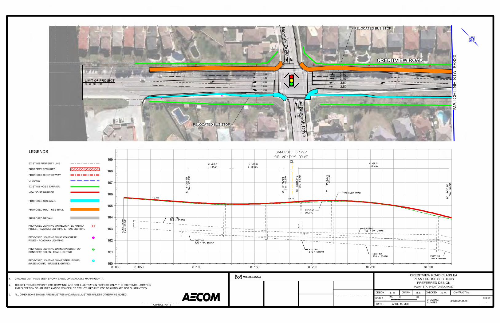


Preferred Design Typical Cross-sections


Long-Term Solution Plans and Profiles


Long-Term Solution Typical Cross-sections


Utility Plan