Ministère de l'Environnement, de l'Ecologie de la Mer et des Forêts – Madagascar - mai 2015 Page...
20
Ministère de l'Environnement, de l'Ecologie de la Mer et des Forêts – Madagascar - mai 2015 Page 1 GEO Symposium Workplan 2012- 2015 AfriGEOSS side event Madagascar Mrs NOASILALAONOMENJANAHARY A. Lucie GEO- DSWG Member National Focal Point AfriGEOSS Ministry of Environment , Ecology, Sea and Forest Madagascar
-
Upload
lester-nichols -
Category
Documents
-
view
220 -
download
0
Transcript of Ministère de l'Environnement, de l'Ecologie de la Mer et des Forêts – Madagascar - mai 2015 Page...

Ministère de l'Environnement, de l'Ecologie de la Mer et des Forêts – Madagascar - mai 2015 Page 1
GEO Symposium Workplan 2012-2015 AfriGEOSS side event
Madagascar
Mrs NOASILALAONOMENJANAHARY A. LucieGEO- DSWG MemberNational Focal Point AfriGEOSS Ministry of Environment , Ecology, Sea and Forest Madagascar

Ministère de l'Environnement, de l'Ecologie de la Mer et des Forêts – Madagascar - mai 2015 Page 2
PLAN BACKGROUND GEO workplan 2012 - 2015 realized GEO workplan 2012 – 2015 ongoing GEO workplan 2012 – 2015 planned

Ministère de l'Environnement, de l'Ecologie de la Mer et des Forêts – Madagascar - mai 2015 Page 3
BACKGROUND
• Madagascar is represented in GEO since the begining and contribute the elaboration of the decennal plan 2005-2015.
• Madagascar became GEO Member since 17th November 2009 in GEO VI plenary session in Washington DC.
• Madagascar added 5 activities in the GEO Workplan 2012-2015. Some activities are realized and some are planned.

Ministère de l'Environnement, de l'Ecologie de la Mer et des Forêts – Madagascar - mai 2015 Page 4
• The Conference RIO+20 confirmed the importance of Earth observation data and information for policymaking, and recognized the relevance and ongoing efforts in developing global environmental observing systems, and the need to support developing countries in their efforts to collect and use environmental data was also reinforced.
RIO +20

Ministère de l'Environnement, de l'Ecologie de la Mer et des Forêts – Madagascar - mai 2015 Page 5
GEO WORKPLAN 2012-2015 REALIZED
1. The Communication Network of Remote Sensing is created2. The Open Source Software online to manage all environmental and spatial (GENIES) is
developed

Ministère de l'Environnement, de l'Ecologie de la Mer et des Forêts – Madagascar - mai 2015 Page 6
GEO WORKPLAN 2012-2015 ONGOING
1. Develop the Madagascar GEO Portal and sharing data to the GEO Portal and share all environmental data to GCI and DSWG

Ministère de l'Environnement, de l'Ecologie de la Mer et des Forêts – Madagascar - mai 2015 Page 7
GEO WORKPLAN 2012-2015 PLANNED
1. Collect the National Environmental Information of Madagascar2. Installation of the Infrastructure MADagascar Earth Observations System (MADEOS) in
10 Regions

Ministère de l'Environnement, de l'Ecologie de la Mer et des Forêts – Madagascar - mai 2015 Page 8
MADEOSMadagascar Earth Observation
System
as presented in GEO Work Plan Task ID-02: Developing Institutional and Individual Capacity

Ministère de l'Environnement, de l'Ecologie de la Mer et des Forêts – Madagascar - mai 2015 Page 9
MADEOS conceptMadagascar Earth Observation System
• 1) Implement a centralized office for Earth Observation in Madagascar and 2) then develop in regions;
• MADEOS will be a single place where experts receive, analyse, interpret and deliver environmental information;
• IT and technical specialists cooperate with scientists• Service oriented policy:
– Collect users’ requirements;– Produce customized information and deliver with contributions;– Collect users feedback
• Serve the 10 most relevant applications of GEO (ecosystems, climate change, agriculture, oceans, biodiversity, health, natural disasters, weather, water, energy)
• MADEOS will be the most efficient way to implement GOESS data sharing principles (full and open exchange of data)

Ministère de l'Environnement, de l'Ecologie de la Mer et des Forêts – Madagascar - mai 2015 Page 10
MADEOS centralized conceptwhere sciences, technologies and services meet

Ministère de l'Environnement, de l'Ecologie de la Mer et des Forêts – Madagascar - mai 2015 Page 11
Expected achievements
• Enhance regional capacity-building networks: – Organize and reinforce international networks (incl. training opportunity
networks) for the use and provision of Earth observations. – Improve coordination of these networks through the GEO Portal and existing
initiatives.
• Create conditions for expanding GEO capacity building activities and improving their effectiveness across Societal Benefit Areas.
• Develop qualitative and quantitative Performance Indicators for measuring the efficacy of institutional and individual capacity building programs
• Installation of the infrastructure MADagascar Earth Observations System (MADEOS) in 10 Regions of Madagascar.
• Obtain scientific recognition: regional (Indian Ocean Commission), and global (WMO, GEO, UNEP, FAO, etc).

Ministère de l'Environnement, de l'Ecologie de la Mer et des Forêts – Madagascar - mai 2015 Page 12
Key outputs
• Development and improvement of open-source software, open systems and observation networks, building upon existing efforts and drawing upon networks in the scope of the following projects (E02HEAVEN, GEONetCast, CIMHET, Madagascar)
• Provide value-added services and centralized information for institutions:– Ministery of environment, Forest and waters– Associated ministeries (transport, energy, health, agriculture, education)– Associated operational private/public agencies (civil protection, maritime
transport, tourism, insurance, coastal development)– Regional development organizations– Universities in Madagascar and abroad

Ministère de l'Environnement, de l'Ecologie de la Mer et des Forêts – Madagascar - mai 2015 Page 13
Support applications for…• Ecosystems / Forests
– Deforestation monitoring– National parks monitoring to protect endangered species (rosewood)– Forest fire early warning and impact assessment
• Climate change– Desertification– Sea level rise impacts – Mangrove and fragile ecosystems, – Coastal erosion
• Agriculture, land use, resource management– Assess impact of better agricultural practices over long periods

Ministère de l'Environnement, de l'Ecologie de la Mer et des Forêts – Madagascar - mai 2015 Page 14
Support applications for…• Oceans
– Develop oceanographic competences in Madagascar– Madagascar to enter into global ocean observing networks :
• Global Drifter Program for surface currents• Argo program for subsurface currents, • Moored data buoys • International cooperation for deployment of buoys and analysis of data
• Bio Diversity– Endangered species monitoring programs (wildlife tracking: turtles, lemurs, falcons etc)– Monitoring of Marine Protected Areas (Convention on Bio Diversity) – Enforce fishing and logging restriction rules
• Natural disaster management, humanitarian & health risks– Floods (observe flooded area daily changes using radar satellite images)– Land slides– Manage refugees health and housing issues during floods– Receive technical advisory support from UN-SPIDER (United Nations Platform for Space-based information
and Emergency Response)

Ministère de l'Environnement, de l'Ecologie de la Mer et des Forêts – Madagascar - mai 2015 Page 15
Support applications for…
• Weather– Cyclones impacts
• Water– Water resource management for human use and farming– Terrain modelling, civil engineering for construction of dykes and reservoirs
• Energy– Evaluate most favorable areas for sustainable energy sources (wind, tide, solar energy)– Environmental impact of mining– Impact of Oil&Gas exploration
• And new applications to be developed on demand

Ministère de l'Environnement, de l'Ecologie de la Mer et des Forêts – Madagascar - mai 2015 Page 16
MADEOS typical infrastructureinspired from similar projects in South Africa or Indonesia
Satellite receiving antenna can be replaced by Internet broadband to receive EO images.
2 blocks of 350 m² or more, single storey.•1 block dedicated to EO analysts and scientific cooperation.•1 block dedicated to data storage and access, IT and system supervision.•Optional conference room•Satellite antennas are optional if Internet allows reliable access to data.
© CLS INDESO

Ministère de l'Environnement, de l'Ecologie de la Mer et des Forêts – Madagascar - mai 2015 Page 17
MADEOS typical infrastructureinspired from similar projects in South Africa or Indonesia
Work places designed for collaborative work•Support sharing of information and trans-domain cooperations (e.g. impact of maritime pollution on fragile ecosystems)•Some of the rooms might be staffed 24x7 during emergency situations•Visioconference•Showroom
Ministère de l'Environnement, de l'Ecologie de la Mer et des Forêts – Madagascar - mai 2015 Page 18
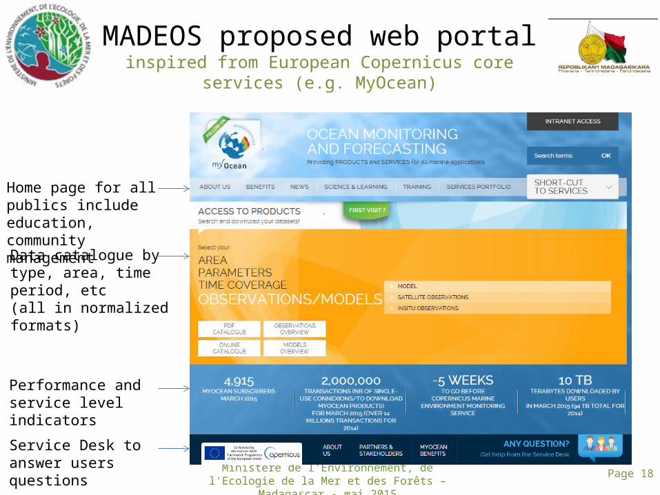
MADEOS proposed web portalinspired from European Copernicus core services (e.g.
MyOcean)
Home page for all publics include education, community management
Data catalogue by type, area, time period, etc (all in normalized formats)
Service Desk to answer users questions
Performance and service level indicators

Ministère de l'Environnement, de l'Ecologie de la Mer et des Forêts – Madagascar - mai 2015 Page 19
MADEOS proposed web portalinspired from European Copernicus core services (e.g.
MyOcean)
Example of general information on sensors available.Data samples and formats descriptions available.

Ministère de l'Environnement, de l'Ecologie de la Mer et des Forêts – Madagascar - mai 2015 Page 20
MADEOS project planningSpecify Design Build Operate
Building design and construction
User requirement collection
System development (data management, portal, models)
Onsite acceptance tests
Operations
Technical processes
Project ManagementProject Planning
Donors’ Assessment and Control
Outreach & international events
Months T0 T0+6 T0+12 T0+18 T0+36T0+24 T0+48
Online service delivery
Applications Create User community forum
Animate user community forum
On site acceptance
Building acceptance
Factory acceptance
Applications’ inaugural ceremony