
MCGREGOR HOUSING ERF360 · At the request of Mr David Douglas of ASLA Devco, ... LL - liquid...
24
CONTACT DETAILS Tel: +27 21 671 4274/80 Fax: +27 21 671 4277 email: [email protected] Postal address: Postnet Suite 32, Private Bag X3, Glosderry, 7702 Physical address: Unit b02, Clareview Business Park, 236 Lansdowne Road, Claremont, 7708 PHASE I GEOTECHNICAL SITE INVESTIGATION FOR MCGREGOR HOUSING ERF360 FOR ASLA DEVCO (PTY) LTD
Transcript of MCGREGOR HOUSING ERF360 · At the request of Mr David Douglas of ASLA Devco, ... LL - liquid...

CONTACT DETAILS
Tel: +27 21 671 4274/80 Fax: +27 21 671 4277 email: [email protected] Postal address: Postnet Suite 32, Private Bag X3, Glosderry, 7702
Physical address: Unit b02, Clareview Business Park, 236 Lansdowne Road, Claremont, 7708
PHASE I
GEOTECHNICAL SITE INVESTIGATION
FOR
MCGREGOR HOUSINGERF360
FOR
ASLA DEVCO (PTY) LTD

PHASE I GEOTECHNICAL SITE INVESTIGATION FORMCGREGOR HOUSING ERF360
Date: May 2013 Project no: 066-13
Contents
Page
Executive Summary 1
1. Introduction and terms of reference 2
2. Information used in the study 2
3. Site description 2
4. Nature of investigation 4
4.1 Test pits and DPL (Dynamic Probe Light) tests 4
4.2 Laboratory testing 4
5. Site geology and groundwater conditions 4
5.1 General 4
5.2 Soil profile 4
5.3 Water table 4
6. Geotechnical evaluation 5
6.1 Engineering and material characteristics 5
6.2 Slope stability and erosion 6
6.3 Excavation Classification with respect to Services 6
6.4 Impact of the Geotechnical Character of the Site onSubsidy Housing Developments 6
7. Site classification 6
8. Foundation recommendations and solutions 7
9. Drainage 7
10. Special precautionary measures 7
11. Conclusions 7
Appendix A: Site Plan and Site Class Designations
Appendix B: Test pit Soil Profiles
Appendix C: Laboratory Test Results

PHASE I GEOTECHNICAL SITE INVESTIGATION FORMCGREGOR HOUSING ERF360
forASLA DEVCO (PTY) LTD
Date: May 2013 Project no: 066-13
EXECUTIVE SUMMARYThe area for the proposed McGregor Housing development comprises a site located on the south-eastern side of the town of McGregor.
Geologically, the site is underlain from ground surface by dense gravelly silts of colluvial origin andgravelly residual clays. Over the major portion of the site, these soils overlie and mask completelyto moderately weathered shales of rock consistency of the Bokkeveld Group.
No water table was encountered on site during the investigation and the main water table probably occurs as a fractured rock aquifer at greater depth. The site investigation was however carried out during the dry summer period and winter rainfall might result in a perched water tabledeveloping in the transported soils above the relatively impermeable rock. Surface water flow (sheet run-off) down-slope is also likely to develop during intense rainfall events.
Possible geotechnical impacts of the site on development, identified in Section 6.4, include:-
• Relative difficulty of excavation in less weathered shales, although excavation is not expected to fall into any subsidy variation categories
• Potentially low to moderately expansive soils, requiring modified normal construction for housing units
• Poor infiltration rates combined with slopes could result in significant surface water run-off
ln terms of the Residential Site Class Designation, the site has been classified as S1/H1/R, H1/R and R in three delineated areas..
Recommendations for foundation design and drainage are given in Sections 8 and 9 respectively. Conventional strip foundations founded in the weathered bedrock where possible and, where notpossible, modified strip foundations are recommended, with modified construction and design precautions as required.
Sound water management is recommended to prevent water ingress into soils below foundations and roadways in order to minimize long-term maintenance.
CORE Geotechnical ConsultantsMcGregor Housing Erf360 Phase 1 geotechnical Investigation 1

1. Introduction and terms of reference
At the request of Mr David Douglas of ASLA Devco, a Phase 1 Geotechnical Site Investigationhas been carried out for the McGregor Housing Project.
The objectives of the investigation are summarised as follows:-
a) Identify any potential hazards
b) Define the ground conditions and provide site classifications including detailed soil profile and groundwater occurrences within the zone of influence of foundations
c) Provide the geotechnical basis for safe and appropriate land use planning, infrastructure design, housing unit design and the formulation of precautionary measures and risk management procedures.
d) Broadly classify the land that is to be developed for subsidy housing in terms of the Housings Code‘s Residential Site Class Designations
e) Gather factual data that has a bearing on the determination of housing subsidy variations and the installation of township services.
The investigation report has been prepared in accordance with the standard specifications of the National Housing Code for Project Linked Greenfield Subsidy Housing Projects (Standard Specifications GFSH-2). However investigation requirements have been modified where site conditions indicate and can be justified.
2. Information used in the study
The following information sources have been used in the investigation:-
• Geological map (1:1 000 000) - Council for Geoscience
• Remote imagery (1:5000 scale)- Google Earth
• Orthophotos (1:10 000) — Dept. Land Affairs
• Site Plans for McGregor Housing Project ·
No geotechnical site investigation reports for sites in the immediate Barrydale area could be obtained.
3. Site description
The location of the site relative to the town of McGregor is shown in Figure 1, and its topographic setting is shown in the remote image, Figure 2.
Topographically, the site is relatively flat with a slight slope to the east, where a wetland has developed adjacent the site. A small earth dam is located on the eastern section.
Our information is that no underground mining activity has taken place here in the past and that no economic minerals are associated with the shales in the area. Consequently the site has probably not been undermined.
CORE Geotechnical ConsultantsMcGregor Housing Erf360 Phase 1 geotechnical Investigation 2

Figure 1: Locality of site
Figure 2: Topography of site
CORE Geotechnical ConsultantsMcGregor Housing Erf360 Phase 1 geotechnical Investigation 3

4. Nature of the investigation
4.1. Desk study and walkover survey
The available geological and topographical maps and orthophotos were used to determine the geology and geological history of the area and to better understand topography, drainage and soil and rock origin in the region. A walkover survey was also conducted to confirm the nature of site features identified in the desk study.
4.2 Test Pits
Nine test pits, spread over the site, were excavated using a digger-loader. Test pits were visually profiled, with representative soil samples being taken from selected horizons for laboratory testing.
Due to the stiffness of the soil and the shallow depth of bedrock, dynamic probe light (DPL) testing was not carried out on this site.
Test pit locations are shown on the site plan in Appendix A (Figure 3). Copies of the recorded test pit soil profiles included in Appendices B.
4.3 Laboratory testing
The following laboratory tests were carried out on selected soil samples;
• Indicator tests in the form of moisture content, grading and Atterberg Limits analysis; to determine basic soils engineering properties.
• Geochemical testing (pH and conductivity) to assess possible deleterious effects of soils on concrete and steel.
The results of the laboratory tests are summarized in Table 6.1. Copies of the full laboratory test results are included as Appendix C.
5. Site geology and groundwater conditions
5.1 General
From ground surface, relatively thin Tertiary deposits of colluvial origin and residual shale soilsmask the underlying weathered shale rock. These shales form part of the Bokkeveld Group - Gydo Formation and consist of black to dark grey fossiliferous shale, mudstone and siltstone.
5.2 Soil profile
Near-surface colluvial soils essentially comprise dense gravelly silts to silty gravels, which are up to 0.70 m thick. These are underlain by residual shale soils that consist mainly of firm to stiff gravelly silty clays up to 1.4 m thick. Calcrete was intersected in test pit TP4 but is expected to be a relatively thin horizon just above the rockhead contact.
The soil horizons are underlain by shales (rock) where the rock depth varies from surface outcrop to 1.4 m depth. The rockhead depth is seen to increase from the north eastern side of the site to the south western portion.
5.3 Water Table
No groundwater was encountered in any of the test pits. The main water table is expected to be located within a fractured rock aquifer at moderate depth. The site investigation was however conducted during the middle of the summer period with high summer temperatures. High winter rainfall might result in the forming of a shallow perched water
CORE Geotechnical ConsultantsMcGregor Housing Erf360 Phase 1 geotechnical Investigation 4

table above the relatively impermeable rock . Significant surface water run-off down-slope can be expected during intense rainfall events as indicated by prominent drainage gullies.
6. Geotechnical evaluation
6.1 Engineering and materials characteristics
Soils engineering properties relevant to design and development are summarized in Tables 6.1 and 6.2. 0n the basis of the field investigation, soils engineering data and site geology, the following points relating to geotechnical engineering conditions on the site may be made:-
a) The near-surface transported (colluvial) soils are generally dense and are consider to be moderately compressible. Due to the density of these soils and their vertical extent in some sections, this horizon may be considered for use as a founding horizon.
b) The underlying residual shale soils exhibit moderate plasticity and low to moderate potential expansiveness. If founding on this horizon is to be considered, appropriate foundation design measures will be required.
c) The weathered shales underlying the soils are completely to moderately weathered, jointed and exhibit low compressibility, moderate strength and low permeability. The shales occur at an average depth of 0.55 m, where intersected, and are considered to exhibit low potential expansiveness. They will thus form a competent founding horizon forstructures.
d) ln terms of material properties, the residual soils show moderate plasticity with low to moderate heave potential. These soils can be expected to exhibit moderate post-compaction strength and could form a construction material of general fill or subgrade quality (see Table 6.2). ln terms of the TRH14 classification for pavement design,the transported material would most likely classify as a G10 quality construction material.
e) The weathered shale bedrock material exhibits low plasticity and fair post-compaction strength (from computed CBR values). This material can be expected to form a G7 (selected layer) quality material or could also be used as gravel wearing course, if not too deeply weathered.
f) Near-surface soils are acidic, with the potential for minor deleterious effects on buried services. Design precautions may thus be required.
g) Relatively low infiltration rates and significant surface run-off down-slope can be expected generally. Attention will thus have to be paid to storm water management and drainage measures.
Table 6.1 Summary of soils engineering properties
Test Pit No.
Depth (m) Description LL PI LS
MC GM pH
CBR*@ 95% Mod. AASHTO
TRH 14 Classification
2 0.5 Silty gravelly clay 28 11 4.5 13.9
0.98 3.8 - G10?
3 0.8 Shale 28 7 3.0 - 2.64 - 21 G7Key; LL - liquid limit.. PI — plasticity index. LS – liquid limit. MC — in-situ moisture content GM — grading modulus.
N-P — non-plastic. CBR — California Bearing Ratio. CBR* - computed CBR value.
CORE Geotechnical ConsultantsMcGregor Housing Erf360 Phase 1 geotechnical Investigation 5

Table 6.2 Engineering properties of compacted materials
Material Potential usage Shear strength when compacted
Drainage characteristics
Workability as a construction material
Residual gravellyclay
General fill Moderate Poor Poor
Weathered shale Selected sub grade, Gravel wearing coarse
Good Moderate Moderate
6.2 Slope stability and erosion
No major slope stability issues are foreseen. There is a potential for soil erosion at surface dueto the silty soils being underlain be relatively impermeable horizons. Erosion measures should therefore be incorporated in surface water drainage design.
6.3 Excavation classification with respect to services
Excavation in soils and highly weathered shale rock, classifies as "soft excavation" (restricted and non-restricted excavation) in terms of the SABS 1200 D Earthworks Specification. Materials can probably be efficiently removed using a digger-loader or backhoe.
The deeper less weathered shale and possibly calcrete, classify as "intermediate excavation". Material can probably be excavated to a depth of around 1.5 m, probably deeper, with tracked excavators of 20 tons or more. The need for blasting appears to be unlikely within at least 2 m of ground level.
6.4 Impact of the geotechnical character of the site on subsidy housing developments
The geotechnical character of the site is considered to impart a number of impacts on housing development and subsidy variations, including: -
• Relative difficulty of excavation in less weathered shales and calcrete, although excavationis not expected to fall into any subsidy variation categories
• Potentially low to moderate heave movements in active residual shale soils, necessitating at least some design precautions
• Poor infiltration rates combined with slopes could result in significant surface water run-off
7. Site classification
The site has a soil profile of colluvial and residual soils overlying weathered shale rock, as outlined in Table 7.1. The engineering design requirements applicable to this site class designation in relation to foundations are detailed in Section 8.
Table 7.1 Residential site class designations
Site Classification
Character of Founding materials
Expected Range of Total Soil Movements (mm)
Assumed Differential Movement (% of Total)
Maximum Allowable Bearing Pressure (kPa)
S1/H1/R
Dense silty colluvium overlying clayey gravels overlying weathered shale rock
<15 50 200
R Shale rock - 50 500
CORE Geotechnical ConsultantsMcGregor Housing Erf360 Phase 1 geotechnical Investigation 6

8. Foundation recommendations and solutions
In areas where rock is close to surface and founding depths allow, residential and community structures may be founded using conventional strip footings. Excavations for foundations should be taken through the soils to found entirely and uniformly in weathered shale of rock consistency.
In areas where it is not possible to found on rock, structures should be found using normal reinforced strip footings together with modified normal construction, including articulation joints and reinforcement in masonry. Due to the heave potential of the residual soils it is recommended that flexible couplings be used on all wet services to accommodate any possible movements that may occur.
A geotechnical engineer should inspect representative foundation excavations prior to castingconcrete. This will ensure that founding horizons are compatible with the design of the foundations and the structures.
Surface beds may be cast directly on silty colluvium after nominal compaction from final terrace level. Consideration should be given to isolating surface beds from walls to accommodate heave movements.
9. Drainage
ln view of the risk associated with storm water run-off, sound water management is required. Suitable measures include grading of slopes to prevent ponding of water around housing units, effective collection and disposal off site of storm water and water from down pipes and regular checking of wet services for leaks.
Similar measures are required with regard to road construction, with regular maintenance of storm water to prevent water ingress into subgrade soils and to minimize long term maintenance.
10. Special precautionary measures
If the small earthfill dam is to be removed it must be ensured that all fill material is adequately compacted with any unconsolidated soft sediments in the dam basin to be trimmed out to spoil. In this area it would be recommended that foundations are taken down to bedrock.
11. Conclusion
This Phase 1 geotechnical site investigation indicates that the area investigated, is generally suitable for project linked subsidy housing development, provided that the aspects of concernrelating to the geotechnical character of the site are addressed.
JOHN YATES
MATTHEW JONES
CORE Geotechnical ConsultantsMcGregor Housing Erf360 Phase 1 geotechnical Investigation 7

APPENDIX A
SITE PLAN AND CLASSIFICATION

CLIENT: ASLA DEVCO (PTY) LTD
PROJECT: MCGREGOR HOUSING ERF360
TITLE: SITE PLAN SHOWING TEST PIT POSITIONS AND SITE CLASSIFICATION
DATE: May-13 SCALE: NTS TRACED BY: SS FIG.NO. 1 JOB NO. 066-13
Tel: +27 21 671 4274 /4280 Fax: +27 21 671 4277 Cell: +27 82 442 6231Email: [email protected] Postal address: Postnet Suite 177, Private Bag X3, 7801, PlumsteadPhysical address: Unitb02, Clareview Business Park, 236 Lansdowne Road, Claremont
KEY
Test PitTP1
TP2
TP3
TP5 TP4
TP6
TP7
TP8
TP9
S1/H/R
S1/H/R
S1/H/RS1/H/R
R
R
S1/H/R
SITE CLASSIFICATION DESIGNATION
Dense silty colluvium overlying clayey gravels overlying weathered shale rock
RShale rock

APPENDIX B – SOIL PROFILES
MCGREGOR HOUSINGERF360
TEST PIT SOIL PROFILES
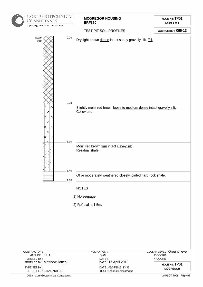
HOLE No: TP01Sheet 1 of 1
HOLE No: TP01Sheet 1 of 1
JOB NUMBER: 066-13JOB NUMBER: 066-13
0.70
0.00
1.10
1.40
1.50
Dry light brown dense intact sandy gravelly silt. Fill.
Slightly moist red brown loose to medium dense intact gravelly silt.Colluvium.
Moist red brown firm intact clayey silt.Residual shale.
Olive moderately weathered closely jointed hard rock shale.
Scale1:10
NOTES
1) No seepage.
2) Refusal at 1.5m.
CONTRACTOR :MACHINE :
DRILLED BY :PROFILED BY :
TYPE SET BY :SETUP FILE :
TLB
Matthew Jones
STANDARD.SET
INCLINATION :DIAM :DATE :DATE :
DATE :TEXT :
17 April 201306/05/2013 13:35C\dot5000\mcgreg.txt
COLLAR LEVEL :X COORD :Y COORD :
Ground level
dotPLOT 7008 PBpH67D068 Core Geotechnical Consultants
HOLE No: TP01MCGREGOR
HOLE No: TP01MCGREGOR

FIND02
MCGREGOR HOUSINGERF360
TEST PIT SOIL PROFILES
HOLE No: TP02Sheet 1 of 1
HOLE No: TP02Sheet 1 of 1
JOB NUMBER: 066-13JOB NUMBER: 066-13
0.30
0.00
0.70
0.80
1.00
Dry light orange brown dense intact gravelly silt.Colluvium.* Reworked by farming.
Slightly moist red brown stiff intact silty gravelly clay.Residual shale.
Light olive brown completely weathered soft rock shale.
Olive moderately weathered medium hard rock shale.
Scale1:10
NOTES
1) Refusal at 1.0m.
2) No seepage.
3) FIND02 sample at 0.5m.
CONTRACTOR :MACHINE :
DRILLED BY :PROFILED BY :
TYPE SET BY :SETUP FILE :
TLB
Matthew Jones
STANDARD.SET
INCLINATION :DIAM :DATE :DATE :
DATE :TEXT :
17 April 201306/05/2013 13:35C\dot5000\mcgreg.txt
COLLAR LEVEL :X COORD :Y COORD :
dotPLOT 7008 PBpH67D068 Core Geotechnical Consultants
HOLE No: TP02HOLE No: TP02
FIND03
MCGREGOR HOUSINGERF360
TEST PIT SOIL PROFILES
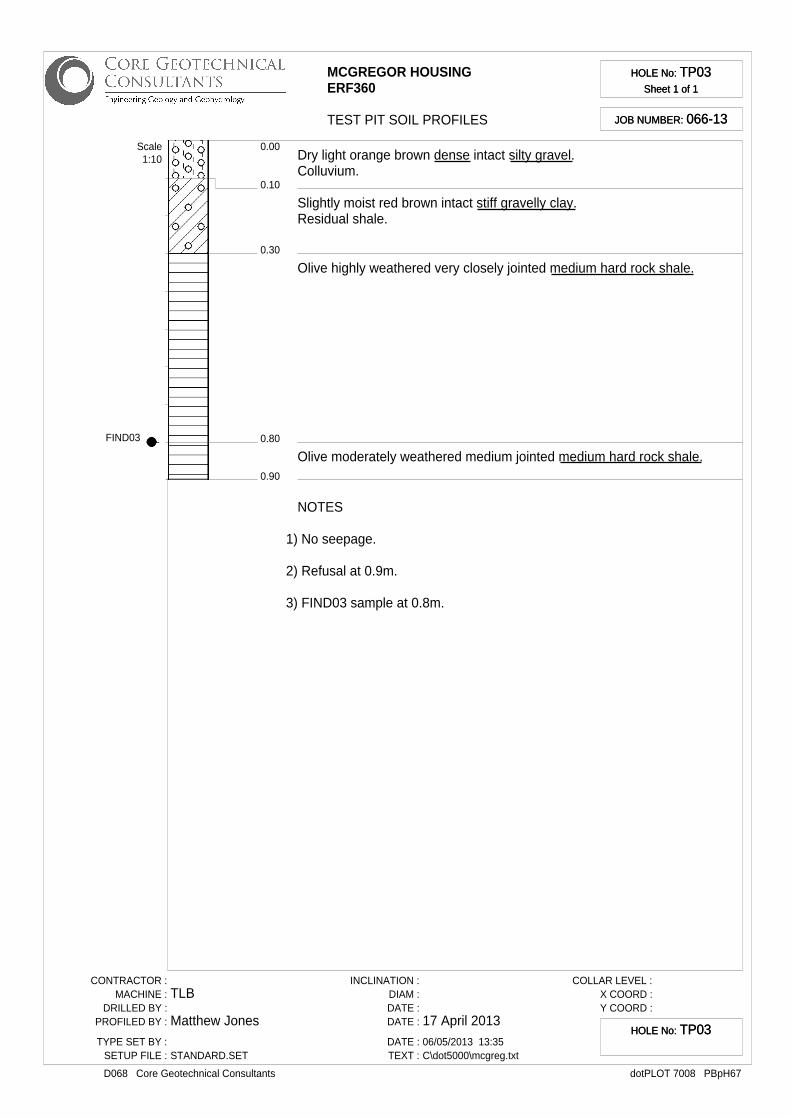
HOLE No: TP03Sheet 1 of 1
HOLE No: TP03Sheet 1 of 1
JOB NUMBER: 066-13JOB NUMBER: 066-13
0.10
0.00
0.30
0.80
0.90
Dry light orange brown dense intact silty gravel.Colluvium.
Slightly moist red brown intact stiff gravelly clay.Residual shale.
Olive highly weathered very closely jointed medium hard rock shale.
Olive moderately weathered medium jointed medium hard rock shale.
Scale1:10
NOTES
1) No seepage.
2) Refusal at 0.9m.
3) FIND03 sample at 0.8m.
CONTRACTOR :MACHINE :
DRILLED BY :PROFILED BY :
TYPE SET BY :SETUP FILE :
TLB
Matthew Jones
STANDARD.SET
INCLINATION :DIAM :DATE :DATE :
DATE :TEXT :
17 April 201306/05/2013 13:35C\dot5000\mcgreg.txt
COLLAR LEVEL :X COORD :Y COORD :
dotPLOT 7008 PBpH67D068 Core Geotechnical Consultants
HOLE No: TP03HOLE No: TP03

MCGREGOR HOUSINGERF360
TEST PIT SOIL PROFILES
HOLE No: TP04Sheet 1 of 1
HOLE No: TP04Sheet 1 of 1
JOB NUMBER: 066-13JOB NUMBER: 066-13
0.10
0.00
0.20
Dry light orange brown dense intact silty gravel.Colluvium.
Dry white very dense intact gravelly silt.Pedogenic hardpan calcrete.
Scale1:10
NOTES
1) No seepage.
2) Refusal at 0.2m.
CONTRACTOR :MACHINE :
DRILLED BY :PROFILED BY :
TYPE SET BY :SETUP FILE :
TLB
Matthew Jones
STANDARD.SET
INCLINATION :DIAM :DATE :DATE :
DATE :TEXT :
17 April 201306/05/2013 13:35C\dot5000\mcgreg.txt
COLLAR LEVEL :X COORD :Y COORD :
dotPLOT 7008 PBpH67D068 Core Geotechnical Consultants
HOLE No: TP04HOLE No: TP04

MCGREGOR HOUSINGERF360
TEST PIT SOIL PROFILES
HOLE No: TP05Sheet 1 of 1
HOLE No: TP05Sheet 1 of 1
JOB NUMBER: 066-13JOB NUMBER: 066-13
0.20
0.00
1.10
1.20
Dry light brown dense intact gravelly silt.Colluvial.
Light olive highly weathered very closely jointed medium hard rock shale.
Olive moderately weathered closely jointed medium hard rock shale.
Scale1:10
NOTES
1) No seepage.
2) Refusal at 1.2m.
CONTRACTOR :MACHINE :
DRILLED BY :PROFILED BY :
TYPE SET BY :SETUP FILE :
TLB
Matthew Jones
STANDARD.SET
INCLINATION :DIAM :DATE :DATE :
DATE :TEXT :
17 April 201306/05/2013 13:35C\dot5000\mcgreg.txt
COLLAR LEVEL :X COORD :Y COORD :
dotPLOT 7008 PBpH67D068 Core Geotechnical Consultants
HOLE No: TP05HOLE No: TP05
MCGREGOR HOUSINGERF360
TEST PIT SOIL PROFILES
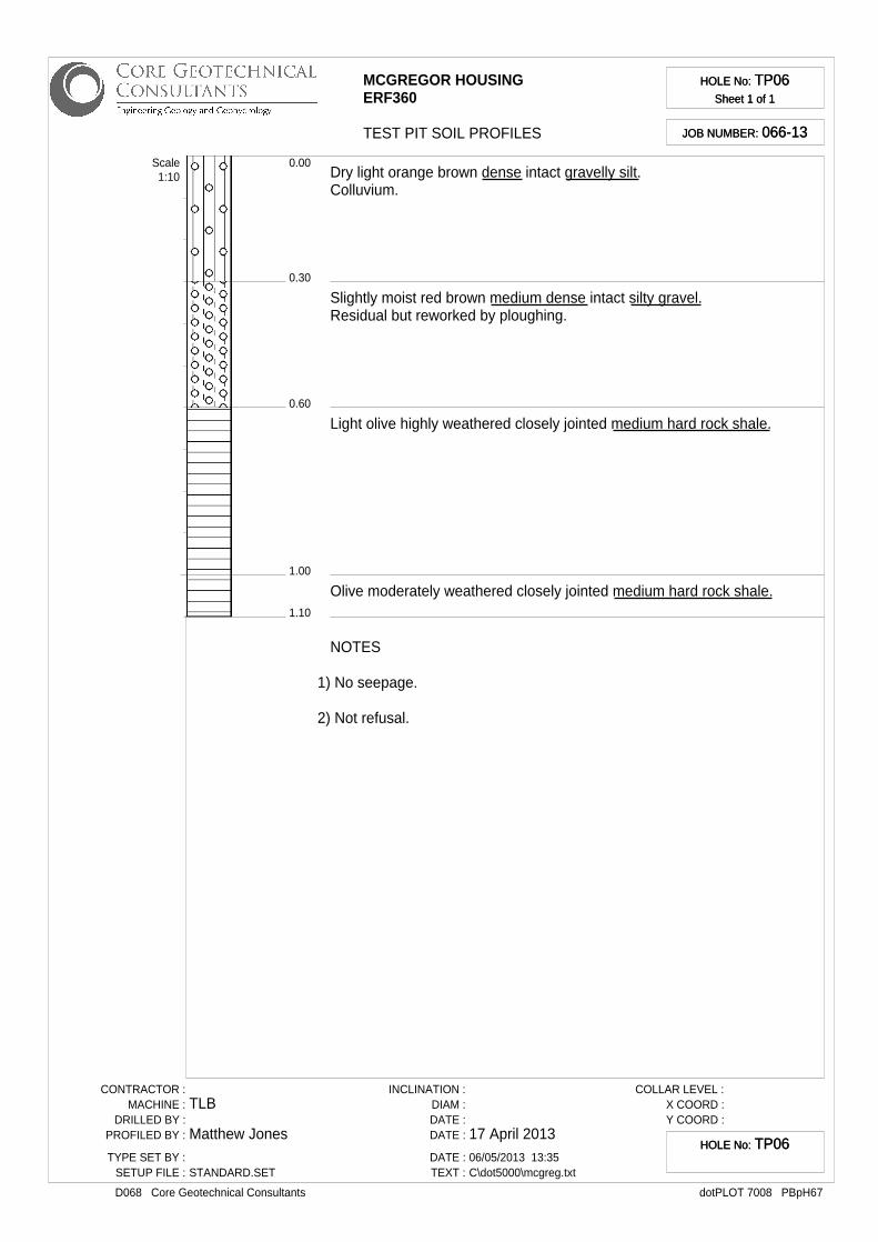
HOLE No: TP06Sheet 1 of 1
HOLE No: TP06Sheet 1 of 1
JOB NUMBER: 066-13JOB NUMBER: 066-13
0.30
0.00
0.60
1.00
1.10
Dry light orange brown dense intact gravelly silt.Colluvium.
Slightly moist red brown medium dense intact silty gravel.Residual but reworked by ploughing.
Light olive highly weathered closely jointed medium hard rock shale.
Olive moderately weathered closely jointed medium hard rock shale.
Scale1:10
NOTES
1) No seepage.
2) Not refusal.
CONTRACTOR :MACHINE :
DRILLED BY :PROFILED BY :
TYPE SET BY :SETUP FILE :
TLB
Matthew Jones
STANDARD.SET
INCLINATION :DIAM :DATE :DATE :
DATE :TEXT :
17 April 201306/05/2013 13:35C\dot5000\mcgreg.txt
COLLAR LEVEL :X COORD :Y COORD :
dotPLOT 7008 PBpH67D068 Core Geotechnical Consultants
HOLE No: TP06HOLE No: TP06
MCGREGOR HOUSINGERF360
TEST PIT SOIL PROFILES
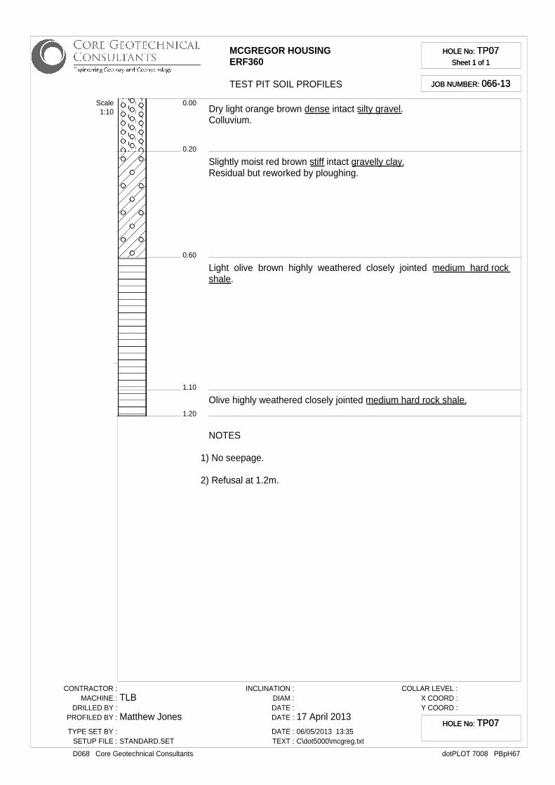
HOLE No: TP07Sheet 1 of 1
HOLE No: TP07Sheet 1 of 1
JOB NUMBER: 066-13JOB NUMBER: 066-13
0.20
0.00
0.60
1.10
1.20
Dry light orange brown dense intact silty gravel.Colluvium.
Slightly moist red brown stiff intact gravelly clay.Residual but reworked by ploughing.
Light olive brown highly weathered closely jointed medium hard rockshale.
Olive highly weathered closely jointed medium hard rock shale.
Scale1:10
NOTES
1) No seepage.
2) Refusal at 1.2m.
CONTRACTOR :MACHINE :
DRILLED BY :PROFILED BY :
TYPE SET BY :SETUP FILE :
TLB
Matthew Jones
STANDARD.SET
INCLINATION :DIAM :DATE :DATE :
DATE :TEXT :
17 April 201306/05/2013 13:35C\dot5000\mcgreg.txt
COLLAR LEVEL :X COORD :Y COORD :
dotPLOT 7008 PBpH67D068 Core Geotechnical Consultants
HOLE No: TP07HOLE No: TP07

MCGREGOR HOUSINGERF360
TEST PIT SOIL PROFILES
HOLE No: TP08Sheet 1 of 1
HOLE No: TP08Sheet 1 of 1
JOB NUMBER: 066-13JOB NUMBER: 066-13
0.50
0.00
1.30
1.40
Dry light orange brown dense intact silty gravel.Colluvium.
Light olive highly weathered closely jointed medium hard rock shale.
Olive moderately weathered closely jointed medium hard rock shale.
Scale1:10
NOTES
1) No seepage.
2) Refusal at 1.4m.
CONTRACTOR :MACHINE :
DRILLED BY :PROFILED BY :
TYPE SET BY :SETUP FILE :
TLB
Matthew Jones
STANDARD.SET
INCLINATION :DIAM :DATE :DATE :
DATE :TEXT :
17 April 201306/05/2013 13:35C\dot5000\mcgreg.txt
COLLAR LEVEL :X COORD :Y COORD :
dotPLOT 7008 PBpH67D068 Core Geotechnical Consultants
HOLE No: TP08HOLE No: TP08

MCGREGOR HOUSINGERF360
TEST PIT SOIL PROFILES
HOLE No: TP09Sheet 1 of 1
HOLE No: TP09Sheet 1 of 1
JOB NUMBER: 066-13JOB NUMBER: 066-13
0.50
0.00
0.70
Light olive brown completely weathered soft rock shale with medium clayconten.
Olive moderately weathered medium hard rock shale.
Scale1:10
NOTES
1) No seepage.
2) Refusal at 0.7m.
CONTRACTOR :MACHINE :
DRILLED BY :PROFILED BY :
TYPE SET BY :SETUP FILE :
TLB
Matthew Jones
STANDARD.SET
INCLINATION :DIAM :DATE :DATE :
DATE :TEXT :
17 April 201306/05/2013 13:35C\dot5000\mcgreg.txt
COLLAR LEVEL :X COORD :Y COORD :
dotPLOT 7008 PBpH67D068 Core Geotechnical Consultants
HOLE No: TP09HOLE No: TP09

APPENDIX C – LABORATORY TEST RESULTS

CLIENT: PROJECT:
Private Bag X3Plumstead 7801 DATE: 30-04-2013
ATT: Matthew REF: L130463
ASTM D422 SIEVE ANALYSIS
DESCRIPTION : SAMPLE NO. : 22087
POSITION : [email protected] CLIENT SAMPLE NO. :
Sieve Analysis Percent
Hydrometer Analysis SCS Dispersion TestPassing
SIE
VE
SIZ
E (
mm
)
75.00
63.00
53.00 0.0655 49
37.50 100 0.0339 42
26.50 99 0.0171 40
19.00 97 0.0090 37
13.20 91 0.0031 37
9.50 87 0.0022 34
6.70 86 0.0013 33
4.75 85
2.36 84 Specific Gravity:
2.00 84 Initial Moisture Content (%) : 13.9
1.18 76 pH : 3.80
0.600 69 79.00
0.425 66
0.300 63
0.150 57
0.0750 52
Liquid Limit 28
Plastic Index 11
Linear Shrinkage 4.5
MOD AASHTO ; C.B.R. :
O.M.C. (%)
C.B.R. @ 100% Comp.
C.B.R. @ 98 % Comp. Tabulated Summary Percentage
C.B.R. @ 95 % Comp. 15
C.B.R. @ 93 % Comp. 33
C.B.R. @ 90 % Comp. 17
35
The above test results are pertinent to the samples received and tested only.
Remarks: ConSR22
Core Geotechnical McGreggor HousingPostnet Suite 177
Dk red brown silty clay
Diameter of particle (mm)
Percentage of soil suspension
(%)
Diameter of particle (mm)
Percentage of soil suspension
(%)
Conductivity mS/m :
Atterberg Limits :
MOD AASHTO (Kg/m³)
Gravel : Percentage - 4.75 mm
Sand : Percentage - 4.75mm and + 0.075mm
Silt : Percentage - 0.075mm and + 0.002mm
Swell ( max ) % Clay : Percentage - 0.002mm
For Geoscience:
While the tests are carried out according to recognized standards Geoscience shall not
be liable for erroneous testing or reporting thereof. This report may not be reproduced except in full without prior consent of Geoscience.
0.001 0.010 0.100 1.000 10.000 100.000
0
10
20
30
40
50
60
70
80
90
100Particle Size Distribution
Particle Size (mm)
Pe
rce
nta
ge
Pa
ss
ing

CLIENT: PROJECT:
Private Bag X3Plumstead 7801 DATE: 30-04-2013
ATT: Matthew REF: L130463
ASTM D422 SIEVE ANALYSIS
DESCRIPTION : SAMPLE NO. : 22088
POSITION : [email protected] CLIENT SAMPLE NO. :
Sieve Analysis Percent
Hydrometer Analysis SCS Dispersion TestPassing
SIE
VE
SIZ
E (
mm
)
75.00 94
63.00 90
53.00 77 0.0707 6
37.50 59 0.0364 5
26.50 43 0.0183 4
19.00 34 0.0096 4
13.20 31 0.0034 2
9.50 28 0.0024 2
6.70 24 0.0014 2
4.75 23
2.36 18 Specific Gravity:
2.00 18 Initial Moisture Content (%) :
1.18 15 pH :
0.600 13
0.425 12
0.300 11
0.150 8
0.0750 6
Liquid Limit 28
Plastic Index 7
Linear Shrinkage 3.0
MOD AASHTO ; C.B.R. :
1948
O.M.C. (%) 12.3
C.B.R. @ 100% Comp. 35
C.B.R. @ 98 % Comp. 28 Tabulated Summary Percentage
C.B.R. @ 95 % Comp. 21 77
C.B.R. @ 93 % Comp. 17 16
C.B.R. @ 90 % Comp. 13 4
0.00 2
The above test results are pertinent to the samples received and tested only.
Remarks: ConSR22
Core Geotechnical McGreggor HousingPostnet Suite 177
Dk red brown gravelly clay sand
Diameter of particle (mm)
Percentage of soil suspension
(%)
Diameter of particle (mm)
Percentage of soil suspension
(%)
Conductivity mS/m :
Atterberg Limits :
MOD AASHTO (Kg/m³)
Gravel : Percentage - 4.75 mm
Sand : Percentage - 4.75mm and + 0.075mm
Silt : Percentage - 0.075mm and + 0.002mm
Swell ( max ) % Clay : Percentage - 0.002mm
For Geoscience:
While the tests are carried out according to recognized standards Geoscience shall not
be liable for erroneous testing or reporting thereof. This report may not be reproduced except in full without prior consent of Geoscience.
0.001 0.010 0.100 1.000 10.000 100.000
0
10
20
30
40
50
60
70
80
90
100Particle Size Distribution
Particle Size (mm)
Pe
rce
nta
ge
Pa
ss
ing