
McDonald/Mack Minor Land Division ProjectMcDonald/Mack Minor Land Division Project (Project),...
92
McDonald/Mack Minor Land Division Project Town of Loomis, Placer County, California Initial Study/Mitigated Negative Declaration Town of Loomis 3665 Taylor Road P.O. Box 1330 Loomis CA 95650 Contact: Robert King, Town Planner (916) 652-1840 email: [email protected] July 2018
Transcript of McDonald/Mack Minor Land Division ProjectMcDonald/Mack Minor Land Division Project (Project),...
McDonald/Mack Minor Land Division Project Town of Loomis, Placer County, California
Initial Study/Mitigated Negative Declaration
Town of Loomis 3665 Taylor Road
P.O. Box 1330 Loomis CA 95650
Contact: Robert King, Town Planner (916) 652-1840
email: [email protected]
July 2018


McDonald/Mack Minor Land Division Project Initial Study/Mitigated Negative Declaration
Draft Mitigated Negative Declaration Town of Loomis
McDonald/Mack Minor Land Division Project
INTRODUCTION
This document has been prepared to evaluate the McDonald/Mack Minor Land Division Project (also referred to as “proposed Project” or “Project”) for compliance under the California Environmental Quality Act (CEQA). The Town of Loomis (Town) is the lead agency responsible for complying with the provisions of CEQA.
PROJECT DESCRIPTION
Consistent with existing zoning, the proposed project would divide one 5-acre parcel into four lots, as well as consolidate and reconfigure lots to the north of the 5-acre parcel, located at 5460 King Road, in the Town of Loomis.
FINDINGS
As lead agency for compliance with CEQA requirements, the Town finds that the proposed Project would be implemented without causing a significant adverse impact on the environment, based on the analysis presented in this Initial Study/ Mitigated Negative Declaration (IS/MND). Mitigation measures for potential impacts associated with biological resources, cultural resources, and tribal cultural resources would be implemented as part of the proposed Project through adoption of a mitigation monitoring and reporting program.
DETERMINATION
On the basis of this evaluation, the Town concludes:
The proposed Project does not have the potential to degrade the quality of the environment, substantially reduce the habitat of a fish or wildlife species, cause a fish or wildlife population to drop below self-sustaining levels, threaten to eliminate a plant or animal community, substantially reduce the number or restrict the range of a rare or endangered species, or eliminate important examples of the major periods of California history or prehistory.
The proposed Project would not achieve short-term environmental goals to the disadvantage of long-term environmental goals.
The proposed Project would not have impacts that are individually limited, but cumulatively considerable.
McDonald/Mack Minor Land Division Project Initial Study/Mitigated Negative Declaration
The proposed Project would not have environmental effects that would cause substantial adverse effects on human beings, either directly or indirectly.
No substantial evidence exists to demonstrate that the proposed Project would have a substantive negative effect on the environment.
This document has been prepared to provide the opportunity for interested agencies and the public to provide comment. Pending public review and approval by the Town Planning Commission and Town Council, this MND will be filed pursuant to CEQA Guidelines §15075. Written comments should be submitted to the Town Planning Department at 3665 Taylor Road, Loomis, California 95650 by 5:00 p.m. on ___________________.<date>
Signature Robert King Town Planner
Date

McDonald/Mack Minor Land Division Project Initial Study/Mitigated Negative Declaration i
Table of Contents 1.0 Introduction .............................................................................................................. 1
1.1 Project Overview ..................................................................................................... 1 1.2 Purpose of this Document ........................................................................................ 1 1.3 Public Review Process ............................................................................................. 1 1.4 Town Approval Process ........................................................................................... 1 1.5 Organization of the Initial Study and Mitigated Negative Declaration ................... 1 1.6 Environmental Factors Potentially Affected ............................................................ 2
2.0 Project Description ................................................................................................... 4 2.1 Project Location ....................................................................................................... 4 2.2 Project Purpose ........................................................................................................ 4 2.3 Parcel Division, Mergers, and Lot Line Adjustments .............................................. 4 2.4 Access and Easements ........................................................................................... 10 2.5 Utilities ................................................................................................................... 10 2.6 No-project Alternative ........................................................................................... 10 2.7 Supporting Technical Studies ................................................................................ 10 2.8 Permits and Approvals Needed .............................................................................. 10
3.0 Environmental Checklist ........................................................................................ 12 3.1 Aesthetics ............................................................................................................... 12 3.2 Agriculture and Forestry Resources ....................................................................... 13 3.3 Air Quality ............................................................................................................. 15 3.4 Biological Resources ............................................................................................. 17 3.5 Cultural Resources ................................................................................................. 25 3.6 Geology and Soils .................................................................................................. 28 3.7 Greenhouse Gas Emissions .................................................................................... 31 3.8 Hazards and Hazardous Materials ......................................................................... 32 3.9 Hydrology and Water Quality ................................................................................ 35 3.10 Land Use and Planning .......................................................................................... 40 3.11 Mineral Resources ................................................................................................. 41 3.12 Noise ...................................................................................................................... 42 3.13 Population and Housing ......................................................................................... 45 3.14 Public Services ....................................................................................................... 46 3.15 Recreation .............................................................................................................. 48 3.16 Transportation and Circulation .............................................................................. 48 3.17 Tribal Cultural Resources ...................................................................................... 51 3.18 Utilities and Service Systems ................................................................................ 53 3.19 Mandatory Findings of Significance ...................................................................... 55
4.0 List of Preparers .......................................................................................................... 58 5.0 References ................................................................................................................... 59

McDonald/Mack Minor Land Division Project Initial Study/Mitigated Negative Declaration ii
List of Figures Figure 1. Project Vicinity ................................................................................................................ 5 Figure 2. Project Location ............................................................................................................... 6 Figure 3. Proposed Project: 5-acre Parcel ....................................................................................... 7 Figure 4. Proposed Project: North Parcels ...................................................................................... 9 Figure 5. Vegetation Communities in the Project Area ............................................................... 20 Figure 6. FEMA 100-year Flood Plain ......................................................................................... 37
List of Tables Table 1. Trees Removed due to Property Improvements .............................................................24 Table 2. Noise Standards for Short Duration Events Near Residential Areas ..............................43 Table 3. Typical Construction Equipment Noise Levels ..............................................................44
List of Appendices Appendix A Mitigation Monitoring and Reporting Program Appendix B Biological Resources Evaluation

McDonald/Mack Minor Land Division Project Initial Study/Mitigated Negative Declaration iii
Acronyms and Abbreviations APN Assessor’s Parcel Number
ASTM American Society for Testing and Materials
BMPs Best Management Practices
CCR California Code of Regulations
CDFW California Department of Fish and Wildlife
CEQA California Environmental Quality Act
CFGC California Fish and Game Code
Corps U.S Army Corps of Engineers
CWA Clean Water Act
DBH diameter at breast height
DPM diesel-exhaust particulate matter
DOC Department of Conservation
DTSC Department of Toxic Substances Control
EIR Environmental Impact Report
FEMA Federal Emergency Management Agency
FMMP Farmland Mapping and Monitoring Program
GHG greenhouse gas
IS/MND Initial Study/Mitigated Negative Declaration
LID Low Impact Design
LOS Level of Service
MMRP Mitigation Monitoring and Reporting Program
MND Mitigated Negative Declaration
MTCO2e/year metric tons of carbon dioxide equivalent per year
NAHC Native American Heritage Commission
NOI Notice of Intent
NPDES National Pollution Discharge Elimination System
NRCS National Resources Conservation Service
PCAPCD Placer County Air Pollution Control District
PCHHS Placer County Health and Human Services
PCWA Placer County Water Agency
PM2.5 particulate matter less than 2.5 microns in diameter
PM10 particulate matter less than 10 microns in diameter
Project McDonald/Mack Minor Land Division Project
REC recognized environmental condition
RR Rural Residential
RS-10 Single Family Residential
RWQCB Regional Water Quality Control Board

McDonald/Mack Minor Land Division Project Initial Study/Mitigated Negative Declaration iv
SPMUD South Placer Municipal Utility District
Town Town of Loomis
UAIC United Auburn Indian Community
USFWS U.S. Fish and Wildlife Service
WEAT Worker Environmental Awareness Training

McDonald/Mack Minor Land Division Project Initial Study/Mitigated Negative Declaration 1
1.0 Introduction
1.1 Project Overview
The Town of Loomis (Town) received an application for a Merger/Lot Line Adjustment (Application #17-11) and Minor Subdivision (Application #17-12), for the proposed McDonald/Mack Minor Land Division Project (Project), located at 5460 King Road, which would divide one 5-acre parcel into four lots, as well as consolidate and reconfigure lots to the north of the 5-acre parcel.
1.2 Purpose of this Document
The purpose of this Initial Study/Mitigated Negative Declaration (IS/MND) is to disclose environmental impacts that may result from the proposed Project. This IS/MND assesses the environmental effects of the proposed Project, as required by CEQA, and is in compliance with state CEQA Guidelines (14 California Code of Regulations [CCR] Section 15000, et seq.), which requires that all state and local government agencies consider the environmental consequences of projects over which they have discretionary authority before acting on those projects.
1.3 Public Review Process
This IS/MND is being circulated for a 30-day public review period to all individuals who have requested a copy, local libraries, and appropriate resource agencies. A Notice of Intent (NOI) is also being distributed to all property owners of record identified by the Town of Loomis’s Assessor’s office as having property adjacent to the proposed Project. The NOI identifies where the document is available for public review and invites interested parties to provide written comments for incorporation into the final IS/MND.
1.4 Town Approval Process
After comments are received from the public and reviewing agencies, the Town of Loomis Planning Commission and/or Council must adopt the IS/MND and approve the mitigation monitoring and reporting program (MMRP) (Appendix A) before it can approve the proposed Project.
1.5 Organization of the Initial Study and Mitigated Negative Declaration
This IS/MND is organized into the following chapters:
Chapter 1 – Project Overview and Background: provides summary information about the proposed Project, describes the public review process for the IS/MND, and includes the CEQA determination for the proposed Project.
Chapter 2 – Project Description: contains a detailed description of the proposed Project.

McDonald/Mack Minor Land Division Project Initial Study/Mitigated Negative Declaration 2
Chapter 3 – Environmental Checklist: provides an assessment of proposed Project impacts by resource topic. The Environmental Checklist form, from Appendix G of the State CEQA Guidelines, is used to make one of the following conclusions for impacts from the proposed Project:
A conclusion of no impact is used when it is determined that the proposed Project would have no impact on the resource area under evaluation.
A conclusion of less than significant impact is used when it is determined that the proposed Project’s adverse impacts to a resource area would not exceed established thresholds of significance.
A conclusion of less than significant impact with mitigation is used when it is determined that mitigation measures would be required to reduce the proposed Project’s adverse impacts below established thresholds of significance.
A conclusion of potentially significant impact is used when it is determined that the proposed Project’s adverse impacts to a resource area potentially cannot be mitigated to a level that is less than significant.
Mitigation measures, if necessary, are noted following each impact discussion.
Chapter 4 – List of Preparers: identifies the individuals who contributed to the environmental document.
Chapter 5 – References Cited: identifies the information sources used in preparing this document.
Appendices – Contains the MMRP and other information to supplement the IS/MND.
1.6 Environmental Factors Potentially Affected
Impacts to the environmental factors below are evaluated using the checklist included in Chapter 3. The Town determined that the environmental factors checked below would be less than significant with implementation of mitigation measures. It was determined that the unchecked factors would have a less-than-significant impact or no impact.
Aesthetics Agriculture and Forestry Air Quality
Biological Resources Cultural Resources Geology/Soils
Greenhouse Gas Emissions
Hazards and Hazardous Materials
Hydrology/Water Quality
Land Use/Planning Mineral Resources Noise
Population/Housing Public Services Recreation
Transportation/Traffic Tribal Cultural Resources Utilities/Service Systems
Mandatory Findings of Significance

McDonald/Mack Minor Land Division Project Initial Study/Mitigated Negative Declaration 3
DETERMINATION: On the basis of this initial evaluation:
I find that the proposed Project COULD NOT have a significant effect on the environment, and a NEGATIVE DECLARATION will be prepared.
I find that although the proposed Project COULD have a significant effect on the environment, there will not be a significant effect in this case because revisions in the proposed Project have been made by or agreed to by the proposed Project proponent. A MITIGATED NEGATIVE DECLARATION will be prepared.
I find that the proposed Project MAY have a significant effect on the environment, and an ENVIRONMENTAL IMPACT REPORT is required.
I find that the proposed Project MAY have a “potentially significant impact” or “potentially significant unless mitigated” impact on the environment, but at least one effect 1) has been adequately analyzed in an earlier document pursuant to applicable legal standards, and 2) has been addressed by mitigation measures based on the earlier analysis as described on attached sheets. An ENVIRONMENTAL IMPACT REPORT is required, but it must analyze only the effects that remain to be addressed.
I find that although the proposed Project could have a significant effect on the environment, because all potentially significant effects (a) have been analyzed adequately in an earlier EIR or NEGATIVE DECLARATION pursuant to applicable standards, and (b) have been avoided or mitigated pursuant to that earlier EIR or NEGATIVE DECLARATION, including revisions or mitigation measures that are imposed upon the proposed Project, nothing further is required.
Robert King, Town Planner Date
McDonald/Mack Minor Land Division Project Initial Study/Mitigated Negative Declaration 4
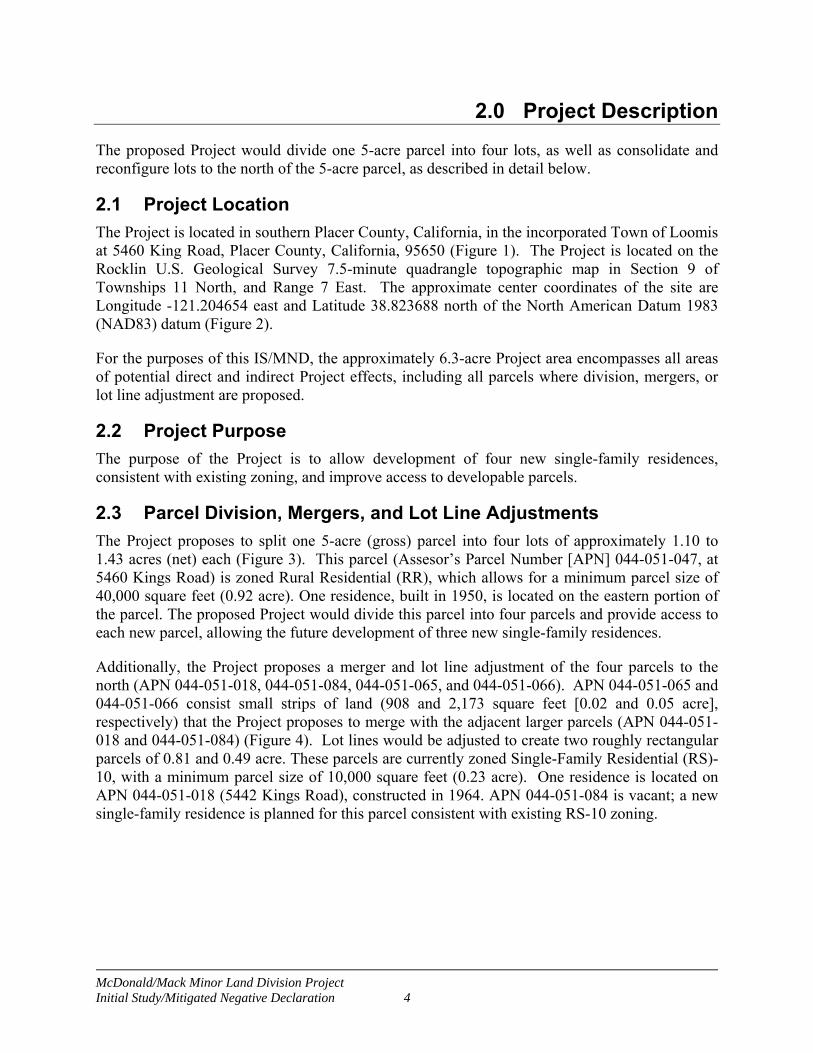
2.0 Project Description
The proposed Project would divide one 5-acre parcel into four lots, as well as consolidate and reconfigure lots to the north of the 5-acre parcel, as described in detail below.
2.1 Project Location
The Project is located in southern Placer County, California, in the incorporated Town of Loomis at 5460 King Road, Placer County, California, 95650 (Figure 1). The Project is located on the Rocklin U.S. Geological Survey 7.5-minute quadrangle topographic map in Section 9 of Townships 11 North, and Range 7 East. The approximate center coordinates of the site are Longitude -121.204654 east and Latitude 38.823688 north of the North American Datum 1983 (NAD83) datum (Figure 2).
For the purposes of this IS/MND, the approximately 6.3-acre Project area encompasses all areas of potential direct and indirect Project effects, including all parcels where division, mergers, or lot line adjustment are proposed.
2.2 Project Purpose
The purpose of the Project is to allow development of four new single-family residences, consistent with existing zoning, and improve access to developable parcels.
2.3 Parcel Division, Mergers, and Lot Line Adjustments
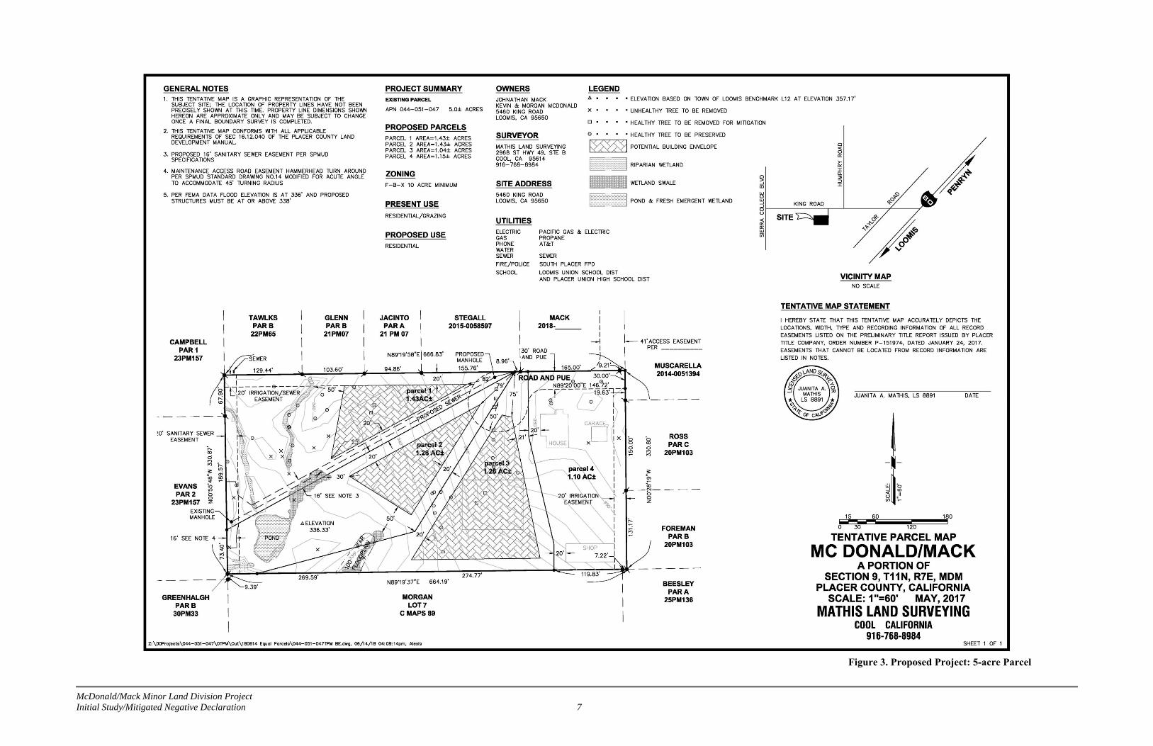
The Project proposes to split one 5-acre (gross) parcel into four lots of approximately 1.10 to 1.43 acres (net) each (Figure 3). This parcel (Assesor’s Parcel Number [APN] 044-051-047, at 5460 Kings Road) is zoned Rural Residential (RR), which allows for a minimum parcel size of 40,000 square feet (0.92 acre). One residence, built in 1950, is located on the eastern portion of the parcel. The proposed Project would divide this parcel into four parcels and provide access to each new parcel, allowing the future development of three new single-family residences.
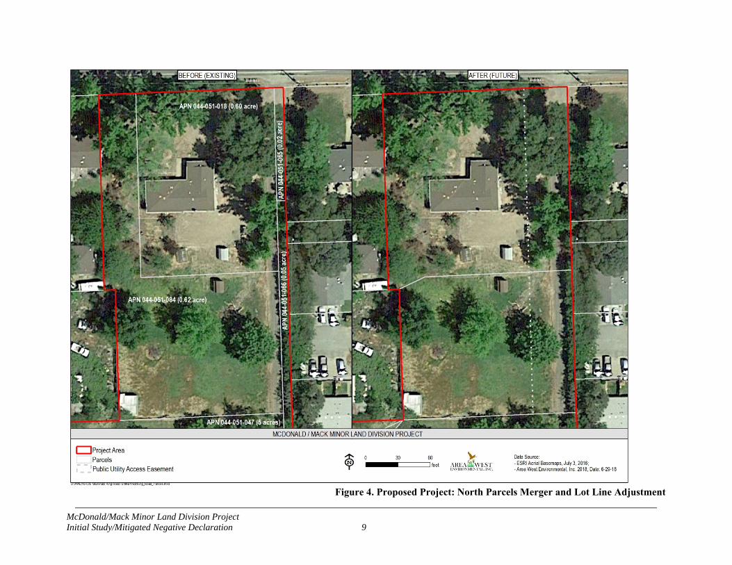
Additionally, the Project proposes a merger and lot line adjustment of the four parcels to the north (APN 044-051-018, 044-051-084, 044-051-065, and 044-051-066). APN 044-051-065 and 044-051-066 consist small strips of land (908 and 2,173 square feet [0.02 and 0.05 acre], respectively) that the Project proposes to merge with the adjacent larger parcels (APN 044-051-018 and 044-051-084) (Figure 4). Lot lines would be adjusted to create two roughly rectangular parcels of 0.81 and 0.49 acre. These parcels are currently zoned Single-Family Residential (RS)-10, with a minimum parcel size of 10,000 square feet (0.23 acre). One residence is located on APN 044-051-018 (5442 Kings Road), constructed in 1964. APN 044-051-084 is vacant; a new single-family residence is planned for this parcel consistent with existing RS-10 zoning.

McDonald/Mack Minor Land Division Project Initial Study/Mitigated Negative Declaration 5
Figure 1. Project Vicinity
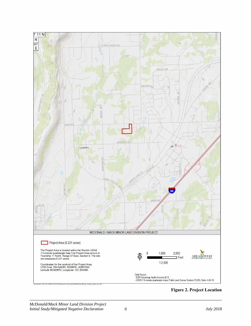
McDonald/Mack Minor Land Division Project Initial Study/Mitigated Negative Declaration 6 July 2018
Figure 2. Project Location
McDonald/Mack Minor Land Division Project Initial Study/Mitigated Negative Declaration 7
Figure 3. Proposed Project: 5-acre Parcel

McDonald/Mack Minor Land Division Project Initial Study/Mitigated Negative Declaration 8
Page intentionally blank
McDonald/Mack Minor Land Division Project Initial Study/Mitigated Negative Declaration 9
Figure 4. Proposed Project: North Parcels Merger and Lot Line Adjustment

McDonald/Mack Minor Land Division Project Initial Study/Mitigated Negative Declaration 10
2.4 Access and Easements
The proposed Project will provide reconfigured access for the subject parcels. A 24-foot wide private access road and 41-foot wide public utilities easement will be granted through the eastern edge of reconfigured APNs 044-051-018 and 044-051-084 (Figure 4). At the southern end of this access road, access to the proposed four sub-divided lots will be granted through a 30-foot wide private access road and public utilities easement ending at a cul-de-sac with a minimum radius of 42 feet (Figure 3). The access road will have an all-weather surface capable of supporting a 75,000-pound vehicle loading per South Placer Fire District requirements.
2.5 Utilities
The new lots would be connected to the public sewer line by connecting a new sewer line to the existing sewer line along the western property boundary at an existing manhole (Figure 3). The new sewer line would include a minimum 16-foot easement providing the South Placer Municipal Utility District (SPMUD) all-weather, drivable access to all sewer facilities. All utility work shall conform to the Standard Specifications of SPMUD. Water service will be provided by Placer County Water Agency (PCWA) via a ¾-inch meter and private pipe connected to the PCWA’s 8-inch treated water main in King Road. The new pipe will be installed within the public utility easement and access road to the new parcels. 2.6 No-project Alternative
Under the No-project Alternative, no division, mergers, or lot line adjustments would be made to existing parcels in the proposed Project area. Construction of a new single-family residence on parcel 044-05-084 would be allowable under the No-project Alternative.
2.7 Supporting Technical Studies
The technical studies listed below were used to support the environmental findings provided in this IS/MND and are available for review upon request:
Cultural Resources Report (Area West Environmental, Inc. 2018a)1
Wetland Delineation Report (Area West Environmental, Inc. 2018b)
Hazardous Waste Initial Site Assessment Report (Ninyo and Moore 2017)
Arborist Report (Acorn Arboricultural Services, Inc. 2017)
2.8 Permits and Approvals Needed
Upon completion of final design for the proposed Project, the following agencies will be contacted, as needed, to obtain their jurisdictional permits or approvals.
South Placer Fire District – Will-serve letter
South Placer Municipal Utility District – Sewer Permit and Will-serve letter 1 Cultural Resources reports contain confidential cultural resource location information; report distribution may be restricted. Cultural resources are nonrenewable, and their scientific, cultural, and aesthetic value can be significantly impaired by disturbance. To prevent vandalism, artifact hunting, and other activities that can damage cultural resources, and to protect the landowner from trespass, locations of cultural resources should be kept confidential. California Government Code 6254.1 exempts archaeological site information from the California Public Records Act.

McDonald/Mack Minor Land Division Project Initial Study/Mitigated Negative Declaration 11
Placer County Water Agency – Waterline extension agreement or Will-serve letter
U.S. Army Corps of Engineers (Corps) – Clean Water Act (CWA) Section 404 Nationwide Permit for Utilities
Regional Water Quality Control Board (RWQCB) – CWA Section 401 Water Quality Certification
California Department of Fish and Wildlife (CDFW) – Streambed Alteration Agreement

McDonald/Mack Minor Land Division Project Initial Study/Mitigated Negative Declaration 12
3.0 Environmental Checklist
This checklist identifies physical, biological, social and economic factors that might be affected by the proposed Project. If it is determined that a particular impact to the environment could occur, the checklist must indicate whether the impact is Potentially Significant, Less Than Significant with Mitigation, or Less Than Significant. In many cases, background studies performed in connection with the projects indicate No Impacts, which do not require further discussion. Where there is a need for clarifying discussion, the discussion is included following the applicable checklist question. The words "significant" and "significance" used throughout the following checklist are related to CEQA impacts. The questions in this form are intended to encourage the thoughtful assessment of impacts and do not represent thresholds of significance.
3.1 Aesthetics
Potentially Significant
Impact
Less-Than-Significant
with Mitigation
Incorporation
Less-Than-Significant
Impact No
Impact
1. Aesthetics
Would the project:
a) Have a substantial adverse effect on a scenic vista?
b) Substantially damage scenic resources, including, but not limited to, trees, rock outcroppings, and historic buildings within a state scenic highway?
c) Substantially degrade the existing visual character or quality of the site and its surroundings?
d) Create a new source of substantial light or glare which would adversely affect day or nighttime views in the area?
Environmental Setting
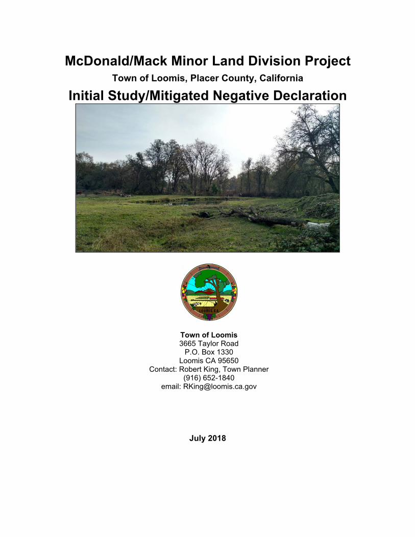
The proposed Project is located within the incorporated limits of the Town of Loomis, Placer County and is governed by the Town of Loomis General Plan (Town of Loomis 2001, as amended). The proposed Project area consists of valley oak woodland and annual grasslands with scattered wetlands, mainly within or along drainages. Lands within and surrounding the Project area are residential. Additionally, some portions of the Project area were previously used for irrigated cattle pasture. There are two existing residences in the Project area, one built in 1950, located on the eastern portion of APN 044-051-047, at 5460 Kings Road, and the other constructed in 1964, located on APN 044-051-018 at 5442 Kings Road. The parcel at 5460 Kings Road is not visible from public roads. Viewer groups of the proposed Project area would predominately consist of property residents and nearby neighbors.
McDonald/Mack Minor Land Division Project Initial Study/Mitigated Negative Declaration 13
Impacts and Mitigation Measures
a, b and c. Would the project have a substantial adverse effect on a scenic vista; substantially damage scenic resources, including but not limited to trees, rock outcroppings, and historic buildings within a state scenic highway; or substantially degrade the existing visual character or the quality of the site and its surroundings?
The proposed Project area is not located in proximity to a local- or state-designated scenic roadway or scenic vista (California Department of Transportation 2018). Construction of the future residences and related improvements would involve minor removal of existing vegetation and trees. Changes to vegetation would not substantially degrade the existing visual character of the proposed Project area and would not alter the overall scenic quality or nature of the proposed Project area vicinity. Overall, this minor residential development in an existing residential setting and would not significantly affect a scenic vista, damage scenic resources, or substantially degrade the existing visual character or quality of the proposed Project area or its surroundings. This impact would be considered less than significant.
Mitigation Measures: None required
d. Would the Project create a new substantial source of light or glare that would adversely affect day or nighttime views in the area?
The proposed Project may result in the development of up to four new dwelling units in a residential area. The lights associated with these developments would not constitute a new substantial source of light or glare that would affect day or nighttime views in the area. This impact would be considered less than significant.
Mitigation Measures: None required 3.2 Agriculture and Forestry Resources
Potentially Significant
Impact
Less-Than-Significant
with Mitigation
Incorporation
Less-Than-Significant
Impact No
Impact
2. Agriculture and Forestry Resources
In determining whether impacts to agricultural resources are significant environmental effects, lead agencies may refer to the California Agricultural Land Evaluation and site Assessment Model prepared by the California Department of Conservation (DOC) as an optional model to use in assessing impacts on agriculture and farmland. In determining whether impacts to forest resources, including timberland, are significant environmental effects, lead agencies may refer to information compiled by the California Department of Forestry and Fire Protection regarding the state’s inventory of forest land, including the Forest Range Assessment Project and Forest Legacy Assessment project; and forest carbon measurement methodology provided in Forest Protocols adopted by the California Air Resources Board. Would the project:
a) Convert Prime Farmland, Unique Farmland, or Farmland of Statewide Importance (Farmland), as shown on the maps prepared pursuant to the Farmland Mapping and Monitoring Program (FMMP) of the California Resources Agency, to non-
McDonald/Mack Minor Land Division Project Initial Study/Mitigated Negative Declaration 14
Potentially Significant
Impact
Less-Than-Significant
with Mitigation
Incorporation
Less-Than-Significant
Impact No
Impact
agricultural uses?
b) Conflict with existing zoning for agricultural use, or a Williamson Act contract?
c) Conflict with existing zoning for, or cause rezoning of, forest land (as defined in Public Resources Code section 12220(g)), timberland (as defined by Public Resources Code section 4526), or timberland zoned Timberland Production (as defined by Government Code section 51104(g))?
d) Result in the loss of forest land or conversion of forest land to non-forest use?
e) Involve other changes in the existing environment which, due to their location or nature, could result in conversion of Farmland to non-agricultural use or conversion of forest land to non-forest use?
Environmental Setting
None of the parcels in the proposed Project area or surrounding vicinity are zoned for agriculture. See the Land Use and Planning Section for a full description of land use and zoning policies in the proposed Project area. According to the California DOC Farmland Mapping and Monitoring Program (FMMP) 2016 Placer County Map, none of the parcels in the proposed Project area or surrounding vicinity are considered Prime Farmland, Farmland of Statewide Importance, or Unique Farmland (DOC 2016). Additionally, none of the parcels in the proposed Project area vicinity are under Williamson Act contract.
Impacts and Mitigation Measures
a, b, c, d, and e. Would the Project convert Prime Farmland, Unique Farmland, or Farmland of Statewide Importance (Farmland), as shown on the maps prepared pursuant to the FMMP of the California Resources Agency, to non-agricultural uses; conflict with any existing zoning for agricultural use, or a Williamson Act contract; conflict with existing zoning for, or cause rezoning of, forest land, timberland, or timberland zoned Timberland Production; result in the loss of forest land or conversion of forest land to non-forest use; or involve other changes in the existing environment which, due to their location or nature, could result in conversion of Farmland to non-agricultural use or conversion of forest land to non-forest use?
The proposed Project area and surrounding vicinity are classified as “Urban and Built-Up Land” and “Other Land” in the FMMP map for Placer County, and none of the parcels are zoned for agricultural use nor are any under a Williamson Act Contract. A portion of the 5-acre parcel has

McDonald/Mack Minor Land Division Project Initial Study/Mitigated Negative Declaration 15
been used for cattle grazing consistent with Rural Residential zoning. There is no forest land in the proposed Project vicinity. There would be no impact.
Mitigation Measures: None required.
3.3 Air Quality
Potentially Significant
Impact
Less-Than-Significant
with Mitigation
Incorporation
Less-Than-Significant
Impact No
Impact
3. Air Quality
Where available, the significance criteria established by the applicable air quality management or air pollution control district may be relied upon to make the following determinations. Would the project:
a) Conflict with or obstruct implementation of the applicable air quality plan?
b) Violate any air quality standard or contribute substantially to an existing or projected air quality violation?
c) Result in a cumulatively considerable net increase of any criteria pollutant for which the project region is non-attainment under an applicable Federal or State ambient air quality standard (including releasing emissions that exceed quantitative thresholds for ozone precursors)?
d) Expose sensitive receptors to substantial pollutant concentrations?
e) Create objectionable odors affecting a substantial number of people?
Environmental Setting
The proposed Project area is located within the Sacramento Valley Air Basin and is under the jurisdiction of the Placer County Air Pollution Control District (PCAPCD). The proposed Project area is currently designated nonattainment for State and federal ambient air quality standards for ozone, for State standards for respirable particulate matter (less than 10 micrometers in diameter) (PM10), and for federal standards for fine particulate matter (less than 2.5 micrometers in diameter) (PM2.5). The area is in designated attainment or unclassified for all other state and federal standards.
Existing land uses in the proposed Project area and vicinity generally consist of residential uses. Nearby sensitive receptors include neighboring residences and the Loomis Grammar school, which is located approximately 0.7 mile east of the Project.
McDonald/Mack Minor Land Division Project Initial Study/Mitigated Negative Declaration 16
Impacts and Mitigation Measures
a, b, and c. Would the project conflict with or obstruct implementation of the applicable air quality plan; violate any air quality standard or contribute substantially to an existing or projected air quality violation; or result in a cumulatively considerable net increase of any criteria pollutant for which the project region is non-attainment under an applicable Federal or State ambient air quality standard (including releasing emissions that exceed quantitative thresholds for ozone precursors)?
Proposed projects that generate emissions in excess of the PCAPCD’s recommended significance thresholds (PCAPCD 2017) would be considered to potentially conflict with or obstruct implementation of the applicable air quality plan, result or contribute substantially to an existing or projected air quality violation, including increases in emissions for which the region is designated non-attainment, and/or result in a cumulatively considerable net increase of any criteria pollutant for which the project region is non-attainment under an applicable Federal or State ambient air quality standard (including releasing emissions that exceed quantitative thresholds for ozone precursors). Implementation of the proposed Project would not result in significant long-term increases of mobile-source emissions. Development of up to four new single family residences in the Project area would not result in significant long-term increases in vehicle trips in the area. When establishing their CEQA Thresholds of Significance, PCAPCD identified a corresponding project size that would result in emissions at or in exceedance of their criteria pollutant thresholds. Based on PCAPCD's project size analysis, the proposed Project is well below the residential project size (617 single family residents or 868 condos) that would exceed the significance threshold for criteria pollutants (PCAPCD 2016).
Construction activities associated with the proposed Project include a small amount of grading for access road and cul-de-sac construction, trenching for utilities installation, and equipment use associated with the construction of up to four single-family residences. Due to the relatively minimal nature of construction activities, the short-term construction-generated emissions related to these minor developments would not exceed applicable thresholds of significance. For these reasons, this impact would be considered less than significant.
Mitigation Measures: None required.
d. Would the project expose sensitive receptors to substantial pollutant concentrations?
Sensitive receptors in the Project area vicinity include neighboring residences and the Loomis Grammar School, located approximately 0.7 mile east of the Project area. Implementation of the proposed Project would not result in the long-term operation of any stationary emission sources and therefore would not result in long-term increases in exposure of sensitive receptors to localized pollutant concentrations.
Construction activities may result in temporary increases of construction-generated emissions, which are short-term, lasting only as long as construction activities occur. These emissions would be temporary and limited to the immediate area surrounding the construction site. Emissions from construction equipment powered by gasoline and diesel engines would include carbon monoxide, nitrous oxides, volatile organic compounds, directly emitted PM10 and PM2.5,

McDonald/Mack Minor Land Division Project Initial Study/Mitigated Negative Declaration 17
and toxic air contaminants such as diesel exhaust particulate matter (DPM). Health-related risks associated with diesel-exhaust emissions are primarily associated with long-term exposure and associated risk of contracting cancer. Project-related construction activities would be short-term and relatively minor. As a result, exposure to construction-generated DPM would not exceed commonly applied thresholds.
During construction, fugitive dust would be generated by grading and other activities related to construction. Fugitive dust emissions are largely dependent on the amount of ground disturbance associated with site preparation activities. Due to the minimal amount of grading associated with the proposed Project, emissions of fugitive dust would not exceed PCAPCD-recommended thresholds of significance, and would not result in increased nuisance to nearby individuals.
Therefore, short-term construction-generated pollutants would have a less than significant impact on nearby sensitive receptors.
Mitigation Measures: None required.
e. Would the project create objectionable odors affecting a substantial number of people?
Minor sources of odors would be present during construction from diesel engines and asphalt paving, which may be considered offensive to some individuals. However, because odors would be temporary and would disperse rapidly with distance from the source, construction-generated odors would not result in frequent objectionable odorous emissions. This impact is less than significant.
Mitigation Measures: None required.
3.4 Biological Resources
Potentially Significant
Impact
Less-Than-Significant
with Mitigation
Incorporation
Less-Than-Significant
Impact No
Impact
4. Biological Resources
Would the project:
a) Have a substantial adverse effect, either directly or through habitat modifications, on any species identified as a candidate, sensitive, or special status species in local or regional plans, policies, or regulations, or by the DFG or USFWS?
b) Have a substantial adverse effect on any riparian habitat or other sensitive natural community identified in local or regional plans, policies, and regulations or by the DFG or USFWS?
c) Have a substantial adverse effect on federally-protected wetlands as defined by Section 404 of the federal Clean Water Act (including, but not limited to, marsh, vernal pool, coastal, etc.) through direct

McDonald/Mack Minor Land Division Project Initial Study/Mitigated Negative Declaration 18
Potentially Significant
Impact
Less-Than-Significant
with Mitigation
Incorporation
Less-Than-Significant
Impact No
Impact
removal, filling, hydrological interruption or other means?
d) Interfere substantially with the movement of any native resident or migratory fish or wildlife species or with established native resident or migratory corridors, or impede the use of native wildlife nursery sites?
e) Conflict with any local policies or ordinances protecting biological resources, such as a tree preservation policy or ordinance?
f) Conflict with the provisions of an adopted Habitat Conservation Plan, Natural Community Conservation Plan, or other approved local, regional, or state habitat conservation plan?
Environmental Setting
The proposed Project is located in a residential area in the Town of Loomis, with elevations in the Project area ranging from approximately 330 to 350 feet above mean sea level. Based on the soils, hydrology, and Mediterranean climate (cool, wet winters and hot, dry summers), the proposed Project area and the surrounding vicinity support plant species typically associated with the Sacramento Valley Floristic Province.
Biological field surveys, consisting of habitat mapping and wetland delineation fieldwork, were completed on December 15, 2017. A Biological Resources Evaluation prepared for the proposed Project (Appendix B) describes existing conditions in the Project area and provides a special-status species assessment.
The Project area contains two existing residences. Undeveloped portions of the Project area predominately consist of irrigated pasture land with scattered wetlands, mainly within or along drainages, as well as patches of valley oak (Quercus lobata) woodland and a small grove of blue gum (Eucalyptus globulus). The proposed Project area supports the following seven vegetation community types, which are described in Appendix B and shown in Figure 5.
developed;
irrigated pasture;
valley oak woodland;
fresh emergent wetland;
wetland swale;
open water (cattle pond); and
riparian wetland.

McDonald/Mack Minor Land Division Project Initial Study/Mitigated Negative Declaration 19
Impacts and Mitigation Measures
a. Will the project have a substantial adverse effect, either directly or through habitat modifications, on any species identified as a candidate, sensitive, or special status species in local or regional plans, policies, or regulations, or by the CDFW or USFWS?
As described in Appendix B, due to the lack of suitable habitat within the site, as verified during field surveys, the Project Area does not represent potential habitat for any special-status plant species. Therefore, the proposed Project would not affect any special-status plant species.
Of the 15 special-status wildlife species initially identified as potentially occurring in the Project vicinity in Appendix B, 11 species would not occur in the proposed Project area or have the potential to be affected by the proposed Project construction because: 1) the proposed Project area lacks suitable habitat for the species, 2) the proposed Project area is outside the species’ known range, and/or 3) Project activities would not affect the species or its habitat. The remaining 4 species have the potential to be affected by the proposed Project, as discussed below.
Potential Impacts to Special-status Reptiles
Aquatic habitats and surrounding uplands provide suitable aquatic and upland habitat for the western pond turtle (Emys marmorata), a state species of special concern. Construction of the proposed Project could result in both direct and indirect impacts to the western pond turtle. Direct impacts to western pond turtles resulting from ground disturbance, equipment use, and other proposed Project activities, as well as indirect effects to western pond turtle resulting from impacts to water quality and aquatic habitat, would be avoided through implementation of Mitigation Measures BIO-1 through BIO-3. All biological resources mitigation measures are described at the end of this impact discussion. Therefore, impacts to special-status reptile species would be less than significant with implementation of mitigation.
Potential Impacts to Special-status and Migratory Birds
Trees and shrubs in the Project area represent potential breeding and/or foraging habitat for some species of special-status and migratory birds. White-tailed kite (Elanus leucurus), Swainson’s hawk (Buteo swainsoni) and purple martin (Progne subis) could potentially breed in the proposed Project area. Additionally, the proposed Project area also contains potential foraging habitat for numerous birds and raptors protected under the Migratory Bird Treaty Act and California Fish and Game Code (CFGC) Section 3503.5. See Appendix B for an evaluation of the special-status bird species that could potential nest and/or forage in the proposed Project area. Removal of trees and vegetation could lead to elimination of nests, nest abandonment and/or could disturb birds foraging in the area. Potential impacts would be avoided through implementation of Mitigation Measures BIO-1, BIO-2, and BIO-4. Therefore, impacts to the special-status bird species would be less than significant with implementation of mitigation.

McDonald/Mack Minor Land Division Project Initial Study/Mitigated Negative Declaration 20
Figure 5. Vegetation Communities in the Project Area

McDonald/Mack Minor Land Division Project Initial Study/Mitigated Negative Declaration 21
Mitigation Measures:
Mitigation Measure BIO-1: Conduct Worker Environmental Awareness Training (WEAT). Before any work occurs in the proposed Project area, including grading and equipment staging, all construction personnel shall participate in an environmental awareness training regarding special-status species and sensitive habitats present in the proposed Project limits. If new construction personnel are added to the proposed Project, they must receive the mandatory training before starting work. As part of the training, an environmental awareness handout will be provided to all personnel that describes and illustrates sensitive resources (i.e., waters of the U.S. and state, riparian habitat, special-status species and habitat, nesting birds/raptors) to be avoided during proposed Project construction and lists applicable permit conditions identified by state and federal agencies to protect these resources.
Mitigation Measure BIO-2: Install Temporary Fencing around Environmentally Sensitive Habitat. Before any ground-disturbing activity occurs within the proposed Project area, temporary construction barrier fencing, silt fencing, and/or flagging shall be installed between the work area and environmentally sensitive habitat areas (i.e., waters of the U.S. and state, riparian vegetation, special-status species habitat, active bird/raptor nests to be avoided), as appropriate. Construction personnel and construction activity shall avoid fenced-off sensitive areas. The exact location of the fencing and/or flagging shall be determined in coordination with a qualified biologist, with the goal of protecting sensitive biological habitat and water quality. The fencing/flagging shall be checked regularly and maintained until all construction is complete.
Mitigation Measure BIO-3: Conduct a Preconstruction Survey for Western Pond Turtle. A qualified biologist shall conduct a preconstruction clearance survey for western pond turtles within 48 hours prior to any ground disturbance in the Project area. Any western pond turtles found within the construction work area shall be allowed to voluntarily move out of this area or shall be captured and held by a qualified biologist for the minimum amount of time necessary to release them into suitable aquatic habitat outside the construction work area. If a western pond turtle nest containing eggs or young is identified within the construction work area, the biologist shall determine an appropriate no-disturbance buffer to ensure avoidance of the nest.
Mitigation Measure BIO-4: Conduct a Preconstruction Nesting Migratory Bird and Raptor Survey. If vegetation removal will occur during the breeding season for migratory birds and raptors (generally February through August), a qualified biologist shall conduct a pre-construction nesting bird and raptor survey prior to the start of vegetation removal and construction activities (including equipment staging). The preconstruction survey shall be conducted no more than 14 days before the initiation of construction activities or vegetation removal. As a part of this survey, all protocol-level survey requirements as described in the Recommended Timing and Methodology for Swainson’s Hawk Nesting Surveys in California Central Valley (Swainson’s Hawk Technical Advisory Committee 2000) will be adhered to.
If an active bird or raptor nest is identified within the construction work area or an active raptor nest is identified within 250 feet from the construction work area, a no-disturbance buffer shall be established around the nest to avoid disturbance of the nesting birds or raptors until a qualified biologist determines that the young have fledged and are foraging on their own. The extent of

McDonald/Mack Minor Land Division Project Initial Study/Mitigated Negative Declaration 22
these buffers shall be determined by the biologist and shall depend on the species identified, level of noise or construction disturbance, line-of-sight between the nest and the disturbance, ambient levels of noise and other disturbances, and other topographical or artificial barriers. If no active nests are found during the preconstruction surveys, then no buffers or additional mitigation is required.
b and c. Would the project have a substantial adverse effect on any riparian habitat or other sensitive natural community identified in local or regional plans, policies, and regulations or by the CDFW or USFWS; or on federally-protected wetlands as defined by Section 404 of the federal CWA (including, but not limited to, marsh, vernal pool, coastal, etc.) through direct removal, filling, hydrological interruption or other means?
The aquatic resources delineation for the Project area identified a total of 0.194 acre of aquatic resources, comprised of fresh emergent wetland, wetland swale, riparian wetland, and open water (stock pond) (Figure 5), all of which are located in the western and southwestern portion of the 5-acre parcel proposed to be divided into four parcels (APN 044-051-047). Future development of the three new home sites proposes to avoid all potentially jurisdictional aquatic resources to the maximum degree possible. Mitigation Measure BIO-2 establishes protective buffers around aquatic resources to ensure these features are avoided. All riparian vegetation would be avoided.
There is an existing SPMUD manhole located on the southwestern edge of the property. Installation of a new sewer line and associated 16-foot-wide drivable easement from the existing manhole to a proposed manhole in the proposed cul-de-sac will require the placement of fill within a small portion of riparian wetland and seasonal swale (Figure 6). SPMUD is also requiring that the landowner construct a 16-foot-wide drivable pathway over the existing sewer line easement along the west side of the 5-acre parcel (Figure 3). The total impact to jurisdictional waters from these sewer line improvements would be less than 0.03 acre (Figure 6). Mitigation Measure BIO-5 would be implemented to ensure compliance with Chapter 13.58 of the Town Municipal Code, “Wetland Protection and Restoration,” which requires that new development achieve “no net loss” of wetlands. Additionally, Mitigation Measures BIO-1 and BIO-2 would minimize potential impacts to water quality within and surrounding the proposed Project area. Therefore, impacts to riparian habitat, sensitive natural communities and waters of the U.S. and State would be less than significant with implementation of mitigation.
Mitigation Measures: Implement Mitigation Measures BIO-1 and BIO-2, described under question a.
Mitigation Measure BIO-5: Achieve No Net-loss of Wetlands. The Project will comply with Chapter 13.58 of the Town Municipal Code, which provides procedures and standards for identifying and protecting wetland resources and for permitting wetland restoration, enhancement, and mitigation projects. Section 13.58.030 requires compliance with federal and state requirements, including obtaining a CWA Section 404 permit, CWA Section 401 permit, and a CFGC Section 1602 permit, as applicable.

McDonald/Mack Minor Land Division Project Initial Study/Mitigated Negative Declaration 23
Figure 6. Wetland Impacts from Sewer Line Improvements

McDonald/Mack Minor Land Division Project Initial Study/Mitigated Negative Declaration 24
d. Would the project interfere substantially with the movement of any native resident or migratory fish or wildlife species or with established native resident or migratory corridors, or impede the use of native wildlife nursery sites?
No impacts to wildlife movement or wildlife nursery sites would result from the proposed Project. Therefore, this impact is considered less-than-significant.
Mitigation Measures: None required.
e. Would the Project conflict with any local policies or ordinances protecting biological resources, such as a tree preservation policy or ordinance?
Chapter 13.54 of the Town of Loomis Municipal Code contains a Tree Preservation and Protection Ordinance that regulates both the removal of "protected trees" and the encroachment of construction activities within their driplines. The code defines protected trees as any native oak tree with a trunk that is a minimum of 6 inches in diameter as measured at breast height (DBH) for Interior Live Oak, Valley Oak, and Oracle Oak and 4 inches DBH for Blue Oak; any oak tree with multiple trunks that have an aggregate DBH of at least 10 inches, or any Heritage Tree. This also includes any trees preserved or replanted pursuant to Chapter 13.54.090, except for Exempt Trees and those classified as invasive species by the California Invasive Pest Council and non-native trees listed as not to be planted on Town-owned property in the Master Tree List. To identify, inventory, and comment upon the current structure and vigor of the protected trees located within and/or overhanging the proposed Project area, a tree survey was completed by a certified arborist on December 7, 2017 and an Arborist Report and Tree Inventory Summary was developed. The tree survey found 86 trees with a DBH of 4 inches or larger within and/or overhanging the proposed project area. Of these trees, 17 were identified as hazardous or dead trees that should be removed due to severity of defects, compromised health, and/or structural instability. Removal of hazardous trees is exempt from the Tree Ordinance and does not require mitigation. Additionally, trees removed for construction of utilities easements required as a condition of development approval are exempt from tree mitigation requirements provided all feasible alternatives to reduce the number of trees proposed for removal have been exhausted. Trees may be removed to allow for road construction, utilities easements, and construction of future homes. Based on the current plans, 6 trees would be removed as a result of property improvements. Of these, 4 trees qualify for protection under the Town’s tree ordinance (Table 1).
Table 1. Trees Removed due to Property Improvements Tree # Common Name Species DBH (inches)1 Protected Tree?
115 Pin Oak Quercus palustris 14 Yes 116 Pin Oak Quercus palustris 15 Yes 117 Pin Oak Quercus palustris 20 Yes 120 Stone Pine Pinus pinea 20, 29 No n/a Eucalyptus Eucalyptus sp. No data No 169 Valley Oak Quercus lobate 13 Yes 1 For multi-stem trees, data includes DBH for each stem

McDonald/Mack Minor Land Division Project Initial Study/Mitigated Negative Declaration 25
As Described in Mitigation Measure BIO-6, prior to the removal or encroachment into the dripline of any of protected tree in the Project area, a tree permit would be obtained from the Town of Loomis. All terms and conditions of the tree permit, including any required mitigation, would be implemented. Therefore, this impact would be less than significant with mitigation.
Mitigation Measures:
Mitigation Measure BIO-6: Comply with Town of Loomis Tree Preservation and Protection Ordinance. The following measures would be implemented to ensure compliance with the Town’s Tree Ordinance:
A final site plan will be developed and submitted to the Town, showing the location of all Project activities that may affect protected trees. The site plan will include locations of access road and cul-de-sac construction, house construction footprints, and a trenching pathway plan depicting easements, sewers, water mains, irrigation, and underground utilities. The plan would also include an accurate plotting of the critical root zone of each protected tree within 50 feet of the soil disturbance activity.
A tree permit would be obtained prior to the removal or encroachment into the dripline of any of protected tree in the Project area following the application process described in Section 13.54.080 of the Town’s Municipal Code.
Removal, mitigation, and replacement of protected trees would be implemented in accordance with Section 13.54.090 of the Town’s Municipal Code. Mitigation will not be implemented for removal of Exempt Trees.
f. Would the project conflict with the provisions of an adopted Habitat Conservation Plan, Natural Community Conservation Plan, or other approved local, regional, or state habitat conservation plan?
There are no adopted Habitat Conservation Plans, Natural Community Conservations Plans or other approved local, regional, or state habitat conservation plans that overlap with the proposed Project area. Therefore, the proposed Project would have no impact.
Mitigation Measures: None required.
3.5 Cultural Resources
Potentially Significant
Impact
Less-Than-Significant
with Mitigation
Incorporation
Less-Than-Significant
Impact No
Impact
5. Cultural Resources
Would the project:
a) Cause a substantial adverse change in the significance of a historical resource as defined in
McDonald/Mack Minor Land Division Project Initial Study/Mitigated Negative Declaration 26
Potentially Significant
Impact
Less-Than-Significant
with Mitigation
Incorporation
Less-Than-Significant
Impact No
Impact
§15064.5?
b) Cause a substantial adverse change in the significance of an archaeological resource as defined in §15064.5?
c) Directly or indirectly destroy a unique paleontological resource or site or unique geologic feature?
d) Disturb any human remains, including those interred outside of formal cemeteries?
Environmental Setting
To identify the potential for cultural resources to be affected by the proposed Project, a cultural resources inventory was conducted for the Project area, consisting of a records search, written contact with Native American groups and related agencies, and onsite fieldwork. The methods and results of the inventory, as well as a description of the ethnographical and historical setting for the proposed Project area and surrounding areas are described in the Cultural Resources Report (Area West Environmental, Inc. 2018a), incorporated by reference.
Impacts and Mitigation Measures
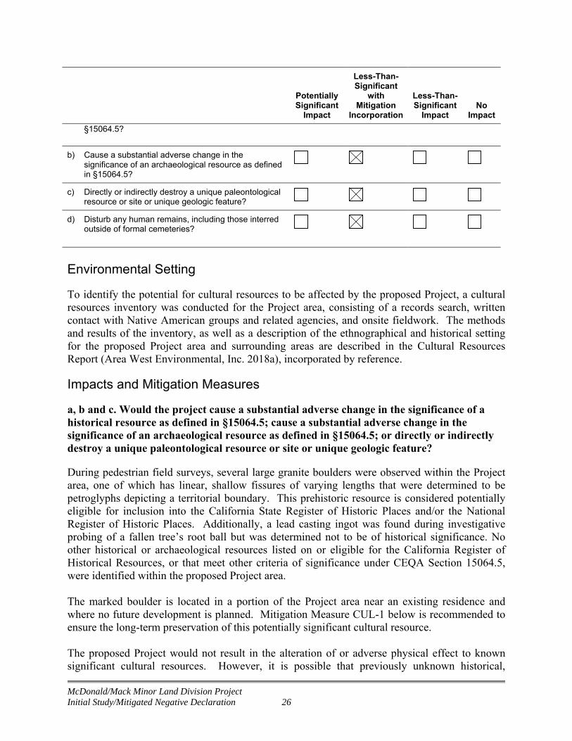
a, b and c. Would the project cause a substantial adverse change in the significance of a historical resource as defined in §15064.5; cause a substantial adverse change in the significance of an archaeological resource as defined in §15064.5; or directly or indirectly destroy a unique paleontological resource or site or unique geologic feature?
During pedestrian field surveys, several large granite boulders were observed within the Project area, one of which has linear, shallow fissures of varying lengths that were determined to be petroglyphs depicting a territorial boundary. This prehistoric resource is considered potentially eligible for inclusion into the California State Register of Historic Places and/or the National Register of Historic Places. Additionally, a lead casting ingot was found during investigative probing of a fallen tree’s root ball but was determined not to be of historical significance. No other historical or archaeological resources listed on or eligible for the California Register of Historical Resources, or that meet other criteria of significance under CEQA Section 15064.5, were identified within the proposed Project area. The marked boulder is located in a portion of the Project area near an existing residence and where no future development is planned. Mitigation Measure CUL-1 below is recommended to ensure the long-term preservation of this potentially significant cultural resource. The proposed Project would not result in the alteration of or adverse physical effect to known significant cultural resources. However, it is possible that previously unknown historical,
McDonald/Mack Minor Land Division Project Initial Study/Mitigated Negative Declaration 27
archaeological, and/or paleontological resources could be discovered during grading and excavation work associated with new construction. Potential impacts to previously undiscovered historic, archaeological, and/or paleontological resources would be avoided through implementation of Mitigation Measures CUL-2 and CUL-3. Impacts are considered less than significant with mitigation
Mitigation Measures:
Mitigation Measure CUL-1: Protection of the Marked Boulder in Situ. Although the current property owners state no intention to deface or remove the boulder, future owners should be aware that the boulder must remain in place without surface disturbance. To ensure the long-term preservation of this potentially significant historic resource, Preservation Conditions (i.e., covenants or easements) shall be attached to the parcel deed requiring preservation of the boulder in place. The Preservation Conditions shall require property owners, over the reasonably foreseeable future and absent extraordinary circumstances, to maintain the physical integrity of the boulder. During any construction activities within 100 feet of the boulder, orange fencing should be installed around the boulder to indicate an environmentally sensitive area. With implementation of a legally enforceable Preservation Condition, there would be no adverse effect on the marker boulder. Mitigation Measure CUL-2: Conduct Worker Environmental Awareness Training (WEAT). Prior to any excavation or other substantial subsurface disturbance activities, any individuals conducting the work should be given a cultural resource awareness training session and advised to watch for cultural resource materials during construction activities. This training will cover both the identification of resources that may be encountered during construction and procedures to be followed in the event of a discovery. This training can be conducted concurrently with WEAT for sensitive biological resources (Mitigation Measure BIO-1).
Mitigation Measure CUL-3: Protect Discovered Cultural Subsurface Resources. If any evidence of prehistoric cultural resources (freshwater shells, beads, bone tool remnants or an assortment of bones, soil changes including subsurface ash lens or soil darker in color than surrounding soil, lithic materials such as flakes, tools or grinding rocks, etc.), historical cultural resources (adobe foundations or walls, structures and remains with square nails, refuse deposits or bottle dumps, often associated with wells or old privies), or paleontological resources (e.g., fossilized remains, imprints, and traces of plants and animals preserved in rocks and sediments) are observed during ground disturbing activities, all work must immediately cease within 50 feet of the find, and a qualified archaeologist must be consulted to assess the significance of the cultural materials. If the find is determined to be potentially significant, the archaeologist, in consultation with the Town and—if the find is prehistoric or Native American in nature—appropriate Native American group(s), shall develop and implement a treatment plan with an emphasis toward preservation in place. If the find is paleontological, a qualified paleontologist will be consulted to develop and implement a treatment plan.
McDonald/Mack Minor Land Division Project Initial Study/Mitigated Negative Declaration 28
d. Would the project disturb any human remains, including those interred outside of formal cemeteries?
No human remains have been previously encountered in the vicinity of the proposed Project. However, this does not preclude the potential for discovering buried human remains during ground disturbance associated with construction of the proposed Project. In the event that human remains are discovered during proposed Project construction, Mitigation Measure CUL-4 shall be implemented. With implementation of Mitigation Measure CUL-4, potential impacts resulting from disturbance of human remains as a result of the proposed Project would be considered less than significant with incorporated mitigation.
Mitigation Measures:
Mitigation Measure CUL-4: Procedures for Human Remains. In accordance with the California Health and Safety Code, Section 7050.5, and the Public Resources Code 5097.98, regarding the discovery of human remains, if human remains are discovered during construction, all work must immediately cease, and the Placer County coroner must be contacted. If the Coroner determines that the remains are those of a Native American, the Coroner shall contact the Native American Heritage Commission (NAHC) and subsequent procedures shall be followed, according to State Public Resources Code Sections 5097.9 to 5097.99, regarding notification of the Native American Most Likely Descendant.
3.6 Geology and Soils
Potentially Significant
Impact
Less-Than-Significant
with Mitigation
Incorporation
Less-Than-Significant
Impact No
Impact
6. Geology and Soils
Would the project:
a) Expose people or structures to potential substantial adverse effects, including the risk of loss, injury, or death involving:
i) Rupture of a known earthquake fault, as delineated in the most recent Alquist-Priolo Earthquake Fault Zoning Map issued by the State Geologist for the area or based on other substantial evidence of a known fault? Refer to Division of Mines & Geology Special Publication 42.
ii) Strong seismic ground shaking?
iii) Seismic-related ground failure, including liquefaction?
iv) Landslides?

McDonald/Mack Minor Land Division Project Initial Study/Mitigated Negative Declaration 29
Potentially Significant
Impact
Less-Than-Significant
with Mitigation
Incorporation
Less-Than-Significant
Impact No
Impact
b) Result in substantial soil erosion or the loss of topsoil?
c) Be located on a geologic unit or soil that is unstable, or that would become unstable as a result of the project, and potentially result in on- or off-site landslide, lateral spreading, subsidence, liquefaction, or collapse?
d) Be located on expansive soils, as defined in Table 18-1-B of the Uniform Building Code, creating substantial risks to life or property?
e) Have soils incapable of adequately supporting the use of septic tanks or alternate wastewater disposal systems where sewers are not available for the disposal of wastewater?
Environmental Setting
One soil map unit, Andregg coarse sandy loam, 2 to 9 percent slopes (106), is present within the Project area (NRCS 2018). The proposed Project area is located in the eastern portion of the Sacramento Valley near the foothills of the Sierra Nevada Mountains, within the physiographic unit referred to as the Great Valley Geomorphic Province. This province encompasses the Sacramento and San Joaquin Valley and is bounded by the Sierra Nevada Mountains to the east, the Coast Range Mountains to the west, the Transverse Range Mountains to the south, and the Klamath Mountains to the north. The geologic formations of the Great Valley are typified by thick sequences of alluvial (river) sediments deposited during the filling of a large ancient basin. The site is underlain by Mesozoic granitic rocks (Wagner et al, 1981).
No active faults are known to exist in Placer County, and no Alquist-Priolo Special Studies Zones are designated in the County (California DOC 2007). The nearest major fault system to Loomis is the Foothills Fault System, which traverses Amador, El Dorado, and Placer counties. Two segments of this system are relatively close to Loomis: the segment of the Bear Mountain Fault Zone (Spenceville Fault) between Folsom and Auburn, and the Melones Fault Zone, about 15 miles to the east. (Town of Loomis, 2001 as amended)
Impacts and Mitigation Measures
a, i-iv. Would the project expose people or structures to potential substantial adverse effects, including the risk of loss, injury, or death involving: rupture of a known earthquake fault; strong seismic ground shaking; seismic-related ground failure, including liquefaction; or landslides?
The proposed Project area does not overlie any known faults and is not within or near an Alquist-Priolo special-studies zone; therefore the proposed Project would not expose people or structures to potential substantial adverse effects from the rupture of a known earthquake fault. The site does not lie within a Special Studies Zone as defined by the State Geologist, and there is no evidence to indicate any likelihood for shallow ground rupture from faulting. The proposed
McDonald/Mack Minor Land Division Project Initial Study/Mitigated Negative Declaration 30
Project area is also not located within a State of California Seismic Hazards Zone, and is generally underlain by soils and fills considered moderately susceptible to liquefaction. There would be no impact associated with exposing people or structures to potential substantial adverse effects from rupture of a known fault, strong seismic ground shaking, or seismic-related ground failure.
Mitigation Measures: None required.
b. Would the project result in substantial soil erosion or the loss of topsoil?
Construction of the proposed Project would involve site grading and earthmoving activities, which would expose soils at the site and could result in soil erosion. However, the area of disturbance for the access road, utilities, and home building is small. Soil erosion and topsoil loss would be limited by implementing standard construction practices and best management practices (BMPs) for erosion and sediment control, consistent with the West Placer Storm Water Quality Design Manual (Placer County 2018). Because erosion control and stormwater pollution prevention measures would be implemented, the proposed Project has limited potential to result in substantial soil erosion or loss of topsoil. This impact would be considered less than significant.
Mitigation Measures: None required. c. Would the project be located on a geologic unit or soil that is unstable, or that would become unstable as a result of the project, and potentially result in on- or off-site landslide, lateral spreading, subsidence, liquefaction, or collapse?
The proposed Project area is not located in or adjacent to an active fault zone or in an area of substantial seismic hazard. The Project is not located on a geologic unit or soil that is unstable or that would become unstable as a result of the proposed Project. The proposed Project is committed to implementing all recommended standard practices and standard engineering practices to minimize the risk of liquefaction, lateral spreading, subsidence, or collapse. The proposed Project would have no impact.
Mitigation Measures: None required.
d. Would the project be located on expansive soils, as defined in Table 18-1-B of the Uniform Building Code, creating substantial risks to life or property?
Soils in the proposed Project area are classified by the Natural Resources Conservation Service (NRCS) as coarse sandy loam (NRCS 2018). Because expansive soils are typically clay soils that are prone to large volume changes related to changes in water content, soils in the proposed Project area are not considered expansive and would not create substantial risks to life and property. The Project would have no impact.
Mitigation Measures: None required.

McDonald/Mack Minor Land Division Project Initial Study/Mitigated Negative Declaration 31
e. Would the proposed project have soils incapable of adequately supporting the use of septic tanks or alternate wastewater disposal systems where sewers are not available for the disposal of wastewater?
No septic tanks or alternative wastewater disposal systems are proposed as part of the proposed Project. There would be no impact.
Mitigation Measures: None required.
3.7 Greenhouse Gas Emissions
Potentially Significant
Impact
Less-Than-Significant
with Mitigation
Incorporation
Less-Than-Significant
Impact No
Impact
7. Greenhouse Gas Emissions
Would the project:
a) Generate greenhouse gas emissions, either directly or indirectly, that may have a significant effect on the environment?
b) Conflict with an applicable plan, policy, or regulation adopted for the purpose of reducing the emissions of greenhouse gases?
Environmental Setting
The proposed Project area is within the jurisdiction of the PCAPCD. Existing land uses in the proposed Project area and vicinity generally consist of residential uses. Nearby sensitive receptors include neighboring residences and the Loomis Grammar school, which is located approximately 0.7 mile east of the Project.
CEQA requires that lead agencies consider the reasonably foreseeable adverse environmental effects of projects they are considering for approval. Greenhouse gases (GHGs) have the potential to adversely affect the environment because such emissions contribute, on a cumulative basis, to global climate change. In turn, global climate change has the potential to result in rising sea levels, which can inundate low-lying areas; reduce snowpack, leading to less overall water storage in the Sierra Nevada; affect rainfall, leading to changes in water supply, increased frequency and severity of droughts, and increased wildfire risk; and affect habitat and agricultural land, leading to adverse effects on biological and agricultural resources. The State of California has not identified quantitative thresholds of significance for GHGs. However, the PCAPCD has identified recommended GHG thresholds of significance to be used for the analysis of project-related impacts. For construction activities, the PCAPCD’s recommended GHG Bright-line threshold is 10,000 metric tons of carbon dioxide equivalent per year (MTCO2e/year) (PCAPCD 2017). The Bright-line threshold is the point at which a project would be deemed to have a cumulatively considerable contribution to global climate change.
McDonald/Mack Minor Land Division Project Initial Study/Mitigated Negative Declaration 32
Impacts and Mitigation Measures
a and b. Would the project generate greenhouse gas emissions, either directly or indirectly, that may have a significant effect on the environment; and would the project conflict with any applicable plan, policy or regulation of an agency adopted for the purpose of reducing the emissions of greenhouse gases?
Development of up to four new single family residences in the Project area would not result in significant long-term increases in vehicle trips in the area. Construction activities associated with the proposed Project include a small amount of grading for access road and cul-de-sac construction, trenching for utilities installation, and minor equipment use associated with the construction of up to four single-family residences. Due to the relatively minimal nature of construction activities, the short-term construction-generated GHG emissions related to these minor developments would not exceed PCAPCD’s recommended GHG Bright-line threshold of 10,000 MTCO2e/year. When adopting their Bright-line threshold, PCAPCD identified corresponding project size with different types of land use development. Based on PCAPCD's project size analysis, the proposed Project is well below the residential project size (646 single family residents or 957 condos) that would exceed the GHG significance threshold (PCAPCD 2016). Based on the threshold and comparison of the proposed Project uses and size, the Project would not trigger a new significant GHG impact. For these reasons, this impact would be considered less than significant.
Mitigation Measures: None required.
3.8 Hazards and Hazardous Materials
Potentially Significant
Impact
Less-Than-Significant
with Mitigation
Incorporation
Less-Than-Significant
Impact No
Impact
8. Hazards and Hazardous Materials
Would the project:
a) Create a significant hazard to the public or the environment through the routine transport, use, or disposal of hazardous materials?
b) Create a significant hazard to the public or the environment through reasonably foreseeable upset and accident conditions involving the release of hazardous materials into the environment?
c) Emit hazardous emissions or handle hazardous or acutely hazardous materials, substances, or waste within ¼ mile of an existing or proposed school?
d) Be located on a site which is included on a list of hazardous materials sites compiled pursuant to Government Code §65962.5 and, as a result, would it create a significant hazard to the public or to the

McDonald/Mack Minor Land Division Project Initial Study/Mitigated Negative Declaration 33
Potentially Significant
Impact
Less-Than-Significant
with Mitigation
Incorporation
Less-Than-Significant
Impact No
Impact
environment?
e) For a project located within an airport land use plan or, where such a plan has not been adopted, within two miles of a public airport or a public use airport, would the project result in a safety hazard for people residing or working in the project area?
f) For a project within the vicinity of a private airstrip, would the project result in a safety hazard for people residing or working in the project area?
g) Expose people or structures to a significant risk of loss, injury, or death involving wildland fires, including where wildlands are adjacent to urbanized areas or where residences are intermixed with wildlands?
Environmental Setting
A Phase I Environmental Site Assessment Report (ESA) was developed for the Project area. The purpose of the report is to identify recognized environmental conditions (RECs)2 in connection with the Project area. The study determined that there is no evidence of recognized RECs in the Project area (Ninyo and Moore 2017). According to the ESA, the northeast portion of the 5-acre parcel was previously planted with a small, non-commercial orchard between the late 1930s and early 1950s. Application of pesticides or herbicides may have occurred in the orchard, and it is possible that residual pesticides may be found in the shallow soils in this small portion of the Project area. An existing residence in the Project area is served by an on-site septic system, which represents a potential source of contamination if it were to be ruptured or damaged during construction. Impacts and Mitigation Measures
a through g. Would the project create a significant hazard to the public or the environment through the routine transport, use, or disposal of hazardous materials; create a significant hazard to the public or the environment through reasonably foreseeable upset and accident conditions involving the release of hazardous materials into the environment; emit hazardous emissions or handle hazardous or acutely hazardous materials, substances, or
2 RECs are defined by the American Society for Testing and Materials (ASTM) as “the presence or likely presence of any hazardous substances or petroleum products in, on, or at a property: (1) due to any release to the environment; (2) under conditions indicative of a release to the environment; or (3) under conditions that pose a material threat of a future release to the environment.”
McDonald/Mack Minor Land Division Project Initial Study/Mitigated Negative Declaration 34
waste within ¼ mile of an existing or proposed school; be located on a site which is included on a list of hazardous materials sites compiled pursuant to Government Code §65962.5 and, as a result, would it create a significant hazard to the public or to the environment; be located within an airport land use plan or, where such a plan has not been adopted, within two miles of a public airport or a public use airport, would the project result in a safety hazard for people residing or working in the project area; or for a project within the vicinity of a private airstrip, would the project result in a safety hazard for people residing or working in the project area; or expose people or structures to a significant risk of loss, injury, or death involving wildland fires, including where wildlands are adjacent to urbanized areas or where residences are intermixed with wildlands?
The proposed Project is not expected to involve the routine transport, use, or disposal of hazardous materials; there is no reasonably foreseeable accident involving the release of hazardous materials; and the Project would not emit hazardous emissions or handle hazardous materials. There are no schools located with ¼ mile or airports located with 2 miles. The Project is not located on a site which is included on a list of hazardous materials sites. No ground disturbance would occur in the area where an existing septic system is located. The Proposed Project is located in a relatively developed setting and is not subject to wildland fires.
The ESA report was transmitted to the Placer County Department of Health and Human Services (PCHHS), Division of Environmental Health, for review. PCHHS requested additional soil sampling in areas historically used for orchard to determine if the site has elevated levels concentrations of pesticides or heavy metals associated with orchard use. Therefore, impacts related to hazards and hazardous materials would be considered less than significant with mitigation.
Mitigation Measures:
Mitigation Measure HAZ-1: Conduct Phase II Soil Sampling and Implement Contamination Removal Activities as Needed. Soil sampling for pesticide residues and metals (e.g., arsenic, copper, mercury, lead) in areas historically used as orchard shall be conducted in accordance with the California Department of Toxic Substances Control (DTSC) Interim Guidance for Sampling Agricultural Properties (Third Revision), dated August 7, 2008. A workplan to conduct a Phase II site assessment shall be submitted to PCHHS for review and approval prior to field activities. The workplan shall also include soil sampling around any historic structures.
Analytical results from soil samples obtained during Phase II screening level investigations shall be compared to the following standards in order to evaluate possible adverse impacts to human health:
Preliminary Remediation Goals (PRGs) for residential usage, established by the U.S. Environmental Protection Agency Region IX; and
California Human Health Screening Levels (CHHSLs) established by the California Environmental Protection Agency.

McDonald/Mack Minor Land Division Project Initial Study/Mitigated Negative Declaration 35
If collected samples show low or non-detect results for the constituents analyzed, no further mitigation is necessary. If exceedances of PRGs and/or CHHSLs are encountered, contamination removal activities shall be implemented in coordination with PCHHS and DTSC. Remedial activities could include but are not limited to excavating soil, lawfully disposing of soil, and retesting onsite soils to ensure native soils are below action levels.
3.9 Hydrology and Water Quality
Potentially Significant
Impact
Less-Than-Significant
with Mitigation
Incorporation
Less-Than-Significant
Impact No
Impact
9. Hydrology and Water Quality
Would the project:
a) Violate any water quality standards or waste discharge requirements?
b) Substantially deplete groundwater supplies or interfere substantially with groundwater recharge such that there would be a net deficit in aquifer volume or a lowering of the local groundwater table level (e.g., the production rate of pre-existing nearby wells would drop to a level which would not support existing land uses or planned uses for which permits have been granted)?
c) Substantially alter the existing drainage pattern of the site or area, including through the alteration of the course of a stream or river, in a manner which would result in substantial erosion or siltation on- or off-site?
d) Substantially alter the existing drainage pattern of a site or area, including through the alteration of the course of a stream or river, or substantially increase the rate or amount of surface runoff in a manner which would result in flooding on- or off-site?
e) Create or contribute runoff water which would exceed the capacity of existing or planned stormwater drainage systems or provide substantial additional sources of polluted runoff?
f) Otherwise substantially degrade water quality?
g) Place housing within a 100-year flood hazard area as mapped on a federal Flood Hazard Boundary or Flood Insurance Rate Map or other flood hazard delineation map?
h) Place within a 100-year flood hazard area structures which would impede or redirect flood flows?
i) Expose people or structures to a significant risk of loss, injury or death involving flooding, including flooding as a result of the failure of a levee or dam?

McDonald/Mack Minor Land Division Project Initial Study/Mitigated Negative Declaration 36
Potentially Significant
Impact
Less-Than-Significant
with Mitigation
Incorporation
Less-Than-Significant
Impact No
Impact
j) Inundation by seiche, tsunami, or mudflow?
Environmental Setting
The proposed Project is in the Dry Creek Watershed. During rain events, water flows from uplands in the surrounding hills, across the Project area, and then south and west to an unnamed drainage that drains into Secret Ravine approximately 4.6 miles southwest of the Project area. Secret Ravine flows southwest for another 2.6 miles, to its confluence with Dry Creek, which flows approximately 16 miles southwest to Steelhead Creek. Steelhead Creek flows for another 6.8 miles to its confluence with the Sacramento River. The Dry Creek Watershed is fed almost entirely by rainfall and encompasses approximately 100 square miles. The primary tributaries in the watershed are Secret Ravine, Strap Ravine, Antelope Creek, Clover Valley Creek, and Linda Creek. The watershed has experienced significant disturbance with reaches being straitened, reduced floodplains, dredging, and removal of riparian vegetation (USFWS 2014).
A portion of the proposed Project area overlaps with the boundary of the 100-year floodplain for the unnamed drainage to the south, as indicated by the Federal Emergency Management Agency (FEMA) Flood Insurance Rate Map (Figure 6). The boundary of a 100-year floodplain is used to demarcate flood hazards and indicates the geographic area having a one percent chance of being flooded in any given year.
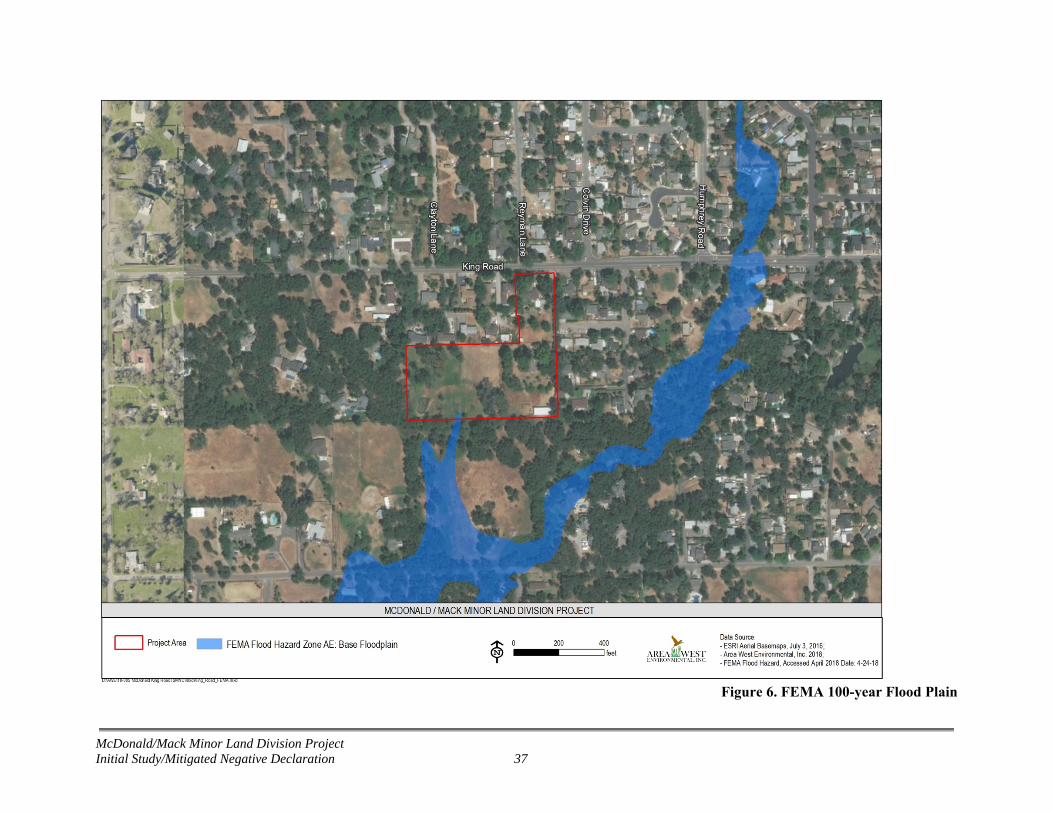
McDonald/Mack Minor Land Division Project Initial Study/Mitigated Negative Declaration 37
Figure 6. FEMA 100-year Flood Plain

McDonald/Mack Minor Land Division Project Initial Study/Mitigated Negative Declaration 38
As described in the Biological Resources section, an aquatic resources delineation study was completed for the proposed Project to determine potential waters of the U.S. under the jurisdiction of the Corps pursuant to Section 404 of the CWA. The aquatic resources delineation for the Project area identified a total of 0.194 acre of aquatic resources, comprised of fresh emergent wetland, wetland swale, riparian wetland, and open water (stock pond) (Figure 5), all of which are located in the western and southwestern portion of the 5-acre parcel proposed to be divided into four parcels (APN 044-051-047).
Impacts and Mitigation Measures
a. Would the project violate any water quality standards or waste discharge requirements? and f. Would the project otherwise substantially degrade water quality?
The proposed Project includes minor ground disturbance that will expose soil and could result in accelerated erosion, which could affect water quality in downstream water bodies by increasing turbidity and/or sedimentation. The proposed Project could also result in the degradation of water quality from runoff of petroleum-based products associated with equipment and vehicles used during construction. Implementation of standard erosion and sediment control practices, as required by the West Placer Storm Water Design Manual (Placer County 2018) and Town policies, would minimize these potential impacts and ensure that the proposed Project does not violate any water quality standards or waste discharge requirements. These BMPs prevent discharge from the site of soil or construction wastes or debris, including contaminants from construction materials, tools, and equipment. Standard BMPs may include, but are not limited to, installing sediment fencing, fiber rolls, or other erosion and sediment control measures between the designated work area and aquatic features; stabilizing all exposed soil prior to potential precipitation events; and using vehicle tracking control. Therefore, the proposed Project would have a less-than-significant impact.
Mitigation Measures: None required.
b. Would the project substantially deplete groundwater supplies or interfere substantially with groundwater recharge such that there would be a net deficit in aquifer volume or a lowering of the local groundwater table level (e.g., the production rate of pre-existing nearby wells would drop to a level which would not support existing land uses or planned uses for which permits have been granted)?
The proposed Project would result in a minor expansion in the amount of impervious surfaces in the proposed Project area. However, the proposed Project is not expected to interfere with groundwater recharge in the Project area. Although site-specific groundwater information was not available, nearby groundwater monitoring reported depth to groundwater at approximately 6 to 7 feet below ground surface (Ninyo and Moore 2017). Construction-related excavation is not expected to occur to a depth that would encounter groundwater. Therefore, the proposed Project would have no impact on groundwater resources.
Mitigation Measures: None required.

McDonald/Mack Minor Land Division Project Initial Study/Mitigated Negative Declaration 39
c, d, and e. Would the project substantially alter the existing drainage pattern of the site or area, including through the alteration of the course of a stream or river, in a manner which would result in substantial erosion or siltation on- or off-site; substantially alter the existing drainage pattern of a site or area, including through the alteration of the course of a stream or river, or substantially increase the rate or amount of surface runoff in a manner which would result in flooding on- or off-site; or create or contribute runoff water which would exceed the capacity of existing or planned stormwater drainage systems or provide substantial additional sources of polluted runoff?
The proposed Project would not substantially alter the existing drainage pattern of the site in a manner that would result in erosion, siltation, or flooding on- or off-site. Additionally, the proposed Project would not create or contribute runoff water that would exceed the capacity of stormwater drainage systems or provide additional sources of polluted runoff.
Future development of the three new home sites proposes to avoid potentially jurisdictional aquatic resources to the maximum degree possible. Mitigation Measure BIO-2 establishes protective buffers around aquatic resources to ensure these features are avoided.
Although there would be a minor increase in the amount of impervious surfaces, the general site drainage pattern would be maintained with the proposed Project. Because the proposed Project will likely create or replace more than 2,500 square feet of impervious surface, the Project is subject to the requirements of Hydromodification Management and Low Impact Design (LID) measures, as required by the Town's new Phase II National Pollution Discharge Elimination System (NPDES) Permit. LID measures will be implemented in compliance with the West Placer County Storm Water Design Manual (Placer County 2018) to ensure no net change in the volume or timing of storm water runoff when compared to existing conditions.
For these reasons, the potential impacts of the proposed Project resulting from altered drainage patterns, and the capacity of existing storm water drainage facilities would be considered less than significant with mitigation.
Mitigation Measures:
Mitigation Measure HYDRO-1: Implement Low Impact Design Measures. As required by the Town's new Phase II NPDES Permit, the proposed proponent will implement Hydromodification Management and Low Impact Design (LID) measures. LID measures will be implemented in compliance with the West Placer County Storm Water Design Manual (Placer County 2018) to ensure no net change in the volume or timing of storm water runoff when compared to existing conditions. Drainage plans and LID designs will be submitted to Town for approval.
g, h, and i. Would the project place housing within a 100-year flood hazard area as mapped on a federal Flood Hazard Boundary or Flood Insurance Rate Map or other flood hazard delineation map; would the project place within a 100-year flood hazard area structures which would impede or redirect flood flows; or would the project expose people or structures to a significant risk of loss, injury or death involving flooding, including flooding as a result of the failure of a levee or dam?
McDonald/Mack Minor Land Division Project Initial Study/Mitigated Negative Declaration 40
A portion of the proposed Project is located within the 100-year flood hazard area for an unnamed drainage (Figure 6). No project activities (e.g., roadway, utility, and home construction) would occur within a federally designated 100-year flood hazard area. As required by Town zoning code, all housing would be constructed a minimum of 2 feet above the floodplain elevation. The project would not impede or restrict flood flows. The proposed Project is not in an area that could be exposed to flooding due to failure of levees or dams and therefore would not expose people or structures to a significant risk of loss, injury, or death involving flooding. Therefore, the Project would have no impact on flood hazards.
Mitigation Measures: None required.
j. Would the project result in inundation by seiche, tsunami, or mudflow?
The proposed Project would not increase the potential or increase the risk to people or structures from seiches, tsunamis, or mudflow. The proposed Project would have no impact.
Mitigation Measures: None required.
3.10 Land Use and Planning
Potentially Significant
Impact
Less-Than-Significant
with Mitigation
Incorporation
Less-Than-Significant
Impact No
Impact
10. Land Use and Planning
Would the project:
a) Physically divide an established community?
b) Conflict with any applicable land use plan, policy, or regulation of an agency with jurisdiction over the project (including, but not limited to, the general plan, specific plan, local coastal program, or zoning ordinance) adopted for the purpose of avoiding or mitigating an environmental effect?
c) Conflict with any applicable habitat conservation plan or natural community conservation plan?
Environmental Setting
The proposed Project is located within the incorporated limits of Town of Loomis, Placer County and is governed by the Town General Plan (2001, as amended) and Town Municipal Code (2018). The Town’s Zoning District and Land Use Designation for 5-acre parcel proposed to be subdivided is RR, which allows for a minimum parcel size of 40,000 square feet (0.92 acre) and allows one dwelling unit per parcel. The parcels to be merged and reconfigured are zoned RS-10, which allows a minimum parcel size of 10,000 square feet (0.23 acre) and one dwelling unit per parcel.
McDonald/Mack Minor Land Division Project Initial Study/Mitigated Negative Declaration 41
Impacts and Mitigation Measures
a, b, and c. Would the project physically divide an established community; conflict with any applicable land use plan, policy, or regulation of an agency with jurisdiction over the project (including, but not limited to, the general plan, specific plan, local coastal program, or zoning ordinance) adopted for the purpose of avoiding or mitigating an environmental effect; or would the project conflict with any applicable habitat conservation plan or natural community conservation plan?
All proposed changes to parcel boundaries and associated future lot development would be consistent with Town zoning requirements. The 5-acre parcel proposed to be subdivided (APN 044-051-047) is designated RR, which allows for a minimum parcel size of 40,000 square feet (0.92 acre) and allows one dwelling unit per parcel. In accordance with this, the proposed four subdivided lots will each be approximately 1.18 acre (Figure 3). Additionally, the Project proposes a merger and lot line adjustment of the four parcels to the north (APN 044-051-018, 044-051-084, 044-051-065, and 044-051-066). APN 044-051-065 and 044-051-066 consist small strips of land (908 and 2,173 square feet [0.02 and 0.05 acre], respectively) that the Project proposes to merge with the adjacent larger parcels (APN 044-051-018 and 044-051-084) (Figure 4). Lot lines would be adjusted to create two roughly rectangular parcels. These parcels are currently zoned RS-10 Residential, with a minimum parcel size of 10,000 square feet (0.23 acre). Accordingly, the two resultant parcels following the merging and lot-line adjustment would be approximately 0.81 acre and 0.49 acre. One residence is located on APN 044-051-018 (5442 Kings Road), constructed in 1964. APN 044-051-084 is vacant; a new single-family residence is planned for this parcel consistent with existing RS-10 zoning. The proposed Project would not physically divide an established community. The proposed Project is consistent with applicable General Plan and Zoning policies and would not conflict with any applicable land use plan, policy, or regulation adopted for the purpose of avoiding or mitigating an environmental effect. For these reasons, there would be no impact on land use.
Mitigation Measures: None required.
3.11 Mineral Resources
Potentially Significant
Impact
Less-Than-Significant
with Mitigation
Incorporation
Less-Than-Significant
Impact No
Impact
11. Mineral Resources
Would the project:
a) Result in the loss of availability of a known mineral resource that would be of future value to the region and the residents of the State?

McDonald/Mack Minor Land Division Project Initial Study/Mitigated Negative Declaration 42
Potentially Significant
Impact
Less-Than-Significant
with Mitigation
Incorporation
Less-Than-Significant
Impact No
Impact
b) Result in the loss of availability of a locally-important mineral resource recovery site delineated on a local general plan, specific plan, or other land use plan?
Environmental Setting
Mineral resources in Placer County include sand, gravel, clay, stone, and gold. The proposed Project area is not located in a mineral resources zone as described by the Surface Mining and Reclamation Act Mineral Land Classification Report. No important mineral resources are known from the proposed Project area. (California DOC, Division of Mines and Geology 1984)
Impacts and Mitigation Measures
a, b. Would the project result in the loss of availability of a known mineral resource that would be of future value to the region and the residents of the State; or result in the loss of availability of a locally-important mineral resource recovery site delineated on a local general plan, specific plan, or other land use plan?
There are no known mineral resources associated with the proposed Project area. There would be no impact.
Mitigation Measures: None required.
3.12 Noise
Potentially Significant
Impact
Less-Than-Significant
with Mitigation
Incorporation
Less-Than-Significant
Impact No
Impact
12. Noise
Would the project:
a) Exposure of persons to, or generation of, noise levels in excess of standards established in the local general plan or noise ordinance, or applicable standards of other agencies?
b) Exposure of persons to, or generation of, excessive groundborne vibration or groundborne noise levels?
c) A substantial permanent increase in ambient noise levels in the project vicinity above levels existing without the project?

McDonald/Mack Minor Land Division Project Initial Study/Mitigated Negative Declaration 43
Potentially Significant
Impact
Less-Than-Significant
with Mitigation
Incorporation
Less-Than-Significant
Impact No
Impact
d) A substantial temporary or periodic increase in ambient noise levels in the project vicinity above levels existing without the project?
e) For a project located within an airport land use plan or, where such a plan has not been adopted, within two miles of a public airport or public use airport, would the project expose people residing in or working in the project area to excessive noise levels?
f) For a project within the vicinity of a private airstrip, would the project expose people residing in or working in the project area to excessive noise levels?
Environmental Setting
The most significant noise sources throughout the Loomis area are the major highways and roadways and the Union Pacific Railroad operations. However, the proposed Project is located out of earshot from these noise sources in an area with a quiet, rural ambiance. Nearby sensitive receptors include neighboring residences and the Loomis Grammar school, which is located approximately 0.7 mile east of the Project.
Table 2 below, which is derived from Table 8-4 of the Public Health and Safety-Noise Element of the Town of Loomis General Plan (Town of Loomis 2001 as amended), identifies noise standards for short duration events near residential areas.
Table 2. Noise Standards for Short Duration Events near Residential Areas
Noise Sensitive Land Use
Duration of Sound (minutes per hour)
Standard
Day/Evening (7am – 10pm) dB
Night (10pm – 7am) dB
All Residential
30 - 60 50 40 15-30 55 45 5-15 60 50 1-5 65 55
Less than 1 minute 70 60
Impacts and Mitigation Measures
a and b. Would the Project result in exposure of persons to or generation of noise levels in excess of standards established in the local general plan or noise ordinance, or applicable standards of other agencies; or would the project result in exposure of persons to or generation of excessive ground-borne vibration or ground-borne noise levels?

McDonald/Mack Minor Land Division Project Initial Study/Mitigated Negative Declaration 44
The addition of up to four new homes and a new private access road in the Project area would not result in significant long-term increases in vehicle traffic or household noise in excess of existing conditions in this Rural Residential neighborhood. Therefore, noise generated by the proposed Project would be limited to short-term construction activities.
Noise associated with short-term construction activities typically occurs intermittently and varies depending upon the nature or phase of construction (e.g., land clearing, grading, and excavation). Noise generated by construction equipment, including earth movers and material handling equipment, can reach high levels, but diminishes in volume with distance. Typical noise levels for construction equipment are summarized in Table 3.
Table 3. Typical Construction Equipment Noise Levels Type of Equipment Typical Noise Level at 50 feet (dBA Lmax)
Air Compressor 81
Backhoe 80
Compactor 82
Concrete Pump 82
Concrete Vibrator 76
Dozer 85
Generator 81
Grader 85
Loader 85
Paver 89
Roller 74
Saw 76
Truck 88 Sources: Federal Transit Administration. 2006. Road Construction Noise Model.
Housing density in the Project area is low to medium, meaning that due to the distance between future construction sites and nearby residences, the intensity of construction noise would be diminished before reaching neighboring residences. Similarly, any ground vibration resulting from construction equipment is expected to be diminished to imperceptible levels before reaching neighboring residences. Construction will be completed under the Town’s noise ordinance. All construction activities will be limited to daytime hours of 7:00 a.m. to 7:00 p.m. Monday through Friday, and 8:00 a.m. to 7:00 p.m. on Saturdays unless conditions warrant that certain construction activities occur during evening or early morning hours (e.g., extreme heat). Therefore, this impact is considered less than significant.
Mitigation Measures: None required.
c. Would the Project result in a substantial permanent increase in ambient noise levels in the project vicinity above levels existing without the project?

McDonald/Mack Minor Land Division Project Initial Study/Mitigated Negative Declaration 45
Implementation of the proposed Project would not result in the installation of any stationary noise sources. Noise generated by the proposed Project would be limited to short-term construction activities. No substantial permanent increase in ambient noise levels would occur, so there would be no impact.
Mitigation Measures: None required.
d. Would the Project result in a substantial temporary or periodic increase in ambient noise levels in the project vicinity above levels existing without the project?
Construction activities may result in temporary increases in ambient noise levels for neighbors. Refer to Question a for a discussion of short-term noise impacts. This impact is considered less than significant.
Mitigation Measures: None required.
e and f. For a project located within an airport land use plan or, where such a plan has not been adopted, within two miles of a public airport or public use airport, would the project expose people residing or working in the project area to excessive noise levels; and for a project within the vicinity of a private airstrip, would the project expose people residing or working in the project area to excessive noise levels?
The proposed Project is not located within an airport land use plan, within two miles of a public or public use airport, or in the vicinity or a private air strip. As a result, the proposed Project area is not subject to high levels of aircraft noise and would not result in a safety hazard for individuals or construction workers located in the proposed Project area. No impact.
Mitigation Measures: None required.
3.13 Population and Housing
Potentially Significant
Impact
Less-Than-Significant
with Mitigation
Incorporation
Less-Than-Significant
Impact No
Impact
13. Population and Housing
Would the project:
a) Induce substantial population growth in an area either directly (e.g., by proposing new homes and businesses) or indirectly (e.g., through extension of roads or other infrastructure)?
b) Displace substantial numbers of existing housing, necessitating the construction of replacement housing elsewhere?
c) Displace substantial numbers of people, necessitating the construction of replacement housing elsewhere?

McDonald/Mack Minor Land Division Project Initial Study/Mitigated Negative Declaration 46
Potentially Significant
Impact
Less-Than-Significant
with Mitigation
Incorporation
Less-Than-Significant
Impact No
Impact
Environmental Setting
There are two existing residences in the Project area. The proposed Project would divide one parcel into four parcels and provide access to each new parcel, allowing the future development of three new single-family residences. Additionally, although not as a result of the proposed Project, one of the two parcels north of the proposed sub-divided parcel is vacant and will eventually be developed consistent with existing zoning. All proposed changes to parcel boundaries and associated future lot development would be consistent with Town zoning requirements.
Impacts and Mitigation Measures
a. Would the project induce substantial population growth in an area either directly (e.g., by proposing new homes and businesses) or indirectly (e.g., through extension of roads or other infrastructure)?
The construction of up to four new homes in a residential area, consistent with existing zoning, would not directly or indirectly induce substantial population growth in the area. This impact would be less than significant.
Mitigation Measures: None required.
b and c. Would the project displace substantial numbers of existing housing, necessitating the construction of replacement housing elsewhere; or displace substantial numbers of people, necessitating the construction of replacement housing elsewhere?
The proposed Project would not require the displacement of existing housing or the construction of replacement housing. There would be no impact.
Mitigation Measures: None required.
3.14 Public Services
Potentially Significant
Impact
Less-Than-Significant
with Mitigation
Incorporation
Less-Than-Significant
Impact No
Impact
14. Public Services
Would the project result in substantial adverse physical impacts associated with the provision of new or physically altered governmental facilities, the construction of which could cause significant environmental impacts, in order to maintain acceptable service rations, response times or other performance objectives for any of the public services:

McDonald/Mack Minor Land Division Project Initial Study/Mitigated Negative Declaration 47
Potentially Significant
Impact
Less-Than-Significant
with Mitigation
Incorporation
Less-Than-Significant
Impact No
Impact
a) Fire protection?
b) Police protection?
c) Schools?
d) Parks?
e) Other public facilities?
Environmental Setting
In the proposed Project area, fire protection and emergency paramedic response services are provided by the South Placer Fire District. Public education is provided through the Loomis Union School District (K–8), Placer Union High School District, and Sierra College School District. The Loomis Union School District has seven elementary schools that provide K–8 education to the school-age children in the community. The Town contracts for its law enforcement services with the Placer County Sheriff’s Department. Nearby public parks include Sunrise Loomis Park and Loomis Basin Community Park. The Town Hall and Public Library are located within 1 mile of the proposed Project.
Impacts and Mitigation Measures
a-e. Would the project result in substantial adverse physical impacts associated with the provision of new or physically altered governmental facilities, need for new or physically altered governmental facilities, the construction of which could cause significant environmental impacts, in order to maintain acceptable service ratios, response times or other performance objectives for fire protection, police protection, schools, parks, or other public facilities?
The proposed Project would not result in the need for new or altered government facilities. Construction of three new homes would not induce substantive population growth that would require expansion of fire, police, school, parks, or other public facilities. The access road to the new homes will meet South Placer Fire District design standards to ensure fire response access requirements are met. Any construction-related traffic would be short-term, temporary, and negligible, and would therefore not cause an impact to emergency response times and associated services. Impacts associated with public services and facilities are therefore considered less than significant.
Mitigation Measures: None required.

McDonald/Mack Minor Land Division Project Initial Study/Mitigated Negative Declaration 48
3.15 Recreation
Potentially Significant
Impact
Less-Than-Significant
with Mitigation
Incorporation
Less-Than-Significant
Impact No
Impact
15. Recreation
Would the project:
a) Increase the use of existing neighborhood and regional parks or other recreational facilities such that substantial physical deterioration of the facility would occur or be accelerated?
b) Include recreational facilities or require the construction or expansion of recreational facilities that might have an adverse physical effect on the environment?
Environmental Setting
Sunrise Loomis Park, Blue Anchor Park, and Loomis Basin Community Park are nearby public parks less than 2 miles from the proposed Project. Impacts and Mitigation Measures
a and b. Would the project increase the use of existing neighborhood and regional parks or other recreational facilities such that substantial physical deterioration of the facility would occur or be accelerated; or include recreational facilities or require the construction or expansion of recreational facilities that might have an adverse physical effect on the environment?
The proposed Project would not increase the use of any recreational facilities and does not include recreational facilities. There would be no impact.
Mitigation Measures: None required.
3.16 Transportation and Circulation
Potentially Significant
Impact
Less-Than-Significant
with Mitigation
Incorporation
Less-Than-Significant
Impact No
Impact
16. Transportation and Circulation
Would the project:

McDonald/Mack Minor Land Division Project Initial Study/Mitigated Negative Declaration 49
Potentially Significant
Impact
Less-Than-Significant
with Mitigation
Incorporation
Less-Than-Significant
Impact No
Impact
a) Conflict with an applicable plan, ordinance or policy establishing measures of effectiveness for the performance of the circulation system, taking into account all modes of transportation including mass transit and non-motorized travel and relevant components of the circulation system, including but not limited to intersections, streets, highways and freeways, pedestrian and bicycle paths, and mass transit?
b) Conflict with an applicable congestion management program, including, but not limited to level-of-service standards and travel demand measures, or other standards established by the county congestion management agency for designated roads or highways?
c) Result in a change in air traffic patterns, including either an increase in traffic levels or a change in location that results in substantial safety risks?
d) Substantially increase hazards due to a design feature (e.g., sharp curves or dangerous intersections) or incompatible uses (e.g., farm equipment)?
e) Result in inadequate emergency access?
f) Conflict with adopted policies regarding public transit, bicycle, or pedestrian facilities, or otherwise decrease the performance of such facilities?
Environmental Setting
The Project area is accessed via King Road, an east-west arterial that extends from Del Mar Avenue across Interstate-80 to beyond Auburn-Folsom Road. King Road has one lane in each direction, with fair to good pavement condition. There is a Class II bike lane (on-street lanes with guide signs and pavement marking) along King Road between Sierra College Boulevard and Interstate 80. The operational performance of the City's roadway system is expressed in the General Plan using levels of service (LOS) that generally describe traffic operations as perceived by the motorist. There are six LOS ranging from "A" through "F," with LOS "A" representing the best range of operating conditions (high speeds and low delay) and LOS "F" representing the worst (low speeds and high delay). Under existing conditions, the King Road at Webb Street and King Road at Sierra College Boulevard intersections both have an LOS of A and an average delay of less than 5 seconds per vehicle (Town of Loomis 2001, as amended).

McDonald/Mack Minor Land Division Project Initial Study/Mitigated Negative Declaration 50
Impacts and Mitigation Measures
a and b. Would the project conflict with an applicable plan, ordinance or policy establishing measures of effectiveness for the performance of the circulation system, taking into account all modes of transportation including mass transit and non-motorized travel and relevant components of the circulation system, including but not limited to intersections, streets, highways and freeways, pedestrian and bicycle paths, and mass transit or would the project conflict with an applicable congestion management program, including, but not limited to level-of-service standards and travel demand measures, or other standards established by the county congestion management agency for designated roads or highways?
The proposed Project does not conflict with the Circulation Element of the Town General Plan or any other applicable plan, ordinance, or policy. Development of up to four new single family residences in the Project area would not result in significant long-term increases in vehicle trips in the area and is not expected to cause an adverse change in the level of service at any roads or intersections in the proposed Project vicinity. Similarly, construction activities would be expected to result in a negligible temporary increase in vehicle trips to the Project area during construction. This impact is considered less than significant.
Mitigation Measures: None required.
c. Would the project result in a change in air traffic patterns, including either an increase in traffic levels or a change in location that results in substantial safety risks
The proposed Project would not result in any impact to air traffic patterns. Therefore, the proposed Project would have no impact.
Mitigation Measures: None required.
d. Would the project substantially increase hazards due to a design feature (e.g., sharp curves or dangerous intersections) or incompatible uses (e.g., farm equipment)?
The private access road and cul-de-sac associated with the proposed Project would be used by current and future residents and conform to all applicable standards of the Town of Loomis and South Placer Fire Department. The proposed Project would not result in incompatible uses, which could result in traffic conflicts or hazards. Therefore, the proposed Project would have no impact.
Mitigation Measures: None required.
e. Would the project result in inadequate emergency access?
The proposed Project has been designed to meet the access requirements of public safety and to be consistent with public safety codes; therefore, the proposed Project is not expected to result in inadequate emergency access for the Project area. The proposed Project would have a less than significant impact on emergency access.

McDonald/Mack Minor Land Division Project Initial Study/Mitigated Negative Declaration 51
Mitigation Measures: None required.
f. Would the project conflict with adopted policies regarding public transit, bicycle, or pedestrian facilities, or otherwise decrease the performance of such facilities?
The proposed Project would not conflict with adopted policies regarding public transit, bicycle, or pedestrian facilities, or otherwise decrease the performance of such facilities. The proposed Project would have no impact.
Mitigation Measures: None required.
3.17 Tribal Cultural Resources
Potentially Significant
Impact
Less-Than-Significant
with Mitigation
Incorporation
Less-Than-Significant
Impact No
Impact
17. Tribal Cultural Resources
a) Would the project cause a substantial adverse change in the significance of a tribal cultural resource, defined in Public Resources Code section 21074 as either a site, feature, place, cultural landscape that is geographically defined in terms of the size and scope of the landscape, sacred place, or object with cultural value to a California Native American tribe, and that is:
i) Listed or eligible for listing in the California Register of Historical Resources, or in a local register of historical resources as defined in Public Resources Code section 5020.1(k), or
ii) A resource determined by the lead agency, in its discretion and supported by substantial evidence, to be significant pursuant to criteria set forth in subdivision (c) of Public Resources Code Section 5024.1. In applying the criteria set forth in subdivision (c) of Public Resource Code Section 5024.1, the lead agency shall consider the significance of the resource to a California Native American tribe.
Environmental Setting
The Cultural Resources Report prepared for the Project area (Area West Environmental, Inc. 2018a) describes the methods and results of the cultural resources inventory conducted for the proposed Project area, as well as a description of the ethnographical and historical setting. The proposed Project lies within the ethnographic territory of the Nisenan, also known as the Southern Maidu.
McDonald/Mack Minor Land Division Project Initial Study/Mitigated Negative Declaration 52
The NAHC was contacted to request a search of the Sacred Lands file for the vicinity of the proposed Project area and contact information for Native Americans who might have an interest in the proposed Project. The NAHC replied that no Native American cultural resources were reported from the Sacred Lands file records search for the Project area and provided a list of Native American contacts for Placer County. All Native American contacts on the list were mailed letters, on December 11, 2017, with an invitation for consultation. Re-contact emails were sent to non-responding tribes on January 5, 2018.
The Town of Loomis had previously informed the United Auburn Indian Community (UAIC) of the Project and requested input from UAIC on any known tribal cultural resources. In a reply letter dated September 20, 2017, the UAIC requested consultation by requesting copies of the environmental and cultural reports, as well as scheduling a site visit. A site visit was conducted with Town of Loomis staff, UAIC representatives, and the consulting archaeologist on February 8, 2018. Based on the site visit, UAIC provided recommended mitigation measures for the Project. In addition to the UAIC, the Shingle Springs Rancheria also requested consultation regarding the Project and copies of any reports prepared for the Project. Impacts and Mitigation Measures
a, i and ii. Would the project cause a substantial adverse change in the significance of a tribal cultural resource, defined in Public Resources Code section 21074 as either a site, feature, place, cultural landscape that is geographically defined in terms of the size and scope of the landscape, sacred place, or object with cultural value to a California Native American tribe, and that is Listed or eligible for listing in the California Register of Historical Resources, or in a local register of historical resources as defined in Public Resources Code section 5020.1(k), or a resource determined by the lead agency, in its discretion and supported by substantial evidence, to be significant pursuant to criteria set forth in subdivision (c) of Public Resources Code Section 5024.1. In applying the criteria set forth in subdivision (c) of Public Resource Code Section 5024.1, the lead agency shall consider the significance of the resource to a California Native American tribe.
There is a large boulder in the Project area with linear, shallow fissures of varying lengths that were determined to be petroglyphs depicting a territorial boundary. This prehistoric resource is considered potentially eligible for inclusion into the California State Register of Historic Places and/or the National Register of Historic Places. Additionally, it is possible that previously unknown tribal cultural resources could be discovered during grading and excavation work associated with new construction. Potential impacts to tribal cultural resources would be avoided through implementation of Mitigation Measures CUL-1 through CUL-4, described in the Cultural Resources Section. Potential impacts to tribal cultural resources are considered less than significant with mitigation.
Mitigation Measures: Implement Measures CUL-1 through CUL-4.

McDonald/Mack Minor Land Division Project Initial Study/Mitigated Negative Declaration 53
3.18 Utilities and Service Systems
Potentially Significant
Impact
Less-Than-Significant
with Mitigation
Incorporation
Less-Than-Significant
Impact No
Impact
18. Utilities and Service Systems
Would the project:
a) Exceed wastewater treatment requirements of the applicable RWQCB?
b) Require or result in the construction of new water or wastewater treatment facilities or expansion of existing facilities, the construction of which could cause significant environmental impacts?
c) Require or result in the construction of new storm water drainage facilities or expansion of existing facilities, the construction of which could cause significant environmental impacts?
d) Have sufficient water supplies available to serve the project from existing entitlements and resources, or are new or expanded entitlements needed?
e) Result in a determination by the wastewater treatment provider that serves or may serve the project that it has adequate capacity to serve the project’s projected demand in addition to the provider’s existing commitments?
f) Be served by a landfill with sufficient permitted capacity to accommodate the project’s solid waste disposal needs?
g) Comply with federal, state, and local statutes and regulations related to solid waste?
Environmental Setting
The Project area is within the SPMUD service boundary, which provides wastewater collection and conveyance service to the Town. Domestic water service to Loomis, including the Project area, is provided by PCWA. PCWA service area is divided into five zones that provide treated and raw water throughout the County. The project area is located entirely within Zone 1, which is the largest of the five zones and provides water service to Auburn, Bowman, Ophir, Newcastle, Penryn, Loomis, Rocklin, Lincoln, and portions of Granite Bay. Zone 1 includes four water treatment facilities, 16 storage tanks providing approximately 49 million gallons of storage capacity, and approximately 496 miles of treated-water piping (PCWA 2011). Loomis’s waste collection services are provided by Recology Auburn Placer. Electric service in this portion of the Town is provided by PG&E. Natural gas lines in the Project vicinity are owned by PG&E. Telecommunications services in the proposed Project area are provided by AT&T and other companies through overhead and underground transmission lines.

McDonald/Mack Minor Land Division Project Initial Study/Mitigated Negative Declaration 54
a. Would the project exceed wastewater treatment requirements of the applicable RWQCB?
Wastewater treatment needs of up to four new homes would be served by the South Placer Wastewater Authority. The SPMUD owns and operates gravity sewers, pump stations, and force mains that provide conveyance of wastewater from the Town of Loomis to regional wastewater treatment plants located in the City of Roseville. The addition of up to four new homes would not constitute a significant new demand for such facilities. Therefore, the proposed Project would have a less than significant impact related to wastewater treatment requirements.
Mitigation Measures: None required.
b. Would the project require or result in the construction of new water or wastewater treatment facilities or expansion of existing facilities, the construction of which could cause significant environmental impacts?
The Project will require extension of existing water service lines from PCWA. A new ¾-inch meter and private pipe will connect to the PCWA’s 8-inch treated water main in King Road. The new pipe will be installed within the public utility easement and access road to the new parcels.
The Project will require the construction of new sewer lines connecting up to four new homes into an existing manhole in the southwestern portion of the Project area. Construction of the new sewer line and corresponding access would affect wetlands on the Project site, as described in the Biological Resources section. Mitigation Measures described in the Biological Resources section would be implemented to minimize potential impacts from construction of sewer facilities and access to meet SPMUD requirements.
Utility identification, verification, and conflict planning will be completed during Project design to identify impacts due to construction. Any necessary utility relocations would be coordinated with responsible utility providers to ensure no disruption of services to utility customers.
Therefore, this impact would be less than significant with mitigation.
Mitigation Measures: Implement Mitigation Measures BIO-1, BIO-2, and BIO-5.
c. Would the project require or result in the construction of new storm water drainage facilities or expansion of existing facilities, the construction of which could cause significant environmental impacts?
As described in the Hydrology and Water Quality Section, LID measures features would be implemented in compliance with the West Placer County Storm Water Design Manual. This impact would be less than significant.
Mitigation Measures: None required.
d. Would the project have sufficient water supplies available to serve the project from existing entitlements and resources, or are new or expanded entitlements needed?
McDonald/Mack Minor Land Division Project Initial Study/Mitigated Negative Declaration 55
The addition of up to four new homes would not constitute a significant new demand for water supplies. A water availability letter has been obtained from PCWA stating that they can serve the new parcels with treated water. Therefore, this impact would be less than significant.
Mitigation Measures: None required.
e. Would the project result in a determination by the wastewater treatment provider that serves or may serve the project that it has adequate capacity to serve the project’s projected demand in addition to the provider’s existing commitments?
The addition of up to four new homes would not constitute a significant new demand for wastewater treatment. A letter would be obtained from SPMUD stating that they can serve the new parcels with public sewer. Therefore, this impact would be less than significant.
Mitigation Measures: None required.
f and g. Would the project be served by a landfill with sufficient permitted capacity to accommodate the project’s solid waste disposal needs and would the project comply with federal, state, and local statutes and regulations related to solid waste?
The addition of up to four new homes would not constitute a significant new demand for solid waste disposal. A “will-serve” letter would be obtained from a franchised refuse collector for weekly or more frequent refuse collection service. Construction activities would generate waste that may require off-site disposal. All solid waste generated during construction of the proposed Project would be collected by the contractor and disposed of in accordance with applicable local, state and federal regulations. Therefore, operational and construction-related impacts on solid waste services are less than significant.
Mitigation Measures: None required.
3.19 Mandatory Findings of Significance
Potentially Significant
Impact
Less-Than-Significant
with Mitigation
Incorporation
Less-Than-Significant
Impact No
Impact
19. Mandatory Findings of Significance
Would the project:
a) Does the project have the potential to degrade the quality of the environment, substantially reduce the habitat of a fish or wildlife species, cause a fish or wildlife population to drop below self-sustaining levels, threaten to eliminate a plant or animal community, reduce the number or restrict the range of a rare or endangered plant or animal or eliminate important examples of the major periods of California history or prehistory?

McDonald/Mack Minor Land Division Project Initial Study/Mitigated Negative Declaration 56
Potentially Significant
Impact
Less-Than-Significant
with Mitigation
Incorporation
Less-Than-Significant
Impact No
Impact
b) Does the project have impacts that are individually limited, but cumulatively considerable? ("Cumulatively considerable" means that the incremental effects of a project are considerable when viewed in connection with the effects of past projects, the effects of other current projects, and the effects of probable future projects)
c) Does the project have environmental effects that will cause substantial adverse effects on human beings, either directly or indirectly?
Impacts and Mitigation Measures
a. Does the project have the potential to degrade the quality of the environment, substantially reduce the habitat of a fish or wildlife species, cause a fish or wildlife population to drop below self-sustaining levels, threaten to eliminate a plant or animal community, reduce the number or restrict the range of a rare or endangered plant or animal or eliminate important examples of the major periods of California history or prehistory?
As described previously in this IS/MND, implementation of mitigation measures identified in the Biological Resources section would ensure that proposed Project implementation would not substantially reduce the habitat of a fish or wildlife species, cause a fish or wildlife population to drop below self-sustaining levels, threaten to eliminate a plant or animal community, or reduce the number or restrict the range of rare or endangered plants or animals. Furthermore, mitigation measures identified in the Cultural Resources section would ensure that the proposed Project would not significantly affect previously undiscovered resources or eliminate important examples of the major periods of California history or prehistory.
Given the existing conditions of the Project area, the fact that potential impacts to biological and cultural resources would primarily occur during construction, and that measures have been identified to reduce these temporary impacts, the overall potential of the proposed Project to degrade the environment is considered less than significant with mitigation.
b. Does the project have impacts that are individually limited, but cumulatively considerable?
Section 15064(h)(1) of CEQA Guidelines states that the lead agency shall consider whether the cumulative impact is significant and the incremental effects of the project are cumulatively considerable. The lead agency may determine that a project’s incremental contribution would be less-than-cumulatively considerable when one or more of the following occur: 1) the contribution would be rendered less-than-cumulatively considerable through implementation of mitigation measures; 2) the project would comply with the requirements of a previously approved plan or mitigation program that provides specific requirements that would avoid or
McDonald/Mack Minor Land Division Project Initial Study/Mitigated Negative Declaration 57
substantially lessen the project’s cumulative effects; and/or 3) the project’s incremental effects would be so small that the environmental conditions would be essentially the same regardless of whether the project is implemented.
Past, present, and reasonably foreseeable future projects in the vicinity of the proposed Project and the potential cumulative effects of these projects are identified in the environmental review completed for the Town of Loomis General Plan. The proposed Project would include construction of new residences consistent with General Plan policies and existing zoning designations. Potential impacts associated with the proposed Project are primarily short-term (construction-related), and shall be mitigated to less-than-significant levels. Long-term incremental effects of the proposed Project are so small that local environmental conditions (e.g., traffic, noise, air quality) would be essentially the same regardless of whether the project is implemented. Therefore, the proposed Project’s incremental contribution to cumulative conditions would be less-than-cumulatively considerable. The Project would have less than significant cumulative impact.
c. Does the project have environmental effects that will cause substantial adverse effects on human beings, either directly or indirectly?
Potential adverse effects to human beings could occur as a result of construction activities. Potential impacts would include temporary increases in noise. These impacts would be short-term, and would cease upon completion of the construction process. Potential adverse effects on human beings as a result of the proposed Project are considered less than significant.
McDonald/Mack Minor Land Division Project Initial Study/Mitigated Negative Declaration 58
4.0 List of Preparers
The Draft IS/MND for the proposed Project were prepared by Area West Environmental, Inc. in cooperation with the Town of Loomis. The following individuals contributed to this IS/MND.
Town of Loomis
Robert King, Planner
Carol Parker, Planning Assistant
Area West Environmental, Inc.
Aimee Dour-Smith, Senior Environmental Planner
Corinne Munger, Environmental Planner/Biologist
Patrick Martin, Biologist
Mary Bailey, Cultural Resources Specialist
Sam Price, GIS Specialist
Ninyo and Moore
Randy Wheeler, Senior Geologist
Duane Blamer, Principal Geologist
Acorn Arboricultural Services
Edwin Stirtz, Certified Arborist

McDonald/Mack Minor Land Division Project Initial Study/Mitigated Negative Declaration 59
5.0 References
Acorn Arboricultural Services, Inc. 2017. Arborist Report and Tree Inventory Summary. December 22, 2017.
Area West Environmental, Inc. 2018a. Cultural Resources Report for the McDonald/Mack Minor Land Division Project.
.2018b. Wetland Delineation Report for the McDonald/Mack Minor Land Division.
California Department of Conservation. 1984. Division of Mines and Geology. OFR 83-37 Mineral Land Classification of the Auburn 15' Quadrangle, El Dorado, and Placer Counties, California. Kohler, S.L., 1984.
.2007. California Geologic Survey. Alquist-Priolo Earthquake Fault Zone maps. Accessed April 2018. Available: <http://www.quake.ca.gov/gmaps/WH/ regulatorymaps.htm>.
.2016. Farmland Mapping and Monitoring Program’s 2016 Placer County Map. Accessed April 2018. Available: <ftp://ftp.consrv.ca.gov/pub/dlrp/FMMP/pdf/ 2016/pla16.pdf>.
California Department of Transportation. 2018. California's Scenic Highway Mapping System Accessed April 2018. Available: <http://www.dot.ca.gov/hq/LandArch/16_livability/scenic_highways/>.
Federal Transit Administration. 2006. Transit Noise and Vibration Impact Assessment. Office of Planning and Environment. Accessed April 2018. Available: <https://www.transit.dot.gov/sites/fta.dot.gov/files/docs/FTA_Noise_and_Vibration_Manual.pdf>.
Placer County. 2018. West Placer Storm Water Quality Design Manual. April 2016, Revised May 2018. Available: https://www.placer.ca.gov/departments/works/strmwtr/strmwtrlid
Placer County Air Pollution Control District (PCAPCD). 2017. CEQA Air Quality Handbook. Updated November 21, 2017. Available: http://www.placerair.org/landuseandceqa/ceqaairqualityhandbook
Placer County Air Pollution Control District (PCAPCD). 2016. CEQA Thresholds of Significance Justification Report. October 2016. Available: http://www.placerair.org/landuseandceqa/ceqathresholdsandreviewprinciples
Placer County Water Agency (PCWA). 2011. Placer County Water Agency 2010 Urban Water Management Plan. Adopted June 16, 2011. Accessed April 2018. Available: http://www.water.ca.gov/urbanwatermanagement/2010uwmps/Placer%20County%20Water%20Agency/Placer%20Co%20WA%20Final%202010%20UWMP%20-%20Main%20document.pdf.

McDonald/Mack Minor Land Division Project Initial Study/Mitigated Negative Declaration 60
Natural Resources Conservation Service. Web soil survey for Project Site. Accessed April 2018. Available: <http://websoilsurvey.nrcs.usda.gov/app/WebSoilSurvey.aspx>.
Ninyo and Moore. 2017. Phase I Environmental Site Assessment Report. King Road Property. November 20, 2017.
Swainson’s Hawk Technical Advisory Committee (SHTAC). 2000. Recommended Timing and Methodology for Swainson’s Hawk Nesting Surveys for the California Central Valley.
Town of Loomis. 2001 as amended. General Plan. Adopted July 31, 2001. Town Council Resolution Number 01-24.
Town of Loomis. 2018. Loomis Municipal Code. Accessed April 2018. Available: http://qcode.us/codes/loomis/
Wagner, D.L., et al, State of California Department of Mines and Geology, Geologic Map of the Sacramento Quadrangle, California [map]. 1:250,000, Regional Geologic Map Series, Map No.1A (Geology) Sheet 1 of 4. Capitol Heights, MD: William Heintz Map Corporation, 1981.
U.S. Fish and Wildlife Service. 2014. Recovery Plan for Central Valley Chinook Salmon and Steelhead. Appendix A. Central Valley Watershed Profiles. July 2014.

Appendix A Mitigation Monitoring and Reporting Program

McDonald/Mack Minor Land Division Project Draft Mitigation Monitoring and Reporting Program A-1 July 2018
Appendix A – Mitigation Monitoring and Reporting Program
Introduction This mitigation monitoring and reporting program summarizes identified mitigation measures, implementation schedule, and responsible parties for the McDonald/Mack Minor Land Division Project (also referred to as “proposed Project” or “Project”). The Town of Loomis (Town) and Project Proponents will use this mitigation monitoring and reporting program to ensure that identified mitigation measures, adopted as a condition of project approval, are implemented appropriately. This monitoring program meets the requirements of California Environmental Quality Act (CEQA) Guidelines Section 14074(d), which mandates preparation of monitoring provisions for the implementation of mitigation assigned as part of project approval or adoption.
Mitigation Implementation and Monitoring
The Town will be responsible for monitoring the implementation of mitigation measures designed to minimize impacts associated with the proposed Project. While the Town has ultimate responsibility for ensuring implementation, others may be assigned the responsibility of actually implementing the mitigation. The Town will retain the primary responsibility for ensuring that the proposed Project meets the requirements of this mitigation plan and other permit conditions imposed by participating regulatory agencies.
The Town will designate specific personnel who will be responsible for monitoring implementation of the mitigation that will occur during proposed Project construction. The designated personnel will be responsible for submitting documentation and reports to the Town on a schedule consistent with the mitigation measures and in a manner necessary for demonstrating compliance with mitigation requirements. The Town will ensure that the designated personnel have authority to require implementation of mitigation requirements and will be capable of terminating proposed Project construction activities found to be inconsistent with mitigation objectives or proposed Project approval conditions. In addition to the prescribed mitigation measures, the following table lists each environmental resource area being affected, the party responsible for ensuring implementation of the mitigation measure, and the corresponding monitoring and reporting requirement.
Mitigation Enforcement
The Town will be responsible for enforcing mitigation measures. If alternative measures are identified that would be equally effective in mitigating the identified impacts, implementation of these alternative measures will not occur until agreed upon by the Town.

McDonald/Mack Minor Land Division Project Draft Mitigation Monitoring and Reporting Program A-2 May 2018
Page intentionally left blank

McDonald/Mack Minor Land Division Project A-2 Draft Mitigation Monitoring and Reporting Program
Draft Mitigation Monitoring and Reporting Program Environmental
Factor Mitigation Measure Responsible Party
Implementation Timing
Monitoring Activity
Biological Resources
Mitigation Measure BIO-1: Conduct Worker Environmental Awareness Training (WEAT). Before any work occurs in the proposed Project area, including grading and equipment staging, all construction personnel shall participate in an environmental awareness training regarding special-status species and sensitive habitats present in the proposed Project limits. If new construction personnel are added to the proposed Project, they must receive the mandatory training before starting work. As part of the training, an environmental awareness handout will be provided to all personnel that describes and illustrates sensitive resources (i.e., waters of the U.S. and state, riparian habitat, special-status species and habitat, nesting birds/raptors) to be avoided during proposed Project construction and lists applicable permit conditions identified by state and federal agencies to protect these resources.
Applicant’s Contractor
Before construction
Contractor will submit WEAT materials and sign-in sheets to Town of Loomis
Mitigation Measure BIO-2: Install Temporary Fencing around Environmentally Sensitive Habitat. Before any ground-disturbing activity occurs within the proposed Project area, temporary construction barrier fencing, silt fencing, and/or flagging shall be installed between the work area and environmentally sensitive habitat areas (i.e., waters of the U.S. and state, riparian vegetation, special-status species habitat, active bird/raptor nests to be avoided), as appropriate. Construction personnel and construction activity shall avoid fenced-off sensitive areas. The exact location of
Applicant’s Contractor and Qualified Biologist
Before and during construction
Town of Loomis shall periodically inspect construction activities and confirm barrier fencing or flagging is in place.

McDonald/Mack Minor Land Division Project A-3 Draft Mitigation Monitoring and Reporting Program
Draft Mitigation Monitoring and Reporting Program Environmental
Mitigation Measure Responsible
Implementation
Monitoring
the fencing and/or flagging shall be determined in coordination with a qualified biologist, with the goal of protecting sensitive biological habitat and water quality. The fencing/flagging shall be checked regularly and maintained until all construction is complete.
Mitigation Measure BIO-3: Conduct a Preconstruction Survey for Western Pond Turtle. A qualified biologist shall conduct a preconstruction clearance survey for western pond turtles within 48 hours prior to any ground disturbance in the Project area. Any western pond turtles found within the construction work area shall be allowed to voluntarily move out of this area or shall be captured and held by a qualified biologist for the minimum amount of time necessary to release them into suitable aquatic habitat outside the construction work area. If a western pond turtle nest containing eggs or young is identified within the construction work area, the biologist shall determine an appropriate no-disturbance buffer to ensure avoidance of the nest.
Applicant’s Qualified Biologist
Within 48 hours prior to ground disturbance
Preconstruction survey report will be submitted to Town Planning Department
Mitigation Measure BIO-4: Conduct a Preconstruction Nesting Migratory Bird and Raptor Survey. If vegetation removal will occur during the breeding season for migratory birds and raptors (generally February through August), a qualified biologist shall conduct a pre-construction nesting bird and raptor survey prior to the start of vegetation removal and construction activities
Applicant’s Qualified Biologist
No more than 14 days before the initiation of construction activities or vegetation removal
Preconstruction survey report will be submitted to Town Planning Department
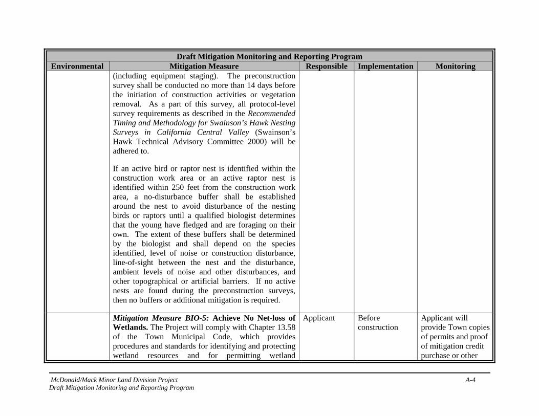
McDonald/Mack Minor Land Division Project A-4 Draft Mitigation Monitoring and Reporting Program
Draft Mitigation Monitoring and Reporting Program Environmental
Mitigation Measure Responsible
Implementation
Monitoring
(including equipment staging). The preconstruction survey shall be conducted no more than 14 days before the initiation of construction activities or vegetation removal. As a part of this survey, all protocol-level survey requirements as described in the Recommended Timing and Methodology for Swainson’s Hawk Nesting Surveys in California Central Valley (Swainson’s Hawk Technical Advisory Committee 2000) will be adhered to.
If an active bird or raptor nest is identified within the construction work area or an active raptor nest is identified within 250 feet from the construction work area, a no-disturbance buffer shall be established around the nest to avoid disturbance of the nesting birds or raptors until a qualified biologist determines that the young have fledged and are foraging on their own. The extent of these buffers shall be determined by the biologist and shall depend on the species identified, level of noise or construction disturbance, line-of-sight between the nest and the disturbance, ambient levels of noise and other disturbances, and other topographical or artificial barriers. If no active nests are found during the preconstruction surveys, then no buffers or additional mitigation is required.
Mitigation Measure BIO-5: Achieve No Net-loss of Wetlands. The Project will comply with Chapter 13.58 of the Town Municipal Code, which provides procedures and standards for identifying and protecting wetland resources and for permitting wetland
Applicant Before construction
Applicant will provide Town copies of permits and proof of mitigation credit purchase or other

McDonald/Mack Minor Land Division Project A-5 Draft Mitigation Monitoring and Reporting Program
Draft Mitigation Monitoring and Reporting Program Environmental
Mitigation Measure Responsible
Implementation
Monitoring
restoration, enhancement, and mitigation projects. Section 13.58.030 requires compliance with federal and state requirements, including obtaining a CWA Section 404 permit, CWA Section 401 permit, and a CFGC Section 1602 permit, as applicable.
compensatory mitigation required in the permits.
Mitigation Measure BIO-6: Comply with Town of Loomis Tree Preservation and Protection Ordinance. The following measures would be implemented to ensure compliance with the Town’s Tree Ordinance: A final site plan will be developed and
submitted to the Town, showing the location of all Project activities that may affect protected trees. The site plan will include locations of access road and cul-de-sac construction, house construction footprints, and a trenching pathway plan depicting easements, sewers, water mains, irrigation, and underground utilities. The plan would also include an accurate plotting of the critical root zone of each protected tree within fifty feet of the soil disturbance activity.
A tree permit would be obtained prior to the removal or encroachment into the dripline of any of protected tree in the Project area following the application process described in Section 13.54.080 of the Town’s Municipal Code.
Applicant Before construction
Applicant will provide post-project record of trees removed and fees paid (if required) to Town of Loomis Planning Department.

McDonald/Mack Minor Land Division Project A-6 Draft Mitigation Monitoring and Reporting Program
Draft Mitigation Monitoring and Reporting Program Environmental
Mitigation Measure Responsible
Implementation
Monitoring
Removal, mitigation, and replacement of protected trees would be implemented in accordance with Section 13.54.090 of the Town’s Municipal Code. Mitigation will not be implemented for removal of Exempt Trees.
Cultural Resources and Tribal Cultural Resources
Mitigation Measure CUL-1: Protection of the Marked Boulder in Situ. Although the current property owners state no intention to deface or remove the boulder, future owners should be aware that the boulder must remain in place without surface disturbance. To ensure the long-term preservation of this potentially significant historic resource, Preservation Conditions (i.e., covenants or easements) shall be attached to the parcel deed requiring preservation of the boulder in place. The Preservation Conditions shall require property owners, over the reasonably foreseeable future and absent extraordinary circumstances, to maintain the physical integrity of the boulder. During any construction activities within 100 feet of the boulder, orange fencing should be installed around the boulder to indicate an environmentally sensitive area. With implementation of a legally enforceable Preservation Condition, there would be no adverse effect on the marker boulder.
Town of Loomis and Property Owners
At time of lot split
Copy of preservation condition in parcel deed will be sent to Town of Loomis Planning Department and UAIC
Mitigation Measure CUL-2: Conduct Worker Environmental Awareness Training (WEAT). Prior to any excavation or other substantial subsurface disturbance activities, any individuals conducting the work should be given a cultural resource awareness training session and advised to watch for cultural
Applicant’s Contractor
Before construction
Contractor will submit WEAT materials and sign-in sheets to Town of Loomis

McDonald/Mack Minor Land Division Project A-7 Draft Mitigation Monitoring and Reporting Program
Draft Mitigation Monitoring and Reporting Program Environmental
Mitigation Measure Responsible
Implementation
Monitoring
resource materials during construction activities. This training will cover both the identification of resources that may be encountered during construction and procedures to be followed in the event of a discovery. This training can be conducted concurrently with WEAT for sensitive biological resources (Mitigation Measure BIO-1).
Mitigation Measure CUL-3: Protect Discovered Cultural Subsurface Resources. If any evidence of prehistoric cultural resources (freshwater shells, beads, bone tool remnants or an assortment of bones, soil changes including subsurface ash lens or soil darker in color than surrounding soil, lithic materials such as flakes, tools or grinding rocks, etc.), historical cultural resources (adobe foundations or walls, structures and remains with square nails, refuse deposits or bottle dumps, often associated with wells or old privies), or paleontological resources (e.g., fossilized remains, imprints, and traces of plants and animals preserved in rocks and sediments) are observed during ground disturbing activities, all work must immediately cease within 50 feet of the find, and a qualified archaeologist must be consulted to assess the significance of the cultural materials. If the find is determined to be potentially significant, the archaeologist, in consultation with the Town and—if the find is prehistoric or Native American in nature—appropriate Native American group(s), shall develop and implement a treatment plan with an emphasis toward preservation in place. If the find is paleontological, a
Applicant’s contractor and Qualified Archaeologist
During construction
Applicant will notify Town of Loomis Planning Department of any discovered materials; Town of Loomis shall periodically monitor construction.

McDonald/Mack Minor Land Division Project A-8 Draft Mitigation Monitoring and Reporting Program
Draft Mitigation Monitoring and Reporting Program Environmental
Mitigation Measure Responsible
Implementation
Monitoring
qualified paleontologist will be consulted to develop and implement a treatment plan.
Mitigation Measure CUL-4: Procedures for Human Remains. In accordance with the California Health and Safety Code, Section 7050.5, and the Public Resources Code 5097.98, regarding the discovery of human remains, if human remains are discovered during construction, all work must immediately cease, and the Placer County coroner must be contacted. If the Coroner determines that the remains are those of a Native American, the Coroner shall contact the Native American Heritage Commission (NAHC) and subsequent procedures shall be followed, according to State Public Resources Code Sections 5097.9 to 5097.99, regarding notification of the Native American Most Likely Descendant.
Applicant’s contractor
During construction
Applicant will follow Health & Safety Codes for discovery of human remains. Town of Loomis shall periodically monitor construction.
Hazards and Hazardous Materials
Mitigation Measure HAZ-1: Conduct Phase II Soil Sampling and Implement Contamination Removal Activities as Needed. Soil sampling for pesticide residues and metals (e.g., arsenic, copper, mercury,
Applicant Before construction
Applicant will provide Town and PCHHS with Phase II workplan for

McDonald/Mack Minor Land Division Project A-9 Draft Mitigation Monitoring and Reporting Program
Draft Mitigation Monitoring and Reporting Program Environmental
Mitigation Measure Responsible
Implementation
Monitoring
lead) in areas historically used as orchard shall be conducted in accordance with the California Department of Toxic Substances Control (DTSC) Interim Guidance for Sampling Agricultural Properties (Third Revision), dated August 7, 2008. A workplan to conduct a Phase II site assessment shall be submitted to PCHHS for review and approval prior to field activities. The workplan shall also include soil sampling around any historic structures.
Analytical results from soil samples obtained during Phase II screening level investigations shall be compared to the following standards in order to evaluate possible adverse impacts to human health: 1) Preliminary Remediation Goals (PRGs) for residential usage, established by the U.S. Environmental Protection Agency Region IX; and 2) California Human Health Screening Levels (CHHSLs) established by the California Environmental Protection Agency.
If collected samples show low or non-detect results for the constituents analyzed, no further mitigation is necessary. If exceedances of PRGs and/or CHHSLs are encountered, contamination removal activities shall be implemented in coordination with PCHHS and DTSC. Remedial activities could include but are not limited to excavating soil, lawfully disposing of soil, and retesting onsite soils to ensure native soils are below action levels.
approval before testing. Applicant will provide Town and PCHHS with testing results. Building permit and/or occupation certificate shall not be issued until PCHHS confirms either no contamination levels are present or remedial activities have been completed.

McDonald/Mack Minor Land Division Project A-10 Draft Mitigation Monitoring and Reporting Program
Draft Mitigation Monitoring and Reporting Program Environmental
Mitigation Measure Responsible
Implementation
Monitoring
Hydrology and Water Quality
Mitigation Measure HYDRO-1: Implement Low Impact Design Measures. As required by the Town's new Phase II NPDES Permit, the proposed proponent will implement Hydromodification Management and Low Impact Design (LID) measures. LID measures will be implemented in compliance with the West Placer County Storm Water Design Manual (Placer County 2018) to ensure no net change in the volume or timing of storm water runoff when compared to existing conditions. Drainage plans and LID designs will be submitted to Town for approval.
Applicant Before construction
Applicant will provide Town with LID plans for approval.

Appendix B Biological Resources Evaluation

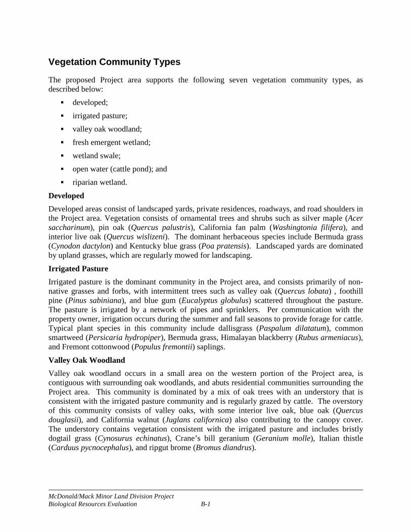
McDonald/Mack Minor Land Division Project Biological Resources Evaluation B-1
Vegetation Community Types
The proposed Project area supports the following seven vegetation community types, as described below: developed; irrigated pasture; valley oak woodland; fresh emergent wetland; wetland swale; open water (cattle pond); and riparian wetland.
Developed Developed areas consist of landscaped yards, private residences, roadways, and road shoulders in the Project area. Vegetation consists of ornamental trees and shrubs such as silver maple (Acer saccharinum), pin oak (Quercus palustris), California fan palm (Washingtonia filifera), and interior live oak (Quercus wislizeni). The dominant herbaceous species include Bermuda grass (Cynodon dactylon) and Kentucky blue grass (Poa pratensis). Landscaped yards are dominated by upland grasses, which are regularly mowed for landscaping.
Irrigated Pasture Irrigated pasture is the dominant community in the Project area, and consists primarily of non-native grasses and forbs, with intermittent trees such as valley oak (Quercus lobata) , foothill pine (Pinus sabiniana), and blue gum (Eucalyptus globulus) scattered throughout the pasture. The pasture is irrigated by a network of pipes and sprinklers. Per communication with the property owner, irrigation occurs during the summer and fall seasons to provide forage for cattle. Typical plant species in this community include dallisgrass (Paspalum dilatatum), common smartweed (Persicaria hydropiper), Bermuda grass, Himalayan blackberry (Rubus armeniacus), and Fremont cottonwood (Populus fremontii) saplings.
Valley Oak Woodland Valley oak woodland occurs in a small area on the western portion of the Project area, is contiguous with surrounding oak woodlands, and abuts residential communities surrounding the Project area. This community is dominated by a mix of oak trees with an understory that is consistent with the irrigated pasture community and is regularly grazed by cattle. The overstory of this community consists of valley oaks, with some interior live oak, blue oak (Quercus douglasii), and California walnut (Juglans californica) also contributing to the canopy cover. The understory contains vegetation consistent with the irrigated pasture and includes bristly dogtail grass (Cynosurus echinatus), Crane’s bill geranium (Geranium molle), Italian thistle (Carduus pycnocephalus), and ripgut brome (Bromus diandrus).
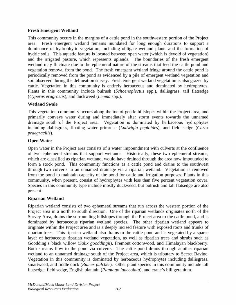
McDonald/Mack Minor Land Division Project Biological Resources Evaluation B-2
Fresh Emergent Wetland This community occurs in the margins of a cattle pond in the southwestern portion of the Project area. Fresh emergent wetland remains inundated for long enough durations to support a dominance of hydrophytic vegetation, including obligate wetland plants and the formation of hydric soils. This aquatic feature is located between open water (which is devoid of vegetation) and the irrigated pasture, which represents uplands. The boundaries of the fresh emergent wetland may fluctuate due to the ephemeral nature of the streams that feed the cattle pond and vegetation removal from the pond. The fresh emergent wetland fringe around the cattle pond is periodically removed from the pond as evidenced by a pile of emergent wetland vegetation and soil observed during the delineation survey. Fresh emergent wetland vegetation is also grazed by cattle. Vegetation in this community is entirely herbaceous and dominated by hydrophytes. Plants in this community include bulrush (Schoenoplectus spp.), dallisgrass, tall flatsedge (Cyperus eragrostis), and duckweed (Lemna spp.).
Wetland Swale This vegetation community occurs along the toe of gentle hillslopes within the Project area, and primarily conveys water during and immediately after storm events towards the unnamed drainage south of the Project area. Vegetation is dominated by herbaceous hydrophytes including dallisgrass, floating water primrose (Ludwigia peploides), and field sedge (Carex praegracilis).
Open Water Open water in the Project area consists of a water impoundment with culverts at the confluence of two ephemeral streams that support wetlands. Historically, these two ephemeral streams, which are classified as riparian wetland, would have drained through the area now impounded to form a stock pond. This community functions as a cattle pond and drains to the southwest through two culverts to an unnamed drainage via a riparian wetland. Vegetation is removed from the pond to maintain capacity of the pond for cattle and irrigation purposes. Plants in this community, when present, consist of hydrophytes with less than five percent vegetation cover. Species in this community type include mostly duckweed, but bulrush and tall flatsedge are also present.
Riparian Wetland Riparian wetland consists of two ephemeral streams that run across the western portion of the Project area in a north to south direction. One of the riparian wetlands originates north of the Survey Area, drains the surrounding hillslopes through the Project area to the cattle pond, and is dominated by herbaceous riparian wetland species. The other riparian wetland appears to originate within the Project area and is a deeply incised feature with exposed roots and trunks of riparian trees. This riparian wetland also drains to the cattle pond and is vegetated by a sparse layer of herbaceous riparian wetland vegetation, as well as riparian trees and shrubs such as Goodding’s black willow (Salix gooddingii), Fremont cottonwood, and Himalayan blackberry. Both streams flow to the pond via culverts. The cattle pond drains through another riparian wetland to an unnamed drainage south of the Project area, which is tributary to Secret Ravine. Vegetation in this community is dominated by herbaceous hydrophytes including dallisgrass, smartweed, and fiddle dock (Rumex pulcher). Other plant species in this community include tall flatsedge, field sedge, English plantain (Plantago lanceolata), and crane’s bill geranium.

McDonald/Mack Minor Land Division Project Biological Resources Evaluation B-3
Special-status Species
Special-status species are generally defined as those species assigned a status designation indicating possible risk to the species. These designations are assigned by state and federal resource agencies (e.g., California Department of Fish and Wildlife [CDFW], U.S. Fish and Wildlife Service [USFWS]) or by private research or conservation groups (e.g., the California Native Plant Society [CNPS]). Assignment to a special-status designation is typically based on a declining or potentially declining population locally, regionally, or nationally. To what extent a species or population is at risk usually determines the status designation. For the purpose of this IS/MND, special-status plant species are generally defined as follows:
Plants listed or proposed for listing as threatened or endangered under the federal Endangered Species Act (ESA) (50 CFR 17.12) and various notices in the Federal Register [FR]).
Plants that are candidates for possible future listing as threatened or endangered under the federal ESA.
Plants considered by the CNPS to be “rare, threatened, or endangered” in California (Rare Plant Rank 1 and 2 species )
Plants listed or candidates for listing as threatened or endangered by the State of California under the California Endangered Species Act (CESA) (14 CCR 670.5).
Plants listed under the California Native Plant Protection Act (California Fish and Game Code [CFGC] 1900 et seq.).
Plants considered sensitive by other federal agencies or state and local agencies or jurisdictions.
Plant species that meet the definition of rare or endangered under CEQA (14 CCR Section 15380).
Special-status wildlife species are generally defined as follows: Wildlife species that are listed or proposed for listing as threatened or endangered under
the federal ESA (50 CFR 17.11) and various notices in the FR). Wildlife species that are candidates for possible future listing as threatened or endangered
under the federal ESA. Wildlife species that are listed or proposed for listing under CESA (CFGC 1992 Sections
2050 et seq.; 14 CCR Sections 670.1 et seq.). Wildlife species that are designated as Species of Special Concern (SSC) by CDFW. Wildlife species that are designated as fully protected under the CFGC Section 3511
(birds), Section 4700 (mammals), Section 5515 (fish), and Section 5050 (reptiles and amphibians).
Species lists for the proposed Project site were obtained from CNPS (CNPS 2018), California Natural Diversity Database (CNDDB) (CDFW 2018), and the USFWS (USFWS 2018), and each species’ potential for occurrence was analyzed based on the elevation and habitats present. See Tables below for an evaluation each species’ potential for occurrence.

McDonald/Mack Minor Land Division Project Biological Resources Evaluation B-4 May 2018
Table B-1. Potentially Occurring Special-status Plant Species
Common and Scientific Name
Legal Status1 Distribution Habitat Association Identification
Period Likelihood of Occurrence Federal/State/
CNPS
Big-scale balsamroot Balsamorhiza macrolepis
--/--/1B.2
Alameda, Amador, Butte, Colusa, El Dorado, Lake, Mariposa, Napa, Placer, Santa Clara, Shasta, Solano, Sonoma, Tehama, and Tuolumne counties.
Serpentine soils in chaparral, cismontane woodland, and valley and foothill grassland from 295 – 5,102 feet (90 – 1,555 meters).
March – June
Unlikely to occur. The microhabitats required for this species do not occur in the Project area.
Hispid bird’s-beak Chloropyron molle ssp. hispidum
--/--/1B.1 Alameda, Fresno, Kern, Merced, Placer, and Solano counties.
Alkaline soils in meadows and seeps, playas, and valley and foothill grassland. 3 – 509 feet (1 – 155 meters).
June – September
Unlikely to occur. The microhabitats required for this species do not occur in the Project area.
Dwarf downingia Downingia pusilla --/--/2B.2
Southern Sacramento Valley, northern San Joaquin Valley, and southern North Coast Ranges.
Vernal pools in valley and foothill grasslands. 3 – 1,460 feet (1 – 445 meters).
March – May
Unlikely to occur. The microhabitats required for this species do not occur in the Project area.
Boggs Lake hedge-hyssop
Gratiola heterosepala
--/SE/1B.2
Fresno, Lake, Lassen, Madera, Merced, Modoc, Placer, Sacramento, Shasta, Siskiyou, San Joaquin, Solano, Sonoma, and Tehama counties.
Clay soils in marshes and swamps (lake margins) and vernal pools. 33 – 7,792 feet (10 – 2,375 meters).
April – August
Unlikely to occur. The microhabitats required for this species do not occur in the Project area.
Legenere Legenere limosa --/--/1B.1
Alameda, Lake Monterey, Napa, Placer, Sacramento Santa Clara, Shasta, San Joaquin, San Mateo, Solano, Sonoma, Tehama, and Yuba counties.
Vernal pools. 3 – 2,887 feet (1-880 meters). April – June
Unlikely to occur. The microhabitats required for this species do not occur in the Project area.
1Status explanations: -- = no listing. State SE = listed as endangered under the CESA. California Native Plant Society Rare Plant Rank (formerly known as CNPS lists) 1B = Rank 1B species: rare, threatened, or endangered in California and elsewhere. 2B = Rank 2B species: rare, threatened, or endangered in California but more common elsewhere.
0.1 = Seriously threatened in California (over 80% of occurrences threatened/high degree and immediacy of threat). 0.2 = Moderately threatened in California (20%-80% occurrences threatened/moderate degree and immediacy of threat). 0.3 = Not very threatened in California (less than 20% of occurrences threatened/low degree and immediacy of threat or no current threats known).

McDonald/Mack Minor Land Division Project Biological Resources Evaluation B-5 May 2018
Table B-2. Potentially Occurring Special-status Wildlife Species Common and
Scientific Name Legal Status1 Distribution Habitat Requirements Likelihood of Occurrence Federal/State
Invertebrates Vernal pool fairy shrimp Branchinecta lynchi
FT/-- Central Valley, Central and South Coast Ranges from Tehama County to Santa Barbara County; isolated populations also in Riverside County and southern Oregon.
Vernal pools and seasonal wetlands; also found in sandstone rock outcrop pools.
Unlikely to occur. Suitable habitat is not present in the Project Area.
Vernal pool tadpole shrimp Lepidurus packardi
FE/-- Central Valley from Shasta County south to Merced County.
Vernal pools and seasonal wetlands. Unlikely to occur. Suitable habitat is not present in the Project Area.
Valley elderberry longhorn beetle Desmocerus californicus dimorphus
FT/-- Central Valley and surrounding foothills below 1,500 feet (460 meters) elevations.
Dependent on elderberry (Sambucus spp.) shrubs as a host plant; potential habitat is shrubs with stems 1 inch in diameter within Central Valley.
Unlikely to occur. There are no elderberry shrubs in the Project area
Amphibians California red-legged frog Rana draytonii
FT/SSC Along the coast and coastal mountain ranges of California from Marin County to San Diego County and in the Sierra Nevada from Tehama County to Fresno County.
Permanent and semi-permanent aquatic habitats, such as creeks and ponds with emergent and submergent vegetation; may aestivate in upland burrows during dry periods.
Unlikely to occur. Although the site is within the historical range of the species, there are no extant populations in this area. The only record within 10 miles is a 2005 CNDDB record at Folsom lake approximately 8.3 miles southwest of the Project area. Historical fish stocking and bullfrog populations at the pond onsite also further decrease the habitat suitability of the site.
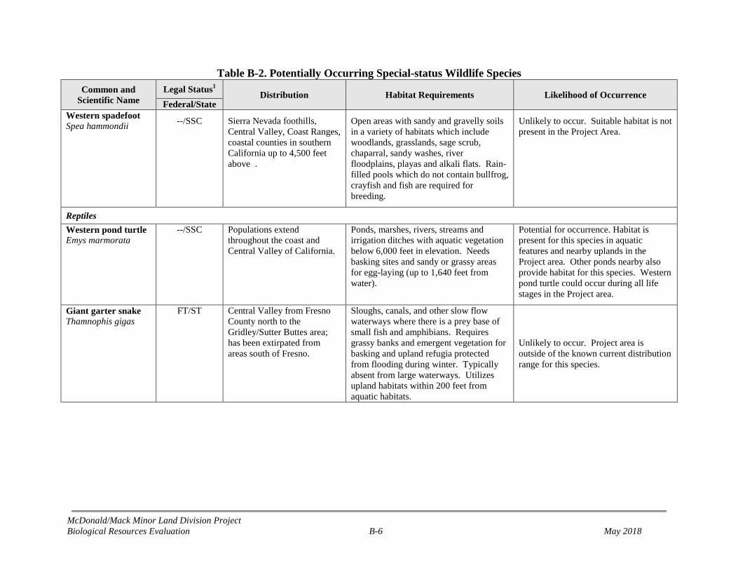
McDonald/Mack Minor Land Division Project Biological Resources Evaluation B-6 May 2018
Table B-2. Potentially Occurring Special-status Wildlife Species Common and
Scientific Name Legal Status1 Distribution Habitat Requirements Likelihood of Occurrence Federal/State
Western spadefoot Spea hammondii --/SSC Sierra Nevada foothills,
Central Valley, Coast Ranges, coastal counties in southern California up to 4,500 feet above .
Open areas with sandy and gravelly soils in a variety of habitats which include woodlands, grasslands, sage scrub, chaparral, sandy washes, river floodplains, playas and alkali flats. Rain-filled pools which do not contain bullfrog, crayfish and fish are required for breeding.
Unlikely to occur. Suitable habitat is not present in the Project Area.
Reptiles Western pond turtle Emys marmorata
--/SSC Populations extend throughout the coast and Central Valley of California.
Ponds, marshes, rivers, streams and irrigation ditches with aquatic vegetation below 6,000 feet in elevation. Needs basking sites and sandy or grassy areas for egg-laying (up to 1,640 feet from water).
Potential for occurrence. Habitat is present for this species in aquatic features and nearby uplands in the Project area. Other ponds nearby also provide habitat for this species. Western pond turtle could occur during all life stages in the Project area.
Giant garter snake Thamnophis gigas
FT/ST Central Valley from Fresno County north to the Gridley/Sutter Buttes area; has been extirpated from areas south of Fresno.
Sloughs, canals, and other slow flow waterways where there is a prey base of small fish and amphibians. Requires grassy banks and emergent vegetation for basking and upland refugia protected from flooding during winter. Typically absent from large waterways. Utilizes upland habitats within 200 feet from aquatic habitats.
Unlikely to occur. Project area is outside of the known current distribution range for this species.

McDonald/Mack Minor Land Division Project Biological Resources Evaluation B-7 May 2018
Table B-2. Potentially Occurring Special-status Wildlife Species Common and
Scientific Name Legal Status1 Distribution Habitat Requirements Likelihood of Occurrence Federal/State
Birds Tricolored blackbird Agelaius tricolor
--/SC, SSC Largely endemic to California; permanent residents in the Central Valley from Butte County to Kern County; at scattered coastal locations from Marin County south to San Diego County; breeds at scattered locations in Lake, Sonoma, and Solano counties; rare nester in Siskiyou, Modoc, and Lassen counties. Sacramento-San Joaquin Valleys and low foothills of coast ranges and Sierra Nevada.
Nests in dense colonies in emergent marsh vegetation, such as tules and cattails, or upland sites with blackberries, nettles, thistles, and grain fields; nesting habitat must be large enough to support 50 pairs; probably requires water at or near the nesting colony; requires large foraging areas, including marshes, pastures, agricultural wetlands, dairies, and feedlots, where insect prey is abundant.
Unlikely to occur. Marsh vegetation sufficient to support tricolored blackbird colonies is not present in the Project Area.
Swainson’s hawk Buteo swainsoni
--/ST Lower Sacramento and San Joaquin Valleys, the Klamath Basin, and Butte Valley; the state's highest nesting densities occur near Davis and Woodland, Yolo County.
Nests in oaks or cottonwoods in or near riparian habitats; forages in grasslands, irrigated pastures, and grain fields.
Potential for occurrence. Swainson’s hawk could nest in riparian trees and forage in grassland and irrigated pasture areas in the Project area.
White-tailed kite Elanus leucurus --/FP Lowland areas west of Sierra
Nevada from head of Sacramento Valley south, including coastal valleys and foothills to western San Diego County at the Mexico border. Central Valley and low foothills of Sierra Nevada.
Agricultural lands and open stages of most herbaceous habitats. Nests in dense oak, willow or other tree stands.
Potential for occurrence. This species could nest and forage in the Project area.
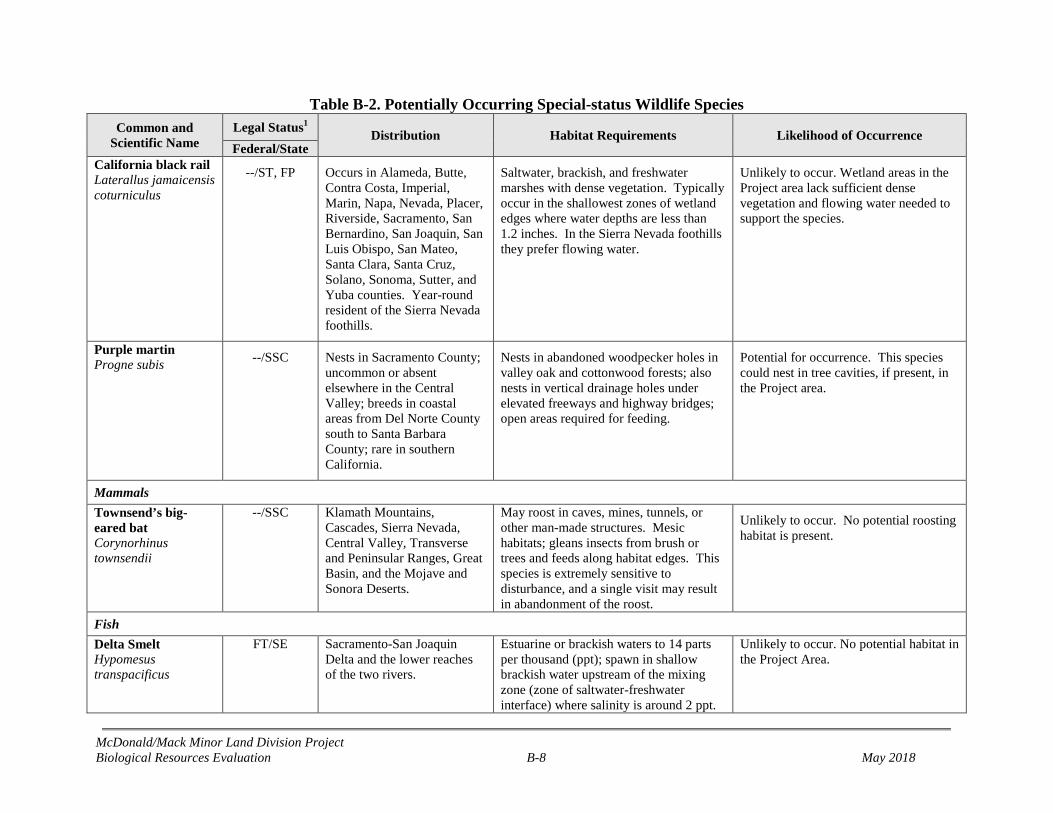
McDonald/Mack Minor Land Division Project Biological Resources Evaluation B-8 May 2018
Table B-2. Potentially Occurring Special-status Wildlife Species Common and
Scientific Name Legal Status1 Distribution Habitat Requirements Likelihood of Occurrence Federal/State
California black rail Laterallus jamaicensis coturniculus
--/ST, FP Occurs in Alameda, Butte, Contra Costa, Imperial, Marin, Napa, Nevada, Placer, Riverside, Sacramento, San Bernardino, San Joaquin, San Luis Obispo, San Mateo, Santa Clara, Santa Cruz, Solano, Sonoma, Sutter, and Yuba counties. Year-round resident of the Sierra Nevada foothills.
Saltwater, brackish, and freshwater marshes with dense vegetation. Typically occur in the shallowest zones of wetland edges where water depths are less than 1.2 inches. In the Sierra Nevada foothills they prefer flowing water.
Unlikely to occur. Wetland areas in the Project area lack sufficient dense vegetation and flowing water needed to support the species.
Purple martin Progne subis --/SSC Nests in Sacramento County;
uncommon or absent elsewhere in the Central Valley; breeds in coastal areas from Del Norte County south to Santa Barbara County; rare in southern California.
Nests in abandoned woodpecker holes in valley oak and cottonwood forests; also nests in vertical drainage holes under elevated freeways and highway bridges; open areas required for feeding.
Potential for occurrence. This species could nest in tree cavities, if present, in the Project area.
Mammals Townsend’s big-eared bat Corynorhinus townsendii
--/SSC Klamath Mountains, Cascades, Sierra Nevada, Central Valley, Transverse and Peninsular Ranges, Great Basin, and the Mojave and Sonora Deserts.
May roost in caves, mines, tunnels, or other man-made structures. Mesic habitats; gleans insects from brush or trees and feeds along habitat edges. This species is extremely sensitive to disturbance, and a single visit may result in abandonment of the roost.
Unlikely to occur. No potential roosting habitat is present.
Fish Delta Smelt Hypomesus transpacificus
FT/SE Sacramento-San Joaquin Delta and the lower reaches of the two rivers.
Estuarine or brackish waters to 14 parts per thousand (ppt); spawn in shallow brackish water upstream of the mixing zone (zone of saltwater-freshwater interface) where salinity is around 2 ppt.
Unlikely to occur. No potential habitat in the Project Area.
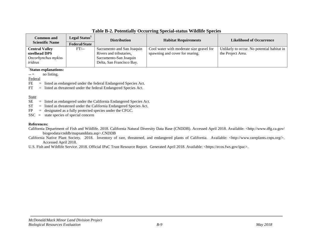
McDonald/Mack Minor Land Division Project Biological Resources Evaluation B-9 May 2018
Table B-2. Potentially Occurring Special-status Wildlife Species Common and
Scientific Name Legal Status1 Distribution Habitat Requirements Likelihood of Occurrence Federal/State
Central Valley steelhead DPS Oncorhynchus mykiss irideus
FT/-- Sacramento and San Joaquin Rivers and tributaries, Sacramento-San Joaquin Delta, San Francisco Bay.
Cool water with moderate size gravel for spawning and cover for rearing.
Unlikely to occur. No potential habitat in the Project Area.
1Status explanations: -- = no listing. Federal FE = listed as endangered under the federal Endangered Species Act. FT = listed as threatened under the federal Endangered Species Act. State SE = listed as endangered under the California Endangered Species Act. ST = listed as threatened under the California Endangered Species Act. FP = designated as a fully protected species under the CFGC. SSC = state species of special concern References: California Department of Fish and Wildlife. 2018. California Natural Diversity Data Base (CNDDB). Accessed April 2018. Available: <http://www.dfg.ca.gov/
biogeodata/cnddb/mapsanddata.asp>.CNDDB California Native Plant Society. 2018. Inventory of rare, threatened, and endangered plants of California. Available: <http://www.rareplants.cnps.org/>.
Accessed April 2018. U.S. Fish and Wildlife Service. 2018. Official IPaC Trust Resource Report. Generated April 2018. Available: <https://ecos.fws.gov/ipac>.