Mayor and City Council le4de Mr. Daniel Quinn ...
18
Memorandum To: Mayor and City Council I le4de From: David Huseman, City Manager"' Ci " J . Date: October 18, 2018 Subject: Epic Crude Pipeline, LP Easement Agreement ISSUE Mr. Daniel Quinn, representing Epic Crude Pipeline LP, has submitted a request for an easement to place a pipeline in a prosed right- of- way ( ROW) on property owned by the City. The easement is located on three separate tracts and is located on or near the Public Works facility. RULES/ HISTORY The area of the ROW being requested is not currently being used as pipeline easement. This will be a new easement to serve Oxy Energy Center. The City Council has the authority to grant an access and use easement to those companies that may provide a benefit to the City or its citizens. ANALYSIS The City currently has several corporate citizens that provide employment and tax base revenue to the community. From time to time, these corporations utilize City owned rights- of- way as part on their ongoing business model. Epic Crude Pipeline has been contracted by Oxy Energy Center to provide a new pipeline route to their Ingleside facility. This new pipeline/ easement will not interfere with City operations or the general public. This Agreement has been reviewed by the City Attorney and been modified to incorporate his comments. CONCLUSION This project will allow for future business development to a current corporate customer and provide nearly $ 50, 000 dollars in a one- time payment to the City. Staff recommends that Council approve the Right- of- Way Agreement. If you have any questions please do not hesitate to call.
Transcript of Mayor and City Council le4de Mr. Daniel Quinn ...

Memorandum
To: Mayor and City Council
I le4de From: David Huseman, City Manager"'Ci "
J . Date: October 18, 2018
Subject: Epic Crude Pipeline, LP Easement
Agreement
ISSUE
Mr. Daniel Quinn, representing Epic Crude Pipeline LP, has submitted a request for an easementto place a pipeline in a prosed right- of-way ( ROW) on property owned by the City. Theeasement is located on three separate tracts and is located on or near the Public Works facility.
RULES/ HISTORY
The area of the ROW being requested is not currently being used as pipeline easement. This willbe a new easement to serve Oxy Energy Center. The City Council has the authority to grant anaccess and use easement to those companies that may provide a benefit to the City or its citizens.
ANALYSIS
The City currently has several corporate citizens that provide employment and tax base revenueto the community. From time to time, these corporations utilize City owned rights- of-way aspart on their ongoing business model. Epic Crude Pipeline has been contracted by Oxy EnergyCenter to provide a new pipeline route to their Ingleside facility. This new pipeline/ easement
will not interfere with City operations or the general public. This Agreement has been reviewedby the City Attorney and been modified to incorporate his comments.
CONCLUSION
This project will allow for future business development to a current corporate customer and
provide nearly $ 50, 000 dollars in a one- time payment to the City. Staff recommends thatCouncil approve the Right- of-Way Agreement.
If you have any questions please do not hesitate to call.

46 EPICY GRADE PIPELINE LP
October 5th, 2018
Re: Consideration and Compensation for that certain Pipeline Right-of-Way and Easement Agreementthe " Agreement") between the City of Ingleside and Epic Crude Pipeline LP (" Epic") dated
October 5th 2018, on, over, and across lands owned by the City of Ingleside, San Patricio CountyTexas.
Dear Sirs,
With this letter, the undersigned parties, being the same parties mentioned above, do hereby acknowledgethat consideration for the rights granted unto Epic by that certain above mentioned Pipeline Right-of-Wayand Easement Agreement shall be as follows:
49, 732. 00
It is further understood and acknowledged that the Agreement provides for a fifty foot( 50') permanent and
an additional fifty foot( 50') temporary construction easement for the purpose of constructing and installingone( 1) pipeline respectively, which is stated and incorporated into above mentioned Pipeline Right-of-Wayand Easement Agreement:
Sincerely,
Daniel Quinn
Right of Way Agent512- 207- 0513
Representing EPIC Crude Pipeline LP

RESOLUTION NO. 2018-
A RESOLUTION OF THE CITY COUNCIL OF INGLESIDE, SAN PATRICIO COUNTY, TEXAS,
authorizing the right-of-way (ROW) agreement with Epic Crude Pipeline LP for the purpose a pipelinenot to exceed twenty inches ( 20") in size.
WHEREAS, the City of Ingleside authorizes the Right- Of-Way ( ROW) Agreement with Epic Crude PipelineLP for the purpose of a pipeline not to exceed twenty inches ( 20") in size for the following properties; and
WHEREAS, Tract TX- SP- OL- 028. 00 DESCRIPTION OF A 50 FOOT WIDE PERMANENT PIPELINE EASEMENTBEING 25 FEET LEFT OF AND 25 FEET RIGHT OF THE HEREIN DESCRIBED SURVEYED BASELINE OUT OF ACALLED 16. 5 ACRE TRACT OF LAND, BEING A PORTION OF LOTS 14, 15, AND 16, BLOCK 90, OF THE T. P.McCAMPBELL SUBDIVISION, RECORDED IN VOLUME 11, PAGE 21, MAP RECORDS SAN PATRICIO COUNTY,TEXAS ( M. R. S. P. C. T.), SITUATED IN THE D. L.& C. CO. SURVEY, ABSTRACT NO. 387, SAN PATRICIO COUNTY,
TEXAS, IN THE NAME OF CITY OF INGLESIDE, RECORDED IN DOCUMENT NUMBER 317669, DEED RECORDSSAN PATRICIO COUNTY, TEXAS ( D. R. S. P. C. T.); and
WHEREAS, Tract TX-SP- OL-029. 00 DESCRIPTION OF A 50 FOOT WIDE PERMANENT PIPELINE EASEMENTBEING 25 FEET LEFT OF AND 25 FEET RIGHT OF THE HEREIN DESCRIBED SURVEYED BASELINE OUT OF ACALLED 2 ACRE TRACT OF LAND SITUATED IN THE D. L.& C. CO. SURVEY, ABSTRACT NO. 387 AND THE W. MC.
DONOUGH SURVEY, ABSTRACT NO. 184, SAN PATRICIO COUNTY, TEXAS, IN THE NAME OF CITY OF INGLESIDE,RECORDED IN DOCUMENT NUMBER 178039, REAL PROPERTY RECORDS SAN PATRICIO COUNTY, TEXAS
R. P. R. S. P. C. T.); and
WHEREAS, Tract TX- SP- OL- 029. 00 DESCRIPTION OF A 50 FOOT WIDE PERMANENT PIPELINE EASEMENTBEING 25 FEET LEFT OF AND 25 FEET RIGHT OF THE HEREIN DESCRIBED SURVEYED BASELINE OUT OF ACALLED 12. 793 ACRE TRACT OF LAND ( REMAINDER), BEING A PORTION OF FARM LOTS 12 AND 13, BLOCK 90
OF THE T. P. McCAMPBELL SUBDIVISION, RECORDED IN VOLUME 1, PAGE 2, MAP RECORDS ARANSAS
COUNTY, TEXAS( M. R. A. C. T.), SITUATED IN THEW. MC. DONOUGH SURVEY, ABSTRACT NO. 184, SAN PATRICIOCOUNTY, TEXAS, IN THE NAME OF CITY OF INGLESIDE, RECORDED IN DOCUMENT NUMBER 447870, REALPROPERTY RECORDS SAN PATRICIO COUNTY, TEXAS ( R. P. R. S. P. C. T.); and
WHEREAS, staff recommends that the City Council award the ROW to Epic Crude Pipeline.
NOW, THEREFORE, BE IT RESOLVED BY THE CITY COUNCIL OF THE CITY OF INGLESIDE,TEXAS, THAT:
Section 1. That the matter and facts recited in the preamble hereof are found and determined to be trueand correct.
Section 2. Epic Crude Pipeline LP will pay to the City of Ingleside $ 49, 732. 00 for a total of 994. 64 ftROW for a fifty( 50') permanent ROW.
Section 4. The City Manager is authorized to execute any and all documents necessary for ROW.
PASSED AND APPROVED this23rd
day of October 2018, by ayes) to nays) with no
abstentions by a vote of the City Council of the City of Ingleside, Texas.
s/ Ronnie Parker, Mayor
Attest: APPROVED AS TO FORM:
s/ Kimberly Sampson Henry, City Secretary s/ Michael Morris, City Attorney
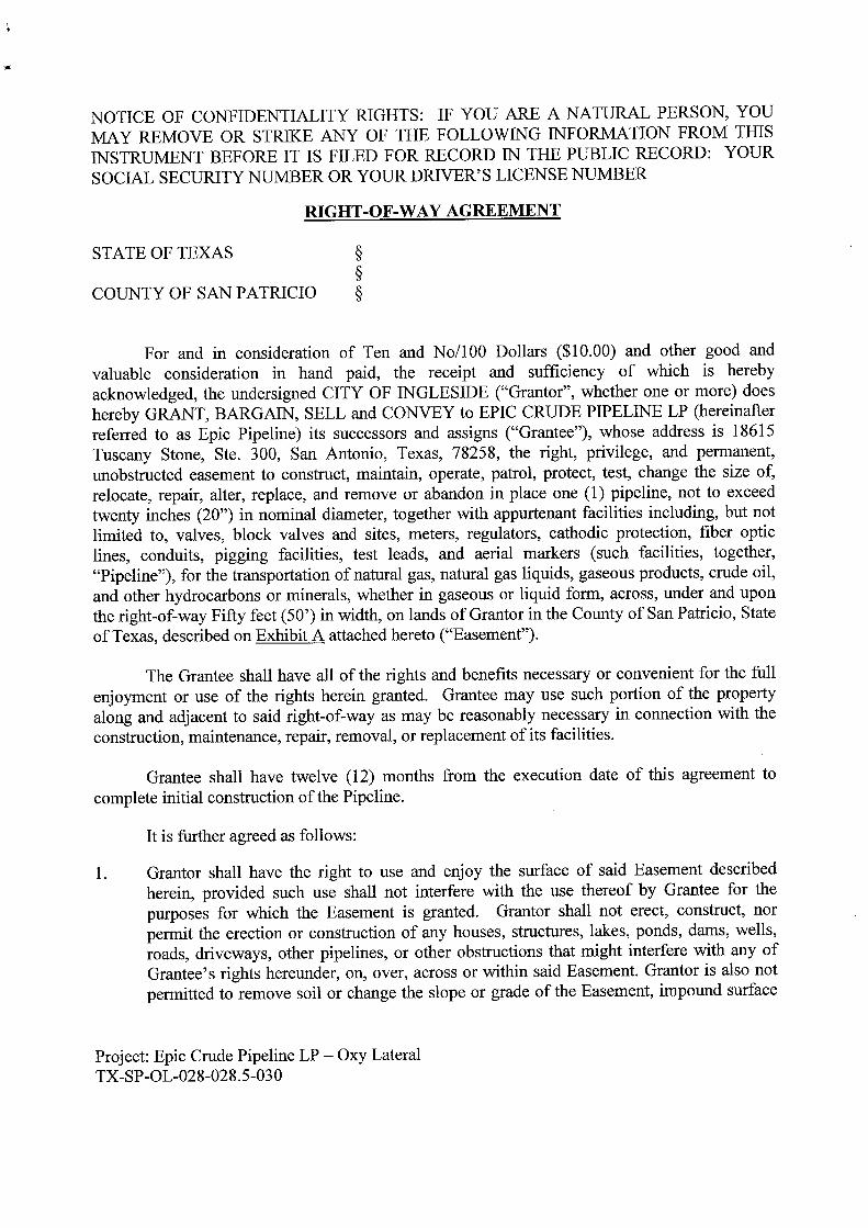
NOTICE OF CONFIDENTIALITY RIGHTS: IF YOU ARE A NATURAL PERSON, YOU
MAY REMOVE OR STRIKE ANY OF THE FOLLOWING INFORMATION FROM THISINSTRUMENT BEFORE IT IS FILED FOR RECORD IN THE PUBLIC RECORD: YOUR
SOCIAL SECURITY NUMBER OR YOUR DRIVER' S LICENSE NUMBER
RIGHT- OF- WAY AGREEMENT
STATE OF TEXAS
COUNTY OF SAN PATRICIO §
For and in consideration of Ten and No/ 100 Dollars ($ 10. 00) and other good and
valuable consideration in hand paid, the receipt and sufficiency of which is herebyacknowledged, the undersigned CITY OF INGLESIDE (" Grantor", whether one or more) does
hereby GRANT, BARGAIN, SELL and CONVEY to EPIC CRUDE PIPELINE LP ( hereinafterreferred to as Epic Pipeline) its successors and assigns (" Grantee"), whose address is 18615
Tuscany Stone, Ste. 300, San Antonio, Texas, 78258, the right, privilege, and permanent,
unobstructed easement to construct, maintain, operate, patrol, protect, test, change the size of,
relocate, repair, alter, replace, and remove or abandon in place one ( 1) pipeline, not to exceed
twenty inches ( 20") in nominal diameter, together with appurtenant facilities including, but notlimited to, valves, block valves and sites, meters, regulators, cathodic protection, fiber opticlines, conduits, pigging facilities, test leads, and aerial markers ( such facilities, together,
Pipeline"), for the transportation of natural gas, natural gas liquids, gaseous products, crude oil,
and other hydrocarbons or minerals, whether in gaseous or liquid form, across, under and uponthe right- of-way Fifty feet( 50') in width, on lands of Grantor in the County of San Patricio, Stateof Texas, described on Exhibit A attached hereto (" Easement").
The Grantee shall have all of the rights and benefits necessary or convenient for the fullenjoyment or use of the rights herein granted. Grantee may use such portion of the property
along and adjacent to said right- of-way as may be reasonably necessary in connection with theconstruction, maintenance, repair, removal, or replacement of its facilities.
Grantee shall have twelve ( 12) months from the execution date of this agreement to
complete initial construction of the Pipeline.
It is further agreed as follows:
1. Grantor shall have the right to use and enjoy the surface of said Easement describedherein, provided such use shall not interfere with the use thereof by Grantee for thepurposes for which the Easement is granted. Grantor shall not erect, construct, nor
permit the erection or construction of any houses, structures, lakes, ponds, dams, wells,roads, driveways, other pipelines, or other obstructions that might interfere with any ofGrantee' s rights hereunder, on, over, across or within said Easement. Grantor is also notpermitted to remove soil or change the slope or grade of the Easement, impound surface
Project: Epic Crude Pipeline LP— Oxy LateralTX- SP- OL- 028- 028. 5- 030

water on the Easement, or plant trees or other landscaping ( other than grasses) on theEasement.
2. Grantee' s right in ingress and egress shall be limited to the Fifty foot ( 50') Easement and
such other property of Grantor as is necessary for Grantee' s ingress and egress, whichGrantor may reasonably designate. Grantee will not use any other roadways on Grantor' sland without permission of Grantor, except in emergency situations. Grantee agrees that
where any damage results to the improved ranch roads of Grantor' s lands used by theGrantee or its employees or agents for the purpose of ingress and egress, said roads shall
be restored to the condition as they existed prior to the Grantee' s use.
3. Grantee shall have a temporary easement (" Temporary Easement"), with a width of
Thirty feet ( 30') in addition to the width of the Easement, during any period ofconstruction, replacement, relocation, or removal of the Pipeline ( or either one of them).
Upon completion of any such construction, the Temporary Easement shall automaticallyexpire.
4. During initial construction of the pipeline, Grantee shall have the right to use additionalworkspace of one hundred feet by one hundred and fifty feet ( 100' X 150') along the
easement area at the crossing of roads, railroads, pipelines, streams, terraces and uneventerrain.
5. Depth Limits. With regard to segments of Pipeline within the Easement that shall be
bored, Grantee shall bury the Pipeline so that the top of the Pipeline shall not be anyshallower than twenty- four feet ( 24') from surface of ground or roadway, or such greater
depth as is required by any applicable law, rule or regulation, or this Easement and asrequired to insure safety Grantee must notify the Texas One- Call at 1- 800- 245- 4545 andthe City for utility locations in the Easement Property at least 48 hours prior to the start ofany construction.
6. Grantee shall have the right to install, maintain, and use gates in all fences which now
cross or shall cross the Easement or which provide access to Grantor' s property or theEasement. Grantor shall allow Grantee to install its own lock if Grantee so chooses.
7. Promptly upon the laying and installation of the pipeline, or promptly upon removal ofthe pipeline, Grantee agrees to restore the surface of the right-of-way and additional
working area, as nearly as reasonably feasible, to its condition immediately prior to suchoperations, including leveling and re- seeding the Easement, if desired by Grantor.
8. With regard to segments of Pipeline within the Easement that shall not be bored, thePipelines to be laid hereunder shall be buried to a minimum depth of thirty- six inches
from the top of the pipe to the then-existing surface of the ground ( including any drainageditches, creeks, and roads, except at those locations where rock is encountered, where thePipeline may be buried at a lesser depth), so as not to interfere with the reasonable and
ordinary use of the land.
Project: Epic Crude Pipeline LP— Oxy LateralTX- SP- OL- 028- 028. 5- 03 0

9. Grantee agrees to pay for any physical damage to growing crops, fences, other structuralimprovements, and all other property owned by or under the control of Grantor caused byconstruction, maintenance, operation, repairing, alteration, replacement, or removal of itsPipeline; provided, however, the initial consideration paid to Grantor shall include alldamages for initial construction of the Pipeline except for damages to fences, whichGrantee shall repair.
10. Grantee shall use the Easement solely for the purposes specified in this Agreement.There shall be no hunting or fishing on the Easement or any of Grantor' s lands byGrantee, its officers, agents, employees, contractors, invitees, guests, or representatives atany time. Grantee shall not permit any firearms or fishing equipment to be brought uponthe Easement.
11. Grantee has the right to trim or cut down or eliminate trees or shrubbery, in the solejudgment of Grantee, its successors and assigns, as may be necessary to prevent possibleinterference with the operation of the Pipeline and to remove possible hazard thereto, andthe right to remove or prevent the construction of, any and all buildings, structures,reservoirs or other obstructions on the Easement which, in the sole judgment of theGrantee, may endanger or interfere with the efficiency, safety, or convenient operation ofthe Pipeline. All trees, brush and other debris caused by construction shall be burnedand/ or chipped and spread on the Easement or removed to an authorized disposal site.The method of disposal shall be selected by Grantee.
12. During operation of the Pipeline, Grantee will maintain the Easement and the Pipeline ingood repair and appearance. All construction debris shall be cleaned up and removed
from the Easement and Grantor' s lands upon completion of installation and constructionof the Pipeline.
13. GRANTEE AGREES TO INDEMNIFY AND HOLD GRANTOR HARMLESS FROMANY CLAIMS, DEMANDS, CAUSES OF ACTION, LIABILITY, OR DAMAGES, OFANY NATURE WHATSOEVER, OCCASIONED BY GRANTEE' S USE AND/OROPERATION OF THE PIPELINE ON THE EASEMENT GRANTED HEREIN,WITHOUT REGARD TO THE CAUSE OR CAUSES THEREOF, OR THE
NEGLIGENCE OR INTENTIONAL ACT OF ANY PERSON, WHETHER SUCH
NEGLIGENCE BE SOLE, JOINT, OR CONCURRENT, ACTIVE OR PASSIVE;
PROVIDED HOWEVER, GRANTEE SHALL NOT INDEMNIFY GRANTOR ANDSHALL NOT BE LIABLE FOR INJURIES OR DAMAGES RESULTING FROM THEGROSS NEGLIGENCE OR INTENTIONAL ACT OF GRANTOR, THE
OPERATOR( S) OF GRANTOR' S SURFACE ESTATE, OR ANY OF THEIR
AGENTS, REPRESENTATIVES, LICENSEES, CONTRACTORS, EMPLOYEES, ORTENANTS.
14. Upon cessation of the use of the Pipeline for the purposes above set forth for a period oftwenty- four ( 24) consecutive months, the Easement shall terminate and all rights
hereunder shall revert automatically to Grantor, its successors and assigns, without thenecessity of a release or reconveyance of any kind. Upon termination of this Easement
Project: Epic Crude Pipeline LP— Oxy LateralTX-SP- OL- 028- 028. 5- 030

for any reason ( including, but not limited to abandonment of the same), Grantee mayeither abandon the Pipeline ( or either of them) in place or remove them ( or either ofthem). Grantee, if it chooses to remove any Pipeline, shall have six ( 6) months withinwhich to commence the removal of its pipeline, and thereafter diligently continue such
removal operations until the same has been fully and completely removed and the surfacerestored to substantially the same condition as the adjoining property of Grantor.
15. Grantee agrees to comply in all material respect at its sole cost, with all applicablefederal, state and local laws, rules, and regulations which are applicable to Grantee' sactivities hereunder, including without limitation, the construction, use, operation,
maintenance, repair and service of Grantee' s Pipeline.
16. The estate and interest granted herein is only an easement and right-of-way, and hence,does not cover or include any right, title, interest or estate in any of the oil, gas or otherminerals lying in, on, under or which may be produced from the easement premises, nordoes the same confer or imply any other right or interest not expressly authorized herein;provided, however, that Grantor shall not be permitted to drill or operate equipment forthe production or development of minerals on the Easement, but it will be permitted toextract the oil and other hydrocarbons from and under the Easement by directional
drilling and other means, so long as such activities do not damage, destroy, injure, and/ orinterfere with the Grantee' s use of the Easement ( or the Pipeline, or either one of them)
for the purposes for which the Easement is hereby granted.
17. This Agreement may be executed in several counterparts, each of which shall be anoriginal of this Agreement but all of which, taken together, shall constitute one and the
same Agreement and be binding upon the parties who executed any counterpart,regardless of whether it is executed by all parties named herein.
18. Grantee shall have the right to assign this grant in whole or in part, in which event
Grantor acknowledges and agrees that the assignee shall succeed to the rights and
obligations of Grantee to the extent conveyed in such assignment.
19. It is agreed that this grant covers the entire agreement between the parties and that no
representation or statements, verbal or written, have been made modifying, adding to, or
changing the terms of this Agreement.
20. Should it occur that, subsequent to the execution of this agreement, Grantee elects toincrease the maximum nominal diameter of a proposed pipeline, Grantee agrees to
increase the compensation to Grantor accordingly, in proportion to the same price perdiameter inch agreed upon between Grantor and Grantee with regard to the original
pipeline nominal diameter. Payment shall be remitted to Grantor, prior to the
commencement of pipeline construction of Grantor' s tract( s).
All of the terms of this Agreement shall be binding upon and shall be for the benefit of the heirs,successors, representatives, and assigns of Grantor and Grantee, and the agreements hereincontained shall be covenants running with the land affected thereby and shall inure to the benefit
Project: Epic Crude Pipeline LP— Oxy LateralTX-SP- OL- 028- 028. 5- 030
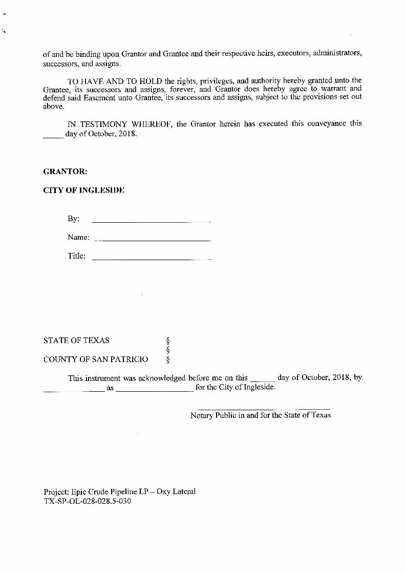
f
of and be binding upon Grantor and Grantee and their respective heirs, executors, administrators,successors, and assigns.
TO HAVE AND TO HOLD the rights, privileges, and authority hereby granted unto theGrantee, its successors and assigns, forever, and Grantor does hereby agree to warrant anddefend said Easement unto Grantee, its successors and assigns, subject to the provisions set outabove.
IN TESTIMONY WHEREOF, the Grantor herein has executed this conveyance this
day of October, 2018.
GRANTOR:
CITY OF INGLESIDE
By:
Name:
Title:
STATE OF TEXAS
COUNTY OF SAN PATRICIO §
This instrument was acknowledged before me on this day of October, 2018, byas for the City of Ingleside.
Notary Public in and for the State of Texas
Project: Epic Crude Pipeline LP— Oxy LateralTX- SP- OL-028- 028. 5- 030

GRANTEE:
EPIC CRUDE PIPELINE, LP
By: EPIC Crude Holdings GP, LLCIts General Partner
By:
Name:
Title:
STATE OF TEXAS
COUNTY OF BEXAR
BEFORE ME, the undersigned authority, on this day personally appearedas of EPIC Crude Holdings GP, LLC, General Partner of EPICCRUDE PIPELINE LP, known to me to be the person whose name is subscribed to theforegoing instrument and acknowledged to me that he executed the same for the purposes andconsideration therein expressed.
GIVEN UNDER MY HAND AND SEAL OF OFFICE this day of October, 2018.
Notary Public in and for the State of Texas
PLEASE RETURN RECORDED ORIGINAL TO:
Epic Crude Pipeline, LP
18615 Tuscany Stone, Suite 300San Antonio, Texas 78258
Project: Epic Crude Pipeline LP— Oxy LateralTX- SP- OL- 028- 028. 5- 030

EPIC Y GRADE PIPELINE, LP
EXHIBIT" A"
SAN PATRICIO COUNTY, TEXAS
PERMANENT PIPELINE EASEMENT DESCRIPTIONOXY LATERAL PIPELINE
TRACT NO.: TX- SP- OL- 028. 00
DESCRIPTION OF A 50 FOOT WIDE PERMANENT PIPELINE EASEMENT BEING 25 FEET LEFT OFAND 25 FEET RIGHT OF THE HEREIN DESCRIBED SURVEYED BASELINE OUT OF A CALLED 16. 5ACRE TRACT OF LAND, BEING A PORTION OF LOTS 14, 15, AND 16, BLOCK 90, OF THE T. P.McCAMPBELL SUBDIVISION, RECORDED IN VOLUME 11, PAGE 21, MAP RECORDS SAN PATRICIOCOUNTY, TEXAS( M. R. S. P. C.T.), SITUATED IN THE D. L.& C. CO. SURVEY, ABSTRACT NO. 387, SANPATRICIO COUNTY, TEXAS, IN THE NAME OF CITY OF INGLESIDE, RECORDED IN DOCUMENTNUMBER 317669, DEED RECORDS SAN PATRICIO COUNTY, TEXAS( D. R. S. P. C. T.), BEING MORE
PARTICULARLY DESCRIBED AS FOLLOWS:
BEGINNING ( P. O. B., X: 1398175. 84, Y: 17206693. 90) at the Northwest line of said 16. 5 acre tract, inAvenue B, from which a 5/8 inch iron rod found for a Southwest corner of said 16. 5 acre tract bears: South18° 41' 05" East, a distance of 428. 87 feet;
THENCE, South 62° 21' 20" East, a distance of 654. 15 feet, to the POINT OF EXIT( P. O. E., X: 1398755. 31,Y: 17206390. 39) at the most Westerly Southeast line of said 16. 5 acre tract, and the West line of a 2 acretract of land recorded in Document Number 178039, Real Public Records San Patricio County, TexasR. P. R.S. P. C.T.), from which a 5/ 8 inch iron rod found for the most Southerly corner of said 16. 5 acre tract,
bears: South 32° 02'50" West, a distance of 327. 55 feet.
The herein described centerline traverses said 16. 5 acre tract a total distance of 654. 15 linear feet39. 65 rods).
Certification is made only to the location of this easement according to evidence and/ or lines of occupationobserved upon the date of this field survey. Only utilities/ easements that were visible and apparent on thedate of this survey, within/ adjoining the described easement, have been located, shown and/ or describedhereon of which I have knowledge of. This certification is limited to those persons or entities shown on theface of this exhibit, is non- transferable and made for this transaction only.
Title information has been provided by the Client; as such, Open Range Field Services does not warrant orguarantee that all conflicts, easements or encumbrances are shown. Adjoiner information shown ordescribed is for informational purposes only.
All bearings, distances and coordinates contained herein are grid, based upon the Texas State PlaneCoordinate System, South Zone, of the North American Datum 1983( NAD83, Realizations 2011, Epoch2010. 00), in U. S. Survey Feet.
A survey exhibit of even date accompanies and is a part of this easement description( EXHIBIT" B").
Codi Lamberson Date
Registered Professional
Land Surveyor No. 6480
Open Range Field Services, LLC
1503 S. Barnes
Pampa, Texas 79065 Date of Survey: August 16, 2018
806) 665- 0770
SHEET 1 OF 2

zoo' Tao 0 100' zoo' t
tB»EXHIBIT1' = 200' SAN PATRICIO COUNTY, TEXAS
PIPELINE EASEMENT PLATLEGEND
TOTAL LENGTH: 654. 15 FEET OR 39. 65 RODSI I PERMANENT EASEMENT
TOTAL EASEMENT: 0. 75 ACRESTEMPORARY WORKSPACEii— EXISTING PIPELINE0. 4— OVERHEAD POWERLINE N
4- UNDERGROUND ELECTRIC LINE TABLESANITARY SEWER LINE BEARING DISTANCEROAD WAY
SUBJECT TRACT 1 S 62' 21' 20" E 654. 15'O CALCULATED POINT
MONUMENT FOUND
O TREE
APOWER POLE A\\
N.E- I BUILDING
A
ATF"SF
MFNT
I N,„_.
o.Y
TF( I
F/ P6'<a Ip
Mq F</HFR
FNTFgs y•
MFNT
ohm
T'%' DETAIL
5Q.1=
JSCALE: 1= 50'
C
D.L.& C. CO. \P. O. B.
TX- SP- OL- 028. 00X: 1398175. 84 SURVEY
CITY OF INGLESIDE \ \Y. 17206693. 90 - A- 387 CALLED 16. 5 ACRES
u
DOCUMENT NO. 317669
D. R. S. P. C. T.
C3 ".-;- A PORTION OF LOTS 14, 15, AND 16,6." \ , , `
BLOCK 90,
pyA / T. P. McCAMPBELL SUBDIVISION
N
lY,- f; VOLUME 11, PAGE 21
7\ .\\ \
M. R. S. P. C.T.
5/ 8" IRON jROD FOUND ' 111111. Ir
OHo
O U/ IAS
1428..87^
ETX- SP- OL- 030. 00
CITY OF INGLESIDECALLED 12.793 ACRES
KDOCUMENT NO. 447870
OyR.P. RB PCT.
bili #' A
r\\
5/ 8" IRON X: 10398755. 31 OHAROD FOUND Y: 17206390. 39 / \\\
f'\\\
oyF
RODFOUNI' \\,\..,x x x
5/ 8" IRON
ROD FOUND
TX- SP-0L-029. 00CITY OF INGLESIDE
T.T. WILLIAMSON CALLED 2 ACRES
DOCUMENT NO. 178039
SURVEY R. P. R. S. P. C. T.
A- 294
NOIErG
1. CERDFlCATIDN IS MADE ONLY TO TIE LOCATION OF THIS EASEMENT ACCORDING TO EVIDENCEAND/ OR INES OF OCCUPATION OBSERVED UPON TEE DATE OF THIS FlEID SUNEY. ONLYUDUIIES/ EASEMENTS THAT WERE NISBLE AND APPARENT ON THE DATE OF THIS SURVEY,WITHN ADIOININO TIE DESNXIBED EHSELEENT, HAVE BEEN LOCATED, SHOWN ANDDIMMEDR DIMMEDHER OF WHICH I HAVE KNOWLEDGE OF. THIS CFIRTFICATION IS LIMITED TO THOSE PERSONS ORENRTES SHOWN ON TEE FACE OF THIS OCHRE. IS NON- TRANSFERABLE AND MADE FOR THISTRANSACTION ONLY.
2. TITLE INFORMATION HAS BEEN PROVEED BY THE WENT; AS SUCH, OPEN RANGE FIELD SERVICESDOES NOT WARRANT OR GUARANTEE THAT ALL CONFLICTS, EASEMENTS OR ENCUMBRANCES ARESHOWN. ADIONER NPoRMATION SHOWN OR DESCRIBED B FOR INFORMATIONAL PURPOSES ONLY.
3. Al BEARINGS, DISTANCES AND COORDINATES CONTAINED HEREIN ARE GRID, EASED UPON THE pRELININARI', THIS DOCUMENT SHALL NOT BETEXAS STATE PLANE COORDINATE STS1EA SOUTH ZONE OF THE NORTH AMERICAN DATUM 1983 RECORDED FOR ANY PURPOSE AND SHALL NOT BENADH3, RE/ LIMON 2011, EPOCH 2010. 00). IN U. S. SURVEY FEET: USED OR VIEWED OR RELED UPON AS A FINAL4. THE OUTER LIMITS OF THE PERMANENT EASEMENT EXTENDS OR SHORTENS TO THE RESPECTIVE
SURVEY DOCUMENT."TRACT UNET. TEMPORARY WORKSPACE UES ADYCENT AND CONTINUOUS TO THE PERMANENTEASEMENT UNLESS NOTED OTHERWISE.
CODI LAMBERSON, R. P. L. S. No. 64805. EASEMENT DESCRIPTION OF EVEN DATE A COMPANES AND IS A PACT OF TNS SURVEY 0818TEXHIBIT' Al. SURVEYED ON THE GROUND: August 16, 2018
PIPELINE, STATION, OR ACCOUNT NUMBER SCALE CONST. YR1503 S. BARNES PAMPA TX 79066 PROJECT NO.OXY LATERAL 1" = 200' 2018 itpEPB/ 4 TBPLS No.: 10193994
0: 806. 665. 0770FILENUMBER CARD FILENAME DRAWN DATE RANGE. 393501H- 10 VEST, BOERNE, TX 78036
ORFS- 600- 110194069N/ A TX—SP—OL- 028. 00. DWG U) 9- 10- 18 FIELD SERVICES, LLC BOL5630. 81630IJ
REV. NO. - DESCRIPTION BY DATE APP. PREVIOUS DWG. NO.
EPIC Y GRADE SI{ T. - DE -
PIPELINE LP ERG. NO.
TX - OF- 028, 00A
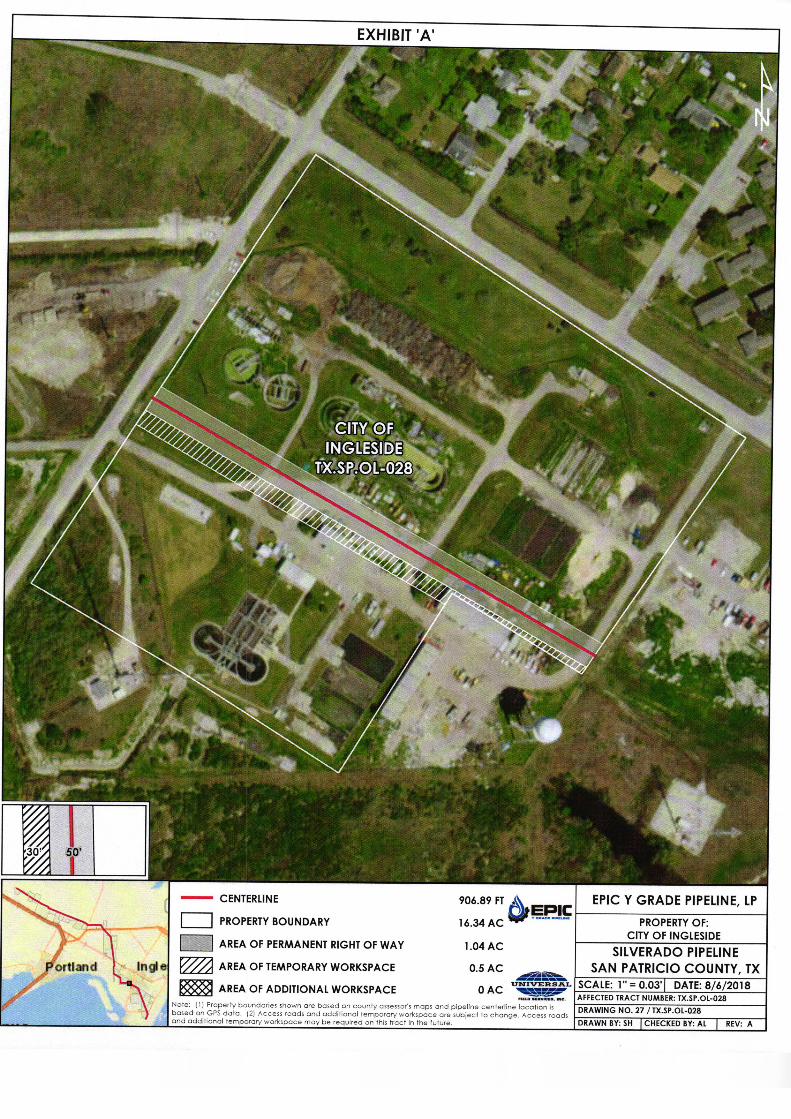
EXHIBIT ' A'
amu -, -' --::
4;,,,,''''
l';* '''
7' " j z
4'teak
7
CITY OFXGLE DSI E
4
TX•SP. OL- 028
4,..
i!, s, 41*-
s
VP
4.
I
11(
30° 50'
CENTERLINE 906. 89 FT
cvaoFgeECEPIC Y GRADE PIPELINE, LP
1
EPIPROPERTY BOUNDARY 16. 34 AC PROPERTY OF:
CITY OF INGLESIDEAREA OF PERMANENT RIGHT OF WAY 1. 04 AC
SILVERADO PIPELINE
Portland Itltlle AREA OF TEMPORARY WORKSPACE 0. 5 AC SAN PATRICIO COUNTY, TXv E L SCALE: 1"= 0. 03' DATE: 8/
282018AREA OF ADDITIONAL WORKSPACE QAC _—
AFFECTED TRACT NUMBER: TX. SP. OL- 028Nte: ( Ij Property boundaries shown arebased oncountyassessor' smaand pipelineenteilocation• is WDRAWING NO. 27/ TX. SP. OL- 028based on GPS data. ( 2) Access roads and additional temporaryworkspace are subject to change. Access roadsand additional temporary workspace may be required on this tract in the future. DRAWN BY: SH CHECKED BY: AL I REV: A

EPIC Y GRADE PIPELINE, LP
EXHIBIT" A"SAN PATRICIO COUNTY, TEXAS
PERMANENT PIPELINE EASEMENT DESCRIPTIONOXY LATERAL PIPELINE
TRACT NO.: TX-SP- OL- 029.00
DESCRIPTION OF A 50 FOOT WIDE PERMANENT PIPELINE EASEMENT BEING 25 FEET LEFT OFAND 25 FEET RIGHT OF THE HEREIN DESCRIBED SURVEYED BASELINE OUT OF A CALLED 2 ACRETRACT OF LAND SITUATED IN THE D. L.& C. CO. SURVEY, ABSTRACT NO. 387 AND THE W. MC.DONOUGH SURVEY, ABSTRACT NO. 184, SAN PATRICIO COUNTY, TEXAS, IN THE NAME OF CITYOF INGLESIDE, RECORDED IN DOCUMENT NUMBER 178039, REAL PROPERTY RECORDS SANPATRICIO COUNTY, TEXAS ( R. P. R. S. P. C. T.), BEING MORE PARTICULARLY DESCRIBED ASFOLLOWS:
BEGINNING( P. O.B., X:1398755.31, Y:17206390.39) at the West line of said 2 acre tract, and an East lineof a called 16. 5 acre tract of land recorded in Document Number 317669, Deed Records San PatricioCounty, Texas( D. R. S. P. C. T.), from which a 5/8 inch iron rod found for the Southwest corner of said 2 acretract bears: South 32° 02' 50" West, a distance of 327. 55 feet;
THENCE, South 62° 21' 20" East, a distance of 300. 91 feet, to the POINT OF EXIT( P. O. E., X: 1399021. 87,Y: 17206250. 77) at the East line of said 2 acre tract, and the Northwest line of a 12. 793 acre tract of landrecorded in Document Number 447870 ( R. P. R. S. P. C. T.), from which a 1/ 2 inch iron rod found for theNortheast corner of said 2 acre tract, bears: North 33° 04' 01" East, a distance of 34.53 feet.
The herein described centerline traverses said 2 acre tract a total distance of 300. 91 linear feet18.24 rods).
Certification is made only to the location of this easement according to evidence and/ or lines of occupationobserved upon the date of this field survey. Only utilities/ easements that were visible and apparent on thedate of this survey, within/ adjoining the described easement, have been located, shown and/ or describedhereon of which I have knowledge of. This certification is limited to those persons or entities shown on theface of this exhibit, is non- transferable and made for this transaction only.
Title information has been provided by the Client; as such, Open Range Field Services does not warrant orguarantee that all conflicts, easements or encumbrances are shown. Adjoiner information shown ordescribed is for informational purposes only.
All bearings, distances and coordinates contained herein are grid, based upon the Texas State PlaneCoordinate System, South Zone, of the North American Datum 1983( NAD83, Realizations 2011, Epoch2010. 00), in U. S. Survey Feet.
A survey exhibit of even date accompanies and is a part of this easement description( EXHIBIT" B").
Codi Lamberson Date
Registered Professional
Land Surveyor No. 6480
Open Range Field Services, LLC1503 S. Barnes
Pampa, Texas 79065Date of Survey: August 16, 2018
806) 665-0770
SHEET 1 OF 2

200100' 100' 290'
EXHIBIT " B"200'
SAN PATRICIO COUNTY, TEXASPIPELINE EASEMENT PLAT
LEGENDTOTAL LENGTH: 300. 91 FEET OR 18. 24 RODSH 1 PERMANENT EASEMENT
TOTAL EASEMENT: 0. 35 ACRESIZ= ZZZI TEMPORARY WORKSPACErr— EXISTING PIPELINEESR— OVERHEAD POWERLINE
ROAD WAY LINE TABLESUBJECT TRACT LINE BEARING DISTANCE0 CALCULATED POINTMONUMENT FOUND 1 S 6221' 20" E 300, 91'
0 POWER POLE
r--- 1 BUILDING
S-:'s>\\
z7
IMANF"
rFASFI` 043..4, 17.>„.7.
p
MF
JNNN\ // \\ \DIF 24/4
iNFNTFBF R\\
MF
7 \
tio eTySloti e AFF DETAIL
Q,
2J
I SCALE: 1= 50'
N.--,:`, T. MC DONOUGH
D. L.& C. CO.
1\
NN SA Rf 84SURVEY \r • -
oyp A- 387
TX- SP- OL- 028. 00
i\ \O CITY OF INGLESIDE
yp CALLED 16. 5 ACRES
O
DOCUMENT NO. 317669
vi% yp
D. R. S. P. C. T.
I\\ \ /\ 0,9p
P. O. B.
X: 1398755. 31 \ \Y. 17206390. 39 \' N.
i 1, TX- SP- OL- 030. 00
NI__`, I ypCITY OF INGLESIDECALLED 12. 793 ACRES
jiO DOCUMENT NO. 44787070
i`-...........„:44:17Air
yp R. P. R. S. P. C. T.;
OAj
RODFONryoLhPROD FOUND
5O \` i;- oypN33° 04' 01"' +
oSLEG34. 5'3-;
fyTOWER
ONIX:
1Al01.87 \\'\'
ROD
5/ 8"
FOUND Y: 17206250. 77
ITX- SP- OL- 029. 00 USCOC OF CORPUS CHRISTI, INC.,
T.T. WILLIAMSON CITY OF INGLESIDE A TEXAS CORPORATION
SURVEY CALLED 2 ACRES I DOCUMENT
CL6. 96
447868
R
A- 294DOCUMENT NO. 178039
R. P. R. S. P. C. T.R. P. R. S. P. C. T.
NQS1. CERIFEADON 15 MADE ONLY TO TEE LOCATION OF THIS EASEMENT ACCORDING TO EVIDENCE
AND/ OR LNES OF OCCLPATDN OBSERVED UPON TEE DATE OF THIS FIELD SURVEY. ONLYUTILITIES/ EASEMENTS THAT WERE NOBLE AND APPARENT ON THE DATE OF THIS SURVEY.NRHN ADIOIRINO TIE DESCRIBED EASEMD4T. HAVE BEEN LOCATED. SHOWN AND/ OR DESCRIBEDHERM OF WHICH I HAVE KNOWLEDGE OF. THS CERTFICAT10N IS LACED TO THOSE PERSONS ORMITES SHOWN ON TRE FACE OF THIS EXHIBIT. IS NON- TRANSFERABLE AND MADE FOR THISTRANSACTION ONLY.
2. TIRE INFORMATION HAS BEEN PROVIDED DY THE CLIENT: AS SUCH. OPEN RANCE FIELD SERVICESDOES NOT WARRANT OR GUARANTEE THAT ALL CONFLICTS. EASDAENTS OR ENCUMBRANCES ARESHOWN. ADIONER WIFORLMTION SHOWN OR DESCRIBED S FOR INFORMATIONAL PURPOSES ONLY.
PRELIMINARY, THIS DOCUMENT SHALL NOT BE3. ALL BEARINGS. DISTANCES AND COORDINATES CONTAEED HERON ARE GRID, BASED UPON THETEXAS STATE PLANE COORDINATE SYSTEM. SOUTH ZONE. OF THE NORTH AMERICAN DATUM 1983 RECORDED FOR ANY PURPOSE AND SHALL NOT BENADR3. REA/ RADON 2011. EPOCH 2010. 00). IN U. S. SURVEY FEET. USED OR VIEWED OR RELIED UPON AS A FINAL4. THE OUTER UMRS OF THE FERNANENT EASEMENT EXIFNDS OR SHORTENS TO THE RESPECTIVE
SURVEY DOCUMENT."TRACT ONES TEMPORARY WORKSPACE UES ADJACENT AND CONTNUOUS TO THE PERMANENTEASEMENT UNLESS LADIES OTHERWISE
CODI LAMBERSON, R. P. L. S. No. 64805. EASEMENT DES( NPRON OF EVEN DATE ACCOAPANES AND IS A PART OF THIS SURVEY COMOEXHIBIT' Al. SURVEYED ON THE GROUND: August 16, 2018
PIPELINE, STATION, OR ACCOUNT NUMBER SCALE CONST. YR1503 S. BARNES PAMPA. TX 79065 PROJECT NO.OXY LATERAL 1" = 200' 2018 OLetr TBPOLeaeess'ano'
RENUMBER CADD FILENAME DRAWN DATE HANE.,'. 393501H- 10VVEST. BOERNE. TXMOOS
ORFS_ 600_ 1TBPLS No.' 10194069FCD9ER4' iCES, LLC.N/ A TX- SP- OL- 029. 00. DWG LD 9- 10- 18 0 830. 816. 5009
REV. NO. - DESCRIPTION BY DATE APP. PREVIOUS DWG. NO.
EPIC Y GRADE SMT. - OF -
PIPELINE LP DWG. NO.
TX OF- 029. 00A

EXHIBIT ' A'
J Yi'
a4 .
a.
AMERICAN TOWER
CORPORATION I*OL- O29
s
S
I
30' 50'
CENTERLINE 24. 46 FT EPIC Y GRADE PIPELINE, LPutEPIC
PROPERTY BOUNDARY 0. 33 ACAa
PROPERTY OF:
AMERICAN TOWER CORPORATIONAREA OF PERMANENT RIGHT OF WAY 0. 03 AC
SILVERADO PIPELINE
Portland Ingle M AREA OF TEMPORARY WORKSPACE 0. 02 AC SAN PATRICIO COUNTY, TX
UNVIESSCALE: 1"= 0. 01' DATE: 8/ 6/ 2018Y. AREA OF ADDITIONAL WORKSPACE 0 AC ;
RAL
AFFECTED TRACT NUMBER: TX. SP. OL- 029lute; ( I( Property boundaries shown are based on county assessor' s maps and pipeline centerline location ...
DRAWING NO. 29/ TX. SP. OL- 029cased an GPS data. ( 2( Access roads and additional temporary workspace are subject to change. Access roadsand additional temporary workspace may be required on this tract in the future. DRAWN BY: SH I CHECKED BY: AL I REV: A

EPIC Y GRADE PIPELINE, LP
EXHIBIT" A"
SAN PATRICIO COUNTY, TEXAS
PERMANENT PIPELINE EASEMENT DESCRIPTIONOXY LATERAL PIPELINE
TRACT NO.: TX-SP- OL-030.00
DESCRIPTION OF A 50 FOOT WIDE PERMANENT PIPELINE EASEMENT BEING 25 FEET LEFT OFAND 25 FEET RIGHT OF THE HEREIN DESCRIBED SURVEYED BASELINE OUT OF A CALLED 12. 793
ACRE TRACT OF LAND( REMAINDER), BEING A PORTION OF FARM LOTS 12 AND 13, BLOCK 90 OFTHE T. P. McCAMPBELL SUBDIVISION, RECORDED IN VOLUME 1, PAGE 2, MAP RECORDSARANSAS COUNTY, TEXAS( M. R. A. C. T.), SITUATED IN THE W. MC. DONOUGH SURVEY, ABSTRACT
NO. 184, SAN PATRICIO COUNTY, TEXAS, IN THE NAME OF CITY OF INGLESIDE, RECORDED INDOCUMENT NUMBER 447870, REAL PROPERTY RECORDS SAN PATRICIO COUNTY, TEXASR. P. R. S. P. C. T.), BEING MORE PARTICULARLY DESCRIBED AS FOLLOWS:
BEGINNING( P. O. B., X: 1399021. 87, Y: 17206250. 77) at the Northwest line of said 12. 793 acre tract, andthe Southeast line of a called 2 acre tract of land recorded in Document Number 178039( R. P. R. S. P. C. T.),
from which a 1/ 2 inch iron rod found on the Northwest line of said 12. 793 acre tract, for the Northeast corner
of said 2 acre tract, bears: North 33° 04' 01" East, a distance of 34.53 feet;
THENCE, South 62°2120" East, a distance of 39.58 feet, to the POINT OF EXIT( P. O.E., X:1399056.93,
Y:17206232. 41) at an Easterly line of said 12. 793 acre tract, and the Northwest line of a 6.01 acre tract ofland recorded in Document Number 447868( R. P. R. S. P. C.T.), from which a calculated corner found for aninterior corner of said 12. 793 acre tract, bears: North 32° 52' 12" East, a distance of 58.88 feet.
The herein described centerline traverses said 12. 793 acre tract a total distance of 39. 58 linear feet2. 39 rods).
Certification is made only to the location of this easement according to evidence and/ or lines of occupationobserved upon the date of this field survey. Only utilities/ easements that were visible and apparent on thedate of this survey, within/ adjoining the described easement, have been located, shown and/ or describedhereon of which I have knowledge of. This certification is limited to those persons or entities shown on the
face of this exhibit, is non- transferable and made for this transaction only.
Title information has been provided by the Client; as such, Open Range Field Services does not warrant orguarantee that all conflicts, easements or encumbrances are shown. Adjoiner information shown or
described is for informational purposes only.
All bearings, distances and coordinates contained herein are grid, based upon the Texas State Plane
Coordinate System, South Zone, of the North American Datum 1983( NAD83, Realizations 2011, Epoch
2010. 00), in U. S. Survey Feet.
A survey exhibit of even date accompanies and is a part of this easement description( EXHIBIT" B").
Codi Lamberson Date
Registered Professional
Land Surveyor No. 6480
Open Range Field Services, LLC
1503 S. Barnes
Pampa, Texas 79065 Date of Survey: August 16, 2018806) 665- 0770
SHEET 1 OF 2

200' 100' 0 100' 200'
EXHIBIT `` B"200' SAN PATRICIO COUNTY, TEXAS
PIPELINE EASEMENT PLATLEGEND TOTAL LENGTH: 39. 58 FEET OR 2.39 RODS
1 PERMANENT EASEMENT TOTAL EASEMENT: 0.05 ACRESzzzi TEMPORARY WORKSPACE
ii- EXISTING PIPELINE AI
OVERHEAD POWERL. INEIV
ROAD WAY LINE TABLESUBJECT TRACT
LINE BEARING DISTANCECALCULATED POINT
MONUMENT FOUND 1 S 62' 21' 20" E 39. 58'0 POWER POLE
Ic
mss\
p6Fg3MFF'VT -
IV& M.C. DONOUGH // \\ Nr
SURVEYD. L.& C. CO.
A- 184 1hSURVEY
A- 387s
qTF\ iTX- SP- OL- 028. 00
P Rg<\CITY OF INGLESIDE FgSFMNFNT
p/
pFNF\
lCALLED 16. 5 ACRES FNT Y
0/..,,, DOCUMENT NO. 317669
D. R. S. P. C. T. 8T/1
STRfir\ \
Grp
moii› \
QIDETAIL
HF N 33° 04' 01" E TX- SP- OL- 030. 00 \ SCALE 1= 50'
P. O. B. 34. 53
1/ 2" IRON \ CITY OF INGLESIDE
Y: 17206250. 77 '\ *
e.ROD FOUND \
CAL(
REEMAIND
12. 793
R
RES
CORNERTED \
DOCUMENT NO. 447870- .
Oy R. P. R. S. P. C. T.
OTS 12
TX- SP- OL- 029. 007' `'\' qyb /
FARM
BLOCK 90,
AND 13
T. P. McCAMPBELLCITY OF INGLESIDE 1 . \\%........ SUBDIVISIONCALLED 2 ACRES
DOCUMENT NO. 178039 , VOLUME 1, PAGE 2R. P. R. S. P. C. T.
O M. R. A. C. T.
N35888' \\ \'/H
P. O. E. X: 1399056. 93
Y: 17206232. 41 Ai,.. o„,,,,
USCOC OF CORPUS81, ' f\\
ice\ O/yoCHRISTI, INC.,
A TEXAS CORPORATION
j\....,.../:::„...,
i \CALLED 6. 01 ACRES
DOCUMENT NO. 447868Com /
j „""..-0'OyF
R. P. R. S. P. C. T. J ',
T.T. WILLL4MSON 0,'
SURVEY
A- 294
IWPROPERTIESJBLW PROPERTIES LTD
CALLED 31. 032 ACRES
EXHIBIT" B"
DOCUMENT NO. 596444
O. P. R. S. P. C. T.
NEE& 11. CERTIFICATION 15 MADE ONLY TO THE LOCATION CF THIS EASEMENT ACCORDING TO EVIDENCE
AND/ CFI LIDS OF OCCUPATION OBSERVED UPON TIE DATE OF THIS FIELD SURVEY. ONLY
uTTLE11Es/ EASERENTS THAT WERE VISIBLE AND APPARENT ON THE DATE OF THIS SURVEY,
NRHEASEMENT,ADJOININO TIE DESCRIBED EASEMENT, KANE BEEN LOCATED, SHOWN AND/ OR DESCRIBED
HEREOF! OF WHICH I HAVE KNOWLEDGE OF. THIS CERTFICAIWN IS UNITED TO THOSE PERSONS OR
ENRTFS SHOWN ON TEE FACE OF THIS EXHIBIT. IS NON- TRANSFERABLE AND MADE FOR THISTRANSACTION ONLY.
2. 1TTLE INFORMATION NNS BEEN PROVEED BY THE CLIENT: AS SUCH, OPEN RANGE FIELD SEREHCES
DOES NOT WARRANT OR GUARANTEE THAT ALL CONFIJCTS, EASEMENTS OR ENCUMBRANCES Aft;SHOWN. ACJONER NFIXUHTION SHOWN OR DESCRIBED IS FOR INFORIAATONAL PURPOSES ONLY.
PRELIMINARY, THIS DOCUMENT SHALL NOT BE3. ALL BEARINGS, DISTANCES AND COORDINATES CONTAINED HEREIN ARE GRID, BASED UPON THE
TEXAS STATE PLANE COORDINATE SYSTEM. SOUTH ZONE. OF THE NORTH AMERICAN DATUM 1562 RECORDED FOR ANY PURPOSE AND SHALL NOT BENAD83. REALRATON 2011. EPOCH 2010. 00), IN U. S. SURVEY FEET. USED OR VIEWED OR RELIED UPON AS A FINAL
4. THE OUTER WMITS OF THE PERMANENT EASEMENT EXTENDS OR SHORTENS' TO THE RESPECTIVE SURVEY DOCUMENT."TRACT UNE& TEMPORARY WORKSPACE UES ADJACENT AND CONTNUOUS TO THE PERMANENT
EASEMENT UNLESS NOTED OTHERWISE CODI LAMBERSON, R. P. L. S. No. 64805, EASEMENT DESCRIPTION OF EVEN DATE ACCOMPANIES AND IS A PART OF THS SURVEY INHIBIT
E811BR X'). SURVEYED ON THE GROUND: August 16, 2018
PIPELINE, STATION, OR ACCOUNT NUMBER SCALE CONST. YR1503 S. BARNES PAMPA. TX 79065 PROJECT NO.
OXY LATERAL 1" = 200' 2018 Elms! TBPLS No: 10193994
FILENUMBER CARD FILENAME DRAWN DATE RANGE. 39350H- 10o EST, BOEn0393501H- 10 WEST, PUERNE. TX ERODES
ORFS- 600- 1N/ A TX—SP—OL- 030. 00. DWG U) 9_ 10- 18
FIELD SERVICES, LC. TBPLSN°. ID194069
O. 830. 81& I
REV. NO. - DESCRIPTION BY DATE APP, PREVIOUS DWG. NO.
EPIC Y GRADE SHT. — OF —
PIPELINE LPDWG. NO.
1 TX- SP- OL- 030, 00nSHT. 2 OF 2 Li

EXHIBIT ' A'r
4/ tkI .-*
4r / Or
Xr
e1tikk.
4..
i
aCITYOF 14e,i,
INGLESIDE
t; ;.
TX. SP. OL- 030
i*-2, —
1,.
r ' -,e.' ;:;":
ir
n.
P
is
30 50'i It.
CENTERLINE 621. 01 FT . EPIC Y GRADE PIPELINE, LPEPIC
PROPERTY BOUNDARY 16. 47 AC PROPERTY OF:
CITY OF INGLESIDEAREA OF PERMANENT RIGHT OF WAY 0. 71 AC
SILVERADO PIPELINEPortland Intjl e 77/ AREA, OF TEMPORARY WORKSPACE 0. 43 AC SAN PATRICIO COUNTY, TX
UMWER= L SCALE: 1"= 0. 05' DATE: 8/ 6/ 2018i
AREA. OF ADDITIONAL WORKSPACE 0 AC =AFFECTED TRACT NUMBER: TX. SP. 01- 030
Nate: ) 1) Property boundaries shown are based on county assessors maps and pipeline centerline location is
me
DRAWING NO. 30/ TX. SP. OL- 030based on GPS data. ) 2) Access roads and additional temporary workspace are subject to change. Access roadsand additional temporary workspace may be required on this tract in the future. DRAWN BY: SH I CHECKED BY: AL I REV: A