Maroochy River Mouth Cost-Benefit Assessment
49
Maroochy River Mouth Cost-Benefit Assessment Final Report June 2017 Sunshine Coast Council Locked Bag 72 Sunshine Coast Mail Centre QLD 4560
Transcript of Maroochy River Mouth Cost-Benefit Assessment
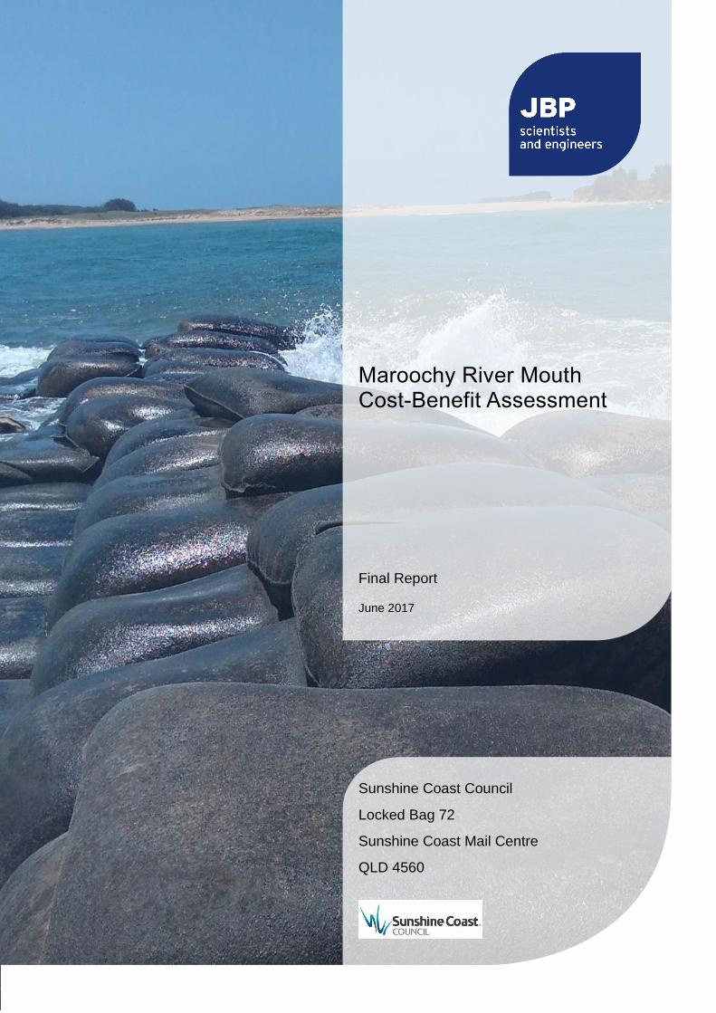
Maroochy River Mouth Cost-Benefit Assessment
Final Report
June 2017
Sunshine Coast Council
Locked Bag 72
Sunshine Coast Mail Centre
QLD 4560

2017s5772 - SCC - Maroochy Groynes CBA Final Report v2.0.docx i
JBA Project Manager Daniel Rodger Jeremy Benn Pacific Level 2, 433 Boundary Street Spring Hill QLD 4004 Australia
Revision History
Revision Ref / Date Issued Amendments Issued to
1.0 / 07.04.2017 Draft Internal Draft GK (SSC)
1.1 / 25.04.2017 Draft Revised costing GK (SSC)
1.2 / 24.05.2017 Draft Following internal review GK, MA (SSC)
2.0 / 24.05.2017 Final Final Report GK, MA (SSC)
Contract This report describes work commissioned by Michael Anderson, on behalf of the Sunshine Coast Council, by a letter dated 09/03/2017. Sunshine Coast Council’s representative for the contract was Georgia Keeshan. The Jeremy Benn Pacific (JBP) team included Pamela Wong, Lachlan Attard and Daniel Rodger.
Prepared by .................................................. Pamela Wong BEng(Civil)
Civil Engineer
....................................................................... Lachlan Attard BEng(Civil)(Hons)
Civil Engineer
Reviewed by .................................................. Angus Pettit BSc MSc CEnv CSci MCIWEM C.WEM
Chartered Principal Analyst (JBA Consulting)
Reviewed by .................................................. Elisa Zavaldi PhD BEng BSc IEAust
Senior Geomorphologist (Alluvium)
Approved by .................................................. Daniel Rodger BSc MEng CEng CMarEng MIEAust MICE IMarEST
RPEQ 17794
Director
Purpose This document has been prepared as a Final Report for Sunshine Coast Council. JBP accepts no responsibility or liability for any use that is made of this document other than by the Client for the purposes for which it was originally commissioned and prepared.
JBP has no liability regarding the use of this report except to Sunshine Coast Council.

2017s5772 - SCC - Maroochy Groynes CBA Final Report v2.0.docx ii
Acknowledgements JBP would like to acknowledge the support provided by of Sunshine Coast Council throughout the project, Rider Levett Bucknall (RLB) for their role as quantity surveyors, and Alluvium for geomorphologic advice.
Copyright © JBA Pacific Scientists and Engineers Pty Ltd 2017
Trading as Jeremy Benn Pacific and JBP Scientists and Engineers
ABN: 56 610 411 508
ACN: 610 411 508
2017s5772 - SCC - Maroochy Groynes CBA Final Report v2.0.docx iii
Executive Summary This study was undertaken by Jeremy Benn Pacific (JBP), on behalf of the Sunshine Coast Council (SCC). The purpose of the study was to undertake a coastal economic analysis at Maroochy River mouth, Maroochydore, for a range of coastal protection options. Due to the meandering river mouth and coastal erosion issues, four geotextile (sandbag) groynes have been constructed to help stabilise the area at the Cotton Tree beach. These groynes are now nearing the end of their functional life, with new replacement options now being considered by Council. Due to the range of options, stakeholders and interested parties, the SCC has undertaken a preliminary economic appraisal as the first stage of a process to select the preferred management option.
The study involved modelling of coastal extremes to determine design conditions for new structures, and the preparation of new designs and whole life-cycle costs for a replacement groyne field using rock or geotextiles sand containers. Also included is a high-level costing of three other coastal protection options; a single large terminal groyne, and two options to re-establish the Maroochy River mouth to the north of Pincushion Island. These three alternative options have not yet progressed through the design stage with Council, and the intention of this study is to consider their likely merits before additional work is undertaken.
The study uses a Cost-Benefit Assessment (CBA) to consider the economic justification for each option. The CBA compares whole life-cycle costs against the benefits of each coastal protection scheme. Expressed in monetary terms, the costs and benefits were estimated for the entire Local Government Area (LGA) over a period of 50 years. Calculated as benefit / costs, a scheme is considered beneficial for values over 1 (i.e. where benefits outweigh costs), with larger values considered to have a greater economic benefit. The CBA considers costs for planning, licenses, design, capital costs, inspections, maintenance and upgrades throughout a 50-year period. Benefits include the land protected by the scheme, the assets and infrastructure located on that land, the role of the caravan park on tourism and visitor spending within the LGA, and the potential to reduce the need for ongoing beach nourishment.
The CBA indicate all options have a positive cost benefit ratio, and are therefore considered economically viable. This is due to the protection of high-value coastal land, and the significant role of the caravan park in accommodating visitors to the LGA.
The CBA enabled the comparison of the replacement rock and geotextile groyne fields, with results indicating rock to be the more financially beneficial material. The use of rock involves relatively high construction costs, however has low ongoing maintenance costs throughout the 50-year design life. This is shown to be more cost effective compared to geotextile groynes, which have lower initial construction costs but significantly higher maintenance requirements and will require three replacements to span the 50-year period.
Outcomes of the CBA indicate that a single large rock groyne (as compared to a groyne field) is the most economically beneficial option for future coastal management. This option is proposed to have the duel benefit of providing protection to Cotton Tree beach, whilst reducing the need for ongoing beach nourishment along the Maroochydore to Alexandra Headland coast. Based on an early conceptual design only, the position and length of the structure is considered indicative. The subsequent design requirements have been accounted for within the CBA through the inclusion of additional costs for studies, designs, modelling and maintenance. The performance of the structure on reducing beach nourishment costs is indicative only, and would require further assessment through a sediment transport investigation. In order to remain the most cost-beneficial, a position and orientation would need to be identified that offered protection to the Cotton Tree beach, minimised annual nourishment costs, did not incur other damages such as downdrift erosion, and did not significantly change the structure dimensions, and therefor costs.
Additional outcomes of the CBA indicate the two options to re-establish the Maroochy River mouth to the north of Pincushion Island have the lowest economic justification. This is primarily due to considerably higher construction costs, approximately double that of the groyne field replacement options. These options would also require considerable investigation into short and long term implications for geomorphic and sedimentation processes at the Maroochy River mouth and adjacent coastline.
This study has focused on the economic viability of the options. The outcomes will enable Council to proceed with subsequent investigations and consultation required to inform the design of suitable coastal protection works that meet the range of environmental, social and economic objectives for the dynamic Maroochy River mouth.
Contents
2017s5772 - SCC - Maroochy Groynes CBA Final Report v2.0.docx iv
Executive Summary ............................................................................................................ iii
1 Introduction ............................................................................................................ 1
1.1 Existing site conditions ....................................................................................................... 3 1.2 Report Structure ................................................................................................................. 4
2 Overview of coastal erosion context and coastal zone economics ....................... 6
2.1 Coastal erosion context ...................................................................................................... 6 2.2 Coastal erosion risk assessment........................................................................................ 6 2.3 Background to coastal zone economics ............................................................................. 7 2.4 Quantifying benefits and costs ........................................................................................... 7
3 Design criteria for new infrastructure ..................................................................... 9
3.1 Datum ................................................................................................................................ 9 3.2 Groyne referencing ............................................................................................................ 9 3.3 Design standards ............................................................................................................... 9 3.4 Climate change .................................................................................................................. 9 3.5 Coastal extremes ............................................................................................................... 9 3.6 Geotechnical analysis ........................................................................................................ 12
4 Design Options ...................................................................................................... 13
4.1 Option 1: Rock groyne field ................................................................................................ 14 4.2 Option 2: Geotextile groyne field ........................................................................................ 16 4.3 Option 3: Single 200m rock groyne .................................................................................... 18 4.4 Option 4: Construction of northern entrance with beach .................................................... 20 4.5 Option 5: Construction of northern entrance with breakwater ............................................ 22
5 Economic assessment ........................................................................................... 24
5.1 Introduction ........................................................................................................................ 24 5.2 Estimating benefits ............................................................................................................. 24 5.3 Sensitivity testing ............................................................................................................... 30 5.4 Comparison of rock and geotextile groynes ....................................................................... 32 5.5 Discussion of the economically preferred option ................................................................ 32
6 Summary ............................................................................................................... 33
A Appendix - Concept drawing of replacement groyne field ..................................... I
B Appendix - P90 costing information ....................................................................... II
C Appendix - Cost-benefit appraisal summary sheet ................................................ III
D Appendix - Example coastal economic analysis ................................................... IV

2017s5772 - SCC - Maroochy Groynes CBA Final Report v2.0.docx v
List of Figures Figure 1-1: Location of Maroochy River mouth, Maroochydore ....................................... 1
Figure 1-2: Maroochy River groynes, Maroochydore ....................................................... 2
Figure 1-3: Aerial photograph taken in 1958 (left), 1980 (right), and 2004 (bottom) ........ 3
Figure 1-4: Image of existing geotextile groyne No. 4 (northernmost) at high tide, showing wave overtopping (JBP, 16 Feb 2017) .............................................................. 4
Figure 1-5: Image of existing geotextile groyne No. 2 at low tide, showing deterioration (JBP, 10 April 2017) .......................................................................................... 4
Figure 2-1: Adopted erosion prone area ........................................................................... 6
Figure 3-1: Computational grid ......................................................................................... 10
Figure 3-2: Computational bathymetry (showing depth) .................................................. 11
Figure 3-3: Nearshore wave conditions from 2019 to 2069 at -2mAHD .......................... 12
Figure 4-1: Top view of rock groyne field ......................................................................... 14
Figure 4-2: Design cross section of rock groyne (mid-way along structure) .................... 15
Figure 4-3: Design cross section of GSC groyne ............................................................. 16
Figure 4-4: Single new 200m southern groyne................................................................. 18
Figure 4-5: Construction of new river entrance with beach (based on BMT WBM, 2016) 20
Figure 4-6: Construction of river entrance with breakwater (BMT WBM, 2016) ............... 22
Figure 5-1: Predicted lost assets and infrastructure at risk of erosion ............................. 24
Figure 5-2: Property valuation examples at Macarthur Park ............................................ 25
List of Tables Table 3-1: Extreme storm tide levels ................................................................................ 9
Table 3-2: Summary of extreme offshore wave conditions .............................................. 10
Table 3-3: Nearshore wave conditions from 2019 to 2069 for 1 in 50-year event. .......... 11
Table 3-4: Bearing capacity and soils profile information. ................................................ 12
Table 4-1: Length and orientation of groynes (based on existing) ................................... 14
Table 4-2: Cost estimates for Option 1: Rock groyne field ............................................... 15
Table 4-3: Cost estimates for Option 2: Geotextile groyne field ....................................... 17
Table 4-4: Cost estimates for Option 3: Single 200m rock groyne ................................... 19
Table 4-5: Cost estimates for Option 4: Construction of north entrance with beach ........ 21
Table 4-6: Cost estimates for Option 6: construction of north entrance with breakwater 23
Table 5-1: Summary of erosion losses ............................................................................. 25
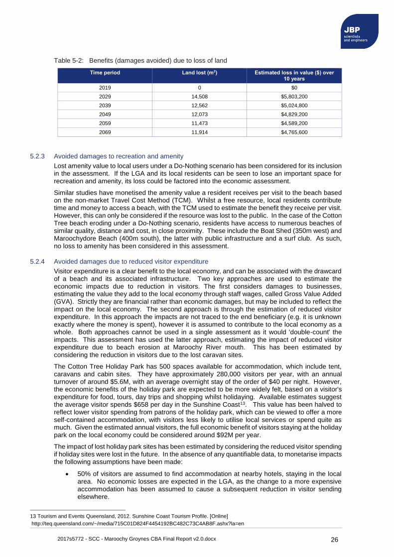
Table 5-2: Benefits (damages avoided) due to loss of land ............................................. 26
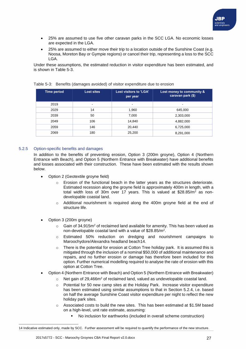
Table 5-3: Benefits (damages avoided) of visitor expenditure due to erosion ................. 27
Table 5-4: Construction and maintenance costs summary ($, Millions) ........................... 29
Table 5-5: Summary of benefit-cost calculation ($, Million), based on 3.5% discount rate ........................................................................................................................... 29
Table 5-6: Impact of cost-benefit ratio with different discount rates ................................. 30
Table 5-7: Impact of cost-benefit ratio with reduced erosion extent and rate .................. 30
2017s5772 - SCC - Maroochy Groynes CBA Final Report v2.0.docx vi
Table 5-8: Impact of cost-benefit ratio with different construction dates .......................... 31
Table 5-9: Impact of cost-benefit ratio with different erodable coastal land values.......... 31
Abbreviations AEP ................................. Annual Exceedance Probability
AHD ................................ Australia Height Datum
CBA ................................. Cost-Benefit Assessment
DCP ................................ Dynamic Cone Penetration
DEHP .............................. Department of Environmental and Heritage Protection
DTMR .............................. Department of Transport and Main Roads
GEV ................................ Generalised Extreme Value
GPD ................................ Generalised Pareto Distribution
GSC ................................ Geotextile Sand Containers
GST ................................. Goods and Services Tax
GVA ................................ Gross Value Added
JBA ................................. Jeremy Benn Associates
JBP ................................. Jeremy Benn Pacific
LGA ................................. Local Government Area
MCA ................................ Multi-Criteria Analysis
MV ................................... Market Value
PCEM .............................. Project Cost Estimating Management
POT ................................. Peaks Over Threshold
PV ................................... Present Value
QLD ................................. Queensland
SCC ................................ Sunshine Coast Council
SWAN ............................. Simulating WAves Nearshore (wave model)
TCM ................................ Travel Cost Method
ULS ................................. Ultimate Limit State
WTP ................................ Willingness to Pay
2017s5772 - SCC - Maroochy Groynes CBA Final Report v2.0.docx 1
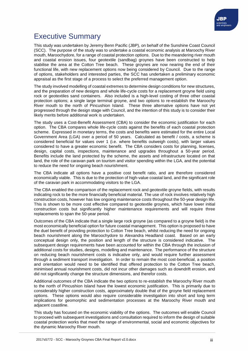
1 Introduction This study was undertaken by Jeremy Benn Pacific (JBP), on behalf of the Sunshine Coast Council (SCC), to prepare a cost-benefit assessment for coastal protection options at the Maroochy River mouth, Maroochydore, Australia (Figure 1-1). Due to the meandering river mouth and coastal erosion issues, four geotextile (sandbag) groynes have been previously constructed to help stabilise the area, which is known as Cotton Tree beach. These groynes are now nearing the end of their functional life, with replacement structures now being considered by Council. Wider coastal management issues have also been considered within this assessment, including the need for regular beach nourishment between the groynes, and along Maroochydore Beach as far as Alexandra Headland.
The study has involved modelling of coastal extremes to determine design conditions for new structures, and the preparation of new designs and costing for five different options. These options consist of a geotextile groyne field, rock groyne field, a large terminal groyne, and two options to re-establish the Maroochy River mouth to the north of Pincushion Island. An economic appraisal and Cost-Benefit Assessment (CBA) has been completed on all options to support selection of a preferred option.
The cost-benefit methodology has been designed to provide a quantitative, financial assessment of ongoing erosion protection at Cotton Tree beach, in terms of value to the Sunshine Coast and the Local Government Area (LGA). This includes tangible benefits such as the land protected by the scheme, the assets and infrastructure located on that land, the role of the caravan park on tourism and visitor spending within the LGA, and the potential to reduce ongoing beach nourishment. The economic benefits of implementing the erosion protection scheme have been compared to the whole-life costs of each design option, presented in terms of a cost-benefit ratio.
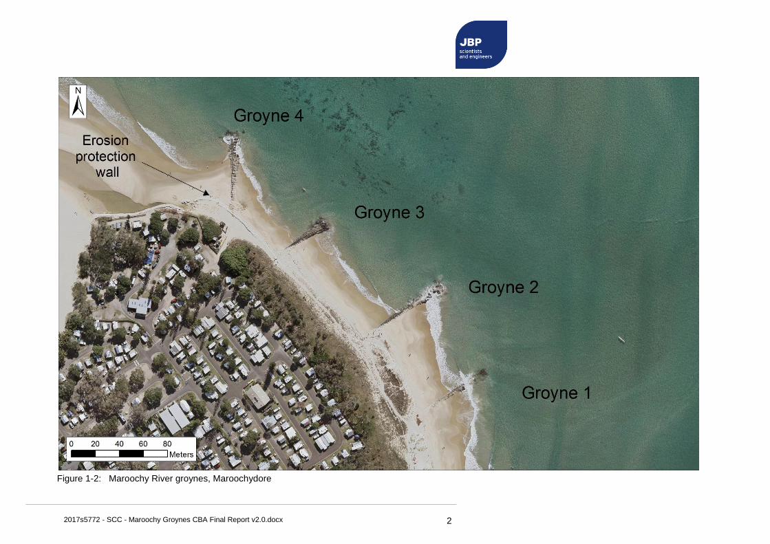
Figure 1-1 and Figure 1-2 shows the location of Maroochy River mouth and groynes adjacent to the Cotton Tree beach.
Figure 1-1: Location of Maroochy River mouth, Maroochydore
Pincushion Island
Maroochy River Island
Cotton Tree Holiday Park
'Cotton Tree beach'
2017s5772 - SCC - Maroochy Groynes CBA Final Report v2.0.docx 2
Figure 1-2: Maroochy River groynes, Maroochydore
Figure 1-2: Maroochy River groynes, Maroochydore
2017s5772 - SCC - Maroochy Groynes CBA Final Report v2.0.docx 3
1.1 Existing site conditions
The Maroochy River is located between Maroochydore and Noosa on the Sunshine Coast. The river mouth is north of Maroochydore Surf Club and located between Cotton Tree Holiday Park and Pincushion Island (Figure 1-1).
The Maroochy River mouth is a dynamic zone and one of the few remaining untrained river entrances in eastern Australia. It includes the Maroochy River Conservation Park, which covers approximately 174ha and includes separate areas on the northern bank of the river, the Channel and Goat Islands in the river mouth, and Mudjimba Island to the north. The Maroochy River Conservation Park Management Plan acknowledges the dynamic nature of the estuary, and that the islands are constantly changing shape and location as the natural course of the river changes.
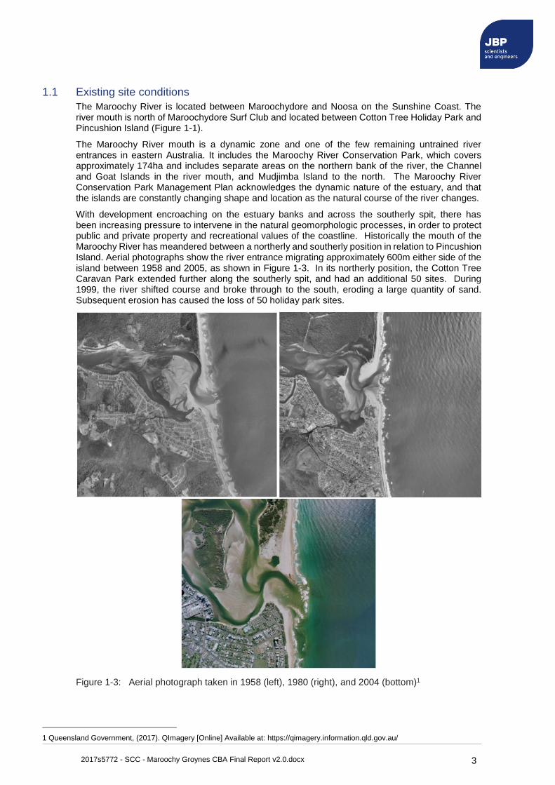
With development encroaching on the estuary banks and across the southerly spit, there has been increasing pressure to intervene in the natural geomorphologic processes, in order to protect public and private property and recreational values of the coastline. Historically the mouth of the Maroochy River has meandered between a northerly and southerly position in relation to Pincushion Island. Aerial photographs show the river entrance migrating approximately 600m either side of the island between 1958 and 2005, as shown in Figure 1-3. In its northerly position, the Cotton Tree Caravan Park extended further along the southerly spit, and had an additional 50 sites. During 1999, the river shifted course and broke through to the south, eroding a large quantity of sand. Subsequent erosion has caused the loss of 50 holiday park sites.
Figure 1-3: Aerial photograph taken in 1958 (left), 1980 (right), and 2004 (bottom)1
1 Queensland Government, (2017). QImagery [Online] Available at: https://qimagery.information.qld.gov.au/
2017s5772 - SCC - Maroochy Groynes CBA Final Report v2.0.docx 4
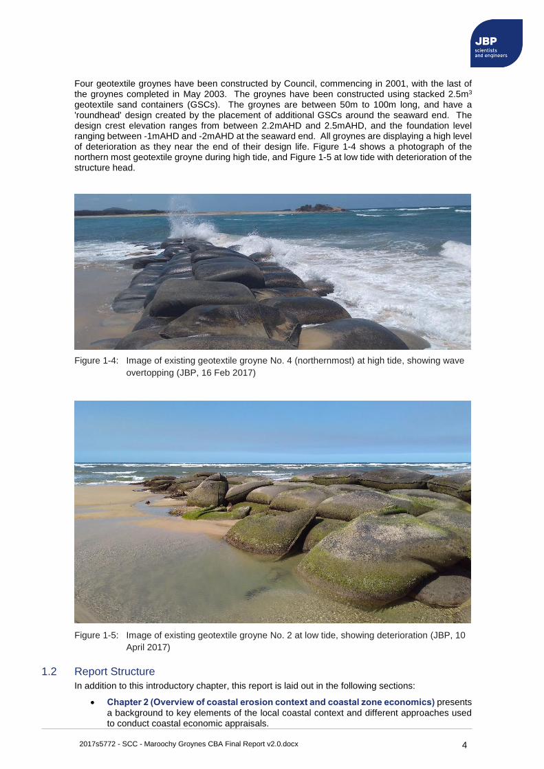
Four geotextile groynes have been constructed by Council, commencing in 2001, with the last of the groynes completed in May 2003. The groynes have been constructed using stacked 2.5m3 geotextile sand containers (GSCs). The groynes are between 50m to 100m long, and have a 'roundhead' design created by the placement of additional GSCs around the seaward end. The design crest elevation ranges from between 2.2mAHD and 2.5mAHD, and the foundation level ranging between -1mAHD and -2mAHD at the seaward end. All groynes are displaying a high level of deterioration as they near the end of their design life. Figure 1-4 shows a photograph of the northern most geotextile groyne during high tide, and Figure 1-5 at low tide with deterioration of the structure head.
Figure 1-4: Image of existing geotextile groyne No. 4 (northernmost) at high tide, showing wave
overtopping (JBP, 16 Feb 2017)
Figure 1-5: Image of existing geotextile groyne No. 2 at low tide, showing deterioration (JBP, 10
April 2017)
1.2 Report Structure
In addition to this introductory chapter, this report is laid out in the following sections:
• Chapter 2 (Overview of coastal erosion context and coastal zone economics) presents
a background to key elements of the local coastal context and different approaches used to conduct coastal economic appraisals.

2017s5772 - SCC - Maroochy Groynes CBA Final Report v2.0.docx 5
• Chapter 3 (Design criteria for new infrastructure) presents design criteria and the
standard of protection for new options considered in this study.
• Chapter 4 (Design and costing of new infrastructure) presents detailed descriptions of all five design options considered in this study, and the estimated whole life-cycle costs for their implementation.
• Chapter 5 (Economic assessment) presents an assessment of the benefits of implementing the preferred strategy, including a benefit-cost assessment.
• Chapter 6 (Summary) presents a summary of the appraisal and recommendations.
2017s5772 - SCC - Maroochy Groynes CBA Final Report v2.0.docx 6
2 Overview of coastal erosion context and coastal zone economics
2.1 Coastal erosion context
Erosion risk is also a changing entity, due to the changing environmental drivers (e.g. sea level rise) and deterioration of any existing coastal protection infrastructure. Coastal erosion is an ongoing risk for social and economic values of the Maroochy River mouth, due to natural processes driving the changing position of the river mouth, and climate drivers of storm activity and sea level rise.
2.2 Coastal erosion risk assessment
As the main drivers for coastal erosion risk, an understanding of the extreme coastal erosion at Maroochy River mouth is required over the assessment period of 50 years. Coastal erosion is considered under a 'Do Nothing' scenario, which assumes extreme sea levels will increase due to climate change, and ongoing coastal erosion will continue unhindered.
2.2.1 Damages due to erosion
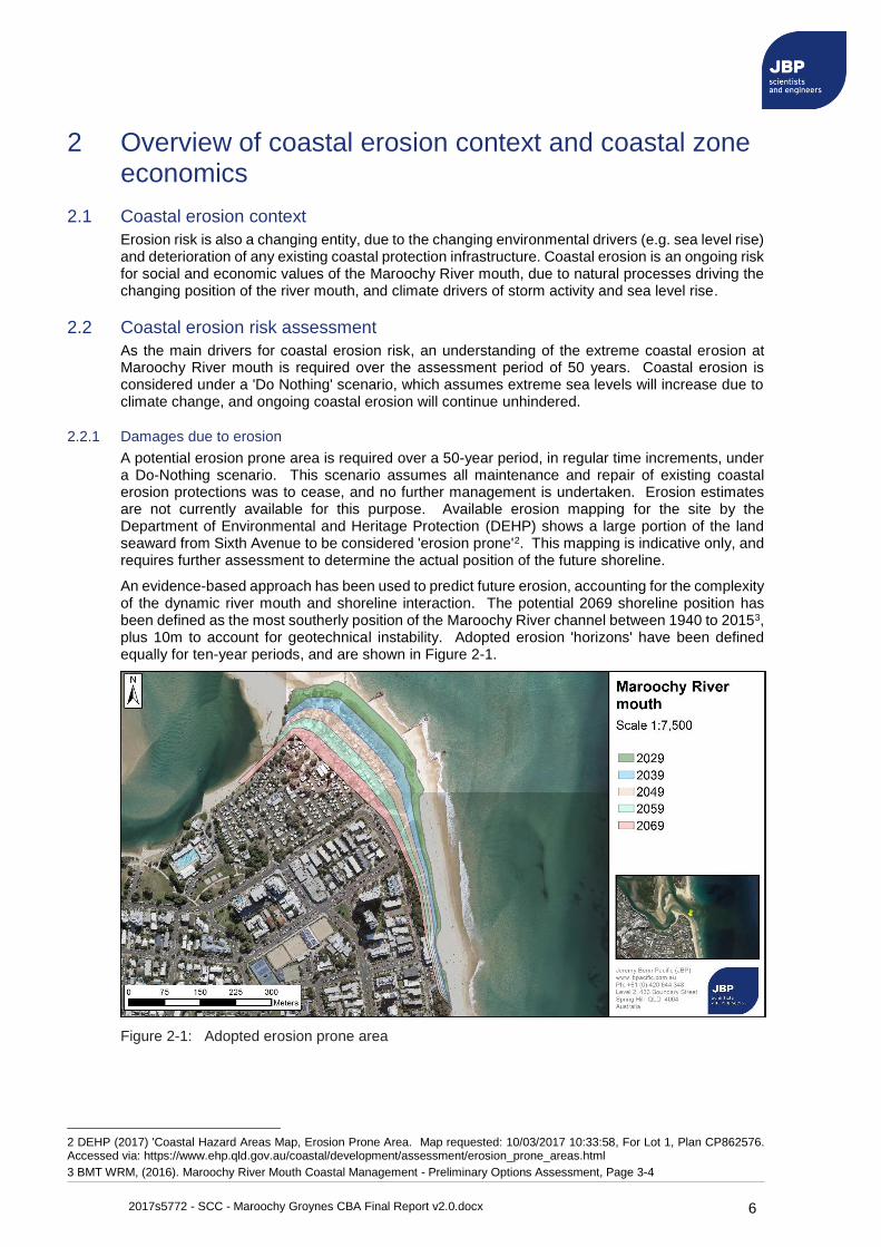
A potential erosion prone area is required over a 50-year period, in regular time increments, under a Do-Nothing scenario. This scenario assumes all maintenance and repair of existing coastal erosion protections was to cease, and no further management is undertaken. Erosion estimates are not currently available for this purpose. Available erosion mapping for the site by the Department of Environmental and Heritage Protection (DEHP) shows a large portion of the land seaward from Sixth Avenue to be considered 'erosion prone'2. This mapping is indicative only, and requires further assessment to determine the actual position of the future shoreline.
An evidence-based approach has been used to predict future erosion, accounting for the complexity of the dynamic river mouth and shoreline interaction. The potential 2069 shoreline position has been defined as the most southerly position of the Maroochy River channel between 1940 to 20153, plus 10m to account for geotechnical instability. Adopted erosion 'horizons' have been defined equally for ten-year periods, and are shown in Figure 2-1.
Figure 2-1: Adopted erosion prone area
2 DEHP (2017) 'Coastal Hazard Areas Map, Erosion Prone Area. Map requested: 10/03/2017 10:33:58, For Lot 1, Plan CP862576. Accessed via: https://www.ehp.qld.gov.au/coastal/development/assessment/erosion_prone_areas.html
3 BMT WRM, (2016). Maroochy River Mouth Coastal Management - Preliminary Options Assessment, Page 3-4
2017s5772 - SCC - Maroochy Groynes CBA Final Report v2.0.docx 7
2.3 Background to coastal zone economics
Quantitative, economic assessments are an increasingly used tool for the selection of preferred coastal management strategies. Management strategies informed by economic analysis typically include protection from, accommodation of, or retreat from sea level rise impacts, and avoidance or reclamation of coastal land.
Economic assessments assist managers to understand the benefits of different management options to users, the local community, or the nation, whilst quantifying whole life-cycle costs such as planning, design, construction, maintenance and decommissioning. Two main approaches are used:
• A cost-benefit assessment (CBA)4, is used to compare whole life-cycle costs of a coastal management scheme with its whole life benefits, expressed in monetary terms. Calculated as benefit / costs, the scheme is considered beneficial for values over 1 (i.e. benefits outweigh costs).
• A multi-criteria analysis (MCA) is typically used when project aspects cannot all be monetised or compared using a single quantitative measurement. For example, many coastal assessments conduct a MCA for elements such as buildability, adaptability to climate change, benefits to the community and society, as well as comparing construction and maintenance costs.
Due to its transparency and its simplicity, a CBA is often the preferred approach when considering new coastal infrastructure. A MCA may be useful at latter stages of the investigation and planning process.
2.4 Quantifying benefits and costs
By quantifying benefits, an economic analysis intends to understand the value gained from the investment. Economic benefits can include aspects of social, environmental, cultural and economic factors, depending on the type of scheme proposed. Valuing benefits requires understanding of the different types of values derived from the coastal zone, establishing a criterion for their measurement, and adopting a consistent approach to monetise their value. They can be considered in several categories, split into direct, indirect, tangible and intangible values. For example, at Maroochy River mouth this could include:
• Direct: Values which relate to the beach itself. This includes property, assets and infrastructure situated within or behind the beach.
• Indirect: Values that are secondary to the beach itself, or are indirectly associated to the functioning of the beach. For example, the value gained by visitors using beach infrastructure.
• Tangible: Values that have a clear monetary value, such as infrastructure and asset investment.
• Intangible: Values that do not have a clear monetary price, such as the value gained by spending time at the beach. These need to be monetised in terms of a financial value to be included within a cost-benefit assessment.
Intangible values can often include the environment or ecology of an area. These are difficult to monetise, and often adopt an approach of valuing 'ecosystem services' by assigning a monetary value to different types of habitat. The change in habitat, e.g. from sand to rock, can then be assigned a change in value and included in a CBA. However, no publicly available ecosystem services values are available in Australia, and as such the environmental benefits or impacts have not been assessed financially. Instead, it is recommended the preferred option(s) be subject to an environmental impact assessment prior to construction.
When considering the benefits of a new scheme, an economic assessment will consider the value gained (or avoided) over a given planning horizon, in this case 50 years. QLD, VIC and NSW are currently undergoing major coastal adaptation planning processes that rely heavily on economic appraisals of options for climate change adaptation. Several examples of benefits considered in Australian and international coastal CBAs are provided in Appendix D for context.
4 also commonly a referred as a Benefit-Cost Assessment (CBA)
2017s5772 - SCC - Maroochy Groynes CBA Final Report v2.0.docx 8
2.4.1 Costs considered within a CBA
A CBA weighs monetised benefits against whole life-cycle costs to implement the scheme over its design life, or a nominal period. This should include elements such as construction, intervention, training, maintenance, repairs, upgrade and decommissioning costs. For example, a beach nourishment scheme may include costs for:
• Planning and design: Professional design fees, consultation, feasibility studies, surveys, licences and consents.
• Capital: Enabling works, construction, handover and training/capacity building for staff.
• Inspections: Monitoring programme, operational and public safety inspections.
• Maintenance: Maintenance and replacement costs for infrastructure, future nourishment.
• Decommissioning: Removal or upgrade at the end of its design life.
Costs are calculated over a long-term and expressed in terms of a Present Value (PV), calculated through a discount factor, allowing direct comparison to scheme benefits at their time of construction.
2017s5772 - SCC - Maroochy Groynes CBA Final Report v2.0.docx 9
3 Design criteria for new infrastructure This section describes input conditions used for all new design options. It provides detail on the datum, groyne referencing, design standards, climate change assumptions, local coastal extremes and geotechnical analysis.
3.1 Datum
All elevation and depth measurements used throughout this study are quoted in the Australian Height Datum (AHD).
3.2 Groyne referencing
All existing and future groynes are designated with a number between 1 and 4, with groyne 1 occupying the most southernmost position, and groyne 4 in the most northern position.
3.3 Design standards
The selected design standards adopted for all conceptual design options are:
• Design standards recommended by the Queensland Government "building-engineering-standards-tidal-works" Operational Policy, to facilitate Development Approvals.
• The construction year is assumed to be 2019.
• The target design life for all structures will be 50 years, spanning to 2069.
• On-going scheduled maintenance will be required to reach the design life.
• The design storm event will be the 1 in 50-year event at the end of each option's design life.
3.4 Climate change
By selecting a design life of 50 years, it is important to include the predicted effects of climate change. Under the new Queensland Coastal Plan the following changes have been adopted:
• A sea level rise factor of 0.8 metres by 2100 (from 1990 levels).
• No allowance has been given to increased offshore waves. However, due to the additional water depth there will be an increase in nearshore wave height.
• No allowance has been made for altered nearshore bathymetry or wave-structure interactions in the future.
3.5 Coastal extremes
Available coastal data and studies were interpreted to identify offshore conditions for a range of return periods. These conditions were subsequently used within a wave transformation model to estimate the design conditions at the seaward toe of the groyne field.
3.5.1 Storm tides
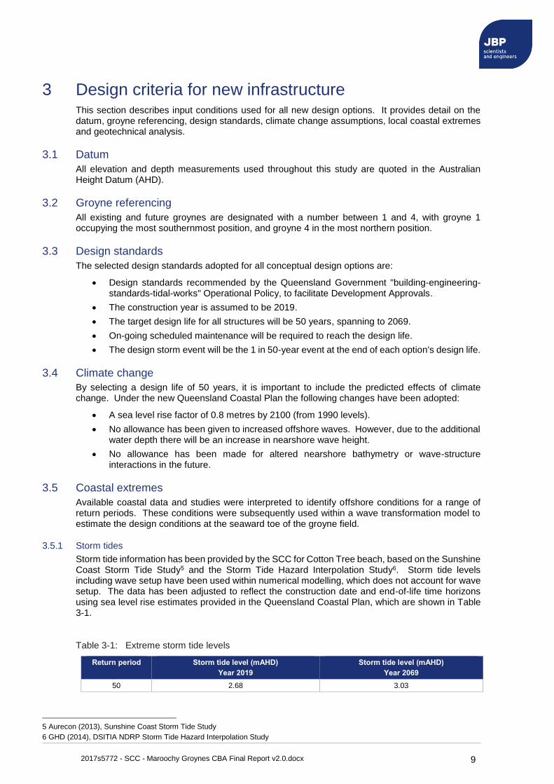
Storm tide information has been provided by the SCC for Cotton Tree beach, based on the Sunshine Coast Storm Tide Study5 and the Storm Tide Hazard Interpolation Study6. Storm tide levels including wave setup have been used within numerical modelling, which does not account for wave setup. The data has been adjusted to reflect the construction date and end-of-life time horizons using sea level rise estimates provided in the Queensland Coastal Plan, which are shown in Table 3-1.
Table 3-1: Extreme storm tide levels
Return period Storm tide level (mAHD)
Year 2019
Storm tide level (mAHD)
Year 2069
50 2.68 3.03
5 Aurecon (2013), Sunshine Coast Storm Tide Study
6 GHD (2014), DSITIA NDRP Storm Tide Hazard Interpolation Study
2017s5772 - SCC - Maroochy Groynes CBA Final Report v2.0.docx 10
3.5.2 Wave conditions
A range of extreme wave conditions has been estimated at the Mooloolaba wave buoy, located in 32m depth of water offshore of Maroochydore. An extreme value marginal analysis was undertaken using a Peaks Over Threshold (POT) approach. This involves defining a threshold to identify 'extreme' events that occurred over a particular wave height, assuming a storm duration of 50 hours. A Generalised Pareto Distribution (GPD) was used to fit all the observations that exceed the threshold, and subsequently used to estimate the extreme wave height for a range of return periods.
The Mooloolaba wave buoy has been in operation since 2000, with directional statistics available since September 2005. The analysis was undertaken twice; first using all data and secondly using only data with a wave direction between 0 and 180 degrees. The results were within 10% for extreme events, with the directional dataset showing slightly larger values, which were adopted for the report. A peak wave period was assigned through a regression analysis of all wave height against period data. The design offshore wave conditions are presented in Table 3-2.
Table 3-2: Summary of extreme offshore wave conditions
Return period Wave height (m) Peak wave period (s)
50 5.9 9.5
Nearshore wave conditions have been estimated using a spectral wave model, which simulates how waves develop and 'transform' as they propagate from a deep-water location (Mooloolaba wave buoy) to the shoreline. The industry-standard SWAN (Simulating WAves Nearshore) model was used, a third-generation wave model capable of simulating wave-wave interactions, shoaling, refraction, wave breaking, and energy dissipation. Whilst uncalibrated, its use offers a more realistic estimate of nearshore wave conditions than analytical depth-limited calculations.
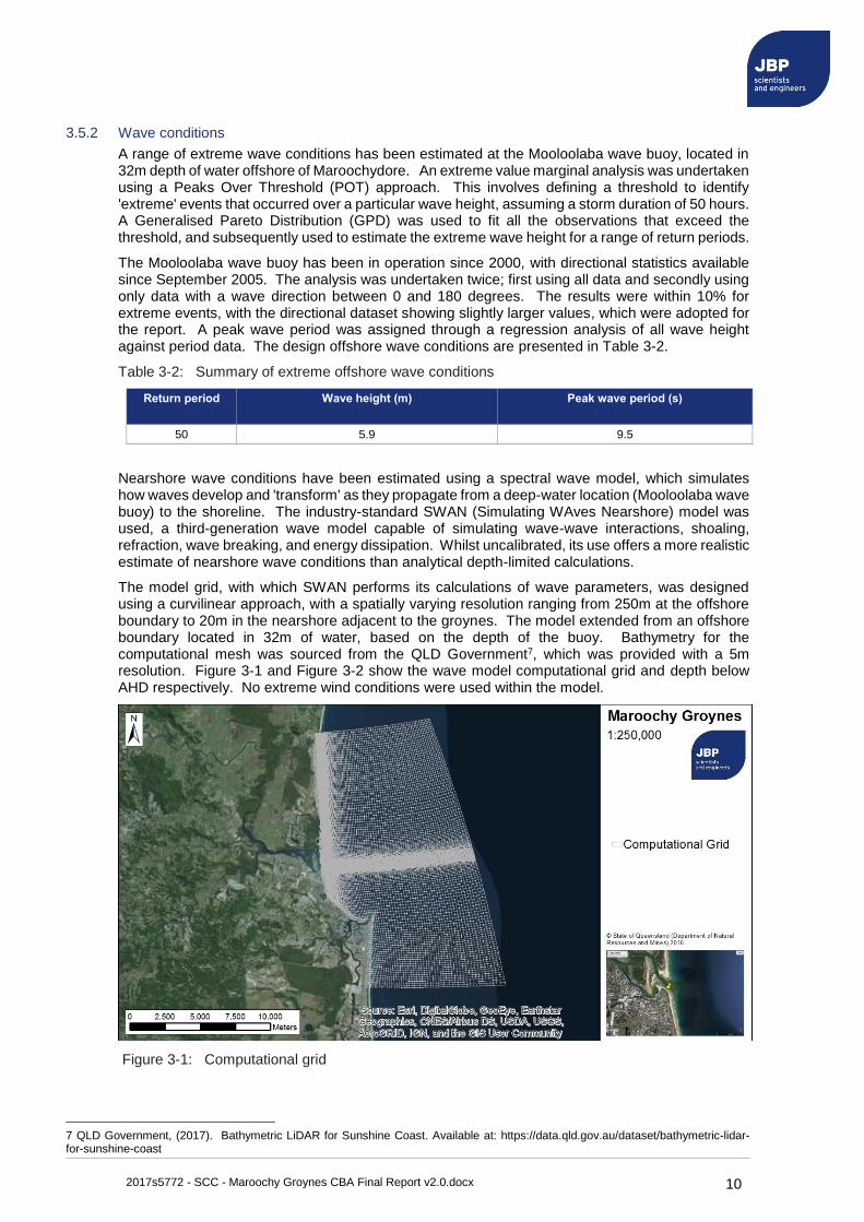
The model grid, with which SWAN performs its calculations of wave parameters, was designed using a curvilinear approach, with a spatially varying resolution ranging from 250m at the offshore boundary to 20m in the nearshore adjacent to the groynes. The model extended from an offshore boundary located in 32m of water, based on the depth of the buoy. Bathymetry for the computational mesh was sourced from the QLD Government7, which was provided with a 5m resolution. Figure 3-1 and Figure 3-2 show the wave model computational grid and depth below AHD respectively. No extreme wind conditions were used within the model.
Figure 3-1: Computational grid
7 QLD Government, (2017). Bathymetric LiDAR for Sunshine Coast. Available at: https://data.qld.gov.au/dataset/bathymetric-lidar-for-sunshine-coast
2017s5772 - SCC - Maroochy Groynes CBA Final Report v2.0.docx 11
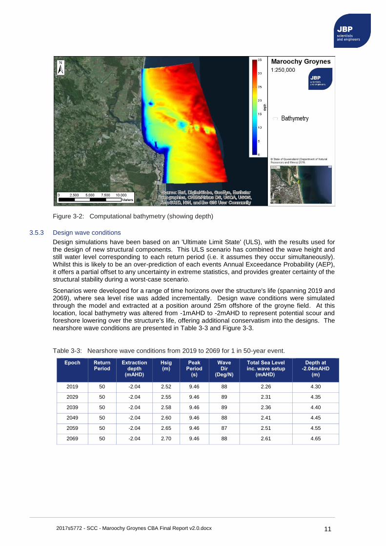
Figure 3-2: Computational bathymetry (showing depth)
3.5.3 Design wave conditions
Design simulations have been based on an 'Ultimate Limit State' (ULS), with the results used for the design of new structural components. This ULS scenario has combined the wave height and still water level corresponding to each return period (i.e. it assumes they occur simultaneously). Whilst this is likely to be an over-prediction of each events Annual Exceedance Probability (AEP), it offers a partial offset to any uncertainty in extreme statistics, and provides greater certainty of the structural stability during a worst-case scenario.
Scenarios were developed for a range of time horizons over the structure's life (spanning 2019 and 2069), where sea level rise was added incrementally. Design wave conditions were simulated through the model and extracted at a position around 25m offshore of the groyne field. At this location, local bathymetry was altered from -1mAHD to -2mAHD to represent potential scour and foreshore lowering over the structure's life, offering additional conservatism into the designs. The nearshore wave conditions are presented in Table 3-3 and Figure 3-3.
Table 3-3: Nearshore wave conditions from 2019 to 2069 for 1 in 50-year event.
Epoch Return Period
Extraction depth
(mAHD)
Hsig (m)
Peak Period
(s)
Wave Dir
(Deg/N)
Total Sea Level inc. wave setup
(mAHD)
Depth at -2.04mAHD
(m)
2019 50 -2.04 2.52 9.46 88 2.26 4.30
2029 50 -2.04 2.55 9.46 89 2.31 4.35
2039 50 -2.04 2.58 9.46 89 2.36 4.40
2049 50 -2.04 2.60 9.46 88 2.41 4.45
2059 50 -2.04 2.65 9.46 87 2.51 4.55
2069 50 -2.04 2.70 9.46 88 2.61 4.65

2017s5772 - SCC - Maroochy Groynes CBA Final Report v2.0.docx 12
Figure 3-3: Nearshore wave conditions from 2019 to 2069 at -2mAHD
3.6 Geotechnical analysis
A geotechnical investigation has been undertaken using 34 Dynamic Cone Penetration (DCP) tests and particle size distribution tests8. Results of the investigation are summarised below.
The sediment is predominantly medium grained sands, with a ~20% portion of fine grained sands. The majority of DCP tests indicated medium dense sand within about 0.5m of the ground surface, with dense sand generally within about 1m to 1.5m of the ground surface. No indurated sand was recorded with the DCP testing, however is believed to be present based on historic photography.
The results of the bearing capacity and soils profile are shown in Table 3-4. Based on this information, and the intention to use the existing groyne footprints, the following has been assumed within designs:
1. Granular soils mean that some settlement is likely to occur on initial placement, with little subsequent movement during the design life.
2. Structures would be founded on the dense sand.
3. Expected settlements would be minimal.
4. Greater settlements will be associated with rock than geotextile due to higher loads, however rock will have the benefit of greater adaptability.
5. Foundation conditions at the site are considered suitable for either rock or geotextile groynes.
Table 3-4: Bearing capacity and soils profile information.
Depth (mm BGL) Description Bearing capacity of soils (kPa)
D50 grain size
(mm)
0 Loose sand n/a ~ 0.26 to 0.31
500 Medium dense sand 75 -
1500 Dense sand 125 -
1500+ No obvious bedrock but becomes more dense with depth
8 Tectonic (2017) 'Geotechnical Investigation, Cost Benefit Analysis Project Maroochy River Groynes Maroochydore', prepared for the Sunshine Coast Council, Report Ref: 17103-001-Rev0, March 2017.
2017s5772 - SCC - Maroochy Groynes CBA Final Report v2.0.docx 13
4 Design Options Five coastal infrastructure options have been considered within this report. They include new groynes designed and costed within this project, and three options designed in previous studies with revised costing now undertaken. A summary of each option is provided below, with design and costing information provided in the sections below.
1. Option 1: Four new rock groynes to replace the existing structures at the Cotton Tree beach. The structures will have a 50-year design life, designed to withstand conditions in 2069, including any effects of sea level rise.
2. Option 2: Four replacement geotextile groynes using GSCs. The structures have been based on a 17-year design life, with increased maintenance in the final years.
3. Option 3: Construction of a new 200m long rock groyne at Cotton Tree, removal of the existing GSC's, active management of any erosion at Cotton Tree, and 100,000m3 of beach nourishment. This option has the potential to reduce future beach nourishment undertaken by SCC along Maroochydore Beach.
4. Option 4: Re-establishment of a northern river channel for the Maroochy River, by the mechanical re-construction of a beach connecting Pincushion Island to Cotton Tree. This option would require dredging of approximately 300,000m3 of sand from within the Maroochy River mouth and North Shore Spit.
5. Option 5: Re-establishment of a northern river channel for the Maroochy River, by the construction of a new rock breakwater connecting Pincushion Island to Cotton Tree.
2017s5772 - SCC - Maroochy Groynes CBA Final Report v2.0.docx 14
4.1 Option 1: Rock groyne field
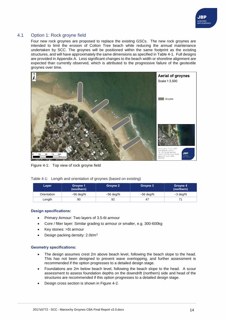
Four new rock groynes are proposed to replace the existing GSCs. The new rock groynes are intended to limit the erosion of Cotton Tree beach while reducing the annual maintenance undertaken by SCC. The groynes will be positioned within the same footprint as the existing structures, and will have approximately the same dimensions as specified in Table 4-1. Full designs are provided in Appendix A. Less significant changes to the beach width or shoreline alignment are expected than currently observed, which is attributed to the progressive failure of the geotextile groynes over time.
Figure 4-1: Top view of rock groyne field
Table 4-1: Length and orientation of groynes (based on existing)
Layer Groyne 1 (southern)
Groyne 2 Groyne 3 Groyne 4 (northern)
Orientation ~56 deg/N ~56 deg/N ~56 deg/N ~3 deg/N
Length 90 92 47 71
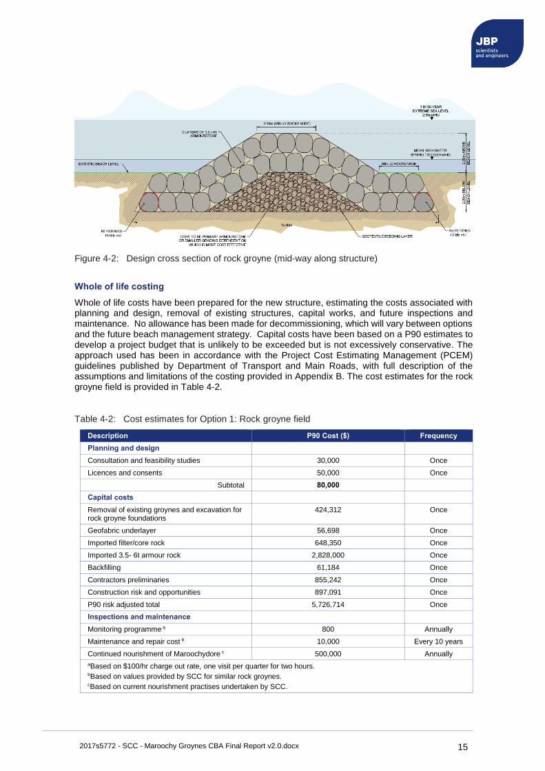
Design specifications:
• Primary Armour: Two layers of 3.5-6t armour
• Core / filter layer: Similar grading to armour or smaller, e.g. 300-600kg
• Key stones: >5t armour
• Design packing density: 2.0t/m3
Geometry specifications:
• The design assumes crest 2m above beach level, following the beach slope to the head. This has not been designed to prevent wave overtopping, and further assessment is recommended if the option progresses to a detailed design stage.
• Foundations are 2m below beach level, following the beach slope to the head. A scour assessment to assess foundation depths on the downdrift (northern) side and head of the structures are recommended if this option progresses to a detailed design stage.
• Design cross section is shown in Figure 4-2.
2017s5772 - SCC - Maroochy Groynes CBA Final Report v2.0.docx 15
Figure 4-2: Design cross section of rock groyne (mid-way along structure)
Whole of life costing
Whole of life costs have been prepared for the new structure, estimating the costs associated with planning and design, removal of existing structures, capital works, and future inspections and maintenance. No allowance has been made for decommissioning, which will vary between options and the future beach management strategy. Capital costs have been based on a P90 estimates to develop a project budget that is unlikely to be exceeded but is not excessively conservative. The approach used has been in accordance with the Project Cost Estimating Management (PCEM) guidelines published by Department of Transport and Main Roads, with full description of the assumptions and limitations of the costing provided in Appendix B. The cost estimates for the rock groyne field is provided in Table 4-2.
Table 4-2: Cost estimates for Option 1: Rock groyne field
Description P90 Cost ($) Frequency
Planning and design
Consultation and feasibility studies 30,000 Once
Licences and consents 50,000 Once
Subtotal 80,000
Capital costs
Removal of existing groynes and excavation for rock groyne foundations
424,312 Once
Geofabric underlayer 56,698 Once
Imported filter/core rock 648,350 Once
Imported 3.5- 6t armour rock 2,828,000 Once
Backfilling 61,184 Once
Contractors preliminaries 855,242 Once
Construction risk and opportunities 897,091 Once
P90 risk adjusted total 5,726,714 Once
Inspections and maintenance
Monitoring programme a 800 Annually
Maintenance and repair cost b 10,000 Every 10 years
Continued nourishment of Maroochydore c 500,000 Annually
aBased on $100/hr charge out rate, one visit per quarter for two hours. bBased on values provided by SCC for similar rock groynes. cBased on current nourishment practises undertaken by SCC.
2017s5772 - SCC - Maroochy Groynes CBA Final Report v2.0.docx 16
4.2 Option 2: Geotextile groyne field
Construction of four replacement geotextile groynes using GSCs is proposed to replace the existing structures. The groynes will be positioned within the same footprint as the existing structures, and will have approximately the same dimensions as specified in Table 4-1. Due to deterioration of the groynes, all GSCs are to be replaced, including those underwater at the base of the structures.
An individual lifetime of 17 years has been adopted for each groyne structure, meaning three iterations will be required to span the 50-year period. This lifetime has been based on the performance of existing GSCs and will have an increasing requirement of maintenance and repair towards the end of their design life. Full designs are provided in Appendix A.
Design specifications:
Design conditions have been assessed against the GSC dimensions at the end of each 17-year period (its functional lifetime)9.
• The continued use of a GCS size of 2.5m3 is considered suitable for all designs over the 50-year period.
• Increased maintenance will be required towards end of design life.
• Full replacement of each groyne after 17 years.
Geometry specifications:
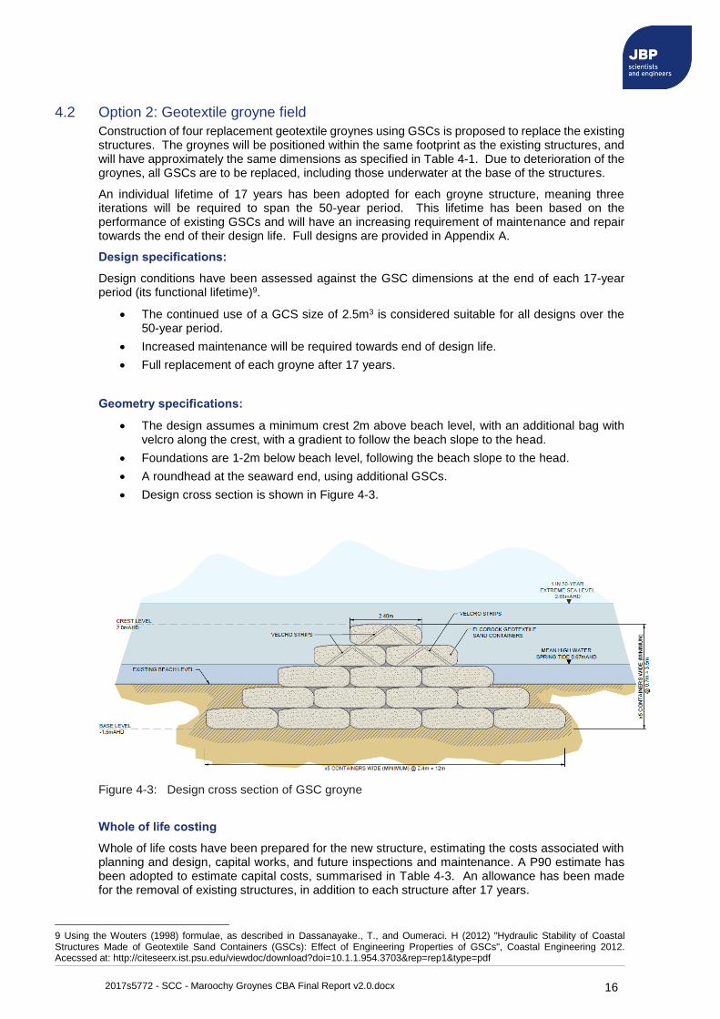
• The design assumes a minimum crest 2m above beach level, with an additional bag with velcro along the crest, with a gradient to follow the beach slope to the head.
• Foundations are 1-2m below beach level, following the beach slope to the head.
• A roundhead at the seaward end, using additional GSCs.
• Design cross section is shown in Figure 4-3.
Figure 4-3: Design cross section of GSC groyne
Whole of life costing
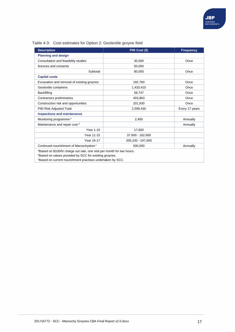
Whole of life costs have been prepared for the new structure, estimating the costs associated with planning and design, capital works, and future inspections and maintenance. A P90 estimate has been adopted to estimate capital costs, summarised in Table 4-3. An allowance has been made for the removal of existing structures, in addition to each structure after 17 years.
9 Using the Wouters (1998) formulae, as described in Dassanayake., T., and Oumeraci. H (2012) "Hydraulic Stability of Coastal Structures Made of Geotextile Sand Containers (GSCs): Effect of Engineering Properties of GSCs", Coastal Engineering 2012. Acecssed at: http://citeseerx.ist.psu.edu/viewdoc/download?doi=10.1.1.954.3703&rep=rep1&type=pdf
2017s5772 - SCC - Maroochy Groynes CBA Final Report v2.0.docx 17
Table 4-3: Cost estimates for Option 2: Geotextile groyne field
Description P90 Cost ($) Frequency
Planning and design
Consultation and feasibility studies 30,000 Once
licences and consents 50,000
Subtotal 80,000 Once
Capital costs
Excavation and removal of existing groynes 192,783 Once
Geotextile containers 1,433,410 Once
Backfilling 58,747 Once
Contractors preliminaries 403,863 Once
Construction risk and opportunities 201,930 Once
P90 Risk Adjusted Total 2,599,430 Every 17 years
Inspections and maintenance
Monitoring programme a 2,400 Annually
Maintenance and repair cost b Annually
Year 1-10 17,600
Year 11-15 37.600 - 162.600
Year 16-17 205,100 - 247,600
Continued nourishment of Maroochydore c 500,000 Annually
aBased on $100/hr charge out rate, one visit per month for two hours. bBased on values provided by SCC for existing groynes. cBased on current nourishment practises undertaken by SCC.
2017s5772 - SCC - Maroochy Groynes CBA Final Report v2.0.docx 18
4.3 Option 3: Single 200m rock groyne
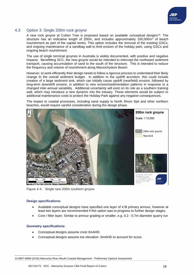
A new rock groyne at Cotton Tree is proposed based on available conceptual designs10. The structure has an indicative length of 200m, and includes approximately 100,000m3 of beach nourishment as part of the capital works. This option includes the removal of the existing GSCs, and ongoing maintenance of a sandbag wall to limit erosion of the holiday park, using GSCs and ongoing beach nourishment.
The use of single terminal groynes in Australia is widely documented, with positive and negative impacts. Benefitting SCC, the new groyne would be intended to intercept the northward sediment transport, causing accumulation of sand to the south of the structure. This is intended to reduce the frequency and volume of nourishment along Maroochydore Beach.
However, to work efficiently their design needs to follow a rigorous process to understand their likely change to the overall sediment budget. In addition to the updrift accretion, this could include creation of a large sediment sink, which can initially cause updrift (nearfield) erosion, followed by long-term downdrift erosion, in addition to new erosion/sedimentation patterns in response to a changed inter-annual variability. Additional uncertainty will exist on its role as a southern training wall, which may introduce a new dynamic into the estuary. These elements would be subject to additional maintenance costs to protect the Holiday Park against any negative consequences.
The impact to coastal processes, including sand supply to North Shore Spit and other northern beaches, would require careful consideration during the design phase.
Figure 4-4: Single new 200m southern groyne
Design specifications:
• Available conceptual designs have specified one layer of 4.9t primary armour, however at least two layers are recommended if this option was to progress to further design stages.
• Core / filter layer: Similar to armour grading or smaller, e.g. 0.2 - 0.7m diameter quarry run
Geometry specifications:
• Conceptual designs assume crest 3mAHD.
• Conceptual designs assume toe elevation -5mAHD to account for scour.
10 BMT-WBM (2016) Maroochy River Mouth Coastal Management - Preliminary Options Assessment
2017s5772 - SCC - Maroochy Groynes CBA Final Report v2.0.docx 19
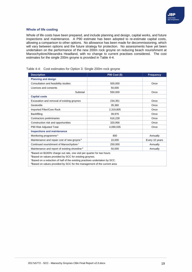
Whole of life costing
Whole of life costs have been prepared, and include planning and design, capital works, and future inspections and maintenance. A P90 estimate has been adopted to re-estimate capital costs, allowing a comparison to other options. No allowance has been made for decommissioning, which will vary between options and the future strategy for protection. No assessments have yet been undertaken on the performance of the new 200m rock groyne on reducing beach nourishment at Maroochydore/Alexandra Headland, with no change to current practises considered. The cost estimates for the single 200m groyne is provided in Table 4-4.
Table 4-4: Cost estimates for Option 3: Single 200m rock groyne
Description P90 Cost ($) Frequency
Planning and design
Consultation and feasibility studies 500,000 Once
Licences and consents 50,000
Subtotal 550,000 Once
Capital costs
Excavation and removal of existing groynes 234,351 Once
Geotextile 35,360 Once
Imported Filter/Core Rock 2,319,805 Once
Backfilling 39,976 Once
Contractors preliminaries 616,228 Once
Construction risk and opportunities 320,956 Once
P90 Risk Adjusted Total 4,090,035 Once
Inspections and maintenance
Monitoring programme a 800 Annually
Maintenance and repair cost of new groyne b 10,000 Every 10 years
Continued nourishment of Maroochydore c 250,000 Annually
Maintenance and report of existing shoreline d 50,000 Annually
aBased on $100/hr charge out rate, one visit per quarter for two hours. bBased on values provided by SCC for existing groynes. cBased on a reduction of half of the existing practises undertaken by SCC. dBased on values provided by SCC for the management of the current area
2017s5772 - SCC - Maroochy Groynes CBA Final Report v2.0.docx 20
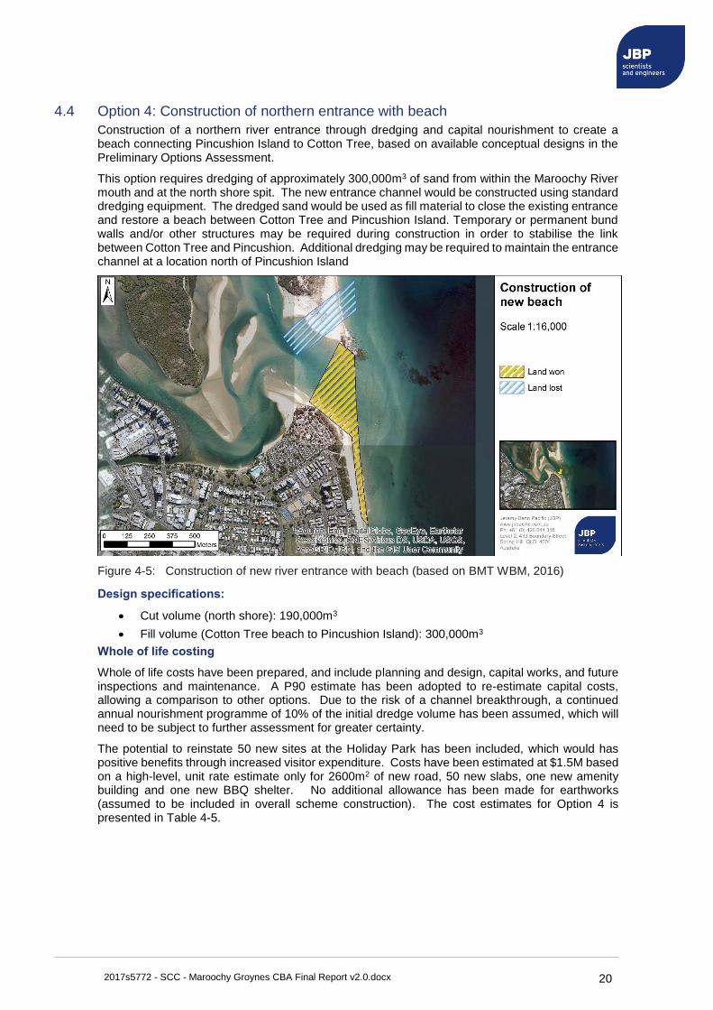
4.4 Option 4: Construction of northern entrance with beach
Construction of a northern river entrance through dredging and capital nourishment to create a beach connecting Pincushion Island to Cotton Tree, based on available conceptual designs in the Preliminary Options Assessment.
This option requires dredging of approximately 300,000m3 of sand from within the Maroochy River mouth and at the north shore spit. The new entrance channel would be constructed using standard dredging equipment. The dredged sand would be used as fill material to close the existing entrance and restore a beach between Cotton Tree and Pincushion Island. Temporary or permanent bund walls and/or other structures may be required during construction in order to stabilise the link between Cotton Tree and Pincushion. Additional dredging may be required to maintain the entrance channel at a location north of Pincushion Island
Figure 4-5: Construction of new river entrance with beach (based on BMT WBM, 2016)
Design specifications:
• Cut volume (north shore): 190,000m3
• Fill volume (Cotton Tree beach to Pincushion Island): 300,000m3
Whole of life costing
Whole of life costs have been prepared, and include planning and design, capital works, and future inspections and maintenance. A P90 estimate has been adopted to re-estimate capital costs, allowing a comparison to other options. Due to the risk of a channel breakthrough, a continued annual nourishment programme of 10% of the initial dredge volume has been assumed, which will need to be subject to further assessment for greater certainty.
The potential to reinstate 50 new sites at the Holiday Park has been included, which would has positive benefits through increased visitor expenditure. Costs have been estimated at $1.5M based on a high-level, unit rate estimate only for 2600m2 of new road, 50 new slabs, one new amenity building and one new BBQ shelter. No additional allowance has been made for earthworks (assumed to be included in overall scheme construction). The cost estimates for Option 4 is presented in Table 4-5.
2017s5772 - SCC - Maroochy Groynes CBA Final Report v2.0.docx 21
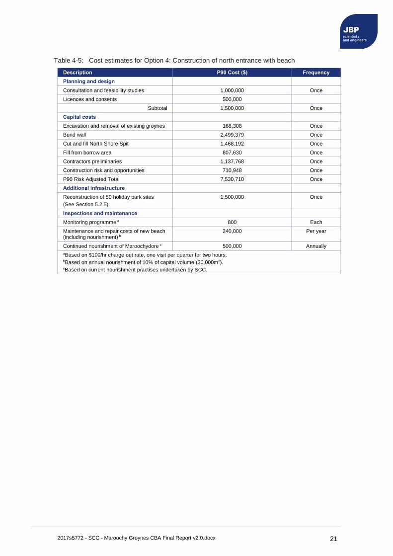
Table 4-5: Cost estimates for Option 4: Construction of north entrance with beach
Description P90 Cost ($) Frequency
Planning and design
Consultation and feasibility studies 1,000,000 Once
Licences and consents 500,000
Subtotal 1,500,000 Once
Capital costs
Excavation and removal of existing groynes 168,308 Once
Bund wall 2,499,379 Once
Cut and fill North Shore Spit 1,468,192 Once
Fill from borrow area 807,630 Once
Contractors preliminaries 1,137,768 Once
Construction risk and opportunities 710,948 Once
P90 Risk Adjusted Total 7,530,710 Once
Additional infrastructure
Reconstruction of 50 holiday park sites
(See Section 5.2.5)
1,500,000 Once
Inspections and maintenance
Monitoring programme a 800 Each
Maintenance and repair costs of new beach (including nourishment) b
240,000 Per year
Continued nourishment of Maroochydore c 500,000 Annually
aBased on $100/hr charge out rate, one visit per quarter for two hours. bBased on annual nourishment of 10% of capital volume (30,000m3). cBased on current nourishment practises undertaken by SCC.
2017s5772 - SCC - Maroochy Groynes CBA Final Report v2.0.docx 22
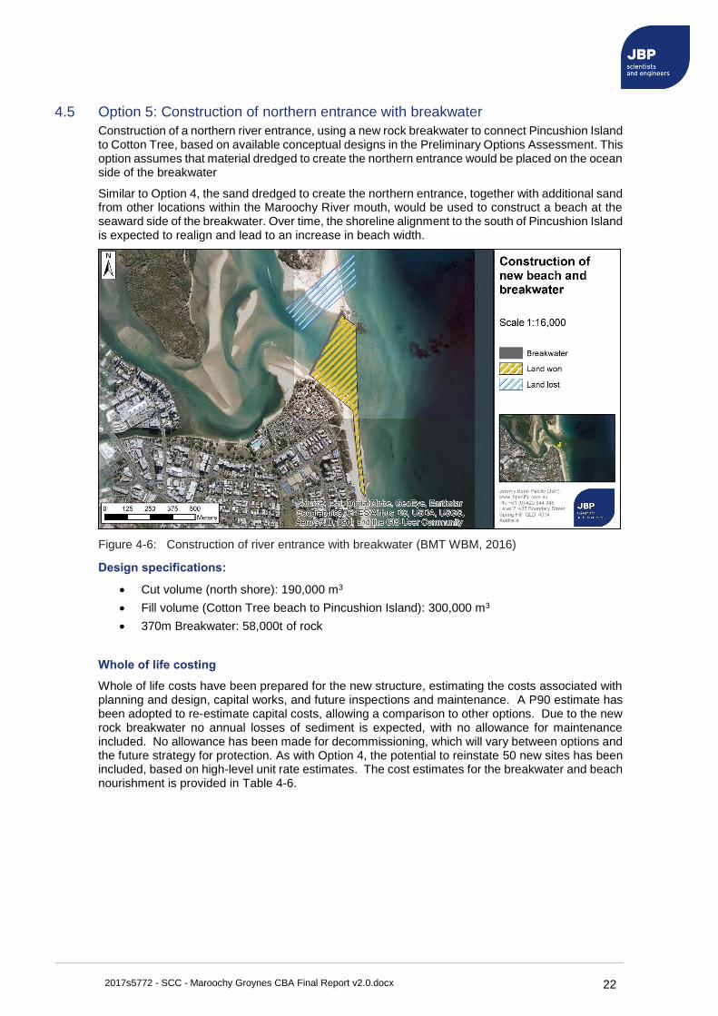
4.5 Option 5: Construction of northern entrance with breakwater
Construction of a northern river entrance, using a new rock breakwater to connect Pincushion Island to Cotton Tree, based on available conceptual designs in the Preliminary Options Assessment. This option assumes that material dredged to create the northern entrance would be placed on the ocean side of the breakwater
Similar to Option 4, the sand dredged to create the northern entrance, together with additional sand from other locations within the Maroochy River mouth, would be used to construct a beach at the seaward side of the breakwater. Over time, the shoreline alignment to the south of Pincushion Island is expected to realign and lead to an increase in beach width.
Figure 4-6: Construction of river entrance with breakwater (BMT WBM, 2016)
Design specifications:
• Cut volume (north shore): 190,000 m3
• Fill volume (Cotton Tree beach to Pincushion Island): 300,000 m3
• 370m Breakwater: 58,000t of rock
Whole of life costing
Whole of life costs have been prepared for the new structure, estimating the costs associated with planning and design, capital works, and future inspections and maintenance. A P90 estimate has been adopted to re-estimate capital costs, allowing a comparison to other options. Due to the new rock breakwater no annual losses of sediment is expected, with no allowance for maintenance included. No allowance has been made for decommissioning, which will vary between options and the future strategy for protection. As with Option 4, the potential to reinstate 50 new sites has been included, based on high-level unit rate estimates. The cost estimates for the breakwater and beach nourishment is provided in Table 4-6.

2017s5772 - SCC - Maroochy Groynes CBA Final Report v2.0.docx 23
Table 4-6: Cost estimates for Option 6: construction of north entrance with breakwater
Description P90 Cost ($) Frequency
Planning and design
Consultation and feasibility studies 1,000,000 Once
Licences and consents 500,000
Subtotal 1,500,000 Once
Capital costs
Excavation and removal of existing groynes 168,308 Once
New breakwater 3,094,443 Once
Cut and fill North Shore Spit 1,468,192 Once
Fill from borrow area 807,630 Once
Contractors preliminaries 1,274,709 Once
Construction risk and opportunities 796.525 Once
P90 Risk Adjusted Total 8,465,234 Once
Additional infrastructure
Reconstruction of 50 holiday park sites
(See Section 5.2.5)
1,500,000 Once
Inspections and maintenance
Monitoring programme a 800 Annually
Maintenance and repair cost of new rock structure b 10,000 Every 10 years
Continued nourishment of Maroochydore c 500,000 Annually
aBased on $100/hr charge out rate, one visit per quarter for two hours. bBased on values provided by SCC for similar rock groynes cBased on current nourishment practises undertaken by SCC.
2017s5772 - SCC - Maroochy Groynes CBA Final Report v2.0.docx 24
5 Economic assessment
5.1 Introduction
An economic assessment and Cost-Benefit Assessment (CBA) has been completed to compare the benefits of each design option. As the Sunshine Coast Council is responsible for the management of their own coastal zone, this assessment has focussed on the local economy within the LGA.
5.2 Estimating benefits
The benefit of each design option has been considered in terms of the protection it offers to assets and infrastructure, land, public amenity, local residents and visitors, or the additional benefit it may mean to the local Council and economy. This has been monetised in terms of the losses that would be incurred under a Do-Nothing option, where the land would be able to erode freely under a meandering river scenario, based on potential erosion 'horizons' in Figure 2-1.
Benefits have included tangible and intangible elements, the latter monetised through non-market techniques. Tangible benefits have included all the infrastructure, assets and land protected or created within the coastal zone due to each scheme. Consideration of intangible values has been undertaken through monetising the additional social amenity for residents.
The following sub-sections outline the approach to quantifying the benefits of each scheme, assessed in terms of:
• Benefits of protected infrastructure and assets.
• Benefits of protected land.
• Benefits to public amenity.
• Benefits to tourism.
• Option-specific benefits and damages.
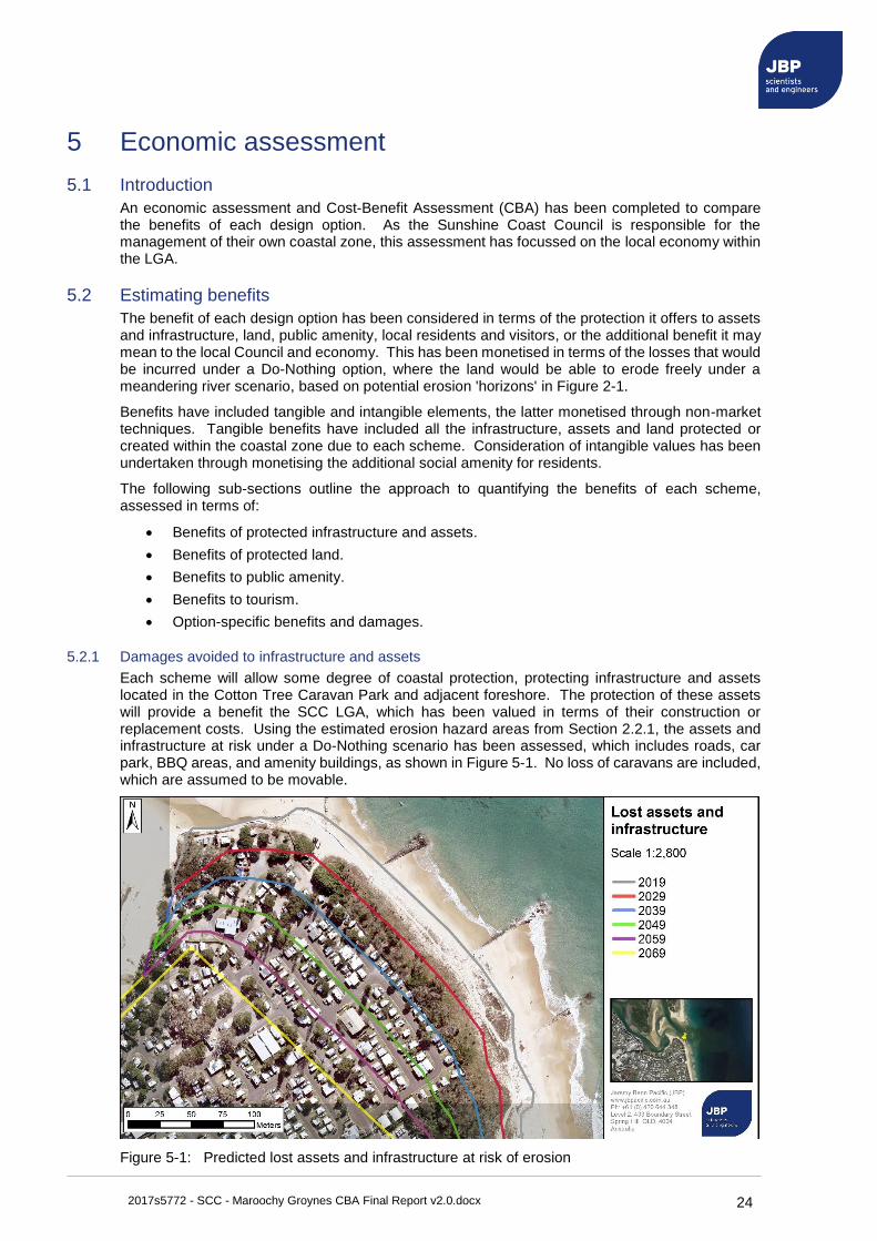
5.2.1 Damages avoided to infrastructure and assets
Each scheme will allow some degree of coastal protection, protecting infrastructure and assets located in the Cotton Tree Caravan Park and adjacent foreshore. The protection of these assets will provide a benefit the SCC LGA, which has been valued in terms of their construction or replacement costs. Using the estimated erosion hazard areas from Section 2.2.1, the assets and infrastructure at risk under a Do-Nothing scenario has been assessed, which includes roads, car park, BBQ areas, and amenity buildings, as shown in Figure 5-1. No loss of caravans are included, which are assumed to be movable.
Figure 5-1: Predicted lost assets and infrastructure at risk of erosion

2017s5772 - SCC - Maroochy Groynes CBA Final Report v2.0.docx 25
Replacement costs have been estimated over each 10-year period and are shown in Table 5-1. These are valued on their cost to replace. Other nearby infrastructure not included in these calculations are the Maroochydore Surf Club and private properties, which may also have some risk under a Do-Nothing scenario.
Table 5-1: Summary of erosion losses
Time period Assets/Infrastructure lost Replacement value ($) over 10 years
2019 Nil (assumed) $0
2029 Slab sites $1,000
2039 Roads, slab sites $60,000
2049 Roads, slab sites $322,000
2059 Roads, slab sites, amenities $1,679,000
2069 Roads, slab sites, BBQ, amenities $1,360,000
5.2.2 Avoided loss of land
Coastal land lost to erosion can represent a significant loss to its local LGA. Land lost to erosion is considered to have a higher value than any new replacement land the council would be able to acquire as open space, e.g. in the hinterland. The difference in value is considered to be lost to the community, and represents the premium placed on coastal land either due to its aesthetics, historical importance or simply its proximity to the beach.
The value of eroded coastal land has been calculated by comparing two locations; the first is at Macarthur Park, considered to be a representative non-coastal area of open space owned by SCC. The second is the Cotton Tree Caravan Park fronting the study site. The difference in these land values represents the premium placed on the coastal waterfront location11. Land values have been taken by the Valuer General tool available through Google Earth12. Land values for MacArthur Park averaged at $260/m2 and Cotton Tree Caravan Park at $660/m2. The difference in land value was calculated as $400/m2, representing the beach frontage premium of developable, erodible land at the study site. Damages that could be avoided by protecting the study site against erosion are presented in Table 5-2. Eroded land is considered a one-off loss to the LGA at the time it is eroded.
Figure 5-2: Property valuation examples at Macarthur Park
11 Further assessment could be undertaken on other 'donor' hinterland areas to understand the range of land values that have similar socio-economic aspects. A hinterland location is preferred over other locations closer to the beach, e.g. the next street back from the frontage. This is because the heavily populated nature of the coastline would prohibit this land being purchased by Council for recreation.
12 Queensland Government (2016). Add-on for Google Earth - for more information see:
https://www.business.qld.gov.au/business/support-tools-grants/services/mapping-data-imagery/queensland-globe/land-valuations
2017s5772 - SCC - Maroochy Groynes CBA Final Report v2.0.docx 26
Table 5-2: Benefits (damages avoided) due to loss of land
Time period Land lost (m2) Estimated loss in value ($) over 10 years
2019 0 $0
2029 14,508 $5,803,200
2039 12,562 $5,024,800
2049 12,073 $4,829,200
2059 11,473 $4,589,200
2069 11,914 $4,765,600
5.2.3 Avoided damages to recreation and amenity
Lost amenity value to local users under a Do-Nothing scenario has been considered for its inclusion in the assessment. If the LGA and its local residents can be seen to lose an important space for recreation and amenity, its loss could be factored into the economic assessment.
Similar studies have monetised the amenity value a resident receives per visit to the beach based on the non-market Travel Cost Method (TCM). Whilst a free resource, local residents contribute time and money to access a beach, with the TCM used to estimate the benefit they receive per visit. However, this can only be considered if the resource was lost to the public. In the case of the Cotton Tree beach eroding under a Do-Nothing scenario, residents have access to numerous beaches of similar quality, distance and cost, in close proximity. These include the Boat Shed (350m west) and Maroochydore Beach (400m south), the latter with public infrastructure and a surf club. As such, no loss to amenity has been considered in this assessment.
5.2.4 Avoided damages due to reduced visitor expenditure
Visitor expenditure is a clear benefit to the local economy, and can be associated with the drawcard of a beach and its associated infrastructure. Two key approaches are used to estimate the economic impacts due to reduction in visitors. The first considers damages to businesses, estimating the value they add to the local economy through staff wages, called Gross Value Added (GVA). Strictly they are financial rather than economic damages, but may be included to reflect the impact on the local economy. The second approach is through the estimation of reduced visitor expenditure. In this approach the impacts are not traced to the end beneficiary (e.g. it is unknown exactly where the money is spent), however it is assumed to contribute to the local economy as a whole. Both approaches cannot be used in a single assessment as it would 'double-count' the impacts. This assessment has used the latter approach, estimating the impact of reduced visitor expenditure due to beach erosion at Maroochy River mouth. This has been estimated by considering the reduction in visitors due to the lost caravan sites.
The Cotton Tree Holiday Park has 500 spaces available for accommodation, which include tent, caravans and cabin sites. They have approximately 280,000 visitors per year, with an annual turnover of around $5.6M, with an average overnight stay of the order of $40 per night. However, the economic benefits of the holiday park are expected to be more widely felt, based on a visitor's expenditure for food, tours, day trips and shopping whilst holidaying. Available estimates suggest the average visitor spends $658 per day in the Sunshine Coast13. This value has been halved to reflect lower visitor spending from patrons of the holiday park, which can be viewed to offer a more self-contained accommodation, with visitors less likely to utilise local services or spend quite as much. Given the estimated annual visitors, the full economic benefit of visitors staying at the holiday park on the local economy could be considered around $92M per year.
The impact of lost holiday park sites has been estimated by considering the reduced visitor spending if holiday sites were lost in the future. In the absence of any quantifiable data, to monetarise impacts the following assumptions have been made:
• 50% of visitors are assumed to find accommodation at nearby hotels, staying in the local area. No economic losses are expected in the LGA, as the change to a more expensive accommodation has been assumed to cause a subsequent reduction in visitor sending elsewhere.
13 Tourism and Events Queensland, 2012. Sunshine Coast Tourism Profile. [Online]
http://teq.queensland.com/~/media/715C01D824F4454192BC482C73C4AB8F.ashx?la=en
2017s5772 - SCC - Maroochy Groynes CBA Final Report v2.0.docx 27
• 25% are assumed to use five other caravan parks in the SCC LGA. No economic losses are expected in the LGA.
• 25% are assumed to either move their trip to a location outside of the Sunshine Coast (e.g. Noosa, Moreton Bay or Gympie regions) or cancel their trip, representing a loss to the SCC LGA.
Under these assumptions, the estimated reduction in visitor expenditure has been estimated, and is shown in Table 5-3.
Table 5-3: Benefits (damages avoided) of visitor expenditure due to erosion
Time period Lost sites Lost visitors to 'LGA'
per year
Lost money to community & caravan park ($)
2019 - - -
2029 14 1,960 645,000
2039 50 7,000 2,303,000
2049 106 14,840 4,882,000
2059 146 20,440 6,725,000
2069 180 25,200 8,291,000
5.2.5 Option-specific benefits and damages
In addition to the benefits of preventing erosion, Option 3 (200m groyne), Option 4 (Northern Entrance with Beach), and Option 5 (Northern Entrance with Breakwater) have additional benefits and losses associated with their construction. These have been estimated with the results shown below.
• Option 2 (Geotextile groyne field)
o Erosion of the functional beach in the latter years as the structures deteriorate. Estimated recession along the groyne field is approximately 400m in length, with a total width loss of 30m over 17 years. This is valued at $28.85/m2 as non-developable coastal land.
o Additional nourishment is required along the 400m groyne field at the end of structure life.
• Option 3 (200m groyne)
o Gain of 34,915m2 of reclaimed land available for amenity. This has been valued as non-developable coastal land with a value of $28.85/m2.
o Estimated 50% reduction on dredging and nourishment campaigns to Maroochydore/Alexandra headland beach14.
o There is the potential for erosion at Cotton Tree holiday park. It is assumed this is mitigated through the inclusion of a nominal $50,000 of additional maintenance and repairs, and no further erosion or damage has therefore been included for this option. Further numerical modelling required to analyse the rate of erosion with this option at Cotton Tree.
• Option 4 (Northern Entrance with Beach) and Option 5 (Northern Entrance with Breakwater)
o Net gain of 29,466m2 of reclaimed land, valued as undevelopable coastal land.
o Potential for 50 new camp sites at the Holiday Park. Increase visitor expenditure has been estimated using similar assumptions to that in Section 5.2.4, i.e. based on half the average Sunshine Coast visitor expenditure per night to reflect the new holiday park sites.
o Associated costs to build the new sites. This has been estimated at $1.5M based on a high-level, unit rate estimate, assuming:
▪ No inclusion for earthworks (included in overall scheme construction)
14 Indicative estimated only, made by SCC. Further assessment will be required to quantify the performance of the new structure.
2017s5772 - SCC - Maroochy Groynes CBA Final Report v2.0.docx 28
▪ 2600m2 of road
▪ 50 new slabs
▪ 1 new amenity building
▪ 1 new BBQ shelter
5.2.6 Cost-benefit assessment
A CBA has been completed to assess the benefits and costs of the preferred coastal management strategy.
The scheme costs and economic assessments presented in the previous chapters have been calculated over distinct time horizons, extending to 50 years from the construction period of 2019. These have been adjusted to calculate a Present Value (PV) by applying a discount rate for all future costs and benefits (further explained in Sub Section 5.2.7). The formula used is as follows:
PVdn = MV (1/(1+r)p) - PVds = MV (1/(1+r)p+s)
Where:
• PVdn = Present Value without scheme (Do Nothing)
• PVds = Present Value with scheme (Preferred Scheme)
• MV = Market Value
• r = discount rate (See section 5.2.7)
• p = the year value is lost (either assets and infrastructure or monetised amenity, visitor expenditure and tourism)
• s = life of scheme
The above approach does not take into account any damage up to the point of anticipated loss for the Do-Nothing case, e.g. road is considered to be completely functional even when the erosion scarp is just metres away. Nor does it account for wave overtopping damages, as a small degree of overtopping is typically anticipated and tolerated within designs.
5.2.7 Discount rate
Selection of a discount rate is an important factor in the CBA calculations. This rate is applied to all future costs and benefits to incorporate a time preference for investment, considering people often prefer to have money now rather than in a future time. If the discount rate used is too high, it will result in less than adequate provision for future generations. If it is too low, a greater emphasis will be put on future generations than to current, present-day issues.
The choice of a discount factor is considered in two recent Australian reports, developed as part of the NCCARF (2016)15 and CoastAdapt (2016)16 projects. These reports review national and international approaches, and have considered the use of varying or constant rates. The former is practiced in the UK, where future costs are discounted to present values based on a time varying discount rates starting at 3.5% for the first 30 years, reducing to 3% at year 31 and 2.5% at year 76. Within Australia a constant rate is favoured, ranging between 3 and 4.5%. This matches economic assessments undertaken by SCC for non-coastal projects, and for this assessment a baseline discount factor of 3.5% has been applied, with 3% and 4% factors used as sensitivity testing.
5.2.8 Cost estimates and optimism bias
An optimism bias varies depending on the level of detail made by the quantity surveyors, which should be lower at the detailed design stage than at the conceptual level. Typically, 60% bias is applied for projects at an early stage of consideration, decreasing to a value of around 30% at the more detailed project stage. Due to the detailed design and P90 estimates available for the current project a 10% optimism bias has been included within the cost build-up of all elements, which is presented in Table 5-4.
15 Truong, C., Trück, S., Davies, P., and Mathew, S. (2016) Exploring valuation methods for climate adaptation options, with particular reference to Australian coastal councils. National Climate Change Adaptation Research Facility, Gold Coast.
16 Wise, R. M., and T. Capon. (2016) Assessing the costs and benefits of coastal climate adaptation. CoastAdapt Information Manual 4, National Climate Change Adaptation Research Facility, Gold Coast

2017s5772 - SCC - Maroochy Groynes CBA Final Report v2.0.docx 29
Table 5-4: Construction and maintenance costs summary ($, Millions)
Option number Option 1 Option 2 Option 3 Option 4 Option 5
Capital costs $5.73M $4.86 $4.09 $9.03 $9.97
O&M costs $12.16 $13.42 $7.31 $17.99 $12.16
Planning and design $0.08 $0.08 $0.55 $3.00 $3.00
Optimism bias adjustment $1.80 $1.84 $1.20 $3.00 $2.51
PV with optimism bias $19.76 $20.19 $13.14 $33.02 $27.64
5.2.9 Benefit assessment
The scheme benefits have been estimated as the avoidance of asset and infrastructure losses, land losses, impact to amenity, and reduced visitors, and the addition of new benefits to either public land or new visitor expenditure. A discount factor has been applied to transform all benefits into present values, which has been calculated for the 50-year period:
• Assets / infrastructure: $1.0M
• Protected land: $12.1M
• Amenity: Nil
• Visitor expenditure: $75.3M
Option 4 and 5 (new northern entrance) has the additional benefit of an additional $23.2M in visitor expenditure, due to the reinstatement of the holiday park sites.
5.2.10 Cost-Benefit Assessment
The CBA was conducted to compare scheme benefits against whole of life costs, both in terms of Present Values. Results are summarised in Table 5-5, and presented in full in Appendix C. Calculated as benefit (PV) / costs (PV), a scheme is considered beneficial for values over 1 (i.e. benefits outweigh costs). The higher the ratio the greater the economic return.
Due to the value of Australian coastal, waterfront land, and the role of the caravan park in accommodating visitors spending money in the LGA, all options are observed to have positive CBA ratios, and are considered economically viable.
Table 5-5: Summary of benefit-cost calculation ($, Million), based on 3.5% discount rate
Do Nothing
($M)
Option 1
Rock groyne field
($M)
Option 2
GSC groyne
field
($M)
Option 3
200m groyne
($M)
Option 4
Nth entrance:
Sand
($M)
Option 5
Nth Entrance:
Rock
($M)
Costs (PV) - 5.7 4.9 4.1 9.0 10.0
Do-Nothing damages (PVdn)
88.2 - - - - -
Damages with scheme (PV)
- 0.0 0.4 0.0 0.0 0.0
Additional value of scheme (PVds)
0.0 0.0 1.0 23.2 23.2
Damage avoided (PVds - PVdn)
- 88.2 87.8 89.2 111.4 111.4
Net Present Value (NPV)
- 68.5 67.6 76.1 78.4 83.8
Cost-Benefit ratio
- 4.5 4.3 6.8 3.4 4.0

2017s5772 - SCC - Maroochy Groynes CBA Final Report v2.0.docx 30
5.3 Sensitivity testing
5.3.1 Discount rate
Selection of a discount rate is an important factor in the CBA calculations. Sensitivity testing of the selected rate has been undertaken by testing the impact of 3%, 3.5% and 4% discount rates, with the results shown in Table 5-6.
The results show the lower 3% discount rate favours schemes with lower future maintenance costs, with the Option 1: Rock groyne considered on par with Option 2: Geotextile groyne. Schemes with increased visitor spending (Option 3 and 4) are considered more beneficial. Option 3: 200m groyne, remains the most cost-beneficial.
Using the higher 4% discount rates favours schemes with higher future maintenance costs. There is a greater differentiation between the rock and geotextile groynes, although slightly closer values for the northern entrance options due to their interaction with future visitor expenditure. Option 3: 200m groyne, remains the most cost-beneficial.
Table 5-6: Impact of cost-benefit ratio with different discount rates
Discount rate (%)
Option 1
Rock groyne field
($M)
Option 2
GSC groyne field
($M)
Option 3
200m groyne
($M)
Option 4
Nth entrance:
Sand
($M)
Option 5
Nth Entrance: Rock
($M)
3 4.8 4.6 7.3 3.6 4.4
3.5 4.5 4.3 6.8 3.4 4.0
4 4.1 4.1 6.3 3.1 3.7
5.3.2 Erosion rates
The rate, timing and extent of erosion used within this assessment adds a source of uncertainty within the analysis. This has been based on the maximum observed southerly position of the Maroochy River channel, and the assumption that the estuary will continue to move into this position in a regular, progressive rate. In reality the rate of erosion will be event-based, with periods of high erosion followed by periods of a stable and accumulating shoreline. This has not been captured in this long-term assessment.
The extent (and therefore rate) of erosion has been halved to test its sensitivity within the CBA. Consequently the revised PV scheme benefits have reduced from approximately $82M to $42M. This is due to a reduced number of holiday park assets being lost, less eroded land, and less impacted visitors.
The results of the sensitivity testing are shown in Table 5-8. This shows a lower CBR, although all options remain cost-beneficial.
Table 5-7: Impact of cost-benefit ratio with reduced erosion extent and rate
Erodable coastal land
value
Option 1
Rock groyne field
($M)
Option 2
GSC groyne field
($M)
Option 3
200m groyne
($M)
Option 4
Nth entrance:
Sand
($M)
Option 5
Nth Entrance: Rock
($M)
Adopted erosion extent
4.5 4.3 6.8 3.4 4.0
Halved erosion extent
2.1 2.1 3.3 2.0 2.4
5.3.3 Delayed construction date
The time of construction has been tested within the CBA. As all costs and damages have been estimated based on specific scenarios (e.g. construction costs were specified for the year 2019) this testing should be used with caution. To limit the degree of interpolation used within the financial calculations, the construction date was delayed by 10 years to coincide with the erosion estimates shown in Figure 5-1.
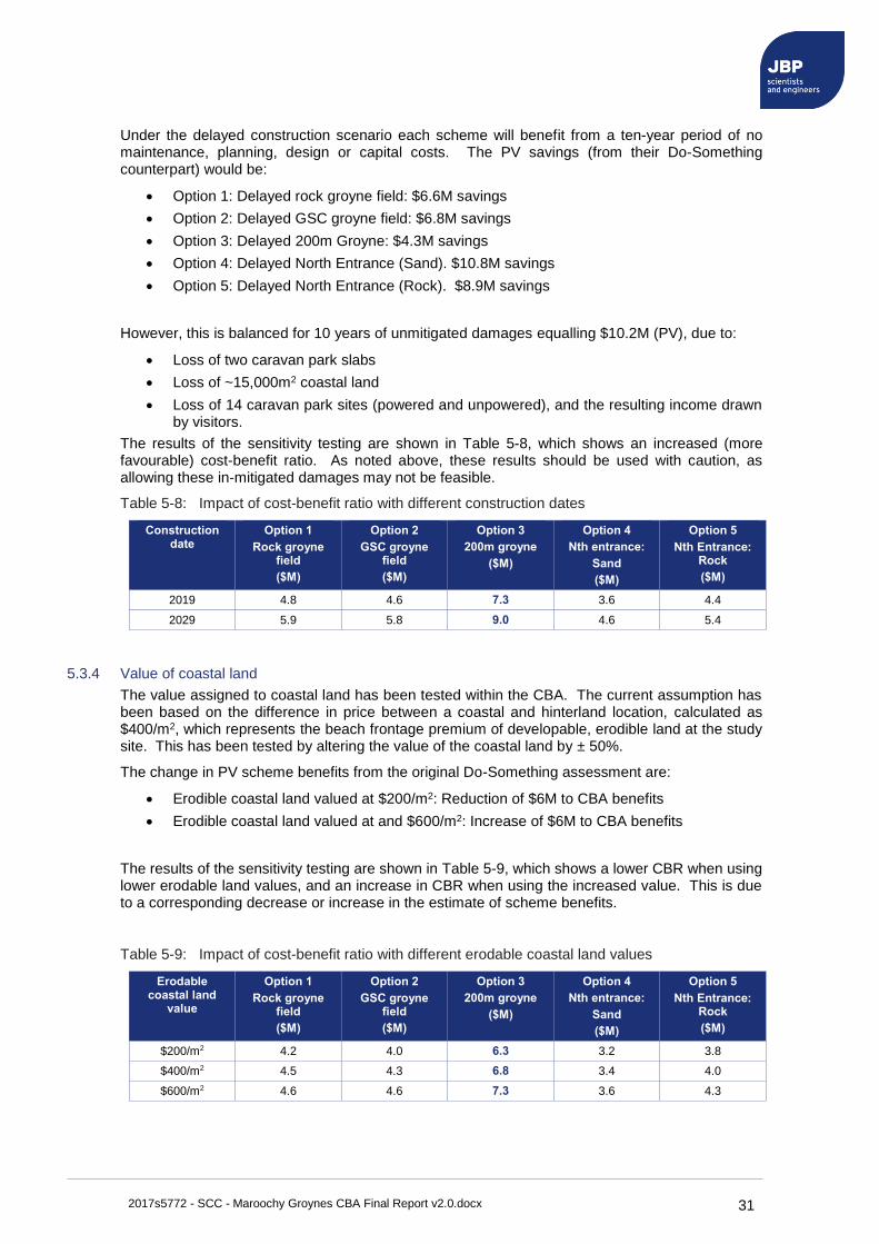
2017s5772 - SCC - Maroochy Groynes CBA Final Report v2.0.docx 31
Under the delayed construction scenario each scheme will benefit from a ten-year period of no maintenance, planning, design or capital costs. The PV savings (from their Do-Something counterpart) would be:
• Option 1: Delayed rock groyne field: $6.6M savings
• Option 2: Delayed GSC groyne field: $6.8M savings
• Option 3: Delayed 200m Groyne: $4.3M savings
• Option 4: Delayed North Entrance (Sand). $10.8M savings
• Option 5: Delayed North Entrance (Rock). $8.9M savings
However, this is balanced for 10 years of unmitigated damages equalling $10.2M (PV), due to:
• Loss of two caravan park slabs
• Loss of ~15,000m2 coastal land
• Loss of 14 caravan park sites (powered and unpowered), and the resulting income drawn by visitors.
The results of the sensitivity testing are shown in Table 5-8, which shows an increased (more favourable) cost-benefit ratio. As noted above, these results should be used with caution, as allowing these in-mitigated damages may not be feasible.
Table 5-8: Impact of cost-benefit ratio with different construction dates
Construction date
Option 1
Rock groyne field
($M)
Option 2
GSC groyne field
($M)
Option 3
200m groyne
($M)
Option 4
Nth entrance:
Sand
($M)
Option 5
Nth Entrance: Rock
($M)
2019 4.8 4.6 7.3 3.6 4.4
2029 5.9 5.8 9.0 4.6 5.4
5.3.4 Value of coastal land
The value assigned to coastal land has been tested within the CBA. The current assumption has been based on the difference in price between a coastal and hinterland location, calculated as $400/m2, which represents the beach frontage premium of developable, erodible land at the study site. This has been tested by altering the value of the coastal land by ± 50%.
The change in PV scheme benefits from the original Do-Something assessment are:
• Erodible coastal land valued at $200/m2: Reduction of $6M to CBA benefits
• Erodible coastal land valued at and $600/m2: Increase of $6M to CBA benefits
The results of the sensitivity testing are shown in Table 5-9, which shows a lower CBR when using lower erodable land values, and an increase in CBR when using the increased value. This is due to a corresponding decrease or increase in the estimate of scheme benefits.
Table 5-9: Impact of cost-benefit ratio with different erodable coastal land values
Erodable coastal land
value
Option 1
Rock groyne field
($M)
Option 2
GSC groyne field
($M)
Option 3
200m groyne
($M)
Option 4
Nth entrance:
Sand
($M)
Option 5
Nth Entrance: Rock
($M)
$200/m2 4.2 4.0 6.3 3.2 3.8
$400/m2 4.5 4.3 6.8 3.4 4.0
$600/m2 4.6 4.6 7.3 3.6 4.3
2017s5772 - SCC - Maroochy Groynes CBA Final Report v2.0.docx 32
5.4 Comparison of rock and geotextile groynes
The CBA results indicate rock to be the more financially beneficial material for new groyne fields. The use of rock involves relatively high construction costs, however has low ongoing maintenance costs throughout the 50-year design life. This is shown to be more cost effective compared to geotextile groynes, which have lower initial construction costs but significantly higher maintenance requirements and will require three replacements to span the 50-year period.
5.5 Discussion of the economically preferred option
Results of the CBA show Option 3: the 200m groyne, as having the highest cost-benefit ratio. This option assumes a single new rock groyne is constructed at Cotton Tree beach. The replacement of the existing structures with a single groyne structure of an assumed 200m length has lower capital costs than four replacement rock groynes, and it has far lower maintenance costs than the use of GSCs. Due to the uncertainty in its placement and performance in protecting the Cotton Tree beach from erosion, an additional allowance has been given for regular maintenance of the area. The economic assessment has assumed its efficiency would decrease regular nourishment of Maroochydore beach by 50%, which needs further quantification through a sediment transport assessment.
The PV costs of the scheme, including further planning, design, construction and maintenance over 50 years is $8M. Monetised benefits of the scheme include:
• Benefits of protected infrastructure and assets: $1.0M
• Benefits of protected land: $12.1M of holiday park land, plus an additional 1.0M of beachfront land created.
• Benefits of retained visitor expenditure: $75.3M
Small changes to the assessed costs and scheme benefits may alter the cost-benefit ratios for all options, in addition to any assumptions made to future maintenance requirements. All changes to the assumptions in this report should be tested by revising the CBA.
2017s5772 - SCC - Maroochy Groynes CBA Final Report v2.0.docx 33
6 Summary This study was undertaken by Jeremy Benn Pacific (JBP), on behalf of the Sunshine Coast Council (SCC), to conduct a coastal economic analysis at Maroochy River mouth, Maroochydore, Australia.
The assessment has used a Cost-Benefit Assessment (CBA) to consider the economic justification behind a range of coastal management approaches. The benefits of implementing each scheme have been assessed based on the protection offered to existing infrastructure and assets, the avoided loss of land, avoided loss of visitor expenditure, or any associated benefits due to the scheme.
The CBA results indicated all options had a positive cost-benefit ratio, and were considered economically viable. This is due to the protection of high-value coastal land, and the significant role of the caravan park in accommodating visitors to the local government area. Outcomes of the CBA are as follows:
• The comparison of the replacement rock and geotextile groyne fields indicates rock to be the more financially beneficial material. The use of rock involves relatively high construction costs, however has low ongoing maintenance costs throughout the 50-year design life. This is shown to be more cost effective compared to geotextile groynes, which have lower initial construction costs but significantly higher maintenance requirements and will require three replacements to span the 50-year period.
• The single large rock groyne (as compared to a groyne field) has the highest cost-benefit ratio. The option was assessed as having the duel benefit of providing protection to Cotton Tree beach, whilst reducing the need for ongoing beach nourishment along the Maroochydore to Alexandra Headland coast. Based on an early conceptual design only, the position, length and performance of the structure is considered indicative, with further design and assessment stages now justified. In order to remain the most cost-beneficial, a position and orientation would need to be identified that offered protection to the Cotton Tree beach, minimised annual nourishment costs, did not incur other damages such as downdrift erosion, and did not significantly change the structure dimensions (and therefor costs).
• The two options to re-establish the Maroochy River mouth to the north of Pincushion Island have the lowest economic justification. This is primarily due to considerably higher construction costs, approximately double that of the groyne field replacement options. These options would also require considerable investigation into short and long term implications for geomorphic and sedimentation processes for the Maroochy River mouth and adjacent coastline.
Due to the range of options, stakeholders and interested parties this economic analysis is considered the first stage of a process to select the preferred management option, with future stages including stakeholder consultation, long term sediment dynamics and the broader management plan for the coastline. These outcomes will enable Council to proceed with subsequent investigations and consultation required to inform the design of suitable coastal protection works that meet the range of environmental, social and economic objectives for the dynamic Maroochy River mouth.

2017s5772 - SCC - Maroochy Groynes CBA Final Report v2.0.docx I
A Appendix - Concept drawing of replacement groyne field
A.1 Appendix A.1: Location Plan
A.2 Appendix A.2: Groyne Option 1 Detail
A.3 Appendix A.3: Groyne Option 2 Detail
2017s5772 - SCC - Maroochy Groynes CBA Final Report v2.0.docx II
B Appendix - P90 costing information
B.1 Overview
High level P90 cost estimates have been undertaken for all structure options. A probabilistic risk assessment model has been used for the costing, considered both inherent and contingent risk using @Risk modelling software17 and based on the Project Cost Estimating Management (PCEM) guidelines published by the Department of Transport and Main Roads (DTMR)18.
B.2 Assumptions and exclusions
The following assumptions have been made within the cost estimate.
• All existing sand geofabric sand container will removed and disposed off-site
• Excavated material will be stockpiled at the site and used for backfilling, with surplus materials to be spread within the site area
• A bed elevation slope is assumed 1:50, and the design crest level is maintained 2.0mAHD along the length of the rock groyne
• The construction will be carried using land based equipment
• There is no requirement for divers for below water works
• There is no requirement for marine traffic management
• The average excavation below beach level is 2m deep
• Dredged sand will be a clean material and no treatment is required
• All quantities for Option 3, 4 & 5 are as per BMT WBM Report19
• All works will be undertaken by local qualified and experienced contractor
• All work will be completed under normal working hours.
The following exclusions have been made within the cost estimate. No allowance has been made for:
• Preservation of the heritage value of Cotton Tree Holiday Park due to erosion (i.e. construction of seawall)
• Staging out of hours works
• Removal of contaminated or hazardous material
• Excavation rock
• Escalation
• Any administrative costs to the principal
• Any loss of revenue, income and disruption costs to operations during works
• Any legal and finance charges
• Any Goods and Services Tax (GST)
• Any statutory fees and charges.
17 @Risk, 2017. Available online: http://www.palisade.com/risk/
18 QLD Government, 2015. Project cost estimating manual: Sixth Edition, page 6.
19 BMT WRM, (2016). Maroochy River Mouth Coastal Management - Preliminary Options Assessment, Page 15-28
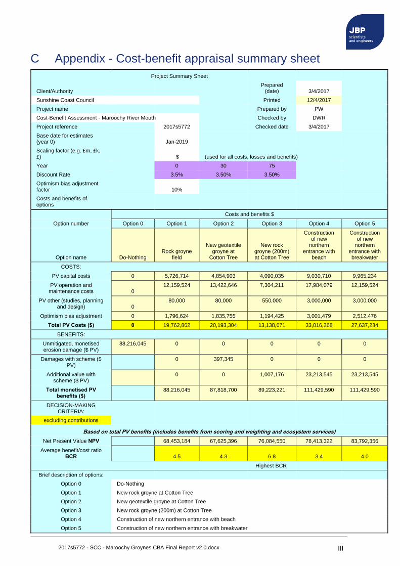
2017s5772 - SCC - Maroochy Groynes CBA Final Report v2.0.docx III
C Appendix - Cost-benefit appraisal summary sheet
Project Summary Sheet
Client/Authority Prepared
(date) 3/4/2017
Sunshine Coast Council Printed 12/4/2017
Project name Prepared by PW
Cost-Benefit Assessment - Maroochy River Mouth Checked by DWR
Project reference 2017s5772 Checked date 3/4/2017
Base date for estimates (year 0) Jan-2019
Scaling factor (e.g. £m, £k, £) $ (used for all costs, losses and benefits)
Year 0 30 75
Discount Rate 3.5% 3.50% 3.50%
Optimism bias adjustment factor 10%
Costs and benefits of options
Costs and benefits $
Option number Option 0 Option 1 Option 2 Option 3 Option 4 Option 5
Option name Do-Nothing Rock groyne
field
New geotextile groyne at
Cotton Tree
New rock groyne (200m) at Cotton Tree
Construction of new
northern entrance with
beach
Construction of new
northern entrance with breakwater
COSTS:
PV capital costs 0 5,726,714 4,854,903 4,090,035 9,030,710 9,965,234
PV operation and maintenance costs 0
12,159,524 13,422,646 7,304,211 17,984,079 12,159,524
PV other (studies, planning and design) 0
80,000 80,000 550,000 3,000,000 3,000,000
Optimism bias adjustment 0 1,796,624 1,835,755 1,194,425 3,001,479 2,512,476
Total PV Costs ($) 0 19,762,862 20,193,304 13,138,671 33,016,268 27,637,234
BENEFITS:
Unmitigated, monetised erosion damage ($ PV)
88,216,045 0 0 0 0 0
Damages with scheme ($ PV)
0 397,345 0 0 0
Additional value with scheme ($ PV)
0 0 1,007,176 23,213,545 23,213,545
Total monetised PV benefits ($)
88,216,045 87,818,700 89,223,221 111,429,590 111,429,590
DECISION-MAKING CRITERIA:
excluding contributions
Based on total PV benefits (includes benefits from scoring and weighting and ecosystem services)
Net Present Value NPV 68,453,184 67,625,396 76,084,550 78,413,322 83,792,356
Average benefit/cost ratio BCR 4.5 4.3 6.8 3.4 4.0
Highest BCR
Brief description of options:
Option 0 Do-Nothing
Option 1 New rock groyne at Cotton Tree
Option 2 New geotextile groyne at Cotton Tree
Option 3 New rock groyne (200m) at Cotton Tree
Option 4 Construction of new northern entrance with beach
Option 5 Construction of new northern entrance with breakwater
2017s5772 - SCC - Maroochy Groynes CBA Final Report v2.0.docx IV
D Appendix - Example coastal economic analysis
D.1 Australian examples:
• Beach and surf tourism and recreation in Australia: Vulnerability and adaptation assessment20
• The assessment considered beach recreation values for residents, estimated using non-market valuation. It used a Willingness To Pay (WTP) approach where travel costs were used to estimate the value of a beach visit for visitors, and included an expenditure analyses for domestic and international visitors. The value of this tourism expenditure specifically related to beach and surf recreation at the Sunshine Coast, QLD, is estimated to be in the order of $270 million annually.
The study undertook various surveys of beach visitation frequency, and the drawcard of the beach. Statistics for the Sunshine Coast region are summarised below:
o 91% of residents had visited the beach in the previous 12-month period
o Average visitation frequency is 84 visits per annum (that is between 1-2 times per week). This is comparable to other statistics from the Gold Coast (2006) which estimated a frequency of 48 times per year (just under once per week).
o The activities with the highest percentage of regular participants are walking/running/jogging and swimming.
o Criteria rated as most important were clean water, a sandy beach, and amenities such as showers and car parking. Commercial services, such as cafés were seen as lower priority.
o The study considered the impact due to changed conditions, such as erosion, undertaking various surveys to understand its impact to beach visitation. Statistics for the Sunshine Coast region are summarised below:
o Approximately 68% of all residents surveyed indicated they would be prepared to travel to another beach, or pay for erosion prevention measures to make this travel unnecessary. At the Sunshine Coast the highest percentage of residents (around 30%) indicated they would travel an additional 30 minutes (round trip) to avoid erosion, and in monetary terms around 36% of residents would pay an additional $10 to avoid erosion.
o This response was even higher for tourists, with around 77% willing to spend time and money to avoid erosion. The majority of tourist respondents (total of 55%) would spend an additional 30 to 60 minutes (round trip) travel time, and in monetary terms around 31% would pay an additional $10 to avoid erosion
The study uses an annual discount rate of 7% over a period of 30 years to estimate future benefits.
• Town Beach climate change benefit cost assessment, Port Macquarie21
Community meetings identified the values residents gained from the beach, which included natural/environmental, social/community and economic benefits, such as the role of the beach in the towns tourism. The CBA estimated benefits as damages avoided due to inundation and erosion. These considered houses, recreational land, car parks and roads. Land values were used for ocean front land, which was considered to have historical values, and used a unit-rate of $781/m2.
• Shoalhaven multi-criteria framework for erosion protection22
The MCA considered economic benefits, damages avoided to ocean front property owners and beach users, adaptation flexibility and visual impact on the beach. As the MCA did not
20 Mike Raybould, M., Anning, D., Ware, D., Lazarow., L (2013) Beach and surf tourism in Australia: Vulnerability and adaptation. Fisheries Research and Development Corporation and Bond University.
21 PMHC, Port Macquarie Hastings Council (2010). Coastal Zone Management Plan for the Town Beach
Coastline. http://www.pmhc.nsw.gov.au/Resident-Services/Environment/Waterways/Managing-ourcoastline/Town-Beach-coastal-management Accessed 20.09.2016
22 Gopalakrishnan, S., Smith, M.D., Slott, J.M. and Murray, A.B., 2011. The value of disappearing beaches: a hedonic pricing model with endogenous beach width. Journal of Environmental Economics and Management, 61(3), pp.297-310.
2017s5772 - SCC - Maroochy Groynes CBA Final Report v2.0.docx V
require all benefits to be monetised, elements were quantified through a mixture of economic and weighted (1-5) scores. Of interest to this project, the beach amenity to users was considered a function of available beach width. A wider beach is considered to have a greater performance in reducing erosion and flooding risks for ocean front properties, will provide more space for recreation, and reduce the crowdedness. Therefore, increasing the beach width increased its value. This study adapted the discount rate of 4.5% p.a.23.
• Mandurah coastal erosion protection assessment24
The benefits of coastal protection were calculated as damages avoided due to loss of buildings and land from erosion. The damages avoided were calculated based on the value of buildings and a unit-rate for residential land, using a price of $600/m2. Of interest to this study, no losses to recreation were considered in the assessment. As the beach is retreating without a backstop defence it is assumed its width will remain constant, therefore presenting no losses to beach users.
D.2 International examples:
• Rhyl Coastal Defence Options Appraisal, Denbighshire Council25
This CBA was submitted to the Welsh Government to support the construction of new coastal defences. It considering the damages avoided to property due to present day and future coastal flooding (including climate change). Benefits were estimated based on depth-damage curves for residential and commercial properties, informed by coastal modelling of extreme sea levels and wave overtopping.
A time-varying discount rate was used, starting at 3.5% for the first 30 years, reducing to 3% at year 31 and 2.5% at year 76, with an overall assessment period of 100 years.
• Cwm Ivy Habitat Creation Project, Natural Resources Wales26
This CBA was used to support the creation of new coastal habitat. It estimated the benefit of creating new habitat through an ecosystem services approach, which quantified changes to biodiversity. This change in value was quantified due to the replacement of terrestrial freshwater habitats with more 'valuable' intertidal habitats. A time-varying discount rate was used, starting at 3.5% for the first 30 years, reducing to 3% at year 31 and 2.5% at year 76.
• Global analysis of erosion of sandy beaches and sea-level rise27
This assessment considered global effects of climate-induced sea-level rise and the erosion to sandy beaches. Benefits were estimated as lost tourism income. It reasoned that tourists are often attracted to regions with more available recreational activities and services, and as a region’s land erodes there will be a decline in both population and the income from tourism.
23 Truong, C., Truck, S., Davies, P., Mathew, S., 2016. Exploring valuation methods for climate adaptation options, with particular reference to Australian coastal councils, pp. 18-33
24 MP Rogers & Associates (2010). Falcon Bay Stabilisation Options.
25 JBA Consulting (2016) Rhyl Coastal Defence Scheme: Preliminary Coastal Risk Assessment, Prepared for the Denbighshire County Council.
26 JBA Consulting (2015) Cwm Ivy Habitat Creation Project, Project Appraisal Report., Prepared for the Natural Resources Wales
27 Hinkel, J., Nicholls, R. J., Tol, R. S., Wang, Z. B., Hamilton, J. M., Boot, G., ... & Klein, R. J. (2013). A global analysis of erosion of sandy beaches and sea-level rise: An application of DIVA. Global and Planetary Change, 111, 150-158.

Offices in
Australia
Singapore
UK
Ireland
Registered Office Level 2,
433 Boundary Street,
Spring Hill QLD 4004 Australia
t:+61 (0)7 3838 2578
e:daniel.rodger@jbpacific .com.au
Visit our website
www.jbpacific.com.au

LOCATION PLANLOCATION PLANSCALE 1:1000SCALE 1:1000
92.0092.00
90.0090.00
47.0047.00
71.0
071
.00
LOCATION PLANLOCATION PLANSCALE 1:50000SCALE 1:50000
The property of this drawing and design vested in Jeremy Benn Associates Ltd. It shall not be reproduced in whole or in part,The property of this drawing and design vested in Jeremy Benn Associates Ltd. It shall not be reproduced in whole or in part,nor disclosed to a third party, without the prior written consent of Jeremy Benn Associates Ltd.nor disclosed to a third party, without the prior written consent of Jeremy Benn Associates Ltd.
ProjectProject
TitleTitle
ClientClientforfor
ScaleScale
Drawing NumberDrawing Number RevisionRevision
Project Number:Project Number:
Drawn:Drawn:Designed:Designed:Checked:Checked:Approved:Approved:
RevisionRevision
Aberdeen HouseAberdeen HouseSouth RoadSouth RoadHAYWARDS HEATHHAYWARDS HEATHWest SussexWest SussexRH16 4NGRH16 4NGUnited KingdomUnited Kingdom
www.jbpacific.com.auwww.jbpacific.com.au
tt +44 (0)1444 473652+44 (0)1444 473652ff +44 (0)845 8627772+44 (0)845 8627772ee [email protected]@jbaconsulting.com
Jeremy Benn PacificJeremy Benn Pacific
Level 2, 433 Boundary StreetLevel 2, 433 Boundary Street
Spring HillSpring Hill
QLD 4004, Australia QLD 4004, Australia
Phone contact for both offices:Phone contact for both offices:Daniel RodgerDaniel Rodger+61 (0) 420 644 348+61 (0) 420 644 348
Maroochydore Beach GroynesMaroochydore Beach Groynes
2017s57722017s5772
ApprovedApprovedCheckedCheckedDesignedDesignedDrawnDrawnDateDate
Purpose of IssuePurpose of Issue StatusStatus
Client ApprovalClient ApprovalRev.:Rev.:
A - ApprovedA - ApprovedB - Approved with RevisionsB - Approved with RevisionsC - Do Not UseC - Do Not Use
CommentsCommentsApprovedApprovedCheckedCheckedDesignedDesignedDrawnDrawnDateDateRev.:Rev.:
CommentsCommentsApprovedApprovedCheckedCheckedDesignedDesignedDrawnDrawnDateDateRev.:Rev.:
CommentsCommentsApprovedApprovedCheckedCheckedDesignedDesignedDrawnDrawnDateDateRev.:Rev.:
CommentsCommentsApprovedApprovedCheckedCheckedDesignedDesignedDrawnDrawnDateDateRev.:Rev.:
CommentsCommentsApprovedApprovedCheckedCheckedDesignedDesignedDrawnDrawnDateDateRev.:Rev.:
CommentsCommentsApprovedApprovedCheckedCheckedDesignedDesignedDrawnDrawnDateDateRev.:Rev.:
CommentsComments
Groynes OptionsGroynes Options
Location PlanLocation Plan
2017s5772-JBP-00-DR-C-10002017s5772-JBP-00-DR-C-1000 P01.00P01.00
AS SHOWN @ A1AS SHOWN @ A1S.OrtigosaS.Ortigosa 29/03/1729/03/17G. KennG. Kenn 23/03/1723/03/17A. DaneA. Dane 23/03/1723/03/17D.RodgerD.Rodger 23/03/1723/03/17
The property of this drawing and design vested in Jeremy Benn Associates Ltd. It shall not be reproduced in whole or in part,The property of this drawing and design vested in Jeremy Benn Associates Ltd. It shall not be reproduced in whole or in part,nor disclosed to a third party, without the prior written consent of Jeremy Benn Associates Ltd.nor disclosed to a third party, without the prior written consent of Jeremy Benn Associates Ltd.
ProjectProject
TitleTitle
ClientClientforfor
ScaleScale
Drawing NumberDrawing Number RevisionRevision
Project Number:Project Number:
Drawn:Drawn:Designed:Designed:Checked:Checked:Approved:Approved:
RevisionRevision
Aberdeen HouseAberdeen HouseSouth RoadSouth RoadHAYWARDS HEATHHAYWARDS HEATHWest SussexWest SussexRH16 4NGRH16 4NGUnited KingdomUnited Kingdom
www.jbpacific.com.auwww.jbpacific.com.au
tt +44 (0)1444 473652+44 (0)1444 473652ff +44 (0)845 8627772+44 (0)845 8627772ee [email protected]@jbaconsulting.com
Jeremy Benn PacificJeremy Benn Pacific
Level 2, 433 Boundary StreetLevel 2, 433 Boundary Street
Spring HillSpring Hill
QLD 4004, Australia QLD 4004, Australia
Phone contact for both offices:Phone contact for both offices:Daniel RodgerDaniel Rodger+61 (0) 420 644 348+61 (0) 420 644 348
Maroochydore Beach GroynesMaroochydore Beach Groynes
2017s57722017s5772
General Notes:General Notes:
1.1. Conceptual designs only - not for Conceptual designs only - not for construction.construction.2.2. All dimensions shown are in metres, and all levels in mAHD unless otherwiseAll dimensions shown are in metres, and all levels in mAHD unless otherwise
stated.stated.3.3. Do not scale from this drawing. All dimensions must be checked/verified on site.Do not scale from this drawing. All dimensions must be checked/verified on site.4.4. This drawing is to be read in conjunction with the associated report.This drawing is to be read in conjunction with the associated report.5.5. The locations of any known services shown on the drawing (if any) areThe locations of any known services shown on the drawing (if any) are
approximate and for guidance only. The Contractor will confirm the location ofapproximate and for guidance only. The Contractor will confirm the location ofany services prior to the commencement of any works.any services prior to the commencement of any works.
6.6. The electronic model of this drawing is not to be used for setting out.The electronic model of this drawing is not to be used for setting out.7.7. Drawings to be read in conjunction with this drawing:Drawings to be read in conjunction with this drawing:
2017s5772-JBP-00-DR-C-1001-Groyne Option 1 Detail_P01.002017s5772-JBP-00-DR-C-1001-Groyne Option 1 Detail_P01.002017s5772-JBP-00-DR-C-1002-Groyne Option 2 Detail_P01.002017s5772-JBP-00-DR-C-1002-Groyne Option 2 Detail_P01.00

SECTION B-BSECTION B-BROCK GROYNEROCK GROYNE
SCALE 1:50SCALE 1:50
3.00m (MIN x3 ROCKS WIDE) 3.00m (MIN x3 ROCKS WIDE)
2.00
m B
ELO
W2.
00m
BEL
OW
BEAC
H L
EVEL
BEAC
H L
EVEL
2.00
m A
BOVE
2.00
m A
BOVE
BEAC
H L
EVEL
BEAC
H L
EVEL
MIN. x2 ROCKS WIDEMIN. x2 ROCKS WIDE
KEYSTONESKEYSTONESTO BE >5TTO BE >5T CORE TO BE PRIMARY ARMOURSTONECORE TO BE PRIMARY ARMOURSTONE
OR SMALLER GRADING DEPENDENT ONOR SMALLER GRADING DEPENDENT ONWHICH IS MOST COST EFFECTIVEWHICH IS MOST COST EFFECTIVE
GEOTEXTILE BEDDING LAYERGEOTEXTILE BEDDING LAYERKEYSTONESKEYSTONESTO BE >5TTO BE >5T
15.40m15.40m
2 LAYERS OF 3.5T-6T2 LAYERS OF 3.5T-6TARMOURSTONEARMOURSTONE
1 IN 50-YEAR1 IN 50-YEAREXTREME SEA LEVELEXTREME SEA LEVEL
2.68mAHD2.68mAHD
MEAN HIGH WATERMEAN HIGH WATERSPRING TIDE 0.67mAHDSPRING TIDE 0.67mAHD
EXISTING BEACH LEVELEXISTING BEACH LEVEL
SECTION A-ASECTION A-AROCK GROYNEROCK GROYNE
SCALE 1:150SCALE 1:150
EXISTING BEACH LEVELEXISTING BEACH LEVEL
STRUCTURE BASE LEVELSTRUCTURE BASE LEVEL
x2 LAYERS OF 3.5T-6Tx2 LAYERS OF 3.5T-6TARMOURSTONEARMOURSTONE
MEAN HIGH WATERMEAN HIGH WATERSPRING TIDE 0.67mAHDSPRING TIDE 0.67mAHD
1 IN 50-YEAR EXTREME1 IN 50-YEAR EXTREMESEA LEVEL 2.68mAHDSEA LEVEL 2.68mAHD
KEYSTONES TO BE >5TKEYSTONES TO BE >5T
KEYSTONESKEYSTONESTO BE >5TTO BE >5T
15.4015.40
AA
AA
BB
BB ROCK GROYNE PLANROCK GROYNE PLANSCALE 1:500SCALE 1:500
ApprovedApprovedCheckedCheckedDesignedDesignedDrawnDrawnDateDate
Purpose of IssuePurpose of Issue StatusStatus
Client ApprovalClient ApprovalRev.:Rev.:
A - ApprovedA - ApprovedB - Approved with RevisionsB - Approved with RevisionsC - Do Not UseC - Do Not Use
CommentsCommentsApprovedApprovedCheckedCheckedDesignedDesignedDrawnDrawnDateDateRev.:Rev.:
CommentsCommentsApprovedApprovedCheckedCheckedDesignedDesignedDrawnDrawnDateDateRev.:Rev.:
CommentsCommentsApprovedApprovedCheckedCheckedDesignedDesignedDrawnDrawnDateDateRev.:Rev.:
CommentsCommentsApprovedApprovedCheckedCheckedDesignedDesignedDrawnDrawnDateDateRev.:Rev.:
CommentsCommentsApprovedApprovedCheckedCheckedDesignedDesignedDrawnDrawnDateDateRev.:Rev.:
CommentsCommentsApprovedApprovedCheckedCheckedDesignedDesignedDrawnDrawnDateDateRev.:Rev.:
CommentsComments
Groynes OptionsGroynes Options
Groyne Option 1 DetailGroyne Option 1 Detail
2017s5772-JBP-00-DR-C-10012017s5772-JBP-00-DR-C-1001 P01.00P01.00
As Shown @ A1As Shown @ A1S.OrtigosaS.Ortigosa 29/03/1729/03/17G. KennG. Kenn 23/03/1723/03/17A. DaneA. Dane 23/03/1723/03/17D.RodgerD.Rodger 23/03/1723/03/17
The property of this drawing and design vested in Jeremy Benn Associates Ltd. It shall not be reproduced in whole or in part,The property of this drawing and design vested in Jeremy Benn Associates Ltd. It shall not be reproduced in whole or in part,nor disclosed to a third party, without the prior written consent of Jeremy Benn Associates Ltd.nor disclosed to a third party, without the prior written consent of Jeremy Benn Associates Ltd.
ProjectProject
TitleTitle
ClientClientforfor
ScaleScale
Drawing NumberDrawing Number RevisionRevision
Project Number:Project Number:
Drawn:Drawn:Designed:Designed:Checked:Checked:Approved:Approved:
RevisionRevision
Aberdeen HouseAberdeen HouseSouth RoadSouth RoadHAYWARDS HEATHHAYWARDS HEATHWest SussexWest SussexRH16 4NGRH16 4NGUnited KingdomUnited Kingdom
www.jbpacific.com.auwww.jbpacific.com.au
tt +44 (0)1444 473652+44 (0)1444 473652ff +44 (0)845 8627772+44 (0)845 8627772ee [email protected]@jbaconsulting.com
Jeremy Benn PacificJeremy Benn Pacific
Level 2, 433 Boundary StreetLevel 2, 433 Boundary Street
Spring HillSpring Hill
QLD 4004, Australia QLD 4004, Australia
Phone contact for both offices:Phone contact for both offices:Daniel RodgerDaniel Rodger+61 (0) 420 644 348+61 (0) 420 644 348
Maroochydore Beach GroynesMaroochydore Beach Groynes
2017s57722017s5772
General Notes:General Notes:
1.1. Conceptual designs only - not for Conceptual designs only - not for construction.construction.2.2. All dimensions shown are in metres, and all levels in mAHD unless otherwiseAll dimensions shown are in metres, and all levels in mAHD unless otherwise
stated.stated.3.3. Do not scale from this drawing. All dimensions must be checked/verified on site.Do not scale from this drawing. All dimensions must be checked/verified on site.4.4. This drawing is to be read in conjunction with the associated report.This drawing is to be read in conjunction with the associated report.5.5. The locations of any known services shown on the drawing (if any) areThe locations of any known services shown on the drawing (if any) are
approximate and for guidance only. The Contractor will confirm the location ofapproximate and for guidance only. The Contractor will confirm the location ofany services prior to the commencement of any works.any services prior to the commencement of any works.
6.6. The electronic model of this drawing is not to be used for setting out.The electronic model of this drawing is not to be used for setting out.7.7. Drawings to be read in conjunction with this drawing:Drawings to be read in conjunction with this drawing:
2017s5772-JBP-00-DR-C-1000-Location Plan_P01.002017s5772-JBP-00-DR-C-1000-Location Plan_P01.002017s5772-JBP-00-DR-C-1002-Groyne Option 2 Detail_P01.002017s5772-JBP-00-DR-C-1002-Groyne Option 2 Detail_P01.00

SANDBAGS GROYNE PLANSANDBAGS GROYNE PLANSCALE 1:500SCALE 1:500
12.0012.00AA
AA
BB
BB
TYPICAL SANDBAG DETAILTYPICAL SANDBAG DETAILNOT TO SCALENOT TO SCALE
SCALE 1:20SCALE 1:20
1.801.800.
700.
70
2.402.40
x5 CONTAINERS WIDE (MINIMUM) @ 2.4m = 12mx5 CONTAINERS WIDE (MINIMUM) @ 2.4m = 12m
2.40m2.40m
ELCOROCK GEOTEXTILEELCOROCK GEOTEXTILESAND CONTAINERSSAND CONTAINERS
x5 C
ON
TAIN
ERS
WID
E (M
INIM
UN
)x5
CO
NTA
INER
S W
IDE
(MIN
IMU
N)
@ 0
.7m
= 3
.5m
@ 0
.7m
= 3
.5m
SECTION B-BSECTION B-BSANDBAGS GROYNESANDBAGS GROYNE
SCALE 1:50SCALE 1:50
EXISTING BEACH LEVELEXISTING BEACH LEVEL
1 IN 50-YEAR1 IN 50-YEAREXTREME SEA LEVELEXTREME SEA LEVEL
2.68mAHD2.68mAHD
MEAN HIGH WATERMEAN HIGH WATERSPRING TIDE 0.67mAHDSPRING TIDE 0.67mAHD
VELCRO STRIPSVELCRO STRIPS
VELCRO STRIPSVELCRO STRIPS
CREST LEVELCREST LEVEL2.0mAHD2.0mAHD
BASE LEVELBASE LEVEL-1.5mAHD-1.5mAHD
SECTION A-ASECTION A-ASANDBAGS GROYNESANDBAGS GROYNE
SCALE 1:150SCALE 1:150
TERRAFIXTERRAFIX"SOFT ROCKS""SOFT ROCKS"
STRUCTURE BASE LEVELSTRUCTURE BASE LEVEL
1 IN 50-YEAR EXTREME1 IN 50-YEAR EXTREMESEA LEVEL 2.68mAHDSEA LEVEL 2.68mAHD
MEAN HIGH WATERMEAN HIGH WATERSPRING TIDE 0.67mAHDSPRING TIDE 0.67mAHDEXISTING BEACH LEVELEXISTING BEACH LEVEL
The property of this drawing and design vested in Jeremy Benn Associates Ltd. It shall not be reproduced in whole or in part,The property of this drawing and design vested in Jeremy Benn Associates Ltd. It shall not be reproduced in whole or in part,nor disclosed to a third party, without the prior written consent of Jeremy Benn Associates Ltd.nor disclosed to a third party, without the prior written consent of Jeremy Benn Associates Ltd.
ProjectProject
TitleTitle
ClientClientforfor
ScaleScale
Drawing NumberDrawing Number RevisionRevision
Project Number:Project Number:
Drawn:Drawn:Designed:Designed:Checked:Checked:Approved:Approved:
RevisionRevision
Aberdeen HouseAberdeen HouseSouth RoadSouth RoadHAYWARDS HEATHHAYWARDS HEATHWest SussexWest SussexRH16 4NGRH16 4NGUnited KingdomUnited Kingdom
www.jbpacific.com.auwww.jbpacific.com.au
tt +44 (0)1444 473652+44 (0)1444 473652ff +44 (0)845 8627772+44 (0)845 8627772ee [email protected]@jbaconsulting.com
Jeremy Benn PacificJeremy Benn Pacific
Level 2, 433 Boundary StreetLevel 2, 433 Boundary Street
Spring HillSpring Hill
QLD 4004, Australia QLD 4004, Australia
Phone contact for both offices:Phone contact for both offices:Daniel RodgerDaniel Rodger+61 (0) 420 644 348+61 (0) 420 644 348
Maroochydore Beach GroynesMaroochydore Beach Groynes
2017s57722017s5772
ApprovedApprovedCheckedCheckedDesignedDesignedDrawnDrawnDateDate
Purpose of IssuePurpose of Issue StatusStatus
Client ApprovalClient ApprovalRev.:Rev.:
A - ApprovedA - ApprovedB - Approved with RevisionsB - Approved with RevisionsC - Do Not UseC - Do Not Use
CommentsCommentsApprovedApprovedCheckedCheckedDesignedDesignedDrawnDrawnDateDateRev.:Rev.:
CommentsCommentsApprovedApprovedCheckedCheckedDesignedDesignedDrawnDrawnDateDateRev.:Rev.:
CommentsCommentsApprovedApprovedCheckedCheckedDesignedDesignedDrawnDrawnDateDateRev.:Rev.:
CommentsCommentsApprovedApprovedCheckedCheckedDesignedDesignedDrawnDrawnDateDateRev.:Rev.:
CommentsCommentsApprovedApprovedCheckedCheckedDesignedDesignedDrawnDrawnDateDateRev.:Rev.:
CommentsCommentsApprovedApprovedCheckedCheckedDesignedDesignedDrawnDrawnDateDateRev.:Rev.:
CommentsComments
Groynes OptionsGroynes Options
Groyne Option 2 DetailGroyne Option 2 Detail
2017s5772-JBP-00-DR-C-10022017s5772-JBP-00-DR-C-1002 P01.00P01.00
As Shown @ A1As Shown @ A1S.OrtigosaS.Ortigosa 29/03/1729/03/17G. KennG. Kenn 23/03/1723/03/17A. DaneA. Dane 23/03/1723/03/17D.RodgerD.Rodger 23/03/1723/03/17
The property of this drawing and design vested in Jeremy Benn Associates Ltd. It shall not be reproduced in whole or in part,The property of this drawing and design vested in Jeremy Benn Associates Ltd. It shall not be reproduced in whole or in part,nor disclosed to a third party, without the prior written consent of Jeremy Benn Associates Ltd.nor disclosed to a third party, without the prior written consent of Jeremy Benn Associates Ltd.
ProjectProject
TitleTitle
ClientClientforfor
ScaleScale
Drawing NumberDrawing Number RevisionRevision
Project Number:Project Number:
Drawn:Drawn:Designed:Designed:Checked:Checked:Approved:Approved:
RevisionRevision
Aberdeen HouseAberdeen HouseSouth RoadSouth RoadHAYWARDS HEATHHAYWARDS HEATHWest SussexWest SussexRH16 4NGRH16 4NGUnited KingdomUnited Kingdom
www.jbpacific.com.auwww.jbpacific.com.au
tt +44 (0)1444 473652+44 (0)1444 473652ff +44 (0)845 8627772+44 (0)845 8627772ee [email protected]@jbaconsulting.com
Jeremy Benn PacificJeremy Benn Pacific
Level 2, 433 Boundary StreetLevel 2, 433 Boundary Street
Spring HillSpring Hill
QLD 4004, Australia QLD 4004, Australia
Phone contact for both offices:Phone contact for both offices:Daniel RodgerDaniel Rodger+61 (0) 420 644 348+61 (0) 420 644 348
Maroochydore Beach GroynesMaroochydore Beach Groynes
2017s57722017s5772
General Notes:General Notes:
1.1. Conceptual designs only - not for Conceptual designs only - not for construction.construction.2.2. All dimensions shown are in metres, and all levels in mAHD unless otherwiseAll dimensions shown are in metres, and all levels in mAHD unless otherwise
stated.stated.3.3. Do not scale from this drawing. All dimensions must be checked/verified on site.Do not scale from this drawing. All dimensions must be checked/verified on site.4.4. This drawing is to be read in conjunction with the associated report.This drawing is to be read in conjunction with the associated report.5.5. The locations of any known services shown on the drawing (if any) areThe locations of any known services shown on the drawing (if any) are
approximate and for guidance only. The Contractor will confirm the location ofapproximate and for guidance only. The Contractor will confirm the location ofany services prior to the commencement of any works.any services prior to the commencement of any works.
6.6. The electronic model of this drawing is not to be used for setting out.The electronic model of this drawing is not to be used for setting out.7.7. Drawings to be read in conjunction with this drawing:Drawings to be read in conjunction with this drawing:
2017s5772-JBP-00-DR-C-1000-Location Plan_P01.002017s5772-JBP-00-DR-C-1000-Location Plan_P01.002017s5772-JBP-00-DR-C-1001-Groyne Option 1 Detail_P01.002017s5772-JBP-00-DR-C-1001-Groyne Option 1 Detail_P01.00