
Maroochy River Conservation Park Management Plan€¦ · 3 3 Basis for Management Maroochy River...
19
Management plan Maroochy River Conservation Park Management plan South East Queensland Biogeographic Region November 1999
Transcript of Maroochy River Conservation Park Management Plan€¦ · 3 3 Basis for Management Maroochy River...
Man
agem
ent
pla
nMaroochy River
Conservation ParkM
anag
emen
t p
lan
South East Queensland Biogeographic Region November 1999
Summary
This management plan provides the framework and guidelines on how Maroochy River ConservationPark will be managed. It sets out the considerations, outcomes and strategies that are proposed to formthe basis on which day-to-day management decisions are made.
This plan was prepared in July 1999 and, in accordance with s 125 of the Nature Conservation Act 1992,will be reviewed not later than 10 years after its approval. For further information on this plan or theplanning process, please contact the Queensland Parks and Wildlife Service Southern Regional Centre inMoggill, Brisbane, on (07) 3202 0200 during business hours.
This management plan was prepared by Queensland Parks and Wildlife Service staff. Thanks are due tothose groups and individuals who made submissions in response to the draft plan.
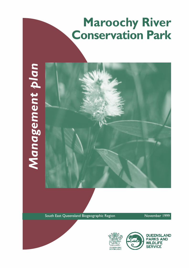
Cover photograph: Melaleuca quinquinervia (paper-barked tea tree)
ISSN 1037-4698© The State of Queensland, Queensland Parks and Wildlife Service, 1999.Copyright protects this publication. Except for purposes permitted by the Copyright Act, storage,transmission or reproduction of all or any part by any means is prohibited without the prior writtenpermission of the Queensland Parks and Wildlife Service. Direct inquiries to the Manager, Education andInformation Unit PO Box 155 BRISBANE ALBERT STREET QLD 4002.
RE291Recycled paper saves energy and resources
Contents
1 Introduction 2
2 Management directions and purposes 2
2.1 Management directions 22.2 Management purposes 2
3 Basis for management 3
3.1 Regional and management context 33.2 Resource description and values of Maroochy River Conservation Park 4
Geology and landformNative plantsNative animalsCultural heritageScenic and aestheticScientific and educationalRecreation and tourismEconomic
4 Management strategies 7
4.1 Natural Resource management 7Native plantsNative animalsIntroduced plants and animalsFire management
4.2 Cultural heritage 104.3 Recreation and tourism 11
Visitor useEducation and interpretation
4.4 Complementary management of adjoining areas 134.5 Plan implementation and monitoring 14
5 References 15
6 Conservation Park map 1
1
1km0
Maroochy RiverConservationPark
Map produced by Conservation Resource UnitDept of Environment & Heritage, Oct 1998.
Legend
Maroochy River CP
Coastline & creeks
Walking tracks
Maroochy River
MudjimbaIsland
David Low
Way
Sun
shin
e M
oto
rway
Cottonwood Street
No
rth
Sho
re R
oad
TwinWaters
DNR Park &RecreationReserveApex
YouthCamp
Ocean Driv e
Es p lanade
ChannelIsland
GoatIsland
weir
LendLeaseResidential
Development
canal
Noj
oor
Roa
d
Bill K
ear Waterw
ay
Maroochydore
Sports field
Brisbane
Caloundra
Maroochy River CP
MoretonBay
2
1 Introduction
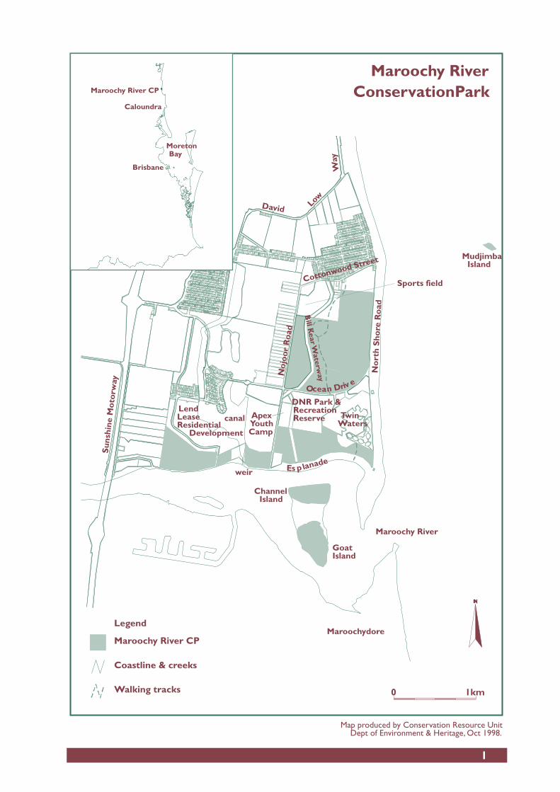
Maroochy River Conservation Park covers approximately 174ha and is situated near the mouth of theMaroochy River at Mudjimba on the Sunshine Coast. It was gazetted as a conservation park in 1992.Mudjimba Island, a small rocky island one kilometre offshore from Mudjimba Beach, was added to thepark in 1998.
The Sunshine Coast is one of the fastest growing areas in Australia. As a result, parks such as MaroochyRiver must be managed to cope with increasing visitor use and surrounding development which isolatethe park from other natural areas. It is therefore important that the Queensland Parks and WildlifeService (QPWS) maintains support from the local community, Maroochy Shire Council and developers inorder to protect the long-term conservation values of the park. The management plan will set theguidelines for the future management of the conservation park within the legislative framework providedby the Nature Conservation Act 1992.
2 Management directions and purposes
2.1 Management directions
Situated in one of Australia’s fastest growing regions, the park will be managed primarily for natureconservation while allowing low impact and sustainable nature-based recreational opportunities.Management will also focus on conserving the aesthetic values of the park including Mudjimba Island offthe coast and Channel and Goat Islands in the river mouth.
Negotiations are underway between QPWS and Maroochy Shire Council with the intention of the latterbecoming conservation park trustees. A trusteeship will direct the implementation of the managementplan by the two agencies.
2.2 Management purposes
The major purposes of management will be to ensure that:• the biodiversity of the park is maintained in a natural state;• significant species or community types such as those that are rare or threatened are protected;• fire and weed management maintains the park’s natural flora and fauna diversity;• Maroochy Shire Council and community groups are involved in the management of the park including
special projects such as site rehabilitation and weed control;• opportunities are provided for environmental education and scientific research;• the QPWS Good Neighbour Policy is implemented;• visitor use is monitored and controlled so that the diversity and integrity of flora and fauna
communities are maintained;• interpretation for the park is developed and incorporates an educational component on the area’s
conservation values;• nature-based recreation and tourism including associated river access at designated locations is
managed to minimise impacts on the park’s natural integrity;• natural changes to the size and shape of Channel and Goat Islands will be allowed to occur; and• surrounding land use has minimal impacts on the park’s conservation values and complementary
landuse of nearby areas is promoted.
3
3 Basis for Management
Maroochy River Conservation Park is dedicated under the Nature Conservation Act 1992 and must bemanaged under s 20 of the Act to -• conserve and present the area’s cultural and natural resources and their values;• provide for the permanent conservation of the area’s natural condition to the greatest possible extent;
and• ensure that any commercial use of the area’s natural resources, is ecologically sustainable.
The Native Title Amendment Act 1998 places obligations on the management of areas designated under theNature Conservation Act1992. Notification is given to Native Title Representative Bodies in the area andnative title claimants on the preparation of management plans, fire management plans and theundertaking of prescribed burning where possible.
The Environmental Protection Agency is producing a regional coastal management plan for the south-east Queensland coast. This plan is in accordance with the Coastal Protection Management Act 1995 andwill describe how the south-east Queensland coastal zone including Maroochy River Conservation Parkwill be managed.
The requirements of other legislation will be met where necessary.
3.1 Regional and management context
Maroochy River Conservation Park was gazetted in 1992 and is located in Maroochy Shire, on theSunshine Coast. Covering approximately 174 hectares, the park is situated in geographically separateareas on the northern bank of the Maroochy River. It also includes Channel and Goat Islands in the rivermouth. Channel and Goat Islands protect natural habitat in the flood tide delta of the Maroochy River.These islands are constantly changing shape and location as the natural course of the river changes.Mudjimba Island (to high water mark) was added to the park in 1998 and is located one kilometreoffshore from Mudjimba beach (Refer Map).
Maroochy River Conservation Park conserves a diverse range of vegetation types. Paper-barked tea treeMelaleuca quinquenervia swamp occurs on poorly drained sites, with tall open forest of mainly pinkbloodwood Corymbia intermedia and brushbox Lophostemon confertus on more elevated areas. Saltmarshcommunities occur behind the littoral mangroves bordering the Maroochy River. These vegetationcommunities, once common in the Maroochy landscape, are now poorly conserved in the region ashabitats continue to be cleared for development.
The different vegetation communities on the park provide habitat for a diverse range of fauna includingseveral significant species. For example, the wallum froglet Crinia tinnula which is listed as vulnerableunder the Nature Conservation (Wildlife Regulation) 1994 is present in the Melaleuca quinquenervia swamp.The park also protects suitable habitat for the vulnerable false water-rat Xeromys myoides which has beenrecorded nearby.
Saltmarsh areas within the park provide important feeding and roosting sites for waterbirds andmigratory waders. Mangroves form an integral part of estuarine habitats providing nursery habitat formany marine animals including important commercial fish species. Mudjimba Island protects thesouthernmost wedge-tailed shearwater Puffinus pacificus colony in Queensland.
Evidence of former Aboriginal occupation in the area exists as midden sites along the Maroochy River.Mudjimba island is an important cultural landmark on the coast for both Aboriginal groups and non-indigenous people.
4
The park provides recreational opportunities including walking and birdwatching and provides access tothe Maroochy River. Local people and visitors from all over Australia holidaying on the Sunshine Coastuse the park and enjoy its scenic amenity. The local community was active in seeking the gazettal of thepark and provides valuable assistance for day-to-day management issues such as weed control.
3.2 Resource description and values of Maroochy RiverConservation Park
Geology and landform
Most of the park is low lying with elevations at less than 0.5 metres above sea level which graduallyincrease inland to just over 0.5 metres above sea level. These areas are comprised of relatively youngmarine and freshwater sands and silts.The park includes Mudjimba Island which is a well known landmark about one kilometre off the coast atMudjimba Beach. This is formed by an outcrop of the Landsborough Sandstone which is of Jurassic age(approximately 190 million years). About 25 metres high, the island covers 1.1 hectares and issurrounded by a wave cut platform which extends to a rocky reef.
Native plants
Well established mangrove communities along the banks of the Maroochy River Conservation Parkconsist of four species - red mangrove Rhizophora stylosa, orange mangrove Brugiera gymnorhiza, greymangrove Avicennia marina and, river mangrove Aegicerus corniculatum. Grey and river mangrovecommunities are also present on Channel and Goat Islands. Mangroves are highly productive, acting asnursery habitat for a variety of commercial fish species. The mangrove communities protect the naturalcharacter of the river mouth and provide protection from erosion.
Saltmarsh occurs on the conservation park along the river foreshore and on the two islands in the rivermouth. The two distinct types consist of closed grassland dominated by Sporobolus virginicus and aherbland dominated by Juncus krausii spp. australiensis. Typically, littoral saltmarsh occurs immediatelybehind mangrove communities and occupies the upper intertidal areas which are frequently inundated bytidal or freshwater. The role that saltmarsh communities play in the ecology of estuaries is perhaps theleast understood of intertidal ecology in Australia, however they are known to provide important habitatfor avian, terrestrial and marine fauna and assist in stabilising erosion prone mudflats. Saltmarshcommunities are not well represented in protected areas in south-east Queensland.
Discrete patches of beach scrub are present on more elevated sections of the northern part of the parkand contain elk horns Platycerium bifurcatum, cork wood Duboisia myoporoides, celery wood Polysciaselegans, lilly-pilly Acmena smithii.
Small areas of swamp oak Casuarina glauca open forest are present on the south western section of thepark. The vegetation of Channel and Goat Islands shows good representation of saltmarsh communitieswith adjacent Casuarina glauca.
Poorly drained areas support paper-barked tea tree Melaleuca quinquenervia tall open forest with varyingunderstoreys. On more elevated sites, tall open forest dominated by brushbox Lophostemon confertus,pink bloodwood Corymbia intermedia and Melaleuca quinquenervia or Moreton Bay ash Corymbia tessellarisoccur. A mixture of rainforest and dry heath species are found in the mid and understorey throughoutboth forest types, although in the wetter sections Melaleuca quinquenervia grows in pure stands with asedge understorey. Melaleuca communities are of regional significance as this coastal community type isbeing rapidly cleared and drained for development.
5
Native animals
Mudjimba Island protects a significant breeding colony of wedge-tailed shearwaters or muttonbirdsPuffinus pacificus. Deep loamy soil on the higher, treeless part of the island provides an ideal spot formuttonbirds to build their burrows. About 4000 birds use the island during breeding season, and havebuilt about 2000 burrows where the females lay their eggs.
The species is listed under the Japan Australia Migratory Bird Agreement (JAMBA), in which thegovernments of both countries agreed to protect migratory birds and birds in danger of extinction. Thewedge-tailed shearwater breeds on a limited number of islands along the eastern and western coasts ofAustralia. While a breeding colony exists on Mudjimba Island, all others in Queensland are located onGreat Barrier Reef islands. Mudjimba Island, which is the southernmost breeding site in Queensland isalso the closest to the mainland. The colony is also significant as it is 20 metres above sea level. Incontrast, northern Queensland reef islands which support these birds are only 5-6 metres above sealevel and vulnerable to cyclonic damage (Dyer, 1997).
The saltmarsh and saline herbland communities provide habitat for terrestrial, avian and marine fauna.This includes potential habitat for the rare false water rat Xeromys myoides. Habitat for the false waterrat consists of mangroves, associated sedgelands and saltmarsh as well as the abutting buffer of salttolerant woodland species. Its habitat is currently threatened by urban development (estate, marina andgolf course construction) and possible predatory behaviour by foxes and cats.
Other native animals present on the park include the swamp wallaby Wallabia bicolor, the eastern greykangaroo Macropus giganteus, echidna Tachyglossus aculeatus and brush-tailed possum Trichosurus vulpecula.The squirrel glider Petaurus norfolcensis has been recorded in tall open forest adjacent to the northernsection of the park. Smaller mammalian species are relatively common in the region with the grasslandmelomys Melomys burtonii and the yellow footed antechinus Antechinus flavipes often recorded in the area(Carter and Baxter 1998).
A variety of frog species are found on the conservation park. An abundance of the vulnerable wallumfroglet Crinia tinnula is present in the freshwater sedgeland and it is likely that related species includingthe wallum rocket frog Litoria freycineti and the wallum treefrog Litoria olongburensis are also present inthis habitat. The copper-backed broodfrog Pseudophryne raveni, green treefrog Litoria caerula and easterndwarf treefrog Litoria fallax occur at vegetated lagoons (Carter and Baxter 1998).
Birds are the most diverse type of vertebrate fauna recorded on the park. The lower reaches of theMaroochy River are important habitat for many migratory wading birds including curlews and whimbrels.The whimbrel Numenius phaeopus, sharp tailed sandpiper Calidris acuminata and the common tern Sternahirundo use the park and are listed under both JAMBA (Japan Australia Migratory Bird Agreement) andCAMBA (China Australia Migratory Bird Agreement). Common seabirds include the little blackcormorant Phalacrocorax sulcirostris and the Australian pelican Pelecanus conspicillatus with the white ibisThresciornis molucca and straw-necked ibis Thresciornis spinicollis frequently seen in flocks along theshoreline (Carter and Baxter 1998).A variety of bird species including honeyeaters, kingfishers, parrots,warblers, whistlers and fairy-wrens are found in forested sections of the park. Species include the yellowtailed black cockatoo Calyptorynchus funereus, red browed firetail Emblema temporalis, superb fairy-wrenMalurus cyaneus and mangrove honeyeater Lichenostomus fasciogularis. Raptors include the whistling kiteHaliastur sphenurus, brahminy kite Haliastur indus, white-bellied sea-eagle Haliaeetus leucogaster, brownfalcon Falco berigora and rare grey goshawk Accipiter novaehollandia (Catterall and Cilento 1997).
Reptiles present on the park include the common tree snake Dendrelaphis punctulata, eastern brownsnake Pseudonaja textilis and dark-flecked garden sunskink Lampropholis delicata (Carter and Baxter 1998).
6
Cultural heritage
Local Aboriginal people consider Mudjimba “Old Woman” Island to be an integral component of thecultural landscape of the Sunshine Coast. The history of the island can be told through various creationstories, one of which is associated with the formation of the Glass House Mountains.
The island is also an important landmark for local non-indigenous people and the name “Old Woman”Island may also relate to sailors coming in from sea and commenting that the island resembled an oldwoman (Dyer 1997). A hut was constructed on Mudjimba Island in the late 1940s and people lived thereuntil1998.
Other Aboriginal cultural sites protected on the conservation park include shell mounds and scar trees.
Scenic and aesthetic
The littoral vegetation protected in the park helps maintain the natural character of the Maroochy Riverincluding Channel and Goat Islands in the river mouth. The park provides a natural and pleasant settingfor river and park users and provides a scenic backdrop in an otherwise rapidly developing area.
Mudjimba Island is an impressive offshore landmark seen from beaches along the Sunshine Coast.
Scientific and educational
With its close proximity to research institutions and the presence of interesting species and significantvegetation communities, Maroochy River Conservation Park provides various opportunities for scientificresearch and education programs. For example, the Sunshine Coast University is undertaking studies onthe wedge-tailed shearwater population at Mudjimba Island, including the problems associated withexotic weed species. Community groups are also involved in research on the park such as a regularmonthly water monitoring program being conducted by the local Maroochy Waterwatch group.
The development of interpretive signage will provide visitors with opportunities to learn more about theimportance of coastal ecosystems in a highly urbanised area.
Recreation and tourism
The conservation park provides a popular recreational setting for local residents, visitors to Twin WatersResort including international visitors, and other holiday makers to the Sunshine Coast region. Visitors tothe park have the opportunity to participate in nature-based recreation mainly in the form of walkingand observing nature. A track system progressing through the northern section of the conservation parkprovides visitors with an interesting progression through various vegetation communities, and includesboardwalks across a paperbark swamp. The park provides recreational access to Maroochy River forfishermen, swimmers and other users.
The waters around Mudjimba Island are used by surfers, divers and fishermen. The island also providessheltered mooring for yachts, although the steep rocky platform around the island prevents landing inmost weather conditions.
The conservation park also contributes to the region’s economic gains from tourism. The naturalvegetation towards the Maroochy River mouth adds to the aesthetic values of the area. This providesholiday makers in apartments on the southern side of the river with pleasant views. Commercial touroperators run boat charters around the conservation park including Channel and Goat Islands in theriver mouth. Many tourists to the area and guests at the neighbouring Twin Waters Resort use thewalking track through the park and enjoy being within a natural setting. Recreational use of the park willincrease in response to surrounding urban development.
7
Economic
Apart from the economic benefits of tourism, the natural setting of the conservation park is promotedin surrounding residential development and possibly increases property prices in adjoining areas.
The mangrove communities such as those fringing the Maroochy River act as nursery habitat for manycommercial fish species. Draining and development in surrounding areas is causing these communities tobecome degraded and lost.
The melaleuca communities are important biological filters. They slow and filter land water runoff beforeit reaches the river system. This decreases pollution of the river system and associated damage to fishpopulations.
4 Management strategies
4.1 Natural Resource management
Native plants
Current situation
Flora surveys have been conducted on the park and the Queensland Herbarium has undertaken the1:25000 Coastal Wetlands Vegetation Survey and Mapping project which includes Maroochy RiverConservation Park.
Melaleuca quinquenervia vegetation on the park is threatened by changes to the water table, altered fireregimes and nutrient pollution. Disturbance to these communities has increased their vulnerability toinvasion by weeds, particularly groundsel, lantana, Singapore daisy and umbrella trees.
Mangrove and saline herbland communities on the foreshore area of the park are being degraded byoveruse and inappropriate recreational use such as four wheel driving, trail bike riding, unauthorisedcamping and lighting of fires.
Desired outcomes
The biological diversity and integrity of the natural ecosystems are conserved in the long term.
Species of special significance including any rare or threatened plants are preserved in situ.
An improved baseline inventory of park flora and vegetation communities is available.
Ecological change is monitored.
Proposed policies, guidelines and actions
• Conduct rehabilitation of the degraded foreshore area at the end of Nojoor Road. This will be done inconjunction with the Maroochy Shire Council and Mudjimba Progress Association. The project will beconducted over time and involve restricting vehicle use to defined and hardened areas. This will allownatural revegetation by native saltmarsh plants to stabilise the bare mud flats. Access will still bepermitted to the river for approved recreational purposes. The project will aim to enhance theaesthetic value of the area and increase habitat for native wildlife.
• Close vehicle tracks along the foreshore of Maroochy River to prevent further disturbance to thesaltmarsh vegetation.
8
• Close other degraded areas to public use for rehabilitation if necessary.• Allow only limited access to the western section of the park (west of the weir) to protect mangrove
communities and false water rat habitat.• Develop a fire management plan which considers the ecological requirements of the different
vegetation community types occurring on the park and includes a fire monitoring component.• Prepare and implement a weed control program which targets particularly invasive species.• Survey and map the locations of noteworthy species and keep photographic records.• Liaise with tertiary institutions to encourage scientific research which increases knowledge of the
management requirements of different plant and animal species and vegetation communities.• Liaise with Lend Lease Pty Ltd regarding any flora and fauna monitoring and research they have
undertaken on the park and surrounds.
Native animals
Current situation
Fauna surveys have been conducted on the park and surrounding land. The conservation park is includedin a bird monitoring study sponsored by Lend Lease Development Pty Ltd. A variety of birds and otherwildlife have been recorded on the park and surrounding areas.
Fauna on the park are facing the pressures of isolation and disturbance as surrounding natural areas aredeveloped for residential purposes.
The wedge-tailed shearwater colony on Mudjimba Island is particularly susceptible to disturbance ifvisitors are able to roam freely around the underground burrows. Little is known about other faunaoccurring on the island. Ground covering weeds such as prickly pear and lantana are limiting the amountof open ground available for shearwaters to construct their burrows.
False water rat habitat occurs on the western foreshore section of the park. Disturbance to this areaincludes trampling of mangrove and saltmarsh vegetation and damage caused by domestic dogs enteringthe park. A new residential development is planned to border the area.
Desired outcomes
Native fauna including any species of special significance is protected.
Habitat necessary for native fauna is protected.
An improved baseline inventory of fauna using the park and surrounding habitat is developed, includingMudjimba Island, and ecological change monitored.
Proposed policies, guidelines and actions
• Conduct long term monitoring of the false water-rat population in the park to assess the potentialimpacts of adjacent landuse. Should a decline be detected, identify the factors responsible andimplement ameliorating measures.
• Encourage local community groups and research institutions to conduct fauna research on the parkwhich will increase the park resource inventory and assist park management. Projects would only beapproved that cause minimal impact on the environment.
• Encourage researchers to continue monitoring the breeding status and viability of the wedge-tailedshearwater colony on Mudjimba Island.
• Conduct weed control on Mudjimba Island in conjunction with DNR and the local community.• Liaise and work with surrounding land developers and new neighbours to encourage surrounding land
use that creates minimal disturbance to the park.• Use park interpretation and education programs to highlight problems domestic pets cause to the
park’s native animals.
9
Introduced plants and animals
Current situation
Environmental weeds are a major problem on the conservation park. Invasive plants such as groundselBaccharis halimifolia, umbrella trees Schefflera actinophylla, lantana Lantana camara and Singapore daisyWedelia trilobata are threatening the park’s natural vegetation. Weeds particularly invade disturbed sitessuch as the degraded area at the end of Nojoor Road and the park entrance off Cottonwood Street.Weeds are spread by wind, birds and other animals, humans and from upstream. Weed sources includesuburban gardens, farming land and degraded natural areas.
Weed disturbance on Channel and Goat Islands is minimal although weed species such as groundsel,broad-leaved pepper tree Schinus terebinthifolia, mile-a-minute Ipomoea cairica and lantana are present.
Prickly pear Opuntia stricta and other environmental weeds including lantana and umbrella trees haveinvaded Mudjimba Island and are reducing the availability of nesting areas for the wedge-tailedshearwaters.
Feral animals, such as foxes and cats, are present on the mainland sections of the park and are possiblyhaving adverse impacts on native fauna.
Urban development around the mainland sections of the park has the potential to increase impacts fromstraying domestic dogs and cats and weed invasion from suburban gardens.
Desired outcomes
Decrease the threatening impacts of introduced plants and animals on the natural biodiversity of the park.
Proposed policies, guidelines and actions
Develop a long term weed action plan for the conservation park to include Mudjimba Island. This willfocus on:• mapping weeds in the park and recommending subsequent priorities for control and appropriate
control methods.• undertaking weed clearing that minimises erosion, reinfestation and enables natural regeneration;• undertaking any revegetation immediately after weeding to prevent reinfestation;• initiating a public education campaign for park neighbours and other interest groups on environmental
weeds and their threats to natural vegetation;• involving community groups in weed control and investigating funding for relevant projects;• involving employment programs such as “Youth Conservation Corps” in weed control;• working with the Department of Natural Resources (DNR), community volunteers and other
authorities to eradicate prickly pear on Mudjimba Island. This will be done while causing minimaldisturbance to the shearwater burrows and the island’s other native flora and fauna. Difficulty of accessto the island needs to be considered when weed control is planned; and
• linking the plan with the South East Queensland Environmental Weeds Strategy being developed by theRural Lands Protection Board.
Developers will be encouraged to install dog and cat-proof fencing along the interface between urbandevelopment and the conservation park.
QPWS will negotiate with Maroochy Shire Council regarding increasing dog patrols on and aroundMaroochy River Conservation Park.Neighbour education and on-the spot fines will be implemented if people continue to walk dogs on thepark.
10
A feral animal control program is being planned for the conservation park after consultation withMaroochy Shire Council, Department of Natural Resources and neighbouring landholders.
Fire management
Current situation
Vegetation communities occurring within the park have different fire management requirements whichare not yet clearly understood.
Nearby residents have been concerned of the fire risk of the conservation park.Uncontrolled vehicle access to the park increases the risk of fires being either deliberately oraccidentally lit.
Desired outcomes
The biological diversity and integrity of native plant and animal communities is maintained by appropriatefire management.Human life, park infrastructure and neighbouring properties are protected as far as possible from fireoriginating from within the park.
Proposed policies, guidelines and actions
Develop a fire management plan for the park which will focus on :• liaising with Maroochy Shire Council and park neighbours and the Mudjimba Rural Fire Brigade;• implementing the QPWS Good Neighbour Policy;• maintaining the biological diversity of native plant communities through appropriate fire management;• undertaking, after assessment and monitoring, prescribed burning to maintain the natural vegetation
communities occurring on the park and to assist in controlling weed infestation in some situations;• locating adequate fire access points around the park boundary;• detailing emergency response procedures and methods of early fire detection including liaising with
park neighbours, local fire brigade and other relevant authorities; and• notifying the Undumbi people,FAIRA, park neighbours and community groups on the development of
the fire management plan and of any proposals to undertake prescribed burning.
4.2 Cultural heritage
Current situation
Aboriginal sites including scar trees and middens are present on the park, and Mudjimba Island is ofcultural importance to local Aboriginal people.
Places of cultural heritage significance to Aboriginal people are automatically protected under theprovision of the Cultural Records(Landscapes Qld and Qld Estate) Act 1987.
A native title claim covering Maroochy River Conservation Park has been lodged with the NationalNative Title Tribunal on behalf of the Undumbi people.
11
Desired outcomes
Cultural heritage sites on the park are identified and protected in accordance with the wishes ofAboriginal people.
Cultural values of the park are presented to visitors if appropriate.
Any native title rights are not compromised by management actions.
Proposed policies, guidelines and actions
• Assess the cultural heritage values of the park in accordance with the Cultural Record Act 1987 and withthe Undumbi people who have traditional links to the area.
• Manage Aboriginal cultural sites in association with Aboriginal people affiliated with the area.• Give Aboriginal people the opportunity to participate in other park management issues where
appropriate.• Only undertake interpretation of cultural sites and the cultural landscape of the park after liaison with
key interest groups including Aboriginal people and other locals affiliated with the area.• Liaise with Aboriginal groups and others regarding any cultural heritage management issues.• Assess the cultural heritage significance of infrastructure on Mudjimba Island.
4.3 Recreation and tourism
Visitor use
Current situation
A walking track was constructed by Novotel Twin Waters Resort with assistance from localorganisations and community groups in the northern section of the park in 1994. The four kilometrewalkway begins opposite the entry to the resort and winds through different vegetation types until itreaches Cottonwood Street. Raised bridges and boardwalks allow visitors to enjoy the paperbark swampwhich is characteristically boggy underfoot.
The southern end of the conservation park is used for vehicle access to the Maroochy River forrecreational purposes. Recreational visitors use the degraded area as a boat ramp, carpark and campingarea. The degraded area extends approximately 300 metres along the northern bank of the MaroochyRiver and consisted of closed grassland dominated by Sporobolus virginicus and saline herbland dominatedby Juncus kraussii spp. australiensis. Environmental weeds establishing in the area and erosion are bothmajor problems in this section of the park. An increasing number of visitors are using and degrading thearea, especially during peak holiday season.
The residential development being undertaken by Lend Lease Development Pty Ltd. is progressing northof the western section of the park and will potentially lead to increased recreational use. Lend Lease hasundertaken to develop a masterplan for the area around their development, including adjacent sectionsof the conservation park. This will be done in consultation with QPWS and Maroochy Shire Council. Aspart of this project Lend Lease will help establish a formalised boat ramp and carpark at the end ofNojoor Road. The company will also be involved in the rehabilitation of the surrounding area and providepedestrian access across the weir. Construction of an educational boardwalk system through a smallsection of the nearby saltmarsh and mangrove community is a possibility.
12
Desired outcomes
Recreation and tourism opportunities do not conflict with the conservation of the park’s natural values.
Visitors can enjoy safe, nature-based recreation and tourism opportunities without disturbing othervisitors.
Opportunities for sustainable nature-based recreation and tourism are provided.
Proposed policies, guidelines and actions
• Rehabilitate the degraded saltmarsh vegetation at the end of Nojoor Road. Control access through theformalisation of both access and carparking at the end of Nojoor Road. A joint project with MaroochyShire Council, Mudjimba Progress Association and other volunteers and community groups will beestablished to achieve these objectives.
• Construct a permanent boat ramp at the end of Nojoor Road after negotiation with park interestgroups.
• Close and revegetate vehicle tracks along the foreshore area.• Formalise a track system to control recreational access on the western side of the weir. This will
potentially incorporate an educational component and raised boardwalks to protect the sensitivevegetation communities.
• No picnic areas will be developed on the park.• Due to the sensitivity of the mangroves and potential habitat for the false water rat, access to the river
will not be provided through the far western section of the park.• Undertake negotiations with DNR for gazetted road reserves which traverse the western side of the
park to be closed and added to the park.• Monitor recreational impacts using photo-monitoring points at sensitive sites to measure impacts
including erosion, trampling and littering.• Assess current recreational opportunities at Maroochy River Conservation Park by conducting visitor
surveys to calculate visitor numbers, reasons for visiting and visitor attitudes.• Conduct liaison with park neighbours and local users regarding access, promotion and appropriate
park use.• Decrease levels of inappropriate park use such as the walking of dogs and vehicle use through
combining community education with the issuing, by rangers, of on-the-spot fines.• Develop an interpretive plan for the park which includes provision for interpretive and directional
signage along designated walking tracks.• Maintain all structures and ground surfaces, including the northern track system, in a safe condition as
part of the regional risk assessment program.• Camping will not be permitted on the conservation park.
Education and interpretation
Current situation
Existing public contact consists of a park information brochure produced in 1992 in conjunction withTwin Waters Resort, Maroochy Shire Council, Mudjimba Progress Association and Sunshine CoastEnvironment Council. Interpretive signage on the park and visitor information sheets need updating.There is currently a lack of information on-site about the park’s natural and cultural values.The park has the potential to enable educational institutions to study its rainforest, native plants andanimals, geology and human impacts on the environment.
13
Desired outcomes
The park is used as a site for research, education and promotion of coastal ecosystems.
The local community supports and is involved in park management.
Visitors increase their understanding and appreciation of the natural and cultural values of the parkwhich results in more sympathetic use of natural areas.
Proposed policies, guidelines and actions
Develop an interpretation plan for the conservation park. This will include:• revising and reprinting the Mudjimba Conservation Park brochure with information on natural values
and recreational opportunities on the park as well as problems to park management such as weeds;• updating existing signage and developing new directional and risk management signage. New signs
would be placed at strategic locations to identify the conservation park boundary;• developing other educational and interpretive signage for the park. Interpretive signage would include
information on cultural heritage and the area’s natural values as well as safety issues; and• initiating a community awareness program about the impacts of environmental weeds and domestic
animals.
Liaise with tertiary institutions to encourage studies in natural resource management and human-useinfluences.
Develop the volunteer network to assist in appropriate park activities.
4.4 Complementary management of adjoining areas
Current situation
Maroochy River Conservation Park has become increasingly isolated as residential development androads separate the park from other natural areas and wildlife corridors.Pressures from surrounding land use include weed invasion and intrusion by domestic and feral animals.Other impacts include nutrient and other pollution run-off into the park as well as altered water tablesand drainage patterns.
The Maroochy Shire Council Strategic Plan and Open Space Strategy includes methods to maintainwildlife corridor linkages to the conservation park.
Desired outcomes
Surrounding land use buffers and complements the conservation values of the park.
Surrounding land use is compatible with the management aims of the conservation park.
Proposed policies, guidelines and actions
• Rationalise the park boundary where possible by adding areas which both link disjunct sections andprovide linkages for wildlife.
• Investigate the incorporation of adjoining council reserves into the conservation park;• Negotiate with Maroochy Shire Council regarding the linking of vegetation and riparian corridors with
public and private landholders adjacent to the park.
14
• Liaise with Department of Natural Resources regarding the management of The Esplanade.• Liaise with surrounding landholders to encourage land use which does not compromise the
conservation park values.• Initiate neighbour education on important park management issues including the impacts of
environmental weeds, wildlife feeding and domestic animals. Methods of public contact may includeneighbour liaison, letterbox drops and information days.
• Prepare a recommended planting list of locally occurring native plant species for circulation to parkneighbours and community groups.
4.5 Plan implementation and monitoring
Current situation
The park is managed on a day-to-day basis by the North Moreton District staff based at Noosa withassistance from District staff situated at Maroochydore. Regional staff will assist with the implementationof the management plan where appropriate. Maroochy Shire Council, local community members andgroups such as the Mudjimba Progress Association play an important role in the protection andmanagement of the park. The park is to be managed primarily for nature conservation and nature basedrecreational use.
Desired outcomes
The management plan is successfully implemented and desired outcomes achieved.The management unit is allocated enough resources to successfully implement the plan.
Proposed policies, guidelines and actions
• Develop an implementation schedule for the plan which considers available staff and resources andprioritises management actions. This will be reviewed annually and tie in with yearly budget allocations.
• Priorities for management at Maroochy River Conservation Park will include:• initiating weed control and site rehabilitation programs in degraded areas in conjunction with Lend Lease Development Pty Ltd, Maroochy Shire Council, DNR and local community groups; and• increasing education and awareness to decrease threatening process caused by park users and neighbours.
• Finalise negotiations with Maroochy Shire Council regarding a trusteeship agreement for theconservation park.
• Set timeframes to enable monitoring of plan implementation and effectiveness of managementstrategies.
• Review the management plan within ten years of approval in accordance with s 125 of the NatureConservation Act 1992.

15
5 References
Carter, B. (1988) Plant Communities of the Maroochy River North Shore, Bill Carter and Associates,Mooloolaba.
Catterall, C.P. & Cilento, N. (1997) Avifauna of the Maroochy River Conservation Park and Twin WatersConservation Area, June 1997, prepared for Lend Lease Development Pty Limited by Wildlife EcologyResearch Group, Faculty of Environmental Sciences, Griffith University.
Dyer, P.K. (1997) Mudjimba Island: Future Prospects, Islands - Culture, Economy and Environment, IAG andNZGS 1997 Conference, Hobart, Tasmania.

16


