Mariners Weather Log DecemberRobert A. Luke Editor Bernadette T. Duet Layout/Design Patti Geistfeld...
100
Vol. 45, No. 3 December 2001 Mariners Weather Log Sizing Up the Iceberg Indestructible Icebergs See page 4
Transcript of Mariners Weather Log DecemberRobert A. Luke Editor Bernadette T. Duet Layout/Design Patti Geistfeld...

Vol. 45, No. 3 December 2001
Mariners Weather Log
Sizing Up the Iceberg
�Indestructible Icebergs�
See page 4

2 Mariners Weather Log
From the Editorial Supervisor
Mariners Weather Log
Mariners Weather Log
U.S. DEPARTMENT OF COMMERCE
Donald L. Evans, Secretary
National Oceanic and
Atmospheric Administration
Conrad C. Lautenbacher, Jr., Administrator
National Weather Service
John J. Kelly, Jr.,
Assistant Administrator for Weather Services
Editorial Supervisor
Robert A. Luke
Editor
Bernadette T. Duet
Layout/Design
Patti Geistfeld
Articles, photographs, and letters should be sent to:
Mr. Robert A. Luke, Editorial SupervisorMariners Weather LogNDBC (W/OPS 52)Bldg 1100, Room 353DStennis Space Center, MS 39529-6000
Phone: (228) 688-1457Fax: (228) 668-3153E-mail: [email protected]
Some Important Web Page Addresses
NOAA http://www.noaa.govNational Weather Service http://www.nws.noaa.govNational Data Buoy Center http://www.ndbc.noaa.govAMVER Program http://www.amver.comVOS Program http://www.vos.noaa.govSEAS Program http://seas.nos.noaa.gov/seas/Mariners Weather Log http://www.nws.noaa.gov/om/
mwl/mwl.htmMarine Dissemination http://www.nws.noaa.gov/om/
marine/home.htmU.S. Coast Guard http://www.navcen.uscg.gov/ Navigation Center marcomms/
See these web pages for further links.
From the Editorial Supervisor
Hello, and Happy Holidays from the entire MWL family.The holiday period is normally a joyous and festive time forall. It is a time to savor the memories past and make newones with your friends and loved ones. Yes, things havechanged this year. No matter where we call home, I believewe all can share a tragic moment or two from this past year.Let us remember our World Trade Center�s maritime familyof American Bureau of Shipping (ABS), New York ShippingAssociation, PACRIM, Port Authority of New York & NewJersey, Rohde & Liesenfeld, Serko & Simon LLP, and Zim-American Shipping Company , and lift them up in ourhearts this holiday season by remembering all the fondmemories we have shared..
This issue has a lot of great stories for your readingpleasure. The International Ice Patrol graces our coverwith a historical perspective of iceberg removal. Anotherarticle, first printed in SMITHSONIAN Magazine, tells ofhow flotsam can be used to study the ocean currents. TheBritish METOFFICE has offered us a story on the EGOSbuoy programme, and the Miami Herald has givenpermission to reprint their story of how the NationalHurricane Center used our VOS Observations to help trackTropical Storm Allison.
Once again, best wishes for a happy and safe holidayseason, and I hope that Santa Claus, Criscringle, FatherChristmas, Father Frost, Père Noël Joulupukki, Kris Kringle,Sabdiklos, Saint Nicolas, Sancte Claus, Sinter Klaas, orWeinachtsmann brings you all that you hope for and more.� Luke

December 2001 3
Mariners Weather Log
Table of Contents
International Ice Patrol ...................................................................................................................... 4
Message in a Bottle .......................................................................................................................... 8
European Group on Ocean Stations (EGOS) .................................................................................. 18
Satellites, or Simply Ships at Sea, Blend to Help Hurricane Forecasters ........................................... 23
TPC Calling All Ships at Sea ........................................................................................................... 25
Retired NWS Employee Inducted into Great Lakes Maritime Hall of Fame...................................... 26
Prostatis: Liberty Ship of WWII ..................................................................................................... 27
Departments:
Marine Weather ReviewNorth Atlantic, May�August 2001 ....................................................................................................... 28North Pacific, May�August 2001 ........................................................................................................ 40Tropical Atlantic and Tropical East Pacific, May�August 2001 .......................................................... 52Mean Circulation Highlights and Climate Anomalies, July�October 2001 ........................................... 61
Coastal Forecast Office News ........................................................................................................................... 65A Storm by Any Other Name ...................................................................................................... ......... 65September 2001 Alaska Marine and Public Services Report ............................................................... 67
VOS Program .................................................................................................................... ................................ 74VOS Awards ........................................................................................................................................ 74VOS Cooperative Ship Reports ............................................................................................................ 67
Meteorological ServicesObservations ......................................................................................................................................... 96

4 Mariners Weather Log
International Ice Patrol
Indestructible Icebergs
MST1 Duyane Alexander
April 15, 2002 will mark the90th anniversary of theloss of the �unsinkable�
RMS Titanic. The Titanic struckan iceberg late in the night on April14, 1912 while crossing theAtlantic Ocean south of the GrandBanks of Newfoundland, andvanished under the waves withintwo and a half hours, taking thelives of over 1500 passengers andcrew. This tragic event directlylead to the creation of the Interna-tional Ice Patrol.
The crew, or �Ice Picks� of theInternational Ice Patrol, consists of18 people: a civilian oceanographerand a computer specialist, fourofficers, one yeoman, and tenmarine science technicians locatedin Groton, Connecticut, with aneleventh marine science technicianremotely located at the NationalIce Center in Suitland, Maryland.The Ice Picks work closely with
expert aviation technicians and aircrew from Coast Guard AirStation Elizabeth City, NorthCarolina. The small crew of theInternational Ice Patrol is dedi-cated to serving the North Atlanticmariner and protecting seafarersof all nations from the dangers oficebergs. Since the U.S. CoastGuard began monitoring iceconditions in 1913, they haveamassed an enviable safetyrecord. There have been noreported losses of life or propertyfor vessels that have heeded theIce Patrol�s published warnings.
The International Ice Patrol isresponsible for providing the Limitof All Known Ice (LAKI) which isspecified under the Safety Of LifeAt Sea (SOLAS) agreement inChapter V and states specifically�...the south-eastern, southern andsouth-west limits of the regions oficebergs in the vicinity of the
Grand Banks of Newfoundlandshall be guarded for the purpose ofinforming passing ships of theextent of this dangerous region...�From the beginning of the Interna-tional Ice Patrol until WWII, thisservice was provided by ships ofthe Revenue Cutter Service (nowthe United States Coast Guard).Aircraft provided the primarysearch method during and after thewar, with surface vessels beingused during unusually heavyiceberg years.
Since the start of the InternationalIce Patrol, one question has beenasked more then any other. Whynot just blow up the iceberg? Theshort answer is, we tried.
There have been many attemptsover the years to reduce the threatposed by icebergs by destroyingthem and/or speeding up theirmelting. The theory is that smaller

December 2001 5
pieces of ice will melt faster. Theproblem has been, and continues tobe, making the smaller pieces ofice. Most of these experimentswere spur-of-the-moment efforts.
The first documented InternationalIce Patrol attempt to destroy aniceberg occurred on March 26th,1913 when the U.S. RevenueCutter Miami used her deck gunon an iceberg she was shadowing(following). The description in theofficial trip report is �A 6-poundshot was fired against the verticalwall of the berg and had no othereffect than to shake down abarrelful of snowlike dust.�Undeterred by this initial failure,the Cutter Miami again used her 6-pounder deck gun on an iceberg onMay 26, 1914. This time she firedtwelve rounds and found theresults to be �...just as effective asif we had stormed the Rock ofGibraltar.� In June 1915, the U.S.Revenue Cutter Seneca reported�One of its faces presented a goodtarget, and I caused seven com-mon shell, without bursting charge,to be fired into it from our 6-pounder guns. The ice was sorotten that the projectiles entered
International Ice Patrol
Drilling
the ice and stuck there, plainlyshowing their bases in the holesthey made.� There are many morereports of a similar nature detailingthe use of everything from 20mmcannon to the standard 5-inch gun
on the larger cutters. Ineach case it was foundthat aside from making abit of crushed ice, thegunfire had no noticeableeffect on icebergs.
One of the collateral dutiesassigned to the vessels of theInternational Ice Patrol was thedestruction of derelict vessels,which were usually wooden sailingships that had been abandoned andmight drift for months on theocean currents, thereby posing ahazard to safe navigation. Theships used guns, mines (an explo-sive device designed specifically tobe attached to the hull of thevessel), and other explosives suchas TNT to destroy derelict vessels.Experiments using these itemswere conducted to see howeffective they would be in speed-ing up the destruction and meltingof icebergs.
Captains of the vessels woulddecide to mine the icebergs byletting the explosives drift next tothe iceberg, attaching the explosiveto them, placing the mine on theiceberg, or trying to jam theexplosives into a hole in thesurface. In each case, very littledamage was done to the iceberg.
In the 1920�s, Professor HowardT. Barnes of McGill Universitylocated in Montreal conducted
experiments on river icedams using thermite (anincendiary material thatproduces molten iron at4000°F) to remove theblockages. In 1926,experiments usingthermite were conductedon icebergs with verypromising results;however, the findingswere not followed up onfor many years. In 1959,the research using
thermite on icebergs was revisited,and experiments using aerialdelivery were conducted usingsurplus WWII incendiary bombs.The bombs would burst on thesurface and spread the materialover the iceberg, having littleoverall effect. However, resultswere reviewed and scientists still
Sizing up the Iceberg
Ready, Aim, Fire!

6 Mariners Weather Log
the International Ice Patrol Bulletinfor 1960 it states �... a magnificentdisplay took place as smoke andmolten iron was hurled hundredsof feet into the air, but the bergremained virtually unchanged.This concluded the thermite tests.�
Another experiment involved theuse of carbon black painted on aniceberg. The theory was that thecarbon black would absorb heatfrom the sun and speed themelting of the iceberg. The carbonhad to be spread by hand, whichrequired boarding an iceberg withall the inherent dangers. Thisexperiment met partial successbecause as the iceberg melted, thewater run off would wash awaythe carbon black, which wouldstop the melting. Additionally asthe center of gravity changed, theiceberg would tend to roll, expos-ing a fresh clean face to the world,thus requiring another applicationof carbon black.
Experiments having aircraft drop1000 lb general purpose and semi-armor-piercing bombs on icebergswere also conducted. Of thetwenty bombs dropped, eighteenstruck the iceberg. Of those
felt thermite had merit for furtherexploration.
Ice Patrol conducted furtherexperiments using Thermite in1960 that were more carefullydesigned and executed, but thistime on grounded icebergs nearNewfoundland. This required thatan iceberg be boarded, holes boredinto the iceberg, placement ofthermite in the holes, and thendetonation. These were verydangerous operations on anunstable iceberg that could rollover at any time with little or nowarning. Three different Thermitecharges of 196 lbs, 364 lbs, and560 lbs of Thermite were deto-nated on two separate icebergs.
The first charge of 196 lbs wasdetonated and produced steam andmolten metal that was scatteredover a distance of 100 yards, butdid little more than produce several
small growlers (very small ice-bergs) and a small crater. Anothericeberg was boarded, and thesecond charge of 364 lbs was setand detonated. The results werethe same. The final charge of 560lbs was then set at the base of alarge pinnacle on the iceberg. In
eighteen, three failed to explode,and three detonated underwater.Aside from producing some brashice, the iceberg was unharmed.Experiments using explosives havebeen conducted as recently as the1980�s.
Research has also been conductedconcerning the use of wires heatedby electricity to cut through theiceberg; however, it was foundthat the electric motors would burnout on the generators beforesignificant progress could bemade.
The International Ice Patrol longago abandoned its iceberg destruc-tion research. The informationpresented is to give you an appre-ciation and a respect for thestrength and power of icebergs.Even today, modern, radarequipped ships do strike icebergs.Three ships struck icebergs asrecently as 1993. For all of ourattempts to melt, destroy, orremove them, the safest and surestmethod has been found to simplyreport the positions of the icebergs
Thermite Explosion
Carbon Black Painting on Icebergs
Bombing Experiments ProveUnsuccessful
International Ice Patrol

December 2001 7
EZIS THGIEH HTGNEL
( tf ) (m) ( )tf (m)
relworG 71< 5< 05< 51<
greBllamS 05-71 51-5 002-05 06-51
greBmuideM 051-15 54-61 004-102 221-16
greBegraL 042-151 57-64 076-104 312-321
egraLyreVgreB
042> 57> 076> 312>
Table 1 Sizing Guidelines
International Ice Patrol
EPAHS NOITPIRCSED
-noNralubaT
tahtsgrebecillasrevocyrogetacsihTdebircsedsadepahs-ralubattonera
eratahtsgrebecisedulcnisihT.wolebdna,ykcolb,gnipols,depahsemod
.elcannip
ralubaTthgieh-htgnelhtiwgrebecideppottalF
1:5nahtretaergnoitar
Table 2 Shape Guidelines
and allow nature to work itsmagic.
If you would like further informa-tion on the attempts to destroyicebergs, please contact theInternational Ice Patrol or visit ourweb page.
How to Report Icebergs
The Ice Patrol encourages com-mercial vessels to immediatelyreport ice sightings toCOMINTICEPAT GROTON CTthrough INMARSAT-A or C, usingCode 42 to U. S. Coast GuardCommunication stations or toCanadian Coast Guard marineradio stations. Regular weatherand sea surface tempera-ture reports providevaluable information evenwhen no ice is sighted.Sightings may be reportedon guarded frequencies aslisted in the annualAnnouncement of Ser-vices.
Copies of the annualAnnouncement of Ser-vices are availablethrough several methods:
1. World Wide Web:www.uscg.mil/lantarea/iip/data/ann_ser.html
2. E-mail request to:[email protected]
3. Mail request to:
Commander,International Ice Patrol1082 Shennecossett RoadGroton, CT 06340-6095
Attention: Ice Information Officer
4. Phone request to:(860)-441-2626
What to Include in an IceReport
When reporting icebergs, certaininformation should be included:
� Ship�s name & call sign
� Date/Time (UTC) ice was sighted� Iceberg position (latitude, longitude)� Method of observation (radar, visual, both)� Number of icebergs
� Size and shape (Tables 1 & 2)
Ice data is constantly analyzed atthe International Ice Patroloperations center in Groton,Connecticut and added to acomputer model. This modelincorporates environmental factorssuch as winds, waves, currents,and sea surface temperatures withiceberg reports to predict drift anddeterioration. The processedinformation from the model is usedto estimate the Limit of All KnownIce every twelve hours. TheLAKI, sea ice limit, and an area ofmany bergs are broadcast in twodaily text bulletins and a graphicfax chart. The broadcast timesand frequencies are available inthe annual Announcement of
Services. They are alsoposted daily in the Prod-ucts section of the IIPweb page at:
www.uscg.mil/lantarea/iip/home.html
The International IcePatrol is grateful to allmariners who havecontributed to this en-deavor and hopes to haveyour support in the future.Should you have anyquestions or comments,please contact the Inter-national Ice Patrol by e-mail through the WorldWide Web or call: (860)-441-2626.

8 Mariners Weather Log
Message in a Bottle
MESSAGE IN A BOTTLE - By studying objects cast up on our shores,researcher Curtis Ebbesmeyer traces the flow of ocean currents
Kevin KrajickPhotographs Rick RickmanReprinted with permission
If Curtis Ebbesmeyer had justone word for budding ocean-ographers, it would probably
be: plastics. If he had more thanone, he might add: roll-on antiper-spirant balls, toxic-waste contain-ers, computer monitors, lightbulbs,armadas of toys and sportinggoods, toilet seats, bales of rubberand marijuana, explosive devices,surfboards, coconuts, aircraft, theoccasional human body, and asurprising number of genuinemessages in bottles. The seas arewonderfully, horribly full of floatingthings. Sooner or later, many ofthem wash up on the beach; andon the way, some make epiccontinent-to-continent journeys,thus forming new data pointsregarding the complex doings oflong-distance ocean currentsystems-the subject ofEbbesmeyer�s work.
Scientists study currents evermore intensely: they affect notonly transportation but weather,biology, evolution and climatechange. Most oceanographers usesatellites and high-tech buoys fortracking them; Ebbesmeyer, a self-described �filter feeder on floatingobjects,� stubbornly does it the old-fashioned way�by studyingmovements of random junk. Partreporter and historian, part water
physicist, he has sources every-where, including his own vast,ragtag worldwide army of beach-combers. �The literature of thingsthat float from here to there is soscattered it makes no sense untilyou compress it,� he says. �Then itbegins to take on a glow, likeradium.�
His contributions to the literaturerange from the seminal to thesemi-wacky, but we know onething: he is probably the onlyscientist to have posed for Peoplemagazine mostly naked (grayed inthe chest hairs, but looking good)in the pool with a floating bathtubducky, a souvenir of one of hisgreatest research triumphs.Colleagues with fancier instru-ments and stiffer attitudes maysneer, but deep down they mustsuspect the truth: he has more funthan they do. Along the way, hehas learned that ocean surfacecurrents can be chaoticallychangeable; if two bathtub toysare dumped, say, in the middle ofthe Pacific at the same moment inthe same spot, one may wash up inHawaii while the other might endup frozen in an Arctic ice floe.
I accidentally entered the world oflong-distance floatables on aCanadian Coast Guard icebreaker
traversing the Northwest Pas-sage�that frozen labyrinth ofislands where Arctic ice floesslowly drain toward the Atlantic.In this treeless region, I waswatching off the bow one day forpolar bears and instead spied deadahead a weathered tree fragmentin the ice. Eddy Carmack, anonboard oceanographer specializ-ing in water movements such aseddies, assured me this wasnormal. �Trees fall off banks ofnorth-flowing Siberian and Cana-dian rivers,� he said. �Then theymove into the sea ice. They maygo around clockwise with theTransarctic Drift��a great gyrecircling the Arctic Ocean��for 30years. Eventually, the tree gets spitout near Greenland. If it�s not toowaterlogged, maybe then it circlesthe Atlantic for a while. Maybe itlands in England or North Carolina,then somebody puts it on themantel. There�s a lot of odd stufflike that.� Carmack jotted downthe Seattle phone number of CurtEbbesmeyer�the man he saidknew the most about such oddstuff.
Ebbesmeyer got started in the mid-1960s with Mobil Oil as a roust-about, then, after attending theUniversity of Washington, anoceanographer. A lot of Mobil�s oil
This article originally printed in The Smithsonian, July 2001

December 2001 9
Message in a Bottle
Floatables of every sort¾hockey gloves andlife buoys, seedpods and bathtub toys¾form theraw materials underlying oceanographerEbbesmeyer�s investigations.

10 Mariners Weather Log
Message in a Bottle
was under the frigid Grand Banksoff Newfoundland; Ebbesmeyerwas told to figure out how to towapproaching icebergs�the largestfloating objects in the world- awayfrom drilling platforms. In 1974 hejoined Evans�Hamilton, Inc., asmall oceanographic consultingfirm specializing in measuring andunderstanding ocean currents. Hisprojects have included placingsewage outfalls to minimize impacton shore (�Did you know 10percent of sewage floats evenafter secondary treatment?�) andtracking oil slicks (of his work onthe Exxon Valdez spill: �Did youknow oranges are good experi-mental surrogates? For some
reason, if you dump thousands inseawater, they�ll distribute them-selves exactly like spilled oil�).
Each ocean, carrying the long-distance floatables studied byEbbesmeyer, hosts one or morehuge gyres shaped by prevailingwinds, Earth�s rotation and border-ing landmasses. The Gulf Stream,skirting the U.S. East Coast, ispart of a clockwise pattern ofsurface currents that carriesCaribbean debris past Nantucket,toward Iceland, to the coasts ofNorway and Britain, around thecalm center of the Sargasso Sea,and back again. In the Pacific, theKuroshio, or Japanese, Current
arcs clockwise away from Japanand becomes the North PacificDrift, then turns south 200 to 500miles off Washington or Oregon,where it is called the CaliforniaCurrent. Off Baja California, itturns back out, passing Hawaii,heading for the Philippines andChina, and back to Japan. Anobject may take six years tocomplete the roughly 14,000-milecircuit.
Unless sidetracked in any ofcountless ways. Storms drivefloaters off track, especially oneswith windage�exposed surfacearea making a sail�into counter-currents or competing gyres, likethe North Pacific�s counterclock-wise Alaska Current, which cansnag something from the PacificNorthwest and send it towardSiberia, or filter it through the teethof the Aleutians to be suckedthrough the Bering Strait and intothe swirling belly of the Arctic.Alternatively, junk may hang outfor years if it drifts into the eyes ofthe great oceanic gyres. Also,strong winds can cause watermasses to upwell or downwellpowerfully, which is reflected bothin surface movements and in hugeworldwide submarine currents thatflow their own separate ways�awhole other story.
It is also becoming apparent thatmajor surface current systems,once thought stable as rocks, arecapable of huge, sudden shifts. Inthe prehistoric past, these couldhave been the result�or cause�of drastic climate change; manyscientists think that cycle couldrecur, with dire results. Oceanicdistributions of nutrients depend oncurrents; hitchhiking on currents is
Peripatetic beachcomber Steve McLeod, displaying a glass fishing float andother finds, has served as a roving data collector for Ebbesmeyer

December 2001 11
Message in a Bottle
integral to the life cycles ofeverything from eels to sharks.There�s also evidence that evenlarge terrestrial animals mayspread and evolve by the unlikelymechanism of �rafting� on oceandebris.
It seems unlikely also that anysmall human-made object cansurvive a long voyage, make it to abeach and stay long enough forsomeone to come along at just theright moment to discover it. Butobjects do. Boy, do they.
In 1959, the Guinness brewingcompany of Dublin dumped150,000 of its bottles into theAtlantic and Caribbean, eachcontaining a scroll bearing greet-ings from �King Neptune� extol-ling Guinness and providinginstructions for converting thebottle into a lamp. They were sowell sealed with cork, wax andlead tape, Guinness predicted theywould go 500 years. According toone of Ebbesmeyer�s sources,about 80 bottles made it to CoatsIsland in Canada�s Hudson Bay, tobe spotted by Inuit hunters. Themystified Inuit used the bottles fortarget practice, but then saw thescrolls and buried the rest in anunmarked grave.
Ebbesmeyer loves such arcana,but must admit that his first love isgarbage. There is so much of it.And most is plastic. The buoyant,indestructible stuff has explodedsince the 1950s and �60s; beforethat most marine garbage wasorganic, so it eventually rotted orsank. The bulk may come fromland, dumped offshore or floatedout rivers, but ships contributemuch. Lost synthetic fishing gear
alone�nets, traps, buoys, lines,packing material�may run150,000 tons a year. More iswashed or thrown off merchantand pleasure vessels, despite a1987 international conventionsupposedly curbing marine dump-ing. As many as 1,000 or moreboxcar-size shipping containers�perhaps the most fruitful sourcesof intriguing objects�fall off shipsannually, releasing fleets offloatable goods.
The results are horrifying. In someyears tens of thousands of sealsand hundreds of thousands ofseabirds may die entangled in lostfishing gear. Turtles, whales, fishand at least 100 seabird speciesmistake plastics for floating food:autopsied animals are oftencrammed with cigarette lighters,plastic bags, tampon applicators,toy soldiers. Old plastics break upunder ultraviolet radiation andwaves, but never die; they turninto �nurdles��colorful, anony-mous fingernail�to BB-size bits.The ocean keeps trying to cleanseitself of them like a cold suffererspitting phlegm. After a recentcount, the Southern CaliforniaCoastal Water Research Projectestimated there were more thanone million per mile along OrangeCounty beaches. �To my horrorand fascination, plastic trash justkeeps going,� says Ebbesmeyer.�It is both sinister and useful.�
Others have long put floatables towork for science. Eighteenth- andnineteenth-century explorersfigured out the outlines of majorcurrents simply by watching whereobjects traveled, including theirown vessels. Today, scientificinstitutions are deploying the latest
Bathtub Toy�s Drift
In 1992 a container ship spilled29,000 bath toys into the NorthernPacific (star, top). After 400 werefound (arrow, middle),oceanographer James Ingrahamused a computer model to track theobjects� route and extrapolate wherethe remainder would go. Monorcurrents would push these floatablesalong myriad paths, indicated hereby individual colored lines. Thecenter chart projects the toy�stravels through 1995; the bottom,through the end of last year.

12 Mariners Weather Log
Message in a Bottle
tracking devices: a planned fleet of3,000-some PALACE floats, orProfiling Autonomous LagrangianCirculation Explorers. Thesedrifters automatically samplesalinity and temperature�alsomeasures of water movements�and dive on programmed sched-ules as deep as a mile to catchvarious current layers, surfacingoccasionally like U-boats totransmit data to satellites. Butinstruments like these cost thou-sands of dollars apiece and are, bynecessity, deployed in limitednumbers.
Which brings us back to floatingjunk�and to Curt Ebbesmeyer.For years he labored at his con-sulting firm in Seattle but neverquite managed to grow up; end-lessly curious, Ebbesmeyer didextracurricular thinking on every-thing from migratory shad to theorigin of life. He and a group ofcolleagues were the first to pointout that a single, sudden 1976Pacific climate/circulation swinghad affected dozens of seeminglyunconnected phenomenon, includ-ing West Coast water-oxygencontents, Arctic sea-ice extents,
Andean glacial dynamics; lifecycles of corals, crabs, oysters,salmon. He collected this datafrom existing studies, like so muchbeachcombed drift; the resultingpublication became a key paper onclimate change.
Field science was about to takeover Ebbesmeyer�s life, beginningone day in May� 1991, when hismother, Genevieve, was servinglunch and reading from the paper.Factory-fresh Nike sneakers andhiking boots were washing up onOregon beaches�so many that
On Oregon�s Indian Beach, collector Barry Tweed sports Nikes from the 1990 spill that became a subject ofscientific inquiry

December 2001 13
Message in a Bottle
beachcombers were holding swapmeets to match lefts with rights ofcorrect sizes for selling or forwearing. No one knew the source.�Curt, isn�t that your business tofigure out things like that?�inquired Genevieve. Some hourslater the phone rang at a home incoastal Rockaway Beach, Oregon,where a swap meet was inprogress. It was Curt Ebbesmeyer.
Thus began a brilliant new incar-nation for the oceanographer�andfor beachcomber/artist SteveMcLeod, mightiest Nike hunter ofthem all. Converging currents andwinds make the Pacific Northwestone of the world�s most productivebeachcombing regions, and thushost to a long-time secret societyof serious beachcombers. The bigprizes: old glass fishing-net floats,
Each of the oceans is home to one or more huge gyres, formed by the major surface current systems. These currents,shown above in their average locations and directions, are driven primarily by prevailing winds and Earth�s rotation.
Image courtesy of Karen Minot
handblown in Japan and rangingfrom golf-ball-size and smaller tobigger than a medicine ball. Therarest are worth at least $3,000;there are also crab pots, ship partsand many other resalable objects.Pros monitor 24-hour weatherradio for two or three days ofwinds from the south to movedebris in from the main oceanicgyre, hobnobbing with fishingcaptains for intelligence on off-shore sightings. Storms, of course,are prime time. Combers wait forhigh tide�even if it�s at 3 A.M.�then climb down crumbly cliffs todot beaches with lanterns, flash-lights, floodlights and headlights;pickup trucks rove surf lines onaccessible stretches.
No one knows who found the firstNikes, but McLeod collected his
initial batch of about 20 along andnear Crescent Beach, a wildstretch of sand flanked by cliffsnear his home in Cannon Beach,Oregon. The 56-year-old ex-coastguardsman had long ago droppedout of the �consumerist economy�to pick chanterelles in the woodsand sell salvaged fishing floats; hesaw an opportunity here. His sizenine hiking boots were worn out,and here was an expensive newsize nine Nike�albeit only a left,encrusted with barnacles. Comb-ers are generally secretive, but thistime they needed each other. Onewoman mentioned the Nikes to alocal television reporter and thenews spread. People put the shoesin washers with bleach. Ensuingswap meets featured mounds ofNikes. Soon McLeod had new

14 Mariners Weather Log
Message in a Bottle
boots on both feet, plus a stock ofextras that eventually netted himabout $1,300, at around $20 a pair.
Things really got going with theappearance of �Dr. Curt,� as theycalled him. For him, this was notabout the money. It took half adozen phone calls to find McLeod,and a dozen or so more broughthim to Nike�s transportationmanager. The man told him�asEbbsmeyer suspected�that Nikehad lost a load of shoes in a
shipping accident; the courts wereironing it out. �They�re washing upnow. Do you want them back?�asked Ebbesmeyer. He was told,not surprisingly, that he and thebeachcombers could keep them.Here, thought Ebbesmeyer, is thebest drift experiment anyone coulddream of.
Phoning shipping lawyers, he gotcourt papers with baseline data:the ship was the Hansa Carrier,en route from Korea, hit by a
storm on May 27, 1990, at 48degrees north, 161 degrees west.Twenty-one containers wereswept off deck; five held 80,000Nikes. Each Nike tongue had atelltale serial number, distinguishingthe shipwrecked ones from thoseof, say, random drowning victimsor forgetful beachgoers. (Ulti-mately, those serial numbers ledEbbesmeyer to deduce that onlyfour of the five containers hadlikely opened�spilling 61,280shoes into the sea.)
Ebbesmeyer visited the beach-combers repeatedly, and fit rightin. �A kindred spiritwith a PhD!�thought McLeod. He was foot-loose, so Ebbesmeyer deputizedhim to document where moreNikes turned up. On the Oregoncoast, McLeod met with a dinerwaitress who directed him to herbrother-in-law, who had agarageful. In another town, helooked both ways, then dove headfirst into a Dumpster for Nikesdiscarded by a beach cleanupcrew. Crossing over into BritishColumbia, he eventually reachedthe wild Queen Charlotte Islands,near Alaska. He joined a sea-kayaking trip in the southernislands and, farther north, metbeachcombers who had recoveredNikes. Meanwhile, Ebbesmeyercollected more reports from hisexpanding beachcomber network.After a year or so, they hadcompiled reliable details on 1,600wash ups, a 2.6 percent recoveryrate�very respectable.
Ebbesmeyer�s old buddy, JimIngraham of the U.S. NationalOceanic and Atmospheric Admin-istration, had worked for years to
John Anderson has recovered an array of glass fishing floats (he holds hisfavorite; his rarest is by his foot), along with countless foam buoys that cover a
40-foot post in his yard.

December 2001 15
Message in a Bottle
extrapolate a computer model ofchanging Pacific surface currentsfrom Navy weather data, but sofar it was only theoretical; herewas a real-life test. They pluggedin spill coordinates with beachingcoordinates and dates; the predic-tions of Ingraham�s Ocean Sur-face Current Simulator(OSCURS) matched nicely. Thisallowed Ingraham to refineOSCURS, and draw computer-animated Nike paths, �spreadinglike ganglia in the ocean andballing up in coastal currents.Then, based on historical weatherdata, they simulated identical spillsfor May 27 of every year, 1946 to1991. The Nikes went a differentway each time�a tribute to theocean�s variability. �The surfacelayer is a strange place,� saidIngraham.
Even before it was published in thegeophysical journal EOS, the studymade them minor media stars(what reporter could resist sciencebased on oceangoing sneakers?),and with this, Ebbesmeyer foundhis true calling. Hundreds ofpeople phoned to see if he couldadvise on other odd floatables theyhad found. Failing to find even oneother scientist pursuing suchthings, he decided he was the manfor the job. He had already cut hispaid workweek 40 percent in orderto write more; now he awaited hisfondest hope: another big containerspill. Besides McLeod, his occa-sional unpaid �research assistants�included Barry Tweed, a retiredOregon contractor who had builttwo stunning seaside houses ofcedar, hemlock and redwood logssalvaged from surf; John Ander-son, a Forks, Washington, plumber
who had backpacked 30,000 drift-net floats from beaches to a verylarge pile by his garage; and VernKrause, a Washington school busdriver with the distinction of havingfound a mysterious stainless-steelsphere that was confiscated by themilitary after Ebbesmeyer soughthelp in identifying it. (Deemedsafe, it was returned the nextweek.)
In December 1991 a friend sentEbbesmeyer a message in a bottlefound on southern VancouverIsland. Gingerly prying open thedampened ship�s sheets,Ebbesmeyer saw Chinese charac-ters�a printed appeal for therelease of the famous dissidentWei Jingsheng, by then imprisoned12 years. It took Ebbesmeyer andsix colleagues a year of phonecalls and help from a friendlyAmerican ex-intelligence man to,first, decipher the waterloggedmessage, and then establish thatTaiwanese frogmen had beenaiming propaganda bottles toward
the mainland for years. Evidencesuggested this one had likely beenreleased in summer 1980 near theisland of Quemoy, when coastalcurrents were favorable. Obvi-ously, it had gone off course.Ingraham again applied OSCURSto plot the probable route�throughan island chain below Japan, thenacross the Pacific�and theypublished a paper in EOS, endingwith the hope that the �magic ofbottle notes� would secure Wei�srelease from a second term inprison. In 1997 Wei was freed�though no bottle connection isknown�and when he camethrough Seattle, he met withEbbsmeyer, who gave him a copyof the EOS paper.
In 1993 an article from the Sitka(Alaska) Sentinel metamorphosedinto the team�s proudest achieve-ment. It reported that scores oftangerine-size yellow ducks, greenfrogs, blue turtles and red beavershad beached in Alaska coves.Another big container spill�bathtub toys, no less.
Ebbsmeyer confirmed some 400sightings along 530 miles of Alaskashoreline. Deciding experimentswere in order this time, he ob-tained samples from the toys� U.S.distributor, Kiddie Products. Eachfour-toy set was housed in aplastic shell with a cardboardbacking, but soaking in seawaterdissolved it, meaning the toys hadprobably been released to go theirseparate ways within 24 hours.
Ebbsmeyer also noted that someof the salvaged toys appeared tohave been gnawed by sea otters,
Anderson�s haul also includesJapanese soda bottles, orange
C- ration containers and other finds.

16 Mariners Weather Log
Message in a Bottle
so he drilled otter-tooth-sized holesin his samples to judge whatportion of the originals might havesunk: none. �Very high-qualitybathtub toys,� said Ebbsmeyer.�Buoyant even when half-water-logged.� He stuck them in hisfreezer to see if Arctic cold wouldcrack them. Nope.
Then one day he got a call from aminor shipping executive, tellinghim his ship had come in anddirecting him to a Tacoma dock.Ebbsmeyer spent four hours withthe captain, who opened the ship�slog to the spill�29,000 toysdumped on January 10, 1992, at44.7 degrees north, 178.1 degreeseast. With the picture complete,OSCURS got huge amounts ofnew data. Best of all, KiddieProducts printed the duckies�calculated twisty 15,000-mile routeon the back of every new bathtub-
toy package. �By far our bestpublication,� says Ebbsmeyer.
He has since founded the nonprofitBeachcombers� and Oceanogra-phers� International Association,complete with the Beachcombers�Alert! newsletter (500 paid sub-scribers from as far as WestAfrica and New Zealand) and itsown Website(www.beachcombers.org). Theorganization has documented spillsof everything from onions tohockey gloves.
Aiming to census marine trash ingeneral, in summer 1999 SteveMcLeod signed onto a small sailingvessel owned by the environmen-talist Algalita Marine ResearchFoundation for three weeks. Theyheaded into one eye of the NorthPacific Subtropical Gyre�dubbedthe Garbage Patch, because itcollects so much junk. McLeod
spent the three weeks seasickdespite his years in the CoastGuard�but still scanning thehorizon. About as far from land asone can get, they found piles ofrope fishing gear, liquid containers,a volleyball, even a refrigerator.The main haul was nurdles: dragswith fine nets indicated 129,000per square mile�six times themass of collected zooplankton. Amahi-mahi caught for dinner wasfull of nurdles.
Ebbsmeyer felt sick when heheard the results. �How do wemeasure the sea�s wildness?� hesaid. �Like a doctor sizing up apatient, I�d look her in the face.She�s breaking out in a nastyrash.�
Lately he can be found in hisbasement warren of six roomscrammed floor to ceiling withnewspapers, books and bluelooseleaf binders marked by topic,all related somehow to floatingthings. I visited him there and sawhe was continuing to expand: therewere rare books on funerarypractices of the ancient Vikings,who liked setting dead peopleadrift. One binder read CUBANREFUGEE RAFTS. A recentsubject of speculation, as reportedin Beachcombers� Alert!: Did theshipwrecked Cuban boy EliánGonzález survive because por-poises, supposedly attracted to thefloatable inner tube, had nudgedthe boy to safety?
Next day I visited John Anderson,the plumber with the major fishing-float collection. Anderson had
One theory behind Elian Gonzalez�s survival, vivified in a mural installed inMiami, is that dolphins nosed the boy�s inner tube, an appealing floatable, to
safety.

December 2001 17
Message in a Bottle
obtained the superstructure of alarge crane, planting it vertically inhis front yard and covering muchof its 40-foot height with foamfishing floats�a kind of totempole. �My monument to beach-combing,� he said. A four-hourtour through the grounds, houseand outbuildings showcased hismeticulously organized acres ofdoll heads, fish gaffs, hard hatswith peoples names on them, sakebottles, neoprene gloves, ropes, apolice LSD-testing kit, fossils,animal bones. �Curt taught me notto overlook anything,� said Ander-son.
Down in Canyon Beach, McLeodseemed a little depressed. Heshowed me around town, sportinga pair of fancy Nikes�he has alifetime supply�but a businessplan to sell sculptures ofbeachcombed kelp stalks hadtanked due to lack of demand. Thebeaches were spectacular andcovered with countless nurdles.Had they been gold flakes orgarnets, we would have been rich.While we hiked, McLeod fanta-sized about new ways to makemoney, including a machine tofilter recyclable nurdles from thesand.
On my travels I also did a lot ofbeachcombing myself. My bestsite was the Willapa NationalWildlife Refuge at LeadbetterPoint, Washington. It was a mile-and-a-half walk through densebush and drizzle to a long, arcingbeach where a receding tide,trackless sand and tsunamis ofsanderlings flying just above theswash told me I was on a still-wildcoast. There are so few left.
Here, in addition to countlessplastic bags, bottle tops, and sodaand water bottles, I logged 302items. Partial List: beer cans�Coors, Bud, Miller, Hamm�s,Rainier; plastic Kodiak chewingtin; blue plastic 55-gallon drum,empty; blue plastic hospital IDbracelet, no name; peppermint LifeSaver, individually wrapped; glassOso Negro liquor bottle, top on;two foam fishing buoys; plastic deliclamshell; three car tires; TacoBell bag; synthetic rope; 12 spentshotgun shells; intact fluorescentlight tube; plastic containers forWindex, Spic & Span, Pennzoil,Dannon and Yami yogurts,Darigold cottage cheese, L�OrealKids shampoo; a sneaker made inTaiwan; red-billed cotton cap; twonice scallop shells; a golf-ball-sizechunk of light gray pumice,possibly from Mount Saint Helens;and�beginner�s luck�a real livemessage in a bottle.
It was semitransparent whiteplastic vitamin bottle with a rustedmetal cap, half buried in the fresh,wet sand, displaying a papersquare jammed inside. I un-screwed it and pulled out two drysheets�a photocopied memoran-dum dated Oct. 20, 1999, regard-ing lifeboats aboard the USSCamden. There was an informalQ&A regarding life, and itsalternative, after abandoning shipfor the boats.
Q: After you are in the water,what is the most likely cause ofinjury to be encountered?
A: Underwater explosion.
Q: How do you enter the waterand proceed away from the ship incase of burning petroleum in thewater?
A: Enter feet first, swim underwater, coming to the surface forair by splashing water away andswim under water. Repeating theprocess until you are clear of theflame.
Q: With water, how long could aman survive without food?
A: Three weeks or longer.
Q: How long could a man survivewithout water?
A: Eight to twelve days.
And so on.
I checked with the Navy. TheCamden is a combat-support ship,based near Seattle. Most of itsrecent missions had been routinecoastal exercises. As far as Icould tell, all aboard were safe andwell; I do not know why someonedropped this bottle, which probablydid not drift far. I now keep it in acabinet by my desk. For somereason, more than anything else Ihave, it reminds me of the sea.
Kevin Krajick�s Barren Lands: AJourney to the North American Arcticin Search of Diamonds is currentlybeing published by W.H. Freeman.Photographer Rick Rickman is basedin Laguna Niguel, California.

18 Mariners Weather Log
European Group on Ocean Stations
European Group on Ocean Stations�Where decision-makers for buoy observations in theNorth Atlantic Ocean Meet�
Torleif LotheEGOS Technical Secretary
In 1977, eight European coun-tries agreed to initiate a projectwith the aim of setting up and
maintaining an experimentalEuropean buoy network. Theproject* was set up as an EECprogramme and, in 1979, a Man-agement Committee consisting ofone representative from eachParty was formally established toco-ordinate the project. A Techni-cal Secretariat was appointed tosupport the work of the Manage-ment Committee and, in 1988, theEuropean Group on Ocean Sta-tions � EGOS � was formed tohelp co-ordinate the acquisition ofmeteorological and oceanographicbuoy data in the North Atlantic.Eleven years later, in 1999, it wasdecided to also appoint a TechnicalCo-ordinator to help deal with theincreasing number of driftingbuoys.
EGOS currently functions as anaction group of the joint WMO-IOC � Data Buoy Co-operationPanel (DBCP) and has grown toinclude nine member countries �Denmark, France, Germany,Iceland, Ireland, The Netherlands,Norway, Sweden, and the UnitedKingdom.
Since its formation, EGOS hasproven to be an efficient forum fortechnical decision-makers withhands-on experience of thedifficult observing regime that theoceans constitute. The buoynetwork has made marked ad-vances since its early experimentalphase, and the focus of EGOS hasnow moved on to advanced topicssuch as data quality, buoymetadata, deployment strategy andspatial/temporal data coverage.
*COST 43 or Co-operation inScience and Technology action 43
� WMO-IOC. World MeteorologicalOrganization � InternationalOceanography Commission
Deployments
The EGOS drifting and mooredbuoys are deployed and operatedin an area of interest bounded bythe latitudes of 30° N. and 65° N.and between the longitudes of 50°W. and the European continent,including the adjacent waters ofthe Baltic Sea and the Mediterra-nean Sea.
In order to maintain a continuousoperational drifting-buoy network,new buoys have to be deployed ona frequent basis. Drifting buoysare usually deployed by observingships sailing from Iceland to theeastern coast of North America orby observing ships normallyoperating on routes from Denmarkto Greenland, or from the UK toNorth America. In recent years an
The objectives of the EGOS programme are:� to maintain an operational network of drifting and moored buoys in the data sparse areas of the North Atlantic;� to co-ordinate the development of drifting buoys provided by EGOS members;� to co-ordinate data dissemination and monitor data quality;
� to provide information on the operational status of buoys to members and co-operating parties.

December 2001 19
Eruopean Group on Ocean Stations
increasing number of air deploy-ments sponsored by the Com-mander, Naval Meteorology andOceanography Command havehelped to improve the spatialresolution.
In the past decade, the annualaverage number of operationaldrifting buoys in the EGOS areaincreased from approximately 11buoys in 1992 to 49 in 2000 (seeFigure 1).
The regular seeding of the NorthAtlantic with drifter buoys, and theroutine deployment and mainte-nance of the moored buoys,ensures a comprehensive networkof in-situ observation data essentialfor forecasting and climatologicalpurposes.
When possible, servicing visits aremade to each moored buoy at six-monthly intervals. The upper
moorings are examined every 12months, and the mooring changedat three-yearly intervals.
Figure 2 overleaf shows thelocations of EGOS drifting andmoored buoy arrays as at 2
Note. For the purposes of thegraph on the left, EGOS issubdivided into two sub areas� EGOS North for buoysdeployed north of 50° N., andEGOS South for buoysdeployed south of 50° N.Because of its importance as adevelopment area for cyclonicweather systems, most of theEGOS programme activity is inthe EGOS North area.
Figure 2. Locations of EGOS drifting and moored buoy arrays asat 2 October 2001.
Figure 1. The number of EGOS drifting buoys reporting airpressure data on the Global Telecommunication System from1992 to October 2001.

20 Mariners Weather Log
October 2001, whilst Figure 3shows the drift trajectories ofEGOS drifting buoys during thefirst half of 2001. Interestingly, andcontrary to normal expectations,very few of these buoys appear tobe drifting out of the square(indicated on Figure 3) to thesouth-west of Iceland.
The Met Office currently contrib-utes nine open ocean mooredbuoys to the EGOS programmeand, in addition, jointly operateswith Météo-France the �Brittany�and �Gacogne� buoys locatedwithin the Bay of Biscay*. Météo-France also operates the �Côted�Azur� and �Pomme� mooredbuoys. In collaboration with theMet Office, the Irish MarineInstitute has also recently initiateda moored buoy programme anddeployed their moored data buoy,�M1�, sited west of the AranIslands. A further moored buoy,�M2�, was deployed earlier thisyear to the east of Dublin, and a
European Group on Ocean Stations
further three new deployments areplanned.
Buoy types
The drifting buoys currentlydeployed within the EGOS area ofoperation are primarily SVP-Btype drifters which report airpressure, pressure tendency andsea-surface temperature on anhourly basis. (See Figures 4(a) and4(b)). These buoys are made by anumber of different manufactur-ers, and some are also designed toreport wind speed and direction. Asmaller number of buoys calledFGGE � type buoys are alsocapable of reporting parameters
such as airtempera-ture.
* See TheMarineObserver,69, 116� FGGE.First GARPGlobalExperiment(GARP.GlobalAtmo-sphericResearchProgramme)
Figure 3. Drifttrajectoriesof EGOSdriftingbuoys duringthe first halfof 2001.(Note thatvery few ofthese buoysappear to bedrifting tothe south-west ofIceland.)
Figure 4(a) (above). Schematic diagramthrough a SVP-B type drifting buoy anddrogue system.
Figure 4(b) (right). A deployed SVP-Btype drifting buoy.

December 2001 21
European Group on Ocean Stations
The average lifetime for driftingbuoys within EGOS has increasedsignificantly in recent years, asindicated in Figure 5. Although thebuoys are expendable and notintended for recovery, they arerecovered and re-deployed insuitable cases.
The moored buoys form part ofa more comprehensive observingprogramme off the Europeancontinental shelf, anchored inwater depths of 2,000 to 4,500metres (see Figure 2 for loca-tions). Parameters measured bythe moored buoys include, but arenot limited to, the following:
� wind speed;� wind gust;� wind direction;� air pressure;� air temperature;� sea-surface temperature;� humidity;� significant wave height.
Figure 6 (opposite) shows atypical moored meteorologicalopen ocean buoy in theprocess of being serviced.
The hull of the moored buoy isnormally made from a combi-
nation of mild steeland closed cellbuoyancy. Thebuoyancy, ayellow-colouredelastomer material,is protectedagainst abrasionand damage.
The superstructureof the buoynormally com-prises a truncatedpyramid supportingan instrument sensorring. The buoy moor-ings are usually aninverse catenary typewith a one-tonne
reserve buoyancy sub-surfacefloat and an acoustic release.
The data sensors for mooredbuoys are normally required to becapable of unattended operation inthe marine environment for at leastsix months. The buoys� systemsare powered by sealed lead-acidgel batteries and charged by solarpanels attached to the superstruc-ture.
Each moored buoy is fitted withtwo multi-element radar reflectorsand a navigation lamp giving anamber light. The lamp has avisibility of 5 miles and has anillumination cycle of 5 flashes in aperiod of 10 seconds followed by a
Figure 6. Servicing a mooredbuoy.
pause of 10 seconds with noillumination.
Data transmission
The drifting buoys transmit datato the ARGOS system which is asatellite-based system collectingplatform data, and delivers it tousers world-wide. Telemetry fromthe platforms is used to calculatethe geographic position. TheARGOS operation begins withtransmissions from PlatformTransmitter Terminals (PTTs)attached to the buoy sensors. ThePTTs uplink (transmit) theirmessages at preset intervals to theARGOS receivers that are onboard the National Oceanic andAtmospheric Administration(NOAA) polar orbiting satellites.The transmitted messages are thenrelayed to one of the three mainsystem ground stations at Wallops
Figure 5. Average operational lifetime ofEGOS drifting buoys.

22 Mariners Weather Log
European Group on Ocean Stations
Island (Virginia, USA), Fairbanks(USA) and Lannion (France).Received buoy data are alsoprocessed through local Land UserTerminals (LUTs) located inNorway, Greenland and France(Oslo, Søndre Strømfjord andLannion, respectively). Thisreduces the delay of disseminatingdata to the Global Telecommunica-tion System (GTS).
On the moored buoys, all thedata from the data acquisition andprocessing systems are transferredto a Data Collection Platform(DCP) and then transmitted viathe Meteosat geo-stationaryoperated by EUMETSAT. Thereare usually two DCPs on eachmoored buoy. The data receivedby EUMETSAT (at Darmstadt inGermany) are then forwarded tothe Met Office where they are
converted into WMO FM13-XISHIP code for retransmission ontothe Global TelecommunicationSystem.
Summary
By combining their national buoyprogrammes within the EGOSframework, it has enabled partici-pating National Meteorological.Services such as the Met Office tofocus on their core activities whilestill being routinely updated onrelevant technical and policyissues. Moreover, EGOS providesparticipating members with thenecessary information to ensurethat they can manage their buoydeployment strategies efficiently,and also acts as forum for the
exchange of technical knowledgeand ideas.
Addendum
[A drifter was deployed from theUK Voluntary Observing shipCanMar Pride and two driftingbuoys were deployed on behalf ofthe Met Office by the IcelandicMeteorological service at the endof October 2001.]
[A replacement K7 buoy (indi-cated as non operational in Figure2), was successfully deployed inmid September 2001 and isoperating normally.]
Real-time observations from theEGOS moored buoys are postedon NDBC�s web site (http://www.ndbc.noaa.gov).
EGOS is improving the quality of data on the GTS
The EGOS Technical Co-ordinator continuously collects information on the quality of EGOS buoy data and caninteract directly with the GTS distribution system when required. If a buoy produces suspect or erroneous data theTechnical Co-ordinator can arrange for the sensor data to be corrected or removed from the GTS.
EGOS maintains detailed buoy records and information
Data quality statistics produced by Météo-France comparing the buoy data with the model fields are reviewed andpublished in EGOS reports on a monthly basis. The monthly reports are prepared by the Technical Secretary and alsoinclude full details of buoys currently deployed, or planned for deployment, their locations, their sensor status etc.The reports are also made available on the dedicated EGOS web-site*
EGOS is increasing the amount of data on the GTS
EGOS aims to increase the number and coverage of data on the GTS by minimizing the time between deployment andGTS distribution, by optimizing deployment strategies, and by performing cost benefit analyses of different buoysystems
EGOS secures data for generations to come
The Technical Secretary maintains a metadata database for all EGOS drifting buoys. This information is vital for theuse of real time data in climatological studies. EGOS intends to make this database compatible with internationalstandards currently being established
* http://www.cmr.no/conmar/egosEGOS home pages are located at http://meteo.shom.fr/egos/

December 2001 23
Tropical Storm Allison
Something ugly appeared tobe brewing in the Gulf ofMexico, but it seemed too
early, too unlikely. Hurricaneforecasters huddled over satellitephotos, analyzed computer print-outs. Then, definitive informationarrived the old-fashioned way -and the debate ended.
The research vessel McArthurreported extraordinarily highwinds. Now forecasters knew thatTropical Storm Allison, the first ofthe hurricane season, was gather-ing itself into a drenching, deadlyforce. They rapidly posted warn-ings in Texas and Louisiana.
In an age of high-tech computersand high-flying satellites, forecast-ers still rely heavily on low-techtools reminiscent of a simpler time:basic weather reports from shipsat sea and amateur radio reportsfrom remote corners of thehurricane zone.
�Without ship reports, we couldn�tdo our job, even in this day andage,� said Dan Brown, a meteo-rologist with the Tropical Analysisand Forecast Branch, a govern-ment unit that works with theNational Hurricane Center. �Wehave to know what�s going on now
SATELLITES, OR SIMPLY SHIPS AT SEA, BLEND TO HELP HURRICANEFORECASTERSBy Martin MerzerReprinted with permission
This article originally Published In the Miami Herald, Tuesday, June 19, [email protected]
before we can figure out what willhappen later.�
Vital Information
Located in a room adjoining thehurricane center�s forecastingcomplex in West Miami-Dade, theunit gathers vital information fromhurricane breeding areas in theAtlantic, Caribbean and Gulf ofMexico.
Much of that data arrives fourtimes a day from scores of vessels- freighters, cruise ships andresearch craft that ply regions toodistant to be reached by reconnais-sance aircraft. For no compensa-tion other than the generation ofgoodwill, crewmembers voluntarilyreport sea and skyconditions.
�Not Required�
�They�re notrequired to report,but we certainlyencourage them to,�said meteorologistRobert Molleda.�The more data, thebetter.�
And in it flows, day after day.
On Monday afternoon, for in-stance, the Santa Maria reportedfrom 1,367 miles southeast ofMiami that the water and airtemperatures were 82°, 19 kt (22-mph) winds blew from the east,the dew point was 72° , and seaswere five feet high.
Data From Buoys
Transmitted by radio, comparableinformation from other ships andfrom nearly 60 buoys mooredclose to shore, and floating freelyin the ocean is collated on chartsused by Brown, Molleda and theircolleagues.
Taken while experiencing gusts to 65 ktwith sustained 45 kt, just 25 miles seawardof Galveston Bay, from the Training VesselState of Maine.Photo courtesy of Bart Clendennon, Cadet Master

24 Mariners Weather Log
Then, they issue marine forecastsfor the tropics and subtropics - andthey relay essential information tohurricane forecasters on duty just20 steps away.
Satellite photos can pinpointstorms, and computerized modelscan help predict how those stormsmight behave, but neither canproduce the precise, real-time datacraved by forecasters. That�swhere ship and ham radio reportscome in.
�This is extremely valuablematerial because it is the only waywe can know for sure what ishappening,� said Lixion Avila, alead forecaster at the hurricanecenter. �It�s a report from aninstrument - not just a picture.�
Seeing The Threat
It was that kind of information thathelped forecasters determineearlier this month that the stormsoon to be called Allison threat-ened residents along the Gulf.
On June 5, just five days into thehurricane season, the McArthurwas conducting research for theNational Oceanic and AtmosphericAdministration about 100 mileseast of the developing storm�scenter.
As conditions deteriorated, crewmembers began transmitting hourlyweather updates. Finally, just after1 p.m., the McArthur reportedsustained wind of 55 mph, wellabove the 39-mph requirement ofa named storm. Allison was born.
47 Deaths
The storm and its remnantsultimately were blamed for 47direct and indirect deaths, includingnine in Florida.
When even stronger stormsthreaten land, a network ofamateur radio operators cranksinto action, and station W4EHW(Watching 4 Early HurricaneWarnings) returns to the air.
Another throwback to the earlydays of hurricane tracking, hamoperators still serve as an impor-tant link between forecasters andthose threatened or assaulted by astorm.
Volunteer Shifts
Based at the hurricane center, thestation is staffed during storms by
Tropical Storm Allison
NOAA ShipMcArthur

December 2001 25
Tropical Storm Allison
TPC Calling All ShipsAt Sea
Christopher BurrChief, Tropical Analysis andForecasting BranchTropical Prediction Center,Miami Florida
The NWS Tropical PredictionCenter (TPC) is now able tocontact ships at sea via an e-mailaccount set up through COMSATMobile Communications. Byknowing a ship�s Inmarsat (aglobal mobile satellite communica-tions operator) Mobile Numberobtained through the Inmarsat shipdirectory Web site, messages canquickly be exchanged with ships atsea and therefore assist forecast-ers in preparing tropical cycloneadvisories and marine forecastproducts. This method of commu-nication was used recently toobtain weather information fromthe ship Nobel Star, which wastraveling near the center ofTropical Storm Dean.
�We routinely receive ship obser-vations every six hours,� saidChristopher Burr, Chief of theTropical Analysis and ForecastingBranch, TPC. But by using e-mail,NWS can now request morefrequent observations and monitorstorms more closely. �Havingthese more timely observationscan really help increase theaccuracy of our marine warningsand save lives� said Burr.
volunteers working around theclock on three-hour shifts. Theyrelay data in both directions - localconditions are reported to fore-casters in South Florida, andforecasts are transmitted to localresidents.
�It�s the human component thatmakes it so exciting,� said JohnMcHugh, a coordinator of theprogram.
During 1998, the station was onthe air for 500 hours and provedparticularly valuable during Hurri-cane Georges, when reports itrelayed from Cuba helped fore-casters reposition the storm�s eyeand recalculate its path through theFlorida Keys.
Local Operators
Last year, 40 shifts of local
operators kept the station runningfor 120 hours.
In addition, the station�s volunteerscoordinate a network of more than200 people who report localweather observations via e-mailand fax, another valuable sourceof information - and anotherexample of what organizers call agenuine humanitarian activity.
�It fulfills a lot of the things thatyou feel from your heart,� saidJulio Ripoll, a local architect whohas been a radio operator andcoordinator for W4EHW since itwent on the air in 1980. �It�s areminder of the way things used tobe.�

26 Mariners Weather Log
Great Lakes Hall of Fame
A retired NWS employee washonored recently for his contribu-tions to the Great Lakes maritimecommunity by being inducted intothe Great Lakes Maritime Hall ofFame. Bill Kennedy is the onlyperson outside of the marinecommunity ever inducted into theGreat Lakes Maritime Hall ofFame, which typically honors
Retired NWS Employee Inducted into Great Lakes Maritime Hall ofFame
captains, mates, andengineers on ships.
Kennedy spent 30years of his 42-yearcareer in Cleveland,OH, as a Port Meteo-rological Officer.Hired in 1953, he wasprimarily responsiblefor setting up a MarineWeather Program onthe Great Lakes, inaddition to writing forthe Mariner�s WeatherLog and designingspecial maps for eachlake so ships couldeasily report theirlocations.
In fact, some of theinductees worked onvessels navigating theGreat Lakes duringKennedy�s tenure in
Cleveland. �After being retired for18 years, I�m so honored that theystill think of me,� he said of hisrecent award. �It is not every daythat a NWS employee receivessuch an honor.� According to BobMcLeod, Awareness BranchChief, Office of Climate, Weatherand Water Services, who workedwith Kennedy in Cleveland, �Bill�s
knowledge of the Great Lakes andcommitment to the NWS are wellknown, and this award is welldeserved. I have known Bill formany years and he did some goodwork up there on the Lakes.�
Although Kennedy has beenrecognized many times for hisnumerous contributions to the fieldof meteorology - he was bestowedan Honorary Lifetime Membershipin the International Ship MastersAssociation and received a bronzemedal for developing a MarineProgram on the Great Lakes - hesays this Hall of Fame induction ishis greatest honor.
These days Kennedy is wellknown in his Venice, FL, commu-nity as the �Venice Gondolier StaffMeteorologist� because of hismany weather-related contribu-tions to the local paper. He evenhas his own weather station andtakes observations for the paper.�After being a weatherman for 61years, I�m still very much in-volved,� he said.
For more information about theHall of Fame, contact Mr. EdBrklacich, Director, Great LakesLore Museum, Sebewaing, MI(517) 883-3225 or [email protected]

December 2001 27
High Seas Wrecks
Protostatis: Liberty Ship ofWorld War II
Skip GillhamVineland, Ontario, Canada
PROTOSTATIS wasoriginally one of the Libertyships of World War II.
These vessels were modeled on aBritish design and used prefabri-cated sections. By the end of thewar over 2,700 had been built toassist the Allied effort.
President Franklin D. Rooseveltreportedly nicknamed these shipsthe �Ugly Ducklings� and althoughthey were not beautiful, they werefunctional. The Liberty shipsmeasured 441.5 feet in length by57 feet at the beam and they couldcarry close to 10,000 tons dead-weight of cargo in five cargoholds.
The John Philip Sousa was builtby the St. John�s River Shipbuild-ing Co. of Jacksonville, FL andcompleted in 1943. The vessel wassteam powered and burned oil,rather than coal, when it joined theUnited States Maritime Adminis-tration. The first two voyages hadproblems with boiler water. Whenexamined, it was discovered thatthe boilers had been installedbefore the protective grease hadbeen removed.
John PhilipSousaserved thecountry wellas a cargo carrier and when peacewas achieved, it, like many of theLiberty ships, was surplus. Someof these ships were retained in theReserve Fleet, but most were soldto foreign interests to rebuild theirmercantile fleets nearly destroyedby war.
This vessel was purchased by aHonduran flag firm in 1946 andsailed as Erato. It was sold andrenamed Taxiarchis in 1954.
In 1960 Greek interests acquiredthe ship and operated it as thetramp steamer Prostatis. Shemade two trips to the Great Lakesin 1965, but the last one wasplagued with problems.
On the final voyage, Prostatisloaded scrap metal at Detroit anddeparted for Genoa, Italy. Thevessel ran aground at TraverseShoal, Lake Ontario, on September30, 1965, and some cargo had tobe removed before tugs could pullthe hull free.
The ship reloaded in the shelter of
Wolfe Island, off Kingston, ONand departed under tow in mid-November. Rounding the easternend of Wolfe Island, Prostatisagain went aground.
By now the crew was low inmorale and running out of food.They eventually left for home in adispute with the owner. Scaven-gers made night calls and removedvarious items of value and beforelong Prostatis was frozen in forthe winter.
Tugs finally freed the freighter inJanuary and it was towed toToronto to wait for spring. By thenonly an overseas trip to Spanishshipbreakers remained. The vesselwas pulled into Valencia on July 5,1966, where ship and cargo wereboth melted down for recycling.This was an inglorious end to oneof the heroic Liberty ships ofWorld War II.

28 Mariners Weather Log
Marine Weather Review
Marine Weather ReviewNorth Atlantic Area�May through August 2001
George P. BancroftMeteorologistMarine Prediction Center
The late spring and summermonths are normally the leastactive of the four-month periodsfor which marine weather summa-ries are prepared. With theBermuda High weaker than usualin May to August 2001, lastwinter�s active pattern of frontsand low-pressure centers movingoff the U.S. East Coast persistedin weaker form through thesumme. This pattern produced twomajor storms described in thisarticle, one in late May and theother late in August. Otherwise,the main track of low-pressurecenters across the North Atlanticduring the summer was north of50°N., with some of the centersturning more north or northwesttoward Greenland. A few of thesedeveloped storm-force winds nearGreenland or over the northeastAtlantic near the British Isles.There was one named tropicalcyclone in MPC�s North Atlanticarea during the period, TropicalStorm Dean, which occurred latein August.
Tropical Activity
Remnants of Tropical StormAllison: MPC�s waters were notdirectly affected by Allison, whichmoved ashore on the upper Texascoast late on June 5. Allison�sremnant low-pressure center lateremerged off the mid-Atlantic coaston the 16th and merged with afrontal system moving off the U.S.East Coast on June 17. Allisonwas known more for heavy rainsproduced over land than for winds,which were below gale force,except in squalls, off the EastCoast.
Regeneration of Tropical StormDean, 25-27 August: Deanexisted as a tropical storm wellsouth of MPC�s marine area priorto August 24, before dissipatingnorth of Hispaniola on the 23rd.The remnants moved north intoMPC�s waters near Bermuda bythe 25th, and re-intensified into atropical storm at 0600 UTCAugust 27 with maximum sus-
tained winds of 50 kt with gusts to60 kt. Prior to regeneration, theremnants of Dean appeared as aweak low in both surface charts ofFigure 7, near 33°N., 68°W. in thefirst chart (0600 UTC August 25)and near 36°N., 65°W. in thesecond analysis chart (0600 UTCAugust 26). The first part ofFigure 10 depicts Tropical StormDean at a maximum strength of 60kt with gusts to 75 kt (just belowminimal hurricane strength of 64 ktfor sustained winds). The LykesNavigator (WGMJ) reported asoutheast wind of 35 kt and 6-m(20-ft) seas near 37°N., 59°W. at0000 UTC August 27, followed bya south wind of 55 kt and 11.5-m(37- ft) six hours later at 38°N.,61.5°W. The intensifying tropicalstorm passed just west of this shipduring that period. Dean thenweakened over cooler water andbecame an extratropical galetwenty-four hours later (secondpart of Figure 10), and eventuallymerged with another gale centernear Greenland late on August 30.

December 2001 29
Marine Weather Review
Other Significant Events of thePeriod
Gale off U.S. East Coast, 7-9May: The center formed south ofMPC�s waters prior to this period.Blocked by a strong ridge of highpressure east of New England, thecenter drifted north to nearBermuda at 1200 UTC May 9with a central pressure of 1002mb. An area of east to northeastgale winds developed in MPC�sfar southern waters between55°W. and 70°W. by the 7th andspread north to 40°N. by May 9.The Oleander (PJJU) andanother ship (GBCF) reportednortheast winds of 35 kt near34°N., 68°W. and 33°N., 65°W.,respectively, at 1200 UTC May 8.Satellite-sensed scatterometer dataindicated winds up to 40 kt. Thesecond ship also encountered 7.5-m (24-ft) seas. The blocking highpressure to the north weakened onthe 9th and allowed the system tomove northeast. By 0000 UTCMay 11, the center was near41°N., 60°W., with winds belowgale force.
Storm of 21-23 May: This stormoriginated from an open frontalwave of low pressure south ofNewfoundland on May 20 andmoved northeast, absorbinganother low-pressure system tothe north near 55°N., 42°W. duringthe period of most rapid develop-ment (Figure 1). The drifting buoy44549 (47°N., 39°W.) reported apressure of 972 mb at 2200 UTCMay 21, indicating the storm wasat least that deep at that time.Therefore, the drop in centralpressure was at least 29 mb in
only a 16-hour period since theanalysis time of the first chart inFigure 1. The 500-mb analysis inFigure 2 is valid at a time just priorto the period of rapid deepeningand depicts a strong short-wavetrough and northwest jet behind it(close spacing of 500-mb con-tours) supporting this development.See Reference 1 for more infor-mation on use of the 500-mb chartand the relationship of the 500-mbflow to surface features. Theauthor determined from the colorversion of the QuikScat image(Figure 3) that maximum winds inthis storm were at least as high as55 kt. There was possible raincontamination in the higher winds(up to 70 kt), rendering themunreliable. The maximum windreported by a ship was north 52 ktfrom the Faust (WRYX) near47°N., 40°W. at 0000 UTC May22. Twelve hours later, the sameship reported southwest winds of45 kt and 12.5-m (41-ft) seas near46°N., 36°W. East of the center,the Meteor (DBBH) encounteredsoutheast winds of 51 kt near47°N., 35°W. at 2100 UTC May21. Twelve hours later, the sameship was north of the storm center,reporting east winds of 45 kt and8-m (26-ft) seas. The stormcenter subsequently weakened anddrifted more northwest on May 23before turning west on the 24th andcontinuing to weaken.
Eastern North Atlantic Storm of10-11 July: A low-pressurecenter moved east off the Labra-dor coast late on July 7 anddeveloped gale force winds afterpassing 40°W. on the 8th, thenbriefly developed storm force
winds southwest of the center onJuly 10. Figure 4 depicts 24-hourmovement and development of thissystem into a storm approachingGreat Britain at 1200 UTC July 10,with some 35 to 40 kt ship reportssouth and west of the center. Ahigh-resolution QuikScat image(Figure 5), valid about 6 hoursprior to the time of the secondanalysis chart of Figure 4, showsan area of 50 to 55 kt northwestwinds between 55°N. and 58°N.on the back side of the stormcenter. One 60 kt wind barbappears near 55.5°N., 19°W.There is more crowding of windbarbs in this version of QuikScatimagery due to the higher datadensity, but the winds of 50 kt orhigher stand out. Among ships, thevessel 9KKF (53N 12W) reporteda west wind of 45 kt at 0000 UTCJuly 11, with a nearby buoy(62090) near the Irish coastreporting 5.5-m (18-ft) seas. At1800 UTC July 10, the WesternBridge (C6JQ9), to the south near51°N., 10°W., reported west windsof 40 kt and seas of 7.5 m (25 ft).The storm center reached amaximum intensity of 984 mb at0600 UTC July 10 near 57N 16W.The system then moved into theNorth Sea and weakened to belowgale force on July 12.
Eastern North Atlantic Gale of15-18 July: This system followeda track similar to that of the 10-11July storm until July 16, when thesystem redeveloped southeastwardto form a new center south ofIreland by 1800 UTC July 17(Figure 6). In the July 16-18period there were numerousreports of gale force winds west

30 Marin
ers Weath
er Log
Marin
e W
eath
er R
evie
w
Figure 1. MPC North Atlantic Surface Analysis charts (Part 1) valid 0600 UTC May 21 and 22, 2001

Decem
ber 2001 31
Marin
e W
eath
er R
evie
w
Figure 2. MPC 500-Mb Analysis of North Atlantic valid at 0000 UTC May 21, 2001. The valid time is six hours prior to that ofthe first surface analysis of Figure 1. The broken or dashed lines are short-wave troughs.

32 Mariners Weather Log
Marine Weather Review
and south of the system, extendingdown into the Bay of Biscay.There was an isolated report ofstorm force winds from the shipFNVABATO (48°N., 5°W.),reporting a west-southwest windof 50 kt at 0000 UTC July 18.The Lykes Navigator (WGMJ)and the ship ELXX6 experienced
west winds of 47 kt near 47°N.,8°W. and 46°N., 8°W., respec-tively, at that time. Also at 0000UTC July 18, the Pharos(ELTX9) encountered southwestwinds of 45 kt and 9.5-m (31-ft)seas, the highest seas reported inthis event. The gale center then
moved into northern France andweakened inland late on the 18th.
Storm of 25-27 August: Thisdeveloping storm followed a tracksimilar to that of the late-Maystorm, except with faster motionnorthward after initial rapid
Figure 3. QuikScat scatterometer image of satellite-sensed winds for 2258 UTC and 2117UTC May 21, 2001 (from NOAA/NESDIS/Office of Research and Applications

Decem
ber 2001 33
Marin
e W
eath
er R
evie
w
Figure 4. MPC North Atlantic Surface Analysis charts (Part 1) valid 1200 UTC July 9 and 10, 2001.

34 Mariners Weather Log
Marine Weather Review
intensification. Figure 7 depicts thedeveloping storm, initially southeastof Newfoundland, merging with acold front coming off the eastcoast of Canada and rapidlyintensifying, with the centralpressure dropping 32 mb in only 24hours. A drifting buoy (44621 near
54°N., 42°W.) reported a pressureof 969 mb at 1000 UTC August26. The storm is shown at maxi-mum intensity, 968 mb, at 0600UTC August 26. This was themost intense non-tropical low (interms of central pressure) of theMay-to-August period in both the
North Atlantic and North Pacificareas. The METEOSAT 7 satelliteimage of Figure 8 shows the stormnear maximum intensity with afrontal cloud band wrappingaround the south and east sides ofa well-defined center. The stormmoved into an area of sparse ship
Figure 5. High-resolution QuikScat image of satellite-sensed winds valid for 0621 UTC July10 (from NOAA/NESDIS/Office of Research and Applications). The resolution is 12.5 km forregular QuikScat inagery.

Decem
ber 2001 35
Marin
e W
eath
er R
evie
w
Figure 6. MPC North Atlantic Surface Analysis charts (Part 1) valid 1800 UTC July 16 and 17, 2001.

36 Mariners Weather Log
Marine Weather Review
Figure 7. MPC North Atlantic Surface Analysis charts valid 0600 UTC August 25 and 26, 2001.

December 2001 37
Marine Weather Review
data, but QuikScat imagery (Figure9) near the time of maximumintensity shows winds of up to 60kt in the south semicircle of thecenter. At 0600 UTC on August26, a ship northeast of the center(Figure 7), the ZCBP6 (55°N.,38°W.) reported a southeast windof 50 kt and 4.5-m (15-ft)
seas.The storm subsequentlyweakened, with winds diminishingto below gale force as the centerapproached Iceland on August 28.
Introduction
The weather pattern from Maythrough the first half of June was a
continuation of the late winter andearly spring pattern. Low-pressurecenters moved from near Japan orthe southwest part of the NorthPacific northeast to the Gulf ofAlaska or near the eastern Aleu-tians, but blocking high pressure
Figure 8. METEOSAT7 infrared satellite image valid 1030 UTC August 26, 2001. Satellite sensestemperature on a scale from warm (black) to cold (white) in this type of image. The valid time isfour and one-half hours after time of the second surface analysis of Figure 7.

38 Mariners Weather Log
Marine Weather Review
Figure 9. QuikScat scatterometer image of satellite-sensed winds for 0806 UTC August 26, 2001(from NOAA/NESDIS Office of Research and applications). The time of the pass is only about 2hours after the valid time of the second surface analysis of Figure 7.

Decem
ber 2001 39
Marin
e W
eath
er R
evie
w
Figure 10. MPC North Atlantic Surface Analysis charts (Part 2) valid 1800 UTC August 27 and 28, 2001.
40 Mariners Weather Log
Marine Weather Review
Marine Weather ReviewNorth Pacific Area�May through August 2001
George P. BancroftMeteorologistMarine Prediction Center
over the Bering Sea forced someof the low-pressure systems in thewest to stall or turn northwest.Many of these produced galeforce winds, with a few accompa-nied by storm force conditions,especially in the first half of May.As the season progressed intosummer, high pressure strength-ened over the eastern Pacific andby August had spread west,forcing the low-pressure tracks toshift more north into the BeringSea. Some of these, especially latein August, redeveloped in the Gulfof Alaska. The tropics becameactive in late July, producingseveral tropical cyclones whichmoved north of 30°N. and passednear or east of Japan beforebecoming extratropical (similar tolows with fronts typically foundoutside the tropics). One of these,Kong-Rey, became an intenseextratropical storm in MPC�s highseas area and another, Sepat,entered the high seas area as atropical storm. The southwestcorner of MPC�s high seas area is30°N., 160°E. (See reference 2).Tropical cyclones also formed inthe eastern North Pacific, but theyremained well south of 30°N.
Tropical Activity
Typhoon Kong-Rey: Kong-Reywas named as a tropical storm
near 25°N., 150°E. at 0000 UTCJuly 22 and drifted northwest overthe next three days, becoming atyphoon by 1200 UTC on July 23.At 1200 UTC July 23, aftercrossing 30°N. near 142°E., Kong-Rey turned more northeast andreached maximum strength near31°N., 144°E., with maximumsustained winds of 85 kt and guststo 105 kt at 0000 UTC July 27. At0900 UTC July 27, the ship PCBZreported a south wind of 40 kt and7.5-m (24-ft) seas. Nine hourslater, with the center of Kong-Reypassing about 60 nmi to the north,the same ship, PCBZ, (31°N.,147°E.) encountered southwestwinds of 60 kt. Kong-Rey thenweakened to a tropical storm withsustained winds to 50 kt and guststo 65 kt near 34°N., 150°E. at0600 UTC July 28. Re-intensifica-tion followed as the storm mergedwith a polar front to the north andbecame an intense, compactextratropical storm with hurricaneforce winds, as shown in Figure 1.The GMS satellite image (Figure2), shows the ex-typhoon with notonly a trailing frontal cloud bandtypically found in extratropicallows, but also a tropical character-istic such as a ring of clouds withthunderstorms near thecenter.There were no shipsreporting near the center, but
QuikScat data valid about sevenhours after the system becameextratropical (Figure 3) reveals 50to 80 kt wind barbs around thecenter. The author determinedthat, due to contamination fromheavy rain, the higher wind speedsare unreliable and concluded thatmaximum winds in the extratropi-cal storm were at least 65 kt. Thestorm subsequently drifted north-east and weakened to a gale near48°N., 173°E. at 0000 UTC July31, and later dissipated in thewestern Bering Sea early onAugust 3.
Typhoon Man-Yi: Man-Yi firstappeared on MPC�s North Pacificsurface charts as a minimaltyphoon near 16°N., 148°E. at0600 UTC August 3 and took amore northward track than Kong-Rey. The typhoon developedhighest sustained winds of 115 ktwith gusts to 140 kt between 1200UTC August 4 and 0600 UTCAugust 5 as it drifted north-northwest. It later reached thatintensity again at 1200 UTCAugust 6 when the center wasnear 27°N., 145°E. The centerthen turned more north-northeastand crossed 30°N., near 148°E. at1200 UTC August 7 with maxi-mum sustained winds of 100 ktand gusts to 125 kt. Man-Yiweakened to a tropical storm near

Decem
ber 2001 41
Marin
e W
eath
er R
evie
w
Figure 1. MPC North Pacific Surface Analysis charts (Part 2) valid 0600 UTC July 28 and 29, 2001.

42 Mariners Weather Log
Marine Weather Review
38°N., 151°E. at 1800 UTCAugust 8, with maximum winds of55 kt and gusts to 70 kt beforebecoming extratropical six hourslater. Man-Yi did not redevelopinto an intense extratropical storm,but instead continued to weaken,becoming a low near 47°N.,153°E. at 0000 UTC August 10,with winds below gale force.
Typhoon Pabuk: Tropical StormPabuk formed near 19°N., 145°E.at 1200 UTC August 14. It movednorthwest, intensifying to a ty-phoon near 21.5°N., 138°E. at0000 UTC August 17, with maxi-mum sustained winds of 85 kt andgusts to 105 kt. The ship VNCGencountered southeast winds of 55kt near 32°N., 136°E. at 1800
UTC August 20. Pabuk thenweakened to a tropical stormbefore turning more northeastacross Japan, emerging east ofJapan as a tropical depression near39°N., 143°E. at 1800 UTCAugust 22. The Super Rubin(3FWP5) reported a south wind of40 kt east of the center near37°N., 145°E. at 1200 UTCAugust 22, and again near 37°N.,
Figure 2. GMS infrared satellite image valid at 0732 UTC July 29, 2001. Satellite sensestemperature on a scale from warm (black) to cold (white) in this type of imagery.

December 2001 43
Marine Weather Review
Note: 1) Times are GMT 2) Times correspond to 30N at right swath edge - time is right swath for overlapping swath 3)Data buffer is Jul 28 22:27 GMT 2001-22 hrs 4) Black barbs indicate possible rain contamination
Figure 3. QuikScat scatterometer image of satellite-sensed winds around the storm in Figures 1and 2. The valid time of the pass is 1843 UTC July 28, or about halfway between the times of thesurface analyses in Figure 1. Image is courtesy of NOAA/NESDIS/Office of Research andApplications

44 Mariners Weather Log
Marine Weather Review
144°E. six hours later. Pabukbecame an extratropical gale near44°N., 141°E. at 0000 UTCAugust 23 before weakening to alow in the northeast Sea ofOkhotsk at 0600 UTC August 24.
Tropical Depression 15W: SeeNortheast Pacific Storm of 30-31 August in the section OtherSignificant Events for moreinformation.
Tropical Storm Sepat: TropicalDepression 17W formed near22°N., 162°E. at 0600 UTCAugust 27 and moved north-northwest. It entered the south-west corner of MPC�s high seaswaters near 31°N., 161°E. asTropical Storm Sepat at 0600 UTCAugust 29. Sepat was a minimaltropical storm with maximumsustained winds of 35 kt and guststo 45 kt from 0000 UTC through1800 UTC August 29, beforeweakening to a tropical depressionnear 36°N., 159°E. at 0000 UTCAugust 30. Sepat became a 992-mb extratropical gale near 40°N.,161°E at 1200 UTC August 30 andmoved northeast while slowlyweakening.
Other Significant Events
Gulf of Alaska Storm of 6-7May: This storm originated justeast of Japan as May began andremained weak while crossing thePacific until it made a turn towardthe Gulf of Alaska early on May 5.Rapid intensification occurred asthe system absorbed another lowand its trailing arctic front ap-proaching from the northwest(Figure 4), and the central pres-
sure dropped 24 mb to 979 mb inthe 24-hour period ending at 0000UTC May 7. The strongestreported winds were north of thecenter, where the NorthernLights (WFJK) reported fromnear 57°N., 143°W. with an eastwind of 55 kt, along with 5-m (17-ft) seas at 2100 UTC May 6. TheGreat Land (WFDP), northwestof the center, experienced northwinds of 45 kt and 6.5-m (21-ft)seas near 58°N., 149°W. at 1200UTC May 7. At 0000 UTC May 7,in the vicinity of the occludedfront, the CSX Kodiak (KGTZ)near 55°N., 138°W. encounteredsoutheast winds of 40 kt and 10.5-m (35-ft) seas, the highest seasreported in this storm. Six hourslater, the CSX Anchorage(KGTX) reported south winds of35 kt and 8-m (26-ft) seas. Also atthis time the Kenai (WSNB) wasreporting northeast winds of 40 ktand 8-m (26-ft) seas near 58°N.,146°W. The Canadian buoy 46205(54.2°N., 134.3°W.), reported amaximum wind of southeast 35 ktwith gusts to 49 kt at 0000 UTCMay 7, and maximum seas of 6.5m (21 ft) three hours later. Thestorm center, at maximum intensityin the six-hour period ending 0600UTC May 7, then began toweaken while drifting northeast.The system weakened to a galenear 57°N 142°W at 0000 UTCMay 8 before moving inland lateon May 8.
Storm of 11-13 May: A complexarea of low pressure moved eastof Japan on May 9 and developeda new center near 38°N 163°E at0000 UTC May 10, and as itmoved east-northeast, it slowly
intensified. After 0000 UTC May11, the center turned more north,with much of the intensificationoccurring in the following 24-hourperiod when the central pressuredropped 18 mb. At 0600 UTCMay 12, near 51°N., 169°W., thesystem was a 980 mb storm whichproduced marginal storm forcewinds around the eastern Aleu-tians. At 0600 UTC May 12, theCSX Kodiak (KGTZ) reportedfrom near 54°N., 161°W. with asoutheast wind of 50 kt and 8-m(26-ft) seas, the highest seasreported in this event. Twelvehours later the ship JNKT (54°N.,166°W.), reported east winds of 50kt and 5.5-m (18-ft) seas. At thattime, the storm center developed alowest central pressure of 975 mbnear 53°N., 169°W. before loopingback to the southwest and theneast and weakening. The systemthen dissipated south of the AlaskaPeninsula near 49°N. on May 14.
Western Pacific and Bering SeaGale of 19-22 June: Thissystem originated as a low whichmoved off the coast of northernJapan at 0600 UTC June 19 andsix hours later developed into a994-mb gale near 39°N 142°E.Figure 5 depicts the period of mostrapid development of this system,when the central pressure dropped22 mb in the 24-hour period ending1200 UTC June 21. The secondsurface analysis of Figure 5 showsthe gale at maximum intensity, 970mb, which is unseasonably strongfor late June. The GMS satelliteimage (Figure 6) reveals a maturesystem with a well-defined centerand frontal cloud band or occlusionwhich has moved well east of the

Decem
ber 2001 45
Marin
e W
eath
er R
evie
w
Figure 4. MPC North Pacific Surface Analysis charts (Part 1) valid 0000 UTC May 6 and 7, 2001.

46 Mariners Weather Log
Marine Weather Review
center. The fact that this systemhad the lowest central pressure,970 mb, along with the two late-August storms described below,made this the most intense extrat-ropical cyclone (in terms of centralpressure) to occur in the NorthPacific oceanic surface analysisarea during the May-to-Augustperiod. At 1200 UTC on June 21,there was an isolated report fromthe ship Aquarius Ace (3FHB8),(45°N., 176°W.), of south winds of50 kt ahead of the occluded front,but other ships reported 35 kt orless. The maximum seas reportedin this event were 8 m (27 ft) fromthe Aquarius Ace. In spite of theintensity of the system, reportedwinds did not exceed 35 kt overthe cold waters of the Bering Sea,where stable conditions near thesurface make it difficult forstronger winds aloft to mix downto the surface in summer. The galecenter remained nearly stationaryduring the following twenty-fourhours, and then weakened tobelow gale strength by June 23.
Gulf of Alaska Storm of 19-21August: This developing stormoriginated as a weak low whichmoved east across the southernSea of Okhotsk on August 15 and16, and then intensified into a galein the central Bering Sea late onAugust 18. The system thenrapidly intensified into a storm as itmoved into the Gulf of Alaska(Figure 7) and pulled in colder airthat was over northwest Alaska(north of the stationary front in thefirst surface chart of Figure 7).Like the late-June event, this stormdeveloped a lowest central pres-sure of 970 mb at 1800 UTC
August 20. The 500-mb analysis ofFigure 8 shows a short-wavetrough and jet stream entering theGulf of Alaska, supporting thisdevelopment. The ships H3EP(54°N., 156°W.) and the CarolineMaersk (OZWA2) at 53°N.,159°W., reported northwest windsof 45 kt at 0000 UTC August 21,the highest reported by ship. Therewere no reports closer to thecenter on the south side, wherepressure gradients were tighter.At 0000 UTC August 21, TheCSX Kodiak (KGTZ) reported anortheast wind of 40 kt and 7.5-m(24-ft) seas, and Buoy 46066(52.5°N., 155°W.) reported seasof 7.6 m (25 ft). Later that day, at1800 UTC, the CSX Liberator(KHRP) at 48°N., 147°W. en-countered west winds of 35 kt and10-m (32 ft) seas, the highest seasreported in this event. By 1200UTC August 21, the center had re-formed to the southeast near51°N., 140°W., before movingnortheast and dissipating near theQueen Charlotte Islands by August24.
Northeast Pacific Storm of 30-31 August: The origin of thisstorm can be traced back toTropical Depression 15W whichformed near 24°N., 162°E. at 0600UTC August 25 and initially movednorthwest. After becoming extrat-ropical near 38°N., 145°E. by 1200UTC August 27 and turningnortheast, the developing stormreached the Central Aleutians at0000 UTC August 30 and turnedeast. The center intensified into astorm while passing through thesouthern Gulf of Alaska (Figure 9),attaining a lowest central pressure
of 970 mb at 1200 and 1800 UTCAugust 31. The ship MTFH(48°N., 145°W.) reported seas of6.5 m (21 ft), with a west wind of55 kt, as plotted in the second partof Figure 9. At the same time, theCSX Spirit (WFLG) encounteredsouth winds of 45 kt and 9-m (30-ft) seas near 52°N., 141°W.,followed six hours later by south-west winds of 50 kt and 11-m (36-ft) seas near 51°N., 138°W. At0300 UTC September 1, Buoy46004 (51°N., 136°W.) reported ahighest wind of 35 kt, with gusts to47 kt from the southwest, followedthree hours later by a maximumsignificant wave height of 6.5 m(21 ft). The storm center thenturned toward the northeast andweakened near the coast ofSoutheast Alaska on September 1.
References
1. Sienkiewicz, J. and Chesneau,L., Mariner�s Guide to the 500-Mb Chart (Mariners WeatherLog, Winter 1995).
2. Bancroft, G., High Seas TextBulletins Issued by MPC (Mari-ners Weather Log, Vol. 40, No. 2,Summer 1996)

Decem
ber 2001 47
Marin
e W
eath
er R
evie
w
Figure 5. MPC North Pacific Surface Analysis charts (Part 2) valid 1200 UTC June 20 and 21, 2001.

48 Marin
ers Weath
er Log
Marin
e W
eath
er R
evie
w
Figure 6. GMS infrared satellite image valid at 1832 UTC June 21, 2001, or about six and one-half hours after valid time ofsecond surface analysis in Figure 5.

Decem
ber 2001 49
Marin
e W
eath
er R
evie
w
Figure 7. MPC North Pacific Surface Analysis charts (Part 1) valid at 1800 UTC August 19 and 20, 2001

50 Marin
ers Weath
er Log
Marin
e W
eath
er R
evie
w
Figure 8. MPC 500-Mb Analysisof North Pacific valid at 0000 UTC August 20, 2001. The broken lines denote short-wavetroughs.

Decem
ber 2001 51
Marin
e W
eath
er R
evie
w
Figure 9. MPC North Pacific Surface Analysis charts (Part 1) valid at 1800 UTC August 30 and 31, 2001.

52 Mariners Weather Log
Marine Weather Review
I. Introduction
The normal change from winter tosummer weather occurred in theTropical Prediction Center (TPC)area of responsibility during thisperiod. Two late season galeevents occurred in the Atlantic inearly May, while twelve tropicalcyclones occurred in the Atlanticand Eastern North Pacific basins.
II. The New TPC TropicalCyclone Danger Area Graphic
Throughout this past hurricaneseason, the TPC has been produc-ing a �Tropical Cyclone DangerArea� graphic available via theInternet and the U.S. Coast Guardhigh frequency facsimile (HFFax). This chart is issued fourtimes per day for both the Atlanticand Eastern/Central Pacific andcoincides with the tropical cycloneforecast/advisories issued by theNational Hurricane Center (NHC)and Central Pacific Hurricane
Tropical Atlantic and Tropical East Pacific Areas�May 2001 -August 2001
Dr. Jack BevenNational Hurricane Center
Daniel P. BrownEric J. HolwegTropical Analysis and Forecast BranchTropical Prediction Center11691 SW 17th Street
Center (CPHC) when a tropicalcyclone occurs. During periods ofno tropical cyclone activity, theproduct continues to be issued,indicating no active systems in thebasin. Developed and implementedat the request of TPC andmMarine Prediction Center highseas customers, this product fills agap in tropical cyclone warningresponsibility to the mariner.
Based on a technique taught inCoast Guard-approved heavyweather avoidance courses, thegraphic attempts to account for theinherent track errors in tropicalcyclone forecasts. The technique,known as the 1-2-3 Rule, usesvalues related to the latest NHC10-year forecast track averages of100 nautical miles at 24hours�200 nautical miles at 48hours�and 300 nautical miles at72 hours. The 1-2-3 Rule is appliedto create an area around thepredicted track of a tropical
cyclone, marking a region of thehigh seas that should be avoidedby mariners. The graphic alsodepicts the current and forecastintensity category (tropical depres-sion, tropical storm, or hurricane)of each tropical cyclone along itsforecast track. The result is a newproduct, readily available to themariner, that provides a visualreference of the latest track/intensity forecast along withminimum recommended distanceto maintain from each tropicalcyclone. Figure 1 shows anexample of this graphic for theEastern and Central Pacific basin.
Tropical cyclones pose a veryserious threat to the mariner, andno single graphic can completelyremove the risks involved withoperating near these systems. Insituations where tropical cycloneforecasts appear uncertain, crewexperience is limited, or vesselhandling is degraded, it is recom-

December 2001 53
Marine Weather Review
mended that vessels increaseseparation beyond that depicted inthe graphic. The 1-2-3 Rule doesnot account for situations such asthe outward expansion of the windfield in tropical cyclonestransitioning to extratropical gales/storms. Additionally, the rule doesnot account for problems encoun-tered with smaller ships operatingin seas of 12 feet or more. Vesselmasters operating in the vicinity oftropical cyclones must also takethese factors into consideration.The TPC/NHC recommends thatmariners operating in the vicinityof tropical cyclones continuallymonitor latest advisories fromNHC and proceed at their ownrisk.
III. Significant Weather of thePeriod
Tropical Cyclones: The Atlantichurricane season started with fivetropical cyclones, of which fourbecame tropical storms; however,none reached hurricane strength.The first half of the EasternPacific season saw seven tropicalcyclones develop. Six of thesebecame tropical storms, with threereaching hurricane strength andone reaching major hurricanestatus. Note: Tropical cyclonedata should be consideredpreliminary. Only the tracks ofthe depressions will be includedhere. Maps showing the tracksof all the named storms of 2001will be available in the nextMariner�s Weather Log.
Atlantic
Tropical Storm Allison: An areaof disturbed weather formed overthe Gulf of Mexico on 4 June, dueto a combination of a tropicalwave and an upper level low.Strong, southerly flow developedeast of the system, and when aclosed circulation formed about120 nmi south of Galveston, Texason the June 5, it immediatelybecame a tropical storm. Allisonmoved northward with maximumsustained winds reaching 50 ktbefore landfall near Freeport,Texas later that day. The cyclonecontinued northward and weak-ened to a tropical depression overeastern Texas on the 6th and 7th.
Figure 1: Example of the Tropical Cyclone Danger Area Graphic issued by the Tropical PredictionCenter

54 Mariners Weather Log
Marine Weather Review
Usually, that would have been theend of Allison; however, events didnot progress normally. Allisonmade a slow loop over southeast-ern Texas, then moved back intothe Gulf of Mexico late on 9 June.It turned east-northeastward andmoved across southeastern
Louisiana and southern Mississippiinto southwest Alabama on the11th. During this motion, an ap-proaching upper level troughcaused Allison to re-intensify as asubtropical storm, even though thecenter was over land (Figure 2).Allison weakened to a subtropical
depression while crossing southernAlabama on the 12th, and the east-northeastward motion persisteduntil the cyclone was over south-ern North Carolina on the 14th.Allison then meandered oversouthern and eastern NorthCarolina until beginning a slow
Figure 2: GOES-8 visible image of Allison as a subtropical storm at 1215 UTC 11 June 2001.Image courtesy of the Naval Research Laboratory, Monterey, CA.

December 2001 55
Marine Weather Review
northward motion on the 15th. Anortheastward motion on the 16th
brought the center offshore,passing near the Delmarva Penin-sula on the 17th and to the south ofCape Cod on the 18th. Allisonregained subtropical storm statuson the 17th and maintained 35-40kt winds until it became extratropi-cal on the 18th.
Allison caused some problems formariners. The NOAA shipMcArthur (call sign WTEJ)reported 48 kt winds at 1700 UTC5 June, while the Paul Buck (callsign KDGR) reported 34 kt windsat 1200 and 1800 UTC the sameday. NOAA buoy 42007 near theMississippi coast reported 34 ktwinds with gusts to 49 kt on 1120UTC 11 June. On 17 June, sail-boats involved in a race alsoreported sustained winds as high
as 48 kt with gusts to 68 kt nearthe mouth of Delaware Bay andCape May, New Jersey. However,since these observations areinconsistent with nearby officialobservations, their accuracy isuncertain.
The worst effects of Allisonoccurred in southeastern Texas.The slow, looping motion producedwidespread excessive rainfalls,with storm totals as high as 36.99inches at the port of Houston.These rains caused widespreadsevere flooding and severe dam-age in the Houston metropolitanarea. Heavy rains, flooding, and afew tornadoes were noted else-where along the track of Allison.In total, the storm was responsiblefor 41 deaths and estimateddamage of more than $5 billion.This makes Allison the deadliest
and most costly tropical or sub-tropical storm on record in theUnited States.
Tropical Depression Two:Reports from a U.S. Navy driftingbuoy indicate that a tropical wavespawned this depression about1000 nmi east of the WindwardIslands on 11 July (Figure 3).Vertical wind shear preventedfurther development of the 25 ktsystem, and the cyclone dissipatedlate the next day about 600 nmieast of the Windward Islands.
Tropical Storm Barry: A tropicalwave that moved westward fromthe African coast on 24 Julyshowed an increase in convectionas it approached the LesserAntilles on the 28th. The wavemoved into the southeastern Gulf
Figure 3: Best track of Tropical Depression Two, 11-12 July 2001.

56 Mariners Weather Log
Marine Weather Review
of Mexico on 1 August, where abroad low pressure area firstformed. On the 2nd, the lowbecame a tropical depressionabout 175 nmi west-northwest ofKey West, Florida. An Air ForceReserve Hurricane Hunter aircraftdetermined that the systembecame Tropical Storm Barry laterthat day. Barry initially movedwest-northwestward, but slowedto a west-southwestward drift onthe 3rd and a northeastward drifton the 4th. Vertical shear causedBarry to briefly weaken to adepression on the 4th. This wasfollowed by intensification asBarry turned northward on the 5th.Barry reached a peak intensity of60 kt before making landfall in theFlorida Panhandle betweenPanama City and Destin early onthe 6th. The cyclone weakened toa depression later that day and to alow on the 7th, which dissipatedover southeastern Missouri on the8th.
Shipping generally avoided Barry.One unidentified ship reported 30kt winds with gusts to 50 kt as thesystem was first developing on the2nd. The only other significantmarine observation was fromNOAA buoy 42039, which re-ported 39 kt sustained winds withgusts to 54 kt and a 1001 mbpressure at 2000 UTC 5 August.The maximum winds observed atan official land station were 42 kt,with gusts to 69 kt at Eglin AirForce Base; however, unofficialobservations, including reportsfrom two sailboats, indicatemaximum sustained winds of 60-65 kt with gusts to hurricane force.
No deaths were directly attributedto Barry, and the storm caused anestimated $30 million in damage.
Tropical Storm Chantal: Atropical wave that moved west-ward from the coast of Africa on11 August developed into a tropicaldepression about 1300 nmi east ofthe Windward Islands on the 14th.Moving westward as fast as 30 kt,the depression weakened back toa wave on the 16th. After passingthrough the Windward Islands, thewave re-organized and developedinto Tropical Storm Chantal on the17th. The storm moved westwarduntil it was south of Jamaica onthe 19th, when it turned west-northwestward. Chantal twicereached a peak intensity of 60 kt �the first time on the 19th and thesecond on the 21st, just before itmade landfall on the YucatanPeninsula near the Mexico-Belizeborder. Chantal gradually turnedwest-southwestward after landfalland dissipated over southeasternMexico the next day.
Two ships reported tropical-stormforce winds in Chantal. The St.Lucia (call sign C6LF8) reported37 kt winds at 1200 UTC 18August, while the C6RO7 (nameunknown) reported 38 kt winds at1800 UTC the same day. Stationsin and around Chetumal, Mexicoreported 35 kt sustained windswith gusts to 54 kt.
No deaths were directly attributedto Chantal, and damage in Belizecaused by the storm was esti-mated at $4 million.
Tropical Storm Dean: A tropicalwave that moved westward fromAfrica on 14-15 August began toshow signs of organization nearthe Lesser Antilles on the 21st. Thewave passed through the VirginIslands on the 22nd, and an AirForce Reserve Hurricane Hunteraircraft determined that by after-noon the wave had developed intoTropical Storm Dean with 50 ktwinds. This phase of Dean�s lifewas short � by the next dayvertical shear had caused it toweaken back to a tropical wave.The wave moved quickly to thenorth, and on 24 August re-developed into a broad low pres-sure area. The low turned slowlynortheastward on the 25th and 26th.The low became a tropical depres-sion late on the 26th and regainedtropical storm status the next day.Dean gradually acceleratednortheastward and reached a peakintensity of 60 kt later on the 27th.It became extratropical southeastof Cape Race, Newfoundland thenext day.
Several ships encountered Dean,and selected observations oftropical-storm force winds aregiven in Table 1. The observationfrom the Lykes Navigator at0600 UTC 27 August was particu-larly important, as it helped todetermine that Dean had againbecome a tropical storm. Squallswith winds to tropical-storm forceoccurred over the Virgin Islandsand Puerto Rico, with St. Thomasreporting 35 kt sustained windswith gusts to 42 kt.

December 2001 57
Marine Weather Review
emiT/etaD)CTU(
pihS eman ngisllac/edutitaL
)N°(edutignoL
)W°(dniW
)tk(deeps/riderusserP
)bm(
0011/22 ratSleboN )PPRK( 8.81 8.26 73/011 0.6101
0060/72rotagivaNsekyL
)JMGW(8.73 6.16 55/091 0.4001
0081/72 uraMugniJ )TPPJ( 0.14 9.55 74/071 5.2101
0000/82ksreaMhciwneerG
)7FIZM(8.04 3.35 63/071 2.7101
There were no reports of casual-ties associated with Dean, anddamage in Puerto Rico caused bythe storm was estimated at $2million.
Eastern Pacific
Hurricane Adolph: A low pres-sure area thatwas likelyassociatedwith a tropicalwave movedfrom CentralAmerica intothe Pacific on22 May. Thesystemgraduallyorganized, anda tropicaldepressionformed on the25th about 215nmi south-southwest ofAcapulco,Mexico.Initiallymoving west-northwest-ward, the
cyclone turned to a slow east-southeastward motion the next dayas it became Tropical StormAdolph. A slow turn to the northoccurred on the 27th as Adolphbecame a hurricane. Adolphturned west-northwestward andintensified on the 28th, reaching anpeak intensity of 125 kt the next
day (Figure 4). Adolph then turnedwestward and gradually weak-ened. It became a tropical stormearly on 1 June and was down-graded to a depression later thatday. The cyclone dissipated earlyon 2 June about 400 nmi south-southwest of Cabo San Lucas,Mexico.
Figure 4: GOES-10 visible image of Hurrican Adolph near peak intensity at 1800UTC 29 May 2001. Image courtesy of the National Climatic Data Center.

58 Mariners Weather Log
Marine Weather Review
The only report of tropical-stormforce winds was from the CMACGM Seurat (call sign DLBX),which reported 39 kt winds and a1006.0 mb pressure at 0600 UTC28 May.
Although Adolph was the strongestMay hurricane of record in theEastern North Pacific, there wereno reports of casualties or dam-age.
Tropical Storm Barbara: Atropical wave that emerged fromthe African coast on 1 Junereached the Pacific on 10-11 June.It first showed signs of organiza-tion on the 18th, and it developedinto a tropical depression on the20th about 1150 nmi southwest ofCabo San Lucas. Moving west-northwestward through its lifetime,the cyclone became TropicalStorm Barbara later that day andreached a peak intensity of 50 ktthe next day. Vertical shear thencaused the system to weaken to atropical depression on the 22nd as itcrossed 140oW into the CentralPacific Hurricane Basin. Thedepression eventually weakened toa tropical wave to the northwest ofKauai on the 26th.
A ship with the call sign V2FA2(name unknown) reported 47 ktwinds 105 nmi from the center at0000 UTC 22 June. While thisreport is close to the estimatedintensity at that time, the distanceof the ship makes the wind speedappear inconsistent with expecta-tion.
There were no reports of damageor casualties from Barbara.
Tropical Storm Cosme: Atropical wave that crossed CentralAmerica on 6 July moved west-ward and slowly organized. Atropical depression formed on the13th about 330 nmi southwest ofManzanillo, Mexico, which be-came Tropical Storm Cosme laterthat day. Maximum sustainedwinds reached 40 kt as Cosmemoved west-northwestward.Cosme weakened to a depressionon the 14th, and then to a lowpressure area on the 15th, when itwas about 440 nmi west-south-west of Cabo San Lucas. Theremnant low moved slowly west-ward until it dissipated on the 18th.
There were no reports of casual-ties, damage, or tropical-stormforce winds from Cosme.
Hurricane Dalila: A tropicalwave that moved westward fromAfrica on 10 July reached theEastern Pacific on the 18th. Thesystem organized into a tropicaldepression on the 21st about 250nmi south of the Gulf ofTehuantepec. Moving west-northwestward, it became TropicalStorm Dalila later that day. Dalilacontinued moving west-northwest-ward through its lifetime, passingabout 100 nmi off the southwestMexican coast on the 22nd and23rd. Dalila briefly became a 65 kthurricane on the 24th, weakeningback to a tropical storm before thecenter passed over Socorro Islandon the 25th. It weakened to atropical depression on the 28th anddissipated later that day about 650nmi west of Cabo San Lucas.
Heavy rains associated with Dalilacaused flash floods that damagedhomes in Chiapas state in Mexico.There were no reports of casual-ties or tropical-storm force winds.
Tropical Storm Erick: A tropicalwave that moved into the Pacificon 16 July began organizing on the18th. The system developed into atropical depression on the 20th
about 695 nmi southwest of CaboSan Lucas. Moving west-north-westward, it became a 35 kttropical storm the next day. Erickmaintained minimal tropical stormstrength until weakening to adepression on the 23rd. It dissi-pated the next day about 1050 nmiwest of Cabo San Lucas.
There were no reports of casual-ties, damage, or tropical-stormforce winds from Erick.
Tropical Depression Six-E: Anarea of disturbed weather, possiblyassociated with a tropical wave,spawned a tropical depression on22 August about 1300 nmi east ofthe Hawaiian Islands (Figure 5).The system moved generallynorth-northwestward beforedissipating on the 24th about 1000nmi east of the Hawaiian Islands.There were no reports of casual-ties or damage.
Hurricane Flossie: A portion ofthe tropical wave that spawnedAtlantic Tropical Storm Chantalmoved into the Pacific on 21August as Chantal was about tomove into the Yucatan Peninsula.The system slowly organized andbecame a tropical depression onthe 26th about 235 nmi south-

December 2001 59
Marine Weather Review
Figure 5: Best track of Tropical Depression Six-E. 22-24 August 2001
southeast of Cabo San Lucas. Thecyclone moved westward andbecame Tropical Storm Flossielater that day. Flossie turned to aslow southwestward motion on the27th as it reached hurricanestrength. This was followed by aslow looping motion on the 28th.Flossie began a northwestwardmotion on the 29th as it reached apeak intensity of 90 kt. Flossieweakened to a tropical storm onthe 31st, then weakened to adepression on 1 September as itrecurved slowly to the northeast.The cyclone dissipated the nextday about 200 nmi of PuntaEugenia, Mexico.
There were no reports of casual-ties, damage, or tropical-stormforce winds directly associatedwith Flossie. However, moisture
and thunderstorms associated withthe remnants of the cyclonespread over portions of southernCalifornia on 2-3 September.Lightning strikes from the stormscaused two deaths, while associ-ated flash flooding and gusty windscaused minor damage.
Other Significant Events
Two late season gale eventsoccurred over the western Atlanticin early May. These gale centersdeveloped along a stationary frontthat was draped across thewestern Atlantic. Strong highpressure north of the front pro-duced strong northeast windsacross the western Atlantic forseveral days prior to the onset ofthe gale force winds. The first galecenter was short-lived, while the
second event produced galeconditions south of 31°N. for about72 hours. No significant non-tropical weather events occurredin the Eastern Pacific basin.
Atlantic, Caribbean and Gulf ofMexico
West Atlantic Gale 3-4 May:This short-lived gale centerdeveloped on 2 May as a lowalong the stationary front drapedacross the west Atlantic. The lowformed northeast of the centralBahamas and at 0000 UTC 3 Maywas analyzed as a 1013 mb lownear 26°N., 66°W. A Quikscatpass from 1000 UTC 3 Maydetected an area of 25 to 30 ktwinds north of the center. At 1200,UTC the ship Liberty Sea (callsign KPZH) near 29° N., 62° W.,

60 Mariners Weather Log
Marine Weather Review
observed winds of 40 kt.Based on this observation,the low was upgraded to agale center at that time.The gale moved northeastat 10 to 15 kt and at 1800UTC was centered near27° N., 60° W. The nextQuikscat pass at 2220 UTC3 May detected a solid areaof 30 kt winds, while theLiberty Sea continued toreport 35 to 40 kt winds atboth 1800 UTC 3 May and0000 UTC 4 May. Quikscatdata at 0934 UTC 4 Mayindicated that the windsassociated with the galecenter had weakened. At1800 UTC 4 May galewarnings were discontin-ued, and the weakeninggale was analyzed as a1011 mb low near 27° N.,57° W. The low remained nearlystationary and finally dissipatedabout 48 hours later.
West Atlantic Gale 6-9 May:On 4 May another low began todevelop along the old stationaryfront across the western Atlanticand central Bahamas. The devel-oping gale drifted northeast andbecame a 1006 mb gale withcenter near 25° N., 71° W. at 0000UTC 6 May. Quikscat data at1023 UTC 6 May detected 30 to35 kt winds within 240 nmi overthe northwest semicircle of thegale center. At 1800 UTC, the shipJoseph (call sign ELRZ8) en-countered northeast winds of 37 ktnear 28°N., 72°W. The ship Sea-Land Expedition (call signWPGJ) observed 34 kt winds near29°N., 70°W. Visible satellite
imagery at 1815 UTC 6 May(Figure 6) depicted a well definedgale centered over the westernAtlantic. At this time anotherstrong high pressure center wasbuilding over northern NewEngland behind a cold frontlocated off the mid-Atlantic Coast.This increased the pressuregradient across the westernAtlantic, and a large area of 25 to30 kt northeast winds developedwell north of the gale center.
As the gale center drifted north-eastward on 7 May, the shipsMaersk Shetland (call signMSQK3) and the Lykes Ex-plorer (call sign WGLA), be-tween 0600 and 1800 UTC,observed northeast winds of 35 to37 kt near Bermuda. By 1200UTC 8 May, the gale center had
moved northward and was locatednear 30°N., 64°W. At this timegale conditions continued over theTPC area north of 27° N. andwest of the gale center to 70° W.The ship ZCRR6 (name un-known) encountered northeastwinds of 30 kt near 30° N., 74° W.At 1200 UTC, two ships nearBermuda, the Oleander (call signPJJU) and the Pacific Princess(call sign GBCF) reported galeforce winds of 35 kt and 37 kt,respectively. The gale centercontinued to move northward, andby 1200 UTC 9 May moved northof the TPC forecast area. Galeconditions ended south of 31°N.,however large northerly swells of2.5 to 3.5 m (8 to 12 ft) continuedover the western Atlantic west of65° W. for the next few days.
Figure 6: GOES-8 visible image of the west Atlantic gale at 1815 UTC6 May 2001. Image courtesy of the National Climatic Data Center.

December 2001 61
Marine Weather Review
JULY - AUGUST 2001
The mean 500-mb circulationduring the middle and late summerwas characterized by a moderatelyamplified train of troughs andridges at middle and high latitudesof the Northern Hemisphere.Enhanced ridges with abovenormal 500-mb heights werelocated over the western Aleu-tians, the northern Great Plains,the central Atlantic, and mostnotably, eastern Europe. At thesurface, both the subtropicalPacific High and the Bermuda-Azores High were stronger thannormal. Interspersed between theridges, slightly stronger thannormal troughs were located overthe eastern Gulf of Alaska, nearthe east coast of North America,over the extreme eastern Atlantic,and near the Urals in central Asia.
During July, except for an early-month heat wave over the West,above normal temperatures wereobserved mainly over the middle ofthe U. S. Along the easternseaboard, rather cool conditionsprevailed most of the time, in
Mean Circulation Highlights And Climate Anomalies -July Through October 2001
A. James Wagner Senior Forecaster, Climate Operations Branch Climate Prediction Center /NCEP/NWS/NOAA
response to the stronger thannormal upper level trough whichprevented the movement ofsignificant amounts of hot andhumid air into the region. DuringAugust, the heat expanded indifferent directions for at least partof the month, which affected mostof the country. A short, but severe,heat wave developed over theNortheast during the second week,and excessive heat pushed backinto the Northwest toward the endof the month. Wildfires becamewidespread over the Northwest,following a long drought that hadits origins during a deficientprevious winter rainy season.
The anomalously strong ridge overeastern Europe and westernRussia led to a prolonged period ofwarm and dry weather over mostthat region. From time to time, thisarea of excessive heat expandedinto southern Europe, northeasternAfrica, and the Middle East.
The recent La Niña had faded to anear-neutral condition, as mea-sured by equatorial sea surfacetemperatures in the Pacific and
most indices of atmosphericcirculation. The monsoon waswell-developed over India andsoutheast Asia, with most areasreceiving normal or greaterrainfall. Under these conditions,the Madden-Julian Oscillation(MJO) was favored to be quiteactive, and it strongly modulatedtropical activity in both the Pacificand the Atlantic sectors.
There were several periods whentyphoons were numerous over thewestern Pacific, but the easternPacific had somewhat less activitythan usual.
Four named storms had developedover the Atlantic region by the endof August, but only Barry affectedthe U.S., producing heavy rainsalong the central Gulf Coast duringthe second week of the month.
The phase of the MJO was suchas to suppress tropical activity inthe Atlantic sector during the latterpart of August, resulting in onlythree weak storms when activity isnormally rapidly increasing.

62 Mariners Weather Log
Marine Weather Review

December 2001 63
Marine Weather Review
64 Mariners Weather Log
Figure legends and descriptionof units:
The chart on the left in each pairshows the two-month seasonalmean 500-mb height contours at60 m intervals in heavy solid lines,with alternate contours labeled indecameters (DM). Height anoma-lies are contoured at 30 m inter-vals. Areas with mean heightanomalies greater than 30 m abovenormal are shown by light solidlines with light shading, and areaswhere the mean height anomalywas more than 30 m below normalhave light dashed lines with heavyshading.
The charts on the right show theseasonal mean sea level pressureat four mb intervals in heavy solidlines, labeled in mb. Anomalies ofSLP are contoured in dashed linesand labeled at two mb intervals,with light shading and light solidlines in areas greater than two mbabove normal, and heavy shadingand light dashed lines in areasmore than two mb below normal.
SEPTEMBER - OCTOBER2001
The mid-tropospheric circulationduring the early fall showed acontinuation of the well developedridge and underlying surface highover the central Pacific. Lowerthan normal pressure prevailedacross the Bering Sea and north-ern Gulf of Alaska, resulting instrong high latitude westerlies andan early onset of the fall rainyseason and gales.
Over the United States, an anoma-lously strong 500-mb ridge pre-vailed over the West, accompaniedby warmer and drier weather thanusual, continuing the drought andwildfire threat past the usual timeof onset of fall rains and coolerweather. Under the slightlyenhanced but broad trough thatcovered most of the eastern U.S.,temperatures were below normalover the southeastern third of theNation during September, and theabnormal coolness persisted overthe Gulf and south Atlantic statesduring October, accompanied byheavy rainfall near the Gulf coast.Areas of above normal tempera-tures was limited to the far West,Southwest, and parts of theNortheast during October. In theWest, only parts of the immediateCalifornia coastline remainedcooler than normal during bothmonths, due to the influence ofbelow normal sea surface tem-peratures (SSTs) near the shore.
The westerlies over the Atlanticwere somewhat south of normal,with above normal heights prevail-ing across the north from New-foundland to the Greenland andBarents seas. Below normalheights and enhanced cyclonicactivity continued over the easternAtlantic, but extended inlandacross central Europe. especiallyduring the latter half of Septemberand the first week of October,when heavy rains occurred oversouthern and central Europe. Thisblocking pattern was associatedwith a negative phase of theNorth Atlantic Oscillation (NAO).The trough and associated stormi-ness retrograded to the west over
the ocean during the latter half ofOctober, and Europe becamewarmer and drier than normal.
Throughout the entire year, therainfall distribution over thetropical Pacific has been moretypical of that accompanying LaNiña, even though since springmany of the indices that monitorthe El Niño/Southern Oscillation(ENSO) cycle have averagedclose to zero, reflecting a neutralcondition. Below normal seasurface temperatures prevailedover the eastern Pacific and muchof the adjoining subtropical waters,but above normal SSTs developedeastward as far as the Dateline.As is typical in La Niña years, theAsian monsoon was active, andthere were numerous typhoonsover the western Pacific, althoughtropical activity declined sharply inthat region during most of October.Again this year, although thenumber of named tropical stormswas somewhat above normal overthe western Atlantic region, manyof the storms were relativelyweak, in spite of above normalSSTs. This was due to greaterthan normal shear from enhancedwesterly components in the high-level winds and periods in whichthe MJO modulation was unfavor-able for strong development. Ofthe Atlantic tropical storms, onlyGabrielle, which produced heavyrains over the Florida Peninsuladuring the second week of Octo-ber, had a substantial effect on theU.S.
Coastal Forecast Office News

December 2001 65
Coastal Forecast Office News
A Storm By Any OtherName
by Larry PeabodyNational Weather ServiceWeather Service Forecast OfficeSan Antonio
They�re called typhoon inthe western Pacific;baguio in the Philippines;
cyclone in the Indian Ocean. Inthe Atlantic Ocean, CaribbeanSea, Gulf of Mexico and easternPacific, they go by the namehurricane. And in Baja, Californiaand along the west coast ofMexico, they�re known aschubasco!
Chubasco? What in the world is achubasco, you ask? To the unin-formed, it may sound like a brandof picante sauce. Or the latestdance craze sweeping Cabo SanLucas. Maybe even that newheavy metal mariachi rock bandplaying the La Paz circuit. Mostlikely it�s what I came down withthe last time I had huevos ranche-ros for breakfast and thenwrestled 12-foot seas off the EastCape of Baja.
Actually, it�s none of the above(although one might get a vote ortwo on that last choice). To theunaware, coming face-to-facewith a chubasco can be terrifying.Some have lived to tell about it;others haven�t.
According to the Glossary ofMeteorology (American Meteoro-logical Society, 1959), the �bible� ofweather terminology, chubasco isdefined as �a severe thunderstormwith vivid lightning and violent
squalls coming from the land onthe west coast of Nicaragua andCosta Rica in Central America.�In addition to severe thunder-storms and squalls, the term alsohas been applied locally to tropicalstorms and hurricanes that strikethe west coast of Mexico and theBaja Peninsula.
In late spring and summer, whenthe inter-tropical convergencezone (ITCZ) is most active,eastern Pacific tropical storms andhurricanes develop in the warmtropical waters southwest ofMexico. Most of these will die atsea as they migrate over colderocean waters; wander aimlesslywestward across the PacificOcean south of Hawaii; moveinland and perish over the desert;or strike the lower California coast
as squalls. But there are destruc-tive exceptions when stormsrecurve back toward Baja and thewest coast of Mexico.
When a tropical storm or hurricanedoes affect the Baja Peninsula ormainland of Mexico, it is accompa-nied by damaging wind, poundingsurf and torrential rain. The winddamages trees, roofs, houses andbuildings. The surf erodes unpro-tected beaches and coastlines;wreaks havoc on vulnerablefishing and pleasure vessels;undermines exposed or poorlyconstructed structures; andseriously damages marinas. Therain introduces new threats �viscous mud slides flowing downfrom nearby hills or mountains, andrampaging flash floods gouging a

66 Mariners Weather Log
Coastal Forecast Office News
Continued from Page 72
normally dry river or creek bed,arroyo (gully) or ramal (branch).
Even tropical storms or hurricanesthat pass hundreds of miles southand west of Baja can have a far-reaching effect. Swells generatedby these distant tropical cyclonescan reach heights of 20 feet ormore on the Pacific side of Baja.On the opposite side, the muchsmoother Sea of Cortez is spared,thanks to the protection offered bythe elongated land mass.
Thunderstorms and squalls formedby the orographic lifting of warmmoist air across coastal mountainranges then drifting across the Seaof Cortez, are known locally ascolla or tribunada. The moun-tains which reach to the shorealong Baja, California and the westcoast of Mexico are favorableareas for development. They candevelop in other ways, such asalong a frontal boundary or someother type of atmospheric distur-bance. Whatever they�re called,they pose the same threat asthunderstorms in the continentalU.S. � intense lightning, suddenwind shifts and buffeting gusts,and torrential rain. In the openocean, gale-force winds producedby an approaching storm cancause seas to build suddenly,threatening to broach or capsizesmall fishing and pleasure boatscaught unprepared. Angry seas of15 feet or higher and pounding surfare produced by the increase inwind and waves. Although rare,hail, funnel clouds, tornadoes orwaterspouts may accompanythese storms.
With the torrential rain comes thethreat of a torrente (flash flood),
especially in mountainous regions.A torrente can be deceptivelytreacherous, since its source canbe miles away from unsuspectingcampers, motorists or villages. Italso can be particularly devastatingwhen it strikes at night under thecloak of darkness.
A colla or tribunada can bedetected early by noting theformation of building cumulusclouds over distant mountainranges or by the approach fromthe sea of cumulonimbus clouds -the squall or thunderstorm. Latemorning or early afternoon are themost favorable times for develop-ment, although they can form atother hours. Usually they tend todissipate during the late afternoonor evening, or if their passagetakes them over cooler water, butthey have been known to persistthroughout the night and last forseveral days.
Few locations along the west coastof Mexico or Baja, California areimmune. The most favorableregions, however, are those areaswhere warm water and steeply-rising terrain are closest. Thereare numerous spots along the westcoast of Mexico where this exists.Any place in Baja California Surwould meet this requirement,especially on the Sea of Cortezside, from Loreto southward pastLa Paz and the East Cape to CaboSan Lucas. Normally, the muchcooler water on the Pacific Oceanside inhibits such formation.
The best protection against theeffects of a colla or tribunada, aswith most other forms of adverseweather, is common sense andadvanced planning. Keep a
weather eye out for the rapidapproach of threatening clouds andhave a plan of action to avoid orminimize the threat. If you haven�tleft port yet and see developingweather, just don�t go! Why take achance? There�s always mañana(tomorrow). If you can�t reachsafe harbor and are caught in theopen, prepare for rough weather,stay below deck and ride out thestorm, if possible. Make sure thereare enough personal flotationdevices (PFDs) on board, and allcrew members and passengers arewearing one. Due to their rapidmovement, collas or tribunadasseldom affect a spot for more thana few hours, although documentedaccounts of gale-force winds,blinding lightning, deafeningthunder and monster seas maymake the experience seem like alifetime, and liken it to scenes from�The Perfect Storm.�
Whatever you call them, chubasco,colla or tribunada, they are theexception to the normally-tranquilweather of Baja, but an exceptionthat can�t be ignored, and onewhich can turn a few hours offishing and pleasure into aneternity of extreme discomfort andpain, even tragedy, if you�re notprepared.
Larry Peabody is Senior Forecaster at theAustin/San Antonio Texas NationalWeather Service Forecast Office; aCertified Consulting Meteorologist (CCM)and freelance writer; a member of theAmerican Meteorological Society, NationalWeather Association, Texas OutdoorWriters Association, Outdoor WritersAssociation of America and, along withwife and fishing companion Barbara, afrequent visitor to Baja, California andadvocate of tag-and-release billfishing.

December 2001 67
Coastal Forecast Office News
Alaska set a new, all-timerecord for Monthly BBXXObservations with 2,268
for September 2001! This beat theold monthly record of 2,059 whichwas set in August 2001. Congratu-lations to the following Alaskapersonnel who visited ships inSeptember: Larry Hubble (7); RichCourtney (4); Mike Kutz (3);Kimberly Vaughan (1); JerryPainter (1); James Bunker (1); andWilford Burson (1).
SEPTEMBER 2001 ALASKA MARINE & PUBLIC SERVICES REPORT
Kodiak was the �A Division�Station of the Month for Septem-ber 2001 with a score of 7,416points. The Kodiak staff again ledthe way with the most BBXXobservations transmitted in Alaska,570, and the most pilot briefings,146. Cold Bay was the �ADivision� second place site with ascore of 3,016 points. They hadtheir best monthly BBXX total ofthe year with 182. 2nd place sitewith a score of 2,805 points.Juneau had 1 ship visit, and 240
New Monthly Record for Alaska BBXX OBS in September!
NWS ALASKA RANKINGS and SCORES
A DIVISION
September 2001 JAN � SEP 2001 2001 Most Improved
1. Kodiak 7,416 1. Kodiak 69,072 1. Juneau +11,4382. Cold Bay 3,016 2. Juneau 31,554 2. Kodiak +8.9913. Yakutat 2,616 3. Cold Bay 20,1304. Juneau 2,345 4. Yakutat 11,576
5. Valdez 1,275 5. Valdez 10,770
October 2001 JAN � OCT 2001 2001 Most Improved
1. Kodiak 7,197 1. Kodiak 77,589 1. Juneau +12,0382. Juneau 2,928 2. Juneau 34,482 2. Kodiak +8,6693. Cold Bay 2,675 3. Cold Bay 22,8054. Yakutat 1,371 4. Yakutat 12,947
5. Valdez 1,250 5. Valdez 12,020
BBXX observations. Yakutat wasthe �A Division� third rankedstation with 1 ship visit, and had anAlaska best 879 marine briefingsfor a score of 2,616 points. Juneauwas the fourth place station with ascore of 2,345 points and 1 shipvisit.
In the �B Division�, WFO An-chorage led the way with a scoreof 1,554 points. ARH Anchoragewas second with 1,400 points on 7

68 Mariners Weather Log
Coastal Forecast Office News
ship visits. St. Paul was third witha score of 1,244 points and 1 shipvisit.
In the �C Division,� Barrow wasfirst again with 300 marinebriefings and a score of 1,301points. Second place McGrath hadtheir first ship visit of the yearwhen they went aboard the tug
SEPTEMBER 2001 JAN � SEP 2001 2001 MOST IMPROVED
1. WFO Anchorage 1,554 1. ARH Anchorage 17,000 1. ARH Anchorage +9,200
2. ARH anchorage 1,400 2. St. Paul 11,210 2. WFO Anchorage +5,964
3. St. Paul 1,244 3. WFO Anchorage 8,755
4. King Salmon 966 4. Annette 8,094
5. Annette 716 5. King Salmon 6,307
SEPTEMBER 2001 JAN � OCT 2001 2001 MOST IMPROVED
1. ARH Anchorage 1,400 1. ARH Anchorage 18,400 1. ARH Anchorage +10,000
2. WFO Anchorage 1,396 2. St. Paul 12,253 2. WFO Anchorage +7,095
3. Annette 1,341 3. WFO Anchorage 10,151
4. St. Paul 1,043 4. Annette 9,435
5. King Salmon 921 5. King Salmon 7,228
that hauled their year�s supply ofhelium for weather balloon opera-tions to town. Third place Bethelhad the second highest total ofPilot Weather Briefings in Alaskafor September with 123.
After the first 8 months of theyear 2001, the Alaska MarineDivision leaders are Kodiak,
ARH Anchorage, and Barrow.ARH Anchorage has the mostship visits with 82. Kodiak has themost BBXX transmitted with4,615, the most Marine Briefingswith 7,421, and the highest total ofPilot Weather Briefings, with1,082. Juneau has 4 FAM Floatsand Flights in 2001. St. Paul hasthe highest total of broadcasts with7,429. Juneau is the 2001 MostImproved Marine and PublicService Program so far with a
Pictured on the left - While at the Port ofAnchorage on September 26, 2001, the
Crowley Tug Seneca received the AlaskaMarine Program �Award of Excellence.�During August 2001, the Seneca had the
highest monthly total of observations inrecent Alaska history with 142. The
Seneca has 396 observations so far thisyear, and they led all Alaska vessels in theyear 2000 with 475 observations. Pictured
from left to right are: Buff Pudwill,Charles Tessaro, and Greg Marsh.
NWS ALASKA RANKINGS and SCORES
B DIVISION

December 2001 69
Coastal Forecast Office News
September 2001 JAN � SEP 2001 2001 Most Improved
1. Barrow 1,301 1. Barrow 8,430 1. Bethel +4,4862. McGrath 1,064 2. McGrath 7,084 2. McGrath +5,9643. Bethel 806 3. Nome 5,468 3. Barrow +3,4544. Nome 765 4. Bethel 5,143 4. Kotzebue +1,5305. Kotzebue 643 5. Kotzebue 3,972 5. Nome +917
6. Fairbanks 125 6. Fairbanks 1,969
September 2001 JAN � OCT 2001 2001 Most Improved
1. McGrath 1,179 1. Barrow 9,135 1. McGrath +5,1592. Nome 835 2. McGrath 8,263 2. McGrath +4,8403. Kotzebue 755 3. Nome 6,303 3. Barrow +3,5844. Barrow 705 4. Bethel 5,579 4. Kotzebue +2,1005. Bethel 436 5. Kotzebue 4,727 5. Nome +1,255
6. Fairbanks 195 6. Fairbanks 2,164
BBXX REPORTHere is the latest information on the TOP 10 VOS WEATHER REPORTING VESSELS in Alaskan waters for this year.
NWS ALASKA RANKINGS and SCORES
C DIVISION
SEPTEMBER 2001 OBS OCTOBER 2001 OBS JAN � OCT 2001 OBS
1. GUARDIAN 220 1. GUARDIAN 165 1. GUARDIAN 810
2. SENECA 151 2. WARRIOR 116 2. ARCTIC SUN 700
3. ADVENTURER 111 3. SENECA 108 3. SENECA 656
4. MALOLO 92 4. CSX ANCHORAGE 92 4. NORTHERN SPIRIT 565
5. ARCTIC SUN 91 5. ARCTIC SUN 88 4. CSX ANCHORAGE 565
6. PACIFIC PRIDE 85 6. C.F. CAMPBELL 77 6. POLAR EAGLE 514
7. SEA VENTURE 82 7. MALOLO 70 7. WARRIOR 496
8. CSX ANCHORAGE 76 8. SEA VENTURE 66 8. SEABULK MONTANA 490
9. NORTHERN SPIRIT 71 9. SINUK 62 9. CSX KODIAK 417
10. TUSTUMENA 67 10. GRETA 56 10. SAMSON MARINER 407
* ALL ALASKA SHIPS 2,268 * ALL ALASKA SHIPS 1,990 * ALL ALASKA SHIPS 13,514

70 Mariners Weather Log
Coastal Forecast Office News
Pictured on the left - After 8 months of the year2001, the CSX Anchorage is one of the Top 10
weather reporting vessels in Alaskan waters with397 observations. Pictured here is WilliamJohnson, 2nd Mate on the CSX Anchorage,
receiving the Award of Excellence while in port inAnchorage, Alaska on September 25th, 2001.
ALASKA SHIP VISITS SEPTEMBER RANKINGSRank Name Location JAN � SEP 2001 SEPTEMBER 2001 Only1. Larry Hubble ARH Anchorage 82 72. Rich Courtney Kodiak 75 43. Greg Matzen ARH Anchorage 284. Jerry Painter Juneau 14 15. Angel Corona Juneau 75. Royce Fontenot Cold Bay 77. Ralph Johnson Yakutat 58. Kimberly Vaughan Yakutat 4 18. Wilford Burson St. Paul 4 110. Mike Kutz MOBEU 3 310. Lynn Chrystal Valdez 310. Ed Harris Cold Bay 310. Terry Stamey MOBEU 310. Laura Furgione Juneau 315. Mike Ford WFO Anchorage 215. Aimee Devaris Juneau 215. Todd Helms MOBEU 215. Jim Roberts King Salmon 215. Chuck Wilson Annette 220. Janet Trimbur Cold Bay 120. Art Puustinen Juneau 120. Ed Plumb Juneau 120. Herschel Knowles ARH Anchorage 120. Jerry Steiger Nome 120. Donovan Price Barrow 120. James Bunker McGrath 1 120 Craig Eckert Cold Bay 1 1

December 2001 71
Coastal Forecast Office News
ALASKA SHIP VISITS OCTOBER RANKINGS
Captain James Faria and 2nd Mate Dave Swimelarfrom the Tug Guardian received the Alaska MarineProgram Award of Excellence while in the port ofAnchorage on September 26, 2001. With 121observations, the Guardian took the 2nd highest totalobservations in Alaskan waters for August 2001. Sofar, the Guardian is ranked 3rd in Alaska for 2001with 425 observations
Rank Name Location JAN � OCT 2001 OCTOBER 2001 only1. Larry Hubble ARH Anchorage 89 72. Rich Courtney Kodiak 81 63. Greg Matzen ARH Anchorage 284. Jerry Painter Juneau 15 15. Royce Fontenot Cold Bay 9 26. Angel Corona Juneau 77. Ralph Johnson Yakutat 58. Kimberly Vaughan Yakutat 48. Wilford Burson St. Paul 410. Mike Kutz MOBEU 310. Lynn Chrystal Valdez 310. Ed Harris Cold Bay 310. Terry Stamey MOBEU 310. Laura Furgione Juneau 315. Mike Ford WFO Anchorage 215. Aimee Devaris Juneau 215. Todd Helms MOBEU 215. Jim Roberts King Salmon 215. Chuck Wilson Annette 220. Janet Trimbur Cold Bay 120. Art Puustinen Juneau 120. Ed Plumb Juneau 120. Herschel Knowles ARH Anchorage 120. Jerry Steiger Nome 120. Donovan Price Barrow 120. James Bunker McGrath 1 120 Craig Eckert Cold Bay 1

72 Mariners Weather Log
Pictured above - Captain John Emmel of the Crowley Tug Warrior received the Alaska Maine ProgramAward of Excellence while in the port of Anchorage on October 1st, 2001. Captain Emmel was the pioneer in
Alaskan waters in sending e-mail weather observations to the National Weather Service beginning thesummer of 1999. During this visit, Captain John loaded the latest SEAS 5.30 software on the Warrior�s
laptop computer. Although the Warrior has spent a good length of time undergoing repairs in the summer of2001, the Warrior is still randed in the Top 10 in Alaskan waters with 329 observations for the period
January through August 2001.
Pictured on the left - 3rd Mate GaryLightner of the CSX Kodiak while in
the port of Anchorage on October 2nd,2001. After the first 8 months of 2001,the CSX Kodiak was one of the Top 10
of Alaskan reporters.
Coastal Forecast Office News
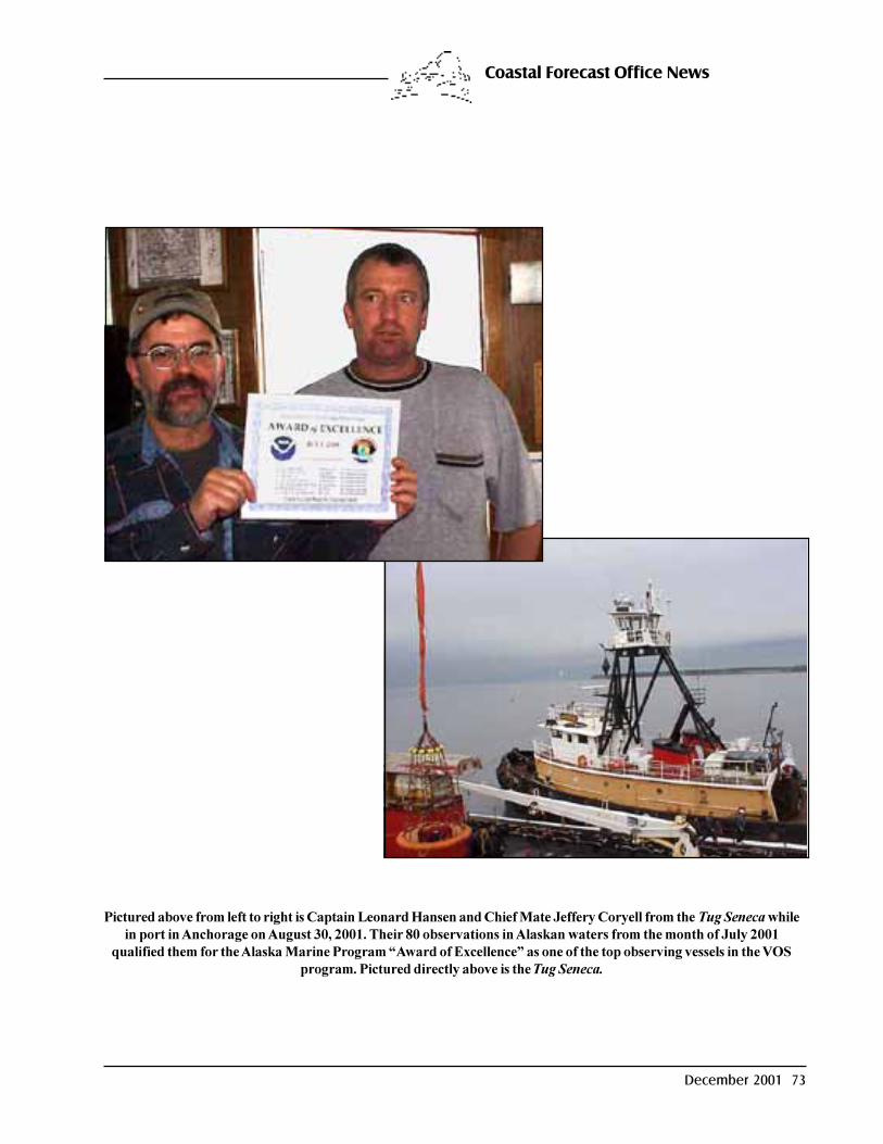
December 2001 73
Coastal Forecast Office News
Pictured above from left to right is Captain Leonard Hansen and Chief Mate Jeffery Coryell from the Tug Seneca whilein port in Anchorage on August 30, 2001. Their 80 observations in Alaskan waters from the month of July 2001
qualified them for the Alaska Marine Program �Award of Excellence� as one of the top observing vessels in the VOSprogram. Pictured directly above is the Tug Seneca.

74 Mariners Weather Log
Pictured on the right - Amy Seeleypresents a 2000 VOS award to theOglebay Norton. Pictured is CaptainPatrick J. Nelson. Other mates notpictured who took observations are: BryceSunderlin, John Sarns, JamesSievewright, Andrew Kania, and ReedWilson.
Pictured on the left - TheChevron Arizona was chosen
by Bob Drummond, PMOMiami, as one of the stellar
performers of 2000. Picturedfrom left to right are: 3rd
Mate Dave Corbett, Chief MateDan Whyte, and Captain Terry
Stark.
Pictured on the left - San Francisco PMO BobNovak awarded the President Polk for
outstanding performance during 2000. From leftto right: Captain Jerry Blackmon, (outgoing),
2ND Officer Doug Heler, and Captain Jeff Cowan(incoming).
VOS Program Awards

December 2001 75
VOS Program Awards
Pictured on the left - The crew of the Ocean Camelliaperformed an exceptional job in taking observations for theVOS program in the year 2000. A VOS Awards Plaque waspresented at the Blair Log yard in Tacoma. Pictured left to
right: 2ND Officer A. Montano, Captain Mo Kim, ChiefOfficer T. Batistil Jr., and 3RD Officer N. Salvanera.
Standing in the background is PMO Pat Brandow of Seattle.
Pictured on the right - The Westward Belinda was chosen byPat Brandow, PMO of Seattle, for a VOS award for the year2000. Pictured left to right, 3RD Officer F. Punay, CaptainUmesh Dixit, 3RD Officer P. Cariquitan, and Chief OfficerA. Mehta.
Pictured on right - JimSaunders, PMO Baltimore (onright), presents VOS awardplaque to Captain Phillip Hansenof the Tellus.

76 Mariners Weather Log
Pictured on the left - The M/V Tropic Key waschosen by Bob Drummond, PMO of Miami, for
a VOS award for the year 2000. Pictured left toright are: Chief Mate Alan Gumboc, Captain
Rodrigo I. Elgincolin Jr., and 2ND Mate MarioFampo.
VOS Program Awards
Pictured on the right - Captain Alan Hinshaw (onleft), of the Sealand Integrity, receiving his 2000
Outstanding award from Jim Nelson PMOHouston (on right). This has been one of the topships for the last 12 years. Kudos to the Captain
and Mates of the Sealand Integrity.
Pictured on the left - A 2000 VOS plaque was awarded tothe Vladivostok for the high quality of surface marine
observations. Pictured from left to right: PMO PatBrandow of Seattle, Captain Yevgeniy Konev, and 3RD
Officer Igor Manokhin.

December 2001 77
VOS Program Awards
Pictured on the right - The Duncan Island wasone of the ships recognized in 2000 by the VOSprogram for excellence in weather reporting.From left to right are Captain Brian Stewart andChief Mate Zdzislaw Tocki.
Pictured on the left - JimSaunders, PMO Baltimore (not
shown), presented VOS awardplaque to the Frances L. From leftto right are: 3RD Officer Abner T.
Manglinong, Captain MichelChapelle, and Chief Officer
Rosaliro R. Rafa Jr.
Jim Saunders, PMO Baltimore,(right) presents VOS awardplaque to Captain Chase (left) ofthe Faust.

78 Mariners Weather Log
Pictured on the left is Juneau HMT, JerryPainter, presenting a VOS award for the
year 2000 to 1ST Mate Michael Daigler ofthe Tug Northern Spirit (below), while inport in Juneau, Alaska on September 19,
2001. The Northern Spirit had the 4thhighest total of BBXX observations inAlaskan waters for the 2000 with 253.
After 8 months of 2001, the Northern Spirithas the 2nd highest total of BBXX
observations with 447. The Northern Spirithas helped pioneer the use of the SEAS
software and 34-mail to encode and transmitBBXX observations in Alaskan waters.
VOS Program Awards

December 2001 79
VOS Program Awards
Pictured on the right - VOS award plaquepresented by Jim Saunders, PMOBaltimore, to the Fidelio. Pictured left toright are: Chief Mate Scott Wegand,Captain Mike Fry, and 2ND Mate FrankLang.
NATIONAL WEATHER SERVICE VOLUNTARY OBSERVING SHIP PROGRAMNEW RECRUITS FROM 01-AUG-2001 TO 31-OCT-2001
NAME OF SHIP CALL SIGN AGENT NAME RECRUITING PMOCOASTAL EXPLORER WCY3112 COASTAL EXPLORER KODIAK, AKHARMONY ACE H3QA BARBER SHIP MGMT. JACKSONVILLE, FLKNIGHT ISLAND NMFN USCG KNIGHT ISLAND MIAMI, FLLIBERTY WAVE KRHZ LIBERTY MARITIME HOUSTON, TXLYKES VOYAGER ELZU5 STRACHAN SHIPPING CO. HOUSTON, TXM/T MONTAUK WDCJ SEALIFT INC NEW ORLEANS, LAM/V PITTSBURG ELTQ6 REEDEREI F. LAEISZ GMBH BALTIMORE, MDMATANUSKA WN4201 ALASKA MARINE HIGHWAY KODIAK, AKNAVIGATOR WBO3345 NAVIGATOR ANCHORAGE, AKPATRICIA S. WCY3527 ISLAND TUG AND BARGE CO. ANCHORAGE, AKRADIANCE OF THE SEAS ELIY5 ROYAL CARRIBEAN CRUISE LINE MIAMI, FLROBERT L. WTW9264 SAUSE BROS OCEAN TOWING CO KODIAK, AKSEA TIGER DGRR T. PARKER HOST NORFOLK, VASEA VICTORY WBH9635 CROWLEY MARITIME ANCHORAGE, AKTAKARA LAZN4 WILHELSEN JACKSONVILLE, FLTROPIC OPAL J8WN TROPIC SHIPPING INC. MIAMI, FLUSNS POMEROY NHRD MAERSK LINES LTD. NEW YORK CITY, NYYELLOWFIN WTE8340 WESTERN PIONEER KODIAK, AK
Pictured on the left - The Nolizwe was chosen by PeteGibino, PMO of Norfolk, as one of the top performers
of 2000. A VOS plaque was presented to the crew.Pictured from left to right are: 2ND Officer Rudy
Villahermosa, Captain Konstantinos Ntamagkas, and3RD Mate Jaime Amparo.
80 Mariners Weather Log
VOS Cooperative Ship Report � January through September 2001
The values under the monthly columns represent the number of weather reports received via radio messages. Commentsor questions regarding this report should be directed to David McShane, VOS Technical Lead, telephone: (228) 688-1768,or via e-mail to: [email protected].
VOS Cooperative Ship Reports
Ship Name Call PMO Jan Feb Mar Apr May Jun Jul Aug Sep Total1ST LT BALDOMERO LOPEZ WJKV Jacksonville 0 0 0 0 0 0 0 0 0 01ST LT JACK LUMMUS WJLV New York City 0 0 0 0 0 0 0 0 0 02ND LT. JOHN P. BOBO WJKH Norfolk 0 0 0 0 0 0 0 0 9 9A. V. KASTNER ZCAM9 Jacksonville 41 55 19 66 76 47 43 83 37 467A.P. MOLLER OVYQ2 Seattle 0 0 0 0 0 0 0 0 29 29AALSMEERGRACHT PCAM Long Beach 0 0 0 0 0 0 0 0 30 30ADVANTAGE WPPO Norfolk 0 0 0 0 0 0 0 0 19 19ADVENTURER WBN3015 Anchorage 0 0 0 0 0 0 0 0 32 32AGNES FOSS WYZ3112 Kodiak 0 0 0 0 0 0 0 0 9 9AGULHAS 3ELE9 Baltimore 0 0 0 0 0 0 0 0 0 0ALASKA MARINER WSM5364 Anchorage 0 0 0 0 0 0 0 0 0 0ALBEMARLE ISLAND C6LU3 New York City 0 0 0 0 0 0 0 0 31 31ALBERNI DAWN ELAC5 Houston 0 0 0 0 0 0 0 0 5 5ALBLASGRACHT PCIG Houston 0 0 0 0 0 0 8 42 25 75ALERT WCZ7335 Anchorage 0 0 0 0 0 0 0 0 0 0ALEXANDER VON HUMBOLD Y3CW Miami 22 627 735 711 734 703 714 736 335 5317ALKMAN C6OG4 Houston 0 0 0 0 0 0 0 0 0 0ALLEGIANCE WSKD Norfolk 0 0 0 0 0 0 0 0 0 0ALLIANCA ROTTERDAM DHGE Baltimore 0 0 0 0 0 0 0 0 0 0ALLIGATOR FORTUNE ELFK7 Seattle 0 0 0 0 0 0 0 0 0 0ALLIGATOR GLORY ELJP2 Seattle 0 0 0 0 0 0 0 0 6 6ALLIGATOR HOPE ELFN8 Seattle 0 0 0 0 0 0 0 0 0 0ALLIGATOR LIBERTY JFUG Seattle 0 0 0 0 0 0 0 0 0 0ALPENA WAV4647 Cleveland 0 0 0 0 0 0 0 0 0 0ALPHA HELIX WSD7078 Kodiak 0 0 0 0 0 0 0 0 12 12ALTAMONTE 3EIG4 Long Beach 0 0 0 0 0 0 0 0 0 0AMBASSADOR BRIDGE 3ETH9 Oakland 40 16 60 43 57 51 42 51 30 390AMERICA WCY2883 New York City 0 0 0 0 0 0 0 0 0 0AMERICA SENATOR 9WCR3 Norfolk 0 0 0 0 0 0 0 0 11 11AMERICA STAR GZKA Houston 0 0 0 0 0 0 0 0 30 30AMERICAN MARINER WQZ7791 Cleveland 0 0 0 0 0 0 0 0 0 0AMERICAN MERLIN WRGY Norfolk 0 0 0 0 0 0 0 0 0 0AMERICANA C6QG4 New Orleans 0 0 0 0 0 0 0 0 0 0ANASTASIS 9HOZ Miami 0 0 0 0 0 0 0 0 0 0ANATOLIY KOLESNICHENKO UINM Seattle 0 0 0 0 0 0 0 0 0 0ANKERGRACHT PCQL Baltimore 0 0 0 0 0 0 0 0 0 0APACHE WCY5541 Kodiak 0 0 0 0 0 0 0 0 0 0APL CHINA S6TA Seattle 0 0 0 0 0 0 0 0 14 14APL GARNET 9VVN Oakland 0 0 0 0 0 0 0 0 0 0APL JAPAN S6TS Seattle 0 0 0 0 0 0 0 0 1 1APL KOREA WCX8883 Seattle 31 78 37 27 34 23 24 29 27 310APL PHILIPPINES WCX8884 Seattle 0 0 0 0 0 0 56 33 18 107APL SINGAPORE WCX8812 Seattle 0 0 0 0 0 0 49 29 20 98APL THAILAND WCX8882 Seattle 0 0 0 0 0 0 0 0 12 12APL TURQUOISE 9VVY Oakland 0 0 0 0 0 0 0 0 0 0APOLLOGRACHT PCSV Baltimore 0 0 0 0 0 0 0 0 0 0ARCTIC BEAR WBP3396 Kodiak 0 0 0 0 0 0 24 21 10 55ARCTIC OCEAN C6T2062 New York City 0 0 0 0 0 0 0 0 0 0ARCTIC SUN ELQB8 Anchorage 0 0 0 0 0 0 0 0 21 21ARGENTINA STAR C6MD8 Houston 0 0 0 0 0 0 0 0 29 29ARGONAUT KFDV New York City 0 0 0 0 0 0 0 0 17 17ARIES HARMONY 3FEY7 Seattle 0 0 0 0 0 0 0 0 0 0ARISO 3FHJ6 Seattle 0 0 0 0 0 0 0 0 0 0ARKTIS FUTURE OXUF2 Miami 0 0 0 0 0 0 0 0 0 0ARMCO WE6279 Cleveland 0 0 0 0 0 0 0 0 1 1AROSIA V2SB New Orleans 0 0 0 0 0 0 0 0 0 0ARTHUR M. ANDERSON WE4805 Chicago 0 0 0 0 0 0 0 0 15 15ASTORIA BRIDGE ELJJ5 Long Beach 0 0 0 0 0 0 61 80 27 168

December 2001 81
VOS Cooperative Ship Reports
Ship Name Call PMO Jan Feb Mar Apr May Jun Jul Aug Sep Total
ATLANTIC 3FYT Miami 0 0 0 0 0 0 312 324 118 754ATLANTIC CARTIER C6MS4 Norfolk 0 0 0 0 0 0 0 0 10 10ATLANTIC COMPANION SKPE New York City 0 0 0 0 0 0 47 45 10 102ATLANTIC COMPASS SKUN Norfolk 0 0 0 0 0 0 0 0 17 17ATLANTIC CONCERT SKOZ Norfolk 0 0 0 0 0 0 0 0 20 20ATLANTIC CONVEYOR C6NI3 Norfolk 0 0 0 0 0 0 0 0 20 20ATLANTIC ERIE VCQM Baltimore 0 0 0 0 0 0 0 0 6 6ATLANTIC FOREST ELTN8 New Orleans 0 0 0 0 0 0 0 0 15 15ATLANTIC NOVA 3FWT4 Seattle 0 0 0 0 0 0 0 0 0 0ATLANTIC OCEAN C6T2064 New York City 0 0 0 0 0 0 0 0 2 2ATLANTIS KAQP New Orleans 0 0 0 0 0 0 0 0 3 3ATTENTIVE WCZ7337 Anchorage 0 0 0 0 0 0 0 0 0 0AUCKLAND STAR C6KV2 Baltimore 0 0 0 0 0 0 0 0 0 0AWARE WCZ7336 Anchorage 0 0 0 0 0 0 0 0 0 0B. T. ALASKA WFQE Long Beach 0 0 0 0 0 0 0 0 3 3BARBARA ANDRIE WTC9407 Chicago 0 0 0 0 0 0 0 0 5 5BARRINGTON ISLAND C6QK Miami 0 0 0 0 0 0 0 0 0 0BAY BRIDGE ELES7 Long Beach 0 0 0 0 0 0 0 0 0 0BELLONA 3FEA4 Jacksonville 0 0 0 0 0 0 0 0 0 0BERING SEA C6YY Miami 0 0 0 0 0 0 0 0 0 0BERNARDO QUINTANA A C6KJ5 New Orleans 0 0 0 0 0 0 66 60 26 152BLACKHAWK WBN2081 Anchorage 0 0 0 0 0 0 0 0 0 0BLARNEY WBP4766 Kodiak 0 0 0 0 0 0 0 0 0 0BLUE GEMINI 3FPA6 Seattle 0 0 0 0 0 0 0 0 0 0BLUE HAWK D5HZ Norfolk 0 0 0 0 0 0 0 0 0 0BLUE NOVA 3FDV6 Seattle 0 0 0 0 0 0 44 10 25 79BOHEME SIVY New York City 0 0 0 0 0 0 0 0 0 0BONN EXPRESS DGNB Houston 734 834 788 867 863 865 1212 984 409 7556BRASILIA DGVS New York City 0 0 0 0 0 0 0 0 11 11BRIGHT PHOENIX DXNG Seattle 0 0 0 0 0 0 0 0 0 0BRIGHT STATE DXAC Seattle 0 0 0 0 0 0 0 0 0 0BRISBANE STAR C6LY4 Seattle 0 0 0 0 0 0 0 0 0 0BRITISH ADVENTURE ZCAK3 Seattle 0 0 0 0 0 0 66 47 21 134BROOKLYN BRIDGE 3EZJ9 Oakland 0 0 0 0 0 0 0 0 0 0BUCKEYE WAQ3520 Cleveland 0 0 0 0 0 0 0 0 0 0BUFFALO WXS6134 Cleveland 0 0 0 0 0 0 0 0 0 0BUNGA ORKID DUA 9MBQ4 Seattle 0 0 0 0 0 0 0 0 0 0BUNGA ORKID TIGA 9MBS3 Seattle 0 0 0 0 0 0 0 0 0 0BUNGA SAGA TIGA 9MBM8 Seattle 0 0 0 0 0 0 0 0 0 0CABO NEGRO ELEM2 Houston 0 0 0 0 0 0 0 0 0 0CALCITE II WB4520 Chicago 0 0 0 0 0 0 0 0 0 0CALIFORNIA JUPITER ELKU8 Long Beach 0 0 0 0 31 15 35 46 32 159CALIFORNIA MERCURY JGPN Seattle 0 0 0 0 0 0 17 17 6 40CALIFORNIA SENATOR DEBB Houston 0 0 0 0 0 0 14 71 37 122CAPE KNOX KAOP New Orleans 0 0 0 0 0 0 0 0 0 0CAPE WRATH WRGJ Baltimore 0 0 0 0 0 0 0 0 0 0CAPRICORN PDAY Baltimore 0 0 0 0 0 0 0 0 3 3CAPT STEVEN L BENNETT KAXO New Orleans 0 0 0 0 0 0 0 0 24 24CARIBBEAN MERCY 3FFU4 Miami 0 0 0 0 0 0 0 0 0 0CARIBE CHALLENGER WDA3588 Kodiak 0 0 0 0 0 0 0 0 3 3CARNIVAL DESTINY 3FKZ3 Miami 0 0 0 0 0 0 0 0 0 0CARNIVAL PARADISE 3FOB5 Miami 0 0 0 0 0 0 0 0 9 9CARNIVAL SPIRIT 3FPR9 Miami 0 0 0 0 0 0 0 0 1 1CARNIVAL TRIUMPH 3FFM8 Miami 0 0 0 0 0 0 0 0 0 0CARNIVAL VICTORY 3FFL8 Miami 0 0 0 0 0 0 0 0 0 0CAROLINA WYBI Jacksonville 0 0 0 0 0 0 0 0 0 0CAROLINE MAERSK OZWA2 Seattle 0 0 0 0 0 0 0 0 0 0CARSTEN MAERSK OZYB2 Seattle 0 0 0 0 0 0 0 0 0 0CASON J. CALLAWAY WE4879 Chicago 0 0 0 0 0 0 0 0 13 13CAVALIER WBN5983 Anchorage 0 0 0 0 0 0 0 0 0 0CELEBRATION H3GQ New Orleans 0 0 0 0 0 0 0 0 5 5CENTURY ELQX6 Miami 0 0 0 0 0 0 0 0 0 0CENTURY HIGHWAY NO. 2 3EJB9 Long Beach 0 0 0 0 0 0 0 0 0 0CENTURY HIGHWAY NO. 1 3FFJ4 Houston 0 0 0 0 0 0 0 0 13 13CENTURY HIGHWAY NO. 3 8JNP Houston 0 0 0 0 0 0 0 0 0 0CENTURY LEADER NO. 1 3FBI6 Houston 0 0 0 0 0 0 0 0 22 22CF CAMPBELL WCT3784 Kodiak 0 0 0 0 0 0 0 0 14 14CGM RENOIR ELVZ8 Norfolk 0 0 0 0 0 0 0 0 20 20CHANG-LIN TIEN C6FE6 Oakland 0 0 0 0 0 0 0 0 4 4
82 Mariners Weather Log
VOS Cooperative Ship Reports
Ship Name Call PMO Jan Feb Mar Apr May Jun Jul Aug Sep Total
CHARLES ISLAND C6JT Miami 0 0 0 0 0 0 23 51 21 95CHARLES L. BROWN KNCZ Jacksonville 0 0 0 0 0 0 0 0 0 0CHARLES M. BEEGHLEY WL3108 Cleveland 0 0 0 0 0 0 0 0 0 0CHASTINE MAERSK OZZB2 Seattle 0 0 0 0 0 0 0 0 31 31CHC NO.1 3FSL2 Seattle 0 0 0 0 0 0 0 0 0 0CHELSEA KNCX Miami 0 0 0 0 0 0 0 0 0 0CHEMICAL PIONEER KAFO Houston 0 0 0 0 0 0 0 0 14 14CHEMICAL TRADER KRGJ Jacksonville 0 0 0 0 0 0 0 0 0 0CHERRY VALLEY WIBK Houston 0 0 0 0 0 0 0 0 12 12CHESAPEAKE BAY WMLH Norfolk 0 0 0 0 0 0 19 38 13 70CHEVRON ARIZONA KGBE Miami 0 0 0 0 0 0 0 0 2 2CHEVRON ATLANTIC C6KY3 New Orleans 0 0 0 0 0 0 0 0 0 0CHEVRON COLORADO KLHZ Oakland 0 0 0 0 0 0 40 30 17 87CHEVRON COPENHAGEN A8GL Oakland 0 0 0 0 0 0 0 0 0 0CHEVRON EMPLOYEE PRIDE C6MC5 Baltimore 0 0 0 0 0 0 0 0 0 0CHEVRON FELUY C6FH5 Houston 0 0 0 0 0 0 0 0 0 0CHEVRON MISSISSIPPI WXBR Oakland 0 0 0 0 0 0 0 0 29 29CHEVRON PERTH C6KQ8 Oakland 0 0 0 0 0 0 47 26 31 104CHEVRON SOUTH AMERICA ZCAA2 New Orleans 0 0 0 0 0 0 0 24 43 67CHEVRON WASHINGTON KFDB Oakland 0 0 0 0 0 0 0 0 0 0CHIEF GADAO WEZD Oakland 0 0 0 0 0 0 0 0 5 5CHINOOK WCY2791 Kodiak 0 0 0 0 0 0 0 0 0 0CHIQUITA BARU ZCAY7 Jacksonville 0 0 0 0 0 0 0 0 0 0CHIQUITA BELGIE C6KD7 Baltimore 0 0 0 0 0 0 0 0 20 20CHIQUITA BREMEN ZCBC5 Miami 0 0 0 0 0 0 0 0 14 14CHIQUITA BRENDA ZCBE9 Miami 0 0 0 0 0 0 38 31 21 90CHIQUITA DEUTSCHLAND C6KD8 Baltimore 0 0 0 0 0 0 0 0 0 0CHIQUITA ELKESCHLAND ZCBB9 Miami 0 0 0 0 0 0 0 0 26 26CHIQUITA FRANCES ZCBD9 Miami 0 0 0 0 0 0 0 0 26 26CHIQUITA ITALIA C6KD5 Baltimore 0 0 0 0 0 0 0 0 0 0CHIQUITA JEAN ZCBB7 Jacksonville 0 0 0 0 0 0 0 0 4 4CHIQUITA JOY ZCBC2 Miami 0 0 0 0 0 0 46 65 35 146CHIQUITA NEDERLAND C6KD6 Baltimore 0 0 0 0 0 0 61 34 30 125CHIQUITA SCANDINAVIA C6KD4 Baltimore 0 0 0 0 0 0 0 0 12 12CHIQUITA SCHWEIZ C6KD9 Baltimore 0 0 0 0 0 0 0 0 23 23CITY OF DURBAN GXIC Long Beach 66 57 78 56 49 51 38 72 26 493CLEVELAND KGXA Houston 0 0 0 0 0 0 0 0 0 0CLIFFORD MAERSK OYRO2 Seattle 0 0 0 0 0 0 0 0 0 0CMA CGM MONET ELRR6 New Orleans 0 0 0 0 0 0 0 0 51 51COASTAL MERCHANT WCV8696 Seattle 0 0 0 0 0 0 0 0 5 5COASTAL NAVIGATOR WCY9686 Seattle 0 0 0 0 0 0 0 0 9 9COASTAL NOMAD WSK2703 Kodiak 0 0 0 0 0 0 0 0 0 0COASTAL PILOT WBP7281 Kodiak 0 0 0 0 0 0 0 0 0 0COASTAL SEA WCA7944 Seattle 0 0 0 0 0 0 0 0 0 0COASTAL TRADER WCO6020 Kodiak 0 0 0 0 0 0 0 0 0 0COASTAL TRADER WSL8560 Kodiak 0 0 0 0 0 0 0 0 0 0COLORADO KWFE Miami 0 0 0 0 0 0 0 0 0 0COLUMBIA WYR2092 Kodiak 0 0 0 0 0 0 0 0 0 0COLUMBIA BRIDGE ELXS4 Seattle 0 0 0 0 0 0 0 0 8 8COLUMBIA STAR WSB2018 Cleveland 0 0 0 0 0 0 0 0 0 0COLUMBUS CALIFORNIA ELUB7 Houston 0 0 0 0 0 0 0 0 0 0COLUMBUS CANADA P3RD8 Norfolk 0 0 0 0 0 0 0 0 0 0COLUMBUS CANADA ELQN3 Seattle 0 0 0 0 0 0 0 0 0 0COLUMBUS CANTERBURY ELUB8 Norfolk 28 52 51 64 76 31 60 46 42 450COLUMBUS QUEENSLAND ELUB9 Norfolk 0 0 0 0 0 0 0 0 0 0COLUMBUS VICTORIA P3RF8 Norfolk 0 0 0 0 0 0 0 0 18 18CONDOLEEZZA RICE C6OK Baltimore 0 0 0 0 0 0 0 0 0 0CONTSHIP AMERICA V7BZ3 Houston 0 0 0 0 0 0 0 0 0 0CONTSHIP ENDEAVOUR ZCBE7 Houston 0 0 0 0 0 0 0 0 1 1CONTSHIP SUCCESS ZCBE3 Houston 0 0 0 0 0 0 0 0 0 0CONTSHIP WASHINGTON ELVZ5 Norfolk 0 0 0 0 0 0 0 0 14 14COPACABANA PPXI Norfolk 0 0 0 0 0 0 0 0 27 27CORAL SEA C6YW Miami 0 0 0 0 0 0 0 0 0 0CORMORANT ARROW C6IO9 Seattle 0 0 0 0 0 0 0 0 0 0CORNELIUS MAERSK OYTN2 Seattle 0 0 0 0 0 0 0 0 4 4CORNUCOPIA KPJC Oakland 0 0 0 0 0 0 0 0 0 0COSCO NORFOLK P3ZY6 Norfolk 0 0 0 0 0 0 0 0 11 11COSMOWAY 3EVO3 Seattle 0 0 0 0 0 0 0 0 0 0COUGAR ACE 9VKE Norfolk 0 0 0 0 0 0 0 0 0 0

December 2001 83
VOS Cooperative Ship Reports
Ship Name Call PMO Jan Feb Mar Apr May Jun Jul Aug Sep Total
COURIER KCBK Houston 0 0 0 0 0 0 0 0 30 30COURTNEY BURTON WE6970 Cleveland 0 0 0 0 0 0 0 0 4 4COURTNEY L ZCAQ8 Baltimore 0 0 0 0 0 0 0 0 10 10CRIMSON GALAXY 3FIQ6 Norfolk 0 0 0 0 0 0 0 0 24 24CROSS POINT WCW8728 Anchorage 0 0 0 0 0 0 0 0 0 0CROWLEY UNIVERSE ELRU3 Miami 0 0 0 0 0 0 0 0 2 2CROWN OF SCANDINAVIA OXRA6 Miami 0 0 0 0 0 0 0 0 26 26CSAV BUSAN ELWZ3 Long Beach 0 0 0 0 0 0 0 0 0 0CSL CABO D5XH Seattle 0 0 0 0 0 0 0 0 11 11CSS HUDSON CGDG Norfolk 0 0 0 0 0 0 0 0 17 17CSX DEFENDER KGJB Oakland 0 0 0 0 0 0 0 0 12 12CSX PATRIOT KHRF Oakland 0 0 0 0 0 0 40 23 22 85CSX ANCHORAGE KGTX Anchorage 0 0 0 0 0 0 62 55 37 154CSX CONSUMER WCHF Houston 0 0 0 0 0 0 0 0 18 18CSX CRUSADER WZJF Jacksonville 0 0 0 0 0 0 0 0 5 5CSX DISCOVERY WZJD Jacksonville 0 0 0 0 0 0 0 0 15 15CSX ENTERPRISE KRGB Oakland 0 0 0 0 0 0 0 0 45 45CSX HAWAII KIRF New York City 0 0 0 0 0 0 0 0 34 34CSX INNOVATOR WGKF Oakland 0 0 0 0 0 0 59 38 27 124CSX KODIAK KGTZ Anchorage 0 0 0 0 0 0 38 38 18 94CSX LIBERATOR KHRP Oakland 0 0 0 0 0 0 0 0 12 12CSX SPIRIT WFLG Oakland 0 0 0 0 0 0 0 0 25 25CSX TACOMA KGTY Anchorage 0 0 0 0 0 0 0 0 13 13CSX TRADER KIRH Oakland 0 0 0 0 0 0 34 46 21 101CYNTHIA FAGAN KSDF Houston 0 0 0 0 0 0 0 0 7 7DAGMAR MAERSK ELZD9 New York City 0 0 0 0 0 0 0 0 25 25DAGNEY WX8482A Kodiak 0 0 0 0 0 0 0 0 0 0DAISHIN MARU 3FPS6 Seattle 0 0 0 0 0 0 0 0 21 21DANIA PORTLAND OXEH2 Miami 0 0 0 0 0 0 0 0 0 0DANIEL FOSS WTS3171 Kodiak 0 0 0 0 0 0 0 0 0 0DAVID Z. NORTON WZF9655 Cleveland 0 0 0 0 0 0 0 0 0 0DELAWARE BAY WMLG Norfolk 0 0 0 0 0 0 0 0 2 2DENALI WSVR Long Beach 0 0 0 0 0 0 0 0 5 5DIANE H. WUR7250 Kodiak 0 0 0 0 0 0 0 0 3 3DILMUN FULMAR ZCRR6 New Orleans 0 0 0 0 0 0 0 0 0 0DIRCH MAERSK OXQP2 Long Beach 0 0 0 0 0 0 0 0 2 2DIRECT CONDOR ELWP7 Long Beach 0 0 0 0 0 0 0 0 1 1DIRECT EAGLE ELWY5 Long Beach 0 0 0 0 0 0 0 0 0 0DIRECT FALCON ELWQ5 Long Beach 0 0 0 0 0 0 0 0 0 0DIRECT JABIRU ELYJ9 Oakland 0 0 0 0 0 0 60 39 36 135DIRECT KOOKABURRA ELWB8 Long Beach 0 0 0 0 0 0 0 0 12 12DON PASQUALE SFQG Unknown 0 0 0 0 0 0 0 0 0 0DON QUIJOTE SFQP New York City 0 0 0 0 0 0 0 0 0 0DORTHE MAERSK DHPD New York City 0 0 0 0 0 0 0 0 0 0DORTHE OLDENDORFF ELXC4 Seattle 0 0 0 0 0 0 0 0 0 0DRAGOER MAERSK OXPW2 Long Beach 0 0 0 0 0 0 0 0 0 0DRESDEN ELXZ4 Oakland 0 0 0 0 0 0 0 0 0 0DREW FOSS WYL7518 Kodiak 0 0 0 0 0 0 0 0 0 0DUHALLOW ZCBH9 Baltimore 0 0 4 2 44 110 60 111 30 361DUNCAN ISLAND C6JS Miami 0 0 0 0 0 0 0 0 40 40E.P. LE QUEBECOIS CG3130 Norfolk 0 0 2 188 225 229 230 241 111 1226EARL W. OGLEBAY WZE7718 Cleveland 0 0 0 0 0 0 0 0 0 0ECSTASY H3GR Miami 0 0 0 0 0 0 0 0 6 6EDGAR B. SPEER WQZ9670 Chicago 0 0 0 0 0 0 0 0 27 27EDWIN H. GOTT WXQ4511 Chicago 0 0 0 0 0 0 0 0 13 13EDYTH L C6YC Baltimore 0 0 0 0 0 0 0 0 4 4EL MORRO KCGH Miami 0 0 0 0 0 0 0 0 2 2EL YUNQUE WGJT Jacksonville 0 0 0 0 0 0 44 31 21 96ELATION 3FOC5 Miami 0 0 0 0 0 0 0 0 0 0EMPIRE STATE KKFW New York City 0 0 0 0 0 0 0 0 0 0ENCHANTMENT OF THE SEAS LAXA4 Miami 0 0 0 0 0 0 0 0 0 0ENDEAVOR WAUW New York City 0 0 0 0 0 0 0 0 33 33ENDURANCE WYA4377 Anchorage 0 0 0 0 0 0 0 0 0 0ENDURANCE WAUU New York City 0 0 0 0 0 0 0 0 0 0ENERGY ENTERPRISE WBJF Baltimore 0 0 0 0 0 0 0 0 0 0ENGLISH STAR C6KU7 Long Beach 0 0 0 0 0 0 0 0 13 13ENIF 9VVI Houston 0 0 0 0 0 0 0 0 0 0ENTERPRISE WAUY New York City 0 0 0 0 0 0 0 0 26 26ESSEN EXPRESS DHEE Norfolk 0 0 0 0 0 0 0 0 14 14

84 Mariners Weather Log
VOS Cooperative Ship Reports
Ship Name Call PMO Jan Feb Mar Apr May Jun Jul Aug Sep Total
EVER DECENT 3FUO7 New York City 0 0 0 0 0 0 0 0 0 0EVER DELIGHT 3FCB8 New York City 0 0 0 0 0 0 0 0 0 0EVER DELUXE 3FBE8 Norfolk 0 0 0 0 0 0 0 0 0 0EVER DEVELOP 3FLF8 New York City 0 0 0 0 0 0 0 0 6 6EVER DEVOTE 3FIF8 New York City 0 0 0 0 0 0 0 0 10 10EVER DIADEM 3FOF8 New York City 0 0 0 0 0 0 0 0 0 0EVER DIVINE 3FSA8 Norfolk 0 0 0 0 0 0 0 0 0 0EVER GAINING BKJO Norfolk 0 0 0 0 0 0 0 0 0 0EVER GENERAL BKHY Baltimore 0 0 0 0 0 0 0 0 0 0EVER GIFTED BKHF Long Beach 0 0 0 0 0 0 0 0 0 0EVER GLOWING BKJZ Long Beach 0 0 0 0 0 0 0 0 0 0EVER GROUP BKJI Long Beach 0 0 0 0 0 0 0 0 20 20EVER LEVEL BKHJ Miami 0 0 0 0 0 0 0 0 0 0EVER LYRIC BKHI Long Beach 0 0 0 0 0 0 0 0 0 0EVER RACER 3FJL4 Norfolk 0 0 0 0 0 0 0 0 2 2EVER REFINE 3FSB4 New York City 0 0 0 0 0 0 0 0 0 0EVER RENOWN 3FFR4 Long Beach 0 0 0 0 0 0 0 0 10 10EVER RESULT 3FSA4 Norfolk 0 0 0 0 0 0 0 0 0 0EVER RIGHT 3FML3 Long Beach 0 0 0 0 0 0 0 0 0 0EVER ROUND 3FQN3 Long Beach 0 0 0 0 0 0 0 0 0 0EVER ROYAL 3FGI3 Long Beach 0 0 0 0 0 0 0 0 0 0EVER ULTRA 3FEJ6 Seattle 0 0 0 0 0 0 0 0 7 7EVER UNION 3FFG7 Seattle 0 0 0 0 0 0 0 0 6 6EVER UNIQUE 3FXQ6 Seattle 0 0 0 0 0 0 0 0 0 0EVER UNISON 3FTL6 Long Beach 0 0 0 0 0 0 0 0 1 1EVER UNITED 3FMQ6 Seattle 0 0 0 0 0 0 0 0 0 0EVERETT EXPRESS DPGD Seattle 0 0 0 0 0 0 0 0 3 3EWA WEZM Seattle 0 0 0 0 0 0 56 38 37 131EXPLORER OF THE SEAS ELWX5 Miami 0 0 0 0 0 0 318 257 190 765FAIRBANKS WGWB Long Beach 0 0 0 0 0 0 0 0 0 0FAIRLIFT PEBM Norfolk 0 0 0 0 0 0 0 0 0 0FAIRMAST PJLC Norfolk 0 0 0 0 0 0 0 0 0 0FALSTRIA C6BD8 Seattle 0 0 0 0 0 0 0 0 0 0FANTASY ELKI6 Miami 0 0 0 0 0 0 0 0 0 0FARALLON ISLAND FARIS Oakland 0 0 0 0 0 0 0 0 0 0FASCINATION C6FM9 Miami 0 0 0 0 0 0 0 0 0 0FAUST WRYX Jacksonville 0 0 0 0 0 0 0 0 4 4FIDELIO WQVY Jacksonville 0 0 0 0 0 0 50 45 25 120FIGARO S6PI Baltimore 0 0 0 0 0 0 53 32 22 107FISHHAWK WRB5085 Kodiak 0 0 0 0 0 0 0 0 12 12FOREST TRADER A8GJ Seattle 0 0 0 0 0 0 0 0 0 0FRANCES HAMMER KRGC Jacksonville 0 0 0 0 0 0 0 0 0 0FRANCES L C6YE Baltimore 0 0 0 0 0 0 0 0 23 23FRANK A. SHRONTZ C6PZ3 Oakland 0 0 0 0 0 0 0 0 0 0FRANKFURT EXPRESS 9VPP New York City 0 0 0 0 0 0 0 0 3 3G AND C PARANA LADC2 Long Beach 0 0 0 0 0 0 0 0 0 0GALE WIND WAZ9548 Anchorage 0 0 0 0 0 0 0 0 11 11GANNET ARROW C6QF5 Seattle 0 0 0 0 0 0 0 0 0 0GARDEN BRIDGE ELVF6 Long Beach 0 0 0 0 0 0 0 0 0 0GEMINI KHCF New York City 0 0 0 0 0 0 0 0 0 0GENE DUNLAP WAS2433 Kodiak 0 0 0 0 0 0 0 0 0 0GEORGE A. STINSON WCX2417 Cleveland 0 0 0 0 0 0 0 0 17 17GEORGE SCHULTZ C6FD4 Baltimore 0 0 0 0 0 0 0 0 0 0GEORGE WASHINGTON BRIDGE JKCF Seattle 24 60 47 68 71 53 45 39 32 439GEORGIA RAINBOW II VRVS5 Jacksonville 0 0 0 0 0 0 0 0 5 5GERMAN SENATOR ELPL3 Seattle 0 0 0 0 0 0 0 0 0 0GINGA MARU JFKC Long Beach 0 0 0 0 0 0 0 0 0 0GITTQA OLDENDORF ELWO7 Norfolk 0 0 0 0 0 0 0 0 0 0GLADIATOR WBN5982 Anchorage 0 0 0 0 0 0 0 0 18 18GLOBAL LINK WWDY Baltimore 0 0 0 0 0 0 0 0 0 0GLOBAL MARINER WWXA Baltimore 0 0 0 0 0 0 0 0 26 26GLOBAL SENTINEL WRZU Baltimore 0 0 0 0 0 0 0 0 0 0GLORIOUS SUCCESS DUHN Seattle 0 0 0 0 0 0 0 0 0 0GOLDEN BEAR NMRY Oakland 0 0 0 0 0 0 0 0 0 0GOLDEN BELL 3EBK9 Seattle 0 0 0 0 0 0 0 0 0 0GOLDEN GATE KIOH Long Beach 0 0 0 0 0 0 0 0 45 45GOLDEN GATE BRIDGE 3FWM4 Long Beach 0 0 0 0 0 0 0 0 0 0GOLDEN LAKER 3FNQ6 Norfolk 0 0 0 0 0 0 0 0 0 0GRAND PACE 3FGJ9 New York City 0 0 0 0 0 0 0 0 0 0

December 2001 85
VOS Cooperative Ship Reports
GRANDEUR OF THE SEAS ELTQ9 Miami 0 0 0 0 0 0 0 0 0 0GREAT BLESS VRVL3 Houston 0 0 0 0 0 0 0 0 0 0GREAT JADE VRVL7 Seattle 0 0 0 0 0 0 0 0 0 0GREAT LAND WFDP Seattle 0 0 0 0 0 0 0 0 10 10GREEN BAY KGTH Long Beach 0 0 0 0 0 0 0 0 0 0GREEN COVE WCZ9380 Oakland 0 0 0 0 0 0 0 0 11 11GREEN DALE WCZ5238 Jacksonville 0 0 0 0 0 0 0 0 12 12GREEN ISLAND KIBK New Orleans 0 0 0 0 0 0 0 0 15 15GREEN LAKE KGTI Baltimore 0 0 0 0 0 0 0 0 0 0GREEN POINT WCY4148 New York City 0 0 0 0 0 0 0 0 12 12GREEN RAINIER 3ENI3 Seattle 0 0 0 0 0 0 0 0 0 0GREEN RIDGE WRYL Seattle 0 0 0 0 0 0 0 0 0 0GREENWICH MAERSK MZIF7 New York City 0 0 0 0 0 0 0 0 5 5GRETA WCY2853 Kodiak 0 0 0 0 0 0 0 0 6 6GRETE MAERSK OZNF2 New York City 0 0 0 0 0 0 0 0 11 11GROTON KMJL New York City 0 0 0 0 0 0 0 0 31 31GUANAJUATO ELMH8 Jacksonville 0 0 0 0 0 0 0 0 0 0GUARDIAN WBO2511 Anchorage 0 0 0 0 39 87 91 118 66 401GUAYAMA WZJG Jacksonville 0 0 0 0 0 0 0 0 8 8GUDRUN MAERSK OZFQ2 New York City 0 0 0 0 0 0 0 5 21 26GUS W. DARNELL KCDK Houston 0 0 0 0 0 0 0 0 0 0GYPSUM BARON ZCAN3 Norfolk 0 0 0 0 0 0 0 0 0 0GYPSUM KING ZCAN2 Baltimore 0 0 0 0 0 0 0 0 0 0HADERA ELBX4 Baltimore 0 0 0 0 0 0 59 86 39 184HANJIN BARCELONA 3EXX9 Long Beach 0 0 0 0 0 0 0 0 0 0HANJIN HONG KONG P3UX7 Long Beach 0 0 0 0 0 0 0 0 0 0HANJIN KAOHSIUNG P3BN8 Seattle 0 0 0 0 0 0 0 0 1 1HANJIN NAGOYA 3FJW8 New York City 0 0 0 0 0 0 0 0 0 0HANSEWALL V2AO3 Norfolk 0 0 0 0 0 0 0 0 0 0HEIDELBERG EXPRESS DEDI Houston 501 335 752 302 747 785 762 686 369 5239HENRY HUDSON BRIDGE JKLS Seattle 0 0 0 0 0 0 0 0 19 19HERBERT C. JACKSON WL3972 Cleveland 0 0 0 0 0 0 0 0 0 0HOEGH DUKE ELWP2 Norfolk 0 0 0 0 0 0 0 0 17 17HOLIDAY 3FPN5 Long Beach 0 0 0 0 0 0 0 0 0 0HONG KONG SENATOR DEIP Seattle 0 0 0 0 0 0 0 0 0 0HONSHU SILVIA 3EST7 Seattle 0 0 0 0 0 0 0 0 0 0HOOD ISLAND C6LU4 Miami 0 0 0 0 0 0 0 0 11 11HORIZON ELNG6 Miami 0 0 0 0 0 0 0 0 0 0HOUSTON EXPRESS 3FQT9 Houston 0 0 0 0 0 0 0 0 0 0HUAL TRANSPORTER C6QO3 Jacksonville 0 0 0 0 0 0 0 0 0 0HUMACAO WZJB Norfolk 0 0 0 0 0 0 38 37 14 89HUMBERGRACHT PEUQ Houston 0 0 0 0 0 0 0 0 0 0HUME HIGHWAY 3EJO6 Jacksonville 0 0 0 0 0 0 0 0 0 0HYUNDAI DISCOVERY 3FFR6 Seattle 0 0 0 0 0 0 0 0 0 0HYUNDAI FORTUNE 3FLG6 Seattle 0 0 0 0 0 0 0 0 0 0HYUNDAI FREEDOM 3FFS6 Seattle 0 0 0 0 0 0 0 0 0 0HYUNDAI INDEPENDENCE 3FDY6 Seattle 0 0 0 0 0 0 0 0 0 0HYUNDAI LIBERTY 3FFT6 Seattle 0 0 0 0 0 0 0 0 0 0IMAGINATION C6FN2 Miami 0 0 0 0 0 0 0 0 4 4INDAMEX MISSISSIPPI ZDDT5 Norfolk 0 0 0 0 0 0 0 0 0 0INDAMEX WASHINGTON ELRJ6 Baltimore 0 0 0 0 0 0 0 0 0 0INDIAN OCEAN C6T2063 New York City 0 0 0 0 0 0 0 0 27 27INDIANA HARBOR WXN3191 Cleveland 0 0 0 0 0 0 0 0 22 22INFINITY ELXX7 Miami 0 0 0 0 0 0 0 0 0 0INLAND SEAS WCJ6214 Chicago 0 0 0 0 0 0 0 0 0 0INTEGRITY WNHL Baltimore 0 0 0 0 0 0 0 0 0 0ISLA DE CEDROS 3FOA6 Seattle 0 0 0 0 0 0 41 26 33 100ISLAND CHAMPION WCZ7046 Anchorage 0 0 0 0 0 0 0 0 0 0ITB BALTIMORE WXKM Baltimore 0 0 0 0 0 0 0 0 6 6ITB MOBILE KXDB New York City 0 0 0 0 0 0 0 0 0 0ITB NEW YORK WVDG Baltimore 0 0 0 0 0 0 0 0 14 14IVARAN EAGLE DNEN Houston 0 0 0 0 0 0 0 0 0 0IVER FOSS WCY6442 Kodiak 0 0 0 0 0 0 0 0 0 0IWANUMA MARU 3ESU8 Seattle 82 31 102 112 76 54 80 74 52 663J. BENNETT JOHNSTON C6QE3 Oakland 0 0 0 0 0 0 0 0 12 12J. DENNIS BONNEY C6FH6 Baltimore 0 0 0 0 0 0 0 0 0 0J.A.W. IGLEHART WTP4966 Cleveland 0 0 0 0 0 0 0 0 0 0JACKLYN M. WCV7620 Chicago 0 0 0 0 0 0 26 53 12 91JACKSONVILLE WNDG Baltimore 0 0 0 0 0 0 0 0 6 6
Ship Name Call PMO Jan Feb Mar Apr May Jun Jul Aug Sep Total
86 Mariners Weather Log
VOS Cooperative Ship Reports
Ship Name Call PMO Jan Feb Mar Apr May Jun Jul Aug Sep Total
JADE ORIENT ELRY6 Seattle 0 0 0 0 0 0 0 0 0 0JADE PACIFIC ELRY5 Seattle 0 0 0 0 0 0 0 0 0 0JAMES A. HANNAH WU8842 Chicago 0 0 0 0 0 0 0 0 0 0JAMES N. SULLIVAN C6FD3 Baltimore 0 0 0 0 0 0 27 23 16 66JAMES R. BARKER WYP8657 Cleveland 0 0 0 75 63 37 82 85 32 374JEB STUART WRGQ Oakland 0 0 0 0 0 0 0 0 0 0JO CLIPPER PFEZ Baltimore 0 0 0 0 0 0 0 0 22 22JO LONN PFEW Houston 0 0 0 0 0 0 0 1 33 34JOHN G. MUNSON WE3806 Chicago 0 0 0 0 0 0 0 0 17 17JOHN J. BOLAND WZE4539 Cleveland 0 0 0 0 0 0 0 0 3 3JOHN PAGE WPKS Norfolk 0 0 0 0 0 0 0 0 0 0JOIDES RESOLUTION D5BC Norfolk 0 0 0 0 0 0 0 0 5 5JOSEPH L. BLOCK WDA2768 Chicago 0 0 0 0 0 0 0 0 6 6JUBILEE 3FPM5 Long Beach 0 0 0 0 0 0 0 0 0 0JUDY LITRICO KCKB Houston 0 0 0 0 0 0 0 0 0 0JUNEAU KSBG Seattle 0 0 0 0 0 0 0 0 0 0KANIN ELEO2 New Orleans 0 0 0 0 0 0 0 0 20 20KAPITAN AFANASYEV UFIL Seattle 0 0 0 0 0 0 0 0 6 6KAPITAN BYANKIN UAGK Seattle 0 0 0 0 0 0 0 0 0 0KAPITAN KONEV UAHV Seattle 0 0 0 0 0 0 0 0 13 13KAPITAN MASLOV UBRO Seattle 0 0 0 0 0 0 0 0 0 0KAPITAN SERYKH UGOZ Seattle 0 0 0 0 0 0 0 0 0 0KAREN ANDRIE WBS5272 Chicago 0 0 0 0 0 0 0 0 4 4KAREN MAERSK OZKN2 Seattle 0 0 0 0 0 0 0 0 0 0KATRINE MAERSK OZLL2 New York City 0 0 0 0 0 0 0 0 0 0KAUAI WSRH Long Beach 0 0 0 0 0 0 0 0 21 21KAYE E. BARKER WCF3012 Cleveland 0 0 0 0 0 0 0 0 4 4KAZIMAH 9KKL Houston 0 0 0 0 0 0 0 0 0 0KEE LUNG BHFN Seattle 0 0 0 0 0 0 0 0 0 0KEN KOKU 3FMN6 Seattle 0 0 0 0 0 0 0 0 0 0KEN SHIN YJQS2 Seattle 0 0 0 0 0 0 0 0 11 11KEN YO 3FIC5 Seattle 0 0 0 0 0 0 0 0 0 0KENAI WSNB Houston 0 0 0 0 0 0 0 0 0 0KENNETH E. HILL C6FA6 New York City 0 0 0 0 0 0 0 0 0 0KENNETH T. DERR C6FA3 New York City 0 0 0 0 0 0 0 0 0 0KENNICOTT WCY2920 Kodiak 0 0 0 0 0 0 0 0 0 0KINSMAN INDEPENDENT WUZ7811 Cleveland 0 0 0 0 0 0 0 0 0 0KIRSTEN MAERSK OYDM2 Seattle 0 0 0 0 0 0 0 0 0 0KIWI ARROW C6HU6 Houston 0 0 0 0 0 0 0 0 0 0KNOCK ALLAN ELOI6 Houston 0 0 0 0 0 0 72 63 52 187KNORR KCEJ New York City 0 0 0 0 0 0 0 0 0 0KNUD MAERSK OYBJ2 New York City 0 0 0 0 0 0 0 0 0 0KOELN EXPRESS 9VBL New York City 669 775 852 823 846 855 880 901 386 6987KUPARUK RIVER WBN4379 Anchorage 0 0 0 0 0 0 0 0 0 0KURE 3FGN3 Seattle 0 0 0 0 0 0 0 0 13 13LAKE GUARDIAN WAO9082 Chicago 0 0 0 0 0 0 0 0 0 0LECONTE WZE4270 Kodiak 0 0 0 0 0 0 0 0 0 0LEO FOREST 3FPH8 Seattle 0 0 0 0 0 0 0 0 13 13LEONARD J. COWLEY CG2959 Norfolk 0 0 0 0 0 0 0 0 0LIBERTY GLORY NBDP New Orleans 0 0 0 0 0 0 0 0 0 0LIBERTY SEA KPZH New Orleans 0 0 0 0 0 0 29 42 38 109LIBERTY SPIRIT WCPU New Orleans 0 0 0 0 0 0 0 0 0 0LIBERTY STAR WCBP New Orleans 0 0 0 0 0 0 0 0 14 14LIBERTY SUN WCOB Houston 0 0 0 0 0 0 0 0 20 20LICORNE PACIFIQUE J8CV5 Houston 0 0 0 0 0 0 0 0 28 28LIHUE WTST Oakland 0 0 0 0 0 0 0 0 34 34LILAC ACE 3FDL4 Long Beach 0 0 0 0 0 0 0 9 26 35LNG LEO WDZB New York City 0 0 0 0 0 0 0 0 0 0LNG LIBRA WDZG New York City 0 0 0 0 0 0 0 0 0 0LNG TAURUS WDZW New York City 0 0 0 0 0 0 0 0 0 0LNG VIRGO WDZX New York City 0 0 0 0 0 0 0 0 0 0LOIS H. WTD4576 Kodiak 0 0 0 0 0 0 0 0 4 4LOK PRAGATI ATZS Seattle 0 0 0 0 0 0 0 0 0 0LONG LINES WATF Baltimore 0 0 0 0 0 0 0 0 0 0LOOTSGRACHT PFPT Houston 0 0 0 0 0 0 0 0 0 0LT CAMPBELL WBD5759 Kodiak 0 0 0 0 0 0 0 0 0 0LUISE OLDENDORFF 3FOW4 Seattle 0 0 0 0 0 0 0 0 0 0LURLINE WLVD Oakland 0 0 0 0 0 0 0 0 6 6LYKES CHALLANGER FNHV Houston 0 0 0 0 0 0 0 0 0 0

December 2001 87
Ship Name Call PMO Jan Feb Mar Apr May Jun Jul Aug Sep Total
LYKES CHALLENGER ELXM4 Houston 0 0 0 0 0 0 0 0 0 0LYKES COMMANDER 3ELF9 Baltimore 0 0 0 0 0 0 0 0 0 0LYKES COMMANDER 3FRY9 Houston 0 0 0 0 0 0 0 0 23 23LYKES CONDOR DGGD Houston 0 0 0 0 0 0 0 0 0 0LYKES DISCOVERER WGXO Houston 0 0 0 0 0 0 0 0 46 46LYKES EAGLE ELZE3 Houston 0 0 0 0 0 0 0 0 20 20LYKES EXPLORER WGLA Houston 47 81 47 46 60 46 49 54 20 450LYKES HAWK ELVB6 Houston 0 0 0 0 0 0 0 0 0 0LYKES HUNTER DNKL Norfolk 0 0 0 0 0 0 0 0 0 0LYKES LIBERATOR WGXN Houston 0 0 0 0 0 0 0 0 31 31LYKES MOTIVATOR WABU Houston 0 0 0 0 0 0 0 40 18 58LYKES NAVIGATOR WGMJ Houston 0 0 0 0 0 0 0 0 14 14LYKES RAVEN DIGF Houston 0 0 0 0 0 0 0 0 0 0LYKES VOYAGER DJPL Houston 0 0 0 0 0 0 0 0 0 0M/V PITTSBURG ELTQ6 Baltimore 0 0 0 0 0 0 0 0 33 33M/V SAFMARINE INFANTA V7CN8 Baltimore 0 0 0 0 0 0 0 0 14 14MAASDAM PFRO Miami 0 0 0 0 0 0 0 38 5 43MACKINAC BRIDGE JKES Seattle 66 78 53 79 91 57 58 86 45 613MADISON MAERSK OVJB2 Oakland 0 0 0 0 0 0 0 0 13 13MAERSK ALASKA KAKF Baltimore 0 0 0 0 0 0 0 0 0 0MAERSK ARIZONA KAKG Baltimore 0 0 0 0 0 0 0 0 27 27MAERSK CALIFORNIA WCX5083 Miami 0 0 0 0 0 0 101 80 45 226MAERSK CHARLESTON ELRO2 New York City 0 0 0 0 0 0 0 0 17 17MAERSK ENDEAVOUR XP4210 Miami 0 0 0 0 0 0 0 0 0 0MAERSK GIANT OU2465 Miami 0 0 0 0 0 0 0 0 0 0MAERSK SEA S6CW Seattle 0 0 0 0 0 0 0 0 0 0MAERSK SHETLAND MSQK3 Miami 0 0 0 0 0 0 0 0 0 0MAERSK SOMERSET MQVF8 New Orleans 0 0 0 0 0 0 0 0 0 0MAERSK STAFFORD MRSS9 New Orleans 0 0 0 0 0 0 0 0 0 0MAERSK SUFFOLK MRSS8 Houston 0 0 0 0 0 0 0 0 0 0MAERSK SURREY MRSG8 Houston 0 0 0 0 0 0 0 0 0 0MAERSK TAIKI 9VIG Baltimore 0 0 0 0 0 0 0 0 0 0MAERSK TAIYO 9VJO Jacksonville 0 0 0 0 0 0 0 0 3 3MAERSK TENNESSEE WCX3486 Miami 0 0 50 44 47 4 30 81 28 284MAERSK TEXAS WCX3249 Miami 0 0 0 0 0 0 0 0 2 2MAERSK VALENCIA ELXK7 Norfolk 0 0 0 0 0 0 0 0 0 0MAERSK WAVE S6TV Baltimore 0 0 0 0 0 0 0 0 11 11MAERSK WIND S6TY Baltimore 0 0 0 0 0 0 0 0 24 24MAERSK_VALENCIA OUJH2 Newark 0 0 0 0 0 0 0 0 5 5MAGLEBY MAERSK OUSH2 New York City 0 0 0 0 0 0 0 0 13 13MAHARASHTRA VTSQ Seattle 0 0 0 0 0 0 0 0 1 1MAHEGA IR4009 Norfolk 0 0 0 0 0 0 0 0 0 0MAHIMAHI WHRN Oakland 0 0 0 0 0 0 0 0 18 18MAIRANGI BAY GXEW Long Beach 0 0 0 0 0 0 0 0 15 15MAJ. BERNARD F. FISHER KBGK Jacksonville 0 0 0 0 0 0 0 0 0 0MALOLO WYH6327 Kodiak 0 0 0 0 0 0 0 0 25 25MANFRED NYSTROM WCN3590 Kodiak 0 0 0 0 0 0 0 0 0 0MANHATTAN BRIDGE 3FWL4 Seattle 0 0 0 0 0 0 0 0 34 34MANOA KDBG Oakland 0 0 0 0 0 0 0 0 0 0MANUKAI KNLO Oakland 0 0 0 0 0 0 0 0 0 0MANULANI KNIJ Oakland 0 0 0 0 0 0 8 42 18 68MARCHEN MAERSK OWDQ2 Long Beach 0 32 22 23 21 24 23 34 25 204MAREN MAERSK OWZU2 Long Beach 0 0 0 0 0 0 0 0 22 22MARGRETHE MAERSK OYSN2 Long Beach 0 0 0 0 0 0 34 37 42 113MARIA ANGELICOUSSIS C6FP2 Houston 0 0 0 0 0 0 0 8 7 15MARIE MAERSK OULL2 New York City 0 0 0 0 0 0 0 0 0 0MARINE CHEMIST KMCB Houston 0 0 0 0 0 0 63 37 22 122MARINE COLUMBIA KLKZ Oakland 0 0 0 0 0 0 0 0 3 3MARION GREEN PIAN Norfolk 0 0 0 0 0 0 0 0 0 0MARIT MAERSK OZFC2 Miami 0 0 0 0 0 0 0 0 0 0MARK HANNAH WYZ5243 Chicago 0 0 0 0 0 0 0 0 0 0MARSTA MAERSK OUNO5 Norfolk 0 0 0 0 0 0 0 0 13 13MARY CATHERINE WTW9216 Kodiak 0 0 0 0 0 0 0 0 0 0MATHILDE MAERSK OUUU2 Long Beach 0 0 0 0 0 0 0 0 5 5MATSONIA KHRC Oakland 0 0 0 0 0 0 0 0 0 0MAUI WSLH Long Beach 0 0 0 0 0 0 0 0 16 16MAURICE EWING WLDZ New York City 0 0 0 0 0 0 0 0 3 3MAYAGUEZ WZJE Jacksonville 0 0 0 0 0 0 0 0 9 9MAYVIEW MAERSK OWEB2 Oakland 0 0 0 0 0 0 0 32 25 57
VOS Cooperative Ship Reports

88 Mariners Weather Log
MEKHANIK KALYUZHNIY UFLO Seattle 0 0 0 0 0 0 0 0 0 0MEKHANIK MOLDOVANOV UIKI Seattle 0 0 0 0 0 0 0 0 0 0MEKONG PIONEER V2JN Miami 0 0 0 0 0 0 0 113 56 169MELVILLE WECB Long Beach 0 0 0 0 0 0 26 67 39 132MERCURY 3FFC7 Miami 0 0 0 0 0 0 0 0 0 0MERLIN WBHU Houston 0 0 0 0 0 0 0 0 28 28MESABI MINER WYQ4356 Cleveland 0 0 0 0 0 0 0 0 20 20METEOR DBBH Houston 0 0 0 0 0 0 0 0 115 115METTE MAERSK OXKT2 Long Beach 0 0 0 0 0 0 0 0 0 0MICHAEL O�LEARY WCP9556 Kodiak 0 0 0 0 0 0 0 0 0 0MICHIGAN WRB4141 Chicago 0 0 0 0 0 0 0 0 0 0MIDDLETOWN WR3225 Cleveland 0 0 0 0 0 0 0 0 0 0MIKI HANA WTW9252 Kodiak 0 0 0 0 0 0 0 0 0 0MING ASIA BDEA New York City 0 0 0 0 0 0 0 0 6 6MING PEACE ELVR9 Long Beach 0 0 0 0 0 0 0 0 0 0MOKIHANA WNRD Oakland 0 0 0 0 0 0 0 0 0 0MOKU PAHU WBWK Oakland 0 0 0 0 0 0 0 0 9 9MOL BRAVERY 3FXX4 Oakland 0 0 0 0 0 0 0 0 30 30MOL COLUMBUS 3ETV8 Seattle 0 0 0 0 0 0 0 0 8 8MONCHEGORSK P3NL5 Houston 0 0 0 0 0 0 0 0 6 6MONTEREY BAY 3FDO6 Seattle 0 0 0 0 0 0 0 0 26 26MORMACSKY WMBQ Houston 0 0 0 0 0 0 0 0 0 0MORMACSTAR KGDF Houston 0 0 0 0 0 0 0 0 6 6MORMACSUN WMBK Houston 0 0 0 0 0 0 0 0 23 23MOSEL ORE ELRE5 Norfolk 0 0 0 0 0 0 0 0 29 29MSC BOSTON 9HGP4 New York City 0 0 0 0 0 0 0 0 0 0MSC CALIFORNIA LAKS5 Seattle 0 0 0 0 0 0 0 0 0 0MSC FEDERICA C4LV New York City 0 0 0 0 0 0 0 0 0 0MSC XINGANG 3EHR6 Norfolk 0 0 0 0 0 0 0 0 0 0MUNKEBO MAERSK OUNI5 New York City 0 0 0 0 0 0 0 17 15 32MV CONTSHIP ROME ELVZ6 Norfolk 0 0 0 0 0 0 0 0 6 6MYRON C. TAYLOR WA8463 Chicago 0 0 0 0 0 0 0 0 0 0MYSTIC PCCQ Long Beach 0 0 0 0 0 0 0 0 0 0NAGOYA EXPRESS P3LE4 Seattle 0 0 0 0 0 0 0 0 0 0NANUQ WCY8498 Anchorage 0 0 0 0 0 0 0 0 0 0NATHANIEL B. PALMER WBP3210 Seattle 0 0 0 0 0 0 0 0 0 0NATOMA WBB5799 Kodiak 0 0 0 0 0 0 0 0 0 0NAVAJO WCT5737 Kodiak 0 0 0 0 0 0 0 0 0 0NEW HORIZON WKWB Long Beach 0 12 3 13 16 40 17 32 35 168NEW NIKKI 3FHG5 Seattle 0 0 0 0 0 0 0 0 0 0NIEUW AMSTERDAM PGGQ Long Beach 0 0 0 0 0 0 0 0 0 0NOAA DAVID STARR JORDAN WTDK Seattle 0 0 0 68 56 51 23 47 34 279NOAA SHIP ALBATROSS IV WMVF Norfolk 0 0 0 0 0 0 94 112 34 240NOAA SHIP DELAWARE II KNBD New York City 0 0 0 0 0 0 90 173 54 317NOAA SHIP FERREL WTEZ Norfolk 0 0 0 0 0 0 0 0 6 6NOAA SHIP KA�IMIMOANA WTEU Seattle 0 0 0 0 0 0 99 67 53 219NOAA SHIP MCARTHUR WTEJ Seattle 0 0 0 0 0 0 0 0 0 0NOAA SHIP MILLER FREEMAN WTDM Seattle 0 0 0 0 0 0 168 152 94 414NOAA SHIP OREGON II WTDO New Orleans 0 0 0 0 6 40 89 181 55 371NOAA SHIP RAINIER WTEF Seattle 0 0 0 0 0 0 0 0 0 0NOAA SHIP RONALD H BROWN WTEC New Orleans 0 0 0 0 0 0 120 16 42 178NOAA SHIP T. CROMWELL WTDF Seattle 0 0 0 0 0 0 0 0 9 9NOAA SHIP WHITING WTEW Baltimore 0 0 0 0 0 0 0 0 0 0NOAAS GORDON GUNTER WTEO New Orleans 0 0 0 0 0 0 108 88 17 213NOBEL STAR KRPP Houston 0 0 0 0 0 0 0 0 0 0NOBLE STAR 3FRU7 Seattle 0 0 0 0 0 0 0 0 0 0NOL STENO ZCBD4 New York City 0 0 0 0 0 0 26 49 14 89NOLIZWE MQLN7 Norfolk 0 0 0 0 0 0 0 0 0 0NOMZI MTQU3 Baltimore 0 0 0 0 0 0 0 0 0 0NOORDAM PGHT Miami 0 0 0 0 0 0 0 0 4 4NORASIA SHANGHAI DNHS New York City 0 0 0 0 0 0 0 0 9 9NORDCLIFF P3GB4 Seattle 0 0 0 0 0 0 0 0 0 0NORDMAX P3YS5 Seattle 0 0 0 0 0 0 62 63 26 151NORDMORITZ P3YR5 Seattle 0 0 0 0 0 0 0 0 0 0NORMA H. WYL6686 Kodiak 0 0 0 0 0 0 0 0 16 16NORMAN S. WCW7514 Anchorage 0 0 0 0 0 0 0 0 9 9NORTHERN LIGHTS WFJK New Orleans 0 0 0 0 0 0 0 0 8 8NORTHERN SPIRIT WAQ2746 Kodiak 0 0 0 0 0 0 29 37 21 87NORWAY C6CM7 Miami 0 0 0 0 0 0 0 0 30 30NORWEGIAN WIND C6LG6 Miami 0 0 0 0 0 0 0 0 0 0
VOS Cooperative Ship Reports
Ship Name Call PMO Jan Feb Mar Apr May Jun Jul Aug Sep Total

December 2001 89
NTABENI 3EGR6 Houston 0 0 0 0 0 0 0 0 0 0NUERNBERG EXPRESS 9VBK Houston 0 0 0 0 0 0 0 0 5 5NYK SPRINGTIDE S6CZ Seattle 0 0 0 0 0 0 0 0 0 0NYK STARLIGHT 3FUX6 Long Beach 0 0 0 0 0 0 0 0 0 0OCEAN CAMELLIA 3FTR6 Seattle 0 0 0 0 0 0 0 38 41 79OCEAN CITY WCYR Houston 0 0 0 0 0 0 0 0 0 0OCEAN CLIPPER 3EXI7 New Orleans 0 0 0 0 0 0 0 0 3 3OCEAN MARINER WCF3990 Anchorage 0 0 0 0 0 0 0 0 0 0OCEAN ORCHID 3ECQ9 Seattle 0 0 0 0 0 0 0 0 0 0OCEAN PALM 3FDO7 Seattle 0 0 0 0 0 0 80 66 40 186OCEAN RANGER WAM7635 Anchorage 0 0 0 0 0 0 0 0 0 0OCEAN SERVICE WTW9263 Kodiak 0 0 0 0 0 0 0 0 0OGLEBAY NORTON WAQ3521 Cleveland 0 0 0 0 0 0 0 0 0 0OLEANDER PJJU Newark 0 0 0 0 0 0 0 0 13 13OOCL AMERICA ELSM7 Oakland 0 0 0 0 0 0 0 0 0 0OOCL CALIFORNIA VRWC8 Seattle 0 0 0 0 0 0 0 0 32 32OOCL FAIR VRWB8 Long Beach 0 0 0 0 0 0 15 22 13 50OOCL FIDELITY VRWG5 Long Beach 0 0 0 0 0 0 0 0 0 0OOCL FORTUNE VRWF2 Norfolk 0 0 0 0 0 0 0 0 0 0OOCL FREEDOM VRCV Norfolk 0 0 0 0 0 0 0 0 0 0OOCL FRIENDSHIP VRWD3 Long Beach 0 0 0 0 0 0 0 0 0 0OOCL HONG KONG VRVA5 Oakland 0 0 0 0 0 0 60 57 35 152OOCL NETHERLANDS VRVN6 Long Beach 0 0 0 0 0 0 0 0 9 9ORIANA GVSN Miami 0 0 0 0 0 0 0 0 0 0ORIENTAL ROAD 3FXT6 Houston 0 0 0 0 0 0 0 0 0 0ORIENTE GRACE 3FHT4 Seattle 0 0 0 0 0 0 0 0 0 0ORIENTE HOPE 3ETH4 Seattle 0 0 0 0 0 0 0 0 0 0ORIENTE NOBLE 3FVF5 Seattle 0 0 0 0 0 0 0 0 0 0ORIENTE PRIME 3FOU4 Seattle 0 0 0 0 0 0 0 0 0 0ORIENTE VICTORIA 3FVG8 Seattle 22 36 41 22 44 20 31 42 33 291OURO DO BRASIL ELPP9 Baltimore 0 0 0 0 0 0 0 0 8 8OVERSEAS CHICAGO KBCF Oakland 0 0 0 0 0 0 0 0 0 0OVERSEAS HARRIETT WRFJ Houston 0 0 0 0 0 0 0 0 14 14OVERSEAS JOYCE WUQL Jacksonville 0 0 0 0 0 0 0 0 19 19OVERSEAS MARILYN WFQB Houston 0 0 0 0 0 0 0 0 0 0OVERSEAS NEW ORLEANS WFKW Houston 0 0 0 0 0 0 0 0 13 13OVERSEAS NEW YORK WMCK Houston 0 0 0 0 0 0 0 0 0 0OVERSEAS PHILADELPHIA WGDB Houston 0 0 0 0 0 0 0 0 0 0OVERSEAS VIVIAN KAAZ Norfolk 0 0 0 0 0 0 0 0 0 0OVERSEAS WASHINGTON WFGV Houston 0 0 0 0 0 0 0 0 0 0P & O NEDLLOYD BUENOS AI PGEC Houston 0 0 0 0 0 0 0 0 3 3P & O NEDLLOYD VERA CRUZ PGFE Houston 0 0 0 0 0 0 0 0 17 17P&O NEDLLOYD GENOA MYMX5 Houston 0 0 0 0 0 0 0 0 19 19P&O NEDLLOYD HOUSTON PGEB Houston 0 0 0 0 0 0 47 53 40 140P&O NEDLLOYD LOS ANGELES PGDW Long Beach 0 0 0 0 0 0 0 0 0 0P&O NEDLLOYD MARSEILLE MYSU5 Seattle 0 0 0 0 0 0 0 0 0 0P&O NEDLLOYD SYDNEY PDHY Seattle 0 0 0 0 0 0 0 0 15 15P&O NEDLLOYD TEXAS ZCBF6 Houston 0 0 0 0 0 0 0 0 0 0PACDREAM ELQO6 Seattle 0 0 0 0 0 0 0 0 0 0PACDUKE A8SL Seattle 0 0 0 0 0 0 0 0 0 0PACIFIC HIRO 3FOY5 Seattle 0 0 0 0 0 0 0 0 0 0PACIFIC MERCHANT ELXR8 Houston 0 0 0 0 0 0 0 0 0 0PACIFIC PRIDE WCN4995 Kodiak 0 0 0 0 0 0 0 0 30 30PACIFIC SENATOR ELTY6 Long Beach 0 0 0 0 0 0 0 0 0 0PACKING ELBX3 Seattle 0 0 0 0 0 0 0 0 0 0PACOCEAN ELJE3 Seattle 0 0 0 0 0 0 0 0 0 0PACPRINCESS ELED8 Houston 0 0 0 0 0 0 0 0 12 12PAN ATLANTIC ELYJ7 Norfolk 0 0 0 0 0 0 0 0 0 0PARAGON WDA2311 Kodiak 0 0 0 0 0 0 0 0 0 0PATRIOT KGBQ Houston 0 0 0 0 0 0 0 0 0 0PATRIOT WDA2500 Seattle 0 0 0 0 0 0 0 0 0 0PAUL BUCK KDGR Houston 0 0 0 0 0 0 0 0 4 4PAUL R. TREGURTHA WYR4481 Cleveland 0 0 0 0 0 0 0 0 4 4PEARL ACE VRUN4 Seattle 0 0 0 0 0 0 51 9 10 70PEGASUS HIGHWAY 3FMA4 New York City 0 0 0 0 0 0 0 0 0 0PEGGY DOW PJOY Long Beach 0 0 0 0 0 0 0 0 0 0PELAGIA PGRQ Houston 86 66 90 100 95 67 106 161 47 818PENANG SENATOR DQVH Seattle 0 0 0 0 0 0 0 0 0 0PFC EUGENE A. OBREGON WHAQ Norfolk 0 0 0 0 0 0 0 0 0 0PFC WILLIAM B. BAUGH KRPW Norfolk 0 0 0 0 0 0 0 0 0 0PHILADELPHIA KSYP Baltimore 0 0 0 0 0 0 0 0 0 0
VOS Cooperative Ship Reports
Ship Name Call PMO Jan Feb Mar Apr May Jun Jul Aug Sep Total

90 Mariners Weather Log
PHILIP R. CLARKE WE3592 Chicago 0 0 0 0 0 0 0 0 0 0PIERRE FORTIN CG2678 Norfolk 0 0 0 0 0 0 0 0 0 0PINO GLORIA 3EZW7 Seattle 0 0 0 0 0 0 0 0 0 0PISCES EXPLORER MWQD5 Long Beach 0 0 0 0 0 0 0 0 0POLAR ALASKA KSBK Long Beach 0 0 0 0 0 0 0 0 4 4POLAR CALIFORNIA WMCV Long Beach 0 0 0 0 0 0 0 0 6 6POLAR EAGLE ELPT3 Anchorage 0 0 0 0 0 0 66 94 23 183POLAR ENDEAVOUR WCAJ New Orleans 0 0 0 0 0 0 0 0 5 5POLAR INDEPENDENCE KLHV Long Beach 0 0 0 0 0 0 0 0 0 0POLAR TEXAS KNFD Long Beach 0 0 0 0 0 0 0 0 4 4POLAR TRADER WCZ3758 Long Beach 0 0 0 0 0 0 0 0 0 0POLYNESIA V2CA2 Oakland 0 0 0 0 0 0 0 0 0 0POTOMAC TRADER WXBZ Houston 0 0 0 0 0 0 0 0 0 0POWHATAN TATF 166 WCY9968 Norfolk 0 0 0 0 0 0 0 0 0 0POWHATTAN WTX7883 Kodiak 0 0 0 0 0 0 0 0 0 0PRESIDENT ADAMS WRYW Oakland 0 0 0 0 0 0 63 66 25 154PRESIDENT GRANT WCY2098 Long Beach 0 0 0 0 0 0 0 0 13 13PRESIDENT JACKSON WRYC Oakland 0 0 0 0 0 0 0 0 11 11PRESIDENT KENNEDY WRYE Oakland 0 0 0 0 0 0 0 0 33 33PRESIDENT POLK WRYD Oakland 0 0 0 0 0 0 0 0 32 32PRESIDENT TRUMAN WNDP Oakland 0 0 0 0 0 0 57 75 37 169PRESIDENT WILSON WCY3438 Long Beach 0 0 0 0 0 0 0 0 31 31PRIDE OF BALTIMORE II WUW2120 Baltimore 0 0 0 0 0 0 39 21 32 92PRINCE OF OCEAN 3ECO9 Seattle 0 0 0 0 0 0 0 0 0 0PRINCE WILLIAM SOUND WSDX Long Beach 0 0 0 0 0 0 0 0 0 0PRINCES HIGHWAY 3ERU8 Jacksonville 0 0 0 0 0 0 0 0 0 0PRIWALL DQVF Norfolk 0 0 0 0 0 0 0 0 4 4PROJECT ARABIA PJKP Miami 0 0 0 0 0 0 0 18 27 45PRUDHOE BAY KPFD Long Beach 0 0 0 0 0 0 0 0 0 0PUDONG SENATOR DQVI Seattle 0 82 106 13 64 21 73 93 50 502PUSAN SENATOR DQVG Seattle 0 0 0 0 0 0 0 0 16 16PVT FRANKLIN J. PHILLIPS WMFW Norfolk 0 0 0 0 0 0 0 0 0 0QUEEN ELIZABETH 2 GBTT New York City 0 0 0 0 0 0 0 0 48 48QUEENSLAND STAR MZBM7 Houston 0 0 0 0 0 0 0 0 35 35R. HAL DEAN C6JN Long Beach 0 0 0 0 0 0 0 0 0 0R.J. PFEIFFER WRJP Long Beach 0 0 0 0 0 0 13 33 36 82R.V. DAY WS6709 Kodiak 0 0 0 0 0 0 0 0 0 0R/V TIGLAX WZ3423 Anchorage 0 0 0 0 0 0 0 0 16 16RADIANCE OF THE SEAS ELIY5 Miami 0 0 0 0 0 0 0 0 0 0RAINBOW BRIDGE 3EYX9 Seattle 0 0 0 0 0 0 0 0 24 24RANGER WBN5979 Seattle 0 0 0 0 0 0 0 0 3 3RANI PADMINI ATSR Norfolk 0 0 0 0 0 0 0 0 0 0RAYMOND E. GALVIN C6FD6 Oakland 0 0 0 0 0 0 0 0 0 0REBECCA LYNN WCW7977 Chicago 0 0 0 0 0 0 0 0 10 10REDFIN WTP2735 Kodiak 0 0 0 0 0 0 0 0 3 3REDOUBT WCG3013 Anchorage 0 0 0 0 0 0 0 0 0 0REPULSE BAY MQYA3 Houston 0 0 0 0 0 0 0 0 18 18RESERVE WE7207 Cleveland 0 0 0 0 0 0 0 0 0 0RESOLUTE KFDZ Norfolk 0 0 0 0 0 0 0 0 0 0RICHARD G MATTHIESEN WLBV Jacksonville 0 0 0 0 0 0 0 0 16 16RICHARD H HATZKE C6FE5 Oakland 0 0 0 0 0 0 0 0 0 0RICHARD REISS WBF2376 Cleveland 0 0 0 0 0 0 0 0 14 14RIO APURE ELUG7 Miami 0 0 0 0 0 0 0 0 0 0ROBERT E. LEE KCRD New Orleans 0 0 0 0 0 0 0 0 0 0ROGER BLOUGH WZP8164 Chicago 0 0 0 0 0 0 0 0 0 0ROGER REVELLE KAOU New Orleans 1 32 78 57 74 39 70 65 30 446ROTTERDAM EXPRESS S6IG Long Beach 788 899 930 904 977 868 942 938 447 7693ROUGHNECK WTW9262 Kodiak 0 0 0 0 0 0 0 0 0 0ROYAL PRINCESS GBRP Long Beach 0 0 0 0 0 0 27 10 15 52RUBIN ARTEMIS 3FAH7 Seattle 0 0 0 0 0 0 0 0 0 0RUBIN BONANZA 3FNV5 Seattle 0 0 0 0 0 0 0 0 0 0RUBIN KOBE DYZM Seattle 0 0 0 0 0 0 0 0 0 0RUBIN PEARL YJQA8 Seattle 0 0 0 0 0 0 0 0 0 0RUBIN STELLA 3FAP5 Seattle 0 0 0 0 0 0 0 0 0 0SABINE PHILADELPHIA WNFJ New Orleans 0 0 0 0 0 0 0 0 0 0SAGA CREST H3FB Miami 0 0 0 0 0 0 0 0 0 0SAGA SPRAY VRRW5 Jacksonville 0 0 0 0 0 0 0 0 0 0SALLY J. WQZ9646 Kodiak 0 0 0 0 0 0 0 0 0 0SALLY MAERSK OZHS2 Seattle 0 0 0 0 0 0 0 0 0 0SALOME S6CL New York City 0 0 0 0 0 0 0 0 0 0SAM HOUSTON KDGA Houston 0 0 0 0 0 0 0 0 0 0
VOS Cooperative Ship Reports
Ship Name Call PMO Jan Feb Mar Apr May Jun Jul Aug Sep Total

December 2001 91
SAMSON MARINER WCN3586 Kodiak 0 0 0 0 0 0 49 61 14 124SAMUEL L. COBB KCDJ Oakland 0 0 0 0 0 0 0 0 0 0SAMUEL RISLEY CG2960 Norfolk 0 0 0 0 0 0 0 0 0 0SAN MARCOS ELND4 Jacksonville 0 0 0 0 0 0 0 0 0 0SANDRA FOSS WYL4908 Kodiak 0 0 0 0 0 0 0 0 0 0SANKO LAUREL 3EXQ3 Seattle 0 0 0 0 0 0 0 0 0 0SANTA CHRISTINA 3FAE6 Seattle 0 0 0 0 0 0 0 0 0 0SANTA MONICA ELNJ3 Seattle 0 0 0 0 0 0 0 0 0 0SAUDI DIRIYAH HZZB Norfolk 0 0 0 0 0 0 0 0 0 0SAUDI HOFUF HZZC Houston 0 0 0 0 0 0 0 14 16 30SC BREEZE ELOC6 New York City 0 0 0 0 0 0 0 0 0 0SC HORIZON ELOC8 Houston 0 0 0 0 0 0 0 0 0 0SCL INFANTA GBSA Houston 0 0 0 0 0 0 0 0 0 0SEA BREEZE WBN3019 Anchorage 0 0 0 0 0 0 0 0 5 5SEA CHEETAH V2PM9 Norfolk 0 0 0 0 0 0 0 0 0 0SEA FLYER WBL8673 Anchorage 0 0 0 0 0 0 0 0 0 0SEA MARINER J8FF9 Miami 0 0 0 0 0 0 0 0 0 0SEA MERCHANT ELQN2 Norfolk 0 0 0 0 0 0 114 96 51 261SEA PRINCESS KRCP New Orleans 0 0 0 0 0 0 0 0 0 0SEA RACER ELQI8 Jacksonville 0 0 0 0 0 0 0 0 0 0SEA RANGER WBM8733 Anchorage 0 0 0 0 0 0 0 0 9 9SEA RIVER HICHINBROOK WJBG Oakland 0 0 0 0 0 0 0 0 0 0SEA TIGER DGRR Norfolk 0 0 0 0 0 0 0 0 0 0SEA VALIANT WBN9213 Anchorage 0 0 0 0 0 0 0 0 0 0SEA VALOR WBN9212 Anchorage 0 0 0 0 0 0 0 0 0 0SEA VENTURE WCC7684 Anchorage 0 0 0 0 0 0 0 0 16 16SEA VICTORY WBH9635 Anchorage 0 0 0 0 0 0 0 0 0 0SEA VIKING WCE8951 Anchorage 0 0 0 0 0 0 0 0 0 0SEA WISDOM 3FUO6 Seattle 0 0 0 0 0 0 0 0 0 0SEA/LAND VICTORY DIDY New York City 0 0 0 0 0 0 0 0 15 15SEABULK MONTANA WCW9126 Anchorage 0 0 0 0 0 0 0 0 7 7SEALAND ACHIEVER WPKD Houston 0 0 0 0 0 0 0 0 19 19SEALAND ARGENTINA DGVN Jacksonville 0 0 0 0 0 0 0 0 0 0SEALAND ATLANTIC KRLZ Houston 0 0 0 0 0 0 0 0 6 6SEALAND COMET V7AP3 Oakland 0 0 0 0 0 0 0 0 21 21SEALAND COMMITMENT KRPB Houston 0 0 0 0 0 0 66 45 43 154SEALAND DEVELOPER KHRH Houston 0 0 0 0 0 0 0 0 28 28SEA-LAND EAGLE V7AZ8 Long Beach 0 0 0 0 0 0 0 0 0 0SEALAND EXPEDITION WPGJ Jacksonville 85 90 48 79 66 48 72 68 37 593SEALAND FLORIDA KRHX Houston 66 104 83 76 39 42 56 55 30 551SEALAND FREEDOM V7AM3 Houston 0 0 0 0 0 0 0 0 0 0SEALAND HONDURAS OUQP2 New Orleans 0 0 0 0 0 0 0 0 6 6SEALAND INDEPENDENCE WGJC Long Beach 0 0 0 0 0 0 0 0 0 0SEALAND INTEGRITY WPVD Houston 219 95 175 145 85 127 141 85 84 1156SEALAND INTREPID 9VWZ Norfolk 0 0 0 0 0 0 0 0 0 0SEALAND MARINER V7AM5 Houston 0 0 0 0 0 0 0 0 0 0SEALAND MERCURY V7AP6 Oakland 29 46 56 52 39 40 63 54 20 399SEALAND METEOR V7AP7 Long Beach 0 0 0 0 0 0 35 60 35 130SEALAND MOTIVATOR WAAH Houston 0 0 0 0 0 0 0 76 34 110SEALAND NAVIGATOR WPGK Long Beach 0 0 0 0 0 0 72 53 29 154SEALAND PERFORMANCE KRPD Houston 0 0 0 0 0 0 0 0 14 14SEALAND PRIDE WDA3673 Houston 0 0 0 0 0 0 0 0 25 25SEALAND QUALITY KRNJ Jacksonville 0 0 0 0 0 0 0 0 18 18SEALAND RACER V7AP8 Long Beach 0 0 0 0 0 0 0 0 0 0SEA-LAND URUGUAY DGVZ Norfolk 0 0 0 0 0 0 0 0 0 0SEARIVER AMERICAN PROGRESS KAWN Valdez 0 0 0 0 0 0 0 0 0 0SEARIVER GALENA BAY WGZK Anchorage 0 0 0 0 0 0 0 0 1 1SEARIVER NORTH SLOPE KHLQ Oakland 0 0 0 0 0 0 0 0 0 0SELMA KALKAVAN TCSX Norfolk 0 0 0 0 0 0 0 0 0 0SENECA WBN8469 Anchorage 0 0 0 0 85 88 75 142 53 443SENSATION C6FM8 Miami 0 0 0 0 0 0 0 0 1 1SETO BRIDGE JMQY Oakland 0 0 0 0 0 0 0 0 42 42SEVEN OCEAN 3EZB8 Seattle 0 0 0 0 0 0 0 0 0 0SEVEN SEAS 3FBS9 Seattle 0 0 0 0 0 0 0 0 0 0SEWARD JOHNSON WST9756 Miami 0 0 0 0 0 0 0 0 0 0SHIRAOI MARU 3ECM7 Seattle 0 0 0 0 0 0 0 0 38 38SIDNEY FOSS WYL5445 Kodiak 0 0 0 0 0 0 0 0 0 0SIDNEY STAR C6JY7 Houston 0 0 0 0 0 0 0 0 0 0SIKU WCQ6174 Anchorage 0 0 0 0 0 0 0 0 0 0SINE MAERSK OZOK2 Seattle 0 0 0 0 0 0 0 0 16 16SINGA STAR 9VNF Seattle 0 0 0 0 0 0 0 0 0 0
VOS Cooperative Ship Reports
Ship Name Call PMO Jan Feb Mar Apr May Jun Jul Aug Sep Total

92 Mariners Weather Log
SINUK WCQ8110 Anchorage 0 0 0 0 38 55 56 53 19 221SKAGEN MAERSK OYOS2 Seattle 0 0 0 0 0 0 0 0 0 0SKAUBRYN LAJV4 Seattle 0 0 0 0 0 0 0 0 9 9SKAUGRAN LADB2 Seattle 0 0 0 0 0 0 0 30 25 55SKODSBORG OYRJ4 Baltimore 0 0 0 0 0 0 0 0 0 0SNOHOMISH WSQ8098 Kodiak 29 19 33 12 12 17 49 23 10 204SOFIE MAERSK OZUN2 Seattle 0 0 0 0 0 0 0 0 0 0SOL DO BRASIL ELQQ4 Baltimore 0 0 0 0 0 0 0 0 0 0SOLAR WING ELJS7 Jacksonville 0 0 0 0 0 0 0 0 38 38SOROE MAERSK OYKJ2 Seattle 0 0 0 0 0 0 0 0 0 0SOUTH FORTUNE 3FJC6 Seattle 0 0 0 0 0 0 0 0 0 0SOUTHDOWN CHALLENGER WA4659 Cleveland 0 0 0 0 0 0 0 0 31 31SOVEREIGN MAERSK OYGA2 Seattle 0 0 0 0 0 0 0 11 14 25SPLENDOUR OF THE SEAS LAUS4 Miami 0 0 0 0 0 0 0 0 0 0SS BADGER WBD4889 Chicago 0 0 0 0 0 0 0 0 31 31SS OCEANIC C6IF7 Miami 0 0 0 0 0 0 0 0 0 0SSGT EDWARD A. CARTER JR WPWH Norfolk 0 0 0 0 0 0 0 0 0 0ST BLAIZE J8FO Norfolk 0 0 0 0 0 0 0 0 0 0ST. CLAIR WZA4027 Cleveland 0 0 0 0 0 0 0 0 0 0ST. LUCY ELPO3 Norfolk 0 0 0 0 0 0 0 0 0 0STACEY FOSS WYL4909 Kodiak 0 0 0 0 0 0 0 0 0 0STALWART WBN6512 Anchorage 0 0 0 0 0 0 0 0 0 0STALWART WYP8962 Anchorage 0 0 0 0 0 0 0 0 0 0STAR ALABAMA LAVU4 Baltimore 0 0 0 0 0 0 0 0 0 0STAR AMERICA LAVV4 Jacksonville 0 0 0 0 0 0 0 0 0 0STAR EAGLE LAWO2 Baltimore 0 0 0 0 0 0 34 43 30 107STAR EVVIVA LAHE2 Jacksonville 0 0 0 0 0 0 50 39 37 126STAR FLORIDA LAVW4 Houston 0 0 0 0 0 0 0 0 4 4STAR FRASER LAVY4 Houston 0 0 0 0 0 0 0 0 10 10STAR GEIRANGER LAKQ5 Norfolk 0 0 0 0 0 0 0 0 16 16STAR GRAN LADR4 Long Beach 0 0 0 0 0 0 0 0 6 6STAR GRINDANGER LAKR5 Norfolk 0 0 0 0 0 0 0 0 0 0STAR HANSA LAXP4 Jacksonville 0 0 0 0 0 0 0 0 14 14STAR HARDANGER LAXD4 Baltimore 0 0 0 0 0 0 0 0 0 0STAR HARMONIA LAGB5 Baltimore 0 0 0 0 0 0 0 0 10 10STAR HERDLA LAVD4 Baltimore 0 0 0 0 0 0 0 0 0 0STAR HIDRA LAVN4 Baltimore 0 0 0 0 0 0 38 13 43 94STAR HIDRA LAVX4 Seattle 0 0 0 0 0 0 0 0 0 0STAR HOSANGER LAXF4 Jacksonville 0 0 0 0 0 0 0 0 0 0STAR HOYANGER LAXG4 Baltimore 0 0 0 0 0 0 0 0 0 0STAR IKEBANA S6BK Norfolk 0 0 0 0 0 0 0 0 1 1STAR ISMENE LANT5 Baltimore 0 0 0 0 0 0 0 0 0 0STAR SKARVEN LAJY2 Miami 0 0 0 0 0 0 0 0 0 0STAR TRONDANGER LAQQ2 Baltimore 0 0 0 0 0 0 0 13 12 25STATENDAM PHSG Miami 0 0 0 0 0 0 0 0 0 0STELLAR KOHINOOR 3FFG8 Seattle 0 0 0 0 0 0 0 0 0 0STENA CLIPPER C6MX4 Miami 0 0 0 0 0 0 18 74 32 124STEWART J. CORT WYZ3931 Chicago 0 0 0 0 0 0 0 0 30 30STONEWALL JACKSON KDDW New Orleans 0 0 0 0 0 0 0 0 0 0STRONG CAJUN KALK Norfolk 0 0 0 0 0 0 0 0 0 0STRONG PATRIOT WCZ8589 Norfolk 0 0 0 0 0 0 0 0 0 0SUCO DO BRASIL ELAQ5 Baltimore 0 0 0 0 0 0 23 37 14 74SUN ACE 3EMJ6 Seattle 0 0 0 0 0 0 0 0 0 0SUN DANCE 3ETQ8 Seattle 0 0 0 0 0 0 0 0 23 23SUNBELT DIXIE D5BU Baltimore 0 0 0 0 0 0 0 0 12 12SUNDA ELPB8 Houston 0 0 0 0 0 0 0 0 0 0SUPER RUBIN 3FWP5 Seattle 0 0 0 0 1 69 38 79 46 233SUSAN MAERSK OYIK2 Seattle 0 0 0 0 0 0 0 0 0 0SUSAN W. HANNAH WAH9146 Chicago 0 0 0 0 0 0 0 0 5 5SVEND MAERSK OYJS2 Seattle 0 0 0 0 0 0 0 0 0 0SVENDBORG MAERSK OZSK2 Seattle 0 0 0 0 0 0 0 0 25 25T/V STATE OF MAINE NTNR Norfolk 0 0 0 0 0 0 0 0 0 0TAGUS LAZA2 Long Beach 0 0 0 0 0 0 0 0 0 0TAI HE BOAB Long Beach 0 0 0 0 0 0 0 0 23 23TAIHO MARU 3FMP6 Seattle 0 0 0 0 0 0 0 0 0 0TAIKO LAQT4 New York City 0 0 0 0 0 0 0 0 0 0TAKAMINE LACT5 Jacksonville 0 0 0 0 0 0 0 0 0 0TAKASAGO LACR5 Jacksonville 0 0 0 0 0 0 0 0 0 0TALISMAN LAOW5 Jacksonville 0 0 0 0 0 0 0 0 0 0
VOS Cooperative Ship Reports
Ship Name Call PMO Jan Feb Mar Apr May Jun Jul Aug Sep Total

December 2001 93
TAMPA LMWO3 Long Beach 0 0 0 0 0 0 0 0 0 0TANABATA WCZ5535 Baltimore 0 0 0 0 0 0 36 45 19 100TAN�ERLIQ WCY8497 Anchorage 0 0 0 0 0 0 0 0 0 0TAPIOLA LAOQ2 Norfolk 0 0 0 0 0 0 0 0 0 0TARAGO LAPN5 New York City 0 0 0 0 0 0 0 0 0 0TATNUCK WBY2415 Kodiak 0 0 0 0 0 0 0 0 5 5TAURUS WYH6499 Kodiak 0 0 0 0 0 0 0 0 15 15TAUSALA SAMOA V2FA2 Long Beach 0 0 0 0 0 0 0 0 22 22TELLUS WRYG Baltimore 0 0 0 0 0 0 0 0 33 33TEQUI 3FDZ5 Seattle 0 0 0 0 0 0 0 0 0 0TEXAS LMWR3 Baltimore 0 0 0 0 0 0 0 0 0 0TEXAS CLIPPER KVWA Houston 0 0 0 0 0 0 0 0 0 0THOMAS G. THOMPSON KTDQ Seattle 0 0 0 0 0 0 0 0 0 0THORKIL MAERSK MSJX8 Miami 0 0 0 0 0 0 43 24 23 90TITAN WAW9232 Kodiak 0 0 0 0 0 0 0 0 0 0TJALDRID XPRT Unknown 0 0 0 0 0 0 0 0 0 0TMM PUEBLA ELRZ8 Houston 0 0 0 0 0 0 0 0 17 17TMM VERACRUZ V2PC4 Houston 0 0 0 0 0 0 0 0 0 0TOBIAS MAERSK MSJY8 Long Beach 0 0 0 0 0 0 0 0 26 26TOKYO HIGHWAY 3EDF9 Long Beach 0 0 0 0 0 0 0 0 0 0TOWER BRIDGE ELJL3 Long Beach 0 0 0 0 0 0 0 0 14 14TRADE COSMOS VRUQ2 Miami 0 0 0 0 0 0 0 0 0 0TRANSWORLD 3FFY3 New Orleans 0 0 0 0 0 0 0 0 0 0TREIN MAERSK MSQQ8 Baltimore 0 0 0 0 0 0 0 0 19 19TRIANON LAIZ4 Jacksonville 0 0 0 0 0 0 0 0 0 0TRINITY WRGL Houston 0 0 0 0 0 0 0 0 13 13TRITON WTU2310 Chicago 0 0 0 0 0 0 0 0 0 0TRIUMPH ACE H3CB Seattle 0 0 0 0 0 0 22 12 36 70TROJAN STAR C6OD7 Baltimore 0 0 0 0 0 0 0 0 13 13TROPIC FLYER J8NV Miami 0 0 0 0 0 0 0 0 0 0TROPIC JADE J8NY Miami 0 0 0 0 0 0 0 0 0 0TROPIC KEY J8PE Miami 0 0 0 0 0 0 0 0 0 0TROPIC LURE J8PD Miami 0 0 0 0 0 0 0 0 1 1TROPIC OPAL J8WN Miami 0 0 0 0 0 0 0 0 0 0TROPIC OPAL J8NW Unknown 0 0 0 0 0 0 0 27 75 102TROPIC SUN 3EZK9 New Orleans 0 0 0 0 0 0 0 0 0 0TROPIC TIDE 3FGQ3 Miami 0 0 0 0 0 0 0 0 0 0TROPICALE ELBM9 New Orleans 0 0 0 0 0 0 0 0 0 0TUDOR STAR C6OD8 Unknown 0 0 0 0 0 0 0 0 28 28TUSTUMENA WNGW Kodiak 0 0 0 0 0 0 32 34 25 91UNITED SPIRIT ELYB2 Seattle 0 0 0 0 0 0 0 0 30 30UNIVERSE EXPLORER 3FMF2 New Orleans 0 0 0 0 0 0 0 0 0 0USCGC ACACIA NODY Chicago 0 0 0 0 0 0 0 0 0 0USCGC ACTIVE NRTF Seattle 0 0 0 0 0 0 0 0 0 0USCGC ACUSHNET NNHA Kodiak 0 0 0 0 0 0 0 0 0 0USCGC ALEX HALEY NZPO Kodiak 0 0 0 0 0 0 0 0 5 5USCGC ANTHONY PETIT NERW Chicago 0 0 0 0 0 0 0 0 0 0USCGC BRAMBLE NODK Cleveland 0 0 0 0 0 0 0 0 0 0USCGC COURAGEOUS NCRG Norfolk 0 0 0 0 0 0 0 0 0 0USCGC DURABLE NRUN Houston 0 0 0 0 0 0 0 0 0 0USCGC FIREBUSH NODL Kodiak 0 0 0 0 0 0 0 0 0 0USCGC GENTIAN NBHF Norfolk 0 0 0 0 0 0 0 0 0 0USCGC HAMILTON NMAG Long Beach 0 0 0 0 0 0 0 0 0 0USCGC HARRIET LANE NHNC Norfolk 0 0 0 0 0 0 0 0 0 0USCGC HEALY NEPP Seattle 0 0 0 0 0 0 0 0 0 0USCGC KATMAI BAY NRLX Chicago 0 0 0 0 0 0 0 0 0 0USCGC KUKUI NKJU Seattle 0 0 0 0 0 0 0 0 0 0USCGC MACKINAW NRKP Chicago 0 0 0 0 0 0 0 0 0 0USCGC MELLON NMEL Seattle 0 0 0 0 0 0 0 0 6 6USCGC MIDGETT NHWR Seattle 0 0 0 0 0 0 0 0 0 0USCGC MORGENTHAU NDWA Oakland 0 0 0 0 0 0 0 0 12 12USCGC NORTHLAND NLGF Norfolk 0 0 0 0 0 0 0 0 0 0USCGC OSPREY NBRF Seattle 0 0 0 0 0 0 0 0 0 0USCGC POLAR SEA NRUO Seattle 0 0 0 0 0 0 0 0 0 0USCGC POLAR STAR NBTM Seattle 0 0 0 0 0 0 0 0 0 0USCGC SASSAFRAS NODT Oakland 0 0 0 0 0 0 0 0 2 2USCGC SEDGE NODU Anchorage 0 0 0 0 0 0 0 0 0 0USCGC SHERMAN NMMJ Oakland 0 0 0 0 0 0 0 0 0 0USCGC STEADFAST NSTF Seattle 0 0 0 0 0 0 0 0 0 0
VOS Cooperative Ship Reports
Ship Name Call PMO Jan Feb Mar Apr May Jun Jul Aug Sep Total

94 Mariners Weather Log
VOS Cooperative Ship Reports
Ship Name Call PMO Jan Feb Mar Apr May Jun Jul Aug Sep Total
USCGC SUNDEW NODW Chicago 0 0 0 0 0 0 0 0 0 0USCGC VIGOROUS NQSP Baltimore 0 0 0 0 0 0 0 0 0 0USCGC WOODRUSH NODZ Seattle 0 0 0 0 0 0 0 0 0 0USNS 1ST LT. HARRY L. MARTIN NDFH Jacksonville 0 0 0 0 0 0 0 0 0 0USNS ALTAIR NRZA Norfolk 0 0 0 0 0 0 0 0 0 0USNS APACHE NIGP Norfolk 0 0 0 0 0 0 0 0 0 0USNS BRUCE C. HEEZEN NBID New Orleans 0 0 0 0 0 0 0 0 31 31USNS CAPELLA NBXO Jacksonville 0 0 0 0 0 0 0 0 0 0USNS GILLILAND NAMJ Norfolk 0 0 0 0 0 0 0 0 0 0USNS IMPECCABLE NINT Norfolk 0 0 0 0 0 0 0 0 0 0USNS JOHN MCDONNELL NJMD New Orleans 0 0 0 0 0 0 0 0 2 2USNS MENDONCA NBMK New Orleans 0 0 0 0 0 0 0 0 0 0USNS NAVAJO_ NOYK Long Beach 0 0 0 0 0 0 0 0 0 0USNS REGULUS NLWA New Orleans 0 0 0 0 0 0 0 0 0 0USNS SEAY NZIN New Orleans 0 0 0 0 0 0 0 0 0 0USNS SHASTA NRNC Seattle 0 0 0 0 0 0 19 47 32 98USNS SODERMAN NANL Norfolk 0 0 0 0 0 0 0 0 0 0USNS SPICA NMJG Norfolk 0 0 0 0 0 0 0 0 0 0USNS SUMNER NZAU New Orleans 0 0 0 0 0 0 0 0 0 0USNS VINDICATOR NTOR Norfolk 0 0 0 0 0 0 0 0 0 0USNS WATKINS NIJB Seattle 0 0 0 0 0 0 0 0 0 0VEGA 9VJS Houston 0 0 0 0 0 0 0 0 0 0VICE PRESIDENT - GULF PORTS MMP1 Houston 0 0 0 0 0 0 0 0 0 0VIRGINIA 3EBW4 Seattle 0 0 0 0 0 0 0 0 0 0VLADIVOSTOK UBXP Seattle 0 0 0 0 0 0 0 0 18 18VOYAGER OF THE SEAS ELWU7 Miami 0 0 0 0 0 0 0 0 7 7WARRIOR WBN4383 Anchorage 0 0 0 0 0 0 0 0 0 0WASHINGTON HIGHWAY JKHH Seattle 0 0 0 0 0 0 0 0 24 24WASHINGTON SENATOR DEAZ Long Beach 0 0 0 0 0 0 0 0 0 0WAYNE FARTHING MMP2 Houston 0 0 0 0 0 0 0 0 0 0WEATHERBIRD II WCT6653 Seattle 0 0 0 0 0 0 0 0 0 0WECOMA WSD7079 Seattle 0 0 0 0 0 0 0 0 22 22WEST DIANA 3FCZ4 Baltimore 0 0 0 0 0 0 0 0 0 0WESTERN BRIDGE C6JQ9 Baltimore 0 0 0 0 0 0 0 0 29 29WESTERN MARINER WRB9690 Anchorage 0 0 0 0 0 0 0 0 0 0WESTERN NAVIGATOR WAX7602 Anchorage 0 0 0 0 0 0 0 0 0 0WESTERN RANGER WBN3008 Anchorage 0 0 0 0 0 0 0 0 0 0WESTERN TITAN WCX4599 Anchorage 0 0 0 0 0 0 0 0 0 0WESTWARD VENTURE KHJB Seattle 0 0 0 0 0 0 24 22 16 62WESTWOOD ANETTE C6QO9 Seattle 0 0 0 0 0 0 0 0 2 2WESTWOOD BELINDA H9IM Seattle 0 0 0 0 0 0 0 57 33 90WESTWOOD BORG LAON4 Seattle 0 0 0 0 0 0 0 54 37 91WESTWOOD BREEZE LAOT4 Seattle 0 0 0 0 0 0 63 49 42 154WESTWOOD CLEO H9GW Seattle 0 0 0 0 0 0 0 0 6 6WESTWOOD JAGO C6CW9 Seattle 0 0 0 0 0 0 0 0 0 0WESTWOOD MARIANNE C6QD3 Seattle 0 0 0 0 0 0 0 0 14 14WILFRED SYKES WDA2769 Chicago 0 0 0 0 0 0 0 0 14 14WILLIAM E. CRAIN ELOR2 Oakland 0 0 0 0 0 0 0 0 0 0WILLIAM E. MUSSMAN D5OE Seattle 0 0 0 0 0 0 0 0 0 0WILSON WNPD New Orleans 0 0 0 0 0 0 0 0 0 0WORLD SPIRIT ELWG7 Seattle 0 0 0 0 0 0 54 51 20 125YEOMAN BRIDGE C6JY9 Baltimore 0 0 0 0 0 0 0 0 2 2YURIY OSTROVSKIY UAGJ Seattle 0 0 0 0 0 0 0 0 0 0ZENITH ELOU5 Miami 0 0 0 0 0 0 0 0 7 7ZIM AMERICA 4XGR New York City 0 0 0 0 0 0 16 59 34 109ZIM ASIA 4XFB New Orleans 0 0 0 0 0 0 43 25 35 103ZIM ATLANTIC 4XFD New York City 0 0 0 0 0 0 0 0 18 18ZIM CHINA 4XFQ New York City 0 0 0 0 0 0 0 0 13 13ZIM EUROPA 4XFN New York City 0 0 0 0 0 0 0 0 16 16ZIM HONG KONG 4XGW Houston 0 0 0 0 0 0 32 58 40 130ZIM IBERIA 4XFP New York City 0 0 0 0 0 0 0 0 36 36

December 2001 95
VOS Cooperative Ship Reports
Ship Name Call PMO Jan Feb Mar Apr May Jun Jul Aug Sep Total
ZIM ISRAEL 4XGX New Orleans 0 0 0 0 0 0 15 34 32 81ZIM ITALIA 4XGT New Orleans 0 0 0 0 0 0 0 0 0 0ZIM JAMAICA 4XFE New York City 0 0 0 0 0 0 0 0 0 0ZIM KOREA 4XGU Miami 0 0 0 0 0 0 0 0 7 7ZIM PACIFIC 4XFC New York City 0 0 0 0 0 0 34 19 43 96ZIM U.S.A. 4XFO New York City 0 0 0 0 0 0 0 0 21 21
Observation Totals Jan Feb Mar Apr May Jun Jul Aug Sep Total3676 4592 5342 5137 5947 5759 11081 11852 11258 64644
On the right - CHRISTIANRADICH at Statue of LibertyOctober 4, 2001
On the right - STAD AMSTERDAM June23, 2001 Photos by Thad Koza Tall ShipsInternational
Above - STRATSRAAD LEHMKUHL and EUROPAarrive at Statue of Liberty as part of SEA TREK
2001, October 4, 2001

96 Mariners Weather Log
U.S. Port MeteorologicalOfficers
Headquarters
David McShaneVoluntary Observing Ship Technical LeaderNational Data Buoy CenterBuilding 1100, Room 353AStennis Space Center, MS 39529-6000Tel: 228-688-1768Fax: 228-688-3153E-mail: [email protected]
Robert A. LukeVoluntary Observing Ship Program LeaderNational Data Buoy CenterBuilding 1100, Room 353DStennis Space Center, MS 39529-6000Tel: 228-688-1457Fax: 228-688-3153E-mail: [email protected]
Atlantic Ports
Robert Drummond, PMONational Weather Service, NOAA2550 Eisenhower Blvd, Suite 312P.O. Box 165504Port Everglades, FL 33316Tel: 954-463-4271Fax: 954-462-8963E-mail: [email protected]
Lawrence Cain, PMONational Weather Service, NOAA13701 Fang RoadJacksonville, FL 32218-7933Tel: 904-741-5186Fax: 904-741-0078E-mail: [email protected]
Peter Gibino, PMO, NorfolkNational Weather Service, NOAA4034-B G. Washington HighwayYorktown, VA 23692-2724Tel: 757-877-1692Fax: 757-877-9561E-mail: [email protected]
James Saunders, PMONational Weather Service, NOAAMaritime Center I, Suite 2872200 Broening HighwayBaltimore, MD 21224-6623Tel: 410-633-4709Fax: 410-633-4713E-mail: [email protected]
Tim Kenefick, PMO, New York/New JerseyNational Weather Service, NOAA110 Lower Main Street, Suite 201South Amboy, NJ 08879-1367Tel: 732-316-5409Fax: 732-316-7643E-mail: [email protected]
Great Lakes Ports
Amy Seeley, PMONational Weather Service, NOAA333 West University Dr.Romeoville, IL 60446-1804Tel: 815-834-0600 Ext. 269Fax: 815-834-0645E-mail: [email protected]
George Smith, PMONational Weather Service, NOAAHopkins International AirportCleveland, OH 44135Tel: 216-265-2374Fax: 216-265-2371E-mail: [email protected]
Gulf of Mexico Ports
John Warrelmann, PMONational Weather Service, NOAANew Orleans International AirportBox 20026New Orleans, LA 70141Tel: 504-589-4839E-mail: [email protected]
James Nelson, PMONational Weather Service, NOAAHouston Area Weather Office1620 Gill RoadDickinson, TX 77539-3409Tel: 281-534-2640 x.277Fax: 281-337-3798E-mail: [email protected]
Pacific Ports
Derek LeeLoyOcean Services Program CoordinatorNational Weather Service Pacific RegionHQGrosvenor Center, Mauka Tower737 Bishop Street, Suite 2200Honolulu, HI 96813-3201Tel: 808-532-6439Fax: 808-532-5569E-mail: [email protected]
Robert Webster, PMONational Weather Service, NOAA501 West Ocean Blvd., Room 4480Long Beach, CA 90802-4213Tel: 562-980-4090Fax: 562-980-4089E-mail: [email protected]
Robert Novak, PMONational Weather Service, NOAA1301 Clay Street, Suite 1190NOakland, CA 94612-5217Tel: 510-637-2960Fax: 510-637-2961E-mail: [email protected]
Patrick Brandow, PMONational Weather Service, NOAA7600 Sand Point Way, N.E.BIN C15700Seattle, WA 98115-6349Tel: 206-526-6100Fax: 206-526-4571 or 6094E-mail: [email protected]
Richard CourtneyNational Weather Service, NOAA600 Sandy Hook Street, Suite 1Kodiak, AK 99615-6814Tel: 907-487-2102Fax: 907-487-9730E-mail: [email protected]
Lynn Chrystal, OICNational Weather Service, NOAABox 427Valdez, AK 99686-0427Tel: 907-835-4505Fax: 907-835-4598E-mail: [email protected]
Larry HubbleNational Weather Service Alaska Region222 West 7th Avenue #23Anchorage, AK 99513-7575Tel: 907-271-3507Fax: 907-271-3711E-mail: [email protected]
SEAS FieldRepresentatives
GOOS Center ManagerSteve Cook8604 La Jolla Shores DriveLa Jolla, CA 92037-1508Tel: 858-546-7103Fax: 619-546-7185E-mail: [email protected]
Meteorological Services
Meteorological Services�Observations
December 2001 97
Meteorological Services
GOOS StaffJohn Steger, LCDRAOML/GOOS Center4301 Rickenbacker CausewayMiami, FL 33149-1026Tel: 305-361-4356Fax: 305-361-4366E-mail: [email protected]
Northeast Atlantic SEAS Rep.Jim FarringtonSEAS Logistics/AMC439 West York StreetNorfolk, VA 23510Tel: 757-441-3062Fax: 757-441-6495E-mail: [email protected]
Pacific Northwest SEAS Rep.Bob DeckerSEAS Logistics/PMC7600 Sand Point Way, NE, Bin C15700Seattle, WA 98115-0700Tel: 206-526-4280Fax: 206-526-4281E-mail: [email protected]
Southwest Pacific SEAS Rep.Carrie WolfeSouthern California Marine Institute820 S. Seaside AvenueSan Pedro, Ca 90731-7330Tel: 310-519-3181Fax: 310-519-1054E-mail: [email protected]
Southeast Atlantic SEAS Rep.Ann-Marie WilburnAOML/GOSO Center4301 Rickenbacker CausewayMiami, FL 33149-1026Tel: 305-361-4336Fax: 305-361-4366E-mail: [email protected]
Gobal Drifter ProgramCraig EnglerAOML/PHOD4301 Rickenbacker CausewayMiami, FL 33149-1026Tel: 305-361-4439Fax: 305-361-4366E-mail: [email protected]
NIMA Fleet Liaisons
Joe Schruender, East Coast Fleet LiaisonChristopher G. Janus, West Coast FleetLiaisonATTN: GIMM (MS D-44)4600 Sangamore RoadBethesda, MD 20816-5003Tel: 301-227-3120Fax: 301-227-4211E-mail: [email protected]
U.S. Coast Guard AMVERCenter
Richard T. KenneyAMVER Maritime Relations OfficerUnited States Coast GuardBattery Park BuildingNew York, NY 10004Tel: 212-668-7764Fax: 212-668-7684E-mail: [email protected]
Other Port MeteorologicalOfficers
Australia
Head OfficeMarine Observations UnitBureau of Meteorology150 Lonsdale Street, 7th FloorMelbourne, VIC 3000Tel: +613 9669 4651Fax: +613 9669 4168E-mail: [email protected]
MelbourneMichael J. Hills, Port Meteorological AgentVictoria Regional OfficeBureau of Meteorology150 Lonsdale Street, 26th FloorMelbourne, VIC 3000Tel: +613 9669 4982Fax: +613 9663 4957E-mail: [email protected]
FremantleMalcolm Young, Port Meteorological AgentMalMet Services Pty LtdUnit 3/76 Gardner StreetCOMO WA 6152Tel: +618 9474 1974Fax: +618 9260 8475E-mail: [email protected]
SydneyCaptain Einion E. (Taffy) Rowlands, PMANSW Regional OfficeBureau of Meteorology, Level 15300 Elizabeth StreetSydney NSW 2000Tel:+612 9296 1547Fax: +612 9296 1648E-mail: [email protected]
Canada
Randy Sheppard, PMOMeteorological Service of Canada16th Floor, 45 Aldernay DriveDartmouth, Nova Scotia B2Y 2N6Tel: 902-426-6703E-mail: [email protected]
Jack Cossar, PMOMeteorological Service of Canada6 Bruce StreetSt. John�s, Newfoundland A1N 4T3Tel: 709-722-4798Fax: 709-722-5097E-mail: [email protected]
Michael Riley, PMOMeteorological Service of Canada700-1200 West 73rd AvenueVancouver, British Columbia V6P 6H9Tel: 604-664-9136Fax: 604-664-9195E-mail: [email protected]
Ron Fordyce, Supt. Marine Data UnitRick Shukster, PMORoland Kleer, PMOMeteorological Service of CanadaPort Meteorological Office100 East Port Blvd.Hamilton, Ontario L8H 7S4Tel: 905-312-0900Fax: 905-312-0730E-mail: [email protected]
[email protected]@ec.gc.ca
Richard Dupuis, PMOMeteorological Service of Canada100 Alexis Nihon Blvd., 3rd FloorVille St. Laurent, Quebec H4M 2N8
China
YU ZhaoguoShanghai Meteorological Bureau166 Puxi RoadShanghai, China
Denmark
Commander Lutz O. R. NiegschPMO, Danish Meteorological Inst.Lyngbyvej 100, DK-2100Copenhagen, DenmarkTel: +45 39157500Fax: +45 39157300

98 Mariners Weather Log
Meteorological Services
United Kingdom
HeadquartersCapt. E. J. O�SullivanMarine Observations Manager, Met. OfficeObservations Supply - Marine NetworksBeaufort ParkEasthampstead, WokinghamBerkshire RG40 3DNTel: +44-1344 85-5723Fax: +44-1344 85-5873Email: [email protected]
Bristol ChannelCaptain A Maytham MM, FRMetS, PGCEMet OfficePort Met Officer - Bristol ChannelTitan House Rm 107Cardiff Bay Business CentreLewis RoadCardiff. CF24 5BSTel: +44 (0) 29 2045 1323Fax:+44 (0) 29 2045 1326E-mail: [email protected]
East EnglandCaptain John Steel, PMOCustoms Building, Albert DockHull HU1 2DPTel: +44 01482 320158Fax: +44 01482 328957
Northeast EnglandCaptain Gordon Young, PMOAble House, Billingham Reach Ind. EstateBillingham, Cleveland TS23 lPXTel: +44 0642 560993Fax:+44 0642 562170
Northwest EnglandColin B. Attfield, PMORoom 331, Royal Liver BuildingLiverpool L3 1JHTel:+44 0151 236 6565Fax: +44 0151 227 4762
Scotland and Northern IrelandCaptain Peter J. Barratt, PMONavy Buildings, Eldon StreetGreenock, Strathclyde PA16 7SLTel: +44 01475 724700Fax: +44 01475 892879
Southeast EnglandCaptain Harry H. Gale, PMOTrident House, 21 Berth, Tilbury DockTilbury, Essex RM18 7HLTel: +44 01385 859970Fax: +44 01375 859972
Southwest EnglandCaptain James M. Roe, PMO
8 Viceroy House, Mountbatten BusinessCentreMillbrook Road EastSouthampton SO15 lHYTel: +44 023 8022 0632Fax: +44 023 8033 7341
France
Yann Prigent, PMOStation Mét., Noveau SemaphoreQuai des Abeilles, Le HavreTel: +33 35422106Fax: +33 35413119
P. CoulonStation Météorologiquede Marseille-Port12 rue Sainte Cassien13002 MarseilleTel: +33 91914651 Ext. 336
Germany
Volker Weidner, PMODeutscher WetterdienstMet. HafendienstPostfach 70 04 2122004 HamburgTel: 040 3190 8826
Volker Weidner, PMOPeter Gollnow, PMOHorst von Bargen, PMODeutscher WetterdienstJenfelder Allee 70a22043 HamburgTel: +49 40 66901411Fax: +49 40 66901496E-mail: [email protected]
Henning Hesse, PMODeutscher WetterdienstAn de Neuen Schleuse27570 BremerhavenTel: +49 471 7004018Fax: +49 471 7004017E-mail: [email protected]
Ulrich Ranke, PMODeutscher WetterdienstFlughafendamm 4528199 BremenTel: +49 421 5372163Fax: +49 421 5372166E-mail: [email protected]
Christel Heidner, OMPChristine Bergs, PMODeutscher WetterdienstSeestr. 15a18119 RostockTel: +49 381 5438830Fax: +49 381 5438863E-mail: [email protected]
Greece
George E. Kassimidis, PMOPort Office, PiraeusTel: +301 921116Fax: +3019628952
Hong Kong
C. F. Wong, PMOHong Kong Observatory134A Nathan RoadKowloon, Hong KongTel: +852 2926 3113Fax: +852 2311 9448E-mail: [email protected]
Israel
Hani Arbel, PMOHaifa PortTel: 972 4 8664427
Aharon Ofir, PMOMarine DepartmentAshdod PortTel: 972 8 8524956
Japan
HeadquartersKanno YoshiakiMarine Div., Climate and Marine Dept.Japan Meteorological Agency1-3-4 Otemachi, Chiyoda-kuTokyo, 100-8122 JapanFax: +03-3211-6908Email: [email protected]
Utsunomiya Tadayoshi, PMOKobe Marine Observatory1-4-3, Wakinohamakaigan-Dori, Chuo-kuKobe, 651-0073 JapanFax: +078-222-8946
Yazawa Yasushi, PMONagoya Local Meteorological Observatory2-18, Hiyoricho, Chigusa-kuNagoya, 464-0039 JapanFax: +052-762-1242
Uwabe Willy, PMOYokohama Local Met. Observatory99 Yamate-cho, Naka-kuYokohama, 231-0862 JapanFax: +045-622-3520

December 2001 99
Kenya
Ali J. Mafimbo, PMOPO Box 98512Mombasa, KenyaTel: +254 1125685Fax: +254 11433440
Malaysia
NG Kim LaiAssistant Meteorological OfficerMalaysian Meteorological ServiceJalan Sultan, 46667 PetalingSelangor, Malaysia
Mauritius
Mr. S RagoonadenMeteorological ServicesSt. Paul Road, Vacoas, MauritiusTel: +230 6861031Fax: +230 6861033
Netherlands
Jan Schaap, PMOKNMI, Afd. WM/OWPort Meteorological OfficePostbus 2013730 AE De Bilt, NetherlandsTel: +3130-2206391Fax: +3130-2210849E-mail: [email protected]
New Zealand
Julie Fletcher, MMOMetService New Zealand Ltd.P.O. Box 722Wellington, New ZealandTel: +644 4700789Fax: +644 4700772
Norway
Tor Inge Mathiesen, PMONorwegian Meteorological InstituteAllegaten 70, N-5007Bergen, NorwayTel: +475 55236600Fax: +475 55236703
Poland
Jozef Kowalewski,PMOInstitute of Meteorology and Water Mgt.Maritime Branchul.Waszyngtona 42, 81-342 Gdynia PolandTel: +4858 6205221Fax: +4858 6207101E-mail: kowalews@stratus/imgw.gdynia.pl
Saudi Arabia
Mahmud Rajkhan, PMONational Met. Environment CentreEddahTel:+ 9662 6834444 Ext. 325
Singapore
Edmund Lee Mun San, PMOMeteorological Service, PO Box 8Singapore Changi AirportSingapore 9181Tel: +65 5457198Fax: +65 5457192
South Africa
C. Sydney Marais, PMOc/o Weather OfficeCapt Town International Airport 7525Tel: + 2721-934-0450 Ext. 213Fax: +2721-934-3296
Gus McKay, PMOMeteorological OfficeDurban International Airpot 4029Tel: +2731-422960Fax: +2731-426830
Mnikeli NdabambiAssistant Director, Meteorological TrainingSouth African Weather BureauTel: +2712-309-3090Fax: +2712-323-4518E-mail: [email protected]
Sweden
Morgan ZinderlandSMHIS-601 76 Norrköping, SwedenTel: 516-924-0499 (0227)
Meteorological Services
(MWL) at $16.00 ($20.00 foreign) per year (3 issues).

In this Issue:
U.S. DEPARTMENT OF COMMERCENational Oceanic and Atmospheric AdministrationNational Data Buoy CenterBuilding 1100, Room 353DStennis Space Center, MS 39529-6000Attn: Mariners Weather Log
Address Correction Requested SpecialOFFICIAL BUSINESS Standard RatePENALTY FOR PRIVATE USE $300
Indestructable Icebergs ................................................................................................................. 4
Message in a Bottle ...................................................................................................................... 8
European Group on Ocean Stations (EGOS) ............................................................................. 18
Satellites, or Simply Ships at Sea, Blend to Help Hurricane Forecasters ................................ 23
Prostatis: Liberty Ship of WWII ................................................................................................. 27