
Maps on Public Display for Tourists in Ayutthaya, Thailand...Wat Phra Si Sanphet. More idealized...
18
3 Maps on Public Display for Tourists in Ayutthaya, Thailand Simon Potter Having written over a dozen articles and collated seven of them into a book about publicly displayed maps in Japan, 1 it seems worthwhile to prepare some articles about such maps outside Japan. As a starter, this and another article 2 have been compiled to address maps on public display in Ayutthaya for a couple of reasons. One is that these types of map are generally put up for the benefit of tourists, and tourism is a very important industry in Thailand, where a “sample set” of such maps began to be made during a trip to Bangkok in 2007 for a conference about Bud- dhism and maps; at the time, it was clear that at least Bangkok was in the business of putting up maps for the benefit of tourists. A second reason is that an interest in Ayutthaya developed while participating in a conference in Bangkok on cultural tourism in 2009, when a day trip to the former capital was taken and informative maps were found in relative abundance. This led to a follow-up research trip early this year, when fieldwork was done equally in Bangkok and Ayutthaya and essen- tially completed a sufficiently sized “sample set” of maps as well as photographs of related sites. A third reason reflects a personal, although professional, bias in that Ayutthaya is a historical monument which reflects the cultural importance of Buddhism in southeast Asia, and sites such as Wat Chai Watthanaram offer an opportunity to show how cosmology can be worked into the cultural landscape. Six Sample Maps and Related Photographs The city of Ayutthaya, about seventy five kilometers north of Bangkok in central Thailand, has many historical ruins as well as flourishing cultural attractions, and it was designated a World Heritage Site by UNESCO in December 1991. 3 It flourished from 1350 to 1767 – the so-called “Ayutthaya Period” of Thai history – when it was the capital of its namesake kingdom (or of Siam) which was an absolute monarchy with Theravada Buddhism as its official religion. Around 1700 Ayutthaya might have
Transcript of Maps on Public Display for Tourists in Ayutthaya, Thailand...Wat Phra Si Sanphet. More idealized...
3
Maps on Public Display for Tourists in Ayutthaya, Thailand
Simon Potter
Having written over a dozen articles and collated seven of them into a book about
publicly displayed maps in Japan,1 it seems worthwhile to prepare some articles
about such maps outside Japan. As a starter, this and another article2 have been
compiled to address maps on public display in Ayutthaya for a couple of reasons.
One is that these types of map are generally put up for the benefit of tourists, and
tourism is a very important industry in Thailand, where a “sample set” of such maps
began to be made during a trip to Bangkok in 2007 for a conference about Bud-
dhism and maps; at the time, it was clear that at least Bangkok was in the business
of putting up maps for the benefit of tourists. A second reason is that an interest
in Ayutthaya developed while participating in a conference in Bangkok on cultural
tourism in 2009, when a day trip to the former capital was taken and informative
maps were found in relative abundance. This led to a follow-up research trip early
this year, when fieldwork was done equally in Bangkok and Ayutthaya and essen-
tially completed a sufficiently sized “sample set” of maps as well as photographs
of related sites. A third reason reflects a personal, although professional, bias in
that Ayutthaya is a historical monument which reflects the cultural importance
of Buddhism in southeast Asia, and sites such as Wat Chai Watthanaram offer an
opportunity to show how cosmology can be worked into the cultural landscape.
Six Sample Maps and Related Photographs
The city of Ayutthaya, about seventy five kilometers north of Bangkok in central
Thailand, has many historical ruins as well as flourishing cultural attractions, and it
was designated a World Heritage Site by UNESCO in December 1991.3 It flourished
from 1350 to 1767 – the so-called “Ayutthaya Period” of Thai history – when it was
the capital of its namesake kingdom (or of Siam) which was an absolute monarchy
with Theravada Buddhism as its official religion. Around 1700 Ayutthaya might have

4
言語文化論集 第XXXⅡ巻 第 1号
been the largest city in the world, with its population having been estimated at one
million, but during the first half of the eighteenth century internal political problems
led to weaknesses in the kingdom. The Burmese, a rival kingdom in southeast Asia,
attacked in the 1750s and 1760s, finally sacked and razed the city in 1767, and in the
process decapitated the vast majority of its Buddhist statues presumably in search of
hidden wealth. Having never regained its political importance, Ayutthaya basically
lay in ruins until archeological and historical work revived its past and paved the way
for the city to become a rather unique destination for tourists. Among its attractions,
which are mostly found on “the island” or not far from it, are red-brick walls, stupas,
and towers as well as numerous Buddhist statues (most beheaded), but there are also
active temples – some with one foot in the past and the other in the present – worth
visiting and activities such as riding elephants and tuk-tuks (motorized tricycles) to
do, while on the east side of the island is a commercial district which caters to all
sorts of requirements for tourists as well as local people. This so-called “island,”
formed by three rivers (the Chao Phraya, Lopburi, and Pasak) flowing around it, is
clearly visible on Maps 2, 3, and 5 in the latter half of this article, and it is small
enough to bicycle around and visit several sites within one day. A more intensive
in-the-field study, however, requires much more time, as the following commentary
on the six maps reproduced in this article suggests.
Ayutthaya, or more formally Phra Nakhon Si Ayutthaya, is the name of both a
province and a city today, and Map 1 shows the province in a strictly diagrammatic
fashion which emphasizes transportation routes. Commissioned by the Tourism
Authority of Thailand (TAT), the seal for which is in the upper right corner and
information about which is given at the left of the composition, it is bilingual except
for the title and the legend. Although none of the lines are explained in the legend,
it would be within reason for a person with fundamental map-reading skills to be
able to figure out that the thick black lines with crossmarks running through the
eastern part of the province are railway lines, the red lines (numbered or not) are
roads, and the blue lines are rivers. Beyond that, though, knowledge has to kick in
to make sense of what is in the map, notably that the gray line interrupted by two
dots represents the provincial boundary and the fainter gray lines interrupted by one
dot are boundaries for the sixteen districts within the province. By looking rather
closely at the map and knowing what at least Ayutthaya the city has to offer, common
reasoning would dictate that the red dots that are concentrated linearly just right of
center denote sites of interest to tourists, examples being from top to bottom the

5
Maps on Public Display for Tourists in Ayutthaya, Thailand
Elephant Kraal Pavilion, Wat Yai Chai Mongkhon, and Bang Pa In. Whereas the Thai
label – translated as “site to tour” – next to the red dot in the legend confirms this,
the meaning of the other two symbols need not be clear; they are “district office”
and “you are here,” respectively, for the black circle and the red star.
While Map 1 has been included because it is an example of entirely abstract
cartography that conveys predetermined important information in a rather “dry”
fashion, the remaining maps in this article employ forms of artwork that go beyond
graphically locating places and provide visually qualitative impressions of selected
subjects. Map 2 is of greater Ayutthaya, the settlement in this case, and it has
two clear purposes, one being to convey topographical information and the other
being to advertise businesses. At the left of the composition, the island which
has most of the sites of historical significance is easily identified, and the railway,
roads, and rivers on the map quickly catch the eye. A closer look at the map,
however, reveals that it has many individual sites on and off the island which are
pictured through symbols that are completely abstract in the sense that they do
not resemble what they denote (abstract symbols par excellence) or are drawings
that resemble, at least theoretically, a generalized type of phenomenon they depict
(symbolic resemblances). Most of these symbols belong to the set which is listed in
the legend below the photographs on the right side of the composition, and they are
labeled in English as “temple,” “government sector,” “education institute,” “Tourism
Authority of Thailand,” “hospital,” “bus station,” “train station,” and “post office.”
Those for sites which are connected to the government sector (a red circle colored
orange inside) or are hospitals (a red cross resembling a plus sign) are completely
abstract, while those connected to TAT and the post office use pictorial symbols
of those institutions, the bus station and train station symbols use pictures of the
mode of transport associated with them (a bus and a train), and that for educational
institutions is a house-like building with a flag in front. The remaining symbol – that
for temples – is however worth critique because it is used without distinction for
temples that are active and for temples that are ruins. In the close-up from Map
2 are four abstract symbols denoting sites linked to the “government sector” and,
more importantly, two “symbolic resemblances” for the temples Wat Phra Ram and
Wat Mahathat. At first sight, or for viewers not in the know, there does not appear
to be anything wrong with the symbolic resemblances – they are the same picture
showing the same sort of phenomenon in the landscape – and many others can be
found throughout the map, as for example just off the southeast corner of the island

6
言語文化論集 第XXXⅡ巻 第 1号
for Wat Phanan Choeng. The difference is that Phanan Choeng is flourishing today,
and famous for its statue Luang Pho To, but the other two are primarily historical
remnants of a bygone age, as suggested by the photographs of views at Phanan
Choeng and Mahathat that follow the close-up (a view of Phra Ram is included after
Map 5). Although making recommendations is not an objective of this article, it
would seem that a symbolic resemblance created from images of old brick towers
(prang), stupas (chedi), and walls would have been better for such archeological/
historical attractions as Mahathat.
As its background attests, Map 3 is at a venue where transportation services for
tourists are offered, but an interesting thing is that it is composed entirely in the
Thai language and, like Map 1, is connected with TAT. One interpretation of this,
of course, is that domestic tourists are also important in Ayutthaya and that they
might be interested in taking at least one of the seven color-coded routes – two by
human-powered tricycle and five by motorized tricycle (tuk-tuk) – which are listed
in the legend at bottom center but which seem to have been made into one combined
grayish route on the map. Still, non-Thai visitors could be just as interested as Thais
in these forms of transportation, which are illustrated in three corners of the map,
and might be shown a route to take on the map by a prospective driver (who, for
that matter, might suggest something completely different). Tuk-tuks in particular
can be seen all over the city, and the one in the photograph after Map 3 is in the
main commercial center, and not on the route indicated on the map. That Map 3
is connected to a business is one point, but another is that it does depict a good
number of sites to visit through the use of “idealized portraits,” some examples
of which can be seen in the close-up from the northwestern part of the island.
Although the pictures on the map come across as somewhat fuzzy, the photographs
of the Reclining Buddha at Wat Lokaya Suttharam and the elephant being ridden
suggest that idealized portraits such as these do draw out salient features of their
subjects without being too detailed and thereby give a decent idea of what tourists
might see. The three other sites that are illustrated as idealized portraits in the top
half of the close-up are the Pridi Phanomyong Memorial (which commemorates a
mid-twentieth-century politician), the Royal Palace in the Ayutthaya Period, and
Wat Phra Si Sanphet.
More idealized portraits are on Map 4, which has an even smaller scope in terms
of topography. It shows the core area of historical sites on the island, ranging from
the Royal Palace in the upper left to the Jirasat Wittaya School in the lower right

7
Maps on Public Display for Tourists in Ayutthaya, Thailand
and the ponds shown on Maps 2, 3, and 5 being in the upper center. Car parks and
toilets are shown on the map through abstract symbols – a red square with a “P”
inside for the former, and a square combining green and yellow with two human
figurines inside for the latter – and nineteen sites are designated by colored circles
with a number inside that correspond with the list on the right side. More interesting,
however, are the idealized portraits of buildings and other structures, old and new,
throughout the map. They may be characterized as simple and sanitized, as can be
seen by contrasting the three stupas (chedi) from Wat Phra Si Sanphet in the upper
left and the picture of the Ayutthaya Historical Study Centre at the bottom center
(just above the symbol for toilets) with the photographs taken of the sites. Judging
from these photographs and how their subjects are shown on Map 4, it is clear that
idealized portraits hint at relevant characteristics but avoid capturing reality.
Map 5 belongs to a set of maps that are found throughout the city, and examples
from eight sites were taken while doing fieldwork, this one being from Wat Chai
Watthanaram. Dominated by the rivers and canals in a strong royal blue, and
seemingly complemented by the road network in black, the diagrammatic part is
completely abstract. Its legend lists their linear symbols as well as those for the
railway line, the Ayutthaya Historical Park (most of the western two thirds of the
island), and police boxes (a black square with a Thai letter inside it). To either side
of the diagram are elongated rectangles which include a list of sixty two sites that
are located on the map through black squares with a number inside and are divided
into three groups: “tourist attractions” (50), “railway station [and] bus terminal”
(2), and “hotel[s]” (10). Accompanying this list are three grayscale photographs,
two in the lower left and one in the upper right, which comprise the only illustrative
material in the composition; that for Wat Phra Ram, from a map at Wat Lokaya Sut-
tharam belonging to the same set as Map 5, is reproduced after the map alongside a
photograph of the same tower. The other photographs on Map 5 and the other maps
in the set, respectively in the lower left and the upper right, are of the Ayutthaya
Historical Study Centre (see the photograph following Map 4) and the main stupa
(chedi) at Wat Yai Chai Mongkhon, which is the tallest structure in the city.
Photographs capture an actual image of a site and therefore belong to a category
of illustrations that have been termed “realistic portraits,” which could also include
rather detailed, almost lifelike paintings or drawings. Although no such paintings
or drawings have been discerned from the Ayutthaya maps photographed to date,
examples of realistic portraits exist in the form of color photographs such as that of

8
言語文化論集 第XXXⅡ巻 第 1号
Wat Chai Watthanaram to the right of the diagrammatic part on Map 6. Because
the plan showing the layout of the temple grounds neither is labeled nor has a
legend, the photograph helps make sense of it. The temple is located beyond the
southwest corner of the island, across the Chao Phraya River which can be seen in
the upper right corner of the photograph and as the thicker blue line on the plan.
Inside the temple compound is a square formation with eight small stupas and a
tower in the middle, and these as well as, for instance, the two stupas near the river,
can be easily identified on the plan. The photograph of the central tower, one of the
smaller towers, and one of the stupas which comes after Map 6 is from a similar
angle (from the southwest) as that in the photograph on the composition, although
at closer range and at ground level. A final comment here about Map 6 is that it
belongs to a set of “Clean Ayutthaya” or, as translated from the Thai, “Ayutthaya:
A Clean City” maps that have similar plans and photographs at different sites.
Analysis
To begin this section, it is worth noting that all six examples are readily identified
as maps – diagrams that portray spatial distributions with at least a relative sense of
distance and direction – and that they emphasize elements in the cultural landscape.
On the “scientific” side, each map provides topographical information (science in the
sense of knowledge) and has been organized in an orderly, meaningful way (science
as system), but it is not clear to what extent they have been compiled according to
an internally consistent scale (science as precision); in regard to the last, only Map
5 gives a clue by noting below the legend in the lower right that it is “not to scale,”
yet by comparing them to each other and to other maps (including those based on
satellite imagery via Google), it is possible to conclude that none of them is off the
mark to the point that the spatial information is distorted to a confusing or useless
extent. The fact that Maps 2-5 can be used comfortably for getting around the city
and that Map 6 clearly lays out the temple compound attests to a conscientious
attempt to create rather reliable scientific documents.
On the artistic side, an interesting observation is that these and other maps in
Ayutthaya have examples from the same categories of illustration found on publicly
displayed maps in Japan. Other than the “abstract symbols” which are generally
expected to be on maps, they are the “symbolic resemblances,” “idealized portraits,”
and “realistic portraits” that have been mentioned in the previous section, to which

9
Maps on Public Display for Tourists in Ayutthaya, Thailand
can be added “cartoon characters” since Map 3 includes three pictures – one large,
two small – of what appears to be a boy on a human-powered tricycle and has two
elephants being ridden in its diagrammatic part (the elephants, though, could be
classified as symbolic resemblances because they locate two sites for that activity).4
All of the maps include abstract symbols of one nature or another, and in fact each
map is in itself an abstraction since all of them have reduced the topography to a
collection of (often colored) lines complemented by symbols and/or illustrations
for selected elements in the landscape. In regard to illustrations that emphasize a
quality of their subjects and are not strictly devoted to locating a site, only Map 1
is completely devoid of them, although the diagrammatic parts of Maps 5 and 6
do not contain any such illustrations either. Still, the three grayscale photographs
within the list of tourist attractions on Map 5 and the color photograph of the temple
compound next to the plan in Map 6 make these two “illustrated maps,” while the
remaining three clearly make use of symbolic resemblances, idealized portraits, and/
or realistic portraits within the diagrammatic part. The significance of this is that
Maps 2-6 have been designed to convey more than just topographical information.
The idealized portraits and photographs on these maps are obviously useful for
advertising or explaining selected sites, although this need not be true of the symbolic
resemblances as hinted at in the discussion of Map 2. It would be within reason to
imagine tourists looking over maps such as Maps 2, 3, and 4 to notice a particular
picture and say “that’s the place we want to go to,” or something similar, since some
might recall images of sites, but not necessarily their names, after having read up
about Ayutthaya, or because a picture or photograph catches their fancy. Photographs
such as that in Map 6 can contribute to a better appreciation of a site than a simple
diagram filled with lines and geometric shapes, and just labeling the diagram with
terms like “tower,” “stupa,” and “wall” might not be very interesting. The connec-
tion of the illustrations with selected sites aside, it is important to note that some
illustrations are used to advertise specific businesses and services; the tricycles on
Map 3, for example, refer to the services offered by the adjacent shop, while Map
2 has what appear to be two dozen pictorial advertisements of a commercial nature
on the right side. None of those advertisements are shown in a close-up in this
article to avoid claims of favoring any business or group of businesses, but they
do include such information as business name, products or types of service, and
telephone numbers in a reasonably appealing way. Although the language in the
advertisements is Thai, they seem to be targeted at visitors more than local residents,

10
言語文化論集 第XXXⅡ巻 第 1号
and their venues in the diagrammatic part of the map have bilingual labels and what
appear to be business logos. Examples can be seen in the close-up, from another
map (at Wat Phanan Choeng) that belongs to the same set as Map 2, which follows
the photograph of Wat Chai Watthanaram.
Despite their usefulness, maps such as the six reproduced here do not reveal
everything that tourists might be interested in. By virtue of being abstract diagrams
that reduce topographical reality, a lot of detail has to be left out and compiling a map
requires decisions of omission as well as inclusion having to be made. Maps 2-5,
which cover at least the main historical district, can certainly direct viewers to such
“must-see” sites as Wats Rat Burana, Mahathat, Phra Ram, and Phra Si Sanphet and
the old Royal Palace, and a tour of that set promises to be a day’s work that would
do more than introduce the day-tripper to the marvels of the old capital. Added to
this, Maps 2, 3, and 5 not only include other sites on the island (as does Map 4) but
also show others off the island, and visiting at least some of these – for example,
Wats Lokaya Suttharam, Chai Watthanaram, Phanan Choeng, and Yai Chai Mong-
khon – would contribute to a better understanding of the historical city as well as the
present one yet, in conjunction with the other set of sites, take more than one day to
accomplish. As impressive as the famous sites are, there are however other places
worth visiting both on and off the island, and many are not located or illustrated on
maps such as these. The best way to explore the city and to come across smaller,
less famous sites such as old temple grounds, active temples, and religious venues
that are not Buddhist, as well as a wide variety of shops and views of the natural
or quasi-natural landscape, is to walk or bicycle around it at one’s own pace. As
incomplete in terms of archeological and other sites that such maps are, it is also
worth noting that there are at least two types of illustration which are absent, but
which would seem to enhance attraction (if not attractiveness): decapitated statues
and – as municipal symbols – elephants, which are shown in the last two photographs
in this article. Neither of these photographs was taken at a famous site, although
decapitated statues are attractions at places such as Wats Rat Burana and Mahathat
and are mentioned in typical tourist literature about Ayutthaya. As for the elephant
as a symbol, not only has its head been used to decorate lampposts, but it has also
provided the form for many manicured bushes in some parts of the city, while it
plays an important role in the local economy since elephant-riding appears to be a
rather popular tourist activity at the two sites indicated on Map 3.
Finally, there is a bit more to Map 6 than what might initially catch the eye – the
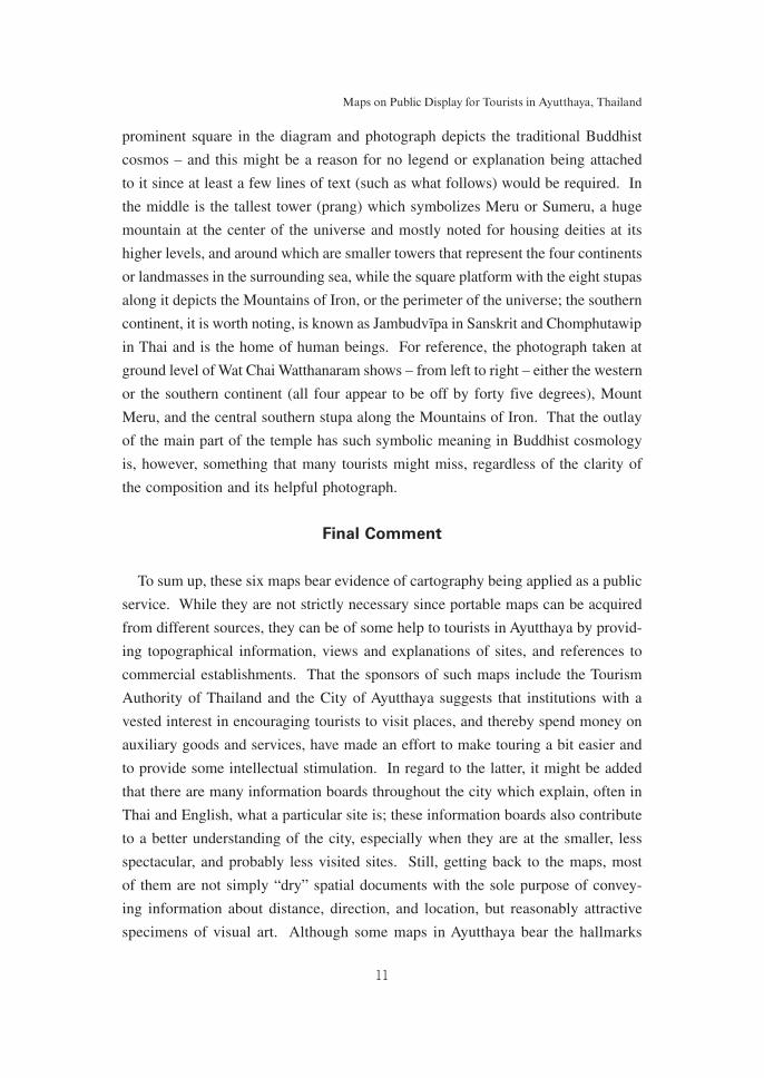
11
Maps on Public Display for Tourists in Ayutthaya, Thailand
prominent square in the diagram and photograph depicts the traditional Buddhist
cosmos – and this might be a reason for no legend or explanation being attached
to it since at least a few lines of text (such as what follows) would be required. In
the middle is the tallest tower (prang) which symbolizes Meru or Sumeru, a huge
mountain at the center of the universe and mostly noted for housing deities at its
higher levels, and around which are smaller towers that represent the four continents
or landmasses in the surrounding sea, while the square platform with the eight stupas
along it depicts the Mountains of Iron, or the perimeter of the universe; the southern
continent, it is worth noting, is known as Jambudvı̄pa in Sanskrit and Chomphutawip
in Thai and is the home of human beings. For reference, the photograph taken at
ground level of Wat Chai Watthanaram shows – from left to right – either the western
or the southern continent (all four appear to be off by forty five degrees), Mount
Meru, and the central southern stupa along the Mountains of Iron. That the outlay
of the main part of the temple has such symbolic meaning in Buddhist cosmology
is, however, something that many tourists might miss, regardless of the clarity of
the composition and its helpful photograph.
Final Comment
To sum up, these six maps bear evidence of cartography being applied as a public
service. While they are not strictly necessary since portable maps can be acquired
from different sources, they can be of some help to tourists in Ayutthaya by provid-
ing topographical information, views and explanations of sites, and references to
commercial establishments. That the sponsors of such maps include the Tourism
Authority of Thailand and the City of Ayutthaya suggests that institutions with a
vested interest in encouraging tourists to visit places, and thereby spend money on
auxiliary goods and services, have made an effort to make touring a bit easier and
to provide some intellectual stimulation. In regard to the latter, it might be added
that there are many information boards throughout the city which explain, often in
Thai and English, what a particular site is; these information boards also contribute
to a better understanding of the city, especially when they are at the smaller, less
spectacular, and probably less visited sites. Still, getting back to the maps, most
of them are not simply “dry” spatial documents with the sole purpose of convey-
ing information about distance, direction, and location, but reasonably attractive
specimens of visual art. Although some maps in Ayutthaya bear the hallmarks

12
言語文化論集 第XXXⅡ巻 第 1号
of aging, especially through fading and discoloration because of exposure to the
natural elements, their combinations of color, line work, and symbolization make
them generally appealing to the eye. This is also a good advertisement for the city
of Ayutthaya and would seem to demonstrate a commitment to making the tourist
experience there a pleasant one.
The Photographs
Map 1: Map of the Province of Phra Nakhon Si Ayutthaya ...
[from the Thai], north to the top.

13
Maps on Public Display for Tourists in Ayutthaya, Thailand
Map 2: Ayutthaya Municipality [English title], north to the top.
Close-up from the center of the island in Map 2.

14
言語文化論集 第XXXⅡ巻 第 1号
Views of Wat Phanan Choeng (left) and three brick towers at Wat Mahathat (right).
Map 3: Road Map for a Tour around Phra Nakhon Si Ayutthaya [from the Thai],
north to the top.
From the map to reality: once you’ve ridden in a tuk-tuk, life will never be the same!

15
Maps on Public Display for Tourists in Ayutthaya, Thailand
Close-up from the northwestern part of the island on Map 3.
The Buddha takes a rest, while tourists take a ride .....

16
言語文化論集 第XXXⅡ巻 第 1号
Map 4: Glor[y] of Ayutthaya and Red Cross Fair 2009 [amended English title],
north to the top and slightly angled to the left.
One of the stupas at Wat Phra Si Sanphet (left)
and the Ayutthaya Historical Study Centre (right).

17
Maps on Public Display for Tourists in Ayutthaya, Thailand
Map 5: Ayutthaya Tourist Map [English title], north to the top.
The tower at Wat Phra Ram on a map from the same set as Map 5 (left)
and in real life (right).

18
言語文化論集 第XXXⅡ巻 第 1号
Map 6: Plan of Wat Chai Watthanaram on a composition entitled “Clean Ayutthaya” in
English, north to the top in the diagram.
One of the smaller towers, the central tower, and one of the stupas
at Wat Chai Watthanaram.

19
Maps on Public Display for Tourists in Ayutthaya, Thailand
Examples of commercial establishments being located on another, older version of Map 2.
Decapitated statues wrapped in yellow cloth at Wat Khunsan (left);
elephant heads adorning a lamppost (right).
Notes
1. The six-chapter book, printed in January 2010 using research funds provided by the
Graduate School of Languages and Cultures at Nagoya University, is Publicly Displayed
Illustrated Maps in Japan: A Collection of Revised Essays, 152 p. (from title page to the
final comment). It contains eight revised essays, one of which is about artwork in historical
Japanese maps and thus is not among the “seven” referred to in the text here, and information
about them and other related publications is given in the monograph.

20
言語文化論集 第XXXⅡ巻 第 1号
2. “Maps on Public Display for Tourists in Ayutthaya, Thailand: Analysis of Their Content
and Artwork,” 20 p. (including reproductions of eight maps and eight close-up views) in
PDF format, prepared for the Fourth International Colloquium on Tourism and Leisure held
in Bangkok in July 2010.
3. A useful history of Ayutthaya in English is Derick Garnier, Ayutthaya: Venice of the East
(Bangkok: River Books, 2004).
4. The definitions from the “Glossary” toward the end of Publicly Displayed Illustrated Maps
in Japan [note 1] follow. Abstract symbol: a letter, line, color, or picture which represents
an element in the landscape, does not resemble what it denotes, but is understood because of
cartographic convention. Symbolic resemblance: a picture which represents an element in the
landscape, can easily be associated with what it represents, is not concerned with peculiari-
ties or individual characteristics, and is the same as or reasonably similar to any others that
are used for the same phenomenon within a map. Idealized portrait: an illustration which
captures the essence of a subject with a sufficient degree of artistic license to argue that the
impression is not supposed to be an exact replica or a reasonably detailed copy. Realistic
portrait: an illustration which strongly captures the unique spirit of a subject by being a
photograph or a rather detailed, lifelike drawing or painting, including to the point that the
surroundings of the subject might be similarly depicted. Cartoon character: an illustration
of a person or animal which lends a sense of animation or draws attention to at least one
characteristic of an individual or a species. As is also noted in the “Glossary,” a symbolic
resemblance generally plays the same role as an abstract symbol, and it is not always easy
to distinguish between these two types of symbol, which can also be the case when trying
to determine if an illustration is an idealized or realistic portrait.
Transliteration of Thai words: As tempting as it was to follow a system of transliteration,
notably the Paiboon or a modified version, it became obvious that this would not be a good
idea because the software used for typing up this article does not contain all the letters with
tone marks and because a good number of letters and letter combinations are not normally
used in English and would require explaining. Hence, the spellings used in this article are
those which are normally used, or seem to be the best of the available choices, in regular
English.
An approximately 51-MB PDF version of this article – fifteen A4-size pages with color photographs and the
text modified for typesetting purposes – can be obtained from the author for a small fee to cover the cost of
materials and postage.


