Manakau to Ohau bridges project feasibility report · namely; Manakau Rail Overbridge, Waikawa...
62
ŌTAKI TO NORTH OF LEVIN PFRs Report No. 3: Manakau to Ohau Bridges Prepared for NZ Transport Agency February 2013
Transcript of Manakau to Ohau bridges project feasibility report · namely; Manakau Rail Overbridge, Waikawa...
ŌTAKI TO NORTH OF LEVIN PFRs Report No. 3: Manakau to Ohau Bridges
Prepared for NZ Transport Agency February 2013

Report 3: Manakau to Ohau Bridges
This document has been prepared for the benefit of NZ Transport Agency. No liability is accepted by this company or any employee or sub-consultant of this company with respect to its use by any other person.
This disclaimer shall apply notwithstanding that the report may be made available to other persons for an application for permission or approval to fulfil a legal requirement.
QUALITY STATEMENT PROJECT MANAGER PROJECT TECHNICAL LEAD
Tracy Couchman Phil Peet
PREPARED BY
………………………………............... ……/……/…… Ian Robertson
CHECKED BY
………………………………............... ……/……/…… Phil Peet
REVIEWED BY
………………………………............... ……/……/…… Marten Oppenhuis
APPROVED FOR ISSUE BY
………………………………............... ……/……/…… Phil Peet
WELLINGTON Level 1, 123 Taranaki Street, Wellington 6011 PO Box 9624, Te Aro, Wellington 6141 TEL +64 4 381 6700, FAX +64 4 381 6739
REVISION SCHEDULE
Rev No Date Description
Signature or Typed Name (documentation on file).
Prepared by Checked by Reviewed by Approved by
A Draft JP PP MO PP
Status: Final February 2013 Project number: Z1925700 Our ref: PFR03 Manuakau Ohau Bridges Final.docx
Report 3: Manakau to Ohau Bridges
Status Final February 2013 Project number: Z1925700 Our ref: PFR03 Manuakau Ohau Bridges Final.docx
Report 3: Manakau to Ohau Bridges
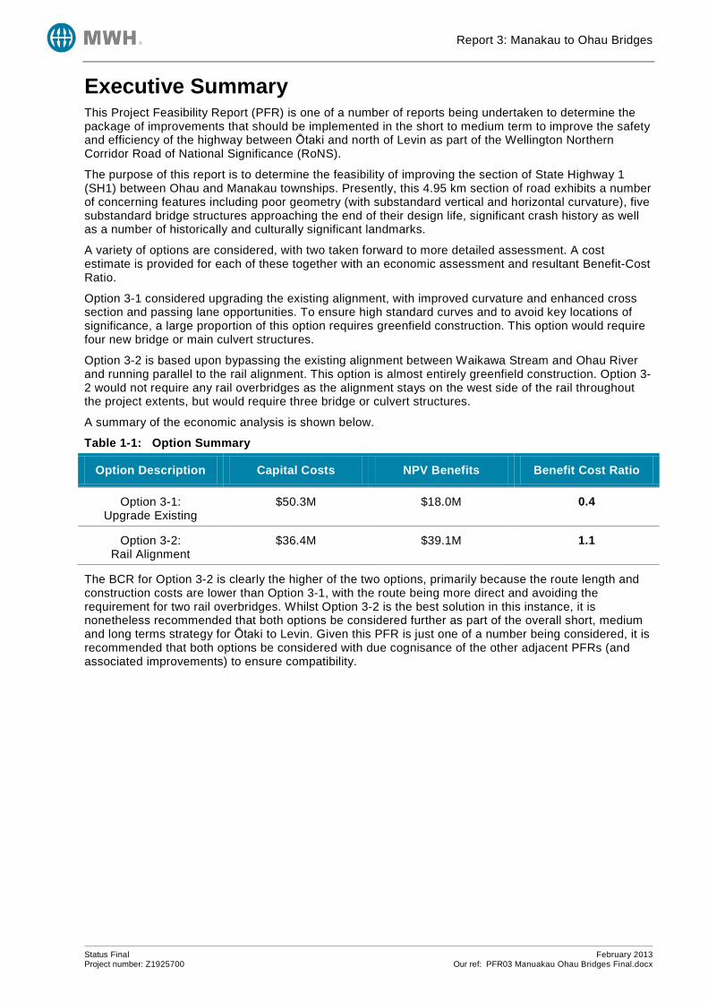
Executive Summary This Project Feasibility Report (PFR) is one of a number of reports being undertaken to determine the package of improvements that should be implemented in the short to medium term to improve the safety and efficiency of the highway between Ōtaki and north of Levin as part of the Wellington Northern Corridor Road of National Significance (RoNS).
The purpose of this report is to determine the feasibility of improving the section of State Highway 1 (SH1) between Ohau and Manakau townships. Presently, this 4.95 km section of road exhibits a number of concerning features including poor geometry (with substandard vertical and horizontal curvature), five substandard bridge structures approaching the end of their design life, significant crash history as well as a number of historically and culturally significant landmarks.
A variety of options are considered, with two taken forward to more detailed assessment. A cost estimate is provided for each of these together with an economic assessment and resultant Benefit-Cost Ratio.
Option 3-1 considered upgrading the existing alignment, with improved curvature and enhanced cross section and passing lane opportunities. To ensure high standard curves and to avoid key locations of significance, a large proportion of this option requires greenfield construction. This option would require four new bridge or main culvert structures.
Option 3-2 is based upon bypassing the existing alignment between Waikawa Stream and Ohau River and running parallel to the rail alignment. This option is almost entirely greenfield construction. Option 3-2 would not require any rail overbridges as the alignment stays on the west side of the rail throughout the project extents, but would require three bridge or culvert structures.
A summary of the economic analysis is shown below.
Table 1-1: Option Summary
Option Description Capital Costs NPV Benefits Benefit Cost Ratio
Option 3-1: Upgrade Existing
$50.3M $18.0M 0.4
Option 3-2: Rail Alignment
$36.4M $39.1M 1.1
The BCR for Option 3-2 is clearly the higher of the two options, primarily because the route length and construction costs are lower than Option 3-1, with the route being more direct and avoiding the requirement for two rail overbridges. Whilst Option 3-2 is the best solution in this instance, it is nonetheless recommended that both options be considered further as part of the overall short, medium and long terms strategy for Ōtaki to Levin. Given this PFR is just one of a number being considered, it is recommended that both options be considered with due cognisance of the other adjacent PFRs (and associated improvements) to ensure compatibility.
Status Final February 2013 Project number: Z1925700 Our ref: PFR03 Manuakau Ohau Bridges Final.docx

Report 3: Manakau to Ohau Bridges
Status Final February 2013 Project number: Z1925700 Our ref: PFR03 Manuakau Ohau Bridges Final.docx
Report 3: Manakau to Ohau Bridges
NZ Transport Agency Report 3: Manakau to Ohau Bridges
CONTENTS Executive Summary .................................................................................................................................. ii 1 Introduction and Background .............................................................................................................. 1
2 Projects Currently Being Investigated ................................................................................................ 1
3 Description of Problem ....................................................................................................................... 3
3.1 Ōtaki to North of Levin ................................................................................................................... 3 3.2 Manakau to Ohau Bridges ............................................................................................................. 3
4 Site Description .................................................................................................................................. 3 5 Traffic Statistics .................................................................................................................................. 7
6 Crash History ...................................................................................................................................... 7
6.1 Crash Data..................................................................................................................................... 7 6.2 Crash Risk ................................................................................................................................... 10
7 Options Considered .......................................................................................................................... 10
7.1 Options Excluded ......................................................................................................................... 10 7.2 Option 3-1: Upgrade Existing ....................................................................................................... 11
7.3 Option 3-2: New Parallel Railway Alignment ............................................................................... 12
7.4 Typical Cross Section .................................................................................................................. 14
8 Design Statement ............................................................................................................................. 15 9 Cost Estimates ................................................................................................................................. 16
10 Economic Assessment and Risk Assessment .................................................................................. 17
10.1 Basis of Economic Analysis ......................................................................................................... 17 10.2 Travel Time Savings .................................................................................................................... 17
10.3 Vehicle Operating Cost Savings .................................................................................................. 18
10.4 Passing Lane Savings ................................................................................................................. 18
10.5 Crash Benefits ............................................................................................................................. 18
10.6 Maintenance Costs ...................................................................................................................... 19 10.7 Benefit Cost Ratio Results ........................................................................................................... 19
10.8 Sensitivity Test ............................................................................................................................ 20
10.9 Risk Assessment ......................................................................................................................... 20
11 Assessment Profile ........................................................................................................................... 21
11.1 Strategic Fit ................................................................................................................................. 21 11.2 Effectiveness ............................................................................................................................... 21
11.3 Efficiency ..................................................................................................................................... 22
12 Social and Environmental Assessment ............................................................................................ 22
13 Geotechnical Requirements ............................................................................................................. 22 14 Land Requirements .......................................................................................................................... 23
Status: Final February 2013 Project number: Z1925700 Our ref: PFR03 Manuakau Ohau Bridges Final.docx
Report 3: Manakau to Ohau Bridges
15 Resource Management Issues ......................................................................................................... 23
15.1 District Plan Provisions ................................................................................................................ 23 15.2 Regional Plans............................................................................................................................. 23
15.3 Other Provisions .......................................................................................................................... 24
16 Maintenance Issues .......................................................................................................................... 24
17 Conclusions and Recommendations ................................................................................................ 24
LIST OF TABLES Table 1-1: Option Summary ..................................................................................................................... ii
Table 5-1: Saturn Base 2011/2041 Network Modelling Results ............................................................... 7 Table 6-1: Annual Distribution of Crashes ............................................................................................... 8
Table 6-2: CAS Crash Type ..................................................................................................................... 8
Table 6-3: HRRRG Crash Type ................................................................................................................ 8
Table 6-4: Crash Causation Factors of Reported Injury Crashes ............................................................ 9
Table 6-5: Environmental Factors ............................................................................................................ 9 Table 9-1: Cost Estimates ...................................................................................................................... 16
Table 10-1: Travel Time Benefits ........................................................................................................... 18
Table 10-2: Vehicle Operating Cost Benefits ......................................................................................... 18
Table 10-3: Passing Lane Benefits ........................................................................................................ 18
Table 10-4: Crash Benefits .................................................................................................................... 18
Table 10-5: Economic Analysis Summary ............................................................................................. 19
LIST OF FIGURES Figure 2-1: Projects Currently Being Investigated ..................................................................................... 2
Figure 4-1: Study Area Location Plan ........................................................................................................ 4
Figure 4-2: Key Historic & Cultural Landmarks .......................................................................................... 6
Figure 7-1: Typical Passing Lane Cross Section ..................................................................................... 14
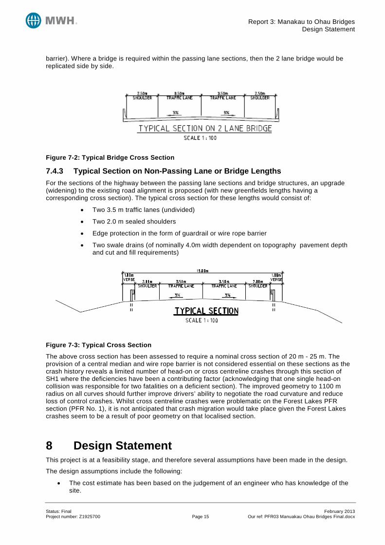
Figure 7-2: Typical Bridge Cross Section ................................................................................................ 15
Figure 7-3: Typical Cross Section ............................................................................................................ 15
APPENDICES Appendix A Photographs
Appendix B Traffic Data
Appendix C Crash Data Appendix D Outline Plans
Appendix E Cost Estimates
Appendix F Economic Analysis Worksheets
Appendix G Bridge Condition Data
Status: Final February 2013 Project number: Z1925700 Our ref: PFR03 Manuakau Ohau Bridges Final.docx
Report 3: Manakau to Ohau Bridges Introduction and Background
1 Introduction and Background Using the outcomes of the Ōtaki to North of Levin Scoping Report and addendum, the NZTA decided that the most appropriate strategy for the highway between Ōtaki and north of Levin is to upgrade the existing highways as the first stage of a long term strategy. This allows the NZTA to realise important safety benefits in the short to medium term whilst deferring the need to construct four lanes for the time being.
This Project Feasibility Report (PFR) is one of a number of reports being undertaken to determine the package of improvements that should be implemented to improve the safety and efficiency of the highway between Ōtaki and north of Levin as part of the Wellington Northern Corridor Road of National Significance (RoNS).
The objectives of the Wellington Northern Corridor RoNS, which runs from Wellington Airport to north of Levin, are:
• To enhance inter regional and national economic growth and productivity;
• To improve access to Wellington’s CBD, key industrial and employment centres, port, airport and hospital;
• To provide relief from severe congestion on the state highway and local road networks;
• To improve the journey time reliability of travel on the section of SH1 between Levin and the Wellington Airport; and
• To improve the safety of travel on state highways.
For the Ōtaki to north of Levin section; the objectives are:
• To provide best value solutions which will progressively meet (via a staged approach) the long term RoNS goals for this corridor of achieving a high quality four lane route;
• To provide better Levels of Service, particularly for journey time and safety, between north of Ōtaki and north of Levin;
• To remove or improve at-grade intersections between north of Ōtaki and north of Levin;
• To engage effectively with key stakeholders; and
• To lodge Notices of Requirement and resource consents as appropriate with the relevant consent authorities for the first individual project by the 2013/14 financial year.
The projects that are being developed to help meet these objectives are presented in Section 2.
The purpose of this report is to determine the feasibility of undertaking improvements to aid road safety and traffic flow between the Manakau and Ohau townships on State Highway 1 south of Levin.
The geographical extent of this project commences just south of the Manakau Rail Overbridge to immediately north of the Ohau River Bridge. The study area therefore includes 5 bridge structures, namely; Manakau Rail Overbridge, Waikawa Stream Bridge, Kuku Stream Bridge, Ohau Rail Overbridge and Ohau River Bridge. It is noted that SH1/57 & Arapaepae Curve (PFR No. 5) Manakau Settlement (PFR. No. 2) and the Ohau Settlement (PFR No. 4) either adjoin or have sections included within the geographical length of this PFR.
The outcome of this PFR will be considered alongside the outcomes of the other PFRs and used to determine the best package of works to progress as the first stage of the long term strategy.
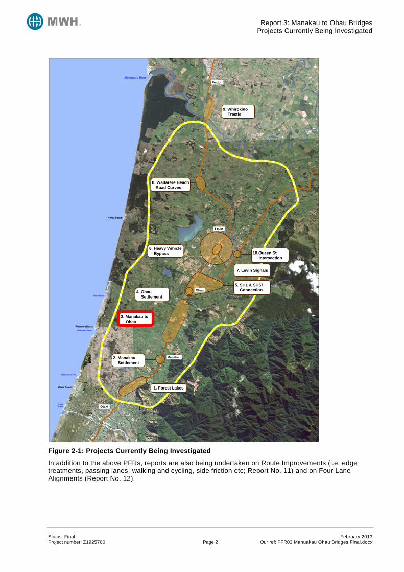
2 Projects Currently Being Investigated The projects that are currently being investigated to meet the short to medium term objectives of the Otaki to north of Levin RoNS project are presented in Figure 2-1:
Status: Final February 2013 Project number: Z1925700 Page 1 Our ref: PFR03 Manuakau Ohau Bridges Final.docx
Report 3: Manakau to Ohau Bridges Projects Currently Being Investigated
Figure 2-1: Projects Currently Being Investigated
In addition to the above PFRs, reports are also being undertaken on Route Improvements (i.e. edge treatments, passing lanes, walking and cycling, side friction etc; Report No. 11) and on Four Lane Alignments (Report No. 12).
Foxton
Levin
Ohau
Manakau
Otaki
1. Forest Lakes
2. Manakau Settlement
3. Manakau to Ohau
4. Ohau Settlement
5. SH1 & SH57 Connection
6. Heavy Vehicle Bypass
7. Levin Signals
10.Queen St Intersection
8. Waitarere Beach Road Curves
9. Whirokino Trestle
Status: Final February 2013 Project number: Z1925700 Page 2 Our ref: PFR03 Manuakau Ohau Bridges Final.docx
Report 3: Manakau to Ohau Bridges Description of Problem
3 Description of Problem 3.1 Ōtaki to North of Levin State Highway 1 and State Highway 57 through the study area have a number of deficiencies, resulting in a poor crash history and a number of locations where the free flow of vehicles is restricted by the tight physical characteristics of the highway.
State Highway 1 currently follows the historic route established in the late 19th and early 20th centuries. As a consequence it is constrained by a now substandard alignment, towns and settlements, narrow curved bridges and significant side friction caused by local roads, commercial frontages and property accesses for the entire stretch.
3.2 Manakau to Ohau Bridges The section of road under consideration in this PFR is approximately 4.95 km in length running from RP985/3.00 to RP985/7.87, or 1.0 km south of the central point of the Manakau Railway Overbridge to the immediate north side of the Ohau River bridge.
Throughout this length of highway there are a number of key issues that are required to be addressed by the improvement works. The majority of the concerns along this section of the highway relate to substandard road geometry, although other concerns exist due to adjacent land uses. These key factors and constraints considered in this PFR are:
• Five substandard bridges all with 20-35 years remaining life
• Width of bridges
• A number of substandard horizontal curves including broken back over Manakau Rail and Waikawa River – all substandard (down to 200 m radius and including advisory speed reduction)
• Deficient vertical curvature, often in combination with deficient horizontal curves
• Issues with vehicle speeds, passing lanes, and side roads in the vicinity of the Tukorehe Marae
The safety record for this length of highway is relatively poor with a total of 52 crashes recorded in the five year period 2007 to 2011, with two fatal and three serious injury crashes being recorded.
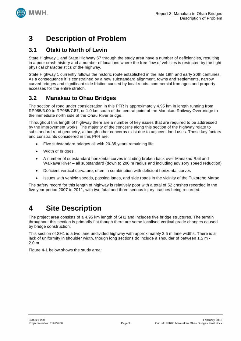
4 Site Description The project area consists of a 4.95 km length of SH1 and includes five bridge structures. The terrain throughout this section is primarily flat though there are some localised vertical grade changes caused by bridge construction.
This section of SH1 is a two lane undivided highway with approximately 3.5 m lane widths. There is a lack of uniformity in shoulder width, though long sections do include a shoulder of between 1.5 m - 2.0 m.
Figure 4-1 below shows the study area:
Status: Final February 2013 Project number: Z1925700 Page 3 Our ref: PFR03 Manuakau Ohau Bridges Final.docx
Report 3: Manakau to Ohau Bridges Site Description
Figure 4-1: Study Area Location Plan
There are 4 side roads within the study area (all no exit):
• Kuku Beach Road (RP985/4.16), serving a small number of residential properties and the coastal area being accessed.
• Kuku East Road (RP985/4.30), which generally serves an area of farming and agriculture
• Whakahoro Road (RP985/7.08), 1.5km in length, narrow access road to a small number of properties.
• North Manakau Road (985/7.51), which provides access to a small number of farming properties.
There are also two passing lanes located within the study area. These are:
• A northbound passing lane on SH1 from RP985/6.09 to RP985/5.45 (length 640m inclusive of tapers)
N
Ohau River Bridge & Rail Overbridge
To Manakau
Kuku Beach Road Kuku East Road
Manakau Rail Bridge
To Ohau / Levin
Waikawa Stream Bridge
Kuku Stream Bridge
Rail Alignment
North Extent & Tie in to Adjacent PFRs
North Manakau Road
Whakahoro Road
South Extent
Status: Final February 2013 Project number: Z1925700 Page 4 Our ref: PFR03 Manuakau Ohau Bridges Final.docx
Report 3: Manakau to Ohau Bridges Site Description
• A southbound passing lane on SH1 from RP985/3.50 to RP985/4.00 (length 500m inclusive of tapers)
The road is also a Limited Access Road (LAR).
The North Island Main Trunk (NIMT) rail line runs predominantly parallel to SH1 for a large section of the Otaki to Levin study area. However, for almost the entirety of this PFR study area the existing SH1 road alignment deviates away from the rail alignment. For this to be achieved, two SH1 rail overbridges transition the SH1 from the west of the rail, to its eastern side immediately south of Waikawa Stream, and then back from the east to the west of the rail alignment immediately south of the Ohau River.
The five bridges within the study area, including their assessed condition1 are described below:
• Ohau River Bridge RP985/3.16 (SH1 BSN 9880), built 1953, current condition is reasonable with an expected remaining life of 30+ years.
• Ohau Rail Overbridge RP985/3.29 (SH1 BSN 9883), built 1956, current condition is reasonable with an expected remaining life of 30+ years
• Kuku Stream Bridge RP985/4.953 (SH1 BSN 9894), built 1929, current condition is reasonable with an expected remaining life of 25+ years
• Waikawa Stream Bridge RP985/6.55 (SH1 BSN 9915), built 1929, current condition is reasonable with an expected remaining life of 20 years
• Manakau Rail Overbridge RP985/6.94 (SH1 BSN 9919), built 1938, current condition is fair, expected remaining life 20 years
Apart from Kuku Stream Bridge, all the other structures are either themselves deficient or within areas of deficient geometry. The consequence is the level of service to road users is progressively reducing. It is not clear whether any of these bridges include seismic design features. Additional bridge data is provided in Appendix G.
1 Information provided by Bloxham Burnett Olliver to MWH August 2012 via email.
Status: Final February 2013 Project number: Z1925700 Page 5 Our ref: PFR03 Manuakau Ohau Bridges Final.docx
Report 3: Manakau to Ohau Bridges Site Description
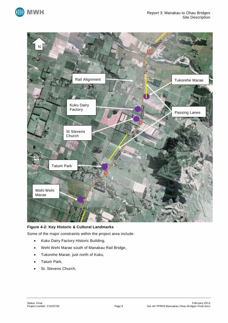
Figure 4-2: Key Historic & Cultural Landmarks
Some of the major constraints within the project area include:
• Kuku Dairy Factory Historic Building,
• Wehi Wehi Marae south of Manakau Rail Bridge,
• Tukorehe Marae, just north of Kuku,
• Tatum Park,
• St. Stevens Church,
N
Wehi Wehi Marae
Tukorehe Marae
St Stevens Church
Kuku Dairy Factory
Tatum Park
Rail Alignment
Passing Lanes
Status: Final February 2013 Project number: Z1925700 Page 6 Our ref: PFR03 Manuakau Ohau Bridges Final.docx
Report 3: Manakau to Ohau Bridges Traffic Statistics
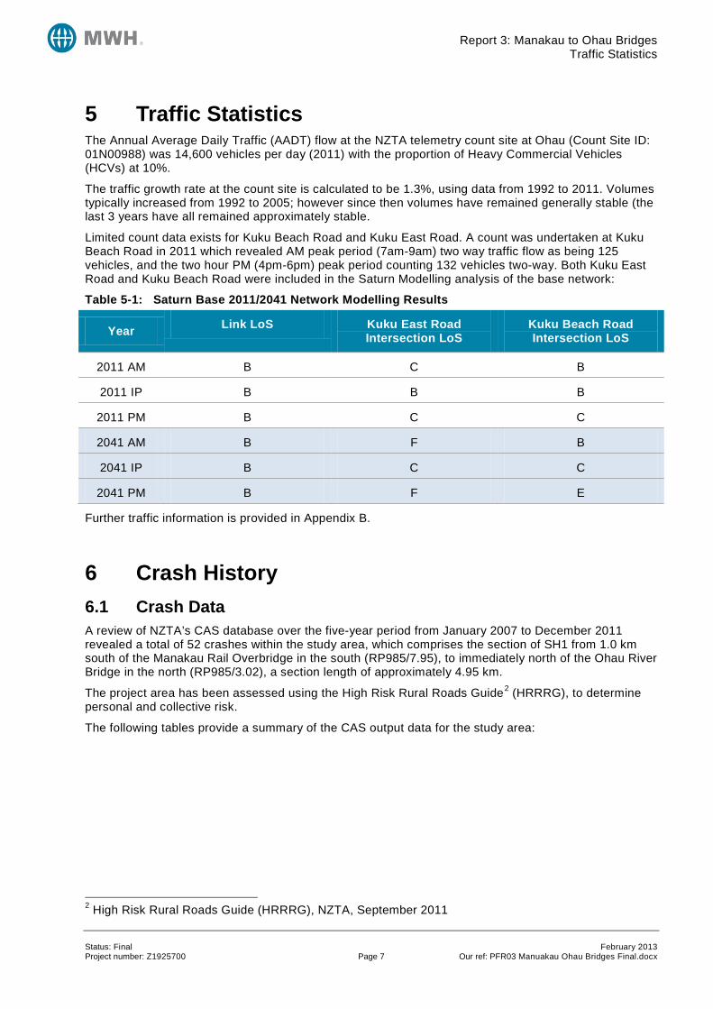
5 Traffic Statistics The Annual Average Daily Traffic (AADT) flow at the NZTA telemetry count site at Ohau (Count Site ID: 01N00988) was 14,600 vehicles per day (2011) with the proportion of Heavy Commercial Vehicles (HCVs) at 10%.
The traffic growth rate at the count site is calculated to be 1.3%, using data from 1992 to 2011. Volumes typically increased from 1992 to 2005; however since then volumes have remained generally stable (the last 3 years have all remained approximately stable.
Limited count data exists for Kuku Beach Road and Kuku East Road. A count was undertaken at Kuku Beach Road in 2011 which revealed AM peak period (7am-9am) two way traffic flow as being 125 vehicles, and the two hour PM (4pm-6pm) peak period counting 132 vehicles two-way. Both Kuku East Road and Kuku Beach Road were included in the Saturn Modelling analysis of the base network:
Table 5-1: Saturn Base 2011/2041 Network Modelling Results
Year Link LoS Kuku East Road Intersection LoS
Kuku Beach Road Intersection LoS
2011 AM B C B
2011 IP B B B
2011 PM B C C
2041 AM B F B
2041 IP B C C
2041 PM B F E
Further traffic information is provided in Appendix B.
6 Crash History 6.1 Crash Data A review of NZTA’s CAS database over the five-year period from January 2007 to December 2011 revealed a total of 52 crashes within the study area, which comprises the section of SH1 from 1.0 km south of the Manakau Rail Overbridge in the south (RP985/7.95), to immediately north of the Ohau River Bridge in the north (RP985/3.02), a section length of approximately 4.95 km.
The project area has been assessed using the High Risk Rural Roads Guide2 (HRRRG), to determine personal and collective risk.
The following tables provide a summary of the CAS output data for the study area:
2 High Risk Rural Roads Guide (HRRRG), NZTA, September 2011
Status: Final February 2013 Project number: Z1925700 Page 7 Our ref: PFR03 Manuakau Ohau Bridges Final.docx
Report 3: Manakau to Ohau Bridges Crash History
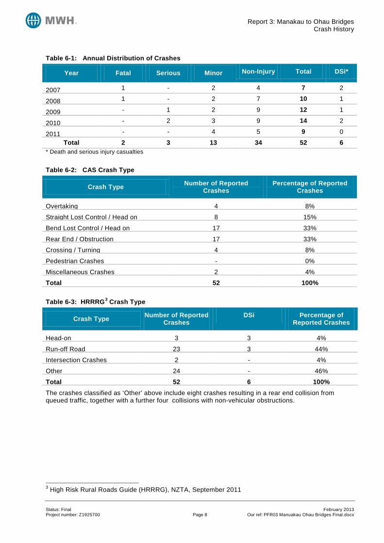
Table 6-1: Annual Distribution of Crashes
Year Fatal Serious Minor Non-Injury Total DSi*
2007 1 - 2 4 7 2
2008 1 - 2 7 10 1
2009 - 1 2 9 12 1
2010 - 2 3 9 14 2
2011 - - 4 5 9 0
Total 2 3 13 34 52 6 * Death and serious injury casualties
Table 6-2: CAS Crash Type
Crash Type Number of Reported Crashes
Percentage of Reported Crashes
Overtaking 4 8%
Straight Lost Control / Head on 8 15%
Bend Lost Control / Head on 17 33%
Rear End / Obstruction 17 33%
Crossing / Turning 4 8%
Pedestrian Crashes - 0%
Miscellaneous Crashes 2 4%
Total 52 100%
Table 6-3: HRRRG3 Crash Type
Crash Type Number of Reported Crashes
DSi Percentage of Reported Crashes
Head-on 3 3 4%
Run-off Road 23 3 44%
Intersection Crashes 2 - 4%
Other 24 - 46%
Total 52 6 100% The crashes classified as ‘Other’ above include eight crashes resulting in a rear end collision from queued traffic, together with a further four collisions with non-vehicular obstructions.
3 High Risk Rural Roads Guide (HRRRG), NZTA, September 2011
Status: Final February 2013 Project number: Z1925700 Page 8 Our ref: PFR03 Manuakau Ohau Bridges Final.docx
Report 3: Manakau to Ohau Bridges Crash History
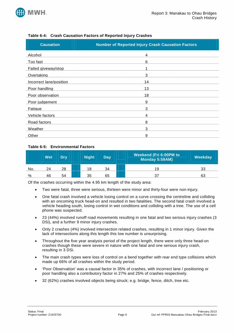
Table 6-4: Crash Causation Factors of Reported Injury Crashes
Causation Number of Reported Injury Crash Causation Factors
Alcohol 4
Too fast 6
Failed giveway/stop 1
Overtaking 3
Incorrect lane/position 14
Poor handling 13
Poor observation 18
Poor judgement 9
Fatigue 3
Vehicle factors 4
Road factors 8
Weather 3
Other 9
Table 6-5: Environmental Factors
Wet Dry Night Day Weekend (Fri 6:00PM to Monday 5:59AM) Weekday
No. 24 28 18 34 19 33
% 46 54 35 65 37 63
Of the crashes occurring within the 4.95 km length of the study area:
• Two were fatal, three were serious, thirteen were minor and thirty-four were non-injury.
• One fatal crash involved a vehicle losing control on a curve crossing the centreline and colliding with an oncoming truck head-on and resulted in two fatalities. The second fatal crash involved a vehicle heading south, losing control in wet conditions and colliding with a tree. The use of a cell phone was suspected.
• 23 (44%) involved runoff road movements resulting in one fatal and two serious injury crashes (3 DSi), and a further 9 minor injury crashes.
• Only 2 crashes (4%) involved intersection related crashes, resulting in 1 minor injury. Given the lack of intersections along this length this low number is unsurprising.
• Throughout the five year analysis period of the project length, there were only three head-on crashes though these were severe in nature with one fatal and one serious injury crash, resulting in 3 DSi.
• The main crash types were loss of control on a bend together with rear end type collisions which made up 66% of all crashes within the study period.
• ‘Poor Observation’ was a causal factor in 35% of crashes, with incorrect lane / positioning or poor handling also a contributory factor in 27% and 25% of crashes respectively.
• 32 (62%) crashes involved objects being struck; e.g. bridge, fence, ditch, tree etc.
Status: Final February 2013 Project number: Z1925700 Page 9 Our ref: PFR03 Manuakau Ohau Bridges Final.docx
Report 3: Manakau to Ohau Bridges Options Considered
6.2 Crash Risk The section of SH1 was analysed according to the High-Risk Rural Roads Guide (HRRRG) which identifies that crash risk can be generally defined in two ways:
• Actual Crash Risk; which is based on crashes reported in the last 5 years. This is separated into collective risk, which is also known as crash density, and personal risk, which is also known as crash rate.
• Predicted Crash Risk; which is based on KiwiRAP road protection score (RPS) and the KiwiRAP star rating.
In terms of crash risk this 4.95 km section of SH1 has:
• A collective risk of 0.20 high-severity (fatal and serious) crashes per km per year;
• A personal risk of 3.78 high-severity crashes per 100 million vehicle km; and
• A KiwiRAP calculated star rating of 2.6 and a published rating of 2 star (for the 4.5 km section RP985/3.00 to RP985/7.50), together with an RPS of 14.2.
The collective risk metric is considered ‘High’ while the personal risk is ‘Low’ for this section of highway. As a result of a high collective crash risk, KiwiRAP star rating & RPS and reported fatal and serious injury crashes reported in the 5 year analysis period (5 in total), this section of SH1 is therefore classified as a high risk rural road. This is an expected result given the deficiencies identified
Further Crash Data can be found in Appendix C.
7 Options Considered Two options, which address the alignment and passing lanes, have been consider for the section of SH1 from North of Waikawa Beach Road to South of Bishops Road with the main aim of improving safety and efficiency. Both options considered include passing lanes and bridge crossings of the Waikawa Stream, Kuku Stream, and Ohau River.
The Do-minimum option is to retain the existing 4.95 km alignment and geometry / alignment and continue with periodic maintenance. Given the age and expected service life of some of the existing five bridge structures, within the 30 year do-minimum analysis period, it is anticipated that three of these structures (Kuku Stream Bridge, Waikawa Stream Bridge and Manakau Rail Overbridge) would require replacement. The cost (and timeframe) of this replacement is therefore included withion the economic analsysis.
The two options are outlined below:
Option 3-1 Upgrade Existing – Involves utilising the existing alignment but upgrading to an improved standard by removing the short curve radii, providing improved passing lanes with an enhanced highway cross section.
Option 3-2 New Parallel Railway Alignment – Effectively ‘straight-lines’ through the curved sections between Manakau and Ohau, following alongside the rail alignment, staying on the western side of the rail throughout. As there is no requirement to cross the rail line, this option avoids the need for any rail structures.
7.1 Options Excluded A variety of options were considered at the concept stage. These concepts broadly followed the principle of upgrading the existing route or providing a new alignment running parallel to the rail line. There was only one feasible option for a railway alignment and this has subsequently been taken forward to option assessment. Two further main options were considered for improving the existing alignment. These are briefly described below:
Status: Final February 2013 Project number: Z1925700 Page 10 Our ref: PFR03 Manuakau Ohau Bridges Final.docx
Report 3: Manakau to Ohau Bridges Options Considered
7.1.1 Curve South of Waikawa Stream An 1100 m curve, departing the existing alignment to the east immediately north of Manakau township and then crossing to the east of the rail line north of Waikawa Stream and joining back into the existing alignment at around RP 985/4.70. The alignment would then transition west of the existing once more, before rising over the rail alignment, just south of Ohau River, where a new river crossing would be provided to the immediate east of the existing Ohau River Bridge.
This option was discounted on the basis of being circuitous with other options likely to deliver improved travel time savings for a reduced capital cost.
7.1.2 Bifurcation or Intersection: North East of Existing Kuku Stream Crossing This option effectively continued the straight section between Waikawa Stream and St Stephens Church to remove the existing curve at RP985/4.70 forming a straight section of highway that could bifurcate with a proposed bridge and link formed to SH57 with a proposed connection and river bridge to the existing SH1 north of Ohau River. An alternative arrangement was also considered incorporating a roundabout or interchange in a similar position to the bifurcation.
This option was initially discounted because of the two river crossings required if a bifurcation or interchange was introduced south of the Ohau River. However, the comments in PFR No.5 relating to this concept option should be noted i.e. this option may still warrant consideration at the SAR stage as despite the earlier additional capital outlay for construction, this may provide a better long term solution for route shortening, shorter length bridges, associated travel time benefits and property impact.
7.2 Option 3-1: Upgrade Existing See Appendix D for outline plans.
Whilst this option does follow the general path of the existing alignment, given the current curve radii is so low at various sections throughout the study area, it is inevitable that a number of sections will be required to deviate from the existing alignment to ensure curves of 1100 m4 (110 km/h design speed) can be provided throughout which future proofs for the 4-laning. Approximately 1400 m of this option would be contained on the existing highway, whilst approximately 3600 m would be greenfield construction (total length of 5.0 km).
In addition, passing lanes have been provided in both a northbound and southbound direction, adjacent to each other within the project length, with the passing lane lengths being approximately 1400-1500 m (a significant lengthening of the current passing lane provision). Initially, providing the passing lanes in a staggered, 2+1 layout was considered. However, the alignment of the route, even with the improved curve radii, is not suited to this arrangement. According to Austroads passing lanes are best located on larger radius curves5 as proposed here, in combination with the passing lanes commencing on straight sections. Within the passing lanes a central median and wire rope barrier is proposed as described in Section 7.4.1.
For the passing lane sections, the full 4-lane median divided cross section has been assumed, and for the remainder of the project length the improved two lane cross section is proposed (i.e. two 3.5 m traffic lanes with 2.0m sealed shoulders).
Within the option there are 4 local roads intersecting SH1. The intersection with North Manakau Road should be investigated further at the SAR stage to determine a suitable arrangement to connect to SH1 (as Option 3-1 is proposed to elevate SH1 at this intersection as the road level is rising over the rail). Whakahoro Road will be unaffected by this option.
Kuku East Road and Kuku Beach Road are both located within the passing lanes section where a central median with wire rope barrier is proposed. These roads would therefore become left in / left out
4 1100 m curve radii were adopted as per the NZTA RoNS guidelines and to future proof for any long term four laning. However, it is noted that other RoNS project are being constructed with a curve radii down to 800 m. If the lower curve radius was adopted in this situation, the majority of the alignment would still require greenfields construction. 5 Austroads Guide To Road Design Part 3: Geometric Design, section 9.4.1
Status: Final February 2013 Project number: Z1925700 Page 11 Our ref: PFR03 Manuakau Ohau Bridges Final.docx
Report 3: Manakau to Ohau Bridges Options Considered
only. No consideration of turn around places has been provided at this stage – however it is recommended that none should be provided within the extent of the passing lanes for safety.
Parts of the existing SH1 would be realigned and the remaining sections of the old alignment reclassified as local roads and used for local access. The intersections with the proposed upgraded SH1 will need to be considered at the SAR stage. This option would affect the quarry access and therefore the layout of this access would also need to be confirmed at the SAR stage.
This option would necessitate the construction of four6 proposed structures as follows:
• A proposed rail structure south of the existing Manakau Rail Overbridge, to bring the highway from the west to the east of the rail alignment. This would be a two lane rail overbridge.
• A new bridge crossing over Waikawa Stream, east of the current river crossing. This would require a two lane bridge and should be located where the bridge span can be minimised at a narrow crossing point (to reduce cost).
• A new culvert for Kuku Stream. Four lanes would be required to cross the Kuku Stream as the passing lanes (both directions) are fully developed at this point. It is anticipated that this river crossing could be undertaken using a reinforced concrete boxed culvert structure (potentially two), due to the narrow span and minor waterway required for this stream. Provided this can be achieved, this would result in a significant cost saving in comparison to providing a full bridge structure(s). However, should culverting the watercourse not be suitable, this would require two separate two lane bridge structures. Providing both bridges now is essential to allow the passing lanes to be constructed and would be compatible with the long term 4-laning solution.
• A proposed bridge crossing Ohau River. This would require a two lane bridge and would cross to the east of the existing river crossing. This realigned section of highway would then be required to connect into the appropriate options detailed in PFR No. 5.
It should be noted that a more detailed assessment is critical to determine the optimum placement of all bridge structures to ensure that unnecessary construction costs are avoided. For example, the proposed Ohau River Bridge proposed in this Option may be better located to achieve a shorter bridge span to minimise capital expenditure. Positions presently depicted are indicative and should be revised accordingly during the SAR stage, with more specialised and detailed assessment and topographical information.
An additional culvert would also be required as the realigned road spans an additional (minor) watercourse south of Kuku Stream.
An alternative alignment has been shown indicatively on the plans (Drawing No. 80500902-03-001-001). This alternative utilises more of the existing road corridor and therefore could be preferable as this will avoid greater land acquisition costs and property severance. However, this alternative option would require the relocation of the historic St. Stevens Church which could prove problematic or prohibitively costly, but should at least be considered in the SAR.
No turnaround facilities have been considered at this stage (which are likely to be required given the central median and wire rope barrier).
7.3 Option 3-2: New Parallel Railway Alignment The lack of rail structures, together with the directness of route (4.7 km total), are the key benefits of this option, but also noting this option is almost entirely greenfield. Another benefit of this option is the new state highway would avoid listed or cultural buildings of significance (though some disruption for access to these locations would eventuate) which tend to be located along the existing SH1 alignment and therefore constrain the improvements and route alignment when following in close proximity to the existing corridor.
6 It should be noted that this PFR (No. 3) ceases at the northern side of the Ohau River. This avoids double counting with the options contained within PFR No. 5, where all of the options considered commence from immediately north of Ohau River. Accordingly this option does not include an additional rail overbridge to transition the alignment to the west side of the rail as some options only require this as part of the SH57 intersection. Therefore these are discussed in PFR. No. 5.
Status: Final February 2013 Project number: Z1925700 Page 12 Our ref: PFR03 Manuakau Ohau Bridges Final.docx
Report 3: Manakau to Ohau Bridges Options Considered
Passing lanes are also provided in both the northbound and southbound directions parallel to each other resulting in a long section of 4-laning (of approximately 1500 m) which is compatible with the long-term 4-laning obejctive. Wire rope central median barrier is proposed for the full length of the passing lanes (and in advance of their commencement) for the reasons described in Section 7.4.1. It has been possible to propose the passing lane length (approximately 1500 m total for both directions) away from any existing accessways (and maintain control via the Limited Access Road status) which is desirable from a safety and efficiency perspective.
The non-passing lane sections are proposed to include two 3.5 m traffic lanes and two 2.0 m sealed shoulders, swale drainage (of around 4.0 m width) and no central median or wire rope barrier.
For the side roads within this section, North Manakau Road and Whakahoro Road intersections with SH1 would need to be considered at the SAR stage but are likely to remain as T intersections with SH1.
Kuku Beach Road would be bisected by the realigned SH1 and central median wire rope barrier would prevent right turns in or out of both the east and west section of Kuku Beach Road. The detail of the intersections should be considered at the SAR stage but one option may be left in and left out only for Kuku Beach Road West, and all access to Kuku Beach Road East taken from the old SH1 which would be declassified to local road status. Provision of U turn facilities would provide for local turning facilities.
With the declassification of the old SH1 to local road, Kuku East Road would no longer form an intersection with the new SH1 alignment and access would remain as is currently the case.
The quarry access would remain unaffected by this alignment and could still be accessed from the declassified SH1. The form and use of the intersections with the existing (declassified) SH1 should be considered in the SAR.
Option 3-2 will necessitate the provision of a number of proposed bridges as described below:
• A proposed two lane bridge would be required at Waikawa Stream, west of the existing bridge. The stream is particularly narrow at this point and so there could be an opportunity to instead provide a box culvert to secure construction costs savings (though a full bridge structure has been included in the cost estimate).
• A proposed culvert over Kuku Stream. Four lanes would be required to cross the Kuku Stream as the passing lanes (both directions) are fully developed at this point. It is anticipated that this river crossing could be performed with a reinforced concrete boxed culvert structure (potentially two), due to the narrow span and minor waterway required for this stream. Provided this can be achieved, this would result in significant cost savings in comparison to providing a full bridge structure(s). However, should a culvert not be suitable, this would require two separate two lane bridge structures. Providing both bridge or culvert structures as part of this project is essential to allow the passing lanes to be constructed and would support the long term 4-laning solution.
• A proposed river crossing of Ohau River west of the existing river crossing. This new crossing would require a single two lane bridge structure, which would then tie-into a new section of realigned SH1 that would connect to the preferred option considered in PFR No. 5.
An additional culvert will be required as the realigned road spans an additional (minor) watercourse south of Kuku Stream.
An alternative alignment has been shown indicatively on drawing number (Drawing No. 80500902-03-001-002) which incorporates a curve of 1100 m at the southern end of the study area in the vicinity of the Waikawa Stream Bridge. There may be benefits in pursuing this alternative alignment should the interface with (and disruption to) the existing properties fronting SH1 at this location prove problematic.
A line item has been included in the cost estimation for the relocation of services – however, given this option proposes to significantly alter the SH1 alignment, it is entirely feasible that further service relocations could be necessary. The proposed alignment does not preclude location of future services, but overhead facilities with poles should be avoided.
No consideration has yet been given to retaining the existing rail overbridges for access to the current SH1 through Kuku. This will need further investigation during the SAR in conjunction with maintenance, safety and constructability requirements.
Status: Final February 2013 Project number: Z1925700 Page 13 Our ref: PFR03 Manuakau Ohau Bridges Final.docx
Report 3: Manakau to Ohau Bridges Options Considered
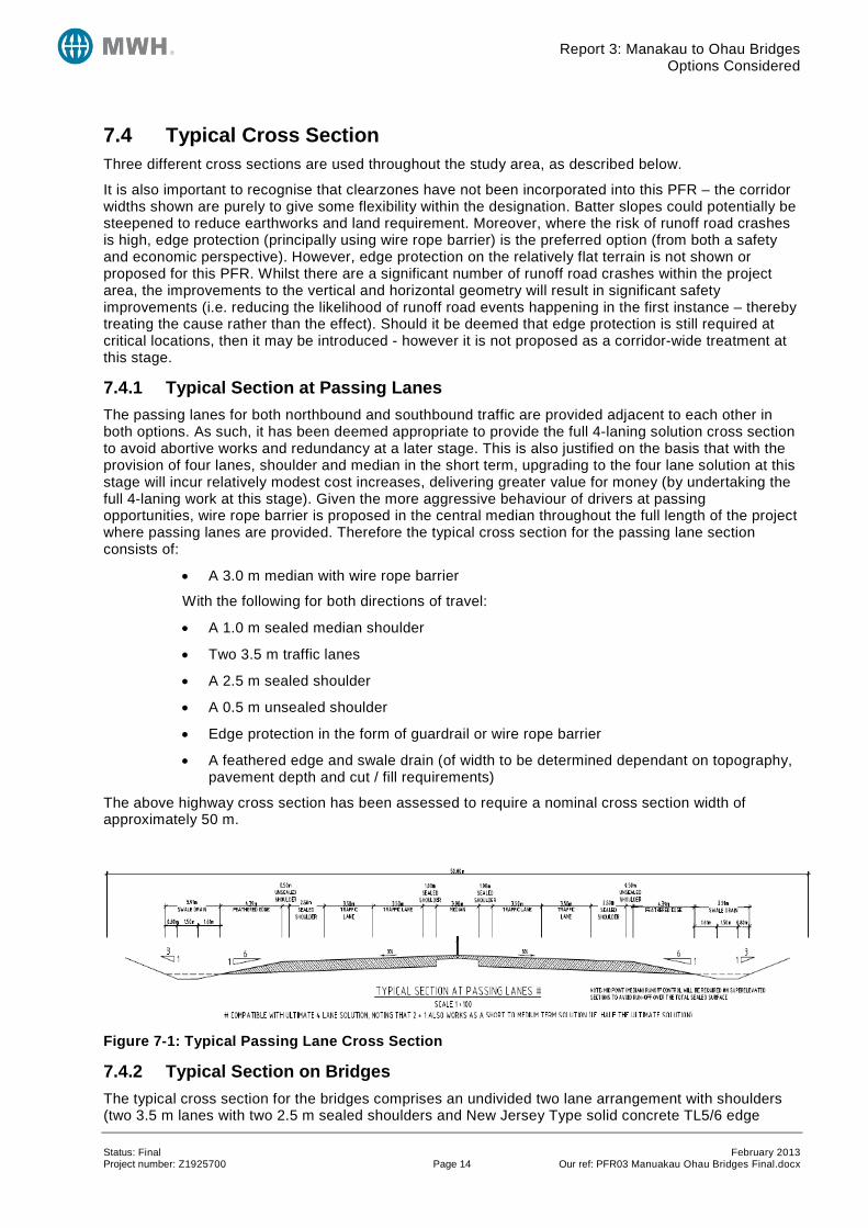
7.4 Typical Cross Section Three different cross sections are used throughout the study area, as described below.
It is also important to recognise that clearzones have not been incorporated into this PFR – the corridor widths shown are purely to give some flexibility within the designation. Batter slopes could potentially be steepened to reduce earthworks and land requirement. Moreover, where the risk of runoff road crashes is high, edge protection (principally using wire rope barrier) is the preferred option (from both a safety and economic perspective). However, edge protection on the relatively flat terrain is not shown or proposed for this PFR. Whilst there are a significant number of runoff road crashes within the project area, the improvements to the vertical and horizontal geometry will result in significant safety improvements (i.e. reducing the likelihood of runoff road events happening in the first instance – thereby treating the cause rather than the effect). Should it be deemed that edge protection is still required at critical locations, then it may be introduced - however it is not proposed as a corridor-wide treatment at this stage.
7.4.1 Typical Section at Passing Lanes The passing lanes for both northbound and southbound traffic are provided adjacent to each other in both options. As such, it has been deemed appropriate to provide the full 4-laning solution cross section to avoid abortive works and redundancy at a later stage. This is also justified on the basis that with the provision of four lanes, shoulder and median in the short term, upgrading to the four lane solution at this stage will incur relatively modest cost increases, delivering greater value for money (by undertaking the full 4-laning work at this stage). Given the more aggressive behaviour of drivers at passing opportunities, wire rope barrier is proposed in the central median throughout the full length of the project where passing lanes are provided. Therefore the typical cross section for the passing lane section consists of:
• A 3.0 m median with wire rope barrier
With the following for both directions of travel:
• A 1.0 m sealed median shoulder
• Two 3.5 m traffic lanes
• A 2.5 m sealed shoulder
• A 0.5 m unsealed shoulder
• Edge protection in the form of guardrail or wire rope barrier
• A feathered edge and swale drain (of width to be determined dependant on topography, pavement depth and cut / fill requirements)
The above highway cross section has been assessed to require a nominal cross section width of approximately 50 m.
Figure 7-1: Typical Passing Lane Cross Section
7.4.2 Typical Section on Bridges The typical cross section for the bridges comprises an undivided two lane arrangement with shoulders (two 3.5 m lanes with two 2.5 m sealed shoulders and New Jersey Type solid concrete TL5/6 edge Status: Final February 2013 Project number: Z1925700 Page 14 Our ref: PFR03 Manuakau Ohau Bridges Final.docx
Report 3: Manakau to Ohau Bridges Design Statement
barrier). Where a bridge is required within the passing lane sections, then the 2 lane bridge would be replicated side by side.
Figure 7-2: Typical Bridge Cross Section
7.4.3 Typical Section on Non-Passing Lane or Bridge Lengths For the sections of the highway between the passing lane sections and bridge structures, an upgrade (widening) to the existing road alignment is proposed (with new greenfields lengths having a corresponding cross section). The typical cross section for these lengths would consist of:
• Two 3.5 m traffic lanes (undivided)
• Two 2.0 m sealed shoulders
• Edge protection in the form of guardrail or wire rope barrier
• Two swale drains (of nominally 4.0m width dependent on topography pavement depth and cut and fill requirements)
Figure 7-3: Typical Cross Section
The above cross section has been assessed to require a nominal cross section of 20 m - 25 m. The provision of a central median and wire rope barrier is not considered essential on these sections as the crash history reveals a limited number of head-on or cross centreline crashes through this section of SH1 where the deficiencies have been a contributing factor (acknowledging that one single head-on collision was responsible for two fatalities on a deficient section). The improved geometry to 1100 m radius on all curves should further improve drivers’ ability to negotiate the road curvature and reduce loss of control crashes. Whilst cross centreline crashes were problematic on the Forest Lakes PFR section (PFR No. 1), it is not anticipated that crash migration would take place given the Forest Lakes crashes seem to be a result of poor geometry on that localised section.
8 Design Statement This project is at a feasibility stage, and therefore several assumptions have been made in the design.
The design assumptions include the following:
• The cost estimate has been based on the judgement of an engineer who has knowledge of the site.
Status: Final February 2013 Project number: Z1925700 Page 15 Our ref: PFR03 Manuakau Ohau Bridges Final.docx
Report 3: Manakau to Ohau Bridges Cost Estimates
• The cost estimate has been based on the assumption that the project can be built using proven technology.
• TL4 wire rope median barrier is proposed in the central median on the approaches to and through the passing lanes section.
• No scheme-wide edge protection or clearzones are proposed at this stage. The provision of safety barrier has been allowed in the vicinity of embankments and bridge structures. This will need further consideration during the scheme design.
• No adverse ground conditions are encountered (e.g. soft subgrade or contaminated material). Geotechnical testing will be a requirement at the next stage.
• For the structures element, an initial assessment has been undertaken. A full structural assessment should be undertaken at scheme stage, particularly given the lack of topographical and geotechnical information.
• A vertical crest K value of 150 has been utilised to meet safe stopping sight distance requirements for 110 km/h design speed (2.5 s reaction time). A vertical sag curve K value of 80 has been used.
• It is noted that lower vertical curve K values have been recently permitted by NZTA in constrained situations, an example being Christchurch Southern Motorway Phase 1, where it is understood a crest curve K value of 72 was accepted. The use of a relaxed K value has not been considered in detail as part of this PFR but should be considered in future to reduce the extents of bridging structures and approaches.
• Where the existing highway is retained, regrading the carriageway would not generally be required but new surfacing would be laid across the entire width and length of the project.
• Some drainage provision has been included (culverts & headwalls) within the cost estimation but this is estimated based purely on the judgement of a drainage engineer.
• Earthwork batter slopes are assumed to be 6H:1V for fills and 3H:1V for cuts (where these are less than 1 m). On protected embankments, fills 2H:1V have been assumed. Earthwork extents have been estimated as no topographical survey data is available.
• A standard pavement design of 350 mm subbase, 170 mm M4 type basecourse and two coat chipseal has been assumed throughout this PFR.
9 Cost Estimates The expected and 95th percentile estimates for the options are detailed in Table 9-1 below.
Table 9-1: Cost Estimates
Option Description Expected Estimate 95th Percentile Estimate
Option 3-1 – Improve Existing Route
$50.3M $64.6M
Option 3-2 – Railway Alignment $36.4M $46.7M
To ensure consistency in comparison, both options include upgrades to the existing alignment from RP985/3.02 to RP985/7.95. Option 3-1 excludes an Ohau rail crossing as it is costed in PFR No. 5.
The cost estimates for the options have been calculated using concept layouts of the options and with no survey data, and are based on the design statement assumptions as listed above. The cost estimates for the options are given in Appendix E.
Status: Final February 2013 Project number: Z1925700 Page 16 Our ref: PFR03 Manuakau Ohau Bridges Final.docx
Report 3: Manakau to Ohau Bridges Economic Assessment and Risk Assessment
Property costs have been included in the options cost estimation based upon information provided by NZTA to MWH in 20117. These figures are calculated considering land use and zoning and applying a broad land value rate to the areas required for the improvements.
10 Economic Assessment and Risk Assessment 10.1 Basis of Economic Analysis Economic analysis was carried out in accordance with NZTA’s Economic Evaluation Manual (EEM) using a modified version of the simplified procedures.
The following assumptions have been made in the calculation of the Benefit Cost Ratio. They are:
1. The base year is 2012 and time zero is 2013.
2. Time zero AADT along this section of road is projected to be approximately 16,100 vehicles per day (2013) and annual traffic growth is estimated as 1.2 %.
3. The crash analysis has been done for the five calendar year period January 2007 – December 2011 and considers the following:
a. Do-minimum: Accident by accident Analysis based on Method A of the EEM has been used as there is one or more fatal or serious injury crashes per kilometre.
b. Option 3-1 and Option 3-2: Crash Rate Analysis Method B of the EEM has been used as both options are a fundamental change to the site.
i. It has been assumed that the speed will increase from 90 km/h for the do-minimum to 100 km/h for Option 3-1 and Option 3-2 (as result of the changes to the geometry and alignment)
ii. The average gradient is expected to decrease from 3% for the do-minimum to 2% for both options.
iii. Since the EEM crash modification factors do not extend beyond a 2.0 m shoulder, we have conservatively assumed that the 2.5 m shoulder benefits are the same as a 2.0 m sealed shoulder for the passing lanes and bridges / structures.
4. The 2011 update factors and a discount rate of 8% have been used.
A summary of the economic analysis is detailed in the following sections.
10.2 Travel Time Savings Improving the road geometry has increased the expected average speed resulting with travel time savings. In addition, Option 2 is shorter than the do-minimum and Option 1.
There may be some disbenefits associated with the additional distance some vehicles will have to travel because of the right turn restrictions associated with the WRB, however these have not been calculated but are likely to be minimal in comparison to the overall travel time savings. Furthermore, they cannot be calculated until the turn around areas have been identified. This extra travel time costs would be similar for both options.
The expected travel time savings are shown in Table 10-1 below.
7 Email provided from Mitchell Cocking (NZTA) to Marten Oppenhuis (MWH) on 12 August 2011
Status: Final February 2013 Project number: Z1925700 Page 17 Our ref: PFR03 Manuakau Ohau Bridges Final.docx
Report 3: Manakau to Ohau Bridges Economic Assessment and Risk Assessment
Table 10-1: Travel Time Benefits
Option Travel Time Savings (NPV)
Option 3-1 – Improvements on existing alignment
$4,970,000
Option 3-2 – New route adjacent railway line $17,600,000
The difference in travel time savings between the options is attributed to Option 3-2 being 290 m shorter than Option 3-1.
10.3 Vehicle Operating Cost Savings There are vehicle operating costs disbenefits for Option 3-1 and savings for Option 3-2 as presented in Table 10-2 below. The disbenefit for Option 3-1 is a consequence of the route length being longer than the do-minimum.
Table 10-2: Vehicle Operating Cost Benefits
Option VOC and CO2 Savings (NPV)
Option 3-1 – Improvements on existing alignment
- $2,690,000
Option 3-2 – New route adjacent railway line $5,250,000
10.4 Passing Lane Savings The passing lane saving have been estimated with the NZ Transport Agency Simplified Procedures A7 – Passing Lane analysis tool. The analysis considered the benefits of extending the existing northbound and southbound passing lanes.
The expected passing lane savings are presented in Table 10-3 below.
Table 10-3: Passing Lane Benefits
Option VOC and CO2 Savings (NPV)
Option 3-1 – Improvements on existing alignment
$2,800,000
Option 3-2 – New route adjacent railway line $2,560,000
Option 3-1 benefits are slightly higher because the passing lanes are 1,725 metres long compared to Option 3-2 being 1,564 metres long.
10.5 Crash Benefits Widening of the shoulders, significant improvements to the road geometry, extension of the passing lanes and installation of a wire rope median barrier are expected to significantly reduce the severity of fatal and serious crashes which involve vehicles crossing the centreline and running off road.
The expected crash cost savings are shown in Table 10-4 below.
Table 10-4: Crash Benefits
Option Crash Cost Savings (NPV) % Saving
Option 3-1 – Improvements on existing alignment $12,900,000 48%
Option 3-2 – New route adjacent railway line $13,700,000 51%
Status: Final February 2013 Project number: Z1925700 Page 18 Our ref: PFR03 Manuakau Ohau Bridges Final.docx
Report 3: Manakau to Ohau Bridges Economic Assessment and Risk Assessment
The difference in crash benefits between the options is solely attributed to Option 3-2 being 290 m shorter than Option 3-1 and therefore the exposure reduced.
The analysis does not specifically account for the installation of WRB, however there will be crash benefits from its installation.
DSi crashes have also been estimated using HRRRG and KiwiRAP methodology8.
10.6 Maintenance Costs Maintenance costs were extracted from RAMM for the previous four years and have been included in the analysis. It has been assumed that the maintenance costs will remain the same for both options, except with the addition of wire rope barrier and additional carriageway width costs.
The additional carriageway costs have been based on $4.50 /m2 for chip seal surfacing.
The average maintenance cost was $3,000 over the project length per year. There has been a higher maintenance cost in year 2012, where $27,000 has been spent mainly on stabilisation. This is not considered a typical annual cost.
Barrier maintenance costs have been estimated by using costs associated with the Centennial Highway (Coast Road) Wire Rope Median Barrier and adjusting for the length of barrier. This has been estimated at $15,000/year for both options. This is conservative as the tight geometric constraints on the coastal section of Centennial Highway would be expected to have a greater number of hits than the section of road covered by this project.
For the do-minimum, the replacement of existing bridges at the end of their design life has been included. The bridges are:
• Waikawa Stream Bridge. To be replaced at year 20 costing $4,360,000.
• Manakau Rail Overbridge. To be replaced at year 20 costing $4,820,000.
• Kuku Stream RCBC. To be replaced at year 25 costing $270,000.
10.7 Benefit Cost Ratio Results Table 10-5: Economic Analysis Summary
Option Description Total Cost (NPV) Total Benefits (NPV) BCR
Option 3-1 – Improvements on existing alignment
$48,500,000 $18,000,000 0.4
Option 3-2 – New route adjacent railway line
$34,600,000 $39,100,000 1.1
8 Using the HRRRG, a high level assessment has been made of the likely numbers of DSI savings that would result from this project (for either option). Presently, this section of SH1 has a KiwiRAP rating of 2.6 stars. Using the KiwiRAP analysis tool ‘What If’ Analysis, and introducing all of the improvement measures proposed for Option 3-1 (Option 3-2 is not possible due to the fundamental change in route), then a new calculated Kiwi Star rating of 2.7 is produced. This is not considered realistic for the magnitude of improvements proposed and does not represent the significant crash improvements that would result. Therefore, a reasonable yet conservative assumption with either option is that a new star rating of 3.5 could be achieved, given the alignment improvements, passing opportunities, median and wire rope barrier and improved intersections. From Appendix C in HRRRG, it is possible to estimate the likely number of fatal and serious crashes on this section. A 3.5 star rating results in a personal crash rate of 11 injury crashes per 100 m Vehicle Kilometres Travelled. Using the HRRRG formula, this results in a projected 4.4 DSi for a 5 year period, as compared with the 6 observed in the five year crash history (a reduction of 1.6 DSi per 5 years).
Status: Final February 2013 Project number: Z1925700 Page 19 Our ref: PFR03 Manuakau Ohau Bridges Final.docx
Report 3: Manakau to Ohau Bridges Economic Assessment and Risk Assessment
Option 3-2 has higher total benefits and a lower total cost compared to Option 3-1 therefore has the higher BCR of 1.1.
Incremental BCR analysis shows that Option 3-2 is the preferred option in economic terms.
10.8 Sensitivity Test The economic analysis and associated BCRs discussed within this section have been calculated using the guidance and processes contained with the EEM. Whilst this is the appropriate method for deriving the BCRs for projects such as this, it is also important to recognise that this methodology can be somewhat misleading, particularly in regard to calculating the likely crash savings resulting from the options. The do-minimum crash costs are calculated on a crash by crash basis, whilst the option costs are calculated using an overall crash rate (given the fundamental change to the site).
Investigation of the crash rate applied (using EEM procedures) suggests an approximate reduction in all crashes of around 50%. However, (using a common sense and investigation principles logic) this is considered to be a very conservative reduction on the basis that both options result in vastly improved alignments (significantly improved vertical and horizontal geometry, improved passing opportunities and bridge structures, improved cross section and wire rope barrier). The existing history includes a number of high severity crashes on the sections of the highway that will be eliminated. Analysis of the 5 year crash data reveals the following:
• 4% Intersection Crashes
• 6% Head-on Crashes
• 44% Run-off Road Crashes
• 46% ‘Other’ Crashes
The ‘Other’ category crashes have been assessed and the majority relate to slow vehicles, non-vehicular obstructions and queuing traffic.
Given the existing crash record and the overall magnitude of improvements to the geometry of the highway, it is therefore proposed that a more reasonable crash rate reduction will result. Therefore, a crash reduction of 80% has been applied which is considered a more reasonable outcome of the improvements proposed.
This would result in the following approximate BCR:
• Option 3-1: BCR of 0.5
• Option 3-2: BCR of 1.3
10.9 Risk Assessment The risks to the project have been assessed using the General Approach as determined in the NZTA Risk Management Process Manual (AC/Man/1).
The major potential risks associated with the Manakau to Ohau Bridges improvement project are considered to be:
• Project unable to get funded due to constrained funding environment.
• Inaccurate cost estimate due to level of available data at this feasibility state, including utility information and assumptions in regards to topography, geotechnical and land value / use.
• Use of reinforced concrete box culvert for Kuku Stream crossing is not feasible and two 2-lane bridge structures are required.
• Conceptual structures type / position are not achievable due to surrounding properties / land uses.
• Incompatibility with adjacent sections improvement works (and preclusion of 4-laning opportunity).
• Traffic delays during construction.
Status: Final February 2013 Project number: Z1925700 Page 20 Our ref: PFR03 Manuakau Ohau Bridges Final.docx
Report 3: Manakau to Ohau Bridges Assessment Profile
• Environmental effects during construction.
• Impacts on existing services.
• Land acquisition difficulties.
• Difficulties in obtaining resource consents and/or alteration to designation.
• Opposition from local iwi.
• Additional landowner accommodation works required.
11 Assessment Profile The Government Policy Statement on Land Transport Funding (GPS) requires the NZTA to consider a number of matters when evaluating projects. To assist in understanding how projects perform against these matters and hence what investment decisions to make, the NZTA utilises an assessment profile process.
The assessment profile is a three-part rating for an activity, rated as high, medium or low e.g. HMM, and representing the assessment for Strategic Fit, Effectiveness and Efficiency respectively.
It is considered that the assessment profile9 for the Manakau to Ohau Bridges PFR is HHL. The following paragraphs outline how this profile has been created.
11.1 Strategic Fit The strategic fit factor is a measure of how an identified problem, issue or opportunity that is addressed by a proposed activity or combination of activities, aligns with the NZTA’s strategic investment direction.
As this project is part of a Road of National Significance and is classified as a High Risk Rural Road, the Strategic Fit is High.
11.2 Effectiveness The effectiveness factor considers the contribution that the proposed solution makes to achieving the potential identified in the strategic fit assessment and to the purpose of the Land Transport Management Act (LTMA).
A wide range of assessment factors are available for use in this effectiveness rating and these draw from the five LTMA areas of:
• Economic Development
• Safety and Personal Security
• Access and Mobility
• Public Health
• Environmental Sustainability
A number of other key criteria need to be considered including integration, consideration of options and responsiveness.
As this project is part of the Roads of National Significance programme, it is recommended that the effectiveness factor for RoNS projects of High is adopted.
This is considered appropriate as the project will contribute positively to safety and is consistent with NZTA’s strategies and plans.
9 NZTA Planning and Investment Knowledge Base, www.pikb.co.nz/assessment-framework
Status: Final February 2013 Project number: Z1925700 Page 21 Our ref: PFR03 Manuakau Ohau Bridges Final.docx
Report 3: Manakau to Ohau Bridges Social and Environmental Assessment
11.3 Efficiency The economic efficiency assessment considers how well the proposed solution maximises the value of what is produced from the resources used. This is primarily undertaken by the Benefit Cost Ratio.
The options have BCRs of 0.4 and 1.1. Options with a BCR of below 1.0 are considered to have ‘no rating’ and are considered economically inefficient. Therefore, upgrading the existing alignment (Option 3-1) should be considered in this category, whilst the alignment parallel to the rail line (Option 3-2) has a BCR of between 1.0 and 2.0 which would be considered Low efficiency.
In reality, due to the way the PFR projects have been divided, both of these options were always likely to demonstrate a low BCR. This is because for the relatively short length of improved highway within the study area, there are also 5 existing bridge structures that need to be improved or rationalised which somewhat artificially inflates the project costs when considered in short isolated sections.
12 Social and Environmental Assessment The Scoping Report phase of the Ōtaki to Levin RoNS identified a number of social and environmental factors relating to the Manakau Ohau Bridges PFR which will need to be assessed during the scheme assessment phase. These are outlined below:
• A tangata whenua site of significance (urupa) near to the existing SH1 alignment at Ohau River
• The Ohau River and adjacent river banks as being culturally significant
• Maori owned land adjacent to existing SH1 including the Tukorehe Marae and Wehi Wehi Marae and urupa
• The presence of a historic building south of the Kuku Stream Bridge (Old Kuku Dairy Factory)
• Threated flora in the vicinity of the Ohau River
Consultation has been carried out under the scoping phase of the Otaki to north of Levin RoNS and on-going consultation will continue with stakeholders throughout the planning and design process. The area is identified as being of cultural importance to the iwi of Rangitane o te Whanganui a Tara, Ngati Raukawa ki te Tonga and Ngati Toa Rangitira.
A Consultation Plan for the project area and consultation will be undertaken in accordance with the plan. The purpose of the plan is to:
• Provide a documented process for intended engagement with the community, including the project context, the parties involved, and desired outcomes;
• Maximise effective and efficient engagement of community within generally tight time constraints;
• Provide the specifics of consultation to be undertaken, including timeframes;
• Help the project team to proactively manage risks to the project/project future from inappropriate or inadequate community engagement; and
• Help the project team to constructively manage community expectations.
13 Geotechnical Requirements A preliminary geotechnical appraisal report was prepared by MWH in 2011. This report outlined that the majority of the stretch of the highway is underlained by beach deposits (Otaki Sandstone). To investigate the subsurface conditions along the alignment which includes the Manakau to Ohau Bridges study area, MWH recommended field investigations consisting of hand-auger bores, boreholes, test pits and cone penetration tests (CPT).
Status: Final February 2013 Project number: Z1925700 Page 22 Our ref: PFR03 Manuakau Ohau Bridges Final.docx
Report 3: Manakau to Ohau Bridges Land Requirements
The preliminary geotechnical appraisal report for the Otaki to Levin RoNS noted the following aspects in regards to the subject study area:
• It has moderate settlement potential;
• It has a seismic potential due to the proximity of the active Northern Ohariu Fault;
• It has moderate susceptibility to liquefaction; and
• It is not located within a tsunami influence zone.
14 Land Requirements Land requirement has been included in the concept development and cost estimation as follows:
• Option 3-1 requires 175,000m2 of land (affecting 70 individual property appellations)
• Option 3-2 requires 180,000m2 of land (affecting 23 individual property appellations)
The land calculations are based on that required for the construction of the road using aerial plan areas. It is entirely feasible that these areas will increase when property negotiations take place and entire plots are required to be purchased.
15 Resource Management Issues The project must meet all statutory requirements. There are a number of documents (both statutory and non-statutory) that must be considered when planning for the state highway improvements. In particular, the requirements of the Resource Management Act, the operative Horowhenua District Plan and the Horizons Regional Plan (proposed One Plan) will be assessed to ensure that the proposed project meets the plan provisions and follows the statutory process.
15.1 District Plan Provisions 15.1.1 Designations SH1 is designated under the operative Horowhenua District Plan for “state highway purposes” (D2). The existing designation is narrow in places and may need to be altered to accommodate the road improvements in Option 3-1. Option 3-2 will require a realignment of sections of the highway and may require a new designation. Accordingly, it is recommended that the designation boundaries be altered to accommodate these works under s181 RMA. NZTA will be required to give notice to the Council of its requirement to alter the designation (NOR). An outline plan will also be required to indicate the scale of the proposed works within the designation.
Alternatively, NZTA could apply for a resource consent (land use consent) to carry out the proposed works outside the designation.
Sections of SH1 run alongside or traverse the railway line. The railway corridor is designated as D1 under the District Plan.
15.1.2 Heritage Issues Schedule 2 – Heritage Features of the District Plan identifies the Old Kuku Dairy Factory (H34) (Map 7) in the vicinity of the proposed works.
15.2 Regional Plans The scheme designs and final construction plans will determine what regional consents are required. The options being investigated involve works that may include work on the bridges over the Ohau River, the Kuku Stream and the Waikawa River.
Status: Final February 2013 Project number: Z1925700 Page 23 Our ref: PFR03 Manuakau Ohau Bridges Final.docx
Report 3: Manakau to Ohau Bridges Maintenance Issues
The following resource consents are likely to be required under the proposed One Plan administered by the Horizon’s Regional Council:
• Land use consents for the placement/extension of structures in the riverbed;
• Temporary diversions of water and takes of water during bridge works;
• Bore permit for geotechnical investigation;
• Stormwater discharges from bulk earthworks;
• Soil and vegetation disturbance;
• Gravel extraction;
• Discharges of contaminants to land; and
• Discharge of contaminants to air from road construction.
15.3 Other Provisions Given that the proposed works may involve earthworks on river/stream banks, there is the potential to unearth Maori artefacts. Current information identifies known sites and an archaeological authority may be required should unknown sites be discovered.
16 Maintenance Issues The current proposals would result in two specific changes to the maintenance regime:
• Maintenance and repair of new bridge structures for the grade separated solutions – noting that the 4 existing structures are all within approximately 30 years of their expected design life.
• Maintenance of additional / new links sections of highway and need to declassify existing State Highway to local road status.
• Option 3-2 would have lower structure maintenance costs with fewer bridge structures.
Both these aspects have been included in the economic evaluations of the options.
17 Conclusions and Recommendations This report explores the options for improving the section of SH1 between the Manakau and Ohau townships. In addition to the highway having a poor crash history, this route contains a number of problematic or constraining features such as substandard vertical and horizontal geometry, numerous bridge structures and the presence of culturally or historically significant landmarks.
Two options have been explored to improve this section of SH1, the first providing improvements along the general path of the existing alignment, whilst the second option realigns SH1 so that it runs parallel to the rail line through the study area. Both options necessitate a significant proportion of greenfield construction and both provide passing opportunities in both directions.
Benefit-Cost Ratios have been produced for both options and are quoted in the report. It is crucial to reiterate that the BCRs provided should not be considered in isolation as for this particular PFR, they may be misinterpreted as the significant cost of the multitude of bridging structures (compared to the relatively modest crash, VOC and travel time benefits) skews the BCRs negatively. Therefore it is vital that these options (and associated economic outputs) are ultimately viewed in tandem with the other PFR options on adjacent sections. Additionally, the feasibility of each option needs to be considered alongside the preferred options considered in adjacent options to ensure they are compatible (for example ensuring the position of the Ohau River crossing in this PFR, can adequately connect into the preferred Option from PFR No. 5 – SH1/57 Connections).
That said, the BCRs in isolation do give a reasonably good indicator of the absolute costs and benefits of these works in isolation. Option 3-2 is preferred over Option 3-1. This is due to a combination of Status: Final February 2013 Project number: Z1925700 Page 24 Our ref: PFR03 Manuakau Ohau Bridges Final.docx
Report 3: Manakau to Ohau Bridges Conclusions and Recommendations
factors. Option 3-2 has significantly improved vehicle operating costs than Option 3-1 due to the reduction in project length whilst Option 3-1 necessitates two additional structures and approach earthworks (and is therefore greater capital costs for construction) and Option 3-2 would have lower whole of life costs (which are not considered in 30 year economics) with a reduced number of structures.
Option 3-2 (following the rail alignment) in isolation exhibits a reasonable BCR and therefore would in economic terms be the preferred option. However, it is recommended that both options are considered further as part of the short, medium and long term strategy because of the risks of considering either of these options as a solution in isolation (and ensuring a suitable fit with adjacent PFR No. 5).
Status: Final February 2013 Project number: Z1925700 Page 25 Our ref: PFR03 Manuakau Ohau Bridges Final.docx
Report 3: Manakau to Ohau Bridges Conclusions and Recommendations
Status: Final February 2013 Project number: Z1925700 Page 26 Our ref: PFR03 Manuakau Ohau Bridges Final.docx

Report 3: Manakau to Ohau Bridges Appendices
Appendix A Photographs
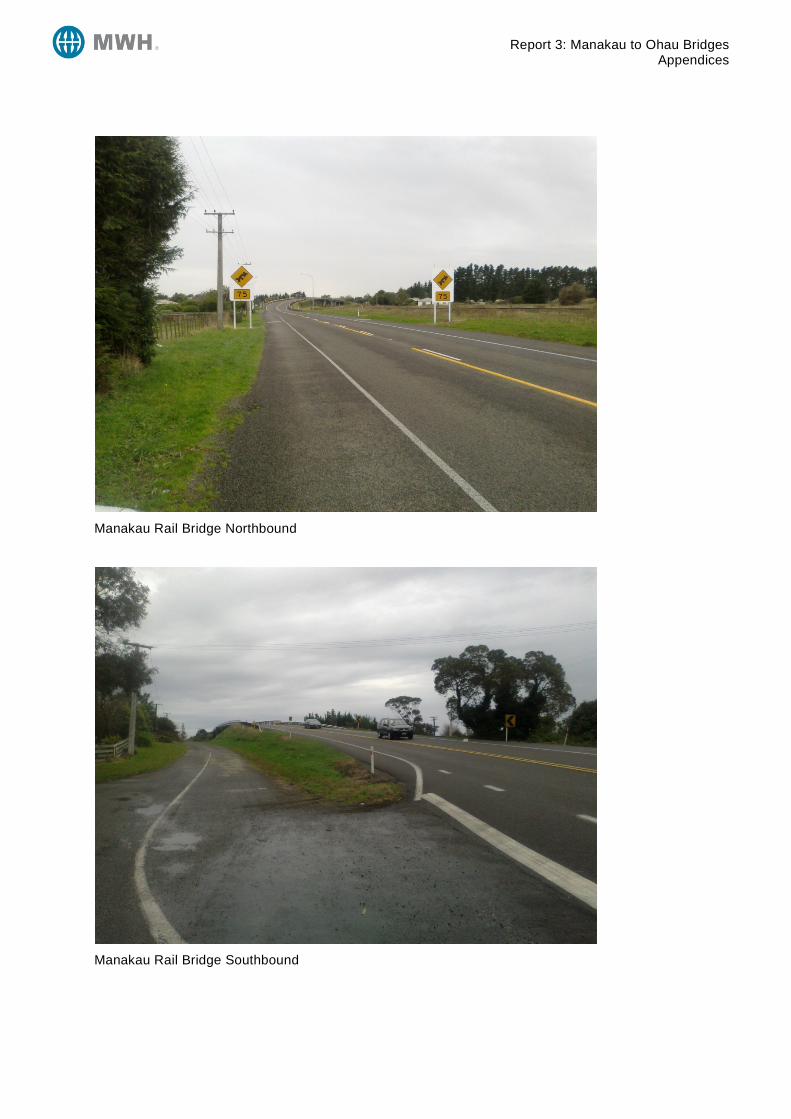
Report 3: Manakau to Ohau Bridges Appendices
Manakau Rail Bridge Northbound
Manakau Rail Bridge Southbound
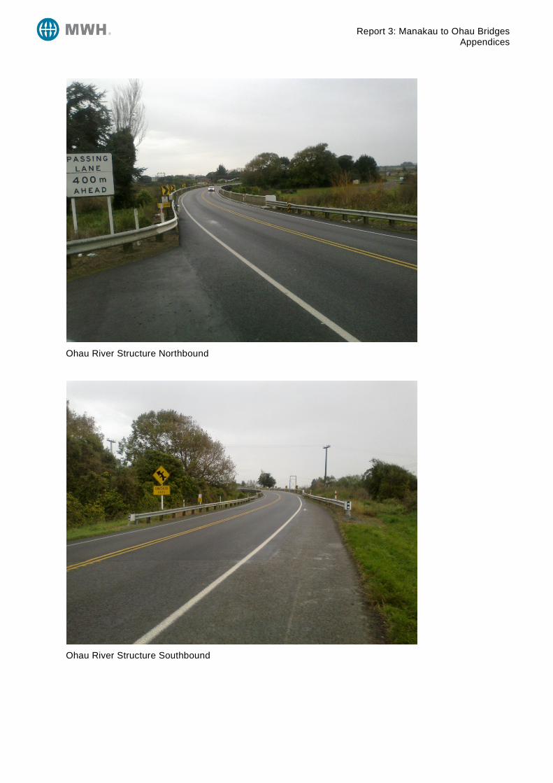
Report 3: Manakau to Ohau Bridges Appendices
Ohau River Structure Northbound
Ohau River Structure Southbound

Report 3: Manakau to Ohau Bridges Appendices
Appendix B Traffic Data
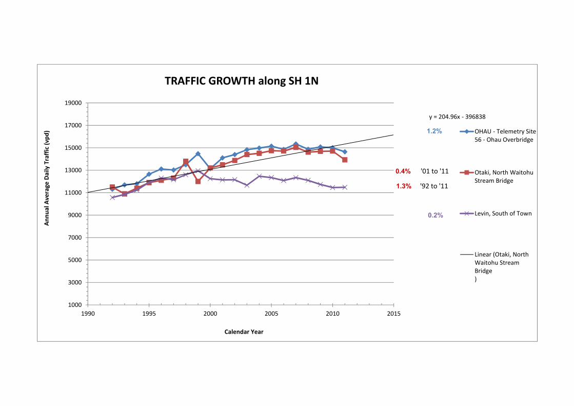
y = 204.96x - 396838
1000
3000
5000
7000
9000
11000
13000
15000
17000
19000
1990 1995 2000 2005 2010 2015
Annu
al A
vera
ge D
aily
Tra
ffic
(vpd
)
Calendar Year
TRAFFIC GROWTH along SH 1N
OHAU - Telemetry Site56 - Ohau Overbridge
Otaki, North WaitohuStream Bridge
Levin, South of Town
Linear (Otaki, NorthWaitohu StreamBridge)
0.2%
1.2%
'01 to '11
'92 to '11
0.4%
1.3%

Report 3: Manakau to Ohau Bridges Appendices
Appendix C Crash Data
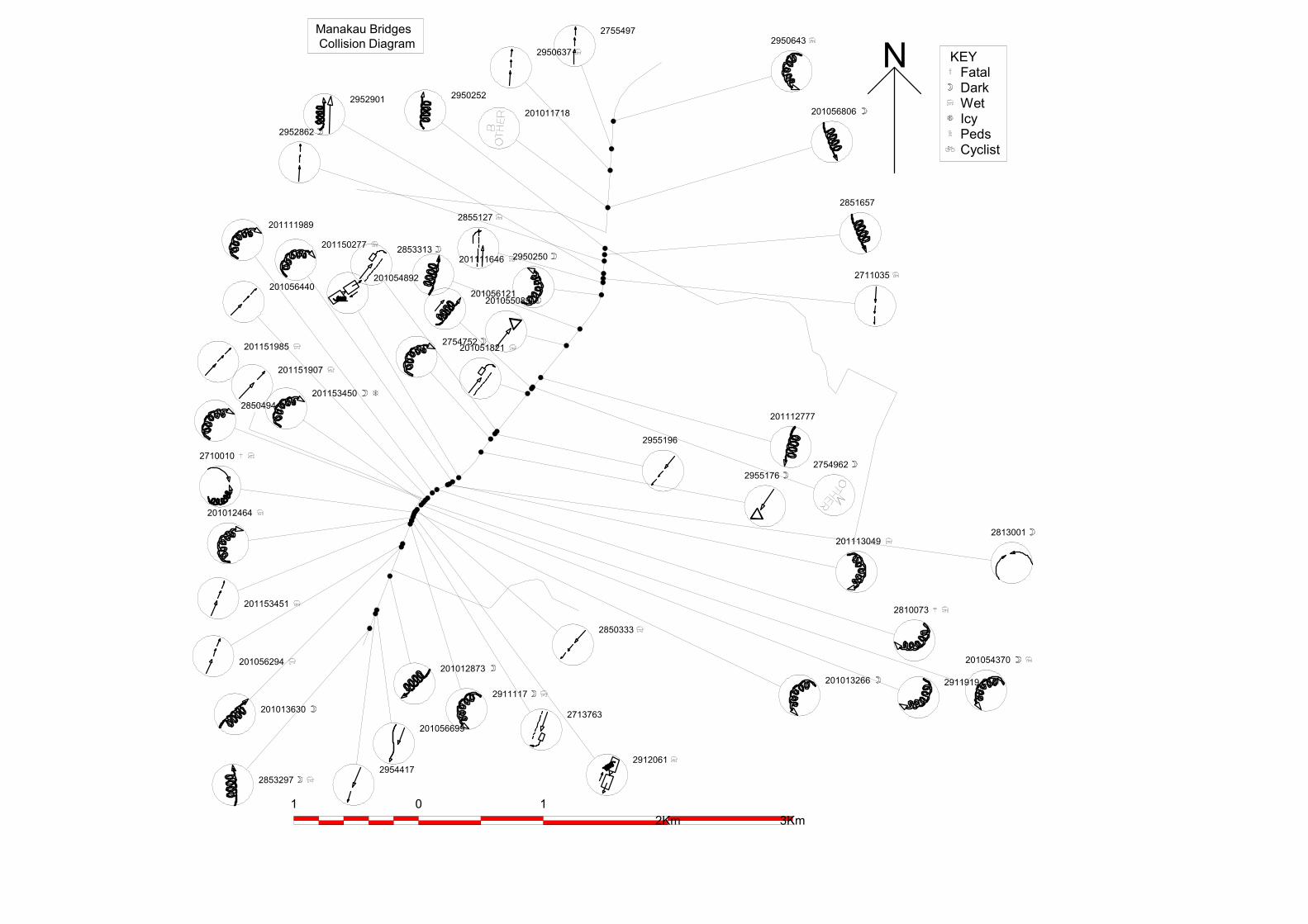
N
2850333
2950643
201056806
2851657
2711035
201112777
2754962
2955196
201013266
2853297
201013630
201056294
201153451
2710010
201012464
2850494201153450
201151907
201151985
201056440
201111989
2853313
2754752
201150277
201054892
2755497
2950637
201011718
29502522952901
2952862
2855127
201111646
201056121
201051821
201055089
2950250
2954417
201056699
201012873
2911117
2713763
2912061
2911919
201054370
2955176
2810073
2813001201113049
1 0 12Km 3Km
KEYFatalDarkWetIcyPedsCyclist
Manakau BridgesCollision Diagram
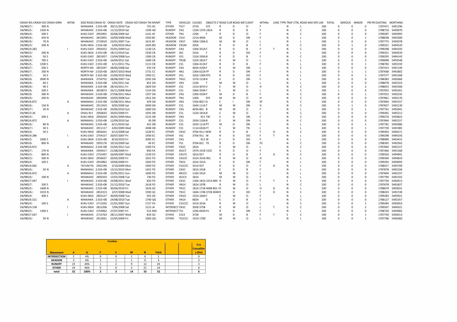
CRASH ROADCRASH DISTCRASH DIRN INTSN SIDE ROAD CRASH ID CRASH DATE CRASH DOWCRASH TIMEMVMT TYPE VEHICLES CAUSES OBJECTS STRUCKROAD CURVEROAD WETLIGHT WTHRa JUNC TYPE TRAF CTRL ROAD MARKSPD LIM FATAL SERIOUS MINOR PERS AGE1PERS AGE2EASTING NORTHING
1N/985/7.816 300 N WAIKAWA BEACH ROAD2.01E+08 30/11/2010 Tue 755 AC OTHER TS1T 372A CFZ R D O F N L 100 0 0 0 1787471 5491296
1N/985/5.597 1450 N WHAKAHORO ROAD2.01E+08 11/12/2010 Sat 1340 AD RUNOFF CN1 132A 137A 181A R D B F N C 100 0 0 0 1788710 5493070
1N/985/4.482 200 S KUKU EAST ROAD2952901 20/06/2009 Sat 1141 AF OTHER TN1 129A F R D O F N C 100 0 0 0 1789287 5493993
1N/985/6.627 420 N WHAKAHORO ROAD2813001 10/09/2008 Wed 1920 BC HEADON CS1C 121A 404A M D DN F N L 100 0 0 1 1788038 5492300
1N/985/6.977 70 N WHAKAHORO ROAD2710010 23/01/2007 Tue 1615 BF HEADON CN1T 106A 130A 359A 402A G M W O L N L 100 2 0 0 1787775 5492078
1N/985/3.954 200 N KUKU BEACH ROAD2.01E+08 5/04/2010 Mon 1620 BO HEADON CN1M 205A R D B F N C 100 0 1 0 1789321 5494520
1N/985/4.282 I KUKU EAST ROAD2950252 25/01/2009 Sun 1130 CA RUNOFF CN1 130A 351A F R D B F T N C 100 0 0 0 1789298 5494193
1N/985/3.954 200 N KUKU BEACH ROAD2.01E+08 18/12/2010 Sat 2330 CB RUNOFF 4S1 101A F R D DO F N L 100 0 0 0 1789321 5494520
1N/985/4.332 50 S KUKU EAST ROAD2851657 13/04/2008 Sun 1300 CB RUNOFF VS1 132A 330A 912 B R D B F N C 100 0 0 0 1789295 5494143
1N/985/4.982 700 S KUKU EAST ROAD2.01E+08 16/04/2011 Sat 1400 CB RUNOFF TN1B 132A 181A 800 T R W O L N L 100 0 0 2 1789098 5493548
1N/985/5.482 1200 S KUKU EAST ROAD2.01E+08 3/11/2011 Thu 1115 CB RUNOFF CS1 130A 412A F R D B F N L 100 0 0 1 1788783 5493159
1N/985/7.974 500 S NORTH MANAKAU ROAD2853297 28/06/2008 Sat 410 CB RUNOFF CN1 402A 410A F R W DN L N C 100 0 0 0 1787414 5491149
1N/985/7.274 200 N NORTH MANAKAU ROAD2.01E+08 28/07/2010 Wed 1731 CC RUNOFF 4N1 136A 622A FP R D DN F N L 100 0 1 1 1787668 5491802
1N/985/7.524 50 S NORTH MANAKAU ROAD2.01E+08 22/09/2010 Wed 1950 CC RUNOFF VS1 102A 130A FPV R D DO F N L 100 0 0 1 1787577 5491568
1N/985/6.116 2000 N WAIKAWA BEACH ROAD2754752 28/08/2007 Tue 2202 DA RUNOFF TN1C 137A 121B B S D DN F N L 100 0 0 0 1788383 5492666
1N/985/6.581 60 S WAIKAWA BR2.01E+08 5/02/2011 Sat 852 DA RUNOFF VN1 110A T M W O L N L 100 0 0 0 1788078 5492323
1N/985/6.611 90 S WAIKAWA BR2.01E+08 28/10/2011 Fri 1820 DA RUNOFF CS1 131A 407A 811 901 V E W O H N C 100 0 0 2 1788053 5492306
1N/985/6.721 200 S WAIKAWA BR2810073 26/11/2008 Wed 1154 DA RUNOFF CS1 106A 359A T E W O L N C 100 1 0 0 1787952 5492261
1N/985/6.767 280 N WHAKAHORO ROAD2.01E+08 27/06/2011 Mon 1357 DA RUNOFF CN1 130A 410A P M D B F N C 100 0 0 1 1787915 5492235
1N/985/6.847 200 N WHAKAHORO ROAD2850494 10/02/2008 Sun 1912 DA RUNOFF TN1 130A EFS M W O H N C 100 0 0 0 1787861 5492176
1N/985/6.872 A MANAKAU N RLY OBR2.01E+08 15/08/2011 Mon 429 DA RUNOFF VN1 135A 802 905 G E I DN SF N C 100 0 0 0 1787844 5492157
1N/985/6.897 150 N WHAKAHORO ROAD2911919 9/05/2009 Sat 2040 DA RUNOFF CS1 104A 111A T M W DN H N C 100 0 1 0 1787827 5492139
1N/985/7.017 30 N WHAKAHORO ROAD2.01E+08 20/06/2010 Sun 1600 DA RUNOFF CN1 403A 801 B M W O F N L 100 0 0 1 1787761 5492041
1N/985/3.26 A OHAU RLY OBR2950643 20/02/2009 Fri 1035 DB RUNOFF CS1 132A 181A B E W O L N C 100 0 0 0 1789365 5495212
1N/985/4.654 500 S KUKU BEACH ROAD2950250 26/01/2009 Mon 2125 DB RUNOFF CN1 911 TW E D DN F N C 100 0 0 0 1789270 5493822
1N/985/6.872 A MANAKAU N RLY OBR2.01E+08 11/09/2010 Sat 30 DB RUNOFF CS1 103A 110A 402A B E W DN L N C 100 0 0 0 1787844 5492157
1N/985/6.967 80 N WHAKAHORO ROAD2.01E+08 6/11/2010 Sat 422 DB RUNOFF CS1 102A 111A 402A PT M D DN F N L 100 0 0 1 1787781 5492086
1N/985/7.079 30 S WHAKAHORO ROAD2911117 4/02/2009 Wed 2048 DB RUNOFF CS1 111A 632A 662A FT E W TN L N L 100 0 0 1 1787739 5491985
1N/985/4.208 50 S KUKU BEACH ROAD2856441 6/12/2008 Sat 1228 EC OTHER CN1C 370A 911 929 WW R D B F D N C 100 0 0 0 1789303 5494271
1N/985/4.286 I KUKU EAST ROAD2754157 20/07/2007 Fri 1930 EC OTHER VS1 370A 911 W R D DO F T N L 100 0 0 0 1789298 5494193
1N/985/5.154 1000 S KUKU BEACH ROAD2.01E+08 8/10/2010 Fri 2005 EC OTHER CN1 912 W E D DO F N L 100 0 0 0 1788989 5493415
1N/985/6.247 800 N WHAKAHORO ROAD2955176 10/10/2009 Sat 40 EC OTHER TS1 370A 821 TX R D DN FS N C 100 0 0 0 1788305 5492562
1N/985/6.872 A MANAKAU N RLY OBR2.01E+08 22/05/2011 Sun 1500 FA OTHER CN1C 181A E W O L N C 100 0 0 0 1787844 5492157
1N/985/7.846 270 N WAIKAWA BEACH ROAD2954417 21/08/2009 Fri 850 FA OTHER 4S1CT 197A 191B 155C R D O F N L 100 0 0 0 1787460 5491268
1N/985/3.482 800 N KUKU EAST ROAD2755497 26/09/2007 Wed 1539 FD OTHER CN1TC 181A 927 R D B F D N C 100 0 0 0 1789350 5494991
1N/985/3.654 500 N KUKU BEACH ROAD2950637 20/02/2009 Fri 1052 FD OTHER CN1VC 331A 353A 901 R W O H N L 100 0 0 0 1789340 5494819
1N/985/4.382 100 S KUKU EAST ROAD2952862 19/06/2009 Fri 1920 FD OTHER TN1V 101A 331A E D DN F N L 100 0 0 0 1789292 5494093
1N/985/6.062 A TATUM PARK ENT2955196 5/10/2009 Mon 1059 FD OTHER CS1CCC 331A 927 R D O F D N L 100 0 0 0 1788417 5492709
1N/985/6.822 50 N MANAKAU N RLY OBR2.01E+08 13/12/2010 Mon 1452 FD OTHER CN1C 181A 191B E D B F N L 100 0 0 0 1787878 5492194
1N/985/6.872 A MANAKAU N RLY OBR2.01E+08 22/05/2011 Sun 1600 FD OTHER 4N1CC 110A 331A M W O L N L 100 0 0 0 1787844 5492157
1N/985/6.947 100 N WHAKAHORO ROAD2850333 12/02/2008 Tue 730 FD OTHER 4S1CV 181A M W O F N L 100 0 0 0 1787794 5492102
1N/985/7.047 I WHAKAHORO ROAD2.01E+08 24/08/2011 Wed 820 FD OTHER CN1C 130A 181A 331A 800 R W O F T S C 100 0 0 0 1787750 5492013
1N/985/7.247 200 S WHAKAHORO ROAD2.01E+08 21/12/2010 Tue 1618 FD OTHER VN1V 181A 197B R W O L N C 100 0 0 0 1787678 5491827
1N/985/5.647 1400 N WHAKAHORO ROAD2.01E+08 30/04/2010 Fri 1626 GC OTHER TN1C 181A 171B 404B 801 927 R W O H D N L 100 0 0 0 1788679 5493031
1N/985/6.037 1010 N WHAKAHORO ROAD2853313 2/07/2008 Wed 1930 GC OTHER TN1C 160A 174B 372B 404B 926 R D DO F D N C 100 0 0 0 1788433 5492728
1N/985/4.554 400 S KUKU BEACH ROAD2855127 30/09/2008 Tue 925 GE OTHER CN1O 155A 160A 333A 817 F E W O F N L 100 0 0 0 1789283 5493921
1N/985/6.521 A WAIKAWA BR2.01E+08 24/08/2010 Tue 1700 QG OTHER VN14 682A D E D B F N C 100 0 0 0 1788127 5492357
1N/985/4.522 240 S KUKU EAST ROAD2711035 21/01/2007 Sun 1727 FD OTHER CS1CCC 331A 353A R W O L N C 100 0 0 1 1789284 5493953
1N/985/4.158 I KUKU BEACH ROAD2812206 7/06/2008 Sat 1213 JA INTERSECTIONCN1C 302B 375B R W O L T G C 100 0 0 2 1789307 5494321
1N/985/5.582 1300 S KUKU EAST ROAD2754962 27/07/2007 Fri 515 MO INTERSECTIONTS1 129A 603A FV R D DN F N L 100 0 0 0 1788720 5493082
1N/985/7.047 I WHAKAHORO ROAD2713763 28/11/2007 Wed 810 GC OTHER CS14 372B M D B F T S C 100 0 0 1 1787750 5492013
1N/985/6.997 50 N WHAKAHORO ROAD2912061 22/05/2009 Fri 1003 QG OTHER TS1CCC 191A 170D M W O L N L 100 0 0 1 1787768 5492060
Crashes
Movement # % F S M N Total
F+S
Casualitie
s (Dsi)
INTERSECTION 2 4% 0 0 1 0 1 0
HEADON 3 6% 1 1 1 0 3 3
RUNOFF 23 44% 1 2 9 12 24 3
OTHER 24 46% 0 0 3 21 24 0
total 52 100% 2 3 14 33 52 6

Report 3: Manakau to Ohau Bridges Appendices
Appendix D Outline Plans
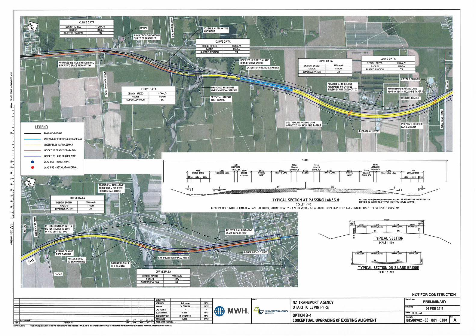
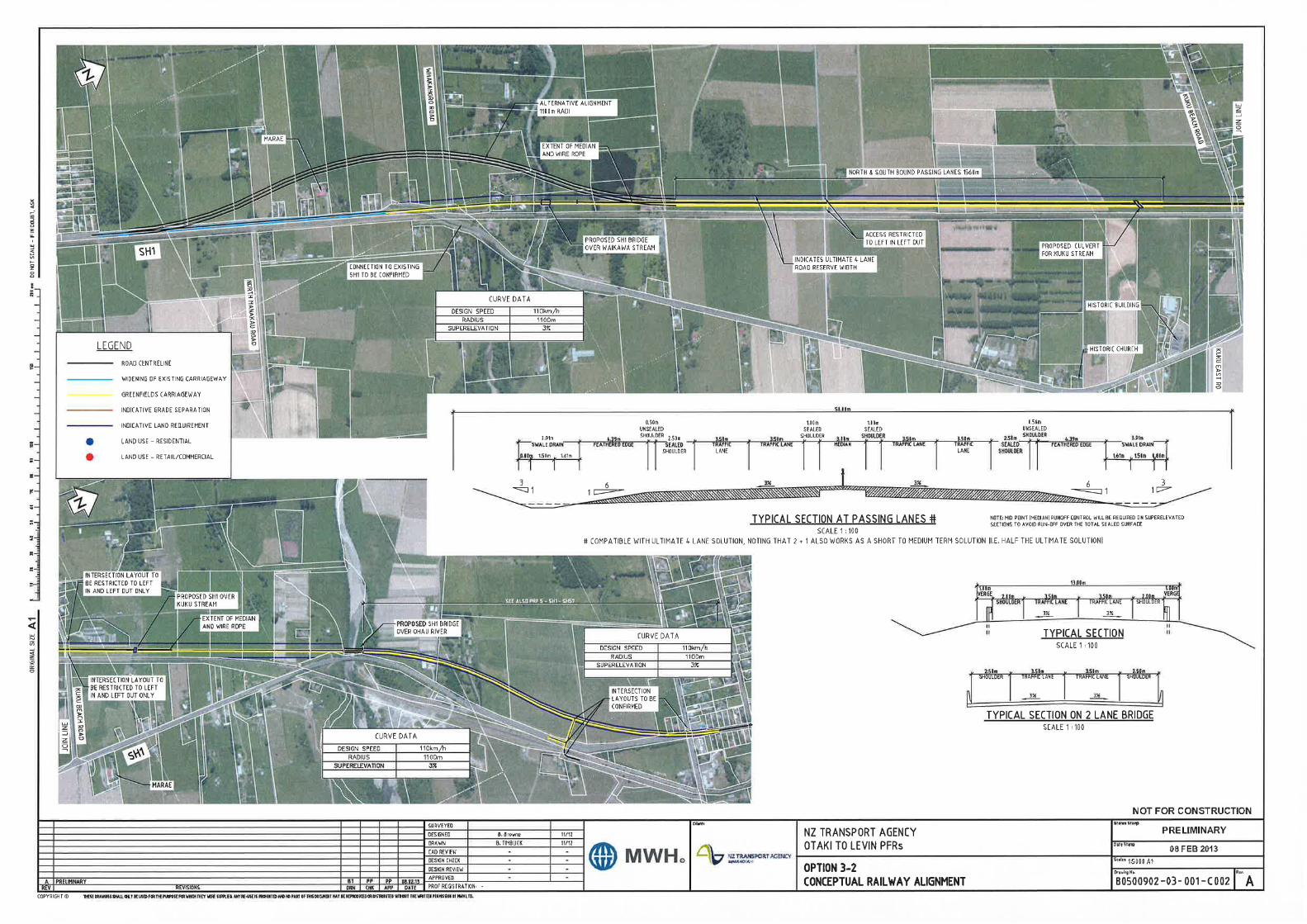
Report 3: Manakau to Ohau Bridges Appendices
Appendix E Cost Estimates
Feasibility Estimate
Item Base Estimate Contingency Funding Risk
A 4,000,000 800,000 1,320,000
- Consultancy Fees 1,111,000 222,200 366,600
- NZTA-Managed Costs 0 0 0
B 1,111,000 222,200 366,600
- Consultancy Fees 2,381,000 476,200 785,700
- NZTA-Managed Costs 0 0 0
C 2,381,000 476,200 785,700
MSQA
- Consultancy Fees 2,381,000 476,200 785,700
- NZTA-Managed Costs 0 0 0
- Consent Monitoring Fees 0 0 0
2,381,000 476,200 785,700
D1 Environmental Compliance 1,600,000 320,000 528,000
D2 Earthworks 3,445,000 1,033,500 1,722,500
D3 Ground Improvments 100,000 20,000 33,000
D4 Drainage 235,000 47,000 77,600
D5 Pavement and Surfacing 4,237,000 847,400 1,398,200
D6 Bridges / Structures 12,930,000 2,586,000 4,266,900
D7 Retaining Walls 900,000 180,000 297,000
D8 Traffic Services 922,500 184,500 304,400
D9 Service Relocations 1,687,500 337,500 556,900
D10 Landscaping 690,000 138,000 227,700
D11 Traffic Management and Temporary Works 2,000,000 400,000 660,000
D12 Preliminary and General 3,000,000 600,000 990,000
D13 Extraordinary Construction Costs 0 0 0
Sub Total Base Physical Works 31,747,000 6,693,900 11,062,200
D 34,128,000 7,170,100 11,847,900
E Project Base Estimate (A+B+C+D) 41,620,000
F (A+B+C+D) 8,668,500
G (E+F) 50,288,500
Project Property Cost Expected Estimate 4,800,000
Investigation and Reporting Expected Estimate 1,333,200
Design and Project Documentation Expected Estimate 2,857,200
Construction Expected Estimate 41,298,100
H (A+B+C+D) 14,320,200
I (G+H) 64,608,700
Project Property Cost 95th Percentile Estimate 6,120,000
Investigation and Reporting 95th Percentile Estimate 1,699,800
Design and Project Documentation 95th Percentile Estimate 3,642,900
Construction 95th Percentile Estimate 53,146,000
13 Nov 2012 Cost Index
Estimate prepared by: Ben Dodgshun Signed
Estimate internal peer review by: Marten Oppenhuis Signed
Estimate external peer review by: Signed
Estimate approved by NZTA Project Manager: Signed
Note: (1) These estimates are exclusive of escalation and GST.
FE
Base Date of Estimate
Total Design and Project Documentation
Total Construction & MSQA
Total Investigation and Reporting
Design and Project Documentation
Construction
Description
Sub Total Base MSQA
95th Percentile Project Estimate
Funding Risk (Assessed / Analysed)
Contingency (Assessed / Analysed)
Project Expected Estimate
Project Estimate - Form AProject Name: Otaki to Levin PFR Study
PFR 3 (Manakau - Ohau Bridges)
Option 3-1
Physical Works
Nett Project Property Cost
Investigation and Reporting
NZ Transport Agency's Cost Estimation Manual (SM014)
First Edition, Amendment 0
Effective from November 2010 1/1 Printed 23/11/2012
Feasibility Estimate
Item Base Estimate Contingency Funding Risk
A 5,000,000 1,000,000 1,650,000
- Consultancy Fees 743,000 148,600 245,200
- NZTA-Managed Costs 0 0 0
B 743,000 148,600 245,200
- Consultancy Fees 1,592,000 318,400 525,400
- NZTA-Managed Costs 0 0 0
C 1,592,000 318,400 525,400
MSQA
- Consultancy Fees 1,592,000 318,400 525,400
- NZTA-Managed Costs 0 0 0
- Consent Monitoring Fees 0 0 0
1,592,000 318,400 525,400
D1 Environmental Compliance 1,600,000 320,000 528,000
D2 Earthworks 1,925,000 577,500 962,500
D3 Ground Improvments 100,000 20,000 33,000
D4 Drainage 172,000 34,400 56,800
D5 Pavement and Surfacing 4,259,000 851,800 1,405,500
D6 Bridges / Structures 6,750,000 1,350,000 2,227,500
D7 Retaining Walls 0 0 0
D8 Traffic Services 550,500 110,100 181,700
D9 Service Relocations 1,687,500 337,500 556,900
D10 Landscaping 683,000 136,600 225,400
D11 Traffic Management and Temporary Works 1,000,000 200,000 330,000
D12 Preliminary and General 2,500,000 500,000 825,000
D13 Extraordinary Construction Costs 0 0 0
Sub Total Base Physical Works 21,227,000 4,437,900 7,332,300
D 22,819,000 4,756,300 7,857,700
E Project Base Estimate (A+B+C+D) 30,154,000
F (A+B+C+D) 6,223,300
G (E+F) 36,377,300
Project Property Cost Expected Estimate 6,000,000
Investigation and Reporting Expected Estimate 891,600
Design and Project Documentation Expected Estimate 1,910,400
Construction Expected Estimate 27,575,300
H (A+B+C+D) 10,278,300
I (G+H) 46,655,600
Project Property Cost 95th Percentile Estimate 7,650,000
Investigation and Reporting 95th Percentile Estimate 1,136,800
Design and Project Documentation 95th Percentile Estimate 2,435,800
Construction 95th Percentile Estimate 35,433,000
13 Nov 2012 Cost Index
Estimate prepared by: Ben Dodgshun Signed
Estimate internal peer review by: Marten Oppenhuis Signed
Estimate external peer review by: Signed
Estimate approved by NZTA Project Manager: Signed
Note: (1) These estimates are exclusive of escalation and GST.
FE
Base Date of Estimate
Total Design and Project Documentation
Total Construction & MSQA
Total Investigation and Reporting
Design and Project Documentation
Construction
Description
Sub Total Base MSQA
95th Percentile Project Estimate
Funding Risk (Assessed / Analysed)
Contingency (Assessed / Analysed)
Project Expected Estimate
Project Estimate - Form AProject Name: Otaki to Levin PFR Study
PFR 3 (Manakau - Ohau Bridges)
Option 3-2
Physical Works
Nett Project Property Cost
Investigation and Reporting
NZ Transport Agency's Cost Estimation Manual (SM014)
First Edition, Amendment 0
Effective from November 2010 1/1 Printed 23/11/2012

Report 3: Manakau to Ohau Bridges Appendices
Appendix F Economic Analysis Worksheets
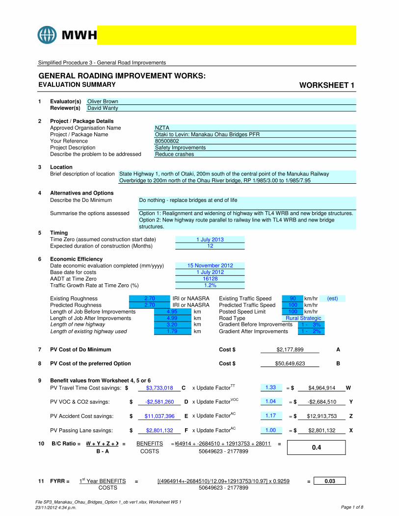
Simplified Procedure 3 - General Road Improvements
GENERAL ROADING IMPROVEMENT WORKS:EVALUATION SUMMARY WORKSHEET 1
1 Evaluator(s) Oliver BrownReviewer(s) David Wanty
2 Project / Package Details
Approved Organisation NameProject / Package NameYour ReferenceProject DescriptionDescribe the problem to be addressed
3 Location
Brief description of location
4 Alternatives and Options
Describe the Do Minimum
Summarise the options assessed
5 TimingTime Zero (assumed construction start date)Expected duration of construction (Months)
6 Economic EfficiencyDate economic evaluation completed (mm/yyyy)Base date for costsAADT at Time ZeroTraffic Growth Rate at Time Zero (%)
Existing Roughness IRI or NAASRA Existing Traffic Speed km/hrPredicted Roughness IRI or NAASRA Predicted Traffic Speed km/hrLength of Job Before Improvements km Posted Speed Limit km/hrLength of Job After Improvements km Road TypeLength of new highway km Gradient Before Improvements
Length of existing highway used km Gradient After Improvements
7 A
8 B
9 Benefit values from Worksheet 4, 5 or 6
PV Travel Time Cost savings: $ C x Update FactorTT= $ W
PV VOC & CO2 savings: x Update FactorVOC
PV Accident Cost savings: x Update FactorAC
PV Passing Lane savings: x Update FactorAC
10 =
11
X
2.70 1004.95
2%3.201.79
4.99
1 -
PV Cost of Do Minimum Cost $ $2,177,899
$3,733,018 1.33 $4,964,914
PV Cost of the preferred Option
B/C Ratio =
$
BENEFITS
-$2,581,260
Z
Y= $ -$2,684,510
$12,913,753
1.04D
$ $2,801,132 F 1.00 = $
50649623 - 2177899FYRR = 1st Year BENEFITS
COSTS==
Cost $ $50,649,623
(est)
Rural Strategic3%
100
90
1 -
0.03[(4964914+-2684510)/12.09+12913753/10.97] x 0.9259
0.4
= $E
=
COSTS
$2,801,132
B - A
W + Y + Z + X 4964914 + -2684510 + 12913753 + 2801132
$ $11,037,396
50649623 - 2177899
1.17
=
1 July 201312
Option 1: Realignment and widening of highway with TL4 WRB and new bridge structures. Option 2: New highway route parallel to railway line with TL4 WRB and new bridge structures.
NZTAOtaki to Levin: Manakau Ohau Bridges PFR80500802Safety ImprovementsReduce crashes
Do nothing - replace bridges at end of life
State Highway 1, north of Otaki, 200m south of the central point of the Manukau Railway Overbridge to 200m north of the Ohau River bridge, RP 1/985/3.00 to 1/985/7.95
2.70
15 November 20121 July 2012
161281.2%
File SP3_Manakau_Ohau_Bridges_Option 1_ob ver1.xlsx, Worksheet WS 1
23/11/2012 4:34 p.m. Page 1 of 8
Simplified Procedure 3 - General Road Improvements
GENERAL ROADING IMPROVEMENT WORKS:EVALUATION SUMMARY WORKSHEET 1
1 Evaluator(s) Oliver BrownReviewer(s) David Wanty
2 Project / Package Details
Approved Organisation NameProject / Package NameYour ReferenceProject DescriptionDescribe the problem to be addressed
3 Location
Brief description of location
4 Alternatives and Options
Describe the Do Minimum
Summarise the options assessed
5 TimingTime Zero (assumed construction start date)Expected duration of construction (Months)
6 Economic EfficiencyDate economic evaluation completed (mm/yyyy)Base date for costsAADT at Time ZeroTraffic Growth Rate at Time Zero (%)
Existing Roughness IRI or NAASRA Existing Traffic Speed km/hrPredicted Roughness IRI or NAASRA Predicted Traffic Speed km/hrLength of Job Before Improvements km Posted Speed Limit km/hrLength of Job After Improvements km Road TypeLength of new highway km Gradient Before Improvements
Length of existing highway used km Gradient After Improvements
7 A
8 B
9 Benefit values from Worksheet 4, 5 or 6
PV Travel Time Cost savings: $ C x Update FactorTT= $ W
PV VOC & CO2 savings: x Update FactorVOC
PV Accident Cost savings: x Update FactorAC
PV Passing Lane savings: x Update FactorAC
10 =
11
2.70
15 November 20121 July 2012
161281.2%
1 July 201312
Option 2: New highway route parallel to railway line with TL4 WRB and new bridge structures and extension of passing lanes
NZTAOtaki to Levin: Manakau Ohau Bridges PFR80500802Safety ImprovementsReduce crashes
Do nothing - replace bridges at end of life
State Highway 1, north of Otaki, 200m south of the central point of the Manukau Railway Overbridge to 200m north of the Ohau River bridge, RP 1/985/3.04 to 1/985/7.95
B - A
W + Y + Z 17611830 + 5247932 + 13720327 + 2558452
$ $11,726,776
36759536 - 2177899
1.17
=
$ $2,558,452 F 1.00
0.08[(17611830+5247932)/12.09+13720327/10.97] x 0.9259
1.1
= $E
=
COSTS
= $ $2,558,452
(est)
Rural Strategic3%
100
90
1 -
PV Cost of Do Minimum Cost $ $2,177,899
$13,241,977 1.33 $17,611,830
PV Cost of the preferred Option Cost $ $36,759,536
36759536 - 2177899FYRR = 1st Year BENEFITS
COSTS==
B/C Ratio =
$
BENEFITS
$5,046,088
Z
Y= $ $5,247,932
$13,720,327
1.04D
X
2.70 1004.95
2%4.700.00
4.70
1 -
File SP3_Manakau_Ohau_Bridges_Option 2_ob ver1.xlsx, Worksheet WS 1
23/11/2012 4:29 p.m. Page 1 of 16

Report 3: Manakau to Ohau Bridges Appendices
Appendix G Bridge Condition Data
Bridge Name:
Ohau (SH1) Bridge
Highway:
1 BCI(Av):
p. 1/2
Bridge Type: RC T-beam, monolithic abuts. Extent code A = No defect B = Not > 5% C = Moderate; 5 - 20% D = Wide; 20 - 50% E = > 50%
Severity code 1 = as new 2 = early signs of defect 3 = moderate defect 4 = severe defect 5 = element failed
BSN: 9880 Map Ref:
Deck width: 7.40m/ Owner:
Span: of Last Insp. date: 22/01/2009 Spans: 1/10.7 8/14.3 1/10.4 Last insp. by: GB
Total bridge length: 135.00m Report Type (G1/G2/D/S):
G2
Ext = Extent ; Sev = Severity Inspector: GRG Next Inspection: Maint.; S=Structural; R=Routine Date: 10/02/2011
Element Ext Sev S/R Brief description of fault and comments
Set No Description
Su
pers
tru
ctu
re
Ele
me
nts
1 Primary element C 3 S Vertical cracking to beams up to 0.3mm wide, and small spall to B4 span H/I at I (see photo)
2 Sec. ele- ment(s)
Transverse beams
3 Other C 2 S Longitudinal and transverse cracking to deck soffit up to 0.2mm wide
4 Half joints
5 Seismic linkages B 2 S Accumulation of bird droppings on linkages
6 Parapet beam or cantilever C 3 S Transverse/diagonal cracking up to 0.3mm wide to soffit of deck overhang
7 Cross bracing B 2 S Vertical cracking to diaphragms up to 0.2mm wide
Lo
ad
-be
ari
ng
S
ub
str
uc
ture
8 Foundations A 1
9 Abutments A 1
10 Head wall
11 Pier / column C 3 S Vertical cracks to CL of piers B,C,D,E,F, and J up to 1.0mm wide, and spalls to top of pile cap pier H (see photo) and to wall of pier I (see photo)
12 Cross-head / capping beam A 1
13 Bearings
14 Bearing plinth / shelf
Du
rab
ilit
y
Ele
me
nts
15 Superstructure drainage A 1
16 Substructure drainage A 1
17 Movement / expansion joints C 3 S Reflective cracking to expansion joint (see photo)
18 Painting: Superstructure elements
19 Painting: substructure elements
20 Painting: barriers/guardrails B 2 R Lichen growing on handrails
Safe
ty
Ele
me
nts
21 Access / walkways / gantries
22 Guardrail / handrail / safety fences
C 3 R Concrete handrails only along bridge
23 Carriageway surfacing C 3 R Settlement and cracking to asphalt of increasing lane abut A approach
24 Footway / verge / footbridge surfacing
A 1
Wate
rway
Ele
me
nts
25 Invert / river bed A 1
26 Aprons A 1
27 Aggradation A 1
28 Degradation B 2 S Bed level may be at bottom of skirts at piers - MONITOR
29 Scour C 3 R Minor debris on piers H and I
30 River banks A 1
Reta
inin
g
Ele
me
nts
31 Revetment / batter slope paving A 1
32 Wing walls A 1
33 Retaining walls
34 Embankments A 1
Oth
er
35 Approach rails / barriers / walls A 1
36 Signs A 1
37 Lighting
38 Services A 1
39 Graffiti B 2 R Minor graffiti
Bridge Name:
Ohau (SH1) Bridge
Highway:
1 BCI(Av):
p. 2/2
Comments and Recommendations for Maintenance/Repairs
Item No. Element
No. Suggested Remedial Work
Priority (H/M/L)
Estimated Cost
1 23 Level and reseal approach locally M $1,000
2 22 Install guardrailing along bridge M $40,000
3 17 Cut asphalt out and replace with Thormajoint M $10,000
4 29 Remove debris L $ 800
5 1 Epoxy inject cracks 0.2mm and wider M $30,000
6 1 Repair spall L $1,000
7 6 Epoxy inject cracks 0.2mm and wider L $20,000
8 11 Repair spalls L $5,000
9 11 Epoxy inject cracks 0.2mm and wider M $10,000
10
Total Construction Cost $117,800
Remedial work recommended in last inspection has been completed: Yes (comment below if NO)
NZTA Database changes required: Yes (Describe change below if answer is YES)
Guardrail corrected
Comments & Recommendations Relating to Future Management (Transfer to current report)
Inspection by : GRG - Bloxam Burnett & Olliver Limited Date 10/02/2011
Report examined by :
Date
Version: 29 April 2011
Bridge Name:
Ohau Rail Overbridge
Highway:
1 BCI(Av):
p. 1/2
Bridge Type: RC portal structure Extent code A = No defect B = Not > 5% C = Moderate; 5 - 20% D = Wide; 20 - 50% E = > 50%
Severity code 1 = as new 2 = early signs of defect 3 = moderate defect 4 = severe defect 5 = element failed
BSN: 9883 Map Ref:
Deck width: 7.32m/ Owner:
Span: of Last Insp. date: 22/01/2009 Spans: 1/9.6 Last insp. by: GB
Total bridge length: 9.60m Report Type (G1/G2/D/S):
G2
Ext = Extent ; Sev = Severity Inspector: GRG Next Inspection: Maint.; S=Structural; R=Routine Date: 9/02/2011
Element Ext Sev S/R Brief description of fault and comments
Set No Description
Su
pers
tru
ctu
re
Ele
me
nts
1 Primary element C 2 S Longitudinal construction joints along soffit of structure are leaking with efflorescence.
2 Sec. ele- ment(s)
Transverse beams
3 Other
4 Half joints
5 Seismic linkages
6 Parapet beam or cantilever A 1
7 Cross bracing
Lo
ad
-be
ari
ng
S
ub
str
uc
ture
8 Foundations A 1
9 Abutments C 3 S Vertical cracks to abutment walls up to 0.8mm wide, and horizontal cracks up to 0.1mm wide.
10 Head wall
11 Pier / column
12 Cross-head / capping beam
13 Bearings
14 Bearing plinth / shelf
Du
rab
ilit
y
Ele
men
ts
15 Superstructure drainage
16 Substructure drainage A 1
17 Movement / expansion joints
18 Painting: Superstructure elements
19 Painting: substructure elements
20 Painting: barriers/guardrails A 1
Safe
ty
Ele
me
nts
21 Access / walkways / gantries
22 Guardrail / handrail / safety fences
A 1
23 Carriageway surfacing A 1
24 Footway / verge / footbridge surfacing
A 1
Wa
terw
ay
Ele
me
nts
25 Invert / river bed
26 Aprons
27 Aggradation
28 Degradation
29 Scour
30 River banks
Reta
inin
g
Ele
me
nts
31 Revetment / batter slope paving
32 Wing walls C 2 S Fine vertical and diagonal cracking to wingwalls
33 Retaining walls
34 Embankments A 1
Oth
er
35 Approach rails / barriers / walls A 1
36 Signs A 1
37 Lighting
38 Services A 1
39 Graffiti B 2 R Moderate amount of offensive graffiti
Bridge Name:
Ohau Rail Overbridge
Highway:
1 BCI(Av):
p. 2/2
Comments and Recommendations for Maintenance/Repairs
Item No. Element
No. Suggested Remedial Work
Priority (H/M/L)
Estimated Cost
1 9 Epoxy inject vertical cracks greater than 0.2mm wide L $20,000
2
3
4
5
6
7
8
9
10
Total Construction Cost $20,000
Remedial work recommended in last inspection has been completed: Yes (comment below if NO)
NZTA Database changes required: No (Describe change below if answer is YES)
Comments & Recommendations Relating to Future Management (Transfer to current report)
Inspection by : GRG - Bloxam Burnett & Olliver Limited Date 9/02/2011
Report examined by :
Date
Version: 29 April 2011
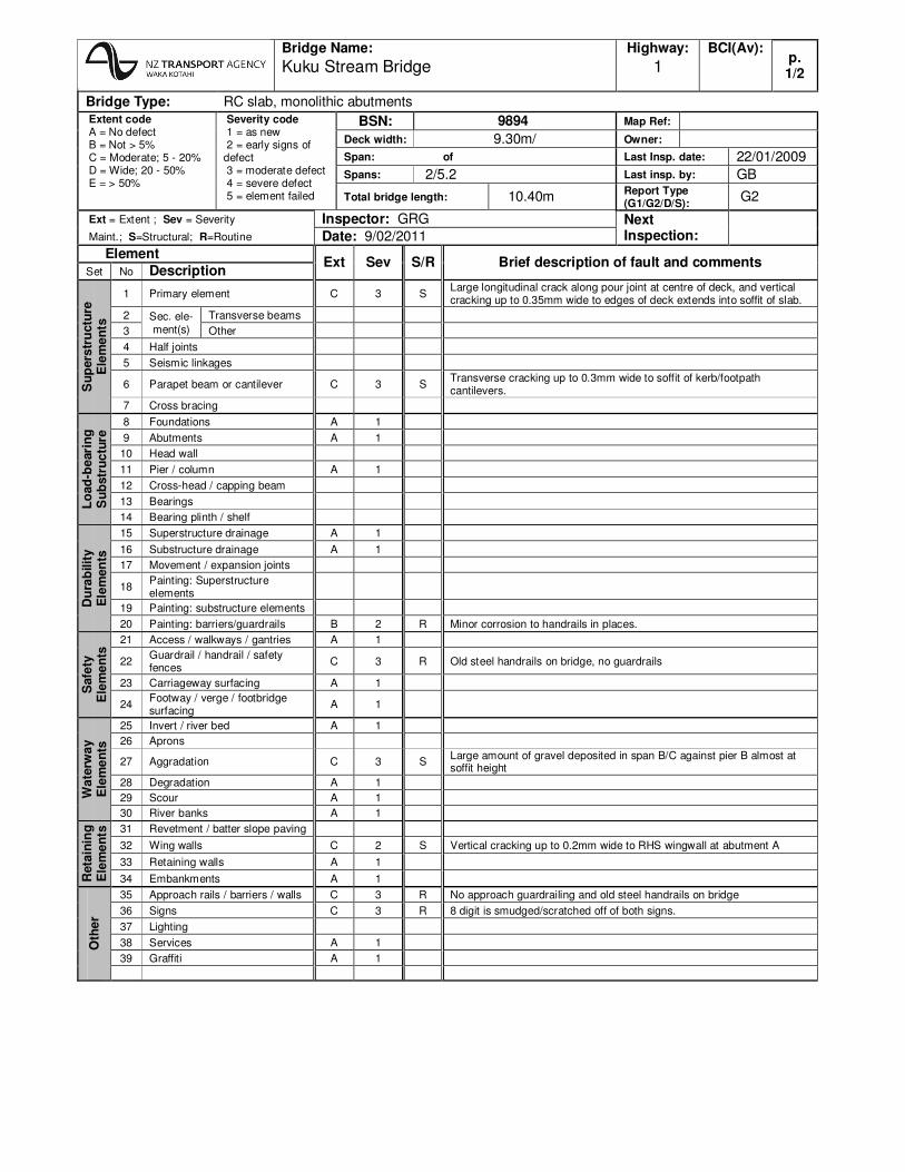
Bridge Name:
Kuku Stream Bridge
Highway:
1 BCI(Av):
p. 1/2
Bridge Type: RC slab, monolithic abutments Extent code A = No defect B = Not > 5% C = Moderate; 5 - 20% D = Wide; 20 - 50% E = > 50%
Severity code 1 = as new 2 = early signs of defect 3 = moderate defect 4 = severe defect 5 = element failed
BSN: 9894 Map Ref:
Deck width: 9.30m/ Owner:
Span: of Last Insp. date: 22/01/2009 Spans: 2/5.2 Last insp. by: GB
Total bridge length: 10.40m Report Type (G1/G2/D/S):
G2
Ext = Extent ; Sev = Severity Inspector: GRG Next Inspection: Maint.; S=Structural; R=Routine Date: 9/02/2011
Element Ext Sev S/R Brief description of fault and comments
Set No Description
Su
pers
tru
ctu
re
Ele
me
nts
1 Primary element C 3 S Large longitudinal crack along pour joint at centre of deck, and vertical cracking up to 0.35mm wide to edges of deck extends into soffit of slab.
2 Sec. ele- ment(s)
Transverse beams
3 Other
4 Half joints
5 Seismic linkages
6 Parapet beam or cantilever C 3 S Transverse cracking up to 0.3mm wide to soffit of kerb/footpath cantilevers.
7 Cross bracing
Lo
ad
-be
ari
ng
S
ub
str
uc
ture
8 Foundations A 1
9 Abutments A 1
10 Head wall
11 Pier / column A 1
12 Cross-head / capping beam
13 Bearings
14 Bearing plinth / shelf
Du
rab
ilit
y
Ele
men
ts
15 Superstructure drainage A 1
16 Substructure drainage A 1
17 Movement / expansion joints
18 Painting: Superstructure elements
19 Painting: substructure elements
20 Painting: barriers/guardrails B 2 R Minor corrosion to handrails in places.
Safe
ty
Ele
me
nts
21 Access / walkways / gantries A 1
22 Guardrail / handrail / safety fences
C 3 R Old steel handrails on bridge, no guardrails
23 Carriageway surfacing A 1
24 Footway / verge / footbridge surfacing
A 1
Wa
terw
ay
Ele
me
nts
25 Invert / river bed A 1
26 Aprons
27 Aggradation C 3 S Large amount of gravel deposited in span B/C against pier B almost at soffit height
28 Degradation A 1
29 Scour A 1
30 River banks A 1
Reta
inin
g
Ele
me
nts
31 Revetment / batter slope paving
32 Wing walls C 2 S Vertical cracking up to 0.2mm wide to RHS wingwall at abutment A
33 Retaining walls A 1
34 Embankments A 1
Oth
er
35 Approach rails / barriers / walls C 3 R No approach guardrailing and old steel handrails on bridge
36 Signs C 3 R 8 digit is smudged/scratched off of both signs.
37 Lighting
38 Services A 1
39 Graffiti A 1
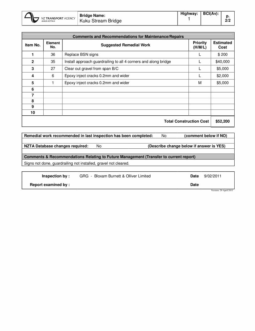
Bridge Name:
Kuku Stream Bridge
Highway:
1 BCI(Av):
p. 2/2
Comments and Recommendations for Maintenance/Repairs
Item No. Element
No. Suggested Remedial Work
Priority (H/M/L)
Estimated Cost
1 36 Replace BSN signs L $ 200
2 35 Install approach guardrailing to all 4 corners and along bridge L $40,000
3 27 Clear out gravel from span B/C L $5,000
4 6 Epoxy inject cracks 0.2mm and wider L $2,000
5 1 Epoxy inject cracks 0.2mm and wider M $5,000
6
7
8
9
10
Total Construction Cost $52,200
Remedial work recommended in last inspection has been completed: No (comment below if NO)
NZTA Database changes required: No (Describe change below if answer is YES)
Comments & Recommendations Relating to Future Management (Transfer to current report)
Signs not done, guardrailing not installed, gravel not cleared.
Inspection by : GRG - Bloxam Burnett & Olliver Limited Date 9/02/2011
Report examined by :
Date
Version: 29 April 2011

Bridge Name:
Waikawa Bridge
Highway:
1 BCI(Av):
p. 1/2
Bridge Type: RC T-beam, monolithic abuts. Extent code A = No defect B = Not > 5% C = Moderate; 5 - 20% D = Wide; 20 - 50% E = > 50%
Severity code 1 = as new 2 = early signs of defect 3 = moderate defect 4 = severe defect 5 = element failed
BSN: 9915 Map Ref:
Deck width: /8.00m Owner:
Span: of Last Insp. date: 22/09/2009 Spans: 4/9.1 Last insp. by: GB
Total bridge length: 36.40m Report Type (G1/G2/D/S):
G2
Ext = Extent ; Sev = Severity Inspector: GRG Next Inspection: Maint.; S=Structural; R=Routine Date: 9/02/2011
Element Ext Sev S/R Brief description of fault and comments
Set No Description
Su
pers
tru
ctu
re
Ele
me
nts
1 Primary element C 3 S
Vertical cracking to beams up to 0.3mm wide, spall at B6 span B/C (small impact?), spall to B4 span B/C at B (200x200x50mm), and thin layer of concrete spalled off from soffit of B1 span C/D near C (1000x300x50mm).
2 Sec. ele- ment(s)
Transverse beams
3 Other A 1
4 Half joints
5 Seismic linkages
6 Parapet beam or cantilever C 3 S Several small spalls to soffit of LHS deck overhang
7 Cross bracing C 2 S Fine vertical cracking to end diaphragms.
Lo
ad
-beari
ng
S
ub
str
uc
ture
8 Foundations A 1
9 Abutments A 1
10 Head wall
11 Pier / column A 1
12 Cross-head / capping beam
13 Bearings A 1
14 Bearing plinth / shelf A 1
Du
rab
ilit
y
Ele
me
nts
15 Superstructure drainage A 1
16 Substructure drainage A 1
17 Movement / expansion joints A 1
18 Painting: Superstructure elements
19 Painting: substructure elements
20 Painting: barriers/guardrails A 1
Safe
ty
Ele
me
nts
21 Access / walkways / gantries
22 Guardrail / handrail / safety fences
A 1
23 Carriageway surfacing C 3 R Minor areas of seal breaking up on bridge and at approaches.
24 Footway / verge / footbridge surfacing
A 1
Wa
terw
ay
Ele
me
nts
25 Invert / river bed A 1
26 Aprons
27 Aggradation A 1
28 Degradation A 1
29 Scour C 3 S Large amount of trees and debris caught on pier D (see photo).
30 River banks A 1
Reta
inin
g
Ele
men
ts
31 Revetment / batter slope paving A 1
32 Wing walls C 3 R Erosion hole formed behind abutment E RHS wingwall (see photo)
33 Retaining walls
34 Embankments A 1
Oth
er
35 Approach rails / barriers / walls A 1
36 Signs A 1
37 Lighting
38 Services A 1
39 Graffiti A 1
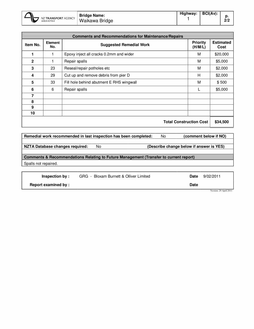
Bridge Name:
Waikawa Bridge
Highway:
1 BCI(Av):
p. 2/2
Comments and Recommendations for Maintenance/Repairs
Item No. Element
No. Suggested Remedial Work
Priority (H/M/L)
Estimated Cost
1 1 Epoxy inject all cracks 0.2mm and wider M $20,000
2 1 Repair spalls M $5,000
3 23 Reseal/repair potholes etc M $2,000
4 29 Cut up and remove debris from pier D H $2,000
5 33 Fill hole behind abutment E RHS wingwall M $ 500
6 6 Repair spalls L $5,000
7
8
9
10
Total Construction Cost $34,500
Remedial work recommended in last inspection has been completed: No (comment below if NO)
NZTA Database changes required: No (Describe change below if answer is YES)
Comments & Recommendations Relating to Future Management (Transfer to current report)
Spalls not repaired.
Inspection by : GRG - Bloxam Burnett & Olliver Limited Date 9/02/2011
Report examined by :
Date
Version: 29 April 2011
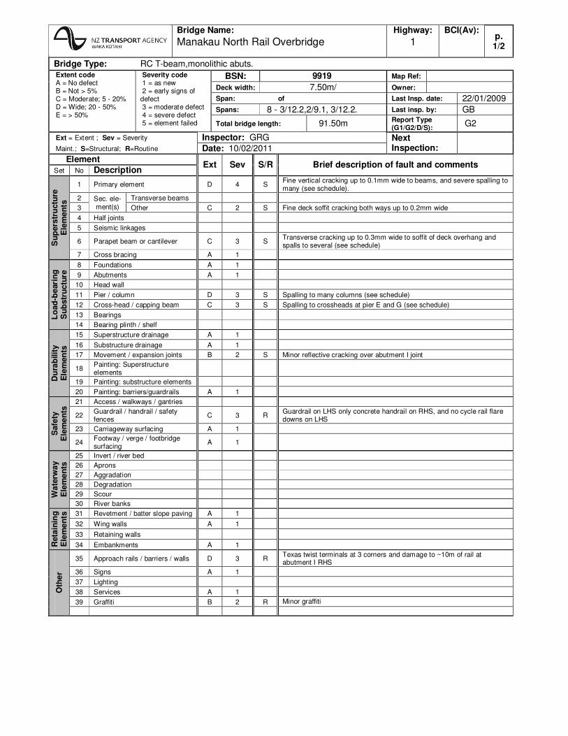
Bridge Name:
Manakau North Rail Overbridge
Highway:
1 BCI(Av):
p. 1/2
Bridge Type: RC T-beam,monolithic abuts. Extent code A = No defect B = Not > 5% C = Moderate; 5 - 20% D = Wide; 20 - 50% E = > 50%
Severity code 1 = as new 2 = early signs of defect 3 = moderate defect 4 = severe defect 5 = element failed
BSN: 9919 Map Ref:
Deck width: 7.50m/ Owner:
Span: of Last Insp. date: 22/01/2009 Spans: 8 - 3/12.2,2/9.1, 3/12.2. Last insp. by: GB
Total bridge length: 91.50m Report Type (G1/G2/D/S):
G2
Ext = Extent ; Sev = Severity Inspector: GRG Next Inspection: Maint.; S=Structural; R=Routine Date: 10/02/2011
Element Ext Sev S/R Brief description of fault and comments
Set No Description
Su
pers
tru
ctu
re
Ele
me
nts
1 Primary element D 4 S Fine vertical cracking up to 0.1mm wide to beams, and severe spalling to many (see schedule).
2 Sec. ele- ment(s)
Transverse beams
3 Other C 2 S Fine deck soffit cracking both ways up to 0.2mm wide
4 Half joints
5 Seismic linkages
6 Parapet beam or cantilever C 3 S Transverse cracking up to 0.3mm wide to soffit of deck overhang and spalls to several (see schedule)
7 Cross bracing A 1
Lo
ad
-be
ari
ng
S
ub
str
uc
ture
8 Foundations A 1
9 Abutments A 1
10 Head wall
11 Pier / column D 3 S Spalling to many columns (see schedule)
12 Cross-head / capping beam C 3 S Spalling to crossheads at pier E and G (see schedule)
13 Bearings
14 Bearing plinth / shelf
Du
rab
ilit
y
Ele
men
ts
15 Superstructure drainage A 1
16 Substructure drainage A 1
17 Movement / expansion joints B 2 S Minor reflective cracking over abutment I joint
18 Painting: Superstructure elements
19 Painting: substructure elements
20 Painting: barriers/guardrails A 1
Safe
ty
Ele
me
nts
21 Access / walkways / gantries
22 Guardrail / handrail / safety fences
C 3 R Guardrail on LHS only concrete handrail on RHS, and no cycle rail flare downs on LHS
23 Carriageway surfacing A 1
24 Footway / verge / footbridge surfacing
A 1
Wa
terw
ay
Ele
me
nts
25 Invert / river bed
26 Aprons
27 Aggradation
28 Degradation
29 Scour
30 River banks
Reta
inin
g
Ele
me
nts
31 Revetment / batter slope paving A 1
32 Wing walls A 1
33 Retaining walls
34 Embankments A 1
Oth
er
35 Approach rails / barriers / walls D 3 R Texas twist terminals at 3 corners and damage to ~10m of rail at abutment I RHS
36 Signs A 1
37 Lighting
38 Services A 1
39 Graffiti B 2 R Minor graffiti
Bridge Name:
Manakau North Rail Overbridge
Highway:
1 BCI(Av):
p. 2/2
Comments and Recommendations for Maintenance/Repairs
Item No. Element
No. Suggested Remedial Work
Priority (H/M/L)
Estimated Cost
1 35 Install complying terminals at 3 corners M $30,000
2 35 Replace 10m of guardrail L $2,000
3 22 Install guardrail along RHS M $20,000
4 12 Repair spalls M $1,000
5 11 Repair spalls H $30,000
6 6 Repair spalls L $1,200
7 6 Epoxy inject cracks 0.2mm and wider L $20,000
8 1 Repair spalls H $35,000
9 22 Install 2 cycle flare downs L $1,000
10
Total Construction Cost $140,200
Remedial work recommended in last inspection has been completed: No (comment below if NO)
NZTA Database changes required: Yes (Describe change below if answer is YES)
Guardrail amended
Comments & Recommendations Relating to Future Management (Transfer to current report)
Guardrail not done, spalls not repaired.
Inspection by : GRG - Bloxam Burnett & Olliver Limited Date 10/02/2011
Report examined by :
Date
Version: 29 April 201