Manakau & Ohau Villages Scheme Assessment Report · 2015-06-17 · C 26/11/13 Draft for...
161
Manakau & Ohau Villages Scheme Assessment Report Prepared for NZ Transport Agency November 2013
Transcript of Manakau & Ohau Villages Scheme Assessment Report · 2015-06-17 · C 26/11/13 Draft for...

Manakau & Ohau Villages
Scheme Assessment Report
Prepared for NZ Transport Agency
November 2013

Manakau & Ohau Scheme Assessment Report
Status: Draft for Consultation Project No.: 80500902 November 2013 Our ref: Manukau_Ohau_SAR_Draft for Consultation.docx
This document has been prepared for the benefit of NZ Transport Agency. No liability is accepted by this company or any employee or sub-consultant of this company with respect to its use by any other person.
This disclaimer shall apply notwithstanding that the report may be made available to other persons for an application for permission or approval to fulfil a legal requirement.
QUALITY STATEMENT
PROJECT MANAGER PROJECT TECHNICAL LEAD
Jon England Phil Peet
PREPARED BY
………………………………............... 16/10/13
Jamie Povall, Dhimantha Ranatunga, Caroline Van Halderen, Martin Hoffmann
CHECKED BY
………………………………............... 17/10/13 Phil Peet
REVIEWED BY
………………………………...... ......... 22/10/13 Marten Oppenhuis
APPROVED FOR ISSUE BY
………………………………............... 24/10/13… Phil Peet
CHRISTCHURCH Hazeldean Business Park, 6 Hazeldean Road, Addington, Christchurch 8024 PO Box 13-249, Armagh, Christchurch 8141 TEL +64 3 366 7449, FAX +64 3 366 7780
REVISION SCHEDULE
Rev No
Date Description Signature or Typed Name (documentation on file).
Prepared by Checked by Reviewed by Approved by
B 19/11/13 Update: following client review
JP PP PP
C 26/11/13 Draft for Consultation JP, DR PP PP

Manakau & Ohau Scheme Assessment Report
Status: Draft for Consultation November 2013 Project number: 80500902 Our ref: Manukau_Ohau_SAR_Draft for Consultation.docx
Executive Summary This primary objective of this Scheme Assessment Report (SAR) is to develop the options and recommendations of the Project Feasibility Reports (PFRs) undertaken for both Manakau and Ohau in 2013, these considered a variety of safety and traffic management improvements that could be undertaken for both the villages.
This report further develops those two previous reports and combines the investigations into a single SAR. The project scope involves developing a scheme stage design for both of the villages that will achieve a variety of safety and traffic management benefits in the short term, prior to any potential four -laning in the long term.
Both villages have experienced some crashes though the actual observed crash history is not considered to be severe. Both villages nevertheless have medium-high collective crash risk. Furthermore, in the public consultation undertaken to date, the communities have raised concern regarding the perceived road safety through the villages including vehicle speeds and a lack of crossing opportunities.
This SAR therefore considers the options identified in the previous PFRs and develops some of these options into a scheme stage design. The general package of improvements through both villages have taken the form of:
Improved road cross-section, including wider sealed shoulders, traffic lanes, flush median and kerb and
channel provision
Reduced 80km/h posted speed limit through both villages
Threshold entry treatments with village and speed signage and physical narrowing
Improved pedestrian provision including a number of safety footpaths
Removal of existing passing lanes on the approach to both villages
Improved turning facilities to side roads through right turn bays
Following the PFR investigations, the NZ Transport Agency is eager to identify and progress improvement measures that will provide immediate improvement to the villages but that can be achieved without the acquisition of significant portions of land (given time and cost impacts).
A number of other measures were considered at PFR stage. However they have been discounted for a variety of reasons such as cost, land requirement or not being considered essential.
The proposed improvements have been economically evaluated and the following Benefit Cost Ratios derived:
Table 1-1: Calculated Benefit Cost Ratios
Option Expected
Estimate ($M) NPV Benefits
($M) Benefit Cost Ratio1
Ohau Township (5 year crash history) 3.75 4.56 1.5
Ohau Township (10 year crash history) 3.75 7.25 2.3
Manakau Township (5 year crash history) 3.21 2.39 0.8
(3.3 including the 2013 fatal)
Manakau Township (10 year crash history) 3.21 3.27 1.2
Whilst the calculated BCRs are not significant, they do demonstrate that the village safety improvement projects provide a level of economic efficiency which is a positive result for projects of this nature. The sensitivity of the BCRs is clearly demonstrated by the 10 year crash history and the 2013 Manakau fatal crash.
It is recommended that the NZ Transport Agency progress the safety improvements for both Manakau and Ohau villages, noting the critical importance of the timing of the passing lane removal and the direct effect on the village and fringe improvements. Consultation with the public and stakeholders is programmed and this will help the NZTA and HDC decide how and when to proceed.
1 Benefit Cost Ratio for a 40 year analysis period, 6% discount rate.

Manakau & Ohau Scheme Assessment Report
Status: Draft for Consultation November 2013 Project No.: 80500902 Our ref: Manukau_Ohau_SAR_Draft for Consultation.docx
NZ Transport Agency
Manakau & Ohau Villages Scheme Assessment Report
CONTENTS
Executive Summary ................................................................................................................................... i
1 Introduction ......................................................................................................................................... 1
1.1 Scheme Assessment Report Objective ......................................................................................... 1
1.2 Project Background ....................................................................................................................... 1
1.2.1 Project Feasibility Report Recommendations ......................................................................... 2
1.3 Objectives and Scope .................................................................................................................... 2
1.3.1 Project Scope.......................................................................................................................... 2
2 Problem Description ........................................................................................................................... 3
2.1 Ōtaki to North of Levin ................................................................................................................... 3
2.2 Manakau Village ............................................................................................................................ 3
2.3 Ohau Village .................................................................................................................................. 4
3 Site Description .................................................................................................................................. 5
3.1 Manakau Village ............................................................................................................................ 5
3.2 Ohau Village .................................................................................................................................. 7
4 Investigation Results ........................................................................................................................ 10
4.1 Traffic Data .................................................................................................................................. 10
4.1.1 Traffic Composition ............................................................................................................... 11
4.2 Speed Limit Review & Traffic Surveys ......................................................................................... 12
4.2.1 Manakau Speed Limit Warrant ............................................................................................. 12
4.2.2 Ohau Speed Limit Warrant ................................................................................................... 12
4.2.3 Traffic Surveys ...................................................................................................................... 12
4.2.3.1 Manakau ....................................................................................................................... 12
4.2.3.2 Speed Surveys .............................................................................................................. 14
4.2.4 Traffic Modelling ................................................................................................................... 16
4.3 Crash Data................................................................................................................................... 17
4.3.1 Manakau ............................................................................................................................... 17
4.3.2 Ohau ..................................................................................................................................... 19
4.3.2.1 Ohau Northbound Passing Lane ................................................................................... 22
4.3.3 Crash Risk: Manakau ............................................................................................................ 22
4.3.3.1 Crash Risk: SH1 / Mokena Kohere Street Intersection ................................................. 23
4.3.3.2 Crash Risk: Other Manakau Intersections ..................................................................... 24
4.3.4 Crash Risk: Ohau .................................................................................................................. 24
4.3.4.1 Crash Risk: SH1 / Victoria Terrace Intersection ............................................................ 25
4.3.4.2 Crash Risk: SH1 / Muhunoa East & West Road Intersection ........................................ 25

Manakau & Ohau Scheme Assessment Report
Status: Draft for Consultation November 2013 Project No.: 80500902 Our ref: Manukau_Ohau_SAR_Draft for Consultation.docx
4.3.4.3 Crash Risk: Other Ohau Intersections ........................................................................... 26
4.4 Geotechnical Testing ................................................................................................................... 26
4.4.1 Manakau ............................................................................................................................... 27
4.4.2 Ohau ..................................................................................................................................... 27
5 Stakeholder Relationship Management and Consultation ................................................................ 28
5.1 Public Consultation ...................................................................................................................... 28
Manakau ........................................................................................................................................... 28
5.2 KiwiRail ........................................................................................................................................ 29
5.3 Ministry of Education ................................................................................................................... 30
5.4 Iwi ................................................................................................................................................ 30
5.5 Others .......................................................................................................................................... 30
6 Improvements Description ................................................................................................................ 30
6.1 Manakau Village Main Improvements .......................................................................................... 30
6.1.1 Posted Speed Limit & Threshold Treatment ......................................................................... 30
6.1.2 Pedestrian and Cycle Facilities ............................................................................................. 31
6.1.3 Side Friction .......................................................................................................................... 31
6.1.4 Side Roads ........................................................................................................................... 32
6.1.4.1 Honi Taipua Street (rail underpass) (RP 985/8.98) ....................................................... 32
6.1.4.2 Mokena Kohere Street (RP 985/8.49) ........................................................................... 33
6.1.4.3 Waikawa Beach Road (RP 985/8.12) ............................................................................ 33
6.1.5 Cross Movements ................................................................................................................. 33
6.1.6 Heavy Vehicle Volumes ........................................................................................................ 34
6.1.7 Cross Section and Shoulder Width ....................................................................................... 34
6.1.8 Proximity of Lighting and Power Poles to Carriageway ........................................................ 35
6.1.9 North Island Main Trunk Railway .......................................................................................... 35
6.1.10 Land Requirement ................................................................................................................ 36
6.2 Manakau Village Fringe Improvements ....................................................................................... 36
6.2.1 Southbound Passing Lane .................................................................................................... 36
6.3 Ohau Village Main Improvements ................................................................................................ 37
6.3.1 Posted Speed Limit & Threshold Treatment ......................................................................... 37
6.3.2 Pedestrian and Cycle Facilities ............................................................................................. 37
6.3.3 Side Friction .......................................................................................................................... 38
6.3.4 Side Roads ........................................................................................................................... 38
6.3.4.1 Muhunoa Road East & West (RP 985/1.84) .................................................................. 38
6.3.4.2 Victoria Terrace (RP 985/1.62) ..................................................................................... 39
6.3.4.3 Marsden Terrace (RP 985/1.41) .................................................................................... 39
6.3.4.4 Vista Road (RP 985/0.99) ............................................................................................. 40
6.3.5 Heavy Vehicle Volumes ........................................................................................................ 40
6.3.6 Cross Section and Shoulder Width ....................................................................................... 40
6.3.7 South of Vista Road Horizontal Curve .................................................................................. 41

Manakau & Ohau Scheme Assessment Report
Status: Draft for Consultation November 2013 Project No.: 80500902 Our ref: Manukau_Ohau_SAR_Draft for Consultation.docx
6.3.8 Proximity of Lighting and Power Poles to Carriageway ........................................................ 41
6.3.9 Edge Protection .................................................................................................................... 42
6.3.10 Land Requirement ................................................................................................................ 42
6.4 Ohau Village Fringe Improvements ............................................................................................. 43
6.4.1 Northbound Passing Lane .................................................................................................... 43
6.4.2 SH1 Horizontal Curve (Bishops Road).................................................................................. 43
6.4.3 Bishops Road (RP 985/2.27) ................................................................................................ 44
6.4.4 Parakawau Road (RP 985/2.63) ........................................................................................... 44
7 Summary of Improvements ............................................................................................................... 45
7.1 Manakau Village .......................................................................................................................... 45
7.2 Ohau Village ................................................................................................................................ 45
8 Social and Environmental Management ........................................................................................... 45
9 Resource Management Issues ......................................................................................................... 46
9.1 District Plan Provisions ................................................................................................................ 46
9.1.1 Designations ......................................................................................................................... 46
9.1.2 Heritage Issues ..................................................................................................................... 46
9.1.3 Contaminated Site ................................................................................................................ 47
9.1.4 Other Provisions ................................................................................................................... 47
9.2 Regional Plan Provisions ............................................................................................................. 47
9.3 Other Provisions .......................................................................................................................... 47
10 Evaluation ......................................................................................................................................... 48
10.1 Cost Estimates............................................................................................................................. 48
10.2 Manakau Economic Evaluation.................................................................................................... 48
10.2.1 Basis of Analysis ................................................................................................................... 48
10.2.2 Crash Benefits ...................................................................................................................... 49
10.2.3 Maintenance Costs ............................................................................................................... 49
10.2.4 Passing Lane Removal ......................................................................................................... 49
10.2.5 Benefit Cost Ratio ................................................................................................................. 50
10.2.5.1 Sensitivity Testing ..................................................................................................... 50
10.3 Ohau Economic Evaluation ......................................................................................................... 51
10.3.1 Basis of Analysis ................................................................................................................... 51
10.3.2 Crash Benefits ...................................................................................................................... 51
10.3.3 Maintenance Costs ............................................................................................................... 52
10.3.4 Passing Lane Removal ......................................................................................................... 52
10.3.5 Benefit Cost Ratio ................................................................................................................. 52
10.3.5.1 Sensitivity Testing ..................................................................................................... 53
10.3.6 Intangible Benefits ................................................................................................................ 53
10.4 Assessment Profile ...................................................................................................................... 54
10.4.1 Strategic Fit ........................................................................................................................... 54
10.4.2 Effectiveness ........................................................................................................................ 54

Manakau & Ohau Scheme Assessment Report
Status: Draft for Consultation November 2013 Project No.: 80500902 Our ref: Manukau_Ohau_SAR_Draft for Consultation.docx
10.4.3 Efficiency .............................................................................................................................. 54
11 Risk Management ............................................................................................................................. 55
12 Discussion of Options ....................................................................................................................... 56
13 Conclusions and Recommendations ................................................................................................ 56
LIST OF TABLES
Table 1-1: Calculated Benefit Cost Ratios ................................................................................................. i
Table 3-1: Side Road Characteristics for Manakau Village ........................................................................ 7
Table 3-2: Side Road Characteristics for Ohau Village ........................................................................... 10
Table 4-1: Comparison of Traffic Growth Rates ....................................................................................... 11
Table 4-2: Mokena Kohere Street and Honi Taipua Street Intersection Volumes.................................. 12
Table 4-3: Railway underpass/Honi Taipua Street Intersection ............................................................. 13
Table 4-4: Manakau and Ohau Speed Survey Results .......................................................................... 14
Table 4-5: Saturn Base 2011/2041 Network Modelling Results ............................................................... 16
Table 4-6: Annual Distribution of Crashes 2008-2012 ............................................................................. 17
Table 4-7: CAS Crash Type ..................................................................................................................... 17
Table 4-8: HRRRG Crash Type ............................................................................................................... 18
Table 4-9: Crash Causation Factors of Reported Injury Crashes ............................................................ 18
Table 4-10: Environmental Factors .......................................................................................................... 18
Table 4-11: Annual Distribution of Crashes, 2003-2007 .......................................................................... 19
Table 4-12: Annual Distribution of Crashes 2008-2012 ........................................................................... 20
Table 4-13: CAS Crash Type ................................................................................................................... 20
Table 4-14: HRRRG Crash Type ............................................................................................................. 20
Table 4-15: Crash Causation Factors of Reported Injury Crashes .......................................................... 21
Table 4-16: Environmental Factors .......................................................................................................... 21
Table 4-17: Annual Distribution of Crashes 2003-2007 ........................................................................... 22
Table 4-18: Estimation of F&S Collective Risk Using Severity Index SH1 Mokena Kohere Street Intersection .............................................................................................................................................. 23
Table 4-19: Estimation of F&S Collective Risk Using Severity Index SH1 / Victoria Terrace Intersection 25
Table 4-20: Estimation of F&S Collective Risk Using Severity Index SH1 / Muhunoa East & West Road Intersection .............................................................................................................................................. 26
Table 4-21: Geology and CBR values for Manakau and Ohau Villages .................................................. 27
Table 10-1: Scheme Estimates ................................................................................................................ 48
Table 10-2: Manakau Economic Analysis Assumptions ........................................................................... 48
Table 10-3 : Benefits - crash costs annual and discounted (30 years at 8%) .......................................... 49
Table 10-4 : Manakau Sensitivity Testing (30 years at 8%) ..................................................................... 50
Table 10-5: Ohau Economic Analysis Assumptions................................................................................. 51
Table 10-6 : Benefits - crash costs annual and discounted (30 years at 8%) .......................................... 52
Table 10-7 : Ohau Sensitivity Testing (30 years at 8%) ........................................................................... 53

Manakau & Ohau Scheme Assessment Report
Status: Draft for Consultation November 2013 Project No.: 80500902 Our ref: Manukau_Ohau_SAR_Draft for Consultation.docx
Table 11-1 : Project Risk Register Extract ............................................................................................... 55
LIST OF FIGURES
Figure 3-1: Manakau Village Study Area Location Plan ............................................................................. 6
Figure 3-2: Ohau Village Study Area Location Plan (fringe not shown) ..................................................... 9
Figure 4-1: Traffic Growth along SH1 near Ohau .................................................................................... 11
Figure 4-2: Traffic Composition along SH1 near Ohau ............................................................................ 11
Figure 4-3: Map of Manakau Village showing the five survey sites ......................................................... 14
Figure 4-4: Manakau village – speeds by vehicle class ........................................................................... 15
Figure 4-5: Ohau village – speeds by vehicle class ................................................................................. 15
Figure 6-1: Typical Section in Manakau ................................................................................................... 35
Figure 6-2: Typical Section in Ohau ......................................................................................................... 41
Figure 13-1: Locality Plan ........................................................................................................................ 58
APPENDICES
Appendix A Locality Plan .................................................................................................................. 58
Appendix B Traffic Data .................................................................................................................... 59
Appendix C Crash Data .................................................................................................................... 60
Appendix D Scheme Drawings ......................................................................................................... 61
Appendix E Preliminary Design Philosophy Statement .................................................................... 62
Appendix F Scheme Pavement Design ............................................................................................ 66
Appendix G Preliminary Land Requirement Plan(s) ......................................................................... 67
Appendix H Ohau Speed Limit Warrant ............................................................................................ 68
Appendix I Manakau Speed Limit Warrant .......................................................................................... 69
Appendix J Proposed Geotechnical Testing Schedule .................................................................... 70
Appendix K Project Risk Register ..................................................................................................... 71
Appendix L Economic Evaluation Worksheets ................................................................................. 72
Appendix M Social and Environmental Assessment ......................................................................... 73
Appendix N Scheme Estimates ........................................................................................................ 74

Manakau & Ohau Scheme Assessment Report
Status: Draft for Consultation November 2013 Project No.: 80500902 Page 1 Our ref: Manukau_Ohau_SAR_Draft for Consultation.docx
1 Introduction
1.1 Scheme Assessment Report Objective
This Scheme Assessment Report (SAR) is provided to develop the safety and traffic management proposals for the villages of Manakau and Ohau. This report follows on from the Project Feasibility Reports (PFRs) undertaken by MWH for both villages in February 2013. The PFRs considered each village separately whereas for this SAR they have been combined into a single report (to avoid repeating commonality).
1.2 Project Background
Using the outcomes of the Ōtaki to north of Levin Scoping Report and Addendum, the NZTA decided that the most appropriate strategy for the highway between Ōtaki and north of Levin is to upgrade the existing highways as the first stage of a long term strategy. This allows the NZTA to rea lise important safety benefits in the short to medium term whilst deferring the need to construct four lanes for the time being.
This Scheme Assessment Report (SAR) is one of a number of reports being undertaken to determine the package of improvements that should be implemented to improve the safety and efficiency of the highway between Ōtaki to north of Levin as part of the Wellington Northern Corridor Road of National Significance (RoNS).
The objectives of the Wellington Northern Corridor RoNS, which runs from Wellington Airport to north of Levin, are:
To enhance inter regional and national economic growth and productivity;
To improve access to Wellington’s CBD, key industrial and employment centres, port, airport
and hospital;
To provide relief from severe congestion on the state highway and local road networks;
To improve the journey time reliability of travel on the section of SH1 between Levin and the
Wellington Airport; and
To improve the safety of travel on state highways.
For the Ōtaki to north of Levin section; the objectives are:
To provide best value solutions which will progressively meet (via a staged approach) the long
term RoNS goals for this corridor of achieving a high quality four lane route;
To provide better Levels of Service, particularly for journey time and safety, between north of
Ōtaki and north of Levin;
To remove or improve at grade intersections between north of Ōtaki and north of Levin;
To engage effectively with key stakeholders; and
To lodge Notices of Requirement and resource consents as appropriate with the relevant
consent authorities for the first individual project by the 2013/14 financial year.
The projects that are being developed to help meet these objectives are presented in Section 2.
The purpose of this report is to further develop the feasibility stage proposals to scheme stage detail for a variety of safety improvements on the section of State Highway 1 through the villages of Manakau and Ohau.
The geographical extent of the project through Manakau is for approximately 1.7 km of State Highway 1 (SH1), from south of Honi Taipua Street to south of North Manakau Road (RP 985/7.52 to RP 985/9.22). The geographical extent of the project through Ohau is for approximately 2.1 km of State Highway 1 (SH1), from south of McLeavey Road to south of Parakawau Road (RP 985/0.80 to RP 985/2.90)
The outcome of this SAR will be considered alongside the outcomes of the other SARs and used to determine the best package of works to progress as the first stage towards the long term strategy.
Manakau & Ohau Scheme Assessment Report
Status: Draft for Consultation November 2013 Project No.: 80500902 Page 2 Our ref: Manukau_Ohau_SAR_Draft for Consultation.docx
Whilst the safety improvements will provide benefits in the short to medium term, it is also necessary to note the effects of the longer term proposals. This is particularly true in Ohau where options for the connection of SH1 and SH57 are currently being investigated and could result in four laning of the highway through Ohau Village or alternatively the connection being made further south and the four laning thereby bypassing the Village.
1.2.1 Project Feasibility Report Recommendations
Two project Feasibility Reports (PFRs) (one for Manakau and one for Ohau) were undertaken by MWH in February 2013 as part of a number of reports being undertaken to determine the package of improvements that should be implemented between Ōtaki and north of Levin.
The recommendations of the PFRs are summarised below:
The economic result for Manakau Village indicates that all improvements are viable as a
package, underpinned by an 80 km/h speed limit, and this is recommended to be taken forward
into the SAR phase.
It is recommended (based on the economic results) that all the improvements minus the
horizontal curve realignment are a viable package for Ohau Village and should be taken forward
into the SAR phase, whilst also testing whether inclusion of the horizontal curve improvement is
still warranted.
Since the PFR investigations were undertaken, the NZ Transport Agency has confirmed their preference for the SAR to consider measures from the PFR stage that can be implemented within the current highway boundary, thereby avoiding the need for land acquisi tion. As such certain measures considered in the PFR have not been progressed through to the SAR stage (discussed in greater detail in section 6).
1.3 Objectives and Scope
The primary project objective is to reduce the number of deaths and serious injuries between Ōtaki and north of Levin by investing in cost effective treatments that promote a ‘Safe System’; focusing on providing safer roads and roadsides, and safe speeds.
1.3.1 Project Scope
The SAR scope is to investigate the PFR findings more fully and to recommend a firm way forward. The project extent is the section of State Highway 1 that runs through Manakau Village and Ohau Village. This project is set up in two sections:
Manakau Village: Includes approximately 1.3 km of State Highway 1 (SH1), from south of Honi
Taipua Street to north of Waikawa Beach Road. A ‘fringe’ section is also included north of
Manakau that includes the existing passing lane, with a section length of approximately 400m.
Ohau Village: Includes approximately 1.3 km of State Highway 1 (SH1), from south of
McLeavey Road to north of Bishops Road. A ‘fringe’ section is also included south of Ohau that
includes the existing short passing lane, with a section length of approximately 800m. In this
section, traffic management features can take advantage of the seal width.
A variety of road safety and traffic management improvement options were considered for Ohau Village, for which benefits and costs were determined. The options considered included;

Manakau & Ohau Scheme Assessment Report
Status: Draft for Consultation November 2013 Project No.: 80500902 Page 3 Our ref: Manukau_Ohau_SAR_Draft for Consultation.docx
Manakau
Village Improvements
reducing the speed limit through Manakau Village to 80 km/h;
installing threshold treatments at either end of the village;
widening the highway to install a flush median and wider shoulders;
closing (or restricting movements at) the intersection at Honi Taipua Street and redirecting traffic to the safer, more efficient T junction of Mokena Kohere Street; and
alterations of the Mokena Kohere Street intersection with SH1 to provide greater separation between the highway and the railway.
Fringe Improvements
removing the southbound passing lane to the north of the village;
Ohau
Village Improvements:
reducing the speed limit through Ohau Village to 80 km/h;
installing threshold treatments at either end of the village;
widening the highway to install a flush median and wider shoulders;
consideration of layout improvements at Muhunoa East / West Road intersection with SH1;
closing Vista and Victoria Terrace intersections (requires a new link road within the local network) with SH 1
Fringe Improvements:
removing the northbound passing lane to the south of the village;
improving or relocating Bishops Road intersection; and
improving horizontal curves – one just south of the village and the other between Marsden Terrace and Vista Road (rail would also need to be shifted).
2 Problem Description
2.1 Ōtaki to North of Levin
State Highway 1 and State Highway 57 through the study area have a number of deficiencies, resulting in a poor crash history and a number of locations where the free flow of vehicles is restricted by the physical characteristics of the highway. State Highway 1 currently follows the historic route established in the late 19th and early 20th centuries. As a consequence it is constrained by a now substandard alignment, towns and villages, narrow curved bridges and significant side friction caused by local roads, commercial frontages and property accesses for the entire stretch.
2.2 Manakau Village
The section of SH1 under consideration in this SAR is approximately 1.3km in length, from south of Honi Taipua Street railway underpass link to north of Waikawa Beach Road, running through Manakau Village. In addition, this SAR also includes a further ‘fringe’ length of 400m which includes the short southbound passing lane to the north of the village. The key issues to be addressed by improvement works relate mostly to the safety and comfort of the community of Manakau and local area traffic. The key factors and constraints considered in this SAR are:
Manakau & Ohau Scheme Assessment Report
Status: Draft for Consultation November 2013 Project No.: 80500902 Page 4 Our ref: Manukau_Ohau_SAR_Draft for Consultation.docx
Posted speed limit, 100 km/h limit through the village, and the incompatibility of the end of the southbound passing lane with the north end of the village.
Vehicle speed problems exacerbated by the southbound passing lane terminating shortly before the village.
Pedestrians and cyclists – no facilities at present.
Side roads.
Side friction.
Nature of commercial development (separated from village, see following point) and off road parking availability.
Movements across the highway from the village to the shops, particularly the dairy.
Increasing heavy vehicle volumes.
Deficient level crossing separation - railway to limit line distance on Mokena Kohere Street (currently 16 m).
No storage for vehicles turning left onto Mokena Kohere Street when rail crossing barriers are down, leaving them exposed to traffic having just merged at the end of the passing lane. Also HCVs exiting will overhang the railway line.
Cross Section (turning movements and pedestrian/cycle provision).
Waikawa Beach Rd intersection 125 m before the end of the passing lane.
Steep shoulder to the south of and opposite Honi Taipua Street.
Power poles close to the road, particularly opposite Honi Taipua Street on steep shoulder.
2.3 Ohau Village
The section of SH1 under consideration in this SAR is approximately 1.3km in length, from north of Bishops Road to south of McLeavey Road, running through the Ohau village. In addition, this SAR also includes a further ‘fringe’ length of 800m which includes the short northbound passing lane to the south of the village (which begins south of Parakawau Road).
The key issues that are being considered for improvement are:
Northbound passing lane leading into village (approx. 740 m long including tapers).
Speed; 100 km/h posted speed zone conflicts with safety and village identity.
Pedestrian and cyclist facilities generally limited.
Side friction; residential and retail/commercial development close to roadside.
Many side roads.
Split community due to the severance effect of SH1
High number of vehicles crossing the highway.
Increasing heavy vehicle volumes.
Short distance between limit line and railway line on Bishops Road (currently 15 m).
Narrow cross section; including narrow shoulders.
Curve at Bishops Road deficient with approx. 400 m radius, which is also within the passing lane.
Deficient vertical crest curve at Marsden Terrace limiting sight distance.
Curve south of Vista Road deficient with approx. 330 m radius.
Close proximity of power poles to carriageway, especially in the village.

Manakau & Ohau Scheme Assessment Report
Status: Draft for Consultation November 2013 Project No.: 80500902 Page 5 Our ref: Manukau_Ohau_SAR_Draft for Consultation.docx
3 Site Description
3.1 Manakau Village
The project area consists of a 1.7 km length of SH 1 from south of the Honi Taipua Street railway underpass link to north of Waikawa Beach Road (RP 985/7.52-9.22 approx.). Of this total 1.7 km, around 1.3 km makes up the village works, with a further 0.4 km that constitute the fringe improvements.
Of the approximately 1.7 km project length, approx. 600 m is within the more built up part of Manakau.
The speed limit through the entire project area is 100 km/h.
The road is a two way undivided carriageway with 3.4 m lanes and generally a varying 0.6 to 1.7 m shoulder on either side; with further variation at the passing lane merge taper.
The road widens for a right turn bay into Mokena Kohere Street, and the southbound passing lane extends into the project area 125 m south of Waikawa Beach Road.
Figure 3-1, overleaf, shows the study area.

Manakau & Ohau Scheme Assessment Report
Status: Draft for Consultation November 2013 Project No.: 80500902 Page 6 Our ref: Manukau_Ohau_SAR_Draft for Consultation.docx
Figure 3-1: Manakau Village Study Area Location Plan
To Ōtaki
To Levin
NN
North Extent of village works
Southbound Passing Lane
Dairy
Rail Alignment
School
War Memorial Garden
Mokena Kohere St / SH1 Intersection
Fruit & Vege Shop
Former Methodist Church
Honi Taipua St / SH1 Intersection
South Extent of village works
Historic gates
Fringe works

Manakau & Ohau Scheme Assessment Report
Status: Draft for Consultation November 2013 Project No.: 80500902 Page 7 Our ref: Manukau_Ohau_SAR_Draft for Consultation.docx
There are three side roads within the study area (south to north) see Table 3-1 for side road characteristics.
Table 3-1: Side Road Characteristics for Manakau Village
Side Road ADT2 Comments
State Highway 1 Manakau Village
Waikawa Beach Road
(RP 985/8.12)
1035 vpd Connecting several blocks of urban, lifestyle and farming properties to SH1. Seasonal highs occur in summer.
Mokena Kohere Street
(RP985/8.49)
600 vpd Mokena Kohere provides access to Manakau School. Connects blocks of urban, retail, commercial, lifestyle and farming properties to SH1.
Honi Taipua Street (road under rail) (RP985/8.98)
250 vpd Connecting SH 1 to the Manakau village (Honi Taipua Street). This short one lane link passes under a restricted height rail underpass. Generally services residential in the vicinity of Manakau, with farming and agricultural areas outside the village.
State Highway 1 is bounded by the railway reserve immediately to the east, beyond which are the main residential streets of Manakau along with the school and other community land uses. The village road network accesses the highway at two locations; the bells and barrier protected level crossing at Mokena Kohere Street at the north end and the short railway underpass connection to Honi Taipua Street at the south end. On the eastern side of the railway is a siding and former fertiliser depot, but it appears that the siding is no longer used to offload and onload from the depot and the depot itself is no longer operating. The current and future use needs to be confirmed. To the west is a mixture of farm land, with a number of residential dwellings and several retail/commercial businesses.
There are no horizontal curves in the project area and the vertical geometry is relatively flat.
There are no dedicated cycling or walking facilities provided along or across State Highway 1.
It is noted that the Waiauti Stream Realignment has been recently completed just south of the village. The new alignment, whilst of a reasonable standard, does not meet RoNS guidelines and hence when four laning proceeds, redundancy of this recent investment (including a stream bridge) will potentially result.
3.2 Ohau Village
The project area consists of a 2.1 km length of SH 1 (RP 985/0.80 - 2.90). Of this total 2.1 km, around 1.3 km makes up the village works, with a further 0.8 km that constitute the fringe improvements.
Of the 2.1 km project area, approximately 300 m is within the more built-up part of Ohau Village.
The speed limit through the entire project area is currently 100 km/h.
There are two horizontal curves within the section and the vertical geometry is undulating, particularly towards the northern end of the section.
The vertical profile changes just after Muhunoa Road (East and West) intersection, when viewed in the northbound direction, to a climbing gradient of approximately 2%, flattening out again around Vista Road.
2
Local road flow counts were obtained using the data sourced from the latest available RCA RAMM records. It is also recognised that
the RCA RAMM flows for Honi Taipua Street seem to be significantly greater than the traffic counts undertaken as part of this SAR.

Manakau & Ohau Scheme Assessment Report
Status: Draft for Consultation November 2013 Project No.: 80500902 Page 8 Our ref: Manukau_Ohau_SAR_Draft for Consultation.docx
The road is a two way undivided carriageway with 3.5 to 3.6 m sealed lanes and variable but generally deficient sealed shoulders, particularly around the passing lane merge taper.
The road widens for a right turn bay into Muhunoa West Road and the passing lane.
There is a pedestrian underpass under SH 1 parallel to Muhunoa Road within the road reserve.
The North Island Main Trunk Railway runs to the east of SH 1 and through the village.
There is a rail underpass on Muhunoa East Road which is unsuitable for heavy or high profile vehicles. Figure 3-2, following, shows the study area.

Manakau & Ohau Scheme Assessment Report
Status: Draft for Consultation November 2013 Project No.: 80500902 Page 9 Our ref: Manukau_Ohau_SAR_Draft for Consultation.docx
Figure 3-2: Ohau Village Study Area Location Plan (fringe not shown)
There are four main intersections within the study area, all with priority control and closely spaced, see Table 3-2 for side road characteristics. Bishops Road and Parakawau Road are also considered in the report but not part of the village improvements proposals.
To Levin
NN
North Extent of village works
Rail Alignment
School
Store & Cafe
Rail underpass
Historic Baptist Church
Pedestrian underpass
Fringe works (southern extent not shown)
To Ōtaki
Marsden Terrace
South Extent of village works

Manakau & Ohau Scheme Assessment Report
Status: Draft for Consultation November 2013 Project No.: 80500902 Page 10 Our ref: Manukau_Ohau_SAR_Draft for Consultation.docx
Table 3-2: Side Road Characteristics for Ohau Village
Side Road ADT3 Comments
State Highway 1 Ohau Village
Vista Road (RP 985/0.99)
60 vpd 800 m long no-exit road serving several rural properties
Marsden Terrace (RP 985/1.41)
20 vpd Very small cul-de-sac connecting three residential dwellings to SH 1, with no vehicle through access to Wairiri Street, however there is a pedestrian link.
Victoria Terrace (RP 985/1.62)
205 vpd Connecting several blocks of urban and lifestyle properties to SH1 in the Ohau village.
Muhunoa East Road / Muhunoa West Road (RP 985/1.84)
860 / 630 vpd Muhunoa East Road: access to Ohau School, restricted 3.6m height rail underpass. Generally residential in the vicinity of Ohau, with farming and agricultural areas outside of the village. Muhunoa West Road: access to the main residential area also connects an area of farming and agriculture outside of the village.
State Highway 1 is bounded by the railway reserve immediately to the east for the northern part of the project area, before the railway deviates away from SH1 close to Marsden Terrace. The railway then remains offset from SH1 until close to the SH1 / Bishops Road intersection where SH1 and the railway line are parallel and side by side again.
A single lane road under rail bridge exists on Muhunoa East Road which is substandard and subject to a vehicle height restriction.
The majority of residential development currently exists on the western side of SH1 in Ohau, with a small amount of residential development and the school located on the eastern side of SH1. A relatively recent pedestrian underpass exists across SH1 connecting Muhunoa Road East and West.
4 Investigation Results
4.1 Traffic Data
The Annual Average Daily Traffic (AADT) flow at the NZTA telemetry count site at the Ohau Rail Overbridge, south of Ohau, (Count Site ID: 01N00988) was 14,300 vehicles per day (2012) with the proportion of Heavy Commercial Vehicles (HCVs) at 10%. The traffic volume within the Ohau Village will likely be higher than this on account of the school, residential dwellings and businesses as evidenced by the side road volumes above. The same is true of SH1 through Manakau Village. This local traffic movement has been considered as part of the safety improvements investigated.
The traffic growth rate at the Ohau count site is calculated to be 1.1%, using data from 1992 to 2012 (Refer Table 4-1 and Figure 4-1 below). Traffic volumes typically increased from 1992 to 2005; however since then volumes have remained generally stable (although the last 2-3 years have been tracking down).
3 Local road flow counts were obtained using the data sourced from the latest available RCA RAMM records.

Manakau & Ohau Scheme Assessment Report
Status: Draft for Consultation November 2013 Project No.: 80500902 Page 11 Our ref: Manukau_Ohau_SAR_Draft for Consultation.docx
Table 4-1: Comparison of Traffic Growth Rates
Count Site 2012 AADT
Historic Growth Rate 1992-2012
10 year Growth Rate 2003-2012
SH1 Ohau Telemetry 14,300 1.1% -0.3%
Figure 4-1: Traffic Growth along SH1 near Ohau
Annual average daily local road traffic volumes, obtained using the data sourced from the latest available RCA RAMM records, are outlined in Table 3-1 and Table 3-2. The impact of the global financial crisis is likely to have had an effect on traffic flow and growt h trends in recent years.
4.1.1 Traffic Composition
The 2012 traffic composition4 at the Ohau telemetry site has been assessed with the results outlined in Figure 4-2. Of the 10% total HCVs, 5% are large trucks longer than 17m (HCV2), with the remainder mainly smaller medium commercial vehicles.
Figure 4-2: Traffic Composition along SH1 near Ohau
4
The following classes are currently recorded: Cars (Light Vehicles – up to 5.5m), Light commercial vehicles (LCV, 50% of 5.5m to 11
m), Medium commercial vehicles (MCV, 50% of 5.5m to 11 m), Heavy commercial vehicles–I (HCV1, 11m – 17m), Heavy commercial
vehicles 2 (HCV2, >17m). Total heavy vehicles are the sum of MCV, HCV1 and HCV2.
y = 172.6x - 331630R² = 0.7358
8,000
9,000
10,000
11,000
12,000
13,000
14,000
15,000
16,000
1990 1995 2000 2005 2010
An
nu
al A
vera
ge D
aily
Tra
ffic
(vp
d)
Calendar Year
Traffic Growth 1992 to 2012Ohau Telemetry Site
OHAU - TelemetrySite 56 - OhauOverbridge
Linear (OHAU -Telemetry Site 56 -Ohau Overbridge)
0.4%
1.1%
0.1%
1.9%
-0.9%
-0.3%
-0.7%
0.2%
'03 - '12 '92 - '12
Traffic Growth Rate
Car, 12317, 86%
LCV, 545, 4%
MCV, 545, 4%
HCV1, 213, 1%
HCV2, 649, 5%
Heavy Vehicles, 1407, 10%
Traffic Composition Ohau Telemetry Site (2012)

Manakau & Ohau Scheme Assessment Report
Status: Draft for Consultation November 2013 Project No.: 80500902 Page 12 Our ref: Manukau_Ohau_SAR_Draft for Consultation.docx
4.2 Speed Limit Review & Traffic Surveys
4.2.1 Manakau Speed Limit Warrant
A speed limit warrant was undertaken for Manakau during the PFR stage, using the Speed Limits New Zealand (SLNZ)5 procedure for establishing speed limits. This is discussed in greater detail in Section 6.1.1 but was shown to warrant an 80km/h speed limit. The Manakau speed limit warrant can be found in Appendix I.
4.2.2 Ohau Speed Limit Warrant
The Ohau village was also assessed using the SLNZ procedure for establishing speed limits. Based on the analysis of 2012 NZTA survey data, a reduced 80 km/h speed limit from south of Levin to south of Ohau is warranted. Further discussion of reducing the speed limit in Ohau is outlined in Section 6.3.1. The Ohau speed limit warrant calculations can be found in Appendix H.
4.2.3 Traffic Surveys
4.2.3.1 Manakau
Traffic surveys, in the form of dual pneumatic tubes, were undertaken along Honi Taipua Street at the intersection of Mokena Kohere Street and the railway underpass in Manakau, as shown in Figure 4 -5 below. These surveys were undertaken to establish the movement patterns of heavy vehicles in and out of Manakau east. Due to the short distance between SH1 and local road (and hence low speeds) at both intersections, it was not possible to lay tubes down on the either Mokena Kohere Street west or the railway underpass leg. As a result, full turning count information could not be obtained. However, the data from the surveyed sites provides sufficient information to determine both the heavy vehicle counts and axle lengths, as well as providing an estimate of the movement patterns. Alternatives, including full video turning count surveys (Miovision) were initially considered but later discounted due to the high cost.
Table 4-2: Mokena Kohere Street and Honi Taipua Street Intersection Volumes
7 Day Volume Mokena Kohere Site
(Eastern leg) Honi Taipua Site 1 (North of School)
Honi Taipua Site 2 (South of School)
All Vehicles
Total Volume 1,791 232 1,835
Northbound/Westbound 856 115 861
Southbound/Eastbound 935 117 974
Heavy Vehicles6
Total heavy vehicles 34 2 68
Larger heavies (HCV2) 0 0 12
Heavy vehicles longer than 13m7
0 0 8
Table 4-2 above shows the volumes across each of the three surveyed sites at the intersection of Mokena Kohere Street and Honi Taipua Street.
5 http://www.nzta.govt.nz/resources/speed-limits/speed-limits-nz/speed-limits-nz.html 6 For the purposes of this analysis, which concentrated on the impact of longer heavy vehicles, ‘heavy vehicles’ were defined as only
those in the HCV1 and HCV2 classes. This ignores the medium commercial vehicles, as the average length of this class was less than
4 m. 7 Includes only those heavy vehicles longer than 13 m (the available stacking distance)
Manakau & Ohau Scheme Assessment Report
Status: Draft for Consultation November 2013 Project No.: 80500902 Page 13 Our ref: Manukau_Ohau_SAR_Draft for Consultation.docx
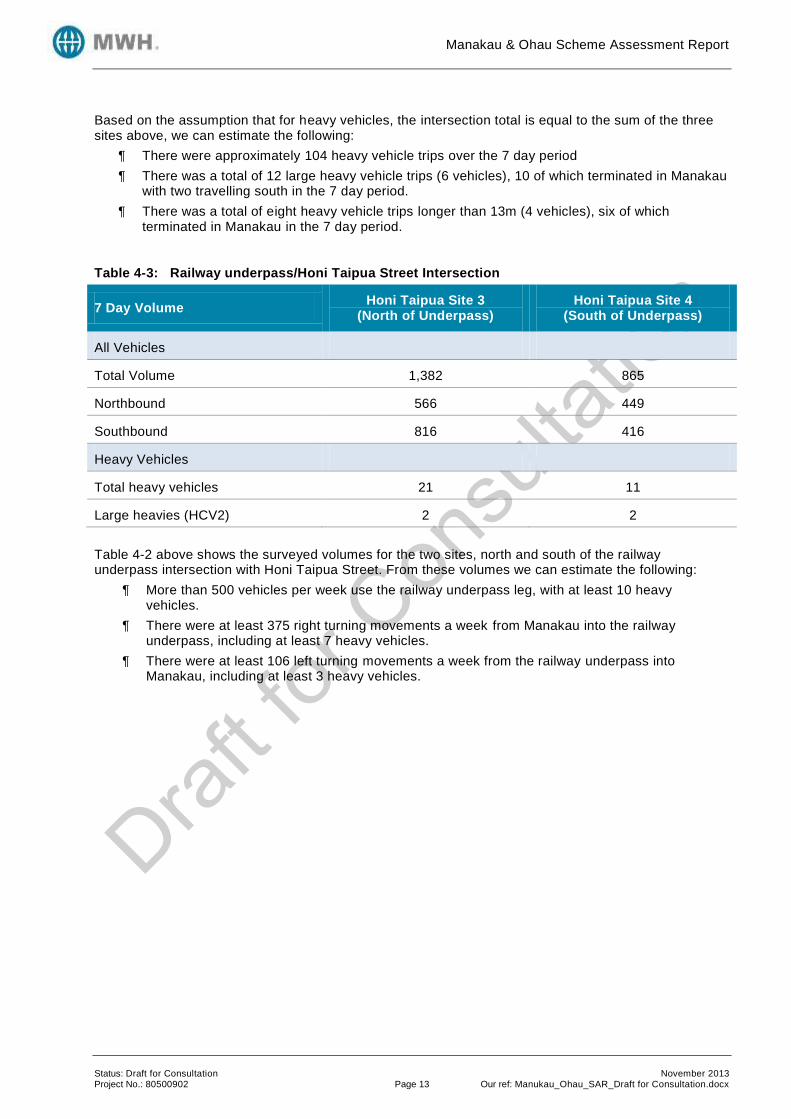
Based on the assumption that for heavy vehicles, the intersection total is equal to the sum of the three sites above, we can estimate the following:
There were approximately 104 heavy vehicle trips over the 7 day period
There was a total of 12 large heavy vehicle trips (6 vehicles), 10 of which terminated in Manakau with two travelling south in the 7 day period.
There was a total of eight heavy vehicle trips longer than 13m (4 vehicles), six of which terminated in Manakau in the 7 day period.
Table 4-3: Railway underpass/Honi Taipua Street Intersection
7 Day Volume Honi Taipua Site 3
(North of Underpass) Honi Taipua Site 4
(South of Underpass)
All Vehicles
Total Volume 1,382 865
Northbound 566 449
Southbound 816 416
Heavy Vehicles
Total heavy vehicles 21 11
Large heavies (HCV2) 2 2
Table 4-2 above shows the surveyed volumes for the two sites, north and south of the railway underpass intersection with Honi Taipua Street. From these volumes we can estimate the following:
More than 500 vehicles per week use the railway underpass leg, with at least 10 heavy vehicles.
There were at least 375 right turning movements a week from Manakau into the railway underpass, including at least 7 heavy vehicles.
There were at least 106 left turning movements a week from the railway underpass into Manakau, including at least 3 heavy vehicles.

Manakau & Ohau Scheme Assessment Report
Status: Draft for Consultation November 2013 Project No.: 80500902 Page 14 Our ref: Manukau_Ohau_SAR_Draft for Consultation.docx
Figure 4-3: Map of Manakau Village showing the five survey sites
Refer to Appendix B for further tube count information, including a breakdown by vehicle class, length and direction.
4.2.3.2 Speed Surveys
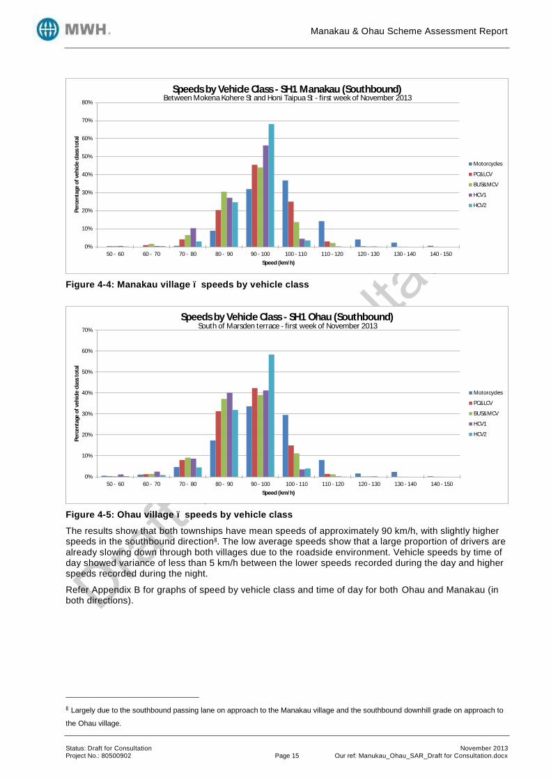
Establishing the existing traffic speeds through both villages is considered to be important and will influence the safety improvement proposals moving forward. Therefore speed surveys were undertaken for both villages with the results outlined in the Table 4-4 below, Figure 4-4 and Figure 4-5 overleaf.
Table 4-4: Manakau and Ohau Speed Survey Results
Location Mean Speed (km/h) 85th
Percentile Speed (km/h)
Manakau: Northbound 90 99
Manakau: Southbound 94 103
Ohau: Northbound 88 97
Ohau: Southbound 91 100
Honi Taipua Site 1
Mokena Kohere Site
Honi Taipua Site 2
Honi Taipua Site 3 North of underpass
Honi Taipua Site 4 South of underpass
13 m storage queue from giveway line to rail crossing (SH/railway)
Manakau & Ohau Scheme Assessment Report
Status: Draft for Consultation November 2013 Project No.: 80500902 Page 15 Our ref: Manukau_Ohau_SAR_Draft for Consultation.docx
Figure 4-4: Manakau village – speeds by vehicle class
Figure 4-5: Ohau village – speeds by vehicle class
The results show that both townships have mean speeds of approximately 90 km/h, with slightly higher speeds in the southbound direction8. The low average speeds show that a large proportion of drivers are already slowing down through both villages due to the roadside environment. Vehicle speeds by time of day showed variance of less than 5 km/h between the lower speeds recorded during the day and higher speeds recorded during the night.
Refer Appendix B for graphs of speed by vehicle class and time of day for both Ohau and Manakau (in both directions).
8 Largely due to the southbound passing lane on approach to the Manakau village and the southbound downhill grade on approach to
the Ohau village.
0%
10%
20%
30%
40%
50%
60%
70%
80%
50 - 60 60 - 70 70 - 80 80 - 90 90 - 100 100 - 110 110 - 120 120 - 130 130 - 140 140 - 150
Pe
rce
nta
ge o
f ve
hic
le c
lass
to
tal
Speed (km/h)
Speeds by Vehicle Class - SH1 Manakau (Southbound)
Motorcycles
PC&LCV
BUS&MCV
HCV1
HCV2
Between Mokena Kohere St and Honi Taipua St - first week of November 2013
0%
10%
20%
30%
40%
50%
60%
70%
50 - 60 60 - 70 70 - 80 80 - 90 90 - 100 100 - 110 110 - 120 120 - 130 130 - 140 140 - 150
Pe
rce
nta
ge o
f ve
hic
le c
lass
to
tal
Speed (km/h)
Speeds by Vehicle Class - SH1 Ohau (Southbound)
Motorcycles
PC&LCV
BUS&MCV
HCV1
HCV2
South of Marsden terrace - first week of November 2013
Manakau & Ohau Scheme Assessment Report
Status: Draft for Consultation November 2013 Project No.: 80500902 Page 16 Our ref: Manukau_Ohau_SAR_Draft for Consultation.docx
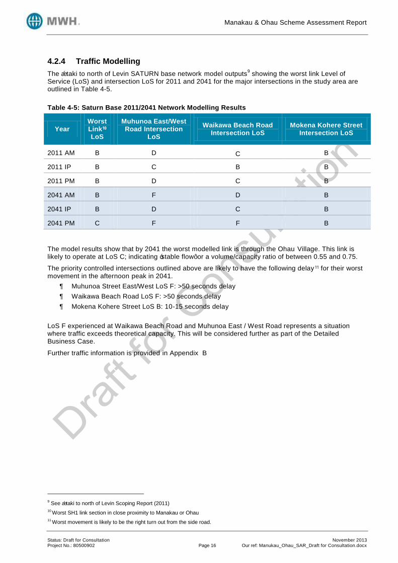
4.2.4 Traffic Modelling
The Ōtaki to north of Levin SATURN base network model outputs9 showing the worst link Level of
Service (LoS) and intersection LoS for 2011 and 2041 for the major intersections in the study area are outlined in Table 4-5.
Table 4-5: Saturn Base 2011/2041 Network Modelling Results
Year Worst Link10 LoS
Muhunoa East/West Road Intersection
LoS
Waikawa Beach Road Intersection LoS
Mokena Kohere Street Intersection LoS
2011 AM B D C B
2011 IP B C B B
2011 PM B D C B
2041 AM B F D B
2041 IP B D C B
2041 PM C F F B
The model results show that by 2041 the worst modelled link is through the Ohau Village. This link is likely to operate at LoS C; indicating ‘stable flow’ or a volume/capacity ratio of between 0.55 and 0.75.
The priority controlled intersections outlined above are likely to have the following delay 11 for their worst movement in the afternoon peak in 2041.
Muhunoa Street East/West LoS F: >50 seconds delay
Waikawa Beach Road LoS F: >50 seconds delay
Mokena Kohere Street LoS B: 10-15 seconds delay
LoS F experienced at Waikawa Beach Road and Muhunoa East / West Road represents a situation where traffic exceeds theoretical capacity. This will be considered further as part of the Detailed Business Case.
Further traffic information is provided in Appendix B
9 See Ōtaki to north of Levin Scoping Report (2011)
10 Worst SH1 link section in close proximity to Manakau or Ohau
11 Worst movement is likely to be the right turn out from the side road.

Manakau & Ohau Scheme Assessment Report
Status: Draft for Consultation November 2013 Project No.: 80500902 Page 17 Our ref: Manukau_Ohau_SAR_Draft for Consultation.docx
4.3 Crash Data
4.3.1 Manakau
A review of NZTA’s CAS database over the five year period from 2008 to 2012 revealed a total of two injury crashes and ten non-injury crashes along the approx.1.5 km section of highway (SH1 RP 985/7.75 – RP 985/9.25). The extended 1.5 km length was chosen to include crashes which would be influenced by the intersections at either end of the site. The southbound passing lane located at the northern extent of Manakau Village is included in this crash analysis, which included a further six non-injury crashes. The following tables provide a summary of the CAS output data. The project area has also been assessed using both the High Risk Rural Roads Guide (HRRRG) and the draft High Risk Intersections Guide (HRIG).
Table 4-6: Annual Distribution of Crashes 2008-2012
Year Fatal Serious Minor Non-Injury Total DSI*
2008 0 0 0 3 3 0
2009 0 0 0 5 5 0
2010 0 0 0 6 6 0
2011 0 0 1 0 1 0
2012 0 1 0 2 3 2
Total 0 1 1 16 18 2
Table 4-7: CAS Crash Type
Crash Type Number of Reported Crashes
Injury Crashes DSI Percentage of
Reported Crashes
Overtaking 2 0 0 11%
Straight Lost Control / Head on
5 1 2 28%
Bend Lost Control / Head on
0 0 0 0%
Rear End / Obstruction 7 1 0 39%
Crossing / Turning 3 0 0 17%
Pedestrian Crashes 0 0 0 0%
Miscellaneous Crashes 1 0 0 5%
Total 18 2 2 100%

Manakau & Ohau Scheme Assessment Report
Status: Draft for Consultation November 2013 Project No.: 80500902 Page 18 Our ref: Manukau_Ohau_SAR_Draft for Consultation.docx
Table 4-8: HRRRG Crash Type
Crash Type Number of Reported Crashes
DSI Percentage of
Reported Crashes
Percentage of Reported High
Severity Crashes
Head-on 1 0 5% 0%
Run-off Road 3 2 17% 100%
Intersection Crashes 5 0 28% 0%
Other 9 0 50% 0%
Total 18 2 100% 100%
Table 4-9: Crash Causation Factors of Reported Injury Crashes
Causation Number of Reported
Crash Causation Factors
Number of Reported Injury Crash Causation
Factors
Number of Reported High Severity Crash Causation Factors
Alcohol 2 1 1
Too fast 1 0 0
Failed Give Way/ Stop
2 0 0
Failed keep left 0 0 0
Overtaking 2 0 0
Incorrect lane/ position
5 1 1
Poor handling 1 0 0
Poor observation 8 1 0
Poor judgement 3 1 0
Fatigue 3 0 0
Disabled/old/ill 1 0 0
Vehicle factors 2 1 0
Road factors 2 1 1
Weather 1 1 1
Cyclist factors 0 0 0
Pedestrian factors 0 0 0
Other 5 0 0
Table 4-10: Environmental Factors
Wet/Icy Dry Night Day Weekend (Fri
6:00PM to Monday 5:59AM)
Weekday
No. 5 13 5 13 9 9
% 28% 72% 28% 72% 50% 50%

Manakau & Ohau Scheme Assessment Report
Status: Draft for Consultation November 2013 Project No.: 80500902 Page 19 Our ref: Manukau_Ohau_SAR_Draft for Consultation.docx
Of the 18 reported crashes over the five year period analysed:
One resulted in serious injury (two DSI), one was minor injury, and 16 were non-injury.
Poor observation was the single highest crash causation factor towards injury crashes, being attributed to eight of the 38 crash causation factors.
Seven were hit object related; including the serious injury crash which involved a northbound vehicle losing control on a straight in heavy rain, going off road to the left and colliding with a post resulting in two DSI. The remaining hit object crashes were non-injury and involved vehicles colliding with fence/kerb/post/roadworks/traffic sign and a ditch.
Three (17%) were run-off road related crashes, resulting in one serious crash (two DSI).
Whilst 2013 has not been assessed as a full years data is not available, it is known that a double fatality occurred in Manakau during 2013. This is obviously highly significant and concerning in relation to the safety of the current arrangement through the village. This occurred on 4 May 2013 and involved multiple vehicles and resulted in two fatalities and one serious injury during dry conditions. The crash type was head on resulting from a loss of control. The effect of this on the project is discussed more in the option improvements and economic evaluation. A further five year period between 2003 and 2007 was also analysed. During this period there were two serious injury crashes. A motorcyclist was hit in 2004 (one DSI) when overtaking a vehicle that was turning right into the fruit and vegetable shop. A car lost control and went off the road, hitting a car parked near the dairy in 2004 (one DSI). There was a fatality involving a right turn across opposing traffic into the fruit and vegetable shop in 2000, which is not included in this analysis period, but this reinforces the on-going high risk nature of this site. The crashes from the 5 year period from 2003-2007 are summarised in Table 4-11.
Table 4-11: Annual Distribution of Crashes, 2003-2007
Year Fatal Serious Minor Non-Injury Total DSI*
2003 0 0 1 3 4 0
2004 0 2 0 0 2 2
2005 0 0 2 1 3 0
2006 0 0 0 0 0 0
2007 0 0 4 2 6 0
Total 0 2 7 6 15 2
* Death and serious injury casualties
4.3.2 Ohau
A review of NZTA’s CAS database over the five-year period from 2008 to 2012 revealed total of 8 injury crashes and 11 non-injury crashes along the 1.6 km section of highway (SH1 RP 985/0.8 – RP 985/2.4). The extended 1.6 km length was chosen to include crashes from the influence of the intersections at either end of the site, and the horizontal curve at the southern end. The following tables provide a summary of the CAS output data. The project area has also been assessed using both the High Risk Rural Roads Guide12 (HRRRG) and the draft High Risk Intersections Guide13 (HRIG).
12
High Risk Rural Roads Guide (HRRRG), NZTA, September 2011
13 High Risk Intersection Guide (HRIG), NZTA, Draft March 2012

Manakau & Ohau Scheme Assessment Report
Status: Draft for Consultation November 2013 Project No.: 80500902 Page 20 Our ref: Manukau_Ohau_SAR_Draft for Consultation.docx
Table 4-12: Annual Distribution of Crashes 2008-2012
Year Fatal Serious Minor Non-Injury Total DSI*
2008 0 0 2 5 7 0
2009 0 0 0 2 2 0
2010 0 0 2 1 3 0
2011 0 1 1 1 3 1
2012 0 0 2 2 4 0
Total 0 1 7 11 19 1
*Death and serious injury casualties
Table 4-13: CAS Crash Type
Crash Type Number of Reported Crashes
Injury Crashes DSI Percentage of
Reported Crashes
Overtaking 1 1 0 5%
Straight Lost Control / Head on
3 3 1 17%
Bend Lost Control / Head on
1 0 0 5%
Rear End / Obstruction 8 2 0 42%
Crossing / Turning 5 2 0 26%
Pedestrian Crashes 0 0 0 0%
Miscellaneous Crashes 1 0 0 5%
Total 19 8 1 100%
Table 4-14: HRRRG14
Crash Type
Crash Type Number of Reported Crashes
DSI Percentage of Reported
Crashes
Percentage of Reported
High Severity Crashes
Percentage of High Severity Crashes
(National)
Head-on 0 0 0% 0% 54%
Run-off road 4 1 21% 100% 21%
Intersection Crashes
7 0 37% 0% 13%
Other 8 0 42% 0% 12%
Total 19 1 100% 100% 100%
14
High Risk Rural Roads Guide (HRRRG), NZTA, September 2011

Manakau & Ohau Scheme Assessment Report
Status: Draft for Consultation November 2013 Project No.: 80500902 Page 21 Our ref: Manukau_Ohau_SAR_Draft for Consultation.docx
Table 4-15: Crash Causation Factors of Reported Injury Crashes
Causation Number of Reported
Crash Causation Factors
Number of Reported Injury Crash Causation
Factors
Number of Reported High Severity Crash Causation Factors
Alcohol 1 1 0
Too fast 1 0 0
Failed Give Way/Stop
4 1 0
Failed keep left 0 0 0
Overtaking 1 1 0
Incorrect lane/ position
4 1 0
Poor handling 3 2 0
Poor observation 11 5 1
Poor judgement 2 1 0
Fatigue 1 0 0
Disabled/old/ill 1 1 0
Vehicle factors 2 1 0
Road factors 5 2 1
Weather 0 0 0
Enter/exit land use 0 0 0
Cyclist factors 0 0 0
Pedestrian factors 0 0 0
Other 2 1 0
Table 4-16: Environmental Factors
Wet/Icy Dry Night Day Weekend (Fri 6:00PM to
Monday 5:59AM) Weekday
No. 3 16 5 14 4 15
% 16% 84% 26% 74% 21% 79%
Of the 19 reported crashes over the five year period analysed:
One resulted in a serious injury (one DSI), seven were minor injury and eleven were non-injury.
The serious injury was incurred during a run off road crash just north of Victoria Terrace in 2011. This was attributed to driver distraction and a slippery road from rain.
Poor observation was the single highest crash causation factor towards injury crashes, being attributed to 11 of the 38 crash causation factors.
Four (21%) run-off road related crashes, resulting in one serious crash.
Five were hit object related; including three injury crashes and two non-injury crashes. Objects struck included; cliff/bank (two injury crashes), debris, fence, tree, ditch and one stray animal.

Manakau & Ohau Scheme Assessment Report
Status: Draft for Consultation November 2013 Project No.: 80500902 Page 22 Our ref: Manukau_Ohau_SAR_Draft for Consultation.docx
A further five year period between 2003 and 2007 was also analysed. During this period there were two fatal and one serious injury crashes. The fatal in 2004 (one DSI) was caused by a northbound car losing control on the curve north of Bishops Road. The fatal in 2006 (three DSI) was caused by a car losing control in the wet on the curve to the south of Vista Road. The serious injury crash in 2006 (one DSI) was a rear-end on the curve near Bishops Road, attributed to following too closely. This suggests a need for improving the geometry or lowering the posted speed limit. These crashes clearly indicate the on-going risk associated with this section and reinforces the need to provide a better balanced solution between the service provided to through traffic and the service provided to the community. None of the recent work (e.g. pedestrian underpass, turning lane widening at Muhunoa Road intersection) has addressed these severe crashes. The 2013 crash statistics have also been investigated to ident ify any significant incidents that should be considered despite not occurring within the five year crash analysis period of 2008-2012. In Ohau there has been one further serious crash that involved multiple vehicles which resulted in one serious and one minor injury resulting from a rear end collision. The crashes from the additional 5 year period from 2003-2007 are summarised in Table 4-17.
Table 4-17: Annual Distribution of Crashes 2003-2007
Year Fatal Serious Minor Non-Injury Total DSI*
2003 0 0 1 4 5 0
2004 1 0 1 3 5 1
2005 0 0 2 2 4 0
2006 1 1 2 5 9 4
2007 0 0 1 5 6 0
Total 2 1 7 19 29 5
4.3.2.1 Ohau Northbound Passing Lane
A review of the crashes for the northbound passing lane leading into Ohau Village was undertaken over a five year period from 2008 to 2012. The review revealed a total of one injury crash and three non-injury crashes along the northbound passing lane (SHI RP 985/2.44 – RP 985/2.92).
Of the four reported crashes over the five year period analysed:
One resulted in serious injury (one DSI) and three were non-injury.
The serious injury resulted from a rear end crash into a turning vehicle at Parakawau Road intersection in 2012. This was attributed to poor observation and judgement.
One crash involved an object hit (non-injury) with the object being a parked vehicle.
4.3.3 Crash Risk: Manakau
The Manakau Village section of SH1 was analysed according to the High-Risk Rural Roads Guide (HRRRG) which identifies that crash risk can be generally defined in two ways:
Actual Crash Risk; which is based on crashes reported in the last 5 years. This is separated into collective risk, which is also known as crash density, and personal risk, which is also known as crash rate.
Predicted Crash Risk; which is based on KiwiRAP road protection score (RPS) and the KiwiRAP star rating.
In terms of crash risk this 1.5 km section of SH 1 has:

Manakau & Ohau Scheme Assessment Report
Status: Draft for Consultation November 2013 Project No.: 80500902 Page 23 Our ref: Manukau_Ohau_SAR_Draft for Consultation.docx
A collective risk value of 0.13 high-severity (fatal and serious) crashes per km per year;
A personal risk value of 2.56 high-severity crashes per 100 million vehicle km; and
An average KiwiRAP star rating of 2.55, giving a published KiwiRAP rating of 2 stars, together with an RPS of 14.18.
The personal risk value equates to the highway having a low-medium risk. However, the collective risk was calculated as medium high, which ordinarily would result in this section being classified as a high-risk rural road. It would also be classified as a medium-high risk rural road due to the KiwiRAP star rating and the RPS. However, as there have been fewer than three high severity crashes in the five year period there are insufficient crashes for this section to be classified as a high risk rural road15. Further analysis was undertaken using the 10 year crash history, which had fewer than five high severity crashes in the 10 year period and hence insufficient crashes for this section to be classified as a high risk rural road16. The HRRRG recommended safety improvement strategy is ‘Safer Corridors’. This supports medium cost infrastructure developments; however, when considering the full Ōtaki to North of Levin study extent, the treatment philosophy is ‘safe systems transformation works’ – justifying large infrastructure improvements. This analysis was carried out for a small section of the Ōtaki to North of Levin RoNS area; other parts of the RoNS area would carry additional benefits. The following rural intersections has been considered in greater detail due to the number of injury crashes that have taken place compared to other intersections within the study area.
4.3.3.1 Crash Risk: SH1 / Mokena Kohere Street Intersection
For Collective Crash Risk:
Reported F&S Crashes: Over the 10 year assessment period, there has been one F&S crash.
Estimated F&S Crashes: The estimated collective crash risk is calculated at 0.53 F&S crashes for a 10 year period. This is presented in the table below:
Table 4-18: Estimation of F&S Collective Risk Using Severity Index SH1 Mokena Kohere Street Intersection
Crash Type Number of Reported
Injury Crashes
Adjusted F&S crashes / All injury
crashes
Estimated Number of F&S Injury
Crashes
Loss of control or off road (straight) (C Type)
1 0.25 0.25
Manoeuvring (M Type) 1 0.28 0.28
Total 2 0.53
Therefore, according to HRIG, and using either method of calculation, this intersection is considered ‘Low’ collective risk. The SH1 / Mokena Kohere Street intersection is calculated as having a personal risk value of 25. According to HRIG, this results in a ‘Low’ personal risk level. However, as there have been less than eight injury accidents and only one high severity crash, the personal risk level should not be used to establish a safety countermeasure for this 10 year period.
15 According to section 4.1 of the HRRRG
16 According to section 4.1 of the HRRRG

Manakau & Ohau Scheme Assessment Report
Status: Draft for Consultation November 2013 Project No.: 80500902 Page 24 Our ref: Manukau_Ohau_SAR_Draft for Consultation.docx
This intersection is determined to be LoSS category ‘IV’ which represents a poor safety performance level compared to similar intersections.17
4.3.3.2 Crash Risk: Other Manakau Intersections
The following two intersections were considered but due to lack of injury crashes compared to other intersections within the study area no assessments can be made.
The SH1 / Waikawa Beach Road intersection had no injury crashes within the 10 year analysis period.
The SH1 / Honi Taipua Street link intersection only had one minor injury crash in the 10 year analysis period.
Further crash data can be found in Appendix C.
4.3.4 Crash Risk: Ohau
The Ohau Village section of SH1 was analysed according to the High-Risk Rural Roads Guide (HRRRG) which identifies that crash risk can be generally defined in two ways:
Actual Crash Risk; which is based on crashes reported in the last 5 years. This is separated into collective risk, which is also known as crash density, and personal risk, which is also known as crash rate.
Predicted Crash Risk; which is based on KiwiRAP road protection score (RPS) and the KiwiRAP star rating.
In terms of crash risk this 1.6 km section of SH 1 has:
A collective risk of 0.13 high-severity (fatal and serious) crashes per km per year;
A personal risk of 2.40 high-severity crashes per 100 million vehicle km; and
An average KiwiRAP star rating of 2.50, giving a published KiwiRAP rating of 2 stars, together with an RPS of 18.66.
The personal risk value equates to the highway having a low-medium risk. However, the collective risk was calculated as medium high, which ordinarily would result in this section being classified as a high-risk rural road. It would also be classified as a medium-high risk rural road due to the KiwiRAP star rating and the RPS. However, as there have been fewer than three high severity crashes in the five year period there are insufficient crashes for this section to be classified as a high risk rural road 18.
Further analysis was undertaken using the 10 year crash history, which also does not have the minimum of five high severity crashes over the 10 year period to be classified as a high risk rural road 19. The HRRRG recommended safety improvement strategy is ‘Safer Corridors’. This supports medium cost infrastructure developments; however, when considering the full Ōtaki to North of Levin study extent, the treatment philosophy is ‘safe systems transformation works’ – justifying large infrastructure improvements. This analysis was carried out for a small section of the Ōtaki to North of Levin RoNS area; other parts of the RoNS area would carry additional benefits. The following rural intersections have been considered in greater detail due to the number of injury crashes that have taken place compared to other intersections within the study area.
17 Including the 2013 fatal crash, which occurred near the intersection, the personal risk band increases from low to low-medium and
the intersection LoSS category increases from LoSS IV to LoSS V.
18 According to section 4.1 of the HRRRG
19 According to section 4.1 of the HRRRG

Manakau & Ohau Scheme Assessment Report
Status: Draft for Consultation November 2013 Project No.: 80500902 Page 25 Our ref: Manukau_Ohau_SAR_Draft for Consultation.docx
4.3.4.1 Crash Risk: SH1 / Victoria Terrace Intersection
The crash risk analysis for all intersections was completed for a 10 year period because of the limited number of injury crashes in the five year period. In terms of collective crash risk for the intersection of SH1 / Victoria Terrace, there are two methods of calculation
Reported Fatal & Serious (F&S) Crashes: Over the 10 year assessment period there has been one F&S crash reported within 50 m of the intersection, resulting in one DSI.
Estimated F&S Crashes: The second method involves the estimation of F&S crashes that have occurred at an intersection using all injury crashes that have occurred during the crash period. This method takes into account the crash movement type, intersection form and control, and collision speed on crash severity outcomes. The estimated collective crash risk is calculated at 0.5 F&S crashes for a 10 year period. This is presented in the table below:
Table 4-19: Estimation of F&S Collective Risk Using Severity Index SH1 / Victoria Terrace Intersection
Crash Type Number of Reported
Injury Crashes
Adjusted F&S crashes / All injury
crashes20
Estimated Number of F&S Injury
Crashes
Loss Control Straight (C Type) 2 0.25 0.5
Total 2 0.5
Therefore, according to HRIG21 and using either method of calculation, this intersection is considered ‘Low’ risk when quantifying collective risk (as there is less than 1.0 F&S crashes for 10 year period). When considering personal risk; a calculation is performed which considers the major and minor road traffic volumes to determine the product of flow to standardise the number of potential conflicts that could occur at an intersection. The SH1 Victoria Terrace intersection is calculated as having a personal risk value of 36. Accordi ng to HRIG22, this results in a ‘Low’ personal risk level. However, as there have been less than eight injury crashes and no high severity crashes, the personal risk level should not be used to establish a safety countermeasure for this 10 year period. The Level of Safety Service (LoSS)23 for this intersection has been calculated to be 4 which is category V24 which demonstrates a very poor safety performance on a five point scale when compared to similar intersections.
4.3.4.2 Crash Risk: SH1 / Muhunoa East & West Road Intersection
For Collective Crash Risk:
Reported F&S Crashes: Over the 10 year assessment period, there has have been no F&S crashes.
Estimated F&S Crashes: The estimated collective crash risk is calculated at 1.61 F&S crashes for a 10 year period. This is presented in the table below:
20
HRIG, Table 8.10
21 HRIG, Table 4-1
22 HRIG, Table 4-2
23 Level of Safety Service, as defined by HRIG, is a method of categorising the safety performance of an intersection compared to
other intersections of that type. 24
LoSS categories range from I (one) to V (five) where intersections classified as LoSS I have a safety performance that is better than
other intersections of that type, in the same speed environment and with similar traffic flows. For intersections of Category V, the
converse is true. Category V have LoSS values greater than 3.

Manakau & Ohau Scheme Assessment Report
Status: Draft for Consultation November 2013 Project No.: 80500902 Page 26 Our ref: Manukau_Ohau_SAR_Draft for Consultation.docx
Table 4-20: Estimation of F&S Collective Risk Using Severity Index SH1 / Muhunoa East & West Road Intersection
Crash Type Number of Reported
Injury Crashes
Adjusted F&S crashes / All injury
crashes
Estimated Number of F&S Injury
Crashes
Overtaking (A Type) 1 0.32 0.32
Rear end (F Type) 1 0.08 0.08
Crossing veh turning (J Type) 1 0.33 0.33
Right turn against (L Type) 2 0.30 0.60
Manoeuvring (M Type) 1 0.28 0.28
Total 6 1.61
Therefore, according to the HRIG, using the F&S injury estimation method, the intersection has a ‘Low -medium’ collective risk. The SH1 / Muhunoa East & West Road intersection is calculated as having a personal risk value of 72. According to HRIG, this results in a ‘Medium’ personal risk level. However, as there have been less than eight injury crashes and no high severity crashes, the personal risk level should not be used to establish a safety countermeasure for this 10 year period (with a minimum of four over a 5 year analysis period). This intersection is determined to be LoSS category ‘II’ which represents a safety performance level comparative to similar intersections.
4.3.4.3 Crash Risk: Other Ohau Intersections
The following two intersections where considered but due to lack of injury crashes compared to other intersections within the study area, no assessments can be made.
The SH1 / Vista Road intersection was considered for a 10 year period but only one minor injury crash occurred in this period.
The SH1 / Marsden Terrace intersection had two minor injury crashes occur in the 10 year analysis period.
4.4 Geotechnical Testing
This section summarises the geotechnical engineering aspects of the scheme. A preliminary ground investigation was conducted on 26-27
th September 2013 which included advancement of three hand
augers at Manakau and four hand augers at Ohau spaced at 600m and 200-400m intervals respectively. Hand augers were advanced to a maximum depth of 2.6m below ground level (bgl) and aimed to characterise soil type. Scala Penetrometer tests have been conducted adjacent each hand auger to a maximum depth of 3.2m bgl which aimed to assess soil density change with depth and California Bearing Ratio (CBR) of the soil. Results of the preliminary ground investigation are summarised in the table below.

Manakau & Ohau Scheme Assessment Report
Status: Draft for Consultation November 2013 Project No.: 80500902 Page 27 Our ref: Manukau_Ohau_SAR_Draft for Consultation.docx
Table 4-21: Geology and CBR values for Manakau and Ohau Villages
Site Alignment Section
Geology Depth to CBR >10
Ma
na
ka
u northern clayey SILT becoming firm at 1.2m and stiff at 2.9m 1.9m
central very soft SILT with minor clay to 0.9m and then fine SAND becoming medium dense at 1m and dense at 1.1m
1.0m
southern very soft silty CLAY becoming very stiff at 1.4m 1.4m
Oh
au
northern fine SAND becoming medium dense at 0.6m, dense at 0.8m and very dense at >2.4m
0.7-1.0m
southern silty GRAVEL with cobbles becoming dense at 0.6m and very dense 0.7m
0.6m
4.4.1 Manakau
The published geological map of the area (GNS, 2000, QMap, Sheet 10) shows the surface geology of the northern section of SH1 at Manakau to comprise aggradational and degradational terraces including minor fan gravel. The central section of the alignment comprises weathered alluvial gravel, blue-grey silty clay and peat and the southern section comprises well sorted floodplain gravels. Field testing including three hand augers and corresponding Scala Penetrometers in these sections found surface soil to comprise silt and silty clay in the northern and southern sections and sand in the central section with CBR values, derived from correlations with Scala penetration resistance values using Stockwell (1977), increasing above 10 below 1 to 1.9m bgl.
Deposits of potentially liquefiable silts are suspected to be located near the Waikawa Stream approximately 600m north of Manakau which is indicated in the cracking and subsidence of the bitumen road seal in this area possibly caused by vibration of the silt by passing trucks. If further testing during detailed design identifies any “quick” silt within the proposed alignment, then these soils should be managed appropriately.
4.4.2 Ohau
GNS, 2000, QMap, Sheet 10 shows the surface geology of the northern section of the proposed alignment at Ohau to comprise weathered alluvial gravel, blue-grey silty clay and peat of alluvial, swamp and possibly lacustrine origin. The southern section of the alignment comprises poorly to moderately sorted gravel with minor sand or silt. Field testing including four hand augers and corresponding Scala Penetrometers in these sections found surface soil to comprise fine sand in the gently undulating topography of the northern section with CBR values over 10 below 0.7-1.0m bgl. The southern section is located within a flat alluvial gravel fan with CBR values over 10 below 0.6m bgl.
A recommended testing schedule for the detailed design phase is included in Appendix J.

Manakau & Ohau Scheme Assessment Report
Status: Draft for Consultation November 2013 Project No.: 80500902 Page 28 Our ref: Manukau_Ohau_SAR_Draft for Consultation.docx
5 Stakeholder Relationship Management and Consultation
5.1 Public Consultation
Consultation has been carried out on a high level on the wider Ōtaki to north of Levin project. A Consultation Report documenting this consultation (Consultation Stages 1 - 3) was prepared in August 2013, and describes and records the consultation undertaken between April 2011 and July 2013. Generally consultation during this stage resulted in significant positive feedback and general support for a staged approach to safety improvements between Ōtaki and Levin. The community acknowledged that safety improvements were needed urgently.
The comments received from the community in the most recent stage of consultation carried out between April 2013 and July 2013 for Manakau and Ohau are summarised below. While it is acknowledged that many comments are relevant to the long term proposals for the villages, many comments raise concerns about safety issues that are the subject of this Scheme Assessment Report.
Manakau
There was mixed reaction to the 80km/h speed limit proposal.
Queries around the use of engine braking restrictions to reduce the noise effects.
Trains waiting in the loop often block the level crossing at Mokena Kohere Street.
Until the train problem is resolved, residents do not want the rail underpass closed otherwise
there is no alternate access from/to the highway for residents or emergency services.
Keep the railway underpass left-turn only (left in, left out).
Widespread support for removing the passing lane.
It was noted that there are narrow shoulders opposite Waikawa Beach Road.
Concern about school children crossing SH1.
Mixed support for the proposal to improve the Mokena Kohere intersection due to limited
evidence of truck usage of Mokena Kohere Street.
Request to extend the 80km/h proposed speed limit south to past Gleesons Road.
Suggestion to construct a feeder/free-turn for northbound traffic from Waikawa Beach Road.
Historic Gates at 1050 SH1, Manakau, need to be preserved. These are located immediately
south of the dairy.
Note there is an archaeologically significant site immediately west of Manakau Rail overbridge.
Support for a wider median strip given the activities in the area with the school, church, hall,
bowling club and hotel as key gathering points for the community.
There is a possible paper road at the back of Manakau towards North Manakau Road. Could
this form an emergency access route?
Noted that the Tukorehe Marae is the end of the bus route hence a large number of parents
picking up children in this location. Requests that this be extended to Manakau, although it was
understood that this would be longer than the maximum bus route length allowed.
Ohau Village
General agreement with closing Victoria Terrace, although there were suggestions that the
NZTA should re-prioritise the intersection of Victoria Terrace and Jervois Terrace if closing some
of the roads.
Support for 80km/h reduction.
Support for removal of the passing lane.
There was concern about pedestrian access across the highway to schools.
Manakau & Ohau Scheme Assessment Report
Status: Draft for Consultation November 2013 Project No.: 80500902 Page 29 Our ref: Manukau_Ohau_SAR_Draft for Consultation.docx
Belief that a bypass of Ohau is the most logical, particularly because of trucks speeding up the
hill to reach Levin - they can be going at speeds of up to 120km/h.
Cycling is very constrained through Ohau. Could new cycling connections be provided off SH1?
Considerable support for SH57 bypass being south of Ohau to reduce traffic through Ohau.
In favour of closing roads accessing SH1 but only if there is a northern outlet for Ohau traffic.
i.e. connect to Vista Road and keep this open, or connect up to Buller Road. A connection to
Buller Road would give the advantage of a non-SH connection between Ohau and Levin
benefiting locals and cyclists.
For Vista Road, add a merging lane for northbound traffic (pulling out of Vista Road).
Query about why Bishops Road should be kept open.
Public consultation on the Manakau and Ohau safety improvement projects has been scheduled in order to avoid potential confusion, given consultation on the wider Ōtaki to Levin improvements are programmed for November and December. The short term improvements are seen as an immediate and achievable ‘fix’ prior to potential major works in future. A Consultation Plan (Strategy) has been prepared for the project area and consultation is being undertaken in accordance with the plan. This is a live document and is updated as the project progresses. The consultation on the Manakau and Ohau safety improvements will be carried out under this plan. The purpose of the plan is to:
Provide a documented process for intended engagement with the community, including the project context, the parties involved, and desired outcomes;
Maximise effective and efficient engagement of community within generally tight time constraints;
Provide the specifics of consultation to be undertaken, including timeframes;
Help the project team to proactively manage risks to the project/project future from inappropriate or inadequate community engagement; and
Help the project team to constructively manage community expectations.
5.2 KiwiRail
Consultation has been undertaken with KiwiRail given the close proximity of the North Island Main Trunk Railway to SH1 and noting both the Manakau and Ohau villages straddle SH1 and the railway. KiwiRail representatives have been provided the draft improvement designs for both villages and did not express any concerns. The requirement for minor earthworks within the rail reserve (for grading purposes) has been presented to KiwiRail who have confirmed that works can take place provided they are not within 4.0m of an existing rail (otherwise specific safety plans will be required). KiwiRail also confirmed that they are considering options for the Manakau loop (subject to funding availability). It is currently too short and is crossed by Mokena Kohere Street. KiwiRail is investigating lengthening, relocating to the north, or relocating south to near Tatum Park. By relocating the loop the issue of trains blocking back across Mokena Kohere Street would be removed. During the consultation process, KiwiRail has also provided train numbers with the current daily totals passing Manakau and Ohau as a total of 20 trains per days (both direction combined). The existing rail loop is also used twice per day to allow trains to pass.
Manakau & Ohau Scheme Assessment Report
Status: Draft for Consultation November 2013 Project No.: 80500902 Page 30 Our ref: Manukau_Ohau_SAR_Draft for Consultation.docx
5.3 Ministry of Education
Consultation has commenced with representatives of the Ministry of Education regarding the existing school bus routes (and stops) and the effect of the proposed upgrade works. Consultation will need to continue through the development of the project to determine the most appropriate bus routes and stop locations.
5.4 Iwi
The area is identified as being of cultural importance to the iwi of Rangitane o te Whanganui a Tara, Ngati Raukawa ki te Tonga and Ngati Toa Rangitira. A number of hui have been held as part of the wider consultation for the Ōtaki to north of Levin project and this consultation is on-going.
5.5 Others
Further consultation will be required with a variety of stakeholders, such as emergency services, RTA, Horowhenua District Council and AA to both understand any issues they may be aware of and raise for consideration, together with explaining and seeking support for the proposed improvements.
6 Improvements Description The improvements available should be seen as all individually and collectively contributing to road safety and traffic management improvement. They are such that some can be standalone, or they may be reliant on other complementary measures, or can be considered in clusters or a total package. However it is important to recognise that the overall benefits and step change improvement in safety will be realised if all of the recommended improvements are implemented as a single holistic package.
As presented previously, the investigation is broken into two parts; Manakau Village and Ohau Village.
The improvement options are described below together with a recommendation of which measures should be progressed. The recommended improvements are presented in Appendix D.
6.1 Manakau Village Main Improvements
6.1.1 Posted Speed Limit & Threshold Treatment
The reduction in posted speed from 100km/h to 80km/h was considered as part of the PFR. Should the speed not be reduced through Manakau then a number of other measures that are considered would not be viable as they are dependent on slower operating speeds. Continuing with the 100km/h speed is likely to be preferable for the SH1 through traffic that would not be required to reduce speed through the village. It is considered that a speed limit reduction is a critical aspect of the safety improvements through the village. A warrant survey was conducted following a field visit in December 2012, with the results analysed in accordance with Speed Limits New Zealand (SLNZ). Following this, the average rating for the section of SH1 through Manakau Village was found to be 4.8, which supports an 80 km/h speed limit through Manakau Village (Table SLNZ12). The speed limit warrant data has been included in Appendix I. The introduction of an 80km/h zone allows the opportunity to consider a flush median, which together with threshold treatments at both ends will give the village a greater identity from a road user view point. The speed limit change signage would be combined with a larger sign signifying the approaching village and could also include a message panel that presents an opportunity for community participation in designing a message to include on the sign panel. Recommendation: Reduce the posted speed through Manakau Village to 80km/h and provide physical threshold treatments (with signage, narrowings, kerb and channel, landscaping and flush median)

Manakau & Ohau Scheme Assessment Report
Status: Draft for Consultation November 2013 Project No.: 80500902 Page 31 Our ref: Manukau_Ohau_SAR_Draft for Consultation.docx
6.1.2 Pedestrian and Cycle Facilities
Providing improvements for pedestrians and cyclists was noted within the previous PFR. Main pedestrian movements are across the highway in a random pattern. Pedestrians should be encouraged to use the local road network and avoid crossing the railway. To facilitate this, a safety footpath is proposed on the western side through the village, connecting Gleesons Road and the northern threshold (approximately 70m north of Waikawa Beach Road). In addition, a further length of footpath is proposed on the eastern side of State Highway 1 between Mokena Kohere Street and a point opposite the dairy (approximately 120m north of Mokena Kohere Street). This section of footpath will also extend into Mokena Kohere Street to provide for the community movements to and from the dairy. Due to the limited land available within the existing road reserve at this location, the footpath proposed is 1.4m at the narrowest point. Further consideration should be given during consultation and detailed design as to whether land can be acquired with the rail corridor. It is also recognised that this footpath as proposed would place pedestrians adjacent to the proposed kerb face and close to moving traffic. Ideally some separation should be provided between traffic and the footpath and acquiring land within the rail corridor would resolve this issue. A pedestrian refuge island has been considered within the central median which would provide improved provision for the pedestrian crossing movements and allow the road to be crossed in two stages. With regard to the pedestrian refuge island, should this be provided, it would need to be adequately lit to ensure the physical island, and pedestrians, are highly conspicuous to approaching vehicles. There is certainly a risk that the island could itself become a hazard for vehicles and this needs to be balanced against the benefits of providing some physical protection for pedestrians crossing to the dairy. A safety audit at detailed design stage that considers this feature will be essential. The refuge island and sections of footpath kerb opposite would be provided with cut downs and tactile paving to assist those with mobility issues or visual impairments, as well as those using pushchairs. Cyclists on the highway are currently not well catered for due to non-uniform sealed shoulder widths and the proposal is to increase the sealed shoulder width to a uniform 2.5 m (see Section 6.1.7) which will provide an improved level of service standard for cyclists. Cyclists will also value the flush median when turning right into properties or side roads. Recommendation: Provide new footpaths for pedestrian movements, noting the key generator of the dairy store. In addition, consider the provision of a pedestrian refuge island. An improved cross section with 2.5m sealed shoulders should also be provided which will assist cyclists.
6.1.3 Side Friction
To improve side friction the options for improvement were to close off accessways directly onto SH1 (and provide an alternative) or to formalise the current crossing provision, noting this is a Limited Access Road (LAR) and new accessways should be closely controlled. The LAR applies to all of Manakau Village, commencing at Manakau North Road and still being in force art the Manakau rail overbridge, some distance beyond the extent of the study area considered in this SAR. Closing off existing accessways is likely to prove extremely unpopular and difficult to achieve and would necessitate the provision of alternatives which would include creating new road links. This would be a costly exercise in terms of acquiring land and constructing new lengths of road. In terms of existing accessways onto SH1 the frequency of properties, and access to them, results in significant side friction, often resulting in delays to following vehicles as they adjust speeds to avoid turning vehicles. This conflict can also lead to crashes at accessways (such crashes are recorded in the crash data assessed). Provision of a wider cross section, particularly sealed shoulders and a flush median, will allow turning vehicles to move more smoothly out of the traffic stream, hence avoiding much of the conflict. The proposed cross section allows for parking for the dairy on both sides. Whilst parking alongside the State Highway is not desirable it is acknowledged that this will take place from motorist pass by trade.

Manakau & Ohau Scheme Assessment Report
Status: Draft for Consultation November 2013 Project No.: 80500902 Page 32 Our ref: Manukau_Ohau_SAR_Draft for Consultation.docx
Therefore a 2.5m sealed shoulder is provided on both sides that will accommodate this short term parking. It is proposed to provide an enhanced access layout to the highway boundary through improved surfacing and kerb and channel. Kerb and channel will be provided through the entirety of the village (further detail is provided in Section 6.1.7) with appropriate cut down kerbs provided through vehicle accessways at residential and commercial properties. The detail of the accessway treatment will require further discussion with landowners at the detailed design stage. No off highway parking provision will be provided. It is recommended that off highway parking provision should be discussed with Horowhenua DC, to ensure that retail/commercial businesses meet District Plan requirements. Recommendation: Provide an improved cross section with wider shoulders and a flush central median which will assist with providing an area for turning vehicles out of the live traffic lane. Provide more formal delineation of existing accessways with kerb and channel and closely control new accessways from being formed directly onto SH1.
6.1.4 Side Roads
6.1.4.1 Honi Taipua Street (rail underpass) (RP 985/8.98)
This intersection is very substandard with the rail underpass restricted to one lane (an exiting HCV would block the underpass for any highway traffic turning left or right). The intersection also has sub -standard visibility to the south (though this could be resolved by regular vegetation control). There has been no recorded crashes at this location in the previous five years. Various options are available at this intersection. Given the substandard nature of the rail underpass and low volumes which use the intersection, it could be possible to close this to vehicles and force all traffic onto Mokena Kohere Street. This was unpopular with residents25 and provides no alternative should there be an incident at the Mokena Kohere Street / SH1 intersection. This would also be difficult to justify given the lack of crashes. Alternatively the intersection could have right turn movements banned. Right turn movements would be better located into and out of Mokena Kohere Street which is already the main intersection serving Manakau and has a safer more conventional design unrestricted by the close proximity of the substandard single lane bridge underpass. However, providing physical measures to encourage compliance with the right turn bans could be difficult. Care will need to be taken to ensure that whatever physical measures are used, do not result in drivers performing U-turns on SH1 or other inappropriate and unsafe movements. The current traffic movements at this intersection were assessed in September 2013 with tube traffic counters placed on Honi Taipua Street, one to the north and one to the south of the existing T intersection. The traffic flows established as part of the traffic survey (as discussed earlier in section 4.2.3) are small but not insignificant and therefore restricting movements to left in and left out offers a safer, but not overly restrictive, solution. It is also understood, following consultation with KiwiRail, that there are longer term considerations for the need to upgrade this bridge given it is nearing the end of its design life. If KiwiRail did proceed to upgrade this bridge, alongside the relocation of the rail crossing loop (see section 5.2,) there may be potential to close this access, rather than replace the bridge, provided the issue of trains dwelling across Mokena Kohere Street is resolved. Recommendation: At this stage left in / left out only is recommended with the right turn movements banned at this intersection. Further consultation will be required along with detailed consideration of the intersection design.
25
Detailed separately in the Otaki to North of Levin Consultation Report

Manakau & Ohau Scheme Assessment Report
Status: Draft for Consultation November 2013 Project No.: 80500902 Page 33 Our ref: Manukau_Ohau_SAR_Draft for Consultation.docx
6.1.4.2 Mokena Kohere Street (RP 985/8.49)
The PFR considered an option of realigning SH1 adjacent to Mokena Kohere Street in order to provide a 23m offset between the rail line and the limit line (as per KiwiRail guidance). Whilst providing this increased offset would be beneficial, the level of necessity has been assessed based upon the existing traffic flows (discussed previously in section 4.2.3). From the week long automatic traffic count undertaken, there were only four instances of a vehicle with length of 13m or greater attempting to turn out of the Mokena Kohere intersection. Given this is such a small number of vehicles, coupled with the small number of trains (20 per day total) realignment of SH1 is not considered essential nor value for money. However, it is fully accepted that whilst the risk of a vehicle blocking back from the limit line on Mokena Kohere Street / SH1 is low, it is nonetheless a significant issue should it occur. Therefore it is considered that a positive improvement would be to provide longer vehicles an opportunity to be able to take evasive action and move into an area that is protected from an approaching train, and also the live traffic lane on SH1. An area of additional seal could be provided with the south side intersection radius set back to allow a vehicle that was straddling the rail tracks to pull forward and clear the tracks without being forced into the live traffic lane. This is considered a cost effective method of designing in a safety enhancement. Recommendation: Do not provide an increased separation distance between the rail and limit line, but provide extra seal for a vehicle to pull into should a train approach (noting the KiwiRail proposals to relocate the existing loop may also relieve situations at this location).
6.1.4.3 Waikawa Beach Road (RP 985/8.12)
This intersection services the beach community and a number of rural properties. Layout is functional and will benefit from the proposed removal of the southbound passing lane. The intersection layout was reviewed and sight distances are acceptable. The existing radius for the left turn into Waikawa Beach Road is tight and is proposed to be upgraded (which will require a small amount of land acquisition). In addition, a more formal higher standard left turn deceleration lane can be provided, allowing vehicles to move out of the main through lane to decelerate before turning into the side road. The existing right turn bay into Waikawa Beach Road is also significantly substandard, offering only 45m total length of auxiliary lane26. Recommendation: Provide improved left and right turn facilities by way of a wider sealed shoulder and flush median respectively. Also improve the right turn bay to comply with current standards (noting this intersection will be within the proposed 80km/h zone).
6.1.5 Cross Movements
Pedestrian movements across SH1 take place in a random pattern and there is a need to better control this behaviour. There will also be vehicle cross movements as residents on the east side make use of the retail/commercial facilities on the west side of the highway. A small number of cyclist cross movements is also likely. There are also those cross movements which result from southbound drivers parking on the east side of the highway and vehicle occupants walking across the highway to the retail/commercial businesses. With the traffic volume in the order of 15,000 vpd (2013) this is very dangerous and some of those crossing may get caught on the centreline. A pedestrian refuge has been considered to provide a safe path to the dairy given this is one of the major pedestrian attractors from the residential community (as well as southbound vehicles parking and occupants crossing the road to frequent the dairy). Pedestrian movements will also be better catered for with the proposal to provide new footpaths (as described in Section 6.1.2).
26 According to Austroads Guide to Road Design Part 4A Table 5.2, the length of deceleration lane including taper (without any storage
length) should be an absolute minimum of 110m.

Manakau & Ohau Scheme Assessment Report
Status: Draft for Consultation November 2013 Project No.: 80500902 Page 34 Our ref: Manukau_Ohau_SAR_Draft for Consultation.docx
Pedestrians crossing SH1 in two stages, by crossing first to the centre line and then waiting for a suitable gap to cross the second lane is dangerous and should not be encouraged. However it is acknowledged that this is very difficult to control and will inevitably continue. The provision of a 2m flush median will improve this situation by at least providing an area of separation for pedestrians to wait if they do get caught in the middle of the road and cannot undertake the entire crossing movement in a single stage. A number of the alternatives/options will assist to make this much safer (80 km/h zone, flush median, etc). Whilst the current situation is considered dangerous, it is noted that there are no recorded pedestrian crashes in the 10 year crash history. Recommendation: That the issues with cross movements are noted and the improvements measures, such as footpath, flush median, potential pedestrian refuge and speed reduction are progressed.
6.1.6 Heavy Vehicle Volumes
The predicted increase in on road freight movement will inevitably result in more, heavier and potentially longer HCVs in the future. This puts more strain on other road users. Hence this adds weight to the argument to widen the cross section and install a flush median as safeguards against a reducing road safety and traffic management performance.
6.1.7 Cross Section and Shoulder Width
There is reference in the sections above to a consistent cross section. A variety of options could be considered for an improved cross section, with the following considered most suitable - two 3.5 m lanes, two 2.5 m shoulders and a 2.0 m flush median between the threshold treatments. The road reserve width is tight and so two options exist; keeping the proposed improvements within the existing road boundary by using kerb and channel, or acquiring additional land. Acquiring additional land would require time for negotiation and could be problematic if land owners do not agree to the sale. Furthermore, there would be a cost to land acquisition. If land was acquired swale drainage could be provided which generally requires additional width than kerb and channel. Kerb and channel could be introduced to ensure widening stays as close to current road reserve width as possible. With the use of kerb and channel it would possible to keep the vast majority of the physical highway within the existing road boundary. An exception to this is where the village thresholds are provided with physical narrowing and signage. As a rear cycle (and tractor) path is proposed at the narrowings, extra corridor width is required. In addition a very small amount of land is required for acquisition on the radius of the Waikawa Beach Road intersection to aid the left turn in movement. Therefore by using kerb and channel it is unlikely that any land acquisition, other than those stated above, will be required (though this will need to be confirmed at detailed design stage) . The existing cross section nominally consists of two 3.4 m wide lanes and sealed shoulders which vary from 0.6 m to 1.7 m. The proposal is to provide a consistent cross section - 2 x 3.5 m lanes, 2 x 2.5 m sealed shoulders and a 2.0 m flush median between the threshold treatments. Kerb and channel will be run between threshold treatments, 70m north of Waikawa Beach Road and 190m south of Honi Taipua Street Link. At intersections, particularly Mokena Kohere St and Waikawa Beach Rd, the seal width is determined by turning lanes (for both left and right turns).

Manakau & Ohau Scheme Assessment Report
Status: Draft for Consultation November 2013 Project No.: 80500902 Page 35 Our ref: Manukau_Ohau_SAR_Draft for Consultation.docx
Figure 6-1: Typical Section in Manakau
Recommendation: The improved cross section is a key component of the improvements through Manakau and should be progressed as described. Kerb and channel will be required throughout to avoid the need for significant land acquisition.
6.1.8 Proximity of Lighting and Power Poles to Carriageway
The lighting through Manakau is provided almost entirely by lighting arms retro-fitted to the power poles on the northbound side of the road, whilst there are also several frangible lighting poles on the southbound side around the Mokena Kohere Street intersection. All are within the road reserve. Two options exist – either underground the power poles or allow them to remain in their current position with the overhead power supply. Consideration has been given to undergrounding the overhead power but it is not considered essential. This is because it is considered the risk (and likely severity) of collision with a power pole is low based on the straight and reasonably flat alignment of the road, improved road cross section and (proposed) reduced posted speed limit. From the crash records assessed, there were two crashes that resulted in a pole being struck. One of these resulted in serious injury where a loss of control type crash took place in heavy rain. It is estimated that undergrounding would cost in the region of $0.8m between the thresholds and this level of expenditure is not expected to achieve a commensurate level of benefits, given the anticipated effect of other safety improvement measures. Recommendation: The power poles should remain above ground. However, due to their existing location on the western side of SH1 where the new footpath is proposed, it is likely that the poles will need to be relocated to the back of the footpath to ensure they do not narrow the footpath.
6.1.9 North Island Main Trunk Railway
The railway runs parallel with the highway on its eastern side for the entire approx. 1 km length, with an offset of approximately 16 m. It does deviate away at the southern end just south of the underpass. Consideration was given to the possibility of shifting the railway to the east (to increase current intersection separation and to allow ultimate 4 laning), but this is compromised by the war memorial and related garden (between the former fertiliser depot and Mokena Kohere St). KiwiRail was consulted on the proposals and confirmed that work could be undertaken in the rail reserve provided it was not within 4.0m of the nearest rail. Generally any works within the rail reserve are minor and require temporary occupation for minor grading of earthworks. However, at the northern threshold, the shoulder behind the threshold for southbound cyclists (and tractors) would require a small area of land.27
27 An area of approximately 15m in length by 3m in width.
Manakau & Ohau Scheme Assessment Report
Status: Draft for Consultation November 2013 Project No.: 80500902 Page 36 Our ref: Manukau_Ohau_SAR_Draft for Consultation.docx
KiwiRail also confirmed that they are currently considering improvement options for the Manakau rail loop. Presently the rail loop is too short (at 600m) and crossed by Mokena Kohere Street. KiwiRail is investigating lengthening, relocating to the north, or relocating to the south near to T atum Park (subject to their funding availability). Recommendation: Further consultation with KiwiRail should be undertaken, particularly in relation to their loop proposals and acquiring land within the rail corridor (for footpath provision as discussed in Section 6.1.7). Consideration of relocating the railway line should not be progressed further.
6.1.10 Land Requirement
The general approach has been to avoid the need for land acquisition by keeping the proposed works within the boundary as much as possible. This has generally been possible and the improvement works are for the most part able to be accommodated within the existing highway boundary. Some temporary occupation will be required for minor earthworks and level grading within private properties. Generally this is minor and should not have any adverse effects. This is necessary because of the widening of the existing seal. At present the road tends to be higher than the surrounding properties. With the seal widening the batter slopes of the road side will need to be graded back into some properties by up to a few metres. This will require temporary occupation for the earthworks to be undertaken to grade back the levels and then for exposed subgrade to be reseeded (and fences reinstated on the property boundary). The need for temporary occupation is generally minimal and primarily located at farm paddocks and is therefore not expected to be problematic. Consultation will help inform the detailed design to minimise the impact on landowners. A small amount of land acquisition is likely to be required at Waikawa Beach Road intersection and the northern village threshold east side (to provide for the shoulder behind the threshold sign). It could be feasible at detailed design stage to design these features out, and thus avoid the need for any land acquisition. Recommendation: Avoid the need for land acquisition by providing improvement measures within the existing highway boundary.
6.2 Manakau Village Fringe Improvements
6.2.1 Southbound Passing Lane
The PFR considered the removal of the southbound passing lane and this is investigated further here. The passing lane creates higher speeds and aggressive dr iving behaviour on the approach to the village. A side road, Waikawa Beach Road, is also within the passing lane extents. Removal of the southbound passing lane in favour of a better package of longer, more evenly distributed passing lanes between Ōtaki and north of Levin is likely to provide an overall improvement for Manakau in terms of vehicle speeds into the village. The removal of the passing lane is therefore considered an essential component of the overall package of improvements for Manakau. However, it is noted that the timing of passing lane removal shall require careful consideration with cognisance of the overall passing lane strategy for the entire Ōtaki to North of Levin project, to ensure suitable opportunities remain available. Failure to do so could result in there being inadequate passing opportunities for a period of time which can result in driver frustration and attempted overtaking in unsafe situations. Failure to remove the passing lane would also have an effect on the proposed threshold provision north of the village, and would not allow for the existing seal to be reallocated to wider shoulders. Recommendation: Remove the southbound passing lane giving due cognisance to timing and the overall passing lane strategy for the Ōtaki to north of Levin project.

Manakau & Ohau Scheme Assessment Report
Status: Draft for Consultation November 2013 Project No.: 80500902 Page 37 Our ref: Manukau_Ohau_SAR_Draft for Consultation.docx
6.3 Ohau Village Main Improvements
6.3.1 Posted Speed Limit & Threshold Treatment
The reduction in posted speed from 100km/h to 80km/h was considered as part of the PFR. Should the speed not be reduced through Ohau, then a number of other measures that are considered would not be viable as they are dependent on slower operating speeds. Continuing with the 100km/h speed is likely to be preferable for the SH1 through traffic that would not be required to reduce speed through the village. It is considered that a speed limit reduction is a critical aspect of the safety improvements through the village and therefore a recent speed limit warrant survey data was reassessed, with the results analysed in accordance with Speed Limits New Zealand (SLNZ). Following this, the average rating for the section of SH1 through Ohau Village was found to be 3.8, which supports an 80 km/h speed limit through the village (Table SLNZ12). The speed limit warrant data has been included in Appendix H. The introduction of an 80km/h zone allows the opportunity to consider a flush median, which together with threshold treatments at both ends will give the village a greater identity from a road user view point. The speed limit change signage would be combined with a larger sign signifying the approaching village and could also include a message panel that presents an opportunity for community participat ion in designing a message to include on the sign panel. Recommendation: Reduce the posted speed through Ohau Village to 80km/h and provide physical threshold treatments (with signage, narrowings, kerb and channel, landscaping and flush median)
6.3.2 Pedestrian and Cycle Facilities
Providing improved pedestrian and cycling facilities is also considered within Ohau Village. There are a variety of options that could be implemented. Improvements could be considered either along SH1 or within the residential area to support pedestrian and cyclist movements. The predominant pedestrian movements are across the highway at Muhunoa Road and the pedestrian underpass constructed in recent years has provided the level of relief required. It is considered that a footpath on the western side of the highway would be beneficial between Muhunoa West Road and Victoria Terrace due to the presence of numerous accessways and the potential for pedestrian movement from these properties to the commercial properties located on Muhunoa East and West Roads. This footpath extends approximately 60m south of Muhunoa West Road (to cater for existing development). The scheme plans also show a footpath being provided between Victoria Terrace and Marsden Terrace though further consultation and assessment is required as to the necessity of providing footpath throughout this length. A 2m width is proposed for any footpath provision throughout Ohau village. Careful consideration has been given to the provision of a footpath along this length. It is important to recognise the disbenefit of providing a footpath which may attract pedestrians (i.e. latent demand), including school children, onto the side of SH1 whereas previously they may have been inclined to use the local road network instead. The risk to pedestrians is greater along SH1 where speeds are much higher and volumes much greater than the local network. Nevertheless, a footpath should be considered to cater for any pedestrian activity along this length and is deemed acceptable given the speed reduction, the relatively straight geometry and the 2.5m shoulder which affords some separation between the moving traffic lane and footpath. Notwithstanding the above, provision for pedestrians within the main residential area to the west of SH1 would be supported by the potential link road between Vista Road and Wairiri Street, which would further support removing pedestrian movements from the side of SH1. However, there is a substantial cost associated with providing this link road, estimated at approximately $250,000 (plus land acquisition cost), and it is not considered that there would be equivalent benefits. Cyclists on the highway are currently not well catered for (non - uniform sealed shoulder widths) and the proposal to provide a consistent and higher standard cross section including uniform 2.5m sealed

Manakau & Ohau Scheme Assessment Report
Status: Draft for Consultation November 2013 Project No.: 80500902 Page 38 Our ref: Manukau_Ohau_SAR_Draft for Consultation.docx
shoulders will result in an improved level of service standard to cyclists. Cyclists will also value the flush median when turning into properties or side roads. Sealed shoulders of 2.5m (as opposed to 2.0m) have been selected on the basis that there could be some short term shoulder parking along SH1 and the extra 0.5m will therefore be of assistance to cyclists when this occurs. Recommendation: Provide a footpath between Muhunoa West Road and Victoria Terrace and consider extending the footpath further north to Marsden Terrace. Provide 2.5m sealed shoulders on SH1 which will provide greater protection for cyclists.
6.3.3 Side Friction
To improve side friction the options for improvement were to close off accessways directly onto SH1 (and provide an alternative) or to formalise the current crossing provision, noting this is a Limited Access Road (LAR) and new accessways should be closely controlled. The current LAR runs the full length of the study area (operative from Tararua Road in the north, to Manakau North Road in the south). Closing off existing accessways is likely to prove extremely unpopular and difficult to achieve and would necessitate the provision of alternatives which would include creating new road links. This would be a costly exercise in terms of acquiring land and constructing new lengths of road. In terms of existing accessways onto SH1 the frequency of properties, and access to them, results in significant side friction, often resulting in delays to following vehicles as they adjust speeds to avoid turning vehicles. This conflict can also lead to crashes at accessways. Provision of a wider cross section, particularly sealed shoulders and a flush median, will allow turning vehicles to move more smoothly out of the traffic stream, hence avoiding much of the conflict. It is proposed to provide an enhanced access layout to the highway boundary through formalising the accessways with kerb and channel. Kerb and channel will be provided through the majority of the Ohau village (further detail is provided in Section 6.3.6) with appropriate cut down kerbs provided through vehicle accessways at residential and commercial properties. Off highway parking provision will not be provided around the SH1/Muhunoa Road commercial/retail properties but should be reviewed by Horowhenua DC in their assessment of future development proposals. Recommendation: Provide an improved cross section with wider shoulders and a flush central median which will assist with providing an area for turning vehicles out of the live traffic lane. Provide more formal delineation of existing accessways with kerb and channel and closely control new accessways from being formed directly onto SH1.
6.3.4 Side Roads
Side road intersections with SH1 create a point of conflict due to opposing vehicle movements and differential speeds. The side roads within the study area are discussed in turn below.
6.3.4.1 Muhunoa Road East & West (RP 985/1.84)
The problem at this intersection is related to safety given it is the main road into both parts of the Ohau township and is a key focal point of the Ohau village with a number of commercial land uses located directly on this four arm priority controlled intersection. A pedestrian underpass has previously been provided. Consideration of safety improvements are discussed below and focus on whether there is a most appropriate intersection form or treatment here. Traffic signals or a roundabout have been considered at this location. Traffic signals would be highly out of context for the rural environment whilst both treatments would severely inconvenience state highway traffic required to decelerate on the approach and then accelerate once through the intersection. A roundabout is also not feasible given the disparity between SH1 traffic volumes and the local road flows. Neither traffic signals or a roundabout are therefore considered as economic or efficient.

Manakau & Ohau Scheme Assessment Report
Status: Draft for Consultation November 2013 Project No.: 80500902 Page 39 Our ref: Manukau_Ohau_SAR_Draft for Consultation.docx
A staggered - T intersection has also been investigated. The Muhunoa East intersection leg could be moved further south to eliminate cross movements. This option lies outside of designation and would require the acquisition of land to be achievable. A small stagger of 25m separation has been sh own which still would require a reasonable area of land acquisition. The realignment of cross road intersections, to a staggered format, such as considered here can have reasonable benefits in providing some offset for traffic travelling between the side roads which is beneficial for two specific purposes. Firstly it reduces the potential for failing to understand the need to give way and overshooting the limit line, increasing the risk of crashes. Secondly, it prevents those drivers that are familiar with the road layout from driving straight through the intersection between the side roads without slowing to an acceptable speed in order to observe the main road traffic and wait for a suitable gap. However, when considering the latest year crash data, there has not been a single recorded crash at this intersection with vehicles failing to give way on the side road (either through misunderstanding or through poor observation). It is noted that this intersection currently operates reasonably safely (with 4 recorded crashes in total directly at the intersection and only 1 resulting in a single minor injury. A further 2 crashes took place within the assessment radius of 50m but are not considered to be intersection related). A further consideration is the effect of the improved SH1/57 connections currently being investigated. Should the improved connection be located south of Ohau Village, there is the potential for additional traffic to use Muhunoa East / West Road for access to the local network, depending upon the ultimate layout and how local road access is provided. Nevertheless, in the short to medium term a staggered-T, roundabout or traffic signals is not considered to be a necessary nor appropriate intersection form for SH1 / Muhunoa East / West Roads. When the improved 1/57 connection is constructed (again assuming south of Ohau) then it is feasible that a significant amount of traffic will divert to the new route (intensified if the new link ultimately becomes SH1 and the section of highway through Ohau Village is downgraded to local road status). It is recommended that a further review of the Muhunoa East / West Road intersection take place in the context of future proposals for SH1/57 when the final route for SH1/57 is selected. Recommendation: It is not considered necessary to realign the existing Muhunoa East Road intersection arm or to provide an alternative form of control. Therefore it is recommended that the current arrangement remains, but that enhanced turning facilities are provided with improved right turn bays and left turn slips.
6.3.4.2 Victoria Terrace (RP 985/1.62)
As part of the PFR undertaken, it was proposed to close this road so that vehicular access directly to and from SH1 would no longer be possible. This would relocate all of the turning movements into and out of the western side of Ohau Village to Muhunoa West Road and may have safety benefits. Alternatively the road could remain open (i.e. maintain the status quo). The longer term effect of the wider Ōtaki to Levin works may have a fundamental effect on this section of the existing SH1, given that some of the options currently being tested could result in a new bypass option which may result in this section of SH1 through Ohau being declassified to local road (in which case closing this road would no longer be a consideration). Recommendation: It is therefore proposed to keep this road open, and to review as part of the SH1/57 proposals. It is a very low traffic generator and with the wider cross section, particularly sealed shoulders and a flush median, will allow turning vehicles to move more smoothly out of the traffic stream, hence improving safety and efficiency. The reduction in speed limit improves the site distance requirements and leads to a safer intersection.
6.3.4.3 Marsden Terrace (RP 985/1.41)
Marsden Terrace is a very short cul-de-sac serving three residential properties with no vehicle through access to the local road network. It is recommended that the NZTA maintain the status quo, noting that the flush median, wider shoulders and reduced speed limit will improve safety and efficiency.

Manakau & Ohau Scheme Assessment Report
Status: Draft for Consultation November 2013 Project No.: 80500902 Page 40 Our ref: Manukau_Ohau_SAR_Draft for Consultation.docx
The PFR noted that the K factor for the vertical curve at Marsden Terrace is 64. The K factor for safe stopping distance for 100km/h is 83.6 and for 80 km/h is 42.9. The need for any improvement is governed by the speed limit. With the proposal to reduce the speed for 100km/h to 80 km/h, there is no need to improve the crest curve. Furthermore, whilst Marsden Terrace has full ‘road’ status, it presently only serves three properties. Recommendation: It is proposed to treat the intersection with SH1 as a right of way and provide kerb cut downs rather than a full bell mouth type junction. The proposed flush median will assist right turning vehicles, and the wider shoulders will assist left turning vehicles. This intersection will be further reviewed as part of the SH1/57 proposals. At this stage it is proposed to retain the access but downgrade to Right of Way status, which will require formal resolution by Horowhenua District Council.
6.3.4.4 Vista Road (RP 985/0.99)
Vista Road is currently a no exit road serving a number of residential and farming properties with no vehicle access through to the local road network. The PFR suggested the potential for closing the access to SH1 and providing a link road through to Wairiri Street. The new link road would be approximately 400m in length. Similar to the Victoria Terrace situation, it is acknowledged that there could be safety benefits in closing the access to SH1 (and providing a local road connection). Allowing the road to remain open would negate the need for an additional 400m road link to be created. The cost of a new road link has been estimated as approximately $250,000 plus land costs. Furthermore, the longer term effect of the wider Ōtaki to North of Levin works may have a fundamental effect on this section of the existing SH1, given that some of the options currently being tested could result in a new bypass option which may result in this section of SH1 through Ohau being declassified to local road (in which case closing this road would no longer be a consideration). Recommendation: To continue with Vista Road open at this stage, noting the wider shoulders, flush median and reduced speed limit will improve safety and efficiency. The cost of a new link road is not considered viable with the costs not expected to be equivalent to the expected benefits. Furthermore, there would be a delaying effect in acquiring land for the new link road. The closure of Vista Road will however be further reviewed as part of the SH1/57 proposals.
6.3.5 Heavy Vehicle Volumes
The predicted increase in on road freight movement will inevitably result in more, heavier and potential ly longer HCVs in the future. This puts more strain on other road users. Hence this adds weight to the argument to widen the cross section and install a flush median as safeguards against a reducing road safety and traffic management performance.
6.3.6 Cross Section and Shoulder Width
There is reference in the sections above to a consistent cross section (section 6.3.2). The current cross section nominally consists of two 3.5 m wide lanes and sealed shoulders which vary from 0.6 m to 1.7 m, with some less than 0.6 m. A variety of options could be considered for an improved cross section, with the following considered most suitable - two 3.5 m lanes, two 2.5 m shoulders and a 2.0 m flush median between the threshold treatments. The road reserve width is tight and so two options exist; keeping the proposed improvements within the existing road boundary by using kerb and channel, or acquiring additional land. Acquiring additional land would require time for negotiation and could be problematic if land owners do not agree to the sale. Furthermore, there would be a cost to land acquisition. If land was acquired swale drainage could be provided which generally requires additional width than kerb and channel.

Manakau & Ohau Scheme Assessment Report
Status: Draft for Consultation November 2013 Project No.: 80500902 Page 41 Our ref: Manukau_Ohau_SAR_Draft for Consultation.docx
Kerb and channel could be introduced to ensure widening stays as close to current road reserve width as possible. With the use of kerb and channel it would possible to keep the vast majority of the physical highway within the existing road boundary. An exception to this is where the village threshold are provided with physical narrowing and signage. As a rear cycle (and tractor) path is proposed at the narrowings, extra corridor width is required. At the northern threshold a small amount of land is required on both the east and west side of the road. At the southern threshold, a small strip of land is required on the east side to accommodate the bypass of the threshold. The kerb and channel is proposed to generally run between threshold treatments, 100m south of Vista Road to 170m south of Muhunoa Road. However it has been possible to remove a length of kerb and channel on one side28 for cost saving purposes. The kerb and channel provision assist in terms of limiting the width required for stormwater drainage and also has the added effect of providing a v isual effect of change in road environment – moving from a rural to a more urban environment (this will assist with driver acceptance and compliance with the speed reduction). A footpath is also included on the western side of the highway within the improved cross section, as described in section 6.3.2.
Figure 6-2: Typical Section in Ohau
Recommendation: Provided an enhanced cross section throughout Ohau Village which will deliver a multitude of safety benefits. The improved cross section should include kerb and channel to keep the improvements located within the existing road corridor.
6.3.7 South of Vista Road Horizontal Curve
The PFR noted that this curve (330m radius) was deficient for a 100km/h operating speed. The intended 80 km/h speed limit will result in this curve being consistent with the operating speed. Recommendation: No changes are proposed for the horizontal curve south of Vista Road.
6.3.8 Proximity of Lighting and Power Poles to Carriageway
The lighting on the southbound side of the road through Ohau consists of frangible light poles, whilst on the northbound side lighting arms were retrofitted to the existing power poles. All are within 1 – 2 m of the edge of seal. One improvement option is to underground the overhead power, hence eliminating power poles. This would reduce the number of roadside hazards and potential for object strike, which provides a consequential reduction in risk. Alternatively, the power poles could remain in-situ with an acceptance that they would still constitute a roadside hazard. Given there has not been a single pole struck in the five year crash history undergrounding is not considered to be essential.
28 East side south of the northern threshold for approximately 200m.

Manakau & Ohau Scheme Assessment Report
Status: Draft for Consultation November 2013 Project No.: 80500902 Page 42 Our ref: Manukau_Ohau_SAR_Draft for Consultation.docx
Furthermore, with the speed reduction, wider sealed shoulder and visual change in road environment (through kerb and channel and footpath provision), it is considered the risk and severity of possible object strike crashes will be reduced. Whilst undergrounding is almost always beneficial a balance needs to be struck between costs and benefits in this regard. It is also noted that, even if the power poles were undergrounded, other hazards such as fence and gate posts still exist which would be more difficult to remove. It is estimated that undergrounding would cost in the region of $0.8m between the thresholds and this level of expenditure is not expected to achieve a commensurate level of benefits, given the anticipated effect of other safety improvement measures. Recommendation: Allow the power poles and lighting columns to remain in-situ and do not progress undergrounding, noting the other safety improvements proposed. Close control of the implementation any future potential road side hazards is advised.
6.3.9 Edge Protection
Protection of embankments with safety barrier and either removal or protection with safety barrier of large trees was considered at PFR stage. At least one serious injury crash is attributed to an embankment as a contributing factor. With the generally flat and straight alignment, protection of embankments and trees is not considered a high priority for this SAR. However it is noted that the removal or protection of roadside hazards is considered an integral aspect of the Safe System philosophy and will be considered further as part of the overall study of clear zones in the Ōtaki to north of Levin Business Case., Extensive lengths of guardrail to protect against all potential hazards throughout Ohau would be difficult at present due to the level of access required. Furthermore, it is anticipated that the proposed speed reduction and improved cross section will further negate the need for additional hazard protection. Edge protection was considered to protect the weigh station site due to positioning on a horizontal curve, south of the Ohau village (in close proximity to Bishops Road). However, it is not considered viable given the location on the curve with trucks needing to gain access either side (which would either result in compromising the length of need or would require extensive guardrailing beyond the space currently available). A possible option could be to relocate the weigh station to an alternative more suitable location as part of the overall Ōtaki to north of Levin projects. A section of guardrail currently exists at the intersection of Vista Road / SH1, located around the northern radius of the intersection and protecting against collisions with an existing variable message sign. A brief assessment has been undertaken and it is unlikely that the guardrail is compliant with standards due to there not being sufficient run out length. However this is not considered to be a major issue and no amendments are proposed. Furthermore there have been no crashes at this location. Recommendation: Do not provide any additional edge protection, noting the need for further consideration as part of the Business Case for the wider Ōtaki to north of Levin project.
6.3.10 Land Requirement
The general approach has been to avoid the need for land acquisition by keeping the proposed works within the road reserve as much as possible. This has generally been possible and the improvement works are for the most part able to be accommodated within the existing highway boundary. Some temporary occupation will be required for minor earthworks and level grading within private properties. Generally this is minor and should not have any adverse effects. This is necessary because of the widening of the existing seal. At present the road tends to be higher than the surrounding properties. With the seal widening the batter slopes of the road side will need to be graded back into some properties by up to a few metres. This will require temporary occupation for the earthworks to be undertaken to grade back the levels and then for exposed subgrade to be reseeded.

Manakau & Ohau Scheme Assessment Report
Status: Draft for Consultation November 2013 Project No.: 80500902 Page 43 Our ref: Manukau_Ohau_SAR_Draft for Consultation.docx
The length of SH1 between Marsden Terrace and Muhunoa East / West Road requires further consideration and discussion with landowners. Presently, the section between Muhunoa East / West Road and Victoria Terrace (both sides) is through existing cut. Consultation will help inform the detail of works through this section to minimise effects on landowners. The section between Victoria Terrace and Marsden Terrace is generally through an area of existing fill, and whilst this section is mainly undeveloped paddock, widening is likely to require the removal of mature trees and hedgerows. However, it is apparent that there are potentially issues with land requirement around the intersection of Muhunoa East & West Road. At the intersection of SH1 and Muhunoa West Road, the property on the southwest quadrant of the intersection (numbered 398 on SH1) is actually constructed partially within the existing road boundary. This is not problematic for the works being proposed as part of this SAR and relocation is not essential. However, should the four laning be pursued directly through Ohau, there will be a requirement to remove this building (as well as impacting on other properties throughout Ohau). Additionally, some land acquisition would be required at the property numbered 10 Muhunoa East Road (the sports field). This is because the road at the existing left turn radius out of Muhunoa East Road currently occupies private property (noting the fence line is already set back and the existing situation is not creating any issue). Recommendation: Avoid the need for land acquisition by providing improvement measures within the existing highway boundary.
6.4 Ohau Village Fringe Improvements
6.4.1 Northbound Passing Lane
The PFR considered the removal of the northbound passing lane and this is investigated further here. The passing lane creates higher speeds and aggressive driving behaviour on the approach to the village and also on the approach to a 400m radius horizontal curve. Two side roads are also accessed (via a right turn) from the overtaking lane of the passing lane. Therefore the removal of the northbound passing lane in favour of a better package of longer, more evenly distributed passing lanes between Ōtaki and north of Levin provides an overall route improvement. For the Ohau Village SAR the removal of the northbound passing lane is noted as having a positive effect on the village (i.e. less aggressive speeds at the end of the short passing lane (approximately 740 m including tapers)), which is close to the village’s main residential and commercial activity. The removal of the passing lane is therefore considered an essential component of the overall package of improvements for Ohau. However, it is noted that the timing of passing lane removal shall require careful consideration with cognisance of the overall passing lane strategy for the entire Ōtaki to North of Levin project, to ensure suitable opportunities remain available. Failure to do so could result in there being inadequate passing opportunities for a period of time which can result in driver frustration and attempted overtaking in unsafe situations. Failure to remove the passing lane would also have an effect on the proposed threshold provision south of the village, and would not allow for the existing seal to be reallocated to wider shoulders and a right turn bay for Parakawau Road. Recommendation: Remove the northbound passing lane giving due cognisance to timing and the overall passing lane strategy for the Ōtaki to north of Levin project.
6.4.2 SH1 Horizontal Curve (Bishops Road)
Improvement of this curve was considered at the PFR stage. As this section would remain outside of the proposed area of speed reduction (from 100km/h to 80km/h through the village), any improvements at this location are not considered to be a priority. It is acknowledged that the (approximately) 400m horizontal curve is deficient, however it is not considered a high priority for a num ber of reasons; firstly it

Manakau & Ohau Scheme Assessment Report
Status: Draft for Consultation November 2013 Project No.: 80500902 Page 44 Our ref: Manukau_Ohau_SAR_Draft for Consultation.docx
has not resulted in any loss of control type crashes (in the previous 5 years 29) and the safety performance will be improved with the provision of wider and consistent shoulders with 2m flush median and removal of the passing lane. Secondly, realigning this curve would require additional land which is contrary to the desires to provide achievable and immediate improvements for the Ohau community (and dependent on the outcomes of the SH1/57 connection proposals it is possible that this section of SH1 will be bypassed and consequently declassified). Recommendation: No improvements to this curve should be progressed immediately. However, on-going monitoring should be undertaken and considered in combination with the proposals for the SH1/57 connections. Sight lines from the curve to the proposed threshold will also need to be assessed to determine whether advanced warning signs or vegetation clearance may be required.
6.4.3 Bishops Road (RP 985/2.27)
Improving the Bishops Road intersection was considered at PFR stage, to increase the rail separation to 23m (from 15m existing). Alternatively the intersection could remain in its current state. Greater separation is not considered essential as there have been no related crashes at this location and is therefore not considered a priority. The provision of wider shoulders through this section will provide an area for heavy vehicles to use should they need to move off the railway line due to an oncoming train. Presently there is no right turn bay provided on SH1 at Bishops Road. With the removal of the passing lane, a right turn bay was considered. However, due to the high superelevation through the horizontal curve (of 8%) a turning bay is not considered acceptable. There has been one recorded crash (resulting in minor injuries) as a result of vehicles turning right from the overtaking lane of the passing lane at this location. The existing layout is not good practice. Recommendation: It is proposed to remove the passing lane (but not to provide a right turn bay). However a 2.5m sealed shoulder will be provided which will assist in providing extra width for vehicles to pass around a vehicle waiting to turn right into Bishops Road. Do not relocate the Bishops Road intersection or provide greater separation as this is not considered to be a priority.
6.4.4 Parakawau Road (RP 985/2.63)
This was not considered within the previous PFR. However, in association with the potential removal of the passing lane, improvement options have been considered at this location. No right turn bay exists for Parakawau Road and right turns are currently taken from the overtaking lane of the existing passing lane. The current situation is particularly concerning given there is a c oncrete plant and weigh station located off Parakawau Road with associated heavy vehicle movements into and out of the intersection directly at the passing lane. Recommendation: In combination with the recommended removal of the passing lane, a new right turn bay should be provided.
29 It is noted that a fatal crash did occur at this location in 2004, where a northbound car lost control on the curve north of Bishops
Road.

Manakau & Ohau Scheme Assessment Report
Status: Draft for Consultation November 2013 Project No.: 80500902 Page 45 Our ref: Manukau_Ohau_SAR_Draft for Consultation.docx
7 Summary of Improvements
7.1 Manakau Village
Speed reduction and threshold treatment provision
New pedestrian footpaths, potential pedestrian refuge and sealed shoulders for cycling
Improved road cross section with consistent lane widths, flush median and wider sealed shoulders
Kerb and channel provision between thresholds to formalise accessways, provide for drainage and change speed environment to reinforce reduced speed limit
Improvements at Honi Taipua Street, potentially becoming restricted to left in / left out movements only
Wider shoulder at Mokena Kohere Street to provide escape for longer vehicles should it be required at railway
Removal of the southbound passing lane
7.2 Ohau Village
Speed reduction and threshold treatment provision
New pedestrian footpaths and sealed shoulders for cycling
Improved road cross section with consistent lane widths, flush median and wider sealed shoulders
Kerb and channel provision between thresholds to formalise accessways, provide for drainage and change speed environment to reinforce reduced speed limit
Improved turning facilities are provided for local roads with wider shoulders and right turn bays
Removal of the northbound passing lane
Provision of right turn bay at Parakawau Road
8 Social and Environmental Management The PFRs for Manakau and Ohau identified a number of social and environmental factors relating to the roading proposals to be assessed during the scheme assessment phase. Given that the safety improvements are of a minor nature, the issues identified in the PFRs are more relevant to the wider project. There are however other issues that are identified associated with the safety improvements. They are:
Manakau There are historic gates at No.1050 SH1, Manakau, located immediately south of the dairy that need to be preserved. These are not listed in the District Plan but have been noted by the Historic Places Trust. Ohau Implementing a staggered-T arrangement at the SH1/Muhunoa East Road intersection will have an impact on the Ohau Store and Café, the sportsfields and may potentially affec t the access to the school, the play centre and the subway under SH1. The impacts of providing a staggered-T arrangement (at the SH1 / Muhunoa East Road intersection) on the Ohau Store and Café could be an opportunity for expansion and options exist to increase the parking area, introduce landscaping etc. This will need to be discussed in further detail with the landowners. The effects on the playing fields will also need to be investigated further, and possibly a new layout may be required. Discussions and consultation with the landowner (understood to be the Council) would need to be carried out. Temporary occupation of private land in both Manakau and Ohau to allow for upgrade will be required. This is outlined in further detail in earlier sections of this report (see Sections 6.1.10 and 6.3.10).

Manakau & Ohau Scheme Assessment Report
Status: Draft for Consultation November 2013 Project No.: 80500902 Page 46 Our ref: Manukau_Ohau_SAR_Draft for Consultation.docx
Temporary occupation will be needed for the earthworks to be undertaken to grade back the levels and then for exposed subgrade to be reseeded. The immediate safety improvements proposed will have important social benefits for the community:
Wider shoulders provide for safer cycling in both villages
Potential pedestrian refuge at the Manakau dairy
Footpaths are proposed along substantial sections of the highway
There are landscaping opportunities and potential community projects for the threshold treatment sign design for the villages
9 Resource Management Issues
The safety improvements must meet all statutory requirements. There are a number of documents (both statutory and non-statutory) that must be considered when planning for the state highway improvements. In particular, the requirements of the Resource Management Act, the operative Horowhenua District Plan and the Horizons Regional Plan (proposed One Plan) will be assessed to ensure that the proposed project meets the plan provisions and follows the statutory process.
9.1 District Plan Provisions
9.1.1 Designations
SH1 is designated under the operative Horowhenua District Plan for “state highway purposes” (D2) (Map 27). The existing designation is narrow in places, however the majority of the proposed safety improvements will be accommodated within the designation. Sections of SH1 run alongside the railway line. The railway corridor is designated as D1 under the District Plan. The designation at the southbound threshold entrance to Manakau may need to be altered to accommodate the shoulder behind the threshold signs for cycles and tractors. The adjoining land is designated for the rail corridor and Notice of Requirement (NOR) for the alteration to the designation may be required in consultation with KiwiRail. Other options for occupying this land can be investigated with KiwiRail. However, should a NOR be required, the designation boundaries will be altered to accommodate these works under s181 of the RMA. NZTA will be required to give notice to the Horowhenua Council of its requirement to alter the designation (NOR). An outline plan will also be required to indicate the scale of the prosed works within the designation. Providing a staggered-T at SH1/Muhunoa East Road intersection may also require an alteration to the designation to accommodate the realignment of Muhunoa East Road. This will be confirmed if it is desired to progress through detailed design and there is greater clarity on the location and the legal status of the two roads. The areas indicated for “temporary occupation” fall outside the road designat ion. Given that the temporary occupation of land for the construction of the safety improvements will be required, clarity will need to be sought on the status of this occupation and whether there will be any implications on the designation. A further designation in the vicinity of the proposed works is the Ohau Primary School in Muhunoa East Road, Ohau (D28) (Map 27) with the Ministry of Education being the designating authority. Access to the school site may be affected by the staggered-T option.
9.1.2 Heritage Issues
The following Heritage Features are identified in the District Plan (Schedule 2). : Manakau
The Former Methodist Church (H25) (Map 29) (currently the Kirkwood Café)
The War Memorial Sarcophagus is identified as H20 (Map 29) located in Honi Taipua Street.

Manakau & Ohau Scheme Assessment Report
Status: Draft for Consultation November 2013 Project No.: 80500902 Page 47 Our ref: Manukau_Ohau_SAR_Draft for Consultation.docx
These sites are unaffected by the safety improvements30. Ohau
The St John the Baptist Church (Muhunoa East Road, Ohau) (H33) (Map 27) (No. 7 Muhunoa East Road). This heritage building is located next to the Ohau Primary School (No. 13 Muhunoa East Road).
The entrance to the site may be affected by the staggered-T option for SH1/Muhunoa East Road intersection. The extent of the effects will be determined if progressed during the detailed design phase.
9.1.3 Contaminated Site
One contaminated site is identified within the vicinity of the proposed works. It is located at No. 390 SH1 Levin South in Ohau (SAHS ID 70012) identified as service station and fuel storage facility containing hydrocarbons. It is classified as “Contamination Acceptable Managed/Remediated”. Given that the safety improvements will be undertaken within the designation, this site is not likely to be affected by the works. However, it is noted that part of this site is identified as being required for temporary occupation. Details of this temporary occupation will need to be confirmed, and if necessary a resource consent may be required under the Resource Management (National Environmental Standard for Assessing and Managing Contaminants in Soil to Protect Human Health) Regulations 2011 (NES) , for soil disturbance.
9.1.4 Other Provisions
Given that the proposed works may involve minor earthworks around the SH1/Muhunoa East intersection, there is the potential to unearth Maori artefacts. Current information does not identify any known sites but an archaeological authority may be required should a site be discovered.
9.2 Regional Plan Provisions
The proposed safety improvements are unlikely to require any regional consents given that there are no water courses in the immediate vicinity of the proposed works. However an earthworks permit may be needed for Option 2 in Ohau should there be any substantial excavations. Details of the extent of the earthworks will be determined during the design phase and quantities of cut and fill be confirmed at that stage. An assessment against the planning provisions will be done when this information is available .
9.3 Other Provisions
Although it is noted that there are no current proposals for permanent road closures at the intersections of Vista Road and Victoria Terrace with SH1, should this be investigated at a later date, closures will be pursuant to the Local Government Act 1974.
30 There are also heritage gates located immediately south of the dairy in Manakau.

Manakau & Ohau Scheme Assessment Report
Status: Draft for Consultation November 2013 Project No.: 80500902 Page 48 Our ref: Manukau_Ohau_SAR_Draft for Consultation.docx
10 Evaluation
10.1 Cost Estimates
The expected and 95th
percentile estimates for this project are detailed in the table below.
Table 10-1: Scheme Estimates
Option Description Expected Estimate ($M) 95th Percentile Estimate ($M)
Manakau Village Improvements 3.20 3.92
Ohau Village Improvements 3.75 4.58
The cost estimates for the option have been calculated using the survey information available. The data provided gives sufficiently detailed and accurate survey for a scheme stage assessment and gives reasonable confidence in the design solution, and associated costs (and by extension, calculated BCR).
The cost estimates above are based on the recommendations and summary of improvements contained within Sections 6 and 7 of this report.
10.2 Manakau Economic Evaluation
10.2.1 Basis of Analysis
An economic evaluation has been carried out in accordance with the full procedures of the Economic Evaluation Manual Volume 1 (EEM1, July 2010). The Manakau Village option was analysed against the Do minimum option. The inputs, assumptions, and results are described in the following sections.
The worksheets used for the economic evaluation are included in Appendix L.
The key assumptions for the economic evaluation are summarised in Table 10-2 below.
Table 10-2: Manakau Economic Analysis Assumptions
Option Description
Time Zero July 2013
Scheme Opening Year July 2015
Construction Period Jan 2015 – July 2015
Base Date for Cost Estimates July 2013
Discount Rate and Analysis Period31
8% and 30 years 6% and 40 years
31 A 30 year analysis period and 8% discount rate has been used and reported. However, the BCR of a 40 year analysis with a 6%
discount rate has also been calculated to reflect this major change in the 2013 release of the EEM.

Manakau & Ohau Scheme Assessment Report
Status: Draft for Consultation November 2013 Project No.: 80500902 Page 49 Our ref: Manukau_Ohau_SAR_Draft for Consultation.docx
Speed limit warrants tend to be a balanced consideration of the comfort/relieved anxiety of a community and a level of service for highway users which they will see as satisfactory (and hence will generally observe the speed limit).
The introduction of a changed speed limit does therefore not go through an economic evaluation. With that in mind the introduction of an 80 km/h zone has not been economically tested for travel time and vehicle operating cost disbenefits. The economics is purely based on the crash reduction predicted as a result of the package of improvements identified – hence this sways in the direction of the balance being in favour of the community and that is considered a defendable position.
Therefore; the main economic comparison for this SAR is to assess the level of safety benefit that can be derived from the package of improvements outlined in section 6. The Do Minimum is deemed to be maintenance of the existing asset based on the forward works programme (FWP).
10.2.2 Crash Benefits
Both 5 year and 10 year crash histories have been extracted (to understand the underlying risk) and a crash by crash analysis undertaken to derive the annual crash cost. Given the diverse nature of the improvements proposed makes it difficult to clearly identify percentage reductions for this section. Therefore, an experienced Safety Engineer/Economic Analyst has judged the likely crash saving.
Only those crashes which the improvement work is deemed to have a positive influence on have been counted towards the crash savings of the improvements. These, as a percentage of all crashes over the study periods, form the expected crash reductions used in the economic analysis. These have been noted as such in the crash list report in Appendix L. It should be noted that the percentage crash reductions determined from the two crash history periods are different, owing to the different severities of crashes that would have been prevented by the improvements.
Benefits have then been calculated based on the most optimistic, pessimistic and median crash reductions expected using engineering judgement. The optimistic scenario is that the maximum crash reductions will be achieved. The pessimistic scenario is that only half of them will be achieved, due to the effect of combining multiple treatments. The median crash reductions, that 75% of the theoretical reductions will be achieved, were taken forward for economic analysis. These are shown in Appendix L.
Table 10-3 : Benefits - crash costs annual and discounted (30 years at 8%)
Option Description Annual Benefits Discounted Benefits
Option 1 (5 yr crash history) $161,000 $2,155,000
10.2.3 Maintenance Costs
Future maintenance costs were based on the future works programme.
The option maintenance costs will increase compared to the Do-minimum due to the extra seal width following shoulder widening, flush median and right turn bay treatments.
Future annual maintenance costs based on annual chip seal maintenance of $0.12/m2.
Construction will include a full length reseal.
Future periodic maintenance costs based on chip seal reseals of $5.50/m2 at 8-year cycles (i.e.
future year 10, 18 and 26).
10.2.4 Passing Lane Removal
The removal of the short 500m southbound passing lane north of Manakau was evaluated using the NZTA’s Economic Evaluation tool (simplified procedures A7). The removal of this passing lane results in a travel time and vehicle operating cost disbenefits. However, as outlined in Section 6.2, the package of passing lane improvements as part of the wider Ōtaki to north of Levin programme will provide l onger

Manakau & Ohau Scheme Assessment Report
Status: Draft for Consultation November 2013 Project No.: 80500902 Page 50 Our ref: Manukau_Ohau_SAR_Draft for Consultation.docx
and more evenly distributed passing opportunities. As a result, the disbenefits will only be in effect for a fraction of the analysis period. For the purposes of this analysis it is assumed that the disbenefits will be in place until 2019, when the Manakau to Ohau realignment will be constructed. The total discounted disbenefits for the four year duration32 while the passing lane is removed was calculated as $615,000. The disbenefits of the passing lane removal and the crashes associated with the passing lane length have been included in the option.
10.2.5 Benefit Cost Ratio
The BCR for the Manakau Village safety upgrades for a five-year accident history, 30 year analysis period and including the dis-benefits of the passing lane removal was calculated as 0.6 for a five-year crash history, 0.8 for a 10 year crash history and rising to 2.3 when including the 2013 fatal crash.
The BCRs were also calculated for a 40 year analysis period and 6% discounting to reflect this major change in the 2013 release of the EEM. The BCR for the Manakau Village safety upgrades for a five-year accident history, 40 year analysis period (with a 6% discount rate) and including the dis-benefits of the passing lane removal was calculated as 0.8 for a five-year crash history, 1.2 for a 10 year crash history and rising to 3.3 when including the 2013 fatal crash.
10.2.5.1 Sensitivity Testing
A number of sensitivity tests were undertaken to provide a likely BCR range these are outlined in the table below.
Table 10-4 : Manakau Sensitivity Testing (30 years at 8%)
Variable
Basic Assumption
(BCR 0.6) Lower Bound Upper Bound
Value Note Value Note BCR Value Note BCR
Construction Costs
$3.21M Scheme Expected Estimate
$3.92M 95
th
Percentile 0.5 $2.78M
Base Estimate
0.6
Crash Costs 75%
Median: 75% of the theoretical
crash reductions achieved
50%
Pessimistic: 50% of the theoretical
crash reductions achieved
0.3 100%
Optimistic: 100% of
the theoretical
crash reductions achieved
0.8
Crash Costs 5
5 Year Crash History
(2008-2012)
10
10 Year Crash History (2003-2012)
0.8
Passing Lane Include
Include passing lane removal dis-
benefits
Exclude
Exclude passing
lane removal
dis-benefits
0.8
32
From the end of construction (July ‘15) to completion of Manakau to Ohau realignment (July ’19)
Manakau & Ohau Scheme Assessment Report
Status: Draft for Consultation November 2013 Project No.: 80500902 Page 51 Our ref: Manukau_Ohau_SAR_Draft for Consultation.docx
Table 10-4 above shows that the BCR is the equally sensitive to a 10 year crash history period, an optimistic crash reduction and excluding the passing lane disbenefits with all adjustments increasing the BCR to 0.8.
Including the recent 2013 straight loss of control/head on fatal crash (outside of the five year analysis period), the BCR increases to 3.3, this is an important sensitivity test as crashes and crash severity are random.
10.3 Ohau Economic Evaluation
10.3.1 Basis of Analysis
An economic evaluation has been carried out in accordance with the full procedures of the Economic Evaluation Manual Volume 1 (EEM1, July 2010). The Ohau village option was analysed against the Do minimum option. The inputs, assumptions, and results are described in the following sections.
The worksheets used for the economic evaluation are included in Appendix L.
The key assumptions for the economic evaluation are summarised in Table 10-5 below.
Table 10-5: Ohau Economic Analysis Assumptions
Option Description
Time Zero July 2013
Scheme Opening Year Dec 2014
Construction Period July 2014 – Dec 2014
Base Date for Cost Estimates July 2013
Discount Rate and Analysis Period33 8% and 30 years 6% and 40 years
Speed limit warrants tend to be a balanced consideration of the comfort/relieved anxiety of a community and a level of service for highway users which they will see as satisfactory (and hence will generally observe the speed limit).
The introduction of a changed speed limit does therefore not go through an economic evaluation. With that in mind the introduction of an 80 km/h zone has not been economically tested for travel time and vehicle operating cost disbenefits. The economics is purely based on the crash reduction predicted as a result of the package of improvements identified – hence this sways in the direction of the balance being in favour of the community and that is considered a defendable position.
Therefore; the main economic comparison for this SAR is to assess the level of safety benefit that can be derived from the package of improvements outlined in section 6. The Do Minimum is deemed to be maintenance of the existing asset based on the forward works programme (FWP).
10.3.2 Crash Benefits
Both 5 year and 10 year crash histories have been extracted (to understand the underlying risk) and a crash by crash analysis undertaken to derive the annual crash cost. Given the diverse nature of the improvements proposed makes it difficult to clearly identify percentage reductions for this section. Therefore, an experienced Safety Engineer/Economic Analyst has judged the likely crash saving.
Only those crashes which the improvement work is deemed to have a positive influence on have been counted towards the crash savings of the improvements. These, as a percentage of all crashes over the study periods, form the expected crash reductions used in the economic analysis. These have been noted as such in the crash list report in Appendix L. It should be noted that the percentage crash
33 A 30 year analysis period and 8% discount rate has been used and reported. However, the BCR of a 40 year analysis with a 6%
discount rate has also been calculated to reflect this major change in the 2013 release of the EEM.

Manakau & Ohau Scheme Assessment Report
Status: Draft for Consultation November 2013 Project No.: 80500902 Page 52 Our ref: Manukau_Ohau_SAR_Draft for Consultation.docx
reductions determined from the two crash history periods are different, owing to the different severities of crashes that would have been prevented by the improvements.
Benefits have then been calculated based on the most optimistic, pessimistic and median crash reductions expected using engineering judgement. The optimistic scenario is that the maximum crash reductions will be achieved. The pessimistic scenario is that only half of them will be achieved, due to the effect of combining multiple treatments. The median crash reductions, that 75% of the theoretical reductions will be achieved, were taken forward for economic analysis. These are shown in Appendix L.
Table 10-6 : Benefits - crash costs annual and discounted (30 years at 8%)
Option Description Annual Benefits Discounted Benefits
Option 1 (5 yr crash history) $279,800 $3,870,000
10.3.3 Maintenance Costs
Future maintenance costs were based on the future works programme, noting that there a re no significant pavement rehabilitation works planned along the study length.
The option maintenance costs will increase compared to the Do-minimum due to the extra seal width following shoulder widening, flush median and right turn bay treatments.
Future annual maintenance costs based on annual chip seal maintenance of $0.12/m2.
Construction will include a full length reseal.
Future periodic maintenance costs based on chip seal reseals of $5.50/m2 at 8-year cycles (i.e.
future year 10, 18 and 26).
10.3.4 Passing Lane Removal
The removal of the short existing northbound passing lane south of Ohau was evaluated using the NZTA’s Economic Evaluation tool (simplified procedures A7) . The removal of this passing lane results in a travel time and vehicle operating cost disbenefits, however as outlined in Section 6.1 the package of passing lane improvements as part of the wider Ōtaki to north of Levin programme will provide longer and more evenly distributed passing opportunities. As a result, the disbenefits will only be in effect for a fraction of the analysis period. For the purposes of this analysis it is assumed that the disbenefits will be in place until 2019, when the Manakau to Ohau realignment/ SH1/SH57 connection will be constructed. The total discounted dis-benefits for the 4.5 year duration34 while the passing lane is removed was calculated as $815,000. The disbenefits of the passing lane removal and the crashes associated with the passing lane length have been included in the option.
10.3.5 Benefit Cost Ratio
The BCR for the Ohau Village safety upgrades for a five-year accident history, 30 year analysis period and including the dis-benefits of the passing lane removal was calculated as 1.0 for a five year crash history and 1.6 for a 10 year crash history.
The BCRs were also calculated for a 40 year analysis period and 6% discounting to reflect this major change in the 2013 release of the EEM. The BCR for the Ohau Village safety upgrades for a five-year accident history, 40 year analysis period (with a 6% discount rate) and including the dis-benefits of the passing lane removal was calculated as 1.5 for a five year crash history and 2.3 for a 10 year crash history.
34 From the end of construction (Dec’ 14) to completion of Manakau to Ohau realignment (July ’19)

Manakau & Ohau Scheme Assessment Report
Status: Draft for Consultation November 2013 Project No.: 80500902 Page 53 Our ref: Manukau_Ohau_SAR_Draft for Consultation.docx
10.3.5.1 Sensitivity Testing
A number of sensitivity tests were undertaken to provide a likely BCR range; these are outlined in the table below.
Table 10-7 : Ohau Sensitivity Testing (30 years at 8%)
Variable
Basic Assumption
(BCR 1.0) Lower Bound Upper Bound
Value Note Value Note BCR Value Note BCR
Construction Costs
$3.75M Scheme Expected Estimate
$4.58M 95th
%tile 0.8 $3.25M Base
Estimate 1.1
Crash Costs 75%
Median: 75% of the
theoretical crash
reductions achieved
50%
Pessimistic: 50% of the theoretical
crash reductions achieved
0.6 100%
Optimistic: 100% of the theoretical
crash reductions achieved
1.4
Crash Costs 5 5 Year Crash History (2008-
2012)
10
10 Year Crash History
(2003-2012)
1.6
Passing Lane Include
Include passing lane removal dis-
benefits
Exclude
Exclude passing lane removal dis-
benefits
1.2
Township Traffic Reduction
0%
No reduction in traffic (i.e. no bypass of
Ohau)
33%
Reduction in traffic following
1/57 link + Levin
bypass
0.7 15%
Reduction in traffic
following 1/57 link
0.8
Table 10-7 above shows that the BCR is the most sensitive to the crash history period, increas ing to 1.6 when considering a 10 year period; this is due to the 10 year crash history period including a 2006 fatal crash. This is an important sensitivity test as crashes are random events.
In addition, a reduction in SH1 traffic through Ohau also has a significant effect on the BCR, dropping it to 0.8 with a 15% volume reduction and 0.7 with a 33% volume reduction. These volume reductions are based on current SATURN modelling outputs with the 15% reduction from the SH1/57 connection only and the 33% reduction with both the SH1/57 link and the Levin bypass constructed.
10.3.6 Intangible Benefits
Community comfort (or discomfort) is often under-estimated. For now this can be viewed as an intangible benefit, but will be quantified at least to a degree when the community is consulted on the detail of the scheme stage proposals. Communities will definitely respond in a positive manner to initiatives that make their environment safer.

Manakau & Ohau Scheme Assessment Report
Status: Draft for Consultation November 2013 Project No.: 80500902 Page 54 Our ref: Manukau_Ohau_SAR_Draft for Consultation.docx
10.4 Assessment Profile
The Government Policy Statement on Land Transport Funding (GPS) requires the NZTA to consider a number of matters when evaluating projects. To assist in understanding how projects perform against these matters and hence what investment decisions to make, the NZTA utilises an assessment profile process. The assessment profile is a three-part rating for an activity, rated as high, medium or low e.g. HMM, and representing the assessment for Strategic Fit, Effectiveness and Efficiency respectively. It is considered that the assessment profile35 for both the Manakau Village and Ohau Village is HHL. The following paragraphs outline how this profile has been created. It should be noted that if this project in its entirety is not deemed economic or efficient, all or several of the improvements can be considered in isolation for the minor improvement programme.
10.4.1 Strategic Fit
The strategic fit factor is a measure of how an identified problem, issue or opportunity that is addressed by a proposed activity or combination of activities, aligns with the NZTA’s strategic investment direction. As this project is part of a Road of National Significance and is part of as a High Risk Rural Road, the Strategic Fit is High.
10.4.2 Effectiveness
The effectiveness factor considers the contribution that the proposed solution makes to achieving t he potential identified in the strategic fit assessment and to the purpose of the Land Transport Management Act (LTMA). A wide range of assessment factors are available for use in this effectiveness rating and these draw from the five LTMA areas of:
Economic Development
Safety and Personal Security
Access and Mobility
Public Health
Environmental Sustainability
A number of other key criteria need to be considered including integration, consideration of options and responsiveness.
As this project is part of the Roads of National Significance programme, it is recommended that the effectiveness factor for RoNS projects of High is adopted for both the townships.
This is considered appropriate as the project will contribute positively to safety and is consistent with NZTA’s strategies and plans.
10.4.3 Efficiency
The economic efficiency assessment considers how well the proposed solution maximises the value of what is produced from the resources used. This is primarily undertaken by the Benefit Cost Ratio. For Ohau, the project has a BCR of 1.5 for the 5 year crash history (2.3 for the 10 year crash history), the efficiency rating is Low36. For Manakau, the project has a BCR of 0.8 for the 5 year crash history (1.2 for the 10 year crash history), the efficiency rating is therefore ‘blank’ as the BCR less than 1.0. However, including the recent 2013 fatal crash the BCR increases to 3.3, therefore it is recommended to adopt a minimum efficiency rating of Low.
35 NZTA Planning and Investment Knowledge Base, www.pikb.co.nz/assessment-framework
36 Note using the 10 year crash history BCR the efficiency rating increases to Medium.

Manakau & Ohau Scheme Assessment Report
Status: Draft for Consultation November 2013 Project No.: 80500902 Page 55 Our ref: Manukau_Ohau_SAR_Draft for Consultation.docx
11 Risk Management The risk file has been completed in accordance with Z/44. An extract of the highest risks have been reproduced in Table 11-1 which follows. Only risks that are initially a high or extreme threat have been reproduced in the following table with the full risk register provided in Appendix K.
Table 11-1 : Project Risk Register Extract
Ra
nk
Description/ Cause/
Consequence Co
ns
q.
Pro
b
Ris
k
Sc
ore
Treatment Strategy
Co
ns
q.
Pro
b
Ris
k
Sc
ore
Commentary &
Closure Statement
1
Manakau & Ohau: Economics of project do not reach appropriate threshold for funding, hence project funding is jeopardised. Significant delay to project (or even cancellation)
Very High
High 24
Economic approach will explore all potential avenues to eke out economic benefits. Consequences of low BCR still very high, but mitigation may reduce likelihood.
Very High
Low 20
2
Manakau & Ohau: Decision to not remove adjacent power poles results in crash and injury for constructed highway
Very High
Low 20
Removal of power poles as part of implementation Very
Low Very Low 1
Significant added cost for removal
2
Manakau & Ohau: Removal of passing lanes in town, leads to unsafe driver behaviour with injuries.
Very High
Low 20
Implementation of passing lane strategy for SH1 should remove temptation to overtake inappropriately.
Very High
Very Low 13
Consequence of injury is still high, but the likelihood is reduced.
4
Manakau & Ohau: Safety audit requires design changes with follow-on implementation cost increases
High Medium 19
Critical review of safety audit findings (including VAC on standards compromise if necessary) to reduce cost consequence.
Medium
Low 11
Manakau & Ohau Scheme Assessment Report
Status: Draft for Consultation November 2013 Project No.: 80500902 Page 56 Our ref: Manukau_Ohau_SAR_Draft for Consultation.docx
12 Discussion of Options It is considered that the options as proposed in Section 7 should be implemented by NZ Transport Agency immediately given the safety and traffic management improvements that would be offered. A key benefit of the proposed options is the ability for these options to be implemented quickly without the need for land acquisition which would result in consequential delays whilst negotiations take place. The options proposed are likely to be generally supported by the communi ties of both villages on the basis of the comments received in previous consultations. However, this will need to be established when consultation takes place now that details of improvements have been developed to a scheme level of design. Overall the BCRs produced for each project are reasonable for works of this nature. As was highlighted earlier in the report, it is advisable for all of the recommended improvements to be implemented as a single holistic package; this will be more cost-effective in terms of the physical works but also will provide the step change road safety impact to the community and through traffic on SH1.
13 Conclusions and Recommendations The analysis has confirmed that the proposed safety and traffic management improvements throug h both Manakau and Ohau is economically viable and worthy of progressing. It is noted that the calculated BCRs have stayed fairly similar when compared to the figures produced in the original PFRs for both of these projects. Some change is not unusual and in this instance in could be expected, given there has been a reasonable change to the elements included in each improvement project in the transition from feasibility to scheme stage. Nevertheless they have remained fairly consistent moving from PFR to SAR which is encouraging. Some fluctuations between costs and benefits are expected due to the significantly greater level of design undertaken at the SAR stage which provides much greater quantification of the expected physical works costs, whilst the actual scope of the improvements has also developed since the PFRs were completed. It is noted the costs have changed between PFR and SAR stage. At PFR stage the Manakau improvements were estimated at $1.95m whereas Ohau was estimated at $3.80m. At the SAR stage the costs for Manakau are estimated at $3.21m whereas Ohau is $3.75m. Again this is a consequence of a more in depth design being undertaken using topographical survey and existing asset data, use of kerb and channel through most of the project areas and development of the improvement measures included in the SAR scope. It is considered that the measures proposed in each village will offer a step change improvement to the safety of the villages for the local communities and therefore it is recommended that both projects be progressed to detailed design immediately. The upgrade measures recommended for implementation as part of this SAR have given regard for the desire to implement improvements quickly and without the need for significant land acquis ition which could delay the project. Furthermore, the measures proposed have been considered against the potential for longer term four-laning through (or close to) the villages and will provide relief for the villages in advance of any potential four-laning works. It is noted that previous public consultation on proposals for Manakau and Ohau have resulted in generally very positive feedback from the local communities.. Further public consultation is programmed to help ensure the scope of works is appropriate. It is therefore recommended that NZTA undertake a road safety audit of the proposals before proceeding to detailed design.

Manakau & Ohau Scheme Assessment Report
Status: Draft for Consultation November 2013 Project No.: 80500902 Page 57 Our ref: Manukau_Ohau_SAR_Draft for Consultation.docx

Manakau & Ohau Scheme Assessment Report
Status: Draft for Consultation November 2013 Project No.: 80500902 Page 58 Our ref: Manukau_Ohau_SAR_Draft for Consultation.docx
Appendix A Locality Plan
Figure 13-1: Locality Plan
Ohau Village
Manakau Village
NN
To Levin
To Wellington

Manakau & Ohau Scheme Assessment Report
Status: Draft for Consultation November 2013 Project No.: 80500902 Page 59 Our ref: Manukau_Ohau_SAR_Draft for Consultation.docx
Appendix B Traffic Data
Traffic Growth

Level of Service Diagrams The following series of diagrams provide graphical representation of the levels of service on the road network for links and intersections for the Base Network. The colour coded levels of service are based on the following criteria taken/derived from the Highway Capacity Manual.
Level Colour Link Criteria Priority Controlled Intersection
Criteria 1
Signalised Intersection
Criteria 1 A - Free flow Green V/C < 0.35 <10 secs <10 secs B - Reasonably free flow
Green V/C <0.55 10-15 secs 10-20 secs
C - Stable flow Yellow V/C <0.75 15-25 secs 20-35 secs D - Approaching unstable flow
Orange V/C <0.90 25-35 secs 35-55 secs
E - Unstable flow Red V/C <0.95 35-50 secs 55-80 secs F - Forced or breakdown flow
Blue V/C >0.95 >50 secs >80 secs
1 Worst delay for turning movements at the intersection per vehicle

Base Network 2011 AM peak

Base Network 2011 Inter-peak

Base Network 2011 PM peak

Base Network 2041 AM peak

Base Network 2041 Inter-peak

Base Network 2041 PM peak


Notes and assumptions
A map of the area showing the surveyed sites is provided below.
7 day + survey period from 11:46 Tuesday, 10 September 2013 => 10:09 Wednesday, 18 September 2013
NZTA2011 scheme classification
Assumed 13 m Mokena Street storage length prior to railway crossing
Class 4 Bus&MCV1 max recorded length was 12.1m, under the 13m queue length
Assume Mokena Kohere site + Hone Taipua site 1 + Hone Taipua site 2 = total in from Mokena Kohere
Results:
Mokena Kohere/ Honi Taipua Street:
Total HCV1 +HCV2 = 104 trips over 7+ days
Total HCV2 = 12 trips (6 vehicles), 10 terminate Manakau 2 travel south.
Total >= 13m (rail/SH) = 8 trips (4 vehicles); 6 terminate in Manakau
Total volumes over 7 days:
o Mokena Kohere =1,791
o Honi Taipua site 1 (north of school) = 232
o Honi Taipua site 2 (south of school, bowling club) = 1,835
Railway underpass/Honi Taipua Street:
Railway underpass greater than 500 vehicles/week (at least 10 HCV1 & HCV2)
At least 375 right turn into railway from Manakau (at least 7 HCV1 & HCV2)
At least 106 left turn from railway into Manakau (at least 3 HCV1 & HCV2)
Total volumes over 7 days:
o Honi Taipua site 3 (north of railway underpass) = 1,382
o Honi Taipua site 4 (south of railway underpass) = 865
Both directions MK HT1 HT2 HT3 HT4
Class Class Min (m) Max (m) Average (m) Min (m) Max (m) Average (m) Min (m) Max (m) Average (m) Min (m) Max (m) Average (m) Min (m) Max (m) Average (m)
MC&PC 1 1 1.2 1.2 1.2 0 0 0 ‐ 27 1.2 1.7 1.5 24 1.2 1.7 1.5 23 1.2 1.6 1.5
PC&LCV 2 1673 0.7 8.5 2.6 225 1.3 5.7 2.6 1516 0.7 8.2 2.6 1241 0.7 3.2 2.7 760 0.8 3.2 2.7
PC&LCV 3 34 5.7 7.4 6.3 1 6.1 6.1 6.1 41 5.1 8.3 6.7 32 5.6 7.9 6.7 23 5.6 8.2 7.0
BUS&MCV 4 46 3.2 5.5 3.9 2 3.7 3.8 3.8 160 3.2 12.1 4.1 34 3.2 5.5 3.7 28 3.2 5.5 3.6
BUS&HCV1 5 32 3.2 7.3 4.3 2 3.5 3.6 3.6 33 3.4 8.7 6.4 15 2.9 6.1 5.2 8 5.9 6.4 6.2
HCV1 6 2 4.6 4.8 4.7 0 0 0 ‐ 21 4.8 13.3 7.3 4 4.7 13.3 7.1 1 14.9 14.9 14.9
HCV1 7 0 0 0 ‐ 0 0 0 ‐ 2 8.3 8.6 8.5 0 0 0 ‐ 0 0 0 ‐
HCV2 8 0 0 0 ‐ 0 0 0 ‐ 0 0 0 ‐ 0 0 0 ‐ 0 0 0 ‐
HCV2 9 0 0 0 ‐ 0 0 0 ‐ 5 11.2 17 12.7 2 11.3 11.4 11.4 2 11.5 11.9 11.7
HCV2 10 0 0 0 ‐ 0 0 0 ‐ 0 0 0 ‐ 0 0 0 ‐ 0 0 0 ‐
HCV2 11 0 0 0 ‐ 0 0 0 ‐ 0 0 0 ‐ 0 0 0 ‐ 0 0 0 ‐
HCV2 12 0 0 0 ‐ 0 0 0 ‐ 3 16.6 18.1 17.4 0 0 0 ‐ 0 0 0 ‐
HCV2 13 0 0 0 ‐ 0 0 0 ‐ 4 18.2 18.9 18.6 0 0 0 ‐ 0 0 0 ‐
??? (unclassified) 14 3 2.2 3.7 3.1 2 1.1 1.1 1.1 23 0.8 1.1 1.0 30 0.7 3.8 1.3 20 1 15.9 2.1
Total 1791 232 1835 1382 865
Total HCV1+HCV2 5‐13 34 2% 2 1% 68 4% 21 2% 11 1%
Total HVs incl MCV 4‐13 80 4% 4 2% 228 12% 55 4% 39 5%
Southbound/Eastbound
AB
Class Class Min (m) Max (m) Average (m) Min (m) Max (m) Average (m) Min (m) Max (m) Average (m) Min (m) Max (m) Average (m) Min (m) Max (m) Average (m)
MC&PC 1 1 0 1.2 1.2 0 0 0 ‐ 16 1.2 1.7 1.6 14 1.2 1.7 1.5 11 1.2 1.5 1.5
PC&LCV 2 864 0.7 8.5 2.7 114 1.3 3.3 2.6 870 0.7 8.2 2.6 744 0.7 3.2 2.6 369 2 3.2 2.7
PC&LCV 3 20 5.7 7.4 6.4 0 0 0 ‐ 17 5.1 7.9 6.5 14 5.6 7.7 6.5 10 5.6 8.2 6.9
BUS&MCV 4 24 3.2 5.5 3.9 1 3.8 3.8 3.8 40 3.2 8.5 3.8 14 3.3 5.5 3.8 7 3.3 5.5 3.8
BUS&HCV1 5 24 3.2 5.3 3.8 1 3.6 3.6 3.6 11 4.9 7.6 6.0 10 2.9 6.1 4.8 4 5.9 6.2 6.0
HCV1 6 1 4.6 4.6 4.6 0 0 0 ‐ 9 5.6 12.4 7.6 2 4.7 5.4 5.1 1 14.9 14.9 14.9
HCV1 7 0 0 0 ‐ 0 0 0 ‐ 0 0 0 ‐ 0 0 0 ‐ 0 0 0 ‐
HCV2 8 0 0 0 ‐ 0 0 0 ‐ 0 0 0 ‐ 0 0 0 ‐ 0 0 0 ‐
HCV2 9 0 0 0 ‐ 0 0 0 ‐ 2 11.2 11.4 11.3 1 11.4 11.4 11.4 1 11.5 11.5 11.5
HCV2 10 0 0 0 ‐ 0 0 0 ‐ 0 0 0 ‐ 0 0 0 ‐ 0 0 0 ‐
HCV2 11 0 0 0 ‐ 0 0 0 ‐ 0 0 0 ‐ 0 0 0 ‐ 0 0 0 ‐
HCV2 12 0 0 0 ‐ 0 0 0 ‐ 1 17.4 17.4 17.4 0 0 0 ‐ 0 0 0 ‐
HCV2 13 0 0 0 ‐ 0 0 0 ‐ 2 18.2 18.7 18.5 0 0 0 ‐ 0 0 0 ‐
??? 14 1 3.7 3.7 3.7 1 1.1 1.1 1.1 6 0.8 1.1 1.0 17 0.7 3.8 1.4 13 1 15.9 2.7
Total 935 117 974 816 416
Total HCV1+HCV2 5‐13 25 3% 1 1% 25 3% 13 2% 6 1%
Total HVs incl MCV 4‐13 49 5% 2 2% 65 7% 27 3% 13 3%
Northbound/westbound
BA
Class Class Min (m) Max (m) Average (m) Min (m) Max (m) Average (m) Min (m) Max (m) Average (m) Min (m) Max (m) Average (m) Min (m) Max (m) Average (m)
MC&PC 1 0 0 0 ‐ 0 0 0 ‐ 11 1.2 1.5 1.4 10 1.4 1.7 1.5 12 1.2 1.6 1.5
PC&LCV 2 809 0.8 5.2 2.6 111 1.8 5.7 2.6 646 0.7 8.1 2.7 497 1.8 3.2 2.7 391 0.8 3.2 2.7
PC&LCV 3 14 5.7 7.1 6.2 1 6.1 6.1 6.1 24 5.3 8.3 6.9 18 5.8 7.9 6.8 13 6 8.2 7.0
BUS&MCV 4 22 3.3 5.5 3.9 1 3.7 3.7 3.7 120 3.2 12.1 4.2 20 3.2 4.9 3.7 21 3.2 4.9 3.5
BUS&HCV1 5 8 3.4 7.3 5.8 1 3.5 3.5 3.5 22 3.4 8.7 6.6 5 6 6.1 6.0 4 6.1 6.4 6.3
HCV1 6 1 4.8 4.8 4.8 0 0 0 ‐ 12 4.8 13.3 7.2 2 4.8 13.3 9.1 0 0 0 ‐
HCV1 7 0 0 0 ‐ 0 0 0 ‐ 2 8.3 8.6 8.5 0 0 0 ‐ 0 0 0 ‐
HCV2 8 0 0 0 ‐ 0 0 0 ‐ 0 0 0 ‐ 0 0 0 ‐ 0 0 0 ‐
HCV2 9 0 0 0 ‐ 0 0 0 ‐ 3 11.3 17 13.6 1 11.3 11.3 11.3 1 11.9 11.9 11.9
HCV2 10 0 0 0 ‐ 0 0 0 ‐ 0 0 0 ‐ 0 0 0 ‐ 0 0 0 ‐
HCV2 11 0 0 0 ‐ 0 0 0 ‐ 0 0 0 ‐ 0 0 0 ‐ 0 0 0 ‐
HCV2 12 0 0 0 ‐ 0 0 0 ‐ 2 16.6 18.1 17.4 0 0 0 ‐ 0 0 0 ‐
HCV2 13 0 0 0 ‐ 0 0 0 ‐ 2 18.4 18.9 18.7 0 0 0 ‐ 0 0 0 ‐
??? 14 2 2.2 3.4 2.8 1 1.1 1.1 1.1 17 0.8 1.1 1.0 13 1 1.2 1.0 7 1 1.1 1.0
Total 856 115 861 566 449
Total HCV1+HCV2 5‐13 9 1% 1 1% 43 5% 8 1% 5 1%
Total HVs incl MCV 4‐13 31 4% 2 2% 163 19% 28 5% 26 6%
Mokena Kohere (Westbound) Honi Taipua Site 1 (northbound) Honi Taipua Site 2 (northbound) Honi Taipua Site 3 (northbound) Honi Taipua Site 4 (northbound)
Count
Wheelbase
Count
Wheelbase
Count
Wheelbase
Count
Wheelbase
Count
Wheelbase
Wheelbase
Count
Wheelbase
Count
Wheelbase
Count
Wheelbase
Count
Wheelbase
Count
Mokena Kohere (Eastbound) Honi Taipua Site 1 (southbound) Honi Taipua Site 2 (southbound) Honi Taipua Site 3 (southbound) Honi Taipua Site 4 (southbound)
Wheelbase
Count
Wheelbase
Count
WheelbaseWheelbase
Count Count
Wheelbase
Count
Mokena Kohere (both directions) Honi Taipua Site 1 (both directions) Honi Taipua Site 2 (both directions) Honi Taipua Site 3 (both directions) Honi Taipua Site 4 (both directions)
Honi Taipua Site 1
Mokena Kohere
Honi Taipua Site 2
Honi Taipua Site 3 North of underpass
Honi Taipua Site 4 South of underpass
13 m storage queue from giveway line to
rail crossing (SH/railway)

0%
10%
20%
30%
40%
50%
60%
50 ‐ 60 60 ‐ 70 70 ‐ 80 80 ‐ 90 90 ‐ 100 100 ‐ 110 110 ‐ 120 120 ‐ 130 130 ‐ 140 140 ‐ 150
Perc
enta
ge o
f veh
icle
class to
tal
Speed (km/h)
Speeds by Vehicle Class ‐ SH1 Manakau (Northbound)
Motorcycles
PC&LCV
BUS&MCV
HCV1
HCV2
Between Mokena Kohere St and Honi Taipua St ‐ first week of November 2013
0%
10%
20%
30%
40%
50%
60%
70%
80%
50 ‐ 60 60 ‐ 70 70 ‐ 80 80 ‐ 90 90 ‐ 100 100 ‐ 110 110 ‐ 120 120 ‐ 130 130 ‐ 140 140 ‐ 150
Perc
enta
ge o
f veh
icle
class to
tal
Speed (km/h)
Speeds by Vehicle Class ‐ SH1 Manakau (Southbound)
Motorcycles
PC&LCV
BUS&MCV
HCV1
HCV2
Between Mokena Kohere St and Honi Taipua St ‐ first week of November 2013

0%
10%
20%
30%
40%
50%
60%
70%
50 ‐ 60 60 ‐ 70 70 ‐ 80 80 ‐ 90 90 ‐ 100 100 ‐ 110 110 ‐ 120 120 ‐ 130 130 ‐ 140 140 ‐ 150
Perc
enta
ge o
f veh
icle
class to
tal
Speed (km/h)
Speeds by Vehicle Class ‐ SH1 Ohau (Southbound)
Motorcycles
PC&LCV
BUS&MCV
HCV1
HCV2
South of Marsden terrace ‐ first week of November 2013
0%
10%
20%
30%
40%
50%
60%
70%
50 ‐ 60 60 ‐ 70 70 ‐ 80 80 ‐ 90 90 ‐ 100 100 ‐ 110 110 ‐ 120 120 ‐ 130 130 ‐ 140 140 ‐ 150
Perc
enta
ge o
f veh
icle
class to
tal
Speed (km/h)
Speeds by Vehicle Class ‐ SH1 Ohau (Northbound)
Motorcycles
PC&LCV
BUS&MCV
HCV1
HCV2
South of Marsden terrace ‐ first week of November 2013

80
85
90
95
100
105
110
115
0 100 200 300 400 500 600 700 800 900 1000 1100 1200 1300 1400 1500 1600 1700 1800 1900 2000 2100 2200 2300
Spee
d (k
m/h
)
Time
SH1 Manakau (northbound) Vehicle speed by time of day
Mean 85% 95%90.1 98.6 103.7
Between Mokena Kohere St and Honi Taipua St ‐ first week of November
80
85
90
95
100
105
110
115
0 100 200 300 400 500 600 700 800 900 1000 1100 1200 1300 1400 1500 1600 1700 1800 1900 2000 2100 2200 2300
Spee
d (k
m/h
)
Time
SH1 Manakau (Southbound) Vehicle speed by time of day
Mean 85% 95%94.3 103 108Overall (km/h)
Between Mokena Kohere St and Honi Taipua St ‐ first week of November

80
85
90
95
100
105
110
0 100 200 300 400 500 600 700 800 900 1000 1100 1200 1300 1400 1500 1600 1700 1800 1900 2000 2100 2200 2300
Spee
d (k
m/h
)
Time
SH1 Ohau (northbound) Vehicle speed by time of day
Mean 85% 95%
Overall (km/h) 87.7 97.2 102.2
South of Marsden terrace ‐ first week of November
80
85
90
95
100
105
110
115
0 100 200 300 400 500 600 700 800 900 1000 1100 1200 1300 1400 1500 1600 1700 1800 1900 2000 2100 2200 2300
Spee
d (k
m/h
)
Time
SH1 Ohau (Southbound) Vehicle speed by time of day
Mean 85% 95%91.3 100.1 105.1Overall (km/h)
South of Marsden terrace ‐ first week of November

Manakau & Ohau Scheme Assessment Report
Status: Draft for Consultation November 2013 Project No.: 80500902 Page 60 Our ref: Manukau_Ohau_SAR_Draft for Consultation.docx
Appendix C Crash Data

Injury and non-injury crashesCombined Crash List Detail report - Run on: 8 Oct 2013
Crash List: Ohau crashes 0812 rev2 of 2Page 1
Crash Type All crashes % All crashesOvertaking CrashesStraight Road Lost Control/Head OnBend - Lost Control/Head OnRear End/ObstructionCrossing/TurningPedestrian CrashesMiscellaneous Crashes
1318501
19
5165
422605
100TOTALCrash factors (*)
TOTAL 38 200
AlcoholToo fastFailed Giveway/StopOvertakingIncorrect Lane/posnPoor handlingPoor ObservationPoor judgementFatigueDisabled/old/illVehicle factorsRoad factorsOther
11414311211252
5521521
1658115511
2611
Age Male Female01010
001
30-3925-2920-2415-19Drivers at fault or part fault in injury crashes
40-4950-5960-6970+
0212
0100
TOTAL 6 3
Male Female210000000
0000105Full
LearnerRestrictedNever licensedDisqualifiedOverseasExpiredOther/UnknownTOTAL 6 3
Total
Total
110103129
71100000
Overall Crash StatisticsCrash SeverityFatalSeriousMinor InjuryNon-injury
Number Social cost ($m)%017
11
05
3758
00.650.650.39
19 1.68
Overall Casualty Statistics0Death
Serious InjuryMinor Injury
Injury Severity Number % all casualties18
01189
9
Crash NumbersYear Fatal Serious Minor Non-inj20082009201020112012
00000
00010
10312
52112
TOTAL 0 1 7 11Percent 0 5 37 58Note: Last 5 years of crashes shown
Casualty NumbersYear Fatal Serious Minor20082009201020112012
00000
00010
10313
TOTAL 0 1 8Percent 0 11 89Note: Last 5 years of casualties shown
Crash Type and Cause Statistics Driver and Vehicle Statistics
All crashes % All crashes
% % %
Drivers at fault or part fault in injury crashesLicence
170000
331733
100
033
033
033
00
100
1111
011
0331122
100
%781111
00000
100
Note: Driver/vehicle factors are not available for non-injury crashes for Northland, Auckland, Waikato and Bay of Plenty before 2007. This will influence numbers and percentages.
Single party
Note: % represents the % of crashes in which the cause factor appearsNumber of parties in crash All crashes % All crashes
5 26Multiple party 14 74TOTAL 19 100
Vehicles involved in injury crashesNo.of vehicles % Injury crashes
SUVCar/Stn WagonMotor CycleTruckVan Or Utility
19121
1375132513
TOTAL 14 139Note: % represents the % of injury crashes in which the vehicle appears
100
9
Note: Driver information is not computerised for non-injury crashes
100
(*) factors are counted once against a crash - ie two fatigued drivers count as one fatigue crash factor.
Crashes with a:Driver factorEnvironmental factor
29 1525 26

Injury and non-injury crashesCombined Crash List Detail report - Run on: 8 Oct 2013
Crash List: Ohau crashes 0812 rev2 of 2Page 2
Intersection/mid-block All crashes % All crashesIntersectionMidblockTOTAL
Objects Struck Injury % Non-injury
712
18
5
19
3 2
3763
2
1426
100
38crashes
%Crashes w/obj.struck
%
5
Cliff BankDebrisFenceTreeDitchStray Animal
201110
2501313130
crashes
0000- 0300- 0900-
10
0 1
10100259Period Total
2100-Day/0559 0859 1159 1459
2 0 1 5
01
00
1759
19
0
0300- 0600-
10 0
0 00 0
1100
2000
0
1500- 1800- 2100-Period 0259 0559 0859 1159 1459
1 5
1500-
0900-
00
0
33
11
00
0 3 30 1
1 00
Road Environment StatisticsRoad Type % Total %
roadLocal State%
0 00
0 00
0 019
0 0
Time Period Statistics
7
100
Conditions
Light/overcastDark/twilightTOTAL
02190
8 11
highwayUrbanOpen RoadTOTAL
Conditions Injury Non-injury6 8 14 74
Total2 3 5 26
%
Injury Non-injury Total %DryWet
1630Ice/snow
19
8416
TOTAL
100
Object Struck Injury
0600- 1200- 1800-
Day/ 0000-
1 0 3 1 5 5 3 1
2059 2400
10
0
20
00
0
WeekdayWeekend
00 0
00 01 6
TOTALNote: Weekend runs from 6 pm on Friday to 6 am on Monday
1200-
0 00 1 4
0 03
1759 2059
%Non-injurycrashes crashes
TOTAL
1
74
Note: % represents the % of crashes in which the object is struck
0
19
Day/Period
2 1
All crashes % All crashesWeekdayWeekend
TOTAL
4 3
100
3 0 140
2400 TotalMonTue
5 3
100 19 10019 100 19 100
8 11 19
0
010001
090009
WedThuFriSatSunTOTAL 1 19
Month Injury % Non-injury % Total %JanFebMarAprMayJunJulAugSepOctNovDecTOTAL
1 13 0 0 1 51 13 3 27 4 210 0 1 9 1 51 13 1 9 2 110 0 2 18 2 110 0 0 0 0 01 13 1 9 2 110 0 0 0 0 00 0 0 0 0 01 13 2 18 3 161 13 1 9 2 112 25 0 0 2 118 100 11 100 19 100

CRASH LIST DETAIL REPORTRun on: 8 Oct 2013
Crash List: Ohau crashes 0812 rev2 (19 crashes)Total Injury Crashes:Total Non-Injury Crashes:
Crash Type Number %Overtaking Crashes:Straight Road Lost Control/Head On:Bend - Lost Control/Head On:Rear End/Obstruction:Crossing/Turning:Pedestrian Crashes:Miscellaneous Crashes:
Environmental Factors Number %Light/Overcast Crashes:Dark/Twilight Crashes:
Wet/Ice:Dry:
Number %Day/PeriodWeekdayWeekend
Object Struck Number %
811
1318501
19
145
316
145
5
19
165
4226
05
100
100
7426
1684
100
7426
19
19
19 100
7 36
TOTAL:
TOTAL:
TOTAL:
TOTAL:
Crash factors (*) Number %
TOTAL:
Crash NumbersYear Fatal Non-Inj
TOTAL: 0 11
38 200
Sat - Sun
Intersection/Midblock7
Number %Intersection:MidBlock: 12TOTAL: 19
3763
100
20082009201020112012
AlcoholToo fastFailed Giveway/StopOvertakingIncorrect Lane/posnPoor handlingPoor ObservationPoor judgementFatigueDisabled/old/illVehicle factorsRoad factorsOther
114143
11211252
552152116581155
112611
Note: Percentages represent the % of crashes in which the vehicle,cause or object appears.
Vehicles Number %CarVan/UteTruckBusMotorcycleBicycle
2833010
841616
050
TOTAL: 35 121
TOTAL:
Cliff BankDebrisFenceTreeDitchStray Animal
211111
1155555
00000
52112
%
%
%
%
%
%
%
%
00010
10312
Serious Minor
1 7
Crashes with objects(s) struck 5 26%
Location Local road St.Highway TotalUrban 0 0 0Open road 0 19 19TOTAL: 0 19 19
% % %000
0100100
0100100 % Crashes with a:
Driver factor 29 152 %Environmental factor 5 26%(*) factors are counted once against a crash - ie two fatigued drivers count as one fatigue crash factor.Note: Driver/vehicle factors are not available for non-injury crashes for Northland, Auckland, Waikato and Bay of Plenty before 2007. This will influence numbers and percentages.

SH 1
N
MUHUNOA WEST ROAD
VICTORIA TERRACE
MARSDEN TERRACE
SH
1N
VISTA ROAD
SH
1N
BIS
HO
PS R
OAD
RA
ILW
AY
TE
RR
AC
E
MUHUNOA EAST ROADS
H 1
N
PARAK
AW
AU R
OAD
MCLEAVEY RO
AD
N
201054959
201252359
201011685
201054618
201052405
2955583
2850703
2850725
201055370
201013696
201013654
201112301
201113086
201212192
201211068
201212735201251656
201154851
2855129
2852836
2850343
2811712
2950860
0.5 0 0.51Km 1.5Km
KEYFatalDarkWetIcyPedsCyclist
Ohau Settlement Crashes 2008-2012

Injury and non-injury crashesCombined Crash List Detail report - Run on: 3 Oct 2013
Crash List: Manakau_Township_0812_updated length of 2Page 1
Crash Type All crashes % All crashesOvertaking CrashesStraight Road Lost Control/Head OnBend - Lost Control/Head OnRear End/ObstructionCrossing/TurningPedestrian CrashesMiscellaneous Crashes
2507301
18
11280
391706
100TOTALCrash factors (*)
TOTAL 38 213
AlcoholToo fastFailed Giveway/StopOvertakingIncorrect Lane/posnPoor handlingPoor ObservationPoor judgementFatigueDisabled/old/illVehicle factorsRoad factorsWeatherOther
21225183312215
11611
1128644
1717611
11628
Age Male Female00000
000
30-3925-2920-2415-19Drivers at fault or part fault in injury crashes
40-4950-5960-6970+
0020
0000
TOTAL 2 0
Male Female000000000
0010001Full
LearnerRestrictedNever licensedDisqualifiedOverseasExpiredOther/UnknownTOTAL 2 0
Total
Total
000000202
10001000
Overall Crash StatisticsCrash SeverityFatalSeriousMinor InjuryNon-injury
Number Social cost ($m)%011
16
066
89
00.650.090.55
18 1.29
Overall Casualty Statistics0Death
Serious InjuryMinor Injury
Injury Severity Number % all casualties22
05050
4
Crash NumbersYear Fatal Serious Minor Non-inj20082009201020112012
00000
00001
00010
35602
TOTAL 0 1 1 16Percent 0 6 6 89Note: Last 5 years of crashes shown
Casualty NumbersYear Fatal Serious Minor20082009201020112012
00000
00002
00011
TOTAL 0 2 2Percent 0 50 50Note: Last 5 years of casualties shown
Crash Type and Cause Statistics Driver and Vehicle Statistics
All crashes % All crashes
% % %
Drivers at fault or part fault in injury crashesLicence
000000
1000
100
000000000
000000
1000
100
%50
000
50000
100
Note: Driver/vehicle factors are not available for non-injury crashes for Northland, Auckland, Waikato and Bay of Plenty before 2007. This will influence numbers and percentages.
Single party
Note: % represents the % of crashes in which the cause factor appearsNumber of parties in crash All crashes % All crashes
5 28Multiple party 13 72TOTAL 18 100
Vehicles involved in injury crashesNo.of vehicles % Injury crashes
SUVCar/Stn Wagon 12 50100TOTAL 3 150Note: % represents the % of injury crashes in which the vehicle appears
100
2
Note: Driver information is not computerised for non-injury crashes
100
(*) factors are counted once against a crash - ie two fatigued drivers count as one fatigue crash factor.
Crashes with a:Driver factorEnvironmental factor
28 1573 17

Injury and non-injury crashesCombined Crash List Detail report - Run on: 3 Oct 2013
Crash List: Manakau_Township_0812_updated length of 2Page 2
Intersection/mid-block All crashes % All crashesIntersectionMidblockTOTAL
Objects Struck Injury % Non-injury
414
38
9
18
1 6
2278
10
950
100
50crashes
%Crashes w/obj.struck
%
1
Cliff BankFenceKerbPost Or PoleRoadworksTraffic SignDitchWater/River
00010000
000500000
crashes
0000- 0300- 0900-
01
0 1
00010259Period Total
2100-Day/0559 0859 1159 1459
7 0 1 9
01
01
1759
18
0
0300- 0600-
10 0
0 00 4
0400
3101
0
1500- 1800- 2100-Period 0259 0559 0859 1159 1459
1 2
1500-
0900-
00
1
20
00
10
0 1 30 1
0 02
Road Environment StatisticsRoad Type % Total %
roadLocal State%
0 00
0 00
0 018
0 0
Time Period Statistics
1
100
Conditions
Light/overcastDark/twilightTOTAL
041
120
2 16
highwayUrbanOpen RoadTOTAL
Conditions Injury Non-injury2 11 13 72
Total0 5 5 28
%
Injury Non-injury Total %DryWet
1350Ice/snow
18
7228
TOTAL
100
Object Struck Injury
0600- 1200- 1800-
Day/ 0000-
0 2 3 1 2 8 1 1
2059 2400
01
0
00
00
0
WeekdayWeekend
00 0
00 00 2
TOTALNote: Weekend runs from 6 pm on Friday to 6 am on Monday
1200-
0 10 0 5
0 03
1759 2059
%Non-injurycrashes crashes
TOTAL
0
50
Note: % represents the % of crashes in which the object is struck
1
18
Day/Period
3 1
All crashes % All crashesWeekdayWeekend
TOTAL
2 1
100
1 0 90
2400 TotalMonTue
8 1
100 18 10018 100 18 100
2 16 18
0
13111111
619666666
WedThuFriSatSunTOTAL 1 18
Month Injury % Non-injury % Total %JanFebMarAprMayJunJulAugSepOctNovDecTOTAL
0 0 1 6 1 60 0 1 6 1 60 0 1 6 1 60 0 3 19 3 171 50 2 13 3 170 0 1 6 1 60 0 1 6 1 60 0 1 6 1 61 50 0 0 1 60 0 1 6 1 60 0 2 13 2 110 0 2 13 2 112 100 16 100 18 100

CRASH LIST DETAIL REPORTRun on: 3 Oct 2013
Crash List: Manakau_Township_0812_updated length (18 crashes)Total Injury Crashes:Total Non-Injury Crashes:
Crash Type Number %Overtaking Crashes:Straight Road Lost Control/Head On:Bend - Lost Control/Head On:Rear End/Obstruction:Crossing/Turning:Pedestrian Crashes:Miscellaneous Crashes:
Environmental Factors Number %Light/Overcast Crashes:Dark/Twilight Crashes:
Wet/Ice:Dry:
Number %Day/PeriodWeekdayWeekend
Object Struck Number %
216
2507301
18
135
513
99
11
18
280
3917
06
100
100
7228
2872
100
5050
18
18
18 100
11 64
TOTAL:
TOTAL:
TOTAL:
TOTAL:
Crash factors (*) Number %
TOTAL:
Crash NumbersYear Fatal Non-Inj
TOTAL: 0 16
38 213
Sat - Sun
Intersection/Midblock4
Number %Intersection:MidBlock: 14TOTAL: 18
2278
100
20082009201020112012
AlcoholToo fastFailed Giveway/StopOvertakingIncorrect Lane/posnPoor handlingPoor ObservationPoor judgementFatigueDisabled/old/illVehicle factorsRoad factorsWeatherOther
21225183312215
116111128644171761111628
Note: Percentages represent the % of crashes in which the vehicle,cause or object appears.
Vehicles Number %CarVan/UteTruckBusMotorcycleBicycle
2115010
83622060
TOTAL: 28 117
TOTAL:
Cliff BankFenceKerbPost Or PoleRoadworksTraffic SignDitchWater/River
13121111
6176116666
00000
35602
%
%
%
%
%
%
%
%
00001
00010
Serious Minor
1 1
Crashes with objects(s) struck 7 39%
Location Local road St.Highway TotalUrban 0 0 0Open road 0 18 18TOTAL: 0 18 18
% % %000
0100100
0100100 % Crashes with a:
Driver factor 28 157 %Environmental factor 3 17%(*) factors are counted once against a crash - ie two fatigued drivers count as one fatigue crash factor.Note: Driver/vehicle factors are not available for non-injury crashes for Northland, Auckland, Waikato and Bay of Plenty before 2007. This will influence numbers and percentages.

WAIKAWA BEACH ROAD
HONI TAIPUA ST
MOKENA KOHERE ST
TAME PORATI ST
MANAKAU RAIL UNDERPASS
HONI TAIPUA ST
HONI TAIPUA ST
SH 1N
SH 1N
SH 1N
N
2950036
2954417
201251778
201056699
29538752853297
2953284
201254109
201212570
201056722
2851946
201052188
201050628
201056927
2952904
201112144
2856293
201051654
0.2 0 0.20.4Km 0.6Km
KEYFatal
DarkWetIcyPedsCyclist
Manakau Township Crashes
2008-2012

Plain English report, run on 08-Oct-2013 Page 1First Street
DistanceSecond streetor landmark CrashNumber Date Day Time
DD/MM/YYYYDescription of Events
DDD HHMM (ENV = Environmental factors)RoadCrash Factors NaturalLight Weather Junction Cntrl Tot InjF S MA E IT R N
DIR||||||
|||
|||
|||
|||
|||
|||
201011685 24/04/2010 Sat 1657 Overcast 1CAR1 NBD on SH 1N hit rear end of SUV2 stop/slow for queue CAR1 following too closely Dry Fine Unknown Nil80S1N/985/0.805 MCLEAVEY ROAD201055370 02/04/2010 Fri 1215 Bright SUV1 SBD on SH 1N hit rear end of CAR2 stop/slow for queue SUV1 failed to notice car slowing Dry Fine Unknown Nil100N1N/985/0.92 VISTA ROAD201252359 17/07/2012 Tue 1900 Darkload or trailer from VAN1 SBD on SH 1N hit CAR2 CAR2 hit Debris VAN1 wheel off Dry Fine Unknown Nil300N1N/985/1.096 MARSDEN TERRACE201013696 08/12/2010 Wed 1525 Bright 1TRUCK1 SBD on SH 1N hit rear of CAR2 turning right from left side CAR2 turned right from left side of road, didnt see/look behind when changing lanes, position or direction ENV: visibility limited by crest or dip
Dry Fine T Type Junction Give Way SignI1N/985/1.396 MARSDEN TERRACE
2850343 05/02/2008 Tue 0110 DarkTRUCK1 NBD on SH 1N lost control turning right on right hand bend TRUCK1 too fast entering corner, lost control Wet Light Rain Unknown Nil200N1N/985/1.416 VICTORIA TERRACE201013654 28/12/2010 Tue 1905 Overcast 1VAN1 SBD on SH 1N lost control; went off road to left, VAN1 hit Fence, Tree
VAN1 alcohol suspected Dry Fine Unknown Nil90S1N/985/1.486 MARSDEN TERRACE201112301 31/07/2011 Sun 0610 Dark 1MOTOR CYCLE1 SBD on SH 1N lost control but did not leave the road MOTOR CYCLE1 lost control end of seal, attention diverted by driver dazzled by sun/lights, dazzling headlights
Dry Fine Unknown Nil40N1N/985/1.572 VICTORIA TERRACE
201113086 08/11/2011 Tue 1919 Twilight 1CAR1 SBD on SH 1N lost control; went off road to left, CAR1 hit Cliff Bank, DitchCAR1 attention diverted by cigarette etc ENV: road slippery (rain)
Wet Fine Unknown Nil25N1N/985/1.587 VICTORIA TERRACE2852836 30/05/2008 Fri 1430 Bright CAR1 NBD on SH 1N hit rear end of CAR2 stop/slow for queue CAR1 following too closely ENV: road surface under construction or maintenance, signs / signals ineffective or inadequate
Dry Fine T Type Junction NilI1N/985/1.616 VICTORIA TERRACE
2950860 27/03/2009 Fri 1200 Bright CAR1 NBD on SH 1N hit rear end of CAR2 stop/slow for queue CAR1 following too closely ENV: road surface under construction or maintenanceDry Fine Unknown Nil50S1N/985/1.666 VICTORIA TERRACE
2811712 19/02/2008 Tue 0805 Bright 1CAR1 NBD on SH 1N changing lanes to left hit TRUCK2 CAR1 hit Cliff Bank CAR1 cut in after overtaking, misjudged speed of own vehicle Dry Fine Unknown Nil50N1N/985/1.785 MUHUNOA EAST ROAD2855129 02/10/2008 Thu 1202 Bright VAN1 NBD on SH 1N hit rear end of CAR2 stop/slow for queue VAN1 failed to notice car slowing, attention diverted by scenery or persons outside vehicle ENV: road surface under construction or maintenance
Dry Fine Unknown Nil25N1N/985/1.81 MUHUNOA WEST ROAD
201154851 12/11/2011 Sat 1240 OvercastCAR2 turning right hit by oncoming CAR1 NBD on SH 1N CAR2 failed to give way at stop sign, attention diverted by scenery or persons outside vehicle, didnt see/look when visibility obstructed by other vehiclesDry Fine X Type Junction Stop SignI1N/985/1.831 MUHUNOA EAST ROAD
201251656 21/05/2012 Mon 0837 Bright CAR1 NBD on SH 1N hit CAR2 turning right onto SH 1N from the left CAR2 failed to give way at stop sign, didnt see/look when required to give way to traffic from another directionDry Fine X Type Junction Stop SignI1N/985/1.831 MUHUNOA EAST ROAD
201212735 01/10/2012 Mon 1545 Overcast 1CAR1 NBD on SH 1N hit CAR2 turning right onto SH 1N from the left CAR1 lost control avoiding another vehicle, suddenly swerved to avoid vehicle CAR2 failed to give way at stop sign, didnt see/look when required to give way to traffic from another direction, impared ability due to old age
Dry Fine X Type Junction Stop SignI1N/985/1.831 MUHUNOA WEST ROAD
2850725 26/02/2008 Tue 0945 Bright CAR2 turning right hit by oncoming CAR1 SBD on SH 1N CAR2 failed to give way when turning to non-turning traffic, misjudged speed etc of vehicle coming from another dirn with right of wayDry Fine X Type Junction Stop SignI1N/985/1.835 MUHUNOA EAST ROAD

Plain English report, run on 08-Oct-2013 Page 2First Street
DistanceSecond streetor landmark CrashNumber Date Day Time
DD/MM/YYYYDescription of Events
DDD HHMM (ENV = Environmental factors)RoadCrash Factors NaturalLight Weather Junction Cntrl Tot InjF S MA E IT R N
DIR||||||
|||
|||
|||
|||
|||
|||
2850703 04/02/2008 Mon 1645 OvercastCAR1 SBD on SH 1N hit CAR2 U-turning from same direction of travelCAR2 didnt see/look behind when reversing/manoeuvering, fatigue (drowsy, tired, fell asleep)
Dry Fine Unknown Nil50S1N/985/1.885 MUHUNOA EAST ROAD2955583 17/10/2009 Sat 2125 DarkCAR1 SBD on SH 1N hit obstruction, CAR1 hit Stray Animal CAR1 did not see or look for other party until too late ENV: animals Wet Light Rain Unknown Nil2000N1N/985/2.158 KUKU BEACH ROAD201211068 14/01/2012 Sat 1600 Bright 2CAR1 NBD on SH 1N hit rear of CAR2 turning right from centre line CAR1 failed to notice car slowing, didnt see/look when visibility obstructed by other vehicles, didnt see/look when visibility limited by roadside features
Dry Fine T Type Junction NilA1N/985/2.287 BISHOPS ROAD

Coded Crash report, run on 08-10-2013, Page 1First Street Second streetor landmark CrashNumber Date Day Time Factors and Roles TotalInj
M DV RM VN VVVDD/MM/YYYY T 1 234DDD HHMMDistanceA is for vehicle 1B is for veh 2 etc F S MA E IT R N
|||||
||||||
||||||
||||||
||||||
||||||
||||||
DIR
OBJECT
CURVE
WETNES
LIGHT
WETHER
JUNCT
CONTRL
MARKS
SPDLMT
PEDage
CYCage
201011685 24/04/2010 Sat 1657 FD CN14 181A OF F N L 100 1R D80S1N/985/0.805 MCLEAVEY ROAD201055370 02/04/2010 Fri 1215 FD 4S1C 331A B F N C 100R D100N1N/985/0.92 VISTA ROAD201252359 17/07/2012 Tue 1900 QG VS1C 668A D DN F N L 100E D300N1N/985/1.096 MARSDEN TERRACE201013696 08/12/2010 Wed 1525 GC TS1C 174B 372B 832 B F T G L 100 1R DI1N/985/1.396 MARSDEN TERRACE2850343 05/02/2008 Tue 0110 DA TN1 111A 130A DN L N C 100M W200N1N/985/1.416 VICTORIA TERRACE201013654 28/12/2010 Tue 1905 CB VS1 101A FT O F N C 100 1R D90S1N/985/1.486 MARSDEN TERRACE201112301 31/07/2011 Sun 0610 CA MS1 139A 363A 601A DN F N C 100 1R D40N1N/985/1.572 VICTORIA TERRACE201113086 08/11/2011 Tue 1919 CB CS1 358A 801 CV TN F N C 100 1R W25N1N/985/1.587 VICTORIA TERRACE2852836 30/05/2008 Fri 1430 FD CN1CC 181A 817 843 B F T N C 100R DI1N/985/1.616 VICTORIA TERRACE2950860 27/03/2009 Fri 1200 FD CN1C 181A 817 B F N C 100R D50S1N/985/1.666 VICTORIA TERRACE2811712 19/02/2008 Tue 0805 AC CN1T 159A 386A C B F N C 100 1R D50N1N/985/1.785 MUHUNOA EAST ROAD2855129 02/10/2008 Thu 1202 FD VN1CC 331A 352A 817 B F N C 100R D25N1N/985/1.81 MUHUNOA WEST ROAD201154851 12/11/2011 Sat 1240 LB CN1C 301B 352B 377B O F X S C 100R DI1N/985/1.831 MUHUNOA EAST ROAD201251656 21/05/2012 Mon 0837 JA CN1C 301B 375B B F X S C 100R DI1N/985/1.831 MUHUNOA EAST ROAD201212735 01/10/2012 Mon 1545 JA CN1CC 137A 197A 301B 375B 507B O F X S C 100 1R DI1N/985/1.831 MUHUNOA WEST ROAD2850725 26/02/2008 Tue 0945 LB CS1C 303B 382B B F X S C 100R DI1N/985/1.835 MUHUNOA EAST ROAD2850703 04/02/2008 Mon 1645 MC CS1CC 371B 410B O F N P 100R D50S1N/985/1.885 MUHUNOA EAST ROAD2955583 17/10/2009 Sat 2125 EC CS1 370A 910 W DN L N C 100E W2000N1N/985/2.158 KUKU BEACH ROAD201211068 14/01/2012 Sat 1600 GD CN1C 331A 377A 378A B F T N C 100 2E DA1N/985/2.287 BISHOPS ROAD

Manakau Township Crashes 08-12Plain English report, run on 03-Oct-2013 Page 1First Street
DistanceSecond streetor landmark CrashNumber Date Day Time
DD/MM/YYYYDescription of Events
DDD HHMM (ENV = Environmental factors)RoadCrash Factors NaturalLight Weather Junction Cntrl Tot InjF S MA E IT R N
Map CoordinatesEasting Northing
DIR||||||
|||
|||
|||
|||
|||
|||
201251778 18/03/2012 Sun 1700 Bright 1787471 5491296TRUCK1 SBD on SH 1N changing lanes/overtaking to right hit CAR2 TRUCK1 weaving or cut in on multi-lane road, didnt see/look behind when changing lanes, position or direction CAR2 suddenly braked CAR3 following too closely, failed to notice car slowing
Dry Fine Unknown Nil300N1N/985/7.816 WAIKAWA BEACH ROAD
201056699 30/11/2010 Tue 0755 Overcast 1787471 5491296TRUCK1 SBD on SH 1N changing lanes to left hit TRUCK2 TRUCK1 hit Cliff Bank, Fence, Water/RiverTRUCK1 didnt see/look behind when changing lanes, position or direction
Dry Fine Unknown Nil300N1N/985/7.816 WAIKAWA BEACH ROAD2954417 21/08/2009 Fri 0850 Overcast 1787460 5491268SUV1 SBD on SH 1N hit rear end of CAR2 stopped/moving slowly
SUV1 suddenly swerved to avoid vehicle CAR2 suddenly braked TRUCK3 overtaking at no passing lineDry Fine Unknown Nil270N1N/985/7.846 WAIKAWA BEACH ROAD
2853297 28/06/2008 Sat 0410 Dark 1787414 5491149CAR1 NBD on SH 1N lost control; went off road to left, CAR1 hit FenceCAR1 new driver showed inexperience, fatigue (drowsy, tired, fell asleep)
Wet Light Rain Unknown Nil500S1N/985/7.974 NORTH MANAKAU ROAD2953875 31/07/2009 Fri 1701 Twilight 1787380 5491063CAR1 NBD on SH 1N hit rear end of CAR2 stop/slow for queue
CAR1 suddenly swerved to avoid vehicle, failed to notice car slowing, attention diverted by cigarette etcDry Fine Unknown Nil50N1N/985/8.066 WAIKAWA BEACH ROAD
2953284 09/04/2009 Thu 1100 Overcast 1787362 5491016CAR1 NBD on SH 1N hit rear end of CAR2 stop/slow for queueCAR1 following too closely CAR3 suddenly braked Dry Fine T Type Junction NilI1N/985/8.116 WAIKAWA BEACH ROAD
201112144 23/05/2011 Mon 1240 Overcast 1 1787224 5490673CAR1 SBD on SH 1N hit SUV2 U-turning from same direction of travelSUV2 didnt see/look behind when changing lanes, position or direction, misjudged speed, etc of vehicle coming from behind or alongside, windscreen or rear window misted/frosted
Dry Fine Unknown Nil370S1N/985/8.486 WAIKAWA BEACH ROAD
2856293 25/11/2008 Tue 0435 Dark 1787223 5490670CAR1 SBD on SH 1N lost control; went off road to left, CAR1 hit Kerb, Post Or PoleCAR1 too far left/right, fatigue (drowsy, tired, fell asleep)
Wet Light Rain T Type Junction Give Way SignI1N/985/8.49 MOKENA KOHERE ST
201051654 11/04/2010 Sun 1650 Bright 1787223 5490670CAR1 SBD on SH 1N hit SUV2 turning right onto SH 1N from the leftSUV2 failed to give way at give way sign, didnt see/look when required to give way to traffic from another direction, impared ability due to old age
Dry Fine T Type Junction Give Way SignI1N/985/8.49 MOKENA KOHERE ST
201254109 27/10/2012 Sat 2350 Dark 1787222 5490670CAR1 NBD on SH 1N hit rear of CAR2 turning right from centre lineCAR1 too fast on straight, overtaking Dry Fine T Type Junction Give Way Sign
I1N/985/8.49 MOKENA KOHERE ST201212570 08/09/2012 Sat 1522 Overcast 2 1 1787213 5490645CAR1 NBD on SH 1N lost control; went off road to left, CAR1 hit Post Or Pole
CAR1 alcohol test result unknown, too far left/right ENV: road slippery (rain), heavy rainWet Heavy Rain Unknown Nil400S1N/985/8.516 WAIKAWA BEACH ROAD
2952904 23/05/2009 Sat 1602 Overcast 1787171 5490540TRUCK1 SBD on SH 1N hit CAR2 headon on straight, CAR2 hit RoadworksTRUCK1 fatigue due to lack of sleep CAR2 lost control avoiding another vehicle, suddenly swerved to avoid vehicle
Wet Light Rain Unknown Nil140S1N/985/8.633 MOKENA KOHERE ST
201056722 24/12/2010 Fri 1420 Bright 1787131 5490438CAR1 NBD on SH 1N hit SUV2 turning right onto SH 1N from the leftSUV2 failed to give way at driveway, misjudged speed etc of vehicle coming from another dirn with right of way ENV: entering or leaving roadside stall
Dry Fine Driveway Nil250S1N/985/8.74 MOKENA KOHERE ST

Manakau Township Crashes 08-12Plain English report, run on 03-Oct-2013 Page 2First Street
DistanceSecond streetor landmark CrashNumber Date Day Time
DD/MM/YYYYDescription of Events
DDD HHMM (ENV = Environmental factors)RoadCrash Factors NaturalLight Weather Junction Cntrl Tot InjF S MA E IT R N
Map CoordinatesEasting Northing
DIR||||||
|||
|||
|||
|||
|||
|||
201050628 07/02/2010 Sun 1538 Bright 1787121 5490412CAR1 SBD on SH 1N hit rear of SUV2 turning right from left sideSUV2 didnt see/look behind when changing lanes, position or direction ENV: entering or leaving roadside stall
Dry Fine Driveway Nil650S1N/985/8.769 WAIKAWA BEACH ROAD
201056927 08/12/2010 Wed 0720 Bright 1787117 5490403load or trailer from VAN1 SBD on SH 1N VAN1 hit Fence, Traffic SignVAN1 inadequate tow coupling Dry Fine Unknown Nil500N1N/985/8.777 GLEESON ROAD
2851946 27/04/2008 Sun 1530 Bright 1787117 5490403MOTOR CYCLE1 NBD on SH 1N hit SUV2 U-turning from opposite direction of travelSUV2 alcohol test above limit or test refused, didnt see/look behind when changing lanes, position or direction ENV: entering or leaving private house / farm
Dry Fine Driveway Nil500N1N/985/8.779 GLEESON ROAD
2950036 03/01/2009 Sat 1508 Bright 1787010 5490129CAR1 SBD on SH 1N hit rear end of CAR2 stop/slow for queueCAR1 following too closely Dry Fine Unknown Nil100S1N/985/9.071 MANAKAU RAIL UNDERPASS
201052188 24/05/2010 Mon 1910 Dark 1786965 5490014CAR1 SBD on SH 1N lost control but did not leave the road, CAR1 hit DitchCAR1 lost control due to road conditions, failed to notice roadworks signs ENV: road surface under construction or maintenance
Wet Light Rain Unknown Nil200N1N/985/9.194 GLEESON ROAD

Manakau Township Crashes 08-12Coded Crash report, run on 03-10-2013, Page 1First Street Second streetor landmark CrashNumber Date Day Time Factors and Roles TotalInj
M DV RM VN VVVDD/MM/YYYY T 1 234DDD HHMMDistanceA is for vehicle 1B is for veh 2 etc F S MA E IT R N
|||||
||||||
||||||
||||||
||||||
||||||
||||||
DIR
OBJECT
CURVE
WETNES
LIGHT
WETHER
JUNCT
CONTRL
MARKS
SPDLMT
PEDage
CYCage
201251778 18/03/2012 Sun 1700 AA TS1CC 177A 372A 191B 181C 331C B F N C 100R D300N1N/985/7.816 WAIKAWA BEACH ROAD201056699 30/11/2010 Tue 0755 AC TS1T 372A CFZ O F N L 100R D300N1N/985/7.816 WAIKAWA BEACH ROAD2954417 21/08/2009 Fri 0850 FA 4S1CT 197A 191B 155C O F N L 100R D270N1N/985/7.846 WAIKAWA BEACH ROAD2853297 28/06/2008 Sat 0410 CB CN1 402A 410A F DN L N C 100R W500S1N/985/7.974 NORTH MANAKAU ROAD2953875 31/07/2009 Fri 1701 FD CN1C 197A 331A 358A TF F N C 100R D50N1N/985/8.066 WAIKAWA BEACH ROAD2953284 09/04/2009 Thu 1100 FD CN1CC 181A 191C O F T N C 100R DI1N/985/8.116 WAIKAWA BEACH ROAD201112144 23/05/2011 Mon 1240 MC CS14 372B 381B 645B O F N C 100 1R D370S1N/985/8.486 WAIKAWA BEACH ROAD2856293 25/11/2008 Tue 0435 CB CS1 129A 410A KP DO L T G C 100R WI1N/985/8.49 MOKENA KOHERE ST201051654 11/04/2010 Sun 1650 JA CS14 302B 375B 507B B F T G C 100R DI1N/985/8.49 MOKENA KOHERE ST201254109 27/10/2012 Sat 2350 GD CN1C 112A 150A DO F T G C 100R DI1N/985/8.49 MOKENA KOHERE ST201212570 08/09/2012 Sat 1522 CB CN1 104A 129A 801 901 P O H N C 100 2 1R W400S1N/985/8.516 WAIKAWA BEACH ROAD2952904 23/05/2009 Sat 1602 BA TS1C 412A 137B 197B R O L N C 100R W140S1N/985/8.633 MOKENA KOHERE ST201056722 24/12/2010 Fri 1420 JA CN14 308B 382B 921 B F D N L 100R D250S1N/985/8.74 MOKENA KOHERE ST201050628 07/02/2010 Sun 1538 GC CS14 372B 921 B F D N C 100R D650S1N/985/8.769 WAIKAWA BEACH ROAD201056927 08/12/2010 Wed 0720 QG VS1 665A FS B F N N 100R D500N1N/985/8.777 GLEESON ROAD2851946 27/04/2008 Sun 1530 MB MN14 103B 372B 929 B F D N C 100R D500N1N/985/8.779 GLEESON ROAD2950036 03/01/2009 Sat 1508 FD CS1C 181A B F N C 100R D100S1N/985/9.071 MANAKAU RAIL UNDERPASS201052188 24/05/2010 Mon 1910 CA CS1 135A 339A 817 V DN L N N 080R W200N1N/985/9.194 GLEESON ROAD

Period 10 years
<>M <>M <>M <>M <>M <>M <>M
<>N <>N <>N <>N <>N <>N <>N
TYPE Adjusted FS Rate Injury Adjusted FS Rate Injury Adjusted FS Rate Injury Adjusted FS Rate Injury Adjusted FS Rate Injury Adjusted FS Rate Injury Adjusted FS Rate Injury Adjusted FS Rate
Overtaking/lane change A 0.32 0 0 0 0 0 0 0 0 0 0 0 0 0 0
Head-on B 0.35 0 0 0 0 0 0 0 0 1 0.35 0 0 0 0
Loss of control or off road (straight) C 0.25 0 0 1 0.25 0 0 0 0 0 0 2 0.5 0 0
Cornering D 0.27 0 0 0 0 1 0.27 0 0 0 0 0 0 0 0
Hit Object E 0.31 0 0 0 0 0 0 0 0 0 0 0 0 0 0
Rear-end F 0.08 0 0 0 0 0 0 0 0 0 0 0 0 0 0
Turning versus same direction G 0.24 0 0 0 0 0 0 1 0.24 1 0.24 0 0 1 0.24
Crossing (no turning) H 0.19 0 0 0 0 0 0 0 0 0 0 0 0 0 0
Crossing (turning) J 0.28 0 0 0 0 0 0 0 0 0 0 0 0 0 0
Merging K 0.26 0 0 0 0 0 0 0 0 0 0 0 0 0 0
Right turn against L 0.29 0 0 0 0 0 0 0 0 0 0 0 0 0 0
Manoeuvring M 0.28 0 0 1 0.28 0 0 0 0 0 0 0 0 0 0
Pedestrian crossing road N 0.73 0 0 0 0 0 0 0 0 0 0 0 0 0 0
Pedestrian other P 0.73 0 0 0 0 0 0 0 0 0 0 0 0 0 0
Misc Q 0.5 0 0 0 0 0 0 0 0 0 0 0 0 0 0
Estimated FS Crashes/Collective Risk Total 0 0 2 0.53 1 0.27 1 0.24 2 0.59 2 0.5 1 0.24
Actual FS Crashes 0 1 0 0 0 1 0
Collective Risk Band 10 Low 10 Low 10 Low 10 Low 10 Low 10 Low 10 Low
Qmajor SH1 (Ohau) 14269 SH1 (Ohau) 14269 SH1 (Ohau) 14269 SH1 (Ohau) 14269 SH1 (Ohau) 14269 SH1 (Ohau) 14269 SH1 (Ohau) 14269
Qminor Waikawa Rd 1035 Mokena Kohere 599 Manakau Rail und 250 Vista 60 Marsden TCE 20 Victoria TCE 204 Bishops Road 500
737 593 418 236 152 385 551
EEM high speed priority T junction model 2691699 2162823 1524847 861610 555216 1405731 2012048
Predicted Injury Crashes B0 B1 B2
Predicted Injury Crashes per year 0.000407 0.18 0.57 0.12 0.09 0.05 0.02 0.01 0.05 0.08
Personal Risk Metric 0 25 18 28 106 36 12
Personal Risk Band Low Low Low Low Medium high Low Low
Injury Crashes Per Year 0 0.20 0.10 0.10 0.20 0.20 0.10
LoSS Value 0 2 2 4 16 4 1
LoSS Band I IV III V V V II
<>M
Rural T Junction <>N
TYPE Adjusted FS Rate Injury Adjusted FS Rate
Overtaking/lane change A 0.32 1 0.32
Head-on B 0.35 0 0
Loss of control or off road (straight) C 0.25 0 0
Cornering D 0.24 0 0
Hit Object E 0.31 0 0
Rear-end F 0.08 1 0.08
Turning versus same direction G 0.22 0 0
Crossing (no turning) H 0.34 0 0
Crossing (turning) J 0.33 1 0.33
Merging K 0.23 0 0
Right turn against L 0.3 2 0.6
Manoeuvring M 0.28 1 0.28
Pedestrian crossing road N 0.73 0 0
Pedestrian other P 0.73 0 0
Misc Q 0.5 0 0
Estimated FS Crashes/Collective Risk Total 6 1.61
Actual FS Crashes 0
Collective Risk Band 10 Low medium
Qmajor SH1N 14642
Qminor Muhunoa East Rd 628
610
EEM high speed priority X road model 2226983
Predicted Injury Crashes B0 B1 B2
Per year 0.000432 0.39 0.5 0.46
Personal Risk Metric 72
Personal Risk Band Medium
Injury Crashes Per Year 0.6
LoSS Value 1.3
LoSS Band II
High Risk Intersection Guide Rural T-Junction (Manakau) Rural T-Junction (Manakau) Rural T-Junction Rural T-Junction Rural T-Junction Rural T-Junction
High Risk Intersection GuideRural X roads
MUHUNOA EAST ROAD
Rural T-Junction
WAIKAWA BEACH ROAD MOKENA KOHERE ST MANAKAU RAIL UNDERPASS VISTA ROAD MARSDEN TERRACE VICTORIA TERRACE BISHOPS ROAD

Manakau & Ohau Scheme Assessment Report
Status: Draft for Consultation November 2013 Project No.: 80500902 Page 61 Our ref: Manukau_Ohau_SAR_Draft for Consultation.docx
Appendix D Scheme Drawings

Manakau & Ohau Scheme Assessment Report
Status: Draft for Consultation November 2013 Project No.: 80500902 Page 62 Our ref: Manukau_Ohau_SAR_Draft for Consultation.docx
Appendix E Preliminary Design Philosophy Statement
The general design principles for both Manakau and Ohau are discussed below. The overall objective of the project is to improve road safety through the villages. The general design philosophy has been to identify lower cost measures than can be implemented quickly without the need for land acquisition. Longer term, both villages are likely to be fundamentally affected by the four-laning proposals. Cross Section The general cross section between thresholds incorporates kerb and channel, two 2.5m sealed shoulders, two 3.5m traffic lanes separated by a 2m flush median. Beyond the kerb and channel there is either a berm or, where considered necessary, a footpath provided. This cross section has been proposed on the basis of consistency through the villages. In the original PFRs, the sealed shoulder was proposed as 2.0m on both sides . However, after further investigation, this has been increased to 2.5m to provide for cyclists, should any kerb side parking take place. Parking does occur sporadically, close to commercial premises and generally being of short duration. Applicable standards or guidance on this situation is somewhat silent – however it is noted that Austroads GTRD Part 3 recommends a minimum total shoulder for 2.5m with 1.5m sealed (for rural single carriageway roads carrying over 3,000 vpd). In addition, though less relevant, the Austroads Cycling Aspects Guide recommends 2.0m width for 80km/h posted speed limits where exclusive bicycle lanes are provided (with an acceptable range being 1.8m-2.7m). In the proximity of side roads, right turn bays have been provided, with a turning bay width of 3.0m. This necessitates a localised widening of the flush median. In Ohau, south of the proposed village thresholds and where there is no kerb and channel proposed, right turn bays into Bishops Road and Parakawau Road are proposed. As this is the location of the passing lane removal, no additional seal is required and consequently turning bays of 3.5m width have been provided. Right turn bays are provided in accordance with Austroads (GTRD Part 4A) standards for deceleration lanes and tapers. For the sections of road outside of the thresholds (i.e. the lengths between the extent of works and the proposed thresholds), the proposed works vary; generally it is proposed to provide 3.5m traffic lanes, 2.0m flush median and 2.0m sealed shoulders, with no kerb and channel. This will require some widening, though north of Manakau and South of Ohau no seal widening is required due to the removal of passing lanes and reallocation of road space. Speed Reduction & Threshold Treatments It is proposed to reduce the speed through both villages from the existing posted limit of 100km/h, down to 80km/h. Speed limit warrants have been completed for both villages to justify the speed reduction. Prior to the speed reduction being applied for, further consultation will be required with stakeholders. In addition, up to date speed surveys will be required. These have been commissioned but are not included within this SAR. The speed reductions through both villages will be supported by physical threshold treatments. The threshold treatments are shown on the drawings and will consist of a large sign, gated on each side of the carriageway that includes the speed limit roundel and the village name. In addition there is an opportunity for the local community to participate in a message or slogan that could also be incorp orated (to be considered at detailed design stage). A physical narrowing will take place at the thresholds. A minimum clearance of 11.0m will be maintained at the narrowest point which is sufficient for the maximum width oversize vehicle (as per the requirements of RTS 16). Given the narrowings have the potential to squeeze cyclists, a rear bypass is also proposed which allows cyclists to travel behind the narrowing rather than being forced into the reduced width shoulder. This threshold bypass facility is 2.5m and can be used by small tractors that experience difficulties at threshold narrowings.

Manakau & Ohau Scheme Assessment Report
Status: Draft for Consultation November 2013 Project No.: 80500902 Page 63 Our ref: Manukau_Ohau_SAR_Draft for Consultation.docx
The proposed speed reduction through Ohau, between the two thresholds, would result in a short section (approximately 650m) of 100km/h posted speed limit between the northern threshold in Ohau and the 80/100km/h speed change further north on SH1 (RP985/0.55). A minimum length of 2km is required a 100km/h posted speed limit and therefore the length of 100km/h would require removal and proposed 80km/h speed limit would need to extend from the threshold in the south of Ohau (RP985/2.01) through the Ohau village all the way to toward Levin. Nevertheless, the threshold is valuable in reinforcing the presence of the village to approaching drivers. Horizontal & Vertical Alignment No changes are proposed to the horizontal or vertical alignment. However it is recognised that the speed reduction will have a beneficial effect on any deficiencies in horizontal or vertical curvature with the reduced speed resulting in lower standards being required and a consequential improvement. Specifics for particular intersections or certain curves are discussed in body of the report. Lighting Lighting is currently provided through both villages. In Ohau there is a combination of existing frangible street lighting columns that seem relatively new. Additional lighting is provided with lighting arms retrofitted to existing power poles. The lighting is concentrated around Muhunoa East Road and generally does not extend far beyond the centre of the village. Similarly in Manakau there is a combination of both with the majority of lighting via retrofit lighting arms on power poles and some frangible columns at the intersection of Mokena Kohere Street. No changes are proposed to the lighting within either village – columns and lighting arms should be retained (noting that due to the proposed widening works, there will be a requirement to remove and replace some of the columns). The PFR considered the possibility of undergrounding the power poles which would have resulted in the need to provide lighting columns in place of the retrofit side arm lighting. However, undergrounding of power is not considered essential and so the lighting should remain in its current state. It is noted that the provision of the pedestrian refuge island in the Manakau project, just north of Mokena Kohere Street, should be lit to ensure conspicuity during the hours of darkness. Roadside Hazards The removal of roadside hazards is not being progressed at this stage. This is based on a combination of factors; limited influence in recorded crashes, the existence of various hazards that would be difficult to remove (such as gateposts and fences) hazards and the reduced speed environment. Future removal (by undergrounding) of power poles or other roadside hazards could be undertaken in a staged manner as resources permit. It is recognised that power poles do pose a significant safety risk if struck and the Safe System principles would support safer roadsides. Intersections (including turning facilities) Turning facilities at intersections have been designed in accordance with Austroads GTRD Part 4A for deceleration lane lengths where right turn bays are proposed. This also applies to the left turn facilities proposed at Muhunoa East / West Road. At other side roads where no full left turn deceleration turning facilities are provided (due to vehicle flows), a wider sealed shoulder is provided (in accordance with Austroads GTRD Part 3 guidance on shoulder provision). The following works are proposed at intersections: Manakau
North Manakau Road: No works
Waikawa Beach Road: Improved turning facilities (right turn bay provided and wide shoulder)
Mokena Kohere Street: Improved turning facilities (right turn bay provided and wide shoulder)

Manakau & Ohau Scheme Assessment Report
Status: Draft for Consultation November 2013 Project No.: 80500902 Page 64 Our ref: Manukau_Ohau_SAR_Draft for Consultation.docx
Honi Taipua Street: Restricted to left in / left out with a physical intersection island to dissuade right turns
Ohau
McLeavy Road: No works
Vista Road: Improved left and right turning facilities. Was considered for closure, with a new link road provided but not taken forward at this stage. Improved turning facilities (right turn bay provided and wide shoulder).
Marsden Terrace: Treated as accessway rather than local road (i.e. cut down kerbs rather than bell mouth junction), due to minimal flows. No specific right or left turn facilities but flush median and sealed shoulder will assist turning vehicles.
Victoria Terrace: Improved turning facilities (right turn bay provided and wide shoulder)
Muhunoa East Road: Improved left and right turning facilities (right turn bay and left turn slip)
Muhunoa West Road: Improved left and right turning facilities (right turn bay and left turn slip)
Bishops Road: Right turn bay not possible due to superelevation. Passing lane removal will assist right turners, together with wider shoulders on both sides.
Parakawau Road: Improved turning facilities (right turn bay provided and wide shoulder) Pedestrians and cyclists Cyclists have been provided for with the provision of the wider sealed shoulders throughout the project extents. Further detail is provided in the main body of the report. Pedestrians have been catered for with lengths of new footpath being provided. It is acknowledged that some pedestrian movements will still take place where no footpath is proposed, however the most popular movements have been considered and footpaths provided to cater for these. In addition, a pedestrian refuge island has been proposed in the Manakau project to assist pedestrians crossing between the general residential community and dairy store. Generally footpaths have been provided with 2m width. The exception to this is the path proposed in Manakau between Mokena Kohere Street (eastern side) which terminates opposite the dairy, due to space limitations. The width provided is approximately 1.4m wide to avoid the need for acquiring land in the railway corridor. At detailed design stage, there is likely to be a requirement to assess the locations of all existing power poles and lighting columns to determine whether they will become an obstruction to pedestrians when a footpath is provided i.e. whether the poles / columns would be located centrally in the proposed footpath and would therefore require relocating to the back of the footpath. Movements across SH1 will also be assisted informally by the provision of the flush median which will provide at least a degree of separation form the moving traffic lanes should pedestrians cross to the centre of the road and be forced to wait for a gap to complete the second half of the crossing. The provision of village threshold treatments are a good visual indicator to drivers of a change in environment, however, it is acknowledged that the narrowing creates a problem for cyclists. As such a cycle bypass facility is provided at all thresholds (2.5m width). Pavement design A full pavement design has been undertaken based on the information available from the geotechnical testing and existing data (such as FWD and RAMM information). This is presented in a separate appendix. It is important to recognise the effects of the widening and provision of kerb and channel on the road cross section profile. Investigation of the forward works programme for maintenance in both Manakau and Ohau show there is no rehabilitation proposed for the next 10 years with only sealing being undertaken. Therefore, there is no justification at this stage for rehabilitation works. Whilst this would be

Manakau & Ohau Scheme Assessment Report
Status: Draft for Consultation November 2013 Project No.: 80500902 Page 65 Our ref: Manukau_Ohau_SAR_Draft for Consultation.docx
preferable, because it would allow the road cross section profile to be rationalised with the kerb and channel, this spend is not justified. Given no works are therefore proposed to the existing seal it will be necessary for the widening between the existing edge of seal and proposed kerb and channel to be become an extension of the existing road crossfall. When future rehabilitations then take place the crossfall of the new shoulder will become greater than the standard 3% of the live lanes due to the position of the channel. This is not considered to be problematic but should be given due cognisance at detailed design stage. Therefore, as part of this project, it is proposed to provide widening only with no works to the existing seal. However, a full reseal is proposed across the full width which will allow a clean and consistent surface for road markings. Additionally, with the provision of the flush median, care will be needed to ensure that the new likely locations of the wheel tracks does not take place in the joint between the old seal and the proposed widening. This is considered unlikely where the existing shoulder is greater than 1.0m which is the case in most locations. However, at some locations the shoulder drops down to 0.7m and there could be the potential for wheel tracking across the joint where the edge of the new 3.5m traffic lane would be would be 400mm outside of the widening. Stormwater A full stormwater design had not been undertaken at this stage. However the proposals have been considered by an experienced stormwater engineer and the use of (primarily) kerb and channel for the conveyance of stormwater is accepted, noting the presence of some reticulated stormwater system in Ohau with sumps, manholes and culverts. Current stormwater drainage in Manakau tends to be open channel with some culverts. The provision of swale drainage is also proposed where kerb and channel is not being installed. No obvious issues exist that suggest the proposed method of managing stormwater is unworkable. A full stormwater design will be progressed during detailed design. Existing Services Existing services plans are provided with the scheme drawings for informat ion purposes. It is not anticipated that any major relocations or protections will be required as part of the project on the basis that only widening of the existing seal is proposed. Undergrounding of existing overhead utilities has been discounted on the basis of not being critical to the project objectives. It is possible that some existing poles / lighting columns will require relocation with the proposed widening but this is not expected to be significant.

Manakau & Ohau Scheme Assessment Report
Status: Draft for Consultation November 2013 Project No.: 80500902 Page 66 Our ref: Manukau_Ohau_SAR_Draft for Consultation.docx
Appendix F Scheme Pavement Design

Status – Final 1 8 October 2013 Project Number – 80500902-0604 SH1 Otaki to Levin - Manakau and Ohau_rev 0 2.docx
State Highway 1 - Otaki to Levin: Manakau
1 Introduction
MWH has been commissioned by the NZ Transport Agency (NZTA) to prepare a preliminary pavement design for the widening on the following two sites:
Site SH RS RP Length (m)
Start End
1. Ohau 1N 985 800 2700 1900
2. Manakau 1N 985 7500 9400 1900
The first site is on Ohau (SH1N-985/800–2700). It is a two-lane, two-way rural highway with a passing lane on the decreasing direction between RP2130 and RP2700. There are six intersections along this section at RP1000, RP1370, RP1593, RP1800, RP2257 and RP2592.
The second site is on Manakau (SH1N-985/7500–9400) which is a two-lane two-way rural highway with a passing lane on the increasing direction between RP7540 and RP8225. There are three intersections along this section at RP8044, RP8434 and RP8928.
Both sites carry approximately 14,600 veh/day with 10% heavy commercial vehicles. Hatched shoulders are observed on both sides of the carriageway.
The preliminary draft plans showing the widening on Ohau and Manakau are attached in Appendix A.
2 Traffic Loading
The 25-year design life have been adopted for the widening on Ohau and Manakau, the traffic loading has been calculated using the equivalent standard axles (ESA) equation 7.1 and 7.2 in Austroads Guide to Pavement Technology Part 2 – Pavement Structural Design and the following inputs:
AADT – 14,600 veh/day
HCV% – 10%
Growth Rate – 2%
The design traffic loading for both sites is 1.23x10⁷ ESA.
The detail design calculation is attached in Appendix B.
3 Geotechnical Investigations
3.1 Hand Auger Logs
3.1.1 Site 1 – Ohau (SH1N-985/800–2700)
Four hand augers were excavated in September 2013 in the Ohau Region on SH1N-985/800–2700. The hand augers were excavated and logged by MWH NZ Ltd. The locations of the hand augers are attached in Appendix C. The amount of hand augers are considered insufficient to represent the site which is 1.9 km long, therefore additional hand augers have been requested to verify the assumptions made in the concept design.
The widening consists of a range of soil between silty clay to sandy with some gravels. The hand auger logs are summarised in Figure 3-1.

Status – Final 2 8 October 2013 Project Number – 80500902-0604 SH1 Otaki to Levin - Manakau and Ohau_rev 0 2.docx
The hand auger logs for Ohau region are attached in Appendix D.
Figure 3-1: Hand Augers on Ohau SH1N-985/800–2700
3.1.2 Site 2 – Manakau (SH1N-985/7500–9400)
Three hand augers were excavated in September 2013 in the Manakau region on SH1N-985/7500–9400. The hand augers were excavated and logged by MWH NZ Ltd. The locations of the hand augers are attached in Appendix C. The number of hand augers undertaken is limited and is inadequate to represent the full site which is 1.9 km. Hence additional hand augers are suggested during the detail design stage.
The material within the widening ranges from silty to sandy with some gravels and cobbles. Hand auger log details are summarised in Figure 3-2.
The hand auger logs for Manakau region are attached in Appendix D.
0
200
400
600
800
1000
1200
1400
1600
1800
2000
2200
2400
2600
OH_HA01 OH_HA02 OH_HA03 OH_H04
Sandy Silt Silty Cobbles Silty Gravel Fine sand
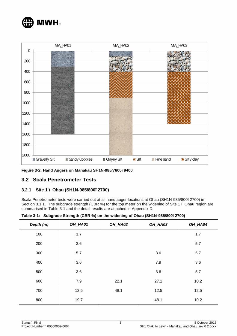
Status – Final 3 8 October 2013 Project Number – 80500902-0604 SH1 Otaki to Levin - Manakau and Ohau_rev 0 2.docx
Figure 3-2: Hand Augers on Manakau SH1N-985/7600–9400
3.2 Scala Penetrometer Tests
3.2.1 Site 1 – Ohau (SH1N-985/800–2700)
Scala Penetrometer tests were carried out at all hand auger locations at Ohau (SH1N-985/800–2700) in Section 3.1.1. The subgrade strength (CBR %) for the top meter on the widening of Site 1 – Ohau region are summarised in Table 3-1 and the detail results are attached in Appendix D.
Table 3-1: Subgrade Strength (CBR %) on the widening of Ohau (SH1N-985/800–2700)
Depth (m) OH_HA01 OH_HA02 OH_HA03 OH_HA04
100 1.7 1.7
200 3.6 5.7
300 5.7 3.6 5.7
400 3.6 7.9 3.6
500 3.6 3.6 5.7
600 7.9 22.1 27.1 10.2
700 12.5 48.1 12.5 12.5
800 19.7 48.1 10.2
0
200
400
600
800
1000
1200
1400
1600
1800
2000
MA_HA01 MA_HA02 MA_HA03
Gravelly Silt Sandy Cobbles Clayey Silt Silt Fine sand Silty clay

Status – Final 4 8 October 2013 Project Number – 80500902-0604 SH1 Otaki to Levin - Manakau and Ohau_rev 0 2.docx
Depth (m) OH_HA01 OH_HA02 OH_HA03 OH_HA04
900 17.2 7.9
1000 17.2 12.5
The subgrade CBR of 3.5-5% is suggested for the pavement design of the widening of Ohau region (SH1N-985/800–2700). This is based on the Scala Penetrometer test results.
3.2.2 Site 2 – Manakau (SH1N-985/7600–9400)
Scala Penetrometer tests were carried out at all hand auger locations at Manakau (SH1N-985/7600–9400) in Section 3.1.1. The subgrade strength for the top meter on the widening of Site 2 – Manakau region is shown in Table 3-2. Detail results are attached in Appendix D.
Table 3-2: Subgrade Strength (CBR %) on the widening of Manakau (SH1N-985/7600–9400)
Depth (m) MA_HA01 MA_HA02 MA_HA03
100 22.1
200 17.2
300 14.8
400 5.7
500 3.6 7.9 1.7
600 5.7 3.6 1.7
700 5.7 3.6 1.7
800 5.7 1.7 1.7
900 5.7 3.6 5.7
1000 3.6 14.8 5.7
The subgrade CBR falls in a range of 1.5–5%. HA_03 shows very weak subgrade strength of 1.7% which requires deeper pavement structure.
4 Design Standards The pavement designs for the widening of both sites will be undertaken in accordance with:
Austroads Guide to Pavement Technology Part 2 – Pavement Structural Design
Austroads Guide to Pavement Technology Part 5 – Pavement Evaluation and Treatment Design
New Zealand Supplement to the 2007 Austroads Pavement Design Guide
CIRCLY 5 modelling software

Status – Final 5 8 October 2013 Project Number – 80500902-0604 SH1 Otaki to Levin - Manakau and Ohau_rev 0 2.docx
5 Conceptual Pavement Design
The objective of the concept pavement and surfacing design is to provide a sound pavement structure for the widening on Site 1 – Ohau (SH1N-985/800–2700) and Site 2 – Manakau (SH1N-985/7500–9400) to withstand the design traffic of 25-year.
Three concept pavement designs were considered for each site. These are:
Option 1 – Foamed bitumen stabilisation (FBS)
Option 2 – Modified aggregate basecourse (MAB)
Option 3 – Unbound aggregate basecourse (UAB)
The preferred options have been selected based on its technical merit, constructability and cost effectiveness.
5.1 Option 1 – Foamed Bitumen Stabilisation (FBS)
This option would involve importing new granular basecourse and subbase materials, then stabilise the basecourse material with foamed bitumen and followed by two coat chipseal surfacing. The pavement thickness of this option is in the range of 500 mm for Site 1 – Ohau and approximately 600 mm for Site 2 – Manakau due to the weaker subgrade strength on Manakau section.
5.2 Option 2 – Modified Aggregate Basecourse (MAB)
This option would involve importing new basecourse and subbase granular aggregate materials, then modify the basecourse with cement followed by two coat chipseal surfacing. The pavement thickness of this option is in the range of 500–600 mm for Site 1 – Ohau and an approximately 600-700 mm for Site 2 – Manakau.
5.3 Option 3 – Unbound Aggregate Basecourse (UAB)
This option will involve importing new basecourse and subbase granular aggregate materials then followed by two coat chipseal surfacing. Since the design traffic loading is very high, this option requires deeper excavation in the order of a metre or more.
5.4 Existing Carriageway
Due to the new widening on Site 1 – Ohau and Site 2 – Manakau, to maintain a reasonable cross-fall, shape corrections with rehabilitation may be considered for the existing carriageway.
6 Further Testing
6.1 Geotechnical Investigations
Additional hand augers and Scala Penetrometer testing will be required for the detailed design stage.
6.2 Laboratory Testing
6.2.1 Subgrade Materials
Further laboratory testing including soaked CBR, plasticity index and clay index tests shall be undertaken to the subgrade materials at the widening of both sites to verify the subgrade strength and material properties. These additional tests will be necessary to aid in the selection of the preferred pavement type.
6.2.2 Granular Aggregates (Basecourse and Subbase)
Laboratory testing including grading, Atterberg limits and soaked CBR shall be undertaken to the granular aggregates to be imported for the widening of both sites to ensure the quality of the aggregates is as per TNZ

Status – Final 6 8 October 2013 Project Number – 80500902-0604 SH1 Otaki to Levin - Manakau and Ohau_rev 0 2.docx
M/4 specification for basecourse material and TNZ M/3 specification for subbase material during the detail design stage.
6.2.3 Foamed Bitumen Stabilisation
Should foamed bitumen basecourse stabilisation option is selected, test briquettes will be prepared for the new AP40 basecourse aggregates using a range of bitumen contents of 2.5-3.5% and cement contents of 1-1.5%. These briquettes should be tested for indirect tensile strength (ITS) tests in order to ensure the design requirements.
The ITS testing shall be undertaken by an accredited laboratory.
6.2.4 Modified Aggregate Basecourse (MAB)
Should the basecourse modification option is selected, unconfined compressive strength (UCS) tests shall be
undertaken by mixing the imported AP40 basecourse with 1-1.5% cement. This is to ensure the strength gain
is achieved to confirm design assumptions.
7 Underground Services
The design shall undertake a comprehensive location and depth of all services on both sites by pilot trenching and/or ground penetrating radar (GPR) to minimise the impact of the pavement design on the services.
8 Drainages
8.1 Kerb and Channel
New kerbs and channels will be proposed installed on both sites after the widening.
8.2 Surface Cross-fall
A surface cross-fall of 3% should be provided on both sides of the carriageway to allow water to run-off the surface into the kerb and channel and stormwater system efficiently.
9 Recommendations
It is recommended that:
modified aggregate basecourse option be investigated for Site 1 – Ohau and Site 2 – Manakau,
the modification can be undertaken by cement or foamed bitumen,
additional hand augers and Scala Penetrometer testing shall be undertaken at the widening during the detail design stage to assist in selecting the right pavement design option,
undertake laboratory testing on the imported aggregates to determine its reactivity with additives and for strength enhancement,
the weak subgrade be stabilised or undercut to provide a robust pavement to avoid future rutting or failures.

Status – Final 7 8 October 2013 Project Number – 80500902-0604 SH1 Otaki to Levin - Manakau and Ohau_rev 0 2.docx
Signed : Date : 20/03/2013 Prepared by: Wendy Chan
ME (Hons), BE (Civil), GIPENZ
Transportation Engineer MWH New Zealand Ltd (Auckland)
Signed : Date : 20/03/2013 Reviewed by: Ramiz Iskander BE Civil, CPEng, MIPENZ, MISCP
Pavement/Surfacing National Specialist MWH New Zealand Ltd (Auckland)

Status – Final 8 October 2013 Project Number – 80500902-0604 SH1 Otaki to Levin - Manakau and Ohau_rev 0 2.docx
Appendix A Preliminary Draft Drawings

Status – Final 8 October 2013 Project Number – 80500902-0604 SH1 Otaki to Levin - Manakau and Ohau_rev 0 2.docx
Appendix B Design Traffic Loading Calculations

SH1N Otaiki - Levin
Manakau - 25 years
Design Year 25
AADT 14600
DF 0.5
HCV 10.0%
LDF 1
Growth 2.0%
CGF 32
NHVAG 2.4
ESA/HVAG 0.6
DESA = 365 x AADT x DF x %HCV x LDF x CGF x NHVAG x (ESA/HVAG)
DESA = 365 x 14600 x 0.5 x 0.1 x 1 x 32 x 2.4 x 0.6
DESA = 12278016
Manakau - 10 year
Design Year 10
AADT 14600
DF 0.5
HCV 10.0%
LDF 1
Growth 2.0%
CGF 10.9
NHVAG 2.4
ESA/HVAG 0.6
DESA = 365 x AADT x DF x %HCV x LDF x CGF x NHVAG x (ESA/HVAG)
DESA = 365 x 14600 x 0.5 x 0.1 x 1 x 10.9 x 2.4 x 0.6
DESA = 4182199
ESA Calculations_Manakau_Ohau: Manakau 1 of 2

SH1N Otaiki - Levin
Ohau - 25 years
Design Year 25
AADT 14600
DF 0.5
HCV 10.0%
LDF 1
Growth 2.0%
CGF 32
NHVAG 2.4
ESA/HVAG 0.6
DESA = 365 x AADT x DF x %HCV x LDF x CGF x NHVAG x (ESA/HVAG)
DESA = 365 x 14600 x 0.5 x 0.1 x 1 x 32 x 2.4 x 0.6
DESA = 12278016
Ohau - 10 year
Design Year 10
AADT 14600
DF 0.5
HCV 10.0%
LDF 1
Growth 2.0%
CGF 10.9
NHVAG 2.4
ESA/HVAG 0.6
DESA = 365 x AADT x DF x %HCV x LDF x CGF x NHVAG x (ESA/HVAG)
DESA = 365 x 14600 x 0.5 x 0.1 x 1 x 10.9 x 2.4 x 0.6
DESA = 4182199
ESA Calculations_Manakau_Ohau: Ohau 2 of 2

Status – Final 8 October 2013 Project Number – 80500902-0604 SH1 Otaki to Levin - Manakau and Ohau_rev 0 2.docx
Appendix C Hand Augers Location Plans


Status – Final 8 October 2013 Project Number – 80500902-0604 SH1 Otaki to Levin - Manakau and Ohau_rev 0 2.docx
Appendix D Hand Auger Logs and Scala Penetrometer Results

Field Survey Staff: A. Hutchinson Page 1 of 26 Draft MWH
Project: Date: 26/9/2013
Job Number:
Coordinates:
Hand Auger
Topography:
Level from road
curb:
Summary:
Depth (m) Photograph
0-0.3
Manukau-Ohau Road Widening
0.3-1.6
Clayey SILT and trace of subangular gravel and organics; yellow mottled
light grey, soft, moist, low plasticity (ALLUVIAL SILT)
Becomes firm @1.2m
Becomes stiff @2.9m
Becomes very stiff @3.2m
Soil Description
80500902/0604
Gently underlating alluvial plain
E 1787364 N 5491059
Clayey SILT which becomes firm at 1.2m and then stiff at 2.9m
insert map
Scala Penetrometer Results
Gravelly SILT with some sand and clay; brown, soft, dry, angular to
subangular, low plasticity, (TOPSOIL/FILL)
~0.1m below
MA-HA01
0
0.5
1
1.5
2
2.5
3
3.5
0.00 5.00 10.00 15.00 20.00
De
pth
(m
)
Scala blows/100mm

Field Survey Staff: A. Hutchinson Page 2 of 26 Draft MWH
Project: Manukau-Ohau Road Widening Date: 26/9/2013
Job Number: 80500902/0604
Coordinates: E 1787194 N 5490560
Hand Auger MA-HA02
Topography: Gently underlating alluvial plain
Level from road
curb:~0.1m above
Summary:
Depth (m) to (m) Photograph
0 0.1 Gravelly SILT with some sand; dark brown, moist, (TOPSOIL)
0.1 0.4
0.4 0.9
Minor medium subrounded to subangular gravel @0.4-0.6m
0.9 2 fine SAND; light brown, (ALLUVIUM)
Trace subangular, medium gravel @1-1.2m
Becomes dense @1.1m
Becomes very dense @1.7m
insert map
Soil Description Scala Penetrometer Results
Sandy COBBLES with some silt and fine to coarse gravel; brown,
moist, (FILL)
SILT with minor clay and trace of sand; yellowish brown, very soft,
moist
0
0.5
1
1.5
2
2.5
3
3.5
0.00 5.00 10.00 15.00 20.00
De
pth
(m
bgl
)
Scala blows/100mm

Field Survey Staff: A. Hutchinson Page 3 of 26 Draft MWH
Project: Manukau-Ohau Road Widening Date: 26/9/2013
Job Number: 80500902/0604
Coordinates: E 1786944 N 54899990
Hand Auger MA-HA03
Topography: Gently underlating alluvial plain
Level from road
curb:~0.8m below
Summary:
Depth (m) to (m) Photograph
0 0.4 Silty COBBLES with some sand; dark brown, moist, (FILL)
0.4 1
1 1.4
Becomes soft @1.3m
Becomes very stiff @1.4m
insert map
Soil Description Scala Penetrometer Results
Silty CLAY; yellowish brown mottled orange and light grey, very
soft, moist, medium plasticity, moderately sensitive
Shear vane @ 1.1m peak shear strength 147kPa, residual 66kPa
Silty CLAY with trace of fine to medium gravel; brown, very soft,
moist, medium plasticity, gravel is angular to subangular
(ALLUVIUM)
0
0.5
1
1.5
2
2.5
3
3.5
0.00 5.00 10.00 15.00 20.00
De
pth
(m
bgl
)
Scala blows/100mm
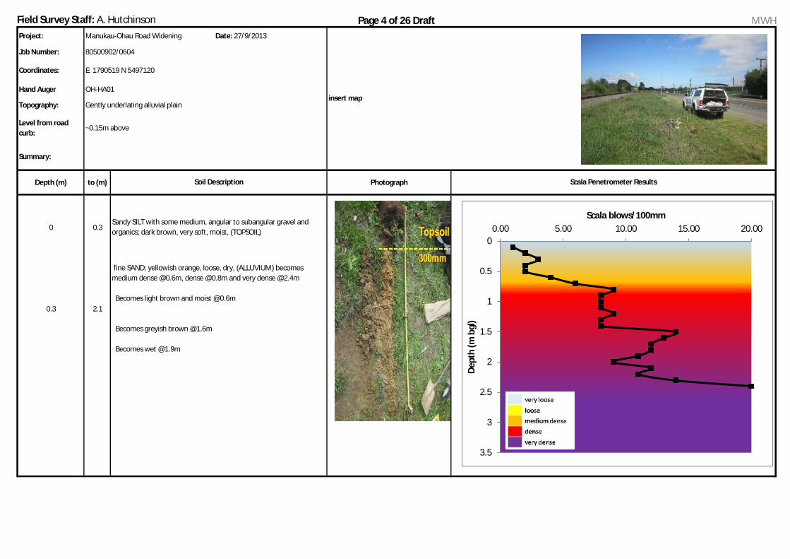
Field Survey Staff: A. Hutchinson Page 4 of 26 Draft MWH
Project: Manukau-Ohau Road Widening Date: 27/9/2013
Job Number: 80500902/0604
Coordinates: E 1790519 N 5497120
Hand Auger OH-HA01
Topography: Gently underlating alluvial plain
Level from road
curb:~0.15m above
Summary:
Depth (m) to (m) Photograph
0 0.3
0.3 2.1
insert map
Soil Description Scala Penetrometer Results
Sandy SILT with some medium, angular to subangular gravel and
organics; dark brown, very soft, moist, (TOPSOIL)
fine SAND; yellowish orange, loose, dry, (ALLUVIUM) becomes
medium dense @0.6m, dense @0.8m and very dense @2.4m
Becomes light brown and moist @0.6m
Becomes greyish brown @1.6m
Becomes wet @1.9m
0
0.5
1
1.5
2
2.5
3
3.5
0.00 5.00 10.00 15.00 20.00
De
pth
(m
bgl
)
Scala blows/100mm

Field Survey Staff: A. Hutchinson Page 5 of 26 Draft MWH
Project: Manukau-Ohau Road Widening Date: 27/9/2013
Job Number: 80500902/0604
Coordinates: E 1790132 N 5496162
Hand Auger OH-HA02
Topography: Flat alluvial pan
Level from road
curb:~0.3m above
Summary:
Depth (m) to (m) Photograph
0 0.25
0.25 0.5
0.6 Becomes dense @0.6m
0.7 Becomes very dense @0.7m
insert map
Soil Description Scala Penetrometer Results
Silty COBBLES with some gravel and minor sand; light brown, moist,
gravel is subrounded to subangular (Alluvial Gravel)
Sandy SILT with some organics; dark brown, very soft, moist
(TOPSOIL) 0
0.5
1
1.5
2
2.5
3
3.5
0.00 5.00 10.00 15.00 20.00
De
pth
(m
bgl
)
Scala blows/100mm

Field Survey Staff: A. Hutchinson Page 6 of 26 Draft MWH
Project: Manukau-Ohau Road Widening Date: 27/9/2013
Job Number: 80500902/0604
Coordinates: E 1790206 N 5496307
Hand Auger OH-HA03
Topography: Flat alluvial pan
Level from road
curb:at curb level
Summary:
Depth (m) to (m) Photograph
0 0.2
0.2 0.45
Becomes dense @ 0.6m
Becomes very dense @ 0.8m
insert map
Soil Description Scala Penetrometer Results
Silty GRAVEL with some cobbles; light brown, loose, moist, gravel is
subrounded (Alluvial Gravel)
Sandy SILT with some organics; dark brown, very soft, moist
(TOPSOIL)
3 7 3 28 12 55
0
0.5
1
1.5
2
2.5
3
3.5
0.00 5.00 10.00 15.00 20.00
CB
R
De
pth
(m
bgl
)
Scala blows/100mm

Field Survey Staff: A. Hutchinson Page 7 of 26 Draft MWH
Project: Manukau-Ohau Road Widening Date: 27/9/2013
Job Number: 80500902/0604
Coordinates: E 1790310 N 5496757
Hand Auger OH-HA04
Topography: Gently underlating alluvial plain
Level from road
curb:~0.35m above
Summary:
Depth (m) to (m) Photograph
0 0.3 Sandy SILT with some organics; dark brown, very soft, (TOPSOIL)
0.3 0.6
0.6 2.6
insert map
Soil Description Scala Penetrometer Results
SAND; light brown, medium dense, moist, (ALLUVIUM)
Becomes dense @1.5m
Sandy SILT; dark yellowish brown, soft, moist, low plasticity,
(ALLUVIUM)
0
0.5
1
1.5
2
2.5
3
3.5
0.00 5.00 10.00 15.00 20.00
De
pth
(m
bgl
)
Scala blows/100mm

Manakau & Ohau Scheme Assessment Report
Status: Draft for Consultation November 2013 Project No.: 80500902 Page 67 Our ref: Manukau_Ohau_SAR_Draft for Consultation.docx
Appendix G Preliminary Land Requirement Plan(s)
Manakau & Ohau Scheme Assessment Report
Status: Draft for Consultation November 2013 Project No.: 80500902 Page 68 Our ref: Manukau_Ohau_SAR_Draft for Consultation.docx
Appendix H Ohau Speed Limit Warrant

Survey forms
Road Controlling Authority at
Road from to
Surveyed by Date
TO
South
Fro
nta
ge
Sid
e R
oad
Su
b T
ota
l
Peds
Cyclis
ts
Park
ing G
eom
etr
y
Geom
etr
y
Tra
ffic
Contr
ol
Use
Su
b T
ota
l
1.0
0 0 0 0 0 4 0 0 4 0
0.9
1 1 2 0 0 0 4 0 0 4 4
Marsden Tce
0.8
0 0 0 0 0 4 0 0 4 0
0.7
0 0 0 0 0 5 0 0 5 0
0.6
1 1 0 0 0 5 0 0 5 2
0.5
0 1 1 0 0 0 5 0 0 5 2
Vista Rd0.4
0 0 0 0 0 5 0 0 5 0
0.3
2 2 0 0 0 5 0 0 5 4
0.2
0 1 1 0 0 0 5 0 0 5 2
McLeavy Dr
0.1
0 0 0 0 0 5 0 0 5 0
80/100
FROM 0.07 47 14
North
and
Total Notes
SPEED LIMIT SURVEY FORM (RATING DIAGRAM)
Average rating between 0.0 equals 1.41.0
NZTA Ohau
DEVELOPMENT
RATINGROADWAY RATING
State Highway 1 NorthSouth
Dan Tate
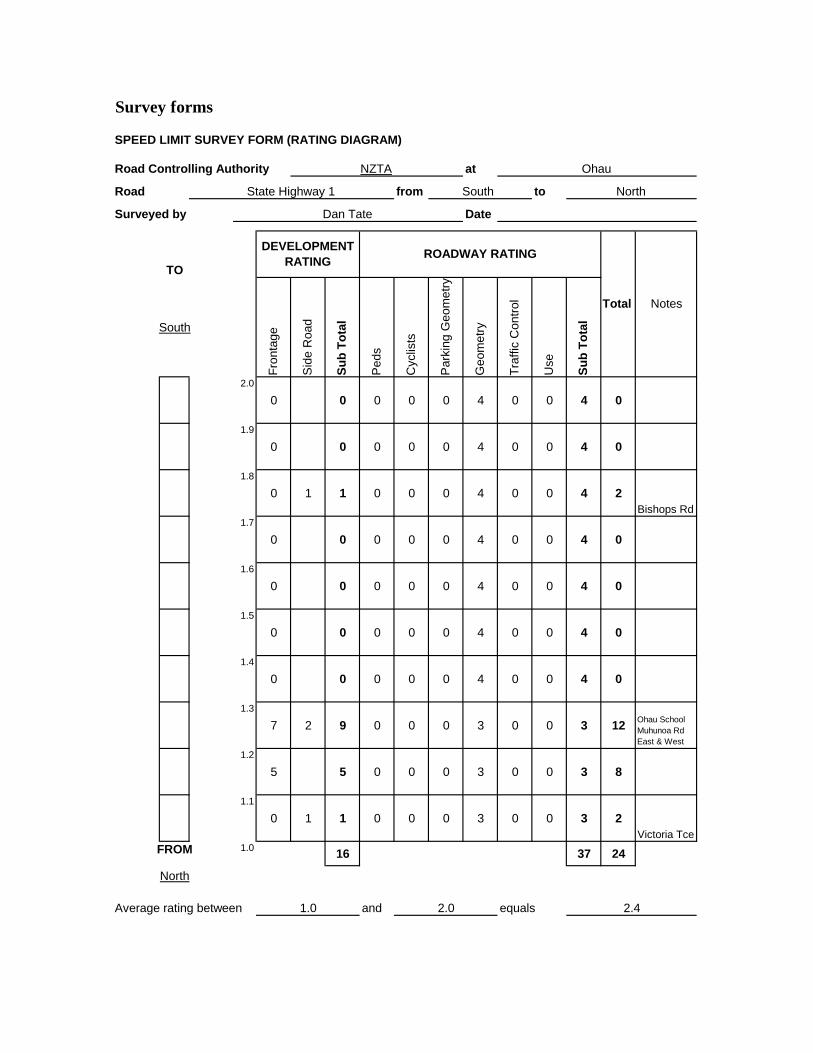
Survey forms
Road Controlling Authority at
Road from to
Surveyed by Date
TO
South
Fro
nta
ge
Sid
e R
oad
Su
b T
ota
l
Peds
Cyclis
ts
Park
ing G
eom
etr
y
Geom
etr
y
Tra
ffic
Contr
ol
Use
Su
b T
ota
l
2.0
0 0 0 0 0 4 0 0 4 0
1.9
0 0 0 0 0 4 0 0 4 0
1.8
0 1 1 0 0 0 4 0 0 4 2
Bishops Rd1.7
0 0 0 0 0 4 0 0 4 0
1.6
0 0 0 0 0 4 0 0 4 0
1.5
0 0 0 0 0 4 0 0 4 0
1.4
0 0 0 0 0 4 0 0 4 0
1.3
7 2 9 0 0 0 3 0 0 3 12Ohau School
Muhunoa Rd
East & West
1.2
5 5 0 0 0 3 0 0 3 8
1.1
0 1 1 0 0 0 3 0 0 3 2
Victoria Tce
FROM 1.016 37 24
North
and 2.4Average rating between 1.0 2.0 equals
DEVELOPMENT
RATINGROADWAY RATING
Total Notes
State Highway 1 South North
Dan Tate
SPEED LIMIT SURVEY FORM (RATING DIAGRAM)
NZTA Ohau

Survey forms
Road Controlling Authority at
Road from to
Surveyed by Date
TO
South
Fro
nta
ge
Sid
e R
oad
Su
b T
ota
l
Peds
Cyclis
ts
Park
ing G
eom
etr
y
Geom
etr
y
Tra
ffic
Contr
ol
Use
Su
b T
ota
l
3.0
1 1 2 0 0 0 3 0 0 3 4
Private Road
2.9
0 0 0 0 0 3 0 0 3 0
2.8
0 0 0 0 0 3 0 0 3 0
2.7
1 1 0 0 0 5 0 0 5 2
2.6
0 0 0 0 0 5 0 0 5 0
2.5
0 0 0 0 0 5 0 0 5 0
2.4
0 0 0 0 0 5 0 0 5 0
2.3
1 1 0 0 0 5 0 0 5 2
2.2
0 1 1 0 0 0 4 0 0 4 2
Parakwau Rd
2.1
0 0 0 0 0 4 0 0 4 0
FROM 2.05 42 10
North
and 1Average rating between 2.0 3.0 equals
DEVELOPMENT
RATINGROADWAY RATING
Total Notes
State Highway 1 South North
Dan Tate
SPEED LIMIT SURVEY FORM (RATING DIAGRAM)
NZTA Ohau

Survey forms
Road Controlling Authority at
Road from to
Surveyed by Date
TO
South
Fro
nta
ge
Sid
e R
oad
Su
b T
ota
l
Peds
Cyclis
ts
Park
ing G
eom
etr
y
Geom
etr
y
Tra
ffic
Contr
ol
Use
Su
b T
ota
l
4.0
3 3 0 0 0 5 0 0 5 6
3.9
5 5 0 0 0 5 0 0 5 10
3.8
0 1 1 0 0 0 5 0 0 5 2Kuku East
Rd & Kuku
Beach Rd
3.7
2 2 0 0 0 5 0 0 5 4
3.6
0 0 0 0 0 3 0 0 3 0
3.5
1 1 0 0 0 3 0 0 3 2
3.4
2 2 0 0 0 3 0 0 3 4
3.3
2 2 0 0 0 3 0 0 3 4
3.2
4 4 0 0 0 3 0 0 3 7
3.1
7 7 0 0 0 3 0 0 3 10 Marae & Gift
Shop
FROM 3.027 38 49
North
and 4.9Average rating between 3.0 4.0 equals
DEVELOPMENT
RATINGROADWAY RATING
Total Notes
State Highway 1 South North
Dan Tate
SPEED LIMIT SURVEY FORM (RATING DIAGRAM)
NZTA Ohau
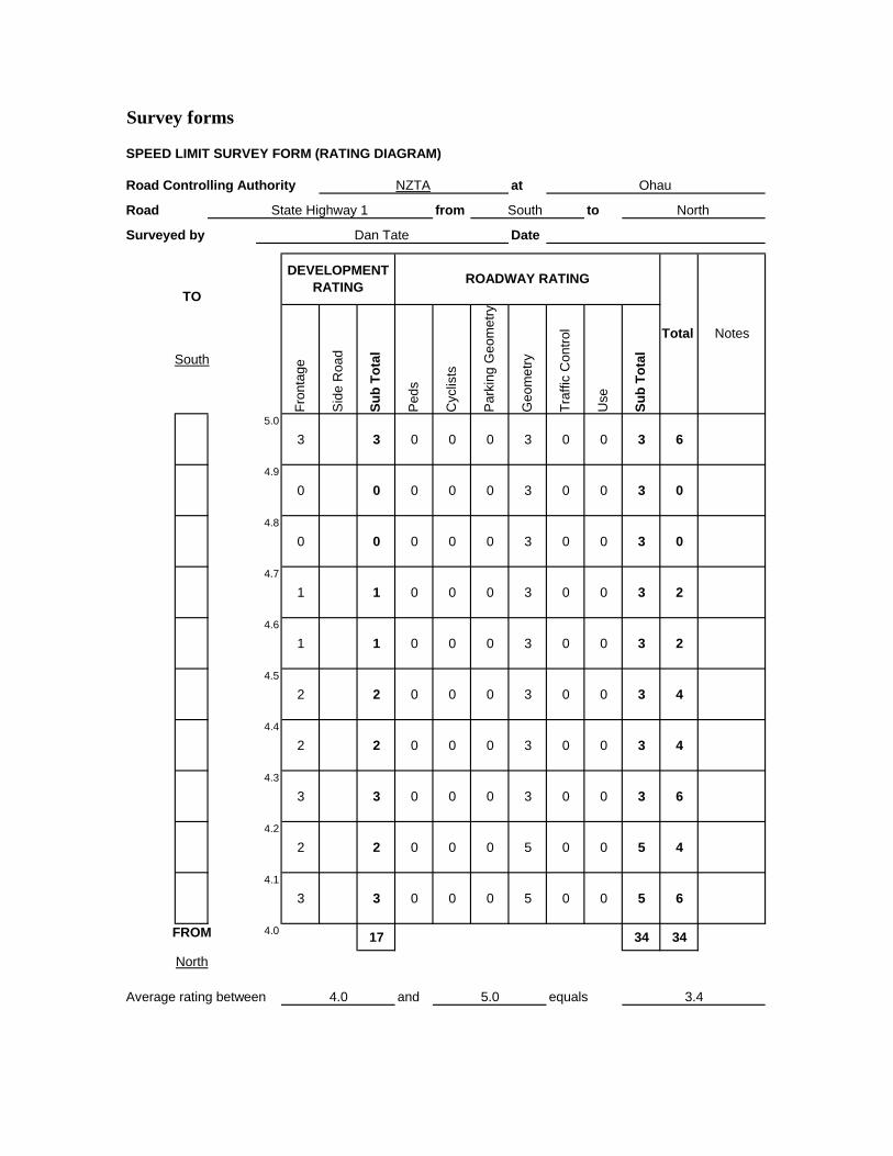
Survey forms
Road Controlling Authority at
Road from to
Surveyed by Date
TO
South
Fro
nta
ge
Sid
e R
oad
Su
b T
ota
l
Peds
Cyclis
ts
Park
ing G
eom
etr
y
Geom
etr
y
Tra
ffic
Contr
ol
Use
Su
b T
ota
l
5.0
3 3 0 0 0 3 0 0 3 6
4.9
0 0 0 0 0 3 0 0 3 0
4.8
0 0 0 0 0 3 0 0 3 0
4.7
1 1 0 0 0 3 0 0 3 2
4.6
1 1 0 0 0 3 0 0 3 2
4.5
2 2 0 0 0 3 0 0 3 4
4.4
2 2 0 0 0 3 0 0 3 4
4.3
3 3 0 0 0 3 0 0 3 6
4.2
2 2 0 0 0 5 0 0 5 4
4.1
3 3 0 0 0 5 0 0 5 6
FROM 4.017 34 34
North
and 3.4Average rating between 4.0 5.0 equals
DEVELOPMENT
RATINGROADWAY RATING
Total Notes
State Highway 1 South North
Dan Tate
SPEED LIMIT SURVEY FORM (RATING DIAGRAM)
NZTA Ohau

Survey forms
Road Controlling Authority at
Road from to
Surveyed by Date
TO
South
Fro
nta
ge
Sid
e R
oad
Su
b T
ota
l
Peds
Cyclis
ts
Park
ing G
eom
etr
y
Geom
etr
y
Tra
ffic
Contr
ol
Use
Su
b T
ota
l
6.0
1 1 0 0 0 5 0 0 5 2
5.9
1 1 0 0 0 5 0 0 5 2
5.8
0 0 0 0 0 5 0 0 5 0
5.7
5 5 0 0 0 5 0 0 5 10
5.6
2 2 0 0 0 5 0 0 5 4
5.5
1 1 0 0 0 5 0 0 5 2
5.4
0 0 0 0 0 5 0 0 5 0
5.3
1 1 0 0 0 5 0 0 5 2
5.2
2 2 0 0 0 5 0 0 5 4
5.1
2 2 0 0 0 4 0 0 4 4
FROM 5.015 49 30
North
and 3Average rating between 5.0 6.0 equals
DEVELOPMENT
RATINGROADWAY RATING
Total Notes
State Highway 1 South North
Dan Tate
SPEED LIMIT SURVEY FORM (RATING DIAGRAM)
NZTA Ohau

Ohau Township Speed Limit Warrant
Vista Road (chainage 0.4) to South of Muhunoa Street (1.3) chainage 0.4 to 1.3
Total development rating = 19
Total roadway rating = 40
therefore;
Total development rating = 19
Total roadway rating (adjusted) = 19
Total rating = 38
Total distance 10*100m
sections
Average Rating ( R ) 3.8
From table SLNZ 12, for a rural location an R value of 3.8 results in a 80 km/h speed limit
Ohau Township Speed Limit Warrant ( from south of Muhunoa Street to the existing 80/100 south of Levin)
Vista Road (chainage 0.4) to South of Muhunoa Street (1.3) chainage 0.4 to 1.3
Total development rating = 22
Total roadway rating = 56
therefore;
Total development rating = 22
Total roadway rating (adjusted) = 22
Total rating = 44
Total distance 14*100m
sections
Average Rating ( R ) 3.1
From table SLNZ 12, for a rural location an R value of 3.1 results in a 80 km/h speed limit
Therefore, the 80k/h is still warranted considering the longer section length
Note:
Due to the short (approx. 550m) distance between the proposed threshold 100m south of Vista Road (RP 985/1.2) and the existing
80/100 speed limit (RP 985/0.55), if the speed limit was changed to 80 km/h throuigh the Ohau township, between the proposed
thresholds south of Vista Road and south of Muhunoa Road, the remaining 650m 100km/h section would be short of the minimum 2km
length required for a 100km/h speed limit (Table SLNZ1). As a result, the proposed 80km/h speed reduction commencing south of
Muhunoa Road would be extended up to the existing Levin South threshold (RP /0.55), with a repeater 80km/h sign at the township
threshold south of Vista Road for southbound traffic.
However, the total roadway rating cannot exceed the development rating, so reduce the total roadway score to same as development
(SLNZ section 4.3)
(RP distance ~920m, from just south of Vista Road (RP 985/1.09) to
south of Muhunoa Street (RP 985/2.01)
However, the total roadway rating cannot exceed the development rating, so reduce the total roadway score to same as development
(RP distance ~1390m, from just south of Buller Road (RP 985/0.62)
to south of Muhunoa Street (RP 985/2.01)

Manakau & Ohau Scheme Assessment Report
Status: Draft for Consultation November 2013 Project No.: 80500902 Page 69 Our ref: Manukau_Ohau_SAR_Draft for Consultation.docx
Appendix I Manakau Speed Limit Warrant
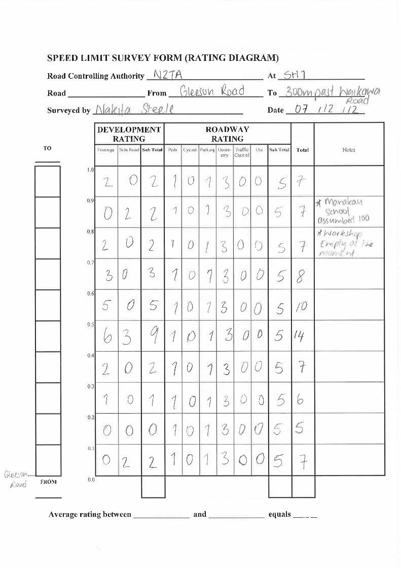


Manakau & Ohau Scheme Assessment Report
Status: Draft for Consultation November 2013 Project No.: 80500902 Page 70 Our ref: Manukau_Ohau_SAR_Draft for Consultation.docx
Appendix J Proposed Geotechnical Testing Schedule
The preliminary geotechnical investigation has included three hand augers and four hand augers with corresponding Scala Penetrometers at Manakau and Ohau respectively.
To provide sufficient information for detailed design of the road widening projects, it is proposed to supplement the preliminary investigation with additional field investigation and laboratory testing in order to further assess the variable ground conditions. The detailed geotechnical investigation will increase sample density to around one sample location every 200m and will include the following:
Project Site Test Location Comments
Test Pits Manakau & Ohau Within unsealed shoulder
5 in each
Shear Vanes Manakau & Ohau Within each test pit 1 per test pit
Scala Penetrometer Manakau & Ohau Within each test pit 1 per test pit
Lab Testing Manakau & Ohau 0.5m below level of proposed pavement widening
3 samples from each Village including California Bearing Ratio, Plasticity Index and Clay Index

Manakau & Ohau Scheme Assessment Report
Status: Draft for Consultation November 2013 Project No.: 80500902 Page 71 Our ref: Manukau_Ohau_SAR_Draft for Consultation.docx
Appendix K Project Risk Register

Ian Rich – HNO Risk Advisor (Tel: 04 894 6287)
August 2013Risk Register
SH1 - Manukau to Ohau I&R
Document Date:
464PM Supplier Lead 1: Jamie Povall MWH
NZTA Wellington Supplier Lead 2: Alix Newman MWH
Jo Draper Supplier RM Specialist: John Creagh MWH
Treatment Strategy
Ran
k
RID Risk Title
Description/
Cause/
Consequence
Risk
Owner
Risk
Owning
Org
Date
RaisedRisk Status Phase
Established
Controls
Co
nsq
.
Pro
b
Ris
k
Sco
re
(refer to Actions Register for detail)
Co
nsq
.
Pro
b
Ris
k
Sco
re Commentary &
Closure Statement
1 O&M10 Economics
Ohau & Manukau: Economics of project do not
reach appropriate threshold for funding, hence
project funding is jeopardised. Signficant delay
to project (or even cancellation)Jamie Povall NZTA 15/10/2013 Live - Parked
Pre
ImplementationNil Very High High 24
Economic approach will explore all
potential avenues to eke out
economic benefits. Consequences
of no economics still very high, but
mitigation may reduce likelihood.
Very High Low 20
2 O&M8 Design
Ohau & Manukau: Decision to not remove
adjacent power poles results in crash and injury
for constructed highwayJo Draper NZTA 15/10/2013 Live - Parked Operation
Design
standards and
speed limits Very High Low 20
Removal of power poles as part of
implementationVery Low Very Low 1
Significant added cost for
removal
2 O&M9 Other
Ohau & Manukau: Removal of passing lanes in
town, leads to unsafe driver behaviour with
injuries. s Jo Draper NZTA 15/10/2013 Live - Parked Operation
Speed limits and
road markingsVery High Low 20
Implementation of passing lane
strategy for SH1 should remove
temptation to overtake
inappropriately.
Very High Very Low 13Consequence of injury is still
high, but the likelihood is
reduced.
4 O&M7 Design
Ohau & Manukau: Safety audit reqiures design
changes with follow-on implementation cost
increases Jamie Povall NZTA 15/10/2013 Live - ParkedPre
ImplementationNil High Medium 19
Critical review of safety audit
findings (including VAC on
standards compromise if
necessary) to reduce cost
consequence.
Medium Low 11
5 O&M1Land and
Property
Ohau: Road is slightly elevated in relation to
properties. With seal widening, access is
required to occupy and regrade land. Owner
refusal may delay project and/or require minor
retaining. Consider delays of greater
consequence
Jo Draper - in
lieu of property
agent.
NZTA 15/10/2013 Live - Treat Property Nil Medium Medium 15
Consultation (to start), if done well
and considerately, with adequate
compensation (as part of
construction costs) should reduce
likelihood of refusal
Low Very Low 2
Cost of implementing this
mitigation already included in
consultation phase costs.
5 O&M3Land and
Property
Ohau: Property numbered 398 on SH1 has
building footprint on NZTA property. While
controls would place onus on owner to remain
clear of NZTA property, issues related to
confirming costs and responsiblities may delay
project and/or have costs.
Jo Draper - in
lieu of property
agent.
NZTA 15/10/2013 Live - Treat Property PWA Medium Medium 15
Consultation to understand (or
negotiate) stance of property
owners and impacts on project.Medium Medium 15
At this stage, inadequate
information to develop a
mitigation approach.
7 O&M2Land and
Property
Ohau: Construction process will require
occupation of KiwiRail land. Refusal for access
may result in delays and/or financial incentives,
although approval in principle held.
Jo Draper - in
lieu of property
agent.
NZTA 15/10/2013 Live - Treat Property Nil Medium Low 11
As part of design process, formal
access approval to be obtained.Medium Very Low 4
Cost of implementing this
mitigation already included in
consultation phase costs.
7 O&M6 Design
Ohau & Manukau: Safety audit changes
property requirements to require designation of
private properties. Delay for process more of an
effect than likely property costs
Jamie Povall NZTA 15/10/2013 Live - ParkedPre
ImplementationNil Medium Low 11
Critical review of safety audit
findings to ensure any designation
is absolutely essential. Should
any designations remain, delay
Medium Very Low 4Mitigation measure only likely to
reduce likelihood of occurrence.
9 O&M4Access and
Severance
Manukau: Access to Honi Taipua St reduced to
left-in/left-out becomes a consultation issue and
delays implementation
Jo Draper - in
lieu of
consultation
agent
NZTA 15/10/2013 EmergingPre
Implementation
NZTA State
Highway
authority.
Low Low 6
Thorough and inclusive consultaton
to inform objectors of purpose and
effect of closure. Should reduce
any delays associated with
unhappy participants.
Low Very Low 2
9 O&M5 Environmental
Ohau & Manukau: Construction has adverse
effects on local environment, including vibration
affecting local properties, potentially delaying
completion.
Jo Draper - in
lieu of
contractor
NZTA 15/10/2013 Live - Parked Implementation
Construction
contract liability
provisions.
Low Low 6
Construction contract to recognise
potential vibration and other
environmental problems, and
reduce likelihood and
consequence.
Very Low Very Low 1
Current ExposureResidual (Target)
Exposure
Semi-Quantitative Semi-Quantitative
16/10/2013Project/Contract:
Project/Contract ID:
NZTA Office:
NZTA Lead:
Page 1 of 1

Manakau & Ohau Scheme Assessment Report
Status: Draft for Consultation November 2013 Project No.: 80500902 Page 72 Our ref: Manukau_Ohau_SAR_Draft for Consultation.docx
Appendix L Economic Evaluation Worksheets

Determination of accident reduction percentage for Method A
(AADT >1500, road section > 1km long, >=3 injury accidents/km, no fundamental change) >> Method A (A6.2) ManakauTreatment adpopted low high % reduction F+S
Percentage reduction based on actual crashes that would have been prevented by improvement measures: Flush median e2.1 (aadt>5000) 52 30 52 30-52% 90Shoulder widening to 2.5m and consistent 3.5m lane widths existing 0.6-1.7m 30 14 35 14-35% 30
Threshold treatment E6.2 HRRRG 20 11 27 11-27% 20
Speed reduction E6.3 HRRRG based on a 10km/h drop in operating speed 20 15-45% 20
2003-2007 2008-2012 2003-2012 checkFatal 0 0 0 0 combined % (multiplicative) - all crashes 78%Serious Inj. 2 1 3 3 combined % (multiplicative) - F&S 96%
Fat. & ser 2 1 3 3Minor Inj. 7 1 8 8 The following treatments will also further reduce select crashes/crash types:Non Inj. 7 16 23 23 LILO at the railway underpass
34 34 Shoulder widening at Mokena Kohere for longer vehiclesFootpath provision, 2.5m shoulder for cyclists
Passing lane removaldue to short length & proximity to township
2003-2007 2008-2012 2003-2012 2002-20072008-20122003-2012Fatal 0 0 0 Fatal 0 0 0 0Serious Inj. 2 1 3 Serious Inj. 0 0 0 3Fat. & ser 2 1 3 Fat. & ser 0 0 0 3Minor Inj. 6 1 7 Minor Inj. 1 0 1 8Non Inj. 5 12 17 Non Inj. 2 4 6 23
27 7 34
2003-2007 2008-2012 2003-2012Fatal 0% 0% 0%Serious Inj. 100% 100% 100%Fat. & ser 100% 100% 100%Minor Inj. 86% 100% 88%Non Inj. 71% 75% 74%
Sensitivity Testing: crash reductions as a percentage of theoretical reduction: 75%
% crash reduction following improvements (assumed actual)2003-2007 2008-2012 2003-2012
Fatal NA NA NASerious Inj. 75% 75% 75%Fat. & ser 75% 75% 75%Minor Inj. 64% 75% 66%Non Inj. 54% 56% 55%
Optimistic: 100% of the theoretical crash reductions achievedMedian: 75% of the theoretical crash reductions achievedPessimistic: 50% of the theoretical crash reductions achieved
Alternative analysis
All crashes
Crashes preventable by improvements (theoretical) Crashes remaining after improvements
It is considered that a crash by crash analysis by is more appropriate given the low number of crashes, short study length, and the combined cumaltive nature of the treatments. This also allows a reduction % to be calculated by crash severity.
crash reduction following improvements (theoretica
Crash reductions have been calculated from analysing the crash history over the preceeding 5 and 10 year periods, and identifying the crashes that would theoretically be prevented by the improvements. BCR's have then been calculated based on the most optimistic, pessimistic and median crash reductions expected. The median improvement has been taken forward for economic analysis.

Section CRASH ROADCRASH DIST
CRASH DIRN
SIDE ROAD CRASH ID CRASH DATECRASH DOW
CRASH TIME
MVMT DESCR CAUSES ROAD WET LIGHT WTHRa JUNC TYPE TRAF CTRLCRASH FATAL CNT
CRASH SEV CNT
CRASH MIN CNT
Fixed by improvements?* CAS Mvmt SEV
Manakau ‐ 2003 to 20071N/985/9.194 200 N GLEESON ROAD 2757153 16/12/2007 Sun 1600 load or trailer from TRUCK1 SBD on SH 1N hit CAR2
CAR2 hit DebrisTRUCK1 load not well secured or moved Dry Bright Sun Fine Unknown Nil 0 0 0 n Miscellaneous
N
Manakau ‐ 2008 to 20121N/985/9.194 200 N GLEESON ROAD 201052188 24/05/2010 Mon 1910 CAR1 SBD on SH 1N lost control but did not leave
the road, CAR1 hit DitchCAR1 lost control due to road conditions, failed to notice roadworks signs ENV: road surface under construction or maintenance
Wet Dark Light Rain Unknown Nil 0 0 0 n Lost control on road
N
Manakau ‐ 2003 to 20071N/985/9.094 300 N GLEESON ROAD 2753755 8/07/2007 Sun 1800 CAR1 SBD on SH 1N hit rear end of CAR2 stop/slow
for queueCAR1 failed to notice car slowing Dry Dark Fine Unknown Nil 0 0 0 y Rear end ‐
queuing N
Manakau ‐ 2008 to 20121N/985/9.071 100 S MANAKAU RAIL
UNDERPASS2950036 3/01/2009 Sat 1508 CAR1 SBD on SH 1N hit rear end of CAR2 stop/slow
for queueCAR1 following too closely Dry Bright Sun Fine Unknown Nil 0 0 0 y Rear end ‐
queuing N
Manakau ‐ 2003 to 20071N/985/8.973 I MANAKAU RAIL
UNDERPASS2713513 12/10/2007 Fri 2330 CAR1 SBD on SH 1N lost control turning left, CAR1
hit Cliff Bank, Post Or PoleCAR1 alcohol test above limit or test refused, too fast entering corner, vehicle caught fire
Dry Dark Fine T Type Junction
Give Way Sign
0 0 1 y Lost control off road M
Manakau ‐ 2003 to 20071N/985/8.971 I MANAKAU RAIL
UNDERPASS2355504 26/08/2003 Tue 1615 CAR1 NBD on SH 1N lost control; went off road to
left, CAR1 hit Fence, Post Or PoleCAR1 lost control avoiding another vehicle, failed to notice car slowing
Dry Bright Sun Fine T Type Junction
Give Way Sign
0 0 0 y Lost control off road N
Manakau ‐ 2003 to 20071N/985/8.829 450 N GLEESON ROAD 2511038 24/01/2005 Mon 1110 CAR1 SBD on SH 1N hit rear of CAR2 turning right
from left sideCAR2 turned right from left side of road, didnt see/look behind when changing lanes, position or direction ENV: entering or leaving other commercial
Wet Overcast Light Rain Driveway Nil 0 0 1 y rear end ‐ slow veh
M
Manakau ‐ 2003 to 20071N/985/8.779 500 N GLEESON ROAD 2411898 22/05/2004 Sat 1616 MOTOR CYCLE1 SBD on SH 1N overtaking hit CAR2
turning right, MOTOR CYCLE1 hit Cliff BankMOTOR CYCLE1 overtaking vehicle signaling right turn ENV: entering or leaving other commercial
Dry Bright Sun Fine Driveway Nil 0 1 0 y OvertakingS
Manakau ‐ 2008 to 2012
1N/985/8.779 500 N GLEESON ROAD 2851946 27/04/2008 Sun 1530 MOTOR CYCLE1 NBD on SH 1N hit SUV2 U‐turning from opposite direction of travel
SUV2 alcohol test above limit or test refused, didnt see/look behind when changing lanes, position or direction ENV: entering or leaving private house / farm
Dry Bright Sun Fine Driveway Nil 0 0 0 y Crossing ‐ turning
N
Manakau ‐ 2008 to 20121N/985/8.777 500 N GLEESON ROAD 201056927 8/12/2010 Wed 720 load or trailer from VAN1 SBD on SH 1N VAN1 hit
Fence, Traffic SignVAN1 inadequate tow coupling Dry Bright Sun Fine Unknown Nil 0 0 0 n Miscellaneous
N
Manakau ‐ 2003 to 20071N/985/8.773 200 N MANAKAU RAIL
UNDERPASS2312936 7/10/2003 Tue 1355 CAR1 SBD on SH 1N lost control turning right, CAR1
hit Bridge, Guard Rail on right hand bend CAR1 lost control avoiding another vehicle Dry Overcast Fine Unknown Nil 0 0 1 n Lost control off
road M
Manakau ‐ 2008 to 20121N/985/8.769 650 S WAIKAWA BEACH ROAD 201050628 7/02/2010 Sun 1538 CAR1 SBD on SH 1N hit rear of SUV2 turning right
from left sideSUV2 didnt see/look behind when changing lanes, position or direction ENV: entering or leaving roadside stall
Dry Bright Sun Fine Driveway Nil 0 0 0 y rear end ‐ slow veh
N
Manakau ‐ 2008 to 20121N/985/8.74 250 S MOKENA KOHERE ST 201056722 24/12/2010 Fri 1420 CAR1 NBD on SH 1N hit SUV2 turning right onto SH
1N from the leftSUV2 failed to give way at driveway, misjudged speed etc of vehicle coming from another dirn with right of way ENV: entering or leaving roadside stall
Dry Bright Sun Fine Driveway Nil 0 0 0 y Crossing ‐ turning
N
Manakau ‐ 2003 to 20071N/985/8.739 620 S WAIKAWA BEACH ROAD 2555609 4/11/2005 Fri 1913 CAR1 SBD on SH 1N lost control; went off road to
right, CAR1 hit FenceCAR1 fatigue (drowsy, tired, fell asleep) Dry Twilight Fine Unknown Nil 0 0 0 n Lost control off
road N
Manakau ‐ 2003 to 20071N/985/8.642 150 S MOKENA KOHERE ST 2511579 28/03/2005 Mon 1830 MOTOR CYCLE1 SBD on SH 1N hit rear end of CAR2
stop/slow for queueMOTOR CYCLE1 lost control under heavy braking, following too closely
Dry Dark Fine Unknown Nil 0 0 1 y Rear end ‐ queuing M
Manakau ‐ 2008 to 20121N/985/8.633 140 S MOKENA KOHERE ST 2952904 23/05/2009 Sat 1602 TRUCK1 SBD on SH 1N hit CAR2 headon on straight,
CAR2 hit RoadworksTRUCK1 fatigue due to lack of sleep CAR2 lost control avoiding another vehicle, suddenly swerved to avoid vehicle
Wet Overcast Light Rain Unknown Nil 0 0 0 n Head on
N
Manakau ‐ 2008 to 20121N/985/8.516 400 S WAIKAWA BEACH ROAD 201212570 8/09/2012 Sat 1522 CAR1 NBD on SH 1N lost control; went off road to
left, CAR1 hit Post Or PoleCAR1 alcohol test result unknown, too far left/right ENV: road slippery (rain), heavy rain
Wet Overcast Heavy Rain
Unknown Nil 0 2 1 y Lost control off road S
Manakau ‐ 2008 to 20121N/985/8.49 I MOKENA KOHERE ST 2856293 25/11/2008 Tue 435 CAR1 SBD on SH 1N lost control; went off road to
left, CAR1 hit Kerb, Post Or PoleCAR1 too far left/right, fatigue (drowsy, tired, fell asleep) Wet Dark Light Rain T Type
JunctionGive Way Sign
0 0 0 y Lost control off road N
Manakau ‐ 2008 to 20121N/985/8.49 I MOKENA KOHERE ST 201051654 11/04/2010 Sun 1650 CAR1 SBD on SH 1N hit SUV2 turning right onto SH
1N from the leftSUV2 failed to give way at give way sign, didnt see/look when required to give way to traffic from another direction, impared ability due to old age
Dry Bright Sun Fine T Type Junction
Give Way Sign
0 0 0 y Crossing ‐ turning
N
Manakau ‐ 2008 to 20121N/985/8.49 I MOKENA KOHERE ST 201254109 27/10/2012 Sat 2350 CAR1 NBD on SH 1N hit rear of CAR2 turning right
from centre lineCAR1 too fast on straight, overtaking Dry Dark Fine T Type
JunctionGive Way Sign
0 0 0 y Rear end ‐ crossing N
Manakau ‐ 2008 to 2012
1N/985/8.486 370 S WAIKAWA BEACH ROAD 201112144 23/05/2011 Mon 1240 CAR1 SBD on SH 1N hit SUV2 U‐turning from same direction of travel
SUV2 didnt see/look behind when changing lanes, position or direction, misjudged speed, etc of vehicle coming from behind or alongside, windscreen or rear window misted/frosted
Dry Overcast Fine Unknown Nil 0 0 1 y Crossing ‐ turning
M
Manakau ‐ 2003 to 20071N/985/8.41 80 N MOKENA KOHERE ST 2712706 1/07/2007 Sun 1145 CAR1 SBD on SH 1N hit rear of CAR2 turning right
from left sideCAR2 attention diverted by passengers, did not see or look for other party until too late, windscreen or mirror ENV: entering or leaving roadside stall
Wet Overcast Light Rain Driveway Nil 0 0 2 y rear end ‐ slow veh
M
Manakau ‐ 2003 to 20071N/985/8.39 100 N MOKENA KOHERE ST 2712650 27/07/2007 Fri 1124 VAN1 SBD on SH 1N hit CAR2 U‐turning from same
direction of travelCAR2 didnt see/look behind when changing lanes, position or direction
Dry Bright Sun Fine Unknown Nil 0 0 1 y Crossing ‐ turningM
Manakau ‐ 2003 to 20071N/985/8.36 130 N MOKENA KOHERE ST 2411105 12/01/2004 Mon 1436 CAR1 SBD on SH 1N lost control; went off road to
right, CAR1 hit Parked VehicleCAR1 failed to keep left on straight, fatigue (drowsy, tired, fell asleep)
Dry Overcast Fine Unknown Nil 0 1 1 y Lost control off road S
Manakau ‐ 2003 to 20071N/985/8.196 80 S WAIKAWA BEACH ROAD 2711969 24/03/2007 Sat 1653 CAR1 SBD on SH 1N lost control while overtaking CAR1 lost control while returning to seal from unsealed
shoulder, overtaking line of traffic or queue, failed to notice oncoming traffic
Dry Bright Sun Fine Unknown Nil 0 0 1 y Lost control off road
M
Manakau ‐ 2003 to 20071N/985/8.116 I WAIKAWA BEACH ROAD 2351514 19/04/2003 Sat 1550 VAN1 NBD on SH 1N hit CAR2 turning right onto SH
1N from the leftVAN1 failed to give way at give way sign Dry Overcast Fine T Type
JunctionGive Way Sign
0 0 0 y Crossing ‐ turningN
Manakau ‐ 2003 to 20071N/985/8.116 I WAIKAWA BEACH ROAD 2354953 19/10/2003 Sun 1343 CAR1 SBD on SH 1N hit CAR2 merging from the right CAR2 turned into incorrect lane, failed to give way at give
way signDry Overcast Fine T Type
JunctionGive Way Sign
0 0 0 y Crossing ‐ turningN
Manakau ‐ 2008 to 20121N/985/8.116 I WAIKAWA BEACH ROAD 2953284 9/04/2009 Thu 1100 CAR1 NBD on SH 1N hit rear end of CAR2 stop/slow
for queueCAR1 following too closely CAR3 suddenly braked Dry Overcast Fine T Type
JunctionNil 0 0 0 y Rear end ‐
queuing N
Manakau ‐ 2003 to 20071N/985/8.101 15 N WAIKAWA BEACH ROAD 2750867 4/03/2007 Sun 1919 CAR1 NBD on SH 1N hit parked veh, CAR1 hit Fence,
Parked Vehicle, Post Or PoleCAR1 too far left/right, attention diverted by cigarette etc Dry Bright Sun Fine Unknown Nil 0 0 0 y Hit object
N
Manakau ‐ 2008 to 20121N/985/8.066 50 N WAIKAWA BEACH ROAD 2953875 31/07/2009 Fri 1701 CAR1 NBD on SH 1N hit rear end of CAR2 stop/slow
for queueCAR1 suddenly swerved to avoid vehicle, failed to notice car slowing, attention diverted by cigarette etc
Dry Twilight Fine Unknown Nil 0 0 0 y Rear end ‐ queuing N
Manakau ‐ 2008 to 20121N/985/7.974 500 S NORTH MANAKAU ROAD 2853297 28/06/2008 Sat 410 CAR1 NBD on SH 1N lost control; went off road to
left, CAR1 hit FenceCAR1 new driver showed inexperience, fatigue (drowsy, tired, fell asleep)
Wet Dark Light Rain Unknown Nil 0 0 0 n Lost control off road N
Manakau ‐ 2008 to 20121N/985/7.846 270 N WAIKAWA BEACH ROAD 2954417 21/08/2009 Fri 850 SUV1 SBD on SH 1N hit rear end of CAR2
stopped/moving slowlySUV1 suddenly swerved to avoid vehicle CAR2 suddenly braked TRUCK3 overtaking at no passing line
Dry Overcast Fine Unknown Nil 0 0 0 y rear end ‐ slow veh
N
Manakau ‐ 2008 to 20121N/985/7.816 300 N WAIKAWA BEACH ROAD 201056699 30/11/2010 Tue 755 TRUCK1 SBD on SH 1N changing lanes to left hit
TRUCK2 TRUCK1 hit Cliff Bank, Fence, Water/RiverTRUCK1 didnt see/look behind when changing lanes, position or direction
Dry Overcast Fine Unknown Nil 0 0 0 y Overtaking
N

Manakau ‐ 2008 to 2012
1N/985/7.816 300 N WAIKAWA BEACH ROAD 201251778 18/03/2012 Sun 1700 TRUCK1 SBD on SH 1N changing lanes/overtaking to right hit CAR2
TRUCK1 weaving or cut in on multi‐lane road, didnt see/look behind when changing lanes, position or direction CAR2 suddenly braked CAR3 following too closely, failed to notice car slowing
Dry Bright Sun Fine Unknown Nil 0 0 0 y Overtaking
N

Otaki to North of Levin: Manakau Township Economic Evaluation
EVALUATION SUMMARY WORKSHEET 1
1 Evaluator(s) Dhimantha Ranatunga, Martin HoffmanReviewer(s) David Wanty
2 Project / Package DetailsApproved Organisation NameProject / Package NameYour ReferenceProject DescriptionDescribe the problem to be addressed
3 LocationBrief description of location
4 Alternatives and OptionsDescribe the Do Minimum
Summarise the options assessed
5 TimingTime ZeroExpected duration of construction (years)End construction
6 Economic EfficiencyAnalysis Period and Discount RateDate economic evaluation completed (mm/yyyy)Base date for costsAADT at Time ZeroAdopted Traffic Growth Rate at Time Zero (%)
Existing Roughness IRI or NAASRA Existing Traffic Speed km/hrPredicted Roughness IRI or NAASRA Predicted Traffic Speed km/hrLength of Highway Before Improvements km Posted Speed Limit km/hrLength of Highway Before Improvements km Road TypeLength of new highway km Gradient Before ImprovementsLength of existing highway used km Gradient After Improvements
7 A
8 B
9 Benefit values from Worksheet 4, 5 or 6PV Passing Lane disbenefits: $ x Update FactorTT = $ W
PV Accident Cost savings: x Update FactorAC
10 =
11
C
(due to short-term passing lane
removal disbenefit)
COSTS $2,824,678
30 June 2015
0.8B - A COSTS 3,109,096 - 284,418
-1%
=
PV Cost of the Option Cost $ $3,109,096
-$663,274 1.00 -$663,274
2.80
FYRR = 1st Year BENEFITS = -$38,164 =
B/C Ratio = W + Y + Z = BENEFITS -663,274 + 0 + 3,050,378
0- 3%
PV Cost of Do Minimum Cost $
$ $2,541,982 E 1.20 = $ $3,050,378 Z
$284,418
1.50 801.50 Rural Strategic2.80 0- 3%
State Highway 1, north of Waikawa Beach Road to south of Honi Taipua Road, SH 1N-985/7.75 to 985/9.25
3.00 80
1 July 20130.50
Oct-131 July 2013
14,5001.0%
3.00 80 (surv/est)
Scheduled maintenance
5 year crash history (2008-2012)Shoulder widening to 2.5m, consistent 3.5m lane width, flush median installation, passing lane removal, threshold treatment, footpath provision, LILO at the railway underpass, widening of the Mokena Kohere SH1 shoulder
40 years, 6%
NZTAOtaki to Levin: Manakau Township PFR80500802Safety ImprovementsReduce crashes & improve community comfort
File Manakau_SAR Economics Summary_v3.xlsx, Worksheet WS 1_opt126/11/2013 12:10 p.m. Page 1 of 1

Otaki to North of Levin: Manakau Township Economic Evaluation
EVALUATION SUMMARY WORKSHEET 1
1 Evaluator(s) Dhimantha Ranatunga, Martin HoffmanReviewer(s) David Wanty
2 Project / Package DetailsApproved Organisation NameProject / Package NameYour ReferenceProject DescriptionDescribe the problem to be addressed
3 LocationBrief description of location
4 Alternatives and OptionsDescribe the Do Minimum
Summarise the options assessed
5 TimingTime ZeroExpected duration of construction (years)End construction
6 Economic EfficiencyAnalysis Period and Discount RateDate economic evaluation completed (mm/yyyy)Base date for costsAADT at Time ZeroAdopted Traffic Growth Rate at Time Zero (%)
Existing Roughness IRI or NAASRA Existing Traffic Speed km/hrPredicted Roughness IRI or NAASRA Predicted Traffic Speed km/hrLength of Highway Before Improvements km Posted Speed Limit km/hrLength of Highway Before Improvements km Road TypeLength of new highway km Gradient Before ImprovementsLength of existing highway used km Gradient After Improvements
7 A
8 B
9 Benefit values from Worksheet 4, 5 or 6PV Passing Lane disbenefits: $ x Update FactorTT = $ W
PV Accident Cost savings: x Update FactorAC
10 =
11
C
(due to short-term passing lane
removal disbenefit)
COSTS $2,824,678
30 June 2015
1.2B - A COSTS 3,109,096 - 284,418
0%
=
PV Cost of the Option Cost $ $3,109,096
-$663,274 1.00 -$663,274
2.80
FYRR = 1st Year BENEFITS = $5,999 =
B/C Ratio = W + Y + Z = BENEFITS -663,274 + 0 + 3,931,569
0- 3%
PV Cost of Do Minimum Cost $
$ $3,276,307 E 1.20 = $ $3,931,569 Z
$284,418
1.50 801.50 Rural Strategic2.80 0- 3%
State Highway 1, north of Waikawa Beach Road to south of Honi Taipua Road, SH 1N-985/7.75 to 985/9.25
3.00 80
1 July 20130.50
Oct-131 July 2013
14,5001.0%
3.00 80 (surv/est)
Scheduled maintenance
10 year crash history (2003-2012)Shoulder widening to 2.5m, consistent 3.5m lane width, flush median installation, passing lane removal, threshold treatment, footpath provision, LILO at the railway underpass, widening of the Mokena Kohere SH1 shoulder
40 years, 6%
NZTAOtaki to Levin: Manakau Township PFR80500802Safety ImprovementsReduce crashes & improve community comfort
File Manakau_SAR Economics Summary_v3.xlsx, Worksheet WS 1_opt126/11/2013 12:11 p.m. Page 1 of 1

1
2
3
4
5
6
7
8
9
10
11
12
13
14
15
16
17
18
19
20
21
22
23
24
25
26
27
28
29
30
31
32
33
34
35
A C D E F G H I J K L M N O P Q R S T U V X
Section CRASH ROADCRASH DIST
ASH D SIDE ROAD CRASH ID CRASH DATE CRASH DOW CRASH TIME MVMT DESCR CAUSES ROAD WET LIGHT WTHRa JUNC TYPE TRAF CTRLCRASH FATAL CNT
CRASH SEV CNT
CRASH MIN CNT
Fixed by improveme
nts? *CAS Mvmt SEV
Ohau ‐ 2008 to 20121N/985/2.828 200 S PARAKAWAU
ROAD201052405 6/05/2010 Thu 1157 CAR1 SBD on SH 1N hit rear end of
CAR2 stop/slow for queueCAR1 travelling unreasonably slowly, suddenly braked, illness and disability
Dry Overcast Fine Unknown Nil 0 0 0 y Rear end ‐ queuingN
Ohau ‐ 2008 to 20121N/985/2.828 200 S PARAKAWAU
ROAD201054618 4/09/2010 Sat 509 TRUCK1 WBD on SH 1N hit parked veh,
TRUCK1 hit Parked VehicleTRUCK1 too far left/right TRUCK2 tail‐lights inadequate or no tail‐lights
Dry Dark Fine Unknown Nil 0 0 0 n Hit objectN
Ohau ‐ 2003 to 20071N/985/2.728 100 S PARAKAWAU
ROAD2652386 20/05/2006 Sat 1135 CAR1 NBD on SH 1N hit rear end of
VAN2 stop/slow for queueCAR1 following too closely Dry Bright Sun Fine Unknown Nil 0 0 0 y Rear end ‐ queuing
N
Ohau ‐ 2008 to 20121N/985/2.628 I PARAKAWAU
ROAD201054959 27/08/2010 Fri 1140 CAR1 SBD on SH 1N changing lanes to
left hit TRUCK2 CAR1 lost control avoiding another vehicle, didnt see/look behind when
Wet Overcast Light Rain T Type Junction
Stop Sign 0 0 0 y OvertakingN
Ohau ‐ 2008 to 20121N/985/2.628 I PARAKAWAU
ROAD201212192 20/06/2012 Wed 653 CAR1 NBD on SH 1N hit rear of CAR2
turning right from centre lineCAR1 failed to notice car slowing, misjudged intentions of another party
Wet Dark Light Rain T Type Junction
Stop Sign 0 2 2 y Rear end ‐ crossingS
Ohau ‐ 2003 to 20071N/985/2.385 550 S MUHUNOA
EAST ROAD2550054 5/01/2005 Wed 1145 CAR1 NBD on SH 1N hit rear of CAR2
turning right from centre lineCAR1 failed to notice car slowing ENV: heavy rain, entering or leaving
Wet Overcast Heavy Rain
Driveway Nil 0 0 0 y Rear end ‐ crossingN
Ohau ‐ 2003 to 20071N/985/2.385 550 S MUHUNOA
EAST ROAD2757446 15/09/2007 Sat 1908 CAR1 NBD on SH 1N hit obstruction,
CAR1 hit Stray Animal, CAR2 hit Stray CAR1 did not see or look for other party until too late ENV: farm animal straying
Wet Dark Light Rain Unknown Nil 0 0 0 n Hit objectN
Ohau ‐ 2003 to 20071N/985/2.335 500 S MUHUNOA
WEST ROAD2611917 27/05/2006 Sat 1250 CAR1 NBD on SH 1N hit rear end of
CAR2 stop/slow for queueCAR1 failed to notice car slowing CAR2 following too closely CAR3 following
Wet Overcast Heavy Rain
Unknown Nil 0 1 2 y Rear end ‐ queuingS
Ohau ‐ 2003 to 20071N/985/2.291 I BISHOPS
ROAD2754608 28/05/2007 Mon 1708 CAR1 SBD on SH 1N hit CAR2 turning
right onto SH 1N from the leftCAR2 failed to give way at stop sign, didnt see/look when visibility
Dry Twilight Fine T Type Junction
Stop Sign 0 0 0 y Crossing ‐ turningN
Ohau ‐ 2008 to 20121N/985/2.287 A BISHOPS
ROAD201211068 14/01/2012 Sat 1600 CAR1 NBD on SH 1N hit rear of CAR2
turning right from centre lineCAR1 failed to notice car slowing, didnt see/look when visibility obstructed by
Dry Bright Sun Fine T Type Junction
Nil 0 0 2 y Rear end ‐ crossingM
Ohau ‐ 2003 to 20071N/985/2.255 A BISHOPS
ROAD2654976 24/09/2006 Sun 2025 CAR1 NBD on SH 1N cutting corner hit
CAR2 head on, CAR1 hit TreeCAR1 alcohol suspected, cutting corner at intersection
Wet Dark Light Rain T Type Junction
Stop Sign 0 0 0 y Head onN
Ohau ‐ 2003 to 20071N/985/2.235 400 S MUHUNOA
WEST ROAD2757739 19/10/2007 Fri 2130 CAR1 NBD on SH 1N changing lanes to
left hit TRUCK2 CAR1 misjudged speed of own vehicle Dry Dark Fine Unknown Nil 0 0 0 n Overtaking
N
Ohau ‐ 2008 to 20121N/985/2.158 2000 N KUKU BEACH
ROAD2955583 17/10/2009 Sat 2125 CAR1 SBD on SH 1N hit obstruction,
CAR1 hit Stray AnimalCAR1 did not see or look for other party until too late ENV: animals
Wet Dark Light Rain Unknown Nil 0 0 0 n Hit objectN
Ohau ‐ 2003 to 20071N/985/2.125 290 S MUHUNOA
EAST ROAD2410109 20/12/2004 Mon 1318 CAR1 NBD on SH 1N lost control turning
left, CAR1 hit TreeCAR1 alcohol not suspected, tested and ‐ve (MoT use only), fatigue due to long
Dry Overcast Fine Unknown Nil 1 0 0 n Lost control off road F
Ohau ‐ 2003 to 20071N/985/1.935 100 S MUHUNOA
WEST ROAD2452901 24/06/2004 Thu 1205 CAR1 NBD on SH 1N hit VAN2 U‐turning
from same direction of travelVAN2 didnt see/look behind when changing lanes, position or direction,
Dry Bright Sun Fine Unknown Nil 0 0 0 y Crossing ‐ turningN
Ohau ‐ 2008 to 20121N/985/1.885 50 S MUHUNOA
EAST ROAD2850703 4/02/2008 Mon 1645 CAR1 SBD on SH 1N hit CAR2 U‐turning
from same direction of travelCAR2 didnt see/look behind when reversing/manoeuvering, fatigue
Dry Overcast Fine Unknown Nil 0 0 0 y Crossing ‐ turningN
Ohau ‐ 2003 to 20071N/985/1.855 20 S MUHUNOA
WEST ROAD2352832 27/04/2003 Sun 1630 CAR1 NBD on SH 1N lost control while
overtaking, CAR1 hit FenceCAR1 alcohol test above limit or test refused, too fast on straight, misjudged
Dry Overcast Fine Unknown Nil 0 0 0 y Lost control off road N
Ohau ‐ 2003 to 20071N/985/1.835 I MUHUNOA
EAST ROAD2352822 4/01/2003 Sat 1030 load or trailer from VAN1 SBD on SH 1N
hit VAN2 VAN2 hit Post Or PoleVAN1 inadequate tow coupling, inadequate or no safety chain
Dry Overcast Fine X Type Junction
Nil 0 0 0 n MiscellaneousN
Ohau ‐ 2003 to 20071N/985/1.835 I MUHUNOA
EAST ROAD2312631 6/09/2003 Sat 1420 VAN1 NBD on SH 1N hit rear end of
CAR2 stop/slow for cross trafficVAN1 failed to notice car slowing Dry Overcast Fine X Type
JunctionStop Sign 0 0 1 y Rear end ‐ crossing
M
Ohau ‐ 2003 to 20071N/985/1.835 I MUHUNOA
EAST ROAD2355695 19/12/2003 Fri 2231 VAN1 NBD on SH 1N overtaking hit
CAR2 turning rightVAN1 misjudged intentions of another party CAR2 didn't signal in time
Dry Dark Fine X Type Junction
Stop Sign 0 0 0 y OvertakingN
Ohau ‐ 2003 to 20071N/985/1.835 I MUHUNOA
EAST ROAD2412383 29/07/2004 Thu 1007 CAR2 turning right hit by oncoming
CAR1 SBD on SH 1N CAR2 failed to give way when turning to non‐turning traffic
Wet Overcast Light Rain X Type Junction
Stop Sign 0 0 1 y Crossing ‐ turningM
Ohau ‐ 2003 to 20071N/985/1.835 I MUHUNOA
WEST ROAD2511154 27/01/2005 Thu 1545 CAR1 SBD on SH 1N hit CAR2 U‐turning
from same direction of travelCAR2 didnt see/look behind when changing lanes, position or direction,
Dry Bright Sun Fine X Type Junction
Stop Sign 0 0 1 y Crossing ‐ turningM
Ohau ‐ 2003 to 20071N/985/1.835 I MUHUNOA
WEST ROAD2611155 12/02/2006 Sun 1720 VAN2 turning right hit by oncoming
VAN1 NBD on SH 1N VAN2 failed to give way, fatigue (drowsy, tired, fell asleep)
Dry Bright Sun Fine X Type Junction
Nil 0 0 1 n Crossing ‐ turningM
Ohau ‐ 2008 to 20121N/985/1.835 I MUHUNOA
EAST ROAD2850725 26/02/2008 Tue 945 CAR2 turning right hit by oncoming
CAR1 SBD on SH 1N CAR2 failed to give way when turning to non‐turning traffic, misjudged speed etc
Dry Bright Sun Fine X Type Junction
Stop Sign 0 0 0 y Crossing ‐ turningN
Ohau ‐ 2008 to 20121N/985/1.831 I MUHUNOA
EAST ROAD201154851 12/11/2011 Sat 1240 CAR2 turning right hit by oncoming
CAR1 NBD on SH 1N CAR2 failed to give way at stop sign, attention diverted by scenery or
Dry Overcast Fine X Type Junction
Stop Sign 0 0 0 y Crossing ‐ turningN
Ohau ‐ 2008 to 20121N/985/1.831 I MUHUNOA
EAST ROAD201251656 21/05/2012 Mon 837 CAR1 NBD on SH 1N hit CAR2 turning
right onto SH 1N from the leftCAR2 failed to give way at stop sign, didnt see/look when required to give
Dry Bright Sun Fine X Type Junction
Stop Sign 0 0 0 y Crossing ‐ turningN
Ohau ‐ 2008 to 2012
1N/985/1.831 I MUHUNOA WEST ROAD
201212735 1/10/2012 Mon 1545 CAR1 NBD on SH 1N hit CAR2 turning right onto SH 1N from the left
CAR1 lost control avoiding another vehicle, suddenly swerved to avoid vehicle CAR2 failed to give way at stop
Dry Overcast Fine X Type Junction
Stop Sign 0 0 1 y Crossing ‐ turning
M
Ohau ‐ 2008 to 20121N/985/1.81 25 N MUHUNOA
WEST ROAD2855129 2/10/2008 Thu 1202 VAN1 NBD on SH 1N hit rear end of
CAR2 stop/slow for queueVAN1 failed to notice car slowing, attention diverted by scenery or
Dry Bright Sun Fine Unknown Nil 0 0 0 y Rear end ‐ queuingN
Ohau ‐ 2008 to 20121N/985/1.785 50 N MUHUNOA
EAST ROAD2811712 19/02/2008 Tue 805 CAR1 NBD on SH 1N changing lanes to
left hit TRUCK2 CAR1 hit Cliff BankCAR1 cut in after overtaking, misjudged speed of own vehicle
Dry Bright Sun Fine Unknown Nil 0 0 1 y OvertakingM
Ohau ‐ 2008 to 20121N/985/1.666 50 S VICTORIA
TERRACE2950860 27/03/2009 Fri 1200 CAR1 NBD on SH 1N hit rear end of
CAR2 stop/slow for queueCAR1 following too closely ENV: road surface under construction or
Dry Bright Sun Fine Unknown Nil 0 0 0 y Rear end ‐ queuingN
Ohau ‐ 2003 to 20071N/985/1.635 200 N MUHUNOA
WEST ROAD2451596 27/04/2004 Tue 1650 VAN1 NBD on SH 1N lost control turning
right, VAN1 went Over Bank on right VAN1 lost control due to road conditions VAN2 lost control ENV:
Wet Overcast Light Rain Unknown Nil 0 0 0 y Lost control off road N
Ohau ‐ 2003 to 20071N/985/1.635 200 N MUHUNOA
WEST ROAD2652335 27/05/2006 Sat 1329 SUV1 SBD on SH 1N hit rear end of
VAN2 stop/slow for queue, VAN2 hit SUV1 following too closely ENV: entering or leaving private house / farm
Wet Overcast Heavy Rain
Driveway Nil 0 0 0 y Rear end ‐ queuingN
Ohau ‐ 2003 to 20071N/985/1.616 I VICTORIA
TERRACE2752110 28/04/2007 Sat 1849 CAR1 SBD on SH 1N hit rear of CAR2
turning right from centre lineCAR1 following too closely CAR2 suddenly braked
Wet Dark Fine T Type Junction
Nil 0 0 0 y Rear end ‐ crossingN
Ohau ‐ 2008 to 20121N/985/1.616 I VICTORIA
TERRACE2852836 30/05/2008 Fri 1430 CAR1 NBD on SH 1N hit rear end of
CAR2 stop/slow for queueCAR1 following too closely ENV: road surface under construction or
Dry Bright Sun Fine T Type Junction
Nil 0 0 0 y Rear end ‐ queuingN

1
A C D E F G H I J K L M N O P Q R S T U V X
Section CRASH ROADCRASH DIST
ASH D SIDE ROAD CRASH ID CRASH DATE CRASH DOW CRASH TIME MVMT DESCR CAUSES ROAD WET LIGHT WTHRa JUNC TYPE TRAF CTRLCRASH FATAL CNT
CRASH SEV CNT
CRASH MIN CNT
Fixed by improveme
nts? *CAS Mvmt SEV
36
37
38
39
40
41
42
43
4445
46
47
48
49
50
51
52
53
54
Ohau ‐ 2008 to 20121N/985/1.587 25 N VICTORIA
TERRACE201113086 8/11/2011 Tue 1919 CAR1 SBD on SH 1N lost control; went
off road to left, CAR1 hit Cliff Bank, CAR1 attention diverted by cigarette etc ENV: road slippery (rain)
Wet Twilight Fine Unknown Nil 0 1 0 y Lost control off road S
Ohau ‐ 2008 to 20121N/985/1.572 40 N VICTORIA
TERRACE201112301 31/07/2011 Sun 610 MOTOR CYCLE1 SBD on SH 1N lost
control but did not leave the roadMOTOR CYCLE1 lost control end of seal, attention diverted by driver dazzled by
Dry Dark Fine Unknown Nil 0 0 1 n Lost control on road M
Ohau ‐ 2003 to 20071N/985/1.536 80 N VICTORIA
TERRACE2613418 27/09/2006 Wed 908 VAN1 SBD on SH 1N lost control while
overtaking, VAN1 hit Cliff BankVAN1 lost control due to road conditions ENV: road slippery (rain)
Wet Overcast Light Rain Unknown Nil 0 0 1 y Lost control off road M
Ohau ‐ 2008 to 20121N/985/1.486 90 S MARSDEN
TERRACE201013654 28/12/2010 Tue 1905 VAN1 SBD on SH 1N lost control; went
off road to left, VAN1 hit Fence, TreeVAN1 alcohol suspected Dry Overcast Fine Unknown Nil 0 0 1 n Lost control off
road M
Ohau ‐ 2008 to 20121N/985/1.416 200 N VICTORIA
TERRACE2850343 5/02/2008 Tue 110 TRUCK1 NBD on SH 1N lost control
turning right on right hand bend TRUCK1 too fast entering corner, lost control
Wet Dark Light Rain Unknown Nil 0 0 0 y Lost control off road N
Ohau ‐ 2003 to 20071N/985/1.4 I MARSDEN
TERRACE2513209 3/11/2005 Thu 612 CAR1 NBD on SH 1N lost control on
curve and hit TRUCK2 head on, CAR1 hit CAR1 lost control avoiding another vehicle TRUCK3 tyres
Dry Overcast Fine T Type Junction
Nil 0 0 1 y Head onM
Ohau ‐ 2008 to 20121N/985/1.396 I MARSDEN
TERRACE201013696 8/12/2010 Wed 1525 TRUCK1 SBD on SH 1N hit rear of CAR2
turning right from left sideCAR2 turned right from left side of road, didnt see/look behind when
Dry Bright Sun Fine T Type Junction
Give Way Sign
0 0 1 y rear end ‐ slow veh M
Ohau ‐ 2003 to 20071N/985/1.244 220 S VISTA ROAD 2750186 24/01/2007 Wed 1540 SUV1 NBD on SH 1N lost control turning
right on right hand bend SUV1 lost control under heavy braking Wet Overcast Light Rain Unknown Nil 0 0 0 y Lost control off
road N
Ohau ‐ 2003 to 20071N/985/1.174 150 S VISTA ROAD 2653700 3/08/2006 Thu 815 CAR1 NBD on SH 1N lost control turning
right, CAR1 hit Tree on right hand bend CAR1 lost control due to road conditions ENV: slippery
Wet Overcast Light Rain Unknown Nil 0 0 0 y Lost control off road N
Ohau ‐ 2003 to 2007 1N/985/1.124 100 S VISTA ROAD 2610039 23/05/2006 Tue 1040 CAR1 NBD on SH 1N lost control on CAR1 lost control due to vehicle fault, Wet Overcast Light Rain Unknown Nil 1 2 0 y Head on F
Ohau ‐ 2003 to 20071N/985/1.124 100 S VISTA ROAD 2655101 23/10/2006 Mon 1815 CAR1 NBD on SH 1N hit rear end of
CAR2 stop/slow for queueCAR1 failed to notice car slowing Wet Overcast Heavy
RainUnknown Nil 0 0 0 y Rear end ‐ queuing
N
Ohau ‐ 2008 to 20121N/985/1.096 300 N MARSDEN
TERRACE201252359 17/07/2012 Tue 1900 load or trailer from VAN1 SBD on SH 1N
hit CAR2 CAR2 hit DebrisVAN1 wheel off Dry Dark Fine Unknown Nil 0 0 0 n Miscellaneous
N
Ohau ‐ 2003 to 20071N/985/1.024 I VISTA ROAD 2355691 27/12/2003 Sat 1443 VAN1 NBD on SH 1N hit CAR2 headon
on straightVAN1 failed to keep left on straight, fatigue (drowsy, tired, fell asleep) CAR3
Dry Bright Sun Fine T Type Junction
Stop Sign 0 0 0 y Head onN
Ohau ‐ 2003 to 20071N/985/1.024 I VISTA ROAD 2456510 17/12/2004 Fri 1510 CAR1 SBD on SH 1N hit rear of VAN2
turning right from centre lineCAR1 failed to notice car slowing, misjudged intentions of another party,
Dry Overcast Fine T Type Junction
Stop Sign 0 0 0 y Rear end ‐ crossingN
Ohau ‐ 2003 to 20071N/985/0.974 50 N VISTA ROAD 2653598 21/07/2006 Fri 1535 CAR1 SBD on SH 1N hit SUV2 U‐turning
from same direction of travelSUV2 didnt see/look behind when changing lanes, position or direction,
Dry Overcast Fine Unknown Nil 0 0 0 y Crossing ‐ turningN
Ohau ‐ 2003 to 20071N/985/0.967 500 S BULLER ROAD 2711833 19/04/2007 Thu 1737 CAR1 SBD on SH 1N hit rear of VAN2
turning right from left sideVAN2 didnt see/look behind when changing lanes, position or direction
Dry Twilight Fine Driveway Nil 0 0 2 y rear end ‐ slow veh M
Ohau ‐ 2003 to 20071N/985/0.924 100 S VISTA ROAD 2555120 18/10/2005 Tue 728 VAN1 SBD on SH 1N lost control turning
left, VAN1 hit Fence, Traffic SignVAN1 fatigue (drowsy, tired, fell asleep) Dry Overcast Fine Unknown Nil 0 0 0 y Lost control off
road N
Ohau ‐ 2008 to 20121N/985/0.92 100 N VISTA ROAD 201055370 2/04/2010 Fri 1215 SUV1 SBD on SH 1N hit rear end of
CAR2 stop/slow for queueSUV1 failed to notice car slowing Dry Bright Sun Fine Unknown Nil 0 0 0 y Rear end ‐ queuing
N
Ohau ‐ 2008 to 20121N/985/0.805 80 S MCLEAVEY
ROAD201011685 24/04/2010 Sat 1657 CAR1 NBD on SH 1N hit rear end of
SUV2 stop/slow for queueCAR1 following too closely Dry Overcast Fine Unknown Nil 0 0 1 y Rear end ‐ queuing
M

Determination of accident reduction percentage for Method AOhau
(AADT >1500, road section > 1km long, >3 injury accidents/km, no fundamental change) >> Method A (A6.2) Treatment Ref. adpopted low high % reduction F+SFlush median e2.1 (aadt>5000) 52 30 52 30-52% 90
Percentage reduction based on actual crashes that would have been prevented by improvement measures: Shoulder widening to 2.5mexisting 0.6-1.7m 30 14 35 14-35% 30Threshold treatment E6.2 HRRRG 20 11 27 11-27% 20
Note: includes passing lane crashesSpeed reduction
E6.3 HRRRG based on a 10km/h drop in operating speed 20 15-45% 20
2003-2007 2008-2012 2003-2012 combined % (multiplicative) - all crashes 78%Fatal 2 0 2 combined % (multiplicative) - F&S 96%
Serious Inj. 1 2 3
Fat. & ser 3 2 5Minor Inj. 7 7 14 The following treatments will also further reduce select crashes/crash types:Non Inj. 20 14 34 Right turn bay provision at Parakawau Road
58Footpath provision, 2.5m shoulder for
Passing lane removaldue to short length & proximity to township
2003-2007 2008-2012 2003-2012 2003-20072008-20122003-2012Fatal 1 0 1 Fatal 1 0 1Serious Inj. 1 2 3 Serious Inj. 0 0 0Fat. & ser 2 2 4 Fat. & ser 1 0 1Minor Inj. 6 5 11 Minor Inj. 1 2 3Non Inj. 17 11 28 Non Inj. 3 3 6
43
2003-2007 2008-2012 2003-2012Fatal 50% 0% 50%Serious Inj. 100% 100% 100%Fat. & ser 67% 100% 80%Minor Inj. 86% 71% 79%Non Inj. 85% 79% 82%
Sensitivity Testing: crash reductions as a percentage of theoretical reduction: 75%
% crash reduction following improvements (assumed actual)2003-2007 2008-2012 2003-2012
Fatal 38% 0% 38%Serious Inj. 75% 75% 75%Fat. & ser 50% 75% 60%Minor Inj. 64% 54% 59%Non Inj. 64% 59% 62%
Optimistic: 100% of the theoretical crash reductions achievedMedian: 75% of the theoretical crash reductions achievedPessimistic: 50% of the theoretical crash reductions achieved
Alternative analysis
It is considered that a crash by crash analysis by is more appropriate given the low number of crashes, short study length, and the combined cumaltive nature of the treatments. This also allows a reduction % to be calculated by crash severity.
Crash reductions have been calculated from analysing the crash history over the preceeding 5 and 10 year periods, and identifying the crashes that would theoretically be prevented by the improvements. BCR's have then been calculated based on the most optimistic, pessimistic and median crash reductions expected. The median improvement has been taken forward for economic analysis.
% crash reduction following improvements (theoretica
All crashes
Crashes preventable by improvements Crashes remaining after improvements

Otaki to North of Levin: Ohau Settlement Economic Evaluation
EVALUATION SUMMARY WORKSHEET 1
1 Evaluator(s) Dhimantha Ranatunga, Martin HoffmanReviewer(s) David Wanty
2 Project / Package DetailsApproved Organisation NameProject / Package NameYour ReferenceProject DescriptionDescribe the problem to be addressed
3 LocationBrief description of location
4 Alternatives and OptionsDescribe the Do Minimum
Summarise the options assessed
5 TimingTime ZeroExpected duration of construction (years)End construction
6 Economic EfficiencyAnalysis Period and Discount RateDate economic evaluation completed (mm/yyyy)Base date for costsAADT at Time ZeroAdopted Traffic Growth Rate at Time Zero (%)
Existing Roughness IRI or NAASRA Existing Traffic Speed km/hrPredicted Roughness IRI or NAASRA Predicted Traffic Speed km/hrLength Before Improvements km Posted Speed Limit km/hrLength After Improvements km Road TypeLength of new highway km Gradient Before ImprovementsLength of existing highway used km Gradient After Improvements
7 A
8 B
9 Benefit values from Worksheet 4, 5 or 6PV Passing Lane disbenefits: $ x Update FactorTT = $ W
PV Accident Cost savings: x Update FactorAC
10 =
11
40 years, 6%
PV Cost of Do Minimum Cost $
C
(due to short-term passing lane
removal disbenefit)
COSTS $3,131,957
1.5B - A COSTS 3,790,926 - 658,969
2%
=
PV Cost of the Option Cost $ $3,790,926
-$871,221 -$871,221
FYRR = 1st Year BENEFITS = $55,672 =
B/C Ratio = W + Y + Z = BENEFITS -871,221 + 0 + 5,429,242
1.00
$ $4,524,369 E 1.20 = $ $5,429,242 Z
$658,969
2.80 0- 3%
2.10 802.10 Rural Strategic2.80 0- 3%
NZTAOtaki to Levin: Ohau Settlement PFR80500802Safety ImprovementsReduce crashes & improve community comfort
State Highway 1, north of Vista Road to south of Bishops Road, SH 1N-985/0.80 to 985/2.9(including the passing lane removal)
3.00 80
1 July 20130.50
Oct-131 July 2013
14,5001.0%
3.00 80 (surv/est)
Scheduled maintenance
5 year crash history (2008-2012)Shoulder widening to 2.5m, consistent 3.5m lane width, flush median installation, passing lane removal, threshold treatment, footpath provision, right turn bay provision.
31 December 2014
File Ohau_SAR Economics Summary_v4.xlsx, Worksheet WS 1_opt126/11/2013 2:13 p.m. Page 1 of 1

Otaki to North of Levin: Ohau Settlement Economic Evaluation
EVALUATION SUMMARY WORKSHEET 1
1 Evaluator(s) Dhimantha Ranatunga, Martin HoffmanReviewer(s) David Wanty
2 Project / Package DetailsApproved Organisation NameProject / Package NameYour ReferenceProject DescriptionDescribe the problem to be addressed
3 LocationBrief description of location
4 Alternatives and OptionsDescribe the Do Minimum
Summarise the options assessed
5 TimingTime ZeroExpected duration of construction (years)End construction
6 Economic EfficiencyAnalysis Period and Discount RateDate economic evaluation completed (mm/yyyy)Base date for costsAADT at Time ZeroAdopted Traffic Growth Rate at Time Zero (%)
Existing Roughness IRI or NAASRA Existing Traffic Speed km/hrPredicted Roughness IRI or NAASRA Predicted Traffic Speed km/hrLength Before Improvements km Posted Speed Limit km/hrLength After Improvements km Road TypeLength of new highway km Gradient Before ImprovementsLength of existing highway used km Gradient After Improvements
7 A
8 B
9 Benefit values from Worksheet 4, 5 or 6PV Passing Lane disbenefits: $ x Update FactorTT = $ W
PV Accident Cost savings: x Update FactorAC
10 =
11
40 years, 6%
PV Cost of Do Minimum Cost $
C
(due to short-term passing lane
removal disbenefit)
COSTS $3,131,957
2.3B - A COSTS 3,790,926 - 658,969
6%
=
PV Cost of the Option Cost $ $3,790,926
-$871,221 -$871,221
FYRR = 1st Year BENEFITS = $189,094 =
B/C Ratio = W + Y + Z = BENEFITS -871,221 + 0 + 8,125,526
1.00
$ $6,771,272 E 1.20 = $ $8,125,526 Z
$658,969
2.80 0- 3%
2.10 802.10 Rural Strategic2.80 0- 3%
NZTAOtaki to Levin: Ohau Settlement PFR80500802Safety ImprovementsReduce crashes & improve community comfort
State Highway 1, north of Vista Road to south of Bishops Road, SH 1N-985/0.80 to 985/2.9(including the passing lane removal)
3.00 80
1 July 20130.50
Oct-131 July 2013
14,5001.0%
3.00 80 (surv/est)
Scheduled maintenance
10 year crash history (2003-2012)Shoulder widening to 2.5m, consistent 3.5m lane width, flush median installation, passing lane removal, threshold treatment, footpath provision, right turn bay provision.
31 December 2014
File Ohau_SAR Economics Summary_v4.xlsx, Worksheet WS 1_opt126/11/2013 2:14 p.m. Page 1 of 1

Manakau & Ohau Scheme Assessment Report
Status: Draft for Consultation November 2013 Project No.: 80500902 Page 73 Our ref: Manukau_Ohau_SAR_Draft for Consultation.docx
Appendix M Social and Environmental Assessment

Option Description:
Social and Environmental Screen Social and Environmental Assessment Note to be completed following consultation
Issue Effects Degree of Effect
Requirements Addressing Effects and meeting requirements
Social and environmental issues Describe the potential social and environmental effects of the option, including where the option may improve social and environmental outcomes
High / Medium / Low / N/A
List all legal requirements and relevant Transit social and environmental objectives
List actions to be taken to meet specific social and environmental requirements and objectives and address all effects identified. Include an estimated cost.
Specific Actions Estimated Cost ($)
Noise
e.g. .construction noise, traffic noise, maintenance noise, presence of sensitive receivers (homes, schools, hospitals)
The noise effects of the safety improvement works will be determined when further details on the design are available. This effect will be addressed in the construction management plan.
N/A Resource consent / designation conditions details: Specific NZTA objectives details:
Planning Policy Manual and Environmental Plan, relevant guidelines
Other details:
Air Quality
e.g. dust, air pollution, greenhouse gas emissions, odour
The air quality effects of the safety improvement works will be determined when further details on the design are available. This effect will be addressed in the construction management plan.
N/A Resource consent / designation conditions details: Specific NZTA objectives details: Planning Policy Manual and Environmental Plan, relevant guidelines
Other details:
Water resources
E.g. sedimentation, contaminants in road run-off, climate change impacts (sea level rise and changing rainfall patterns), impacts on sensitive water bodies, changing hydrological cycles and water flow patterns.
There are no water courses in the extent of the works. It is noted that there is a recently constructed Waiauti Stream realignment at the southern end of the Manakau Township (outside the area of works). Works on the construction of the threshold that is likely to cause sediment and enter this stream will be managed to mitigate sediment laden run-off. This effect will be addressed in the construction management plan.
Low Resource consent / designation conditions details: Specific NZTA objectives details: Planning Policy Manual and Environmental Plan, relevant guidelines
Other details:
Erosion and sediment control
e.g. soil slips, landslides, water erosion (raindrop, sheet, rill gully, tunnel, channel) and wind erosion (dust)
Works on the construction of the threshold that is likely to cause sediment and enter this stream will be managed to mitigate sediment laden run-off. These works and any earthworks will be addressed in the construction management plan.
Low Resource consent / designation conditions details: Specific NZTA objectives details: Planning Policy Manual and Environmental Plan, Regional Council Stormwater Guidelines
Other details:
Social responsibility
e.g. social, severance, social interaction, connectivity
The improvements will improve the connectivity within the two settlements by making the highway safer.
N/A Resource consent / designation conditions details: Specific NZTA objectives details: Planning Policy Manual and Environmental Plan, relevant guidelines
Other details:
Culture and Heritage
e.g. waahi tapu and Statements of identified Maori interests, archaeological sites, historic buildings, places, trees and special features
The discovery of artefacts will be covered under the agreed discovery protocols.
N/A Resource consent / designation conditions details: Specific NZTA objectives details: Planning Policy Manual and Environmental Plan, relevant guidelines
Other details:
Ecological resources
e.g. significant vegetation, fauna passage, habitat protection, special
No areas of ecological significance have been identified in the areas of works.
Low Resource consent / designation conditions details: Specific NZTA objectives details: Planning Policy Manual and Environmental Plan, relevant guidelines

Option Description:
Social and Environmental Screen Social and Environmental Assessment Note to be completed following consultation
Issue Effects Degree of Effect
Requirements Addressing Effects and meeting requirements
Social and environmental issues Describe the potential social and environmental effects of the option, including where the option may improve social and environmental outcomes
High / Medium / Low / N/A
List all legal requirements and relevant Transit social and environmental objectives
List actions to be taken to meet specific social and environmental requirements and objectives and address all effects identified. Include an estimated cost.
trees, reinstatement of vegetation, slope stabilisation, use of low-growth vegetation to reduce maintenance costs
Other details:
Spill response and contamination
e.g. spills from vehicle accidents, onsite storage of fuels, excavations of contaminated soils/clean fill
The service station at No. 390 SH1 is identified as a contaminated site. Given that part of this site may be required for temporary occupation, a consent may be needed under the NES, for soil disturbance. Spill responses will be addressed under the construction management plan
Low Resource consent / designation conditions details: Specific NZTA objectives details: Planning Policy Manual and Environmental Plan, relevant guidelines
Other details:
Resource efficiency
E.g. in situ pavement recycling, energy efficiency, initiatives to reduce waste to landfill, use of local materials.
Tender requirements should address resource efficiency outcomes.
N/A Resource consent / designation conditions details: Specific NZTA objectives details: Planning Policy Manual and Environmental Plan, relevant guidelines
Other details:
Climate change:
Adaptation and mitigation e.g. sea level rise, greenhouse gas emissions, increase incidence of flooding and coastal storms
The effects of climate change are not likely to be relevant to this minor project, although the aim at improving overall efficiencies on the network, may reduce gas emissions.
N/A Resource consent / designation conditions details: Specific NZTA objectives details: Planning Policy Manual and Environmental Plan, relevant guidelines
Other details:
Visual quality
e.g. landscaping, retaining walls, noise walls, views from roads neighbouring properties
The construction of thresholds offer the opportunity to provide landscaping and signage (with community involvement) in the settlements.
N/A Resource consent / designation conditions details: Specific NZTA objectives details: Planning Policy Manual and Environmental Plan, relevant guidelines
Other details:
Vibration
E.g. construction and maintenance vibration, pavement surface, heavy traffic vibration, presence of sensitive receivers including historic buildings and features.
The vibration effects of the safety improvement works will be determined when further details on the design are available. This effect will be addressed in the construction management plan.
N/A Resource consent / designation conditions details: Specific NZTA objectives details: Planning Policy Manual and Environmental Plan, relevant guidelines
Other details:
Land use and transport integration
E.g. integration of land use and development with transport networks, reverse sensitivity, access management.
The safety improvements in Manakau and Ohau are part of the wider upgrades proposed for the Otaki to Levin project.
N/A Resource consent / designation conditions details: Specific NZTA objectives details: Planning Policy Manual and Environmental Plan, relevant guidelines
Other details:
Urban design
E.g. context sensitive design, including aesthetics of structures (refer PSG/12 for guidance).
The construction of thresholds at the entrances of the Manakau and Ohau settlements offer the opportunity to provide landscaping and signage. This could involve input from the local communities.
N/A Resource consent / designation conditions details: Specific NZTA objectives details: Planning Policy Manual and Environmental Plan, relevant guidelines
Other details:

Option Description:
Social and Environmental Screen Social and Environmental Assessment Note to be completed following consultation
Issue Effects Degree of Effect
Requirements Addressing Effects and meeting requirements
Social and environmental issues Describe the potential social and environmental effects of the option, including where the option may improve social and environmental outcomes
High / Medium / Low / N/A
List all legal requirements and relevant Transit social and environmental objectives
List actions to be taken to meet specific social and environmental requirements and objectives and address all effects identified. Include an estimated cost.
Public Health
e.g. stress to individuals and community, personal security, cycling and walking opportunities
Current proposals make provision for footpaths and improved level of service standard for cyclists.
N/A Resource consent / designation conditions details: Specific NZTA objectives details: Planning Policy Manual and Environmental Plan, relevant guidelines
Other details:
Cycling infrastructure
e.g. on highway cycle lanes, segregated cycle path adjacent to SH, links into local cycling network
The proposal is to increase the sealed shoulder width to a uniform 2.5 m (See Section Error! Reference source not found.) which will provide an improved level of service standard for cyclists. Cyclists will also value the flush median when turning right into properties or side roads.
N/A Resource consent / designation conditions details: Specific NZTA objectives details: Planning Policy Manual and Environmental Plan, relevant guidelines
Other details:
Cycle crossing facilities
e.g. shared cycle/pedestrian crossing at traffic signals, widened traffic island to accommodate cyclists where cycle route crosses SH, dropped crossings
No cycle crossing facilities are provided in the proposals but this is being investigated as part of the wider Otaki to Levin project.
N/A Resource consent / designation conditions details: Specific NZTA objectives details: Planning Policy Manual and Environmental Plan, relevant guidelines
Other details:
Walking infrastructure
e.g. new or widened footway, connections to local road footways
Current proposals make provision for 2m wide footpaths along certain sections of the highway.
N/A Resource consent / designation conditions details: Specific NZTA objectives details: Planning Policy Manual and Environmental Plan, relevant guidelines
Other details:
Pedestrian crossing facilities
e.g. signalised crossings, traffic islands, dropped crossings, pedestrian desire lines
A pedestrian refuge island is proposed within the central median at the dairy which would provide improved provision for the pedestrian crossing movements and allow the road to be crossed in two stages.
N/A Resource consent / designation conditions details: Specific NZTA objectives details: Planning Policy Manual and Environmental Plan, relevant guidelines
Other details:
Bus related Infrastructure
e.g. bus laybys, hardstandings, buildouts into carriageway at bus stop
The effects of the project on bus related infrastructure particularly that relating to school bus routes, will be determined when further details on the design are available.
N/A Resource consent / designation conditions details: Specific NZTA objectives details: Planning Policy Manual and Environmental Plan, relevant guidelines
Other details:
Priority lanes
e.g. potential to include bus, freight, HOV or HOT lane either through the reallocation of existing roadspace or new construction to make certain modes more efficient and widen travel choice
No priority bus lanes are envisaged for the project given the nature of the environment and the status of the highway.
N/A Resource consent / designation conditions details: Specific NZTA objectives details: Planning Policy Manual and Environmental Plan, relevant guidelines
Other details:
Traffic management
e.g. potential for ITS, variable message
The safety improvements propose 80km/h signage and narrowing of the roadway at the threshold of the Manakau and Ohau
High Resource consent / designation conditions details: Specific NZTA objectives details: Planning Policy Manual and Environmental Plan, relevant guidelines

Option Description:
Social and Environmental Screen Social and Environmental Assessment Note to be completed following consultation
Issue Effects Degree of Effect
Requirements Addressing Effects and meeting requirements
Social and environmental issues Describe the potential social and environmental effects of the option, including where the option may improve social and environmental outcomes
High / Medium / Low / N/A
List all legal requirements and relevant Transit social and environmental objectives
List actions to be taken to meet specific social and environmental requirements and objectives and address all effects identified. Include an estimated cost.
signing, variable speed management, ramp signalling
Townships. Other details:

Manakau & Ohau Scheme Assessment Report
Status: Draft for Consultation November 2013 Project No.: 80500902 Page 74 Our ref: Manukau_Ohau_SAR_Draft for Consultation.docx
Appendix N Scheme Estimates

Scheme Estimate
Item Base Estimate Contingency Funding Risk
A 0 0 0
- Consultancy Fees Nil Nil Nil
- NZTA-Managed Costs Nil Nil Nil
B Nil Nil Nil
- Consultancy Fees 132,789 19,920 33,200
- NZTA-Managed Costs 0 0 0
C 132,789 19,920 33,200
MSQA
- Consultancy Fees 141,825 21,270 35,500
- NZTA-Managed Costs 0 0 0
- Consent Monitoring Fees 0 0 0
141,825 21,270 35,500
D1 Environmental Compliance 333,450 50,000 83,400
D2 Earthworks 71,719 17,900 30,100
D3 Ground Improvements 0 0 0
D4 Drainage 867,950 130,200 217,000
D5 Pavement and Surfacing 260,823 39,100 65,200
D6 Bridges / Structures 0 0 0
D7 Retaining Walls 0 0 0
D8 Traffic Services 261,068 39,200 65,300
D9 Service Relocations 37,406 5,600 9,400
D10 Landscaping 122,203 18,300 30,600
D11 Traffic Management and Temporary Works 290,700 43,600 72,700
D12 Preliminary and General 264,866 39,700 66,200
D13 Extraordinary Construction Costs 0 0 0
Sub Total Base Physical Works 2,510,185 383,600 639,900
D 2,652,010 404,870 675,400
E Project Base Estimate (A+B+C+D) 2,784,799
F (A+B+C+D) 424,790
G (E+F) 3,209,589
Project Property Cost Expected Estimate 0
Investigation and Reporting Expected Estimate Nil
Design and Project Documentation Expected Estimate 152,709
Construction Expected Estimate 3,056,880
H (A+B+C+D) 708,600
I (G+H) 3,918,189
Project Property Cost 95th Percentile Estimate 0
Investigation and Reporting 95th Percentile Estimate Nil
Design and Project Documentation 95th Percentile Estimate 185,909
Construction 95th Percentile Estimate 3,732,280
15 Oct 2013 Cost Index
Estimate prepared by: Martin Hoffmann Signed
Estimate internal peer review by: Nigel Lister Signed
Estimate external peer review by: Signed
Estimate approved by NZTA Project Manager: Signed
Note: (1) These estimates are exclusive of escalation and GST.
(2) I&R Project Phase Estimates are set to Nil as these are now sunk costs.
Contingency (Assessed / Analysed)
Project Expected Estimate
Project Estimate - Form C
Project Name: Ohau and Manakau Scheme Assessment Report
Manakau
Physical Works
Nett Project Property Cost
Investigation and Reporting
SE
Base Date of Estimate
Total Design and Project Documentation
Total Construction & MSQA
Total Investigation and Reporting
Design and Project Documentation
Construction
Description
Sub Total Base MSQA
95th Percentile Project Estimate
Funding Risk (Assessed / Analysed)
NZ Transport Agency's Cost Estimation Manual (SM014)
First Edition, Amendment 0
Effective from November 2010 1/1 Printed 25/10/2013

Scheme Estimate
Item Base Estimate Contingency Funding Risk
A 0 0 0
- Consultancy Fees Nil Nil Nil
- NZTA-Managed Costs Nil Nil Nil
B Nil Nil Nil
- Consultancy Fees 154,740 23,210 38,700
- NZTA-Managed Costs 0 0 0
C 154,740 23,210 38,700
MSQA
- Consultancy Fees 165,270 24,790 41,300
- NZTA-Managed Costs 0 0 0
- Consent Monitoring Fees 0 0 0
165,270 24,790 41,300
D1 Environmental Compliance 409,500 61,400 102,400
D2 Earthworks 135,242 33,800 56,800
D3 Ground Improvements 0 0 0
D4 Drainage 536,048 80,400 134,000
D5 Pavement and Surfacing 418,410 62,800 104,600
D6 Bridges / Structures 0 0 0
D7 Retaining Walls 0 0 0
D8 Traffic Services 215,720 32,400 53,900
D9 Service Relocations 411,600 61,700 102,900
D10 Landscaping 131,523 19,700 32,900
D11 Traffic Management and Temporary Works 357,000 53,600 89,300
D12 Preliminary and General 310,095 46,500 77,500
D13 Extraordinary Construction Costs 0 0 0
Sub Total Base Physical Works 2,925,138 452,300 754,300
D 3,090,408 477,090 795,600
E Project Base Estimate (A+B+C+D) 3,245,148
F (A+B+C+D) 500,300
G (E+F) 3,745,448
Project Property Cost Expected Estimate 0
Investigation and Reporting Expected Estimate Nil
Design and Project Documentation Expected Estimate 177,950
Construction Expected Estimate 3,567,498
H (A+B+C+D) 834,300
I (G+H) 4,579,748
Project Property Cost 95th Percentile Estimate 0
Investigation and Reporting 95th Percentile Estimate Nil
Design and Project Documentation 95th Percentile Estimate 216,650
Construction 95th Percentile Estimate 4,363,098
15 Oct 2013 Cost Index
Estimate prepared by: Martin Hoffmann Signed
Estimate internal peer review by: Nigel Lister Signed
Estimate external peer review by: Signed
Estimate approved by NZTA Project Manager: Signed
Note: (1) These estimates are exclusive of escalation and GST.
(2) I&R Project Phase Estimates are set to Nil as these are now sunk costs.
SE
Base Date of Estimate
Total Design and Project Documentation
Total Construction & MSQA
Total Investigation and Reporting
Design and Project Documentation
Construction
Description
Sub Total Base MSQA
95th Percentile Project Estimate
Funding Risk (Assessed / Analysed)
Contingency (Assessed / Analysed)
Project Expected Estimate
Project Estimate - Form C
Project Name: Ohau and Manakau Scheme Assessment Report
Ohau
Physical Works
Nett Project Property Cost
Investigation and Reporting
NZ Transport Agency's Cost Estimation Manual (SM014)
First Edition, Amendment 0
Effective from November 2010 1/1 Printed 25/10/2013