Maldon Local Development Plan · Maldon Local Development Plan Further Assessment of Impact of...
52
Maldon Local Development Plan Further Assessment of Impact of Proposed Development Sites in Heybridge, and South Maldon on Highway Network November 2013 Prepared by: Brendan Johnston County Hall Market Road Chelmsford Essex CM1 1QH For: David Coleman Maldon District Council Council Offices Princes Road Maldon Essex CM9 5DL EB004c
Transcript of Maldon Local Development Plan · Maldon Local Development Plan Further Assessment of Impact of...
Maldon Local Development Plan
Further Assessment of Impact of Proposed Development Sites in Heybridge, and
South Maldon on Highway Network
November 2013
Prepared by: Brendan Johnston
County Hall Market Road Chelmsford Essex CM1 1QH
For: David Coleman
Maldon District Council
Council Offices Princes Road Maldon Essex CM9 5DL
EB004c
Maldon Local Development Plan
Assessment of Traffic Impact Report
ii
Document Control Sheet
Report Title Maldon Local Development Plan
CD Reference
Status Final
Revision 1
Control Date 14th November, 2013
Record of Issue
Issue Status Author Date Check Date Authorised Date
1 Final B Johnston Nov ‘13 M Young Nov ‘13 C Aarons Nov ‘13
Distribution
Organisation Contact Number of Copies
Maldon District Council David Coleman 1
Essex County Council Hannah Neve 1
Essex County Council Kevin Fraser 1
Essex County Council Matthew Bradley 1
Essex Highways Brendan Johnston 1
EB004c
N:\9 Trans Impr\TP\Projects\TTP1012 - Maldon LDP\(4) Reports\MaldonLDP - Further Study - Nov 13.docx iii
Contents
1 Introduction ..................................................................................................................... 1
1.1 Background to Study ......................................................................................................... 1 1.2 Report Structure ............................................................................................................... 1
2 Development for Consideration ........................................................................................ 2
2.1 Development Proposal Details ......................................................................................... 2
3 Trip Generation ................................................................................................................ 4
3.1 Introduction ...................................................................................................................... 4 3.2 Trip Rates .......................................................................................................................... 4 3.3 Trip Numbers .................................................................................................................... 5
4 Study Area and Considerations ......................................................................................... 7
4.1 Assessment Junctions ....................................................................................................... 7 4.2 Heybridge Link Road Scenarios ......................................................................................... 8
5 Highway Capacity Assessments in Maldon District .......................................................... 10
5.1 Introduction .................................................................................................................... 10 5.2 B1018 Langford Road / B1018 Heybridge Approach / Holloway Road Roundabout ..... 11 5.3 B1018 Heybridge Approach / A414 Roundabout ........................................................... 16 5.4 A414 / Fullbridge Roundabout........................................................................................ 17 5.5 B1018 The Causeway / The Square / B1022 The Street Roundabout ............................ 18 5.6 B1022 Colchester Road / B1026 Goldhanger Road Roundabout ................................... 19 5.7 A414 / Spital Road Roundabout ..................................................................................... 20 5.8 A414 / B1018 Limebrook Way Roundabout ................................................................... 21 5.9 Limebrook Way / Fambridge Road Roundabout ............................................................ 22 5.10 Limebrook Way / Mundon Road / Park Road ................................................................. 23 5.11 A414 Oak Corner Junction .............................................................................................. 24 5.12 Proposed A414 Wycke Hill Bypass .................................................................................. 27 5.13 Proposed A414 Bypass / South Maldon Development Access Junction (western end of bypass) ........................................................................................................................................ 29 5.14 Proposed A414 Bypass / Wycke Hill Junction (eastern end of bypass) .......................... 30 5.15 Impact of Potential Southern Link Road between B1010 Fambridge Road and A414 ... 31
6 Wider Impacts of Maldon District Development .............................................................. 33
6.1 Introduction .................................................................................................................... 33 6.2 A414 / Little Baddow Road / Mayes Lane (Eves Corner), Danbury ................................ 33 6.3 A414 / A12 Interchange .................................................................................................. 34 6.4 B1019 Maldon Road / B1137 The Street, Hatfield Peverel ............................................ 35
7 Summary and Conclusions .............................................................................................. 38
7.1 Study Findings Summary ................................................................................................. 38 7.2 Concluding Comment ..................................................................................................... 41
EB004c
N:\9 Trans Impr\TP\Projects\TTP1012 - Maldon LDP\(4) Reports\MaldonLDP - Further Study - Nov 13.docx iv
Figures Figure 1: MDC Preferred Development Allocations ................................................................... 3 Figure 2: Heybridge and Maldon Junction Assessment Locations ............................................... 7 Figure 3: Proposed Link Road Alignments (indicative) ............................................................... 9 Figure 4: A414 Oak Corner Junction Possible Mitigation .......................................................... 25 Figure 5: Indicative Alignment of Proposed A414 Wycke Hill Bypass ........................................ 27 Figure 6: MDC's Possible Alignments of Southern Link Road (housing figures now superseded) 31 Figure 7: B1019 Maldon Road / B1137 The Street, Hatfield Peverel ......................................... 36
Tables Table 3-1: Vehicle Trip Rates (per dwelling) for Heybridge and Maldon Housing Developments . 4 Table 3-2: Vehicle Trip Rates (per 100 sqm) for Maldon Employment Developments ................. 4 Table 3-3: Trip Numbers to / from Proposed Heybridge Housing Developments ........................ 5 Table 3-4: Trip Numbers to / from South Maldon Housing Developments ................................. 5 Table 3-5: New Trip Numbers to / from South Maldon Employment Developments .................. 5 Table 3-6: Change in Total Trips Predicted for South Maldon compared to May 2013 Study ....... 6 Table 5-1: B1018 Langford Road / B1018 Heybridge Approach Roundabout Performance ........ 11 Table 5-2: B1018 Langford Road / B1018 Heybridge Approach Roundabout Performance ........ 12 Table 5-3: B1018 Langford Road / B1018 Heybridge Approach Roundabout Performance ........ 13 Table 5-4: Heybridge Link Road Assessment ........................................................................... 14 Table 5-5: B1018 Heybridge Approach / A414 Roundabout Performance................................. 16 Table 5-6: A414 / Fullbridge Roundabout Performance ........................................................... 17 Table 5-7: B1018 The Causeway / The Square / B1022 The Street Roundabout Performance ... 18 Table 5-8: B1022 Colchester Road / B1026 Goldhanger Road Roundabout Performance .......... 19 Table 5-9: A414 / Spital Road Roundabout Performance ......................................................... 20 Table 5-10: A414 / B1018 Limebrook Way Roundabout Performance ...................................... 21 Table 5-11: Limebrook Way / Fambridge Road Roundabout Performance ............................... 22 Table 5-12: Limebrook Way / Mundon Road / Park Road Roundabout Performance ................ 23 Table 5-13: A414 Oak Corner Junction Performance ............................................................... 24 Table 5-14: A414 Oak Corner Roundabout Performance with Mitigation (indicative) ............... 26 Table 5-15: Proposed A414 Bypass / South Maldon Development Access Roundabout Performance (west of Limebrook Way Roundabout) (indicative) ............................................. 29 Table 5-16: Proposed A414 Bypass / Wycke Hill Junction Performance (indicative) .................. 30 Table 5-17: Proposed A414 Bypass / South Maldon Development Access with Southern Link Road ..................................................................................................................................... 32 Table 6-1: A12 Offslip Maximum Queue Lengths (metres and pcus), June 2013 ....................... 34 Table 6-2: B1137 The Street / B1019 Maldon Road Junction Performance ............................... 35 Table 7-1: Preliminary Costs for Junction Improvements and New Schemes in Heybridge / Maldon Area (excluding wider impacts) ................................................................................. 40
EB004c
N:\9 Trans Impr\TP\Projects\TTP1012 - Maldon LDP\(4) Reports\MaldonLDP - Further Study - Nov 13.docx 1
1 Introduction
1.1 Background to Study
Essex County Council (ECC) and Maldon District Council (MDC) have been working together to
progress MDC’s Local Development Plan (LDP) towards the submission stage. To this end, Essex
Highways (EH) recently provided a report (May 2013) on the potential impact on the highway
network of 1,000 dwellings in Heybridge, 1,250 dwellings in South Maldon and 900 dwellings in
Burnham-on-Crouch. This was followed by a supplementary report in June 2013 which considered
the accommodation of an additional 700 dwellings plus accompanying link roads in various
locations across Maldon district. The report also reviewed the potential impact of the proposed
developments on the wider highway network, i.e. in Chelmsford City Council and Braintree District
Council areas. These two pieces of work followed on from an earlier report in December 2010
(produced by Mouchel plc) which provided similar evidence.
Having considered the above reports, MDC have now identified their preferred development
scenario. This includes the provision of a total 2,830 dwellings across Heybridge and Maldon, plus
5 hectares of employment. This report considers the implications of these latest proposals on the
highway network, both in and around Heybridge and Maldon, and at key locations in neighbouring
districts.
1.2 Report Structure
Following this introductory section, Section 2 summarises the latest development proposals, before
Section 3 considers the impact of MDC’s new baseline housing and employment scenarios for
Heybridge and South Maldon in terms of trip generation. Section 4 then highlights the area of study,
Section 5 details the impact of the proposed developments on the local highway network, Section
6 reports on their assessed impact at sensitive locations on the wider highway network, and Section
7 concludes with comment on the study findings and a summary of the main points.
EB004c
N:\9 Trans Impr\TP\Projects\TTP1012 - Maldon LDP\(4) Reports\MaldonLDP - Further Study - Nov 13.docx 2
2 Development for Consideration
2.1 Development Proposal Details
MDC’s preferred development scenario, as identified in the MDC Preferred Options drawing dated
11th July 2013 (cf. Figure 1 overleaf), is for the following development allocations in the Heybridge
and Maldon area:
Heybridge
900 total dwellings on land at north Heybridge; and
100 dwellings on land adjacent to Scraley Road.
South Maldon
450 dwellings on land at Wycke Hill North (north and west of the A414);
120 dwellings on land at Wycke Hill South (south of the A414);
1,140 dwellings on land east of the A414 and south of Limebrook Way; and
120 dwellings off Park Drive.
Figure 1 highlights MDC’s site locations within the context of the wider Maldon district and which
are the subject of this study.
Lastly, it has been indicated by MDC that 5 hectares (ha) of employment land is also planned for
South Maldon; B1, B2 and B8 land uses have been identified, with a 70% light industry and 30%
office use split for the B1 usage. Following consultation with MDC, 0.5 ha has been assumed for the
Wycke Hill North site and 4.5 ha for the Wycke Hill South site.
In the absence of more detailed information, it has been assumed that the employment land use
areas on the Wycke Hill South site are evenly split between the three types (B1, B2 and B8), and for
Wycke Hill South the assumption is 50:50 for B1 and B2.
EB004c

N:\9 Trans Impr\TP\Projects\TTP1012 - Maldon LDP\(4) Reports\MaldonLDP - Further Study - Nov 13.docx 3
Figure 1: MDC Preferred Development Allocations
EB004c
N:\9 Trans Impr\TP\Projects\TTP1012 - Maldon LDP\(4) Reports\MaldonLDP - Further Study - Nov 13.docx 4
3 Trip Generation
3.1 Introduction
Trip numbers for the proposed developments have been have been obtained from the TRICS (Trip
Rate Information Computer System) database. TRICS is a database of traffic surveys for various
types of development and is managed by JMP Consultants Ltd. It is the standard transport planning
industry tool for quantifying the level of trip generation expected for proposed developments. It is
widely used by both developers and local highway authorities in putting together and assessing
planning applications respectively. N.B. Details of trip distribution and assignment are included in
Section 3.5 of both the December 2010 and May 2013 studies.
3.2 Trip Rates
The trip rates used in this evaluation are consistent with those used in the previous studies
referenced in Section 1.1. It is re-iterated that these are average trip rates (rather than the
commonly-used 85th percentile rates) as it has been assumed that any development would be
expected to be accompanied by a comprehensive package of sustainable transport measures, such
as new or improved public transport services and facilities, connections to the local pedestrian and
cycle networks, the promotion of Smarter Choices and a detailed travel plan to encourage the use
of non-car modes of travel.
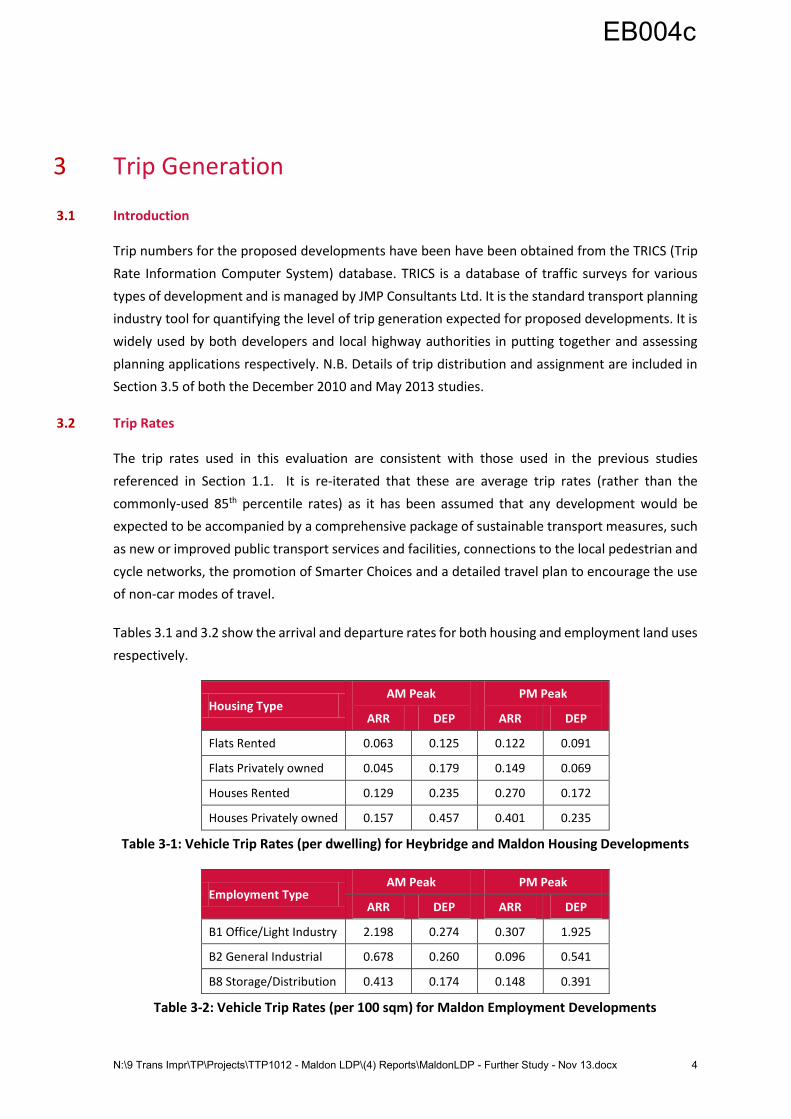
Tables 3.1 and 3.2 show the arrival and departure rates for both housing and employment land uses
respectively.
Housing Type AM Peak PM Peak
ARR DEP ARR DEP
Flats Rented 0.063 0.125 0.122 0.091
Flats Privately owned 0.045 0.179 0.149 0.069
Houses Rented 0.129 0.235 0.270 0.172
Houses Privately owned 0.157 0.457 0.401 0.235
Table 3-1: Vehicle Trip Rates (per dwelling) for Heybridge and Maldon Housing Developments
Employment Type AM Peak PM Peak
ARR DEP ARR DEP
B1 Office/Light Industry 2.198 0.274 0.307 1.925
B2 General Industrial 0.678 0.260 0.096 0.541
B8 Storage/Distribution 0.413 0.174 0.148 0.391
Table 3-2: Vehicle Trip Rates (per 100 sqm) for Maldon Employment Developments
EB004c
N:\9 Trans Impr\TP\Projects\TTP1012 - Maldon LDP\(4) Reports\MaldonLDP - Further Study - Nov 13.docx 5
3.3 Trip Numbers
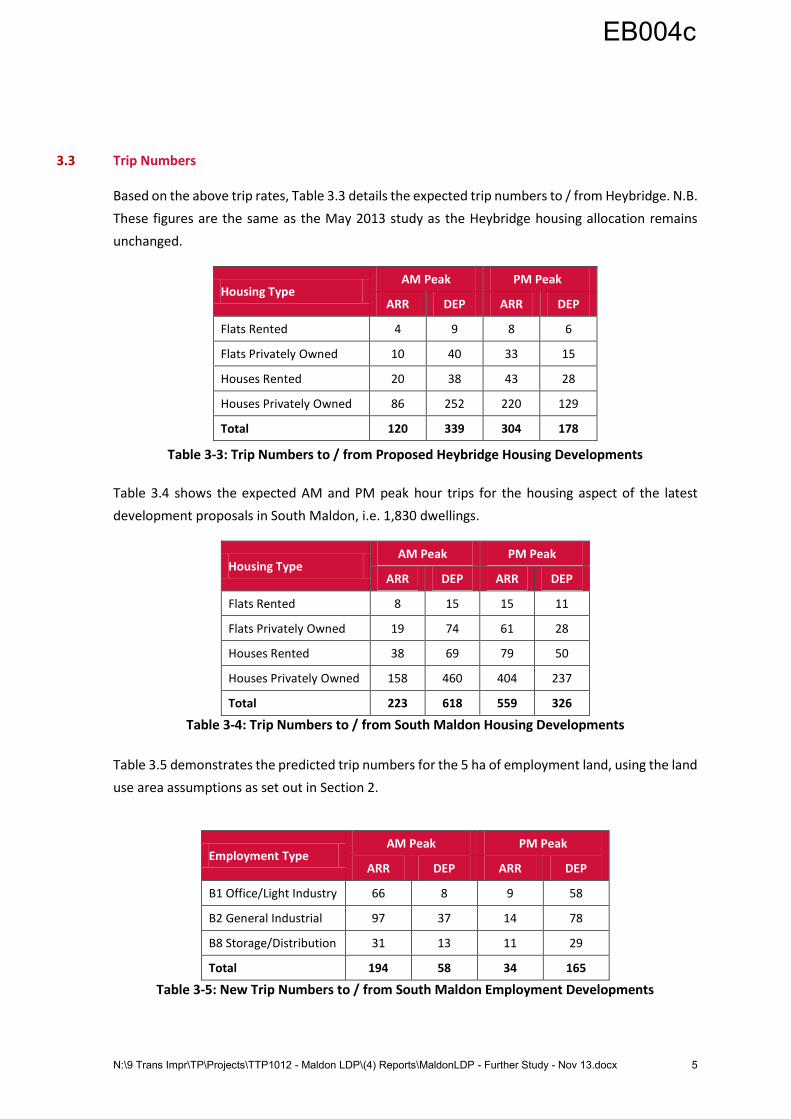
Based on the above trip rates, Table 3.3 details the expected trip numbers to / from Heybridge. N.B.
These figures are the same as the May 2013 study as the Heybridge housing allocation remains
unchanged.
Housing Type AM Peak PM Peak
ARR DEP ARR DEP
Flats Rented 4 9 8 6
Flats Privately Owned 10 40 33 15
Houses Rented 20 38 43 28
Houses Privately Owned 86 252 220 129
Total 120 339 304 178
Table 3-3: Trip Numbers to / from Proposed Heybridge Housing Developments
Table 3.4 shows the expected AM and PM peak hour trips for the housing aspect of the latest
development proposals in South Maldon, i.e. 1,830 dwellings.
Housing Type AM Peak PM Peak
ARR DEP ARR DEP
Flats Rented 8 15 15 11
Flats Privately Owned 19 74 61 28
Houses Rented 38 69 79 50
Houses Privately Owned 158 460 404 237
Total 223 618 559 326
Table 3-4: Trip Numbers to / from South Maldon Housing Developments
Table 3.5 demonstrates the predicted trip numbers for the 5 ha of employment land, using the land
use area assumptions as set out in Section 2.
Employment Type AM Peak PM Peak
ARR DEP ARR DEP
B1 Office/Light Industry 66 8 9 58
B2 General Industrial 97 37 14 78
B8 Storage/Distribution 31 13 11 29
Total 194 58 34 165
Table 3-5: New Trip Numbers to / from South Maldon Employment Developments
EB004c
N:\9 Trans Impr\TP\Projects\TTP1012 - Maldon LDP\(4) Reports\MaldonLDP - Further Study - Nov 13.docx 6
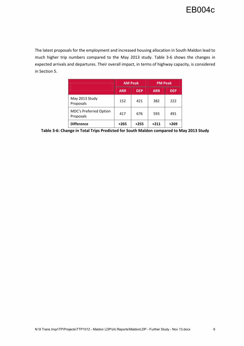
The latest proposals for the employment and increased housing allocation in South Maldon lead to
much higher trip numbers compared to the May 2013 study. Table 3-6 shows the changes in
expected arrivals and departures. Their overall impact, in terms of highway capacity, is considered
in Section 5.
AM Peak PM Peak
ARR DEP ARR DEP
May 2013 Study Proposals
152 421 382 222
MDC’s Preferred Option Proposals
417 676 593 491
Difference +265 +255 +211 +269
Table 3-6: Change in Total Trips Predicted for South Maldon compared to May 2013 Study
EB004c
N:\9 Trans Impr\TP\Projects\TTP1012 - Maldon LDP\(4) Reports\MaldonLDP - Further Study - Nov 13.docx 7
4 Study Area and Considerations
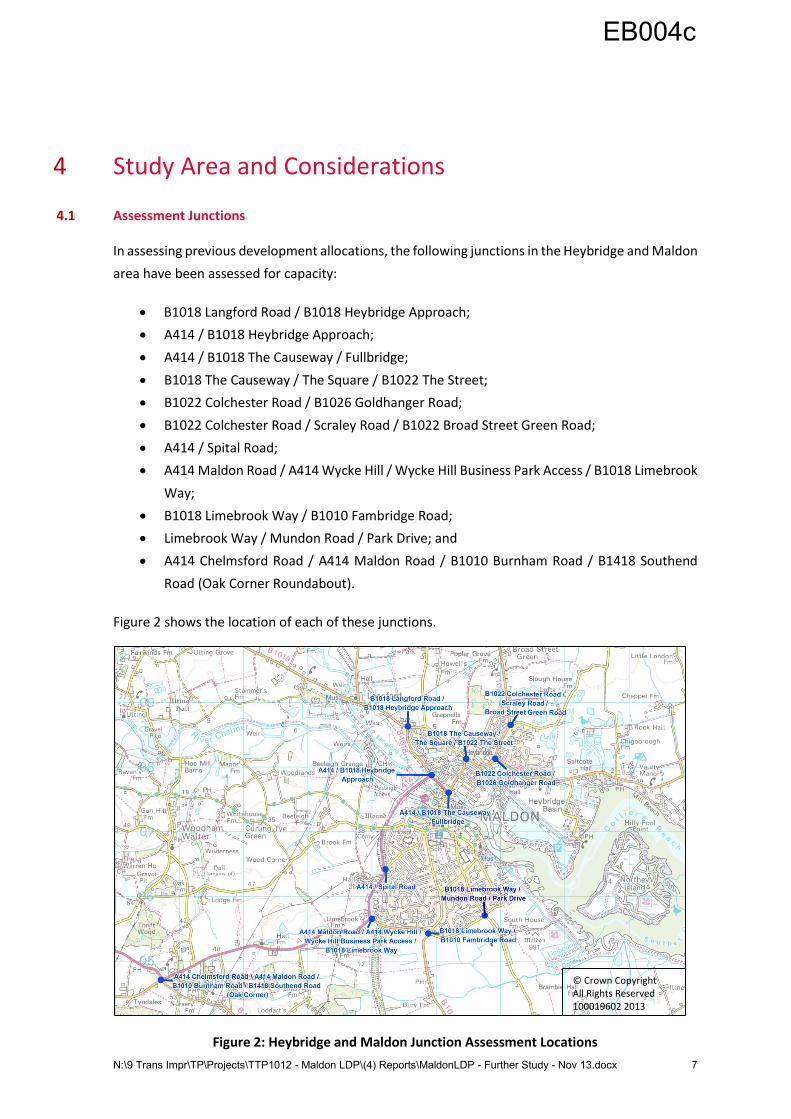
4.1 Assessment Junctions
In assessing previous development allocations, the following junctions in the Heybridge and Maldon
area have been assessed for capacity:
B1018 Langford Road / B1018 Heybridge Approach;
A414 / B1018 Heybridge Approach;
A414 / B1018 The Causeway / Fullbridge;
B1018 The Causeway / The Square / B1022 The Street;
B1022 Colchester Road / B1026 Goldhanger Road;
B1022 Colchester Road / Scraley Road / B1022 Broad Street Green Road;
A414 / Spital Road;
A414 Maldon Road / A414 Wycke Hill / Wycke Hill Business Park Access / B1018 Limebrook
Way;
B1018 Limebrook Way / B1010 Fambridge Road;
Limebrook Way / Mundon Road / Park Drive; and
A414 Chelmsford Road / A414 Maldon Road / B1010 Burnham Road / B1418 Southend
Road (Oak Corner Roundabout).
Figure 2 shows the location of each of these junctions.
Figure 2: Heybridge and Maldon Junction Assessment Locations
© Crown Copyright All Rights Reserved 100019602 2013
EB004c
N:\9 Trans Impr\TP\Projects\TTP1012 - Maldon LDP\(4) Reports\MaldonLDP - Further Study - Nov 13.docx 8
Although not located in Maldon District area, three further junctions have been considered in this
study. They are:
A414 Eves Corner junction in Danbury;
A414 / A12 intersection; and
B1019 / B1137 junction in Hatfield Peverel.
Due to the absence of sufficient data, these junctions have not received the same level of
assessment as the Heybridge and Maldon junctions. Their future performance is nevertheless
discussed in Section 6.
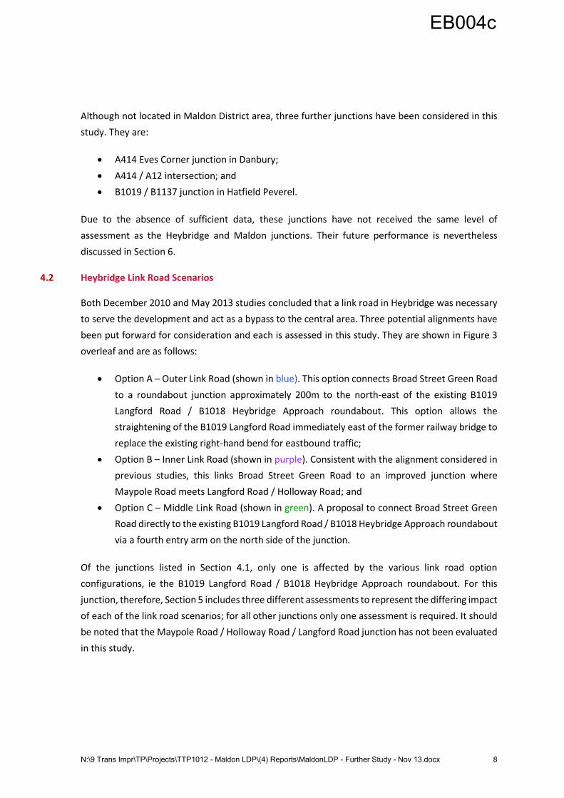
4.2 Heybridge Link Road Scenarios
Both December 2010 and May 2013 studies concluded that a link road in Heybridge was necessary
to serve the development and act as a bypass to the central area. Three potential alignments have
been put forward for consideration and each is assessed in this study. They are shown in Figure 3
overleaf and are as follows:
Option A – Outer Link Road (shown in blue). This option connects Broad Street Green Road
to a roundabout junction approximately 200m to the north-east of the existing B1019
Langford Road / B1018 Heybridge Approach roundabout. This option allows the
straightening of the B1019 Langford Road immediately east of the former railway bridge to
replace the existing right-hand bend for eastbound traffic;
Option B – Inner Link Road (shown in purple). Consistent with the alignment considered in
previous studies, this links Broad Street Green Road to an improved junction where
Maypole Road meets Langford Road / Holloway Road; and
Option C – Middle Link Road (shown in green). A proposal to connect Broad Street Green
Road directly to the existing B1019 Langford Road / B1018 Heybridge Approach roundabout
via a fourth entry arm on the north side of the junction.
Of the junctions listed in Section 4.1, only one is affected by the various link road option
configurations, ie the B1019 Langford Road / B1018 Heybridge Approach roundabout. For this
junction, therefore, Section 5 includes three different assessments to represent the differing impact
of each of the link road scenarios; for all other junctions only one assessment is required. It should
be noted that the Maypole Road / Holloway Road / Langford Road junction has not been evaluated
in this study.
EB004c
N:\9 Trans Impr\TP\Projects\TTP1012 - Maldon LDP\(4) Reports\MaldonLDP - Further Study - Nov 13.docx 9
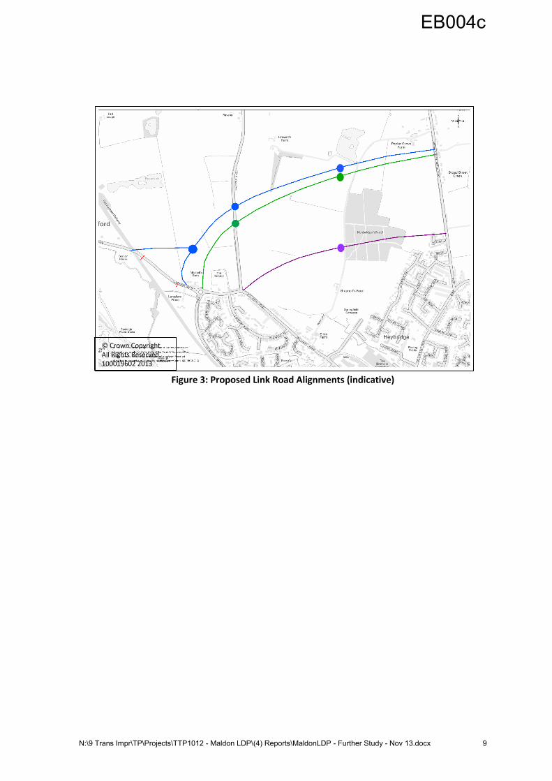
Figure 3: Proposed Link Road Alignments (indicative)
© Crown Copyright All Rights Reserved 100019602 2013
EB004c
N:\9 Trans Impr\TP\Projects\TTP1012 - Maldon LDP\(4) Reports\MaldonLDP - Further Study - Nov 13.docx 10
5 Highway Capacity Assessments in Maldon District
5.1 Introduction
As with the May 2013 study, the junction assessments have been carried out using the Transport
Research Laboratory’s (TRL) Junctions8 software programme. Junction performance outputs
include a Ratio of Flow to Capacity (RFC). To reiterate, where the RFC value is greater than 1.0 then
the approach is said to have exceeded its theoretical capacity as the number of vehicles arriving at
the junction are more than it can accommodate. As such, any approach with an RFC above 1.0
would be expected to suffer from significant vehicle queues and delays. However, for existing
junctions, an RFC of between 0.90 and 1.0 is an indication that an approach has reached its practical
capacity and that vehicles will experience greater unreliability and increasing delay and congestion.
Any arm with an RFC of less than 0.90 is usually considered to be operating satisfactorily.
For ease of reference, and to be consistent with the May 2013 study, the tables in the following
sections have been colour-coded. Any junction arm with an RFC of more than 1.0 is therefore shown
in red, RFCs of 0.90 to 1.00 are shown in amber, whilst green represents anything less than 0.90.
The tables also provide an indication of the level of queuing likely to take place on each arm. These
are shown in passenger car units (PCUs*).
Each of the following junction assessments sets out the results for the current Base Year
performance, the 2026 Background Traffic scenario, the May 2013 study scenario for 2026 with
1,000 dwellings in Heybridge and 1,250 dwellings in South Maldon and, lastly, the latest Local Plan
development proposals for 2026. N.B. It does not include details of the B1022 Colchester Road /
Scraley Road / B1022 Broad Street Green Road junction (the previous study identified no capacity
concerns at this location and this study has confirmed those findings)
* PCU is a general term used to quantify all vehicles on the road; a car or van = 1.0 PCUs, a medium goods
vehicle = 1.5 PCUs and a heavy goods vehicle = 2.0 PCUs.
EB004c
N:\9 Trans Impr\TP\Projects\TTP1012 - Maldon LDP\(4) Reports\MaldonLDP - Further Study - Nov 13.docx 11
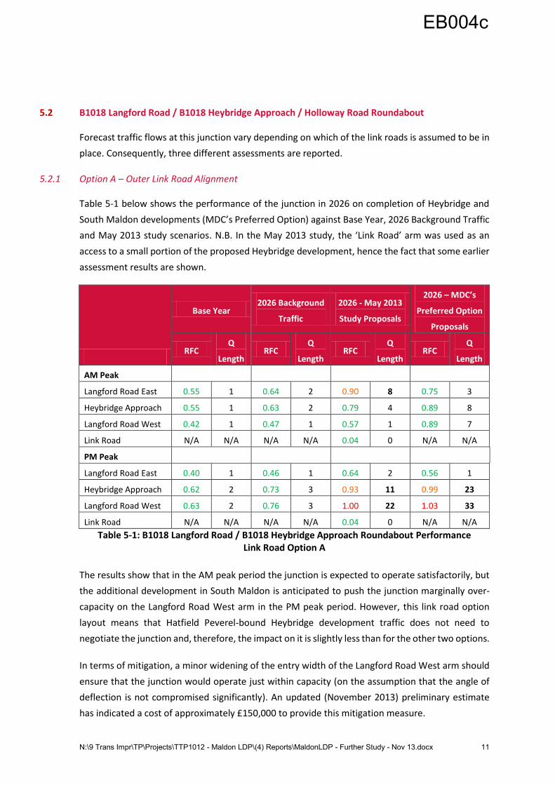
5.2 B1018 Langford Road / B1018 Heybridge Approach / Holloway Road Roundabout
Forecast traffic flows at this junction vary depending on which of the link roads is assumed to be in
place. Consequently, three different assessments are reported.
5.2.1 Option A – Outer Link Road Alignment
Table 5-1 below shows the performance of the junction in 2026 on completion of Heybridge and
South Maldon developments (MDC’s Preferred Option) against Base Year, 2026 Background Traffic
and May 2013 study scenarios. N.B. In the May 2013 study, the ‘Link Road’ arm was used as an
access to a small portion of the proposed Heybridge development, hence the fact that some earlier
assessment results are shown.
Base Year 2026 Background
Traffic
2026 - May 2013
Study Proposals
2026 – MDC’s
Preferred Option
Proposals
RFC Q
Length RFC
Q
Length RFC
Q
Length RFC
Q
Length
AM Peak
Langford Road East 0.55 1 0.64 2 0.90 8 0.75 3
Heybridge Approach 0.55 1 0.63 2 0.79 4 0.89 8
Langford Road West 0.42 1 0.47 1 0.57 1 0.89 7
Link Road N/A N/A N/A N/A 0.04 0 N/A N/A
PM Peak
Langford Road East 0.40 1 0.46 1 0.64 2 0.56 1
Heybridge Approach 0.62 2 0.73 3 0.93 11 0.99 23
Langford Road West 0.63 2 0.76 3 1.00 22 1.03 33
Link Road N/A N/A N/A N/A 0.04 0 N/A N/A
Table 5-1: B1018 Langford Road / B1018 Heybridge Approach Roundabout Performance Link Road Option A
The results show that in the AM peak period the junction is expected to operate satisfactorily, but
the additional development in South Maldon is anticipated to push the junction marginally over-
capacity on the Langford Road West arm in the PM peak period. However, this link road option
layout means that Hatfield Peverel-bound Heybridge development traffic does not need to
negotiate the junction and, therefore, the impact on it is slightly less than for the other two options.
In terms of mitigation, a minor widening of the entry width of the Langford Road West arm should
ensure that the junction would operate just within capacity (on the assumption that the angle of
deflection is not compromised significantly). An updated (November 2013) preliminary estimate
has indicated a cost of approximately £150,000 to provide this mitigation measure.
EB004c
N:\9 Trans Impr\TP\Projects\TTP1012 - Maldon LDP\(4) Reports\MaldonLDP - Further Study - Nov 13.docx 12
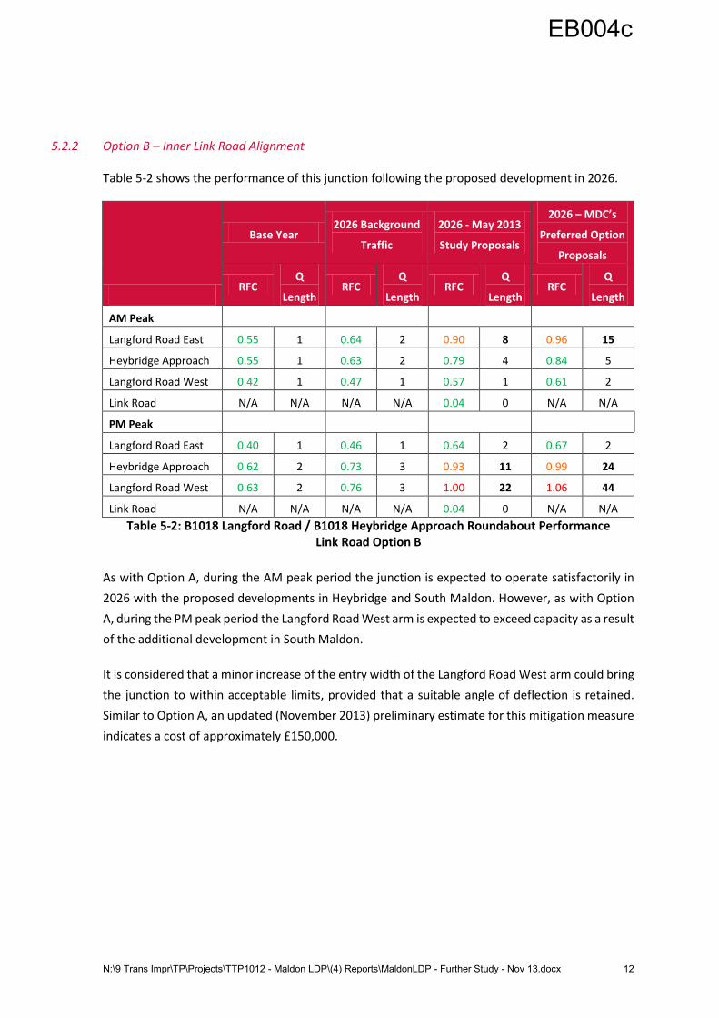
5.2.2 Option B – Inner Link Road Alignment
Table 5-2 shows the performance of this junction following the proposed development in 2026.
Base Year 2026 Background
Traffic
2026 - May 2013
Study Proposals
2026 – MDC’s
Preferred Option
Proposals
RFC Q
Length RFC
Q
Length RFC
Q
Length RFC
Q
Length
AM Peak
Langford Road East 0.55 1 0.64 2 0.90 8 0.96 15
Heybridge Approach 0.55 1 0.63 2 0.79 4 0.84 5
Langford Road West 0.42 1 0.47 1 0.57 1 0.61 2
Link Road N/A N/A N/A N/A 0.04 0 N/A N/A
PM Peak
Langford Road East 0.40 1 0.46 1 0.64 2 0.67 2
Heybridge Approach 0.62 2 0.73 3 0.93 11 0.99 24
Langford Road West 0.63 2 0.76 3 1.00 22 1.06 44
Link Road N/A N/A N/A N/A 0.04 0 N/A N/A
Table 5-2: B1018 Langford Road / B1018 Heybridge Approach Roundabout Performance Link Road Option B
As with Option A, during the AM peak period the junction is expected to operate satisfactorily in
2026 with the proposed developments in Heybridge and South Maldon. However, as with Option
A, during the PM peak period the Langford Road West arm is expected to exceed capacity as a result
of the additional development in South Maldon.
It is considered that a minor increase of the entry width of the Langford Road West arm could bring
the junction to within acceptable limits, provided that a suitable angle of deflection is retained.
Similar to Option A, an updated (November 2013) preliminary estimate for this mitigation measure
indicates a cost of approximately £150,000.
EB004c
N:\9 Trans Impr\TP\Projects\TTP1012 - Maldon LDP\(4) Reports\MaldonLDP - Further Study - Nov 13.docx 13
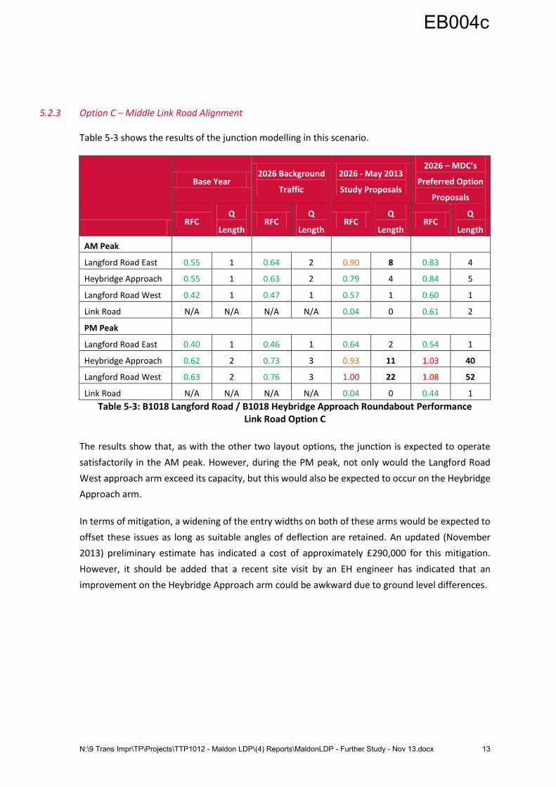
5.2.3 Option C – Middle Link Road Alignment
Table 5-3 shows the results of the junction modelling in this scenario.
Base Year 2026 Background
Traffic
2026 - May 2013
Study Proposals
2026 – MDC’s
Preferred Option
Proposals
RFC Q
Length RFC
Q
Length RFC
Q
Length RFC
Q
Length
AM Peak
Langford Road East 0.55 1 0.64 2 0.90 8 0.83 4
Heybridge Approach 0.55 1 0.63 2 0.79 4 0.84 5
Langford Road West 0.42 1 0.47 1 0.57 1 0.60 1
Link Road N/A N/A N/A N/A 0.04 0 0.61 2
PM Peak
Langford Road East 0.40 1 0.46 1 0.64 2 0.54 1
Heybridge Approach 0.62 2 0.73 3 0.93 11 1.03 40
Langford Road West 0.63 2 0.76 3 1.00 22 1.08 52
Link Road N/A N/A N/A N/A 0.04 0 0.44 1
Table 5-3: B1018 Langford Road / B1018 Heybridge Approach Roundabout Performance Link Road Option C
The results show that, as with the other two layout options, the junction is expected to operate
satisfactorily in the AM peak. However, during the PM peak, not only would the Langford Road
West approach arm exceed its capacity, but this would also be expected to occur on the Heybridge
Approach arm.
In terms of mitigation, a widening of the entry widths on both of these arms would be expected to
offset these issues as long as suitable angles of deflection are retained. An updated (November
2013) preliminary estimate has indicated a cost of approximately £290,000 for this mitigation.
However, it should be added that a recent site visit by an EH engineer has indicated that an
improvement on the Heybridge Approach arm could be awkward due to ground level differences.
EB004c
N:\9 Trans Impr\TP\Projects\TTP1012 - Maldon LDP\(4) Reports\MaldonLDP - Further Study - Nov 13.docx 14
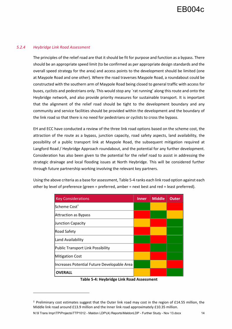
5.2.4 Heybridge Link Road Assessment
The principles of the relief road are that it should be fit for purpose and function as a bypass. There
should be an appropriate speed limit (to be confirmed as per appropriate design standards and the
overall speed strategy for the area) and access points to the development should be limited (one
at Maypole Road and one other). Where the road traverses Maypole Road, a roundabout could be
constructed with the southern arm of Maypole Road being closed to general traffic with access for
buses, cyclists and pedestrians only. This would stop any `rat running’ along this route and onto the
Heybridge network, and also provide priority measures for sustainable transport. It is important
that the alignment of the relief road should be tight to the development boundary and any
community and service facilities should be provided within the development and the boundary of
the link road so that there is no need for pedestrians or cyclists to cross the bypass.
EH and ECC have conducted a review of the three link road options based on the scheme cost, the
attraction of the route as a bypass, junction capacity, road safety aspects, land availability, the
possibility of a public transport link at Maypole Road, the subsequent mitigation required at
Langford Road / Heybridge Approach roundabout, and the potential for any further development.
Consideration has also been given to the potential for the relief road to assist in addressing the
strategic drainage and local flooding issues at North Heybridge. This will be considered further
through future partnership working involving the relevant key partners.
Using the above criteria as a base for assessment, Table 5-4 ranks each link road option against each
other by level of preference (green = preferred, amber = next best and red = least preferred).
Key Considerations Inner Middle Outer
Scheme Cost†
Attraction as Bypass
Junction Capacity
Road Safety
Land Availability
Public Transport Link Possibility
Mitigation Cost
Increases Potential Future Developable Area
OVERALL
Table 5-4: Heybridge Link Road Assessment
† Preliminary cost estimates suggest that the Outer link road may cost in the region of £14.55 million, the Middle link road around £13.9 million and the Inner link road approximately £10.35 million.
EB004c

N:\9 Trans Impr\TP\Projects\TTP1012 - Maldon LDP\(4) Reports\MaldonLDP - Further Study - Nov 13.docx 15
Table 5-4 indicates that the Outer link road is favoured over the other two options in that it most
readily delivers the key elements, and provides the best solution in terms of highway capacity
advantage. However, EH and ECC recommend that the Middle option should also be retained for
further consideration, and be explored further through the masterplanning process.
EB004c
N:\9 Trans Impr\TP\Projects\TTP1012 - Maldon LDP\(4) Reports\MaldonLDP - Further Study - Nov 13.docx 16
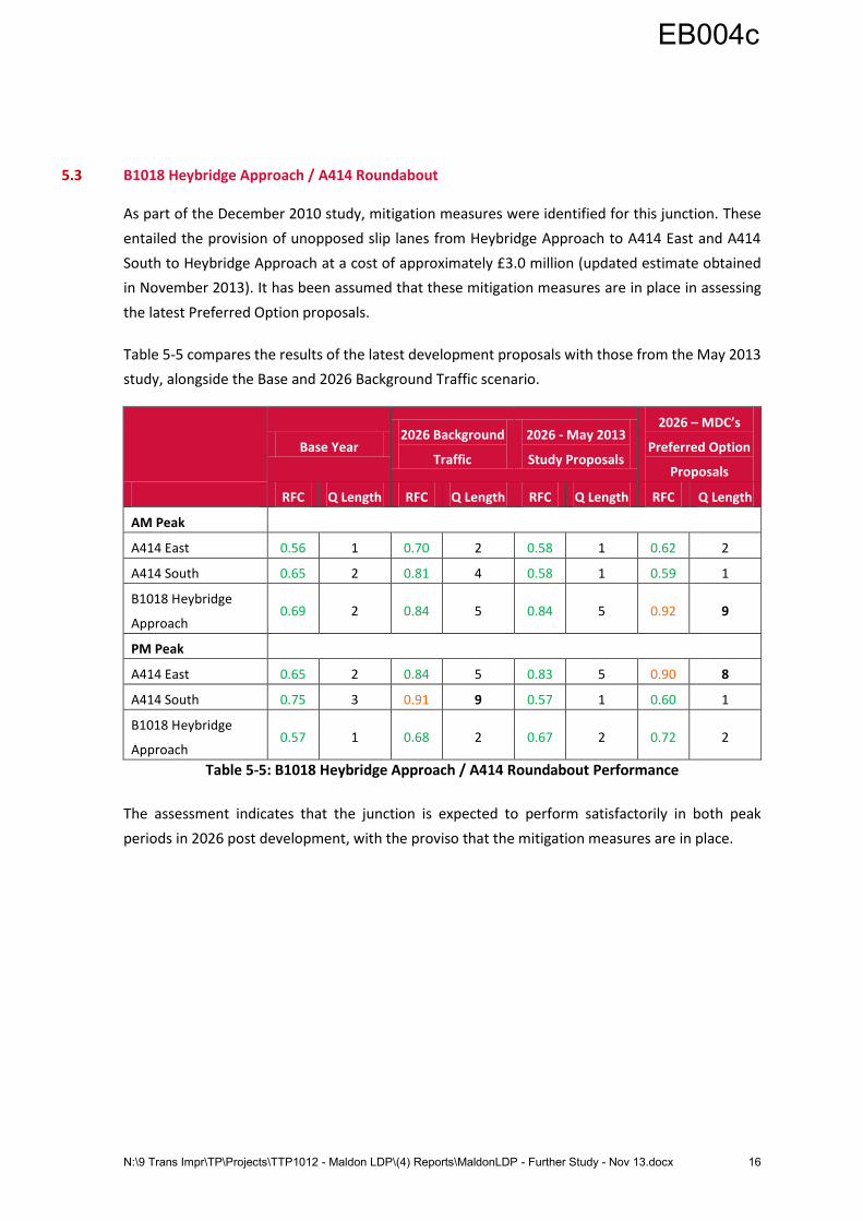
5.3 B1018 Heybridge Approach / A414 Roundabout
As part of the December 2010 study, mitigation measures were identified for this junction. These
entailed the provision of unopposed slip lanes from Heybridge Approach to A414 East and A414
South to Heybridge Approach at a cost of approximately £3.0 million (updated estimate obtained
in November 2013). It has been assumed that these mitigation measures are in place in assessing
the latest Preferred Option proposals.
Table 5-5 compares the results of the latest development proposals with those from the May 2013
study, alongside the Base and 2026 Background Traffic scenario.
Base Year 2026 Background
Traffic
2026 - May 2013
Study Proposals
2026 – MDC’s
Preferred Option
Proposals
RFC Q Length RFC Q Length RFC Q Length RFC Q Length
AM Peak
A414 East 0.56 1 0.70 2 0.58 1 0.62 2
A414 South 0.65 2 0.81 4 0.58 1 0.59 1
B1018 Heybridge
Approach 0.69 2 0.84 5 0.84 5 0.92 9
PM Peak
A414 East 0.65 2 0.84 5 0.83 5 0.90 8
A414 South 0.75 3 0.91 9 0.57 1 0.60 1
B1018 Heybridge
Approach 0.57 1 0.68 2 0.67 2 0.72 2
Table 5-5: B1018 Heybridge Approach / A414 Roundabout Performance
The assessment indicates that the junction is expected to perform satisfactorily in both peak
periods in 2026 post development, with the proviso that the mitigation measures are in place.
EB004c

N:\9 Trans Impr\TP\Projects\TTP1012 - Maldon LDP\(4) Reports\MaldonLDP - Further Study - Nov 13.docx 17
5.4 A414 / Fullbridge Roundabout
The May 2013 study indicated that no mitigation measures would be needed at this junction with
the original development proposals. Table 5-6 shows the results of the modelling with the updated
development proposals.
Base Year 2026 Background
Traffic
2026 - May 2013
Study Proposals
2026 – MDC’s
Preferred Option
Proposals
RFC Q Length RFC Q Length RFC Q Length RFC Q Length
AM Peak
B1018 The Causeway 0.71 2 0.65 2 0.90 8 0.89 7
Fullbridge 0.46 1 0.56 1 0.54 1 0.55 1
A414 West 0.61 2 0.76 3 0.78 3 0.87 6
PM Peak
B1018 The Causeway 0.55 1 0.66 2 0.67 2 0.68 2
Fullbridge 0.69 2 0.83 5 0.87 6 0.89 7
A414 West 0.57 1 0.80 4 0.81 4 0.81 4
Table 5-6: A414 / Fullbridge Roundabout Performance The results confirm that the junction would continue to operate satisfactorily in both peak periods
in 2026. The similarity in the results is due to the fact that only a limited number of trips associated
with the updated development proposals in South Maldon would route via this junction.
EB004c
N:\9 Trans Impr\TP\Projects\TTP1012 - Maldon LDP\(4) Reports\MaldonLDP - Further Study - Nov 13.docx 18
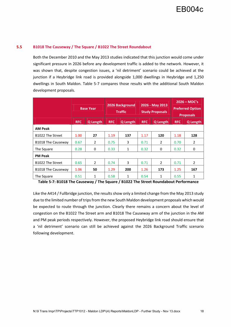
5.5 B1018 The Causeway / The Square / B1022 The Street Roundabout
Both the December 2010 and the May 2013 studies indicated that this junction would come under
significant pressure in 2026 before any development traffic is added to the network. However, it
was shown that, despite congestion issues, a ‘nil detriment’ scenario could be achieved at the
junction if a Heybridge link road is provided alongside 1,000 dwellings in Heybridge and 1,250
dwellings in South Maldon. Table 5-7 compares those results with the additional South Maldon
development proposals.
Base Year 2026 Background
Traffic
2026 - May 2013
Study Proposals
2026 – MDC’s
Preferred Option
Proposals
RFC Q Length RFC Q Length RFC Q Length RFC Q Length
AM Peak
B1022 The Street 1.00 27 1.19 137 1.17 120 1.18 128
B1018 The Causeway 0.67 2 0.75 3 0.71 2 0.70 2
The Square 0.28 0 0.33 1 0.32 0 0.32 0
PM Peak
B1022 The Street 0.65 2 0.74 3 0.71 2 0.71 2
B1018 The Causeway 1.06 50 1.29 200 1.26 173 1.25 167
The Square 0.51 1 0.58 1 0.54 1 0.55 1
Table 5-7: B1018 The Causeway / The Square / B1022 The Street Roundabout Performance
Like the A414 / Fullbridge junction, the results show only a limited change from the May 2013 study
due to the limited number of trips from the new South Maldon development proposals which would
be expected to route through the junction. Clearly there remains a concern about the level of
congestion on the B1022 The Street arm and B1018 The Causeway arm of the junction in the AM
and PM peak periods respectively. However, the proposed Heybridge link road should ensure that
a ‘nil detriment’ scenario can still be achieved against the 2026 Background Traffic scenario
following development.
EB004c
N:\9 Trans Impr\TP\Projects\TTP1012 - Maldon LDP\(4) Reports\MaldonLDP - Further Study - Nov 13.docx 19
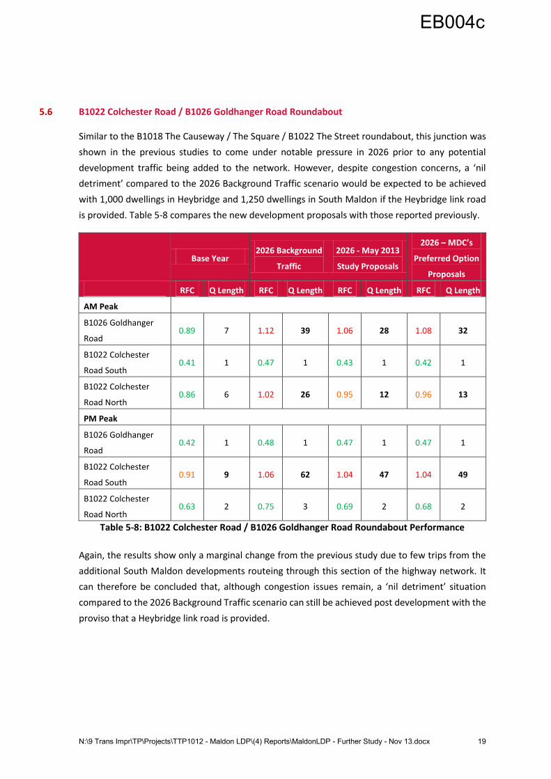
5.6 B1022 Colchester Road / B1026 Goldhanger Road Roundabout
Similar to the B1018 The Causeway / The Square / B1022 The Street roundabout, this junction was
shown in the previous studies to come under notable pressure in 2026 prior to any potential
development traffic being added to the network. However, despite congestion concerns, a ‘nil
detriment’ compared to the 2026 Background Traffic scenario would be expected to be achieved
with 1,000 dwellings in Heybridge and 1,250 dwellings in South Maldon if the Heybridge link road
is provided. Table 5-8 compares the new development proposals with those reported previously.
Base Year 2026 Background
Traffic
2026 - May 2013
Study Proposals
2026 – MDC’s
Preferred Option
Proposals
RFC Q Length RFC Q Length RFC Q Length RFC Q Length
AM Peak
B1026 Goldhanger
Road 0.89 7 1.12 39 1.06 28 1.08 32
B1022 Colchester
Road South 0.41 1 0.47 1 0.43 1 0.42 1
B1022 Colchester
Road North 0.86 6 1.02 26 0.95 12 0.96 13
PM Peak
B1026 Goldhanger
Road 0.42 1 0.48 1 0.47 1 0.47 1
B1022 Colchester
Road South 0.91 9 1.06 62 1.04 47 1.04 49
B1022 Colchester
Road North 0.63 2 0.75 3 0.69 2 0.68 2
Table 5-8: B1022 Colchester Road / B1026 Goldhanger Road Roundabout Performance
Again, the results show only a marginal change from the previous study due to few trips from the
additional South Maldon developments routeing through this section of the highway network. It
can therefore be concluded that, although congestion issues remain, a ‘nil detriment’ situation
compared to the 2026 Background Traffic scenario can still be achieved post development with the
proviso that a Heybridge link road is provided.
EB004c
N:\9 Trans Impr\TP\Projects\TTP1012 - Maldon LDP\(4) Reports\MaldonLDP - Further Study - Nov 13.docx 20
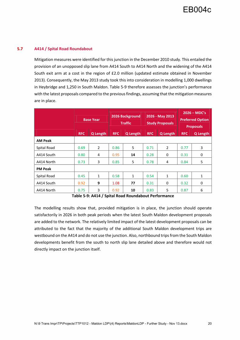
5.7 A414 / Spital Road Roundabout
Mitigation measures were identified for this junction in the December 2010 study. This entailed the
provision of an unopposed slip lane from A414 South to A414 North and the widening of the A414
South exit arm at a cost in the region of £2.0 million (updated estimate obtained in November
2013). Consequently, the May 2013 study took this into consideration in modelling 1,000 dwellings
in Heybridge and 1,250 in South Maldon. Table 5-9 therefore assesses the junction’s performance
with the latest proposals compared to the previous findings, assuming that the mitigation measures
are in place.
Base Year 2026 Background
Traffic
2026 - May 2013
Study Proposals
2026 – MDC’s
Preferred Option
Proposals
RFC Q Length RFC Q Length RFC Q Length RFC Q Length
AM Peak
Spital Road 0.69 2 0.86 5 0.71 2 0.77 3
A414 South 0.80 4 0.95 14 0.28 0 0.31 0
A414 North 0.73 3 0.85 5 0.78 4 0.84 5
PM Peak
Spital Road 0.45 1 0.58 1 0.54 1 0.60 1
A414 South 0.92 9 1.08 77 0.31 0 0.32 0
A414 North 0.75 3 0.92 10 0.83 5 0.87 6
Table 5-9: A414 / Spital Road Roundabout Performance
The modelling results show that, provided mitigation is in place, the junction should operate
satisfactorily in 2026 in both peak periods when the latest South Maldon development proposals
are added to the network. The relatively limited impact of the latest development proposals can be
attributed to the fact that the majority of the additional South Maldon development trips are
westbound on the A414 and do not use the junction. Also, northbound trips from the South Maldon
developments benefit from the south to north slip lane detailed above and therefore would not
directly impact on the junction itself.
EB004c
N:\9 Trans Impr\TP\Projects\TTP1012 - Maldon LDP\(4) Reports\MaldonLDP - Further Study - Nov 13.docx 21
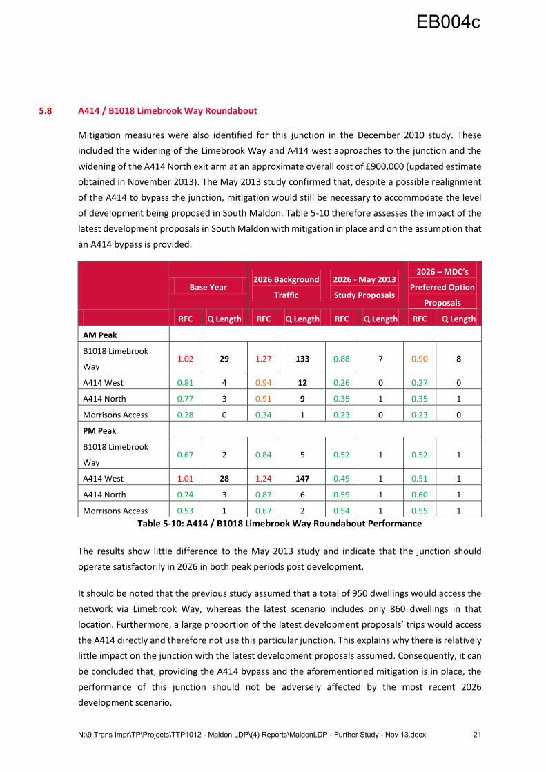
5.8 A414 / B1018 Limebrook Way Roundabout
Mitigation measures were also identified for this junction in the December 2010 study. These
included the widening of the Limebrook Way and A414 west approaches to the junction and the
widening of the A414 North exit arm at an approximate overall cost of £900,000 (updated estimate
obtained in November 2013). The May 2013 study confirmed that, despite a possible realignment
of the A414 to bypass the junction, mitigation would still be necessary to accommodate the level
of development being proposed in South Maldon. Table 5-10 therefore assesses the impact of the
latest development proposals in South Maldon with mitigation in place and on the assumption that
an A414 bypass is provided.
Base Year 2026 Background
Traffic
2026 - May 2013
Study Proposals
2026 – MDC’s
Preferred Option
Proposals
RFC Q Length RFC Q Length RFC Q Length RFC Q Length
AM Peak
B1018 Limebrook
Way 1.02 29 1.27 133 0.88 7 0.90 8
A414 West 0.81 4 0.94 12 0.26 0 0.27 0
A414 North 0.77 3 0.91 9 0.35 1 0.35 1
Morrisons Access 0.28 0 0.34 1 0.23 0 0.23 0
PM Peak
B1018 Limebrook
Way 0.67 2 0.84 5 0.52 1 0.52 1
A414 West 1.01 28 1.24 147 0.49 1 0.51 1
A414 North 0.74 3 0.87 6 0.59 1 0.60 1
Morrisons Access 0.53 1 0.67 2 0.54 1 0.55 1
Table 5-10: A414 / B1018 Limebrook Way Roundabout Performance
The results show little difference to the May 2013 study and indicate that the junction should
operate satisfactorily in 2026 in both peak periods post development.
It should be noted that the previous study assumed that a total of 950 dwellings would access the
network via Limebrook Way, whereas the latest scenario includes only 860 dwellings in that
location. Furthermore, a large proportion of the latest development proposals’ trips would access
the A414 directly and therefore not use this particular junction. This explains why there is relatively
little impact on the junction with the latest development proposals assumed. Consequently, it can
be concluded that, providing the A414 bypass and the aforementioned mitigation is in place, the
performance of this junction should not be adversely affected by the most recent 2026
development scenario.
EB004c
N:\9 Trans Impr\TP\Projects\TTP1012 - Maldon LDP\(4) Reports\MaldonLDP - Further Study - Nov 13.docx 22
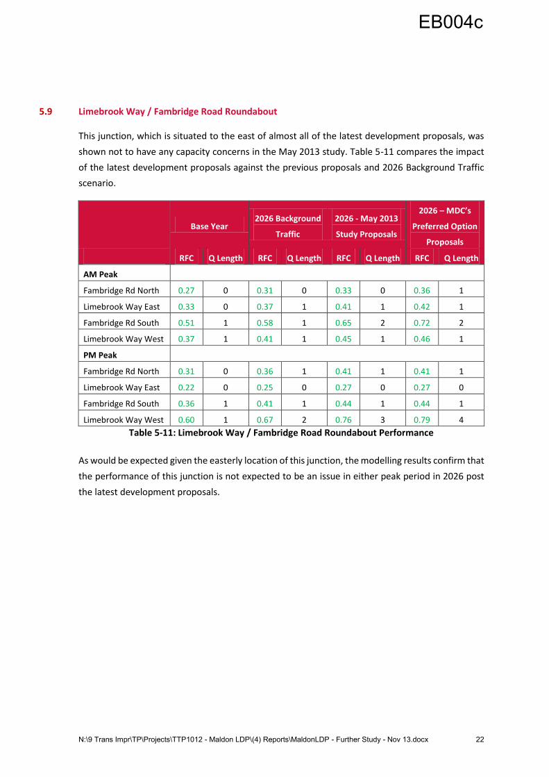
5.9 Limebrook Way / Fambridge Road Roundabout
This junction, which is situated to the east of almost all of the latest development proposals, was
shown not to have any capacity concerns in the May 2013 study. Table 5-11 compares the impact
of the latest development proposals against the previous proposals and 2026 Background Traffic
scenario.
Base Year 2026 Background
Traffic
2026 - May 2013
Study Proposals
2026 – MDC’s
Preferred Option
Proposals
RFC Q Length RFC Q Length RFC Q Length RFC Q Length
AM Peak
Fambridge Rd North 0.27 0 0.31 0 0.33 0 0.36 1
Limebrook Way East 0.33 0 0.37 1 0.41 1 0.42 1
Fambridge Rd South 0.51 1 0.58 1 0.65 2 0.72 2
Limebrook Way West 0.37 1 0.41 1 0.45 1 0.46 1
PM Peak
Fambridge Rd North 0.31 0 0.36 1 0.41 1 0.41 1
Limebrook Way East 0.22 0 0.25 0 0.27 0 0.27 0
Fambridge Rd South 0.36 1 0.41 1 0.44 1 0.44 1
Limebrook Way West 0.60 1 0.67 2 0.76 3 0.79 4
Table 5-11: Limebrook Way / Fambridge Road Roundabout Performance
As would be expected given the easterly location of this junction, the modelling results confirm that
the performance of this junction is not expected to be an issue in either peak period in 2026 post
the latest development proposals.
EB004c
N:\9 Trans Impr\TP\Projects\TTP1012 - Maldon LDP\(4) Reports\MaldonLDP - Further Study - Nov 13.docx 23
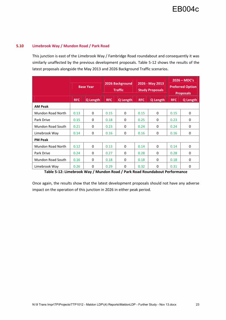
5.10 Limebrook Way / Mundon Road / Park Road
This junction is east of the Limebrook Way / Fambridge Road roundabout and consequently it was
similarly unaffected by the previous development proposals. Table 5-12 shows the results of the
latest proposals alongside the May 2013 and 2026 Background Traffic scenarios.
Base Year 2026 Background
Traffic
2026 - May 2013
Study Proposals
2026 – MDC’s
Preferred Option
Proposals
RFC Q Length RFC Q Length RFC Q Length RFC Q Length
AM Peak
Mundon Road North 0.13 0 0.15 0 0.15 0 0.15 0
Park Drive 0.15 0 0.18 0 0.25 0 0.23 0
Mundon Road South 0.21 0 0.23 0 0.24 0 0.24 0
Limebrook Way 0.14 0 0.16 0 0.16 0 0.16 0
PM Peak
Mundon Road North 0.12 0 0.13 0 0.14 0 0.14 0
Park Drive 0.24 0 0.27 0 0.28 0 0.28 0
Mundon Road South 0.16 0 0.18 0 0.18 0 0.18 0
Limebrook Way 0.26 0 0.29 0 0.32 0 0.31 0
Table 5-12: Limebrook Way / Mundon Road / Park Road Roundabout Performance
Once again, the results show that the latest development proposals should not have any adverse
impact on the operation of this junction in 2026 in either peak period.
EB004c
N:\9 Trans Impr\TP\Projects\TTP1012 - Maldon LDP\(4) Reports\MaldonLDP - Further Study - Nov 13.docx 24
5.11 A414 Oak Corner Junction
5.11.1 Existing Junction Performance
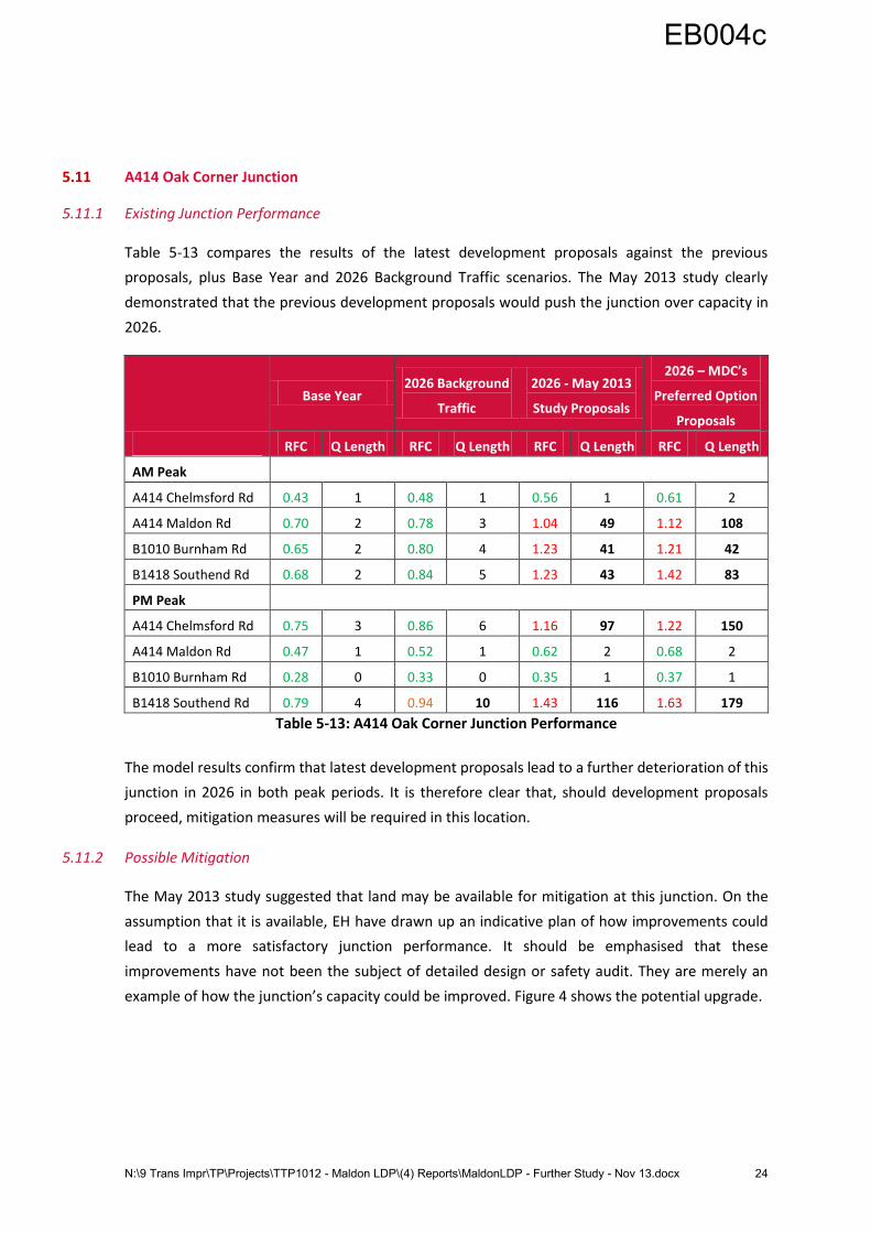
Table 5-13 compares the results of the latest development proposals against the previous
proposals, plus Base Year and 2026 Background Traffic scenarios. The May 2013 study clearly
demonstrated that the previous development proposals would push the junction over capacity in
2026.
Base Year 2026 Background
Traffic
2026 - May 2013
Study Proposals
2026 – MDC’s
Preferred Option
Proposals
RFC Q Length RFC Q Length RFC Q Length RFC Q Length
AM Peak
A414 Chelmsford Rd 0.43 1 0.48 1 0.56 1 0.61 2
A414 Maldon Rd 0.70 2 0.78 3 1.04 49 1.12 108
B1010 Burnham Rd 0.65 2 0.80 4 1.23 41 1.21 42
B1418 Southend Rd 0.68 2 0.84 5 1.23 43 1.42 83
PM Peak
A414 Chelmsford Rd 0.75 3 0.86 6 1.16 97 1.22 150
A414 Maldon Rd 0.47 1 0.52 1 0.62 2 0.68 2
B1010 Burnham Rd 0.28 0 0.33 0 0.35 1 0.37 1
B1418 Southend Rd 0.79 4 0.94 10 1.43 116 1.63 179
Table 5-13: A414 Oak Corner Junction Performance
The model results confirm that latest development proposals lead to a further deterioration of this
junction in 2026 in both peak periods. It is therefore clear that, should development proposals
proceed, mitigation measures will be required in this location.
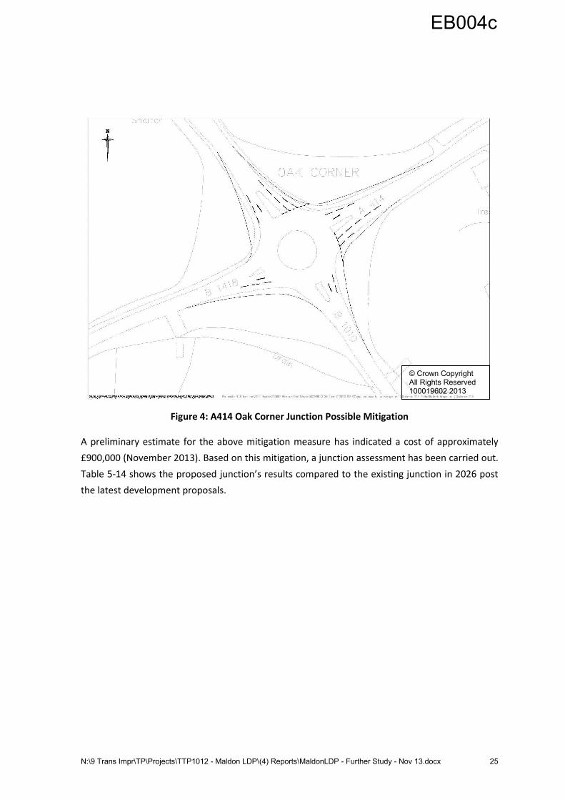
5.11.2 Possible Mitigation
The May 2013 study suggested that land may be available for mitigation at this junction. On the
assumption that it is available, EH have drawn up an indicative plan of how improvements could
lead to a more satisfactory junction performance. It should be emphasised that these
improvements have not been the subject of detailed design or safety audit. They are merely an
example of how the junction’s capacity could be improved. Figure 4 shows the potential upgrade.
EB004c
N:\9 Trans Impr\TP\Projects\TTP1012 - Maldon LDP\(4) Reports\MaldonLDP - Further Study - Nov 13.docx 25
Figure 4: A414 Oak Corner Junction Possible Mitigation
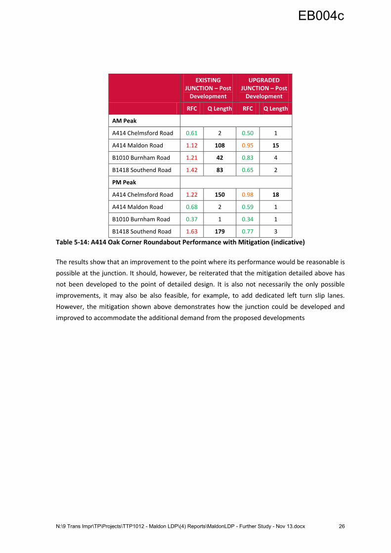
A preliminary estimate for the above mitigation measure has indicated a cost of approximately
£900,000 (November 2013). Based on this mitigation, a junction assessment has been carried out.
Table 5-14 shows the proposed junction’s results compared to the existing junction in 2026 post
the latest development proposals.
© Crown Copyright All Rights Reserved 100019602 2013
EB004c
N:\9 Trans Impr\TP\Projects\TTP1012 - Maldon LDP\(4) Reports\MaldonLDP - Further Study - Nov 13.docx 26
EXISTING JUNCTION – Post
Development
UPGRADED JUNCTION – Post
Development
RFC Q Length RFC Q Length
AM Peak
A414 Chelmsford Road 0.61 2 0.50 1
A414 Maldon Road 1.12 108 0.95 15
B1010 Burnham Road 1.21 42 0.83 4
B1418 Southend Road 1.42 83 0.65 2
PM Peak
A414 Chelmsford Road 1.22 150 0.98 18
A414 Maldon Road 0.68 2 0.59 1
B1010 Burnham Road 0.37 1 0.34 1
B1418 Southend Road 1.63 179 0.77 3
Table 5-14: A414 Oak Corner Roundabout Performance with Mitigation (indicative)
The results show that an improvement to the point where its performance would be reasonable is
possible at the junction. It should, however, be reiterated that the mitigation detailed above has
not been developed to the point of detailed design. It is also not necessarily the only possible
improvements, it may also be also feasible, for example, to add dedicated left turn slip lanes.
However, the mitigation shown above demonstrates how the junction could be developed and
improved to accommodate the additional demand from the proposed developments
EB004c

N:\9 Trans Impr\TP\Projects\TTP1012 - Maldon LDP\(4) Reports\MaldonLDP - Further Study - Nov 13.docx 27
5.12 Proposed A414 Wycke Hill Bypass
Consistent with the proposed Heybridge link road, modelling has assumed that the bypass will be
a fit for purpose relief road which would become the new A414 route. Moving forward, the route
will need to have an appropriate speed limit (to be confirmed as per appropriate design standards
and the overall speed strategy for the area) and access points to the development should be limited
(preferably a single access point as any more would be detrimental to its use as a bypass and part
of the primary route network). Ideally, the preferred alignment of the bypass would be the outer
boundary of the development as this would negate the need for pedestrian crossing points
(adequate facilities should be provided within the development and the boundary of the bypass).
However, land constraints at the eastern end of the proposed bypass may necessitate routeing
through the central part of the currently-proposed development area. If the bypass is to be an outer
boundary as preferred therefore, the development land would be significantly reduced and,
consequently, it may be difficult to accommodate all 450 dwellings and 0.5ha of employment
designated for Wycke Hill North area.
Figure 5 shows the approximate alignment that has been considered within the Wycke Hill North
development area and the basis used for the traffic modelling.
Figure 5: Indicative Alignment of Proposed A414 Wycke Hill Bypass
© Crown Copyright All Rights Reserved 100019602 2013
EB004c
N:\9 Trans Impr\TP\Projects\TTP1012 - Maldon LDP\(4) Reports\MaldonLDP - Further Study - Nov 13.docx 28
Whilst it is difficult to estimate the level of cost as the alignment has yet to be confirmed,
preliminary indications suggest it could be in the region of £8.0 million (figure updated in November
2013).
EB004c
N:\9 Trans Impr\TP\Projects\TTP1012 - Maldon LDP\(4) Reports\MaldonLDP - Further Study - Nov 13.docx 29
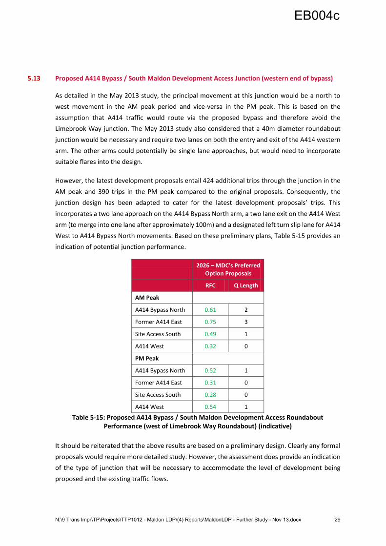
5.13 Proposed A414 Bypass / South Maldon Development Access Junction (western end of bypass)
As detailed in the May 2013 study, the principal movement at this junction would be a north to
west movement in the AM peak period and vice-versa in the PM peak. This is based on the
assumption that A414 traffic would route via the proposed bypass and therefore avoid the
Limebrook Way junction. The May 2013 study also considered that a 40m diameter roundabout
junction would be necessary and require two lanes on both the entry and exit of the A414 western
arm. The other arms could potentially be single lane approaches, but would need to incorporate
suitable flares into the design.
However, the latest development proposals entail 424 additional trips through the junction in the
AM peak and 390 trips in the PM peak compared to the original proposals. Consequently, the
junction design has been adapted to cater for the latest development proposals’ trips. This
incorporates a two lane approach on the A414 Bypass North arm, a two lane exit on the A414 West
arm (to merge into one lane after approximately 100m) and a designated left turn slip lane for A414
West to A414 Bypass North movements. Based on these preliminary plans, Table 5-15 provides an
indication of potential junction performance.
2026 – MDC’s Preferred
Option Proposals
RFC Q Length
AM Peak
A414 Bypass North 0.61 2
Former A414 East 0.75 3
Site Access South 0.49 1
A414 West 0.32 0
PM Peak
A414 Bypass North 0.52 1
Former A414 East 0.31 0
Site Access South 0.28 0
A414 West 0.54 1
Table 5-15: Proposed A414 Bypass / South Maldon Development Access Roundabout Performance (west of Limebrook Way Roundabout) (indicative)
It should be reiterated that the above results are based on a preliminary design. Clearly any formal
proposals would require more detailed study. However, the assessment does provide an indication
of the type of junction that will be necessary to accommodate the level of development being
proposed and the existing traffic flows.
EB004c
N:\9 Trans Impr\TP\Projects\TTP1012 - Maldon LDP\(4) Reports\MaldonLDP - Further Study - Nov 13.docx 30
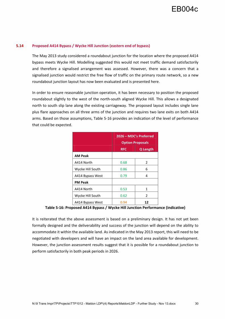
5.14 Proposed A414 Bypass / Wycke Hill Junction (eastern end of bypass)
The May 2013 study considered a roundabout junction for the location where the proposed A414
bypass meets Wycke Hill. Modelling suggested this would not meet traffic demand satisfactorily
and therefore a signalised arrangement was assessed. However, there was a concern that a
signalised junction would restrict the free flow of traffic on the primary route network, so a new
roundabout junction layout has now been evaluated and is presented here.
In order to ensure reasonable junction operation, it has been necessary to position the proposed
roundabout slightly to the west of the north-south aligned Wycke Hill. This allows a designated
north to south slip lane along the existing carriageway. The proposed layout includes single lane
plus flare approaches on all three arms of the junction and requires two lane exits on both A414
arms. Based on those assumptions, Table 5-16 provides an indication of the level of performance
that could be expected.
2026 – MDC’s Preferred
Option Proposals
RFC Q Length
AM Peak
A414 North 0.68 2
Wycke Hill South 0.86 6
A414 Bypass West 0.79 4
PM Peak
A414 North 0.53 1
Wycke Hill South 0.62 2
A414 Bypass West 0.94 12
Table 5-16: Proposed A414 Bypass / Wycke Hill Junction Performance (indicative)
It is reiterated that the above assessment is based on a preliminary design. It has not yet been
formally designed and the deliverability and success of the junction will depend on the ability to
accommodate it within the available land. As indicated in the May 2013 report, this will need to be
negotiated with developers and will have an impact on the land area available for development.
However, the junction assessment results suggest that it is possible for a roundabout junction to
perform satisfactorily in both peak periods in 2026.
EB004c
N:\9 Trans Impr\TP\Projects\TTP1012 - Maldon LDP\(4) Reports\MaldonLDP - Further Study - Nov 13.docx 31
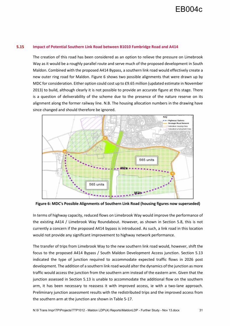
5.15 Impact of Potential Southern Link Road between B1010 Fambridge Road and A414
The creation of this road has been considered as an option to relieve the pressure on Limebrook
Way as it would be a roughly parallel route and serve much of the proposed development in South
Maldon. Combined with the proposed A414 Bypass, a southern link road would effectively create a
new outer ring road for Maldon. Figure 6 shows two possible alignments that were drawn up by
MDC for consideration. Either option could cost up to £9.65 million (updated estimate in November
2013) to build, although clearly it is not possible to provide an accurate figure at this stage. There
is a question of deliverability of the scheme due to the presence of the nature reserve on its
alignment along the former railway line. N.B. The housing allocation numbers in the drawing have
since changed and should therefore be ignored.
Figure 6: MDC's Possible Alignments of Southern Link Road (housing figures now superseded)
In terms of highway capacity, reduced flows on Limebrook Way would improve the performance of
the existing A414 / Limebrook Way Roundabout. However, as shown in Section 5.8, this is not
currently a concern if the proposed A414 bypass is introduced. As such, a link road in this location
would not provide any significant improvement to highway network performance.
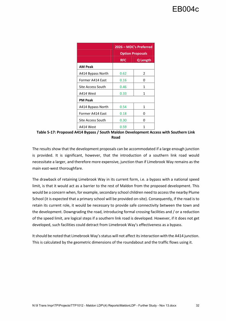
The transfer of trips from Limebrook Way to the new southern link road would, however, shift the
focus to the proposed A414 Bypass / South Maldon Development Access junction. Section 5.13
indicated the type of junction required to accommodate expected traffic flows in 2026 post
development. The addition of a southern link road would alter the dynamics of the junction as more
traffic would access the junction from the southern arm instead of the eastern arm. Given that the
junction assessed in Section 5.13 is unable to accommodate the additional flow on the southern
arm, it has been necessary to reassess it with improved access, ie with a two-lane approach.
Preliminary junction assessment results with the redistributed trips and the improved access from
the southern arm at the junction are shown in Table 5-17.
EB004c
N:\9 Trans Impr\TP\Projects\TTP1012 - Maldon LDP\(4) Reports\MaldonLDP - Further Study - Nov 13.docx 32
2026 – MDC’s Preferred
Option Proposals
RFC Q Length
AM Peak
A414 Bypass North 0.62 2
Former A414 East 0.16 0
Site Access South 0.46 1
A414 West 0.33 1
PM Peak
A414 Bypass North 0.54 1
Former A414 East 0.18 0
Site Access South 0.30 0
A414 West 0.59 1
Table 5-17: Proposed A414 Bypass / South Maldon Development Access with Southern Link Road
The results show that the development proposals can be accommodated if a large enough junction
is provided. It is significant, however, that the introduction of a southern link road would
necessitate a larger, and therefore more expensive, junction than if Limebrook Way remains as the
main east-west thoroughfare.
The drawback of retaining Limebrook Way in its current form, i.e. a bypass with a national speed
limit, is that it would act as a barrier to the rest of Maldon from the proposed development. This
would be a concern when, for example, secondary school children need to access the nearby Plume
School (it is expected that a primary school will be provided on-site). Consequently, if the road is to
retain its current role, it would be necessary to provide safe connectivity between the town and
the development. Downgrading the road, introducing formal crossing facilities and / or a reduction
of the speed limit, are logical steps if a southern link road is developed. However, if it does not get
developed, such facilities could detract from Limebrook Way’s effectiveness as a bypass.
It should be noted that Limebrook Way’s status will not affect its interaction with the A414 junction.
This is calculated by the geometric dimensions of the roundabout and the traffic flows using it.
EB004c
N:\9 Trans Impr\TP\Projects\TTP1012 - Maldon LDP\(4) Reports\MaldonLDP - Further Study - Nov 13.docx 33
6 Wider Impacts of Maldon District Development
6.1 Introduction
Under MDC’s duty to co-operate with neighbouring authorities, Chelmsford City Council (CCC) and
Braintree District Council (BDC) have raised concerns over the possible impact of the MDC proposals
on their areas.
Two locations have been identified as being of significant concern, namely the Eves Corner junction
in Danbury (A414 / Little Baddow Road / Mayes Lane) and B1019 Maldon Road / B1137 The Street
in Hatfield Peverel. The issue of the existing A12 junction with the A414 at Sandon has also been
raised and is considered in this section.
6.2 A414 / Little Baddow Road / Mayes Lane (Eves Corner), Danbury
This junction currently experiences notable delays in both peak periods. In particular, westbound
queues are prevalent in the AM peak and eastbound queues dominate the PM peak. It is reasonable
to assume that these queues are partially attributable to trips to / from the Maldon and Heybridge
area. Any further development is therefore likely to exacerbate this situation.
It has not been possible to formally model the junction as part of this study as no recent traffic data
is available. However, it has been assessed in the past as part of a 2004 study of the A414 corridor.
This included modelling of the junction using two different software packages; SIAS’ S-Paramics
microsimulation and TRL’s PICADY (for priority junctions). The result of that study led to plans to
install pre-signals on the two minor roads of the junction, Little Baddow Road and Mayes Lane. The
theory was that the signals would hold the minor road traffic back and ensure smoother passage
for the major route, i.e. the A414. This option would also have discouraged rat-running on the
neighbouring minor routes. However, these options were not progressed.
For this latest study a site visit was carried out by an Essex Highways engineer on Wednesday 18th
September, 2013 to assess the potential for any upgrade at the junction. It was concluded that the
land-take within the junction has already been maximised; the highway / footway cannot extend
any further due to the Heathcote School premises, newly-developed private residences and the
village green. Furthermore, as all four arms of the junction are existing bus routes, it would not be
possible to provide bus priority measures which accommodate all required movements.
The options to improve the junction are therefore limited. It would be possible to convert it into a
priority junction where the A414 becomes the main thoroughfare and the minor roads have to give
way. This was assessed in the 2004 study and would ensure much improved east:west throughput
compared to the existing situation. However, it would be detrimental to the minor road bus and
traffic movements and is therefore likely to be opposed by local residents.
EB004c
N:\9 Trans Impr\TP\Projects\TTP1012 - Maldon LDP\(4) Reports\MaldonLDP - Further Study - Nov 13.docx 34
Given that Eves Corner is a key junction en route to the A12 and Chelmsford from Maldon district, it
is clear that more detailed study is required of the existing problems at the junction and the potential
impact of the proposed Heybridge and Maldon developments. Consequently, EH have recently
commissioned new traffic counts for the junction and these will be used to assess the current
situation and, if possible, identify any possible options for the junction. Details of this study will be
reported by EH in a subsequent technical note in the next two months.
6.3 A414 / A12 Interchange
As with Eves Corner, it has not been possible to carry out a formal junction assessment due to the
absence of any recent traffic data. However, EH has access to the Department for Transport’s
TrafficMaster data which can be used to estimate average peak period speeds and identify possible
traffic ‘hot spots’. Furthermore, as part of an agreement with the Highways Agency to monitor
demand at the junction, EH holds queue length data collected in June 2013 for the A12 slip roads.
The TrafficMaster data, which is contained in Appendix A, indicates that average speeds at the
junction do not fall below reasonable levels for a roundabout junction in either peak period. For
both eastbound and westbound traffic average speeds are shown to drop to no less than 20mph
through the junction.
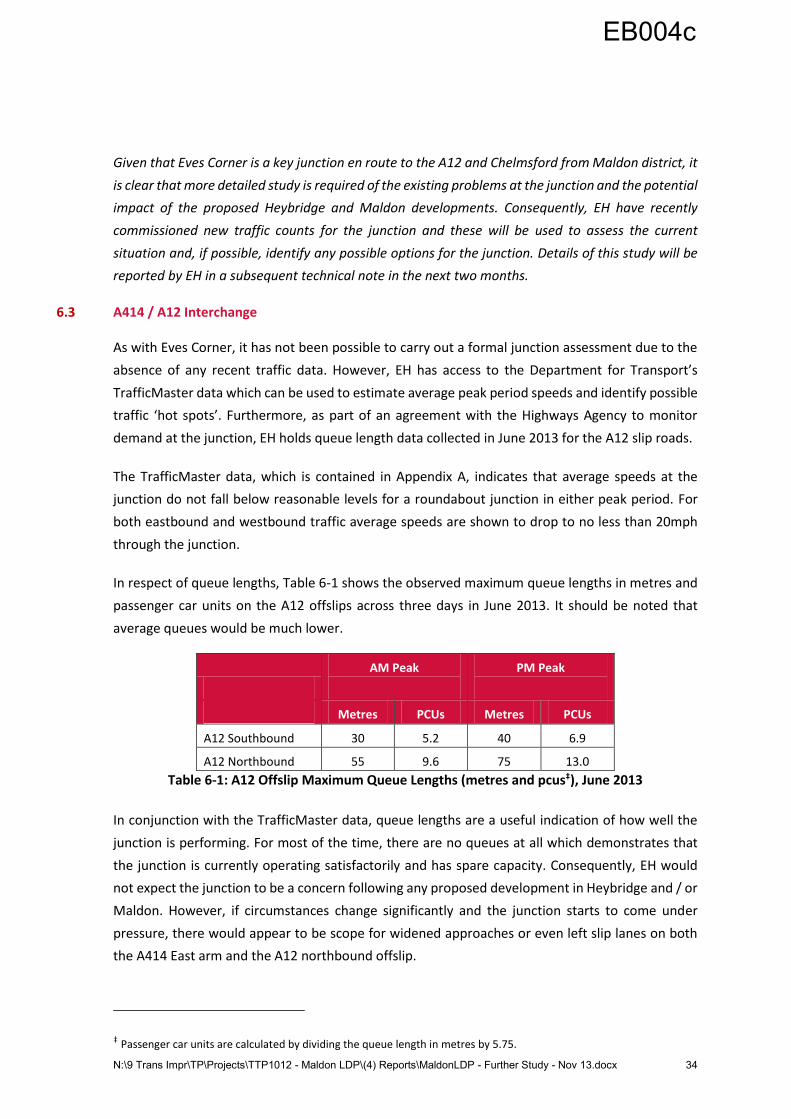
In respect of queue lengths, Table 6-1 shows the observed maximum queue lengths in metres and
passenger car units on the A12 offslips across three days in June 2013. It should be noted that
average queues would be much lower.
AM Peak
PM Peak
Metres PCUs Metres PCUs
A12 Southbound 30 5.2 40 6.9
A12 Northbound 55 9.6 75 13.0
Table 6-1: A12 Offslip Maximum Queue Lengths (metres and pcus‡), June 2013
In conjunction with the TrafficMaster data, queue lengths are a useful indication of how well the
junction is performing. For most of the time, there are no queues at all which demonstrates that
the junction is currently operating satisfactorily and has spare capacity. Consequently, EH would
not expect the junction to be a concern following any proposed development in Heybridge and / or
Maldon. However, if circumstances change significantly and the junction starts to come under
pressure, there would appear to be scope for widened approaches or even left slip lanes on both
the A414 East arm and the A12 northbound offslip.
‡ Passenger car units are calculated by dividing the queue length in metres by 5.75.
EB004c
N:\9 Trans Impr\TP\Projects\TTP1012 - Maldon LDP\(4) Reports\MaldonLDP - Further Study - Nov 13.docx 35
6.4 B1019 Maldon Road / B1137 The Street, Hatfield Peverel
The most recent data held by EH for this junction, which is currently a mini-roundabout, is from
October 2010. More recent traffic flows (March 2012) are contained within a Transport Assessment
entitled Proposed Development at Oval Park, Hatfield Road, Langford by Waterman Boreham Ltd,
March 2012. However, the raw data was not included in the document and therefore the slightly
older, but verifiable data has been used (it should be noted that the two data sources display close
similarities, indicating little change over the 18 months between them). N.B. As with Eves Corner in
Danbury, EH have commissioned a new traffic count for this junction and it will be studied to validate
the following findings. Full details will be included in a follow-up technical note.
With regard to the level of development traffic from Heybridge and South Maldon which would use
the junction, this has been based on information taken from the Waterman Boreham Transport
Assessment, where it is indicated that approximately 25% of trips use the B1018 Witham Road
instead of the B1019 towards Hatfield Peverel. It has therefore been assumed that the other 75%
use this junction and have been incorporated into the assessment based on the existing turning
proportions. This is considered to be a robust figure as, in reality, a number of trips are likely to be
‘lost’ to the minor roads between the B1018 Witham Road junction in Langford and the Hatfield
Peverel mini-roundabout.
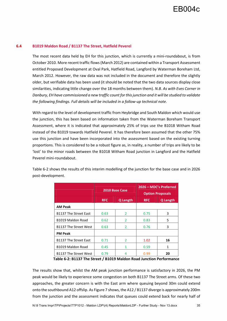
Table 6-2 shows the results of this interim modelling of the junction for the base case and in 2026
post-development.
2010 Base Case
2026 – MDC’s Preferred
Option Proposals
RFC Q Length RFC Q Length
AM Peak
B1137 The Street East 0.63 2 0.75 3
B1019 Maldon Road 0.62 2 0.83 5
B1137 The Street West 0.63 2 0.76 3
PM Peak
B1137 The Street East 0.71 2 1.02 16
B1019 Maldon Road 0.45 1 0.59 1
B1137 The Street West 0.79 4 0.99 20
Table 6-2: B1137 The Street / B1019 Maldon Road Junction Performance
The results show that, whilst the AM peak junction performance is satisfactory in 2026, the PM
peak would be likely to experience some congestion on both B1137 The Street arms. Of these two
approaches, the greater concern is with the East arm where queuing beyond 30m could extend
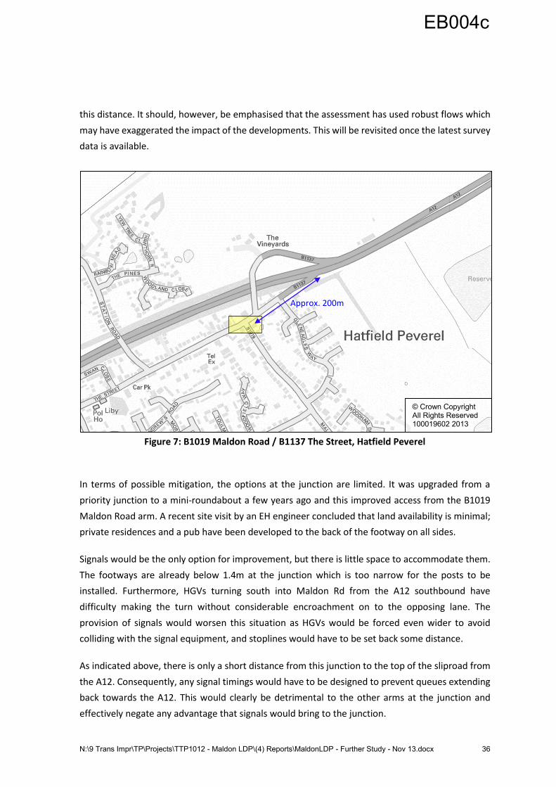
onto the southbound A12 offslip. As Figure 7 shows, the A12 / B1137 diverge is approximately 200m
from the junction and the assessment indicates that queues could extend back for nearly half of
EB004c
N:\9 Trans Impr\TP\Projects\TTP1012 - Maldon LDP\(4) Reports\MaldonLDP - Further Study - Nov 13.docx 36
this distance. It should, however, be emphasised that the assessment has used robust flows which
may have exaggerated the impact of the developments. This will be revisited once the latest survey
data is available.
Figure 7: B1019 Maldon Road / B1137 The Street, Hatfield Peverel
In terms of possible mitigation, the options at the junction are limited. It was upgraded from a
priority junction to a mini-roundabout a few years ago and this improved access from the B1019
Maldon Road arm. A recent site visit by an EH engineer concluded that land availability is minimal;
private residences and a pub have been developed to the back of the footway on all sides.
Signals would be the only option for improvement, but there is little space to accommodate them.
The footways are already below 1.4m at the junction which is too narrow for the posts to be
installed. Furthermore, HGVs turning south into Maldon Rd from the A12 southbound have
difficulty making the turn without considerable encroachment on to the opposing lane. The
provision of signals would worsen this situation as HGVs would be forced even wider to avoid
colliding with the signal equipment, and stoplines would have to be set back some distance.
As indicated above, there is only a short distance from this junction to the top of the sliproad from
the A12. Consequently, any signal timings would have to be designed to prevent queues extending
back towards the A12. This would clearly be detrimental to the other arms at the junction and
effectively negate any advantage that signals would bring to the junction.
© Crown Copyright All Rights Reserved 100019602 2013
Approx. 200m
EB004c
N:\9 Trans Impr\TP\Projects\TTP1012 - Maldon LDP\(4) Reports\MaldonLDP - Further Study - Nov 13.docx 37
A new junction on the A12 could possibly alleviate potential future congestion problems at the
junction. This option has not been explored in detail, but would be likely to entail realigning the
existing B1019 Maldon Road to link with a junction between the B1389 southbound onslip and the
B1137 offslip at Hatfield Peverel. Preliminary estimations have put the cost of such plans at a
minimum of £40 million; this option has not been pursued.
EB004c
N:\9 Trans Impr\TP\Projects\TTP1012 - Maldon LDP\(4) Reports\MaldonLDP - Further Study - Nov 13.docx 38
7 Summary and Conclusions
7.1 Study Findings Summary
This study has considered the impact on the highway network of 1,000 potential dwellings in
Heybridge, plus 1,830 dwellings and 5 hectares of employment land in South Maldon. It has also
given consideration to three different alignments for the proposed Heybridge link road. The
methodology for the study has remained consistent with that used in the December 2010 study by
Mouchel plc and EH’s work in May 2013 with regard to trip generation, assignment to the highway
network and capacity assessments.
The principal findings are summarised as follows:
Assessment of Heybridge Link Road
Outer, Inner and Middle link roads have been assessed. Having considered junction capacity, road
safety, land availability, the possibility for providing a public transport link and the cost of mitigating
the Langford Road / Heybridge Approach roundabout, EH and ECC recommend that the Outer and
Middle link roads should be retained for further consideration, and be explored further through the
masterplanning process.
Assessment of Existing Junctions in Maldon District
On the assumption that a new link road is provided in Heybridge and a new A414 Bypass developed
in South Maldon, the following junctions have been identified as performing satisfactorily in 2026
post the latest development proposals:
A414 / B1018 The Causeway / Fullbridge;
B1022 Colchester Road / Scraley Road / B1022 Broad Street Green Road;
B1018 Limebrook Way / B1010 Fambridge Road; and
Limebrook Way / Mundon Road / Park Drive.
Provided that the aforementioned new link road and bypass are in place and mitigation measures
are undertaken, the following junctions should perform satisfactorily:
B1018 Langford Road / B1018 Heybridge Approach;
A414 / B1018 Heybridge Approach;
A414 / Spital Road;
A414 Maldon Road / A414 Wycke Hill / Wycke Hill Business Park Access / B1018 Limebrook
Way; and
A414 Chelmsford Road / A414 Maldon Road / B1010 Burnham Road / B1418 Southend
Road (Oak Corner Roundabout).
EB004c
N:\9 Trans Impr\TP\Projects\TTP1012 - Maldon LDP\(4) Reports\MaldonLDP - Further Study - Nov 13.docx 39
The following junctions have been identified as operating above capacity in 2026 post
development. However, a ‘nil detriment’ situation can be achieved against the 2026 Background
Traffic scenario if a Heybridge link road is provided:
B1018 The Causeway / The Square / B1022 The Street; and
B1022 Colchester Road / B1026 Goldhanger Road.
Assessment of Proposed A414 Bypass, Associated Junctions and Southern Link Road in South
Maldon
The proposed A414 Bypass in South Maldon had been identified in previous studies as necessary in
order to accommodate both existing demand and proposed development traffic. However, its
introduction would require sizeable junctions to be provided at each end of the route. Negotiations
with developers will therefore be necessary regarding the level of land-take involved.
The proposed Southern Link Road will not have any material benefit to highway capacity and would
require a larger and more expensive junction with the A414. However, its introduction would allow
Limebrook Way to be downgraded from its existing national speed limit status. This would enable
improved and safer connectivity between the proposed development on the south side of
Limebrook Way and the rest of Maldon, which is a key consideration given the need to provide
secondary school children with safe access to the Plume School. A reduced speed limit and crossing
facilities would assist in achieving this.
However, as the Southern Link Road is not proposed as a required highway mitigation, it is
important that Limebrook Way’s function as a principal route with an appropriate speed limit is
retained. The current road not only operates as bypass on the south side of Maldon, but also serves
the wider highway network, in particular towards Burnham-on-Crouch and the Dengie peninsula.
In this scenario, consideration of the connectivity between the South Maldon development and
Maldon town centre and its facilities (including education) should be the subject of further review.
This process should include assessing the potential for utilising the existing green link associated
with the Wycke Hill Nature Reserve.
Assessment of Existing Junctions Outside Maldon District
Under MDC’s Duty to Co-operate with neighbouring authorities, Braintree District and Chelmsford
City Councils have raised concerns over the potential impact of the proposed developments on
three junctions in their areas. It has not been possible to model the junctions accurately at this
stage due to the absence of recent traffic data. However, the following junction is anticipated to
perform satisfactorily in 2026:
A414 / A12 Interchange.
EB004c
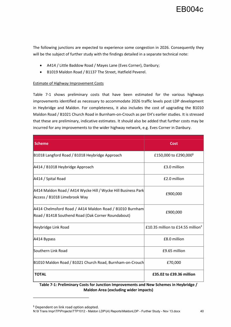
N:\9 Trans Impr\TP\Projects\TTP1012 - Maldon LDP\(4) Reports\MaldonLDP - Further Study - Nov 13.docx 40
The following junctions are expected to experience some congestion in 2026. Consequently they
will be the subject of further study with the findings detailed in a separate technical note:
A414 / Little Baddow Road / Mayes Lane (Eves Corner), Danbury;
B1019 Maldon Road / B1137 The Street, Hatfield Peverel.
Estimate of Highway Improvement Costs
Table 7-1 shows preliminary costs that have been estimated for the various highways
improvements identified as necessary to accommodate 2026 traffic levels post LDP development
in Heybridge and Maldon. For completeness, it also includes the cost of upgrading the B1010
Maldon Road / B1021 Church Road in Burnham-on-Crouch as per EH’s earlier studies. It is stressed
that these are preliminary, indicative estimates. It should also be added that further costs may be
incurred for any improvements to the wider highway network, e.g. Eves Corner in Danbury.
Scheme Cost
B1018 Langford Road / B1018 Heybridge Approach £150,000 to £290,000§
A414 / B1018 Heybridge Approach £3.0 million
A414 / Spital Road £2.0 million
A414 Maldon Road / A414 Wycke Hill / Wycke Hill Business Park
Access / B1018 Limebrook Way £900,000
A414 Chelmsford Road / A414 Maldon Road / B1010 Burnham
Road / B1418 Southend Road (Oak Corner Roundabout) £900,000
Heybridge Link Road £10.35 million to £14.55 million‡
A414 Bypass £8.0 million
Southern Link Road £9.65 million
B1010 Maldon Road / B1021 Church Road, Burnham-on-Crouch £70,000
TOTAL £35.02 to £39.36 million
Table 7-1: Preliminary Costs for Junction Improvements and New Schemes in Heybridge / Maldon Area (excluding wider impacts)
§ Dependent on link road option adopted.
EB004c
N:\9 Trans Impr\TP\Projects\TTP1012 - Maldon LDP\(4) Reports\MaldonLDP - Further Study - Nov 13.docx 41
All of the estimates detailed in the text of this report and shown in Table 7-1 are based on high level
drawings; more accurate costings can only be provided once designs become available.
All costs include:
An allowance for utilities diversions (note that there is no anticipated impact for the
Burnham-on-Crouch scheme);
40% risk allowance for Major Projects (more than £500, 000), 30% for Minor Works;
Design, surveys and contract administration; and
Landscaping and ecological measures (where required).
All costs exclude:
Land acquisition / Compulsory Purchase Orders;
Part 1 Claims;
Traffic Regulation Order processing, advertising and legal fees;
Consultation and publicity;
Essex CC Commissioning and administrative costs; and
Drainage attenuation structures.
Assumptions:
There are no special geotechnical requirements;
No quantified risk assessment has been made, therefore an assumption has been made
regarding risk (see notes above);
All pylons will remain in-situ; and
There are no special environmental issues / requirements.
The price base is 2013.
The costs represent the sum that ECC can be confident of delivering the scheme if procured via ECC
using traditional procurement methods. If a developer were to build some of the larger schemes,
the out-turn cost may be less due to not having to face the same risk factors and being able to
employ strategies such as design and build.
7.2 Concluding Comment
It is clear that the level of development being considered within MDC’s LDP will necessitate
significant upgrades to the local highway network and, potentially, in neighbouring districts.
However, this study demonstrates that, in the immediate Maldon and Heybridge area, it is possible
to mitigate against the impact of the proposed developments provided that funding and land is
made available. The potential for mitigating against the proposed developments in Danbury and
EB004c

N:\9 Trans Impr\TP\Projects\TTP1012 - Maldon LDP\(4) Reports\MaldonLDP - Further Study - Nov 13.docx 42
Hatfield Peverel will be considered in a separate technical note when new data has been collected
and assessed.
EB004c

N:\9 Trans Impr\TP\Projects\TTP1012 - Maldon LDP\(4) Reports\MaldonLDP - Further Study - Nov 13.docx 43
Appendices
Appendix A: DfT TrafficMaster Data for Maldon District – AM and PM Peak Hours .................. 45
EB004c

N:\9 Trans Impr\TP\Projects\TTP1012 - Maldon LDP\(4) Reports\MaldonLDP - Further Study - Nov 13.docx 44
EB004c
N:\9 Trans Impr\TP\Projects\TTP1012 - Maldon LDP\(4) Reports\MaldonLDP - Further Study - Nov 13.docx 45
Appendix A: DfT TrafficMaster Data for Maldon District – AM and PM Peak Hours
EB004c

N:\9 Trans Impr\TP\Projects\TTP1012 - Maldon LDP\(4) Reports\MaldonLDP - Further Study - Nov 13.docx 46
EB004c
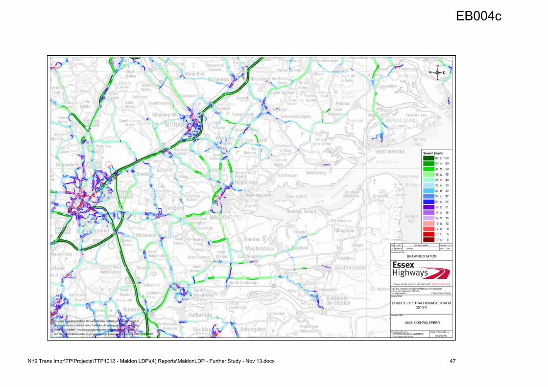
N:\9 Trans Impr\TP\Projects\TTP1012 - Maldon LDP\(4) Reports\MaldonLDP - Further Study - Nov 13.docx 47
EB004c
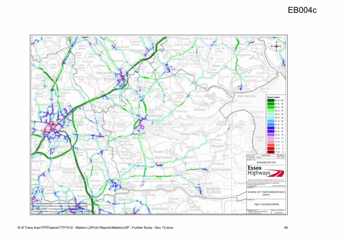
N:\9 Trans Impr\TP\Projects\TTP1012 - Maldon LDP\(4) Reports\MaldonLDP - Further Study - Nov 13.docx 48
EB004c