MA2014-1 - mlit.go.jp report is a translation of the Japanese original investigation report. The...
42
MA2014-1 MARINE ACCIDENT INVESTIGATION REPORT January 31, 2014
Transcript of MA2014-1 - mlit.go.jp report is a translation of the Japanese original investigation report. The...
MA2014-1
MARINE ACCIDENT
INVESTIGATION REPORT
January 31, 2014
The objective of the investigation conducted by the Japan Transport Safety Board in
accordance with the Act for Establishment of the Japan Transport Safety Board is to determine the
causes of an accident and damage incidental to such an accident, thereby preventing future accidents
and reducing damage. It is not the purpose of the investigation to apportion blame or liability.
Norihiro Goto
Chairman,
Japan Transport Safety Board
Note:
This report is a translation of the Japanese original investigation report. The text in
Japanese shall prevail in the interpretation of the report.

MARINE ACCIDENT INVESTIGATION REPORT
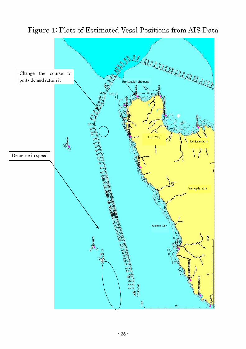
Vessel type and name: Container ship YONG CAI
IMO number: 9164859
Gross tonnage: 9,810 tons
Vessel type and name: Fishing vessel SHINYOMARU No.2
Fishing vessel registration number: IK3-14561
Gross tonnage: 3.4 tons
Accident type: Collision
Date and time: 20:15, April 15, 2012 (Local time, UTC+9 hours)
Location: Off the north-northeast coast of Rokkosaki in Suzu City, Ishikawa
Prefecture
031.5°true, 3.5 nautical miles from Rokkosaki lighthouse
(Approximately 37°34.7’N, 137°21.9’E)
January 9, 2014
Adopted by the Japan Transport Safety Board
Chairman Norihiro Goto
Member Tetsuo Yokoyama
Member Kuniaki Shoji
Member Toshiyuki Ishikawa
Member Mina Nemoto

SYNOPSIS
Summary of the Accident
Container ship YONG CAI was proceeding west-northwest toward Port of Busan in the
Republic of Korea with a master and 17 crew members onboard, whereas fishing vessel
SHINYOMARU No.2 was proceeding south-southwest toward the Noroshi Fishing Port in Suzu
City with a skipper and a crew onboard. Both vessels collided with each other at approximately
20:15 on April 15, 2012 off the North-northeast coast of Rokkosaki.
The skipper on SHINYOMARU No.2 was killed and a crew member went missing. The bow
section of the vessel was crushed, and she was capsized.
YONG CAI suffered scratch to the bulbous bow on the starboard side.
Probable Causes
It is somewhat likely that this accident occurred while YONG CAI was proceeding
west-northwest and SHINYOMARU No.2 was proceeding south-southwest off the
north-northeastern coast of Rokkosaki at night due to the two vessels colliding with each other due
to the facts that Third Officer of YONG CAI did not appropriately keep watch on the starboard side
and that Skipper of the SHINYOMARU No.2 noticed YONG CAI only when it approached very
closely.
It is probable that YONG CAI collided with SHINYOMARU No.2 due to the fact that Third
Officer of YONG CAI was not appropriately keeping watch on the starboard side, not noticing
SHINYOMARU No.2 coming close. Therefore, it is probable that appropriate watch must be kept at
all times with vision, hearing, and all other means appropriate for the situation so that bridge
watch keeper can make judgments on the surrounding situation and possibility of collision with
other vessels.
- 1 -
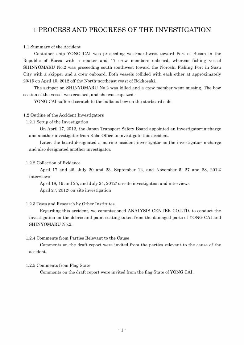
1 PROCESS AND PROGRESS OF THE INVESTIGATION
1.1 Summary of the Accident
Container ship YONG CAI was proceeding west-northwest toward Port of Busan in the
Republic of Korea with a master and 17 crew members onboard, whereas fishing vessel
SHINYOMARU No.2 was proceeding south-southwest toward the Noroshi Fishing Port in Suzu
City with a skipper and a crew onboard. Both vessels collided with each other at approximately
20:15 on April 15, 2012 off the North-northeast coast of Rokkosaki.
The skipper on SHINYOMARU No.2 was killed and a crew member went missing. The bow
section of the vessel was crushed, and she was capsized.
YONG CAI suffered scratch to the bulbous bow on the starboard side.
1.2 Outline of the Accident Investigators
1.2.1 Setup of the Investigation
On April 17, 2012, the Japan Transport Safety Board appointed an investigator-in-charge
and another investigator from Kobe Office to investigate this accident.
Later, the board designated a marine accident investigator as the investigator-in-charge
and also designated another investigator.
1.2.2 Collection of Evidence
April 17 and 26, July 20 and 23, September 12, and November 5, 27 and 28, 2012:
interviews
April 18, 19 and 25, and July 24, 2012: on-site investigation and interviews
April 27, 2012: on-site investigation
1.2.3 Tests and Research by Other Institutes
Regarding this accident, we commissioned ANALYSIS CENTER CO.LTD. to conduct the
investigation on the debris and paint coating taken from the damaged parts of YONG CAI and
SHINYOMARU No.2.
1.2.4 Comments from Parties Relevant to the Cause
Comments on the draft report were invited from the parties relevant to the cause of the
accident.
1.2.5 Comments from Flag State
Comments on the draft report were invited from the flag State of YONG CAI.
- 2 -
2 FACTUAL INFORMATION
2.1 Events Leading to the Accident
Events leading to this accident were as follows.
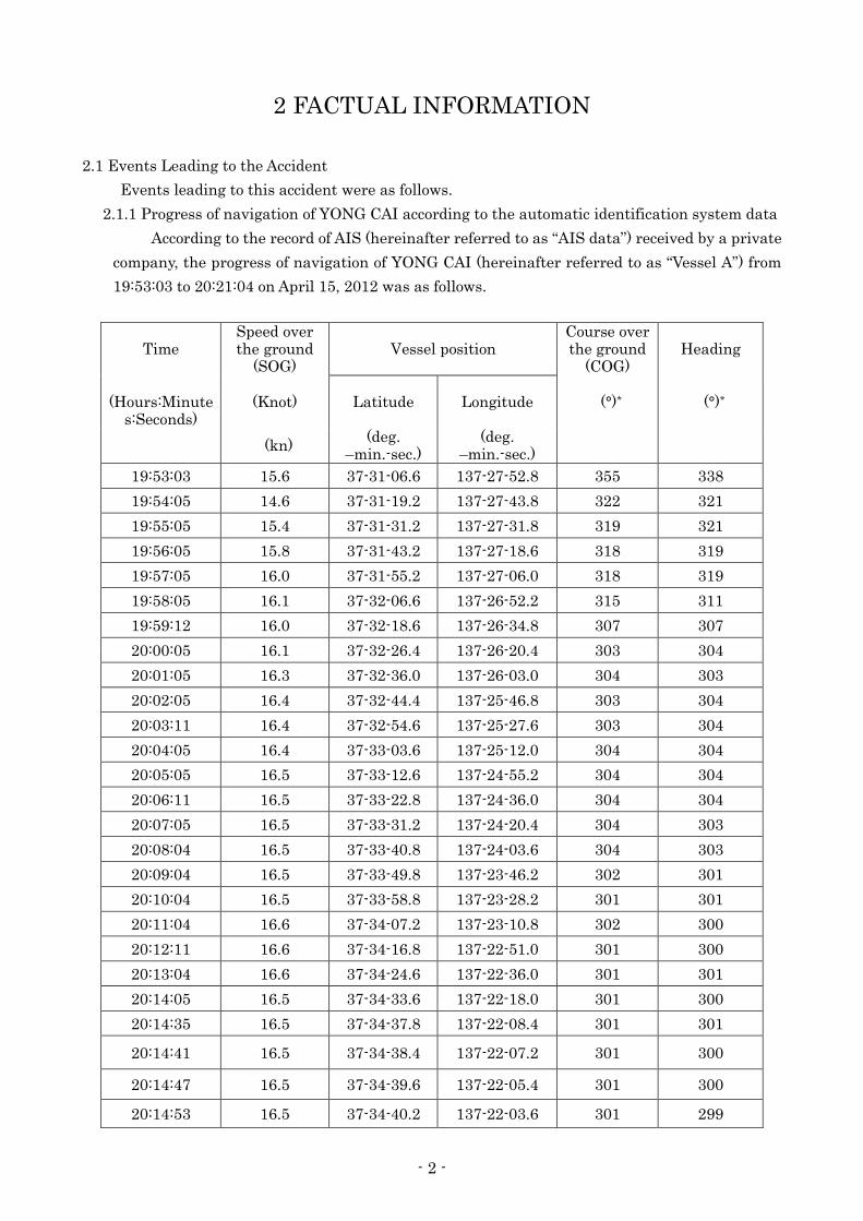
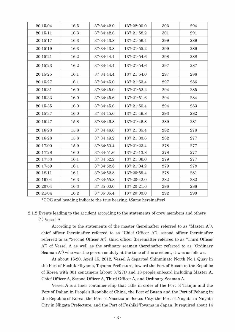
2.1.1 Progress of navigation of YONG CAI according to the automatic identification system data
According to the record of AIS (hereinafter referred to as “AIS data”) received by a private
company, the progress of navigation of YONG CAI (hereinafter referred to as “Vessel A”) from
19:53:03 to 20:21:04 on April 15, 2012 was as follows.
Time Speed over the ground
(SOG) Vessel position
Course over the ground
(COG) Heading
(Hours:Minute
s:Seconds) (Knot) Latitude Longitude (°)* (°)*
(kn) (deg.
–min.-sec.) (deg.
–min.-sec.)
19:53:03 15.6 37-31-06.6 137-27-52.8 355 338
19:54:05 14.6 37-31-19.2 137-27-43.8 322 321
19:55:05 15.4 37-31-31.2 137-27-31.8 319 321
19:56:05 15.8 37-31-43.2 137-27-18.6 318 319
19:57:05 16.0 37-31-55.2 137-27-06.0 318 319
19:58:05 16.1 37-32-06.6 137-26-52.2 315 311
19:59:12 16.0 37-32-18.6 137-26-34.8 307 307
20:00:05 16.1 37-32-26.4 137-26-20.4 303 304
20:01:05 16.3 37-32-36.0 137-26-03.0 304 303
20:02:05 16.4 37-32-44.4 137-25-46.8 303 304
20:03:11 16.4 37-32-54.6 137-25-27.6 303 304
20:04:05 16.4 37-33-03.6 137-25-12.0 304 304
20:05:05 16.5 37-33-12.6 137-24-55.2 304 304
20:06:11 16.5 37-33-22.8 137-24-36.0 304 304
20:07:05 16.5 37-33-31.2 137-24-20.4 304 303
20:08:04 16.5 37-33-40.8 137-24-03.6 304 303
20:09:04 16.5 37-33-49.8 137-23-46.2 302 301
20:10:04 16.5 37-33-58.8 137-23-28.2 301 301
20:11:04 16.6 37-34-07.2 137-23-10.8 302 300
20:12:11 16.6 37-34-16.8 137-22-51.0 301 300
20:13:04 16.6 37-34-24.6 137-22-36.0 301 301
20:14:05 16.5 37-34-33.6 137-22-18.0 301 300
20:14:35 16.5 37-34-37.8 137-22-08.4 301 301
20:14:41 16.5 37-34-38.4 137-22-07.2 301 300
20:14:47 16.5 37-34-39.6 137-22-05.4 301 300
20:14:53 16.5 37-34-40.2 137-22-03.6 301 299
- 3 -
20:15:04 16.5 37-34-42.0 137-22-00.0 303 294
20:15:11 16.3 37-34-42.6 137-21-58.2 301 291
20:15:17 16.3 37-34-43.8 137-21-56.4 299 289
20:15:19 16.3 37-34-43.8 137-21-55.2 299 289
20:15:21 16.2 37-34-44.4 137-21-54.6 298 288
20:15:23 16.2 37-34-44.4 137-21-54.6 297 287
20:15:25 16.1 37-34-44.4 137-21-54.0 297 286
20:15:27 16.1 37-34-45.0 137-21-53.4 297 286
20:15:31 16.0 37-34-45.0 137-21-52.2 294 285
20:15:33 16.0 37-34-45.6 137-21-51.6 294 284
20:15:35 16.0 37-34-45.6 137-21-50.4 294 283
20:15:37 16.0 37-34-45.6 137-21-49.8 293 282
20:15:47 15.8 37-34-46.8 137-21-46.8 289 281
20:16:23 15.8 37-34-48.6 137-21-35.4 282 278
20:16:28 15.8 37-34-49.2 137-21-33.6 282 277
20:17:00 15.9 37-34-50.4 137-21-23.4 278 277
20:17:28 16.0 37-34-51.6 137-21-13.8 278 277
20:17:53 16.1 37-34-52.2 137-21-06.0 279 277
20:17:59 16.1 37-34-52.8 137-21-04.2 279 278
20:18:11 16.1 37-34-52.8 137-20-59.4 278 281
20:19:04 16.3 37-34-55.8 137-20-42.0 282 282
20:20:04 16.3 37-35-00.0 137-20-21.6 286 286
20:21:04 16.2 37-35-05.4 137-20-03.0 292 293
*COG and heading indicate the true bearing. (Same hereinafter)
2.1.2 Events leading to the accident according to the statements of crew members and others
(1) Vessel A
According to the statements of the master (hereinafter referred to as “Master A”),
chief officer (hereinafter referred to as “Chief Officer A”), second officer (hereinafter
referred to as “Second Officer A”), third officer (hereinafter referred to as “Third Officer
A”) of Vessel A as well as the ordinary seaman (hereinafter referred to as “Ordinary
Seaman A”) who was the person on duty at the time of this accident, it was as follows.
At about 16:20, April 15, 2012, Vessel A departed Shinminato North No.1 Quay in
the Port of Fushiki-Toyama, Toyama Prefecture, toward the Port of Busan in the Republic
of Korea with 301 containers (about 3,727t) and 18 people onboard including Master A,
Chief Officer A, Second Officer A, Third Officer A, and Ordinary Seaman A.
Vessel A is a liner container ship that calls in order of the Port of Tianjin and the
Port of Dalian in People's Republic of China, the Port of Busan and the Port of Pohang in
the Republic of Korea, the Port of Naoetsu in Joetsu City, the Port of Niigata in Niigata
City in Niigata Prefecture, and the Port of Fushiki-Toyama in Japan. It required about 14
- 4 -
days for a round voyage.
Master A decided to have Chief Officer A to keep the navigational watch after the
ship left the port, and then he left the bridge at about 17:20.
At about 19:45, when Third Officer A, who was in charge of the next watch, came to
the bridge, Chief Officer A briefed him on that there was a cargo ship ahead that was
heading leftward, that attention must be paid to this ship, that the range scales of the two
radars were six nautical miles (M), that the engine was full ahead, that the course was
about 020° and was on autopilot steering, and that two masthead lights, sidelights, and
sternlight were on. Chief Officer A handed over the navigational watch and left the bridge
at about 19:50.
Ordinary Seaman A kept a lookout while standing behind the steering stand, and
was duty with Third Officer A.
Third Officer A set the course on about 300° at about 19:55 and sighted a light
around 15° to 20° in the direction of the starboard bow which was reported by Ordinary
Seaman A. However, due to the fact that the said light was not moving, he thought that it
was a light of a float (hereinafter referred to as “the float”) and proceeded on the same
course at the speed of 16 to 16.5kn (SOG, the same hereinafter).
Third Officer A did not think there was danger in the direction on the starboard bow
and kept lookout in the direction on the port bow mainly at the port side of the bridge.
Because he assumed that Ordinary Seaman A, who was standing behind the steering
stand, would watch the starboard side.
When Ordinary Seaman A was watching the movement of several cargo ships
nearby, there was a ship that was coming close from starboard stern. When he looked
such as ahead of the starboard side after looking at its movement by using a 6M range
scale radar, he saw a light very close to the starboard bow. At this point, he reported to
Third Officer A that there was a light on the starboard bow.
In response to the report on the light from Ordinary Seaman A, Third Officer A
moved to the starboard side of the bridge and recognized the light in the vicinity of 5° to
10° of the starboard bow. Since the light was extremely close, he ordered ‘hard-a-port’
with the intention of avoiding the light even if it was a float. Ordinary Seaman A changed
to manual steering and held hard-a-port, altered the course to about 270°.
Third Officer A thought that the vessel collided with the float and looked behind
after passing. After confirming that the light had disappeared and that the time was
20:15 on the bridge clock, he altered the course back to the original course and continued
to navigate.
When Master A came to the bridge at about 20:55, Third Officer A reported the facts
that there was recently a light ahead on the starboard side, that he thought it was
strange and ordered port rudder, and that the light had disappeared when he looked
behind after giving the order.
Master A had a suspicion that the light may have been a light of a fishing vessel and
ordered Third Officer A to slow down at about 21:00. He checked the side shell plating on
the starboard side from the deck with Chief Officer A and boatswain, but they could not
find damage. Thinking that there was nothing, he ordered to return the speed to the
- 5 -
original speed at about 22:10.
Master A was called on radio by the Japan Coast Guard at about 09:00 on the
following day on April 16 and he berthed Showaminami No.4 quay in the Sakai Port,
which is located in Sakaiminato City, Tottori Prefecture, at about 22:09 in response to the
order by the Japan Coast Guard.
(2) SHINYOMARU No.2
According to the statements of the family of the skipper (hereinafter referred to as
“Skipper B”) of SHINYOMARU No.2 (hereinafter referred to as “ Vessel B”), skipper
(hereinafter referred to as “Skipper C”) of the consort (hereinafter referred to as “ Vessel
C”), and employees of Fisheries Cooperative Association (hereinafter referred to as
“employees of Fisheries Cooperative”), to which Vessel B had belonged, it was as follows.
Vessel B left the Noroshi Fishing Port with Vessel C at about 13:00 on April 15 with
Skipper B and the crew member onboard (hereinafter referred to as “Crew B”) heading to
a fishing ground called “Wajimadashi” in the vicinity of 4 to 5M north-northeast of
Rokkosaki. After setting 2 sets of gill net in the said fishing ground, it returned to the
Noroshi Fishing Port at about 14:30.
Vessel B left the Noroshi Fishing Port with Vessel C at about 17:30 in order to raise
the two sets of gill net that they had set during the day. They arrived at Wajimadashi at
about 18:00, stopped the engine, and was drifting until after the sunset, at which time
they started raising the gill nets.
Vessel B lit the rotating light, working light, and light specified by the law on the
power-driven vessel underway at about 18:50 and started raising the gill nets.
When Skipper C looked at Vessel B after raised the gill nets and before return at
about 20:00 and saw the working light of Vessel B, he thought that Vessel B had not
finished raising the gill nets and sailed for the Noroshi Fishing Port.
The family of Skipper B lit the panel light of the workplace within the Noroshi
Fishing Port at about 20:00 to prepare for the arrival of Vessel B, expecting that Vessel B
would return to the port by latest 20:30. However, since it did not return, they went to
Vessel C to request them to contact Vessel B after 21:00. Although Skipper C called
Vessel B with a fishery radio, there was no response.
Skipper C unloaded the gill nets that were loaded on his own vessel onto the quay
and left the Noroshi Fishing Port at about 22:00. Although he arrived at Wajimadashi at
about 22:25, he did not see the light belonging to Vessel B. Therefore, he requested the
Japan Coast Guard to conduct a search at about 23:00 .
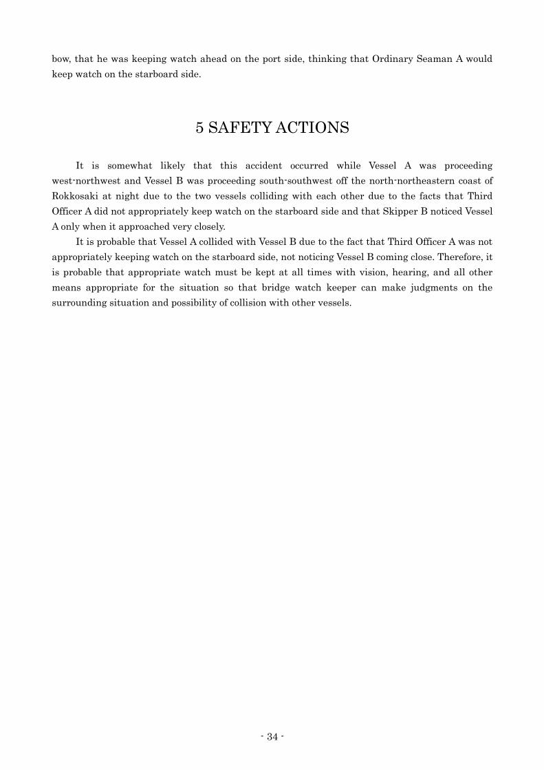
The accident occurred at around 20:15 on April 15, 2012, and the location was the vicinity of
031.5° 3.5M from Rokkosaki Lighthouse.
(Refer to Attached Figure 1 Plots of Estimated Vessl Positions from AIS Data, Photo 1 : Vessel A,
and Photo 2 : Vessel B)

- 6 -
2.2 Injuries to Persons
(1) Vessel A
There were no casualties.
(2) Vessel B
According to the postmortem certificate of Skipper B, he was diagnosed to have been
killed due to drowning.
Crew B went missing.
2.3 Damage to Vessels
(1) Vessel A
Vessel A suffered scratch to the upper bulbous bow on the starboard side.
Photo 2-1 Damage to Vessel A

- 7 -
(2) Vessel B
The bow was lost after the crush, and it suffered damage such as cracking and peeling
in the side shell plating n the starboard bow, both side bulwarks on the bow, fender on the
port bow, and fender on the starboard stern.
Photo 2-2 Damage to Vessel B
2.4 Crew Information
(1) Gender, Age, and Certificate of Competence
Master A Male, 59 years old, Nationality: People's Republic of China
Endorsement attesting the recognition of certificate under STCW regulation I/10
Master (Issued by Saint Vincent and the Grenadines)
Date of issue: April 24, 2012
(valid until July 2, 2016)
Third officer A Male, 29 years old, Nationality: People's Republic of China
Endorsement attesting the recognition of certificate under STCW regulation I/10 Officer
(Issued by Saint Vincent and the Grenadines)
Date of issue: November 22, 2011
(valid until July 21, 2015)
Ordinary Seaman A Male, 22 years old, Nationality: People's Republic of China
Endorsement attesting the recognition of certificate under STCW regulation I/10
Ordinary Seaman (Issued by Saint Vincent and the Grenadines)
Date of issue: December 28, 2011
(valid until August 17, 2016)
Skipper B Male, 76 years old
Bulwark on the starboard bow
Fender on the port bow Bulwark on the port bow
Bow came off
- 8 -
First class boat’s operator/personal water craft operator/with passenger service license
Date of issue: December 19, 1975
Date of revalidation: April 19, 2010
(valid until March 22, 2016)
Crew B Male, 51 years old
No certificate
(2) Seagoing Experience
(i) Master A
According to the statement from Master A, his experience was as follows:
He had been a master for 20 years and had been boarding Vessel A since April 9,
2012. This was the first time for him to navigate the area where the accident occurred
as a master.
He was in good health, and his vision and hearing were also good.
(ii) Third officer A
According to the statements of Third Officer A and Second Officer A, it was as follows:
After boarding a vessel as an apprentice for one year from May 14, 2009, he became
a third officer. He had been boarding Vessel A as a third officer since December 6, 2011.
His eyesight was 0.6 and 0.8, and his hearing had no problem.
He was in good health with no illness or chronic disease.
Drinking on the vessel is prohibited, and he was not drinking at the time of this
accident.
He had no sleep-related problem.
His attitude toward work was serious, and he was responsible and very considerate.
(iii) Ordinary Seaman A
According to the statement of Chief Officer A and the written reply to the questionnaire
by the management company, it was as follows:
He had been boarding Vessel A as an ordinary seaman since December 19, 2011.
Although he was young, his attitude toward work was serious, and he was a studious
young man who often made reports while watchkeeping.
He seemed to be in good health.
(iv) Skipper B
According to the statements of Skipper C and Skipper B’s family, it was as follows:
He had been boarding fishing vessels since he graduated from school, and he had
been a fisherman for about 60 years.
He was not wearing glasses, and he did not have problem in his daily living and
work. Therefore, it was presumed that there was no problem in his eyesight or hearing.
His arms and legs were also healthy, and he was in good health considering his age with
no chronic disease.
(v) Crew B
According to the statements of Skipper B’s family and employees of Fisheries
Cooperative, it was as follows:
He is the son of Skipper B and came on board on Vessel B around the end of March,
2012, and had worked with gill net fishing as a crew member 7 to 8 times so far.

- 9 -
It was presumed that there was no problem in his eyesight, due to the fact that he
was wearing glasses. He was not visiting a hospital for treatment and he was in good
health.
2.5 Vessel Information
2.5.1 Particulars of Vessel
(1) Vessel A
IMO number: 9164859
Port of registry: KINGSTOWN (Saint Vincent and the Grenadines)
O wne r : DV DRAGON (YONG YI) LIMITED (People's Republic of
China)
Management company: DALIAN GRAND OCEAN SHIP MANAGEMENT
CO.,LTD. (People's Republic of China)
Gross tonnage: 9,810 tons
L×B×D: 135.50m×24.50m×12.20m
Hull material: Steel
Engine: 1 diesel engine
Output: 9,360kW
Propulsion: Single 4-blade controllable pitch propeller
Date of construction: October, 1988
(2) Vessel B
Fishing vessel registration number: IK3-14561
Base port: Suzu City, Ishikawa Prefecture
Owner: Individually-owned
Gross tonnage: 3.4 tons
Lr×B×D: 8.85m×2.79m×0.80m
Hull material: FRP
Engine: 1 diesel engine
Output: 242kW
Propulsion: Single 3-blade fixed pitch propeller
Date of launch: April 21, 1983
2.5.2 Information regarding vessel equipment, etc.
(1) Vessel A
(i) Hull structure
According to the general arrangement plan of Vessel A, Vessel A was a aft bridge
type container ship and had the loading capacity of 810TEU*1.
(ii) View from the Bridge
The forward view from the port side in the bridge, there was a derrick in front of
the standing position and the derrick post made a blind area, but the view from other
places was clear. The forward view from the starboard side in the bridge, there was no
*1 “TEU (Twenty-foot equivalent units)” refers to the unit that represents the number of containers, which is
described by converting containers with different lengths into 20ft containers.
- 10 -
blind area.
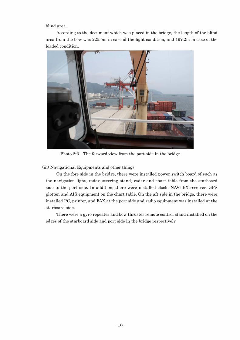
According to the document which was placed in the bridge, the length of the blind
area from the bow was 225.5m in case of the light condition, and 197.2m in case of the
loaded condition.
Photo 2-3 The forward view from the port side in the bridge
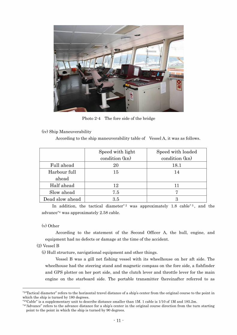
(iii) Navigational Equipments and other things.
On the fore side in the bridge, there were installed power switch board of such as
the navigation light, radar, steering stand, radar and chart table from the starboard
side to the port side. In addition, there were installed clock, NAVTEX receiver, GPS
plotter, and AIS equipment on the chart table. On the aft side in the bridge, there were
installed PC, printer, and FAX at the port side and radio equipment was installed at the
starboard side.
There were a gyro repeater and bow thruster remote control stand installed on the
edges of the starboard side and port side in the bridge respectively.
- 11 -
Photo 2-4 The fore side of the bridge
(iv) Ship Maneuverability
According to the ship maneuverability table of Vessel A, it was as follows.
Speed with light
condition (kn)
Speed with loaded
condition (kn)
Full ahead 20 18.1
Harbour full
ahead
15 14
Half ahead 12 11
Slow ahead 7.5 7
Dead slow ahead 3.5 3
In addition, the tactical diameter* 2 was approximately 1.8 cable* 3 , and the
advance*4 was approximately 2.58 cable.
(v) Other
According to the statement of the Second Officer A, the hull, engine, and
equipment had no defects or damage at the time of the accident.
(2) Vessel B
(i) Hull structure, navigational equipment and other things.
Vessel B was a gill net fishing vessel with its wheelhouse on her aft side. The
wheelhouse had the steering stand and magnetic compass on the fore side, a fishfinder
and GPS plotter on her port side, and the clutch lever and throttle lever for the main
engine on the starboard side. The portable transmitter (hereinafter referred to as
*2“Tactical diameter” refers to the horizontal travel distance of a ship’s center from the original course to the point in
which the ship is turned by 180 degrees. *3“Cable” is a supplementary unit to describe distance smaller than 1M. 1 cable is 1/10 of 1M and 185.2m. *4“Advance” refers to the advance distance for a ship’s center in the original course direction from the turn starting
point to the point in which the ship is turned by 90 degrees.

- 12 -
“remote control”) and the control board on the port side of the wheelhouse were
connected by the electric wire, and it enabled remote control for the main engine and
the steering gear.
(ii) State of various machinery and tools
At the time of the on-site investigation by marine accident investigators at the
Noroshi Fishing Port, the main engine clutch lever (center for neutral, forward for
ahead, and back for astern) was approximately at the center position. Throttle lever was
also approximately at the center position.
Photo 2-5 Clutch lever and throttle lever
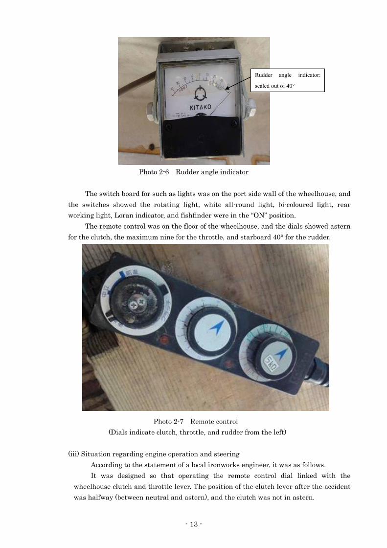
There were three square windows in the wheelhouse, and there was a clear view
screen in the central window. The rudder angle indicator was above the central window,
and its pointer was indicating past starboard 40°.
Throttle lever: Approximately at the center position
Clutch lever: Approximately at the center position
- 13 -
Photo 2-6 Rudder angle indicator
The switch board for such as lights was on the port side wall of the wheelhouse, and
the switches showed the rotating light, white all-round light, bi-coloured light, rear
working light, Loran indicator, and fishfinder were in the “ON” position.
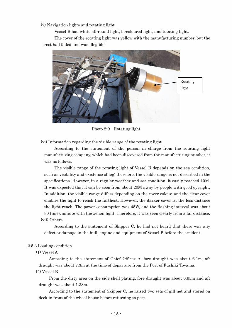
The remote control was on the floor of the wheelhouse, and the dials showed astern
for the clutch, the maximum nine for the throttle, and starboard 40° for the rudder.
Photo 2-7 Remote control
(Dials indicate clutch, throttle, and rudder from the left)
(iii) Situation regarding engine operation and steering
According to the statement of a local ironworks engineer, it was as follows.
It was designed so that operating the remote control dial linked with the
wheelhouse clutch and throttle lever. The position of the clutch lever after the accident
was halfway (between neutral and astern), and the clutch was not in astern.
Rudder angle indicator:
scaled out of 40°

- 14 -
Local fishing vessels normally use half ahead engine to save fuel. In order to
change over from half ahead (2,000 rpm) to astern, it takes two to three seconds to
reduce the engine revolution until 800 to 1,000rpm, about one second to change the
clutch from ahead to astern, about three seconds for it to start operating after the clutch
is switched to astern, and about one to two seconds to turn up the throttle dial. It took at
least seven to eight seconds to change from half ahead to astern and turn up the throttle
dial.
If the engine revolution is high, the clutch would not change from ahead to astern.
In half ahead engine, the position of throttle dial is from four to five. However, just
before the collision, it is expected that the clutch lever could not change to astern
position, because the throttle dial was turned to nine (maximum position) and the
engine revolution was too high.
Although the rudder was starboard 40°, it was possible to turn starboard 40° in
two to three seconds. The display of starboard 40° on the rudder angle indicator means
that the rudder was actually turned to starboard 40°. Even if the rudder angle indicator
is submerged in sea water, its pointer would not have moved unless a new electric signal
was transmitted.
(iv) State of the view
A lookout cockpit, which was surrounded by glasses in four directions, was
additionally installed above the wheelhouse ceiling. A board was bridged between the
both sidewall in the wheelhouse, and the surrounding views were favorable when the
investigator look out a cockpit window by sitting on the board.
Photo 2-8 Wheelhouse
Additionally installed lookout cockpit
A board was bridged between the both sidewall
- 15 -
(v) Navigation lights and rotating light
Vessel B had white all-round light, bi-coloured light, and totating light.
The cover of the rotating light was yellow with the manufacturing number, but the
rest had faded and was illegible.
Photo 2-9 Rotating light
(vi) Information regarding the visible range of the rotating light
According to the statement of the person in charge from the rotating light
manufacturing company, which had been discovered from the manufacturing number, it
was as follows.
The visible range of the rotating light of Vessel B depends on the sea condition,
such as visibility and existence of fog; therefore, the visible range is not described in the
specifications. However, in a regular weather and sea condition, it easily reached 10M.
It was expected that it can be seen from about 20M away by people with good eyesight.
In addition, the visible range differs depending on the cover colour, and the clear cover
enables the light to reach the furthest. However, the darker cover is, the less distance
the light reach. The power consumption was 45W, and the flashing interval was about
80 times/minute with the xenon light. Therefore, it was seen clearly from a far distance.
(vii) Others
According to the statement of Skipper C, he had not heard that there was any
defect or damage in the hull, engine and equipment of Vessel B before the accident.
2.5.3 Loading condition
(1) Vessel A
According to the statement of Chief Officer A, fore draught was about 6.1m, aft
draught was about 7.3m at the time of departure from the Port of Fushiki Toyama.
(2) Vessel B
From the dirty area on the side shell plating, fore draught was about 0.65m and aft
draught was about 1.38m.
According to the statement of Skipper C, he raised two sets of gill net and stored on
deck in front of the wheel house before returning to port.
Rotating light
- 16 -
2.6 Information regarding the watchkeeping arrangement of Vessel A
According to the statement of Master A, Second Officer A, Third Officer A, and Ordinary
Seaman A, it was as follows.
Vessel A had maintained the 4 on / 8 off watch routine system. Second Officer A kept watch
from 00:00 to 04:00 and from 12:00 to 16:00, Chief Officer A kept watch from 04:00 to 08:00 and
from 16:00 to 20:00, and Third Officer A kept watch from 08:00 to 12:00 and from 20:00 to 24:00,
and each of them kept watch along with another ordinary seaman. These time periods were fixed
for each officer, and ordinary seamen switched their watch every month. At the time of such as the
departure/arrival and narrow channel navigation, Master A maneuvered.
2.7 Information regarding fishing operation form
2.7.1 Fishing Operation
(1) Fishing Operation of the Fisheries Cooperative, to which Vessel B belong
According to the statement of Skipper C and the Skipper of the consort (hereinafter
referred to as “Skipper D”), it was as follows.
The fishing operation of fishing vessels in the Noroshi Fishing Port mainly involved
gill net fishing, and they captured such as marbled rockfish, black rockfish, porgy, and
threadsail filefish. All of the gill net fishing vessels in the Noroshi Fishing Port left the
port at once at 13:00 and returned to the port after setting one or two sets of gill net. If
they all leave the port at once, they can check the allocation of gill nets of other vessels.
Therefore, they did not have their own gill nets overlapping gill nets of other vessels.
Fishing vessels released gill nets from stern when they were setting nets. They
raised gill nets with double winding on the net roller at the starboard side of the front
side. Since fish become active before sunset and get caught in the nets, they were raising
the gill nets after sunset.
Fishing vessels left the Noroshi Fishing Port again from 17:30 to 18:30 and went to
fishing grounds, raised the gill nets for an hour to an hour and a half after sunset, and
returned to the port by about 20:30. They landed the gill nets on the quay, and family
members removed fish from them for one hour to two hours, depending on how much fish
was caught. Fishing vessels finished work after 22:00, rested, and took the fish to the
stock yard of the Noroshi Fishing Port in the following morning in time for the market
opening at about 05:30. After this, employees of the Fisheries Cooperative collected fish
in the Noroshi Fishing Port, took the fish to the Suzu City branch of Fisheries
Cooperative in Ishikawa Prefecture on its trucks to sell the fish in auction. Fishing
vessels prepared for fishing, such as loading gill nets, and left the port at 13:00 at once.
They repeated this schedule.
Since large vessels often navigate off the coast of Rokkosaki, fishing vessels set gill
nets after confirming that there is no large vessel. In addition, they lit the designated
navigation lights of power-driven vessels as well as the rotating light so that large vessels
could be easily visible the vessels. In addition to these lights, they also lit working lights
for deck lighting when they engaged in fishing operation.
- 17 -
(2) Fishing Operation of Vessel B
According to the statements of Skipper C and Skipper D, it was as follows.
Skipper B had been recording the points to set gill nets in each fishing ground on
the GPS plotter installed on the Vessel B. Locations to set the gill nets were fixed for each
fishing ground.
Gill nets set by Vessel B were about 750m long and about 4.5m high for each net.
Floats of about 10cm long and about 3cm in diameter were attached every 75cm on the
top side, and weights of about 37.5g were attached every 19cm on the bottom side for each
net.
Vessel B set the gill nets from the west end toward the eastern direction to follow
the current of the sea. It raised the gill nets from the east end toward the western
direction to prevent the gill nets from hanging rocks. It took about 30 minutes to set 2
sets of gill net, and it took 1 hour to 1.5 hours to pull out 2 sets of gill net.
Upon returning to the port from Wajimadashi after sunset, Skipper B determined
the course from the position where they finished heaving up gill nets towards the
Rokkosaki Lighthouse, navigated the vessel at the speed of about ninekn by setting the
engine half ahead to save fuel, and headed the Vessel B toward the red lighthouse of the
Noroshi Fishing Port (Noroshi Port No.2 North Breakwater South Lighthouse) where the
light started to appear bright.
During navigation, the bow would rise and hide the forward view, and so Skipper B
would sit on a board, which was bridged from the both sidewall in the wheelhouse, put his
head out from the cockpit, which was additionally installed on the top part of the
wheelhousee, and steer with a remote control to secure the forward view.
Vessel B had lit the white all-round light, bi-coloured light, and rotating light, which
was seen from all directions, at around sunset during navigation.
Vessel B would light the rotating light when it raised nets as well as when it was
returning to the port, because the yellow rotating light would inform large vessels that
there is a fishing vessel at night.
On the day of this accident, Vessel B had set 2 sets of gill net at Wajimadashi as
usual. Vessel B had not used the terrestrial navigation, when it was setting gill nets, and
it was setting gill nets where they were marked on the GPS plotter. The approximate
locations where Vessel B was setting gill nets at Wajimadashi can be comprehended by
looking at the GPS plotter installed on Skipper C’s vessel, since Vessel B would always
operate with Vessel C. The locations were the same as usual on the day of this accident.
2.7.2 Fishing position of Vessel B
According to the statement of Skipper C and the GPS plotter installed on Vessel C, it was
as follows.
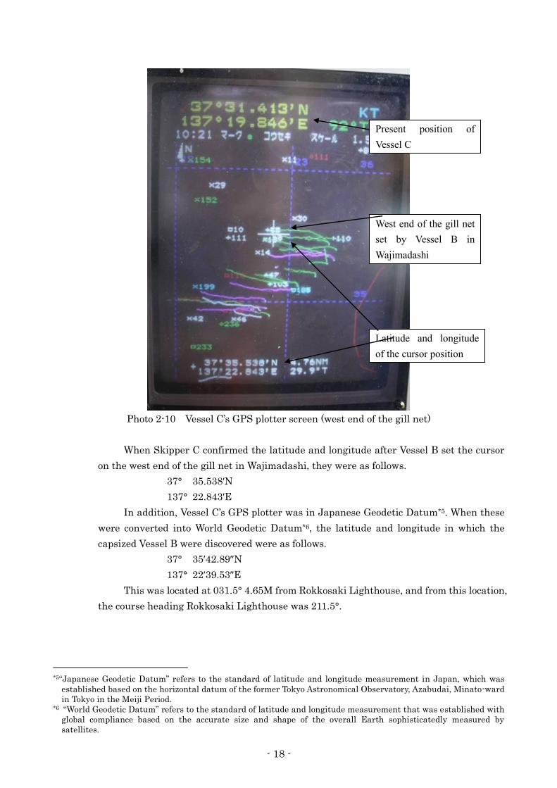
(1) The location where gill nets are set in each fishing ground is marked on GPS plotter by
each vessel, so each fishing vessel had a designated location. According to the marks for
the location in which Vessel B set the gill nets in Wajimadashi shown on the GPS plotter
installed on Vessel C, the west end of the gill net was slightly south of mark 30 where the
cursor was set.
- 18 -
Photo 2-10 Vessel C’s GPS plotter screen (west end of the gill net)
When Skipper C confirmed the latitude and longitude after Vessel B set the cursor
on the west end of the gill net in Wajimadashi, they were as follows.
37° 35.538′N
137° 22.843′E
In addition, Vessel C’s GPS plotter was in Japanese Geodetic Datum*5. When these
were converted into World Geodetic Datum*6, the latitude and longitude in which the
capsized Vessel B were discovered were as follows.
37° 35′42.89″N
137° 22′39.53″E
This was located at 031.5° 4.65M from Rokkosaki Lighthouse, and from this location,
the course heading Rokkosaki Lighthouse was 211.5°.
*5“Japanese Geodetic Datum” refers to the standard of latitude and longitude measurement in Japan, which was
established based on the horizontal datum of the former Tokyo Astronomical Observatory, Azabudai, Minato-ward
in Tokyo in the Meiji Period. *6 “World Geodetic Datum” refers to the standard of latitude and longitude measurement that was established with
global compliance based on the accurate size and shape of the overall Earth sophisticatedly measured by
satellites.
Present position of Vessel C
West end of the gill net set by Vessel B in Wajimadashi
Latitude and longitude of the cursor position

- 19 -
(2) The east end of Vessel B’s gill net in Wajimadashi was slightly south of mark 110 where
the curser was set. When the latitude and longitude were confirmed, they were as follows.
Photo 2-11 Vessel C’s GPS plotter screen (east end of the gill net)
When Skipper C confirmed the latitude and longitude after Vessel B set the cursor
on the east end of the gill net in Wajimadashi, they were as follows.
37° 35.464′N
137° 23.406′E
When these were converted into World Geodetic Datum, they were as follows.
37° 35′ 38.45″N
137° 23′ 13.31″E
This was located at 036.5°4.90M from Rokkosaki Lighthouse.
(3) GPS plotter datum installed on Vessel C
Datum displayed “2 Tokyo” and was set for Japanese Geodetic Datum.
Present location of Vessel C
East end of the gill net set by Vessel B in Wajimadashi
Latitude and longitude of the cursor position
- 20 -
2.7.3 Location of discovery of the capsized Vessel B
According to the statement of Skipper C and the GPS plotter installed on Vessel C, it was
as follows.
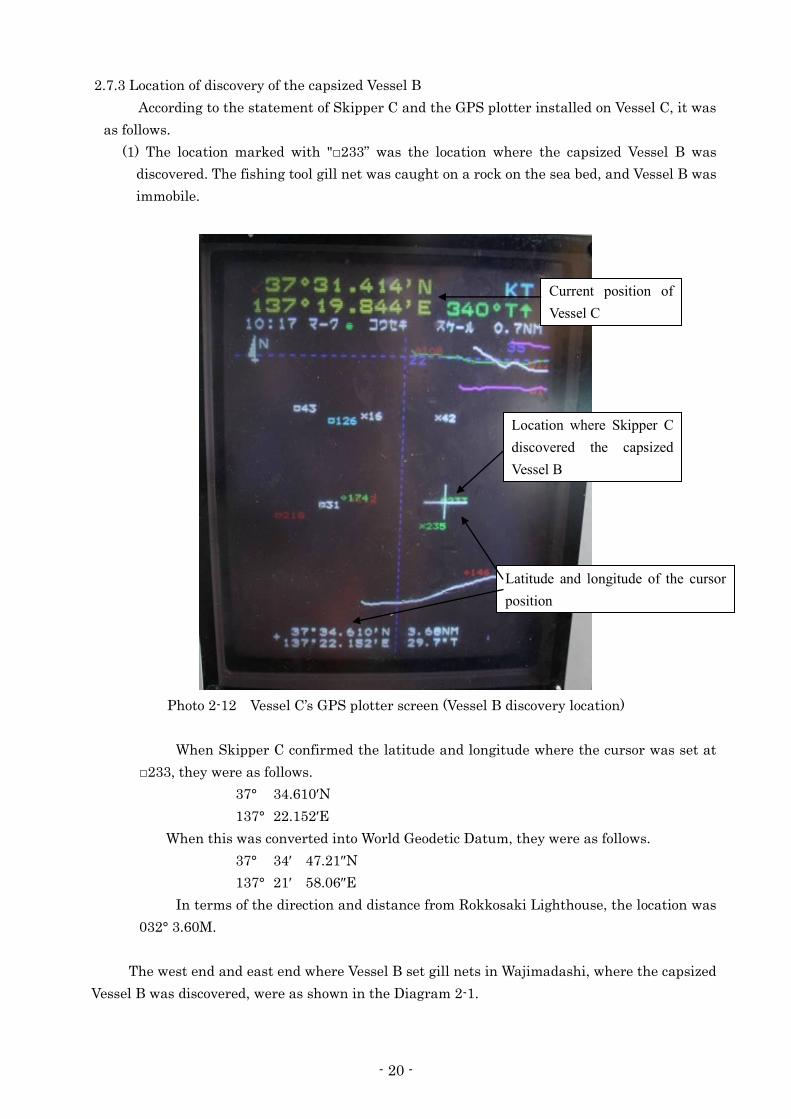
(1) The location marked with "□233” was the location where the capsized Vessel B was
discovered. The fishing tool gill net was caught on a rock on the sea bed, and Vessel B was
immobile.
Photo 2-12 Vessel C’s GPS plotter screen (Vessel B discovery location)
When Skipper C confirmed the latitude and longitude where the cursor was set at
□233, they were as follows.
37° 34.610′N
137° 22.152′E
When this was converted into World Geodetic Datum, they were as follows.
37° 34′ 47.21″N
137° 21′ 58.06″E
In terms of the direction and distance from Rokkosaki Lighthouse, the location was
032° 3.60M.
The west end and east end where Vessel B set gill nets in Wajimadashi, where the capsized
Vessel B was discovered, were as shown in the Diagram 2-1.
Current position of Vessel C
Location where Skipper C discovered the capsized Vessel B
Latitude and longitude of the cursor position

- 21 -
Diagram 2-1 Vessel B discovery location, and the west end and the east end where Vessel B set gill nets
2.8 Weather and Sea Conditions
2.8.1 Weather observations
(1) The observed values of the Wajima Meteorological Observatory located about 46km
west-southwest of the accident occurrence site were as follows.
19:00 Weather: Fine, Wind direction: Southwest, Wind speed: 2.1m/s, visibility:
20.0km
20:00 Weather: Fine, Wind direction: South-southwest, Wind speed: 3.4m/s, visibility:
20.0km
21:00 Weather: Fine, Wind direction: South-southwest, Wind speed: 4.3m/s, visibility:
20.0km
(2) The observed values of the Suzu Local Meteorological Observatory located about 16km
south-southwest from the accident site were as follows.
19:00 Wind direction: North, Wind speed:1.0m/s, Temperature: 9.2℃
20:00 Wind direction: North-northeast, Wind speed:0.8m/s, Temperature: 7.5℃
21:00 Wind direction: Northeast, Wind speed:0.6m/s, Temperature: 6.3℃
(3) According to the nautical almanac issued by the Japan Coast Guard, the sunset time in
the vicinity of the accident site was 18:26.
a:Vessel B discovery location b:West end where Vessel B set gill nets c:East end where Vessel B set gill nets
a
b c
Wajimadashi
Noroshi Port No.2 North Breakwater South Lighthouse Noroshi Fishing Port
Suzu City, Ishikawa Prefecture
Rokkosaki Lighthouse
- 22 -
2.8.2 Observation by the Crew
(1) According to the statement of Master A, the weather was clear, there was weak wind,
waves were small, and the visibility was good.
(2) According to the statement of Third Officer A, the weather was clear, wind direction was
north, wind speed was 4 to 5m/s, waves were not big, and the visibility was good.
(3) According to the statement of Skipper C, at the time of fishing operation, the weather
was clear, wind direction was north, wind was weak, waves were about 50cm high, and
the visibility was good. When they set gill nets, the current flowed to north. There was
almost no current when they raised the gill nets. The current flowed to west when they
discovered the capsized Vessel B. The current changes the direction often and it was
difficult to determine the current direction when the accident happened.
(4) According to the statement of Skipper D, current around Wajimadashi usually flows to
west or east. There are Tsushima Current and Liman Current, and current flow also
changes depending on the time. It was flowing north and west on the day of the accident
at approximately 0.7 to 0.8kn.
2.9 Information Regarding Search and Rescue
According to the statements of Skipper C and employees of Fisheries Cooperative, and
information by the Japan Coast Guard, it was as follows.
Capsized Vessel B was discovered at about 00:34 on April 16 by an airplane of the Japan Coast
Guard on search.
Skipper C was requested to confirm the capsized vessel with a patrol vessel of the Japan Coast
Guard and confirmed that the capsized vessel was Vessel B and that Vessel B was not moving
possibly due to gill nets and anchor falling in the sea and catching rocks of the sea bed.
Skipper B was discovered at the cockpit, which had been additionally installed in the
wheelhouse, and rescued by a diver of the Japan Coast Guard at about 05:19 but was pronounced
dead in the hospital to which he was taken.
Skipper B was not wearing a lifejacket when he was discovered.
Vessel B was towed by a fishing vessel that came for support to the Noroshi Fishing Port and
was temporarily put on the quay.
Although Japan Coast Guard and fishing vessels of the Fisheries Cooperative, to which Vessel
B belonged, searched for Crew B, who went missing, from April 16 to 18, Crew B was not
discovered.
The Japan Coast Guard decided to conclude the full search for Crew B as of the sunset on
April 18 and conduct search on regular patrol after this point.
2.10 Information regarding give-ways with navigating vessels in the accident area
According to the statements of Skipper C and Skipper D, it was as follows.
Large vessels often navigate in the vicinity of the accident site, so fishing vessels set gill nets
after confirming that there was no large vessel. They lit such as working lights and rotating lights,
while raising the gill nets, so large vessels gave way to fishing vessels.
Fishing vessels often gave way to large vessels when going to and from fishing grounds.
Sometimes large vessels passed fishing vessels on the side even when they were raising nets.

- 23 -
2.11 Safety management system
(1) Vessel A
According to the statements of Second Officer A and Third Officer A and the written
reply to the questionnaire by the management company, it was as follows.
China Classification Society issued a conformity certificate to the management company
based on the ISM Code on October 13, 2011. In addition, Saint Vincent and the Grenadines
Marine Bureau issued a safety management certificate to this vessel based on the ISM Code
on March 1, 2012.
The management company has been educating to the crew members in line with the
safety management system.
Before boarding the vessel, crew members took interviews to confirm such as their work
experience and qualifications and received ISM-related instructions by the management
company after passing the paper test.
Crew members received instructions for several hours on their roles and what they
should do while they are on board regarding the vessel structure, equipment installed on the
vessel, ocean routes and safety voyage.
Crew members participated in a conference on safety once a month after boarding the
vessel and received one to two hour instructions by the master in line with the safety
management system.
Third Officer A was told to pay attention to fishing vessels and to navigate with care for
safety by Master A every time.
In addition, the ISM Manual on Vessel A included a summary of “responsibilities of
officers on watch during navigation” was as follows.
4.3.1 Responsibilities of officers on watch during navigation
1 Sincerely execute the requirements and regulations on navigation safety according to the
deck operation manual.
2 Strictly follow the regulations in the International Regulations for Preventing Collisions
at Sea, constantly keep sharp look out, and safely avoid traveling vessels, fishing nets,
floats, and various drifting objects. Do not engage in tasks unrelated to watchkeeping.
Make sure that someone is keeping thorough watch regardless of the situation.
3 Accurately fix the vessel position by means of various navigation machinery and
equipments, celestial objects, and landmarks. During navigation along a coast or narrow
channel, fix the vessel position at least once every 20 minutes. If the master deems it
necessary, follow the instruction and fix the vessel position.
4 Closely observe the surrounding geography and various landmarks. Closely observe
these landmarks with reference to coast pilot especially if it is the first time to sight such
landmarks.
5 Accurately measure the error of electric compass and magnetic compass with reference to
the operation manual.
6 Comprehend the weather condition and pay attention to changes in the wind speed, wind
- 24 -
direction, and atmospheric pressure. Measure the vessel position as much as possible
before weathers with possible bad visibility, etc. Record the values on the measuring
equipment and strictly follow the 2 regulations of Article 19 and Article 35 in the
International Regulations for Preventing Collisions at Sea of 1972.
7-24 Omitted
(2) Instruction of Fisheries Cooperative, to which Vessel B belonged
According to the statements of employees of Fisheries Cooperative, it was as follows.
Fisheries Cooperative’s Suzu City branch, Ishikawa Prefecture held a safety study
session once a year.
The Suzu City branch which was established as a result of seven regions merging in
June in 2002, held a safety study session once a year, in addition each region also held a
safety study session by inviting officers of the Japan Coast Guard as lecturers about once a
year.
2.12 Investigation regarding the component analysis of the debris and paint coating
ANALYSIS CENTER CO.LTD. was commissioned to conduct a comparison analysis of the
debris and paint coating taken at the time of the on-site investigation of Vessel A and the debris and
paint coating taken at the time of the on-site investigation of Vessel B and conducted component
analysis.
(1) Objective
This investigation is a comparison analysis of the debris and paint coating from
Vessel A and Vessel B. Reddish debris were found on both Vessel A and Vessel B. In the test,
comparison analysis of the “debris found on Vessel B and Vessel A paint coating” as well as
the “debris found on Vessel A and Vessel B paint coating” are conducted.
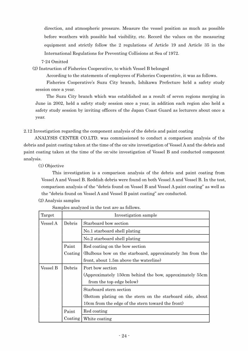
(2) Analysis samples
Samples analyzed in the test are as follows.
Target Investigation sample
Vessel A Debris Starboard bow section
No.1 starboard shell plating
No.2 starboard shell plating
Paint
Coating
Red coating on the bow section
(Bulbous bow on the starboard, approximately 3m from the
front, about 1.5m above the waterline)
Vessel B Debris Port bow section
(Approximately 150cm behind the bow, approximately 55cm
from the top edge below)
Starboard stern section
(Bottom plating on the stern on the starboard side, about
10cm from the edge of the stern toward the front)
Paint
Coating
Red coating
White coating
- 25 -
“Debris on the starboard bow section of Vessel A”, “Debris 1 on the starboard shell
plating of Vessel A”, and “Debris 2 on the starboard shell plating of Vessel A” were taken
from the damaged part of Vessel A. “Red coating on the bow of Vessel A” is a piece of paint
coating taken from the coated part on the bulbous bow on Vessel A.
In addition, “Debris on the port bow section of Vessel B” and “Debris on the starboard
stern section of Vessel B” were taken from the damaged part of Vessel B. On the other hand,
“red coating of Vessel B” and “white coating of Vessel B” are pieces of paint coating taken
from the coated part at the bottom of Vessel B.
(3) Analysis method and results
“Red coating of Vessel B” was composed of 4 layers of the 1st red layer, 2nd red layer,
3rd red layer, and 4th red layer. “White coating of Vessel B” had one layer.
On the other hand, “red coating on the bow section of Vessel A” was composed of 2
layers of pale red layer and deep red layer. Based on such layer composition of the paint
coating, this analysis conducted a comparison analysis with IR spectroscopy in order to
compare each debris and paint coating.
IR spectroscopy utilized in the analysis is a method that utilizes characteristics of
substances absorbing infrared rays. Infrared ray absorption property is unique for each
composition ingredient (material). Infrared ray absorption property is called “IR spectrum”,
which can be visualized in graphs. Therefore, comparison analysis is made possible by
comparing the waves of graphs derived from the measurement result of each sample.
When the IR spectra of “debris on the starboard stern section of Vessel B” and the
“debris on the port bow section of Vessel B” were first compared, the two IR spectra were
about the same. Therefore, the two sample debris from the starboard stern section of
Vessel B and from the port bow section of Vessel B were judged to be the same type of
component. Next, the IR spectra of these two sample debris and each layer of Vessel A
paint coating were compared. As a result, the infrared ray absorption property wave
domains and spectrum shapes for the debris and the pale red layer of the “red coating on
the bow section of Vessel A” were highly consistent. Therefore, it was elucidated that the
“debris on the starboard stern section of Vessel B”, “debris on the port bow section of Vessel
B”, and the pale red layer of the “red coating on the bow section of Vessel A” were the same
type of component. On the other hand, the IR spectra of these two sample debris and the
infrared ray absorption property wave domain and spectrum shape seen in the IR
spectrum of the deep red layer of the “red coating on the bow section of Vessel A” were very
different. Therefore, they were judged to be different component.
Due to the above results, it was probable that the “debris on the starboard stern
section of Vessel B” and the “debris on the port bow section of Vessel B” came from Vessel A
paint coating.
In addition, when the IR spectra of each debris from the starboard bow section of
Vessel A and the starboard shell platings of Vessel A, each layer of the “red coating on
Vessel B”, and “white coating on Vessel B” were compared, the infrared ray absorption
property wave domain and spectrum shape seen in each IR spectrum was different from
each other. Therefore, it was elucidated that component from both debris of Vessel A, each
layer of the “red coating on Vessel B”, and “white coating on Vessel B” were different.
- 26 -
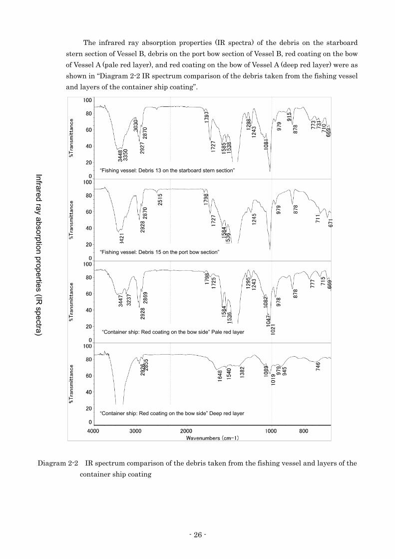
The infrared ray absorption properties (IR spectra) of the debris on the starboard
stern section of Vessel B, debris on the port bow section of Vessel B, red coating on the bow
of Vessel A (pale red layer), and red coating on the bow of Vessel A (deep red layer) were as
shown in “Diagram 2-2 IR spectrum comparison of the debris taken from the fishing vessel
and layers of the container ship coating”.
Diagram 2-2 IR spectrum comparison of the debris taken from the fishing vessel and layers of the
container ship coating
Infrared ray absorption properties (IR spectra)
“Fishing vessel: Debris 13 on the starboard stern section”
“Fishing vessel: Debris 15 on the port bow section”
“Container ship: Red coating on the bow side” Pale red layer
“Container ship: Red coating on the bow side” Deep red layer

- 27 -
3 ANALYSIS
3.1 Situation of the Accident Occurrence
3.1.1 Events Leading to the Accident
According to 2.1 and 2.7, the process leading to the accident was as follows.
(1) Vessel A
(i) It is probable that Vessel A left the Port of Fushiki-Toyama at about 16:20 on April
15.
(ii) It is probable that Vessel A changed her course toward left off the eastern coast of
Rokkosaki and navigated on autopilot at a speed of 16 – 16.5kn on the course of
about 300°.
(iii) It is probable that Third Officer A sighted a light in the vicinity of 15° to 20°
starboard bow but thought that it was a light of a float due to the fact that it was not
moving.
(iv) It is probable that Third Officer A kept lookout in the direction on the port bow
mainly at the port side of the bridge because he assumed that Ordinary Seaman A
would watch the starboard side.
(v) It is probable that Ordinary Seaman A recognized a light in the vicinity of 5° to 10° of
the starboard bow and reported the matter to Third Officer A.
(vi) It is probable that Third Officer A moved to the starboard side and recognized a light
in the vicinity of the starboard bow, ordered Ordinary Seaman A to steer
‘hard-a-port,’ looked behind after passing, and thought that the vessel had collided
with a float due to the fact that there was no light.
(vii) It is probable that Vessel A returned her course by turning the rudder to starboard
after it turned to port by about 20° from the original course, that Third Officer A
reported to Master A, who had come to the bridge, that he thought that the vessel
had collided with a float at about 20:55, that Master A checked the side shell plating
but continued to navigate due to the fact that he saw no damage when he was called
by Japan Coast Guard on the radio, and that he berthed the Sakai Port after being
ordered by the Japan Coast Guard.
(2) Vessel B
(i) It is probable that Vessel B left the Noroshi Fishing Port at about 17:30 on April 15.
(ii) It is somewhat likely that Vessel B arrived at the fishing ground at about 18:00,
waited for sunset while drifting, and lit the navigation light and rotating light at
around sunset.
(iii) It is somewhat likely that Vessel B started fishing operation from the location of
036.5° 4.90M from Rokkosaki Lighthouse and lit the working light at about 18:50.
(iv) It is somewhat likely that Vessel B finished fishing operation at the location of 031.5°
4.65M from Rokkosaki Lighthouse, set the course at about 211.5° toward Rokkosaki
Lighthouse, set the engine at half ahead, and navigated at the speed of about 9.0kn.
(v) It is probable that Vessel B and Vessel A collided with each other despite the fact that
Skipper B took give-way actions with remote control immediately before the collision.

- 28 -
3.1.2 Date, Time, and Location of the Occurrence of the Accident
According to 2.1 and 2.7.2 and the location and time in which track of Vessel A intersected
with the presumed track of Vessel B from the record of AIS data, it is probable that the date
and time of this accident was at about 20:15 on April 15, 2012 and that the occurrence place
was in the vicinity of 031.5° 3.5M from Rokkosaki Lighthouse.
(Refer to Attached Figure 2 Estimated Vessel Positions)
3.1.3 Situation of the collision
According to 2.12, it is certain that the two vessels collided with each other due to the fact
that the debris on the starboard stern section of Vessel B, debris on the port bow section of
Vessel B, and the red coating (pale red layer) on the bow of Vessel A were the same type of
component. The collision situation of the two vessels was as follows.
(1) Vessel A
According to the cruising situation around 20:15 from the record of AIS data in 2.1.1,
it is probable that Vessel A was navigating at a heading of 281° to 294° and the speed of
15.8 to 16.5kn.
(2) Vessel B
(i) According to 2.5.2 (2), it is probable that it was turned the rudder to starboard 40°
with the remote control and set the clutch and throttle dial to full astern, but the
clutch was not in astern and remained neutral.
(ii) According to 3.1.1 (2), it is somewhat likely that Vessel B was navigating in the
course of south-southwest at a speed of about 9kn.
(iii) According to the damaged condition, which is later mentioned in 3.1.4, it is probable
that Vessel A and Vessel B collided with the the starboard bow of Vessel A and the
bow of Vessel B in a perpendicular angle.
3.1.4 Damaged condition
According to 2.3, it is probable that Vessel A suffered scratch to the bulbous bow on the
starboard side and Vessel B crushed and lost the bow and suffered damage in the fender on the
stern on the starboard side, etc.
3.1.5 Situation of casualties, etc.
According to 2.2, it was as follows:
(1) There were no casualties on Vessel A.
(2) Skipper B was killed and Crew B went missing on Vessel B.
3.2 Causal Factors of the Accident
3.2.1 Situation of the Crew and the Vessels
(1) Crew
According to 2.4, the situation of the crew were as follows.
(i) Third Officer A held a legal and valid endorsement attesting the recognition of
certificate under STCW regulation I/10.
It is probable that Third Officer A was in good health condition.
- 29 -
(ii) It is probable that Ordinary Seaman A was in good health condition.
(iii) Skipper B held a legal and valid boat’s operator license.
It is probable that Skipper B was in good health condition.
(2) Vessels
According to 2.5.2, the condition was as follows.
(i) It is probable that Vessel A had no defect or malfunction to the hull, engine,
machinery, or equipment at the time of the accident and that there was no structure
that would interfere with watchkeeping on the starboard bow.
(ii) It is somewhat likely that Vessel B had no defect or malfunction to the hull, engine,
machinery, or equipment at the time of the accident.
3.2.2 Weather and Sea Conditions
According to 2.8, it is probable that the weather was clear with the wind direction of
north-northeast to north, the wind force of 1, and the visibility of favorable, while the sunset
was at 18:26.
3.2.3 Situations immediately before the collision
(1) Vessel A
According to 2.1 and 3.1.1, it is probable as follows.
(i) Third Officer A kept lookout in the direction on port bow at the port side of the
bridge.
(ii) Since there was a vessel coming close from starboard stern, Ordinary Seaman A
looked at the movement of the vessel with the 6M scale range radar, and then looked
in the direction of the starboard bow, saw a light in the vicinity, and reported it to
Third Officer A.
(iii) In response to the report by Ordinary Seaman A, Third Officer A moved to the
starboard side of the bridge, recognized a light in the vicinity of the starboard bow,
and ordered Ordinary Seaman A to steer ‘hard-a-port.’
(2) Vessel B
According to 2.3, 2.5.2(2), 2.7.1, 2.7.2(1), and 3.1.3, it was as follows.
(i) It is somewhat likely that Vessel B left the vicinity of 031.5° 4.65M from Rokkosaki
Lighthouse and navigated in the course of about 211.5° toward Rokkosaki
Lighthouse and at the speed of about 9.0kn in half ahead. Therefore, it is somewhat
likely that the departure time was at about 20:08, due to the fact that it would have
taken about seven minutes and 40 seconds if it had navigated 2,130m at 9.0kn from
the departure point to the collision point.
(ii) It is somewhat likely that Skipper B, as later mentioned in 3.2.5 (2), was sitting on a
board that was bridged between both sidewall in the wheelhouse, putting his head
above the cockpit that was additionally installed above the wheelhouse, and
navigating with remote control.
(iii) It is probable that Vessel B switched the remote control dial to starboard 40°, clutch
to astern, and throttle dial to maximum immediately before the collision and that the
- 30 -
main engine clutch lever moved to the neutral position from ahead but did not switch
to the astern side due to the fact that the engine revolutions were high.
(iv) It is probable that Vessel B collided in the course of south-southwest and at the speed
of about 9kn.
3.2.4 Information Regarding Safety Management
(1) Vessel A
According to 2.11 (1), it is probable that the safety education provided to crew
members was as follows.
The management company has been educating to them in line with the safety
management system.
Before boarding the vessel, crew members received instructions by employees of the
management company on their roles and what they should do while they are on board
regarding the vessel structure, equipment installed on the vessel, ocean routes and safety
voyage. After boarding the vessel, they participated in a conference on safety once a month
and received instructions by the master in line with the safety management system.
In addition, Master A had instructed Third Officer A to pay attention to fishing
vessels and to navigate with care for safety.
(2) Vessel B
According to 2.11 (2), the instruction of the Fisheries Cooperative, to which Vessel B
belonged, was as follows.
Fisheries Cooperative’s Suzu City branch which was established as a result of seven
regions merging, held a safety study session once a year. In addition, each region also held
a safety study session by inviting officers of the Japan Coast Guard as lecturers about once
a year.
3.2.5 Situation of Vessel B at the time of the accident
(1) Condition of lights and fishfinder at the time of the accident
According to 2.5.2(2) and 2.7.1, it is probable that it was as follows:
During navigation, they usually lit the white all-round light, bi-coloured light, and
rotating light at around sunset. In addition to the white all-round light, bi-coloured light,
and rotating light, they lit the working light during fishing operation.
From the fact that the power switches for the white all-round light, bi-coloured light,
rotating light, rear working light, and fishfinder were on and the above-mentioned
condition, these lights were on at the time of this accident.
(2) Situations of the Skipper and others while returning to the port
According to 2.1.2(2), 2.7.1 and described above in (1), it is somewhat likely that to be
as follows.
From the following items, Skipper B was sitting on a board that was bridged between
the both sidewall in the wheelhouse, putting his head above the cockpit surrounded by
glasses that was additionally installed, and navigating with manual steering with remote
control, during which time Crew B was working on the rear deck.
(i) After raised gill nets onto the vessel at fishing grounds, they returned to the Noroshi
- 31 -
Fishing Port, after which they placed the gill nets on the quay for the family
members to remove the fish. Therefore, Skipper B did not need to remove fish from
gill nets during navigation.
(ii) Skipper B was discovered at the cockpit.
(iii) Rear working light power switch was on.
(iv) Crew B is missing.
3.2.6 Analysis on watchkeeping and other things leading to the collision of two vessels
(1) Vessel A
According to 2.1.2, 3.1.1 and 3.2.3, it is probable that it was as follows:
(i) Third Officer A thought that the light, which he sighted in the direction on the
starboard bow, was a float due to the fact that it was not moving and that there was
no danger in the direction on the starboard bow. He also assumed that Ordinary
Seaman A, who was standing behind the steering stand, would watch the starboard
side and kept lookout in the direction on the port bow at the port side of the bridge.
Third Officer A did not notice Vessel B, because he was not appropriately keeping
watch on the starboard side.
(ii) Third Officer A though that the light, which he sighted in the direction of the
starboard bow, was a float. However, from the movements of Vessel A and Vessel B,
the said light was the light of Vessel B.
(2) Vessel B
According to 3.1.1 and 3.2.3(2), it was as follows.
Due to the fact that the position of the remote control dial, clutch lever, throttle lever,
and rudder angle indicator of Vessel B indicated full astern and the rudder angle was past
starboard 40°, it is probable that Skipper B took actions to prevent the collision
immediately before the collision. Due to this, it is somewhat likely that Skipper B noticed
Vessel A only when it came close. However, due to the facts that Skipper B was killed and
Crew B went missing, it was not possible to clarify the watchkeeping situation of Skipper B,
who noticed Vessel A only when it came close.
3.2.7 Analysis for Occurrence of the Accident
(1) Vessel A
According to 3.1.1, 3.1.3and 3.2.3, it is probable that it was as follows:
(i) Vessel A changed her course to left off the eastern coast of Rokkosaki and navigated
in the course of about 300° and at the speed of about 16 to 16.5kn.
(ii) Third Officer A sighted a light in the direction of the starboard bow and thought that
it was a float due to the fact that it was not moving and that there was no danger in
the direction of the starboard bow. However, the sighted light was the light of Vessel
B.
(iii) Third Officer A thought that there was no danger in the direction of the starboard
bow and kept lookout in the direction on the port bow at the port side of the bridge,
because he assumed that Ordinary Seaman A would keep watch on the starboard
side.
- 32 -
(iv) Since there was a vessel coming close from starboard stern, Ordinary Seaman A
looked at the movement of the vessel with the 6M range scale radar, looked in the
direction of the starboard bow, recognized a light in the vicinity, and reported it to
Third Officer A.
(v) In response to the report by Ordinary Seaman A, Third Officer A moved to the
starboard side of the bridge, recognized the light in the vicinity of the direction of the
starboard bow, and ordered Ordinary Seaman A to steer ‘hard-a-port.’
(vi) Third Officer A, as previously mentioned in (iii), kept lookout in the direction on the
port bow and did not appropriately keep watch on the starboard side. Therefore, he
did not notice Vessel B coming close, and Vessel A collided with Vessel B.
(2) Vessel B
According to 3.1.1, 3.1.3(2), 3.2.3(2) and 3.2.6(2), it was as follows.
(i) It is somewhat likely that Vessel B arrived at the fishing ground, and then waited for
the sunset while drifting, and lit the navigation lights and rotating light at around
sunset.
(ii) It is somewhat likely that Vessel B started operation at the location of 036.5° 4.90M
from Rokkosaki Lighthouse and lit the working light at about 18:50.
(iii) It is somewhat likely that Vessel B finished fishing operation at the location of 031.5°
4.65M from Rokkosaki Lighthouse at about 20:08, set the course at about 211.5°
toward Rokkosaki Lighthouse with the half ahead engine, and navigated at the
speed of about 9.0kn.
(iv) It is somewhat likely that Skipper B was sitting on a board that was bridged between
the both sidewall in the wheelhouse, putting his head above the cockpit that was
additionally installed, and navigating with remote control, during which time Crew
B was on the rear deck.
(v) It is somewhat likely that Skipper B noticed Vessel A only when it came close and
took give-way actions but that Vessel B collided with Vessel A.
(Refer to Attached Figure 2 Estimated Vessel Positions, Attached Figure 3 “5 Whys”
analysis)

- 33 -
4 CONCLUSIONS
4.1 Findings
(1) Vessel A
(i) It is probable that Vessel A changed its course to the left off the eastern coast of
Rokkosaki and navigated in the course of approximately 300° at the speed of 16
to16.5kn. (3.2.7 (1)(i))*7
(ii) It is probable that Third Officer A sighted a light in the direction of the bow on the
starboard side, that he thought it was a float due to the fact that it was not moving, that
he thought there was no danger in the direction of the starboard bow, and that the
sighted light actually was the light of Vessel B. (3.2.7 (1)(ii))
(iii) It is probable that Third Officer A was keeping watch ahead on the port side on the left
side of the bridge. (3.2.7 (1)(iii))
(iv) It is probable that Third Officer A recognized a light in the direction of the starboard
bow in response to the report by Ordinary Seaman A and ordered Ordinary Seaman A to
steer ‘hard-a-port.’ (3.2.7 (1)(iv), 3.2.7 (1)(v))
(v) It is probable that Vessel A collided with Vessel B due to the fact that Third Officer A did
not notice Vessel B coming close because he was not appropriately keeping watch on the
starboard side. (3.2.7 (1)(vi))
(2) Vessel B
(i) It is somewhat likely that Vessel B finished fishing operation at approximately 20:08
after raising the gill nets, that it set its course toward Rokkosaki Lighthouse, and
navigated at the speed of approximately 9kn. (3.2.7 (2)(iii))
(ii) It is somewhat likely that Skipper B was sitting on a board that was bridged, putting
his head above the lookout stand that was additionally installed, and navigating with
remote control, during which time Crew B was on the rear deck. (3.2.7 (2)(iv))
(iii) It is somewhat likely that Skipper B noticed Vessel A only when it approached very
closely and took give-way actions but Vessel B collided with Vessel A. (3.2.7 (2)(v))
(iv) It was not possible to clarify the watchkeeping status of Skipper B due to the facts that
Skipper B was killed and Crew B went missing. (3.2.6 (2))
4.2 Probable Causes
It is somewhat likely that this accident occurred while Vessel A was proceeding
west-northwest and Vessel B was proceeding south-southwest off the north-northeastern coast of
Rokkosaki at night due to the two vessels colliding with each other due to the facts that Third
Officer A did not appropriately keep watch on the starboard side and that Skipper B noticed Vessel
A only when it approached very closely.
It is probable that Third Officer A did not appropriately keep watch on the starboard side
because he thought a light he sighted in the direction of the starboard bow was a float due to the
fact that it was not moving, that he thought there was no danger in the direction of the starboard
*7 Numbers included at the end of each sentence in this section indicate major section numbers under “3 Analysis”
regarding these mentions.
- 34 -
bow, that he was keeping watch ahead on the port side, thinking that Ordinary Seaman A would
keep watch on the starboard side.
5 SAFETY ACTIONS
It is somewhat likely that this accident occurred while Vessel A was proceeding
west-northwest and Vessel B was proceeding south-southwest off the north-northeastern coast of
Rokkosaki at night due to the two vessels colliding with each other due to the facts that Third
Officer A did not appropriately keep watch on the starboard side and that Skipper B noticed Vessel
A only when it approached very closely.
It is probable that Vessel A collided with Vessel B due to the fact that Third Officer A was not
appropriately keeping watch on the starboard side, not noticing Vessel B coming close. Therefore, it
is probable that appropriate watch must be kept at all times with vision, hearing, and all other
means appropriate for the situation so that bridge watch keeper can make judgments on the
surrounding situation and possibility of collision with other vessels.
- 35 -
Figure 1: Plots of Estimated Vessl Positions from AIS Data
Decrease in speed
Change the course to portside and return it
Suzu City Uchiuramachi
Yanagidamura
Wajima City
Rokkosaki lighthouse

- 36 -
Figure 2: Estimated Vessel Positions
Collision Site (around 20:15 on April 15, 2012)
Estimated navigating course for Vessel B
Vessel B’s departure point
Rokkosaki Lighthouse
Noroshi Port NO. 2 North Breakwater South Lighthouse
Vessel A’s navigationg course
Noroshi Fishing Port Suzu City, Ishikawa Prefecture

- 37 -
Figure 3: “5 Whys” analysis
A船 三航士A
三航士Aは、右舷船首方に危険はないものと思った。
三航士Aは右舷船首方に灯火を視認し、灯火が動かないので浮子だと思ったが、B船の灯火であった。
三航士Aは、右舷船首方の至近に灯火を認め、甲板員Aに左舵を指示した。
三航士Aは、左舷前方の見張りを行い、右舷方の見張りを適切に行っていなかったことから、B船の接近に気付かなかった。
三航士Aは、甲板員Aが右舷側の見張りを行ってくれるものと思った。
A船の船首部とB船の船首とが衝突した。
甲板員A
甲板員Aは、右舷前方を見たところ、至近に灯火を認め、三航士Aに報告した。
甲板員Aは、右舷後方から接近する船舶の動向を6Mレンジとしたレーダーで見たりしていた。
B船
船長Bは、A船が至近に接近して気付き、避航動作をとった可能性があると考えられるが、同人が死亡し、また、乗組員Bが行方不明であることから、A船が至近に接近して気付くこととなった見張りの状況を明らかにすることはできなかった。
Vessel A
Vessel B
3/O A
OS A
Bow of Vessel A and bow of Vessel B collided with each other.
Third Officer A recognized a light in the vicinity of the starboard bow and ordered Ordinary Seaman A to to steer ‘hard-a-port’
Third Officer A kept lookout in the direction on the port bow and did not appropriately keep watch on the starboard side. Therefore, he did not notice Vessel B coming close.
Third Officer A thought that there was no danger in the direction of the starboard bow
Third Officer A sighted a light in the direction of the starboard bow and thought that it was a float due to the fact that the light was not moving. However, the light was the light of Vessel B.
Third Officer A thought that Ordinary Seaman A would keep watch on the starboard side.
Ordinary Seaman A looked at the movements of a vessel coming close from starboard stern with a 6M range scale radar.
When Ordinary Seaman A looked ahead on the starboard side, he recognized a light in the vicinity and reported it to Third Officer A.
It is somewhat likely that Skipper B noticed Vessel A only when it came close and took give-way actions. However, it was not possible to clarify the watchkeeping situation when Skipper B noticed Vessel A only when it came close, due to the facts that Skipper B was killed and Crew B went missing.
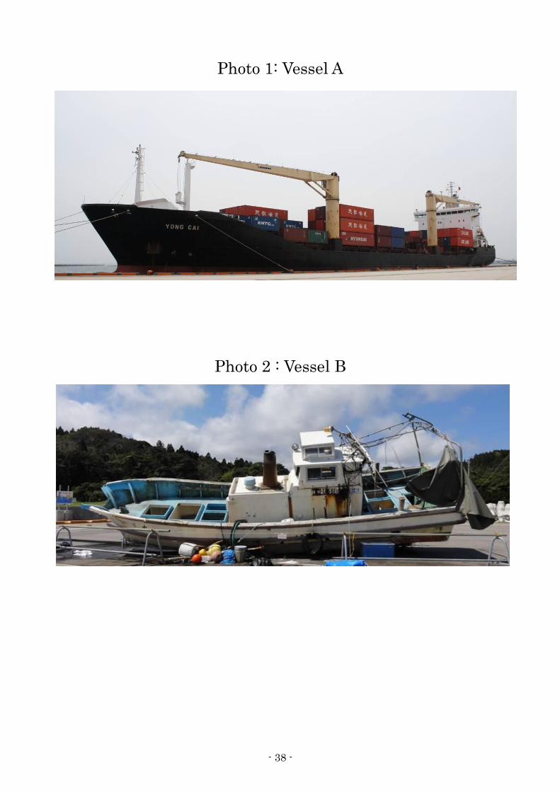
- 38 -
Photo 1: Vessel A
Photo 2 : Vessel B