LOWER COLORADO RIVER ACCOUNTING SYSTEM (LCRAS) …
199
LOWER COLORADO RIVER ACCOUNTING SYSTEM (LCRAS) COMPUTER PROGRAM AND DOCUMENTATION By B.K. von Allworden, Sandra J. Owen-Joyce, John D. Sandoval, and Lee H. Raymond U.S. GEOLOGICAL SURVEY Open-File Report 91 - 179 Prepared in cooperation with the U.S. BUREAU OF RECLAMATION Tucson, Arizona May 1991
Transcript of LOWER COLORADO RIVER ACCOUNTING SYSTEM (LCRAS) …

LOWER COLORADO RIVER ACCOUNTING SYSTEM (LCRAS) COMPUTER PROGRAM AND DOCUMENTATION
By B.K. von Allworden, Sandra J. Owen-Joyce, John D. Sandoval, and Lee H. Raymond
U.S. GEOLOGICAL SURVEY Open-File Report 91 - 179
Prepared in cooperation with the U.S. BUREAU OF RECLAMATION
Tucson, Arizona May 1991

U.S. DEPARTMENT OF THE INTERIOR
MANUEL LUJAN, JR., Secretary
U.S. GEOLOGICAL SURVEY
Dallas L. Peck, Director
For additional information write to:
District Chief U.S. Geological Survey 375 South Euclid Avenue Tucson, Arizona 85719-6644
Copies of this report can be purchased from:
U.S. Geological Survey Books and Open-File Reports Section Federal Center, Box 25425 Denver, Colorado 80225
______LCRAS COMPUTER PROGRAM AND DOCUMENTATION______
CONTENTS
Page
Abstract ...................................................... 1-1
Introduction ................................................... 2-1
Algorithms and terminology ........................................ 3-1
Estimating consumptive use ................................... 3-1
Distribution of consumptive use ............................... 3-4
Lower Colorado River Accounting System (LCRAS) program ................ 4-1
Main program ................................................. 5-1Narrative ............................................... 5-1Variable list ............................................. 5-2Flow chart ............................................... 5-4Program listing ........................................... 5-10
Subroutine FLOWIN ............................................. 6-1Narrative ............................................... 6-1Variable list ............................................. 6-1Flow chart ............................................... 6-2Program listing ........................................... 6-4
Subroutine TRTOIN .............................................. 7-1Narrative ............................................... 7-1Variable list ............................................. 7-1Flow chart ............................................... 7-2Program listing ........................................... 7-6
Subroutine DUIN ............................................... 8-1Narrative ............................................... 8-1Variable list ............................................. 8-2Flow chart ............................................... 8-3Program listing ........................................... 8-6
111

LCRAS - COMPUTER PROGRAM AND DOCUMENTATION______
CONTENTS
Page
Subroutine AREAIN ............................................. 9-1Narrative ............................................... 9-1Variable list ............................................. 9-1Flow chart ............................................... 9-2Program listing ........................................... 9-3
Subroutine LUMP .............................................. 10-1Narrative ............................................... 10-1Variable list ............................................. 10-1Flow chart ............................................... 10-3Program listing ........................................... 10-7
Subroutine BC ................................................. 11-1Narrative ............................................... 11-1Variable list ............................................. 11-2Flow chart ............................................... 11-5Program listing ........................................... 11-13
Subroutine BWR ................................................ 12-1Narrative ............................................... 12-1Variable list ............................................. 12-1How chart ............................................... 12-3Program listing ........................................... 12-5
Subroutine HV2ML .............................................. 13-1Narrative ............................................... 13-1Variable list ............................................. 13-1Flow chart ............................................... 13-6Program listing ........................................... 13-15
Subroutine HV2DV .............................................. 14-1Narrative ............................................... 14-1Variable list ............................................. 14-1Flow chart ............................................... 14-3Program listing ........................................... 14-4
IV

LCRAS - COMPUTER PROGRAM AND DOCUMENTATION
CONTENTS
Page
Subroutine DV2PK .............................................. 15-1Narrative ............................................... 15-1Variable list ............................................. 15-1Flow chart ............................................... 15-3Program listing ........................................... 15-4
Subroutine PK2IP ............................................... 16-1Narrative ............................................... 16-1Variable list ............................................. 16-1Flow chart ............................................... 16-3Program listing ........................................... 16-4
Subroutine IP2ML ............................................... 17-1Narrative ............................................... 17-1Variable list ............................................. 17-1Flow chart ............................................... 17-3Program listing ........................................... 17-4
Subroutine SORT ............................................... 18-1Narrative ............................................... 18-1Variable list ............................................. 18-1Flow chart ............................................... 18-3Program listing ........................................... 18-8
Subroutine TABLE1 ............................................. 19-1Narrative ............................................... 19-1Variable list ............................................. 19-1Flow chart ............................................... 19-3Program listing ........................................... 19-8
Subroutine TABLE2 ............................................. 20-1Narrative ............................................... 20-1Variable list ............................................. 20-1Flow chart ............................................... 20-4Program listing ........................................... 20-11

LCRAS - COMPUTER PROGRAM AND DOCUMENTATION
CONTENTS
Page
Subroutine TABLES ............................................. 21-1Narrative ............................................... 21-1Variable list ............................................. 21-1Flow chart ............................................... 21-2Program listing ........................................... 21-4
Subroutine TABLE4 ............................................. 22-1Narrative ............................................... 22-1Variable list ............................................. 22-1Row chart ............................................... 22-4Program listing ........................................... 22-11
Selected references .............................................. 23-1
Attachments ................................................... 24-1
A-Q. Examples of:
A. The primary data file ............................. A-lB. The flow data file ................................ B-lC. The tributary-inflow data file ........................ C-lD. The domestic-use data file .......................... D-lE. The open-water surface areas and evaporation-rates data file .. E-l F. An image-processing data file ....................... F-lG. A temperature data file ............................ G-lH. A precipitation data file ........................... H-lI. The empirical water-use coefficients data file ............. 1-1J. The daylight data file .............................. J-lK. The title input data files for the output tables ............. K-lL. The output file of the calculated water-use rates for the
vegetation types along the lower Colorado Riverby reach .................................... L-l
M. The output file for the Parker Dam to Imperial Dam reachshowing the area of each vegetation type by diverter .... M-l
N. The output file for the Bill Williams River below Alamo Damshowing evapotranspiration ....................... N-l
VI
LCRAS - COMPUTER PROGRAM AND DOCUMENTATION
CONTENTS
A-Q. Examples of Continued
TABLE
Page
0. The output file for the Hoover Dam to Morelos Dam reachshowing evapotranspiration and consumptive use ........ 0-1
P. The output file showing domestic use for each diverter withineach reach and totals by State ..................... P-l
Q. The output file showing the water-budget calculation resultsfor each reach ................................ Q-l
ILLUSTRATIONS
Figure 1. Map showing the Colorado River basin and study area .............. 2-2
2. Schematic diagram showing reaches along the lower Colorado River .... 4-2
3. Diagram showing flow chart of the LCRAS computer program ........ 4-3
Table 1. List of variables in common blocks ........................... 4-5
Vll
LCRAS - COMPUTER PROGRAM AND DOCUMENTATION
CONVERSION FACTORS
Multiply By. To obtain
inch (in.) foot (ft) mile (mi) acre acre-foot (acrc-ft)
25.40.30481.6090.40470.001233
millimeter (mm) meter (m) kilometer (km) square hectometer (hm2) cubic hectometer (hm3)
ACRONYMS
ASCII American Standard for Computer Information InterchangeBLM U.S. Bureau of Land ManagementBWR Bill Williams River subroutine within LCRASCAP Central Arizona ProjectCIDD Cibola Valley Irrigation and Drainage DistrictCNWR Cibola National Wildlife RefugeCRIR Colorado River Indian ReservationDOS Disk Operating SystemDV2PK Davis Dam to Parker Dam subroutine within LCRASELAS Earth Resources Laboratory Applications SoftwareCIS Geographic Information SystemHV2DV Hoover Dam to Davis Dam subroutine within LCRASHV2ML Hoover Dam to Morelos Dam subroutine within LCRASIP2ML Imperial Dam to Morelos Dam subroutine within LCRASLCRAS Lower Colorado River Accounting System computer programNIB Northerly International Boundary with MexicoPVID Palo Verde Irrigation DistrictPK2IP Parker Dam to Imperial Dam subroutine within LCRASSIB Southerly International Boundary with MexicoUSBR U.S. Bureau of ReclamationUSGS U.S. Geological Survey
VIII

LOWER COLORADO RIVER ACCOUNTING SYSTEM (LCRAS) COMPUTER PROGRAM AND DOCUMENTATION
By
B. K. von AllwordenSandra J. Owen-Joyce
John D. SandovalLee H. Raymond
ABSTRACT
In 1964, the U.S. Supreme Court gave specific legal rights for the annual use of 7.5 million acre-feet of lower Colorado River water to the States of California, Arizona, and Nevada. In addition, under the Rio Grande, Colorado, and Tijuana Treaty of 1944, 1.5 million acre-feet per year of water must be supplied to Mexico. The water supply of the lower Colorado River is overapportioned. The U.S. Geological Survey, in cooperation with the U.S. Bureau of Reclamation, took a regional approach and developed an accounting system to estimate, distribute, and monitor the annual consumptive use of the water supply.
The Lower Colorado River Accounting System (LCRAS) computer program combines a water- budget estimate of consumptive use by vegetation with estimates of evapotranspiration by diverter from image processing of satellite data. Consumptive use by vegetation along a reach is calculated as the residual in a water budget Evapotranspiration by diverter is calculated from vegetation types and areas determined from digital-image analysis of satellite data and water-use rates calculated using a modified Blaney-Criddle formula. Prorating consumptive use by vegetation with the estimates of evapotranspiration by diverter produces a good approximation of consumptive use by vegetation for each diverter.
LCRAS runs on a microcomputer and is written in a modular fashion so that modifications can be made easily as new data, new software, and improved techniques become available. LCRAS also can be used as an annual planning tool The lower Colorado River is divided into four reaches, each beginning and ending at a dam. Each of these four reaches has a separate subroutine that calculates consumptive use by vegetation within that reach by adding an inflow components and subtracting change in reservoir storage and all outflow components except consumptive use. A fifth subroutine allows the river to be treated as a single reach from Hoover Dam to Morelos Dam. Documentation for the LCRAS program describes the modular subroutines and includes data input instructions, narratives, variable lists, flow charts, and code listings of the program.
ABSTRACT14

LCRAS - COMPUTER PROGRAM AND DOCUMENTATION
INTRODUCTION
The Colorado River is a life line to the southwestern United States. Beginning in the Rocky Mountains, the river acquires water from six states, winds through the Grand Canyon and the deserts of Nevada, Arizona, and California, and flows into Mexico (fig. 1). The river supplies water to towns and agricultural areas along its path and also, through pumped diversion to canals, water is exported to Los Angeles, San Diego, Phoenix, and Tucson.
The Colorado River Compact of 1922 apportioned 7.5 million acre-ft/yr of beneficial consumptive use to the lower basin of the Colorado River (Hely, 1969, p. 39). In 1964, a Decree by the U.S. Supreme Court granted legal rights to lower Colorado River water to Arizona, California, and Nevada. Arizona has rights to 2.8 million acre-ft/yr, California to 4.4 million acre-ft/yr, and Nevada to 0.3 million acre-ft/yr (U.S. Supreme Court, 1964). As an outcome of these rulings, the U.S. Bureau of Reclamation and U.S. Geological Survey cooperatively account for the quantities of water released through regulatory structures, diverted, returned, and consumptively used. Under the Decree (U.S. Supreme Court, 1964), these quantities must be stated separately as to each diveiter, each point of diversion, and each of the States of Arizona, California, and Nevada. To meet the requirements stated in the Decree, an accounting system for consumptive use was developed.
The Lower Colorado River Accounting System (LCRAS) combines hydrologic water budgets, digital-image analysis of satellite data, and geographic information system (GIS) technologies to quantify consumptive use of water from the lower Colorado River. A regional water-budget approach is the basis for a system by which annual consumptive use of river water can be estimated within the 12,500-square-mile study area. Analysis of satellite data provides vegetation types and associated acreages. The acreages multiplied by water-use rates give estimates of evapotranspiratioa The boundaries of each user's area are delineated, digitized, and entered in a data base by using GIS software to obtain the spatial distribution of consumptive use.
LCRAS is a modular computer program designed to process the large quantities of data and to combine the output from water budgets with the output from digital-image analysis. LCRAS was designed for (1) annual accounting but can also be operated as a planning tool and (2) easy modification as new data, software, and improved techniques become available. Within LCRAS, annual consumptive use of lower Colorado River water by vegetation is estimated with water budgets and distributed areally by using estimates of evapotranspiration calculated for each diverter from image analysis and digitized boundaries. LCRAS also accounts for evaporation from open-water surfaces and domestic, municipal, and industrial consumptive use. LCRAS contains
INTRODUCTION 2-1

LCRAS COMPUTER PROGRAM AND DOCUMENTATION
116°114
108°
4
39°
1 / ". L- / \ V/T^\ COLORADO )
, upptu^
CJOLORADO . I BASIN .-^
H\/
29°California
50 100 MILES
0 50 100 KILOMETERS
Figure l.-The Colorado River basin and study area (shaded).
INTRODUCTION 2-2

LCRAS - COMPUTER PROGRAM AND DOCUMENTATION
a single-reach option and a four-reach option that are used to estimate and distribute consumptive use to water users in the 320-mile reach between Hoover Dam and Morelos Dam. The single-reach option provides data for the entire flood-plain area. The four-reach option provides data for four subreaches. Water-data inputs to the program are selected to reflect the different hydrologic conditions in each individual subreach of the lower Colorado River.
The purpose of this report is to document the LCRAS computer program. This documentation includes the following:
1. A description of the general algorithms used to calculate consumptive use by vegetation and evapotranspiration.
2. A description of the input data format
3. A narrative, variable list, flow chart, and program listing for each subroutine.
4. Attachments that show examples of input and output data files.
INTRODUCTION 2-3

LCRAS - COMPUTER PROGRAM AND DOCUMENTATION
ALGORITHMS AND TERMINOLOGY
Estimating Consumptive Use
The Lower Colorado River Accounting System uses a basic water-accounting system (water budget), which is similar to a financial balance sheet Water that enters the system must be stored in the system or released from the system. The water budget for a given reach is expressed as
IF = OF, + AS,, (1) where
IF = total inflow, in acre-feet, to the reach;OF, = total outflow, in acre-feet, from the reach; andAS, = change in reservoir storage, in acre-feet, in the reach.
Consumptive use of river water is an outflow component of the water budget that can be solved for by rewriting equation 1 as
AS,, (2) where
Cl}a = consumptive use, in acre-feet, of Colorado River water andOF - total outflow other than consumptive use, in acre-feet, from the reach.
Inflow to the reach includes flow in the river below the upstream dam, precipitation that falls on the area of vegetation and open-water surfaces, and tributary inflow in the reach. Inflow can be expressed as
IF = Qn + P + 1F^ (3) where
Qu = quantity, in acre-feet, of flow in the river below the upstream dam of the reach (read in from data file FLOW.DAT);
P = precipitation, in acre-feet, that falls on the area of vegetation and open-water surfaces in the reach; and
7F,, = tributary inflow, in acre-feet, in the reach (read in from data file TRIB.DAT).
Precipitation as an inflow component is calculated as
ALGORITHMS AND TERMINOLOGY 3-1

LCRAS - COMPUTER PROGRAM AND DOCUMENTATION
P = (PJ12XA, + AJ, (4) where
pm = annual precipitation, in inches, at the weather station selected to represent the reach (annual precipitation is calculated as the sum of the monthly precipitation values in the weather-station precipitation data files, such as PARKERPPT);
Av = net vegetated area, in acres, (excluding multiple cropping) in the reach (calculated and stored as NETACR by reach); and
Aw = the area, in acres, of open-water surfaces in a reach of the river (calculated from single-image classifications of the individual reaches of the river and read in from data file AREA.DAT).
Outflow other than consumptive use from a reach includes flow in the river below the downstream dam and water exported out of the study area (fig. 1) and can be expressed as
OF = &, + Q^ (5) where
Qj, = quantity, in acre-feet, of flow in the river below the downstream damand
Qa = quantity, in acre-feet, of water diverted from the river and exported out of the study area.
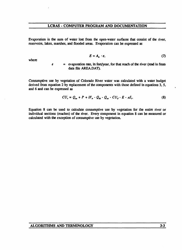
Consumptive use of Colorado River water must be broken down into individual components because not all the consumptive use is charged to users (diverters). These components include consumptive use by vegetation (crops and phreatophytes), evaporation from open-water surfaces, and domestic, municipal, and industrial use. Consumptive use of river water can be expressed as
E + CV+ (6) where
CUy = consumptive use by vegetation, in acre-feet, of Colorado River water, E = evaporation, in acre-feet, from the open-water surfaces in the reach;
and CUj = domestic, municipal, and industrial consumptive use, in acre-feet, in
the reach (calculated in subroutine DUIN using data file DU.DAT).
ALGORITHMS AND TERMINOLOGY 3-2
LCRAS - COMPUTER PROGRAM AND DOCUMENTATION
Evaporation is the sum of water lost from the open-water surfaces that consist of the river, reservoirs, lakes, marshes, and flooded areas. Evaporation can be expressed as
E = Aw -c, (7) where
t - evaporation rate, in feet/year, for that reach of the river (read in from data file AREA.DAT).
Consumptive use by vegetation of Colorado River water was calculated with a water budget derived from equation 2 by replacement of the components with those defined in equations 3, 5, and 6 and can be expressed as
CUV = ft. + P + IF, -Qt-Qv-CUj-E- ASr. (8)
Equation 8 can be used to calculate consumptive use by vegetation for the entire river or individual sections (reaches) of the river. Every component in equation 8 can be measured or calculated with the exception of consumptive use by vegetation.
ALGORITHMS AND TERMINOLOGY 3-3

LCRAS - COMPUTER PROGRAM AND DOCUMENTATION
Distribution of Consumptive Use
Consumptive use by vegetation can be approximated by estimating evapotranspiration; this relation provides a means to distribute consumptive use by vegetation among water users but not open-water evaporation or domestic, municipal, and industrial use. Evapotranspiration is the loss of water from a land area through transpiration by vegetation and evaporation from the soil surface under the vegetation and can be expressed as
ET = A -Wu, (9) where
ET = estimated evapotranspiration, in acre-feet; A = the area, in acres, of each vegetation type; and Wu = water-use rate, in feet/year, for that vegetation type.
Areas for each vegetation type by diverter are determined from digital-image analysis of satellite data. Water-use rates for crops are calculated using a modification of the formula developed by Blaney and Griddle (1950). The modified formula is expressed as
(10) where
U = vegetation water-use rate, in acre-feet/acre/year, during the growth of the vegetation (substitutes for Wu in equation 9);
km = monthly empirical water-use coefficient that is dependent on the type and location of the vegetation;
tm = mean monthly temperature, in degrees Fahrenheit;dm = monthly percentage of total daylight hours of the year, andpm = monthly precipitation, in inches.
Phreatophyte water-use rates were calculated for the density types (sparse, medium, and dense) classified by image analysis by using another modification of the formula developed by Blaney and Griddle (1950), which can be expressed as
(11)
The same mean monthly temperatures used for estimating water-use rates for crops for the different reaches were used to estimate water-use rates for phreatophytes. Monthly precipitation was not included in equation 11 to estimate water-use rates for phreatophytes because phreatophytes are deep-rooted plants that use ground water in the alluvial aquifer.
ALGORITHMS AND TERMINOLOGY 3-4

LCRAS - COMPUTER PROGRAM AND DOCUMENTATION
For each diverter, the number of acres of each crop type is multiplied by the respective water-use rate to obtain an estimate of evapotranspiration by that crop. Total crop evapotranspiration by diverter is obtained by summing the individual crop evapotranspiration. Evapotranspiration by phreatophytes was summed separately by State to determine the proportion of evapotranspiration by crops for the reach. Total evapotranspiration by vegetation is then summed for each reach. To distribute consumptive use by vegetation to diverters, the percentage of evapotranspiration calculated for each diverter was applied to the estimate of consumptive use by vegetation calculated for the reach with equation 8.
Flow in the Bill Williams River is measured below Alamo Dam 36 mi upstream from Lake Havasu on the Colorado River. A water budget is used to estimate the amount of water that reaches the Colorado River. Inflow from the Bill Williams River is a component in the water budget for the Davis Dam to Parker Dam reach, which can be expressed as
E, (12) where
Q^ - flow, in acre-feet, in the Bill Williams River that enters the ColoradoRiver and
Q^ = flow, in acre-feet, in the Bill Williams River below Alamo Dam (readin from data file FLOW.DAT).
ALGORITHMS AND TERMINOLOGY 3-5

LCRAS - COMPUTER PROGRAM AND DOCUMENTATION
LOWER COLORADO RIVER ACCOUNTING SYSTEM (LCRAS) PROGRAM
The accounting system developed for the lower Colorado River is complex because it combines the use of two technologies (water budget and remote sensing), which generate large amounts of data from a large study area. To help manage the data, this area is divided into four reaches. Each reach begins and ends at a dam to form independent hydrologic models that can be analyzed separately (fig. 2).
The LCRAS Program is divided into two parts or processors (fig. 3). The first part uses the water budget to calculate consumptive use by vegetation along a reach. The second part uses vegetation types and areas and water-use rates to estimate evapotranspiration for each diverter. In order to reduce the effect of any error associated with the water-use rates, evapotranspiration by diverter is converted to a percentage of total evapotranspiration. These percentages are multiplied by the total consumptive use by vegetation for the reach to compute consumptive use by vegetation for each diverter.
The format for the input data was a major concern when designing the LCRAS program. The input data for the water budget will be changed each year, therefore, the input files must be both easy to update and meaningful to the user independent of the program. This was done by allowing input to be read from fully annotated ASCII files (attachments A-J). Each subreach defined in the primary data file (attachment A) has a set of data files associated with it. The first data file that LCRAS needs for each subroutine is an image-classification data file (attachment F), which is the output data from image-processing software. Two files contain weather-station data in the subreach a mean monthly temperature data file (attachment G) and a monthly precipitation data file (attachment H). Each year these files must be updated with current data from the National Climatic Data Center. The actual names of these data files are read from the primary data file, but they must have names that conform with the computer-operating system.
Satellite data for 1984 were processed using ELAS1 to classify crop and phreatophyte-density types and to calculate areas. The output data file from the image processing must be formatted for input into LCRAS. A separate Fortran program reads the ELAS output data file and produces the input data file for use by LCRAS. This allows any method of vegetation classification and area measurement to be used. The format required for the image-processing output data file is shown in attachment F.
Another important concern in the development of the computer program was to allow new or updated calculation methods to be inserted easily into the program. To do this, a modular program design is used. Each type of input, such as gaged flows or domestic use, is read from
'Use of brand name in this report is for identification purposes only and does not constitute endorsement by the U.S. Geological Survey.
LCRAS PROGRAM 4-1

LCRAS - COMPUTER PROGRAM AND DOCUMENTATION
XoUJ
CN
UJct:
x oUJce
x oLJct:
/"^\
LmmmmlLAKE MEADHOOVER DAM
^COLORADO RIVER ^ AQUEDUCT
LAKE HAVASUPARKER DAM
ALL AMERICAN
LAKE MOHAVE DAVIS DAM
«JL.
IMPERIAL DAM
GILA GRAVITY MAIN CANAL
GILA RIVER
MORELOS DAM
Figure 2.~Reaches along the lower Colorado River.
LCRAS PROGRAM 4-2

LCRAS - COMPUTER PROGRAM AND DOCUMENTATION
LCRAS LOWER COLORADO RIVER ACCOUNTING SYSTEM
WATER BUDGETConsumptive use
Compile data collected from gaging stations, weather stations, utility records, population records, and other sources, and load to inputJ.ll&d.
T
Calculate consumptive use by vegetation as
CU = Qi + P + Tr - Qo - Ex - Ev - Du - AS,
where
CU = consumptive use by vegetation,
Qi = river inflow,P - precipitation,Tr tributary inflow, Qo = river outflow, Ex = exported water, Ev = open-water evaporation, Du = domestic, municipal, and
industrial use, andAS = change in storage.
T
REMOTE SENSING & GISEvapotranspiration
Image processing of satellite data determines vegetation types and acreages.
T
Digitize diverter boundaries by using geographic information system (GIS) software.
T
Overlay diverter boundaries on classified images and sum vegetation areas by type for each diverter.
T
Calculate water-use rates by vegetation by using the Blaney-Criddle formula.
T
Estimate evapotranspiration by vegetation types and sum evapotranspiration by crops for each diverter.
T
Calculate evapotranspiration by diverter as a percentage of total evapotranspiration.
T
Calculate consumptive use by diverter by using percentages of evapotranspiration by diverter multiplied by consumptive use by vegetation from the water budget.
Figure 3.--Flow chart of LCRAS computer program.
LCRAS PROGRAM 4-3

LCRAS - COMPUTER PROGRAM AND DOCUMENTATION
a single input file by a single subroutine. Each reach also has a unique subroutine to calculate consumptive use by vegetation using equation 6. For the satellite data, three subroutines are common for all reaches. These subroutines read the data from the data file, sort the data, estimate evapotranspiration, and apportion consumptive use by vegetation to each diverter along the reach. Three subroutines produce output table files: (1) a table listing the water-use rates for each vegetation type per month by reach (attachment L), (2) a table for each reach listing the area of each crop by diverter (attachment M), and (3) a table for each reach listing the calculated evapotranspiration, the percentage of evapotranspiration used by each diverter, and the calculated consumptive use by vegetation for each diverter in each State as well as State totals (attachment O).
The main program is used primarily as a vehicle to call the subroutines. A small amount of overhead, such as variable initialization, defining common blocks, and reading the general data file, also is performed in the main program. No parameters are passed directly to any of the subroutines; instead, all shared variables are stored in the common blocks. The variables used in the program are shown in table 1.
LCRAS PROGRAM 4-4

LCRAS COMPUTER PROGRAM AND DOCUMENTATION
Table 1.- List of variables in common blocks
Name
AREAS
BILOUT
CORVEG
CRPCOF
CRPNAM
DATFEL
DIVNAM
DTOTAL
4
LCRAS
Commonblock Type
INDATA INTEGER*4
RDAT4 REAL*8
COUNTS INTEGER*4
WDATA INTEGER*4
WDATA CHARACTER*20
IDATA CHARACTER*50
VEGDAT CHARACTER*40
PHRDAT INTEGER*4
PROGRAM
Subroutinesinvolved
AREAINBWRHV2MLHV2DVDV2PKPK2IP
MAINBWRHV2MLDV2PK
LUMPBWRTABLE1
BC
BC
AREAINFLOWINTOffilNBCDUINMAIN
LUMPSORTTABLE1TABLE2TABLE4
BCBWRSORTTABLE2TABLE4
Action
Read from fileUsed to calculate BILOUTUsed to calculate FDTOTUsed to calculate RCHTSUsed to calculate RCHTSUsed to calculate RCHTS
Used to set RCHTSCalculatedUsed to calculate FDTOTUsed to calculate RCHTS
Read from fileUsed to calculate BILOUTUsed to calculate NETVEG
Read from file
Read from file
Used to open fileUsed to open fileUsed to open fileUsed to open fileUsed to open fileRead from file
Read from fileSorts character arrayWritten to a fileWritten to a fileWritten to a file
CalculatedUsed to calculate BILOUTSorts by DIVNAMWritten to a fileWritten to a file
4-5

LCRAS COMPUTER PROGRAM AND DOCUMENTATION
Table 1.- List of variables in common blocks - Continued
Name
DUS
ETOTAT
EVAPS
FDNUM
FDETOTFLOWS
INFILE
LOCLAT
MTOTAL
LCRAS
Common block
INDATA
BLCR1
INDATA
SUMMRY
SUMMRYINDATA
LUMP1
BLCR1
PHRDAT
PROGRAM
Type
INTEGERS
INTEGERS
INTEGERS
INTEGERM
INTEGERMINTEGERS
CHARACTER'50
INTEGERM
INTEGERM
Subroutines involved
DUINHV2MLHV2DVDV2PKPK2IP
BCBWRSORTTABLE2TABLE4
AREAINBWRHV2MLHV2DVDV2PK
MAIN
MAINFLOWINBWRHV2MLHV2DVDV2PKPK2IP
MAINLUMPTABLES
MAINBC
BCBWRSORTTABLE2TABLE4
Action
CalculatedUsed to calculate FDTOTUsed to calculate RCHTSUsed to calculate RCHTSUsed to calculate RCHTS
CalculatedUsed to calculate BILOUTSorts by DFVNAMWritten to a fileWritten to a file
CalculatedUsed to calculate BILOUTUsed to calculate FDTOTUsed to calculate RCHTSUsed to calculate RCHTS
Set to zero
NoneRead from fileUsed to calculate BILOUTUsed to calculate FDTOTUsed to calculate RCHTSUsed to calculate RCHTSUsed to calculate RCHTS
Read from fileUsed to open fileWritten to a file
Read from fileUsed in conditional
CalculatedUsed to calculate BILOUTSorts by DFVNAMWritten to a fileWritten to a file
4-6
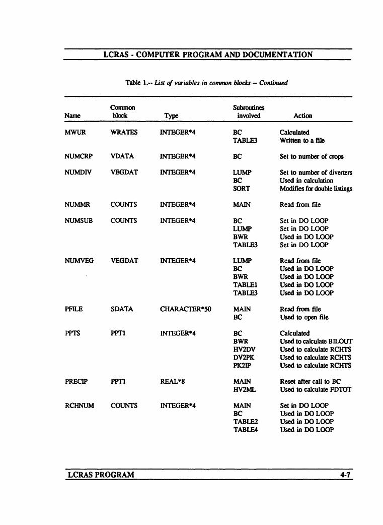
LCRAS - COMPUTER PROGRAM AND DOCUMENTATION
Name
MWUR
NUMCRP
NUMDIV
NUMMR
NUMSUB
NUMVEG
PFILE
PPTS
PRECIP
RCHNUM
LCRAS
Table
Common block
WRATHS
VDATA
VEGDAT
COUNTS
COUNTS
VEGDAT
SDATA
PPT1
PPT1
COUNTS
PROGRAM
1. List of variables in common
Type
INTEGER*4
INTEGER*4
INTEGER*4
INTEGER'4
INTEGERS
INTEGER*4
CHARACIER*50
INTEGER*4
REAL*8
INTEGER*4
blocks ~ Continued
Subroutines involved
BC TABLES
BC
LUMP BC SORT
MAIN
BC LUMP BWR TABLES
LUMP BC BWR TABLE1 TABLES
MAIN BC
BC BWR HV2DV DV2PK PK2IP
MAIN HV2ML
MAIN BC TABUE2 TABLE4
Action
Calculated Written to a file
Set to number of crops
Set to number of diverters Used in calculation Modifies for double listings
Read from file
Set in DO LOOP Set in DO LOOP Used in DO LOOP Set in DO LOOP
Read from file Used in DO LOOP Used in DO LOOP Used in DO LOOP Used in DO LOOP
Read from file Used to open file
Calculated Used to calculate BILOUT Used to calculate RCHTS Used to calculate RCHTS Used to calculate RCHTS
Reset after call to BC Used to calculate FDTOT
Set in DO LOOP Used in DO LOOP Used in DO LOOP Used in DO LOOP
4-7

LCRAS - COMPUTER PROGRAM AND DOCUMENTATION
Table 1.-- List of variables in common blocks - Continued
Common Name block Type
RCHTS INDATA REAL*8
STOTAL PHRDAT INTEGERM
SUBNUM COUNTS INTEGER*4
TFILE SDATA CHARACTER*50
TOT VEGDAT INTEGER*4
TOTALS BOTH4 INTEGER*4
TRTOS INDATA INTEGER*4
Subroutines involved
MAINHV2DVDV2PKPK2IPTABLE2TABLE4
BCBWRSORTTABLE2TABLE4
MAINBCLUMPTABLE1TABLE3
MAINBCTABLE3
LUMPSORT
MAINSORTTABLE1
TRIBINBWRHV2MLHV2DVDV2PKPK21P
Action
Set only value for BWRCalculatedCalculatedCalculatedUsed to calculate COUsed to calculate CO
CalculatedUsed to calculate BELOUTSorts by DIVNAMWritten to a fileWritten to a file
Read from fileUsed in DO LOOPUsed in DO LOOPUsed in DO LOOPUsed in DO LOOP
Read from fileUsed to open fileUsed in conditional
Set to number of divertersModifies for double listings
Set to zeroCalculatedUsed for summation
Read from fileUsed to calculate BELOUTUsed to calculate FDTOTUsed to calculate RCHTSUsed to calculate RCHTSUsed to calculate RCHTS
LCRAS PROGRAM 4-8

LCRAS - COMPUTER PROGRAM AND DOCUMENTATION
Table 1. List of variables in common blocks Continued
NameCommon block Type
Subroutines involved Action
VEGNAM VEGDAT CHARACIER*20
WUR
YEAR
WRATES
BLCR1
INTEGER*4
INTEGERM
LUMP BCTABLE1 TABLES
BC TABLES
MAIN BC
Read from file Used in conditional Written to a file Written to a file
Calculated Written to a file
Read from file Used in conditional
LCRAS PROGRAM 4-9

______LCRAS COMPUTER PROGRAM AND DOCUMENTATION
MAIN PROGRAM
Narrative
The main program for the LCRAS system is a 'program shell* that calls the other modules. Some minor initialization is done, such as initializing the variables in the common blocks. The principal function of the main program is to read the data from the primary input data file. This data file contains the file names for all the other input data files, the file names for the output tables, the calendar year for which the data is to be compiled, the number and names of the reaches to be run, and the number and data file names for the subreaches for each reach. The format for the primary data file is shown in attachment A.
Another function of the main program is to open any data files that are used by more than one subroutine. The main program opens and closes two output data files that are written to by several subroutines. These are the domestic-use table and the water-use rate table. Several data files that contain title information for output files are opened by the main program. Although some subroutines create new files for each reach, the title information for all the tables is stored in one file that must remain open continuously.
The main loop in the program, which cycles through each subroutine, is in the main program. The data for each reach are read from the general data file and the appropriate subroutines are executed. When the first reach is complete, which includes producing or adding to the output table files, the data for the second reach are read and processed. This algorithm allows most of the variables to be reused for each reach.
The last function of the main program is to close any open files, including input and output files. Once the files are closed, the main program returns control back to the operating system.
MAIN SUBROUTINE 5-1

LCRAS - COMPUTER PROGRAM AND DOCUMENTATION
Variable List
Name Common Description
BILOUT
DATFIL(10)
These are:
[RDAT4]
[IDATA]
FDNUM
FILNAM
INFELE(10)
LOCLAT(10)
NUMMR
PFILE(10)
PRECIP(4)
DATFDL(1) DATFIL(2) DATFHX3) DATFIL(4)
DATFDL(5) DATFDL(6) DATFDLC?) DATFIL(8) DATFIL(9) DATFIL(10)
Discharge from the Bill Williams River into the Colorado River between Davis Dam and Parker Dam.
The array DATFIL contains the names of the input data files.
Flow Data file.Tributary-Inflow Data file.Domestic-Use Data file.Open-Water Surface Area and Evaporation-RatesData file.Crop-Coefficient Data file.Daylight Data file.Information for Table 1.Information for Table 2.Information for Table 3.Information for Domestic-Use Tables.
[SUMMRY] Total number of diverters in the system.
Name of the domestic-use output file.
[LUMP1] Array containing names of the subreach image- classification data files within a single reach.
[BLCR1] Array containing the latitude for each subreach within a single reach.
* [COUNTS] Number of major reaches contained in the model
are stored in this variable.
[SDATA] Array containing the names of the precipitation data files for each subreach within a single reach.
[PPT1] Precipitation for each area in each subreach.
MAIN SUBROUTINE 5-2

LCRAS - COMPUTER PROGRAM AND DOCUMENTATION
Name Common Description
RCHNAM
RCHNUM
RCHTS(4)
SUBNUM
TEMP
TFILE(IO)
TITLE
WUNAME
YEAR
YLINES
Name of the reach that is compared to the subroutine names for execution, must match a subroutine name exactly.
[COUNTS] Number of the current subreach being processed.
[INDATA] Consumptive use by vegetation for each subreach.
Number of subreaches within a single reach.
Temporary variable to save the RCHTS value while BWR subroutine is called.
[SDATA] Array containing the names of the temperature data files for each subreach within a single reach.
String variable is used to read the title from the data file and write it to the output file.
TOTALS(10O25) [BOTH4] Array containing the total area of each crop for each diverter along a single reach.
Name of the output file for the water-use table.
[BLCR1] Year for the data.
Number of lines in a table title.
MAIN SUBROUTINE 5-3

LCRAS - COMPUTER PROGRAM AND DOCUMENTATION
Flow chart Lower Colorado River Accounting SystemMain Program
Begin program
Set Bill Williams River outflow value equal to zero
Open primary data file
Set K equal to zero
Increment K
Read the Input data file names
Repeat until oil names ore read in
C START J
No
Read the output file name for the domestic use data table
Open file containing titles and output fie names for table 1
Open file containing titles and output fie names for table 2
Open file containing titles and output fie names for table 3
Read the number of lines in the title and the output file name for table 3
Open the output file for the domestic - use data tafalo
Open the output file for table 3
Set K equal to zero
Continued on next page
MAIN SUBROUTINE 5-4

LCRAS - COMPUTER PROGRAM AND DOCUMENTATION
Lower Colorado River Accounting SystemMain Program Continued
Read the title line for table 3
Write the title line to the output file for table 3
Repeat until title is complete
Write blank line for table 3
Write blank line for table 3
Write heading of the months for table 3
Read the Inflow data from the inflow file
Read the tributary data from the tributary data file
Read In and calculate the domestic use data from the domestic-use file
Read the open-water surface areas and the evaporation rates
Read the current year to be processed
Read the number of reaches to be processed
Set I equal to one
Set J equal to one
0
READ TITLE(I)
/ WRITE TITLE(I)
No
/ WRITE LINE /
/ WRITE UNE /
~ I/ WRITE HEADER S
Continued on next page
MAIN SUBROUTINE 5-5

LCRAS - COMPUTER PROGRAM AND DOCUMENTATION
Lower Colorado River Accounting SystemMain Program Continued
©
Sat TOTALS(I.J) to zero
Increment J
Repeat until J > 25
Increment 1
Repeat until 1 > 100
i
j
Read the reach name to be processed
Read the number of subreoches In reach
Set J equal to zero
Increment J
Read subreoch Input data file name
Read location latitude of subreoch
Read temperature Input file name for reach being processed
Read precipitation input file name for reach being processed
Continued on next page f (
MAIN SUBROUTINE
TOTALS(I.J) - 0
J + 1
No .XX"X^VV\N^
Yes
I + 1
No ^^^^^^^^^
___ <s^ \ -, \r\f\ ^^^.
Yes
| READ RCHNAM
| READ SUBNUM
J = 0
J - J + 1
| READ INFILE(J)
f^READ LOCLAT(J)
| READ TFILE(J)
I READ PRLE(J)
D © ©5-6

LCRAS - COMPUTER PROGRAM AND DOCUMENTATION
Lower Colorado River Accounting SystemMain Program Continued
© ©
Repeat untl all subreaches are read in
Calculate area of each vegetation type by divert er
Calculate water use rotes using modified ESaney Crfdde formula
Make comparison to determine if variable RCHNAM equals 'DV2PK'
Calculate inflow to Lake Havasu from Bill Wniiame River
Calculate consumptive use by diverter from Oavis Dam to Parker Dam
Make comparison to determine if variable RCHNAM equals 'HV20V
Calculate consumptive use by diverter from Hoover Dam ta Oovts Oom
Make comparison to determine if variable RCHNAM equals 'PK2IP'
CALL
Yes
LUMP
Continued on next page ©
MAIN SUBROUTINE 5-7

LCRAS COMPUTER PROGRAM AND DOCUMENTATION
Lower Colorado River Accounting SystemMain Program Continued
Calculate consumptive use by dlverter from Parker Dam to Imperial Dom
Make comparison to determine if variable RCHNAM equals 'IP2ML*
Calculate consumptive use by diverter from Imperial Dam to Morelos Dom
Error message If there is no match
End of program due to error
Produce a table of areas of each crop by dlverter far each reach
Produce a table of evapotronsplratlon, percentage, and consumptive use for Arizona, California, Nevada, and Federal Lands far each reach
Produce a table of water use rates for each vegetation type for each reach
Repeat until oil reaches are processed
If oil four reaches have been called, call subroutine 'HV2ML'
Calculate consumptive use by diverter from Hoover Dam to Morelas Dam
Continued on next page
MAIN SUBROUTINE 5-8

LCRAS - COMPUTER PROGRAM AND DOCUMENTATION
Lower Colorado River Accounting SystemMain Program Continued
Close general data file
Close domestic-use output file
Close file containing the titles and output file names for table 1
Close file containing the titles and output file names for table 2
Close file containing the titles and output file nomes for toble 3
Close the output fie for toble 3
End of program
MAIN SUBROUTINE 5-9

LCRAS - COMPUTER PROGRAM AND DOCUMENTATION
Program Listing
MAIN PROGRAM
CHARACTER*100 TITLE (10) CHARACTER*40 DIVNAM(IOO), FDNAME(250), RCHNAM CHARACTER*20 VEGNAM(50) , CRPNAM(SO)CHARACTER*22 INFILE(IO), DATFIL(15)
* WUNAME, PFILE(IO),INTEGERM NUMDIV(IO), NUMSUB,
* SUBNUM, LOCLAT(IO)* YEAR, RCHNUM,* TOT, NUMCRP,INTEGER*4 TOTALS (100,25), MTOTAL ( 50 )
TFILE(IO),FILENAMNUMMR,NUMVEG,YLINES,FDNUMCORVEG(IO),
DTOTAL(50), ETOTAL(IOO), STOTAL(50),
CC
CCCC
CCCC
FDETOT(250)REAL*8 FLOWS (30), TRIES (40),
DUS(20), EVAPS(20),PPTS, WUR(5,25),PRECIP(5), RCHTS(5),CRPCOF(50,12)
COMMON / VEGDAT / DIVNAM, VEGNAM, NUMVEG,COMMON / PHRDAT / DTOTAL, MTOTAL, STOTALCOMMON / INDATA / FLOWS, TRIES, AREAS,COMMON / COUNTS / NUMSUB, NUMMR, SUBNUM,COMMON / WRATES / MWUR, WURCOMMON / BLCR1 / LOCLAT, ETOTAL, YEARCOMMON / LUMP1 / INFILECOMMON / SDATA / PFILE, TFILECOMMON / BOTH4 / TOTALSCOMMON / IDATA / DATFILCOMMON / PPT1 / PPTS, PRECIPCOMMON / WDATA / CRPCOF, CRPNAMCOMMON / VDATA / NUMCRPCOMMON / RDAT4 / BILOUTCOMMON / SUMMRY / FDNAME, FDETOT, FDNUMCOMMON / SUM2 / FDACR
AREAS (20),BILOUT,MWUR (5 ,25, 12)FDACR (5) ,
NUMDIV, TOT
EVAPS , DUS , RCHTSRCHNUM, CORVEG
Set the Bill Williams River number to zero (0) and the fullriver acreage to zero (0) .
BILOUT = 0FDNUM = 0
.Print the title to the screen and ask thethe primary data file.
user for the name of
WRITE (*,1)1 FORMAT (////////////////////,10X,'LOWER COLORADO RIVER'
' ACCOUNTING SYSTEM',////) WRITE (* 2)
2 FORMAT (2X,'What is the profile data file name ?')READ (*,'(A22)') FILENAMWRITE (*,3)
3 FORMAT (///,2X,'Please Wait - Processing')
Open the primary data file to read data and the names of other data files required.
MAIN SUBROUTINE 5-10
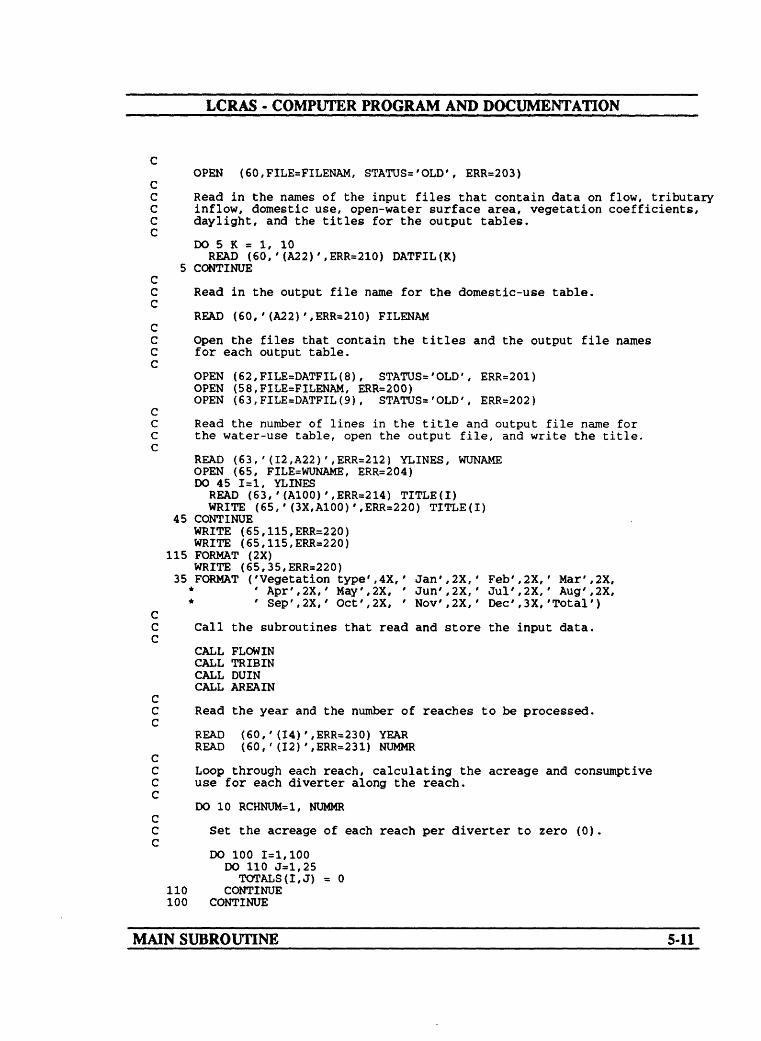
LCRAS - COMPUTER PROGRAM AND DOCUMENTATION
OPEN (60,FILE=FILENAM, STATUS='OLD', ERR=203) CC Read in the names of the input files that contain data on flow, tributary C inflow, domestic use, open-water surface area, vegetation coefficients, C daylight, and the titles for the output tables. C
DO 5 K = 1, 10READ (60,'(A22)',ERR=210) DATFIL(K)
5 CONTINUE CC Read in the output file name for the domestic-use table. C
READ (60,'(A22)',ERR=210) FILENAM CC Open the files that contain the titles and the output file names C for each output table. C
OPEN (62,FILE=DATFIL(8) , STATUS='OLD', ERR=201)OPEN (58,FILE=FILENAM, ERR=200)OPEN (63,FILE=DATFIL(9) , STATUS='OLD', ERR=202)
CC Read the number of lines in the title and output file name for C the water-use table, open the output file, and write the title. C
READ (63,'(I2,A22)',ERR=212) YLINES, WUNAMEOPEN (65, FILE=WUNAME, ERR=204)DO 45 1=1, YLINES
READ (63,'(A100)',ERR=214) TITLE(I) WRITE (65,'(3X,A100)',ERR=220) TITLE(I)
45 CONTINUEWRITE (65,115,ERR=220)WRITE (65,115,ERR=220)
115 FORMAT (2X)WRITE (65,35,ERR=220)
35 FORMAT ('Vegetation type',4X,' Jan',2X, ' Feb',2X,' Mar',2X,* ' Apr',2X,' May',2X, ' Jun',2X, ' Jul',2X,' Aug',2X,* ' Sep',2X,' Oct',2X, ' Nov',2X,' Dec',3X,'Total')
CC Call the subroutines that read and store the input data. C
CALL FLOWIN CALL TRIBIN CALL DUIN CALL AREAIN
CC Read the year and the number of reaches to be processed. C
READ (60,'(14)',ERR=230) YEAR READ (60,'(12)',ERR=231) NUMMR
CC Loop through each reach, calculating the acreage and consumptive C use for each diverter along the reach. C
DO 10 RCHNUM=1, NUMMR CC Set the acreage of each reach per diverter to zero (0). C
DO 100 1=1,100 DO 110 J=l,25
TOTALS(I,J) = 0 110 CONTINUE 100 CONTINUE
MAIN SUBROUTINE £lT

LCRAS - COMPUTER PROGRAM AND DOCUMENTATION
cC Read the subreach file name, latitude, temperature fileC name, and precipitation file name associated with eachC subreach file.C
READ (60,'(A40)',ERR=232) RCHNAM WRITE (*,66) RCHNAM
66 FORMAT (//,2X,'Processing Reach - ',A40) CC If reach DV2PK is to be calculated, then subroutine BWR is run C first to calculate BILOUT. C
IF (RCHNAM .EQ. 'DV2PK') THENWRITE (*,61)
61 FORMAT (//,4X,'Processing BWR for DV2PK') CC Read the number of subreaches in the reach and loop through C each one, reading and storing the image-processing data file name, C latitude of the subreach, temperature data file name, and C precipitation data file name. C
READ (60,'(12) f ,ERR=233) SUBNUM DO 57 J= 1, SUBNUM
READ (60,'(A22)',ERR=240) INFILE(J) READ (60,'(12)', ERR=241) LOCLAT(J) READ (60,'(A22)',ERR=242) TFILE(J) READ (60,'(A22)',ERR=243) PFILE(J)
57 CONTINUE CC Call subroutine LUMP to consolidate the image-processing data C file and call subroutine BC to apply the Blaney-Criddle C formula to the vegetation data. Save the precipitation C value for DV2PK. C
CALL LUMPTEMP = PRECIP(RCHNUM) CALL BCPRECIP(RCHNUM) = TEMP CALL BWRRCHTS(RCHNUM) = BILOUT CALL TABLE1 CALL TABLE4 CALL TABLE3 WRITE (*,74) BILOUT
74 FORMAT (6X,'Outflow from Bill Williams River is '.F15.0)WRITE (* 73)
73 FORMAT (/,4X,'Continue with processing DV2PK') CC Reset the acreage in each reach by diverter to zero (0). C
DO 112 1=1,100 DO 111 J=l,25
TOTALS(I,J) = 0111 CONTINUE112 CONTINUE
END IF CC Read the number of subreaches in the reach and loop through C each one, reading and storing the image-process ing data file name, C latitude of the subreach, temperature data file name, and C precipitation data file name. C
READ (60,'(12)',ERR=233) SUBNUM
MAIN SUBROUTINE 542"

LCRAS - COMPUTER PROGRAM AND DOCUMENTATION
DO 50 J= 1, SUBNUMREAD (60,'(A22)',ERR=240) INFILE(J) READ (60,'(12)', ERR=241) LOCLAT(J) READ (60,'(A22)',ERR=242) TFILE(J) READ (60,'(A22)',ERR=243) PFILE(J)
50 CONTINUE CC Call subroutine LUMP to consolidate the image-processing data C file and call subroutine BC to apply the Blaney-Criddle C formula to the vegetation data. C
CALL LUMPCALL BCWRITE (*,51)
51 FORMAT (8X,'Applying Water Budget Formula') CC Call the appropriate water-budget subroutine for the reach C that is being calculated. If the reach name does not match, C an error is produced. C
IF (RCHNAM .EQ. 'HV2DV') CALL HV2DV(*72)IF (RCHNAM .EQ. 'DV2PK') CALL DV2PK(*72)IF (RCHNAM .EQ. 'PK2IP') CALL PK2IP(*72)IF (RCHNAM .EQ. 'IP2ML') CALL IP2ML(*72)
C79 WRITE (*,80) RCHNAM80 FORMAT (//, 20X,'ERROR - ',A5,' CHOSEN NOT FOUND ')
STOP C
72 CALL TABLE1 CALL TABLE2 CALL TABLE3
10 CONTINUE CC If all four reaches have been calculated, call the water- C budget subroutine for the Hoover Dam to Morelos Dam reach C of the lower Colorado River. C
IF (NUMMR .EQ. 4) CALL HV2ML CC Close all the open files. C
CLOSE (60) CLOSE (58) CLOSE (62) CLOSE (63) CLOSE (65) WRITE (*,49)
49 FORMAT (//,2X,'PROCESSING COMPLETE',///)RETURN
CC Error messages. C
200 WRITE (*,209) DATFIL(6) STOP
201 WRITE (*,209) DATFIL(7) STOP
202 WRITE (*,209) DATFIL(8) STOP
203 WRITE (*,209) 'FILE.DAT' STOP
204 WRITE (*,209) WUNAME STOP
MAIN SUBROUTINE
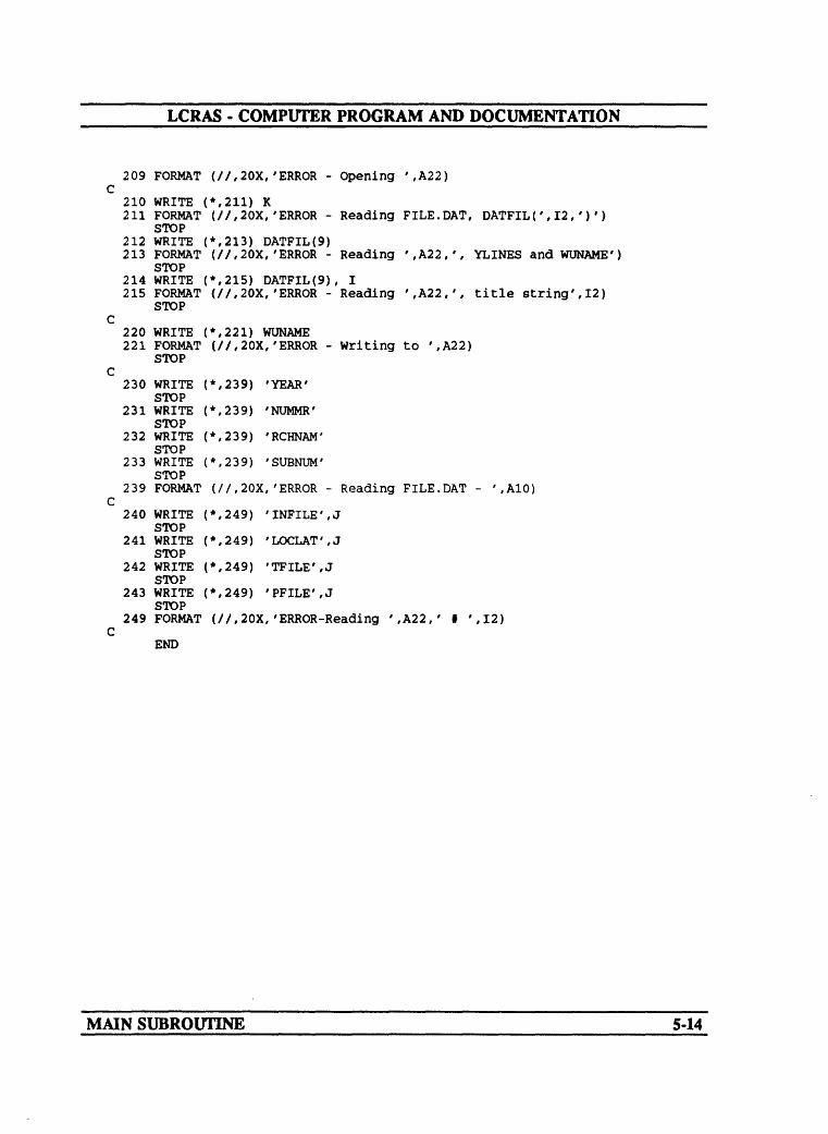
LCRAS - COMPUTER PROGRAM AND DOCUMENTATION
209 FORMAT (//,20X,'ERROR - Opening ',A22) C
210 WRITE (*,211) K211 FORMAT (//,20X,'ERROR - Reading FILE.DAT, DATFIL(',12,')')
STOP212 WRITE (*,213) DATFIL(9)213 FORMAT (//,20X,'ERROR - Reading ',A22,', YLINES andWUNAME')
STOP214 WRITE (*,215) DATFIL(9), I215 FORMAT (//,20X,'ERROR - Reading ',A22,', title string',12)
STOP C
220 WRITE (*,221) WUNAME221 FORMAT (//,20X,'ERROR - Writing to ',A22)
STOP C
230 WRITE (*,239) 'YEAR' STOP
231 WRITE (*,239) 'NUMMR' STOP
232 WRITE (*,239) 'RCHNAM' STOP
233 WRITE (*,239) 'SUBNUM' STOP
239 FORMAT (//,20X,'ERROR - Reading FILE.DAT - ',A10) C
240 WRITE (*,249) 'INFILE',J STOP
241 WRITE (*,249) 'LOCLAT',J STOP
242 WRITE (*,249) 'TFILE',J STOP
243 WRITE (*,249) 'PFILE',JSTOP
249 FORMAT (//,20X,'ERROR-Reading ',A22,' f ',12) C
END
MAIN SUBROUTINE 5-14

______LCRAS COMPUTER PROGRAM AND DOCUMENTATION
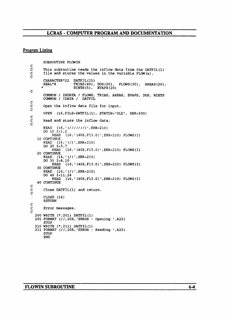
SUBROUTINE FLOWIN
Narrative
Subroutine FLOWIN reads the annual flow measured at gaging stations along the lower Colorado River from Hoover Dam to the SIB. The quantities are in acre-feet The data file is designed to be human readable; much of the information is skipped and only the actual data values are stored as variables. The format for the data is shown in attachment B. Note that the data are separated into four groups, each of which corresponds to one of the reaches along the river. Also note that the flow quantities in the data files are the only items that should be changed unless there is a modification in the way the consumptive-use estimates are calculated.
Variable List
Name Common Description
DATFEX1) [IDATA] ASCII input data file that consists of the annual- flow quantities measured at gaging stations along the lower Colorado River.
FLOWS(20) [INDATA] Array that contains the annual-flow quantitiesmeasured at gaging stations along the lower Colorado River.
FLOWIN SUBROUTINE 6-1

LCRAS - COMPUTER PROGRAM AND DOCUMENTATION
Flow chartLower Colorado River Accounting System
Subroutine FLOWN
Begin subroutine FLOWN
Open the Input fie containing the Inflow data
Read the first eight lines in the data fie
Set I equal to zero
Increment I
Read Inflow values 1-2
Repeat until I > 2
START
No
Read two blank lines In the data file
Increment I
Read Inflow values 3 7
Repeat until I > 7No
Read two blank lines In the data file
Increment I
Continued on next page
FLOWIN SUBROUTINE 6-2

LCRAS - COMPUTER PROGRAM AND DOCUMENTATION
Lower Colorado River Accounting SystemSubroutine FLOWN Continued
Read Inflow values 8-10
Repeat until I > 10
Read two blank lines In the data file
Increment I
Read inflow values 11-18
Repeat until I > 18
Close inflow doto file
Return to main program
FLOWIN SUBROUTINE 6-3
LCRAS - COMPUTER PROGRAM AND DOCUMENTATION
Program Listing
SUBROUTINE FLOWIN
This subroutine reads the inflow data from the DATFIL(l) file and stores the values in the variable FLOW(x).
CHARACTER*22 DATFIL(15)REAL*8 TRIES(40), DUS(20), FLOWS(30), AREAS(20),
* RCHTS(5), EVAPS(20)
COMMON / INDATA / FLOWS, TRIES, AREAS, EVAPS, DUS, RCHTS COMMON / IDATA / DATFIL
Open the inflow data file for input.
OPEN (16,FILE=DATFIL(1), STATUS='OLD', ERR=200)
Read and store the inflow data.
READ (16,'(///////)',ERR=210) DO 10 1=1,2
READ (16,'(40X,F13.0)',ERR=210) FLOWS(I) 10 CONTINUE
READ (16,'(/)',ERR=210) DO 20 1=3,7
READ (16, ' (40X,F13.0)',ERR=210) FLOWS(I) 20 CONTINUE
READ (16,'(/)',ERR=210) DO 30 1=8,10
READ (16,'(40X,F13.0)',ERR=210) FLOWS(I) 30 CONTINUE
READ (16,'(/)',ERR=210) DO 40 1=11,24
READ (16,'(40X,F13.0)',ERR=210) FLOWS(I) 40 CONTINUE
Close DATFIL(1) and return.
CLOSE (16) RETURN
Error messages.
200 WRITE (*,201) DATFIL(1)201 FORMAT (//,20X,'ERROR - Opening ',A22)
STOP.210 WRITE (*,211) DATFIL(1)211 FORMAT (//,20X,'ERROR - Reading ',A22)
STOP END
FLOWIN SUBROUTINE 6-4

______LCRAS - COMPUTER PROGRAM AND DOCUMENTATION
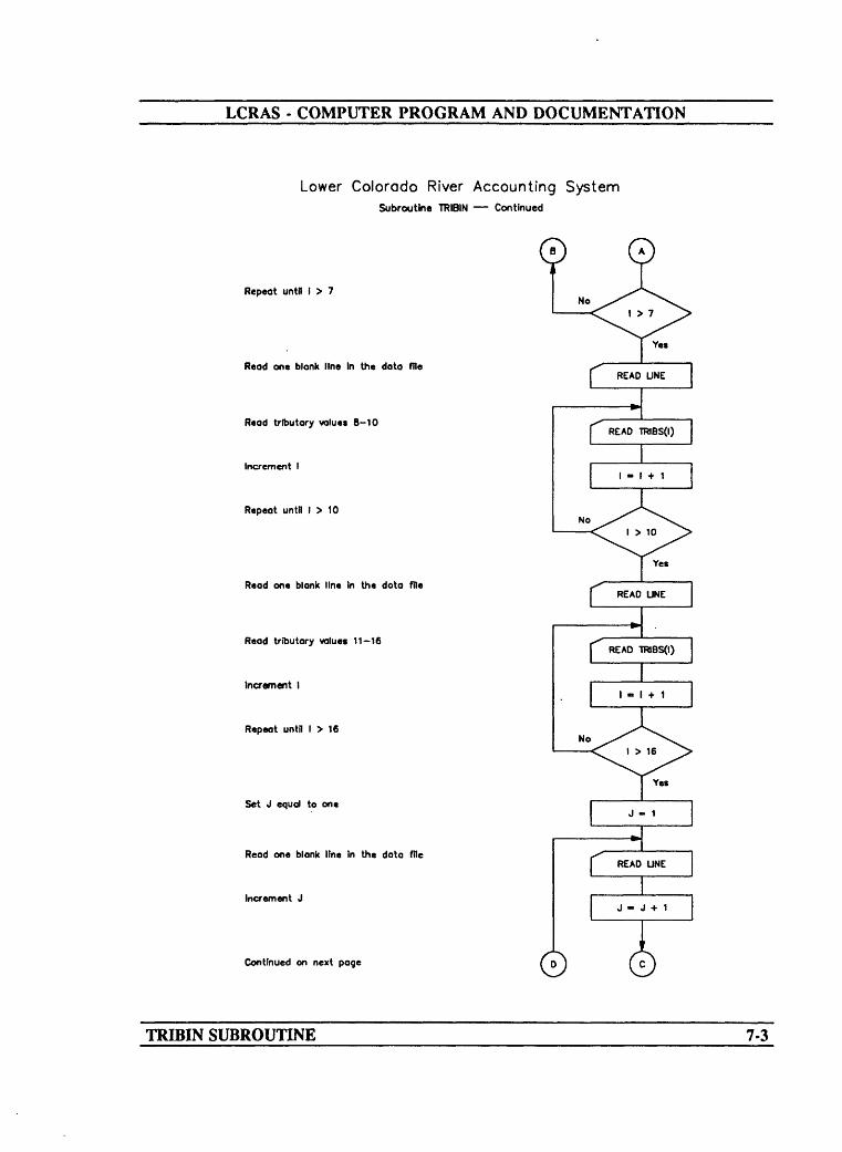
SUBROUTINE TRIBIN
Narrative
Subroutine TRIBIN reads the estimates of unmeasured tributary inflow along the lower Colorado River from Hoover Dam to the NIB. The quantities are in acre-feet The data file is designed to be human readable; much of the information is skipped and only the actual data values are stored as variables. The format for the tributary input data file is shown in attachment C. Note that the data is divided into groups separated by one blank line.
Variable List
Name Common Description
DATFILE(2) [IDATA] ASCII input data file that consists of the annualtributary-inflow estimates from various tributary streams along the lower Colorado River.
TRIBS(40) [INDATA] Array that contains tributary-inflow estimatesalong the lower Colorado River.
TRIBIN SUBROUTINE 7-1

LCRAS - COMPUTER PROGRAM AND DOCUMENTATION
Flow chartLower Colorado River Accounting System
Subroutine TRIBIN
Begin subroutine TRIBIN
Open the fie containing the tributary data
Read the first five blank lines In the data fie
Set I equal to 1
Increment I
Read the tributary values 1-4
Repeat until I > 4
START
No
Set J equal to 1
Increment J
Read one blank line
Repeat until J > 3No
Read tributary values 5-7
Increment I
Continued on next page
TRIBIN SUBROUTINE 7-2
LCRAS - COMPUTER PROGRAM AND DOCUMENTATION
Lower Colorado River Accounting SystemSubroutine TRIBIN Continued
Repeat untfl 1 > 7
Read one blank line In the data file
Read tributary values 8-10
Increment I
Repeat until I > 10
Read one blank line In the dota file
Read tributary values 11-16
Increment I
Repeat until I > 16
Set J equal to one
Read one blank Itne In the data file
Increment J
Continued on next page
Yes
TRIBIN SUBROUTINE 7-3
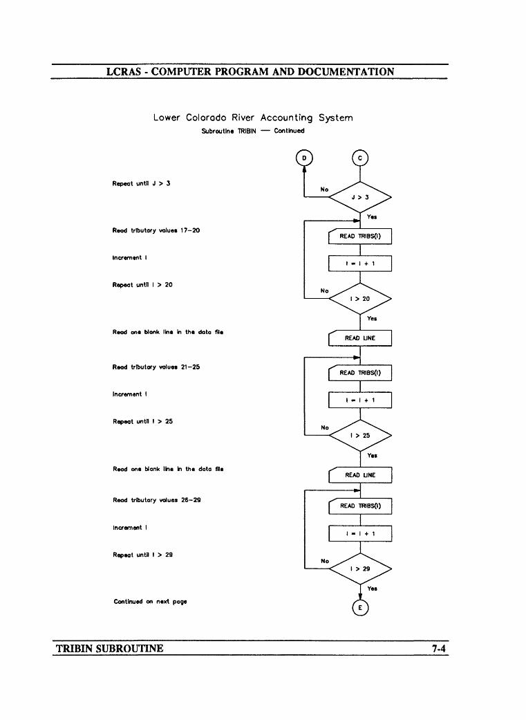
LCRAS - COMPUTER PROGRAM AND DOCUMENTATION
Lower Colorado River Accounting SystemSubroutine TRIBIN Continued
Repeat until J > 3
Read tributary values 17-20
Increment I
Repeat until I > 20
Read one Wank line in the data file
Read tributary values 21-25
Increment I
Repeat until I > 25
Read one blank line In the data file
Read tributary values 26-29
Increment I
Repeat until I > 29
Continued on next page
Yes
No
TRIBIN SUBROUTINE 7-4

LCRAS - COMPUTER PROGRAM AND DOCUMENTATION
Lower Colorado River Accounting SystemSubroutine TRIBIN Continued
Set J equal to one
Read one blank line In the data file
Increment J
Repeat until J > 3
Read tributary values 3O 31
Increment I
Repeat until I > 31
dose tributary data file
Return to main programRETURN
TRIBIN SUBROUTINE 7-5

LCRAS - COMPUTER PROGRAM AND DOCUMENTATION
Program Listing
SUBROUTINE TRIBIN CC This subroutine reads the tributary data from the DATFIL(2) C file and stores the values in the variable TRIB(x). C
CHARACTER*22 DATFIL(15)REAL*8 TRIES(40), DUS(20). FLOWS(30),
* EVAPS(20), RCHTS(5), AREAS (20) C
COMMON / INDATA / FLOWS, TRIES, AREAS, EVAPS, DUS, RCHTS COMMON / IDATA / DATFIL
CC Open the tributary data file for input. C
OPEN (16,FILE=DATFIL(2), STATUS='OLD', ERR=200) CC Read and store the tributary data. C
READ (16,'(////)',ERR=210) DO 10 1=1,4
READ (16,' (45X,F5.0)',ERR=210) TRIES(I) 10 CONTINUE
DO 20 1=1,3READ (16,'(1X)',ERR=210)
20 CONTINUE DO 30 1=5,7
READ (16,'(45X,F5.0)',ERR=210) TRIES(I) 30 CONTINUE
READ (16,'(IX)',ERR=210) DO 40 1=8,10
READ (16,' (45X,F5.0)',ERR=210) TRIES(I) 40 CONTINUE
READ (16,'(1X)',ERR=210) DO 50 1=11,16
READ (16,'(45X,F5.0)',ERR=210) TRIES(I) 50 CONTINUE
DO 60 1=1,3READ (16,'(1X)',ERR=210)
60 CONTINUEDO 70 1=17,20
READ (16,'(45X,F5.0)',ERR=210) TRIES (I) 70 CONTINUE
READ (16,'(IX)',ERR=210) DO 80 1=21,25
READ (16,'(45X,F5.0)',ERR=210) TRIBS(I) 80 CONTINUE
READ (16,'(IX)',ERR=210) DO 90 1=26,29
READ (16,' (45X,F5.0)',ERR=210) TRIES(I) 90 CONTINUE
DO 100 1=1,3READ (16,'(IX)',ERR=210)
100 CONTINUEDO 110 1=30,31
READ (16,'(45X,F5.0)',ERR=210) TRIES (I) 110 CONTINUE
CC Close DATFIL(2) and return. C
TRIBIN SUBROUTINE 7-6
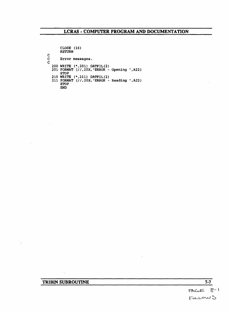
LCRAS - COMPUTER PROGRAM AND DOCUMENTATION
CLOSE (16)RETURN
CC Error messages. C
200 WRITE (*,201) DATFIL(2)201 FORMAT (//,20X,'ERROR - Opening ',A22)
STOP210 WRITE (*,211) DATFIL(2)211 FORMAT (//,20X,'ERROR - Reading ',A22)
STOP END
TRIBIN SUBROUTINE 7-7

______LCRAS COMPUTER PROGRAM AND DOCUMENTATION
SUBROUTINE DUIN
Narrative
Subroutine DUIN reads and calculates domestic consumptive use along the lower Colorado River. The data are taken from Hoover Dam to the NIB. The data file is designed to be human readable; much of the information is skipped and only the actual data values are stored as variables. If a non-zero value for pumpage is read, then this value is used; if a zero value is read, then the pumpage is set to the resident population multiplied by the resident per capita consumptive use. The estimates of domestic use by user are then written to an output file and summed by State (attachment P). The format for the input data is shown in attachment D. The pumpage with no returns and the resident per capita water-use quantities are in acre-feet
DUIN SUBROUTINE 8-1

LCRAS - COMPUTER PROGRAM AND DOCUMENTATION
Variable List
Name Common Description
AZDU
CADU
CWPP
DATFHX3)
DATFIL(10)
DNAME
DOM
DUS(20)
NVDU
POP
STATE
VARNAM
Arizona total domestic consumptive use along the lower Colorado River.
California total domestic consumptive use along the lower Colorado River.
Resident per capita consumptive use.
[IDATA] ASCII input data file that consists of pumpage with no returns, the resident population, the resident per capita water use, and the State abbreviation.
[IDATA] ASCII output file that consists of domestic consumptive use by water user and total domestic consumptive use for Arizona, California, and Nevada.
Diverter name.
Temporary variable for domestic consumptive use.
[INDATA] Domestic consumptive use for each reach along the lower Colorado River.
Nevada total domestic consumptive use along the lower Colorado River.
Resident population for each area wheie the domestic consumptive use is to be calculated.
Two character State code in capital letters.
State initials.
DUIN SUBROUTINE 8-2
LCRAS - COMPUTER PROGRAM AND DOCUMENTATION
Flow chartLower Colorado River Accounting System
Subroutine DUIN
Begin subroutine DUIN
Open file containing the domestic-use data
Open the output file for the final domestic use values
Set the Arizona domestic-use values to zero
Set the California domestic-use values to zero
Set the Nevada domestic-use values to zero
Read the first two characters in the data file
Sets I - 1
Read the first two characters, dlverter name, domestic use, population, per capita rate, and State the diverter Is In from the data fie
Determine if It Is the end of the data file
Determine if the first two characters are blank, same reach, or contain letters, new reach
Determine If the domestic-use value Is zero
Continued on next page © ©
DUIN SUBROUTINE 8-3

LCRAS - COMPUTER PROGRAM AND DOCUMENTATION
Lower Colorado RiverSubroutine DUIN
Accounting System Continued
0 0Domestic use equals the population times the per capita rote
Determine If variable STATE equals 'AZ'
Set AZDU value equal to AZDU plus DOM value
Determine If variable STATE equals *CA'
Set CAOU vdue equal to CADU plus DOM value
Determine If variable STATE equals W
Set NVDU value equal ta NVDU plus DOM value
Set the total domestic-use value equal to the previous domestic use value plus the current domestic-use value
Increments I by 1
Wite the diverter name and the domestic- use value to the output file
Wlte the total Arizona domestic-use value to the output file
Write the total California domestic-use value to the output fie
Continued on next page
DUIN SUBROUTINE 8-4

LCRAS - COMPUTER PROGRAM AND DOCUMENTATION
Lower Colorado River Accounting SystemSubroutine DUIN Continued
VKHte the total Nevada domestic-use value to the output file
Close the output file far the domestic-use data
Close the file containing the domestic use data
Return to the main program
DUIN SUBROUTINE 8-5

LCRAS - COMPUTER PROGRAM AND DOCUMENTATION
Program Listing
SUBROUTINE DUIN CC This subroutine reads the domestic-use data from the C DATFIL(3) file and stores the values in the variable DUS(x). C
CHARACTER*50 DATFIL(15)CHARACTER*20 DNAMECHARACTER*2 VARNAM, STATEREAL*8 FLOWS(30), AREAS(20), RCHTS(5), POP, CWPP, DOM,
* TRIBS(40), DUS(20), EVAPS(20), AZDU, CADU, NVDU C
COMMON / INDATA / FLOWS, TRIES, AREAS, EVAPS, DUS, RCHTSCOMMON / IDATA / DATFIL
CC Open the domestic-use input data file and the domestic-use output C table file. C
OPEN (16,FILE=DATFIL(3), STATUS='OLD', ERR=200)OPEN (59,FILE=DATFIL(10), ERR=210)
CC Set the States domestic-use variable to zero (0). C
AZDU = 0CADU = 0NVDU = 0
CC Read the first two characters from DATFIL(3). C
READ (16,'(///)')READ (16,'(A2) ',ERR=210) VARNAM1 = 1
CC Read the code, diverter name, pumpage with no returns, resident C population, resident per capita consumptive use, and State the C diverter is located in. C
10 READ (16,'(A2,A20,3X,F6.0,6X,F6.0,4X,F3.2,6X,A2)',END=20,ERR=210)* VARNAM, DNAME, DOM, POP, CWPP, STATE
CC If the code is blank, continue because the diverter is in the C current reach. If the code is not blank, complete calculations for C this reach and continue with the next reach. C
IF (VARNAM .EQ. ' ') THEN CC If the pumpage equals zero (0), then calculate the domestic use C as the product of resident population and resident per capita C consumptive use. C
IF (DOM .EQ. 0) DOM = POP * CWPP CC Sum each State's domestic use and the total domestic use for C the reach. C
IF (STATE .EQ. 'AZ') AZDU = AZDU + DOMIF (STATE .EQ. 'CA') CADU = CADU + DOMIF (STATE .EQ. 'NV') NVDU = NVDU + DOMDUS(I) = DUS(I) + DOM
ELSE
DUIN SUBROUTINE 8-6

LCRAS - COMPUTER PROGRAM AND DOCUMENTATION
i = 1+1END IF
CC Write the diverter names, domestic use for that diverter, and each C State's total domestic use to the domestic-use output table. C
WRITE (59, 40, ERR=210) DNAME, DOM 40 FORMAT (2X,A20,6X,F6.0)
GOTO 1020 WRITE (59,50, ERR=210) AZDU 50 FORMAT (2X,'ARIZONA DOMESTIC USE',6X,F6.0)
WRITE (59,60, ERR=210) CADU 60 FORMAT (2X,'CALIFORNIA DOMESTIC USE',3X,F6.0)
WRITE (59,70, ERR=210) NVDU70 FORMAT (2X,'NEVADA DOMESTIC USE',7X,F6.0)
CC Close the files and return. C
CLOSE (59) CLOSE (16) RETURN
CC Error messages. C
200 WRITE (*,201) DATFIL(3)201 FORMAT (//,20X,'ERROR - Opening ',A22)
STOP210 WRITE (*,211) DATFIL(3)211 FORMAT (//,20X,'ERROR - Reading ',A22)
STOP END
DUIN SUBROUTINE 8-7

______LCRAS COMPUTER PROGRAM AND DOCUMENTATION______
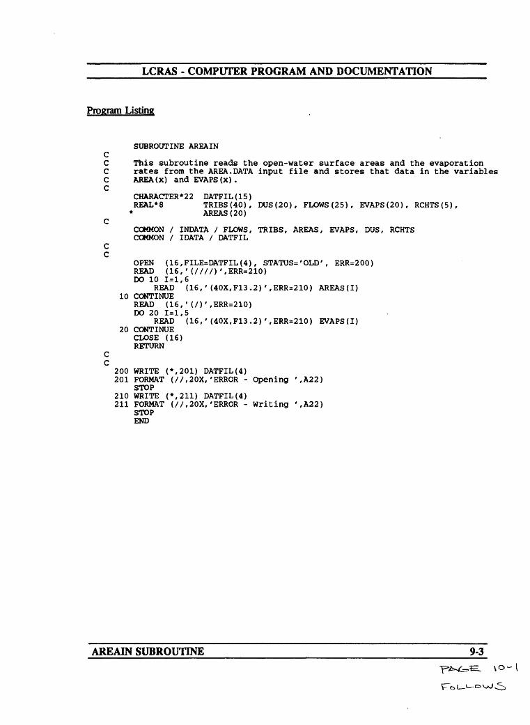
SUBROUTINE AREAIN
Narrative
Subroutine AREAIN reads the open-water surface area and the evaporation rate for each reach along the lower Colorado River. The data file is designed to be human readable; much of the information is skipped and only the actual data values are stored as variables. The format for the data is shown in attachment E.
Variable List
Name Common __ Description
AREAS(20) [INDATA] Open-water surface area for each reach along thelower Colorado River.
EVAPS(20) [INDATA] Evaporation rate for each reach along the lowerColorado River.
DATFIL(4) [IDATA] ASCII file that contains the open-water surfacearea and the evaporation rate for each reach along the lower Colorado River.
AREAIN SUBROUTINE 9-1

LCRAS - COMPUTER PROGRAM AND DOCUMENTATION
Flow chartLower Colorado River Accounting System
Subroutine AREAIN
Begin subroutine AREAIN
Open the file containing the open water surface areas and the evaporation rates
Read the first five blank lines In the data file
Read open-water surface area values 1-6
Repeat until I > 6
Read one blank line from the data file
Read evaporation rate values 1-5
Repeat until I > 5
Close the file containing the open water surface areas and the evaporation rates
Return to main program
Yea
CLOSE (16)
C RETURN J
AREAIN SUBROUTINE 9-2
LCRAS - COMPUTER PROGRAM AND DOCUMENTATION
Program Listing
SUBROUTINE AREAIN CC This subroutine reads the open-water surface areas and the evaporation C rates from the AREA.DATA input file and stores that data in the variables C AREA(x) andEVAPS(x). C
CHARACTER*22 DATFIL(15)REAL*8 TRIES(40), DUS(20), FLOWS (25), EVAPS(20), RCHTS(5),
* AREAS(20) C
COMMON / INDATA / FLOWS, TRIES, AREAS, EVAPS, DUS, RCHTSCOMMON / IDATA / DATFIL
C C
OPEN (16 / FILE=DATFIL(4), STATUS='OLD', ERR=200)READ (16, '(////)',ERR=210)DO 10 1=1,6
READ (16,'(40X,F13.2)',ERR=210) AREAS(I) 10 CONTINUE
READ (16,'(/)',ERR=210)DO 20 1=1,5
READ (16,'(40X,F13.2)',ERR=210) EVAPS(I) 20 CONTINUE
CLOSE (16)RETURN
C C
200 WRITE (*,201) DATFIL(4)201 FORMAT (//,20X,'ERROR - Opening ',A22)
STOP210 WRITE (*,211) DATFIL(4)211 FORMAT (//,20X,'ERROR - Writing ',A22)
STOP END
AREAIN SUBROUTINE

LCRAS - COMPUTER PROGRAM AND DOCUMENTATION
SUBROUTINE LUMP
Narrative
Subroutine LUMP reads and processes the image-processing input data file for the lower Colorado River. Header data in the file include the number of vegetation classes, number of vegetation types, and vegetation class numbers. The data include the vegetation classes by vegetation types, vegetation names, diverter names, and acreage associated with each vegetation class for each diverter along a given reach. After the data are read and stored, the subroutine sums the acreages by vegetation type for each diverter along the reach. The image data are from Hoover Dam to the SIB. The format for the image-processing input data file is shown and explained in attachment F. Each reach may be divided into more than one section called a subreach and each subreach may contain up to 100 diverters. Each subreach may contain a different number of vegetation classes but must have the same number of vegetation types.
Variable List
Name Common Description
ACRAGE
CORVEG(10)
DIVNAM(IOO)
FLAG(60)
INFELE(10)
NUMCDE(25)
NUMCLS
NUMDIV(IO)
Acreage value in the image-processing data file.
[COUNTS] Vegetation acreage less double-cropped area for each reach.
[VEGDAT] Name of each diverter in a subreach.
Flag that is set when two classification numbers occur in a subreach, used as a part of the net acreage calculation.
[LUMP1] Name of the ASCII input data file that contains the image-processing data for each subreach.
Number of vegetation classes associated with each crop or phreatophyte-density type.
Number of classification numbers output by image processing for each subreach.
[VEGDAT] Number of diverters within each subreach.
LUMP SUBROUTINE 10-1

LCRAS - COMPUTER PROGRAM AND DOCUMENTATION
Name Common Description
NUMMR
NUMSUB
NUMVEG
RCHNUM
SUBNAM
SUBNUM
TOT
TOTALS(100,25)
TTOTAL(25)
VEGCDE(20,20)
VEGNAM(50)
[COUNTS] Number of reaches the user chooses to be processed by the accounting system.
[COUNTS] Number of the subreach currently being processed.
[VEGDAT] Number of crop and phreatophyte-density types related to each subreach.
[COUNTS] Number of the reach that is currently being processed.
Name given to each subreach along a single reach.
[COUNTS] Total number of subreaches in each reach.
[VEGDAT] Total number of diverters along the reach being processed.
[BOTH4] Total acreage for each crop and phreatophyte-density type by diverter.
REAL variable that contains the total acreage by crop and phreatophyte-density type for each reach.
Vegetation codes related to each respective vegetation type.
[VEGDAT] Name of each vegetation type associated with each reach.
LUMP SUBROUTINE 10-2

LCRAS - COMPUTER PROGRAM AND DOCUMENTATION
Flow chartLower Colorado River Accounting System
Subroutine LUMP
Begin subroutine LUMP
Set the total number of dlverters to zero
Open the input data file containing the dlverter names, vegetation types, and the acreage of each vegetation type
Read the subreoch name from the data file
Read the number of dosses in data file
Read In the number of. vegetation types In the data fie
Read the vegetation name and the number of vegetation codes
Read each vegetation code
Repeat until J > number of vegetation codes
Repeat untB I > number of vegetation types
Set the number of dlverters equal to zero
Set the correct vegetation acreage to zero
Read the dlverter name
Continued on next page
LUMP SUBROUTINE 10-3

LCRAS - COMPUTER PROGRAM AND DOCUMENTATION
Lower Colorado River Accounting SystemSubroutine LUMP Continued
Determine If end of fffe
Set flag equal to zero
Repeat unto J > number of classes
Increment the total number of dlverters
Increment the total number of dlverters per subreach
Read the vegetation acreage
Set ths vegetation acreage equal to zero
Repeat until J > number of vegetation types
Make comparison to determine if I is equal to the vegetation code
Sum the vegetation acreage by vegetation type
©
Continued on next page©
END OF
No
No
No
J >
©
© ©©©
LUMP SUBROUTINE 10-4

LCRAS - COMPUTER PROGRAM AND DOCUMENTATION
Lower Colorado River Accounting SystemSubroutine LUMP Continued
00©Make comparison to determine If the flog Is less than one
Sum the vegetation acreage less the double-cropped area
Set the flag equal to 1 If statement true
Repeat until L > the number of vegetation codes
Repeat until J > the number of vegetation names
Sum the acreage for each vegetation type per dlverter
Repeat until J > number of vegetation names
Repeat until I > the number of classification numbers
Go back to line 20
Close the Input data file
Continued on next page
©
LUMP SUBROUTINE 10-5

LCRAS - COMPUTER PROGRAM AND DOCUMENTATION
Lower Colorado River Accounting SystemSubroutine LUMP Continued
Repeat untR the number of subreoches to greater than the subreoch number
Return to main program
LUMP SUBROUTINE 10-6

LCRAS - COMPUTER PROGRAM AND DOCUMENTATION
Program Listing
SUBROUTINE LUMP CC This subroutine reads the data from the image-processing C data file and compiles the acres of each crop and C phreatophyte-density type for each diverter in the reach. C
CHARACTER*40 SUBNAM, DIVNAM(IOO)CHARACTER *20 VEGNAM(SO)CHARACTER*22 INFILE(IO)INTEGERM NUMCLS, NUMVEG, NUMDIV(IO), NUMCDE(25),
* NUMMR, VEGCDE(20,20), TOT, TOTALS(100,25),* NUMSUB, SUBNUM, RCHNUM, CORVEG(IO)REAL*8 ACRAGE, FLAG(60), TTOTAL(25)
CCOMMON / VEGDAT / DIVNAM, VEGNAM, NUMVEG, NUMDIV, TOT COMMON / COUNTS / NUMSUB, NUMMR, SUBNUM, RCHNUM, CORVEG COMMON / LUMP1 / INFILE COMMON / BOTH4 / TOTALS
CC Set the total number of diverters to zero (0). C
TOT = 0 CC For each subreach, read the data from the image-processing C data file. C
DO 75 NUMSUB=1, SUBNUM WRITE (*,61) NUMSUB
61 FORMAT (8X,'Processing Satellite data for subreach - ',12) OPEN (16, FILE=INFILE(NUMSUB), STATUS='OLD', ERR=80) READ (16,'(20X,A40)', ERR=90) SUBNAM READ (16,'(20X,I2)' , ERR=100) NUMCLS READ (16,'(20X,I2)' , ERR=110) NUMVEG CORVEG (NUMSUB) = 0 DO 10 1=1,NUMVEG
READ (16,'(A20,I2)', ERR=120) VEGNAM(I), NUMCDE(I) READ (16,*, ERR=130) (VEGCDE(I,J), J=1,NUMCDE(I))
10 CONTINUE CC Read the diverter name, vegetation type, and the classes C corresponding to each diverter/vegetation type. C
NUMDIV (NUMSUB) = 020 READ (16,'(//,A40,//)', ERR=140, END=70) DIVNAM(TOT+1)
DO 6 J = 1, NUMCLS FLAG(J) = 0 TTOTAL(J) = 0
6 CONTINUE TOT=TOT+1NUMDIV (NUMSUB) = NUMDIV (NUMSUB)+1 DO 60 1=1,NUMCLS
READ (16,'(20X,F8.2)', ERR=150, END=70) ACRAGE DO 40 J=l,NUMVEGDO 30 L=1,NUMCDE(J)
CC Sum the vegetation acreage for each diverter/vegetation C type. C
LUMP SUBROUTINE I5T

LCRAS - COMPUTER PROGRAM AND DOCUMENTATION
IF (I .EQ. VEGCDE(J,L)) THENTTOTAL(J)= TTOTAL(J) + ACRAGE
CC Sum the vegetation acreage less the double-cropped area C for each diverter/vegetation type. C
IF (FLAG(I) .LT. 1) THENCORVEG (NUMSUB) =CORVEG (NUMSUB) +INT (ACRAGE-*-. 5) FLAG(I) = 1
END IF END IF
30 CONTINUE 40 CONTINUE
CC Sum the integer of the total acreage for output. C
60 CONTINUEDO 45 J = 1,NUMVEGTOTALS(TOT,J)= INT(TTOTAL(J)+.5)
45 CONTINUEGOTO 20
CC Close the open data files and return. C
70 CLOSE (16) 75 CONTINUE
RETURN CC Error messages. C
80 WRITE (*,81)81 FORMAT (//,20X,'ERROR - Opening INFILE(SUBNUM)')
STOP90 WRITE (*,91)91 FORMAT (//,20X,'ERROR - Reading SUBNAM')
STOP100 WRITE (*,101)101 FORMAT (//,20X,'ERROR - Reading NUMCLS')
STOP110 WRITE (*,111)111 FORMAT (//,20X,'ERROR - Reading NUMVEG(RCHNUM)')
STOP120 WRITE (*,121)121 FORMAT (//,20X,'ERROR - Reading VEGNAM(RCHNUM,I,)')
STOP130 WRITE (*,131)131 FORMAT (//,20X, 'ERROR - Reading VEGCDEd, J) ')
STOP140 WRITE (*,141)141 FORMAT (//,20X,'ERROR - Reading DIVNAM(RCHNUM,K)')
STOP150 WRITE (*,151)151 FORMAT (//,20X,'ERROR - Reading ACRAGE')
STOP END
LUMP SUBROUTINE 10-8

______LCRAS COMPUTER PROGRAM AND DOCUMENTATION______
SUBROUTINE BC
Narrative
Subroutine BC uses a modified Blaney-Criddle formula (equation 10) to calculate the monthly water-use rates, sum the annual water-use rate for each vegetation type, and compute the evapotranspiration for each vegetation type. Data required are read from four ASCII data files: temperature (attachment G), precipitation (attachment H), empirical water-use coefficients (attachment I), and monthly percentage of total daylight hours of the year (attachment J). These input data files are opened and read, and data are stored within the subroutine. The temperature and precipitation files must be updated each year.
Temperature Data
The temperature input data files contain multiple years of data that consist of the year the data were collected and the mean monthly temperatures for selected stations along the lower Colorado River. Because this subroutine is executed once for every reach, a different temperature file should be used for each reach. The format of the data file is similar to the one produced by the National Climatic Data Center. In order to reduce the width of the table and still contain all the data, decimal points are assumed and not included; therefore, each value must be divided by ten to obtain degrees Fahrenheit
Precipitation Data
The precipitation input data files contain multiple years of data and consist of monthly precipitation for selected stations along the lower Colorado River. As with the temperature data file, every reach should have a unique precipitation data file. Precipitation data are in hundredths of inches (decimal points are not included) and must be converted to feet by dividing by 1,200.
Water-Use Coefficients
The empirical water-use coefficients input data file consists of the vegetation name and monthly vegetation water-use coefficients. The vegetation name is compared to the names in the image-processing data files. AH vegetation names must match exactly including case and space location.
Monthly Daylight Data
The monthly percentage of total daylight hours of the year input data file consists of latitude (LAT) and the monthly percentages of daylight hours for each latitude. As each line is read, the latitude value is compared to the value from the general data file. Once a match is made, the monthly values are read and stored
BC SUBROUTINE 114

LCRAS - COMPUTER PROGRAM AND DOCUMENTATION
Upon collection of the appropriate values for the formula, the numbers are then inserted into the modified Blaney-Criddle formula (equation 10) for computation of monthly water-use rates. The monthly rates are then summed into an annual water-use rate. Multiplying the annual water-use rate by the area of each vegetation type gives the annual evapotranspiration for each crop and phreatophyte-density type. All calculations in this subroutine are performed on real numbers, but because of round-off errors that may occur later in the program, estimates of evapotranspiration are returned to the main program as rounded integers. Finally, total precipitation is summed and stored.
Variable List
Name Common Description
CRPCOF(50,12)
CRPNAM(50)
DATFIL(5)
DATFIL(6)
DAYLIG(12)
DELTA
DIVNAM(100)
DTOTAL(50)
ETOTAIX100)
[WDATA] Monthly vegetation water-use coefficients.
[WDATA] Vegetation names read from the vegetation water-use coefficient input data file and used to compare the vegetation names for each reach read from the image- processing input data file.
[IDATA] ASCn input data file that consists of the monthly vegetation water-use coefficients for each vegetation type.
[IDATA] ASCn input data file that contains the latitude and the monthly percentages of total daylight hours of the year.
Monthly percentages of total daylight hours of the year associated with each selected latitude.
Offset used in loop counters to account for subreaches.
[VEGDAT] Diverter names for each reach along the lower Colorado River.
[PHRDAT] INTEGER value for total evapotranspiration for dense phreatophytes.
[BLCR1] INTEGER value for total evapotranspiration by crops for each of the reaches.
BC SUBROUTINE 11-2

LCRAS - COMPUTER PROGRAM AND DOCUMENTATION
Name Common Description
ETUSED(100,25)
LATTTU
LOCLAT(10)
MTOTAL(50)
MWUR(5,25,12)
NUMCRP
NUMDIV(IO)
NUMSUB
NUMVEG
PFILE(10)
[PHRDAT]
[WRATHS]
[VDATA]
[VEGDAT]
[COUNTS]
[VEGDATJ
[SDATA]
PPTS
PRECPS(12)
RCHNUM
STOTAL(50)
INTEGER value for total evapotranspiration per diverter for each of the reaches.
Latitude read from the monthly percentage of total daylight hours input data file and used to compare to the location latitude of the subreach, read from the primary input data file.
[BLCR1] Location latitude, read from the primary input data file and used to compare to the latitude, read from the monthly percentage of total daylight hours input data file.
INTEGER value for total evapotranspiration for medium phreatophytes.
Monthly water-use rates calculated for vegetation types for each reach along the lower Colorado River.
Number of vegetation types read from the vegetation water-use coefficients input data file.
Number of diverters associated with each subreach.
Number of subreaches read from the primary input data file.
Number of vegetation types read from the image- processing input data files.
ASCII input data file mat contains the precipitation data for selected stations along the lower Colorado River.
Monthly precipitation values from selected weather stations.
Monthly precipitation values taken from selected stations associated with each subreach.
[COUNTS] Number of reaches currently being processed.
[PHRDAT] INTEGER value for total evapotranspiration for sparse phreatophytes.
[PPT1]
BC SUBROUTINE 11-3

LCRAS - COMPUTER PROGRAM AND DOCUMENTATION
Name Common Description
SUBNUM
TDTOTA
TEMPER(12)
TETOTA
TETUSE
TFILE(10)
TMTOTA
TOTALS(100,25)
TSTOTA
TYEAR
VEGNAM(50)
WUR(5,25)
YEAR
[COUNTS] Number of subreaches per reach.
REAL value for total evapotranspiration for dense phreatophytes.
Monthly temperature values from selected weather stations.
Total crop evapotranspiration for each reach.
Temporary evapotranspiration value.
[SDATA] ASCfl input data file that contains the temperature values for selected stations along the lower Colorado River.
REAL value for total evapotranspiration for medium phreatophytes.
[BOTH4] Acreage for each crop and phreatophyte-density type by diverter.
REAL value for total evapotranspiration for sparse phreatophytes.
Temporary year, read from the temperature and precipitation input data files and compared with the year to be processed, which is read from the primary input data file.
[VEGDAT] Vegetation names read from the image-processing input data files used to compare the vegetation type names read from the vegetation water-use coefficient input data file.
[WRATES] Annual water-use rates summed for each vegetation type by reach along the lower Colorado River.
[BLCR1] Year to be processed, which is read from the primary input data file and compared with the temporary year, read from the temperature and precipitation input data files.
BC SUBROUTINE 11-4

LCRAS - COMPUTER PROGRAM AND DOCUMENTATION
Flow chartLower Colorado River Accounting System
Subroutine BC
Begin subroutine BC
Open the Input data file containing the empirical water-use coefficients
Read the first three blank lines In the data file
Set K equal to zero
Read the vegetation name
Read the vegetation coefficients
Repeat until J > 12
Repeat until end of file
Increment K
Go bock to line 10
Set the variable NUMCRP equal to K
Close the empirical water-use coefficients Input data file
Set counter equal to zero
C START
Continued on next page
BC SUBROUTINE 11-5

LCRAS - COMPUTER PROGRAM AND DOCUMENTATION
Lower Colorado River Accounting SystemSubroutine BC Continued
9Set the precipitation value to zero
Open the Input data file containing monthly precipitation
Read the first four blank lines In the data fie
Read each latitude
Rood the monthly percentage of doyight value*
Repeat until K > 12
Determine If the latitude In the data fie equals the latitude far the subreoch
Go to line 50
Continued on next page /"!
BC SUBROUTINE
PPTS - 0
OPEN F1LE-DATF1LE(6)
^ READ {///)
[ READ LATITU
>
[READ DAYUG(K)
No .S^ 1 <^" K >
NO ^XLATII1 <^OCLAT(l
12 J^>
Ef^UMSUBV>
Yes
GOTO SO
b db11-6
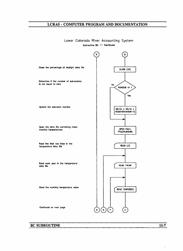
LCRAS - COMPUTER PROGRAM AND DOCUMENTATION
Lower Colorado River Accounting SystemSubroutine BC Continued
Close the percentage of daylight data file
Determine If the number of subreaches is not equal to zero
Update the subreach number
Open the data file containing mean monthly temperatures
Read the first two lines in the temperature data file
Read each year In the temperature data file
Read the monthly temperature value
Continued on next page
0
NoNUMSUB O 1
Yes
[READTEMPER(K)
©00
BC SUBROUTINE 11-7
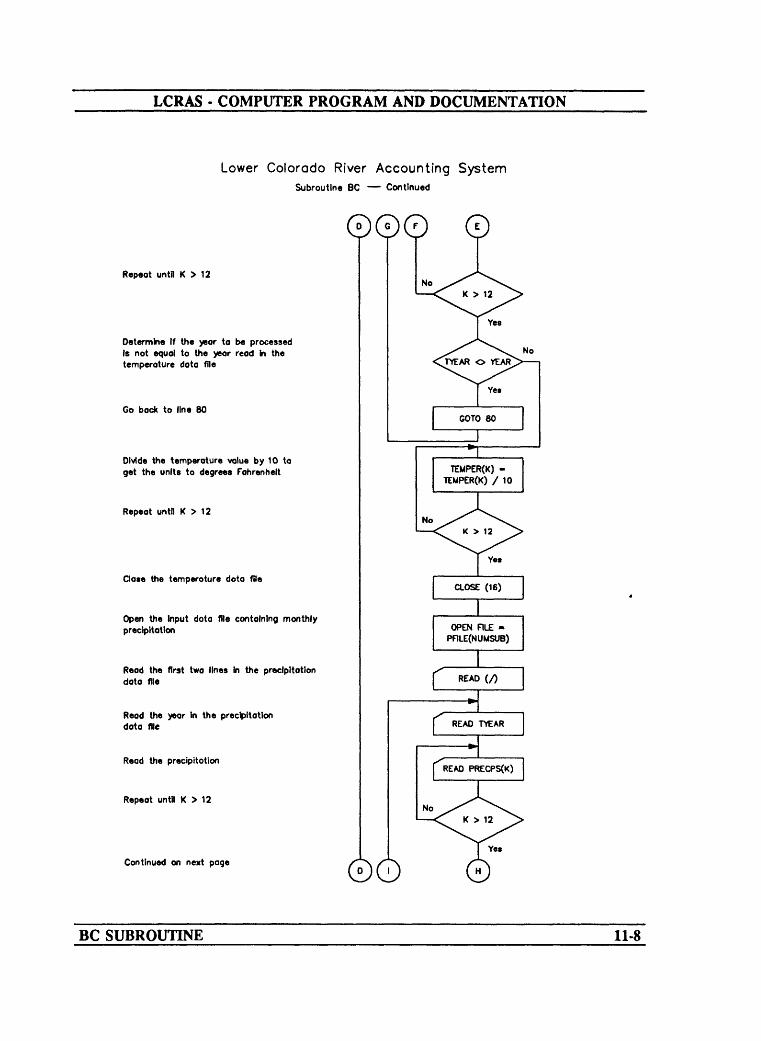
LCRAS - COMPUTER PROGRAM AND DOCUMENTATION
Lower Colorado River Accounting SystemSubroutine BC Continued
Repeat until K > 12
Determine If the year to be processed Is not equal to the year read In the temperature data file
Go bock to line 80
Divide the temperature value by 10 to get the units to degrees Fahrenheit
Repeat until K > 12
Close the temperature doto file
Open the Input dota file containing monthly precipitation
Read the first two lines In the precipitation doto file
Read the year In the precipitation data file
Read the precipitation
Repeat until K > 12
Continued on next page ©O
BC SUBROUTINE 11-8

LCRAS - COMPUTER PROGRAM AND DOCUMENTATION
Lower Colorado River Accounting SystemSubroutine BC Continued
©oDetermine if the year in the precipitation fie equals the year to be processed
Go back to line 15
Close the precipitation data file
Set the total vegetation evopotransplratlon value to zero
Set the total sparse evopotronspirotion value to zero
Set the total medium evapotranspiration value to zero
Set the total dense evapotronspiratlon value to zero
Set the water-use rote value to zero
S«t the evopotronspirotion value to zero
Determine if the vegetation name equals the crop name
Calculate the monthly water-use rate
Continued on next page 00© 0
BC SUBROUTINE 11-9

LCRAS - COMPUTER PROGRAM AND DOCUMENTATION
Lower Colorado River Accounting SystemSubroutine BC Continued
©00
Determine if the monthly water use rate Is < zero
Set the monthly water use rate equal to zero
Sum the monthly water-use rates
Repeat until K > 12
Determine If L Is > the number of crops minus three
Set the monthly water use rate equal to the first crop coefficient in the crop coefficient data file
Calculate the yearly water-use rote
Calculate the evapotransplratlon
Determine If the vegetation name Is equal to 'SPARSE*
Continued on next page
BC SUBROUTINE 11-10

LCRAS - COMPUTER PROGRAM AND DOCUMENTATION
Lower Colorado River Accounting SystemSubroutine BC Continued
0000Sum evapotronspiration for sparse phreotophytes
Determine if the vegetation name is equal to 'MEDIUM'
Sum evapotranspirotlon for medium phreotophytes
Determine If the vegetation name Is equal to 'DENSE*
Sum evapotranspirotlon for dense phreotophytes
Repeat untt L > number of vegetation types
End program If the vegetation name and crop name do not match
Change the evopotronsplrotlon value to on integer
Sum the total evapotranspirotlon
Continued on next page ©
BC SUBROUTINE 11-11
LCRAS - COMPUTER PROGRAM AND DOCUMENTATION
Lower Colorodo River Accounting SystemSubroutine BC Continued
Sum evopotronspiration for sparse phreatophytes
Change the sparse evopotronspiration value to an Integer
Change the medium evapotranspirotion value to on Integer
Change the total vegetation evapotransptratlon value to an Integer
Change the dense evapotronsplratlon value to on Integer
Repeat until I > the lost diverter
Repeat until the number of subreaches Is > the subreoch number
Sum the precipitation
Repeat until I > 12
Return to main program
> OELTA+X No NUMDIVTNUMSUB)
©
Yes
RETURNJ
BC SUBROUTINE 11-12

LCRAS - COMPUTER PROGRAM AND DOCUMENTATION
Program Listing
SUBROUTINE BC
This subroutine calculates the monthly water-use rates and the annual water-use rate for each vegetation type using the Blaney-Griddle formula. The following input files must be in a specific format: DATFIL(5), DATFIL(6), TFILE, and PFILE.
CHARACTER*40 DIVNAM(IOO) CHARACTER *2 2 DATFIL ( 15 ) , CHARACTER*20 VEGNAM(SO), INTEGER*4 NUMVEG,
****REAL* 8
***
COMMON /COMMON /COMMON >COMMON >COMMON >COMMON /COMMON >COMMON >COMMON /COMMON >COMMON >
YEARLOCLAT (10),DTOTAL (50),RCHNUM,TMTOTA,DAYLIG(12),PPTS,PRECIP(5)
' COUNTS / NUMSUB,' VEGDAT / DIVNAM,f BCTH4 / TOTALSt PPT1 / PPTS,t PHRDAT / DTOTAL,' BLCR1 / LOCLAT,f WDATA / CRPCOF,f WRATES / MWUR,' VDATA / NUMCRPf SDATA / PFILE,t IDATA / DATFIL
TFILE (10), PFILE (10) CRPNAM(SO) NUMDIV(IO), NUMSUB,DELTA, TOTALS (100LATITU, NUMMR,ETOTAL (100), NUMCRP ;STOTAL(50), ETUSED(100TETOTA, CRPCOF (50,TEMPER (12), PRECPS(12)TPRECP, MWUR (5, 25,
NUMMR, SUBNUM, RCHNUM,VEGNAM, NUMVEG, NUMDIV,
PRECIPMTOTAL, STOTALETOTAL, YEARCRPNAMWUR
TFILE
TYEAR,25), MTOTAL(50),
SUBNUM,TOT,
,25), CORVEG(IO)12), TETUSE,
TDTOTA,12), WUR(5,25),
CORVEGTOT
Read the data from DATFIL(6).
OPEN (16, FILE=DATFIL(5), STATUS='OLD', ERR =240)READ (16,'(//)', ERR = 90)K=0
10 READ (16,'(A20,12F6.2)', ERR=250, END=20) CRPNAM(K+1), * (CRPCOF(K+l,J),J=1,12)K=K+1GOTO 10
20 NUMCRP = KCLOSE (16)
DELTA = 0 PPTS = 0 DO 199 NUMSUB=1,SUBNUMWRITE (*,21) NUMSUBFORMAT (8X,'Applying Blaney-Criddle formula to subreach -',12)21
30
Read the input data from DATFIL(6).
OPEN (16, FILE=DATFIL(6), STATUS='OLD', ERR=210)READ (16,'(///)', ERR=90)READ (16,'(I2,2X,12F6.2)',ERR=260, END=90) LATITU,
(DAYLIG(K),K=1,12) IF (LATITU .EQ. LOCLAT(NUMSUB)) GOTO 50
BC SUBROUTINE 11-13

______LCRAS COMPUTER PROGRAM AND DOCUMENTATION______
GOTO 30
50 CLOSE (16) CC Read the data from the temperature input files and convert C from tenths of degrees Fahrenheit to degrees Fahrenheit. C
IF (NUMSUB .NE. 1) DELTA = DELTA + NUMDIV(NUMSUB-l) C
OPEN (16, FILE=TFILE(NUMSUB), STATUS='OLD', ERR=220) READ (16,'(/) '/ ERR=90)
80 READ (16,'(I4,12F5.0)',ERR=90,END=270) TYEAR, (TEMPER(K),K=1,12) IF (TYEAR .NE. YEAR) GOTO 80 DO 85 K=l,12
85 TEMPER(K) = TEMPER(K)/10.CLOSE (16)
CC Read the data from the precipitation input files and convert C precipitation from hundredths of inches to feet. C
OPEN (16, FILE=PFILE(NUMSUB), STATUS='OLD', ERR=230) READ (16,'(/)', ERR=290)
15 READ (16,'(I4,12F5.0)',ERR=280,END=90) TYEAR, (PRECPS(K),K=1,12) IF (TYEAR .NE. YEAR) GOTO 15 CLOSE (16)
CDO 140 I=DELTA+1, DELTA+NUMDIV(NUMSUB) TETOTA = 0 TSTOTA = 0 TMTOTA = 0 TDTOTA = 0 DO 130 J=l, NUMVEG WUR(NUMSUB,J) = 0 TETUSE = 0
CC Compute the water-use rate, in feet, for each crop and C phreatophyte-density type in each reach. C
DO 120 L=1,NUMCRPIF (VEGNAM(J) .EQ. CRPNAM(L)) THEN DO 100 K=l,12TPRECIP = PRECPS(K) IF (L .GT. NUMCRP-3) TPRECIP =0.0MWUR(NUMSUB, J,K) = (CRPCOF(L,K) *TEMPER(K) *DAYLIG(K) )
* /12. - (TPRECIP/1200.)IF (MWUR(NUMSUB, J,K) .LE. 0) MWUR (NUMSUB, J,K) = 0 MWUR (NUMSUB, J,K) =INT(MWUR (NUMSUB, J,K) *100 .+0. 5) /100 . WUR (NUMSUB, J) = WUR (NUMSUB, J) + MWUR (NUMSUB, J,K)
100 CONTINUE CC Compute the evapotranspiration, in acre-feet, for each C crop and phreatophyte-density type for each C diverter in each reach. C
TETUSE = TETUSE + WUR (NUMSUB, J) *TOTALS (I, J) IF (VEGNAM(J)(:6).EQ.'SPARSE') THEN TSTOTA = TSTOTA + TETUSE GOTO 130
END IFIF (VEGNAM(J)(:6).EQ.'MEDIUM') THEN TMTOTA = TMTOTA + TETUSE GOTO 130
END IF
BC SUBROUTINE 11-14

LCRAS - COMPUTER PROGRAM AND DOCUMENTATION
IF (VEGNAM(J)(:5).EQ.'DENSE') THEN TDTOTA = TDTOTA + TETUSE GOTO 130
END IF GOTO 125
END IF 120 CONTINUE
STOP 125 ETUSED(I,J) = INT( (TETUSE-»-.005) *100 .) /100.
TETOTA = TETOTA + TETUSE 130 CONTINUE
STOTAL(I) = INT(TSTOTA+0.5) MTOTAL(I) = INT(TMTOTA-»-0.5) ETOTAL(I) = INT(TETOTA-»-0.5) DTOTAL(I) = INT(TDTOTA+0.5)
140 CONTINUEDO 40 I =1,12
PPTS = PPTS + PRECPS(I)/1200 40 CONTINUE
199 CONTINUEPPTS = INT((PPTS / SUBNUM) * 100 + .5) / 100. PRECIP(RCHNUM) = PPTS RETURN
CC Error messages C
90 WRITE (*,201)201 FORMAT (//,20X,'ERROR - DATA READING')
STOP240 WRITE (*,241)241 FORMAT (//,20X,'ERROR - READING KC.DATA')
STOP210 WRITE (*,211)211 FORMAT (//,20X,'ERROR - READING LIGHT.DATA')
STOP220 WRITE (*,221)221 FORMAT (//,20X,'ERROR - READING TEMPERATURE FILE')
STOP230 WRITE (*,231)231 FORMAT (//,20X,'ERROR - READING PRECIPITATION FILE')
STOP250 WRITE (*,251)251 FORMAT (//,20X,'ERROR - READING CRPNAM')
STOP260 WRITE (*,261)261 FORMAT (//,20X,'ERROR - READING LATITUDE')
STOP270 WRITE (*,271)271 FORMAT (//,20X,'ERROR - READING TEMPERATURE')
STOP280 WRITE (*,281)281 FORMAT (//,2OX,'ERROR - READING PRECIPITATION')
STOP290 WRITE (*,291)291 FORMAT (//,20X,'ERROR - READING FIRST LINE')
STOP END
BC SUBROUTINE IMS
12.- I

LCRAS - COMPUTER PROGRAM AND DOCUMENTATION
SUBROUTINE BWR
Narrative
Subroutine BWR, by using equation 12, computes the streamflow in the Bill Williams River that reaches the Colorado River. This inflow is one of the components in the water budget for the Davis Dam to Parker Dam reach. Evapotranspiration from vegetation along the river, as well as the net vegetated acreage, are summed. Once flow into the Colorado River is calculated, each quantity in the water budget is written to an output file.
Variable List
Name Common Description
AREAS(5)
BILOUT
BWRET
[INDATA] Open-water surface area along the Bill Williams River below Alamo Dam.
[RDAT4] Streamflow from the Bill Williams River to the Davis Dam to Parker Dam reach.
Total evapotranspi ration by crops and phreatophytes along the Bill Williams River.
CORVEG(NUMSUB) [COUNTS] Total net vegetated area for the Bill Williams River.
DTOTAL(K) [PHRDAT] Total evapotranspiration for dense phreatophytesalong the Bill Williams River.
ETOTAL(100) [BLCR1] Integer value for total evapotranspiration forcrops.
EVAPS(5) [INDATA] Evaporation rate for the open-water surface areaalong the Bill Williams River.
FLOWS(5) [INDATA] Flow in the Bill Williams River below AlamoDam.
BWR SUBROUTINE 12-1

LCRAS - COMPUTER PROGRAM AND DOCUMENTATION
Name Common Description
MTOTAL(K)
NETACR
NUMSUB
NUMVEG
PPTS
STOTAIXK)
SUBNUM
TRTOS(10)
TRTOS(16)
[PHRDAT] Total evapotranspiration for the medium phreatophytes along the Bill Williams River.
Total net vegetated area along the Bill Williams River.
[COUNTS] Number of subreaches in the Bill Williams River reach.
[ VEGDAT] Number of vegetation types read from the image- processing input data files.
[PPT1] Total precipitation for the Bill Williams River reach.
Total evapotranspiration for sparse phreatophytes along the Bill Williams River.
[COUNTS] Subreach number currently being processed.
[INDATA] Unmeasured average annual runoff to the Bill Williams River.
[INDATA] Ground-water discharge to the Bill Williams River.
BWR SUBROUTINE 12-2
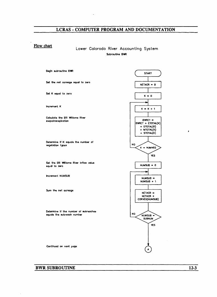
LCRAS COMPUTER PROGRAM AND DOCUMENTATION
Flow chartLower Colorado River Accounting System
Subroutine BWR
Begin subroutine
Set the net acreage equal to zero
Set K equal to zero
Increment K
Calculate the Bill Williams River evopotranspration
Determine If K equals the number of vegetation types
Set the Bill Williams River Inflow value equal to zero
Increment NUMSUB
Sum the net acreage
Determine if the number of subreaches equals the subreoch number
C START J
NETACR - 0
NO
Continued on next page
YES
BWR SUBROUTINE 12-3

LCRAS - COMPUTER PROGRAM AND DOCUMENTATION
Lower Colorado River Accounting SystemSubroutine BW? Continued
Compute Inflow to the Davls Oom to Parker Dam reach
Write the identification heading to the output file for the BM Williams River
Write the surface-water area for the Bill Williams River to the output file
Write the evaporation rate to the output file for the Bill Wlllams River
x/WRITE AREAS(5)x^~ I '
x^WRITE £VAPS(5V/
Write the evaporation from open water surface areas to the output file for the Bill Williams River
/WRITE AREAS(5) EVAPS(5) /
Write the omount of precipitation to the output file for the Bffl Williams River
Write the precipitation value to the output file for the BM Williams River
Write the Inflow to the Oovis to Porker Dam reach
Return to the main program
) WRITE (AREAS(5y A NETACR)«PPTS /
WRITE PPTS
WRITE BILOUT7C RETURN
BWR SUBROUTINE 12-4

LCRAS COMPUTER PROGRAM AND DOCUMENTATION
Program Listing
SUBROUTINE BWR
This subroutine calculates the streamflow in the Bill Williams River that enters the Colorado River.
CHARACTER*40 DIVNAM(IOO)CHARACTER*20 VEGNAM(SO)INTEGER*4 LOCLAT(IO) ,
* NUMMR,* NUMVEG,
RCHNUM, TOT,
NUMSUB, NUMDIV(IO)
DTOTAL(50), MTOTAL(50)
REAL*8ETOTAL(IOO), CORVEG(IO) FLOWS(30), DUS(20), AREAS(20), BWRET,
TRIES(40) EVAPS(20), RCHTS(5),
SUBNUM, YEAR STOTAL(50),
PPTS, BILOUT,
NETACR, PRECIP(5)
COMMON / RDAT4 / BILOUTCOMMON / BLCR1 / LOCLAT, ETOTAL, YEARCOMMON / INDATA / FLOWS, TRIES, AREAS, EVAPS, DUS, RCHTSCOMMON / PPT1 / PPTS, PRECIPCOMMON / VEGDAT / DIVNAM, VEGNAM, NUMVEG, NUMDIV, TOTCOMMON / PHRDAT / DTOTAL, MTOTAL, STOTALCOMMON / COUNTS / NUMSUB, NUMMR, SUBNUM, RCHNUM, CORVEG
NETACR = 0
Calculate the total crop and phreatophyte evapotranspiration.
DO 30 K = 1, NUMVEGBWRET = BWRET + ETOTAL (K) + DTOTAL (K) + MTOTAL (K) + STOTAL (K)
30 CONTINUE
Calculate the total acreage minus the double-cropped area.
DO 50 NUMSUB = 1,SUBNUMNETACR = NETACR + CORVEG(NUMSUB)
50 CONTINUE
Calculate the streamflow in the Bill Williams River that enters the Colorado River.
120 BILOUT = FLOWS(5) + TRIES(10) + TRIES(16) - BWRET - * (AREAS(5)*EVAPS(5)) + (AREAS (5) +NETACR) * PPTS
Write the open-water surface area, evaporation rate, area times evaporation rate, precipitation, precipitation rate, and flow to the Colorado River from the Bill Williams River to the output file.
WRITE 60 FORMAT
WRITE WRITE WRITE WRITE WRITE WRITE
65 FORMAT66 FORMAT
(58,60,ERR=250)(2X,'BILL WILLIAMS REACH')
(58,65,ERR=250) AREAS(5) (58,66,ERR=250) (58,67,ERR=250) (58,69,ERR=250) (58,70,ERR=250)(58,71,ERR=250)
EVAPS(5)AREAS(5)*EVAPS(5) (AREAS(5)+NETACR)* P PTS PPTS BILOUT
(4X,'AREAS(5)'18X,F9.2) (4X,'EVAPS(5)'18X,F9.2)
BWR SUBROUTINE 12-5

LCRAS - COMPUTER PROGRAM AND DOCUMENTATION
67 FORMAT (4X, 'AREAS(5)*EVAPS(5)'9X,F9.2) 69 FORMAT (4X,'(AREAS(5)+NETACR)*PPTS'4X,F9.2)
(4X, 'PRECIPITATION'13X,F9.2)FLOW TO COLORADO RIVER'1X,F12.2)
70 FORMAT71 FORMAT (4X,
RETURN
Error messages.
250 WRITE (*,251)251 FORMAT (//,20X,'ERROR - WRITING TO FILE 58')
STOP END
BWR SUBROUTINE 12-6

LCRAS - COMPUTER PROGRAM AND DOCUMENTATION
SUBROUTINE HV2ML
Narrative
Subroutine HV2ML calculates consumptive use by vegetation along the Colorado River between Hoover Dam and Morelos Dam by using equation 8. This subroutine also produces a table for the Hoover Dam to Morelos Dam reach that lists evapotranspiration, percentage of evapotranspiration, and consumptive use by vegetation for each diverter (attachment O).
Variable List
Name
AREAS(l)
AREAS(2)
AREAS(3)
AREAS(4)
BILOUT
DUS(l)
DUS(2)
DUS(3)
HV2ML SUBROUTINE
Common
[INDATA]
[INDATA]
[INDATA]
[INDATA]
[RDATA4]
[INDATA]
[INDATA]
[INDATA]
Description
Open-water surface area in the reach between Hoover Dam and Davis Dam.
Open-water surface area in the reach between Davis Dam and Parker Dam.
Open-water surface area in the reach between Parker Dam and Imperial Dam.
Open- water surface area in the reach between Imperial Dam and Morelos Dam.
Inflow from the Bill Williams River, calculated with the BWR subroutine.
Domestic water use along the reach between Hoover Dam and Davis Dam.
Domestic water use along the reach between Davis Dam and Parker Dam.
Domestic water use along the reach between Parker Dam and Imperial Dam.
13-1

LCRAS - COMPUTER PROGRAM AND DOCUMENTATION
Name
DUS(4)
EVAPS(l)
EVAPS(2)
EVAPS(3)
EVAPS(4)
FLOWS(l)
FLOWS(2)
FLOWS(3)
FLOWS(4)
FLOWS(6)
FLOWS(7)
FLOWS(8)
FLOWS(9)
FLOWS(IO)
FLOWS(13)
FLOWS(15)
FLOWS(17)
HV2ML SUBROUTINE
Common
[INDATA]
[INDATA]
[INDATA]
[INDATA]
[INDATA]
[INDATA]
[INDATA]
[INDATA]
[INDATA]
[INDATA]
[INDATA]
[INDATA]
[INDATA]
[INDATA]
[INDATA]
[INDATA]
[INDATA]
Description
Domestic water use along the reach between Imperial Dam and Morelos Dam.
Evaporation rate for the reach between Hoover Dam and Davis Dam.
Evaporation rate for the reach between Davis Dam and Parker Dam.
Evaporation rate for the reach between Parker Dam and Imperial Dam.
Evaporation rate for the reach between Imperial Dam and Morelos Dam.
Measured discharge below Hoover Dam.
Change in storage in Lake Mohave.
Measured discharge below Davis Dam.
Outflow in the Colorado River Aqueduct
Outflow in the Central Arizona Project Canal
Change in storage in Lake Havasu.
Measured discharge below Parker Dam.
Change in storage in Senator Wash Reservoir.
Measured flow above Imperial Dam.
Outflow in the All American Canal below Pilot Knob.
Outflow in the Wellton-Mohawk Canal
Inflow from the Gila River near Dome.
13-2

LCRAS - COMPUTER PROGRAM AND DOCUMENTATION
Name
FLOWSU8)
FLOWS(19)
FLOWS(20)
FLOWS(21)
FLOWS(22)
FLOWS(23)
FLOWS(22)
NETACR
PRECIP(1)
PRECIP(2)
PRECIP(3)
PRECIP(4)
TRffiS(l)
TRffiS(2)
HV2ML SUBROUTINE
Common
[INDATA]
[INDATA]
[INDATA]
[INDATA]
[INDATA]
[INDATA]
[INDATA]
[PPT1]
[PPT1]
[PPT1]
[PPT1]
[INDATA]
[INDATA]
Description
Measured outflow at the Northerly InternationalBoundary.
Surface-water return flow from Eleven Milewaste way.
Surface-water return flow from Cooperwaste way.
Surface-water return flow from Twenty-OneMile wasteway.
Surface-water return flow from Main Drain.
Surface-water return flow from West MainCanal wasteway.
Surface-water return flow from East Main Canalwasteway.
Net acreage of crops along the reach.
Precipitation for each area in the reach betweenHoover Dam and Davis Dam.
Precipitation for each area in the reach betweenDavis Dam and Parker Dam.
Precipitation for each area in the reach betweenParker Dam and Imperial Dam.
Precipitation for each area in the reach betweenImperial Dam and Morelos Dam.
Ground-water discharge from springsdownstream from Hoover Dam.
Unmeasured average annual runoff along thereach.
13-3

LCRAS - COMPUTER PROGRAM AND DOCUMENTATION
Name Common Description
TRTOS(3)
TRTOS(4)
TRTOS(5)
TRTOS(6)
TRmS(7)
TRTOS(8)
TRIBS(9)
TRTOS(ll)
TRmS(12)
TRTOS(13)
TRTOS(14)
TRffiS(15)
TRTOS(17)
TRffiS(18)
[INDATA]
[INDATA]
[INDATA]
[INDATA]
[INDATA]
[INDATA]
[INDATA]
[INDATA]
[INDATA]
[INDATA]
[INDATA]
[INDATA]
[INDATA]
[INDATA]
Ground-water discharge from the Colorado River valley.
Ground-water discharge from Eldorado Valley.
Unmeasured average annual runoff from Davis Dam to Topock.
Unmeasured average annual runoff from Topock to Parker Dam.
Unmeasured average annual runoff from the Whipple Mountains.
Unmeasured tributary inflow from Piute Wash.
Unmeasured tributary inflow from Sacramento Wash.
Ground-water discharge from Davis Dam to Topock.
Ground-water discharge from Topock to Parker Dam.
Ground-water discharge from Piute Valley.
Ground-water discharge from Sacramento Valley.
Ground-water discharge from Chemehuevi Valley.
Unmeasured average annual runoff from the Whipple Mountains.
Unmeasured average annual runoff from the BigMaria Mountains.
HV2ML SUBROUTINE 13-4

LCRAS - COMPUTER PROGRAM AND DOCUMENTATION
Name Common Description
TRTOS(19)
TRTOS(20)
TRTOS(21)
TRTOS(22)
TRffiS(23)
TRTOS(24)
TRTOS(25)
TRTOS(26)
TRTOS(27)
TRTOS(28)
TRTOS(29)
TRTOS(30)
TRTOS(31)
[INDATA] Unmeasured average annual runoff from the Palo Verde-Mule Mountains.
[INDATA] Unmeasured average annual runoff from Dome Rock-Trigo-Chocolate Mountains.
[INDATA1 Unmeasured tributary inflow from Vidal Wash.
[INDATA] Unmeasured tributary inflow from Bouse Wash.
[INDATA] Unmeasured tributary inflow from Tyson Wash.
[INDATA] Unmeasured tributary inflow from McCoy Wash.
[INDATA] Unmeasured tributary inflow from Milpitas Wash.
[INDATA] Ground-water discharge from Vidal Wash.
[INDATA] Ground-water discharge from Bouse Wash.
[INDATA] Ground-water discharge from Tyson Wash.
[INDATA] Ground-water discharge from Chuckwalla Valley.
[INDATA] Unmeasured average annual runoff along the reach.
[INDATA] Ground-water discharge near Dome.
HV2ML SUBROUTINE 13-5

LCRAS - COMPUTER PROGRAM AND DOCUMENTATION
Flow chart
Lower Colorado River Accounting SystemSubroutine HV2ML
Begin subroutine HV2ML
Set the FOTOT (tow into the river) to Include FLOWS(1). BILOUT. and FLOWS(17)
Set I equal to tero for uee ra o counter
Increment I
Add total precipitation falling on the vegetated area to the total (low
Determine If all the eubreoches hove been added
Set I equal to nro for use o» o counter
Increment I
Add oH the tributary values in the data fie to the total flow
Determine If all the tributaries hove been added
Subtract all tributary inflow* used for Bin Wfllioms River and subtract oN exported flows from the total flow in the reach
START
FDTOT - FDTOT(ARCAS(l)+FDACR(l)) PREdP(0
-(AREAS(I)« VAPS(I))- DUS(I)
NO
FDTOT -
TRIB(I)FDTOT +
NO32
YES
FDTOT * FDTOT-FUOWS{2) - FLOWS(4)-FLOW'S^) - FLOWS(75-FLOWS(9) - TRIBSOO)-TW8S06) - FLOWS(U)-FUOWS(>5) - FLOWS(18-FLOWSf>9) - FLOWS(20-FLOWS(21) - FLOWS(22-FUOWS(23) - FLOWS/2*
Continued on next page
HV2ML SUBROUTINE 13-6

LCRAS - COMPUTER PROGRAM AND DOCUMENTATION
Lower Colorado River Accounting SystemSubroutine HV2ML Continued
Reset PTOT to zero
Set I equal to zero for uee oe a counter
Increment
Calculate the amount of evaporation from the open water *urface and add to PTOT
Determine If all the subreoches have been added
WHte the evaporation for the reach and the sum of the domestic uee values to a verification fie
Reset PTOT for another use
Set I equal to zero for use as a counter
Increment I
Calculate the amount of precipitation that falls on the open-water surface oreae and the total vegetated area along the reach
Determine If all the eubreaches have been added
Write the precipitation value, the sum of the precipitation rates, and the total consumptive use along the reach
Continued on next page
PTOT - PTOT AREAS(I)« VAPS<I)
YES
PTOT I EVAPS
AREASOKVAPSO) IDUS
HV2ML SUBROUTINE 13-7

LCRAS - COMPUTER PROGRAM AND DOCUMENTATION
Lower Colorado River Accounting SystemSubroutine HV2ML Continued
Set I quo) to zero for use as o counter
Increment I
Check to see If the dlverter Is flagged to be skipped with an V
Reduce the number of dlverters by one
Set J equal to 1-1 for use as o counter
Increment J
Move the diverter name and the dlverter ET total up In the array to fill the slat left by removing the flogged dlverter
Repeat for all the dlverters
Repeat for all the dlverters
Set I equal to zero for use as a counter
Increment I
Set J equal to zero for use as a counter
Increment J
Continued on next page
FDNAMEfJ)-FDNAUE(J-M) FDETOT(J)-FDETOT(J+1)
NO
HV2ML SUBROUTINE 13-8

LCRAS - COMPUTER PROGRAM AND DOCUMENTATION
Lower Colorado River Accounting SystemSubroutine HV2ML Continued
Check to eee If the dtverter name appear* in the array
Add the ET totals for the dlverter that appears twice
Decrease the number af diverters by one
Set K equal to J-1 for use as a counter
Increment K by one
Move the dlverter names and ET totals down In the matrix to replace the duplicate dlverter name
Repeat for oil the remaining diverters
Repeat for all the diverters
Repeat for oil the diverters minus one
Reset ETOT to zero
Reset I to zero far use as a counter
Increment I by one
Continued on next page
I
FDI FD
NO
NO
NO
YES
FDETOT(I) - FDETOT(I) 4 FDETOT(J)
FONUM - FDNUM-1
FDNAMEfK) - FDNAME(K+1) FDETOT(K) - FDETOT(K+1)
HV2ML SUBROUTINE 13-9

LCRAS - COMPUTER PROGRAM AND DOCUMENTATION
Lower Colorado River Accounting SystemSubroutine HV2ML Continued
Check to see If the dtverter name starts with PHRE
Change the name of the dtverter to 2222 so It Is sorted last
Repeat for alt dlvertera
Reset I to zero for use os a counter
Increment I by one
Reset J to zero for use as a counter
Increment J by one
Check to see if the dtverter names ore In alphanumeric order
Switch the diverter name with the one after It to put them In order
Switch the evopotronspfrotion total to match the switch of the dtverter names
Check if J is greater than the total number of divertera minus I
Continued on next page
FDNAME(I) - '2222' 4 FDNAME(I)
T FDNAME(J+1) FDNAME(J+1) - FONAME(J) FDNAME(J) - T
TOTE - FDETOT(J+1) FDETOT(J+1) - FDETOT(J) FDETOT(J) - TOTE
HV2ML SUBROUTINE 13-10

LCRAS - COMPUTER PROGRAM AND DOCUMENTATION
Lower Colorado River Accounting SystemSubroutine HV2ML Continued
Check to see If I Is greater than the total number of dlverters minus one
Read In the number of lines In the title and the name of the output file
Open the file TNAME for output to print the complete table
Reset I to zero for use as a counter
Increment I by one
Read a line for the table title from the title data file
Write the table title line to the output file
Continue reading and writing the title for XUNES of lines
Write the headings for the table, these are hard coded In the program
Set CK to the State code for the frst dlverter to be used to separate the States on the table
Write the first State name. 'ARIZONA'
Set all af the total variables to zero for calculation during the printing processes
Continued on next page
WRITE THE HEADINGS FOR THE TABLE; OIVERTER. EVAPOTRANS- PIRATION. PERCENTAGE. AND CONSUMPTIVE USE
HV2ML SUBROUTINE 13-11

LCRAS - COMPUTER PROGRAM AND DOCUMENTATION
Lower Colorado River Accounting SystemSubroutine HV2ML Continued
Reset I to zero for use as a counter
Increment I by one
Add the evopotransplratlon, percentage, consumptive use, and total percentage to their respective total variables
Check If o dlverter In o new stote is next and branch to print totals
Check to see If the current State is Arizona
Print out the totals for the Stote of Arizona
Check to see if the current State Is California
Print out the totals for the State of California
Check to see If the current State Is Nevada
Print out the totals for the State of Nevada
Continued on next page
P - FDETOT(l)/ETOT 100 C - P » FDTOT/100. TOTE - TOTE + FDETOT(I) TOTP » TOTP -f P TOTC - TOTC + C PTOT - PTOT -f P
WRITE Totals for Arizona' WRITE TOTE. TOTP. TOTC
VWJTE 'Totals for California' S. WRITE TOTE. TOTP. TOTC
WRITE Totals for Nevada' WRITE TOTE. TOTP. TOTC
HV2ML SUBROUTINE 13-12

LCRAS - COMPUTER PROGRAM AND DOCUMENTATION
Lower Colorado River Accounting SystemSubroutine HV2ML Continued
Reset the State total counters for the evapotransplrotlon. percentage, and consumptive use
Set CK to the State code for the next set of diverters
Check to see If the new State is California
Print out the heading for the State of California
Check to see if the new State is Nevada
Print out the heading for the State of Nevada
Check to see if the new State Is Federal Lands
Print out the heading for the State of Federal Lands
Check to see if the diverter name has been changed to '2222'
Change the diverter name bock from '222? to 'Phreotophytes'
Continued on next page
FDNAME(I) - CK + Phreotophytes
HV2ML SUBROUTINE 13-13

LCRAS - COMPUTER PROGRAM AND DOCUMENTATION
Lower Colorado River Accounting SystemSubroutine HV2ML Continued
Write the dlverter name, total vapotronsplrotlon, percentage, and estimated consumptive use
Repeat loop for all dlverters
Wt-lte the total line for the Federal Lands
Write the totol line for the reach from Hoover Dam to Morelos Dam
Close output file 69
Return to main program
©F
WRITE FDNAMEO), FDETOTO)., P, C f
WRITE 'Totals for Federal Lands', TOTE. TOTP. TOTC
WRITE 'Water Budget Estimate' ETOT. PTOT. FDTOT
CLOSE. TNAME
C RETURN
HV2ML SUBROUTINE 13-14
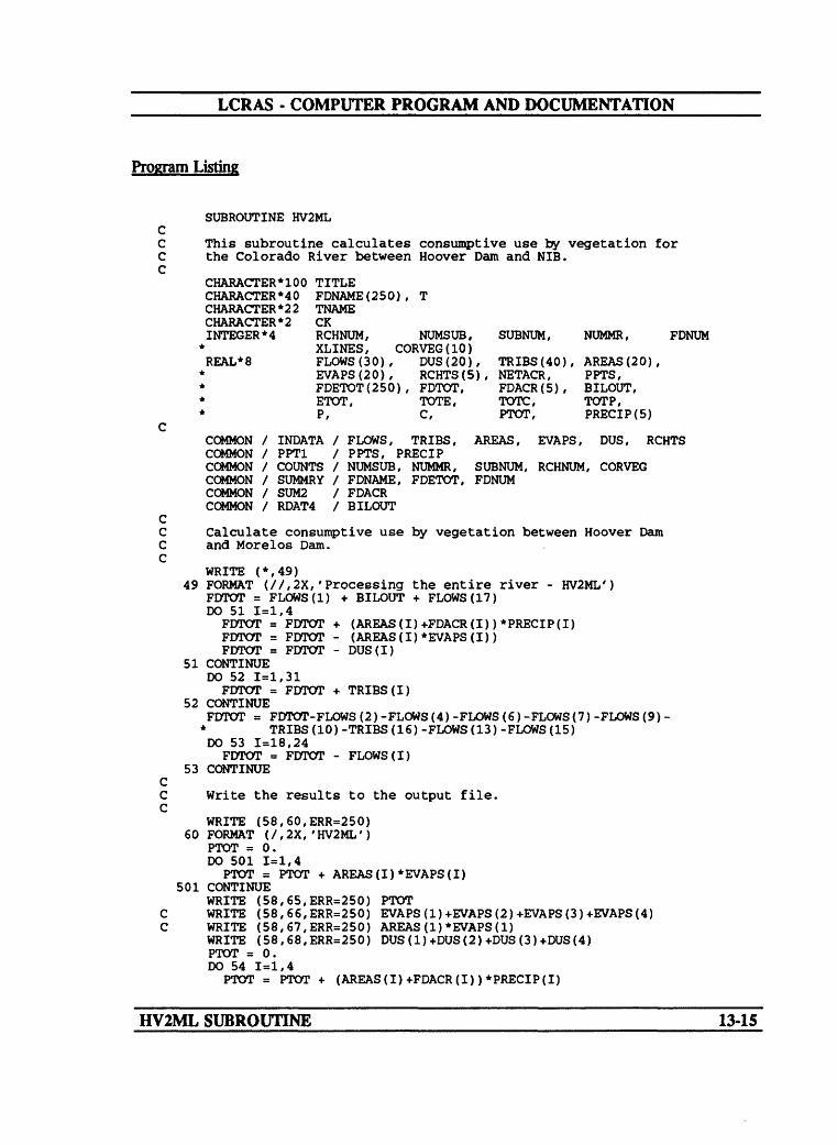
LCRAS - COMPUTER PROGRAM AND DOCUMENTATION
Program Listing
SUBROUTINE HV2ML
This subroutine calculates consumptive use by vegetation for the Colorado River between Hoover Dam and NIB.
CHARACTER*100 TITLE CHARACTER*40 FDNAME(250), T CHARACTER*22 TNAME CHARACTER * 2INTEGER*4 RCHNUM, NUMSUB, SUBNUM, NUMMR, FDNUM
" XLINES, CORVEG(IO) REAL*8
COMMON COMMON COMMON COMMON COMMON COMMON
CKRCHNUM, NUMSUB,XLINES, CORVEG(IO)FLOWS (30), DUS(20),EVAPS(20), RCHTS(5),FDETOT(250), FDTOT,ETOT, TOTE,P, C,
SUBNUM,
TRIES (40),NETACR,FDACR(5) ,TOTC,PTOT,
NUMMR,
AREAS (20)PPTS,BILOUT,TOTP,PRECIP(5)
/ INDATA / FLOWS, TRIES, AREAS, EVAPS, DUS, RCHTS/ PPT1 / PPTS, PRECIP/ COUNTS / NUMSUB, NUMMR, SUBNUM, RCHNUM, CORVEG/ SUMMRY / FDNAME, FDETOT, FDNUM/ SUM2 / FDACR/ RDAT4 / BILOUT
Calculate consumptive use by vegetation between Hoover Dam and Morelos Dam.
WRITE (*,49)49 FORMAT (//,2X,'Processing the entire river - HV2ML')
FDTOT = FLOWS(1) + BILOUT + FLOWS(17) DO 51 1=1,4FDTOT = FDTOT + (AREAS(I)+FDACR(I))*PRECIP(I)FDTOT = FDTOT - (AREAS(I)*EVAPS(I))FDTOT = FDTOT - DUS(I)
51 CONTINUEDO 52 1=1,31FDTOT = FDTOT + TRIES(I)
52 CONTINUEFDTOT = FDTOT-FLOWS(2)-FLOWS(4)-FLOWS(6)-FLOWS(7)-FLOWS(9)-
* TRIES(10)-TRIES(16)-FLOWS(13)-FLOWS(15) DO 53 1=18,24FDTOT = FDTOT - FLOWS(I)
53 CONTINUE
Write the results to the output file.
WRITE (58,60,ERR=250) 60 FORMAT (/,2X,'HV2ML')
PTOT = 0. DO 501 1=1,4
PTOT = PTOT + AREAS(I)*EVAPS(I) 501 CONTINUE
WRITE (58,65,ERR=250) PTOTWRITE (58,66,ERR=250) EVAPS(1)+EVAPS(2)+EVAPS(3)+EVAPS(4)WRITE (58,67,ERR=250) AREAS(1)*EVAPS(1)WRITE (58,68,ERR=250) DUS(1)+DUS(2)+DUS(3)+DUS(4)PTOT = 0.DO 54 1=1,4
PTOT = PTOT + (AREAS(I)+FDACR(I))*PRECIP(I)
HV2ML SUBROUTINE 13-15

LCRAS - COMPUTER PROGRAM AND DOCUMENTATION
54 CONTINUEWRITE (58,69,ERR=250) PTOTWRITE (58,70,ERR=250) PRECIP(l)+PRECIP(2)+PRECIP(3)+PRECIP(4)WRITE (58,71,ERR=250) FDTOT
65 FORMAT (4X,'SUM(AREAS*EVAPS)'10X,F9.2)66 FORMAT (4X,'EVAPS(1)'18X,F9.2)67 FORMAT (4X,'AREAS(1)*EVAPS(1)'9X,F9.2)68 FORMAT (4X,'DUS(SUM)'18X,F9.2)69 FORMAT (4X,'SUM(AREAS+NETACR)*PPTS'4X,F9.2)70 FORMAT (4X,'SUM PRECIPITATION'9X,F9.2)71 FORMAT (4X,'CONSUMPTIVE USE'SX,F12.2)
WRITE (*,72) FDTOT72 FORMAT (1OX,'Consumptive use for the entire river is ',F12.2)
CC Remove any diverters flagged with a '*' in the third column. C
DO 666 1=1, FDNUMIF (FDNAME(I) (3:3) .EQ. '*') THEN
FDNUM = FDNUM-1 DO 667 J=I,FDNUM
FDNAME(J) = FDNAME(J+1) FDETOT(J) = FDETOT(J+1)
667 CONTINUEEND IF
666 CONTINUE CC Remove any diverter that may appear twice. C
DO 101 1=1, FDNUM-1 DO 102 J=I+1,FDNUM
IF (FDNAME(I) .EQ. FDNAME(J)) THEN FDETOT(I) = FDETOT(I) + FDETOT(J) FDNUM = FDNUM -1 DO 103 K=J,FDNUM
FDNAME(K) = FDNAME(K+1) FDETOT(K) = FDETOT(K+1)
103 CONTINUEEND IF
102 CONTINUE 101 CONTINUE
CC Change the name of the phreatophyte-density types to place C them last when the diverters are sorted. C
ETOT = 0DO 111 1=1,FDNUM
IF (FDNAME(I) (4:7) .EQ. 'PHRE') THEN FDNAME(I) = FDNAME(I)(:3) // 'ZZZZ'
END IFETOT « ETOT + FDETOT(I)
111 CONTINUE CC Sort the remaining diverters by State and name. C
DO 121 1=1,FDNUM DO 122 J=l,FDNUM-1
IF (FDNAME(J) .GT. FDNAME(J+1)) THEN T = FDNAME(J+1) FDNAME(J+1) = FDNAME(J) FDNAME(J) = T TOTE = FDETOT(J+1) FDETOT(J+1) = FDETOT(J) FDETOT(J) = TOTE
HV2ML SUBROUTINE 13-16

LCRAS - COMPUTER PROGRAM AND DOCUMENTATION
END IF122 CONTINUE 121 CONTINUE
CC Open the output file and print the title. C
READ (62, '(I2,A22)', ERR=260) XLINES, TNAME OPEN (69, FILE=TNAME, ERR=260) DO 126 1=1, XLINESREAD (62,'(A100)', ERR=260) TITLE WRITE (69,'(5X,A100)',ERR=260) TITLE
126 CONTINUEWRITE (69,' (/) ') WRITE (69,100,ERR=260)
100 FORMAT ('Diverter',21x, 'Evapotranspiration',7X, * 'Percentage',4x,'Consumptive use') WRITE (69,'(2X)')
CC Write the data to the output file. Keep track of the State and C when it changes, write the subtotals for each State. C
CK = FDNAME(l)(:2) WRITE (69,301)
301 FORMAT (2X,'ARIZONA') WRITE (69,'(2X)') TOTE = 0. TOTP = 0. TOTC = 0. PTOT = 0. DO 131 1=1, FDNUM
P = FDETOT(I)/ETOT * 100. C = P*FDTOT /100. TOTE = TOTE + FDETOT(I) TOTP = TOTP + P PTOT = PTOT + P TOTC = TOTC + CIF (FDNAME(I)(:2) .NE. CK) THEN WRITE (69,'(2X)')IF (CK .EQ. 'AZ') WRITE (69,302) TOTE, TOTP, TOTC IF (CK .EQ. 'CA') WRITE (69,303) TOTE, TOTP, TOTC IF (CK .EQ. 'NV') WRITE (69,304) TOTE, TOTP, TOTC
302 FORMAT (2X,'Totals for Arizona ',3X,F16.0,F17.2,F16.0,//)303 FORMAT (2X,'Totals for California ',3X,F16.0,F17.2,F16.0,//)304 FORMAT (2X,'Totals for Nevada ',3X,F16.0,F17.2,F16.0,//)
TOTE = 0. TOTP = 0. TOTC = 0.CK = FDNAME(I)(:2) IF (CK .EQ. 'CA' ) WRITE (69,306) IF (CK .EQ. 'NV' ) WRITE (69,307) IF (CK .EQ. 'US' ) WRITE (69,308)
306 FORMAT (2X,'California',///)307 FORMAT (2X,'Nevada',///)308 FORMAT (2X,'Federal Lands',///)
END IFIF (FDNAME(I)(4:7) .EQ. 'ZZZZ') THEN
FDNAME(I) = CK // ' PHREATOPHYTES' END IF WRITE (69,309) FDNAME(I), FDETOT(I) , P, C
309 FORMAT (4X,A20,9X,F12.0,9X,F8.2,4X,F12.0) 131 CONTINUE
WRITE (69,305) TOTE, TOTP, TOTC 305 FORMAT (2X,'Totals for Federal Lands',3X,F16.0,F17.2,F16.0,//)
HV2ML SUBROUTINE 13-17

LCRAS - COMPUTER PROGRAM AND DOCUMENTATION
WRITE (69,133) ETOT,PTOT,FDTOT 133 FORMAT (2X, 'Water-Budget Estimate',10X,F12.0,11X,F6.2,4X,F12.0)
CLOSE (69)RETURN
CC Error messages C
250 WRITE (*,251)251 FORMAT (//, 20X, 'ERROR - WRITING TO FILE 58')
STOP260 WRITE (*,261)261 FORMAT (//,20X, 'ERROR - READING TITLE')
STOP END
HV2ML SUBROUTINE 13-18

LCRAS - COMPUTER PROGRAM AND DOCUMENTATION
SUBROUTINE HV2DV
Narrative
Subroutine HV2DV calculates consumptive use by vegetation along the Colorado River between Hoover Dam and Davis Dam by using equation 8. This subroutine appends open-water surface area, evaporation rate, evaporated water, domestic use, total precipitation that falls on the vegetated area, yearly precipitation, and the total consumptive use for the reach to the summary table (attachment Q).
Variable List
Name
AREAS(l)
DUS(l)
EVAPSd)
FLOWS(l)
FLOWS(2)
FLOWS(3)
NETACR
PPTS
RCHTS(l)
Common
[INDATA]
[INDATA]
[INDATA]
[INDATA]
[INDATA]
[INDATA]
[PPT1]
[INDATA]
Description
Open-water surface area within the reach.
Domestic water use along the reach.
Evaporation rate for the reach.
Measured discharge below Hoover Dam.
Change in storage in Lake Mohave.
Measured discharge below Davis Dam.
Net acreage of crops along the reach.
Precipitation for each area in the reach.
Consumptive use by vegetation along the
TRffiSO)
reach.
[INDATA] Ground-water discharge from springs downstream from Hoover Dam.
HV2DV SUBROUTINE 14-1

LCRAS - COMPUTER PROGRAM AND DOCUMENTATION
Name_____________Common___________Description
TRIBS(2) [INDATA] Unmeasured average annual runoff alongthe reach.
TRIBS(3) [INDATA] Ground-water discharge from theColorado River valley.
TRIBS(4) [INDATA] Ground-water discharge from EldoradoValley.
HV2DV SUBROUTINE 14-2

LCRAS - COMPUTER PROGRAM AND DOCUMENTATION
Flow ChartLower Colorado River Accounting System
Subroutine HV2DV
Begin «ibroutln« HV2DV C START
Set th« n«t acr«ag« equal to zero
Set NUUSUB equal to zero for use as a counter
Increment NUMSUB
Calculate the net acreage by adding the corrected vegetation areas for each «j breach
Determine If the number of subreaches equals the subreach number
NETACR - 0
Calculate consumptive use by vegetation for the reach from Hoover Dam to Da vis Dam by using the water budget The exact meanings for the variables are listed In the data fH« In the attachments
WHte the area, evaporation rate, evaporated water, domestic use, precipitation, ond the yearly precipitation for the reach. This data Is written to the general output file
RCHTS(RCHNUM)
aowsO)+ TRIBSd] + TRIBS + TRIE + TRIBS-aov-ARE/
EVA-FLOV- DUSO)" + (AREAS(1)+
NETACRlxPPTS
AREAS{1)EVAPS(1)
AEAS(1)»EVAPS(1)DUS(1)
^AREASOJ+NETACRjxPPTS ,PP7S
RCHTS(RCHNUM)
Return to the main program C RETURN
HV2DV SUBROUTINE 14-3

LCRAS - COMPUTER PROGRAM AND DOCUMENTATION
Program Listing
SUBROUTINE HV2DV(*) CC This subroutine calculates consumptive use by vegetation for the C Colorado River between Hoover Dam and Davis Dam. C
INTEGER*4 RCHNUM, NUMSUB, SUBNUM, NUMMR,* CORVEG(IO) REAL*8 FLOWS(30), DUS(20), TRIBS(40), AREAS(20),
* EVAPS (20), RCHTS(5), NETACR, PPTS,* FDACR(5), PRECIP(5)
CCOMMON / INDATA / FLOWS, TRIES, AREAS, EVAPS, DUS, RCHTSCOMMON / PPT1 / PPTS, PRECIPCOMMON / COUNTS / NUMSUB, NUMMR, SUBNUM, RCHNUM, CORVEGCOMMON / SUM2 / FDACR
CC Sum the acreage without double-cropped areas. C
NETACR = 0 C
DO 50 NUMSUB = 1,SUBNUMNETACR = NETACR + CORVEG (NUMSUB)
50 CONTINUEFDACR (RCHNUM) = NETACR
CC Calculate consumptive use by vegetation for the Hoover Dam C to Davis Dam reach. C
RCHTS (RCHNUM) = FLOWS (1) VTRIBS(l) +TRIBS (2) +TRIBS (3) VTRIBS (4)-* FLOWS (2) - (AREAS (1) *EVAPS (1) ) -FLOWS (3) -DUS (1) +* (AREAS(1)+NETACR)* PPTS
CC Write the open-water surface area, evaporation rate, area times C evaporation rate, domestic use, precipitation, precipitation rate, C and consumptive use by vegetation for the Hoover Dam to Davis Dam C reach to the output file. C
WRITE (58,60,ERR=250) 60 FORMAT (2X,'HOOVER TO DAVIS REACH')
WRITE (58,65,ERR=250) AREAS(l)WRITE (58,66,ERR=250) EVAPS(1)WRITE (58,67,ERR=250) AREAS(1)*EVAPS(1)WRITE (58,68,ERR=250) DUS(l)WRITE (58,69,ERR=250) (AREAS (1) +NETACR) * PPTSWRITE (58,70,ERR=250) PPTSWRITE (58,71,ERR=250) RCHTS(RCHNUM)
65 FORMAT (4X,'AREAS(1)'18X,F9.2)66 FORMAT (4X,'EVAPS(1)'18X,F9.2)67 FORMAT (4X,'AREAS (1)*EVAPS(1)'9X,F9.2)68 FORMAT (4X,'DUS(1)'20X,F9.2)69 FORMAT (4X, '(AREAS(1)+NETACR)*PPTS'4X,F9.2)70 FORMAT (4X, 'PRECIPITATION'13X,F9.2)71 FORMAT (4X,'CONSUMPTIVE USE'8X,F12.2)
WRITE (*,72) RCHTS(RCHNUM)72 FORMAT (1OX,'Consumptive use for Hoover to Davis is ',F12.2)
RETURN 1
HV2DV SUBROUTINE 14-4

LCRAS - COMPUTER PROGRAM AND DOCUMENTATION
cC Error messages C
250 WRITE (*,251)251 FORMAT (//,20X, 'ERROR - WRITING TO FILE 58')
STOP END
HV2DV SUBROUTINE14-5
LCRAS - COMPUTER PROGRAM AND DOCUMENTATION
SUBROUTINE DV2PK
Narrative
Subroutine DV2PK calculates consumptive use by vegetation along the Colorado River between Davis Dam and Parker Dam by using equation 8. This subroutine appends open- water surface area, evaporation rate, evaporated water, domestic use, total precipitation that falls on the vegetated area, yearly precipitation, and the total consumptive use for the reach to the summary table (attachment Q).
Variable List
Name Common Description
AREAS(2)
BILOUT
DUS(2)
EVAPS(2)
FLOWS(3)
FLOWS(4)
FLOWS(6)
FLOWS(7)
FLOWS(8)
NETACR
PPTS
DV2PK SUBROUTINE
[INDATA]
[RDATA4]
[INDATA]
[INDATA]
[INDATA]
[INDATA]
[INDATA]
[INDATA]
[INDATA]
[PPT1]
Open-water surface area within the reach.
Inflow from the Bill Williams River, calculated in the BWR subroutine.
Domestic water use along the reach.
Evaporation rate for the reach.
Measured discharge below Davis Dam.
Outflow in the Colorado River Aqueduct
Outflow in the Central Arizona Project Canal.
Change in storage in Lake Havasu.
Measured discharge below Parker Dam.
Net acreage of crops along the reach.
Precipitation for each area in the reach.
15-1

LCRAS - COMPUTER PROGRAM AND DOCUMENTATION
Name Common Description
RCHTS(2)
TRTOS(5)
TRIBS(6)
TRffiS(7)
TRffiS(8)
TRTOS(9)
TRIBS(11)
TRffiS(12)
TRmS(13)
TRffiS(14)
TRIBS(15)
[INDATA] Consumptive use by vegetation along the reach.
[INDATA] Unmeasured average annual runoff from Davis Dam to Topock.
[INDATA] Unmeasured average annual runoff from Topock to Parker Dam.
[INDATA] Unmeasured average annual runoff from the Whipple Mountains.
[INDATA] Unmeasured tributary inflow from Piute Wash.
[INDATA] Unmeasured tributary inflow from Sacramento Wash.
[INDATA] Ground-water discharge from Davis Dam to Topock.
[INDATA] Ground-water discharge from Topock to Parker Dam.
[INDATA] Ground-water discharge from Piute Valley.
[INDATA] Ground-water discharge from Sacramento Valley.
[INDATA] Ground-water discharge from Chemehuevi Valley.
DV2PK SUBROUTINE 15-2

LCRAS - COMPUTER PROGRAM AND DOCUMENTATION
Flow chart Lower Colorado River Accounting SystemSubroutine OV2PK
Begin subroutine OV2PK c START
Sat the net acreage equal to zero
Set NUMSUB equal to zero for use of o counter
Increment NUMSUB
CoteuJata the net acreage by adding the corrected vegetation oreae for each eubreoch
Determine If the number of eubreochea equate the eubreoch number
Cateulota consumptive use by veaetotion for the reach from Dovte Dam to Parker Dam by using the water budget The exact meentnge for the vortoblee are Hated In the data fie In the attachments
NETACR 0
NETACR - NETACR +
CORVEG(NUMSUB)
NO
YES
RCHTS<RCHNUM)
FLOWSCJ)""B
Write the area, evaporation rate, evaporated water, domestic uae, precipitation, and the yearly precipitation for the reach. This data b written to the general output fla
AREAS<2)EVPAS(2)
AREAS(2)xEVAPS(2)DUS(2)
^(AREAS(2)+NETACR)xPPTS ,PPTS
RCHTS(RCHNUM)
Return to the main programRETURN
DV2PK SUBROUTINE 15-3

LCRAS - COMPUTER PROGRAM AND DOCUMENTATION
Program Listing
SUBROUTINE DV2PK(*)
This subroutine calculates consumptive use by vegetation for the Colorado River between Davis Dam and Parker Dam.
INTEGER*4k
REAL*8
NUMSUB, SUBNUM, NUMMR,RCHNUM,CORVEG(IO)FLOWS(30), DUS(20), TRIES(40), AREAS(20),EVAPS(20), RCHTS(5), PPTS, BILOUT,NETACR, FDACR(5), PRECIP(5)
COMMON / INDATA / FLOWS, TRIBS, AREAS, EVAPS, DUS, RCHTSCOMMON / COUNTS / NUMSUB, NUMMR, SUBNUM, RCHNUM, CORVEGCOMMON / PPT1 / PPTS, PRECIPCOMMON / RDAT4 / BILOUTCOMMON / SUM2 / FDACR
Sum the acreage without double-cropped areas.
NETACR = 0
DO 50 NUMSUB = 1,SUBNUMNETACR = NETACR + CORVEG(NUMSUB)
50 CONTINUEFDACR(RCHNUM) = NETACR
Calculate consumptive use by vegetation for the Davis Dam to Parker Dam reach.
RCHTS(RCHNUM) = FLOWS(3)+TRIBS(5)+TRIBS(6)+TRIBS(7)+TRIBS(8)+* TRIBS(9)+TRIBS(11)+TRIBS(12)+TRIBS(13)+TRIBS(14)+* TRIBS(15)-FLOWS(4)-FLOWS(6)-FLOWS(7)-FLOWS(8)-* (AREAS(2)*EVAPS(2))-DUS(2)+BILOUT+* (AREAS(2)+NETACR)*PPTS
Write the open-water surface area, evaporation rate, area times evaporation rate, domestic use, precipitation, precipitation rate, and consumptive use by vegetation for the Davis Dam to Parker Dam reach to the output file.
WRITE (58,60,ERR=250)60 FORMAT (2X,'DAVIS TO PARKER REACH')
WRITE (58,65,ERR=250) AREAS(2) WRITE (58,66,ERR=250) EVAPS(2) WRITE (58,67,ERR=250) AREAS(2)*EVAPS(2) WRITE (58,68,ERR=250) DUS(2)WRITE (58,69,ERR=250) (AREAS(2)+NETACR)*PPTS WRITE (58,70,ERR=250) PPTS WRITE (58,71,ERR=250) RCHTS(RCHNUM)
65 FORMAT (4X,'AREAS(2)'18X,F9.2)66 FORMAT (4X,'EVAPS(2)'18X,F9.2)67 FORMAT (4X,'AREAS(2)*EVAPS(2)'9X,F9.2)68 FORMAT (4X,'DUS(2)'20X, F9.2)69 FORMAT (4X,'(AREAS(2)+NETACR)*PPTS'4X,F9.2)70 FORMAT (4X,'PRECIPITATION'13X,F9.2)71 FORMAT (4X,'CONSUMPTIVE USE'8X,F12.2)
WRITE (*,72) RCHTS(RCHNUM)
DV2PK SUBROUTINE 15-4
LCRAS - COMPUTER PROGRAM AND DOCUMENTATION
72 FORMAT (1OX,'Consumptive use for Davis to Parker is ',F12.2) C
RETURN 1250 WRITE (*,251)251 FORMAT (//,20X,'ERROR - WRITING TO FILE 58')
STOP C
233 WRITE (*,239) 'SUBNUM'239 FORMAT (//,20X,'ERROR - Reading FILE.DAT - ',A10)
STOP240 WRITE (*,249) 'INFILE',J
STOP241 WRITE (*,249) 'LOCLAT',J
STOP242 WRITE (*,249) 'TFILE',J
STOP243 WRITE (*,249) 'PFILE',J
STOP249 FORMAT (//,20X,'ERROR-Reading ',A22,' i ',12)
CEND
DV2PK SUBROUTINE15-5

LCRAS - COMPUTER PROGRAM AND DOCUMENTATION
SUBROUTINE PK2IP
Narrative
Subroutine PK2IP calculates consumptive use by vegetation along the Colorado River between Parker Dam and Imperial Dam by using equation 8. This subroutine appends open-water surface area, evaporation rate, evaporated water, domestic use, total precipitation that falls on the vegetated area, yearly precipitation, and the total consumptive use for the reach to the summary table (attachment Q).
Variable List
Name
AREAS(3)
DUS(3)
EVAPS(3)
FLOWS(8)
FLOWS(9)
FLOWS(IO)
NETACR
PPTS
RCHTS(3)
TRIBS(17)
Common
[INDATA]
[INDATA]
[INDATA]
[INDATA]
[INDATA]
[INDATA]
[PPT1]
[INDATA]
[INDATA]
Description
Open-water surface area within the reach.
Domestic water use along the reach.
Evaporation rate for the reach.
Measured discharge below Parker Dam.
Change in storage in Senator Wash Reservoir.
Measured flow above Imperial Dam.
Net acreage of crops along the reach.
Precipitation for each area in the reach.
Consumptive use by vegetation along the reach.
Unmeasured average annual runoff from the
TRIBS(18)
Whipple Mountains.
[INDATA] Unmeasured average annual runoff from the Big Maria Mountains.
PK2IP SUBROUTINE 16-1

LCRAS - COMPUTER PROGRAM AND DOCUMENTATION
Name Common Description
TRIBS(19)
TRIBS(20)
TRIBS(21)
TRIBS(22)
TRIBS(23)
TRIBS(24)
TRIBS(25)
TRIBS(26)
TRIBS(27)
TRIBS(28)
TRIBS(29)
[INDATA] Unmeasured average annual runoff from the Palo Verde-Mule Mountains.
[INDATA] Unmeasured average annual runoff from Dome Rock-Trigo-Chocolate Mountains.
[INDATA] Unmeasured tributary inflow from Vidal Wash.
[INDATA] Unmeasured tributary inflow from Bouse Wash.
[INDATA] Unmeasured tributary inflow from Tyson Wash.
[INDATA] Unmeasured tributary inflow from McCoy Wash.
[INDATA] Unmeasured tributary inflow from Milpitas Wash.
[INDATA] Ground-water discharge from Vidal Wash.
[INDATA] Ground-water discharge from Bouse Wash.
[INDATA] Ground-water discharge from Tyson Wash.
[INDATA] Ground-water discharge from the Chuckwalla Valley.
PK2IP SUBROUTINE 16-2

LCRAS - COMPUTER PROGRAM AND DOCUMENTATION
Row Chart Lower Colorado River Accounting SystemSubroutine PK2IP
Begin subroutine PK2IP
Set the net acreage equal to zero
Set NUMSUB equal to zero for use as a counter
Increment NUMSUB
Calculate the net acreage by adding the corrected vegetation areas for each subreach
Determine if the number of subreoches equals the subreoch number
Calculate consumptive use by vegetation for the reach from Porker Dam to Imperial Oom by using the water budget. The exact meanings for the variables ore listed in the data file In the attachments
START
write the area, evaporation rote, evaporated water, domestic use, precipitation, and the yearly precipitation for the reach. This data is written to the general output file
RCHTS(RCHNUM)
FLOWS(B) + TRIBS(17)
TRIBSOB)
+ TRIBS(20) + TRIBS(21 + TRIBS<22 + TRIBS(23 + TRIBS(24 + TRIBS(25 + TRIBS(26 + TRIBSC27 + TRIBS(28-f TRSS(29-FLOWS(9- FLOWS(10)- AREAS(3)x
EVAPS(3)- OUS(3) + (AREAS(3)+
NETACR)xPPTS
AREAS<3)EVAPS(3)
AREAS(3)xEVAPS(3)OUS(3)
^(AREAS(3)+NETACR)xPPTSPPTS
RCHTS(RCHNUM)
Return to the main program c RETURN
PK2IP SUBROUTINE 16-3

LCRAS - COMPUTER PROGRAM AND DOCUMENTATION
Program Listing
SUBROUTINE PK2IP(*)
This subroutine calculates consumptive use for the Colorado River between Parker Dam and Imperial Dam.
INTEGER*4k
REAL*8
RCHNUM, CORVEG(IO) FLOWS(30), EVAPS(20) , FDACR(5),
NUMSUB, SUBNUM, NUMMR,
DUS(20), TRIES(40), AREAS(20), RCHTS(5), NETACR, PPTS, PRECIP(5)
COMMON / INDATA / FLOWS, TRIES, AREAS, EVAPS, DUS, RCHTSCOMMON / PPT1 / PPTS, PRECIPCOMMON / COUNTS / NUMSUB, NUMMR, SUBNUM, RCHNUM, CORVEGCOMMON / SUM2 / FDACR
Sum the acreage without double-cropped areas.
NETACR = 0
DO 50 NUMSUB = 1,SUBNUMNETACR = NETACR + CORVEG(NUMSUB)
50 CONTINUEFDACR(RCHNUM) = NETACR
Calculate consumptive use by vegetation for the Parker Dam to Imperial Dam reach.
RCHTS(RCHNUM) = FLOWS(8)+TRIBS(17)+TRIBS(18)+TRIBS(21)+TRIBS(22)+* TRIES(23)+TRIBS(26)+TRIBS(27)+TRIBS(28)+TRIBS(19)+* TRIES(20)+TRIBS(24)+TRIBS(25)+TRIBS(29)-(AREAS(3)** EVAPS(3))-FLOWS(9)-FLOWS(10)-* DUS(3) + (AREAS(3)+NETACR)*PPTS
Write the open-water surface area, evaporation rate, area times evaporation rate, domestic use, precipitation, precipitation rate, and consumptive use for the Parker Dam to Imperial Dam reach to the output file.
WRITE 60 FORMAT
WRITE WRITE WRITE WRITE WRITE WRITE WRITE
65 FORMAT66 FORMAT67 FORMAT68 FORMAT69 FORMAT70 FORMAT71 FORMAT
WRITE72 FORMAT
RETURN
(58,60,ERR=250)(2X,'PARKER TO IMPERIAL REACH')
(58,65,ERR=250) AREAS(3) (58,66,ERR=250) EVAPS(3) (58,67,ERR=250) AREAS(3)*EVAPS(3) (58,68,ERR=250) DUS(3)(58,69,ERR=250) (AREAS(3)+NETACR)*PPTS (58,70,ERR=250) PPTS (58,71,ERR=250) RCHTS(RCHNUM)(4X,'AREAS(3)'18X,F9.2)(4X,'EVAPS(3)'18X,F9.2)(4X,'AREAS(3)*EVAPS(3)',9X,F9.2)(4X,'DUS(3)'20X,F9.2)(4X,'(AREAS(3)+NETACR)*PPTS'4X,F9.2)(4X,'PRECIPITATION'13X,F9.2)(4X,'CONSUMPTIVE USE'8X,F12.2)(*,72) RCHTS(RCHNUM)(1OX,'Consumptive use for Parker to Imperial is *,F12.2)1
PKUP SUBROUTINE 16-4

LCRAS - COMPUTER PROGRAM AND DOCUMENTATION
cC Error messages.C
250 WRITE (*,251)251 FORMAT (//,20X,'ERROR - WRITING TO FILE 58')
STOP END
PK2IP SUBROUTINE16-5
LCRAS - COMPUTER PROGRAM AND DOCUMENTATION
SUBROUTINE IP2ML
Narrative
Subroutine IP2ML calculates consumptive use by vegetation along the Colorado River between Imperial Dam and Morelos Dam by using equation 8. This subroutine appends open-water surface area, evaporation rate, evaporated water, domestic use, total precipitation that falls on the vegetated area, yearly precipitation, and the total consumptive use for the reach to the summary table (attachment Q).
Variable List
Name Common Description
AREAS(4)
DUS(4)
EVAPS(4)
FLOWS(IO)
FLOWS(13)
FLOWS(15)
FLOWS(17)
FLOWS(18)
FLOWS(19)
FLOWS(20)
[INDATA]
[INDATA]
[INDATA]
[INDATA]
[INDATA]
[INDATA]
[INDATA]
[INDATA]
[INDATA]
[INDATA]
Open-water surface area within the reach.
Domestic water use along the reach.
Evaporation rate for the reach.
Measured flow above Imperial Dam.
Outflow in the All American Canal below Pilot Knob.
Outflow in the Wellton-Mohawk Canal
Inflow from the Gila River near Dome.
Measured outflow at the Northerly International Boundary.
Surface-water return flow from Eleven Mile wasteway.
Surface-water return flow from Cooperwasteway.
IP2ML SUBROUTINE 17-1

LCRAS - COMPUTER PROGRAM AND DOCUMENTATION
Name Common Description
FLOWS(21)
FLOWS(22)
FLOWS(23)
FLOWS(22)
NETACR
PPTS
RCHTS(4)
TRffiS(30)
TRIBS(31)
[INDATA]
[INDATA]
[INDATA]
[INDATA]
[PPT1]
[INDATA]
[INDATA]
[INDATA]
Surface-water return flow from Twenty-One Mile wasteway.
Surface-water return flow from Main Drain.
Surface-water return flow from West Main Canal wasteway.
Surface-water return flow from East Main Canal wasteway.
Net acreage of crops along the reach.
Precipitation for each area in the reach.
Consumptive use by vegetation along the reach.
Unmeasured average annual runoff along the reach.
Ground-water discharge near Dome.
IP2ML SUBROUTINE 17-2

LCRAS - COMPUTER PROGRAM AND DOCUMENTATION
Flow chart Lower Colorado River Accounting SystemSubroutine IP2ML
Begin subroutine IP2MLSTART
Set the net acreage equal to zero
Set NUMSUB equal to zero for use as a counter
Increment NUMSUB
Calculate the net acreage by adding ths corrected vegetation areas for each su breach
Determine If the number of subreoches equals the subreoch number
Calculate consumptive use by vegetation for the reach from Imperial Dam to Morelos Dam by using the water budget The exact meanings for the variables are listed in the data fie In the attachments
NETACR - 0
RCHTS(RCHNUM)FLOWSftO)
+ FLOWS07) TRJBS<30) TRBS(31)
08
EVAPS -DUS(4) + (AREASf 4)+
NETACRJxPPTS
VYrlte the area, evaporation rate, evaporated water, domestic use, precipitation, and the yearly precipitation for the reach. This data is written to the general output fie
Return ta the main program
1 AREAS'4)/ EVAPS(4)/ AREAS(4)xEVAPS(4)
/AREAS<4)+NETACR)xPPTS)/ / PPTS I RCHTS(RCHNUM)
c RETURN
IP2ML SUBROUTINE 17-3

LCRAS - COMPUTER PROGRAM AND DOCUMENTATION
Program Listing
SUBROUTINE IP2ML(*)
This subroutine calculates the consumptive use by vegetation for the Colorado River between Imperial Dam and Morelos Dam.
INTEGER*4 RCHNUM, NUMSUB, SUBNUM, NUMMR, CORVEG(IO)REAL*8 FLOWS(30), DUS(20), TRIES(40), AREAS(20), EVAPS(20),
* RCHTS(5), PPTS, NETACR, FDACR(5), PRECIP(5)
COMMON / INDATA / FLOWS, TRIES, AREAS, EVAPS, DUS, RCHTS COMMON / COUNTS / NUMSUB, NUMMR, SUBNUM, RCHNUM, CORVEG COMMON / PPT1 / PPTS, PRECIP COMMON / SUM2 / FDACR
Sum the acreage without double-cropped areas.
NETACR = 0
DO 50 NUMSUB = 1,SUBNUMNETACR = NETACR + CORVEG(NUMSUB)
50 CONTINUEFDACR(RCHNUM) = NETACR
Calculate consumptive use by vegetation for the Imperial Dam to Morelos Dam reach.
RCHTS(RCHNUM) = FLOWS(10)+FLOWS(17)+TRIBS(31)+TRIBS (30)-* FLOWS (13)-(AREAS(4)*EVAPS(4))-FLOWS(18)-DUS(4)-* FLOWS(19)-FLOWS(20)-FLOWS(21)-FLOWS(22)-* FLOWS(23)-FLOWS(24)-FLOWS(15)+* (AREAS(4)+NETACR)*PPTS
Write the open-water surface area, evaporation rate, area times evaporation rate, domestic use, precipitation, precipitation rate, and consumptive use by vegetation for the Imperial Dam to Morelos Dam reach to the output file.
WRITE (58,60,ERR=250)60 FORMAT (2X,'IMPERIAL TO MORELOS REACH')
WRITE (58,65,ERR=250) AREAS(4) WRITE (58,66,ERR=250) EVAPS(4) WRITE (58,67,ERR=250) AREAS(4)*EVAPS(4) WRITE (58,68,ERR=250) DUS(4)WRITE (58,69,ERR=250) (AREAS(4)+NETACR)*PPTS WRITE (58,70,ERR=250) PPTS WRITE (58,71,ERR=250) RCHTS(RCHNUM)
65 FORMAT (4X,'AREAS(4)'18X,F9.2)66 FORMAT (4X,'EVAPS(4)'18X,F9.2)67 FORMAT (4X,'AREAS(4)*EVAPS(4) ', 9X,F9.2)68 FORMAT (4X,'DUS(4)'20X,F9.2)69 FORMAT (4X,'(AREAS(4)+NETACR)*PPTS'4X,F9.2)70 FORMAT (4X,'PRECIPITATION'13X,F9.2)71 FORMAT (4X,'CONSUMPTIVE USE'8X,F12.2)
WRITE (*,72) RCHTS(RCHNUM)72 FORMAT (1 OX,'Consumptive use for Imperial to Morelos is ',F12.2)
RETURN 1
IP2ML SUBROUTINE 17-4

LCRAS - COMPUTER PROGRAM AND DOCUMENTATION
cC Error messages. C
250 WRITE (*,251)251 FORMAT (//,20X,'ERROR - WRITING TO FILE 58')
STOP END
IP2ML SUBROUTINE 17-5

LCRAS - COMPUTER PROGRAM AND DOCUMENTATION
SUBROUTINE SORT
Narrative
Subroutine SORT is used to alphabetize the diverter data by State and diverter name. This is done using a temporary array and bubble sort algorithm for speed and simplicity. Once the sort is completed, this subroutine checks for diverters appearing more than once in the data. In this case, the values for the diverter are summed and stored with the diverter and all other references to the diverter are removed.
Variable List
Name Common Description
DIVNAM(100)
DTOTAL(50)
ETOTAL(50)
MTOTAL(50)
NUMDIV(IO)
S(100)
[ VEGDAT] Array that contains the names of all the diverters in a reach.
[PHRDAT] Array that contains the estimates of evapotranspiration for dense phreatophytes for each diverter along the reach.
[BLCR1] Array that contains the estimates of evapotranspiration for crops for each diverter along the reach.
Flag used to indicate that a swap occurred in the bubble sort routine.
[PHRDAT] Array that contains the estimates of evapotranspiration for medium phreatophytes for each diverter along the reach.
[VEGDAT] Array that contains the number of diverters for each subreach mat make up the main reach.
Temporary array that is used for the external bubble sort in the linear sort routine.
SORT SUBROUTINE 18-1

LCRAS - COMPUTER PROGRAM AND DOCUMENTATION
Name Common Description
STOTAL(50)
TN
TOT
TOTALS(100,25)
TT
[PHRDAT] Array that contains the estimates of evapotranspiration for sparse phreatophytes for each diverter along the reach.
Temporary character variable used in the swap routine.
[VEGDAT] Total number of diverters along the reach.
[BOTH4] Total evapotranspiration for each crop per diverter along the reach.
Temporary real variable used in the swap routine.
SORT SUBROUTINE 18-2

LCRAS - COMPUTER PROGRAM AND DOCUMENTATION
Flow chartLower Colorado River Accounting System
Subroutine SORT
Begin subroutine SORT
Set I - 0 for counter
Increment I by one
Set work array to counter
Repeat for all diverters
Set K - 0 for counter
Increment K by one
Set F « 0 for flog
Set I B o for counter
Increment I by one
c START
Check if the diverter name in position S(l) is olphanumericolly greater than the next diverter name located In position S(l+1)
Swap the values in the work array to put them In order. T is a temporary variable. Turn flog on by setting F » 1
Continued on next page
0©
SORT SUBROUTINE 18-3

LCRAS - COMPUTER PROGRAM AND DOCUMENTATION
Lower Colorado River Accounting SystemSubroutine SORT Continued
Repeat for all unsorted dlverters
If flag is set, quit V loop
Repeat for all diverters except the last one
Set K - 0 for counter
Increment K by one
Set I - 0 for counter
Increment I by one
Check If S(l) = K
Swap the actual dtverter names in the DIVNAM orray. The TN is a temporary character variable
Swap the evapotranspiration values calculated from the Image-processing data in the ETOTAL array. The TT to o temporary real variable
Continued on next page 0©
SORT SUBROUTINE 18-4

LCRAS COMPUTER PROGRAM AND DOCUMENTATION
Lower Colorado River Accounting SystemSubroutine SORT Continued
0©
Swap the vapotrontpiratlon valuta for the sparse phreatophytes In the STOTAL array. TT Is a temporary real variable
Swap the svopo transpiration values for the dense phreatophytes In the DTOTAL array. TT Is a temporary real variable
Swap the evapatransplratlon values for the medium phreatophytes In the M TOTAL array. TT Is a temporary real variable
Set L » 0 for counter
Increment L by one
Swap the evopotronspirotion values for each crop (L) for each dlverter (I). The TT is a temporary real variable
Repeat for each crop
Swop the variables in the work array bock to the sorted array. T Is a temporary Integer variable
Repeat for every dlverter not sorted
Continued on next page ©
SORT SUBROUTINE 18-5

LCRAS - COMPUTER PROGRAM AND DOCUMENTATION
Lower Colorado River Accounting SystemSubroutine SORT Continued
Repeat for every dlverter not sorted
Set I = 0 for a counter
Increment I by one
Check and see if two diverters have the same name. Because the diverters are sorted, they must be together
Add the crop and three phreotophyte type* evopotronsplrotlon for diverters appearing twice
Set J - 0 for counter
Increment J by one
Add the crop acreage for each crop type for diverters appearing twice
Repeat for each crop
Set J * 0 for counter
Continued on next page
Yes
ETOTAL(I)-ETOTAL(I)+ETOTAL(I+1) DTOTAL(l)-DTOTAL(l)+DTOTAL(l+1) MTOTAL(I)-MTOTAL(I)+MTOTAL(I+1) STOTAL(I)-STOTAL(I)+STOTAL(I+1)
0©
SORT SUBROUTINE 18-6

LCRAS - COMPUTER PROGRAM AND DOCUMENTATION
Lower Colorado River Accounting SystemSubroutine SORT Continued
0©
Increment J by one
Move each diverter nomt and variables aesociated with it one level down In the array, filling the blank left by the double- dtverter entry
Set K - 0 for counter
Increment K by one
Move the crop acreage values down one slot In the orray to account for the dlverters thot ore listed twice
Repeat for each crop
Repeat for all diverters less one
If I < TOT-1, go bock and check Ifthe diverter is listed again. If I > TOT-1.get out of the consolidation loop 'I*
Clear the last diverter name in the array because it has been reassigned to one less
Reduce the total number of diverters to account for the double listing
Repeat for all diverters less one
Return to main program
©
SORT SUBROUTINE 18-7

LCRAS - COMPUTER PROGRAM AND DOCUMENTATION
Program Listing
SUBROUTINE SORT
This subroutine uses a linear sort to alphabetize the diverter names The subroutine then compresses the diverter names and data if the diverter name appears more than once.
CHARACTER*40 DIVNAM(IOO) , TNCHARACTER*20 VEGNAM(SO)INTEGER*4 NUMDIV(IO), NUMVEG,
* LOCLAT(IO)* MTOTAL(50)* DTOTAL(50), CORVEG(IO)
TOT, F,S(100), TOTALS(100,25), YEAR,STOTAL(SO), ETOTAL(IOO), TT,
COMMON / VEGDAT /COMMON / BOTH4 /COMMON / PHRDAT /COMMON / BLCR1 /
DIVNAM, VEGNAM, NUMVEG, NUMDIV, TOTTOTALSDTOTAL, MTOTAL, STOTALLOCLAT, ETOTAL, YEAR
Set up the dummy array.
DO 400 1=1, TOTS(I) = I
400 CONTINUE
Sort the dummy array according to the diverter names,
DO 130 K=l,TOT-1 F = 0
DO 140 I=1,TOT-KIF (DIVNAM(S(I)) .GT. DIVNAM(S(1+1))) THEN T = S(I) S(I) = Sd + 1) S(I-t-l) = T F = 1
END IF 140 CONTINUE
IF (F .LT. 1) GOTO 150 130 CONTINUE
Use the dummy array to sort the data in one pass,
150 DO 160 K=l,TOT-1DO 170 I=K+1,TOT
IF (S(I) ,EQ. K) THEN TN = DIVNAM (S (I)) DIVNAM(S(I)) = DIVNAM(S(K)) DIVNAM(S(K)) = TN TT = ETOTAL(S(I)) ETOTAL(S(I)) = ETOTAL(S(K)) ETOTAL(S(K)) = TT TT = STOTAL(S(I)) STOTAL(S(I)) = STOTAL(S(K)) STOTAL(S(K)) = TT TT = DTOTAL(S(I)) DTOTAL(S(I)) = DTOTAL(S(K)) DTOTAL(S(K)) = TT TT = MTOTAL(S(I)) MTOTAL(S(I)) = MTOTAL(S(K))
SORT SUBROUTINE 18-8

LCRAS - COMPUTER PROGRAM AND DOCUMENTATION
L)
180
170
MTOTAL(S(K)) = TT DO 180 L=1,NUMVEGTT = TOTALS(S(I)TOTALS(S(I),L) = TOTALS(S(K),L)TOTALS(S(K),L) = TT
CONTINUE T = S(I) S(I) = S(K) S(K) = T
END IF CONTINUE
160 CONTINUE
If two diverters are the same, duplications.
add the values and remove
10DO 30 1=1,TOT-1
IF (DIVNAM(I) ETOTAL(I) = DTOTAL(I) = MTOTAL(I) = STOTAL(I) =
.EQ. DIVNAM(I+1)) THEN
20
5040
ETOTAL(I) + ETOTAL(I+1) DTOTAL(I) + DTOTAL(I+1) MTOTAL(I) + MTOTAL(I+1) STOTAL(I) + STOTAL(I+1)
DO 20 J=1,NUMVEGTOTALS(I,J) = TOTALS (I, J)
CONTINUE DO 40 J=I+1,TOT-1
DIVNAM(J) = DIVNAM(J+1) ETOTAL(J) = ETOTAL(J+1) DTOTAL(J) = DTOTAL(J+1) MTOTAL(J) = MTOTAL(J+1) STOTAL(J) = STOTAL(J+1) DO 50 K=1,NUMVEGTOTALS (J,K) = TOTALS(J+1,K)
CONTINUE CONTINUEIF (I .GT. TOT-1) GOTO 32 DIVNAM(TOT) = ' TOT = TOT-1 GOTO 10
+ TOTALS(I+1,J)
END IF 30 CONTINUE 32 TOTACR =
RETURNSTOPEND
SORT SUBROUTINE 18-9
LCRAS - COMPUTER PROGRAM AND DOCUMENTATION
SUBROUTINE TABLE1
Narrative
Subroutine TABLE1 produces a table for each reach showing total vegetation acreage by type for each diverter along the reach (an example is attachment M). The name and title for the table are read from a title data file (attachments K).
Variable List
Name Common Description
CORVEGOO)
DIVNAM(100)
NETVEG
NLINES
NUMVEG
SUBNUM
TEMPI
TEMP2(25)
TFNAME
[COUNTS] Vegetation acreage less the double-cropped area for each reach.
[VEGDAT] Diverter names for each reach along the lower Colorado River.
Total area of crops not counting double-cropped classification.
Number of lines in the title, read from a data file and written to the output file.
[VEGDAT] Number of vegetation types read from the image- processing input data files.
[COUNTS] Number of subreaches per reach.
Variable used to hold the sum of all the crop areas.
Array to hold the sum of the crop areas by diverter.
Character variable used to store the name of the output file.
TABLE1 SUBROUTINE 19-1

LCRAS - COMPUTER PROGRAM AND DOCUMENTATION
Name Common Description
TITLE
TOT
TOTACR
TOTALS(100,25)
VEGNAM(50)
Character array used to hold the title for the table.
Total number of diverters in the reach.
Total area covered by crops.
[BOTH4] Acreage for each crop and phreatophyte-density type by diverter.
[VEGDAT] Vegetation-type names read from the image- processing input data files used to compare the vegetation-type names read from the vegetation water-use coefficient input data file.
TABLE1 SUBROUTINE 19-2

LCRAS - COMPUTER PROGRAM AND DOCUMENTATION
Flow chartLower Colorado River Accounting System
Subroutine TA8LE1
Begin Subroutine TABLE1
Open OATF1L(7) for Input
Read number of title lines and title data file name
Open table data file for input
Set I to zero as counter
Increment I
Read title line from DATFIL(7)
Write title to table data file
Repeat for all title lines
Write two Monk lines
Set the next vegetation vector after the last vegetation name to ' TOTAL*
) WRITE BLANK ~J ( WRITE BLANK (
VEGNAM(VEGNUM-M) - ' TOTAL'
Continued on next page
TABLE1 SUBROUTINE 19-3
LCRAS - COMPUTER PROGRAM AND DOCUMENTATION
Lower Colorado River Accounting SystemSubroutine TABLE1 Continued
WHte all the vegetation names across the top including TOTAL
Draw a line across the page
Sort the data by state and dfverter name
Set I to zero as counter
Increment I
Clear TEMP2 vector for storing totals
Repeat for all vegetations and total
J WRITE VEGNAM(J) J / WHERE J-1 TO / / NUMVEG + 1 f
/ WRITE '_' 1WHERE J-1 /TO 132 f
Clear TOTALR variable
Set I to zero as counter
Increment I
Clear TEMPI variable
Continued on next poge © ©
TABLE1 SUBROUTINE 19-4
LCRAS - COMPUTER PROGRAM AND DOCUMENTATION
Lower Colorado River Accounting SystemSubroutin« TABLE1 Continued
©
Set K to zero os counter
Increment K
Sum total acreage for each dlverter
Sum totals for each vegetation for all dlverters
Sunn total acreage for all dlverters
Repeat for all vegetations
Sum total vegetation for each dlverterTEMP2(NUMVEG+1) - TEMP2(NUMVEG+1) + TEMPI
Continued on next page © ©
TABLE1 SUBROUTINE 19-5

LCRAS - COMPUTER PROGRAM AND DOCUMENTATION
Lower Colorado River AccoSubroutine TABLE1 Co
©
Writ* the dfverter name, total acreage for each vegetation type, and total vegetation
Write total acreage for each vegetation and total for all vegetations
Write two blank lines
Write total acreage for all diverters
Set NETVEG variable to zero
Set 1 to zero as counter
Increment 1
1 Sum total vegetated area allowing for double-cropped areas
Continued on next page f
TABLE1 SUBROUTINE
untlng Systemntinued
91 WRITE DIVNAM(I) I / WRITE TOTALS(I.NAM) / / WHERE MUM - 1 / / TO NUMVEG / f WRITE TEMPI J
NO ^^ ^^^ <T 1 - TOT ^>
Yes
J WRITE TEMP2(K) / / WHERE K » 1 / / TO NUMVEG+1 /
J WRITE BLANK / / WRITE BLANK /
/ WRITE TOTALACR /
NETVEG - 0
1 > 0
1-141
NETVEG - NETVEG + CORVEG(I)
D ©
19-6

LCRAS - COMPUTER PROGRAM AND DOCUMENTATION
Lower Colorado River Accounting SystemSubroutine TABLE1 Continued
Repeat for all subreaches
Write net vegetated acreage
dose oil ffles
Return to main programJ
TABLE1 SUBROUTINE 19-7

LCRAS - COMPUTER PROGRAM AND DOCUMENTATION
Program Listing
SUBROUTINE TABLE1
This subroutine reads the titles and the output file naves frost the input file DATFIL(7) and produces a table with the following information: a title for the table, vegetation names, diverter naves, and areas of each vegetation type, in acres, per diverter for each reach.
CHARACTER*100 TITLECHARACTER*40 CHARACTER'22 CHARACTER'20 INTEGER* 4
DIVNAM (100) TFNAME, DATFIL (15) VEGNAM (SO) NUMDIV (10), NUMVEG, NUMSUB, TOT, TOTACR, NETVEG, RCHNUM, TEMP2 (25) , CORVEG (10), ETOTAL(IOO), MTOTAL (50)
FLAG (40), NUMMR, LOCLAT(IO), TEMPI, STOTAL(SO),
NLINES, SUBNUM, YEAR, TOTALS(100,25) DTOTAL(SO),
COMMON COMMON COMMON COMMON COMMON COMMON
/ VEGDAT / DIVNAM, VEGNAM, NUMVEG, NUMDIV, TOT / COUNTS / NUMSUB, NUMMR, SUBNUM, RCHNUM, CORVEG / BOTH4 / TOTALS
DTOTAL, MTOTAL, STOTALLOCLAT, ETOTAL, YEAR
/ PHRDAT / / BLCR1 / / IDATA / DATFIL
Read in the table titles and output file names.
OPEN (61, FILE=DATFIL(7), STATUS='OLD', ERR=500)
READ (61,'(I2.A22)',ERR=S10) NLINES, TFNAME OPEN (17,FILE= TFNAME, ERR=530) DO 100 I = 1, NLINESREAD (61,'(A100)', ERR=520) TITLEWRITE(17,'(5X,A100)',ERR=540) TITLE
100 CONTINUEWRITE (17,66,ERR=540) WRITE (17,66,ERR=540)
66 FORMAT (2X)VEGNAM(NUMVEG+1) = ' TOTAL'WRITE (17,111,ERR=560)(VEGNAM(J), J=1,NUMVEG+1)
111 FORMAT ('DIVERTER',18X.20A9)WRITE (17,'(132A1)'.ERR=SSO)('_', J=l,132)
Sort the data.
CALL SORT
Write the diverter name and acreage, which corresponds to the respective vegetation types.
DO 67 I=1,NUMVEG+1 TEMP2(I) = 0
67 CONTINUE
TOTACR B 0 DO 190 1=1,TOT
TEMPI = 0 DO 200 K=l,NUMVEG
TEMPI = TEMP1+TOTALS(I,K) TEMP2(K) = TEMP2(K)-t-TOTALS(I,K) TOTACR = TOTACR + TOTALS(I,K)
200 CONTINUETEMP2(NUMVEG+1) = TEMP2 (NUMVEG+1)+TEMP1WRITE (17,112.ERR=570) DIVNAM(I),(TOTALS(I,MM), MM=1. NUMVEG),
* TEMPI 112 FORMAT(4X,A20,2019,112) 190 CONTINUE
WRITE (17,113,ERR=570) (TEMP2(M),M=1.NUMVEG+1) 113 FORMAT (/,4X,'TOTAL',1SX,2019)
Write total acreage and net acreage to the output file.
WRITE (17,66, ERR=570)
TABLE1 SUBROUTINE 19-8

LCRAS - COMPUTER PROGRAM AND DOCUMENTATION
WRITE (17,66, EJUU570) WRITE (17,118,ERR«570) TOTACR
118 FORMAT ('Total vegetated area',6X,112) WRITE (17,66, ERR«570) NETVEG * 0 DO 210 I«1,SUBNUMNETVEG = NETVEG + CORVEG(I)
210 CONTINUEWRITE (17,149,ERR=570) NETVEG
149 FORMAT ('Net vegetated area',8X,112) CLOSE (17) CLOSE (16) RETURN
CC Error messages. C500 WRITE (*,501) DATFIL(7)501 FORMAT (//,2X.'ERROR - OPENING '.A22)
STOP510 WRITE (*,511) DATFIL(7)511 FORMAT (//,2X.'ERROR - READING TITLE INFO FROM ',A22)
STOP520 WRITE (*,521) DATFIL(7)521 FORMAT (//,2X,'ERROR - READING IN TITLES FROM ',A22)
STOP530 WRITE (*,531) TFNAME531 FORMAT (//,2X,'ERROR - OPENING ',A22)
STOP540 WRITE (*,541)541 FORMAT (//,20X,'ERROR-READING IN DATA4')
STOP550 WRITE (*,551)551 FORMAT (//, 2 OX,'ERROR-READ ING IN DATA5')
STOP560 WRITE (*,561)561 FORMAT (//,2OX,'ERROR-READING IN DATA6')
STOP570 WRITE (*,571)571 FORMAT (//,20X,'ERROR-WRITING IN DATA?')
STOP END
TABLE1 SUBROUTINE19-9

LCRAS COMPUTER PROGRAM AND DOCUMENTATION
SUBROUTINE TABLE2
Narrative
Subroutine TABLE2 produces tables that show evapotranspiration, percentage, and consumptive use by diverter and are totaled by State (attachments O). The subroutine first adds all the estimates of evapotranspiration for the reach and uses the total to calculate the percentage for each diverter. This percentage is then multiplied by consumptive use by vegetation calculated with the water budget to apportion consumptive use by vegetation among the diverters.
Variable List
Name Common Description
CN1(4)
CN2(4)
CN3(4)
CO
DIVNAM(IOO)
DTOTAIX50)
ET
ETOTAIX100)
FLO
Array of the State initials for comparisons.
Array of the complete name of the State for output
Array of the State total label for output
Temporary integer value for consumptive use by diverter.
[VEGDATj Diverter names for each reach along the lower Colorado River.
[PHRDAT] Integer value for the total evapotranspiration for dense phreatophytes.
Temporary integer value of the REAL evapotranspiration value.
[BLCR1] Integer value for total evapotranspiration by crops for each of the reaches.
Indicates the next diverter is in a new State.
TABLE2 SUBROUTINE 20-1

LCRAS - COMPUTER PROGRAM AND DOCUMENTATION
Name Common Description
GCO
GET
MTOTAL(50)
PCO
PET
PTOT(4)
RCHNUM
RCHTS(5)
RTOT
STOTAL(50)
TANAME
Grand total of consumptive use along the reach.
Grand total of evapotranspiration along the reach.
[PHRDAT] Integer value for total evapotranspiration for medium phreatophytes.
Temporary integer value for consumptive use by phreatophytes.
Temporary integer value for percentage of evapotranspiration by phreatophytes.
Array of the total evapotranspiration for phreatophytes.
[COUNTS] Number of the reach currently being processed.
[INDATA] Array that contains the total consumptive use for each reach along the lower Colorado River calculated with the water budget
Total evapotranspiration for the reach used for percentage calculations.
[PHRDAT] Integer value for total evapotranspiration for sparse phreatophytes.
Name of the output file.
TCO
TET
Total consumptive use for each State.
Total percentage of evapotranspiration for each State.
TABLE2 SUBROUTINE 20-2
LCRAS - COMPUTER PROGRAM AND DOCUMENTATION
Name Common Description
TITLE
TOT
TOTAL(4)
TTO
XLINES
Character variable used to transfer the title strings from the input data file to the output table file.
Total number of diverters along the reach.
Array that contains total evapotranspiration, including phreatophytes, for each State.
Total evapotranspiration for each State.
Number of title strings for the table.
TABLE2 SUBROUTINE 20-3

LCRAS - COMPUTER PROGRAM AND DOCUMENTATION
Flow chartLower Colorado River Accounting System
Subroutine TABLE2
Begin Subroutine TABLE2
Set the variables that wll be used to make headings for the table
c START
Read the number of title lines and the title lines from the title ffle
Set I - 0 for counter
Increment I by one
Read In a line from the Input ffle as a title for the table
Write the title line to the output file
Repeat for all lines In the title
Leave 2 blank lines between the title and the table labels
WHte the column headings for the table
CN1(1CN2C1CN3<1CN1(2CN2(2CHX2CN1(3GN2(3CN3(3CN1(4CN2(4CN3(4
'AT
"Arizona*'Totals for Arizona*'CA'
'California''Totals for California'W'Nevada'
'Totals for Nevada*'US'
'Federal Lands''Totals for federal Lands'
WRITE 'Diverier'. 'Evapotranspiratlon'. 'Percentage and 'Consumptive Use*
Continued on next page
TABLE2 SUBROUTINE 20-4

LCRAS - COMPUTER PROGRAM AND DOCUMENTATION
Lower Colorado River Accounting SystemSubroutine TABLES Continued
Set 1 * 0 for counter
Increment 1 by one
Check If dlvnrter is flogged by on '*' In the third position for deletion
Decrease the number of diverters by one
Set J - 0 for counter
Increment J by one
Remove any dlverter thot is flagged with on ' ' In the third column of the name by moving all diverters and associated data In the array up one slot
Repeat for all diverters
Repeat for all diverters
Set 1 » 0 for counter
Increment 1 by one
Continued on next page
D)VNAM(J) DIVNAM(J+1) ETOTALCJ) - rrOTAL(J+l) STOTAL(J) - STOTAUJ+1) MTOTAL(J) - MT1TAL(J+1) OTOTAL(J) - OTOTAL(J+1)
TABLE2 SUBROUTINE 20-5
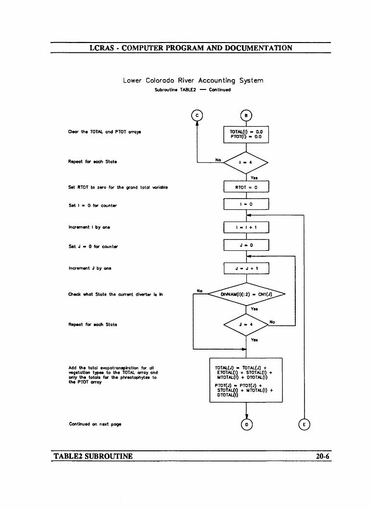
LCRAS - COMPUTER PROGRAM AND DOCUMENTATION
Lower Colorado River Accounting SystemSubroutine TABLE2 Continued
dear the TOTAL and PTOT arrays
Repeat for each State
Set RTOT to zero for the grand total variable
Set I * 0 for counter
Increment I by one
Set J > 0 for counter
Increment J by one
Check what State the current diverter \* in
Repeat for eoch State
Add the total evopotronspirotlon for oil vegetation typee to the TOTAL array and only the totals for the phreatophytes to the PTOT array
OIVNAM(I)(:2) - CN1(J)
.--
Yes
No
TOTAL(J) - TOTAL(J) + ETOTAL0) + STOTAL(I) + MTOTAL(I) + OTOTAL(I)
PTOT(J) - PTOT(J) + STOTAL(I) + MTOTAL(I) + DTOTALfl)
Continued on next page ©
TABLE2 SUBROUTINE 20-6

LCRAS COMPUTER PROGRAM AND DOCUMENTATION
Lower Colorado River Accounting SystemSubroutine TABLE2 Continued
Check If the dlverter ( Federal Lands
Sum evopotronsplratlon by crops and phreatophyte* into th« ETOTAL array
Repeat for all dfoerters
Set J « 0 for counter
Increment J by one
Add up the grand total for oil States
Repeat far each State
dear the variable* used for storing State and grand totals for percentage of evopotronsplrotlon and prorated consumptive use
Set I » 0 for counter
Increment I by one
Continued on next page
©
Yes
ETOTAL(I) » ETOTAL(I) + STOTALfl) + UTOTAL(I) + DTOTAL(I)
TABLE2 SUBROUTINE 20-7
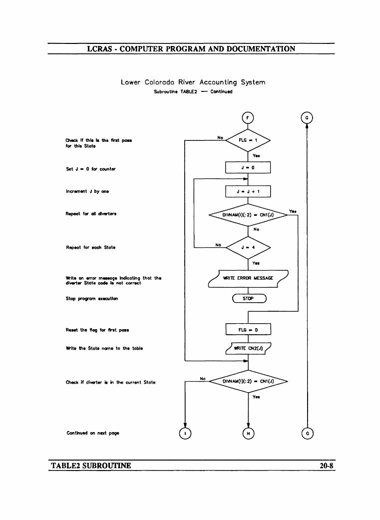
LCRAS - COMPUTER PROGRAM AND DOCUMENTATION
Lower Colorado River Accounting SystemSubroutine TABLE2 Continued
©
Check If this is the first para for this State
Set J - 0 for counter
Increment J by one
Repeat for all dlvertcrs
Repeat for each State
Write on error message indicating that the diverter State code is not correct
Stop program execution
Reset the flog for first pass
Write the State name to the table
Check If diverter a in the current State
Continued on next page
TABLE2 SUBROUTINE 20-8
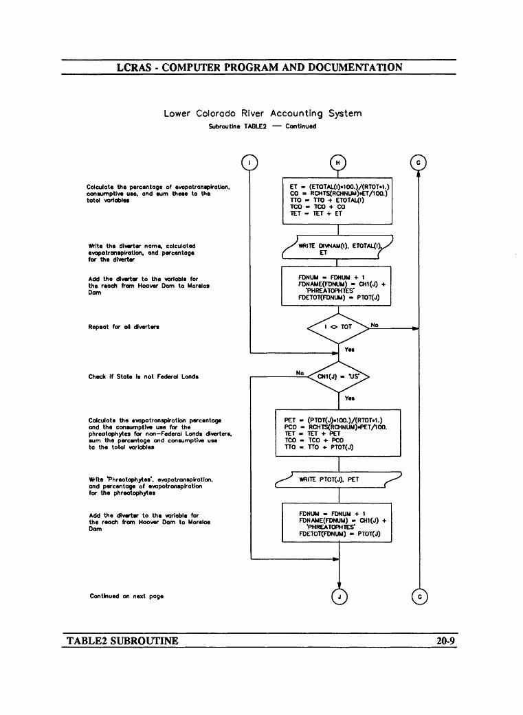
LCRAS - COMPUTER PROGRAM AND DOCUMENTATION
Lower Colorado River Accounting SystemSubroutine TABLE2 Continued
oCalculate the percentage of evopotranspirotion, consumptive use, and sum these to the total variables
VWte the dtverter name, calculated evopotransptrotlon, and percentage for the dtverter
Add the dlverter to the variable for the reach from Hoover Oam to Morelos Dam
Repeat for oil dlverters
Check If State Is not Federal Lands
Calculate the evapotransplratlon percentage and the consumptive use for the phreatophytes for non-Federal Lands dlverter*. sum the percentage and consumptive use to the total variables
Wtte *Phreatophytes'. evopotransptrotlon, and percentage of evapotronsplratlon for the phreatophytes
Add the dlverter to the variable for the reach from Hoover Dam to Morelos Dam
ET - (ETOTAL(I)«100.)/(RTOT«1.) CO = RCHTS<RCHNUM).ET/100.) TTO - TTO + ETOTAL(I) TCO - TCO + CO TET - TET + ET
F
WRITE DIVNAM(I). ETOTAL(l ET P
FDNUM - FONUM -I- 1 FDNAME(FDNUM) - CH1(J)
'PHREATOPHTES* FDETOT(FDNUM) - PTOT(J)
Yes
PET - (PTOT(J)«100.)/(RTOT»1.) PCO - RCHTS(RCHNUM)«PET/100. TET - TET + PET TCO - TCO -I- PCO TTO » TTO -I- PTOT(J)
PTOT(J). PET
FDNUM « FONUM -I- 1 FDNAME(FDNUM) - CH1(J) +
'PHREATOPHTES* FDETOT(FONUM) « PTOT(J)
Continued on next page o ©TABLE2 SUBROUTINE 20-9
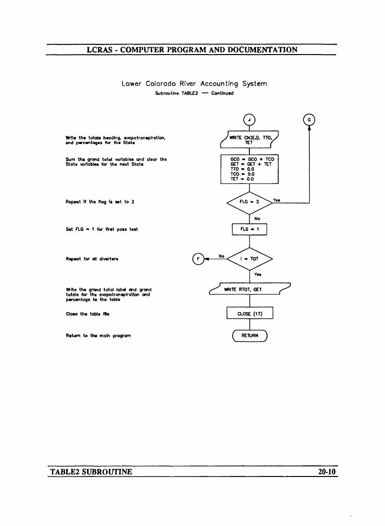
LCRAS - COMPUTER PROGRAM AND DOCUMENTATION
Lower Colorado River Accounting SystemSubroutine TABLE2 Continued
VWte the totals heading, evapotronsplratlon, and percentages for the State
Sum the grand total variables and dear the State variables for the next State
Repeat If the flag Is set to 2
Set FUG - 1 for first pass test
Repeat for all diverters
Wlte the grand total label and grand totals for the evapotronsplratlon and percentage to the table
Close the table file
Return to the main program
©y (
CN3(J).
GCO - GCO + TCO GET - GET + TET TTO - 0.0 TCO - 0.0 TET - 0.0
No
FLG - 1
TABLE2 SUBROUTINE 20-10
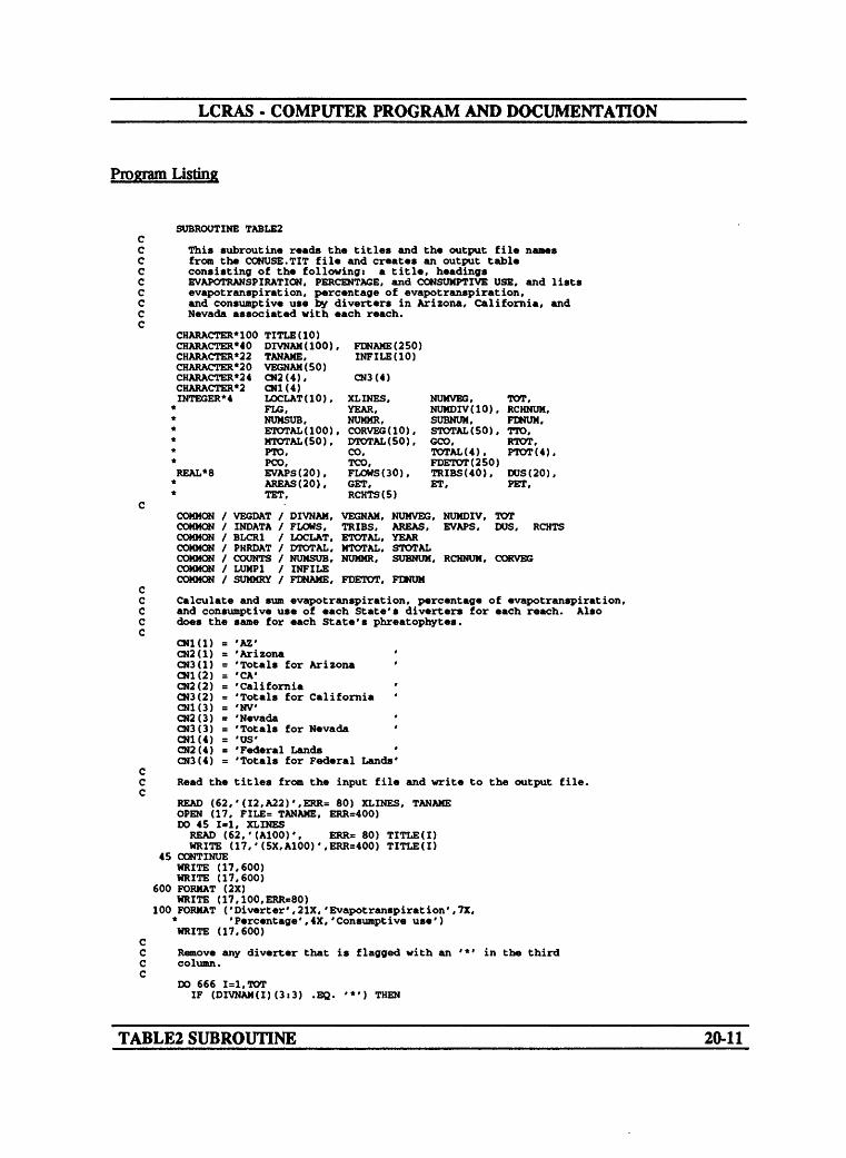
LCRAS - COMPUTER PROGRAM AND DOCUMENTATION
Program Listing
SUBROUTINE TABLE2
This subroutine reads the titles and the output file names from the CONUSE.TIT file and creates an output table consisting of the following: a title, headings EVAPOTRANSPIRATION, PERCENTAGE, and CONSUMPTIVE USB, and lists evapotranspiration, percentage of evapotranspiration, and consumptive use by diverters in Arizona, California, and Nevada associated with each reach.
CHARACTER* 100CHARACTER*40CHARACTER*22CHARACTER*20CHARACTER'24CHARACTER*2INTEGER*4
REAL* 8
TITLE(IO)DIVNAM(IOO),TANAME,VEGNAM(SO)CN2(4),CNK4)LOCLAT(IO),FLG,NUMSUB,ETOTAL(IOO),MTOTAL(50),pro,PCO,EVAPS(20),AREAS (20),TET,
FDNAME(250)INFILE(IO)
CN3(4)
XLINES,YEAR,NUMMR.CORVEG(IO),DTOTAL(50),CO,TCO,FLOWS (30),GET,RCHTS(5)
TOT,NUMVEG, NUMDIV(IO), RCHNUH, SUBNUM, FDNUM, STOTAL(50), TTO, GCO.TOTAL(4). FDETOT(250) TRIBS(40), DUS(20) ET, PET,
RTOT, PTOT(4),
COMMON COMMON COMMON COMMON COMMON COMMON COMMON
VEGDATINDATABLCR1PHRDATCOUNTSLUMP1SUMMRY
/ DIVNAM, VEGNAM, NUMVEG, NUMDIV, TOT / FLOWS, TRIES, AREAS, EVAPS, DOS, / LOCLAT, ETOTAL, YEAR
STOTALSUBNUM, RCHNUM. CORVEG
RCHTS
DTOTAL, MTOTAL, NUMSUB, NUMMR,INFILEFDNAME. FDETOT, FDNUM
Calculate and sum evapotranspiration, percentage of evapotranspiration, and consumptive use of each State's diverters for each reach. Also does the same for each State's phreatophytes.
CNl(l) = 'AZ'CN2(1) = 'ArizonaCN3(1) = 'Totals for ArizonaCNK2) = 'CA'CN2(2) = 'CaliforniaCN3(2) = 'Totals for CaliforniaCN1(3) = 'NV'CN2(3) = 'NevadaCN3(3) = 'Totals for Nevada 'CN1(4) = 'US'CN2(4) = 'Federal LandsCN3(4) = 'Totals for Federal Lands'
Read the titles from the input file and write to the output file.
READ (62,'(I2,A22)',ERR= 80) XLINES. TANAME OPEN (17, FILE= TANAME, ERR-400) DO 45 1=1, XLINES READ (62,'(A100)', WRITE (17,'(5X,A100)
45 CONTINUEWRITE (17,600) WRITE (17,600)
600 FORMAT (2X)WRITE (17,100,ERR=80)
100 FORMAT ('Diverter',21X,'Evapotranspiration' * 'Percentage', 4X, WRITE (17.600)
ERR= 80) TITLE(I) ,ERR=400) TITLE(I)
'Consumpt ive use')7X,
Remove any diverter that is flagged with an column.
'*' in the third
DO 666 1=1,TOTIF (DIVNAM(I)(3:3) .EQ. '*') THEN
TABLE2 SUBROUTINE 20-11

LCRAS - COMPUTER PROGRAM AND DOCUMENTATION
TOT » TOT-1 DO 667 J-I.TOT
DIVNAM(J) « DIVNAM(J+1) ETOTAL(J) « ETOTAL(J+1) STOTAL(J) « STOTAMJ+1) MTOTAL(J) = MTOTAL(J+1) DTOTAL(J) = DTOTAL(J+1)
667 CONTINUEEND IF
666 CONTINUE CC Clear the TOTAL and PTOT arrays for calculations. C
DO 5 J=l,4TOTAL(J) =0.0 PTOT(J) * 0.0
5 CONTINUE RTOT * 0
CC Sum evapotranspiration for each diverter for each State C and SUB a grand total for the reach. C
DO 10 1*1,TOT DO 15 J=l,4
IF (DIVNAM(I)(:2) .EQ. CN1(J)) GOTO 1615 CONTINUE16 TOTAUJ) = TOTAL(J)+ ETOTAL(I)+ STOTAL(I)+ MTOTAL(I)+DTOTAL(I)
PTOT(J) = PTOT(J) + STOTAL(I) + MTOTAL(I) + DTOTAL(I) IF (CN1(J) .EQ. 'US') THENETOTAL(I) = ETOTAL(I) 4- STOTAL(I) + MTOTAL(I) 4- DTOTAL(I)
END IF 10 CONTINUE
CDO 20 Jrl.4RTOT * TOTAL(J) + RTOT
20 CONTINUE C
FLG = 1 GCO * 0.0 GET = 0.0 TOO = 0.0 TET = 0.0
CDO 250 I = 1. TOT
24 IF (FLG .EQ. 1) THEN DO 25 J=l,4
IF (DIVNAM(I)(s2) .EQ. CNl(J)) GOTO 2625 CONTINUE
WRITE (*,29) 29 FORMAT (2X,'I CAN NOT MATCH THE DIVERTER STATE')
STOP 26 FLG = 0
WRITE (17,106.ERR=80) OJ2(J) 106 FORMAT (2X.A24,/)
END IF CC Calculate the percentage of evapotranspiration and consumptive use C for each diverter and sum for each State. C
IF (DIVNAM(I)(:2) .EQ. OJ1(J)) THEN ET = (ETOTAL(I)*100.)/(RTOT*1.) CO a RCHTS(RCHNUM) * ET / 100. TTO = TTO + ETOTAL(I) TOO = TCP 4- CO TET = TET + ETWRITE (17. 70, ERR=80) DIVNAM(I), ETOTAL(I), ET, CO
70 FORMAT (4X,A20.9X. 112,9X.F8.2,7X,112) FDNUM = FDNUM+1 FDNAME(FDNUM) = DIVNAM(I) FDETOT(FDNUM) = ETOTAL(I) IF (I .NE. TOT) GOTO 250 IF (I .EQ. TOT) FLG - 2
END IF C
IF (CN1(J) .NE. 'US') THENPET = (PTOT(J)*100.)/(RTOT*1.) PCO = RCHTS(RCHNUM) * PET / 100. TET = TET + PET
TABLE2 SUBROUTINE 20-12

LCRAS - COMPUTER PROGRAM AND DOCUMENTATION
TOO * TOO + PCOTTO » TTO + PTOT(J)WRITE (17,470, ERR=402) PTOT(J), PET, PCO
470 FORMAT (4X,'PHREATOPHYTES',16X,I12,F17.2,119)FDNUM > FDNUM+1FDNAME(FDNUM) * CN1(J) //''// 'PHREATOPHYTES'FDETOT(FDNUM) « PTOT(J)
END IP WRITE (17,471, ERR=402) CN3(J), TTO, TET, TOO
471 FORMAT (IX,/,2X,A24,3X,I16,F17.2,119,//) C
OCO « GCO + TOO GET » GET 4- TET TTO « 0.0 TOO » 0.0 TET » 0.0IF (FLO .EQ. 2) GOTO 250 FLO « 1 GOTO 24
250 CONTINUEWRITE (17,75,ERR=80) RTOT. GET, GCO
75 FORMAT ('Reach totals',21X,112,11X.F6.2,7X,112) WRITE (17,600) IRCHTS = 1NT(RCHTS(RCHNUM)) WRITE (17,450) IRCHTS
450 FORMAT ('Water-Budget Estimate '.43X,115) CLOSE (17) RETURN
CC Error messages. C
200 WRITE (*,201)201 FORMAT (//,20X,'ERROR - Reading input files')
STOP80 WRITE(*,81)81 FORMAT (//.20X,'ERROR - Reading TANAME')
STOP400 WRITE(*,401)401 FORMAT (//,20X,'ERROR - Writing TANAME')
STOP402 WRITE (*,403)403 FORMAT (//,20X.'ERROR - WRITING TO TABLE 2')
STOP END
TABLE2 SUBROUTINE20-13

LCRAS - COMPUTER PROGRAM AND DOCUMENTATION
SUBROUTINE TABLES
Narrative
Subroutine TABLES produces a table that shows the vegetation types in each reach, monthly water-use rates for each vegetation type, and the annual water-use rate for each type (attachment L). All of the values used in this subroutine are calculated in the BC subroutine.
Variable List
Name Common Description
INFILE(10)
MWUR(5,25,12)
NUMSUB
NUMVEG
SUBNUM
TFILE(10)
VEGNAM(50)
WUR(5,25)
[LUMP 1 ] Name of the image-processing input file for each subreach in a reach.
[WRATES] Monthly water-use rates calculated for vegetation types for each reach along the lower Colorado River.
[COUNTS] Number of subreaches read from the primary input data file.
[ VEGDAT] Number of vegetation types read from the image- processing input data files.
[COUNTS] Number of subreaches per reach.
[SDATA] ASCII input data file that contains the temperature data for selected stations along the lower Colorado River.
[VEGDAT] Vegetation-type names read from the image- processing input data files used to compare the vegetation-type names read from the vegetation- growth coefficient input data file.
[WRATES] Annual water-use rates summed for each vegetation type by reach along the lower Colorado River.
TABLES SUBROUTINE 21-1
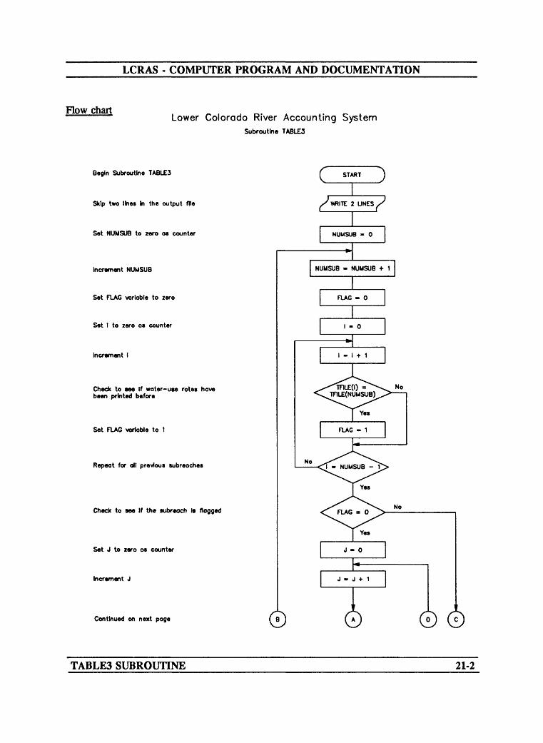
LCRAS - COMPUTER PROGRAM AND DOCUMENTATION
How chartLower Colorado River Accounting System
Subroutine TABLE3
Begin Subroutine TABLE3
Skip two lines In the output file
Set NUMSUB to zero as counter
Increment NUMSUB
Set FLAG variable to zero
Set I to zero as counter
Increment I
Check to see If water-use rotes hove been printed before
Set FLAG variable to 1
Repeat for all previous subreoches
Check to see If the subreoch Is flagged
Set J to zero as counter
Increment J
Continued on next page 0 ©
TABLES SUBROUTINE 21-2

LCRAS - COMPUTER PROGRAM AND DOCUMENTATION
Lower Colorado River Accounting SystemSubroutine TABLES Continued
\Mrlte the vegetation name and the corresponding monthly water-use rote to the output file
Repeat for all vegetation types
Repeat for all subreaches
Return to main program
©WRITE VEGNAM(J) WRITE MWUR(NUMSUB.J.I)
WHERE I = 1 TO 12 WRITE WUR(NUMSUB.J)
© ©
TABLES SUBROUTINE 21-3

LCRAS - COMPUTER PROGRAM AND DOCUMENTATION
Program Listing
SUBROUTINE TABLE3
This subroutine is used to read the titles from the data file and produces an output file in table form containing the following: a title, a heading with a three- letter abbreviation of the twelve months, a list of each vegetation type, and the monthly water-use rates of each vegetation type.
CHARACTER*80 TITLE(10) CHARACTERMO DIVNAM(IOO)
TFILE(IO), VEGNAM(SO) YLINES, NUMVEG,
CHARACTER*22 CHARACTER*20 INTEGERM
REAL*8
COMMON COMMON COMMON COMMON COMMON
TOT,
PFILE(IO),
NUMSUB,NUMDIV(IO),CORVEG(IO)
INFILE(IO)
RCHNUM, SUBNUM,
NUMMR, NUMCRP,
WUR(5,25), MWUR(5,25,12)
/ VEGDAT / DIVNAM, VEGNAM, NUMVEG, NUMDIV, TOT/ WRATES / MWUR, WUR/ COUNTS / NUMSUB, NUMMR, SUBNUM, RCHNUM, CORVEG/ LUMP1 / INFILE/ SDATA / TFILE, PFILE
Skip two lines in the output file.
WRITE (65,115,ERR=90) WRITE (65,115,ERR=90)
115 FORMAT (2X)
Write the vegetation names and their corresponding monthly water-use rates to the output file.
DO 10 NUMSUB=1,SUBNUM FLAG = 0 DO 20 1=1,NUMSUB-1
IF (TFILE(I) .EQ. TFILE(NUMSUB)) FLAG =1 20 CONTINUE
IF (FLAG .EQ. 0) THENWRITE (65,50,ERR=90) INFILE(NUMSUB), TFILE(NUMSUB)
50 FORMAT (2X,A22,2X,'-',2X,A22) DO 30 J=l, NUMVEG
WRITE (65,100,ERR=90) VEGNAM(J), (MWUR(NUMSUB,J.I) * 1=1,12), WUR(NUMSUB.J)
100 FORMAT (4X,A10,3X,12F6.2,2X,F6.2) 30 CONTINUE
WRITE (65,115.ERR-90) END IF
10 CONTINUE RETURN
Error Messages
80 WRITE (*,81)81 FORMAT (//,20X,'ERROR - Reading WUTITLE.DATA')
STOP90 WRITE (*,91)91 FORMAT (//,20X,'ERROR - Writing to WUNAME')
STOP END
TABLE3 SUBROUTINE 21-4

LCRAS - COMPUTER PROGRAM AND DOCUMENTATION
SUBROUTINE TABLE4
Narrative
Subroutine TABLE4 produces a table for the Bill Williams River that shows evapotranspiration and percentage for each diverter (attachment N). The subroutine first adds all the estimates of evapotranspiration for the reach and uses the total to calculate the percentage for each diverter. This routine is different than TABLE2 in that it does not add the diverters to the master diverter list This table includes only output from the BWR subroutine.
Variable List
Name Common Description
CN1(4)
CN2(4)
CN3(4)
CO
DIVNAM(IOO)
DTOTAL(50)
ET
ETOTAL(100)
FLG
Array of the State initials for comparisons.
Array of the complete name of the State for output
Array of the State total line for output
Temporary integer value for consumptive use for a diverter.
[VEGDAT] Diverter names for each reach along the lower Colorado River.
[PHRDAT] Integer value for the total evapotranspiration for dense phreatophytes.
Temporary integer value of the REAL evapotranspiration value.
[BLCR1] Integer value for the total evapotranspiration by crops for each of the reaches.
Indicates the next diverter is in a new State.
TABLE4 SUBROUTINE 22-1

LCRAS - COMPUTER PROGRAM AND DOCUMENTATION
Name Common Description
GCO
GET
MTOTAL(50)
PCO
PET
PTOT(4)
RCHNUM
RCHTS(5)
RTOT
STOTAIX50)
TANAME
TCO
TET
TITLE
Grand total of consumptive use along the reach.
Grand total of evapotranspiration along the reach.
[PHRDAT] Integer value for total evapotranspiration for medium phreatophytes.
Temporary integer value for consumptive use by phreatophytes.
Temporary integer value for percentage of evapotranspiration by phreatophytes.
Array of total evapotranspiration for phreatophytes.
[COUNTS] Number of the reach currently being processed.
[INDATA] Array that contains the total consumptive use for each reach along the lower Colorado River calculated with the water budget
Total evapotranspiration for reach used for percentage calculations.
[PHRDAT] Integer value for total evapotranspiration for sparse phreatophytes.
Name of the output file.
Total consumptive use for each State.
Total percentage of evapotranspiration for each State.
Character variable used to transfer the title strings from the input data file to the output table file.
TABLE4 SUBROUTINE 22-2

LCRAS COMPUTER PROGRAM AND DOCUMENTATION______
Name Common Description
TOT Total number of diverters along the reach.
TOTAL(4) Array that contains total evapotranspiration,including phreatophytes, for each State.
TTO Total evapotranspiration for each State.
XLINES Number of title strings for the table.
TABLE4 SUBROUTINE 22-3
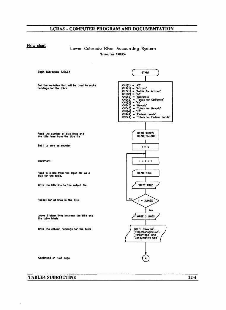
LCRAS - COMPUTER PROGRAM AND DOCUMENTATION
Flow chartLower Colorado River Accounting System
Subroutine TABLE4
Begin Subroutine TABLE*
Set the variables that wll be used to moke headings for the table
c START
Read the number of title lines and the title lines from the title file
Set I to zero as counter
Increment I
Read In a line from the Input ffle as a title for the table.
Write the title line to the output file
Repeat for oil tines in the title
Leave 2 blank lines between the title and the table labels
the column headings for the table
CN1(1 CN2(1 CM 3(1 011(2 012(2 CN3(2 011(3 CN2(3 CN3{3 CN1(4 CN2(4 CN3(4
- 'AT- ^Arizona'- 'Totals for Arizona' « 'CA*
- 'California'= 'Totals far California'" '.NV>- 'Nevada'- 'Totals for Nevada'" ',US'
- 'Federal Lands'- 'Totals far Federal Lande'
WRITE 'Diverter*. |Evopotronsplrotioo', 'Percentage and 'Consumptive Use*
Continued on next page
TABLE4 SUBROUTINE 22-4

LCRAS - COMPUTER PROGRAM AND DOCUMENTATION
Lower Colorado River Accounting SystemSubroutine TABLE4 Continued
Set I - 0 for counter
Increment I by one
Check If dlverter is flogged by on in the third position for deletion
Decrease the number of dlverters by one
Set J * 0 for counter
Increment J by one
Remove any diverter that is flogged with an '»' In the third column of the name by moving all olverters ond associated data In the array up one slot
Repeat for oil olverters
Repeat for ad dverters
Set I » 0 for counter
increment I by one
Continued on next page
DIVNAM(J) - DIVNAM(J+1) ETOTAL(J) - ETOTAL(J+1) STOTAL(J) - STOTAUJ+1) MTOTAL(J) - MT1TAL(J-M) DTOTAL(J) - DTOTAL(J-H)
TABLE4 SUBROUTINE 22-5

LCRAS - COMPUTER PROGRAM AND DOCUMENTATION
Lower Colorado River Accounting SystemSubroutine TABLE4 Continued
dear the TOTAL and PTOT arrays
Repeat for each State
Set RTOT to zero for the grand total variable
Set I = 0 for counter
Increment I by one
Set J « 0 for counter
Increment J by one
Check what State the current dlverter Is In
Repeat for each State
Add the total evapotransplrotion for all vegetation types to the TOTAL array and only the totals for the phreotophytes to the PTOT array
DIVNAM(I)(:2) - CN1(J)
. -
Yes
No
TOTAL(J) - TOTAUJ) + ETOTAL(I) + STOTAL(I) + MTOTAL(I) + DTOTALfl)
PTOT(J) - PTOT(J) + STOTAL(l) + MTOTALO) + DTOTAL(I)
Continued on next page ©
TABLE4 SUBROUTINE 22-6

LCRAS - COMPUTER PROGRAM AND DOCUMENTATION
Lower Colorado River Accounting SystemSubroutine TABLE4 Continued
Check If the dlverter \a Federal Lands
Sum evapatransplratlan by crops and phreatophytes Into the ETOTAL array
Repeat for all dlverters
Set J - 0 for counter
Increment J by one
Add up the grand total for all States
Repeat for each State
Clear the variables used for storing State and grand totals for percentage of evapotranspiratlon and prorated consumptive use
Set I - 0 for counter
Increment I by one
Continued on next page
©
Yes
ETOTAL(I) = ETOTALfJ) + STOTAL(I) + MTOTAL(I) DTOTAL(I)
TABLE4 SUBROUTINE 22-7

LCRAS - COMPUTER PROGRAM AND DOCUMENTATION
Lower Colorado River Accounting SystemSubroutine TABLE4 Continued
Check if this is the first pass for this State
Set J to zero as counter
Increment J
Repeat for all dlverters
Repeat for each State
Wlte on error message Indicating that the diverter Stote code ! not correct
Stop program execution
Reset the flog for first pass
Kfrlte the State name to the table
Check If diverter 'a in the current State
Continued on next page ©
TABLE4 SUBROUTINE 22-8

LCRAS - COMPUTER PROGRAM AND DOCUMENTATION
Lower Colorado River Accounting SystemSubroutine TABLE4 Continued
oCalculate the precentage of evapotransplratlon, consumptive use, and mm these to the total variables
Wlte the dlverter name, calculated evapotransplratlon, and percentage for the dlverter
Repeat for all dlverters
ET - (ETOTAL(I)«100.)/(RTOT«1.) CO - RCHTS(RCHNUM)«ET/100.) TTO » TTO + ETOTAL(I) TCO m TCO + CO TET - TET + ET
WHTE D)VNAM(I). ETOTAL(I)V and ET 7
Check If State Is not Federal Lands
Calculate the evopotransplrotlon percentage and the consumptive use for the phreatophytes for non-Federal Lands diverters, sum the percentage and consumptive use to the total variables
Write *Phreatophytes', evapotransplratlon, and percentage of evopotronsplrotion for the phreatophytes
Yes
PET - (PTOT(J>100.)/(RTOT»1.) PCO - RCHTS(RCHNUM)*PET/100. TET - TET + PET TCO - TCO + PCO HO - HO + PTOT(J)
WRITE PTOT(J). PET
Continued on next page ©TABLE4 SUBROUTINE 22-9

LCRAS - COMPUTER PROGRAM AND DOCUMENTATION
Lower Colorado River Accounting SystemSubroutine TABLE4 Continued
Wite the totals heading, evopotronsplratlon. and percentage for the State
Sum the grand total variables and dear the State variable for the next State
Repeat If the flag is set to 2
Set FIG - 1 for first pass test
Repeat for all diverters
Wlte the grand total label and grand totals for the evopotronsplrotlon and percentage to the table
Close the table fie
Return to the main program
©} VYRITE CN3<J). TIQ.J
( (
GCO - GCO + TCO GET - GET 4- TET TTO - 0.0 TCO - 0.0 TET - 0.0
No
FLG - 1
TABLE4 SUBROUTINE 22-10
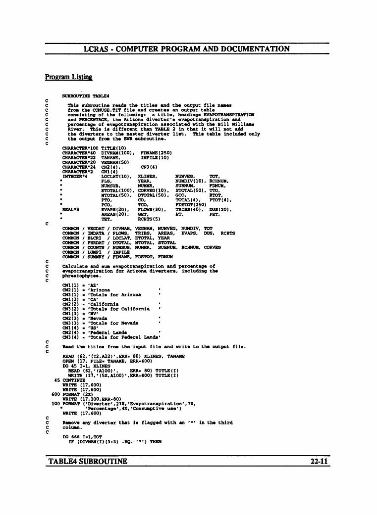
LCRAS - COMPUTER PROGRAM AND DOCUMENTATION
Program ListiM
SUBROUTINE TABLE4
This subroutine reads the titles and th« output file namesfro* the CONUSE.TIT file and creates an output tableconsisting of the following: a title, headings EVAPOTRANSPIRATIONand PERCENTAGE, the Arizona diverter's evapotranspiration andpercentage of evapotranspiration associated with the Bill WilliamsRiver. This is different than TABLE 2 in that it will not addthe diverters to the master diverter list. This table included onlythe output fro* the BWR subroutine.
CHARACTER'100 TITLE (10) CHARACTERMO DIVNAM(IOO) CHARACTER*22 TANAME, CHARACTER*20 VEGNAM(50) CHARACTER*24 CN2 ( 4 ) ,
, FDNAME (2 50) INFILE (10)
CN3(4)CHARACTER*2 CN1 ( 4 )DJTEGER*4
REAL*8
COMMON /COMMON /COMMON /COMMON /COMMON /COMMON /COMMON /
LOCLAT (10).FLO,NUMSUB,ETOTAL(IOO)MTOTAL(50),pro.POO,EVAPS(20),AREAS (20),TET,
VEGDAT / DIVNAM,INDATA / FLOWS,BLCR1 / LOCLAT,PHRDAT / DTOTAL,COUNTS / NUMSUB,LUMP1 / INFILESUMMRY / FDNAME,
XLINES, NUMVEG,YEAR, NUMDIV (10)NUMMR, SUBNUM.
, CORVEG(IO), STOTAL (50)DTOTAL (50), GOO,CO, TOTAL (4),
TOT,, RCHNUM.FDNUM.
» TTO,RTOT,PTOT(4),
TOO, FDETOT(250)FLOWS (30). TRIBS(40),GET, ET,RCHTS(5)
VEGNAM, NUMVEG, NUMDIV,TRIBS, AREAS, EVAPS,ETOTAL, YEARMTOTAL, STOTALNUMMR, SUBNUM, RCHNUM,
FDETOT, FDNUM
DUS (20),PET,
TOTDUS, RCHTS
CORVEG
Calculate and SUB evapotranspiration and percentage of evapotranspiration for Arizona diverters, including the phreatophytes.
CNl(l) CN2(1) CN3(1) CN1(2) CN2(2) CN3(2) CNK3) CN2(3) CN3(3) CN1(4) 0)2(4) CN3(4)
AZ''Arizona ''Totals for Arizona ' CA' 'California Totals for California ' HW'Nevada ''Totals for Nevada ' US''Federal Lands'Totals for Federal Lands'
Read the titles fro* the input file and write to the output file.
READ (62,'(I2,A22)',ERR= 80) XLINES, TANAME OPEN (17, FILE* TANAME, ERR«400) DO 45 Iml, XLINESREAD (62,' (A100)', ERR= 80) TITLE (I) WRITE (17,'(5X.A100)',ERR=400) TITLE(I)
45 CONTINUEWRITE (17,600) WRITE (17,600)
600 FORMAT (2X)WRITE (17.100.ERR.80)
100 FORMAT ('Diverter', 21X, 'Evapotranspiration',7X. * 'Percentage',4X,'Consunpt ive use') WRITE (17,600)
Remove any diverter that is flagged with an '*' in the third column.
DO 666 1=1.TOTIF (DIVHAM(I)(3«3) .EQ. '*') THEN
TABLE4 SUBROUTINE 22-11
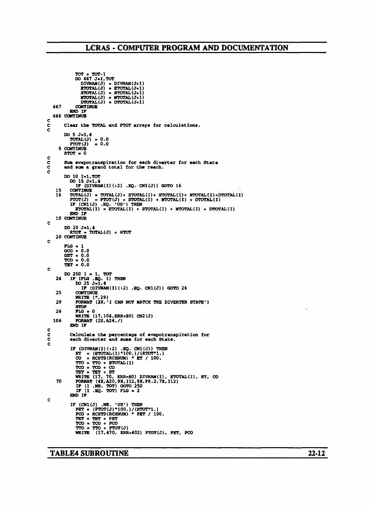
LCRAS - COMPUTER PROGRAM AND DOCUMENTATION
TOT » TOT-1 DO 667 J»I,TOT
DXVNAM(J) * DIVNAM(J+1) ETOTAL(J) * ETOTAMJ+1) STOTAL(J) * STOTAL(J+1) MTOTAL(J) * MTOTAL(J+1) DTOTAL(J) * DTOTAL(J+1)
667 COMTINUBEND IF
666 CONTINUE CC Clear the TOTAL and PTOT arrays for calculations. C
DO 5 J*l,4TOTAL(J) * 0.0 PTOT(J) * 0.0
5 CONTINUE RTOT 0
CC SUB vapotranspiration for each diverter for each State C and sun a grand total for the reach. C
DO 10 I-l.TOT DO 15 J«l,4
IF (DIVNAM(I)(:2) .EQ. CNl(J)) GOTO 1615 CONTINUE16 TOTAL(J) * TOTAL(J)-t- ETOTAL(I)+ STOTAL(I)+ MTOTAL(I)-fDTOTAL(I)
PTOT(J) » PTOT(J) + STOTAL(I) + MTOTAL(I) + DTOTAL(I) IF (CN1(J) .EQ. 'US') THENETOTAL(I) * ETOTAL(I) + STOTAL(I) + MTOTAL(I) + DTOTAL(I)
END IF 10 CONTINUE
CDO 20 J-1,4RTOT * TOTAL(J) + RTOT
20 CONTINUE C
FLO * 1 SCO * 0.0 GET * 0.0 TOO * 0.0 TET * 0.0
CDO 250 1*1, TOT
24 IF (FLO .EQ. 1) THEN DO 25 J-1,4
IF (DIVNAM(I)(:2) .EQ. CNl(J)) GOTO 2625 CONTINUE
WRITE (*,29) 29 FORMAT (2X,'I CAN NOT MATCH THE DIVERTER STATE')
STOP 26 FLG * 0
WRITE (17,106,ERR=80) CN2(J) 106 FORMAT (2X.A24,/)
END IF CC Calculate the percentage of evapotranspiration for C each diverter and SUBS for each State. C
IF (DIVNAM(I)(:2) .EQ. CN1(J)) THEN ET « (ETOTAL(I)*100.)/(RTOT*1.) CO * RCHTS(RCHNUM) * ET / 100. TTO * TTO + ETOTAL(I) TOO s TOO + CO TET " TET + ETWRITE (17. 70, ERR=80) DIVNAM(I), ETOTAL(I), ET, CO
70 FORMAT (4X,A20.9X,I12,9X,F8.2,7X,112) IF (I .NB. TOT) GOTO 250 IF (I .EQ. TOT) FLG * 2
END IF C
IF (CN1(J) .NE. 'US') THENPET « (PTOT(J)*100.)/(RTOT*1.)PCO * RCHTS(RCHNUM) * PET / 100.TET * TET + PETTOO a TOO + PCOTTO a TTO + PTOT(J)WRITE (17,470, ERR=402) PTOT(J), PET, PCO
TABLE4 SUBROUTINE 22-12
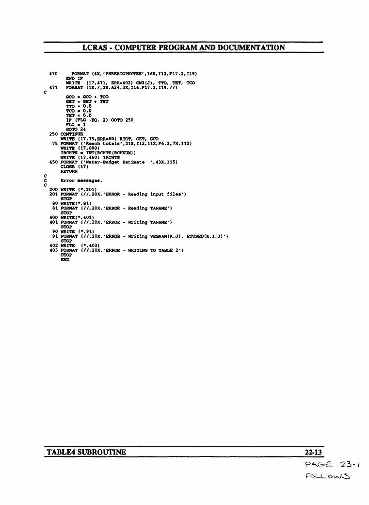
LCRAS - COMPUTER PROGRAM AND DOCUMENTATION
470 FORMAT (4X,'PHREATOPHYTBS',16X, I12,F17.2,119) END IF WRITE (17,471, ERR*402) CN3(J), TTO, TET, TCO
471 FORMAT (IX,/.2X. A24,3X, I16.F17.2.119.//) C
QCO * QCO + TOO GET * GET + TET TTO * 0.0 TCO * 0.0 TET * 0.0IF (FLO .BQ. 2) GOTO 250 FLO * 1 GOTO 24
250 CONTINUEWRITE (17,75,ERR=80) RTOT, GET, GCO
75 FORMAT ('Reach totals',21X,112,11X.F6.2,7X,112) WRITE (17,600) IRCHTS * INT(RCHTS(RCHNUM)) WRITE (17,450) IRCHTS
450 FORMAT ('Water-Budget Estimate ',43X,115) CLOSE (17) RETURN
CC Error messages. C
200 WRITE (*,201)201 FORMAT (//,20X,'ERROR - Reading input files')
STOP80 WRITE(*,81)81 FORMAT (//.20X,'ERROR - Reading TANAME')
STOP400 WRITE(*,401)401 FORMAT (//,20X,'ERROR - Writing TANAME')
STOP90 WRITE (*,91)91 FORMAT (//,20X.'ERROR - Writing VEGNAM(K.J), ETUSED(K,I,J)')
STOP402 WRITE (*,403)403 FORMAT (//.20X.'ERROR - WRITING TO TABLE 2')
STOP END
TABLE4 SUBROUTINE 22-13

LCRAS - COMPUTER PROGRAM AND DOCUMENTATION
SELECTED REFERENCES
Blaney, HJ7., and diddle, W.D., 1950, Determining water requirements in irrigated areas from climatological and irrigation data: U.S. Dept of Agriculture, Soil Conserv. Service, Tech. Paper 96,48 p.
Condes de la Tore, Alberto, 1982, Support by the U.S. Geological Survey for adjudications, compacts, and treaties: U.S. Geological Survey Open-File Report 82-680,24 p.
Graham, MR, Junkin, B.C., Kalcic, M.T., Pearson, R.W., and Seyfarth, B.R., 1985, Earth Resources Laboratory applications software: National Aeronautics and Space Administration National Space Technology Laboratories, No. 183.
International Boundary and Water Commission United States and Mexico, 1984, Flow of the Colorado River and other western boundary streams and related data: Western Water Bulletin 1984, International Boundary and Water Commission United States and Mexico duplicated report, 92 p.
National Climatic Data Center, 1951-84a, Climatological data, annual summary Arizona: U.S. Department of Commerce (published annually).
National Climatic Data Center, 1951-84b, Climatological data, annual summary California: U.S. Department of Commerce (published annually).
National Climatic Data Center, 1951-84c, Climatological data, annual summary Nevada: U.S. Department of Commerce (published annually).
Owen-Joyce, S J., 1987, Estimates of average annual tributary inflow to the lower Colorado River, Hoover Dam to Mexico: U.S. Geological Survey Water-Resources Investigations Report 87-4078,1 sheet.
U.S. Bureau of Reclamation, 1986, Compilation of records in accordance with Article V of the Decree of the Supreme Court of the United States in Arizona vs. California dated March 9,1964, calendar year 1984: U.S. Bureau of Reclamation duplicated report, 34 p.
U.S. Bureau of Reclamation, 1987, Compilation of records in accordance with Article V of the Decree of the Supreme Court of the United States in Arizona vs. California dated March 9, 1964, calendar year 1985: U.S. Bureau of Reclamation duplicated report, 37 p.
U.S. Supreme Court, 1964, State of Arizona, plaintiff v. State of California, et al., defendants: Decree-March 9, 1964, no. 8, original, 14 p.
White, N. D., and Garrett, W. B., 1988, Water resources data for Arizona, water year 1985: U.S. Geological Survey Water-Data Report AZ-85-1, 343 p.
REFERENCES23-1
LCRAS - COMPUTER PROGRAM AND DOCUMENTATION
ATTACHMENTS
ATTACHMENTS 24-1
LCRAS - COMPUTER PROGRAM AND DOCUMENTATION
123456781234567890123456789012345678901234567890123456789012345678901234567890123456789012345
0
0
o
o
0
0
0
0
0
0
0
0
o
o
0
0
0
0
0
o
0
o
o
0
o
o
0
0
0
0
o
0
0
o
o
o
o
0
FLOW84.DATTRIB.DATDD84.DATAREA84.DATKC.DATLIGHT.DATAREAS84 .TITCONUSE84 .TITRATES84 .TITDU84.OUTBUD84.OUT19844HV2DV1HOOV2DAV.DAT36WILLOW-B.TMPWILLOW-B.PPTDV2PK1BILLWR.DAT36PARKER. TMPPARKER . PPT3DAV2PARK.PHR36BULLCITY.TMPBULLCITY.PPTDAV2PARK.DAT36BULLCITY.TMPBULLCITY.PPTHAV2PARK.DAT36BULLCITY.TMPBULLCITY.PPTPK2IP5PARK2IMP.DAT34PARKER. TMPPARKER. PPTPARK2IMP.PHR34PARKER. TMPPARKER. PPTPV2IMP.DAT34BLYTHE.TMPBLYTHE.PPTPV2IMP.PHR34BLYTHE.TMPBLYTHE.PPTYUM2IMP.DAT34BLYTHE.TMPBLYTHE.PPTIP2ML3IMP2MORL.DAT32YUMA.TMPYUMA.PPTIMP2MORL.PHR32YUMA.TMPYUMA.PPTSOUTHYUM.DAT32YUMA.TMPYUMA.PPT
(Flow data file)(Tributary inflow data file)(Domestic-use data file)(Open-water surface area t evaporation-rates data file)(Empirical water-use coefficients data file)(Daylight data file name)(Title data file for TABLE1 subroutine)(Title data file for TABLE2 and TABLE4 subroutines)(Title data file for TABLE3 subroutine)(File name for domestic-use output file)(File name for water-budget output file)(Calendar year to run LCRAS)(Number of major reaches)(First reach subroutine name)(Number of subreaches in the reach)(Image-classification data file)(Latitude for the subreach)(Temperature file for the subreach)(Precipitation file for the subreach)(Second reach subroutine name)(Number of subreaches in the reach)(Image-classification data file)(Latitude for subreach)(Temperature file for the subreach)(Precipitation file for the subreach)(Third reach subroutine name)(Image-classification data file for the 1st subreach)(Latitude of the 1st subreach)(Temperature file for the 1st subreach)(Precipitation file for the 1st subreach)(Image-classification data file for the 2nd subreach)(Latitude of the 2nd subreach)(Temperature file for the 2nd subreach)(Precipitation file for the 2nd subreach)(Image-classification data file for the 3rd subreach)(Latitude for the 3rd subreach)(Temperature file for the 3rd subreach)(Precipitation file for the 3rd subreach)/
«
\
o
0
o
o
0
0
o
0
0
0
0
0
o
o
0
0
0
0
0
o
0
o
o
0
o
0
o
o
0
0
o
0
o
o
o
o
o
0
123456789
101112131415161718192021222324252627282930313233343536373839404142434445464748495051525354555657585960616263646566676869707172737475
A. Example of the primary data file.
ATTACHMENT A A-l

LCRAS - COMPUTER PROGRAM AND DOCUMENTATION
1234 56781234567890123456789012345678901234567890123456789012345678901234567890123456789012345
o
o
o
o
o
0
o
0
o
o
o
0
0
o
o
o
0
0
o
0
0
o
0
0
o
o
o
0
0
o
0
o
o
o
0
0
o
o
GAGED FLOWS FOR EACH REACH
CALENDAR YEAR: 1984
Hoover Dam to Da vis DamColorado River below Hoover DamChange in storage Lake Mohave
Da vis Dam to Parker DamColorado River below Davis Dam
Colorado River AqueductBill Williams River below Alamo DamCentral Arizona Project CanalChange in storage Lake Havasu
Parker Dam to Imperial DamColorado River below Parker Dam
Change in storage Senator WashColorado River above Imperial Dam
Imperial Dam to Morales DamDiversion to Mittxy LakeAll American CanalAll American Canal below Pilot KnobGila Gravity Main CanalWell ton-Mohawk Canal
Colorado River below Imperial DamGila River near Dome
Colorado River at NIBEleven Mile wastewayCopper wastewayTwenty -One Mile wastewayMain drainWest Main Canal wastewayEast Main Canal wasteway
* Added to Colorado River above Imperial
'
Flow, inacre- feet
21861000-150000
216580001237230111800
053100
20464000652
19106000
979082690003046000754800391400
10080000266000
154310001530721
099380
04090
Dam table
StationNumber
0942150009422500
0942300009424150094260000942665009427500
09427520*09429490
0952240009523000095275000952250009522700094295000952050009522000095250000953185009533000095340000953430009534500
in the annual
o
o
LCRAS oVariable
o
FLOWS(l) oFLOWS (2)
o
FLOWS (3) oFLOWS (4)FLOWS (5) oFLOWS (6)FLOWS (7) o
oFLOWS (8)FLOWS (9) oFLOWS (10)
o
FLOWS (11) oFLOWS (12)FLOWS (13) oFLOWS (14)FLOWS (15) oFLOWS (16)FLOWS (17) oFLOWS (18)FLOWS (19) oFLOWS (20)FLOWS (21) oFLOWS (22)FLOWS (23) oFLOWS (24)
oreport .
0
o
0
0
o
o
o
o
o
o
o
o
o
o
o
0
o
0
123456789
101112131415161718192021222324252627282930313233343536373839404142434445464748495051525354555657585960616263646566676869707172737475
B. Example of the flow data file.
ATTACHMENT B B-l
LCRAS - COMPUTER PROGRAM AND DOCUMENTATION
123456781234567890123456789012345678901234567890123456789012345678901234567890123456789012345
0 UNMEASURED TRIBUTARY INFLOW ESTIMATES
o CALENDAR YEARi 1984
o Hoover Dam to Davis DamSprings
o Unmeasured runoffGround-water discharge
o Eldorado Valley
o Davis Dam to Parker DamUnmeasured runoff
o Davis Dam to TopockTopock to Parker Dam
o Nhipple MountainsUnmeasured runoff from tributary streams
o Piute WashSacramento Wash
o Bill Williams River subareaGround-water discharge
o Davis Dam to TopockTopock to Parker Dam
o Piute ValleySacramento Valley
o Chemehuevi ValleyBill Williams River subarea
oParker Dam to Imperial Dam
o Unmeaaured runoffNhipple Mountains
o Big Marie-Riverside MountainsPalo Verde-Mule Mountains
o Dome Rock-Trigo-Chocolate MountainsUnmeasured runoff in tributary streams
o Vidal WashBouse Wash
o Tyson WashMcCoy Wash
o Milpitas WashGround-water discharge
o Bouse WashTyson Wash
o Vidal WashChuckwalla Valley
oImperial Dam to Morelos Dam
o Ground-water dischargeGila River
o Unmeasured runoff from Yuma area
o
0
o
o
o
o
o
o
o
o
o
o
o
Flow, inacre- feet
308021002001100
12000150001150
100025004000
0880
230010000
2604000
115023001200
16200
1300480026008001200
1200350250400
10002000
EEEE
EEE
EEE
EEEEEE
EEEE
EEEEE
EEEE
EE
o
LCRAS 0Variable
oTRIB(l)TRIB(2) oTRIB(3)TRIB<4) o
o
TRIB<5) oTRIB(6)TRIB(7) o
TRIE (8) oTRIE (9)TRIE (10) o
TRIE (11) oTRIE (12)TRIE < 13) 0TRIE (14)TRIB(IS) 0TRIE (16)
O
oTRIBU7)TRIBQ8) 0TRIB(19)TRIB(20) 0
TRIB(21) 0TRIE (22)TRIE (23) oTRIE (24)TRIE (25) o
TRIE (26) oTRIB(27)TRIB(28) 0TRIB(29)
o
oTRIE (30)TRIBC31) 0
o
o
o
o
o
o
o
o
o
o
o
o
o
101112131415161718192021222324252627282930313233343536373839404142434445464748495051525354555657585960616263646566676869707172737475
C. Example of the tributary-inflow data file.
ATTACHMENT C C-l

LCRAS - COMPUTER PROGRAM AND DOCUMENTATION
123456781234567890123456789012345678901234567890123456789012345678901234567890123456789012345
o DOMESTIC- AND MUNICIPAL-USE DATA FILE CalendarData Column 1 t Pumpage,
o Data Column 2: ResidentData Column 3: Resident
o HOOVER TO DAVISWillow Beach
o Cottonwood CoveKatherine
o Diversion - Davit DanL.C.R.D. Project
o DAVIS TO PARKERBullhead City-Riviera
o Bermuda CityLaugh 1 in
o Mohave Steam PlantGolden Shore*
o TopockLake Havasu City
o Needle*Havasu Lake
o Mojave Water Con* Di*Lake Havasu I&D Di*
o Consol Water Util LtdSan Bernard! no Co.
o Clark Co Park* & RecPortenier, Warren E.
o PARKER TO IMPERIALParker (Town)
o PottonEhrenberg
o CibolaMart Inez Lake
o EarpParker Dam/Govt Camp
o VidalBlythe (City)
o East BlytheRipley
o Palo VerdeBig River
o BLM Permittee*IMPERIAL TO MORELOS
o Yuma (City)Yuma (County)
o Yuma Proving GroundBard
o WinterhavenMarine Corp* Air Sta
o S. Pacific Co.Yuma Co.
o Yuma Me*a Fruit GrowYuma Union HS
o MORELOS TO SIBSomerton
o GadcdenSan Lui*
o
o
o
o
o
0
o
o
0
o
in acre- feet,population
with no
per capita water use.
9043937014260
000
1419800000
1089085291156
42
000000000000
890206
00000
1775481212
200
000
00000
15895500950
65025
176455100
0000000
2530260
120429310
150013636
75121940450332
00
459601940611001532896
00000
43200
2575
Yeartreturn*
1984to the river
in acre- feet
.00
.00
.00
.00
.00
.03
.03
.30
.00
.03
.03
.03
.39
.00
.00
.00
.00
.00
.00
.00
.13
.03
.03
.03
.03
.75
.88
.07
.29
.25
.16
.07
.00
.00
.09
.03
.03
.06
.09
.00
.00
.00
.00
.00
.03
.00
.03
AZNVAZAZAZ
AZAZNVNVAZAZAZCACAAZAZAZCANVNV
AZAZAZAZAZCACACACACACACACACA
AZAZAZCACAAZAZAZAZAZ
AZAZAZ
0
o
o
o
0
o
0
0
0
o
0
0
o
o
0
o
0
0
o
0
o
o
o
0
o
o
o
0
o
o
0
0
o
0
0
0
0
0
123456789
101112131415161718192021222324252627282930313233343536373839404142434445464748495051525354555657585960616263646566676869707172737475
D. Example of the domestic-use data file.
ATTACHMENT D D-l

LCRAS - COMPUTER PROGRAM AND DOCUMENTATION
0 OPEN-WATER SURFACE AREAS AND EVAPORATION RATES FOR
0 CALENDAR YEAR: 1984
o Surface Areas HV.DV 25419.38
0 DV.PK 21961.86 PK.IP 10262.38
o IP. ML 1385.66 BWR 576.00
o Senator Wash 0.00
o Evaporation Rates HV.DV 5.85
o DV.PK 5.91 PK.IP 5.68
0 IP. ML 5.20 BWR 5.00
o Area of Open Water
o HV.DV 25419.38 DV.PK 21961.86
o PK.IP 10262.38 IP. ML 1385.66
o
o
o
o
o
o
o
o
o
o
o
o
o
o
o
o
0
o
o
o
o
o
o
o
o
o
EACH
acres acres acres acres acres acres
feet feet feet feet feet
feet feet feet feet
REACH o
O
O AREAS(l) ARE AS (2) o AREAS (3) AREAS (4) o ARE AS (5) AREAS (6) o
OEVAPS(l) EVAPS(2) o EVAPS(3) EVAPS(4) o EVAPS(5)
O
OPNWTR(l) 0 OPNWTR(2) OPNWTR(3) o OPNWTR(4)
o
0
0
o
o
o
o
o
o
o
o
o
o
o
o
0
0
0
0
o
0
0
o
o
o
0
123456789
101112131415161718192021222324252627282930313233343536373839404142434445464748495051525354555657585960616263646566676869707172737475
E. Example of the open-water surface areas and evaporation-rates data file
ATTACHMENT E E-l

LCRAS - COMPUTER PROGRAM AND DOCUMENTATION
123456781234567890123456789012345678901234567890123456789012345678901234567890123456789012345
0 SUBREACH tNUMBER OF CLASSES :
o VEGETATION TYPES tALFALFA
o 7,16,18COTTON
o 8,10tjLnpftrn VflUSAl
o 17DENSE
o 0MEDIUM
o 24SPARSE
o 3,11,15
0AZ FORT MOJAVE IR
oCLASS 1
0 12
o 34
o 56
o 78
o 910
0 1112
o 1314
o 1516
o 1718
o 1920
o 2122
o 2324
0
0 CA FORT MOJAVE IR
o CLASS 11
o 23
o 45
o 67
o 89
o 1011
o 1213
o 1415
o 1617
o 1819
o 2021
o 2223
o 24
o
MOJAVE2463
2
1
0
1
3
ACREAGE7357.421026.09201.99470.75328.641515.342015.73671.5163.01
3157.94532.53
1100.211048.961699.422822.512804.58221.771052.67544.2618.5416.698.651.86.00
ACREAGE216.2133.9827.1815.4546.332.47
142.0917.91
.001.24
82.7861.7769.8192.66
158.141069.32345.94537.4435.83
.62
.00
.00
.00
.00
(Subreach none) o(Number of classes from the image)(Number of different vegetation types) o(First vegetation name, number of classes)(Cl.ass numbers for the 1st vegetation type) o(Second vegetation name, number of classes)(Class numbers for the 2nd vegetation type) o(.....
o
o
0
.....) 0(Required 2 blank lines before eachdiverter name) o(Diverter name)(Required blank line after name) o(Title line)(Class one, acreage for class one) o(Class two, acreage for class two)(Class three, acreage for class three) o(.....
o
o
o
o
o
0
o
o
o
o.....)(Required 2 blank lines before each odiverter name)(Second diverter name) o(Required blank line after name)(Title line) o(Class one, acreage for class one)(Class two, acreage for class two) o(Class three, acreage for class three)(..... 0
o
0
o
o
o
o
o
0
o
.....) 0(Required 2 blank lines before eachdiverter name) o
123456789
101112131415161718192021222324252627282930313233343536373839404142434445464748495051525354555657585960616263646566676869707172737475
F. Example of an image-processing data file.
ATTACHMENT F F-l
LCRAS - COMPUTER PROGRAM AND DOCUMENTATION
123456781234567890123456789012345678901234567890123456789012345678901234567890123456789012345
o MV FORT MOJAVE IR
o CLASS 11
o 23
o 45
o 67
o 89
o 1011
o 1213
o 1415
o 1617
o 1819
o 2021
o 2223
o 24
oAZ STATE OF AZ
OCLASS 1
0 12
o 34
o 56
o 78
o 910
0 1112
o 1314
o 1516
o 1718
o 1920
o 2122
o 2324
0
0 CA STATE OF CA
0 CLASS i1
o 23
o 45
o 67
o 89
o 1011
o 1213
o 14
ACREAGE736.36502.8440.15110.58406.48
8.65134.6725.94
.00
.0016.68
271.20494.82695.58430.5716.06
.00
.00132.20
.00
.00
.00
.00
.00
ACREAGE3520.561189.20238.44427.49730.79347.19
1734.65369.4433.36745.00619.62954.45
1406.622265.902608.141910.68156.92610.96583.1712.9915.453.71.00.00
ACREAGE1087.23160.0127.18163.09160.6388.35
677.06130.3411.74
140.23176.06319.38221.77540.54
(Third diverter name) o(Required blank line after name)(Title line) o(Class one, acreage for class one)(Class two, acreage for class two) o(Class three, acreage for class three)(..... 0
o
o
o
o
o
o
o
o
o
.....) 0(Required 2 blank lines before eachdiverter name} o(Fourth diverter name)(Required blank line after name) o(Title line)(Class one, acreage for class one) o(Class two, acreage for class two)(Class three, acreage for class three) o(.....
0
o
o
o
o
o
0
0
o
o.....)(Required 2 blank lines before each odiverter name)(Fifth diverter name) o(Required blank line after name)(Title line) o(Class one, acreage for class one)(Class two, acreage for class two) o(Class three, acreage for class three)(..... 0
o
o
o
o
o
767778798081828384858687888990919293949596979899
100101102103104105106107108109110111112113114115116117118119120121122123124125126127128129130131132133134135136137138139140141142143144145146147148149150
F. Example of an image-processing data file Continued.
ATTACHMENT F F-2

LCRAS COMPUTER PROGRAM AND DOCUMENTATION
123456781234567890123456789012345678901234567890123456789012345678901234567890123456789012345
o
0
o
o
o
0
0
0
0
0
o
o
0
o
0
0
0
o
0
o
o
0
0
o
o
0
o
0
o
o
o
0
0
0
0
o
0
0
15161718192021222324
NV STATE OF NV
CLASS I123456789
101112131415161718192021222324
867.32 o932.18557.21 o383.63162.47 o
2.476.18 o3.711.24 o.00 .....)
(Required 2 blank lines before each odiverter name)(Sixth diverter name) o(Required blank line after name)
ACREAGE (Title line) o1918.11 (Class one, acreage for class one)701.76 (Class two, acreage for class two) o295.29 (Class three, acreage for class three)261.92 (..... o234.1388.33 o0.000.00 o9.880.00 o
27.18358.30 o781.46859.29 o560.30418.23 o
0.000.00 o
135.293.71 o5.571.86 o.00
468.19 .....) o
o
0
0
o
0
0
o
0
0
o
o
0
0
0
0
o
0
o
151152153154155156157158159160161162163164165166167168169170171172173174175176177178179180181182183184185186187188189190191192193194195196197198199200201202203204205206207208209210211212213214215216217218219220221222223224225
F. Example of an image-processing data file Continued.
ATTACHMENT F F-3

LCRAS - COMPUTER PROGRAM AND DOCUMENTATION
123456781234567890123456789012345678901234567890123456789012345678901234567890123456789012345
o 020193761967
o 19681969
o 19701971
o 19721973
o 19741975
o 19761977
o 19781979
o 19801981
o 19821983
o 19841985
o 19861987
o
o
0
0
o
o
o
0
o
0
0
0
o
0
o
o
o
0
0
o
o
o
o
o
0
o
o
514547519508478471475494515488514440526552507519516496551500
WILLOW BEACH,
618534596569570540539541583569552505577574563570546516587578
648608626632690567650593606576629593595611606620629599
608
691724667705697684693649680727684691696751695651675733717744
AZ,
802830820754800828831789822735779796751793795783837811811802
Mean
910887901890905913937899886915911878864922873869876898916897
monthly temperatures,
957964968978983974954968963965956921947975923919925935917908
909995959950929942920923908946920886916948929882898904961931
872898845844839845882868832852820891844870844865871811804865
772747711719693694730754714696746755761729714697723690719717772
in 1/lOthB degrees Fahrenheit o645 485621 486 o622 548623 511 o570 474559 470 o591 519600 486 o577 513000 000 o601 552561 448 o573 518607 566 o635 543577 504 709 o606 531 712586 490 712 o570 520 709629 533 o600 480 724
o
o
o
0
o
0
0
o
o
o
o
o
0
o
o
0
0
o
o
o
0
0
o
0
o
o
o
123456789
101112131415161718192021222324252627282930313233343536373839404142434445464748495051525354555657585960616263646566676869707172737475
G. Example of a temperature data file.
ATTACHMENT G G-l

LCRAS COMPUTER PROGRAM AND DOCUMENTATION
12345678 123456789012345678901234567890123456789012345678901234S678901234567890123456789012345
o 020193761967
WILLOW BEACH, AZ, Monthly precipitation, in 1 /100th« inches o000000017300077
o 1968000010003500030000040000100012000330002000007000200001400000 o1969001350009700033000010003800014000330000100006000120001000000
o 1970000050002700085000000000000001000290016600000000000005000020 o1971000030002900002000020005500000000020009500000000150000600042
o 1972000000000000000000160000700004000270006100022000S0001S100026 o1973
o 19741975
o 19761977
o 19781979
o 19801981
o 19821983
o 19841985
o 19861987
o 1988
o
0
0
0
0
o
o
0
0
0
o
o
o
o
o
o
0
o
0
o
o
0
o
o
o
0
0580980020000261471801495275420
80358355
0450010101330000980653143297260
18193256
229050114Oil1061732051091261067154
210
Oil000071025
0108000
10
11470
170
30102
0300
0310390880450162256230004
373
067000000000OOS000008
0000223
15
000006033104032
006197051
183110249
0050281010001001S400811
141193199185
000
000 0000 138
074 021342 148196 025088 066
0 01683 13
232 31 19
42 8575 276 107 150 147
045041012013006144025
030491076752782
0049 o002005 o073096 o079
0 o0
87 671 o51 573
293 846 o5 327
101 o75 531
0
o
o
0
o
o
o
0
o
0
0
o
o
o
o
o
0
o
o
0
0
0
o
0
0
0
0
123456789
101112131415161718192021222324252627282930313233343536373839404142434445464748495051525354555657585960616263646566676869707172737475
H. Example of a precipitation data file.
ATTACHMENT H H-l
LCRAS - COMPUTER PROGRAM AND DOCUMENTATION
oCROP
OCOTTON
o ALFALFABERMUDA
0 SORGHUMCOTTON
0 WHEATCITRUS
0 BROCCOLIMELONS
o CAULIFLOWERFALL LETTUCE
0 SAFFLOWERSPRING LETTUCE
0 DRY ONIONSMILO
0 CORNDATES
0 TOMATOESMEDIUM
0 SPARSEDENSE
O
0
o
o
o
o
o
o
o
o
o
o
o
o
o
o
o
o
0
o
0
o
o
o
0
0
EMPIRICALJAN
0.000.000.000.000.000.430.391.020.000.960.000.140.040.340.000.075.172.000.000.000.00
WATER-USEFEB
0.000.920.000.000.000.800.48O.S40.000.000.000.330.35O.S60.000.440.000.000.710.570.85
MAR
0.001.210.000.000.001.630.410.000.000.000.000.800.671.230.001.500.000.000.930.741.12
COEFFICIENTSAPR
0.091.250.660.000.091.630.460.000.120.000.001.920.941.720.001.490.000.000.960.771.15
MAY
0.271.360.790.000.270.420.470.000.510.000.001.490.000.430.000.000.000.001.050.841.26
JUN
0.601.361.060.000.600.000.550.001.420.000.001.560.000.000.000.000.000.001.050.841.26
JUL
1.201.221.170.441.200.000.580.000.630.000.000.340.000.000.440.000.000.001.050.841.26
AUG
1.401.101.101.481.400.000.630.000.000.000.000.000.000.001.480.000.000.001.040.831.25
SEP
1.111.330.891.051.110.000.640.200.000.200.040.000.000.001.100.000.000.001.020.821.23
OCT
0.600.950.710.350.600.000.630.740.000.660.350.000.000.000.340.000.000.000.730.580.88
NOV
0.270.800.000.000.270.040.591.190.001.330.670.000.000.000.000.000.000.000.620.490.74
oDEC
O0.000.00 o0.000.00 o0.000.30 o0.400.99 o0.000.78 o0.940.00 o0.000.00 o0.000.00 o0.000.00 o0.000.00 o0.00
o
o
o
o
o
o
o
o
o
o
0
o
o
o
o
0
0
o
o
o
o
o
o
o
0
0
123456789
101112131415161718192021222324252627282930313233343536373839404142434445464748495051525354555657585960616263646566676869707172737475
I. Example of the empirical water-use coefficients data file.
ATTACHMENT I M
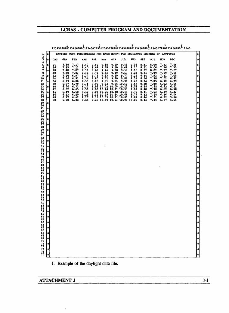
LCRAS - COMPUTER PROGRAM AND DOCUMENTATION
123456781234567890123456789012345678901234567890123456789012345678901234567890123456789012345
0 DAYTIME HOUR PERCENTAGES FOR EACH MONTH FOR
o LAT JAN FEB MAR
o 24 7.58 7.17 8.40 26 7.49 7.12 8.40
o 28 7.40 7.07 8.39 30 7.30 7.03 8.38
o 32 7.20 6.97 8.37 34 7.10 6.91 8.36
o 36 6.99 6.86 8.35 38 6.87 6.79 8.34
o 40 6.76 6.73 8.33 42 6.62 6.65 8.31
o 44 6.49 6.58 8.30 46 6.33 6.50 8.29
o 48 6.17 6.42 8.27 50 5.98 6.32 8.25
0
o
o
o
o
o
o
o
o
o
o
0
o
0
o
o
o
o
o
o
o
o
o
o
o
o
o
0
o
APR MAY JUN JUL
8.60 9.30 9.20 9.41 8.64 9.38 9.30 9.49 8.68 9.46 9.38 9.58 8.72 9.53 9.49 9.67 8.75 9.63 9.60 9.77 8.80 9.72 9.70 9.88 8.85 9.81 9.83 9.99 8.90 9.92 9.95 10.10 8.95 10.02 10.08 10.22 9.00 10.14 10.21 10.35 9.05 10.26 10.38 10.49 9.12 10.39 10.54 10.64 9.18 10.53 10.71 10.80 9.25 10.69 10.93 10.99
INDICATED DEGREES OF
AOG SEP
9.05 8.31 9.10 8.31 9.16 8.32 9.22 8.34 9.28 8.34 9.33 8.36 9.40 8.36 9.47 8.38 9.54 8.38 9.62 8.40 9.70 8.41 9.79 8.42 9.89 8.44
10.00 8.44
OCT
8.09 8.06 8.02 7.99 7.93 7.90 7.85 7.80 7.75 7.70 7.63 7.58 7.51 7.43
LATITUDE o
NOV DEC o
7.43 7.46 o 7.36 7.35 7.27 7.27 o 7.19 7.14 7.11 7.05 o 7.02 6.92 6.92 6.79 o 6.82 6.66 6.72 6.52 o 6.62 6.38 6.49 6.22 o 6.36 6.04 6.22 5.86 o 6.07 5.65
o
o
o
o
o
o
o
o
o
o
o
o
o
o
o
0
o
o
o
o
o
o
o
o
o
o
o
o
o
101112131415161718192021222324252627282930313233343536373839404142434445464748495051525354555657585960616263646566676869707172737475
J. Example of the daylight data file.
ATTACHMENT J J-l

LCRAS - COMPUTER PROGRAM AND DOCUMENTATION
o
(4
£4
»f
00
«2S
o
^00Oti-i
«
\
IQ
0
iW
1
J
8
C H
««
^
f
t)
a
0
%|1
<f*
^
f t* Q
St«
0
a»Oti-i
Jj> ^
dga
.,4i_i1-4
31-4
t)
*J
CoI-l«
«t)sc
%
Iao
£1
t)
>
X
u«
o
%11
^1^ t)* <Q
it*
o
^00ON*"*
1 }<£ou
1« H
t)
8c
H
%Mt)
t)
o
i1coft
*Jt)
X
8t)0
511
< +^0» t)
g « 1
<p
>f
0
* 0000 OtOt i-lI-l
%i JQ
« -4 O« ^4T* J*h 14
B *M 0
*J 0« §§ 2 9" "i
fl
) V4
a M
« «u u « flc c
» %M Mt) t)
1 >
0 .0
^ jfr
^ ^s s5 5o o
fl flu * >t) t)? w
V> >
1 1t) t)
o o
i) i)
<4 <41 11 1
rt ! »
30 t) 00 f)" S t3*St-iJO XJO
i^H^
000
^00ot I-l
89o ft
1o
§a^41o
%
1 t)0
c H
«3
f)
-^4J
iou gsc0
so
I11£4 O i
M frj "
^
f 0 H*9
i E 6*s
O 0
^000t
%Mt)
v<
II-l H
^Jffl.c
o
^*J
Mu
c
«Bo
s1̂
11
ffl
?.«l-l2*2I^1
0
^00ot I-l
1ozu&o4J
1« ft
i*
su
cft
«
f)
<J
too ggc0
gQ
i£
11
u«/>^» t)
«3>f
0
^CD0t^H
B2 3V
v<
t)tM
0
§9oM1£
1t)Mu
c H
«
«
3
f§u 2iBo
go
i£
11
Br;*tf00 t)
MjQ
o
00otI-l
1a«0I-l
s£0
1QI-l« rt
I%
so
o
«
f)
3
foo ggB0
gQ
1I1
8 '1 p<* D
^ ^0» t)0»d7«d
g^l
O 0
^00o^I-l
I« o
80X
o
M 0o
1 0
u
B rt
4)
3
« 3
f§u 2iBo
gfl
ifl511
o
t)r-l
A
o
^00OtI-l
Hae
fl o
1-4
8^4V
i-H
e*
so*4J^)t)
B
*J
3
u
fl< '
t> ooo£4 ^
00 t)
00 M JQ
2 <5J$ _K i-l
ooooooooooooooo
K. Example of the title input data files for the output tables.
ATTACHMENT K K.I
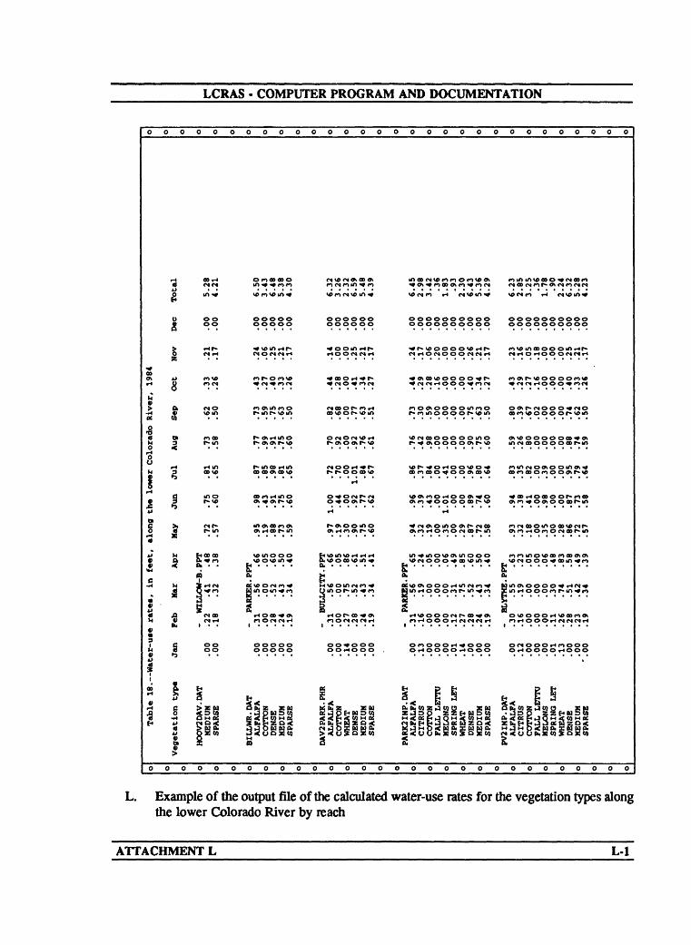
LCRAS - COMPUTER PROGRAM AND DOCUMENTATION
o
000*rt
11o3
1
jjl-l0
JgVc H
V
V
14
sf00
1
o
0 0
1
yo
01
iH
I1M
M
^
1
Vegetation type v
o o
o o
OOr-l
00oo
rHf>
MVO
vom
rooo
dm
mo r-vo
£ 0000 *n
n
*L« . .00oo
HOOV2DAV.DAT MEDIUM
SPARSE
o o
ooooo
o<»> ooooo
ooooo ooooo
« VJ> U1 rH f- CNOMCNt-l
^r-o^vo
**> o\ m f*> o
r» Oh rtlfl O
r- mOO rtlfl
oo r> t-i mo
motoofnot
vcinooog .....
a
t-IOOO *OH
ooooo o oooo
BILLWR.DAT ALFALFA COTTON
DENSE MEDIUM
SPARSE
ooooo
oooooooooooooooooooo
oooooo oooooooooo oooooooooo oooooo oooooooooo oooooooooo
^ooor^r- *<*a>vooooo,,r- ^wosooooo^*
04 a> o r» f> «n n o at oo o o mr>o oo» f-cNOO O^»CNO
OCNOCNVOd VO <S OOO OO O O m O Ot VO OOOO OOO ^O>
OOrH-*r> VDf>.^Or400VOO «A OOtOOmOf«
0*0«Nf-«N VOW^O^OOW^O *a>r.00>00f-r,<»
H >-l
t.somsoddd m^movo^mooo «r>movoa> «o>««
e * *
OOOOOO O fO OO O rH ^» O O O O (S O O O r4 r> O O O OOtHOOO , O r* OOOO r-4OOO O tH O O O O rH O O O
a: t> p E< p t*£ < K E P u -< < i §< B
>-CO « 0 ^K« QK« g< 0 *K« 0*«
oooooooooooooooooooo
L. Example of the output file of the calculated water-use rates for the vegetation types along the lower Colorado River by reach
ATTACHMENT L L-l

LCRAS - COMPUTER PROGRAM AND DOCUMENTATION
oooooooooooooooooooooooooooooo
OOOr-IOOOOOO
2 WMO<<<Q<XWWO. 53oOS w w5a52 w
oooooooooooooooooooooooooooooo
L. Example of the output file of the calculated water-use rates for the vegetation types along the lower Colorado River by reach Continued.
ATTACHMENT L ET

LCRAS - COMPUTER PROGRAM AND DOCUMENTATION
o
*0»o\tH
g
r-(
«
ll
I
0i>
ia
fc0M
I
IO«
a H
>70jjh5
H O
aE4J
ao
-H4J«
£0r«o00
«M
O
a0sfi
vo «« >
0r-(
1
O
o o
1u£4
a*CO
gMaS
H8)
1
H
iigM
£CO
(0
o
1iM
J
3h
S
10
CO
p{£4M0
<
3
3̂
«1(K10
0 0
oooooooooo
SSoSSP^SSoSSSSSSSSSSSo^ V6 <N ^H f"* f"* O ^f ^ (N *^) O\ ^ 00 rH F*> O O rH ^
M M tH tHM Cllft tHg ^1^ (^
tH
<N o» <H o eso ^ to r»ff> nIft tH <N tH (O <N
ONMOIftOMW^^lftrlVOVfieSVOr-liHOt^lftMO «««H<NO»VO tH r- Olft VO r><<^^^ O Ot^- O\
in tH ft <N ^>
^ tH ^> O\ <N fO ^O tH O\ 00 tf* OD <N O <^t 9t ift ^ d O t^O n -! ro « "> vc r- vc vo vo r"> ro o vc <N - <s - <NfO fO <N tH ^ <N 9-t ^ tH ff* 00 rO Ift
«» «H <N <N
r^oyxsovo^^wc^^^KNOvortOMnoool/)VO«HOt 0»^^lft 0» «H IftVA 0»
VO <N tH tH O\ <NiH 0tH <N
O(OVO(^OOO(^OOOOOOF>(NOiHOOOtH <N <N <N <N <Nf
(^ vetH M
O\lftiHO»«00»iHiH<NlftOtOlftOO<N<">V0OOO ^ KO <N f^ tH ^ ̂ O OA O ^ OB OA
tH tH ft \flO\ tft * rH
tH
VOtHrO^>OO»(OO^r-<NVO<NOOt<<^OAOtOOO<N IH n a> in OB tH a\ in
VO *> tH * ON
0 PJ?SI'*> 'H 2S»M2oS 0 ?ooS 000O Ift * r-l *» r"> *» <N iH 1/tlfttHlftes ift M
<N <S
HOA«HO OAlHOtH O <N V0 iHVO iH iH <N iHiH Ift
IftOn^OtOfN^OBlftr^^iOOlftVAOfNOOO^ ft fH f) ̂ ift ^ <N ift ^O ^ r** 09 OA<N ^ ^ ift ^ ift OB «H^
^- M<N M
< S SCO a X U Ik4 £SB O *tf E2 3BS % b< ^ 0) u u 02£ 1 ^ e d2s« ?^ ?fl««iPu M X H'^CBX ics iO?b@*SBoto <Po< <S SEW SB 55 ZHH wb«Db,ii.< S3 . PfcSSj
rfrf SSS j § cS ^a
§ n a H M H S S < 2 «< M of S M S < (0 > S <uouuuwSwfflouzSaa«!ouSMMNMNNNHNNi<i<i<i4<i4;i<i<<(OCO(Q
OOOOOOOOOO
O O 0
<N O\r-OBto<N
VOIft Ift OB H
IftnOB H
0\o^i H
«0»OBtoto
»OtH Iftin
i-t^o»r» H
VOIftIft * H
^« (^VO
ift
00VO^ir»
<NO\
00
* <N
^inift
^D
4J
S I5
5*
O 0 O
oooooooooooooo
VOIft
<N
s
jM 0£
02
oooooooooooooo
M. Example of the output file for the Parker Dam to Imperial Dam reach showing the area of each vegetation type by diverter.
ATTACHMENT M M-l

LCRAS - COMPUTER PROGRAM AND DOCUMENTATION
O 0 O O O
too\«H
M
|0£
H>H >H H
>H H 0
A <a in inJJ 1-400
0 C£ 0 i-lOO *t O <Nt»
14
? £OI-t<B
*>>M
. §M -H <Nt»
* 2 isC -H M H a
"* §O M H i>
s aM 0
Ji> 0
I1
A WM> t*
M0 X
1 «8** M S sg
O O CB
tJ ^3 S£5 ^ HO
O 0 O 0 0
0 O 0
O O0 0
o dO Ot-l 1-4
V
0\ 0\\o vo vo voVO VD^ ^
a§M rth<14 M0 «H
>M «4J
M O H U
U £
£ 21KO O O
oooooooooooooooooooooo
oooooooooooooooooooooo
N. Example of the output file for the Bill Williams River below Alamo Dam showing evapotranspiration
ATTACHMENT N ST

LCRAS - COMPUTER PROGRAM AND DOCUMENTATION
^ C* n o**r^o*^ oo^1 __.p> oifo t-t oo «/> ro t-t « > 01 vo vo t-too <f> r»r» vo\o i/>
OO iHOO <N
' in <y> o o OXNOOOJ ^i^^iin <N i/tt-toor-ooooon ovo oo ooooimr- vot-t IH fn vo r-t oo 01 * r> in o» <N o\o «i/tiHt-t t-i voot-toiv r>it-to oo f» 01 vo 01 oo OB c« o t- e>koi r-«»<Mn oo oonmr-oo co
U QW§MO MM
3° ;
8 §|g§r:8ggM§ggMf< < EZ&MHMPOSKO!"--'"- --oooooou
O. Example of the output file for the Hoover Dam to Morelos Dam reach showing evapotranspiration and consumptive use.
ATTACHMENT O oT

LCRAS - COMPUTER
ooooooooooo
<NV69> f» <N O 1/1 <N 1/1 "»
<N <N 1/1 o i/> *« r- co r-i r*iH rH f*f*f r>
rH
V6V6iH CO O IS) V6 0* i-l rH OrHISt t-» rHOXNrHOUl
<Nr-«N V«
^ C4 9l O tH l/> ^ CO ^f l/>
OV«l/t <N 1/tOrHiH O>
tH cocoro O rH
o
J
|l| -8 «jl« |3og 2 Q ^|&^
2 »H os i->(^ ^^^ ^ M CQCQCQCQCQ4 ^ S5&B35 *J O P P P P P 4^i g e gooooooooooo
PROGRAM AND DOCUMENTATION
ooooooooooooooooooo
S ON
O 0
o oo orH
ro00t~ « ooV0rH
«
114J
w t)
3 1£ itO V4 4J
ooooooooooooooooooo
O. Example of the output file for the Hoover Dam to Morelos Dam reach showing evapotranspiration and consumptive use Continued.
ATTACHMENT O O-2

LCRAS - COMPUTER PROGRAM AND DOCUMENTATION
oooooooooooooooooooooooooooooo
»f~o»<no ro OB f» o> oo t- » «-i rt o f» t- t~ r» t-i
ug2 *, °^ &» S ? « 8 80, > S x 8?S3*8. ° » § M « D g!
> U « rH *J OQ«« 1 a -HQTI >i « o U 0» D O M
X « « >i O> »U UX*j « uo^^c ca b nJ3 « UXSC-H «CiU CM
O W> ^^3S >S cp «Mi- ij N 6 H^ Seep-HOb « u-" i-n^ c _ «i^^illog-S^"5 S. 35 MSS^ f « = ' *>G^oo^ ^--o.cpoc^gj§|8«g.g|5||| x :ss|='3« ijgg|§ijs.s «-|;|> o«"^^^';;,«l2 0 !sw tJig 3« M i M JTM-O >i « ftr-l 0»JCM g g E M C M
oooooooooooooooooooooooooooooo
P. Example of the output file showing domestic use for each diverter within each reach and totals by State.
ATTACHMENT P SFT

LCRAS - COMPUTER PROGRAM AND DOCUMENTATION
oooooooooooooooooooooooooooooo
«H OO'* <s r- oo^ o« to o«oo n to CAOOOO o oo or-m n otmr* \o
n >* tH <s r~ <s <N<Nin oo «H «n M \o r~ in
O vnK OH <se»!iJne»:b'*os u«c o O2 o u< O w3 O W coto u co < < co < ww co < tou co < w o.D2 a H Z os as a HZDOS a HZDOS a ftsS 13 < .. -
O»-t»-»«H Majminm MO f*r*e>i ~-n5.O««« 1-1S ^^^ ~-MS uxug
oooooooooooooooooooooooooooooo
Q. Example of the output file showing the water-budget calculation results for each reach.
ATTACHMENT Q____________________________________Q-l