LODE MINING IN THE QUARTZBURG AND GRIMES … MINING IN THE QUARTZBURG AND GRIMES PASS PORPHYRY BELT,...
31
LODE MINING IN THE QUARTZBURG AND GRIMES PASS PORPHYRY BELT, BOISE BASIN, IDAHO. By E. L. JONES, Jr. INTRODUCTION. FIELD WORK AND SCOPE OF REPORT. This report is based on a reconnaissance trip to the Boise Basin from July 10 to July 12, 1915, by the writer, with J. B. Umpleby, under whose direction this work was undertaken, and on an exami- nation by the writer, during September, 1915, of the geology and ore deposits of the basin. The publication of a report on the Quartzburg and Grimes Pass porphyry belt in advance of the report on the ore deposits of the State by Mr. Umpleby is considered advisable because of the recent important mining developments along this belt and because of frequent requests for information concerning the Boise Basin and vicinity which can not be met because the stock of the previous Survey report on this region has been exhausted. Although this paper takes up in detail only the Quartzburg and Grimes Pass area it gives a brief account of the geology and ore deposits of the Boise Basin as a whole. ACKNOWLEDGMENTS. The mining men of the Boise Basin extended many courtesies to the writer, who makes grateful acknowledgment, particularly to Messrs. Etheridge Walker, E. E. Carter, E. F. Blain, F. T. Day, A. C. Gallupe, and E. R. Abernathy. PREVIOUS WORK. The geology and ore .deposits of the Boise Basin were studied by Lindgren 1 in 1896, and his important contribution will be referred to frequently. The geologic map that accompanies the present report is a reproduction of Lindgren's map drawn to a smaller scale on parts of the Survey's reconnaissance topographic maps of the Idaho Basin and Garden Valley quadrangle and the more detailed map of the Boise quadrangle. On the map in this report (PL II) the locations of the principal mines in the Boise Basin are shown by mine symbols and numbers. i Lindgren, Waldemar, The mining districts of the Idaho Basin and the Boise Ridge, Idaho: U. S. Geol. Survey Eighteenth Ann. Kept., pt. 3, pp. 617-744,1898. 83
Transcript of LODE MINING IN THE QUARTZBURG AND GRIMES … MINING IN THE QUARTZBURG AND GRIMES PASS PORPHYRY BELT,...
LODE MINING IN THE QUARTZBURG AND GRIMES PASS PORPHYRY BELT, BOISE BASIN, IDAHO.
By E. L. JONES, Jr.
INTRODUCTION.
FIELD WORK AND SCOPE OF REPORT.
This report is based on a reconnaissance trip to the Boise Basin from July 10 to July 12, 1915, by the writer, with J. B. Umpleby, under whose direction this work was undertaken, and on an exami nation by the writer, during September, 1915, of the geology and ore deposits of the basin. The publication of a report on the Quartzburg and Grimes Pass porphyry belt in advance of the report on the ore deposits of the State by Mr. Umpleby is considered advisable because of the recent important mining developments along this belt and because of frequent requests for information concerning the Boise Basin and vicinity which can not be met because the stock of the previous Survey report on this region has been exhausted. Although this paper takes up in detail only the Quartzburg and Grimes Pass area it gives a brief account of the geology and ore deposits of the Boise Basin as a whole.
ACKNOWLEDGMENTS.
The mining men of the Boise Basin extended many courtesies to the writer, who makes grateful acknowledgment, particularly to Messrs. Etheridge Walker, E. E. Carter, E. F. Blain, F. T. Day, A. C. Gallupe, and E. R. Abernathy.
PREVIOUS WORK.
The geology and ore .deposits of the Boise Basin were studied by Lindgren 1 in 1896, and his important contribution will be referred to frequently. The geologic map that accompanies the present report is a reproduction of Lindgren's map drawn to a smaller scale on parts of the Survey's reconnaissance topographic maps of the Idaho Basin and Garden Valley quadrangle and the more detailed map of the Boise quadrangle. On the map in this report (PL II) the locations of the principal mines in the Boise Basin are shown by mine symbols and numbers.
i Lindgren, Waldemar, The mining districts of the Idaho Basin and the Boise Ridge, Idaho: U. S. Geol. Survey Eighteenth Ann. Kept., pt. 3, pp. 617-744,1898.
83

84 CONTRIBUTIONS TO ECONOMIC GEOLOGY, 1916, PART I.
LOCATION.
The Boise Basin, which lies in Boise County, Idaho, is an inter- montane depression near the western edge of the mountainous region that occupies the central part of the State. The Boise Basin is sepa rated from the Snake River plains on the west by Boise Ridge; the low-lying divide between Payette River and Moore Creek is its northern boundary; and high mountains flank it on the east andsouth.
SETTLEMENTS AND ACCESSIBILITY.
Idaho City, Centerville, Placerville, Quartzburg, and Pioneerville are the principal centers of the mining industry. The total popula tion of the Boise Basin is probably not over 700, but in the early days of its mining history the population was many thousands.
All the towns are connected by roads, and several roads lead to outside points. Idaho City, the county seat, is connected with Boise by a stage road 32 miles long that crosses Boise Ridge at an altitude of 5,000 feet. The Hawkins toll road, which crosses this ridge at an altitude of 5,500 feet, is the means of access between Placerville and Horseshoe Bend, on Payette River. Prom Placerville a road leads north to Garden Valley, on Payette River, and Pioneerville is also connected with Payette Valley by a road over Grimes Pass. East of Idaho City a road crosses the divide between the drainage basins of Moore Creek and North Fork of Boise River and leads to the Edna and Banner silver mines. The Intermountain Railroad, owned and oper ated by the Barber Lumber Co., has recently been built to the vicinity of Centerville, on Grimes Creek. It gives access to the Boise Basin from the Boise River valley and Moore Creek. Although built pri marily for the removal of the valuable timber from tracts in the Boise Basin to the large sawmill at Barberton, the railroad will greatly benefit the mining industry of the basin.
MINING DISTRICTS.
The Idaho City, Quartzburg, Centerville, and Pioneerville (Summit Flat) mining districts center about the towns of the same names. Other mining districts in the Boise Basin are the Gambrinus and Elk- horn districts, northeast of Idaho City. The term "Boise Basin district" is sometimes used to include all these districts.
HISTORY.
The history of quartz mining in the Quartzburg and Grimes Pass porphyry belt is closely associated with the famous placer deposits of the Boise Basin. Placer gold was discovered in this region in August, 1862, by a party of prospectors from Walla Walla, Wash., under the leadership of George Grimes. Grimes was killed by In-
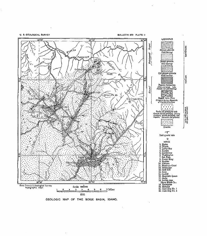
U. S. GEOLOGICAL SURVEY BULLETIN 640 PLATE
LEGEN.D
k£siP<
^^Tr^Cj^^^S-'/v''- V'Famj^~ i ' \i < -'S, x . ((''^Hf-vl" ^
Base from U.S.Geological Survey - -.topographic maps ocaie.
10 1 2 3 4 5.6 7 Miles
1916
MINES1. Blaine2. Illinois3. Lucky Boy4. Eureka5. Gambrinus6. Washington7. Sub Rosa8. Forest King9. Boulder
10. Elkhorn11. Mountain Chief12. Belshazzar13. Gold Hill14. Iowa15. Carroll16. Mountain Queen17. Idaho.18. Golden Age
Diana Mines'Co.:19. Enterprise20. Mohawk21. Coon Dog No. 122. Coon Dog No. 4
GEOLOGIC MAP OF THE BOISE BASIN, IDAHO.
LODE MINING IN BOISE BASIN, IDAHO. 85
dians, and his grave is at Grimes Pass, a few hundred feet east of the road that leads to Payette River. The greater part of the placer ground was located in the same year that gold was discovered, and the succeeding years were marked by great mining activity in this and surrounding regions. The placers of the basin have been worked continuously from their discovery to the present time, though the greatest production was made in the first few years of operation. In many places the rich placer ground was traced to the outcrops of decomposed quartz veins, and these veins were early exploited, though the production of the quartz mines has always been less than that of the placers. Many veins worked by names in the Gambrinus district, northeast of Idaho City, and in the Quartzburg district were thus discovered. In 1867 and 1868 at least 10 quartz mills were reported to have been in operation. These mills treated free-milling gold ores, but after a period of activity and considerable production many of them were dismantled. The cessation of milling in the Gambrinus district and in other parts of the basin was due in part to the working out of ore bodies and in part to the increasing pro portion of ores not amenable to the stamp-amalgamation process. Within recent years, owing to the exhaustion of the placer ground, the quartz deposits are receiving more attention, and mill treatment suitable to the base ores of the Quartzburg district has been success fully devised. Near Grimes Pass the Diana Mines Co. has begun the development of a number of properties and has conducted mill experimentation work. The Gold Hill, Mountain Chief, and Golden Age mines, in the Quartzburg and Grimes Pass belt, have produced notable amounts of gold and silver in recent years.
PRODUCTION.
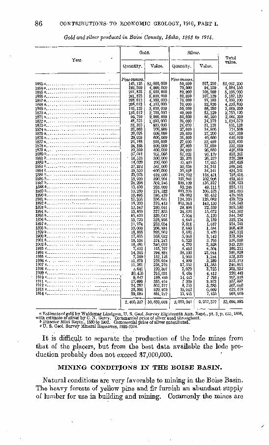
The amount of gold and silver produced in the Boise Basin has long been the subject of dispute, for the records of production for the early years are very incomplete. From the best records avail able, however, the total production of gold and silver from 1863 to 1914 in Boise County is estimated by the Geological Survey at $53,096,995. Of this amount probably more than 95 per cent was derived from the Boise Basin.
During the last five years the installation of large electrically driven dredges that work in extensive creek-bed gravels has mate rially added to the production of the basin, arid in 1912, 1913, and 1914 the annual production exceeded $500,000.
86 CONTRIBUTIONS- TO ECONOMIC GEOLOGY, 1916, PART I.
Gold and silver produced in Boise County, Idaho, 1863 to 1914.
Year.
1863 <».... .-.-..................-.-...-.-..-1864 o. .....................................18650.................... ..................1866 o.. ....................................1867 a....-...-- ..-....-........--....-.-.-.1868 o. .....................................1869 a. .....................................18700...... .--...........-.-........--...-.18710..-............-..-...--..-.-.-----.--1879/118730.......----.-.---.-.------.--.-----.--1874a.... ..................................18750.. .-...- ...................... -..^...18760......................................18770......................................
18790....--....-..------...-----.-.----.--.1QOA Tj
mn>.... ..................................1 OQO 7)iQCo ft
18846. ..... --------------------------------18856...-...----.-.---..-..-----.-.-..--.-.18866......................................18876.......:......--.-..-.--....--.......-1 QSfi h
18896....... ...............................18906......................................18916......................................18926.......................................18936.......................................18946......................................18956......................................18966......................................18976......................................18986......................................18996......................................19006......................................19016......................................19026......................................1903 c.. ................... .........,. ; .....1904 c............... .......................1905 c......... .............................1906 c.. ....................................1907 c............................. ...... .1908 c...... ....................... .... .1909C..... ........................ .1910 cl.. ...... .............................1911 c.............. '........................1912 c............................. ..... .1913 c...... ;....................: -1914 c............................. .
Gold.
Quantity.
Fine ounces. 145,125 193,500 241,875 241,875 208, 013 208,013 145, 125 130, 612 96,750 48,375 38, 700 33,863 29,025 29,025 24, 188 24, 188 19,350 37,011
- 14,513 14,029 27,332 19,350 29,973 18,910 24,296 13, 690 13,280 18, 695 17,253 18,209 13,547 15,859 16, 429 15,770 11,274 10,008 19, 055 17,835 18,104 16,481
7,533 14,265 7,360
11,079 11,381 d,641
10,450 9,647
17,099 24,297 29,996 29,084
2,460,337
Value.
$3,000,000 4,000,000 5, 000, 000 5,000,000 4,300,000 4,300,000 3,000,000 2,700,000 2,000,000 1,000,000
800,000 700,000 600,000 600,000 500,000 500,000 400, 000 765,086 300,000 290, 000 565,000 400, 000 619,600 390,904 502, 246 283,000 274, 522 386, 459 356, 651 376,413 280,041 327,835 339,617 325,995 233,054 206,884 393, 902 368,682 374,243 340, 692 155, 707 294,884 152, 145 229,024 235, 276 199,307 216,031 199, 430 353,464 502,277 620,070 601,2^7
50,859,668
Silver.
Quantity.
Fine ounces. 50,000 70,000 80,000
, 80,000 70,000 70,000 50,000 40,000 50,000 26,000 24,000 27,000 30,000 35, 000 27,000 27,000 24, 000 81,025 23,203 15, 469 30, 938 30,938
110, 702 103, 945 139, 109 52,246
113,376 89,002
124,325 163,368 28, 896 24,876
7,954 4,645 2,811 2,685 5,681 5,068 6,325 4,770 8,432
38,330 1,960 4,909
17,553 7,029 8,484
14, 443 7 308 8,753
10,942 13, 441
2,092,941
Value.
867,250 94, 150
106,960 107,120 93, 100 92,820 66,250 53, 120 66,250 34,372 31, 128 34,506 37,200 40.600 32,400 31,050 26,880 93, 179 26,219 17,635 34,341 34,341
118, 451 102,906 136,327
49, 111 106, 573 93,452
123,082 142,130 22,539 15,672 5,170 3,159 1,687 1,584 3,409 3,142 3,795 2,528 4,504
21,944 1,184 3,289
11,585 3,725 4,412 7.798 3,873 5,383 6,609 7,433
2, 237, 327
Total value.
$3,007,250 4,094,150 5,106,960 5, 107, 120 4,393,100 4,392,820 3,066,250 2, 753, 120 2,066,250 1,034,372
831,128 734,506 637, 200 640,600 532,400 531,050 426,880 858,265 326,219 307,635 599,341 434,341 738,051 493,810 638,573 332, 111 381.095 479,911 479, 733 518, 543 302,580 343,507 344,787 329,154 234,741 208,468 397,311 371,824 378,038 343,220 160, 211 316,828 153,329 232, 313 246,861 203,032 220,443 207, 228 357,337 507,660 626, 679 608,660
53,096,995
o Estimate of gold by Waldemar Lindgren, U. S. Geol. Survey Eighteenth Ann. Rept.,pt. 3,p. 655,1898, with estimate ofsilver by C. N. Gerry. Commercial price of silver used throughout.
6 Director Mint Repts., 1880 to 1902. Commercial price of silver substituted, c U. S. Geol. Survey Mineral Resources, 1903-1914.
It is difficult to separate the production of the lode mines from that of the placers, but from the best data available the lode pro duction probably does not exceed $7,000,000.
MINING CONDITJONS IN THE BOISE BASIN.
Natural conditions are very favorable to mining in the Boise Basin. The heavy forests of yellow pine and fir furnish an abundant supply of lumber for use in building and mining. Commonly the mines are
LODE MINING IN BOISE BASIN, IDAHO. 87
equipped with sawmills, and sufficient timber can be cut on the mining claims to supply their own demands. Water for milling is
abundant, but the supply for hydraulic placer mining is scant, and it must be conducted through ditches and flumes many miles long that are expensive to build and maintain. Most of the hydraulic operators can work only for a few months of the year. The streams in the basin are too small and too low in gradient for the develop ment of electric power, but the Boston & Idaho Co.'s power plant on Payette River supplies power for .the company's own needs and sells surplus current to other mines of the region. The Intermountain Railroad, which connects Centerville with Boise, will materially re duce the charges for transportation on mine and mill supplies and on ores and concentrates shipped to smelters.
MILLING PRACTICE.
The future of lode mining in the Boise Basin, particularly along the Quartzburg and Grimes Pass porphyry belt, will largely depend on the adoption of suitable mill treatment, for the ores taken out along this belt are becoming increasingly base, and in general less than 50 per cent of the gold content can be recovered by amalgama tion. The present milling practice of the Boise Basin ores is stamp amalgamation, concentration, or cyanidation, or a combination of these processes.
Stamp-amalgamation mills were exclusively used during the early days of mining and are still adaptable to some of the ores in the Gambrinus district, and a large part of the gold content of the Gold Hill ores is obtained by this method. At the Gold Hill mine, how ever, an additional saving is made on Wilfley tables and vanners. Most of the concentrates from this mine were shipped, but for a time cyanidation of the concentrates proved a success, and it is said that this practice will be resumed. Other ores from the Quartzburg and Grimes Pass porphyry belt are much baser than the Gold Hill ores. The ores from the Mountain Chief mine, at the south end of this belt, are treated by combined amalgamation, concentration, and cyanidation. About 40 per cent of the gold content is caught on the amalgamation plates. The overflow from the plates is concen trated to a low-grade product by Deister and Wilfley tables, and the concentrates are further treated with a weak cyanide solution. In this process 92 per cent of the gold content is extracted. The com bined extraction of the processes used at this mine is said to be about 85 per cent. The company is contemplating the cyanidation of the whole mine output.
The Golden Age mill, near Grimes Pass, is now treating base ores from the lower workings. The total saving of the gold content by
88 CONTEIBUTIONS TO ECONOMIC GEOLOGY, 1&16, PART I.
combined stamp amalgamation and concentration is said to be only 60 per cent.
A mill was built in 1902 to treat the ores from the Enterprise group. The processes employed, a combination of amalgamation and concen tration, are reported to have been not very satisfactory. This mill has been acquired by the Diana Mines Co., and experiments are being made on the ores from that company's numerous claims. Some of these ores are composed chiefly of sphalerite and chalcopyrite.
PHYSIOGRAPHY AND GEOGRAPHY.
From the high ridge above Quartzburg an observer looking east ward obtains a vivid impression of the significant structural features of the Boise Basin. Before him the area of depression, 15 miles long and 12 miles wide, is inclosed on all sides except to the north by high mountains. This area is traversed by heavily wooded flat- topped and gently sloping ridges that rise but a few hundred feet above the stream levels. These ridges, though outliers of the inclos ing mountains, are separated from them by abrupt slopes several hundred feet high. This change in slope is well marked on the ridges to the east, though modified by the valleys. The south boundary of the basin is marked by an abrupt change in slope from the level of the benches that border Moore Creek on the south. In a similar manner the Boise Ridge on the west is sharply delimited from its outlying spurs. The ridge that bounds the basin on the north, however, presents no strong contrast to the topography of those within the basin. This ridge, which here marks the divide between Payette River and tributaries of Moore Creek, extends from the Boise Ridge north of Quartzburg eastward around the head of Grimes Creek and joins the high mountains on the east side of the basin. Near Grimes Pass the summit of this ridge is but a few hundred feet above Grimes Creek, but its northern slope is a steep descent of 2,500 feet to the level of Payette River.
The most prominent peaks of the surrounding mountains are Wilson Peak and Elk Creek Mountain, to the east; Thorn Creek Moun tain, to the south; and Shafer Butte, on Boise Ridge. Of these peaks Elk Creek Mountain, about 8,300 feet in altitude, is the highest, and Shafer Butte, 7,500 feet, the lowest. Idaho City, at an altitude of 4,000 feet, is the lowest town in the basin. Quartzburg is at an alti tude of 4,500 feet, and Pioneerville at about 4,300 feet. Grimes Pass is 5,100 feet above sea level and Garden Valley Pass 4,900 feet.
The Boise Basin is drained by Moore Creek, which joins Boise River about 20 miles southwest of Idaho City. The principal tributaries of Moore Creek are Granite, Grimes, and Elk creeks. Within the basin these streams flow in broad gravel-filled channels with grades as low as 20 feet to the mile, but their upper courses in
LODE MINING IN BOISE BASIN, IDAHO. 89
the surrounding mountains have steep grades and narrow valleys. Their grades below the basin are also much steeper than those within it. Evidently the peculiar physiographic features of the Boise Basin were not formed by stream erosion alone. An explanation of their origin is given hi the discussion of the geologic history below.
I GEOLOGY.
' HOCKS OF THE AREA.
The Boise Basin is underlain chiefly by granite, but within it there are also later intrusive porphyritic rocks, lamprophyres and pegma tites, small areas of lavas and lake beds, and bench and stream gravels. The granite is part of the Idaho batholith, an intrusive mass whose area exceeds 20,000 square miles. The age of this granite is consid ered late Cretaceous or early Tertiary. Porphyritic dike rocks, which comprise diorite porphyry, rhyolite, quartz diorite porphyry, and related varieties, are most abundant in the zone extending north eastward from Quartzburg, but rocks of one or more of these types occur sparingly hi other parts of the basin. Pegmatites and dark fine-grained dike rocks (lamprophyres) are more generally distributed through the area, and commonly the lamprophyres are intruded in the fissures or shear zones that contain the ore deposits. Small areas of lake beds and associated basalts overlie the granite near IdaMo City, Placerville, and Pioneerville. Old bench and stream gravels occur at numerous places along the streams and in the low divides between them. Generally their maximum elevation does not exceed 250 feet above the creek bed, but high on Boise Ridge Lindgren noted a deposit of gravel whose present position can be accounted for only by exten sive faulting.
GEOLOGIC HISTORY.
With regard to the geologic history of the Boise Basin Lindgren states:
The succession of geological events to which the existence of the basin and of the gold-bearing gravels is due is neither simple nor easy to decipher. In a large degree this is owing to the very monotonous structure of the bedrock series, which gives few clues, except those indicated by the topography, to the character of the movements that have taken place, for it soon becomes apparent during a study of the district that erosion alone, unaided by orographic movements, can not have produced this depression situated on the divide between two main rivers.
The principal events are believed to be as follows, though the sequence is incomplete:
The oldest rock is the granite, which is of late Cretaceous or early Tertiary age. Next the granitic dike rocks were intruded, and still later the lode deposits were formed. Before the uplift that differ entiated the Snake River plains from the mountainous area to the
' 37757° Bull. 640 17 7
90 CONTRIBUTIONS TO ECONOMIC GEOLOGY, 1916, PAET 1.
east the granite was extensively eroded, and the higher summits are thought to be part of the old surface thus produced. The structure of the basin is due to faulting, by which a'block of granite was sunk far below the surrounding upland surface. At this tune the drain age system was initiated, and the streams within the basin eroded channels nearly to their present levels. Later, during Tertiary time, Snake River was dammed by causes ascribed to crustal move ments, and the plains area was occupied by a lake whose high-level mark, as recorded on the mountains near Boise, was 4,200 feet. This lake extended up Boise River and its tributary Moore Creek and occupied much of the basin. Beds of clay and fine and coarse granite sands were deposited in the lake, and gravel deposits were laid down at the mouths of tributary streams. Basalt flows were also intercalated with the lake beds. Further crustal movements caused the draining of the Tertiary lake, and the streams within the basin resumed then' erosion. Large parts of the gravel and lake beds within the basin were removed, but further faulting occurred and some blocks of lake deposits were sunk and others tilted to altitudes above that of their original deposition. In late Tertiary tune came the eruption of Snake River basalt. On lower Moore Creek lava of this age that probably flowed through a vent along the stream forms a level floor whose top is about 100 feet above the creek. When this lava was poured out it effectively dammed the creek and caused the deposition of gravel along the main streams of the Boise Basin. These gravels are termed bench gravels and occur more or less con tinuously at elevations ranging from a few feet to 100 feet above the stream beds. The lava barrier was gradually cut through by Moore Creek, and its base is now well above the stream level.
IGNEOUS BOCKS.
GRANITE.
Within the Boise Basin the granite shows little variation in compo sition and lithologic character. It is a coarse-grained gray rock that readily disintegrates to a coarse sand. It is not well exposed over the larger part of the area, and generally specimens of the fresh rock can be obtained only from mine workings. Quartz, orthoclase, oligo- clase, and biotite are the principal constituents. Hornblende is a variable constituent, and where present occurs in small amounts. Titanite and zircon are accessory. The granite generally shows little evidence of secondary structure, but along the Quartzburg and Grimes Pass porphyry belt and in the Gambrinus district the granite is sheared in zones thai trend, respectively, northeast and about N. 60° W.
LODE MINING IN BOISE BASIN, IDAHO. 91
DIKE ROCKS.
GENERAL FEATURES.
The zone of porphyritic dike rocks in the Boise Basin is over 12 miles long> and extends from Canyon Creek to and beyond Grimes Pass. Its. extent east of the Coon Dog group was not determined. Rocks similar to some of those here described occur in the Pearl district, about 20 miles southwest of Quartzburg, in alignment with the basin zone. Lindgren mapped these rocks in the Boise Basin and used the term "porphyrite" to include the several types. The zone varies in width; it is narrowest in the Gold Hill mine, where it is probably not over 200 feet wide, but it is nearly a mile wide at the head of Wolf Creek, gradually narrows to a quarter of a mile at the Golden Age mine, and beyond that attains a width of over a mile.
The dike rocks of the porphyry belt present many variations, and the relations of the different types are not everywhere apparent. Some types occur throughout the zone, but others are only local. In places one type may grade to another type. The rocks of this zone consist of diorite porphyry, quartz diorite porphyry, granite porphyry, rhyolite porphyry, and narrow fine-grained dark dike rocks. The diorite porphyry and the porphyritic granitic rocks are the most per sistent. Rhyolite was noted only in the vicinity of Grimes Pass. It is the dominant rock in the Coon Dog No. 1 claim and occurs as a small mass inclosed in diorite porphyry in the Golden Age mine. In common with the granite, the dike rocks are greatly decomposed on the surface and no attempt has been made to map the different kinds.
QUARTZ DIORITE PORPHYRY AND GRANITE PORPHYRY.
Rocks that are best described by the terms quartz diorite por phyry and granite porphyry were noted at several places along the zone from the Gold Hill mine to the claims of the Enterprise group. The relations of these varieties are not clear, though probably they are gradations of the same magma. These rocks are the dominant kinds in the Gold Hill mine, and they appear to be older than smaller masses of diorite porphyry and narrow dikes of lamprophyre. All these rocks are altered, and the alteration is greatest along shear zones containing the ore bodies, where the feldspars are altered to sericite and calcite and the hornblende and biotite are. altered to chlorite. Pyrite in cube form is abundant and occurs commonly in the altered feldspars. The rocks in this mine are gray to green. Some of the sections examined microscopically show holocrystalline minerals in the groundmass with large feldspar and quartz phenocrysts. The feldspars are labradorite and in less quantity orthoclase. The altera tion products of hornblende and biotite are abundant in the ground-

92 CONTRIBUTIONS TO ECONOMIC GEOLOGY, 1916, PART I.
mass. Other rocks of a light-gray color contain large phenocrysts of altered feldspar and rounded crystals of quartz embedded in a fine grained or felsitic groundmass. In these rocks the ferromagnesian minerals occur in small amounts.
RHYOLITE PORPHYRY.
Intrusive bodies of rhyolite porphyry were observed in the Golden Age mine and in prospects on the Coon Dog group. The rhyolite porphyry may represent a phase of the granite porphyry and quartz diorite porphyry. It is a light-gray rock in which small crystals of quartz are sparingly distributed in a fine-grained or felsitic ground- mass. Under the microscope the groundmass is seen to be composed of feldspar and quartz, in part intergrown, and sparse minute grains of chlorite that are probably altered crystals of hornblende. The feldspar is chiefly orthoclase.
DIORITE PORPHYRY.
Diorite porphyry is abundant in the porphyry belt, being well de veloped between Canyon Creek and the Gold Hill mine and the dominant rock in. the Golden Age mine. It is a gray to green spotted rock in which phenocrysts of feldspar generally about a quarter of an inch in diameter are set in a fine-grained groundmass of feldspar, hornblende, and biotite, or their alteration products. The large feldspars are in part labradorite, some of them wholly or partly al tered to sericite and calcite. Hornblende is almost entirely altered to chlorite, and the biotite is partly altered to chlorite and white mica. Labradorite, orthoclase, and a little quartz also occur in the ground- mass.
DARE-COLORED DIKE ROCKS.
Small dark-colored dikes (lamprophyres) occur at numerous places in the Boise Basin and commonly are intruded in the shear zones and fissures that contain the ore deposits. They are of different types, but probably the most common variety is one containing black mica or biotite and known as minette.
A typical specimen from the Washington mine, in the Gambrinus district, is a dark-green fine-grained rock containing conspicuous plates of biotite. Under the microscope the groundmass is seen to be composed chiefly of brown hornblende, orthoclase, and sodic plagioclase with interstitial quartz. - Magnetite in small grains and crystals is plentiful. Chlorite, calcite, and sericite are abundant secondary products.
Numerous bowlders of a fine-grained dark-gray rock that have evidently been derived from dikes in the basin occur in the bench gravels east of Placerville. The rock is a granular aggregate of labra dorite laths, hypersthene grams, and a little quartz. Magnetite is

LODE MINING IN BOISE BASIN, IDAHO. 93
present in numerous small grains, and small crystals of apatite are accessory. This rock is petrographically a norite gabbro.
Diabase dikes in the porphyry belt north of Placerville are reported by Lindgren. In the Mountain Chief mine an altered dark-colored dike as much as 30 feet wide closely follows the shear zone in which the vein was deposited. The dike is evidently earlier than the ore, for the vein occurs on one or both walls of the dike, and in places the dike is shattered and numerous veinlets of quartz and ore pene trate it. This rock appears to be similar to the dike rock occurring in the bench gravels east of Placerville.
PEGMATITE.
Pegmatite dikes occur commonly throughout the basin. Owing to the extensive disintegration of the granite and its similarity to pegma tite composition the pegmatite can not be readily distinguished from it, but in places where the granite bedrock is exposed by placer mining numerous small irregular dikes of pegmatite were noted. These dikes are composed principally of large crystals of quartz and feldspar and plates of mica, but in several of them garnets were noted, and the dikes are believed to be the source of some of the rarer minerals found in the placer deposits. Monazite, bismuthinite, and a radioactive mineral whose composition has not been determined are thought to have been derived from the pegmatite dikes.
BASALTS.
The latest igneous rocks in the Boise Basin are the basalts, of which there are small patches associated with the lake beds near Idaho City. As described by Lindgreii, the basalt is a medium-grained dark-green rock, with abundant scattered crystals of greenish-yellow olivine. Under the microscope it is seen to be composed of augite, labradorite, olivine, and small crystals of magnetite. A considerable body of basalt occurs high on Boise Ridge northwest of Quartzburg and is correlated with the basalt accompanying the lake beds.
SEDIMENTARY BOCKS.
PAYETTE FORMATION.
The lake deposits to which the name Payette formation has been given consist of unconsolidated clay, sand, and gravel. They occupy a considerable area on both sides of Moore Creek near Idaho City. There is a small area of similar beds on Muddy Creek about If miles north of Pioneerville, and some granite sand that underlies the bench gravels on Fall Creek west of Placerville is thought to be part of this series. About 300 feet of these beds are exposed near Idaho City, where they consist chiefly of green and gray clays with sandy layers
94 CONTRIBUTIONS TO ECONOMIC GEOLOGY, 1916, JART I.
and thin beds of coaly material. On Muddy Creek carbonized wood from the lake beds is used for blacksmith fueL Silicified wood is commonly found in these beds, and the clay layers contain well- preserved vegetable remains, by means of which the early Tertiary (Eocene) 1 age of these beds was determined. Near Idaho City the beds have a westerly dip as high as 15° and have clearly been dis turbed since then* deposition. The lake beds are separated from the granite by faults near Warm Springs 2 and on Elk Creek at the north end of Gold Hill. These faults have preserved the lake beds from erosion; indeed, near Idaho City the lake beds extend far below the present stream channels. A bore hole was sunk in these beds at Idaho City from a point 20 feet above the level of Moore Creek, and a thickness of 516 feet was measured to granite bedrock. The total thickness of lake beds at Idaho City is about 850 feet.
TERTIARY STREAM GRAVELS.
Deposits of auriferous gravels overlie the lake beds east of Idaho City and the granite in scattered areas on ridges near Placerville and Pioneerville. They occur generally not more than 250 feet above the stream levels, and their maximum thickness is about 100 feet. These gravels are regarded by Lindgren as having been laid down soon after the deposition of the lake beds, and are therefore of Tertiary age. They have been worked since the discovery of gold in the basin and are well situated for hydraulic mining, which is the method generally employed. The working season is dependent on the water supply and generally does not exceed three months.
BENCH GRAVELS.
In addition to the Tertiary stream gravels there are in numerous localities along the streams, generally at lower elevations, other gravels that are regarded by Lindgren as having been deposited when lower Moore Creek was dammed by a basalt flow. These gravels are, as a rule, not more than 25 feet thick. West of Placerville, between Fall and Canyon creeks, they are in places 200 feet above the stream levels. Their present position is due, according to Lindgren, to dis placement along the steep eastern fault scarp of Boise Ridge. In this connection Lindgren noted on Boise Ridge at an altitude of 6,800 feet a small body of gravel intercalated in basalt flows. The bench gravels have been extensively mined, and little of the original deposit remains.
1 Knowlton, F. H.. FossU flora of the John Day Basin, Oreg.: U. S. Geol. Survey Bull. 204, pp. 110-111. 1902.
2 Lindgren, Waldemar, op. cit., p. CG7.
LODE MINING IN BOISE BASIN, IDAHO. ' 95
RECENT STEEAM GRAVELS.
The major streams within, the Boise Basin proper flow in compara tively broad gravel-filled channels with low gradients, in contrast to their upper and lower courses outside of the basin, where the canyons are narrow and the stream grades are steep. The gravel deposits in these channels are in part reconcentrated older stream and bench gravels. Near Idaho City, on Moore and Elk creeks, the average width of these gravels for a distance of 3 miles is about 1,000 feet and their depth ranges from 15 to 30 feet. Tailings from placer operations in the older and higher gravels have spread out over the adjacent creek bottoms and in many places form extensive deposits several feet thick. These gravels were rich in gold 'and were extensively worked in the early days of placer mining, but owing to the low stream gradients and to the depth of gravel below water level a con siderable part of the deposits could not be worked until their sys tematic exploitation was undertaken by dredges. Below Centerville, on Grimes Creek, to the junction with Granite Creek and up Granite Creek for several miles the creek gravels are available for dredging, but the Moore Creek deposits have been practically worked out.
ORE DEPOSITS.
CLASSIFICATION AND DISTRIBUTION.
The ore deposits of the Boise Basin comprise veins and placer deposits. The veins occur in zones of sheeted granite. The two most persistent zones are the Quartzburg and Grimes Pass gold belt and that in the Gambrinus district, 6 miles northeast of Idaho City, but scattered quartz veins and shear zones occur outside of these main zones. The Quartzburg and Grimes Pass belt extends in a northeasterly direction and bounds the Boise Basin on the northwest; the zone of shearing in the.Gambrinus district trends about N. 60° W. and lies partly along the base of the steeper mountains that bound the basin on the east. Both belts are believed toJie in or parallel to zones of major faulting which in part determined the topographic features of the basin.
GAMBBINT7S AND ELKHORN DISTRICTS.
Many mines in the Gambrinus district were considerable producers in the early days of mining in the basin, among them the Illinois, Lucky Boy, Gambrinus, Washington, Sub Rosa, Boulder, and Forest King. The Elkhorn mine, in the Elkhorn district, which bounds, the Gambrinus district on the north, was extensively worked in 1867 and 1868, and intermittently since then, and is credited with a production of $800,000. The records of production of these mines are very

96 CONTRIBUTIONS TO ECONOMIC GEOLOGY, 1916, PART I.
incomplete, but it is believed that the Gambrinus and Elkhorn dis tricts have produced not less than $2,000,000. Most of the mines have not been worked for many years, and their workings are inac cessible. The Lucky Boy mine, however, was being reopened at the time of the writer's visit, ,and preparations were being made to mill the ore. The ore of the Gambrinus district was largely free milling, and much gold was obtained from sluicing the vein outcrops. Gam brinus, Illinois, and other gulches that head in this belt were very rich in placer gold. The ore is contained in extensive shear zones in granite and is largely oxidized, but it is said that in the deeper work ings of the Gambrinus mine stibnite was found, and ores from the Boulder mine contain pyrite, arsenopyrite, and sphalerite. The ore of the Lucky Boy, which is probably similar to ores from adjoining properties, is a sheeted granite traversed by iron-stained seams and by stringers and lenses of quartz, making in places shoots of high- grade gold ore. The Washington mine, in addition to gold .ore in shear zones, contains a well-defined vein that is valuable chiefly for silver. Notwithstanding the considerable production of gold from these mines and from placers below them, the exploitation of mines and prospects in the Gambrinus and Elkhorn districts appears to be unaccountably small.
PLACER DEPOSITS.
The placer deposits are found chiefly along the major streams of the basin and in the tributary streams and gulches which head in the gold-belt areas. Fall, Granite, Wolf, Ophir, Muddy, and Grimes creeks and California and Ophir gulches, which head in or cut through the Quartzburg and Grimes Pass belt, and Elk and Moore creeks with their tributaries, which drain the area of the Gambrinus and Elkhorn districts, are all rich in placer gold, while streams outside of these zones and not cutting isolated veins contain little gold. The gold is contained in the older stream and bench gravels and in the recent stream gravels. The principal placer operators of the Boise Basin during the season of 1915 were the Boston & Idaho Gold Dredging Co., operating a dredge on Moore Creek, near Idaho City; the Boise Basin Improvement Co., hydraulicking the old stream gravels of Gold and East hills, near Idaho City; and others conducting hydraulic operations on the Leary-Brogan and Reid tracts, east of Placerville, and on the tracts owned by the Missouri Mining Co., on Muddy Creek.
Coarse gold is becoming increasingly rare in the Boise Basin, as the shallower and richer deposits toward the source of the gold have been worked over. Few of the particles now obtained are worth more than a fraction of a cent, although nuggets worth several dollars are occasionally saved. The placer gold ranges in fineness from 0.770 to 0.912, and is generally of higher grade than the average obtained

LODE MINING IN BOISE BASIN, IDAHO. 07
from the lodes. The minerals associated with the gold in the placer deposits are monazite, garnet, hematite, ilmenite, bismuthinite, and a rare mineral not specifically determined, which gives a test for radium. Monazite is abundant and widely distributed in the gravel deposits. According to Lindgren, it contains about 1.2 per cent of thoria, one of the principal rare-earth oxides that are used in the manufacture of incandescent mantles. The principal supply of monazite comes from Brazil, where the mineral is of higher grade than the Boise Basin monazite and is cheaply mined. A mill was built near Centerville to save the monazite, but it burned down several years ago, and apparently little of the product was, shipped. Small crystals of bismuthinite, or bismuth sulphide, occur sparingly in the Leary-Brogan and Reid tracts, east of Placerville. The rare radium- bearing mineral was noted only at one place in shallow placer ground in a small gulch tributary to Grimes Creek about 1$ miles southwest of Pioneerville. Garnet, hematite, and ilmenite are commonly asso ciated with the placer gold but have no economic importance.
QTJARTZBURG AND GRIMES PASS GOLD BELT.
DISTRIBUTION AND CHARACTER OF VEINS.
The Quartzburg and Grimes Pass gold belt contains mines and prospects from the Mountain Chief mine to Grimes Pass, but for a distance of several miles northeast of the Mineral Hill prospect little development work has been done. The veins comprise quartz-sul phide fillings with well-defined walls and narrow veinlets in shattered zones in the country rock. Some of the veins or fissures have a proved length of 1 mile, but their extent in depth has not been deter mined. The deepest shaft is that of the Gold Hill mine, 500 feet deep, and it represents the greatest depth to which any of the veins have been explored about 4,000 feet above sea level. The divide between Canyon and Fall creeks at the point where it is crossed by the Mountain Chief vein is about 6,000 feet in elevation; therefore a vertical range of at least 2,000 feet in the vein occurrence is repre sented. The Gold Hill mine is the only one in which extensive development work has been done, and the exploitation of veins along this belt, like that in the Gambrinus district, is comparatively little. The veins trend in a general northeasterly direction and dip 30°-80° SE. They are usually in or adjacent to the intrusive por phyries, but some are in granite half a mile from the porphyry con tact. In its greatest development near Garden Valley Pass and east of Grimes Pass the vein zone is 1$ miles wide, but southwest of the Gold Hill mine, where the porphyry belt is narrow, the veins are lim ited chiefly to the footwall of the dike.
98 CONTRIBUTIONS TO ECONOMIC GEOLOGY, 1916, PAET I.
MINERALOGY
The primary ore minerals that were observed in the ores of the Quartzburg and Grimes Pass belt are native gold, pyrite, galena, sphalerite, chalcopyrite, stibnite, and tetrahedrite, and those derived from the alteration and oxidation of the primary minerals are cerusite, chalcocite, malachite, and native copper. The zone of oxidation, however, extends only a short distance below the surface, and the secondary minerals form no well-defined deposits and nearly every where are associated with some unaltered sulphide material. Native copper was noted in a specimen of finely brecciated rhyolite obtained near the surface on the Coon Dog No. 1 claim, and malachite in surface croppings of granite porphyry on the same claim. Chalcocite occurs as a sooty coating and partial replacement of the chalcopyrite in the Coon Dog ores. Cerusite occurs sparingly as a partial alteration product of galena in shallow ores in the Golden Age, Enterprise, and other workings near Grimes Pass.
The mineral composition of the veins along this belt is variable. Pyrite and sphalerite are most widely distributed; some of the other minerals occur only here and there. Thus massive arseno- pyrite was noted only in the deeper workings of the Mountain Chief mine. Stibnite is common in the Mountain Chief and Gold Hill ores. Tetrahedrite occurs chiefly in the ores in the vicinity of Grimes Pass but was also noted in specimens from the Carroll mine. Chalcopyrite is particularly abundant in the ores of the Coon Dog group and occurs sparingly, intergrown with arsenopyrite, in the Mountain Chief ores. Galena is most abundant near Grimes Pass.
Up to the present time gold is the principal metal that has been derived from the mines along this belt, mainly because it predomi nates in the Gold Hill ores, but silver is also of value in the recently developed Mountain Chief and Golden Age mines, and assays of the ores from several prospects of the Diana Mines Co. indicate high silver contents. The proportion by weight of silver to gold in the Mountain Chief ores is 4 to 1. With the erection of adequate concentrating machinery lead, copper, and possibly zinc will add materially to the metal output of the Grimes Pass ores. Gold is particularly associated with stibnite in the Gold Hill and Mountain Chief ores. In the Gold Hill mine it can frequently be seen, in places in coarse flakes, but in the Mountain Chief mine it is generally not visible until the crushed ore has been scoured in the pan. Some galena ores near Grimes Pass carry high gold contents, and it is reported that large pieces of inter- grown galena and gold were obtained from the disintegrated outcrop of the vein on the Overlook claim of the Diana Mines Co. Silver appears to accompany the antimonial minerals, particularly tetra hedrite and also galena.

LODE MINING IN BOISE BASIN, IDAHO. 99
MINES.
MOUNTAIN CHIEF.
The Mountain Chief mine (No. II), 1 at the southwest end of the porphyry belt, is 3£ miles .west of Piacerville. Six claims and one mill site form the group> which is owned by the National Mining & Development Co. The Ebenezer, an adjoining claim, one of the early discoveries of the region, was acquired by the company and is in cluded in the group. The claims extend from the summit of the divide between Fall and Canyon creeks to Canyon Creek. The Mountain Chief and Ebenezer claims produced considerable gold in the early days, mostly from sluicing of the disintegrated vein, but other than $15,000 reported in the Mint records the amount is not known. The National Mining & Development Co. was organized in 1911, and development work was begun in December of that year. The mill was put into operation October 1, 1912; and continued until May 1, 1913, but since that time it has been running intermittently. The production by the present company is between $150,000 and $175,000.
The property is developed by four tunnels, all driven northeast ward on or near the strike of the vein. Tunnel No. 1 is near the summit of the divide between Fall and Canyon creeks. Tunnel No. 2 is about 120 feet below No. 1 and is 600 feet long to the face. Tunnel No. 3 is 115 feet below No. 2 and is 800 feet long. Tunnel No. 4 is 168 feet below No. 3 and at the time of visit had been opened for 400 feet. The portal of tunnel No. 4, 5,600 feet in altitude, is several hundred feet above Canyon Creek. Practically all the ore above tunnel No. 3 to the end line of the claim has been stoped out. The ore is conveyed to the mill on Canyon Creek by an aerial tram, the upper terminal of which at the time of visit was being changed from tunnel No. 3 to the portal of tunnel No. 4.
The vein is a fissure filling in sheared granite and diorite por phyry. It strikes N. 45° E. and dips 60° SE. The diorite porphyry occurs at the northeast end of the claim. The shear zone is fol lowed persistently on the hanging wall of the vein by a fine-grained greenish dike rock 10 to 30 feet wide. The rock is considerably altered, but it probably belongs to the lamprophyre group. Dikes of similar character were noted in surface workings of the Ebenezer claim. In No. 4 level the vein or ore shoot is followed by an altered green dike from a few inches to several feet wide. The dike is older than the vein, for the ore may be on either or both walls of the dike or may occur in it as veinlets penetrating shattered parts. The vein or the mineralized part of the shear zone averages 2 feet wide, but it pinches and swells and in places is but a few inches wide. The
' The numbers in parentheses indicate corresponding numbers on Plate II.
100 CONTRIBUTIONS TO ECONOMIC GEOLOGY, 1916, PART I.
ore is obtained mainly from a single vein, but here and there sul phide veinlets lead off into the wall rock. The vein varies in char acter; in some places sulphides with subordinate quartz constitute the fissure filling; in other places coarsely granular quartz is abun dant, particularly in the central part of the vein. The sulphides are pyrite, sphalerite, arsenopyrite, chalcopyrite, and stibnite. Stibnite occurs in the quartz-sulphide ore as thin spindles between the quartz crystals or extending across the vugs in the quartz. Ore of this type contains much gold. Sphalerite was particularly abun dant in the upper workings, where the wall rocks are of diorite porphyry, but occurs sparingly in the quartzose ores from the lower levels. Massive sulphide ore from the dump of tunnel No. 4 shows an intergrowth of arsenopyrite, pyrite, chalcopyrite, and a few quartz crystals. Arsenopyrite was noted hi no other mine along the porphyry belt, although this mineral is common in the ores of the Pearl district. A polished section across quartzose ore shows deposition of pyrite along the walls and granular quartz and small fragments of altered wall rocks in the center. The quartz was de posited at different periods, for the vein shows several bands separ ated by streaks of small fragments of wall rock. Stibnite and some pyrite occur in the interstices of the quartz crystals. The vein, then, was first composed of pyrite and probably other sulphides, the fissure was reopened by subsequent movement along it, and quartz and finally stibnite were deposited.
Two ore shoots have been developed in tunnels No. 3 and No. 4, and the shear zone connecting them contains small stringers and bunches of ore. According to Mr. Gallupe, the shoot at the south west end of the workings is 150 feet long and that at the northeast end 400 feet long. Both ore shoots pitch northeast. The assay value of the ore is said to average more than $30 a ton and is seldom as low as $20 a ton. Picked ore that showed abundant stibnite assayed more than $1,000 a ton. In a recent communication Mr. Gallupe states that the ore from the more recently developed parts of tunnel No. 4 assayed from $30 to $40 in gold and 6 to 8 ounces of silver to the ton. The vein is 10 inches to 2 feet wide.
The mill began the treatment of ores October 1, 1912. A com bined stamp-amalgamation and concentration process was first used. The concentrates were shipped to smelters near Salt Lake City. In August, 1914, cyanidation was employed on the concentrates, with results so satisfactory that the company is planning to work the entire mine output by this method. The mill is equipped with five stamps and its capacity is 20 tons a day. The ore is crushed to pass a 20-mesh screen and flows over plates, where approximately 40 per cent of the gold content of the ore is caught. The overflow from the plates is classified and treated on tables where a low-grade concen-
LODE MINING IN BOISE BASIN, IDAHO. 101
trate is obtained. The concentrates are reground in a 4-foot pan to a slime and then treated with a weak cyanide solution 2 pounds cyanide to the ton of water. The charge is agitated for 48 hours and subjected to intermittent decantation. An extraction of 92 per cent of the gold content of concentrates is made, and the combined recovery by amalgamation and cyanidation is 85 per cent. The fineness of the bullion is slightly more than 0.600.
BELSHAZZAR.
The Belshazzar group (No. 12) of eight unpatented claims joins the Mountain Chief group on the northeast and extends to Fall Creek. George Tew, Lewis Klein, and associates are the owners of the property. The discovery was made in 1875 through placer workings, and the disintegrated vein matter near the divide between Fall and Canyon creeks is said to have yielded $65,000 hi gold. There has been intermittent development on the property since 1880, but the last productive work was done hi 1909. About 4,000 tons of ore has been treated in a small stamp and concentration mill on the property, and the average value of the ore was $10.48 a ton. Fully 50 per cent of the gold content of the ore was recovered on the plates. The concentrates, which are mainly pyrite, assay from $21 to $100 a ton, but they have not been shipped.
The mine is developed by three tunnels at intervals of 100 feet on the dip of the vein. The upper tunnel is driven 550 feet, the middle tunnel 600 feet, and the lower tunnel 512 feet. They are connected by raises. From the lower tunnel an aerial tram conveys the ore to the mill on Fall Creek, 400 feet below. The vein, which on its con tinuation in the Mountain Chief group strikes N. 45° E. and dips 60° SE., on this group strikes N. 60°-80° E. and dips at an average of 35° S., but in the lower tunnel it becomes steeper. The vein follows for most of its course the contact between granite on the footwall and diorite porphyry on the hanging wall, but in places either rock may occur on both walls of the vein. The vein is contained in a shear zone, and the width of the ore ranges from a few inches to several feet. The wider parts of the vein have been stoped out above the middle tunnel. In places there is much gouge material along the vein and in the ore. The wall rocks of the vein have been largely altered, and sericite is abundant. The shear zone in the por phyry has been penetrated by a crosscut 20 feet long, a short distance from the portal of the lower tunnel. Here numerous small seams of pyrite are exposed which trend at small angles to the course of the main vein fissure.
The ore is similar to that from the Mountain Chief mine and con sists of sulphides, generally in small veinlets, relatively free from quartz, and a quartzose ore with stibnite hi the interstices and in vugs of the quartz crystals. Ore of this type has a high gold content.

102 CONTRIBUTIONS TO ECONOMIC GEOLOGY, 1916, PART I.
Pyrite is the most abundant sulphide, but locally sphalerite occurs in notable quantities:
GOLD HILL.
The Consolidated Gold Hill and Iowa group (Nos. 13 and 14) at Quartzburg consists of 14 claims, 11 of which are patented. It in cludes the Newburg, Homeward Bound, Elizabeth, Mayflower, Con federate, Dunlap, Gold Hill, Pioneer, Lone Star, Mountain Girl, and Iowa claims. The property, of which E. E. Carter is manager, is controlled by the Boston & Idaho Gold Dredging Co. The reported production from the workings of this group exceeds $5,000,000, but mining is now being done only through the Pioneer shaft. The Pioneer claim has produced $200,000 in the last seven years. The veins of this group were located in the early sixties and have been productive with short interruptions since 1864. Three stamp-amal gamation mills, the Iowa, Last Chance, and Pioneer, treated the ores, but the Pioneer is the only one now operated. In the early days considerable gold was obtained from surface workings and the sluicing of disintegrated vein matter on the Newburg, Homeward Bound, Elizabeth, and Mayflower claims.
Three well-defined productive ore zones nave been exploited on the Gold Hill group. The northernmost of these zones is the Iowa, which, according to Lindgren, is a narrow vein very rich in free gold that strikes in the northeasterly direction common to most of the veins hi the porphyry belt and dips southeast. The wall rocks are granite.
The Gold Hill vein, a short distance south of the Iowa vein, is de nned by Lindgren as a well-defined quartz vein which strikes N. 70° E. and dips 70° S. The footwall is granite, and on the hanging-wall side is a belt of porphyritic rocks several hundred feet wide. The vein is irregular and ranges from a few inches to 6 feet in width. From it rich stringers extend into the porphyry hanging wall. This vein is regarded as the continuation of the Mountain Chief and Bel- shazzar vein. Most of the production of the claim group has been derived from the Gold Hill vein.
The third mineral zone is a zone of shearing in the porphyritic rocks of the Pioneer claim. It contains rich narrow seams of gold ore in highly altered wall rocks.
The Pioneer claim is developed by a shaft 500 feet deep and levels at 100, 250, 400, and 500 feet below the collar. Approximately 6,500 feet of drifts and crosscuts have been driven. The 400-foot level connects with old workings on the 40Q-foot level of the Gold Hill shaft. The production from the Pioneer shaft dates from 1884, but work has not been carried on continuously. In 1908 the shaft was unwatered after a period of inactivity, and the property has pro duced for most of the time since then.
LODE MINING IN BOISE BASIN, IDAHO. 103
The dominant country rock of the Pioneer mine consists of quartz diorite porphyry and closely allied rocks, which are described on page 91. Apparently intruding the quartz diorite porphyry, though in places separated from it by faults, are dikes and masses of diorite porphyry that have a maximum thickness of 100 feet. Narrow dikes of lamprophyre also occur. All the rocks are highly altered, but most extensively adjacent to the veins, where the rocks are of much lighter color. Sericite is abundantly developed as an altera tion product of the feldspars, and hornblende and biotite are largely altered to chlorite. Pyrite in well-developed cubes is abundant throughout these rocks.
The ore occurs as narrow veinlets or seams in shear zones which trend generally northeast. In some places these seams are abundant enough to form ore bodies 50 feet or more long and 20 to 30 feet wide; in others a single vein may be mined for a considerable distance along its strike. In general, however, the ore bodies Jiave little regularity; the seams of which they are made up have no great persistence and in places end abruptly. The ore occurs both in the quartz diorite porphyry and the diorite porphyry, the contact between the two porphyries being a favorable site for ore development. Because the rocks in the shear zones are highly altered, the appearance of ore and barren country rock is very similar and therefore constant panning is necessary for the determination of the ore.
The ore consists of quartz carrying free gold associated with stibnite and sphalerite or of these sulphides with little quartz. The gold is coarse and in some specimens from the 400-foot level coarse flakes of it are coated by the black antimony mineral. Generally, however, the gold can not be detected until after the ore has been crushed and scoured in the pan. On the 400 and 500 foot levels nar row rich seams have been recently encountered in drifts west from the shaft, and their development may lead to the discovery of valuable ore bodies in this part of the mine, which has been little explored between the 250 and 500 foot levels.
The mine force consists of about 35 men, employed in two shifts. Square-set timbering is used in the wider otopes. Drifts are run at a cost of 13.50 to $5 a foot.
The mill has a capacity of 50 tons a day. The ore is roughly crushed by 20 stamps and then is further reduced in a Lane slow- speed mill'to pass a 30-mesh screen. In this process the gold is polished and largely liberated from the sulphides. The overflow from the Lane mill passes over plates, where approximately 80 per cent of the gold content is saved, and it is finally treated on Wilfley tables. Concentrates of two grades are obtained. Those of the first class, which contain much stibnite, assay over $100 a ton, and those of the second class, mostly pyrite, assay about $15 a ton. The con-
104 CONTRIBUTIONS TO ECONOMIC GEOLOGY, 1916, PART I.
centrates were treated with cyanide solutions for a time, and the managers intend to resume that treatment. The average value of the ore treated during 1914 was $5 to the ton, but at the time of visit ore of much higher grade was being mined.
CARROLL-DRISCOLL,
The Carroll-Driscoll group (No. 15) comprises 14 claims which extend in a northeasterly direction from the end lines of the Gold Hill group to Garden Valley Pass. The property was worked in the early days, and many thousand dollars' worth of gold was produced from surface workings and by sluicing disintegrated veins on the Ivanhoe and Capital claims, at the head of California Gulch. The principal development work on this group consists of two tunnels, 178 feet apart, on the Ivanhoe claim. The upper tunnel, which is several hundred feet long, is now partly caved. It is a shallow drift on the vein, which strikes N. 30° E. and dips steeply east.. Consid erable ore has been produced, but the amount is not definitely known. The ore consists of veinlets of massive pyrite and a little quartz which carry free gold. The country rock is granite.
The lower tunnel is driven in a course N. 60° W. for 1,450 feet. It intersects a shear zone 135 feet wide, which contains several sulphide veins in zones of more intense shearing. These veins trend from north to N. 30° E. and dip steeply east. The largest vein is near the hanging wall of the main shear zone, and'its width ranges from 3 to 12 feet. The zone is further explored by a drift on its hanging wall and by short crosscuts driven to the main vein. The shear zone carries an abundant flow of water, which, with the softness of the vein matter, renders mining somewhat difficult.
The vein matter is composed largely of a soft white gouge which incloses the sulphides. The gouge is sericite, a secondary mica derived from the alteration of feldspars. Pyr-te, in well-developed crystal aggregates or individuals, is the dominant sulphide in the gouge, but here and there are fragments of older vein material in which quartz, calcite, pyrite, galena, sphalerite, and tetrahedrite were recognized. These sulphides, however, have largely been ground up and incorporated in the gouge. It is evident that there have been two general periods of'sulphide deposition and that exten sive alteration and movement have occurred in the vein subsequent to the first period. Pyrite is the,latest mineral in the sericite gouge, as proved by its well-developed crystal form. According to E. F. Blain, superintendent of the property, the vein assays from $5 to $15 a ton in gold and $2 to $3 a ton in silver. No assays were made to determine whether the pyrite of the lower tunnel contains any gold and silver, but it is thought more probable, that these metals are contained in the older sulphides.

LODE MINING IN BOISE BASIN, IDAHO. 105
. MOUNTAIN QUEEN.
The Mountain Queen mine (No. 16) lies west of Grimes Creek, at the southern edge of the porphyry belt. The prpperty was recently acquired by- the Golden Age Mining Co., but no work has been done on it for many years. On Grimes Creek are the burned ruins of an old 20-stamp mill which treated the Mountain Queen ore. The reported production of the mine is $150,000. Two tunnels explore the Mountain Queen vein, one near the creek level and the other 200 feet higher and about 150 feet below the divide between Payette River and Grimes Creek. Both tunnels are now caved. The vein is con tained-in a granite porphyry having rounded quartz phenocrysts. It trends N. 40° E., and its course for 300 feet on the surface is marked by stoped-out parts of the vein.
IDAHO.
The Idaho (No. 17) is one of the claims of the Theron group,, owned by the Golden Age Mining Co. It lies on the east side of Grimes Creek opposite the Mountain Queen. A tunnel 250 feet long is driven on a vein that trends N. 35° E. and dips 65° SE. The vein is probably the continuation of the Mountain Queen vein. Only at the face of the tunnel is the vein exposed. Hem a band of sulphides 2 inches wide is contained in sheared and altered diorite porphyry near the contact with granite porphyry. The ore contains pyrite, galena, and sphalerite, but its tenor was not learned.
GOLDEN AGE.
The Golden Age Mining Co. controls 21 claims, of which 8 are patented and application has been made for patent for 8 others. These claims lie on both sides of Grimes Creek and extend north eastward 1 mile from a point near Grimes Pass. The mine is near the northeast end of the group, on the south side of Grimes Creek, at an altitude of 5,000 feet. The ore body was discovered in 1896, but the production dates intermittently from April, 1909. The mine was closed in July, 1912, but work was resumed in August, 1914, and since then about 15 men have been continuously employed. The total production is reported to be approximately $200,000, principally in gold.
The development is directed chiefly from the mill tunnel level, on which the crosscuts and drifts aggregate about 2,000 feet. A winze 100 feet deep below the tunnel level has 500 feet of drifts. An old shaft probably not more than 200 feet deep connects with the mill tunnel.
Diorite porphyry is the dominant rock of the crosscut tunnel, but near the vein there is exposed a mass of intrusive rhyolite 100 feet thick whose relation to the diorite porphyry is not clearly shown.
37757° Bull. 640 17 8 ., .......
106 CONTRIBUTIONS TO ECONOMIC GEOLOGY, 1916, PAET I.
The diorite porphyry is cut by several shear zones and small faults that trend nearly north and dip steeply both east and west. At 100 feet from the tunnel portal a shear zone 40 feet wide, known as the Jerry Simpson vein, is intersected. This zone contains many sul phide seams which constitute a low-grade ore, but no attempt has been made to mine the deposit. Other shear zones in the tunnel section show small sulphide veins, but only one of them has been exploited. Where cut by the tunnel the productive vein is a narrow sulphide vein in sheared wall rocks. It trends north and on the tunnel level and hi the lower drift dips 60° W., but in places on the stoped-out parts of the vein above the tunnel level it dips east. The ore body is 600 feet long and has been largely removed above the tunnel level, the present production being made from stopes below it. On the tunnel level two drifts extend for 200 feet on split parts of the vein. At no place is the distance between the drifts greater than 20 feet. The split parts of the vein join at each end on the tunnel level and probably also below it, as but one ore body occurs on the lower level. Above the tunnel the two parts of the vein extend for 60 feet, the eastern limb bending over toward but not joining the western part. At the north end of the ore shoot the vein is displaced with small offsets by several east-west faults, Another fault of similar direction is apparently older than the mineral ization as the vein continues through it undisturbed.
The vein is essentially an aggregate of sulphides with subordinate quartz. The sulphides are pyrite, galena, sphalerite, and tetrahe- drite. Stibnite is reported to occur but was not observed in the ore. Pyrite predominates over galena and sphalerite, and these sulphides in turn are in excess of tetrahedrite.
The ore is of high grade and is valuable chiefly for its gold content, but it also contains silver. The battery feed of the ore now being mined is said to assay about $48 a ton in these metals. Much of the ore previously mined assayed from $7 to $20 to the ton. Assays of samples across the vein which showed notable amounts of tetrahe drite gave as much as 35 ounces of silver to the ton. The ore now mined is much more base than that which was obtained from the upper mine workings, and a much lower saving of the precious metals is effected. The reported recovery is 60 per cent of the assay value.
The ore is treated at the mine in a mill of 15 stamps, whose capacity for a product of the desired screen size is 20 tons in 24 hours. The ore is crushed to pass a 40-mesh screen. The gold that is liberated and polished by this crushing process is caught on the plates. The overflow from the plates is treated on Wilfley tables, where concen trates of two grades are made. Those of the first class assay from $90 to $200 a ton, and those of the second class, which are mainly pyrite, assay only $8 to the ton. The loss of sulphides and of amal gam in the tailings is considerable.
LODE MINING IN BOISE BASIN, IDAHO. 107
DIANA MINES CO.
Claims and general operations.
The Diana Mines Co. controls by ownership or lease 87 mining claims contained in 14 groups. These are the Diana, Enterprise, Golden Fleece, Ader, Doyle, Pool, Jeannot, Overlook, Butts, Isabella, Coon Dog, Whaley, Mohawk, and Independence groups. With the exception of the Golden Fleece group, near Centerville, all are on the porphyry belt in the vicinity of Grimes Pass. Only two of these groups, the Enterprise and Golden Fleece, are patented. The claims near Grimes Pass border the Golden Age group on three sides, with the open end to the east. North of the Golden Age the claims for a distance of 2 miles occupy the low divide between Grimes Creek and Payette River, and to the south they include much of the drainage basin of Charlotte Gulch. The. town site of Diana lies within the boundaries of these claims at the junction of Charlotte Gulch and Grimes Creek. The company began operations late in September, 1915, and probably an average of 75 men have been employed throughout the winter. This work included the opening of old workings and extension of development, erection of mine buildings, mill operation and experimentation, mine surveying, road making, lumbering, and numerous other activities. The development work was confined to the Enterprise, Overlook, Mohawk, and Coon Dog groups. The work was somewhat hindered by an exceptionally heavy snowfall, but even under the adverse conditions substantial progress has been made. During the course of this work several carloads of ore and con centrates have been shipped. This work was begun after the writer's visit, so that several of the prospects which were not accessible at that time have since been opened. The development is not extensive on any of the groups, and consequently there is much to be learned regard ing the character and extent of the ore bodies. The deepest workings accessible at the tune of examination were those on the Coon Dog No. 1 claim, where a depth of 100 fee.t below the outcrop was attained. The lowest tunnel of the old workings on the Blackbird claim of the Enterprise group is reported to intersect the vein 650 feet below the outcrop.
The principal operations of the company are described below. On several other groups near Grimes Pass, acquired by this company, considerable work was done years ago. Excellent assay values were reported from some of the veins, but at that tune the ores could not be treated or shipped profitably and the workings were allowed to cave. The company has postponed the reopening of these workings until the disappearance of the deep snow.

108 CONTRIBUTION'S TO ECONOMIC GEOLOGY, 1916, PART I.
Enterprise.
The Enterprise group (No. 19) of five patented claims is at the head of Charlotte Gulch. These claims were known as the Ingle group and were worked about 1902, when a mill was built on the property to treat the ores. At that time the Blackbird claim was developed by three tunnels, which were driven 800, 1,100, and 1,200 feet on the vein and the lowest one of which attained a depth of 650 feet below the outcrop. The tunnels were connected by raises and a shaft was sunk to the upper tunnel. The Baby claim was de veloped by a shaft 150 feet deep. In 1902 the mill, it is said, treated 3,600 tons of ore, the average value of which was $9 in gold and silver to the ton. Part of the gold was caught on the plates, and the overflow was treated on Standard tables. The average value of the concentrates was $40 to $50 a ton. The concentration process em ployed is said to have been poorly adapted to the character of the ore, and after a short run the mill was closed and development work discontinued until the property was acquired by the Diana Mines Co. This company reopened the old workings, adjusted the tables and machinery of the mill, and installed motors, the power for which was purchased from the Boston & Idaho Gold Dredging Co. In adjust ing the tables 200 tons of ore was treated, from which $1,076 in gold was recovered on the plates. About 37 tons of concentrates, including some old stock on hand, were shipped and yielded a net return of $961.
In a recent communication Mr. F. T. Day, manager of the Djana Mines Co., gave further details of the mill treatment and smelter returns of the concentrates. The ore now being mined and treated at the mill contains approximately 0.25 ounce of gold and 4 ounces of silver to the ton and 2 per cent of lead. The ratio of ore to the concentrated product is.about 8 to 1, and the saving effected by the mill treatment is 85 per cent of the assay value of the ore. This ore was not amalgamated. The average metal content of two shipments of concentrates was 1.56 ounces of gold and 12.6 ounces of silver to the ton, 0.7 per cent of copper, 12.9 per cent .of lead, and 8.3 per cent of zinc, aggregating in value about $57 to the ton at the current price of metals at that time. During a three weeks run in March, 1916, the mill produced 32.48 tons of concentrates whose average assay value was $65.7 to the ton. The net smelter return on 130.845 tons of concentrates was $4,285.
The vein trends N. 70° E. and dips 65° S. Where exposed by sluicing at the caved portal of the lowest tunnel it is contained in an iron and copper stained shear zone about 20 feet wide. The ore body is said to be from 4 to 12 feet wide. The country rocks, which are poorly exposed, are granite and granite porphyry. In places the sheared and altered granitic hanging wall of the vein contains dis seminated crystals of pyrite, galena, and sphalerite, which may ex-
LODE MINING IN BOISE BASIN, tDAHO. 109
tend 20 feet from the main fissure. The ore as noted on the dump of the lowest tunnel is composed of pyrite, sphalerite, galena, and a little chalcopyrite. The gangue is a fine-grained quartz that in part appears to have been introduced in the fissure after the deposition of the sulphides. The ore in the upper workings is partly oxidized, and some of the galena is altered to cerusite. In this part of the ore body the lead minerals were apparently in excess of the zinc minerals.
Mohawk.
The two claims of the Mohawk group (No. 20) adjoin the Enter prise group on the north. The Mohawk vein was discovered in 1914, and the development work on it consists only of a short discovery tunnel, a crosscut tunnel 100 feet lower, near the bottom of the gulch, a raise connecting the two tunnels, and short drifts on intermediate levels. In all there is about 300 feet of development work.
The vein occurs in a shear zone in granite and granite porphyry. It strikes N. 70° E., dips 60° S., and is approximately parallel to the vein on the Enterprise claim. The vein is explored by drifts for a distance of 75 feet only, and therefore little is known regarding its continuity. On the outcrop the vein consists of iron-stained honey combed quartz which contains some unaltered pyrite and galena, but on the 50 and 100 foot levels the sulphides are unaltered.
In places the ore is several feet wide. In the west drift from the lower tunnel the ore shoot pinches out in the fissure, but in a recent extension of this drift ore was again struck. Free gold occurs in the ore, and it is reported that 100 tons obtained near the surface was treated in a 2-stamp mill on Grimes Creek and yielded $22 to the ton on the plates. Pyrite, sphalerite, galena, chalcopyrite, and a little tetrahedrite constitute the sulphides. A polished section of ore shows large crystals of sphalerite and smaller ones of pyrite and a few of tetrahedrite in granular quartz. The sphalerite is thoroughly shattered; the fragments are more or less detached, and the inter stices are filled with quartz. This indicates that the sphalerite was first deposited and later shattered by movements along the fissure and the quartz was then deposited in and about it. Chalcopyrite and galena are closely contemporaneous with the sphalerite, but some of the tetrahedrite and pyrite are associated with the later quartz.
Coon Dog.
The Coon Dog group of 10 unpatented claims extends in an east- west direction along the divide between Grimes Creek and Payette River and in part across Grimes Creek. Assessment and develop ment work was done on these claims by J. H. Ballinger from 1903 until they were acquired by the Diana Mines Co. Since January 1, 1916, this company has shipped several carloads of copper ore, arid
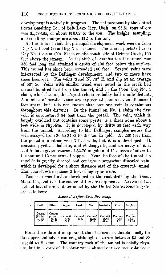
110 CONTBIBUTIONS TO ECONOMIC GEOLOGY, 1916, PART I.
development is actively in progress. The net payment by the United States Smelting Co., of Salt Lake City, Utah, on 95.61 tons of ore was $1,588.85, or about $16.62 to the ton. The freight, sampling, and smelting charges are about $12 to the ton.
At the time of visit the principal development work was on Coon Dog No. 1 and Coon Dog No. 4 claims. The tunnel portal of Coon Dog No. 1 claim (No. 21) is on tlie south side of Grimes Creek, 100 feet above the stream. At the time of examination the tunnel was 330 feet long and attained a depth of 100 feet below the surface. This tunnel has since been extended 160 feet. Several veins were intersected by the Ballinger development, and two or more have since been cut. The veins trend N. 70° E. and dip at an average of 50° S. Veins with similar trend were noted in the creek bed several hundred feet from the tunnel, and in the Coon Dog No. 4 claim, which lies on, the Payette slope probably half a mile distant. A number of parallel veins are exposed at points several thousand feet apart, but it is not known that any one vein is continuous throughout this distance. In the tunnel on No. 1 claim the first 'vein is encountered 84 feet from the portal. The vein, which is largely oxidized but contains some pyrite, is a shear zone about 4 feet wide in rhyolite. It is developed by drifts 60 feet each way from the tunnel. According to Mr. Ballinger, samples across the vein assayed from $6 to $100 to the ton in gold. At 280 feet from the portal is another vein 3 feet wide, but it is undeveloped. It contains pyrite, sphalerite,, and chalcopyrite, and an assay of it is said to have given returns of $2.70 in gold and 11 ounces of silver to the ton and 12 per cent of copper. Near the face of the tunnel the rhyolite is greatly sheared and contains a somewhat distorted vein, which is developed for a short distance east of the crosscut tunnel. This vein shows in places 2 feet of high-grade ore.
This vein was further developed in the east drift by the Diana Mines Co., and it is the source of the ore shipments. Assays of two carload lots of ore as determined by the United States Smelting Co. are as follows:
Assays of ore from Coon Dog group.
Gold.
Ounces per ton. 0. 1525 .105
Silver.
Ounces per ton.
13.43 14.55
Copper.
Per cent. 4.95 5.56
Lead.
Percent. 0.85
Iron.
Per cent. 15.25 15.9
Insoluble.
Per cent. 48.65 44.4
Zinc.
Per cent. 7.05 7.2
Sulphur.
Per cent. 18.9 19.88
From these data it is apparent that the ore is valuable chiefly for its copper and silver content, although it carries between $2 and $3 in gold to the ton. The country rock of the tunnel is chiefly rhyo lite, but in several of the shear zones altered dark-colored dike rocks
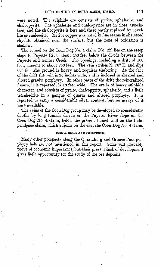
LODE MINING IN BOISE BASIN, IDAHO. Ill
were noted. The sulphide ore consists of pyrite, sphalerite, and chalcopyrite. The sphalerite and chalcopyrite are in close associa tion, and the chalcopyrite is here and there partly replaced by covel- lite or chalcocite. Native copper was noted in fine seams in shattered rhyolite obtained near the surface, but the zone of oxidation is shallow.
The tunnel on the Coon Dog No. 4 claim (No. 22) lies on the steep slope to Payette River about 450 feet below the divide between the Payette and Grimes Creek. The openings, including a drift of 100 feet, amount to about 250 feet. The vein strikes N. 70° E. and dips 60° S. The% ground is heavy and requires timbering. At the face of the drift the vein is 26 niches wide, and is inclosed in sheared and altered granite porphyry. In other parts of the drift the mineralized fissure, it is reported, is 10 feet wide. The ore is of heavy sulphide character, and consists of pyrite, chalcopyrite, sphalerite, and a little tetrahedrite in a gangue of quartz and altered porphyry. It is reported to carry a considerable silver content, but no assays of it were available.
The veins of the Coon Dog group may be developed to considerable depths by long tunnels driven on the Payette River slope on the Coon Dog No. 4 claim, below the present tunnel, and on the Inde pendence claim, which adjoins on the east the Coon Dog No. 4 claim.
OTHER MINES AND PROSPECTS.
Many other prospects along the Quartzburg and Grimes Pass por phyry belt are not mentioned in this report. Some will probably prove of economic importance, but 'their present -lack of development gives little opportunity for the study of the ore deposits.