Literature Survey, Literature Comprehension, & Literature Review.
Climate Technology Centre and Network (CTCN) Technical Assistance for the Development of an Urban Adaptation Plan for Kurunegala
Literature Review Report
“Report on literature review, data and information”
CTCN Request No. 2018000009
Vol.2
May 2019
Kurunegala, Sri Lanka

Compilers:
Dr. Hanna Cho, Research Fellow, Korea Environment Institute
Ms. Hyelim Jeong, Researcher, Korea Environment Institute
Mr. Simon Odawa, Intern, Korea Environment Institute
Dr. Shishiroda Ratnayake, Chief Medical Officer, Kurunegala Municipal Council
Mr. Sujith Ratnayake, Asst. Director, Climate Change Secretariat, Ministry of Mahaweli
Development & Environment
Ms. Hasula Wickremasinghe, Programme Assistant, Climate Change Secretariat, Ministry of
Mahaweli Development & Environment
The Climate Technology Centre & Network (CTCN) has provided Technical Assistance
(TA) to Kurunegala Municipal Council (KMC) and Ministry of Mahaweli Development
and Environment (MMDE) in Sri Lanka through pro-bono support from Korea
Environment Institute (KEI) Korea Adaptation Center for Climate Change (KACCC) and
Green Technology Center (GTC) in Republic of Korea.

Table of Content
1 Introduction ........................................................................................................................ 1
2 Literature Review ............................................................................................................... 1
2.1 National Level Strategies and Plans ............................................................................. 1
2.1.a Climate Change .................................................................................................... 1
2.1.b Water Management .............................................................................................. 5
2.1.c Heat wave/Heat stress .......................................................................................... 8
2.2 Local Level Strategies and Plans .................................................................................. 9
2.2.a Climate Change .................................................................................................. 11
2.2.b Water Management ............................................................................................ 11
2.2.c Heat Wave .......................................................................................................... 12
2.3 Other Plans and Projects ............................................................................................. 12
2.3.a Current Projects by International Organizations ................................................ 12
2.3.b Current Projects lead by Government ................................................................ 14
3 Basic Information of Kurunegala ..................................................................................... 16
3.1 Physical Characteristics .............................................................................................. 16
3.1.a Location and Geography .................................................................................... 16
3.1.b Climate ............................................................................................................... 17
3.1.c Land Use ............................................................................................................ 17
3.2 Socio-economic Characteristics ................................................................................. 20
3.2.a Population .......................................................................................................... 20
3.2.b Language ............................................................................................................ 20
3.2.c Economic ........................................................................................................... 20
3.2.d Poverty ............................................................................................................... 21
3.2.e Education ........................................................................................................... 21
3.2.f Religion .............................................................................................................. 22

3.3 Infrastructure .............................................................................................................. 22
3.3.a Water Supply System and Sewage Treatment ................................................... 22
3.3.b Solid Waste Management .................................................................................. 23
3.3.c Critical Infrastructure ......................................................................................... 24
3.4 Current Condition and Outlook of Climate Change ................................................... 25
3.4.a Current Conditions ............................................................................................. 26
3.4.b Damage of Disaster ............................................................................................ 27
3.4.c Outlook of Climate Change ............................................................................... 28
4 Current Problems of Kurunegala City .............................................................................. 28
5 Discussion and Result shouldn’t this be ‘results and discussion’ .................................... 29
References ................................................................................................................................ 31

1
1 Introduction
In 2018 Climate Technology Centre and Network initiated a Technical Assistance (TA) titled
“Development of a Climate Smart City in Kurunegala” in response to a request from Municipal
Council Kurunegala through the Ministry of Mahaweli Development and Environment of
Democratic Socialist Republic of Sri Lanka. Korea Adaptation Center for Climate Change
(KACCC) through Korea Environment Institute was identified as the implementer of this TA.
The TA is expected to: i) identify the current effects of climate change in Kurunegala City; ii)
assess climate change vulnerability and risk to prioritized issues (heat stress and water
management); iii) propose an adaptation action plan for addressing heat wave and water
management and; iv) build the capacity of city planners and policy makers in order to transform
Kurunegala City into a climate-smart city.
This report entails review of literature and relevant information – plans, policies strategies in
Sri Lanka and most importantly Kurunegala City that will facilitate a better understanding
when delivering on this TA.
2 Literature Review
2.1 National Level Strategies and Plans
2.1.a Climate Change
Sri Lanka has taken several positive steps by introducing national policies, strategies and
actions in order to address climate change. Amongst which are;
2.1.a.1 National Climate Change Policy of Sri Lanka, 2011
The National Climate Change Policy of Sri Lanka was developed to provide guidance and
directions for all the stakeholders to address the adverse impacts of climate change efficiently
and effectively. The National Climate Change Policy contains a vision, mission, goal and a set
of guiding principles followed by broad policy statements under Vulnerability, Adaptation,
Mitigation, Sustainable Consumption and Production, Knowledge Management and General

2
Statements. It emphasizes on collaborative action at all levels as this is necessary to transform
the policy into meaningful set of actions to meet the challenges of climate change.
2.1.a.2 National Climate Change Adaptation Strategy for Sri Lanka, 2011-2016
This strategy - NCCAS laid out a prioritized framework for action and investment for the 2011-
2016 period aimed at systematically moving Sri Lanka and its people towards a climate change
resilient future. It mirrored and supported Sri Lanka’s national development strategy as
articulated in the Mahinda Chintana and aimed at ensuring its success and sustainability.
Accordingly, key findings of sector-based analysis were synthesized into an integrated
framework, and structured into the following 5 Strategic Thrusts;
i. Mainstream Climate Change Adaptation into National Planning and Development
ii. Enable Climate Resilient and Healthy Human Settlements
iii. Minimize Climate Change Impacts on Food Security
iv. Improve Climate Resilience of Key Economic Drivers
v. Safeguard Natural Resources and Biodiversity from Climate Change Impacts
Under each of the Strategic Thrusts, key Thematic Areas for action, along with priority
Adaptation Measures, were identified. An estimated 47.7 billion rupees in incremental
additional financing was required to implement the NCCAS over its 6 year duration. Hundreds
of stakeholders representing a cross section of government institutions, national NGOs,
professionals, and academia covering a wide range of sectors were engaged in the process of
developing this strategy.
2.1.a.3 Technology Needs Assessment and Technology Action Plans for Climate
Change Adaptation and Mitigation, 2014
Technology Needs Assessment and Technology Action Plans for Climate Change Adaptation
was the outcome of the project on Technology Needs Assessment (TNA) on Climate Change
Adaptation and Mitigation for Sri Lanka conducted by the Climate Change Division of the
Ministry of Environment and Renewable Energy from June 2011 to April 2013.
The main objective of the Climate Change Technology Needs Assessment is to identify and
assess environmentally sound technologies that have synergy between reducing the impact of
climate change and the rate of GHG emissions in Sri Lanka within national development

3
objectives. The TNA represents a set of country driven activities that identify and determine
the most appropriate mitigation and adaptation priority technologies for Sri Lanka. By adopting
a consultative process, it identifies the barriers to technology transfer and measures to address
these barriers through a sectoral analysis.
As the initial step of the TNA process, the priority sectors for adaptation and mitigation were
identified in consultation with the National TNA Committee. The priority sectors thus
identified for adaptation were Food, Health, Water, Coastal and Biodiversity. This
prioritization was followed by preparation of a list of potential technologies for each sector in
consultation with sectoral stakeholder working groups and other sector experts. Thereafter this
list was prioritized by using the Multi Criteria Decision Analysis (MCDA) process at
stakeholder consultation workshops for each sector. The process was involved in; a) selecting
basic criteria for evaluation, b) deciding on sub-criteria associated with each basic criterion and
c) weighting the criteria and sub-criteria. Then the Performance Matrix was constructed based
on the criteria and weighted scores followed by Benefit/Cost analysis which helped
determining the most preferred, prioritized technologies.
2.1.a.4 National Action Plan for Haritha Lanka Programme in 2009
This Action Plan was developed in pursuance of a decision taken at a meeting convened by the
Presidential Secretariat on 16th October 2008. Short-, medium-, and long-term solutions to meet
current and emerging economic and environmental challenges were explored when preparing
the Plan. A preliminary draft was initially developed by the Ministry of Environment and
Natural Resources taking into consideration the five-year national environmental action plan
titled “Caring for Environment 2009 – 2013”, and the National Strategy for Sustainable
Development, both of which were developed through extensive deliberations with the relevant
ministries and other related key stakeholder institutions. Using the draft prepared by the
Ministry of Environment and Natural Resources and incorporating the outcome of deliberations
and conclusions reached during four meetings of secretaries of the relevant ministries, the final
draft of the Action Plan for the Haritha Lanka Programme was prepared.
A National Council for Sustainable Development (NCSD) was established by the government
under the Haritha Lanka Programme to function as a national platform to launch and promote
the process of achieving sustainable development. The ten broad missions/thrust areas covered
by the programme are: Clean Air - Everywhere, Saving the Fauna, Flora and Ecosystems,

4
Meeting the Challenges of Climate Change, Wise Use of the Coastal Belt and the Sea Around,
Responsible Use of the Land Resources, Doing Away with the Dumps, Water for All and
Always, Green Cities for Health and Prosperity, Greening the Industries, Knowledge for Right
Choices. The programme includes short-, medium- and long- term targets spanning the period
2009 – 2016 and performance indicators.
2.1.a.5 National Adaptation Plan on Climate Change (NAP) 2016-2025
This plan was prepared in line with the broad set of guidelines set forth by UNFCCC for
development of national adaptation plans (NAPs) (UNCCS 2012). The NAP covers adaptation
needs at two levels, namely; adaptation needs of key vulnerable sectors and cross-cutting
national needs of adaptation. Nine vulnerable sectors were identified in the consultation process
and they include; food security, water, coastal sector, health, human settlements, bio-diversity,
tourism and recreation, export development and industry- energy-transportation. The
consultation process adopted in the preparation of the plan helped to identify adaptation needs
of each vulnerable sector based on logical criteria involving projections, vulnerabilities,
impacts and socioeconomic outcomes. The plan identifies adaptation options that can fulfil the
needs and actions necessary to achieve these options with responsible agencies and key
performance indicators. They together constitute the sectoral action plans for each vulnerable
sector. The NAP also include interventions necessary for fulfilling cross-cutting national needs
of adaptation identified on the basis of analyzing common sectoral needs and opinions of key
stakeholders. The plan also proposes an institutional and coordination mechanism along with
implementation and resource mobilization strategies for successful implementation on a
realistic timeframe.
2.1.a.6 Nationally Determined Contributions (NDCs) of Sri Lanka
As per the outcome of the 19th Conference of Parties (COP19) in Warsaw in 2013, all Parties
were invited to prepare INDCs. This is as part of the work of the Ad Hoc Working Group on
the Durban Platform for Enhanced Action (ADP) that was established at COP 17 in Durban to
“Develop a protocol, another legal instrument or an agreed outcome with legal force under the
Convention applicable to all Parties". The Paris Agreement was reached and the NDCs shall
make it possible to track progress and achieve a collective ambition level sufficient to limit
global warming to well below 2°C relative to pre-industrial levels and pursue to limit the
temperature increase to 1.5°C above pre-industrial level.

5
Sri Lanka submitted its Intended Nationally Determined Contributions (INDCs) in October
2015, and improved version of INDCs in April 2015, at the time of signing the Paris
Agreement. NDCs of Sri Lanka submitted in September 2016 were prepared based on the
Readiness Plan for the Implementation of the Intended Nationally Determined Contributions
(INDCs) 2017-2019 (previously submitted INDCs following the principle of common but
differentiated responsibilities and respective capabilities).1
The Nationally Determined Contributions comprise of the following areas Mitigation,
Adaptation, Loss and Damage and Means of Implementation. The sectors discussed under
mitigation are energy (electricity generation), transportation, industry, waste and forestry.
Under Adaptation, the focused sectors are human health, food security (agriculture, livestock
and fisheries), water and irrigation, coastal and marine, biodiversity, urban infrastructure and
human settlement, tourism and recreation.
2.1.a.7 Readiness Plan for the Implementation of the Intended Nationally Determined
Contributions (INDCs) 2017-2019
The readiness phase till 2020 was for allowing the country to prepare for the full-scale
implementation of chosen NDCs. Adequate preparations were required to ensure successful
implementation of NDCs to achieve the set GHG emission reduction targets by 2030.
A Readiness Plan for the Implementation of the INDCs of Sri Lanka was developed in
consultation with relevant stakeholders, led by line ministries that cover the 14 sectors
identified in the NDCs of Sri Lanka. The sector specific line Ministries and other stakeholders
provided information and recommendations on the implementation of the NDCs, need of
identifying policy gaps, institutional gaps, need for improvements in human and technical
capacity, as well as financial and technical support to implement the NDCs by 2020.1
2.1.b Water Management
Sri Lanka can be considered as a country with sufficient amount of available water. Sri Lanka
is prosperous in water resources with 103 rivers, more than 20 major wetlands, exceptionally
designed minor and major irrigation systems and significant groundwater resources.2
1 Nationally Determined Contributions Ministry of Mahaweli Development and Environment Sri Lanka, September 2016 2 Ministry of Environment and Natural Resources. (2008). Caring for the Environment 2008- 2012. Towards sustainable development. Ministry of Environment and Natural Resources, Battaramulla, Sri Lanka.
6
The total cultivated area in Sri Lanka had been estimated as 1.8 million ha. The area cultivated
with paddy is about 848,691 ha of which 644,478 ha is irrigated, whilst the balance is rain-fed.
Out of the irrigated lands in Sri Lanka 90% is cultivated with paddy and hence the irrigated
areas for Other Field Crops (OFCs) are estimated at 71,608 ha. Irrigation systems with a
command area of more than 80 ha are classified as major irrigation schemes and are managed
by the Irrigation Department (ID) and the Mahaweli Authority of Sri Lanka (MASL). The
minor irrigation systems are usually associated with a village and are managed by the local
community. Department of Agrarian Development and Provincial Councils play a major role
in providing the necessary services to the farmers in minor irrigation schemes.
The drinking water is provided by the National Water Supply and Drainage Board and covers
31.5% of the population whilst the small rural water supply schemes using natural streams and
wells provide water to about 18% of the population. The overall access to safe water is about
81% in 2010. The NWSDB is also responsible for providing water to industrial and livestock
sectors. The overall water demand as of 2010 is estimated as follows;3
Sri Lanka has more than 50 institutions and over 40 legislations dealing with water. The
following are some of these institutions and legislations;
2.1.b.1 Water Sector Institutional Setup
• The Department of Irrigation (DI), established in 1900, is primarily responsible for
water resources planning, project formulation, construction, maintenance and
informally responsible allocations of water for irrigation.
• The Mahaweli Authority of Sri Lanka (MASL), established in 1979, is responsible
for water resources development in many large river basins in the country.
• The Water Resources Board (WRB) was established in 1968. It coordinates
governmental water resources functions and formulates national policies relating to the
control and use of water resources.
• The National Water Supply and Drainage Board (NWSDB) established in 1974 is
the main agency for domestic and industrial water supply, sewage, and surface drainage.
• The Ceylon Electricity Board (CEB) is responsible for the generation, transmission,
and distribution of electric power, including hydropower.
3 Gunawardena, E.R.N. (2013). Sustainable Water Resources Management in Sri Lanka: Status at Present and Strategies for Future.

7
• The Department of Meteorology (DM) is responsible for gathering information
needed for estimating available water supplies nationwide.
2.1.b.2 National Water Resources Management Policy
The Water Resources Management Policy and the Water Resources Act attempts deals with
integrated water resources management (IWRM) allocation on an equitable and efficient basis;
decentralised decision-making; and a new holistic institutional structure.
2.1.b.3 National Policy on Water Supply and Sanitation
This policy was formulated in 2002 by the Ministry of Housing and Plantation Infrastructure
and provides a framework for the supply of safe drinking water and access to sanitation
services. It involves a programme for sector reforms, including the establishment of a
regulatory commission for water supply and sanitation services, and the contracting of private
operators in selected areas to improve operational efficiency and to provide private sector
operational finance. A division for rural water supply and sanitation will be set up under the
Ministry. The policy covers provision of drinking water from bulk water supply to consumers
through piped networks and other means, such as tankers, tube and dug wells and other
community distribution systems.4
2.1.b.4 National Policy on Rural Water Supply and Sanitation
This policy recognizes that the demand for water resources is increasing, with competition from
users for water for domestic use, agriculture, and industry. As a result, there is the need for an
institutional arrangement for the efficient allocation and management of facilities, with
stakeholder participation. Basic principles of the policy are the same as that of the National
Water Supply and Sanitation Policy, but with a few additional principles strengthening it with
respect to community participation. Some of the key principles are that: Provision of water
supply and sanitation services be people-centered and demand-driven; the role of the
government, provincial councils and local government authorities be to regulate and facilitate
sector activities. CBOs, NGOs and the private sector (small-scale private operators) should be
the services providers; Women play a central role in the decision-making process.
4 Ministry of Housing and Plantation Infrastructure, 2002

8
2.1.b.5 Mines and Minerals Act (No 33 of 1992)
Empowers an owner or occupier of any land or a licensee authorized in terms of the act to
produce and consume mineral water in or from such land for his or her personal use.
2.1.b.6 National Physical Planning Policy and Plan (2011-2030)
Addresses ‘water resources development’ including the protection of catchments, water
resources and tanks. The policy specifies in details certain principles and strategies to achieve
these objectives.
2.1.c Heat wave/Heat stress
There is no clear definition for heat wave and heat stress. But, heat wave is considered as a
long term temperature anomaly characterized by each locations unique climatology of heat and
heat stress can be considered as the short term temperature anomaly measuring recent thermal
acclimatization.5 Further, the World Meteorological Organization defines a heat wave as five
or more consecutive days during which the daily maximum temperature surpasses the average
maximum temperature by 5°C (9°F) or more. The Indian Meteorological Department has
adopted their own definition which requires a temperature increase of 5-6°C (9-10.8°F) or more
above the normal temperature. Those affected by heat stress are mainly children under four
years of age and the elderly.
A briefing paper titled the Global Climate Risk Index 2019 published by “Germanwatch” looks
at the impacts of weather-related loss events such as storms, floods and heat waves from 1998
to 2017. It ranked Sri Lanka as the second most impacted territory in 2017. 6
Similarly, The challenge before Sri Lanka, and the island’s north in particular, is well
documented in a September 2018 World Bank Group study that looked into South Asia’s
climate profiles, analyzing how temperatures have risen considerably and will continue to rise,
with precipitation patterns becoming less predictable.
5 Nairn, J. and Fawcett, R.(2013) Defining heatwaves: heatwave defined as a heat-impact event servicing all community and business sectors in Australia. CSIRO and the Bureau of Meteorology, Australia. 6 'Extreme weather puts traditional livelihoods in peril in Sri Lanka, studies warn', MONGABAY, 19.05.2019, https://news.mongabay.com/2019/05/extreme-weather-puts-traditional-livelihoods-in-peril-in-sri-lanka-studies-warn/
9
“Sri Lanka’s proximity to the ocean makes it vulnerable to increase in extreme tropical storms
and sea level rise,” the study says. It says the country also contains “hidden hotspots,” areas
that are economically at risk from climate change that are not often discussed. It adds that by
2050, annual average temperatures on the island are projected to increase by about 1 to 1.5
degrees Celsius (1.8 to 2.7 degrees Fahrenheit) under a climate-sensitive scenario, and 1 to 2
degrees Celsius (1.8 to 3.6 degrees Fahrenheit) under a carbon-intensive scenario.
The study says Sri Lanka has 19 million people living in locations that would become
“moderate or severe hotspots” by 2050 under the carbon-intensive scenario, or more than 90
percent of the total population. And if the projection holds true, Sri Lanka’s Northern and North
Western provinces will emerge as the top hotspots.7
The National Climate Change Policy of Sri Lanka (as published by the Ministry of
Environment-Sri Lanka in 2012; Annex 1), declares a vision, mission, goal and a set of guiding
principles followed by broad policy statements under Vulnerability, Adaptation, Mitigation,
Sustainable Consumption and Production, Knowledge Management and General Statements,
emphasizing the need of urgently adopting “collaborative action at all levels is necessary to
transform this policy into meaningful set of actions to meet the challenges of climate change”.
Nonetheless, no specific mitigation or adaptation strategies are defined under the “National
Physical Planning Policy and Plan (2011-2030)” to minimize or withstand the predicted “Heat
Wave” conditions at national level.
2.2 Local Level Strategies and Plans
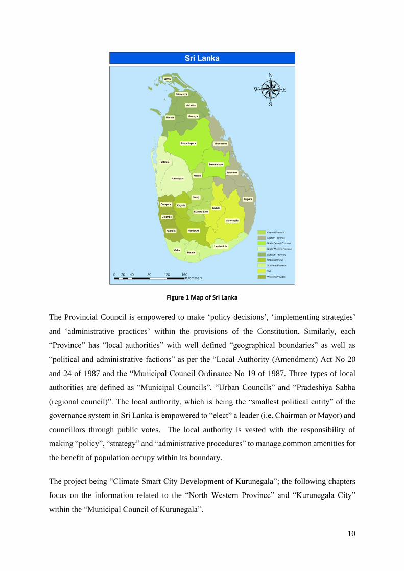
Sri Lanka consists of Nine Provinces (see Figure 1) with ‘geographically well-defined
boundaries’ as well as “constitutionally designated political and administrative factions”. The
13th amendment to the Constitution of Sri Lanka,8 introduced “Provincial Council”, which
consist of ‘Provincial Chief Minster with three other Minsters’ and council members ‘elected’
through public votes.
7 Mani, Muthukumara S.; Bandyopadhyay, Sushenjit; Chonabayashi, Shun; Markandya, Anil; Mosier, Thomas Michael Rowe. 2018. South Asia’s hotspots : the impact of temperature and precipitation changes on living standards (English). Washington, D.C. : World Bank Group. http://documents.worldbank.org/curated/en/201031531468051189/South-Asia-s-hotspots-the-impact-of-temperature-and-precipitation-changes-on-living-standards 8 THIRTEENTH AMENDMENT TO THE CONSTITUTION, Ministry of Justice, https://www.lawnet.gov.lk/1947/12/31/thirteenth-amendment-to-the-constitution-2/
10
Figure 1 Map of Sri Lanka
The Provincial Council is empowered to make ‘policy decisions’, ‘implementing strategies’
and ‘administrative practices’ within the provisions of the Constitution. Similarly, each
“Province” has “local authorities” with well defined “geographical boundaries” as well as
“political and administrative factions” as per the “Local Authority (Amendment) Act No 20
and 24 of 1987 and the “Municipal Council Ordinance No 19 of 1987. Three types of local
authorities are defined as “Municipal Councils”, “Urban Councils” and “Pradeshiya Sabha
(regional council)”. The local authority, which is being the “smallest political entity” of the
governance system in Sri Lanka is empowered to “elect” a leader (i.e. Chairman or Mayor) and
councillors through public votes. The local authority is vested with the responsibility of
making “policy”, “strategy” and “administrative procedures” to manage common amenities for
the benefit of population occupy within its boundary.
The project being “Climate Smart City Development of Kurunegala”; the following chapters
focus on the information related to the “North Western Province” and “Kurunegala City”
within the “Municipal Council of Kurunegala”.

11
2.2.a Climate Change
Despite a dearth of information related to climate change at a local level, the ‘Climate Change
Vulnerability Data Book’ 9 addresses the climate vulnerability of five sectors (urban
development, human settlements and economic infrastructure; water; agriculture and fisheries;
health and biodiversity and ecosystem services) which are considered critical for national
development. This contains a vulnerability mapping for all districts.
The preparation of “Provincial Climate Change Action Plan of North Western Province
(PCCAP-NWP)” was initiated in 2018 by the “Chief Ministry of the North Western Province
of Sri Lanka” with the technical guidance from the “Climate Change Secretariat” under the
Ministry of Environment-Sri Lanka.
The project on “Development of a Climate Smart City in Kurunegala” was launched in 2018
by the “Municipal Council of Kurunegala” with The Climate Technology Centre & Network
(CTCN) which has provided Technical Assistance through pro-bono support from Korea
Environment Institute (KEI) Korea Adaptation Center for Climate Change (KACCC) and
Green Technology Center (GTC) to prepare an Adaptation Plan and to assess climate change
vulnerability and risk of the Kurunegala city in collaboration with the Climate Change
Secretariat, Ministry of Environment-Sri Lanka which is the focal point for the UNFCCC.
2.2.b Water Management
The provincial level and thus the municipal level strategies and plans on water management so
far have been generally within the national framework.
Nevertheless, the “development plan of NWP in year 2018” (refer to Mr. Jayathissa, Director
of NWP.) indicates that the accelerated maintenance of “small irrigation tanks” and the
“initiatives for improvement of cascade water management system” are some of the provincial
level responsive actions adopted by provincial irrigation department and provincial agrarian
development department.
Similarly, the strategy of introducing “community cluster based water supply schemes” in rural
level rather than individually depending on water sources by the National Community Water
Supply Department (NCWSD) within the NWP is also recognised as an action to reduce
9 MoE, 2011. Climate Change Vulnerability Data Book. Ministry of Environment.

12
vulnerability of local community to depletion of ground water table with drought hit climate
conditions in NWP (refer to Mr. Jayathilaka Herath, Director General of NCWSD).
2.2.c Heat Wave
The annual report of the “Meteorological Department of Sri Lanka” indicates that the North
Western Province is a “hot spot” in terms of vulnerability to temperature rise leading to the
heat wave scenario. Nonetheless, no previous actions are reported except the initiatives being
planned under this proposal.
2.3 Other Plans and Projects
2.3.a Current Projects by International Organizations
Here are current climate change-related projects in Sri Lanka, in particular, organized by
international organizations such as World Bank, UNDP, UNFCCC etc. This section is to
analyse possibility of duplicate redundant overlap projects. If some areas are overlapped, then
we will analyse and strengthen the focus area of the project to have differentiation from the
existed projects.
2.3.a.1 The Megapolis - Western Region Master Plan - 2030
The Western Megapolis is envisioned and conceptualized as the prudent Grand Strategy for
achieving two decisive interdependent transformations required in Sri Lanka’s forward march
to achieve the status of “A High Income Developed Country”. The spatial transformation of
urban agglomerations in the Western Region is to be achieved through structural
transformation of the National Economy as a whole, while comprehensively addressing the
burning issues brought about by past trends of spontaneous urbanization.
Western Megapolis has three broad national goals:
• To address the issues resulting from the congestion pressures being exerted on the urban
physical infrastructure, urban services amenities, and the environment.
• To create the enabling environment for propelling the nation to the status of a high
income developed country tunneling through the middle income trap, by way of
leveraging the economies of agglomeration, through development and transformation
of the physical and institutional infrastructure and the national economic structure.

13
• To optimally harness the benefits of knowledge-based innovation-driven global
economic environment characterized by such developments as the new industrial
revolution and emergence of smart cities.
The total land area of the Western Region is 3684 km2 and consists of several districts
including: Gampaha in the north, Colombo in the middle and Kalutara in the south and some
parts of Rathnapura, Kegalle and Galle. Western region is the most densely populated in the
country and is home to the legislative capital of Sri Jayawardenepura Kotte.
2.3.a.2 Moragahakanda-Kaluganga Development Project
Funded by: Sino Hydro Corporation China
The project takes place in the Matale District in the Central Province. This project is envisaged
to resolve the issue of inadequacy of water for irrigation and generation of 25MW. It will
reduce emissions of 90,200 tCO2eq from this project. The Eastern Province, Northern Province,
North Central Province and North Western Province will benefit by securing water and food
security as it is envisaged that agricultural production will increase by 123,000 tons annually.
Water will be diverted to the Kurunegala District up to Polpithigama, Ehetuwewa,
Galagamuwa, Ambalanpola and Mahawa by building canals.
2.3.a.3 Uma Oya Multipurpose Development Project
This project is located in the Badulla District. It will add 123MW of electricity to the national
grid while reducing 273,800tCO2eq of emissions. The purpose of this project is to divert
145million cubic meters of excess water in the Uma Oya basin to the Kirindi Oya basin
contributing to diminish the waters scarcity in the south-eastern dry-zone.
2.3.a.4 Climate Resilient Integrated Water Management Project (CRIWMP)
This is a seven-year project (2017-2024) aimed at strengthening the resilience of Smallholder
Farmers in Sri Lanka’s Dry Zone to climate variability and extreme events. The project targets
poor and vulnerable households in three river basins -the Malwathu, Mi, and Yan (rivers)-
which flow through the northern part of the Dry Zone. These river basins are among the most
vulnerable to the vagaries of the climate, have a high presence of village irrigation systems and
cascade systems on which poor and vulnerable farming populations depend for their

14
livelihoods, and are in areas that significantly lack safe drinking water, which pose a high risk
of kidney disease.
The total cost of the Project is USD 52.08 Million of which USD 38.08 Mn will be financed
through a grant received from Green Climate Fund (GCF). Government of Sri Lanka has
committed an additional USD 14 Mn to co-finance the activities identified under the Project.
Ministry of Mahaweli Development and Environment, which is also the implementing partner
to the project, will implement the project with technical assistance of the United Nations
Development Programme (UNDP) and with the support of Department of Agriculture,
Department of Agrarian Development, National Water Supply and Drainage Board,
Department of National Community Water Supply and Ministry of Disaster Management.
2.3.a.5 Addressing Climate Change Impacts on Marginalized Agricultural
Communities Living in the Mahaweli River Basin of Sri Lanka.
Funded by World Food Programme
Objective is to mitigate effects of climate change induced rainfall variability and its impacts on
livelihood and food security of farm households in three vulnerable divisions of the Mahaweli
River Basin.
2.3.a.6 Strengthening the Resilience of Post-conflict Recovery and Development to
Climate Change Risks in Sri Lanka
Funded by UNDP
The project's key objective is increase the resilience of communities to climate change-induced
hazards through integration of climate-smart policies and actions into development planning
and budgeting, including in the reconstruction and rehabilitation programmes in the Northern
Province and Eastern Province.
2.3.b Current Projects lead by Government
Here are current climate change-related projects in Sri Lanka, in particular, organized by
government of Sri Lanka.
2.3.b.1 Climate Resilient Irrigation Infrastructure Project (CRIIP) by Irritation Dept./
MASL

15
Combined climate resilience planning with development benefits to reduce vulnerability of
exposed people. Flood and Drought hazard modelling is being carried out for 9 river basins
considering the erratic rainfall pattern and water vulnerability.
2.3.b.2 2. North Western Canal Project
North Western Canal Project under the Mahaweli Water Security Program implemented by the
MMDE through DOI under ADB funds to convey 130 MCM/ Year of excess waters from the
water rich Mahaweli River Basin in to cascade system in Deduru Oya and Mee Oya river basisn
to enhance cultivation of 12500 Ha in dry weather hit areas of NWP (Polpithigama, Maho,
Ambanpola and Galgamuwa DS zones).
2.3.b.3 Greater Kurunegala Water Supply and Sanitation Project of NWD&DB (2011)
This project is purposed to supply drinking water to an estimated 600,000 people living in
Kurunegala and manage its sewerage system more effectively.
2.3.b.4 ‘Community Cluster Based Water Supply Schemes’ by the National
Community Water Supply Department (NCWSD),
2.3.b.5 Components of the National Solid Waste Management – Pilisaru Project
This is implemented by the CEA under MMDE, including “Solid Waste Segregation &
Composting Facility” in main solid waste disposal site in Kurunegala, the Sundirapola,
2.3.b.6 Road Sector development Projects by the Provincial RDA (NWP)
The rural roads and RDA the main road with Road Network of Kurunegala City (including
introducing color lights, pedestrian under passes & improved side drainages etc.),
2.3.b.7 Reforestation/ Forest cover improvement Projects undertaken by the Forest
and Wildlife Departments.
2.3.b.8 8. Wastewater Agriculture and Sanitation for Poverty Alleviation (2006)
It is funded by the European Commission. The objective of the project is to improve the
livelihoods of urban and peri-urban farmers who are using wastewater in agriculture and the
communities who are responsible in producing the wastewater or consuming the agricultural
produce.
16
3 Basic Information of Kurunegala
Kurunegala is the capital city of the North Western Province. It has gained importance not only
for its social and economic resource base, but also for its historical past. The ancient kingdoms
of Kurunegala, Panduwasnuwara and Yapahuwa are located in the District. Kurunegala is
located within the ‘coconut triangle’. Therefore, most of the service roads have been
constructed to facilitate its needs. It is the core of politics, economy and culture. Since
Kurunegala is the main service centre of the province, the large number of service oriented
institutions as well as higher education centers located within the boundaries of Kurunegala
serve a floating population. Despite its small population, it takes pride of place for the service
functions it provides.
3.1 Physical Characteristics
3.1.a Location and Geography
The Kurunegala City is situated in the Northwestern Province of Sri Lanka and well known for
its historically important religious places as well as its location as a gateway to major cities of
the country such as Colombo, Kandy, Negombo, Anuradhapura and Trincomalee. It covers an
area of 10.53 Km2 and its own socio-economic and historical significance. The city is located
between 7° 29′ 0″ N and 80° 22′ 0″ E coordinates in proximity to the districts of Kandy and
Matale in the central highland. The area is situated in the peneplain lying 108 to 120 meters
above mean sea level.10
10 Development Plan for Urban Development Area of Kurunegala 2006-2015

17
Figure 1. Location of Kurunegala City in Sri Lanka
3.1.b Climate
The climate of the Kurunegala is characterized by a ‘Tropical climate’. The dry season is from
February to September and the annual rainfall is around 2,316.1 mm with the highest rainfall
occurring in October and November during the North-East monsoon. The coolest average
temperatures in the year are in December and January with an average temperature of
approximately 26 degrees Celsius, while April to September has the hottest average
temperatures in the year at an average of approximately 30 degrees Celsius. The mean annual
temperature is approximately 27.4 C and the annual relative humidity varies from 71-87%.11.
The warmest month of the year is April, with an average temperature of 28.5 °C. January has the lowest
average temperature of the year. It is 25.6 °C.
3.1.c Land Use
3.1.c.1 Residential Use
11 Department of Meteorology, Colombo, Sri Lanka. http://www.meteo.gov.lk/

18
Residential land use in relation to the extent of developed land, it is 56% and it comprises
36.57% of the total land extent. The highest overall distribution of residential use is in the west
and south west of the city, as this is influenced by the availability of more land for development
as well as better facilities.12
3.1.c.2 Commercial Use
Commercial development has mainly taken place predominantly along the streets and the by-
roads. Even though the commercial land use in the city is clearly evident, it is in a concentrated
form of ribbon development. There is an increase in the conversion of residential use into
commercial use while with the expansion of the town centre the commercial activities are not
being centralized due to the existence of government land. On the other hand, suppression of
cluster commercial development leads to the building of houses along the main roads.12
3.1.c.3 Roads and Transport
Whereas the secondary roads are inadequate, the amount of land used for the main roads
conforms to an acceptable level. The road and transport system in Kurunegala is more orderly
when compared to other towns.10
3.1.c.4 Agricultural and other Uses
Agricultural uses as well as rock outcrops restrict development in Kurunegala while at the same
time contributing to the improvement of the urban environment. On this basis, the following
interpretations can be made when analyzing this land use distribution pattern;
i. The land available in the town for development being limited to 20%. This situation,
with the restrictions imposed in the use of paddy lands for developments are considered,
it is reduced to 5%.
ii. When the overall development process is considered it is observed that in the town
centre appreciable development has taken place and much of this development is
concentrated to the southwest of the town. As this is inter-related to the provincial
development, hence it is not easy to control it. As such, ribbon development is taking
place along Colombo road and Ambepussa-Kurunegala road.
12 Development Plan for Urban Development Area of Kurunegala 2006-2015
19
iii. Due to high land values a significant growth in residential land use is not evident.
iv. Because of the concentrated development in the Town centre, the adjacent lands are
used by the Government and semi-Government for their uses. As these are multiplied
due to prevailing market forces, the Town centre and adjoining areas have developed
in an unplanned manner.
v. The fact that some uses fall within an acceptable standards, other uses indicate an over
utilization of land.
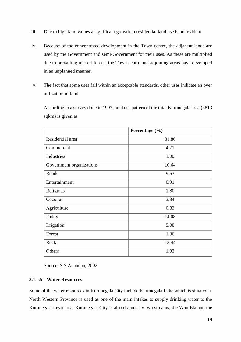
According to a survey done in 1997, land use pattern of the total Kurunegala area (4813
sqkm) is given as
Percentage (%)
Residential area 31.86
Commercial 4.71
Industries 1.00
Government organizations 10.64
Roads 9.63
Entertainment 0.91
Religious 1.80
Coconut 3.34
Agriculture 0.83
Paddy 14.08
Irrigation 5.08
Forest 1.36
Rock 13.44
Others 1.32
Source: S.S.Anandan, 2002
3.1.c.5 Water Resources
Some of the water resources in Kurunegala City include Kurunegala Lake which is situated at
North Western Province is used as one of the main intakes to supply drinking water to the
Kurunegala town area. Kurunegala City is also drained by two streams, the Wan Ela and the
20
Beu Ela which confluence just before Wilgoda Anicut (weir) and flow on through agricultural
land before joining the Maguru Oya (river) at Watawehera estate just outside the western
boundary of Kurunegala City. The Beu Ela originates from the Wennaru Wewa (irrigation
tank) and was originally an irrigation canal but now acts as a city drain, although it is still used
for irrigation.13
3.2 Socio-economic Characteristics
3.2.a Population
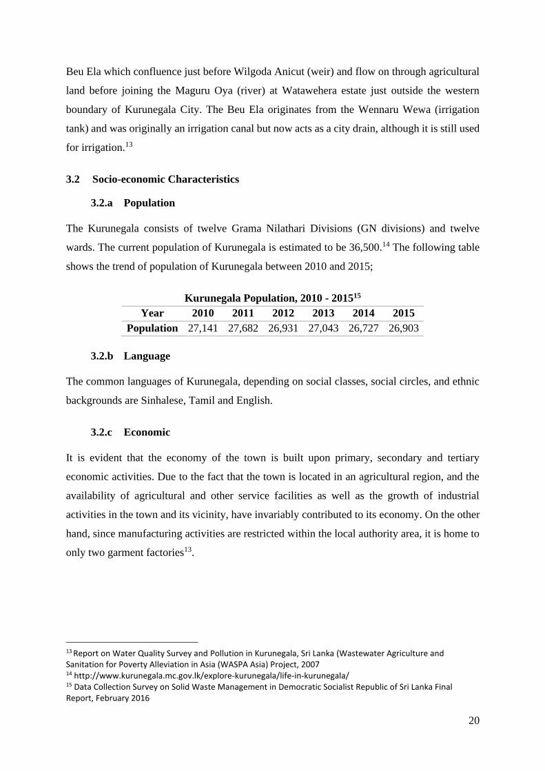
The Kurunegala consists of twelve Grama Nilathari Divisions (GN divisions) and twelve
wards. The current population of Kurunegala is estimated to be 36,500.14 The following table
shows the trend of population of Kurunegala between 2010 and 2015;
Kurunegala Population, 2010 - 201515
Year 2010 2011 2012 2013 2014 2015
Population 27,141 27,682 26,931 27,043 26,727 26,903
3.2.b Language
The common languages of Kurunegala, depending on social classes, social circles, and ethnic
backgrounds are Sinhalese, Tamil and English.
3.2.c Economic
It is evident that the economy of the town is built upon primary, secondary and tertiary
economic activities. Due to the fact that the town is located in an agricultural region, and the
availability of agricultural and other service facilities as well as the growth of industrial
activities in the town and its vicinity, have invariably contributed to its economy. On the other
hand, since manufacturing activities are restricted within the local authority area, it is home to
only two garment factories13.
13 Report on Water Quality Survey and Pollution in Kurunegala, Sri Lanka (Wastewater Agriculture and Sanitation for Poverty Alleviation in Asia (WASPA Asia) Project, 2007 14 http://www.kurunegala.mc.gov.lk/explore-kurunegala/life-in-kurunegala/ 15 Data Collection Survey on Solid Waste Management in Democratic Socialist Republic of Sri Lanka Final Report, February 2016
21
The Kurunegala district environment is conducive to the cultivation of agricultural crops and
has thereby attained popularity for paddy and coconut cultivation as well as other minor crops
such as cinnamon, pepper, cocoa, coffee and nutmeg.
3.2.d Poverty
In Sri Lanka, poverty figures refer to the share of individuals whose household per capita
consumption falls below the official poverty line. This poverty headcount index is the standard
measure of the incidence of poverty. Kurunegala is home to 7.7 percent of the country’s poor
people even though only 6.5 percent of its population lives under the official poverty line. Sri
Lanka’s current poverty line is moderate by regional standards, but below what one might
expect from a country at Sri Lanka’s level of development. This is partly because the poverty
line was developed using 2002 data and is therefore based on consumption patterns in 2002.
The country’s context has changed dramatically in the years in between, and we believe it is
good practice to update the benchmark used to judge poverty about once per decade. This
makes updating the current poverty line a priority for Sri Lanka.16
The headcount index is calculated by taking into account all the food and non-food
expenditures collected in the Household Income and Expenditure Survey (HIES). Differences
in the cost of living across different districts, and the number of people in the household are
also considered. This per capita household consumption is then compared to the national
poverty line. This line was defined as the expenditure for a person to meet the daily calorie
intake of 2,030 kcal based on the Cost of Basic Needs approach, and was set at 1,423 rupees in
2002. To keep the national poverty line constant, this line has been inflated in subsequent years
using the Colombo Consumer Price Index (CCPI).
3.2.e Education
Kurunegala is the education hub of the North Western province with many leading public and
private schools and auxiliary education institutions. It also serves as the academic centre for
students from other neighboring provinces due to the city's facilities and the location. The city
is home for 12 national schools and 5 private and international schools making it a city well
16 Understanding Poverty in Sri Lanka, 2017 http://www.worldbank.org/en/news/feature/2017/03/02/part1-understanding-poverty-sri-lanka

22
suited for studies. In addition to that, Kurunegala attracts more than 60,000 students a week for
tuition and auxiliary classes. 14
3.2.f Religion
Buddhism is the main and the most widely practised religion in Kurunegala. The city is also
home to a wide range of other religious faiths such as Hinduism, Christianity and Islam. The
prominent Buddhist temples in Kurunegala include Athkanda Raja Maha Viharaya, Ibbagala
Raja Maha Viharaya, Angangala cave temple, Wilbawa Purana Viharaya and Bauddhaloka
Viharaya. Churches, Mosques and Hindu temples are also found in the city. The Roman
Catholic Diocese of Kurunegala's bishop is headquartered in the city. The Church of Ceylon,
which is the Anglican Church in Sri Lanka, operates a diocese in Kurunegala covering the
North-Central province and Kurunegala, Kandy, Matale and Kegalle, Anuradapura,
Polonnaruwa districts.17
3.3 Infrastructure
3.3.a Water Supply System and Sewage Treatment
Safe drinking water coverage in Sri Lanka is around 86% of the population while the population
having pipe borne water supply facilities is around 46%. Currently, around 35.2 percent of the
population has been connected to the national pipe borne water distribution network of the
National Water Supply & Drainage Board (NWSDB) and 10.8% of population served pipe
borne water facilities through the CBOs, Local Authorities. In the context of sanitation, there
are around 97,000 sewer connections connected to pipe sewerage system in the country
covering around 2.4 percent of population and rest of the population uses individual onsite
sanitation systems. Kurunegala is one of the cities with safe water coverage less than the
national average.18
Kurunegala Lake which is situated at North Western Province is used as one of the main intakes
to supply drinking water to the Kurunegala town area. This lake has been identified as a
regional water body which has been subjected to occasional eutrophication during recent past.
According to the National Water Supply and Drainage Board (NWSDB), Kurunegala, Sri
Lanka, this Lake had been cleaned two times from 2003 and 2010 due to the algae growth.
17 https://en.wikipedia.org/wiki/Kurunegala 18 Public Investment Programme 2017 - 2020

23
About 78% of Kurunegala town area is drained by two streams, the Wan Ela and the Beu Ela
which confluence just before Wilgoda Anicut (weir) and flow on through agricultural land
before joining the Maguru Oya (river) at Watawehera estate just outside the western boundary
of Kurunegala Municipality.13 The National Water Supply and Drainage Board (NWSDB)
carry out routine water quality monitoring for drinking water sources and supplies in
Kurunegala.19
There is inadequate sewerage system in Kurunegala and the majority of people living in the
area dispose of their waste using on-site sanitation methods. Urban runoff, untreated grey water
and sewage are discharged into the urban drainage canals and streams. Surface waters are
extremely polluted and do not even comply with the discharge standards for industrial
effluents13. The wastewater generated in Kurunegala city is estimated to be 4,620 m3/day.19
In August 2018, the Greater Kurunegala Water Supply and Sewerage Project was inaugurated.
This project will provide clean water for households, government and private sector offices,
schools, hospitals, tourist hotels, daily floating population of over 70,000. It will also provide
disposal of wastewater for 3,500 domestic and commercial institutions through its well-
organized sewerage network.20 Greater Kurunegala Water Supply and Sewerage Project is seen
as a boost to the quality of life and protection of the environment in Kurunegala, and the
underground water and lake water quality will also be improved through the waste water
treatment of this project.
3.3.b Solid Waste Management
In Kurunegala City, solid waste management is carried out by the Municipal Health
Department (MHD) headed by the MOH who is responsible for overall SWM activities. With
regard to organization, the experienced MOH (Medical officer of health) and PHI (Public
health inspector) have taken the actual command of waste management and are working in
close collaboration with the PHI and the SV.15
Total waste generation unit in Kurunegala is 1.84kg/person/day where organic waste comprise
of kitchen waste and grass & wood occupies less than 70%, on the other hand, the ratio of
19 National Water Supply and Drainage Board (NWSDB). 2005. Initial Environmental Examination Report: In Respect of Greater Kurunegala Sewerage Project. Sri Lanka: Ministry of Urban Development and Water Supply. 20 http://www.xinhuanet.com/english/2018-08/14/c_137389078.htm

24
recyclable waste comprising of paper, textiles, plastic, metal and glass & bottles occupies close
to 30%, which is the urbanized waste composition.21
However, the absence rate of disposal site workers for the compost and recycling facility is
high and it often causes a malfunction of the facility. The kerbside collection is conducted by
Kurunegala and the residences have to store their mixed waste in a plastic barrel or a polythene
sack and discharge them in front of their houses on the collection day. The owners of
restaurants and shops also store their waste in plastic barrels of 100 or 200 litres, which are
collected by door to door collection. Even though, Kurunegala residents complain about the
low frequency for waste collection due to the low attendance of collection workers.15
Collection and transportation of solid waste is conducted by Kurunegala. The waste collection
covers 100 % of Kurunegala area and no collection fee is charged either for residents or large
scale waste generators. The solid waste collected in Kurunegala is transferred to the
Sundarapola final disposal site located in Kurunegala. This facility was established and has
been in operation since 2012. In Sundarapola, only 2tons/day of solid waste can be accepted at
the compost yard due to shortage of workers.15
3.3.c Critical Infrastructure
3.3.c.1 Roads and Railway
Kurunegala plays an important role as a linkage between the commercial capital Colombo and
the central, eastern and northern cities of Sri Lanka. Five major roads intersect in Kurunegala.
Kurunegala is also one of the main stops along Sri Lanka's main railway line running
connecting Colombo and Jaffna. The Railway station is situated in a suburb called Gettuwana,
a few kilometres away from the city centre. The Bus Stand is situated in the city centre within
a sprawling shopping complex.22
A characteristic feature in the city is the road network with national and regional linkages with
a major railway connecting Colombo and Anuradhapura as indicated below. This makes it a
main intersection linking different parts of Sri Lanka;10
• Colombo - Kurunegala - Trincomalee Road
21Solid Waste Management Action Plan (2008) by National Solid Waste Management Support Center (NSWMSC) 22 http://www.kurunegala.mc.gov.lk/explore-kurunegala/
25
• Colombo - Kurunegala - Anuradhapura Road
• Kurunegala - Puttalam Road
• Kurunegala - Negomob Road
• Kurunegala - Kandy Road
• Colombo, Kurunegala, Anuradhapura Railway
3.3.c.2 Hospitals
Sri Lanka has a well-developed network of government hospitals which provide treatment at
no cost to patients. In the districts, there are a number of small primary hospitals supported by
at least one referral hospital. It is estimated that no citizen is more than 30 minutes from a
primary hospitals.
In Kurunegala, there are 44 Primary Hospitals and a tertiary/referral hospital, Teaching
Hospital Kurunegala (THK). The Primary Hospitals includes the Base Hospitals and the
Divisional Hospitals. The Base Hospitals provide healthcare in relation to four main specialized
care only. The Divisional Hospitals are hospitals with very low facilities and they do not
provide any specialized care.23
3.3.c.3 Sporting Venues
Major sporting venues in Kurunegala include Welagedara Stadium which is the top sporting
venue in Kurunegala and also a multi-use stadium with a capacity of 10,000 people.24 It
regularly hosts domestic cricket matches. Another one is Maliga Pitiya Stadium with a capacity
of 3000 people and is located along Colombo Road.17
3.3.c.4 Archaeological Sites
Being an ancient city, Kurunegala has many historical places of visit. Ridi Viharaya (Silver
temple), Munneswaram temple, Yapahuwa, Panduwasnuwara, Arankele monastery,
Dadagamuwa Viharaya, Padeniya Rajamaha Viharaya, Elephant rock are few of the places that
travellers visit along their travel route.
3.4 Current Condition and Outlook of Climate Change
23 Shahmy S, Kularatne SAM, Rathnayake SS, Dawson AH (2017). A prospective cohort study of the effectiveness of the primary hospital management of all snakebites in Kurunegala district of Sri Lanka. 24 https://en.wikipedia.org/wiki/Welagedara_Stadium

26
3.4.a Current Conditions
Sri Lanka being a small tropical island there is no significant annual variation in temperature
due to latitude. However, significant regional variation in temperature could be observed due
to altitude. In lowland areas, average annual temperature usually vary around 26.5 – 28.5 °C
and it falls quickly as altitude increases (e.g. Nuwara Eliya – 15.9 °C at 1800 mean sea level).
In the absence of high seasonal variation in temperature, the average pattern of climate in a
given local area is determined mainly by the variations in precipitation. Sri Lanka’s mean
annual rainfall is around 1850 mm (range from 900 mm to 5000 mm). There are three major
sources of rainfall in the country, namely; monsoonal, convectional and depressional. Based
on the variation in precipitation, Sri Lanka’s climate is generally divided into four seasons:25
a) First inter-monsoon season (FIM): March –April (268 mm, 14%)
b) Southwest monsoon season (SWM): May –September (556 mm, 30%)
c) Second inter-monsoon season (SIM): October-November (558 mm, 30%)
d) Northeast monsoon season (NEM): December- February (479 mm, 26%)
The first inter-monsoon (FIM) rains are usually experienced around March-April period.
During the FIM, southwestern quarter and certain parts of central highlands receive over 250
mm rainfall. Most other parts get rainfall around 100 -250 mm. Hazardous lightning associated
with thunderstorms is a frequent incident and sometimes intensive rainfall may give rise to
flash floods.25
The country experiences Southwestern monsoon (SWM) around May-September. During the
SWM season, mid-elevation western slopes of central highlands receive over 3000 mm rainfall
and southwestern coastal belt around 1000-1600 mm. Higher elevations in central highlands
get rainfall around 800 mm. Long lasting monsoon rains may result in floods in low-lying areas
and landslides in hilly areas. Rains can be experienced at any time during the day and night.
Second inter-monsoon season (SIM) brings rainfall around October-November period. Unlike
FIM, the influence of depressions is common during SIM, whole country experiencing strong
winds with widespread rains, sometime leading to floods and landslides. It is the season with
most evenly distributed rainfall in Sri Lanka. Many areas receive over 400 mm. Slopes in
southwestern quarter receive 750 -1200 mm. Usual period of northeast monsoon season (NEM)
is December-February. During this season moist wind blowing from northeast Asian landmass
25National Climate Change Adaptation Plan of Sri Lanka 2015-2024

27
produces seasonal rainfall in northern, north central and eastern parts of the country. Highest
rainfall figures are recorded in north-eastern slopes of the hill country and eastern slopes of the
Knuckles/Rangala range.25
This general pattern of annual rainfall results in an overall mean annual rainfall around 1850
mm that range from 900 mm to 5000 mm. Southwestern quarter of the country, especially
western slopes of central highlands receive the highest rainfall (e.g. Yatiyantota, Ginigathhena,
Watawala > 5000 mm). On the other hand, southeastern (Yala, Palatupana < 1000 mm) and
northwestern (Mannar < 1000 mm) coastal areas receive the lowest amount of rainfall. Based
on the variation in mean annual rainfall the country it has been divided in to three major
climatic zones.25
• Wet zone (mean annual rainfall > 2500 mm)
• Intermediate zone (mean annual rainfall 1750-2500 mm)
• Dry zone (mean annual rainfall <1750 mm)
These climatic zones have further been subdivided into three elevation categories (low-country
- <300 m; mid-country – 300-900 m; up-country - >900 m) to cover the associated temperature
variations. These divisions have given rise to 46 agro-ecological zones, a classification that
provides the basis for various decisions and recommendations concerning agriculture and other
sectors25.
3.4.b Damage of Disaster
Cummulatively, more than 36 million Sri Lankans have been affected by natural hazards such
as floods, landslides, cyclones and droughts over a period of 40 years to 2016, with an average
of over 900,000 people, an equivalent of 4.1% of the entire population affected annually.26
According to the table below, Kurunegala was documented as one of the 9 Sri Lanka’s
Provincial Capitals exposed to these climate risks between 1974 to 2017 where floods and
drought caused several incidents.27
Climate Risk Exposure 1974-2017
Flood Landslide Drought Cyclone
Affected Deaths Affected Deaths Affected Deaths Affected Deaths
Badulla 2,251 - 6,424 41 - - - -
Galle 27,206 - 2 4 - - - -
26 GoSL (Government of Sri Lanka) 2016a. Impacts of Disasters in Sri Lanka 27 Disaster Management Centre (DMC) Database

28
Ratnapura 113,260 9 6,969 47 4,313 - - -
Jaffna 40,268 - - 2,150 - - -
Kurunegala 2,774 2 - - 141,074 - - -
Anuradhapura 4,030 - - - 19,645 - - -
Trincomalee 33,535 - - - 18,187 75,000
Kandy 505 - 2,615 7 - - - -
WRM28 3,807,394 223 2,084 36 530,763 - 9,355 3
Total 4,031,223 234 18,115 135 716,132 0 84,355 3
3.4.c Outlook of Climate Change
Observed and projected changes suggests that the climate of Sri Lanka is undergoing three
major types of changes.
• Gradual increase in ambient air temperature
• Changes in distribution pattern of rainfall
• Increase in frequency and severity of extreme weather events
In addition to the above changes in atmosphere, there are associated changes in oceanic
environment too, especially sea level rise, that seem to create significant impacts over Sri
Lanka. Another recent projection has predicted that climate pattern in Sri Lanka is getting more
polarized where the Dry zone becomes drier and Wet zone becomes wetter in years to come.29
4 Current Problems of Kurunegala City
The problems currently occur in Kurunegala are below:
a) Increasing trend in Flash Floods and Water Scarcity in the City due to long dry spell
and short term, high intensity rain falls
b) Continual rise of Heat index (being at extreme caution level in the 1st quarter of the
year of last 3 years)
c) Regular occurrence of spontaneous Fires in the old solid waste dumpsite (due to
temperature rise and methane emission)
28 Western Region Megapolis (WRM) 29 Punyawardena, B.V.R., S. Mehmood, A.K., Hettiarachchi, M, Iqbal, S.H.S.A Silva, and A. Goheer (2013a) Future Climate of Sri Lanka: An approach through dynamic downscaling of ECHAM4 General Circulation Model (GCM).

29
d) Increasing trend of Heat stress conditions experienced by occupants in the City
e) Increasing air pollutants (particulate matter, dust and smoke-noxious gases) levels in
the City
f) Limiting factors affecting efficiency in proper solid waste management such as:
- Absence of “Safe Temporary Storage and Final Disposal of Clinical Wastes”
generated within the City,
- Lack of support due to poor awareness/ attitudes for “generator segregation of
wastes” by bulk solid waste generators like Government office complexes, Hospital
etc..
- Poor drainage system that causes difficulties in removal, accumulation of wastes
and stagnation
g) Extreme weather bound health impacts like “Dengue epidemic condition”.
h) Climate sensitive diseases
i) Lack of storm water drainage for city limits
j) Heavy traffic congestion in town area increasing the daytime heat stress
k) Inadequate space within city limits to design shady tree areas
5 Discussion and Result
The literature review indicates that there is a dearth of baseline data related to water
management and heat stress. Data is available only from periodically conducted surveys or data
collections made for specific purposes. Therefore, there is no continuity of data. Further,
quantitative information which leads to the development of indicators for exposure, sensitivity
and coping capacity are not easily available. Basic data such as land-use planning and water
capacity needs to be updated.
Heat stress is experienced by the communities but there is no published information related
specifically to health hazards due to heat stress. Nor are there records available with the
Medical Officer of Health to indicate the relationship of heat stress and health.
30
Water scarcity which arises due to prolonged drought which may be exacerbated by
anthropological interventions is also not documented.
It is needed a data collection and storage system (a comprehensive data base and accompanying
GIS maps) to understand the status and impact of climate change. This allows Kurunegala to
establish suitable climate change action plans through an accurate analysis of the status.

31
References
Anandan,S,S (2002) A study of traffic plan for Kurunegala Municipal area, Thesis.University
of Moratuwa
Development Plan for Urban Development Area of Kurunegala 2006-2015
GoSL (Government of Sri Lanka) 2016a. Impacts of Disasters in Sri Lanka
Gunawardena, E.R.N. (2013). Sustainable Water Resources Management in Sri Lanka: Status
at Present and Strategies for Future.
Mani, Muthukumara S.; Bandyopadhyay, Sushenjit; Chonabayashi, Shun; Markandya, Anil;
Mosier, Thomas Michael Rowe. 2018. South Asia’s hotspots : the impact of temperature and
precipitation changes on living standards (English). Washington, D.C. : World Bank Group
Mines and Minerals Act (No 33 of 1992)
MoE (Ministry of Environment and Natural Resources) (2008). Caring for the Environment
2008- 2012. Towards sustainable development. Ministry of Environment and Natural
Resources, Battaramulla, Sri Lanka.
MoE, 2011. Climate Change Vulnerability Data Book. Ministry of Environment.
Mines and Minerals Act (No 33 of 1992), Sri Lanka.
Nairn, J. and Fawcett, R.(2013) Defining heatwaves: heatwave defined as a heat-impact event
servicing all community and business sectors in Australia. CSIRO and the Bureau of
Meteorology, Australia.
National Action Plan for Haritha Lanka Programme in 2009
National Adaptation Plan on Climate Change (NAP) 2016-2025
National Climate Change Adaptation Plan of Sri Lanka 2015-2024
National Climate Change Adaptation Plan of Sri Lanka 2015-2024
National Climate Change Adaptation Strategy for Sri Lanka, 2011-2016
National Climate Change Policy of Sri Lanka, 2011
National Physical Planning Policy and Plan (2011-2030)
National Policy on Rural Water Supply and Sanitation for Sri Lanka
National Policy on Water Supply and Sanitation for Sri Lanka, 2002

32
National Water Resources Management Policy for Sri Lanka
National Water Supply and Drainage Board (NWSDB). 2005. Initial Environmental
Examination Report: In Respect of Greater Kurunegala Sewerage Project. Sri Lanka: Ministry
of Urban Development and Water Supply.
Nationally Determined Contributions (NDCs) of Sri Lanka, 2016
NSWMSC (National Solid Waste Management Support Center) (2008). Solid Waste
Management Action Plan
Public Investment Programme 2017 – 2020
Punyawardena, B.V.R., S. Mehmood, A.K., Hettiarachchi, M, Iqbal, S.H.S.A Silva, and A.
Goheer (2013a) Future Climate of Sri Lanka: An approach through dynamic downscaling of
ECHAM4 General Circulation Model (GCM).
Readiness Plan for the Implementation of the Intended Nationally Determined Contributions
(INDCs) 2017-2019
Shahmy S, Kularatne SAM, Rathnayake SS, Dawson AH (2017). A prospective cohort study
of the effectiveness of the primary hospital management of all snakebites in Kurunegala district
of Sri Lanka.
Technology Needs Assessment and Technology Action Plans for Climate Change Adaptation
and Mitigation, 2014
Western Region Megapolis Master Plan – 2030