Literature Review (Review of Related Literature - Research Methodology)
May 21, 2014 Mr. Nathan Bass UC Synergetic, LLC 10101 Claude Freeman Dr. Suite 100-W Charlotte, North Carolina 28262
RE: Literature Review and Windshield Reconnaissance for the Urquhart-Graniteville 230kV Siting Study, Aiken County, South Carolina
Dear Nathan:
In March 2014, Brockington and Associates, Inc. contracted with UC Synergetic, LLC (UCS) to conduct a cultural resources literature review for the proposed Urquhart-Graniteville 230kV Siting Study. The Urquhart-Graniteville Study Area is located in western Aiken County, South Carolina, with a small portion extending into far eastern Richmond County, Georgia, and consists of approximately 48 square miles. The research results outlined in this letter report provide information for planning purposes only and are not meant to serve as compliance with Section 106 of the National Historic Preservation Act or other state and/or federal legislation.
Literature Review, Architecture We conducted a literature review for the Urquhart-Graniteville Study Area to determine if any properties or sites had been recorded within the proposed project area. This research included an initial review of all previously recorded architectural resources located within the study area boundary on file with Archsite, South Carolina’s digital repository for cultural resources. This digital data was supplemented with a records check at the South Carolina Institute of Archaeology and Anthropology (SCIAA) and the South Carolina Department of Archives and History (SCDAH) in Columbia, South Carolina. A small portion of the 48 square mile study area extends into Georgia and that information was gathered from an online data system (Georgia’s Natural, Archaeological, and Historic Resources GIS [GNAHRGIS]). All previously recorded properties are identified in our dataset. The data collected in Columbia and GNAHRGIS includes:
1. All recorded aboveground historic resources; 2. All recorded archaeological resources; 3. All archaeological sites, structures, and districts that are listed on the National Register of
Historic Places (NRHP).
The Urquhart-Graniteville Study Area contains multiple and sometimes overlapping properties and districts. The status of each previously recorded architectural property is discussed in greater detail below and any additional information gleaned during the windshield survey is provided in the accompanying GIS data set.
Brockington'ULTURAL
RESOURCES CONSULTING
Atlanta ~ Charleston ~ Savannah ~ Elizabethtown ~ Jacksonville ~ Pensacola www.brockington.org
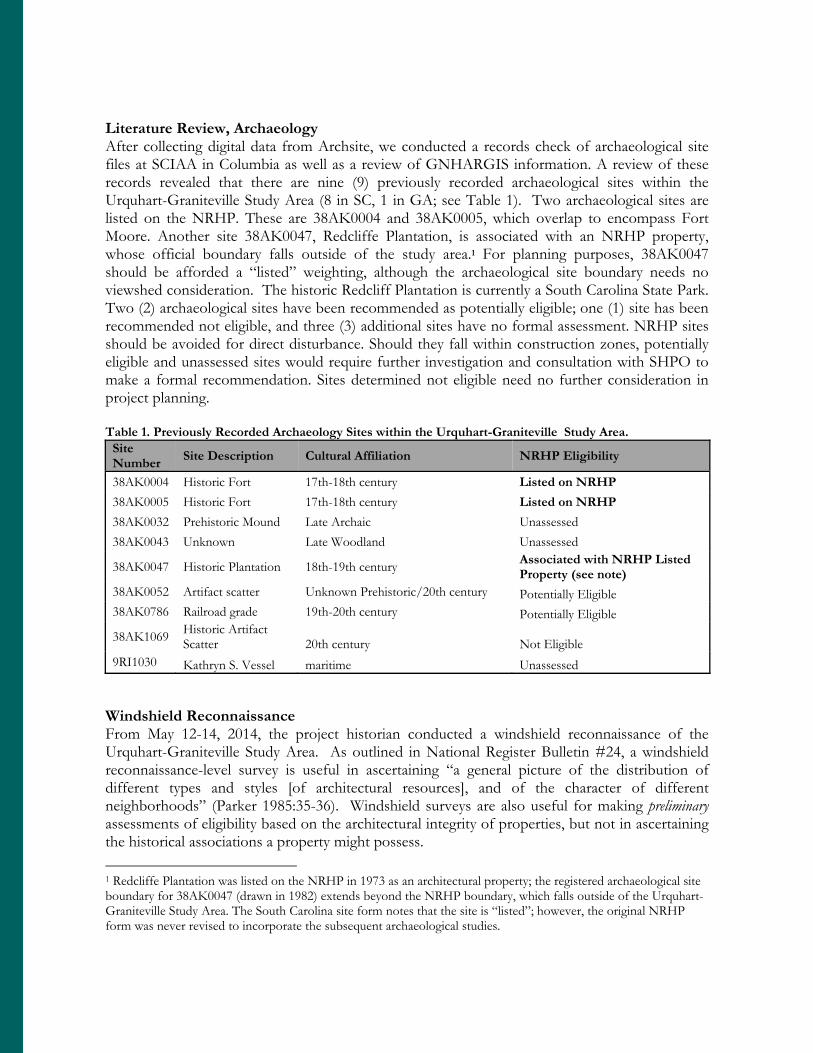
Literature Review, Archaeology After collecting digital data from Archsite, we conducted a records check of archaeological site files at SCIAA in Columbia as well as a review of GNHARGIS information. A review of these records revealed that there are nine (9) previously recorded archaeological sites within the Urquhart-Graniteville Study Area (8 in SC, 1 in GA; see Table 1). Two archaeological sites are listed on the NRHP. These are 38AK0004 and 38AK0005, which overlap to encompass Fort Moore. Another site 38AK0047, Redcliffe Plantation, is associated with an NRHP property, whose official boundary falls outside of the study area.1 For planning purposes, 38AK0047 should be afforded a “listed” weighting, although the archaeological site boundary needs no viewshed consideration. The historic Redcliff Plantation is currently a South Carolina State Park. Two (2) archaeological sites have been recommended as potentially eligible; one (1) site has been recommended not eligible, and three (3) additional sites have no formal assessment. NRHP sites should be avoided for direct disturbance. Should they fall within construction zones, potentially eligible and unassessed sites would require further investigation and consultation with SHPO to make a formal recommendation. Sites determined not eligible need no further consideration in project planning. Table 1. Previously Recorded Archaeology Sites within the Urquhart-Graniteville Study Area.
Site Number
Site Description Cultural Affiliation NRHP Eligibility
38AK0004 Historic Fort 17th-18th century Listed on NRHP
38AK0005 Historic Fort 17th-18th century Listed on NRHP
38AK0032 Prehistoric Mound Late Archaic Unassessed
38AK0043 Unknown Late Woodland Unassessed
38AK0047 Historic Plantation 18th-19th century Associated with NRHP Listed Property (see note)
38AK0052 Artifact scatter Unknown Prehistoric/20th century Potentially Eligible 38AK0786 Railroad grade 19th-20th century Potentially Eligible
38AK1069 Historic Artifact Scatter 20th century Not Eligible
9RI1030 Kathryn S. Vessel maritime Unassessed Windshield Reconnaissance From May 12-14, 2014, the project historian conducted a windshield reconnaissance of the Urquhart-Graniteville Study Area. As outlined in National Register Bulletin #24, a windshield reconnaissance-level survey is useful in ascertaining “a general picture of the distribution of different types and styles [of architectural resources], and of the character of different neighborhoods” (Parker 1985:35-36). Windshield surveys are also useful for making preliminary assessments of eligibility based on the architectural integrity of properties, but not in ascertaining the historical associations a property might possess.
1 Redcliffe Plantation was listed on the NRHP in 1973 as an architectural property; the registered archaeological site boundary for 38AK0047 (drawn in 1982) extends beyond the NRHP boundary, which falls outside of the Urquhart-Graniteville Study Area. The South Carolina site form notes that the site is “listed”; however, the original NRHP form was never revised to incorporate the subsequent archaeological studies.
The Urquhart-Graniteville Study Area is located in western Aiken County, South Carolina with a small portion extending across the Savannah River into eastern Richmond County, Georgia. The Study area encompasses a number of roadways, including: US Hwy. 278, SC Hwy. 28, Pine Log Road, Beech Island Avenue, Herndon Dairy Road, Pine Log Road, US Hwy. 1, SC Hwy. 421, and a variety of municipal streets in the communities of Beech Island, Warrenville, and Graniteville. As a whole, the Urquhart-Graniteville Study Area contains significant infill and modern (mid-20th Century to present) development as a result of its proximity to the cities of Aiken and Augusta. A substantial portion of the building stock is modular or pre-fabricated homes dating from the 1970s to present. Several horse farms are also scattered in the more rural portions of the Study area.
The Urquhart-Graniteville reconnaissance consisted of a vehicular inspection of architectural resources visible from all publicly accessible roads within the study area. It is important to note that topographic and aerial maps often indicate properties located along private roads as well as abandoned and existing field roads. In this particular study area, it was sometimes difficult to observe properties from public rights-of-way due to dense vegetation. If a previously recorded property was found to be inaccessible or not visible, we tried referencing current aerials and Aiken County tax assessor’s data to determine if a building was extant. This was sometimes problematic due to poor locational and descriptive information in the dataset. The purpose of our windshield reconnaissance was to:
1. Evaluate all previously recorded architectural resources (if any); 2. Locate architectural resources not previously recorded and that appear to meet the
minimum fifty year age requirement for the NRHP, and 3. Identify potentially eligible NRHP properties and mark in the GIS data set.
There are a total of seven (7) properties (both architectural and archaeological) listed on the NRHP. One of these is the Graniteville Historic District, which was also declared as a National Historic Landmark in 1978. The Graniteville NRHP/NHL district includes a cotton mill, canal, Gothic Revival mill housing, and other architectural resources associated with the oldest textile mill in South Carolina. The NRHP boundary for Aiken Winter Colony Historic District 1 also penetrates the larger study area. The Warrenville Elementary School, Oakland Plantation, The Cedars, and the site of Fort Moore (archaeological sites 38AK0004 and 38AK0005) are also listed on the NRHP. A final NRHP property is archaeological site 38AK0047 (Redcliffe Plantation), noted in the previous section. The archaeological site boundary itself is not in the official nomination form for Redcliffe Plantation; however, it is directly associated with the NRHP listed property, and is therefore considered an extension of it. The majority of previously recorded resources located within the study area were identified through architectural surveys conducted during the late 1980s (Preservation Consultants, Inc. 1986, 1988). There are a total of 52 previously recorded above-ground individual resources in the 48 square mile study area. Five (5) are eligible; fifty (47) are not eligible.2
2 There were two additional previously recorded properties in the original dataset, which we subsequently deleted because they are now listed on the NRHP. These include the Glover House (ID#0362) and The Cedars (ID#0281).
There are seven (7) “historic areas” noted by polygons in the GIS dataset. These are previously recorded properties that contain multiple resources that were evaluated holistically. Of these 7 historic areas, none were recommended as eligible historic districts or properties. There are three historical communities that lie within the Study area: Beech Island on the southern end of the transmission line, and Warrenville and Graniteville abut each other on the northern end. During the windshield survey, we paid particular attention to these areas to ascertain if they might contain possible additional historic districts. Moreover, the architectural surveys of the late 1980s (Preservation Consultants, Inc. 1986, 1988) recorded numerous resources within the Graniteville and Warrenville areas; those previously discussed “historic areas” are depicted on the resource location map. We reviewed the accompanying report inset maps; however, those maps did not provide sufficient locational or descriptive detail for us to accurately plot each building. However, we did review the building stock during the windshield survey to identify any potentially eligible individual architectural resources within those areas. Any newly identified resources are noted in our GIS dataset. The 1986 architectural survey report (Preservation Consultants, Inc.) suggested the community of Graniteville may contain additional historic districts beyond the 1978 National Historic Landmark district. After a field review, we found one area in western Graniteville that retained sufficient architectural integrity and cohesiveness to exhibit such potential. This district (bound by 4th Street on the north, Marshall Street on the south, Ergle Street on the west and Leitner Street on the east) is an excellent collection of early twentieth century mill housing. The 1986 report did not recommend the presence of historic districts in Warrenville or Beech Island. During the windshield survey, we found that several of the previously recorded properties had been plotted incorrectly in Archsite, though the discrepancies generally amounted to less than 100 feet. Those resources that could be visually verified during the windshield survey are now correctly mapped in the GIS dataset. During the windshield survey, we identified an additional eight (8) architectural properties (including the above referenced district in west Graniteville) that appear to retain sufficient architectural integrity to be considered eligible for inclusion in the NRHP. These are primarily located within the Graniteville and Warrenville communities in the northern portion of the study area. Where possible, properties considered potentially eligible for the NRHP should be avoided and visual effects considered during project planning. In addition, we observed other properties that appear to be 50 years old (thus, meeting the minimal standard for NRHP eligibility consideration) distributed throughout the study area; these are properties that would be recorded by an architectural historian during a standard Section 106 survey. Due to alterations or modifications, these properties appear to have lost their architectural integrity and may not meet the criteria of eligibility for listing on the NRHP under Criterion C. However, these properties might possess historical significance which could only be determined through more detailed archival research
such as would be required for a Section 106 cultural resources survey. We did not attempt to plot each of these resources in our GIS dataset.
The Urquhart-Graniteville Resources Map (Figure 1) provided below details the findings from both the literature review and windshield reconnaissance. The projection used to develop the map and shapefiles was NAD 1927 UTM Zone 17. Should you have any questions regarding the GIS data or require any additional information on a particular property, please do not hesitate to send me an email ([email protected]) or call 678-638-4126.
Sincerely,
F. Patricia Stallings Senior Historian
References
Parker, Patricia L. 1985 Guidelines for Local Surveys: A Basis for Preservation Planning. National Register
Bulletin #24. National Park Service, Washington, D.C.
Preservation Consultants, Inc. 1986 Aiken County-West, Final Survey Report. 1988 Aiken County-East, Final Survey Report.
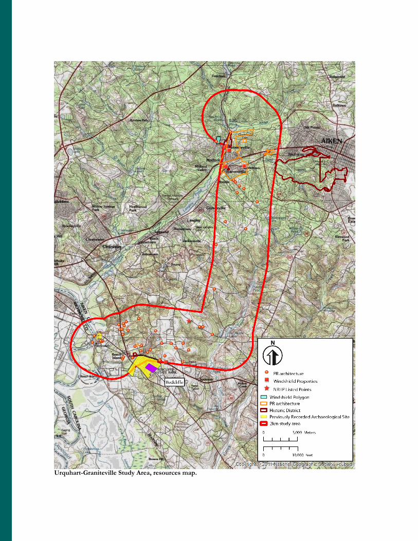
Urquhart-Graniteville Study Area, resources map.
Vo
I
PC
I X~
'/I/airy
//
N~C'sI
"c'cy'dtc
N
1
v
Redchffe'0
)
)fe'l
PR architecture~ Windshield Properties
* NRHP Listed Points
~ Windshield PolygonC3 PR architecture
C3 Historic District~ Previously Recorded Archaeologi«al Site
g5 2km study area
0 s,lylo M t
10,000 F t
011-Nation PG g aPhrc'C ietyai- begdaeealAka'M Ms