Ligurian Ocean Bottom Seismology and Tectonics Research ...€¦ · LOBSTER Ligurian Ocean Bottom...
3
LOBSTER Ligurian Ocean Bottom Seismology and Tectonics Research Ligurian Ocean Bottom Seismology and Tectonics Research (LOBSTER) PIs: H. Kopp 1 , D. Lange 1 , I. Grevemeyer 1 PostDoc: A. Dannowski 1 1 GEOMAR Helmholtz-Zentrum für Ozeanforschung Kiel Synopsis and objectives The objectives of the project LOBSTER (Ligurian Ocean Bottom Seismology and Tectonics Research) are twofold: 1) to monitor seismicity in the Ligurian basin using closely spaced broadband ocean bottom seismometers to provide state-of- the-art imaging of subsurface structures 2) to conduct a detailed amphibious seismic refraction survey of the Ligurian basin transition from the oceanic to the continental domain. LOBSTER provides the offshore component of AlpArray and the SPP 2017 ‚Mountain Building Processes in 4D’. The marine component of AlpArray/ SPP2017 4DMB A network of 30 French/German ocean bottom broadband seismometers (OBS) was deployed in June 2017 using the French RV PourquoiPas? as platform. In order to share ship-related costs between the two nations, recovery is conducted using RV Maria S. Merian in February 2018 (cruise MSM-71, Figure 1). The marine expedition MSM-71 aims to study the structural geometry of the Ligurian Basin, including the transition from oceanic to continental lithosphere and to recover the 30 broadband OBS stations from the German/French long term network. Long-term seismic monitoring No long-term network was installed in the past in the Ligurian Sea. The German- French seismic network recorded over a period of 8 months and extends the dense seismometer network of the AlpArray initiative that covers the entire region of the Alps onshore. With the integration of the marine stations, seismic travel time tomographic approaches will be improved and from this, new insights on the location of the subducting slabs in the transition zone between the Alps and the Apennines will be gained and questions on the 3D- geometry of the subduction polarity reversal might be answered. OBS recordings of teleseismic events will be essential to define subsurface structures at the transition from the Western Alps to the Apennines and improve our understanding of the 3D- geometry of the system and its kinematics. Refraction seismic experiment In addition to the passive seismology experiment, two active on-offshore wide- angle transects of 150 nm each will unravel the upper structure of the Ligurian Basin at crustal scale resolution. A particular focus will be on the ocean- continent boundary at the Alps-Apennines junction, which is poorly defined due to the lack of modern refraction data. 35 short-period OBS will be deployed along the two transects, respectively. Italian colleagues will provide stations to extend the profile on-shore in Liguria and on Corsica (Figure 2). The profiles will be shot using the GEOMAR G-Gun array (86 l). Along both profiles a ~280 m long streamer will be towed behind the vessel to record the upper sedimentary structures. Those structures will be poorly imaged by OBS measurements, however they are important for the data analysis.
Transcript of Ligurian Ocean Bottom Seismology and Tectonics Research ...€¦ · LOBSTER Ligurian Ocean Bottom...
LOBSTER Ligurian Ocean Bottom Seismology and Tectonics Research
Ligurian Ocean Bottom Seismology and Tectonics Research (LOBSTER) PIs: H. Kopp1, D. Lange1, I. Grevemeyer1
PostDoc: A. Dannowski1
1GEOMAR Helmholtz-Zentrum für Ozeanforschung Kiel
Synopsis and objectives The objectives of the project LOBSTER (Ligurian Ocean Bottom Seismology and Tectonics Research) are twofold: 1) to monitor seismicity in the Ligurian basin
using closely spaced broadband ocean bottom seismometers to provide state-of-the-art imaging of subsurface structures
2) to conduct a detailed amphibious seismic refraction survey of the Ligurian basin transition from the oceanic to the continental domain.
LOBSTER provides the offshore component of AlpArray and the SPP 2017 ‚Mountain Building Processes in 4D’. The marine component of AlpArray/ SPP2017 4DMB A network of 30 French/German ocean bottom broadband seismometers (OBS) was deployed in June 2017 using the French RV PourquoiPas? as platform. In order to share ship-related costs between the two nations, recovery is conducted using RV Maria S. Merian in February 2018 (cruise MSM-71, Figure 1). The marine expedition MSM-71 aims to study the structural geometry of the Ligurian Basin, including the transition from oceanic to continental lithosphere and to recover the 30 broadband OBS stations from the German/French long term network. Long-term seismic monitoring No long-term network was installed in the past in the Ligurian Sea. The German-French seismic network recorded over a period of 8 months and extends the dense seismometer network of the AlpArray initiative that covers the entire region of the
Alps onshore. With the integration of the marine stations, seismic travel time tomographic approaches will be improved and from this, new insights on the location of the subducting slabs in the transition zone between the Alps and the Apennines will be gained and questions on the 3D-geometry of the subduction polarity reversal might be answered. OBS recordings of teleseismic events will be essential to define subsurface structures at the transition from the Western Alps to the Apennines and improve our understanding of the 3D-geometry of the system and its kinematics. Refraction seismic experiment In addition to the passive seismology experiment, two active on-offshore wide-angle transects of 150 nm each will unravel the upper structure of the Ligurian Basin at crustal scale resolution. A particular focus will be on the ocean- continent boundary at the Alps-Apennines junction, which is poorly defined due to the lack of modern refraction data. 35 short-period OBS will be deployed along the two transects, respectively. Italian colleagues will provide stations to extend the profile on-shore in Liguria and on Corsica (Figure 2). The profiles will be shot using the GEOMAR G-Gun array (86 l). Along both profiles a ~280 m long streamer will be towed behind the vessel to record the upper sedimentary structures. Those structures will be poorly imaged by OBS measurements, however they are important for the data analysis.
LOBSTER Ligurian Ocean Bottom Seismology and Tectonics Research
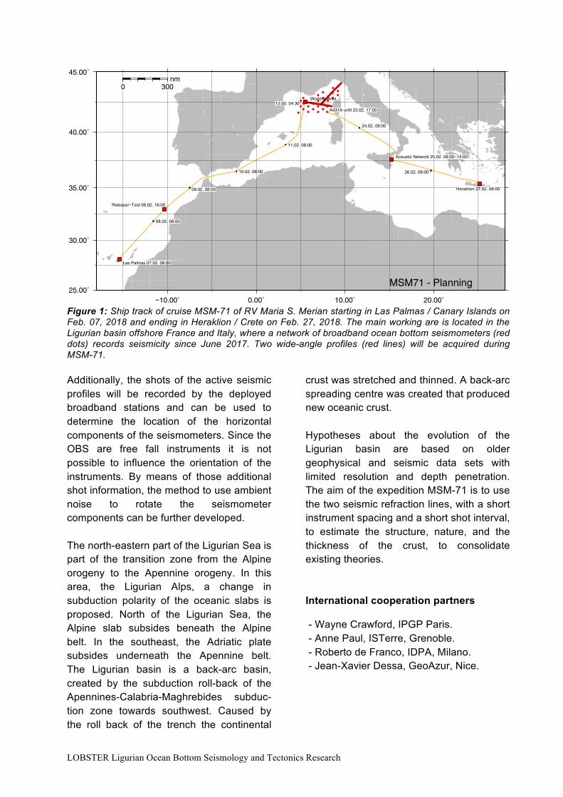
Figure 1: Ship track of cruise MSM-71 of RV Maria S. Merian starting in Las Palmas / Canary Islands on Feb. 07, 2018 and ending in Heraklion / Crete on Feb. 27, 2018. The main working are is located in the Ligurian basin offshore France and Italy, where a network of broadband ocean bottom seismometers (red dots) records seismicity since June 2017. Two wide-angle profiles (red lines) will be acquired during MSM-71. Additionally, the shots of the active seismic profiles will be recorded by the deployed broadband stations and can be used to determine the location of the horizontal components of the seismometers. Since the OBS are free fall instruments it is not possible to influence the orientation of the instruments. By means of those additional shot information, the method to use ambient noise to rotate the seismometer components can be further developed. The north-eastern part of the Ligurian Sea is part of the transition zone from the Alpine orogeny to the Apennine orogeny. In this area, the Ligurian Alps, a change in subduction polarity of the oceanic slabs is proposed. North of the Ligurian Sea, the Alpine slab subsides beneath the Alpine belt. In the southeast, the Adriatic plate subsides underneath the Apennine belt. The Ligurian basin is a back-arc basin, created by the subduction roll-back of the Apennines-Calabria-Maghrebides subduc-tion zone towards southwest. Caused by the roll back of the trench the continental
crust was stretched and thinned. A back-arc spreading centre was created that produced new oceanic crust. Hypotheses about the evolution of the Ligurian basin are based on older geophysical and seismic data sets with limited resolution and depth penetration. The aim of the expedition MSM-71 is to use the two seismic refraction lines, with a short instrument spacing and a short shot interval, to estimate the structure, nature, and the thickness of the crust, to consolidate existing theories. International cooperation partners - Wayne Crawford, IPGP Paris. - Anne Paul, ISTerre, Grenoble. - Roberto de Franco, IDPA, Milano. - Jean-Xavier Dessa, GeoAzur, Nice.
08.02. 08:00
09.02. 08:00
10.02. 08:00
11.02. 08:00
A431A until 23.02. 17:00
24.02. 08:00
26.02. 08:00
Las Palmas 07.02. 08:00
Releaser−Test 08.02. 16:00
Acoustic Network 25.02. 08:00−14:00
Heraklion 27.02. 08:00
−10.00˚ 0.00˚ 10.00˚ 20.00˚25.00˚
30.00˚
35.00˚
40.00˚
45.00˚
12.02. 04:30
0 300nm
Working Area
MSM71 - Planning
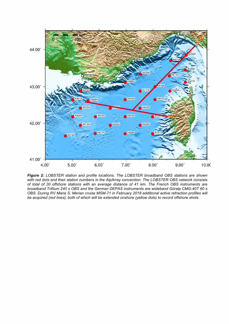
Figure 2: LOBSTER station and profile locations. The LOBSTER broadband OBS stations are shown with red dots and their station numbers in the AlpArray convention. The LOBSTER OBS network consists of total of 30 offshore stations with an average distance of 41 km. The French OBS instruments are broadband Trillium 240 s OBS and the German DEPAS instruments are wideband Güralp CMG-40T 60 s OBS. During RV Maria S. Merian cruise MSM-71 in February 2018 additional active refraction profiles will be acquired (red lines), both of which will be extended onshore (yellow dots) to record offshore shots.