Latitude and Longitude - Montessori Materials from Montessori for
4
©Montessori for Everyone 2018 Latitude and Longitude www.montessoriforeveryone.com latitude longitude latitude longitude
Transcript of Latitude and Longitude - Montessori Materials from Montessori for

©Montessori for Everyone 2018 Latitude and Longitude www.montessoriforeveryone.com
latitude longitude
latitude longitude
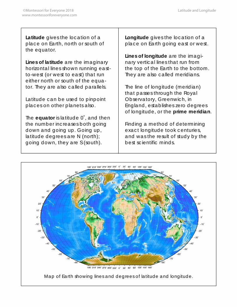
Latitude gives the location of a place on Earth, north or south of the equator. Lines of latitude are the imaginary horizontal lines shown running east-to-west (or west to east) that run either north or south of the equa-tor. They are also called parallels. Latitude can be used to pinpoint places on other planets also. The equator is latitude 0˚, and then the number increases both going down and going up. Going up, latitude degrees are N (north); going down, they are S (south).
Longitude gives the location of a place on Earth going east or west. Lines of longitude are the imagi-nary vertical lines that run from the top of the Earth to the bottom. They are also called meridians. The line of longitude (meridian) that passes through the Royal Observatory, Greenwich, in England, establishes zero degrees of longitude, or the prime meridian. Finding a method of determining exact longitude took centuries, and was the result of study by the best scientific minds.
Map of Earth showing lines and degrees of latitude and longitude.
©Montessori for Everyone 2018 Latitude and Longitude www.montessoriforeveryone.com

©Montessori for Everyone 2018 Latitude and Longitude www.montessoriforeveryone.com
Two views of a globe, showing lines of both latitude and longitude.
South Pole (Antarctica) North Pole (Arctic Circle)
View of each pole of the Earth, with lines of latitude and longitude. Notice how the lines of latitude form concentric circles, while the lines of
longitude are all the same circumference.

©Montessori for Everyone 2018 Latitude and Longitude www.montessoriforeveryone.com
To make this work: print on cardstock, laminate, and cut cards apart. You will want to use a globe when you present this material, so that the child can see the Earth in 3D and see the lines of latitude and longitude crisscrossing the globe. The first set of cards, showing the globe with only latitude or longitude, are 3-part cards to be used in the traditional 3-part card manner along with the definitions. The other three cards (world map, poles, and globes with both latitude and longitude) are simply informational, and can be read aloud by the child or adult. One fun activity is to have the child determine exactly at what latitude and longitude they are located, or find the latitude and longitude of a famous place. Most globes and atlases have the degrees of latitude and longitude. The backs of most atlases list cities and countries with their degrees of latitude and longitude. An older child might be interested in researching the development of longitude, and how it affected map making, travel, and exploration. Children can trace a circle using the circle template from the metal insets or geometry cabinet. By moving the circle template slowly towards the middle of the traced circle, and tracing only arcs, they can fill in the lines of latitude and/or longitude.
Please note: this PDF is copyrighted by Montessori for Everyone and is free for personal use only. Please do not up-load it to any other website (including school websites) or file-sharing service (like Scribd). Just link to us if you want to share. Thanks!