Landslide Hazard Mitigation in the Nilgiris District ...ijesd.org/papers/274-CD0088.pdf ·...
4
Abstract—Landslides are one of the common most problems globally and India as well. The Indian hill masses are prone to landslides from low hazard to severe landslide hazard. The Nilgiris district situated in the southern part of India on the Western Ghats is prone to High to Severe Landslide Hazard. In recent past the occurrence of landslides in Nilgiris are increased. The historical landslide inventory analysis of this area clearly reveals that the future landslide occurrence in the district is multifold and disastrous. Many researchers quantified the landslide hazard and risk in these areas, however there is no much studies landslide hazard mitigation planning, environmental and societal related issues. Also the recent numerous landslides/landslip in November 2009 taught a lesson and create need and urgency to address these issues. In this connection the existing landslide hazard scenario, the initiation made on landslide hazard mitigation in the district, the feasibility of cost effective technology for slope stabilization, environmental and societal issues need to be addressed for the Nilgiris district were studied and recommendation were given to over come these issues. The present study can be useful information to the environmental scientists, planners and policy makers in landslide hazard mitigation practices in the Nilgiri district. Index Terms—Bio-engineering, hazard, landslide, mitigation, Nilgiris. I. INTRODUCTION Landslide hazard is one of the most significant hazards that affect different parts of India every year during the rainy season. There is a variation in the degree of landslide incidences in various hill ranges [1]. The landslide hazard zonation atlas of India published by Building Materials and Technology Promotion Council (BMTPC), Government of India categorized the Nilgiris district of Tamil Nadu state is one of the severe to very high landslide hazard prone areas of India. The district is well known for the landslides threat [2]. In the recent times causalities and damage due to landslides have increased in the Nilgiri Hills. Totally 1150 landslides/landslips were reported within five days from 10 to 15 November, 2009, and taken away about 80 human lives, and reported 3785 huts were damaged, and part of roads and railway lines. This taught the lesson for the need and urgency of Habitat safety in Landslide Hazard Prone Areas. The present study analyses the causes of landslides, existing Manuscript received September 13, 2012; revised October 17, 2012. G. P. Ganapathy is with the Centre for Disaster Mitigation and Management, VIT University, Vellore 632014, India (e-mail: [email protected]). C. L. Hada is with United Nation Development Programme (UNDP), Pulchowk, Nepal under Emergency Preparedness and Recovery Programme (e-mail: [email protected]). landslide hazard scenario, issues by landslides faced on environment and society in the Nilgiris District. Fig. 1. Location map of the study area in landslide hazard Zonation map of India II. DESCRIPTION OF THE STUDY AREA Nilgiri is hilly district with an area of 2500 sq. kms and is situated in the northwestern part of Tamil Nadu state. It is bordered by the states of Karnataka in the north, Kerala in the west and south and by the districts Erode and Coimbatore of Tamil Nadu in the north east respectively. Ootacamund (udagamandalam) is the district head quarters (Figure 1). The total population of the district is 762141 as per the Census 2001. Charncokite and pyroxene granulite and covers a major part of the district [3]. Most of the parts in the district rocks are deeply weathered and the soil thickness is found to be upto 40m with lithomarge is a common feature in the district. Geomorphologically the Nilgiri hills rise abruptly from the surrounding plains to an elevation of 1370m amsl. The drainage is dendritic to radial at places with prominent rapids, cascades and water falls. The Ootacamund and Coonoor surfaces include gentle mounds, with soil cover, stream meanderings and gentle smoothening of the hills. The latter abuts against the former at many places, with break in slope. III. LANDSLIDE HAZARD SCENARIO OF NILGIRIS The Nilgiris district has a long history of disastrous landslide events. Some of the notable landslides recorded from the year 1865 to 2009 were discussed here. Generally October to December is the season for landslide in the Nilgiris. Most of these landslides are triggered by the heavy intense rainfall in the district. In November 1891 heavy rain caused many landslips on the Coonoor ghat, and did great damage to the Kotagiri - Metuppalayam road. Many people were killed in Ooty on account of houses collapses, landslides and drowning on 5th November 1978. There was Landslide Hazard Mitigation in the Nilgiris District, India – Environmental and Societal Issues G. P. Ganapathy and C. L. Hada International Journal of Environmental Science and Development, Vol. 3, No. 5, October 2012 497 10.7763/IJESD.2012.V3.274
-
Upload
nguyenlien -
Category
Documents
-
view
214 -
download
0
Transcript of Landslide Hazard Mitigation in the Nilgiris District ...ijesd.org/papers/274-CD0088.pdf ·...

Abstract—Landslides are one of the common most problems
globally and India as well. The Indian hill masses are prone to landslides from low hazard to severe landslide hazard. The Nilgiris district situated in the southern part of India on the Western Ghats is prone to High to Severe Landslide Hazard. In recent past the occurrence of landslides in Nilgiris are increased. The historical landslide inventory analysis of this area clearly reveals that the future landslide occurrence in the district is multifold and disastrous. Many researchers quantified the landslide hazard and risk in these areas, however there is no much studies landslide hazard mitigation planning, environmental and societal related issues. Also the recent numerous landslides/landslip in November 2009 taught a lesson and create need and urgency to address these issues. In this connection the existing landslide hazard scenario, the initiation made on landslide hazard mitigation in the district, the feasibility of cost effective technology for slope stabilization, environmental and societal issues need to be addressed for the Nilgiris district were studied and recommendation were given to over come these issues. The present study can be useful information to the environmental scientists, planners and policy makers in landslide hazard mitigation practices in the Nilgiri district.
Index Terms—Bio-engineering, hazard, landslide, mitigation, Nilgiris.
I. INTRODUCTION Landslide hazard is one of the most significant hazards that
affect different parts of India every year during the rainy season. There is a variation in the degree of landslide incidences in various hill ranges [1]. The landslide hazard zonation atlas of India published by Building Materials and Technology Promotion Council (BMTPC), Government of India categorized the Nilgiris district of Tamil Nadu state is one of the severe to very high landslide hazard prone areas of India. The district is well known for the landslides threat [2]. In the recent times causalities and damage due to landslides have increased in the Nilgiri Hills. Totally 1150 landslides/landslips were reported within five days from 10 to 15 November, 2009, and taken away about 80 human lives, and reported 3785 huts were damaged, and part of roads and railway lines. This taught the lesson for the need and urgency of Habitat safety in Landslide Hazard Prone Areas. The present study analyses the causes of landslides, existing
Manuscript received September 13, 2012; revised October 17, 2012. G. P. Ganapathy is with the Centre for Disaster Mitigation and
Management, VIT University, Vellore 632014, India (e-mail: [email protected]).
C. L. Hada is with United Nation Development Programme (UNDP), Pulchowk, Nepal under Emergency Preparedness and Recovery Programme (e-mail: [email protected]).
landslide hazard scenario, issues by landslides faced on environment and society in the Nilgiris District.
Fig. 1. Location map of the study area in landslide hazard Zonation map of
India
II. DESCRIPTION OF THE STUDY AREA Nilgiri is hilly district with an area of 2500 sq. kms and is
situated in the northwestern part of Tamil Nadu state. It is bordered by the states of Karnataka in the north, Kerala in the west and south and by the districts Erode and Coimbatore of Tamil Nadu in the north east respectively. Ootacamund (udagamandalam) is the district head quarters (Figure 1). The total population of the district is 762141 as per the Census 2001. Charncokite and pyroxene granulite and covers a major part of the district [3]. Most of the parts in the district rocks are deeply weathered and the soil thickness is found to be upto 40m with lithomarge is a common feature in the district. Geomorphologically the Nilgiri hills rise abruptly from the surrounding plains to an elevation of 1370m amsl. The drainage is dendritic to radial at places with prominent rapids, cascades and water falls. The Ootacamund and Coonoor surfaces include gentle mounds, with soil cover, stream meanderings and gentle smoothening of the hills. The latter abuts against the former at many places, with break in slope.
III. LANDSLIDE HAZARD SCENARIO OF NILGIRIS The Nilgiris district has a long history of disastrous
landslide events. Some of the notable landslides recorded from the year 1865 to 2009 were discussed here. Generally October to December is the season for landslide in the Nilgiris. Most of these landslides are triggered by the heavy intense rainfall in the district. In November 1891 heavy rain caused many landslips on the Coonoor ghat, and did great damage to the Kotagiri - Metuppalayam road. Many people were killed in Ooty on account of houses collapses, landslides and drowning on 5th November 1978. There was
Landslide Hazard Mitigation in the Nilgiris District, India – Environmental and Societal Issues
G. P. Ganapathy and C. L. Hada
International Journal of Environmental Science and Development, Vol. 3, No. 5, October 2012
49710.7763/IJESD.2012.V3.274

continuous heavy rainfall during 12th to 19th November 1979 and there was heavy rain of 102.2mm at Coonoor and a heavy landslide at Selas in which a house was completely buried in the debris along with 2 women and 3 children. There was another 'cloud burst' on 11th November 1993 in the upper reach of Marappalam of Coonoor Taluk, about 18 huts situated below the road and washing away Coonoor MTP ghat Road for about 1½km. The road traffic was suspended for more than a fort night. Twelve persons lost their live and 15 persons missing. It is laid that 21 passengers were washed away with two buses. An important highway, sheared stretched of rail road for about 300 m. Numerous landslides were reported in the early hours on 14 November 2006 killing one and injuring three persons and disrupting traffic in NH - 67 and blocking of mountain rail track between Mettupalayam and Coonoor [4]. In 2009 itself there were 1150 landslides/landslips were reported in Nilgiris out of these landslides about 98% are minor slips.
Increasing demands from different sections of society as well as the need to bring into the main stream the isolated communities in the remote hill areas, have resulted in an increase of all types of construction activities in these areas. In order to maintain the tempo of developmental activities and also mitigate losses due to landslides, there is need for developing appropriate framework for landslide hazard management [5].
The Building Materials Technology Promotion Council of the Government of India published small scale landslide hazard map of India in 1:6 million scale (Figure 2). The Landslide Hazard Zonation Map of India presented in the Landslide Atlas 2003 is based on a systematic study of the literature, the information available on intensity and spatial distribution of landslides, preparation and processing of thematic maps in small scale 1:6 million on a GIS platform [6] and [7] .
The Geological Survey of India, in collaboration with the State Geology branch, Government of Tamil Nadu launched detailed geological investigations of the landslides in August 1979. During 1978 and 1979 over 300 landslides/landslips, which occurred in the densely populated and developed area of 200 sq.km between Ooty and Coonoor were studied detail by the team of GSI and State Geology Branch of Government of Tamil Nadu. The main causes of landslides in different places were identified and the role played by excessive deforestation, obstruction to the normal drainage channels and changes in land use were studies by the team. The geologists have also been able to produce for the first time in the country a zonation map of landslide susceptibility on a regional scale [8]. Also the report gives recommendation for restrictions on changes in land use, roads, urban development, housing colonies and reservoirs. The risk quantification study for part of The Nilgiris district were carried out by Geological Survey of India, in collaboration with ITC Netherlands [9].
During the last three decades, the population in the Hills has gone up many folds as a sequel to heavy urbanisation and tourist influx, exerting severe strain on geo-environmental parameters. Under the circumstances, reactivation of the slide could be disastrous. Hence, detailed study will help to
identify the potential parameters of slide for monitoring, mitigating and forewarning [4].
Fig. 2. Landslide hazard Zonation map of the Nilgiris district (modified from
BMTPC, 2003).
IV. LANDSLIDE HAZARD MITIGATION THROUGH COST EFFECTIVE TECHNOLOGY
Strengthening of buildings and infrastructure should lead to reduction in Vulnerability. The vulnerability of buildings as well as infrastructure in a landslide however is most in cases nearly 100 percent, regardless of the quality of construction. Hence the vulnerability of the structures cannot be reduced. This option therefore is not highly relevant to landslide prone areas [10]. The planning principles of a landslide risk studies are: 1) gather accurate hazard information; 2) plan to avoid hazards before development and subdivision occurs; 3) take a risk-based approach in areas likely to be developed or subdivided; and 4) communicate the risk of hazards [11] and [12]. However the simple cost effective technology, soil bio-engineering is discussed in this chapter.
Use of Soil Bio Engineering for Slope Stabilization Soil bioengineering is the use of plant material, living or
dead, to alleviate environmental problems such as shallow, rapid landslides and eroding slopes and stream banks [13] and [14]. The effectiveness of vegetative structures is limited to 0.5 to 1.0 meters in general and complements the conventional civil engineering structures. For deep seated failures, bioengineering structures can not stabilize directly but can contribute indirectly to civil engineering structures by protecting the soil surface. Soil bioengineering most often mimics nature by using locally available materials and a minimum of heavy equipment, and it can offer roadside managers an inexpensive way to resolve local environmental problems [15] and [16]. Soil bioengineering can provide an effective means of treating sites where steep slopes and soil instability are resulting in revegetation problems [17]. Soil Bio-engineering is not a substitute for civil engineering. It offers engineers a set of tools to complement those already available in solving range of shallow slope problems. The functions of Soil Bio Engineering work similar way as civil engineering structures. Six major engineering functions that a bio-engineering structures are: Catch (Holding / stopping of falling soil particles over the surface), Armour (armouring the slope surface against rain splash and erosion), Support (supporting the soil mass from below), Anchor (anchoring
International Journal of Environmental Science and Development, Vol. 3, No. 5, October 2012
498
the loose particle down to a firm ground), Reinforce (reinforce the soil by increasing its shear strength) and Drain (improving drainage capacity of the poorly draining soil).
Soil bioengineering systems are strong initially and grow stronger as vegetation becomes established. Even if plants die, roots and surface organic litter continues to play an important role during reestablishment of other plants. Once plants are established, root systems reinforce the soil mantel and remove excess moisture from the soil profile. This is often the key to long-term soil stability. Soil bioengineering provides improved landscape and habitat values. Soil Bio Engineering systems work by fulfilling the engineering functions required for the protection and stabilization of slopes [18].
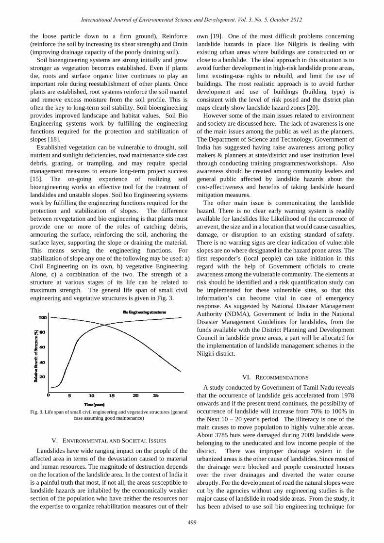
Established vegetation can be vulnerable to drought, soil nutrient and sunlight deficiencies, road maintenance side cast debris, grazing, or trampling, and may require special management measures to ensure long-term project success [15]. The on-going experience of realizing soil bioengineering works an effective tool for the treatment of landslides and unstable slopes. Soil bio Engineering systems work by fulfilling the engineering functions required for the protection and stabilization of slopes. The difference between revegetation and bio engineering is that plants must provide one or more of the roles of catching debris, armouring the surface, reinforcing the soil, anchoring the surface layer, supporting the slope or draining the material. This means serving the engineering functions. For stabilization of slope any one of the following may be used: a) Civil Engineering on its own, b) vegetative Engineering Alone, c) a combination of the two. The strength of a structure at various stages of its life can be related to maximum strength. The general life span of small civil engineering and vegetative structures is given in Fig. 3.
Fig. 3. Life span of small civil engineering and vegetative structures (general
case assuming good maintenance)
V. ENVIRONMENTAL AND SOCIETAL ISSUES Landslides have wide ranging impact on the people of the
affected area in terms of the devastation caused to material and human resources. The magnitude of destruction depends on the location of the landslide area. In the context of India it is a painful truth that most, if not all, the areas susceptible to landslide hazards are inhabited by the economically weaker section of the population who have neither the resources nor the expertise to organize rehabilitation measures out of their
own [19]. One of the most difficult problems concerning landslide hazards in place like Nilgiris is dealing with existing urban areas where buildings are constructed on or close to a landslide. The ideal approach in this situation is to avoid further development in high-risk landslide prone areas, limit existing-use rights to rebuild, and limit the use of buildings. The most realistic approach is to avoid further development and use of buildings (building type) is consistent with the level of risk posed and the district plan maps clearly show landslide hazard zones [20].
However some of the main issues related to environment and society are discussed here. The lack of awareness is one of the main issues among the public as well as the planners. The Department of Science and Technology, Government of India has suggested having raise awareness among policy makers & planners at state/district and user institution level through conducting training programmes/workshops. Also awareness should be created among community leaders and general public affected by landslide hazards about the cost-effectiveness and benefits of taking landslide hazard mitigation measures.
The other main issue is communicating the landslide hazard. There is no clear early warning system is readily available for landslides like Likelihood of the occurrence of an event, the size and in a location that would cause casualties, damage, or disruption to an existing standard of safety. There is no warning signs are clear indication of vulnerable slopes are no where designated in the hazard prone areas. The first responder’s (local people) can take initiation in this regard with the help of Government officials to create awareness among the vulnerable community. The elements at risk should be identified and a risk quantification study can be implemented for these vulnerable sites, so that this information’s can become vital in case of emergency response. As suggested by National Disaster Management Authority (NDMA), Government of India in the National Disaster Management Guidelines for landslides, from the funds available with the District Planning and Development Council in landslide prone areas, a part will be allocated for the implementation of landslide management schemes in the Nilgiri district.
VI. RECOMMENDATIONS A study conducted by Government of Tamil Nadu reveals
that the occurrence of landslide gets accelerated from 1978 onwards and if the present trend continues, the possibility of occurrence of landslide will increase from 70% to 100% in the Next 10 – 20 year’s period. The illiteracy is one of the main causes to move population to highly vulnerable areas. About 3785 huts were damaged during 2009 landslide were belonging to the uneducated and low income people of the district. There was improper drainage system in the urbanized areas is the other cause of landslides. Since most of the drainage were blocked and people constructed houses over the river drainages and diverted the water course abruptly. For the development of road the natural slopes were cut by the agencies without any engineering studies is the major cause of landslide in road side areas. From the study, it has been advised to use soil bio engineering technique for
International Journal of Environmental Science and Development, Vol. 3, No. 5, October 2012
499

slope stabilization where ever is possible. It offers engineers a set of tools to complement those already available in solving range of shallow slope problems. The functions of soil bio engineering works also have similar role as civil engineering structures. The cost of implementing this technique also is very much less than the civil engineering measures. Also the natural beauty of the hills would be retained in the hill slopes. The Soil bio engineering provides improved landscape and habitat values. However the soil bio engineering is not suitable for all sites and situations, it is advised a detailed site specific study should be carried out before implementing this technique.
ACKNOWLEDGMENT The authors are grateful to the Geotechnical Cell, Coonoor,
for providing the data and necessary information without which this work would not have been possible. The first author acknowledges all the facilities provided by Dr.G. Viswanathan, Chancellor, VIT University, Vellore and his constant encouragement.
REFERENCES [1] R. K. Bhandari, “The Indian Landslide Scenario, Strategic Issues and
Action Points,” (A Key Note address – Technical Session on Landslides) First India Disaster Management Congress, New Delhi, 29-30 November 2006.
[2] G. P. Ganapathy, K. Mahendran, and S. K. Sekar, “Need and urgency of Landslide Risk Planning for Nilgiri district, Tamil Nadu State, India,” International Journal of Geomatics and Geosciences, vol.1, no. 1. 2010, pp29-40, 2010.
[3] GSI, District Resource Map Series: Nilgiri District Tamil Nadu, published by Geological Survey of India-explanatory Note. , 1993.
[4] C. Thanavelu and Chandrasekaran, “Geotechnical Assessment of November 2006 landslides in the Nilgiris Tamil Nadu,” Abstract Volume: Proceedings of the National Seminar on Challenges in Engineering Geology, 03rd to 05th December 2008.
[5] G. P. Ganapathy and Jothimani Ponnusamy, “ Hazard Estimation and First Level Landslide Risk Mapping-A Case Study, Burliar Area of the Nilgiris District in Western Ghats,” Abstracts of the “Geomatics 2009” National Conference, Dehradun, Feb 4-6, 2009.
[6] BMTPC, Landslide Hazard Zonation Atlas of India, Published by Building Materials and technology Promotion Council, Government of India and Anna University, Chennai, pp.125, 2003.
[7] S. Rajarathnam and G.P. Ganapathy, “Landslide Hazard Zonation of India, a GIS Approach,” Proceedings of the First India Disaster Management Congress, New Delhi, 29-30 November 2006.
[8] D. N. Seshagiri, S. Badrinarayanan, R. Upendran, C.B. Lakshmikantham, and V. Srinivasan, “The Nilgiris landslide,” Miscellaneous publication no. 57. Geological Survey of India, 1982.
[9] P. Jaiswal and C. J. Van Westen, “Probabilistic landslide initiation hazard assessment along a transportation corridor in the Nilgiri area, India,” Geophysical Research Abstracts, vol. 11, EGU2009-2854, 2009, EGU General Assesmbly 2009.
[10] UNDRO, “Mitigating Natural Disasters, Phenomena, Effects and Options, A manual for Policy Makers and Planners,” A publication within the framework of the International Decade for Natural Disaster Reduction (IDNDR), 1990 -1999, New York, 1991.
[11] A. Leventhal and G. Withycombe, “Landslide risk management for Australia,” The Australian Journal of Emergency Management, vol. 24 No. 1, February 2009.
[12] W. Saunders and P. Glassey, “Taking a risk-based approach for landslide planning: An outline of the New Zealand landslide guidelines,” The Australian Journal of Emergency Management, vol. 24 no. 1, February 2009.
[13] David F. Polster, “Mining and the Environment III,” Laurentian University, Sudbury, Ontario, Canada, May 25 – 28, 2003.
[14] H. M. Schiechtl (Trans. N. K. Horstmann, 1980), “Bioengineering for Land Reclamation and Conservation,” University of Alberta Press. Edmonton. Alberta. pp.404, 1980.
[15] L. Lewis, “Soil Bioengineering - An Alternative for Roadside Management,” A Practical Guide pp.47, 2000.
[16] L. Lewis, Sandra L. Salisbury and Shannon Hagen, “Soil bioengineering for Upland slope stabilization,” Soil Bioengineering for Slopes, Research Report Research Project WA-RD 491.1, Washington State Department of Transportation, pp.88, 2001.
[17] D. H. Gray, A. T. Leiser, “Biotechnical Slope Protection and Erosion Control,” Van Nostrand Reinhold Company Inc. Scarborough, Ontario, pp. 271, 1982.
[18] WSDOT, “Road Side Manual, M25-30.01,” Washington State Department of Transportation Development Division, Design Office, Olympia, WA 98504-7329, pp.314, July 2012.
[19] Bhoop Singh, DST's initiatives on "Landslide Hazard Mitigation, [Online]. Available: http://gisdevelopment.net/application/natural_hazards/landslides/ma05297pf.htm, 2006
[20] NDMA, “National Disaster Management Guidelines: Management of Landslides and Snow Avalanches,” National Disaster Management Authority, Government of India, June 2009.
Dr. Ganapathy Pattukandan Ganapathy born on 2 June 1976 at Tamil Nadu, India. He has graduated from the College of Engineering Guindy, Anna University, in the year 1997 and completed his Masters from the Same University in Applied Geology Discipline. He completed his Doctoral Research in Earthquake Microzonation for Chennai City at Anna University, Chennai.
He served for Centre for Disaster Mitigation and Management, Anna University, Chennai for 8 years as a Scientist and carried out research studies the field of earthquake hazard assessment, earthquake monitoring, seismic micro-zonation, landslide hazard zonation, environment impact assessment and management. Dr.Ganapathy handled 10 funded research projects and more than 30 Consultancy projects on Disaster Management and Mining. His ongoing funded research projects are Earthquake damage scenario analysis for Chennai City funded by ISRO, Preparation of guidelines for Disaster Resistant Structures by Ministry of Urban Affairs, and Updating the loss database for the state of Tamil Nadu funded by UN –ISDR, Geneva.
Dr. Ganapathy presented more than 50 research papers in reputed International/National journals, workshops and conferences and he is Managing Editor and Editorial Board Member for 13 International Journals. He is the honorary member in the Joint Working Group for Geotechnical Disaster Management. He is the nominated member for the creation of Disaster loss database for Tamil Nadu State by UNDP. He is the invited member of the Working Committee on Landslide Hazard Mitigation, National Disaster Management Authority, Government of India. Dr. Ganapathy contributed to the Global Assessment Report 2011 on Disaster Risk Reduction. At present, he is working as Associate Professor at Centre for Disaster Mitigation and Management, VIT University, Vellore, Tamil Nadu, India.
Ms. Chandra Lakshmi Hada born on 5 November, 1978 in Bhaktapur in Nepal. She has completed her Bachelor of Architecture in Nepal Engineering College, Tribhuvan University, Kathmandu, Nepal during 1996 – 2001 and completed her Master of Science in Urban Planning at Institute of Engineering, Pulchowk Campus – Tribhuvan University, Nepal in 2009.
Ms. Hada has a vast experience in the field of Disaster Risk Reduction. She started her career as Junior Architect in a private company in 1999. Then she worked as a Teaching Instructor in Institute of Engineering, Kathmandu till 2003. She has hold various position at Manager level in many organizations till August 2008. In April 2008 she moved to the Earthquake Risk Reduction and Recovery Preparedness Programme for Nepal (UNDP/ERRRP-Project), Babarmahal, Kathmandu as a full time Project Engineer and Training Coordinator. Later on she moved to UN Habitat, Lao PDR as a Consultant for Disaster Risk Reduction and Building Back Better. She worked some times in Asisan Disaster Preparedness Centre (ADPC), Bangkok. Presently Ms. Hada is working as a Project officer for Emergency Preparedness & Response and Early Recovery in the Comprehensive Disaster Risk Management Programme, UNDP, Pulchowk, Nepal.
Ms. Hada holds membership in various societies’ viz., Nepal Engineering Council, Society of Nepalese Architects (SONA), Nepal Engineering Association (NEA) - member (8388), and Regional & Urban Planners’ Society of Nepal (RUPSON).
International Journal of Environmental Science and Development, Vol. 3, No. 5, October 2012
500