LAND RECLAMATION PROGRAM - DNR Reclamation Program | 3 INTRODUCTION Mining activity in Missouri...
32
2012-2013 LAND RECLAMATION PROGRAM BIENNIAL REPORT
Transcript of LAND RECLAMATION PROGRAM - DNR Reclamation Program | 3 INTRODUCTION Mining activity in Missouri...

2012-2013LAND RECLAMATION
PROGRAMB I E N N I A L R E P O R T

The cover photo is Lester Davis Reclamation Project.

Introduction and Land Reclamation Commission List
Land Reclamation Program and AdministrationOrganization2012 - 2013 Program Highlights
Coal MiningIntroduction and PurposePermittingBond ReleasesInspectionsEnforcementBondingBond Forfeiture ReclamationOff-Site Impacts
Abandoned Mine LandsReclamation FundingReauthorizationInventory and RankingFeature ProjectsNon-Coal Reclamation Projects
Industrial Minerals PermittingInspectionsLegislative and Rule ChangesFeesMissouri Blasting Safety ActMining Versus DevelopmentPublic ParticipationEnforcementBondingBond ForfeitureSand and Gravel RulesIn-Stream Sand and Gravel MiningSpotlight on the Ozarks: Sand and Gravel Mining
Metallic MineralsIntroduction and PurposePermittingInspectionsEnforcementBonding
Table of Contents
44
67789999
1010111214
17172020202021222223232425
2627292929

2 | Missouri Department of Natural Resources

Land Reclamation Program | 3
INTRODUCTION
Mining activity in Missouri began as early as the 1740s for mineral commodities such as lead, iron, limestone, sand and gravel. Coal mining, however, began in Missouri in the 1840s. With no legislation or regulation of these operations, there were as many as 67,000 acres left unreclaimed by coal-mining operations. An estimated 40,000 acres were left abandoned from the mining of other commodities. Missouri was left with a legacy of acid-mine drainage, dangerous highwalls, toxic mine spoils, dangerous mine shaft openings, unvegetated and barren soils, soil erosion and stream sedimentation.
The Missouri Department of Natural Resources’ Land Reclamation Program was established in 1974 to regulate present mining operations and to reduce or eliminate the issues caused by coal mining operations prior to laws regulating such operations were enacted. The Land Reclamation Program works to ensure today’s mining industry remains in compliance with Missouri Law Chapter 444 (Rights and Duties of Miners and Mine Owners). The law includes several chapters that are enforced by separate units within the Land Reclamation Program. The Industrial Minerals and Metallic Minerals Unit is responsible for sections Metallic Minerals Waste Management RsMo. Chapter 444.350-444.380 and the Land Reclamation Act RsMo. Chapter 444.760-444.790. The Projects and Inspection Unit, and the Permits, Contracts and Design Unit are responsible for the Surface Coal Mining Law RsMo Chapter 444.800-444.970.
The state regulations further define these laws. Citizens can find these laws in their entirety in the Rules of Department of Natural Resources Division 40 - Land Reclamation Commission Chapters 1 through 10 for coal and industrial minerals. Metallic Minerals regulations are found at Rules of Department of Natural Resources Division 45 - Metallic Minerals Waste Management Chapters 1 through 8.
The ultimate responsibility of the program is to ensure mine sites in Missouri are returned to a suitable land use and the adverse effects from active mining operations are minimized. When properly reclaimed, these areas can once again be used as farm lands or wildlife areas. Wildlife habitat remains a primary concern of the Land Reclamation Program. Whenever possible, abandoned mines are reclaimed with wetlands, native prairie grasses and trees that are part of Missouri’s history. Declining coal production in no way decreases the responsibilities of the Land Reclamation Program.
Monthly inspections of each mine continue to be performed long after the last ton of coal is removed. Revisions to permits and reclamation changes continue to be submitted for review and approval, as operators fine-tune their post-mining land use plans. Bond release requests increase in number and in size as more ground is reclaimed to acceptable standards. In effect, reclamation activities consume a far larger percentage of time and effort than the actual mining of coal itself.
This biennial report provides information and statistical summaries concerning the activities and business accomplishments of the Land Reclamation Program and its efforts to reclaim mined land during the calendar years of 2012 and 2013.
For more information, contact the department’s Land Reclamation Program at 800-361-4827 or 573-751-4041.
Kevin Mohammadi, Staff DirectorLand Reclamation Progam
Public Members
Jim DiPardo, ChairmanSt. James
Dr. Gregory Haddock, Associate Professor of Geography
Northwest Missouri State University
Dr. Leslie Gertsch, Associate Professor of Geological Engineering
Missouri University of Science & TechnologyRock Mechanics & Explosives Research Center
Col. John RifflePleasant Hill
Statutory Members
Robert Ziehmer, DirectorMissouri Department of Conservation
Joe Gillman, State Geologist, DirectorDivision of Geology and Land Survey
Missouri Department of Natural Resources
John Madras, DirectorClean Water Commission
MISSOURI DEPARTMENT OF
NATURAL RESOURCES
LAND RECLAMATION COMMISSION

4 | Missouri Department of Natural Resources
OrganizationThe Land Reclamation Program was originally established in the Omnibus State Reorganization Act of 1974. This act created the Department of Natural Resources and placed the Land Reclamation Commission (created by Missouri Statutes Chapter 444) under its auspices. The Land Reclamation Commission directs the staffing and operations of the program within the Missouri Department of Natural Resources’ Division of Environmental Quality.
The seven-member commission includes three statutory members - the state geologist, the director of the Missouri Department of Conservation and the staff director of the Clean Water Commission. The governor, with Senate approval, selects four public members. Of these four, only two may be of the same political party. Only one member of the commission may have a direct link with the mining industry.
The Land Reclamation Program consists of the administrative, abandoned mines lands, coal and non-coal units. A total of 22 full time staff members are divided between the four units. Together they are responsible for administration of the program, reclaiming abandoned mine lands and conducting inspections at all active mining operations in Missouri.
2013-2014 Program HighlightsAt the start of fiscal year 2012 Missouri had 4,890 acres both permitted and bond forfeiture and by the end of fiscal year 2013 only 3,750 acres remained. Overall the total amount of bonded acreage continues to decrease. The demand for high sulfur coal in Missouri continues to be steady at 422,000 tons as reported in 2012. The Land Reclamation Program released reclamation responsibility on 8 permits covering 720 acres at bond forfeiture sites and consequently 3 inspectable units were removed as well. Releases of reclamation liability on permanent program permits were approved on 69 acres reducing the acreage on one permit and completely releasing another permit and one inspectable unit.
Non-coal
The Doe Run Company, Sweetwater Mine, Metallic Minerals Waste Management Permit:
The Sweetwater Mine produces lead and zinc along with the waste product of tailings, which is regulated under the Metallic Minerals Waste Management Act
sections 444.360-444.380 RSMo. Tailings have the texture and size of fine grain sand. There are historical reports of windblown tailings going across property lines along with polluting Logan Creek. Sweetwater Mine stormwater discharges in to Logan Creek, which is on the Missouri 303(d) list of Impaired Waters for lead being found in sediment. The permit to operate a metallic mineral waste management facility at Sweetwater was initially issued to ASARCO and needed to be transferred to The Doe Run Company. This has been a three year endeavor to get a document to the point of No Further Responses Required and review is now final. Director Sara Parker Pauley signed a Metallic Minerals Permit Certificate issued on September 30, 2013, to The Doe Run Company, Sweetwater Facility. The permit has 15 conditions and does not relieve the permittee for any claim under federal and state Natural Resources Damages authority nor should be considered as waiver of such authority by state or EPA. A soil remediation plan along with a wind erosion work plan is an essential part of the permit. Dedication of department staff along with company personnel to properly implement the permit, conditions and plans results in better protection of the environment for the Reynolds County area as illustrated in the following photographs.
Magruder Limestone Company, Inc., Lake Ozark Quarry, permit issuance
Magruder Limestone Company Inc. applied for an expansion of its existing permit at a new site in Miller County; referred here as Lake Ozark Quarry. After consideration of all the information gathered at its Sept. 27, 2007, meeting, the Land Reclamation Commission ordered a hearing be conducted before deciding whether to issue the permit expansion. On July 24, 2008, the Land Reclamation Commission limited the permit area to that area west of Osage Beach sewer line easement. All the area east of the sewer line easement was denied. The full permit application was for 205 acres, the approved area is approximately one-third that acreage. The issued permit also included five conditions: blasting hours, blasting distances, blast plan, seismographs and elevation of mine floor.
On Sept. 28, 2008, following five detonations shortly after 2008 permit issuance, the Lake Ozark/Osage Beach Joint Sewer Board filed an injunction to cease all blasting related activities at Lake Ozark Quarry operated by Magruder Limestone Company Inc. The injunction was filed due to blasting vibrations temporarily shutting off a bank of 72 ultraviolet light bulbs that treat
LAND RECLAMATION PROGRAM AND ADMINISTRATION

Land Reclamation Program | 5
sewage before being released into Osage River. The ultraviolet lights reportedly shut off on two of the five detonations. Pushing a reset button would bring the ultraviolet lights back to functioning.
Shortly after filing for the injunction to cease all detonations, Lake Ozark/Osage Beach Joint Sewer Board filed a petition in Miller County Circuit Court against the Land Reclamation Commission claiming the hearing officer’s misapplication of burden of proof; the hearing officer’s unscientific order based on use of Wikipedia; and the incomplete nature of the application due to a power line easement not being illustrated on the detail map.
On April 3, 2009, Miller County Circuit Court Senior Judge Frank Conley reversed the Land Reclamation Commission order of July 24, 2008, granting Magruder Limestone Company a quarry permit and ordered the commission to hold a new hearing.
The Land Reclamation Commission did appeal the decision to the Missouri Western District Court of Appeals. On August 31, 2010, the Western District Court of Appeals issued its ruling:
1) If the petitioner produces sufficient scientific evidence of the impact of the permitted activity, the applicant must then satisfy the burden of persuasion, which is the “duty to convince the fact-finder to view the facts in a way that favors that party.” BLACK’S, supra at 223. To satisfy the burden of persuasion, the applicant must prove, by competent and substantial scientific evidence, that the petitioner’s health, safety, or livelihood will not be unduly impaired by the impact from the permitted activity. See 10 CSR 40-1 0.080(3)(B) and (D). In its order, the Commission did not distinguish between the burdens of production and persuasion and, instead, repeatedly stated that Petitioners bore the burden of proof and that the applicant, Magruder, bore no burden. Specifically, the Commission said: The Applicant did not have the burden to prove that the operation of
the proposed quarry will not unduly impair the health, safety or livelihood of the petitioners. The Commission’s statements are contrary to the plain language of section 444.773 and 10 CSR 40-10.080(3)(B). Because the Commission failed to apply the burden of proof in accordance with the statute and regulation, its decision was made upon unlawful procedure. Accordingly, we reverse the Commission’s decision granting Magruder the expansion permit and remand the cause to the Commission for a new hearing.
2) Petitioners seek reversal of the Commission’s decision and a new hearing based upon the Commission’s relying upon unscientific evidence outside the record. Our disposition of Petitioners’ first point renders this point moot.
3) The map showing the utility easements is not part of the public notification requirement. The information contained on the map is not part of the public notice. The public notice is unaffected by the inclusion or exclusion of the map in the application packet. The Director’s deeming the application complete before Magruder filed the map showing the utility easements did not invalidate the Commission’s ultimate decision to grant the expansion permit. The statute further reinforces that actual completeness is not required to trigger the publication of notice as it provides that, if the Director fails to respond to a permit application within forty-five calendar days, the application “shall be deemed to be complete.” § 444.772.10. The Director’s failure to act in this circumstance results in the application’s being automatically deemed complete and triggers the publication of notice, presumably regardless of whether the application is actually complete.
In late October 2012 another hearing was held with the Administrative Hearing Commission, Honorable Commissioner Karen Winn. On June 27, 2013, Commissioner Winn rendered her decision to issue the permit with eight conditions. On Sept. 26, 2013, the Land Reclamation Commission met to discuss Commissioner Winn’s recommended decision. The Land Reclamation Commission made
Left: Sweetwater Mine site prior to consent decree.
Right: Sweetwater Mine site after consent decree.

6 | Missouri Department of Natural Resources
COAL MINING
Introduction and PurposeBecause of growing national concern over the environmental degradation caused by coal mining, the U.S. Congress in 1977 passedPublic Law 95-87. This law, also known as the Surface Mining Control and Reclamation ActI, dictated specific requirements for the reclamation of coal mined land, and also established state regulatory authorities for the enforcement and monitoring of surface mine reclamation activities. The act also established programs and funding for reclaiming coal mine lands mined prior to May 2, 1977.
On May 3, 1978, the legislature amended Missouri’s Strip Mine Law establishing Chapter 444.535 RSMo, commonly referred to as the Interim Program Law. Requirements of this law included:
• Topsoil must be removed and replaced to a minimum 6 inch depth.
• All prime farmland soils must be removed and replaced to 48 inch depth.
• All mined land must be reclaimed to an equal or better land-use capability.
• Mined land must be backfilled and graded to approximate original contour.
a decision to adopt five of Commissioner Winn’s conditions: 1) detonate explosives in accordance with the blasting plan; 2) the entire 205 acre could be mined without any further public notification requirements; 3) 24-hour advance blasting notice via phone to the City of Osage Beach administrative office; 4) elevation of the mine floor should run above grade of the easement of the sewage treatment lines, and; 5) no piling of rock within 150-feet of the sewage line easement.
After the Sept. 26, 2013, permit issuance, the Lake Ozark/Osage Beach Joint Sewer Board filed a petition for review in Miller County Circuit Court asking the court to issue an order or judgment setting aside or otherwise reversing the Land Rec-lamation Commission’s final decision and denying in full Magruder’s permit expansion application.
Abandoned Mine Land Unit
Since the early 1840s, coal mining has at times been a major industry in the north central and southwest portions of Missouri. Up to 6 million tons of coal were mined annually in the first three decades of the 20th century. Because mining companies gave little or no thought to the post-mining value of the land, some 67,000 acres of land were left abandoned prior to passage of
Missouri’s first strip-mine legislation in 1971. Although nature has adequately reclaimed much of this land over the years, more than 10,000 acres have been identified that require at least some amount of reclamation work to correct a wide range of public health, safety and environmental problems. These problems include safety hazards such as steep and unstable highwalls and embankments, open mine shafts, abandoned mining equipment and facilities, dangerous impoundments and unsanitary trash dumps. Acid mine drainage and sedimentation from exposed coal waste and mine spoils also pollute and clog streams. Subsidence, caused when old underground mines collapse, may damage overlying buildings.
Abandoned mine land reclamation took a giant step forward when the U.S. Congress enacted Public Law 95-87, the Surface Mining Control and Reclamation Act of 1977. The act outlined specific requirements for the reclamation of lands mined after May 2, 1977, and established programs and funding for reclaiming abandoned mine lands. In January 1982, Missouri received approval from the federal Office of Surface Mining to operate the Abandoned Mine Land program and conduct reclamation work in the state.
• Coal waste and other acid-or toxic-forming material must be covered with a minimum of 4 feet of non-toxic material.
• A permanent vegetative cover compatible with the pre-mining land use must be established.
On May 17, 1982, the Missouri legislature passed the Surface Coal Mining Law (Chapters 444.800 - 444.970) to match federal standards established in the Surface Mining Control and Reclamation Act. The law made changes to the permitting process and granted the Land Reclamation Commission the authority to administer the abandoned mine land program. Coal companies were now required to submit baseline information on the hydrology, geology, soils, fish and wildlife, and cultural resources of the proposed mining area along with a detailed description of the proposed operation and reclamation plan. The most significant change to the reclamation requirements was that prime farmland soils must be removed and replaced to a 48 inch depth. These requirements, known as the Permanent Program Law, continue in effect to the present day.

Land Reclamation Program | 7
Over recent years, Missouri coal production has declined from 4.2 million tons in 1987 to approximately 422 thousand tons during 2012. This decline is largely due to industry demands for low-sulfur, western coal needed by power plants to reduce air pollution and meet emission standards required by the federal Clean Air Act. Most of Missouri’s coal reserves contain relatively high sulfur content, ranging from 2 to 7 percent by weight. However, Missouri coal has a relatively high British Thermal Unit, or BTU, compared to western coal. In recent years, some power plants have opted to mix Missouri’s coal with lower BTU western coal to increase energy production without exceeding sulfur emissions.
Over the last two fiscal years, coal mining has been concentrated in an area in southwestern Missouri where, in places, coal seams contain lower levels of sulfur. During this time period, the Land Reclamation Program issued two coal mining permit expansions, which increased the existing Hume mine by 188 acres. This active mine site is located in Bates County. At the end of fiscal year 2013, one company held two Missouri surface coal mine permits producing coal. The remaining permitted mines in Missouri were in various stages of reclaiming the land to regulatory standards. Of these permits the LRP received two permit revisions for land use changes, one permit expansion, and one new permit, all ofwhich were approved.
Land Reclamation Program staff closely monitors coal mining operations, including both coal removal and reclamation activities. Monthly inspections of each mine are performed to ensure reclamation requirements are adhered to and continue until the reclamation liability release proving hydrologic balance of surface and groundwater, soil stability and vegetative production for a minimum of five years after final grading and seeding.
PermittingStaff members are responsible for reviewing permit revisions and new permit applications. Land Reclamation Program staff personnel are professionally trained in specific technical areas and are responsible for reviewing technical plans with respect to their area(s) of expertise. Technical areas that must be reviewed include engineering, blasting, soil science, geology, hydrology, revegetation, land use plans, fish and wildlife protection, cultural and historical resources and reclamation technology. Staff members review all coal permit applications for adequacy and recommend approval or denial to
the Land Reclamation Program staff director. The staff also conducts regular evaluations of existing permits and also provides technical assistance to the mining industry and the public.
A thorough review of surface coal mining permit applications, permit revisions and other permit-related actions are necessary to ensure all requirements of the law and regulations are met.
Reviewing permit processes includes determining all applications, as well as the review process itself; meet all legal and administrative requirements. The permitting requirements for coal mining are extensive, requiring careful evaluation of diverse and comprehensive environmental topics such as soil characteristics, surface and subsurface water quality controls, fish and wildlife information, cultural resources and land use planning. Reviews also focus on specific details such as engineering designs for sedimentation ponds and water diversions, blasting plans and hydrogeologic data to determine the probable hydrologic consequences of mining. Other permitting responsibilities include evaluating each applicant’s legal compliance history with past mining activities and ensuring all public review requirements are fulfilled. Staff members also coordinate with other regulatory agencies to ensure the company proposing to conduct the mining activity has obtained other necessary environmental permits.
Bond ReleasesReclamation begins immediately after coal is removed from a strip mine pit. Regulations dictate a pit must be completely backfilled and graded no later than 180 days after coal removal. Topsoil must then be redistributed within an additional 270 days. The area must then be seeded during the first available growing season, with specific vegetation sufficiently established to control erosion by the end of the second year. Sediment ponds, diversions, explosive storage areas and maintenance pads also are subject to reclamation requirements once they become inactive or are no longer needed as part of the mining operation. Only when these requirements are met can an operator obtain a release of reclamation bonds.
In 2006 bonding requirements were changed for surface coal mines from a bond pool, with a flat bonding rate for all areas, to full cost bonding. Full cost bonding requires an engineering evaluation the area to be mined determining the worst case scenario in terms of cost to reclaim should the company, for whatever reason, be unable to complete full reclamation. The bond amount is

8 | Missouri Department of Natural Resources
determined by the Land Reclamation Program and is then posted by the company before a permit to mine coal is approved and issued. The bond is held in escrow by the Land Reclamation Program until such time as reclamation is completed and approved by the staff director of the program. Bonds are released in phases as regulated reclamation milestones are met.
The permanent program had f ive liability releases. Four release actions on four different permits were for Associated Electric Cooperative consisting of 21.5 acres and one complete permit release for Continental Coal Inc. for 47.5 acres.
Alternate Fuels Incorporated (AFI) Permits
As noted in the 2008-2009 report mentioned here for background information: In accordance with the legal consent agreement entered into with Continental Insurance and Beachner Construction an over bonded amount of $144,000.00 was released after the sureties mobilized for reclamation. The release was to the sureties for a portion of a permit associated with AFI. Shortly after the surety’s mobilization one of the landowners filed suit against Missouri for the reclamation plan that had been approved. Several months following the filing of the lawsuit AFI received a multi-million dollar court settlement from the State of Missouri for interfering in a business deal. The company filed bankruptcy as there more financial claims against the company than available funds. Since the company does have the financial resources to perform the reclamation the sureties have suspended any further work until it is legally clear what reclamation plan will be followed and if the company will be required to complete the reclamation.
As noted in the 2010-2011 report, Christopher J. Redmond with Husch Blackwell, LLP, was assigned as the bankruptcy trustee for AFI. A reclamation plan was approved for permit #1990-01 as prepared by TRIAD Environmental Services and work began shortly afterwards.
Permit revisions were approved by the LRP director for permits 1991-02 & 1996-01. Two of the three landowners associated with permit 1991-02 appealed to the Administrative Hearing Commission as being adversely affected by this decision. Since reclamation is proceeding AFI was moved from annual inspections to monthly inspections starting in June 2011.
During this period 2012-2013, the bankruptcy trustee has successfully completed the initial reclamation on permit #1990-01 and the Phase I reclamation liability release was approved by
program director in July 2012 with a bond release of sureties for that permitted acreage released in December 2012. Reclamation work continues on permit #1996-01. The litigation by the landowners of two of the three properties on permit #1991-02 continues with only minimum reclamation activities continuing where possible on property that is not part of the litigation.
InspectionReclamation activities are closely monitored to ensure the required performance standards are met and the reclamation plans approved in the company’s mining permits are followed. Coal mine inspections are performed monthly. On-site inspections serve three primary functions:
• Ensure an operation is functioning in a man-ner consistent with applicable state laws.
• Ensure an operation is fully complying with the conditions of the permit.
• Provide a public record on the status of mining and reclamation at a site.
Two styles of inspections are done, termed a complete and partial. Complete inspections are required once per calendar quarter. They involve a complete review of an operator’s compliance with all permit conditions and state statutes. As the name implies, partial inspections are a review of an operator’s compliance with some of the permit conditions and state statutes.
Many aspects of a mining operation are evaluated during an inspection:
• Mining occurs within the confines of the permit.
• Topsoil is being salvaged and stockpiled.• All storm water runoff from mined areas
enters sedimentation ponds.• Pits and other areas of mine disturbance
are promptly backfilled and graded.• Topsoil is replaced to the required thickness.• Vegetation is quickly reestablished in order
to control erosion.
Monthly inspections continue after an operation ceases mining coal. Continued monitoring ensures reclamation continues in an expedient manner and all conditions of the reclamation plan are followed. Only when an operator gains approval for a Phase II release (vegetation sufficient to control erosion) does the inspection frequency decrease from monthly to quarterly.

Land Reclamation Program | 9
EnforcementNotices of violation may be issued when an operator is out of compliance with the conditions of the permit or with state regulations. These are only issued after efforts to correct noncompliance through the process of conference, conciliation and persuasion prove ineffective. In general, if a notice of violation is issued, a monetary penalty will also be issued. Because inspections are conducted each month, it is rare that a serious noncompliance would exist. Well trained inspectors are able to identify when a mining or reclamation process is getting off-track in time to rectify the situation with the company before the need to issue formal enforcement occurs.
Cessation orders are an elevated form of a no-tice of violation and are a more serious form of enforcement. The department will issue an order when a condition or practice at the mine site con-stitutes imminent danger to the health and safety of the public or imminent environmental harm to land, water or air resources. Orders may require the immediate cessation of mining until the prob-lem is corrected. Cessation orders, because of their seriousness, require immediate abatement by the operator. Failure to do so may lead to a revocation of the mining permit. Cessation orders may also be issued for a failure to abate a notice of violation within the required time frame.
If cessation orders are not abated in a timely manner through the appropriate action on the part of the mining company, the next level of enforcement action is a show-cause order. This means the operator is ordered to show why their permit should not be revoked and the reclamation bond forfeited. Show-cause orders may also be issued for other reasons such as for patterns of violations and uncorrected delinquent reclamation.
There were no v iolat ions issued during this period.
Bonding Missouri’s Surface Coal Mining Law (Chapters 444.800 - 444.970) was amended in 2006 to ad-dress changes mandated by the federal Office of Surface Mining. A condition of Missouri’s reacquisi-tion of primacy was to change the bonding system in Missouri from one of a bond pool to one of full cost bonding. The necessary regulation changes were made prior to full return of primacy to the state on Feb. 1, 2006, through emergency rulemak-ing. These rules remained in effect until such time as the normal rulemaking process was completed.
The former bond pool approach relied on a set amount of money per acre being posted by the permit applicant prior to receiving a permit to engage in surface mining of coal and this set amount was supplemented by payments into a bond pool from all companies based upon yearly coal production. As of August 2012 there no remaining funds left in the A Bond Pool.
The present full cost bond approach requires the applicant to provide an estimate of the cost to reclaim a surface mine given the worst case scenario of the mining operation. That estimate is reviewed by program engineers and, when verified, that dollar amount is the amount of bonding required to be posted prior to the issuance of any surface mining permit for coal.
Bond Forfeiture ReclamationEach permitted coal company in Missouri is required to provide financial assurances to ensure reclamation of the site after coal removal. Upon completion of reclamation to applicable standards, the coal company receives a release from the Land Reclamation Program. Should a coal company fail to provide reclamation to applicable standards the bonds are forfeited to the Land Reclamation Program and these bonds are used by the program to provide reclamation to the site mined by the coal company.
The Land Reclamation Program continues to reclaim bond forfeiture sites resulting in the complete release of three inspectable units with 9 permits covering 916 acres. As of the end of FY 2013 bond forfeiture consists of five permits and four inspectable units for a total of 400.50 acres.
Off -Site ImpactsAn off-site impact is defined as anything resulting from a surface coal mining and reclamation activity or operation that causes a negative effect on resources, such as people, land, water, structures, etc. The program must regulate or control the mining or reclamation activity or result of the activity causing an off-site impact. In addition, the impact on the resource must be substantiated as being related to a mining and reclamation activity and must be outside the area authorized by the permit for conducting mining and reclamation activities.
There were no off-site impacts identified during this period.

10 | Missouri Department of Natural Resources
ABANDONED MINE LANDS
Reclamation FundingThe Abandoned Mine Land (AML) activities of Land Reclamation Program are funded by the U.S. Department of Interior’s Office of Surface Mining Reclamation and Enforcement AML Reclamation fund. All of the money in the fund is collected from active coal mining companies through fees charged on the tonnage of coal mined since passage of Surface Mining Control and Reclamation Act. The Office of Surface Mining Reclamation and Enforcement distributes the fund to the eligible states and American Indian tribes. To date, Missouri has received $85.7 million in AML grants and cooperative agreements from the fund to conduct reclamation work in Missouri. Missouri has an excellent record for obligating the funds received. Through state fiscal year 2013, 98 percent of all grants received have been contractually obligated for the completion of reclamation projects.
Because of steadily declining coal production since the late 1980s, Missouri and other midwestern states have received decreasing allocations. In 1987, the U.S. Congress established an annual minimum base funding level in the amount of $2 million to allow states with significant abandoned coal mine problems but limited coal production to continue their AML programs. However, the $2 million minimum base amount was consistently being reduced to $1.5 million in the federal appropriations process. As part of the 2006 amendments to SMCRA, the minimum base funding to states was incrementally increased over five years to the current maximum of $3 million per year. And furthermore, these funds are administered as mandatory grant funds that no longer go through the federal appropriation process.
ReauthorizationThe Abandoned Mine Land (AML) reauthorization was signed into law by President George W. Bush on Dec. 20, 2006. Following a three and one-half year legislative debate in congress over AML reauthorization, the comprehensive legislation was passed as part of the Tax Relief and Health Care Act of 2006. This bill represented the culmination of more than 10 years of work by the states, tribes, federal government, and other supporters to address the future of the AML program. These new changes in federal law have resulted in substantial increases in AML funding to states and tribes and allowed the program to focus AML
reclamation on projects that benefit public health and safety.
The AML reauthorization, which amended the 1977 Surface Mining Control Act, was a significant windfall that provides many benefits to the Missouri AML Program. It extended federal AML fee collection authority and funding of the AML program for an additional 15 years until the year 2021. The changes doubled the amount of AML funds that Missouri and the other minimum base states receive for completing reclamation projects that benefit public health and safety. In addition, the State of Missouri is designated as a recipient of AML funds, even if it cannot continue to operate the coal regulatory program.
There were several other notable changes made by the 2006 amendments:
AML Reclamation AcomplishmentsThrough June 30, 2013
Problem Reclaimed Under Construction
Under Design Total
AML Projects (#) 161 2 4 167
Mine Openings (#) 272 0 0 272
Highwall (ft.) 105,671 4,890 1,300 111,861
Hazardous Facilities 33 0 0 33
Subsidence (ac.) 7 0 0 7
Surface Burning 19 0 0 19
Underground Mine Fire (ac.) 7 0 0 7
Unsanitary Trash Dumps (ac.) 84 0 0 84
Dangerous Piles/Embankments (ac.) 805 0 25 830
Clogged Streams (mi.) 10.8 0 0 10.8
Clogged Stream Lands (ac.) 1,612 1 2 1,615
Polluted Waters: Human Consumption, Agricultural or Industrial (#) 61 0 0 61
Hazardous Impoundments (#) 20 0 0 20
Polluted Impoundments (#) 96 0 0 96
Haul Road (ac.) 1 0 0 1
Spoil (ac.) 1,648 0 0 1,648
Gob (ac.) 151 0 0 151
Slurry (ac.) 69 0 0 69
Total AML Acreage 4,498 4 27 4,530
• AML fees reduced by 20 percent over the duration of the extension.
• Previously Unappropriated State Share balances will be paid out to states and tribes over a seven-year period.
• AML allocation formula modified to direct more funds to areas with most historic coal-related problems.
• AML funds distributed annually outside of congressional appropriation process.
• Lien provisions streamlined.• Redefines priorities for AML funding.

Land Reclamation Program | 11
These changes result in dramatic and far-reaching effects to the AML program. The states, tribes and federal Office of Surface Mining worked cooperatively to ensure a smooth implementation of the 2006 amendments in a way that benefits citizens of the nation’s coalfields.
Inventory and RankingPublic Law 95-87 requires that the highest priority abandoned coal mine sites be reclaimed before problems created by mining other commodities are addressed. The order in which abandoned mine land is reclaimed is initially determined by classifying the problem sites into three broad priority categories. Priority I and II problem sites are reclaimed first since they pose a threat to the public health and safety. Priority III problem sites that adversely affect the environment may be addressed simultaneously if they are located adjacent or are contiguous to priority I and II problems. Otherwise stand-alone priority III features may not be reclaimed until all priority I and II sites have been reclaimed. P.L. 95-87 also provides that, at the request of the governor of the state or head of the tribal body, certain Priority I non-coal reclamation projects may be undertaken on a case-by-case basis before the priorities related to past coal mining have been fulfilled. The Land Reclamation Program has been closing extremely dangerous non-coal mine shafts under this provision since 2001. The information pertaining to Missouri’s abandoned mine lands is contained in the AML Inventory. This database currently contains 270 AML problem sites. It is continually updated as existing site conditions change or new sites are identified.
On an annual basis, the unfunded high priority (Priority I and II) problem sites are ranked and selected for future reclamation work according to the severity of existing problems. To date, an estimated $104 million in Priority I and II AML problems have been inventoried in Missouri. Of this total, $51 million remains unfunded.
Missouri’s Abandoned Mine Land Emergency Program
The Land Reclamation Program is responsible for investigat-ing all AML emergency complaints in Missouri and conducting reclamation work when emergencies are declared. An AML emergency is a sudden event related to past coal mining that has a high probability of causing substantial harm. There must also be a need to abate the emergency situation more quickly than would be possible under normal AML program operations. Sometimes an emergency complaint constitutes an eligible coal mine problem, but the situation does not meet the emergency criteria. In this case, reclamation work could still be undertaken by the Land Reclamation Program under the normal AML program. The proposed reclamation project, however, would be subject to the project ranking and selection process and would have to compete for available grant funds along with other priority I and II problem sites.
During Fiscal Year 2012 and 2013 the Land Reclamation Program conducted one coal emergency investigation. This emergency complaint regarded a small, smoldering gob pile near the town of Crighton, Mo., associated with an area of past underground coal mining. The Land Reclamation Program conducted an on-site investigation and determined that the gob pile was isolated, posed no threat to entering the underground workings, and the fire had consumed the majority of the coal refuse that fueled the smoldering pile. Therefore, the LRP monitored the site. This course allowed the pile to smother out and rather than expose more contaminants into the air. By the end of this reporting period, it appeared that the pile was no longer burning.
AML Reclamation AcomplishmentsJuly 1, 2011 through June 30, 2013
Final Designs Completed
Project Name County Acres AML Problems*
Lester Davis Barton 38 DH, HWB, DPE, SA
Little Tipple Highwalls Bates 15 DH, HWB
Millersburg Callaway 40 DH, PWAI, CSL, DPE, SA
Lost Dog Callaway 2 2 VO's
Webb City Elks Lodge Jasper 1 1 VO
Ardath Highwall Barton 90 DH, HWB, GO, CSL, SA
Beau Lane Shafts Jasper 1 1 VO
Big Ben Shafts Greene 1 1 VO
Total Acres 188
Construction Contract Awards
Highland Highwall Henry 65 DH, HWB, DPE, SA
Lester Davis Barton 38 DH, HWB, DPE, SA
Little Tipple Highwalls Bates 15 DH, HWB
Lost Dog Callaway 2 2 VO's
Webb City Elks Lodge Jasper 1 1 VO
Ardath highwall Barton 90 DH, HWB, GO, CSL, SA
Beau Lane Shaft Jasper 1 1 VO
Big Ben Shaft Greene 1 1 VO
Total Acres 213
Construction Contract Completions
Harrisburg/Thornhill Boone/Howard 75 DPE, CSL, IRW, GO, PWAI, SA
Montrose Badlands Henry 33 DH, DPE, CSL, PWAI, SA
Highland Highwall Henry 65 DH, HWB, DPE, SA
Leter Davis Barton 38 DH, HWB, DPE, SA
Lost Dog Callaway 2 2 VO's
Webb City Elks Lodge Jasper 1 1 VO
Beau Lane Shaft Jasper 1 1 VO
Big Ben Shaft Greene 1 1 VO
Total Acres 216
*Key to AML problem abbreviations:
IRW -Industrial or residential waste dump.VO - Vertical opening.SA - Spoil area.P - Portal.SL - Slurry (coal waste).DH - Dangerous highwall.GO - Gob (coal waste).
DPE - Dangerous piles or embankments.PWAI - Polluted water agricultural/industrial.CS - Clogged stream conditions.S - Subsidence.WA - Water problems (acid mine drainage and sedimentation).HEF - Hazardous equipment and facilities.

12 | Missouri Department of Natural Resources
Feature Projects
MONTROSE BADLANDS RECLAMATION PROJECTThe Montrose Badlands Reclamation Project was completed during this reporting period. The project is located on privately owned land adjacent to County Road SW1301, approximately three miles northwest of Montrose in Henry County. The project reclaimed approximately 33 acres of abandoned coal mine lands and eliminated the health and safety hazards associated with 500 feet of dangerous highwall located adjacent to a frequently traveled county road. Additional features addressed included the grading and re-contouring approximately 10 acres of dangerous piles and embankments, 7.5 acres of clogged stream lands, and the backfilling of three small ponds of standing water classified as polluted due to acidic conditions. The project area was then seeded with a mixture of cool season grasses and legumes. The project was awarded to Hale Fencing and Bobcat Services LLC from Henley, Missouri. Notice to proceed was given on May 20, 2011, with substantial completion accomplished on Oct. 26, 2011. Final payment amounted to $436,687.68.
HIGHLAND HIGHWALL RECLAMATION PROJECT DESIGNThe AML unit completed the design for the Highland Highwall Abandoned Mine Land Reclamation Project. This project is located on privately owned land off County Road NW 730 and just to the north of US Highway 52, approximately two miles west of Calhoun in Henry County. The project reclaimed approximately 85 acres of abandoned coal mine lands while eliminating the health and safety hazards associated with a 3,600-feet long highwall and a final pit impoundment both of which were adjacent to a well- traveled county gravel road. Additional work included grading and re-contouring approximately 45 acres of poorly vegetated piles and embankments. Upon completion the site was revegetated with cool season grasses and legumes to reduce erosion. The project was awarded to Walters Excavating LLC from Lowry City, Missouri. Construction activities began on Sept. 19, 2011, and was completed in May 2012. Final payment amounted to $844,353.53.
LESTER DAVIS RECLAMATION PROJECTThe AML unit and the Office of Administration’s Division of Facilities Management Design and Construction contracted Allgeier, Martin and Associates Inc. in Joplinas the primary design consultant to develop the Lester Davis Reclamation Project. The project is located on both private and Missouri Department of Conservation lands, south West Central Road in western Barton County.
(1) Photo showing the degraded mine spoils and acidic drainage found on the site prior to the start of construction activities. (2) Post construction photo of the reclaimed and revegetated spoil material and showing a marked improvement of the site’s overall water quality. (3) Photo shows the proximity of the dangerous highwall and hazardous water impoundment from the county gravel road. (4) Post construction photo shows the site after the elimination of the dangerous highwall and hazardous water impoundment. (5) Post-Construction photo of endwall next to county road.
3
4
1
2
5
Land Reclamation Program | 13
The project consisted of approximately 38 acres of abandoned mine lands and entailed eliminating two water filled pits and backfilling an endwall, all of which were located adjacent to a well-traveled county road. Other activities included the grading and shaping of numerous dangerous piles and embankments and the creation of a rock swale with the addition of high quality lime to neutralize acid forming materials prior to entering an unnamed tributary which eventually flows into Second Nicholson Creek. Upon completion of construction activities the project was seeded to both warm season and cool season grasses along with numerous tree and shrub plantings. The project was awarded to Double S Dirt Works Inc., located in Liberal, Missouri. Construction on the project began on June 30, 2012, and was completed on Oct. 10, 2012, at a cost of $460,477.77.
ARDATH HIGHWALL RECLAMATION PROJECTThe AML unit completed the design for the Ardath Highwall Reclamation Project. The project consisted of reclaiming approximately 90 acres of abandoned coal mine lands on private property. The project located in the E1/2 of Section 30, Township 33N, Range 33W in Barton County. The project has eliminated health and safety hazards associated with 3400 feet of dangerous highwalls located next to a well-traveled county road. Additional work consisted of grading and shaping mine spoils and the installation of two rock swales for storm water control. The site will be seeded to a mixture of warm season grasses, and then mulched.
The reclamation project was awarded to TL Enterprises Inc., Garnett, Kans. Construction activities began on Oct. 22, 2012, with a final contract completion date of March 17, 2014.
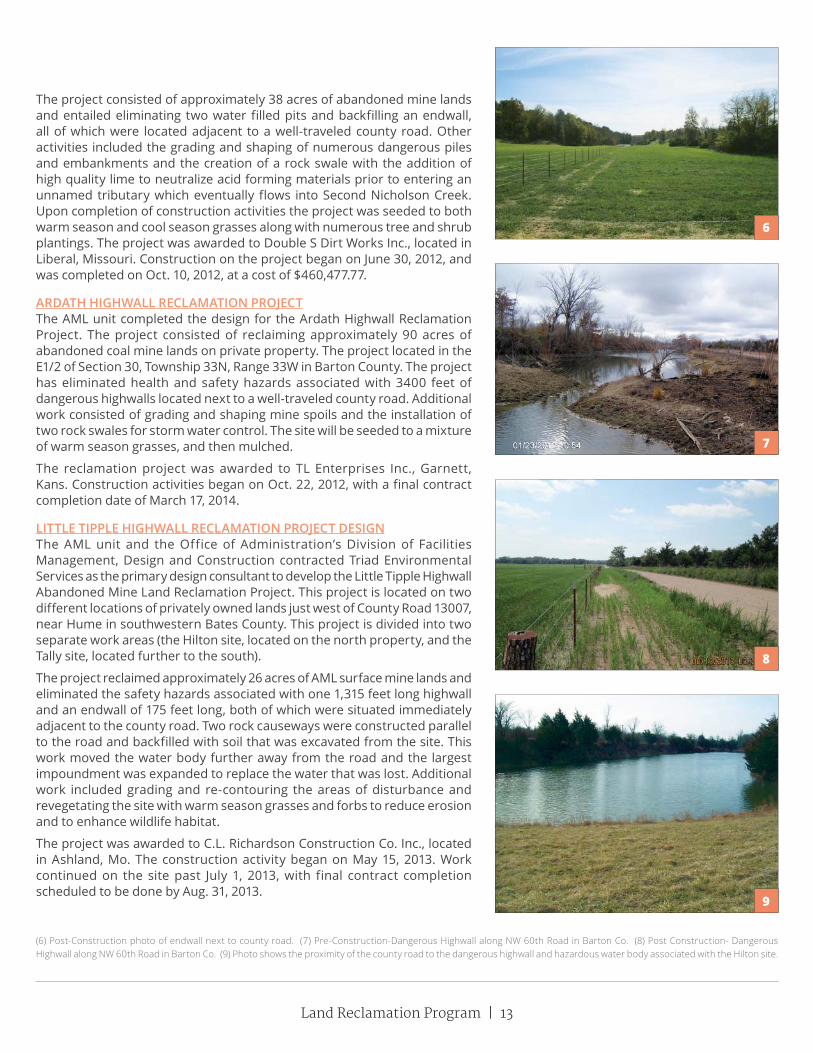
LITTLE TIPPLE HIGHWALL RECLAMATION PROJECT DESIGNThe AML unit and the Office of Administration’s Division of Facilities Management, Design and Construction contracted Triad Environmental Services as the primary design consultant to develop the Little Tipple Highwall Abandoned Mine Land Reclamation Project. This project is located on two different locations of privately owned lands just west of County Road 13007, near Hume in southwestern Bates County. This project is divided into two separate work areas (the Hilton site, located on the north property, and the Tally site, located further to the south).
The project reclaimed approximately 26 acres of AML surface mine lands and eliminated the safety hazards associated with one 1,315 feet long highwall and an endwall of 175 feet long, both of which were situated immediately adjacent to the county road. Two rock causeways were constructed parallel to the road and backfilled with soil that was excavated from the site. This work moved the water body further away from the road and the largest impoundment was expanded to replace the water that was lost. Additional work included grading and re-contouring the areas of disturbance and revegetating the site with warm season grasses and forbs to reduce erosion and to enhance wildlife habitat.
The project was awarded to C.L. Richardson Construction Co. Inc., located in Ashland, Mo. The construction activity began on May 15, 2013. Work continued on the site past July 1, 2013, with final contract completion scheduled to be done by Aug. 31, 2013.
(6) Post-Construction photo of endwall next to county road. (7) Pre-Construction-Dangerous Highwall along NW 60th Road in Barton Co. (8) Post Construction- Dangerous Highwall along NW 60th Road in Barton Co. (9) Photo shows the proximity of the county road to the dangerous highwall and hazardous water body associated with the Hilton site.
6
7
8
9

14 | Missouri Department of Natural Resources
Abandoned Mine Land Non-Coal Reclamation ProjectsAlthough the Land Reclamation Program uses federal money designated to reclaim abandoned coal mines, the money may also be used to reclaim non-coal vertical mineshaft openings if they meet certain criteria. These non-coal problems are allowed to be corrected with a request from the governor if it is necessary for the protection of the public health, safety and general welfare from extreme danger, thereby meeting Priority I problem criteria.
Between July 1, 2011, and June 30, 2013, 4 dangerous non-coal shafts were closed in the Joplin/ tri-state mining district. Two major projects known as the Webb City Elks Lodge Shaft located in Webb City and the Big Ben Shaft located in Springfield sealed mine openings that suddenly developed in neighborhoods, with the latter one affecting the structure of a home. Reclamation of these shafts included excavating to bedrock, or solid earth, and constructing a steel-reinforced concrete plug over the open shaft.
WEBB CITY ELKS LODGE SHAFTThe project site is located on private property in Webb City in Jasper County. The project consisted of closing one priority 1 abandoned underground lead/zinc shaft that had opened up in a wooden area directly behind the Webb City Elks Lodge and next to a crowded subdivision. On Jan. 24, 2012, the project was awarded to Emery Sapp & Sons DBA/Kennedy-ESS Contractors, from Springfield. Reclamation of the project entailed the construction and placement of a steel-reinforced concrete plug over the shaft opening and then backfilling to the surface with fill material excavated from the area surrounding the site. Work began on Jan. 30, 2012, and was deemed complete on Feb. 7, 2012. A MDNR monument marker was installed at the center of the filled shaft surface. Final total cost amounted to $19,656.74.
(10) Photo shows the Webb City Elks Lodge Shaft collapse opening and its proximity to a nearby subdivision. (11) Post construction photos showing the site after the reclamation and elimination of the dangerous lead/zinc shaft just before reseeding of the area.
10
11

Land Reclamation Program | 15
BIG BEN PROJECT SUMMARYOn the evening of Jan. 29, 2013, a subsidence occurred between two homes located at 1515 and 1519 S. Devon Road, Springfield. It was believed that the area where the subsidence occurred is the location of an abandoned vertical mine shaft known as “Big Ben.” The Land Reclamation Program received reports about the shaft subsidence the morning of Jan. 31, 2013. Program staff immediately began collecting information in preparation of a site investigation conducted later that morning.
Maps obtained from the Missouri Geological Survey (formerly Division of Geology and Land Survey) and georeferenced on aerial photos using geographical information systems by the Greene County Resource Management Department show a lead and zinc shaft entrance in the vicinity of two homes at 1515 and 1519 S. Devon Road. The homes were constructed approximately 20 years ago.
Reportedly, the vertical opening was originally a vertical shaft extending 190 feet deep and horizontally following the lead and zinc veins in opposite directions. It is believed the vertical shaft was filled in the 1950’s or 1960’s prior to the area being developed as a residential neighborhood. The subsidence around the vertical shaft created a vertical opening approximately 31 feet long, 14 feet wide and 15 feet deep between the two houses. What appeared to be mine related concrete foundations and unconsolidated fill were present in the cone shaped vertical opening. Both landowners, signed consent forms to allow the Land Reclamation Program to fill the vertical opening.
The first priority was to ensure the foundations of both homes were stable and eliminate potential hazards to crews working in the area. The home located at 1519 S. Devon Road was particularly vulnerable with the subsidence causing 60 to 70 percent of the footing under one side of the house to fall into the vertical opening. If not stabilized, it was believed the home would collapse into the vertical opening in the near future. The homeowners contracted with an engineering firm (Palmerton & Parrish, Inc. of Springfield) for consulting and design to permanently stabilize the homes. The consulting engineer recommended constructing a cast in place concrete support beam that would span the length of the vertical opening and would be used to reduce the pressure placed on the exposed foundation. The footing and foundation on the house located at 1515 S. Devon Road appeared to be intact with some cracks appearing on the basement walls. The program contracted an excavating company for the placement of rock fill to stabilize the side slopes of the vertical opening, installation of temporary supports for the foundations of both homes, and to provide a suitable foundation for constructing the concrete cast in place support beam. This work was completed on Feb. 1, 2013.
The consulting engineer designed a cast in place concrete beam and micro-pilings to permanently stabilize both homes. Through the consulting engineer, the program contracted with DeWitt and Associates of Springfield to construct the cast in place beam. The beam was needed for the house located at 1519 S. Devon to span the vertical opening. The concrete beam was completed on March 15, 2013. Micro-pilings were installed on March 19, 2013, to support the cast in place concrete beam and were also installed around the foundation of the 1515 South Devon home. On March 27, 2013, the program hired Freddy Van’s Inc. to excavate into the existing mine shaft. The contractor excavated down approximately 18 feet, to the center of the mine shaft. Further excavation around the subsidence was not possible due to continued sloughing of the excavation area and the potential to weaken the micro-pilings.
(12) Picture from initial investigation on February 1, 2013 showing vertical opening subsidence between houses at 1515 and 1519 S. Devon Road, Springfield. (13) Installation of rock to allow a stable base for temporary stabilization and for the construction of the concrete cast in place beam. (14) Temporary stabilization in place to prevent one of the houses from collapsing into the subsidence.
12
13
14

16 | Missouri Department of Natural Resources
It was decided that an oversized concrete plug would be installed that would prevent another catastrophic collapse. Loose material was removed from the vertical opening to create stable surface for placing the concrete plug. On March 29, 2013, approximately 77 cubic yards of concrete was placed in the conical shaped excavated hole and was reinforced with size #8 rebar.
On April 9, 2013, the areas underneath the homes that had not been filled with concrete were pressure grouted by the contractor and four to five yards of grout was injected under the two homes. On the same day, some of the rock fill removed from the subsidence was placed over the concrete plug and graded out in preparation for landscaping the project area. LRP Environmental Engineer Brent Willeford, P. E., oversaw the excavation, development of the concrete plug, and grouting of the homes. On April 17, 2013, the excess rock fill removed from the subsidence was loaded onto dump trucks belonging to Greene County by the contractor hired by LRP. Greene County offered to haul and dispose of the excess fill. General cleanup of the project area was completed by the contractor on this date as well. A landscaping contractor was hired by LRP and topsoil was placed and graded and the yards were mulched and reseeded on May 1, 2013.
The Missouri Department of Natural Resources Land Reclamation Program appropriated $78, 067.02 to complete this project.
Occasionally a dangerous mineshaft may be closed by backfilling with rock, soil material, or backfilling with concrete to create a monolithic concrete plug. These closure methods are quick and relatively inexpensive but often may not be the best choice. Most of the time a more costly, yet more permanent closure method, is preferred. This more common type of typical non-coal shaft closure consists of excavating the loose soil material around the hole down to the bedrock constructing a platform; pouring a wedge-shaped, steel-reinforced, concrete plug at the top of the shaft and backfilling over the concrete with earthen material. A closure of this type ranges typically ranges from around $12,000 -$20,000 per shaft but can vary based upon the specific conditions of each shaft.
Currently there is one non-coal shaft in the inventory to address. However, it is suspected that there are many more open shafts that we are unaware of that will need to be closed. Dangerous mine shafts will continue to open up (especially in the tri-state lead/zinc mining district in the Joplin area) and will be investigated and closed to protect the public.
15
16
17
(15) Construction of the concrete cast in place beam. (16) Finished cast in place beam. (17) Installation of the concrete plug over the shaft opening. (18) Final grade after backfilling, reseeding and mulching. (19) Typical 10’X10’ non-coal vertical mineshaft opening 150’ deep.

Land Reclamation Program | 17
INDUSTRIAL MINERALS
PermittingIndustrial mineral mining permit certificates are issued for a one-year period. The industrial mineral permits must be continually renewed until the Land Reclamation Commission or staff director deems all mined land covered by the permit is fully reclaimed. Approximately 700 new or renewed permits were issued in the past two years. Since some permits contain multiple sites, the number of permitted sites is substantially higher. In addition to the new and renewed permits, staff spent a considerable amount of time reviewing other permit actions, including permit transfers, expansions, amendments and consultations with the Missouri Department of Conservation. Fees collected from industrial mineral permits are used to conduct necessary regulatory functions.
InspectionsBefore 2007, the state was historically separated into at least four geographic area inspection units. Now, the state is divided into two geographic area inspection units with at least two inspectors assigned to each unit. Each unit contains about 57 counties. Not all counties have an industrial mineral mine site. When staff wanted the state divided into two regions, it was noted that some areas become more active at times when compared to others. Before the change, one staff member had to investigate a lot of complaints in the southwest portion of the state while inspection staff assigned to the northeast portion of the state had a relatively normal schedule. Now, at least two inspection staff members share an assigned area to help maintain a relatively even workload.
Operators who have been in the business for more than five years have undoubtedly seen changes in inspection staff. Many operators prefer the same inspector each year for the purpose of consistency. The program will accommodate their request as often as possible.
Inspectors are limited to the amount of on-site inspections they can perform in a given year, as they conduct permitting and other actions as well. Mine operations range in size from one acre gravel bars to some sites being greater than 300 acres such as limestone quarries. In 2013, there were 733 permitted industrial mineral sites, with 498 inspections conducted in 2012 and 530 inspections conducted in 2013. These total numbers are consistent in average when compared to the number of inspections conducted over the past few years. Three factors contribute to the similar rate of inspection numbers:
• Longer employee retention time.• Increased efficiency for producing inspection reports.• Fewer turnovers in inspection staff.
18 19

18 | Missouri Department of Natural Resources
2013 2007 20052009 2003 2001
Year
Amou
nt o
f Acr
es R
elea
sed
Acres Released Since 2001
1167
697
481
949
511
954 972
1665
766
477
710
The Industrial Mineral Unit projects to maintain a total of 500 inspections in years to come as long as the unit retains a full inspection staff and certified inspectors to conduct investigations. Each of the five inspectors conducts about 100 inspections. The non-coal staff conducting inspections at this rate will be able to accomplish inspecting a site once every two years. This is a huge improvement when compared to the last 10 years.
Types of Inspections
In 2012 and 2013 there was an average of 514 site inspections conducted. Inspections typically fit into three categories.
Regular Inspections
Regular open pit inspections are conducted to determine if an operator is in compliance with the approved permit and the applicable performance requirements. Performance requirements checked by inspectors include timeliness of reclamation, safety barriers, lateral support, erosion and siltation control, grading, topsoil handling and revegetation. Inspectors also evaluate each mine site to ensure all mining disturbance is confined to the permitted and bonded area and the approved post-mining land uses are being established.
In-stream sand and gravel inspections now involve performance standards. Inspectors evaluate the mined area on the gravel bar to make sure the material being excavated is unconsolidated. Inspectors also look to make sure there is no mining below the waterline, no relocation of stream channels, no sorting or washing of gravel on the gravel bar and an undisturbed buffer of 10-feet from the flowing water.
Complaint Inspections
Complaint inspections are conducted after the program receives notification an industrial mineral operation may be in violation of the Land Reclamation Act. Complaints filed may involve blasting, noise, truck traffic, water pollution, digging in flowing water, erosion or siltation. Following an investigation, the inspector and operator are often successful in resolving a citizen’s complaint in a timely manner. However, many complaints related to mining operations, such as blasting and noise, are not regulated by the Land Reclamation Program and are referred to the appropriate regulatory authority.
The department requires a complaint be investigated within 30 days. The goal is to respond within 14 days of receiving them. However, an investigation is usually conducted within seven work days. There were 34 complaints filed and investigated in 2012 and 42 complaints in 2013.
530
2013 2009 20052011 2007 2003 2001
Non-Coal Inspections Since 2001
Year
Amou
nt o
f Ins
pect
ions 498
654
381
227263
223
139
233
294
163
100
216

Land Reclamation Program | 19
Bond Release and Other Inspections
Bond and reclamation responsibility release is an important part of the mine closure process. Bond release inspections are conducted at the operator’s request when reclamation has been completed. The mining company will also send the landowner a letter announcing the intent to seek a release of the mined land. The landowner may request a hearing before the Land Reclamation Commission if they feel the land is not properly reclaimed.
The focus of the bond release inspection is to determine if the mine site has been reclaimed in accordance with the reclamation plan. The inspector must evaluate if the operator has established the designated post mining land uses. Post mining land uses may be designated as wildlife habitat, agricultural, development or water impoundment. At least two growing seasons must pass after an area has been planted before the success of revegetation can be judged. Land never affected by mining, but is under permit and bond, may be released as unaffected.
The staff director determines if the bond, or any portion thereof, should be released. When mined land is properly reclaimed a recommendation for bond release is made to the Land Reclamation Commission or staff director. If either the Land Reclamation Commission or staff director approves the request for approval of reclaimed land, the reclamation performance bond is released back to the operator. The commission or staff director approved the release of 697acres of reclaimed mine land in 2012 and 1,167 acres in 2013.
To obtain a Request for Approval of Reclaimed Land form, contact the Department ’s Land Reclamation Program by telephone at 573-751-4041. The form is also available on the department ’s Web site at www.dnr.mo.gov/forms/index.html#LandReclamation.
The depar tment and programs are also conducting compliance assistance visits for new operators. Typically, the department allows an operator to conduct operations for a few months before conducting an initial inspection. Inspectors will typically let a new operator conduct operations for a two-month period and then see what changes the operator may need to make to stay in compliance with applicable mining laws. Assistance visits are another type of inspection. If an operator requests an inspection to see how to conform to the mining laws, then an inspector will provide that type of assistance inspection. Inspection staff was
charged in March 2007 to inspect every site that is in either an outstanding state or national resource watershed. Inspection staff completes the requirement to visit each mine site within an outstanding state or national resource watershed on an annual basis.
Top: Water pumped from clay and discharged directly
in to receiving stream, Callaway county.
Middle: Alsey Refractories, reclaimed Clay mine,
Pillard Site.
Bottom: River Cement, Bridgeton Clay pit –
just opened

20 | Missouri Department of Natural Resources
Legislative and Rule ChangesOn August 28, 2013, the Land Reclamation Act was changed to extend the sunset date of fees to Dec. 31, 2018. The fee rate remains the same as they were passed in 2007.
There were no rule changes in 2012 or 2013. Staff is comparing the rules to all of the Land Reclamation Act for appropriate additions, revisions and rescissions.
The Land Reclamation Act and the regulations governing tar sands and barite mining remained essentially unchanged during the evolution of the coal mining standards. In 1990, the passage of House Bill 1584 amended the Land Reclamation Act to encompass all non-coal surface mining activity. This includes limestone, sand, gravel, clay, tar sands and barite mining. Sandstone, granite and trap rock quarries also became subject to the 1990 mining regulations.
The revisions require a much more thorough description of the method of operation and reclamation. The public was also included in the permitting process for the first time, through a public notice and comment procedure. In addition, the right of anyone affected by noncompliance at an operation could request a hearing before the Land Reclamation Commission.
Time frames requiring operators to complete reclamation in a timely manner were established. Bonding fees were significantly increased to ensure the state could complete reclamation if a permit is revoked. Grading to a traversable topography, as well as replacing 12-inches of topsoil is also a requirement. Following these amendments, rules and regulations became effective Feb. 6, 1992.
Fees Changes to the 2007 edition of the Land Reclamation Act became effective on Aug. 28, 2007. It included a fee increase for operations that mine more than 5,000 tons of sand and gravel per year or any other commodity. The fee is based on an annual permit, bonded acreage and site fee calculation. The rate increase includes an $800 permit fee, a $200/$400 site fee depending if the site is mined more than six months and a $10 acreage fee for each bonded acre. A total permit fee will not exceed $3,000.
The fee of $300 for operators that mine less than 5,000 tons of sand and gravel per year has not change since 2002. Fees became effective on Aug. 28, 2007, and remain in effect until Dec. 31, 2013.
There is also a new geologic resources fee that will be administered by the Missouri Geological
Survey, a division of the Department of Natural Resources previously known as the Division of Geology and Land Survey. This fee includes a $50 permit fee, a $50 site fee and a $6 acreage fee for each bonded acre. The department will use this new geologic resources fee to provide assistance to the industrial minerals industry in identifying the quantity and quality of natural resources. The department will work closely with the newly created Industrial Minerals Advisory Council to establish initiatives and goals for the program.
Missouri Blasting Safety ActAlthough the department’s Land Reclamation Program does not have any authority concerning blasting related activity, detonations of explosives at quarries is one of the top complaints received by the program. Because of this, the Missouri Legislature introduced the Missouri Blasting Safety Act (House Bill 298).
The governor signed the Missouri Blasting Safety Act on July 13, 2007. The Missouri State Fire Marshal’s Office implements this act. The Blasting Safety Act requires individuals using explosives to have or be supervised by a person with a blaster’s license, with some exceptions. The act directs the Division of Fire Safety to create a blaster’s licensing program.
The act lays out qualif ications for license applicants, which include completing an approved blaster’s training course and passing a licensing examination. Licenses are valid for three years and may be renewed upon the applicant meeting renewal requirements as specified in the act. Blaster’s licenses shall be required within 180 days of the division publishing licensing rules.
Contact the Division of Fire Safety at 573-751-2930 to learn more about these requirements.
Mining Versus DevelopmentAmendments made in 2005 to the Land Reclamation Act provides further clarification about land development. Land development sites sometimes have excess material due to excavation activities. In some cases, industrial minerals make up the majority of excavated material. The Land Reclamation Act provides permit exemptions for construction excavations to protect land development sites from being labeled as a mine site. These constructions sites must have engineering plans and specifications prepared by an architect, professional engineer or landscape architect. Excavation for construction performed under a written contract that requires excavation of minerals or f ill dirt shall be

Land Reclamation Program | 21
considered construction and exempt from Land Reclamation permitting requirements. These generally involve cut and fill operations when the material commodity is not subjected to screening, sorting or other forms of beneficiation.
Sand and Gravel Rules
On Sept. 15, 2001, the Land Reclamation Commission published proposed rules in the Missouri Register, which were intended to mirror the Water Protection Program’s gravel removal guidelines. During the period that followed, the Land Reclamation Program received many comments concerning these proposed rules. The commission decided to hold four public meetings around the state in an effort to publicize the reason for the rules and explain the department’s interpretation of them. These meetings were held in December 2001, followed by a public hearing on Jan. 24, 2002. After deliberation, the commission decided to form a workgroup to review and possibly revise the proposed rules. The workgroup included members from industry, landowners, anglers, hydrologists, environmental groups, government agencies and others with an interest in streams and gravel mining. The workgroup was mandated to come up with suggestions for rules that would be acceptable to all interested parties. The rules for in-stream sand and gravel mining operations became effective in May 2005.
Public ParticipationWhen applying for a new site, transferring an existing site or applying for an expansion, an operator is required to send a notice of intent to operate a surface mine. The operator is required to send the notice by certified mail to all landowners considered adjacent or contiguous, and to the governing body of the counties or cities where the proposed mine area is located. The operator is also required to publish a public notice of intent in a newspaper that is qualified to run public notices and is located in the county where the proposed mine is located. The public notice must be printed once a week for four consecutive weeks. The public notice requirement also allows the public an opportunity to provide comments or request a public meeting. The public comment period lasts for 45 days. Operators have the right to respectfully decline a public meeting if they desire. Operators are also holding their own version of a public meeting or “open house” neighborhood gatherings to discuss mine plans when proposing a new site with great success.
Since Aug. 28, 2001, 38 public meetings have been held based on the 2001 edition of the Land
Reclamation Act. Attendance figures at the public meeting ranged from a group of five to a crowd of more than 100 people. Twenty-seven of the public meetings resolved the concerns expressed by the public and did not go as a request for a hearing before the Land Reclamation Commission. Public meetings provide a forum for the public to better understand or resolve issues related to a proposed mine site. They also provide a starting point for a company to reveal the proposed mine plan and provide responses to the public’s concerns. Some of the topics covered at the public meetings involve impacts to air quality, water quality, permitting issues, blasting related issues and livelihood issues. The communication at the meetings allows everyone the opportunity to share and understand the potential impacts a proposed surface mine may present.
Following a public meeting, the Land Reclamation Act at Section 444.773.3, RSMo, requires the staff director to make a formal recommendation regarding the issuance or denial of an applicant’s permit. The director’s recommendation is based on several specific items:
• Application’s compliance with submitting a complete application.
• Application’s compliance with fulfilling the requirements of a complete application.
• Consideration of any written comments received.
• Whether the operator has had a permit revoked or a bond forfeited.
• If a petition is filed and a hearing is held, the commission shall make the decision.
The industrial minerals permitting program continues to look for ways to improve its methods of helping the public to understand the industrial minerals permitting procedures. Each year, citizens living near proposed mines request six to 10 public hearings about the issuance of permits.
The Land Reclamation Commission granted nine hearings since the 2001 edition of the Land Reclamation Act. Requests for hearings require a tremendous amount of staff time along with resources to address and will become increasingly common as mining companies look to open sites near heavily populated areas. In seven cases, the operator was issued a certificate to operate a surface mine. One case involved the operator withdrawing their application. On May 23, 2013, the commission granted a hearing for AA Quarry Permit application. On June 17, 2013, Bart Tichenor was selected to serve as Hearing Officer. The actual hearing will not be held until July 2014.

22 | Missouri Department of Natural Resources
EnforcementEnforcement powers of the Land Reclamation Commission were enhanced in two significant ways by revisions made in 1990 to the Land Reclamation Act. The commission may impose administrative penalties when notices of violation are issued, and it has the option to refer civil actions to the Cole County Court rather than the county where the violation occurred. These revisions have resulted in more prompt and vigorous action by the operators to eliminate violations. Often, violations observed during an inspection are eliminated through the use of conference, conciliation and persuasion. This process encourages the operator to correct a noncompliance through voluntary action and is used normally in cases of relatively minor noncompliance. If attempts to correct a violation through conference, conciliation and persuasion are not successful, a notice of violation is issued to the operator.
The program issued 12 notices of violation during 2012 and 2013. Ten violations were administrative in nature, and two violations involved performance standard requirements. Administrative violations often involve mining without a valid permit, failure to maintain bond or failure to renew a permit. The performance standard violations involved removal of vegetation greater than an inch and a half measured at breast height at gravel mining sites. An increase in the number of site inspections at industrial minerals operations typically carries the potential for an increase in enforcement activity during a specific time frame. Since the Land Reclamation Program started conducting compliance assistance visits, the department has noticed mining operators are now more informed about the law and regulations and are less likely to be in a violation situation. Potential enforcement actions are avoided or minimized through close coordination with the department’s Land Reclamation Program staff.
BondingOpen-pit sand and gravel operations mining 5,000 tons per year or less must be bonded at a rate of $500 per acre before a permit is issued. For all other operations, the minimum bond required on eight acres or less is $8,000; every acre over eight acres requires bond at $500 per acre. The rules allow for a $4,500 per acre topsoil bond when there is a failure to salvage topsoil for those acres. Typically, in-stream sites are not subject to bonding requirements due to the lack of reclamation responsibility. However, upon inspection if an in-stream site is determined to
Above: Removal of trees greater than an inch and a half
measured at breast height, Ozark County
New sites and expansions to existing sites are needed to provide building commodities to meet the needs and demands of on-going and new construction. It is likely that sometime in the future, changes may need to be implemented to associated statutes, rules or internal policies for the Land Reclamation Program to better respond to the needs of the environment, the unregulated community and companies that mine industrial minerals.
Routinely, the concerns brought to the commission involve issues outside the regulatory authority provided in the Land Reclamation Act. These issues include concerns about blasting, safety on public roads and the mine’s effect on property values. Even so, the commission has encouraged all citizens who have requested hearings under the proper circumstances to personally appear at regularly scheduled commission meetings. The request for a public hearing process has brought an acute awareness to the commission about what is most troubling to the citizens. In return, the public has an opportunity to learn more about the reclamation requirements under the Land Reclamation Act. Continued contact will help pave the way for the citizens to resolve their concerns about mining.

Land Reclamation Program | 23
have created a reclamation responsibility, bonding requirements of $500 per acre will be imposed.
The state will use the bond to complete reclamation if the permittee, for whatever reason, is unable or unwilling to fulfill the legal obligation to reclaim the disturbance to the land surface they caused. An operator may secure bond through a surety bond, certificate of deposit, or an irrevocable letter of credit. All bonds must be submitted on forms provided by the Land Reclamation Program.
If an operator elects to use a certificate of deposit to secure bond, the certificate of deposit must be accompanied by a “Personal Bond Secured by a certificate of deposit.” The certificate of deposit must also be assigned to the State of Missouri and the issuing bank must acknowledge this action using the assignment of certificate of deposit. The assignment must be irrevocable and conditioned on the release of the bond by the Land Reclamation Commission. A certificate not assigned to the State must be made payable solely to the State of Missouri. In either case, the interest earned on a certificate of deposit must be made payable to the depositor.
Applicants who wish to increase the number of acres under permit must post additional bond. A surety bond may be increased through a rider with an attached power of attorney. Bonds may be replaced, dollar for dollar, at any time. The old bond cannot be returned until the replacement bond has been submitted and accepted by the Land Reclamation Program staff director. At the end of 2013 there is record of:
$13,755,650.00 Surety bonds$ 1,846,587.97 Certificates of Deposits$ 2,322,000.00 Letters Of Credit$17,924,236.97 Total amount in Bond
Bond ForfeitureThe Land Reclamation Act went into effect Jan. 1, 1972, and permitted and regulated the mining of limestone, clay, barite, tar sands along with sand and gravel in Missouri. As part of regulation, the companies and individuals participating were obligated to put up a reclamation performance bond in the amount of $500 per acre for every permitted acre. If an individual or company fails to perform the required reclamation, the bonds would then be forfeited and the state would complete the reclamation.
The bonding amount was subsequently found to be inadequate to cover reclamation costs as well as other inadequacies in the act. Therefore, the act was amended effective Aug. 28, 1990. The
amendment added granite, trap rock, sandstone, oil shale and shale to those already regulated and increased the reclamation bonding to a minimum bond of $8,000 for the first eight acres and $500 for every acre permitted thereafter. Between 1972 and 1990, 26 sites operated by 14 different companies became bond forfeiture sites and proper reclamation became responsibility of the department’s Land Reclamation Program.
In 2003, National Refractories left reclamation responsibilities to the state when they went bankrupt. Due to negotiations with the surety company, a settlement was not reached until October 2006. The surety provided $85,250 in bond monies to reclaim 25 clay pits for a total of 162.5 acres. After an initial inspection, the department’s Land Reclamation Program quickly learned there was not enough bond to properly reclaim the sites in accordance with The Land Reclamation Act. Two sites in particular have a cost estimate of $200,000 for proper reclamation. The program continues to work with landowners to reclaim these sites. No mining companies have left a reclamation responsibility to the State in 2006 or 2007. In 2008 and 2009 there was a total of 93-acres forfeited involving two limestone and two sand and gravel mining operations. In 2010 and 2011, there were no bond forfeited acres. In 2012 and 2013 two clay mine sites for a total of 43 acres were forfeited along with an eight-acre limestone site.
Sand and Gravel RulesOn Sept. 15, 2001, the Land Reclamation Commission published proposed rules in the Missouri Register, which were intended to mirror the Water Protection Program’s gravel removal guidelines. During the period that followed, the Land Reclamation Program received many comments concerning these proposed rules. The commission decided to hold four public meetings around the state in an effort to publicize the reason for the rules and explain the department’s interpretation of them. These meetings were held in December 2001, followed by a public hearing on Jan. 24, 2002. After deliberation, the commission decided to form a workgroup to review and possibly revise the proposed rules. The workgroup included members from industry, landowners, anglers, hydrologists, environmental groups, government agencies and others with an interest in streams and gravel mining. The workgroup was mandated to come up with suggestions for rules that would be acceptable to all interested parties. The rules for in-stream sand and gravel mining operations became effective in May 2005.

24 | Missouri Department of Natural Resources
In-Stream Sand and Gravel MiningIn-stream sand and gravel mining is one of the most prevalent types of mining in Missouri, as far as the number of sites. This type of mining method does not allow excavating machinery in the flowing portion of the stream, it is more of a bar skimming mining operation.
Bar skimming is limited to the exposed portion of the gravel bar above the water line, between the ordinary high banks of a stream. Bar skimming is recommended as a means for advancing stream resource conservation while maintaining a viable extraction industry. This type of gravel removal operation lowers the risk of forward erosion of the stream channel upstream and sedimentation downstream. In addition, the practice of removing gravel at periods of low water flow will aid in protecting wildlife near the stream environment. Some of the new rules include staying an adequate distance from the stream bank, use of existing crossing areas, leaving an undisturbed buffer of 10-feet from the flowing water line and no mining below the water line unless the operator has applied for and received a variance.
In 2013 there were 251 permitted in-stream sites. Numerous operators across the state excavate sand and gravel deposits, commonly known as gravel bars, as a source of aggregate material.
During the 1990s in-stream sand and gravel mining underwent several changes in regulatory control within Missouri. In the early 1990s, the department’s Land Reclamation Program was the permitting and enforcement authority that both issued permits for this type of mining activity and also oversaw the proper removal of sand and gravel from Missouri’s streams. In the mid 1990s, the regulation of this activity was taken up by the Army Corps of Engineers who took over the entire process of permitting and inspecting these mining facilities. The Army Corps of Engineers lost their jurisdiction over this activity in late 1998 due to a ruling by the U.S. District Court of Appeals. The court found that “de-minimus” or incidental fall back of sand and gravel into the stream from which it was being excavated did not constitute the placement of fill by the mining operation. Hence, the court ruled the Army Corps of Engineers had exceeded its authority in requiring a permit for this activity.
In January 1999, the Land Reclamation Program resumed the former position of the regulatory authority over this type of mining activity and bases this authority upon the provision of the state’s Land Reclamation Act. Approximately 150 permits were re-issued to the mining industry during the early months of 1999 by the Land Reclamation Program to take the place of the existing Army Corps of
Left: Travis Sand and Gravel, reclaimed bond forfeiture site. Right: Paul Camden Excavating, Meramec River.

Land Reclamation Program | 25
Engineer’s permits. This responsibility continues to the present day on the part of the Land Reclamation Program.
Spotlight on the Ozarks: Sand and Gravel MiningSand and gravel mining operators in the Ozarks face challenges that operators in other regions of Missouri do not experience. The greatest regulatory challenge for sand and gravel operators is conducting mining and processing operations within the watershed of an Outstanding National or State Resource Waters. Outstanding resource waters are defined by the Missouri Department of Natural Resources’ Water Protection Program as state or national waters:
• Outstanding state resource waters are high quality waters with a significant aesthetic, recreational or scientific value, specifically designated as such by the Clean Water Commission.
• Outstanding national resource waters are waters that have outstanding national recreational and ecological significance. These waters shall receive special protection against any degradation in quality. Congressionally designated rivers, including those in the Ozark national scenic river ways and the wild and scenic rivers system, are so designated.
The Ozark counties of Phelps, Crawford, Dent, Shannon, Reynolds, Texas, Carter, Douglas and Howell contain a majority of the either state or national outstanding resource waters. There are some smaller designated areas present in a few other counties scattered about the state. In-stream sand and gravel operations are prohibited from those waters listed as outstanding national resource waters. Clean water laws require mining operations within national outstanding resource watersheds to have a no discharge system. Discharges at sites in outstanding state resource watersheds shall not cause the current water quality in the streams to be lowered. Because of this regulation, the department’s Land Reclamation Program issues a letter of six extra conditions along with a certificate to operate a surface mine to operators in these watersheds. Five of the conditions are applicable to all other operators as part of their standard sand and gravel excavation plan. The one condition that is not required of all other operators is the mined gravel bar is left nearly level at the end of the day. This is accomplished by back dragging any ledge or ridge created by the excavation. Most operators do this already and it does not present a financial
burden to their operation. The mine site is not the only portion of the operation subject to the Water Protection Program’s no-discharge requirements.
A no discharge system is also required for washing and other processing areas along with all other types of businesses that operate in an outstanding resource watershed. It is possible to operate a no-discharge sand and gravel wash plant. Spring Creek Materials currently operates mine sites and wash plants in compliance with the no discharge requirements. Owner Travis Morrison reports the only other alternative is to have sand and gravel shipped in from more than 150 miles away from the Missouri River. Shipping doubles the price of that material for every 35 miles of travel. In this case, sand could cost up to $85 per ton, not a viable option as it would be reflected in construction costs. Currently, there is an adequate supply of sand and gravel to meet growth demands in the outstanding resource watersheds of the Ozarks as this region is not experiencing the economic growth demands when compared to Branson, St. Louis or Kansas City.
Mining and economic development projects in the watersheds of outstanding resource waters are subject to either no discharge requirements or shall not cause the current water quality in the streams to be lowered. These mine sites or development projects are not any different than other ones; however, the water protection standards have stricter requirements compared to other portions of the state. Operators in the Ozarks want universal and fair treatment for all mine operators in the state. Operators ask the department to keep in mind the effects the water quality standards have on economic development as these decisions affect day to day operations. Ozark operators are managing their business on a thin line and believe extra conditions imposed on their operation are unfair circumstances. The University of Missouri’s CARES website provides free aerial photographs, allowing operators to locate isolated gravel bars. Inspectors also use this website to measure disturbed acreage at quarry operations. To view a site from the air, visit the website at www.cares.missouri.edu.

26 | Missouri Department of Natural Resources
METALLIC MINERAL ACTIVITES
Introduction and PurposeThe Metallic Minerals Waste Management Act, enacted into law in 1989, gives regulatory authority to the director of the Department of Natural Resources to have and exercise all powers provided in sections 444.352 – 444.380 of this act. The Metallic Minerals Waste Management Act regulates disposal of waste from metallic minerals mining, beneficiation and processing. Some of the director’s duties are to secure appropriate staff, coordinate existing environmental programs, issue permits, make inspections, manage fees, maintain records of management practices, seek additional funds, publish rules and pursue appropriate enforcement actions. The minerals covered by the Metallic Minerals Waste Management Act are those minerals or ores containing lead, iron, zinc, copper, gold and silver. A Metallic Minerals Waste Management Permit was required no later than six months after Aug. 28, 1989, for any active metallic minerals waste management areas operating under a National Pollutant Discharge Elimination System permit, or dam safety registration, or both, or within 90 days after filing an application for an National Pollutant Discharge Elimination System construction permit or dam safety construction permit, whichever is applied for first. The operator applied to the director for a metallic minerals waste management area permit. Today, operator applications contain but are not limited to, a schedule and plan for closure and inspection-maintenance of the waste management area. Operators will implement the plan when the useful operating life of the waste management area is complete or when there is permanent cessation of the operation.
Right: Cyclone Spreader building up the tailings dam at
Buick Mine.

Land Reclamation Program | 27
PermittingIn 1991, the Department of Natural Resources issued 11 permits to operators under the Metallic Minerals Waste Management Act. During 2001 and 2002, the program continued the five year review of the metallic minerals waste management permits. In 2002, the only underground iron ore producer, the Pea Ridge Iron Ore Company transferred their 180-acre permit area to an entity by the name of Upland Wings Inc. Upland Wings was bought out by Pea Ridge Resources in 2011. Pea Ridge Resources is conducting studies to determine if mining will resume.
Metallic minerals waste management permit applications consist of f inancial assurance information and detailed waste management area closure and inspection-maintenance plans. The plans establish and explain the technical steps proposed to accomplish and maintain closure after mining and waste disposal is completed.
Such plans address a number of issues:
• The design and construction of waste control structures and tailings dams.
• The characterization of waste products.• The methods for control and protection of
surface water.• The methods for protection of ground water
and aquifers.• The geology and seismicity of the area.• The potential of subsidence.• The reuse and off-site removal of wastes.• The surface reclamation of waste manage-
ment areas.
During the on-going permit application review, Land Reclamation Program is coordinating with other Department of Natural Resources programs involved with the metallic minerals waste management areas. These agencies include the Division of Environmental Quality’s Air Pollution Control, Solid Waste Management, Hazardous Waste and Water Protection programs. It also works with Missouri Geological Survey, another division of the Department of Natural Resources. The coordination process will allow the other programs to review and comment on the technical aspects of the plans so all the departments’ issues may be incorporated into the permit.
The Doe Run Company’s Buick Resource Recycling Division is being operated under a Hazardous Waste Program landfill permit. This landfill site encompasses the current metallic mineral waste management area permitted by the Land Reclamation Program. The Hazardous Waste Program’s permit is more restrictive and requires
Top: New Viburnum Clay Cap started in 2012.
Bottom: Herculaneum slag pile about capped with soil
June 2012.

28 | Missouri Department of Natural Resources
Above: Teck Cominco, Magmont Mine, Metallic Minerals Waste Management Area, nearly reclaimed.
a much more significant clay cap over the old slag pile. This would mean much better environmental protection; due in part to the fact the site must meet post closure requirements for 30 years after closure date.
The Land Reclamation Program was involved with the departmentwide inspection and surveillance activities performed at The Doe Run Company’s Herculaneum smelter. In May 2001, the department, the Environmental Protection Agency and The Doe Run Company signed a voluntary administrative order on consent. The order requires the company to conduct certain response actions to abate an imminent and substantial endangerment to the public health, welfare and environment.
The Land Reclamation Program has been monitoring the construction of a containment berm around the perimeter of the current slag pile, which was required in the order. Construction of the berm has been underway since spring 2007. The Herculaneum smelter closed on December 31, 2013, and will no longer produce slag.

Land Reclamation Program | 29
InspectionTypically, inspections are performed semi-annually on the 11 metallic minerals waste management permit areas within Missouri. During the course of these inspections, all aspects of each company’s permits are evaluated. The main focus of these inspections is to assess the company’s compliance with virtually every environmental law administered by the Missouri Department of Natural Resources. The Land Reclamation Program is entrusted as the coordinating agency within the department for each active metallic mineral producer currently operating in Missouri. It is the program’s responsibility to act as the liaison for the other programs within the department and each metal producer to ensure continuing compliance with all applicable state environmental laws.
Actual on-the-ground reclamation does not begin at these sites until mineral production is stopped, and mine closure begins. Only one lead producer in Missouri is in active closure at the present time. Teck-Cominco Magmont Mine ceased production in 1995 and began the actual reclamation of the surface effects of almost 30 years of lead mining and processing. During 2001 and 2002, three more facilities ceased production. The Doe Run Company’s Viburnum mine and Buick primary smelter also ceased production. The Doe Run Company’s Glover smelter is in the process of receiving approval from the department for a partial closure of an old slag pile at its facility. The closure and inspection-maintenance plans for these mines and smelters are either being reviewed by the department at this time or the department is waiting for submittal of revised closure plans for review and approval.
EnforcementTo date, four enforcement actions under the provisions of the Metallic Minerals Waste Management Act have been necessary by the Land Reclamation Program. Enforcement actions were at two smelters and two mines. These actions included violations for construction of a waste management control structure prior to department approval, the failure of two facilities to contain metallic mineral wastes within their approved waste management areas and the failure of a now bankrupt facility for failure to submit annual permit fees.
Enforcement under this law is significantly different from enforcement under either the coal or industrial minerals units of the program. When it becomes necessary to issue a citation to any of the metal producers, the authority to do so rests solely with the director of the Department of Natural Resources. Enforcement is only authorized by law after attempts to eliminate the violation through conference, conciliation and persuasion have been exercised and exhausted. In 2010 and 2011 the department and Attorney General’s legal staff worked with Doe Run in negotiation settlement concerning The Doe Run Company, Sweetwater Mine. These negotiations have produced an enhanced environmental protection plan that goes above the requirements in the Metallic Minerals Waste Management Act. The outcome of those environmental protection plans and on the ground improvement is documented as a noteworthy event for this biennial report.
BondingUnder Metallic Minerals Waste Management Act, Section 444.368, before a permit can be issued, the operator shall file a demonstration of financial assurance in the form of a bond, certificate of deposit, letter of credit, insurance, company guarantee, escrow agreement or other form of financial assurance as approved by the director. Any financial assurance instrument shall be in such form as the director prescribes, to the benefit of the State of Missouri, conditioned that the operator shall faithfully perform all terms of the permit and the requirements of sections 444.352 to 444.380. Upon completion of the terms of the permit and closure and inspection-maintenance requirements in sections 444.352 to 444.380, the financial assurance instrument may then be released from the benefit of the State of Missouri, back to the operator.
The financial assurance instrument shall be signed by the operator and shall be in the penal sum of $1,000 for each acre or fraction of an acre of the metallic minerals waste management area, but not less than $20,000 for each permit. No financial assurance instrument shall be cancelled or terminated by the operator except after no less than 90 days’ notice and substitution by some other financial assurance approved by the director. In the event a company guarantee is furnished, it shall be in the form of a letter, duly executed by an officer of the company, guaranteeing the required amount of financial assurance, accompanied by a financial test statement demonstrating ownership of real property or mining rights in Missouri of an assessed valuation of at least three times the amount of required financial assurance.

Please consider using recycled paper when printing this report.
Information on the Internet Missouri Department of Natural ResourcesDepartment Home Page ................................................................................................................. www.dnr.mo.gov
Land Reclamation Program ............................................................................................................ www.dnr.mo.gov/env/lrp/index.html
The Complete Missouri Mining Law .............................................................................................. www.moga.mo.gov/statutes/c444.htm
U.S. Department of Interior Offi ce of Surface MiningOffi ce of Surface Mining, Washington DC ..................................................................................... www.osmre.gov
Offi ce of Surface Mining - Mid-Continent Regional Coordinating Center, Alton, IL ................ www.mcrcc.osmre.gov
Other Mining and Reclamation OrganizationsNational Association of Abandoned Mine Land Programs ......................................................... www.naamlp.net
Interstate Mining Compact Commission ...................................................................................... www.imcc.isa.us
National Association of State Land Reclamationists ................................................................... www.naslr.org
Limestone Producers Association ................................................................................................. www.molimestone.com
The Mining Industry Council of Missouri ...................................................................................... www.momic.com
P.O. Box 176, Jeff erson City, MO 65102-0176
800-361-4827 or 573-751-4041
www.dnr.mo.gov/env/lrp
PUB25088/2014